the status of noaa/nesdis precipitation algorithms and...
TRANSCRIPT

17-21 November 2014 7th IPWG - Tsukuba, Japan 1
The Status of NOAA/NESDIS Precipitation Algorithms and
Products Ralph Ferraro
NOAA/NESDIS College Park, MD USA
Limin Zhao, Sid Boukabara, Tanvir Islam, Stan Kidder, Bob Kuligowski, Huan
Meng, Patrick Meyers, Isaac Moradi, Brian Nelson, Scott Rudlosky, Tom Smith, JJ Wang, Nai-Yu Wang, Yalei You, Jerry Zhan
(and some others that I have unintentionally left off…)
17-21 November 2014 7th IPWG - Tsukuba, Japan 2
Outline • Satellite Status • Operational products
– GOES-based products – POES-based products
• Including non-NOAA satellites
– Blended products
• Other activities – Climate Products/Data Records – New Algorithms and Approaches – Future “Enterprise” Product Systems at NOAA
• Summary

17-21 November 2014 7th IPWG - Tsukuba, Japan
February 2017?
GMI#2/Windsat 2018?

17-21 November 2014 7th IPWG - Tsukuba, Japan 4
17-21 November 2014 7th IPWG - Tsukuba, Japan 6
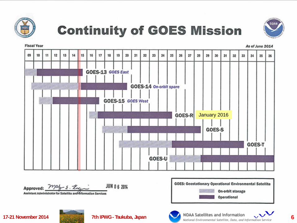
January 2016
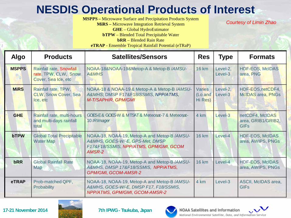
NESDIS Operational Products of Interest
Algo Products Satellites/Sensors Res Type Formats MSPPS Rainfall rate, Snowfall
rate, TPW, CLW, Snow Cover, Sea Ice, etc
NOAA-18&NOAA-19&Metop-A & Metop-B /AMSU-A&MHS
16 km Level-2, Level-3
HDF-EOS, McIDAS area, PNG
MiRS Rainfall rate, TPW, CLW, Snow Cover, Sea Ice, etc
NOAA-18 & NOAA-19 & Metop-A & Metop-B /AMSU-A&MHS; DMSP F17&F18/SSMIS, NPP/ATMS, M-T/SAPHIR, GPM/GMI
Varies (Lo and Hi Res)
Level-2, Level-3
HDF-EOS,netCDF4, McIDAS area, PNGs
GHE Rainfall rate, multi-hours and multi-days rainfall total
GOES-E & GOES-W & MTSAT & Meteosat-7 & Meteosat-10 IR Imager
4 km Level-3 netCDF4, McIDAS area, GRIB1/GRIB2, GIFs
bTPW Global Total Precipitable Water Map
NOAA-18, NOAA-19, Metop-A and Metop-B /AMSU-A&MHS, GOES-W/-E, GPS-Met, DMSP F17&F18/SSMIS, NPP/ATMS, GPM/GMI, GCOM AMSR-2
16 km Level-4 HDF-EOS, McIDAS area, AWIPS, PNGs
bRR Global Rainfall Rate Map
NOAA-18, NOAA-19, Metop-A and Metop-B /AMSU-A&MHS, DMSP 17&F18/SSMIS, NPP/ATMS, GPM/GMI, GCOM-AMSR-2
16 km Level-4 HDF-EOS, McIDAS area, AWIPS, PNGs
eTRAP Prob-matched QPF, Probability
NOAA-18, NOAA-19, Metop-A and Metop-B /AMSU-A&MHS, GOES-W/-E, DMSP F17, F18/SSMIS, NPP/ATMS, GPM/GMI, GCOM-AMSR-2
4 km Level-3 ASCII, McIDAS area, GIFs
MSPPS – Microwave Surface and Precipitation Products System MiRS – Microwave Integration Retrieval System
GHE – Global HydroEstimator bTPW – Blended Total Precipitable Water
bRR – Blended Rain Rate eTRAP - Ensemble Tropical Rainfall Potential (eTRaP)
17-21 November 2014 7th IPWG - Tsukuba, Japan
Courtesy of Limin Zhao
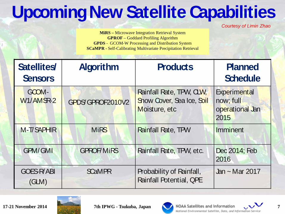
Upcoming New Satellite Capabilities
Satellites/Sensors
Algorithm Products Planned Schedule
GCOM-W1/AMSR-2
GPDS/GPROF2010V2
Rainfall Rate, TPW, CLW, Snow Cover, Sea Ice, Soil Moisture, etc
Experimental now; full operational Jan 2015
M-T/SAPHIR MiRS Rainfall Rate, TPW Imminent
GPM/GMI GPROF/MiRS Rainfall Rate, TPW, etc. Dec 2014; Feb 2016
GOES-R/ABI (GLM)
SCaMPR Probability of Rainfall, Rainfall Potential, QPE
Jan ~ Mar 2017
17-21 November 2014 7th IPWG - Tsukuba, Japan 7
MiRS – Microwave Integration Retrieval System GPROF – Goddard Profiling Algorithm
GPDS - GCOM-W Processing and Distribution System SCaMPR - Self-Calibrating Multivariate Precipitation Retrieval
Courtesy of Limin Zhao
17-21 November 2014 7th IPWG - Tsukuba, Japan 8
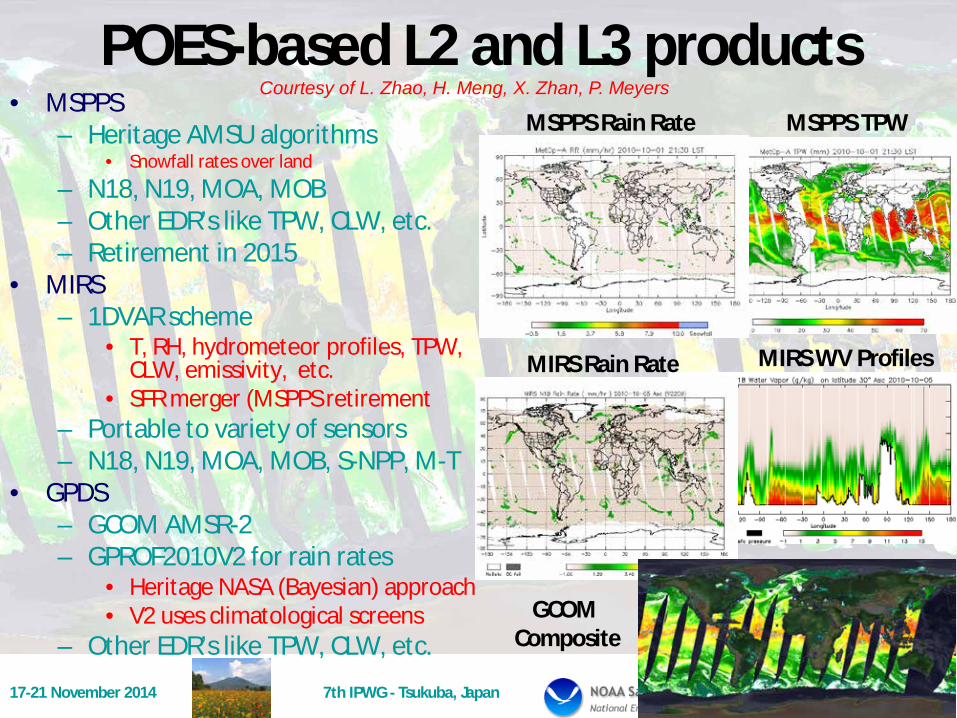
POES-based L2 and L3 products • MSPPS
– Heritage AMSU algorithms • Snowfall rates over land
– N18, N19, MOA, MOB – Other EDR’s like TPW, CLW, etc. – Retirement in 2015
• MIRS – 1DVAR scheme
• T, RH, hydrometeor profiles, TPW, CLW, emissivity, etc.
• SFR merger (MSPPS retirement – Portable to variety of sensors – N18, N19, MOA, MOB, S-NPP, M-T
• GPDS – GCOM AMSR-2 – GPROF2010V2 for rain rates
• Heritage NASA (Bayesian) approach • V2 uses climatological screens
– Other EDR’s like TPW, CLW, etc.
MSPPS Rain Rate MSPPS TPW Courtesy of L. Zhao, H. Meng, X. Zhan, P. Meyers
MIRS Rain Rate MIRS WV Profiles
GCOM Composite
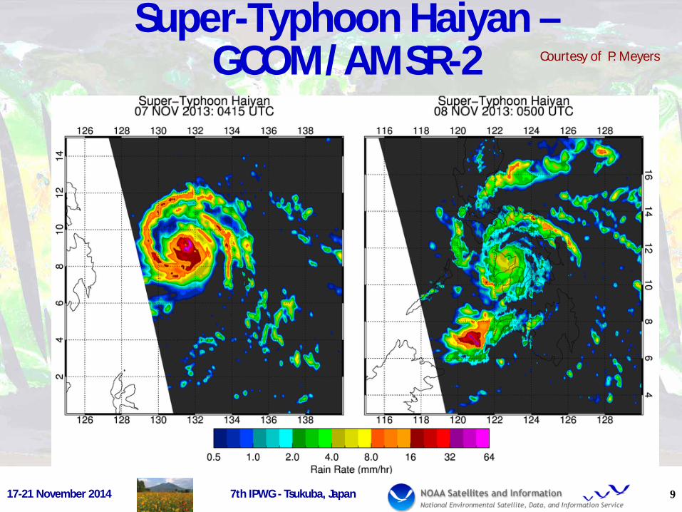
Super-Typhoon Haiyan – GCOM/AMSR-2
9
Courtesy of P. Meyers
17-21 November 2014 7th IPWG - Tsukuba, Japan
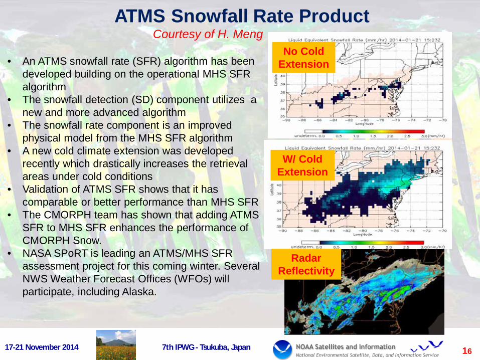
• An ATMS snowfall rate (SFR) algorithm has been developed building on the operational MHS SFR algorithm
• The snowfall detection (SD) component utilizes a new and more advanced algorithm
• The snowfall rate component is an improved physical model from the MHS SFR algorithm
• A new cold climate extension was developed recently which drastically increases the retrieval areas under cold conditions
• Validation of ATMS SFR shows that it has comparable or better performance than MHS SFR
• The CMORPH team has shown that adding ATMS SFR to MHS SFR enhances the performance of CMORPH Snow.
• NASA SPoRT is leading an ATMS/MHS SFR assessment project for this coming winter. Several NWS Weather Forecast Offices (WFOs) will participate, including Alaska.
ATMS Snowfall Rate Product
W/ Cold Extension
No Cold Extension
Radar Reflectivity
16 17-21 November 2014 7th IPWG - Tsukuba, Japan
Courtesy of H. Meng

17-21 November 2014 7th IPWG - Tsukuba, Japan 11
GOES-based Short-Term Rainfall Products • Current:
– Hydro-Estimator • IR-only plus adjustments using NWP
model data • Operational over CONUS; global
experimentally – Experimental SCaMPR
• Multi-spectral IR calibrated against MW
• Currently CONUS-only • GOES-R (2016+) Era:
– Rainfall Rate • Modification of SCaMPR with
additional spectral bands – 0-3 h Rainfall Potential
• Extrapolation-based nowcast – 0-3 h Probability of Rainfall
• Conditional probabilities based on rainfall nowcasts
Hydro-Estimator
SCaMPR
Rainfall Rate
Rainfall Potential Rainfall
Probability
Courtesy of R. Kuligowski

17-21 November 2014 7th IPWG - Tsukuba, Japan 12
Other Non-NOAA Satellite Related Products • DMSP SSMI/SSMIS
– Legacy EDR’s developed at NESDIS
– Improved legacy algorithm developed and delivered to NRL…
• TRMM TMI – TRMM V7 2A12 (Land)
• AMSR-E – GPROF2010V2
• GPM GPM – Contributed to GMI pre-
launch over land – Developing new methods
for possible use by GPM
Courtesy of N-Y. Wang, P. Meyers, D. Vila

Megha-Tropiques Recent Results (Rain - T. Islam, CIRA; TPW – I .Moradi, CICS)
17-21 November 2014 7th IPWG - Tsukuba, Japan 13
MiRS SAPHIR only TPW (Ocean – L, C; Land – R)
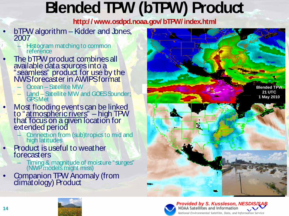
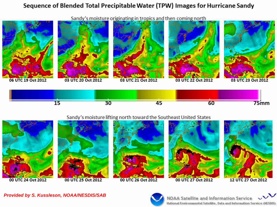
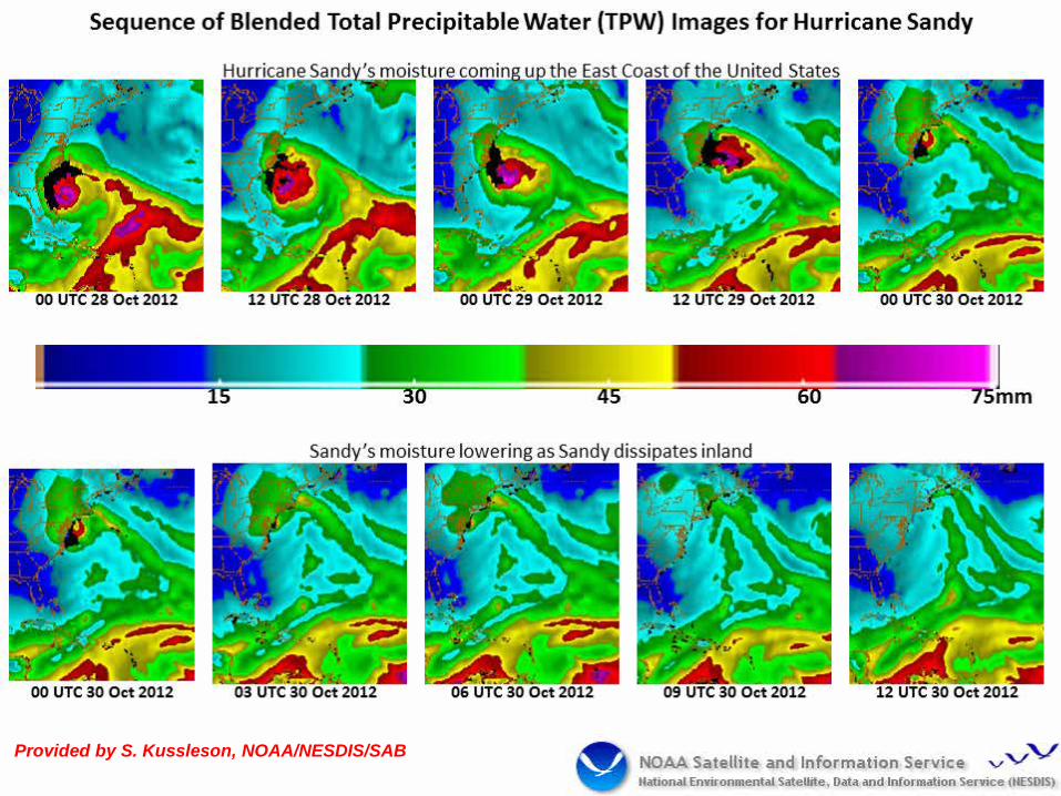
Blended TPW (bTPW) Product http://www.osdpd.noaa.gov/bTPW/index.html
• bTPW algorithm – Kidder and Jones, 2007
– Histogram matching to common reference
• The bTPW product combines all available data sources into a “seamless” product for use by the NWS forecaster in AWIPS format
– Ocean – Satellite MW – Land – Satellite MW and GOES Sounder;
GPS Met • Most flooding events can be linked
to “atmospheric rivers” – high TPW that focus on a given location for extended period
– Connection from (sub)tropics to mid and high latitudes
• Product is useful to weather forecasters
– Timing & magnitude of moisture “surges” (NWP models might miss)
• Companion TPW Anomaly (from climatology) Product
14 Provided by S. Kussleson, NESDIS/SAB
Blended TPW 21 UTC
1 May 2010
18 November 2014 IPWG Training Workshop 15 Provided by S. Kussleson, NOAA/NESDIS/SAB
18 November 2014 IPWG Training Workshop 16 Provided by S. Kussleson, NOAA/NESDIS/SAB
17-21 November 2014 7th IPWG - Tsukuba, Japan 17
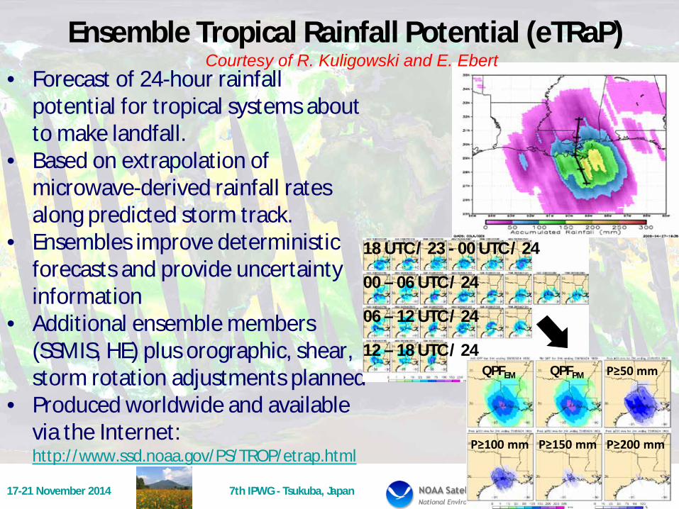
Ensemble Tropical Rainfall Potential (eTRaP) • Forecast of 24-hour rainfall
potential for tropical systems about to make landfall.
• Based on extrapolation of microwave-derived rainfall rates along predicted storm track.
• Ensembles improve deterministic forecasts and provide uncertainty information
• Additional ensemble members (SSMIS, HE) plus orographic, shear, storm rotation adjustments planned
• Produced worldwide and available via the Internet: http://www.ssd.noaa.gov/PS/TROP/etrap.html
QPFEM P≥50 mm QPFPM
P≥100 mm P≥150 mm P≥200 mm
18 UTC / 23 - 00 UTC / 24
00 – 06 UTC / 24
06 – 12 UTC / 24
12 – 18 UTC / 24
Courtesy of R. Kuligowski and E. Ebert

18 November 2014 IPWG Training Workshop 18
Typhoon Halong – Landfall 9 Aug 14
Storm Track 24-hr rain
Estimate 0600 UTC
Probability Of 100 mm Or more
17-21 November 2014 7th IPWG - Tsukuba, Japan 19
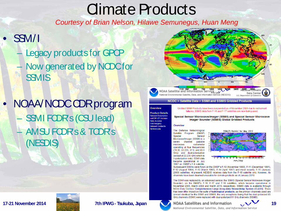
Climate Products
• SSM/I – Legacy products for GPCP – Now generated by NCDC for
SSMIS
• NOAA/NCDC CDR program – SSMI FCDR’s (CSU lead) – AMSU FCDR’s & TCDR’s
(NESDIS)
Courtesy of Brian Nelson, Hilawe Semunegus, Huan Meng

18 November 2014 IPWG Training Workshop
SSMI Climate Time Series
• Monthly mean products derived from SSM/I since July 1987: – Precipitation rate and frequency – Snow cover frequency – Sea-ice concentration – Oceanic total precipitable water – Oceanic cloud liquid water and
frequency – Ocean surface wind speed
• Products are now generated and archived at NOAA/NCDC
• Used by NCEP/CPC, JMA, GEWEX/GPCP

New Ideas for GPROF2014/Sounders
• Supported by NESDIS contribution to NASA PMM Team ActivitiesYou, R. Ferraro
• Working with C. Kidd/C. Kummerow
• Based on NMQ matchups with SSMIS and ATMS
• Key questions: – How best to stratify
databases over land? • Ancillary data use
– How many view angle categories needed?
17-21 November 2014 7th IPWG - Tsukuba, Japan
NMQ ATMS
21
Courtesy of Y. You and N-Y. Wang

Minute Lightning Density with 2 Long-track Tornados
DCLMA Applications – Showing the potential synergy from GOES-R ABI & GLM, and GCOM AMSR2
Lightning Flashes Each Second Overlaid on AMSR2 Precipitation
Patrick Meyers Univ. of MD/CICS
22

Precipitation Enterprise Concept (NOAA/NESDIS GEARS)
23 17-21 November 2014 7th IP
GPM(DPR&GMI)
NOAA-POES(AMSU&MHS)
Suomi NPP/JPSS(ATMS)
GCOM-W(AMSR-2)
MetOP(AMSU&MHS)MEGHA TR.(MADRAS)
DMSP(SSMIS)
GOES-R(ABI & GLM)
NOAA GPM PPS(OSPO/NESDIS)
GAUGE WSR-88D
Multi-sensor PrecipitationAlgorithms
MPE, CMORPH & MRMS(GAUGE+WSR-88D
+ GOES)
Rai
nR
ate
NWS/RFC/WFONWS/Centers
DoDNESDIS/STAR/
SAB/CLASSJCSDA
OAR/Testbeds
NOAA Enterprise Precipitation Processing System : Phase III
Legend
Sensor or satellite
Processor
End User
L1b
L1b
L1b
L1b
L1b
L1b
L1b
PPS Products (L1-c & Rain Rate)
L1bNUP Gen. & SCaMPR NUPsLE
O M
ICR
OW
AVE
LEO
MIC
RO
WAV
EG
EO
IR &
Lig
ht. R
ainR
ate
Courtesy of C. Kondragunta
17-21 November 2014 7th IPWG - Tsukuba, Japan 24
Summary and Future • NOAA/NESDIS generates several operational precipitation products
– GOES-based – POES-based, including JPSS – Blended products
• NOAA also actively involved in other missions – DMSP – NASA – TRMM, AMSR-E, GPM – JAXA – AMSR-2 – CNES/ISRO – M-T
• NOAA has maturing Climate Data Record Program – Synergy with SCOPE-CM
• Future – GOES-R (ABI, GLM) – JPSS (ATMS, VIIRS, etc.) – Enterprise solution to products – blended products becoming a requirement – Maturing CDR’s and role with stakeholders