the significance of geography on trade, state power …
TRANSCRIPT

THE SIGNIFICANCE OF GEOGRAPHY ON TRADE, STATE POWER AND DEVELOPMENT:
COMPARATIVE RESEARCH ON WEST AFRICA AND EAST MEDITERRANEAN EUROPE
FROM EIGHTH TO FIFTEENTH CENTURY
BY
NYAGA WALTER MAINA
THESIS PROPOSAL SUBMITTED TO SCHOOL OF HUMANITIES & SOCIAL SCIENCES IN
PARTIAL FULFILLMENT OF REQUIREMENT FOR MASTER OF ARTS IN INTERNATIONAL
RELATIONS
UNITED STATES INTERNATIONAL UNIVERSITY-AFRICA
SUMMER 2019

i
DECLARATION
I, undersigned, declare that this is my original work and has not been submitted to any other
college, or university other than the United States International University- Africa for academic
credit.
Signed: _______________________________ Date: ____________________
NYAGA WALTER MAINA -622947
Student.
This thesis has been presented for examination with my approval as the appointed supervisor
Signed: _________________________________ Date: ____________________
DR. ALEKSI YLÖNEN
Supervisor.
Signed: _________________________________ Date: _____________________
Prof. MARTIN NJOROGE
Dean, School of Humanities and Social Sciences.
Signed: _________________________________ Date: _____________________
Ambassador Prof. RUTHIE RONO
Deputy Vice Chancellor Academic Affairs.
ii
Abstract
The existing historical economic and political accounts of Africa and Europe fails to fully explain
the divergence of commerce, state power, and development between the two regions. The patterns
of differences in these two regions have far more significant underlying factors. They go beyond
historical experiences of Africa's of slavery and slave trade, colonialism and imperialism. The
over-emphasis on unique history as the primary cause of the gap in state power and development
veils fundamental insights that may be useful in understanding this divergence and possibly reduce
current and future inequalities between the two regions. Notwithstanding political, economic and
social accounts on the origin of the existing power asymmetries between Africa and Europe, spatial
and geophysical factors have been left out of the equation hence the goal of the study.

iii
Dedication
To mum Rodah Alwang' a, and grandparents Capher and Joyce Alwang' a

iv
Table of Contents
DECLARATION ............................................................................................................................. i
Abstract ........................................................................................................................................... ii
Dedication ...................................................................................................................................... iii
Acronyms and Abbreviations ........................................................................................................ vi
Definition of Terms ....................................................................................................................... viiList of Maps ................................................................................................................................. viii
List of Figures ................................................................................................................................ ix
CHAPTER 1 ................................................................................................................................. 11
1.0Introduction ............................................................................................................................. 111.1 Background..........................................................................................................................................12
1.2 Problem Statement...............................................................................................................................19
1.3 Objectives of the Study ........................................................................................................... 19
1.4 Research Questions ................................................................................................................. 201.5 Significance of the Study.....................................................................................................................21
1.6 Scope of the study ................................................................................................................... 21
CHAPTER 2 ................................................................................................................................. 232.0Literature Review.................................................................................................................................23
2.1 Introduction ............................................................................................................................. 23
2.2 The significance of Geography on Trade, State Power, and Development in Africa ............. 23
2.3 The significance of Geography on Trade, State Power and Development in Europe ............. 31
2.4 The significance of Geography on Trade, State power and Development in Mali Empire from eleventh to the sixteenth century ................................................................................................... 32
2.5 The significance of Geography on Trade, and State power and Development in Songhay Empire from eighth to fifteenth Century ...................................................................................... 34
2.6 The significance of Geography on Genoa’s Trade, State power, and Development .............. 35
2.7 The significance of Geography on Venetian Trade, State power, and Development ............. 42
2.8 Literature Gap ......................................................................................................................... 532.9 Theoretical Framework of Analysis ........................................................................................ 53
CHAPTER 3 ................................................................................................................................. 63
METHODOLOGY ....................................................................................................................... 633.0 Research Design...................................................................................................................................63
3.1 Research Type ......................................................................................................................... 63

v
3.2 Research Approach ................................................................................................................. 63
3.3 Qualitative Approach .............................................................................................................. 64
3.4 Quantitative Approach ............................................................................................................ 64
3.5 Quantitative Research Design ................................................................................................. 65
3.6 Framework for Spatial Analysis ............................................................................................. 653.7 Methodological Context .......................................................................................................... 66
3.8 Research Scope ....................................................................................................................... 66
3.9 Data Sources ........................................................................................................................... 66
3.9.1 Sample and Sample Techniques .......................................................................................... 67
3.9.2 Data Collection Methods ..................................................................................................... 67
3.9.3 Data Collection Tools .......................................................................................................... 68
3.9.4 Data Analysis Methods ........................................................................................................ 683.9.5 Proximity Analysis Methods ............................................................................................... 70
3.9.6 Research Validity ................................................................................................................. 70
3.9.7 Research Reliability ............................................................................................................. 70
CHAPTER FOUR ......................................................................................................................... 71
4.0 Findings and Data analysis ..................................................................................................... 71
4.1 The Significance of Geography on Commerce and Trade ...................................................... 71
4.2 The Significance of Geography on state power ...................................................................... 81
4.3 The Significance of Geography on Development ................................................................... 87CHAPTER FIVE .......................................................................................................................... 89
5.0 Conclusion .............................................................................................................................. 89
5.1 Policy Recommendations on Africa ....................................................................................... 90
Appendix 1-Spatial Autocorrelation and Moran I Computation .................................................. 98
Appendix 2- Map of Genoa and Venice ..................................................................................... 100
Appendix 3- Map of the Kingdom of Mali ................................................................................. 101
Appendix 4-Map of the Kingdom of Songhay ........................................................................... 102
Appendix 5-Digital Elevation Map for Africa and Europe ........................................................ 103Appendix 6-Map-Climatic Patterns Africa and Europe .............................................................. 104
Appendix 7- Map of Koppen Climate Classification ................................................................. 105
References…. ............................................................................................................... ...............106

vi
Acronyms and Abbreviations
USGS UnitedStatesGeologicalSurveyNASA TheNationalAeronauticsandSpaceAdministrationESRI InternationalSupplierforGeographicInformationSystemDD DegreeDecimalsDMS Degree,Minutes,DecimalsArcGIS GeographicInformationSystemsoftwarefromEsriCompany° N DegreesNorthoftheEquator° W DegreesSouthofEquator° E DegreesEastofEquator° S DegreesSouthofEquator
vii
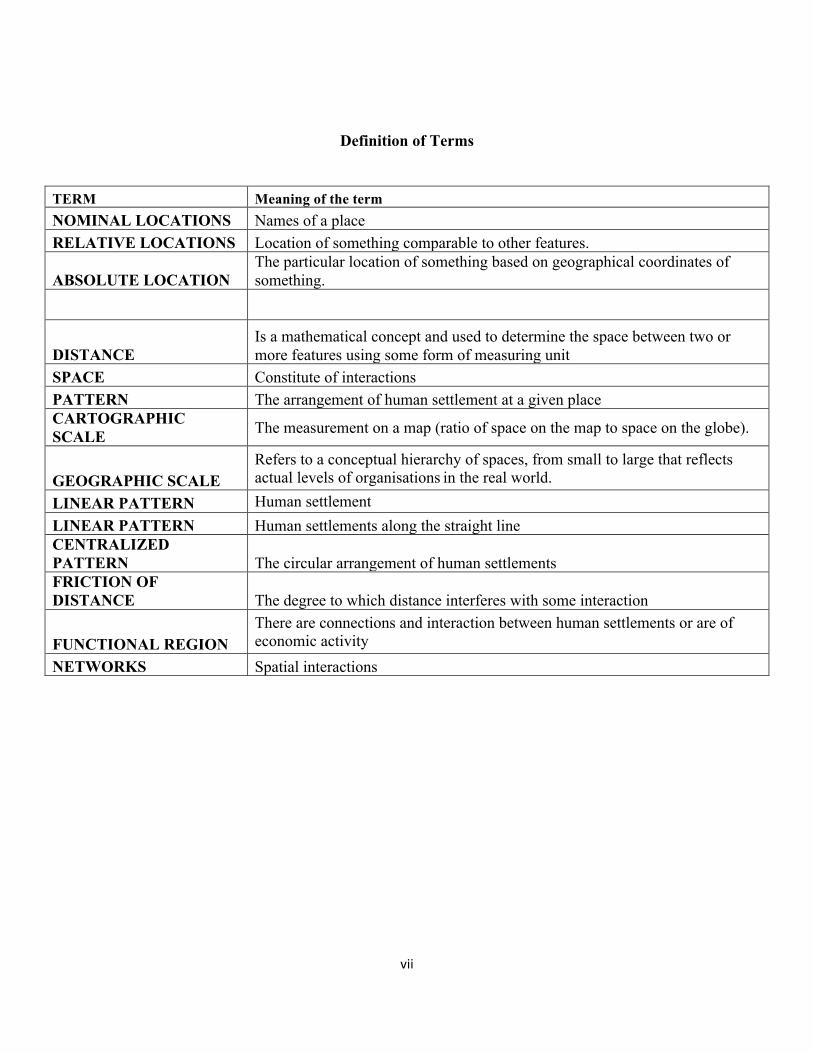
Definition of Terms
TERM Meaning of the term NOMINAL LOCATIONS Names of a place RELATIVE LOCATIONS Location of something comparable to other features.
ABSOLUTE LOCATION The particular location of something based on geographical coordinates of something.
DISTANCE Is a mathematical concept and used to determine the space between two or more features using some form of measuring unit
SPACE Constitute of interactions PATTERN The arrangement of human settlement at a given place CARTOGRAPHIC SCALE The measurement on a map (ratio of space on the map to space on the globe).
GEOGRAPHIC SCALE Refers to a conceptual hierarchy of spaces, from small to large that reflects actual levels of organisations in the real world.
LINEAR PATTERN Human settlement LINEAR PATTERN Human settlements along the straight line CENTRALIZED PATTERN The circular arrangement of human settlements FRICTION OF DISTANCE The degree to which distance interferes with some interaction
FUNCTIONAL REGION There are connections and interaction between human settlements or are of economic activity
NETWORKS Spatial interactions
viii
List of Maps
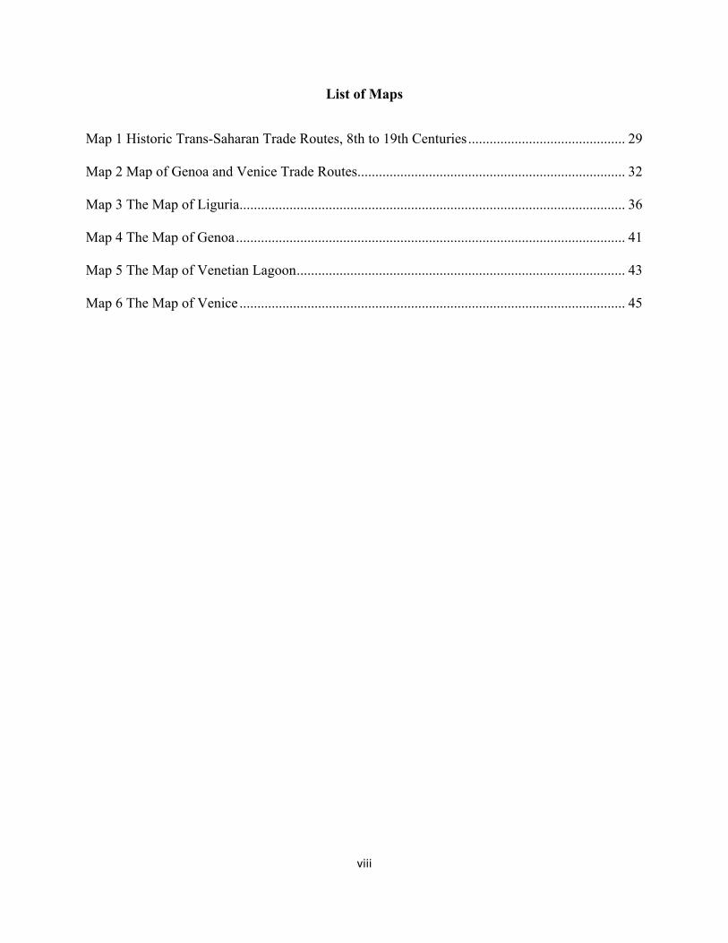
Map 1 Historic Trans-Saharan Trade Routes, 8th to 19th Centuries ............................................ 29
Map 2 Map of Genoa and Venice Trade Routes ........................................................................... 32
Map 3 The Map of Liguria ............................................................................................................ 36
Map 4 The Map of Genoa ............................................................................................................. 41
Map 5 The Map of Venetian Lagoon ............................................................................................ 43
Map 6 The Map of Venice ............................................................................................................ 45

ix
List of Figures
Figure 1 Genoese Trade 1252 to 1313 .......................................................................................... 39
Figure 2 A Sample of Professions in Genoa 1451 to 1517 ........................................................... 40
Figure 4 Spatial Autocorrelation findings for Mali and Songhay Empires .................................. 71
Figure 5 Spatial Autocorrelation findings Genoa and Venice ...................................................... 72

x
Acknowledgements
I wish to acknowledge my thesis supervisor DR. Aleksi Ylönen for his guidance and valuable
insights on this study. In particular, noting that the survey cut across four fields, I am much
indebted to Dr Aleksi immense knowledge in the field of History, International Relations, and
Development studies. His relentless energy, focus on quality arguments and passion to pass
knowledge while allowing freedom to research and express myself have made me a better person.
I also acknowledge the efforts and thoughts of Dr Elijah Munyi on my preliminary research
methodology formulation. Dr Munyi posed a series of provocative questions on the subject matter
which in the end have been very enriching to the study.
Similarly, I wish to acknowledge the contribution of Dr George Katete on my research. His counsel
and advice on the scope, research design, and research variables have enhanced the study. In the
same vein, I wish to acknowledge abundant moral Support from my mother Rodah Alwang' a
Grandparents Kapher and Joyce Alwang' a, Dr. Dan Odaba, Dr. Maurice Mashiwa, and my
classmate Abdul Kadir when I needed it most. The research will not be successful without the
efforts of Francis Muthee Karanja geospatial consultant for my study. I also appreciate the
Newborn Areba who through his generosity, I was able to access key reference materials used in
the research. I also appreciate my bosses Noel Sikolia and Wangari Mungai for their unwavering
support throughout my master's studies. Finally, I wish to express my sincere appreciation to my
classmate and friend Frank Walter Ouma whose keen eye was useful in proof reading, critiquing,
and editing of this study to the desired quality standard

11
CHAPTER 1
1.0 Introduction
The study Significance of Geography on Trade, State power, and Development is comparative
research aimed at exploring the impact of geography (Space) on trade, state power and
development. Geography is the bedrock of international politics and such the influence of
geography on the economic competitiveness of Africa and Europe is quite profound. In the military
strategy for instance, ground may be accessible, entrapping, intrusive, constrictive, precipitous,
and distant (Gray & Sloan, 1999). There are various forms of geography. There is the geography
of space, distance, time, terrain, and weather. Geography is out their objectively as the environment
but also geography is here as imagined spatial relationships. The two aspects of geography as an
environment and as envisioned spatial relationship serves as a driver of technology and military
tactics, logistics, and social organisation of the society (Griffith, 1963).
The study compares the significance of geography on trade, state power, and development on
West African empires of Mali and Songhai to European city-states of Venice and Genoa. The study
scope is between eighth to the fifteenth century. State power in the context of the study refers to
economic power, military power, and political power. In the study, geography refers to two aspects
mainly as an environment and as envisioned or imagined spatial relationships that serve as a driver of
commerce, technology, military tactics, movement, and social organisation of the society. In the
development of commerce and state power, the study assumes that the extent of imagined space is as
a result of the nature and characteristics of physical geography. Restrictive geophysical characteristics
may hinder imagined spatial relationships hence weakening drivers of state power and development.
Conversely, favourable geophysical characteristics bolster imagined spatial relationships hence state
power and development. In the study, State power entails means to extract, transform, consume
the produce of nature (Mann, 1986). The normal relations permeating in human lives through a
12
combination of the social organisation of labour alongside a network of capital, trade and
production chains constitute state power. Military power is regarded as defensive and offensive
coercive capabilities as a consequence of social organisation and concentrated lethal force (Mann,
1986, pp. 1-34). The centralised and territorial regulation of social life constitutes political power.
Development in the context of the study is the cumulative consequence of trade and state power.
1.1 Background
There has been a profound divergence in commerce, state power and development between Europe
and Africa for the past eight centuries. Observing this schism, Mahbub Ul-Haq notes that "a
poverty curtain has descended right across the face of the world dividing it into two different
worlds, two separate planets, two unequal humanities constituting one embarrassingly rich and the
other desperately poor (Ul-Haq, 1971). In the effort to explain Africa’s peripheral position in the
world system, prominent scholars of history, political science, and international relations have
attributed the current deviation in state power and development exhibited in Africa and Europe to the
experiences of the slave trade, colonialism, cold war, and neo-colonialism (Rodney, 1973).
According to Rodney (1973, p.206), the legacies of slavery and colonialism are responsible for
Africa's underdevelopment. In Rodney's views, Africa has been critical in the development of Europe.
The development of Europe pushed Africa to the periphery of the international system. He postulates
that the underdevelopment of Africa was, in fact, the product of centuries of slavery, exploitation and
imperialism. For Rodney, under-development is a condition historically produced through capitalist
expansion and dominion, and very clearly not an intrinsic property of Africa itself. The scholar posits
that under-development is the different process of capitalism, one that creates both value and wealth
for the exploiters while immiserating the exploited (Rodney, 1973, p. 206).
According to Mazrui (1986), the legacy of the trans-Saharan and transatlantic slave trade, the partition
of the African continent, and eventual colonisation had twin impacts on Africa’s development. First,

13
colonial rule destroyed indigenous structures. Second, the colonial rule destroyed a culture. The
presence of transplanted structures of governance interfered with natural state formation and social
organisation. The destruction of cultures is responsible for the manifesting inefficiency,
mismanagement, and corruption (P.20)
On his part, Ce’saire (2000) notes that colonialization had a great impact on African culture and
development. The domination of indigenous people hindered effective human contacts that existed in
pre-colonial Africa. Further, the scholar laments that the colonial masters used indigenous people as
production machines for their benefits.
According to Fanon (1963), the oppression of the indigenous, as well as the exploitation of African
natural resources, deliberately held the development of the continent at the expense of European
powers. Even after independence, Fanon laments that in spite of formal sovereignty acquired after
independence the power of the new states was in the hands of the imperialist.
On his part, DuBois (1945) note that colonialism was a direct product of capitalism. In his view,
Africa and Asia were just a source of cheap labour and natural resources. The subsequent exploitation
of labour and natural resources by the colonial project led to underdevelopment in Africa.
According to Kwame (1965), in the aftermath of independence, neo-colonialism become the new
colonialism in Africa. Nkrumah notes that the emergence of neo-colonialism as an instrument of
imperialism has led to the outward trapping by European powers on African sovereignty.
Consequently, the outside forces direct African economic system as well as the political policy.
The control of African states by foreign powers further deepens the development gap between
Europe and Africa.

14
On his part, Nyerere (1974) notes that colonialism and imperialism have created rich and poor
nations. Powerful individuals within states benefit at the expense of deprivation of the majority.
Similarly, within the International system, wealthy nations dominate the rest of the world. (P.82)
Munene Macharia, a renowned Kenyan Historian and professor of International Relations echoes
similar views to Nyerere. In the book Historical Reflections on Kenya: Intellectual Adventurism,
Politics and International Relations, Munene notes that poverty in Africa is a direct legacy to
colonialism. Further, he adds that the Africans dislike of each other is as a result of colonial socio-
political conditioning of Africans to be irresponsible and disunited in the face of external threats
is also a direct consequence of colonialism (Macharia, 2012).
This study does not dispute these facts and opinions. The impact of the slave trade, colonialization,
and the Cold War on Africa is too profound. Ignoring such a history constitute dehumanising a
whole African people. Notwithstanding the history, little has been done to account for the
divergence of state power and development in the pre-colonial (Bayart, 1996). The post-colonial
period has been emphasised considering the impact of European colonisation in Africa while
ignoring longer pre-slavery and colonial period (Woods, 2003).
Secondly, there is has been great emphasis on the aspect of human agency as the main cause of
asymmetrical economic and political relations between Europe and Africa. For instance, disruption
of cultures and indigenous political, administrative, and economic relations as anathema to Africa's
development. Whereas the study does not in any way downplay the role of human agency in
fostering development, the study seeks to bring to fore factors other than human agency that may
have also been responsible for limiting development on the African continent. The human agency
after all may not be the sole cause of unequal development between the two regions.

15
In the study Discourse on the Origin and Basis of Inequality among Men, the French philosopher
Jean Jacques Rousseau postulates that inequality may be of two kinds. The physical inequality
established nature. Secondly, social relations establish moral or political inequality (Rousseau,
1754). The indicators of physical inequality consist of environmental factors such as type of soils,
amount rainfall, and amount of moisture among others. The indicators of moral or political
inequality include various benefits that men have the privilege to enjoy at the expense of others.
They include being wealthy than others, being powerful than others, and being domineering than
others.
Moral or political inequality has well been elaborated and documented by the post-colonial writers.
Though, attention is absent in understanding the inequality arising out of natural ordering of things
especially between the two regions under consideration among scholars.
It is worthy to note a limited link between geographic factors constituting both geophysical and
biophysical to the development of commerce and state power. The omission of natural causes of
inequality at the expense of human agency does not, therefore, provided a holistic understanding
of Africa's place in the international system. The human agency works within the natural
ecosystem. Therefore, the mutual and understanding and consideration for both political and
natural origins of inequality will be useful in the formulation of a valid prescription for amending
existing power asymmetry between Europe and Africa.
There is a strong correlation between economic power, military power, and political power. The
relationship arises out of the fact that all these constituents of power are endogenous to space
within the international system. According to Bearce & Fisher (2002) neither of these elements of
power are outside global system or space further; each constituent may be a product of states
motivated to increase their resources and influence.

16
Since all the constituents of power are endogenous, the two scholars postulate that a third
exogenous factor governs the relationship between the three. While observing economic
geography for instance, the scholars note that it makes the growth of trading networks possible as
well as rendering military conquest and the subsequent extraction of resources easier to achieve
(Bearce & Fisher, 2002). Further, features of economic geography that facilitate trade, such as
roads, bridges, and railways, can similarly be used for troop movements and resource extraction.
According to Gleditsch & Ward (2000) economic geography constitutes both physical geography
and economic infrastructure. Different physical geographies have precipitated various economic
geographies and trade networks. For instance, the authors note that economic geography of
Western Europe is more compact than that of distended South America, which might be used to
account for the difference in the high levels of trade, warfare, conquest in the former than in the
later. Studies on the influence of Geography on Africa’s political economy are few. According to
Odell (1974) spatial aspects of economic problems remain of relatively little concern to planners,
advisors and politicians.
On the other hand, statistics show that economic development and underdevelopment are aspects of
the uneven spatial distribution of economic activities (Henderson, Shalizi, & Venables, 2001).
According to Odell, there is wide believe that problems of the spatial economy are marginal to the
main development issues and are a few. This notion has led to an inherent conflict between attempts
to maximise national concern for the geographical distribution of economic activities.
Further, according to Haussmann (2001) the economic-development experts fail the continent when
they promise that with the right mix of pro-market policies, developing countries will eventually
prosper. Contrary, the author notes that the market system alone is not the sole cause of
underdevelopment. Geography just as in past continue to be cause of underdevelopment in the present
Africa. Hausmann’s postulations are not in isolation from the development debate. At the United

17
Nations conference on women and development of 2006, the U.S. Treasury Secretary decried "the
tyranny of geography," particularly in African countries. According to Summers (2001), the failure
of African governments to put in place the enabling environment for development is not the sole
reason why these states are weak. Beyond government incapacity to provide essential services,
tropical nations with poor soil, an erratic climate also make countries to be vulnerable to infectious
diseases, drought, famine and poverty (pp.44-53).
In Africa, there is avoidance by scholars to examine how the topic of cultural geography impacts state
power, commerce, and development. Most often, tackling the topic is equated to promoting or
justifying European colonial and imperial project in Africa. From many perspectives, the theme seems
laced with racial connotations justifying the domination of some races against others (Hausmann,
2001, pp.44-53). It is a taboo to discuss it. Notwithstanding these fears, this study advances the view
that whereas in some respect, the study of political geography used in the past as a justification of
domination of Africa by external forces, it can to be used to explain the position of Africa in the world
and propose mechanisms of pushing Africa from periphery to core in international affairs.
. In the study by Woods (2003) entitled Geography Back in Civilizations, Wealth, and Poverty, the
scholar brings an informative perspective to explain the emergence of the gap between rich and
developing nations. He postulates that development is determined by geography as an environment
in the primary development process. Moreover, since growth is defined by geography, such means
can be identified and constrained by natural resources. However with luck, effective political
institutions, determination, and innovation, it is possible to overcome the barriers (Woods, 2003).
According to a study by Bayart (1996) some theories on development and civilisation in Africa have
failed to situate developing nations within a broader span of historical time. For instance, in Sub-
Saharan Africa, little was done to understand the link between precolonial African societies and the
postcolonial period. Instead, how colonial and postcolonial period shaped Africa has attracted much
attention (Bayart, 1996). On his part, Dwayne Woods questions as to whether a phenomenon such as

18
colonialism that endured for a century at most should overshadow Sub-Saharan Africa's much longer
precolonial history (Woods, 2003).
In this regards, he advances Putterman (2000) argument that Geographical environment affected the
process of development across civilisations by giving certain areas a head start over others. This head
start mattered insofar as it influenced the diffusion of crops, ideas, and technologies (Putterman,
2000). Civilisations that were close to one another-in particular those on the Eurasian continent tended
to adopt and imitate developments that occurred in the cultures close to them. If they did not, they
generally fell victim to more advanced civilisations or emerging ones that had acquired a
technological advantage of some kind. (Putterman, 2000) Cultures that were geographically farthest
from the areas that had an initial environmental head start lost ground and still lag behind today
concerning wealth and levels of development.
The argument on the relationship between Geography and the socio-political institution is even more
robust. According to Sowell (1998) geography has played a significant role in the history of conquest,
as it has in the history of cultural evolution in general. There are regions of the world that the
geographical barriers constrained the emergence of powerful nation-states, able to protect their
populations from marauding outsiders. For instance, the Balkan Mountains fragmented peoples
culturally and isolated them from the economic and intellectual advances of the outside world hence
this region became a significant supplier of slaves for centuries before Europeans turned to Africa as
the source of slaves for the Western Hemisphere (Sowell, 1998).
There is a correlation between the environment and the type of state. According to a study by Herbst
(2000), state formation in Sub-Saharan Africa did not follow the pattern in Europe (notably western
Europe) due to environmental factors. African leaders faced an environment of low population
densities and vast expanses of available land. Exit always existed as an option for Africans who chafed
under the authority of coercive leaders. Such an exit option gave a frontier dynamic to pre-colonial
19
African history that affected state formation, kinship structures, and efforts at centralisation of state
authority.
Herbst theorises that land was not the primary factor in warfare in Africa. Instead, the capture of
people and treasure were most important. The land was available to all who needed it. In contrary to
Africa, the European states saw the necessity of mobilising tremendous resources from their
populations to fight wars and were therefore forced to develop deep ties with their hinterlands. The
pre-colonial African leaders mainly exploited people outside their polity because the point of the war
was to take women, cattle, and slaves. Thus, the slave trade, especially in the medieval ages, should
be seen as part of the process by which African states grew by capturing people rather than by gaining
control over the territory (Herbst, 2000).
1.2 Problem Statement
The economic, social, and political divergence between Africa and Europe have deep underlying
causes. They go beyond Africa's experiences of slavery and the slave trade, colonialism, and
imperialism (Rodney, 1973). They too can be explained by exogenous factors beyond social,
economic, and political dynamics within these regions. The biophysical and geophysical
differences between Africa and Europe may account for divergence in commerce, state power and
development between the two regions. While geography boosted state power and development in
Europe, it constrained the growth of the same in Africa (Sachs & McCord, 2015).
1.3 Objectives of the Study
The general objective of the study is to study the significance of geography on, trade, state power and
development. It is a comparative research study on West Africa and Eastern Mediterranean Europe.
The specific objectives of the study are as follows:

20
1.3.1
To explore the significance of Geography on trade in West Africa and Eastern Mediterranean Europe
between eighth to fifteenth century
1.3.2
To explore the significance of Geography on state power in West Africa and Eastern Mediterranean
Europe from the eighth to fifteenth century
1.3.3
To explore the significance of Geography on development in West Africa and Eastern Mediterranean
Europe from the eighth to fifteenth century
1.4 Research Questions 1.4.1
What is the significance of Geography on trade in West Africa and Eastern Mediterranean Europe
between eighth to fifteenth century?
1.4.2
What is the significance of Geography on state power in West Africa and Eastern Mediterranean
Europe between eighth to fifteenth century?
1.4.3
What is the significance of Geography on development in West Africa and Eastern Mediterranean
Europe between eighth to fifteenth century?

21
1.5 Significance of the Study
The significance of the study to the discipline of International Relations rests on the fact that it
provides an additional analytical framework for understanding unequal power asymmetries
between Africa and Europe beyond social, economic, and political dynamics. The study uses
spatial analysis to examine how previously unconsidered geographical variables influenced the
current social, economic, and political power asymmetries in the regions under study. The
capturing spatial (geographic) information and subsequently linking it to qualitative data will allow
future researchers of International Relations and policymakers to develop a holistic view of many
different contextual variables critical in tackling existing unequal relations between Africa and
Europe. The identification of differences between various spaces and social organisation and
subsequent examination of the interrelation of variables of power in space and time will transform
the discipline of International Relations in meaningful ways worth of exploration (Steinberg &
Steinberg, 2006). The study hopes to offer advice to policymakers in government and private
sectors on how to eliminate geographical barriers that hinder progress and development of the
African continent.
1.6 Scope of the study
The scope of the survey in West Africa and Eastern Mediterranean Europe. The study cover period is
from eighth to the fifteenth century.
1.7 Organization of the Study
The study constitutes five chapters. The first chapter is the proposal. The proposal comprises of an
introduction, the background of the study, problem statement, objectives of the study, research
questions, significance of the study, the scope of the study, and organisation of the study. The
second chapter comprises of literature review, theoretical framework analysis, and the literature
gap. The methodology is the third chapter of the study. It consists of research design, research

22
type, research approach, qualitative approach, quantitative approach, quantitative research design,
a framework for spatial analysis, methodological context, research scope, data sources, sample and
sampling techniques, data collection methods, Ethical considerations, research validity, research
reliability. The fourth chapter comprises findings and data analysis chapter. Chapter five is the
conclusion and future policy and research recommendations.

23
CHAPTER 2 2.0 Literature Review
2.1 Introduction
The second chapter is on the literature review. The comprehensive literature review is arranged
using the funnel approach of qualitative research. The approach gives the reader a broad global
perspective before narrowing to specific areas of analysis. The chapter is therefore divided into
eight sections. The first section gives a general overview of the significance of geography on trade,
state power, and development in Africa. The second section gives a general overview of the
significance of geography on trade, state power, and development in Europe. Under Africa, two
sub-sections are dealing with the significance of geography on trade, state power and development
on the West African Kingdoms of Mali and the Songhay Empire respectively. Under Europe, two
sub-sections are dealing with the significance of geography on trade, state power and development
on the East Mediterranean city-states of Genoa and Venice. The chapter also contains a section on
the literature gap and the theoretical framework of analysis of the study.
2.2 The significance of Geography on Trade, State Power, and Development in Africa
Africa is popularly referred to us the cradle of humankind. Jeffries (2017) notes, the African
continent is a treasure trove of ancient history. Africa is a continent defined with immense
geophysical relief (Jeffries, 2017). According to Blij & Muller(2002), the enormous environmental
implications affecting the African continent arises from the fact that significant part of Africa lies
in the latitudes where global conditions produce arid conditions due to less moisture (Blij &
Muller, 2002). The presence of less moisture is responsible for the formation of deserts such as
Sahara in North and West Africa, Namib, and Kalahari in the Southern Africa. The African with

24
exception of Mozambique and Somali plateau continent has an average altitude of 660m above
sea level (Blij & Muller, 2002).
The highest parts of Africa include the massive Ethiopian plateau with an elevation exceeding
4250m. The Mount Kilimanjaro in East Africa rise to 5880m, and the Drakensberg mountains in
the south rise to 3350m above the sea level (Cole & Blij, 2007). According to De Blij & Muller
(2002), it is indeed surprising that the major basins in Africa such as the Congo basin, Djibouti,
Sudan, Chad basin as well as the equatorial tropical low land lie well above the sea level, in contrast
to much lower-lying amazon basin across Atlantic.
Africa is a plateau continent surrounded by many escarpments. In South Africa Blij and Muller
(2002) note that the widespread cliffs mark the edges of plateaus. The land precipitates from
1500m elevation to narrow hilly coastal belt (Blij & Muller, 2002). Although such escarpments
are present in other parts of the world such as Brazilian highlands and the western edge of India
Deccan plateau, Africa is massive slopes are disproportionate to its size (pp.335-338).
According to Blij & Muller (2002), navigation in the Africa continent is very limited in comparison
to Europ. In Africa, the flow of water to the ocean is far smaller than the rainfall would suggest
(Blij & Muller, 2002). More than half of the continent surface is composed of regions either with
or no drainage at all draining internally (Blij & Muller, 2002). Due to the poor topography, rivers
in Africa find difficult obstacles that render them to be of little use for navigation purposes. The
profiles of African streams consist of gentle slope stretches connected by abrupt rapids, falls,
cataracts that limit navigational activities on the continent (Blij & Muller, 2002).
The Zaire river, for instance has thirty-two rapids between Stanley Pool and estuary. The Zambezi
falls 110km at Victoria Falls before plunging into Kariba. The Nile passes through six rapids and
cataracts from Khartoum before reaching the Mediterranean. The other major rivers found in

25
Africa such as the Niger; Senegal, the orange and Limpopo have stepped profiles that render
navigation difficult (Blij & Muller, 2002).
According to Blij and Mueller (2002), Europe's rivers arising from the Alpines creates a radial
pattern outward from continents interior highlands to the sea. The fact that these rivers are
navigable has in a significant way favoured traffic, settlements and trade in northern Europe. In
Africa, geography seems to have adverse effects on settlement patterns, political, military and
economic development.
Africa is the centre of all continents in the world. As Ali Mazrui notes, the equator divides the
continent into two halves. No other region in the world does possess these characteristics.
Ironically, majority of the people on the continent have lived in isolation for an extended period
(Mazrui, 1986). It is astounding that the most central of the continents exist at the periphery of
world affairs. As Mazrui notes, it is quite profound that whereas European adventurer traversed
the sea to find and conquer new lands, the reverse was absent in Africa. In fact, except for Mansa
Musa king Mali, there is no evidence of Africans seeking to conquer and dominate foreign lands
beyond the continent. What is evident is that Africans were interested in waters for subsistence; it
never provided them an avenue of governing other worlds beyond the horizon (Mazrui, 1986).
In contrast, the by-products of European adventure namely slave trade, colonialism, and neo-
colonialism provides evidence of origins of subservient Africa's position in political power,
economic power, military power, technological power, and social power at the world stage
(Mazrui, 1979).
The experiences of the slave trade, colonialism, and neo-colonialism of which Africa has
undergone are humiliating and brutal. From an observer perspective, Ali Mazrui notes that the

26
African condition presents a paradox of the Garden of Eden in decay because Africa is probably
the first home of humankind, but it is the last to be made genuinely habitable (Mazrui, 1979).
The period between the eighth and fifteenth century saw Africa occupy a unique political and
economic position in world affairs. Africa rose to the eminence of international political issues due
to some reasons. First, the declining Roman Empire as from 2nd century finally crumbled under
Gothic invasion leaving Europe in anarchy occasioned by emerging rival groups. Second, the
emergence of Islamic empire at the Arabian Peninsula- a region with few commercial centres with
trade routes that ran from the shores of Indian Ocean to Mediterranean Sea (Fasi & Hrbek, 1992).
The emergence of the Islamic empire and the subsequent conquest of Egypt, Cyrenaica,
Tripolitania (Libya), Buzacena (Tunisia), and Fez (Morocco) brought Africa to the world centre
stage. The subduing of Iberian Peninsula in 704 CE under the leadership of Musa ibn Nusayr of
the Umayyad caliphate with the help of Arabized and Islamized Berbers marked the pinnacle of
Africa in the world affairs (Fasi & Hrbek, 1992).
Third, the trans-Saharan trade and the subsequent emergence of powerful states in South of Sahara
trading with consolidated Islamic empire across the Maghrib had no doubt rendered Africa the
influential power of the world. However, from the twelfth century onwards, Africa began to
decline both economically and politically. In the mid-14th century to the fifteenth century, Africa
push from the core to the periphery of the international political economy began (Fasi & Hrbek,
1992).
Throughout the eighth and fifteenth century, many societies in Africa attained social, political, and
economic organisation sometimes equivalent and sometimes superior to those that existed in other
places on the globe. Regarding economic development, geography seems to have limited division of
labour and specialisation in comparison to Europe factors that would have made Africa competitive

27
in the then prevailing international political economy of the period under study. The limited
competitiveness subsequently subjected Africa to dependency by the end of fifteenth century (Fasi &
Hrbek, 1992).
As a social process, the division of labour and specialisation happen in the spatial environment.
Subsequently, the division of labour and specialisation play a crucial role in stimulating the social,
economic, and political organisation of any given society. According to Holmwood (1996) the
division of labour and specialisation has not only the power of amalgamating society into a
community but also the ability to carry the society to a high level of cultural, artistic, and intellectual
development.
Despite Africa being within access of knowledge possessed by Arab conqueror such as the sciences
of Mathematics, Chemistry, Medicine, and Numerals, Africa failed to move towards a high level of
cultural artistic and intellectual development. Geography not only hindered diffusion of ideas, and
technologies across Africa but also limited access to markets that would have inspired faster growth.
It is the power of exchange that gives occasion to the division of labour and specialisan. Subesquently,
the degree of market power is determined by the extent of the division of labour. Therefore, if the
market is small, no single person can have enough desire to dedicate himself entirely to one
employment (Holmwood, 1996).
Throughout Africa in the period under discussion, the limited division of labour and specialisation
seems to be an obstacle to the social, economic, and political organisation of even the most complex
societies that did exist in Africa. In the Sahel for instance, archaeological research shows that there
were substantial economic activities in the areas around modern Senegal; Niani to Tondidaru along
the valley of river Niger; the present day Niamey; Marand, and Ife (Devisse, 1992).

28
Despite substantial economic activities in these areas, Shaw (1992) notes that these economic
activities small-scale systems of exchange that were not able to stimulate faster growth of centralised
political and religious institutions with sufficient wealth to patronise outstanding artistic production.
Shaw notes that the exchange systems were so simple and sometimes so local. For instance, the fish
from the riverine area traded for grains far away from the riparian zone. Bushmeat hunted and caught
in the Savanna might have been exchanged for foods around the forest. An Iron smelting area might
trade for pottery made in an area endowed with suitable clay (Shaw, 1992).
The most complex exchange systems on the large part of Africa developed after the gradual
emergence of Sahara trade from the eighth to the 10th century. Commerce during this period became
part of the large-scale exchange system. The trans-Saharan trade played a critical role in stimulating
the division of labour but also to a limited extent — the trans-Saharan trade involved trade in rare
commodities such as salt; gold, wheat, fabrics, copper in both Maghreb and the Sahel. The increased
exchange as a consequence of the trans-Saharan trade forced African economies in the Maghreb to
move from barter to currency form by the eleventh century (Devisse, 1992, pp.193-195).
The intensity of trade forced political establishment in the Islamic empire to mint coins used for
facilitating the transaction of business in their respective economies. By eleventh century at least
seven-coin mint circulated in areas of Tlemcen, Sidjilamasa, Aghmart; Nuliamta; Fez; Marrakesh;
and Salah (Devisse, 1992, pp.193-195).
Though the Sahara trade stimulated the division of labour and specialisation in the Maghreb,
Commerce thrived in the market areas of Tamdult, Sidjilmasa, Tahert, Wargla and Djarid in the Sahel
and Western Maghreb. The limited market in the Maghreb and Sahel arose out of the fact that societies
in both regions were primarily overwhelmed by unique physical geographical factors that frustrated
the emergence of a strong market for both production and consumption of the products.

29
The presence of the Sahara Desert between the Maghreb and Sahel proved to be a significant obstacle
in the establishment of a broader market which would have stimulated the division of labour between
the Maghreb and the Sahel. (12) The Sahara is expansive. It stretches between 1000 and 2000 km in
width. Devisse (1992) notes that crossing the Sahara was a long and dangerous journey. The fact that
the Sahara trade was long and dangerous eliminated any potential for the participation of ordinary
people in the trade. The dangerous nature of Sahara left commerce a reserve of elites who find
encouragement in the trade through selling and buying commodities such as gold (Devisse, 1992, pp.
193-195).
Map 1 Historic Trans-Saharan Trade Routes, 8th to 19th Centuries
The study of the political economy of Africa between eighth to the fifteenth century reveals the fact
that the division of labour was not only limited in the upper middle half of the continent but also
widely spread through parts of Africa. In East Africa, whereas continuous trade relations with the
30
outside world stimulated the division of labour, the interior of East Africa was largely isolated from
each other as well as the coast (Masao, 1992). The division of labour and specialisation along the East
African coast according to Masao was necessitated by the interaction between coastal settlements and
the Islamic world in the export and import trade (Masao, 1992, pp. 230-236).
The Islamic world exported products such as clothes, beads, and glass to the East African coast. The
East African coast exported products such as Ivory; tortoiseshell; ambergris, incense, gold, iron,
animal skins, and slaves. The commerce interaction between the Islamic world and East African coast
served as a catalyst in the establishment of centres such as Mogadishu; Marka; Brava; Mombasa;
Manda in Lamu archipelago; Unguja; and Pemba between ninth and 10th century. (Masao, 1992, pp.
230-296).
The portrait of the African political economy in the period under discussion shows the limited division
of labour and specialisation as a significant constant that impeded Africa's growth and development
hence gradually subordinating Africa to a status of dependency in the international political economy.
Both human and natural factors caused the existence of the limited market hence limited division of
labour. The human factors arose out of the failure of African societies to effectively manage their
political affairs hence instability and under-development. The unique African Geography as a
consequence of nature reduced natural movement of knowledge, goods and services that limiting
division of labour as well as the advancement of Africa to higher, intellectual, and artistic society
(Hulfaman, 1992).
It is a fact of nature that unsocial state can never supply tolerably the common necessaries for life.
Every society is naturally deficient in providing its own basic needs that arise naturally between states'
fosters the commerce of exchanging societies. It is through trade that a community depend upon other

31
nations. As a consequence, commerce and dependency cement and connects people while increasing
their wealth and other artistic ventures (Harris, 1996).
The topography of Africa limited the application of fundamental natural law of exchange in Africa.
As Hulfaman (1992) notes, until recently, Africa isolation existed for long periods. Apart from North
Africa and the East African coasts, the continent remained for centuries outside significant trade flows
within and beyond it. In addition to limited trade that characterised African continent, the influence
of maritime civilisations did not penetrate very far into the interior of tropical of Africa which of most
remained in the outside world. The limited connectivity and exchange in medieval Africa limited
improvement of productive powers of labour, skill, the ability of the African continent. The
consequences inevitably became subordination of Africa in the international political economy in the
period under study (Hulfaman, 1992).
2.3 The significance of Geography on Trade, State Power and Development in Europe
In the world, Europe is the second smallest continent. In geographical terms, the continent is a
peninsula comprised of peninsulas (National Geographic Society, 2018). Peninsula refers to a land
mass surrounded on three sides by water. European peninsulas comprise Iberian, Italian, and
Balkan in the south as well as the Scandinavian and Jutland located in northern Europe. In totality,
Europe is a peninsula of the Eurasian supercontinent and is bordered by the Arctic Ocean to the
north, the Atlantic Ocean to the west, and the Mediterranean, Black, and Caspian seas to the south
(National Geographic Society, 2018).
The European geographical assets are notable. The interconnections between peninsulas is
significant. On the other hand, great northern Europe's lowlands are composed of navigable rivers
that emerge from the north of Alpine system wending from the continents interior to the sea.
Among the most successful streams include the Rhine, the Danube; in the Maine Germany; the

32
Rhone in central and western Europe, the Volga in Russia, the Po river in Italy, the Seine and Loire
rivers in France, the Elbe river in Germany and Vistula Poland (Blij & Muller, 2002, pp. 47-48).
Map 2 Map of Genoa and Venice Trade Routes from Eleventh to Sixteenth Century
Source (Yogarajah, 2012).
2.4 The significance of Geography on Trade, State power and Development in Mali Empire from eleventh to the sixteenth century
The Wangara people popularly known as the Marka of the Soninke founded the kingdom of Mali. It
developed from the settlements around the Jenne. The Wangara people in the quest for trade and
political influence advanced southwards to Kumbu Saleh. The birth of the Mali Empire was in 1235
after the defeat of Soso under the guidance of Sundiata Keita. To consolidate state power and promote
commerce, Sundiata increased the geography of Mali Empire by conquering strategic towns. After
the conquest of Soso, Sundiata began the conquest of lands for the former kingdom of Ghana. He
proceeded to Senegal and Gambia basins, conquering Casamance, the highlands of Guinea Bissau,
33
Senegambia kingdom of Kaabu, Upper Senegal River, Dianfunu, and Kita. He later conquered
strategically essential trading towns of Gao, and Tukrur was completing the conquest of Western
Sudan (Zerbo & Niane, 1997).
Sundiata established Mali's capital at Niani. Geographically, Niani was on a plain along river
Sakarani. The river was navigable all round. The rings of hills and a rocky peak surrounding Niani
provided dual advantages of both communication and security. Niani had two significant
geographical advantages. First, the site was far from the Sahelian areas exposed to incursions by
nomads which made it more secure. The city also had two main outlets. One outlet headed northward
(Mande route) the other headed southward (Sarakolle route) (Zerbo & Niane, 1997, pp.50-55).
Niani was also on the edge of the forest which was a source of Gold, Kola nuts, palm oil, and Ivory
which Maninka traders purchased in exchange for cotton, copper goods, and salt. Mali was also in
possession of strategic trading salt pan of Taghãza and trading city of Walatã.
With expanded geography, Mali controlled trade in entire western Sudan. In addition to strategic trade
routes and towns in her possession, the Mande people to build staging posts such as Kongo and
Bengho that became major trading cities (Zerbo & Niane, 1997, p.69).
According to Zerbo and Niane (1997) the wealth acquired from the control of vital trade routes and
towns in Sudan gradually enabled Mali to develop a centralised authority under Mansa Musa. In the
twelfth century, the kingdom had been divided into twelve provinces each headed by a governor
(Farin). Mali established a strong standing army of 100,000 men to protect the empire. With the
increased division of labour, Agriculture, animal rearing, fishing, and craft continued to play a critical
role in the economy (p.65).

34
2.5 The significance of Geography on Trade, and State power and Development in Songhay Empire from eighth to fifteenth Century
The Kingdom of Songhay emerged out of the city of Gao. Gao had extensive trade links with North
Africa. According to Davidson, Buah & Ajayi (1965) by the sixteenth century, the Songhai people
had the largest state in Africa. The growth of Songhay extended to North and South of Niger.
The Songhay empire had a favourable position along the great Niger River. The Niger river facilitated
excellent communication and trade. The empire also controlled strategic towns of Gao, Timbuktu,
and Jenne especially under the guidance of Sunni Ali popularly known as Askia the great (p.70).
The city of Timbuktu was at the tip of the Niger River. The caravan trade passed through the town.
Defensively, the town was severely situated to defend itself especially from raids by Touregs of
Somalia. The city did not enjoy long periods of peace. According to Davidson, Buah & Ajayi (1965)
from 1325 to 1433 the town was part of the Mali Empire. Touregs later conquered it for 12 years.
The Songhay enclosed the city in 1458. In 1591, it fell under the Moroccan rule. Despite being a
centre of upheaval, the city flourished in the scholarship of writing and theology (p.76). Similarly,
Timbuktu like Gao, Kumbi Saleh, and Tekrur were intermediary cities between the traders of Western
Sudan and those of Sahara in the north.
The other important city in the Kingdom of Songhay was Jenne. Unlike Timbuktu, Kumbi, Gao, and
Tekrur, Jenne was intermediary city between traders of Western Sudan and traders of forest lands of
the south. Defensively, Jenne occupied a strong defensive position. Throughout most of the year, the
flood waters encircled by flood waters of river Niger. According to Davidson, Buah, & Ajayi (1965),
it was Jenne in 1400 that gold and other goods of forested land passed through to traders at Timbuktu
and Southern ports. It was also through Jenne that products from the north increasingly reached south
to wooded areas (p.77).

35
2.6 The significance of Geography on Genoa’s Trade, State power, and Development
Geography played a significant role on state power, commerce, and development of Genoa.
According to Kirk (2005), Genoa faces the sea. The city is surrounded on both sides by hills and
mountains. The city-state appears as if an amphitheater centred on the watery stage of the circular
port.
The location of Genoa is at the northern tip of the region of Liguria. The highest point in Genoa
is Mt Liguria standing at Monte Saccarello 7,218 feet above sea level. As Steven Epstein notes,
the dramatic changes in altitude in this small region produce five zones of vegetation and climate
within a little ecosystem. The Mediterranean area ranges from the sea to 500 meters. Scrub,
coastal pines and other trees, flowering bushes, and a rich variety of flowers (Epstein, 1996). The
fertile ground suitable for vineyards and Olive groves ranges from 800 to 1,500 meters. The
subalpine and alpine Above 1,500 provided some vivid scenery but not an economic benefit to the
Genoese. According to Epstein, these heights are so close to the coast that they determine several
critical geographic features. Natural lakes are not present in Liguria except for a few frozen ones
due to the reasonably abundant water that naturally falls too quickly. Diseases like were malaria
were not a problem to local residents (p.10).
According to Kirk (2005) Genoa lacks navigable rivers to the interior as well as the broad coastal
plains. Further, Genoa is at the periphery of a fertile environment not suitable for favouring natural
formation and sustenance of the city. Despite the emergence of territorial state, Kirk notes that
except for the city, the strip of land assembled under Genoese control did not extend inland over
the mountains.
According to Epstein, the northwestern stretch of the Apennines steeply descends to the sea. The
flat space is very little. The poor mountain soils could not sufficiently provide for livelihoods.
36
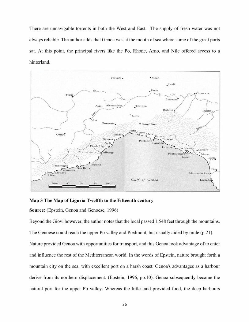
There are unnavigable torrents in both the West and East. The supply of fresh water was not
always reliable. The author adds that Genoa was at the mouth of sea where some of the great ports
sat. At this point, the principal rivers like the Po, Rhone, Arno, and Nile offered access to a
hinterland.
Map 3 The Map of Liguria Twelfth to the Fifteenth century
Source: (Epstein, Genoa and Genoese, 1996)
Beyond the Giovi however, the author notes that the local passed 1,548 feet through the mountains.
The Genoese could reach the upper Po valley and Piedmont, but usually aided by mule (p.21).
Nature provided Genoa with opportunities for transport, and this Genoa took advantage of to enter
and influence the rest of the Mediterranean world. In the words of Epstein, nature brought forth a
mountain city on the sea, with excellent port on a harsh coast. Genoa's advantages as a harbour
derive from its northern displacement. (Epstein, 1996, pp.10). Genoa subsequently became the
natural port for the upper Po valley. Whereas the little land provided food, the deep harbours

37
provided anchorage for ships. The coastal and suitable prevailing winds from northwest provided
clear sailing south and east directions. The Mediterranean winds, the Saharan sirocco from the
southeast and the libeccio from the southwest complemented southwest currents providing Genoa
with an easy opportunity to easy to get in and out of the harbour (John, 1988).
There was a tremendous expansion of Genoa's influence between the twelfth and fourteenth
century. During this period, Genoa established colonial and maritime commercial systems. The
merchant colonies extended to the East while maintaining the capability to access the entire
Mediterranean. According to Kirk (2005), the colonies established around the black sea, the sea of
Azov in Aegean, Iberian Peninsula, England, and Flanders.
Culture, commerce and trade, and state power are the exhibits of the impact of Geography on
Genoa. Individualism was one outstanding culture of Genoese people. A product of a harsh
environment, the society chose selfishness at the expense of generosity — individualism at the
expense of communism. As Greif (1995) notes, the spirit of individualism in Genoa manifested
itself most clearly in the unwillingness of the Genoese to cooperate. Most often, the city frequently
found itself without allies in times of crises. The individual Genoese mirrored the town such that
everyone was expected to make their way in the world for survival.
To cope with individualism, Genoese had early on to develop private property rights to regulate
relations. By the eleventh century, Genoa under Marchese Alberto had been begun to develop
charters governing ownership and disposal of property rights. In 1056, for instance, the land had
an actual market value. As Cole(1938) notes, by the thirteenth century, land ownership was
widespread in Genoa. The author notes that Genoese burgesses owned much real estate in the
countryside as well- houses, woodland, meadow, pasture, olive and fig orchards, vineyards, oak
and chestnut groves. Women, as well as serfs, were permitted to sell or rent estates as they so
wished. A large proportion of the estates of the great merchant's families invested in real estate in
38
and around Genoa. As Margret Cole notes, in Genoa, the land was equivalent to productive
investment and easily converted into liquid capital by sale or mortgage (Cole, 1938).
Commerce and trade became the most exceptional effects of Geography on the Genoese society.
The uncertain environment created individualism hence the need for private ownership of property.
Finally, private property to the formulation of rules necessary for state preservation while
multiplying capital power. To prosper, Genoese had to turn to see. With no capital, they had to
develop capital from a trust. As Epstein notes, to acquire the means of engaging in maritime
commerce developed three capital instruments. This contract is known as commenda, the societas,
and the sea loan (Epstein, 1996, p.56).
The commenda was a commercial contract by which the travelling partner took some capital from
an investor and promised to put this wealth to work in a trading or other venture in exchange for a
fixed part, usually one-quarter, of the profit. As Lopez (1976) notes, a commenda gave young men
with little or no capital to begin life in overseas commerce.
In a societas contract, both partners contributed capital in different ratios. After the business is
complete, the partners deducted the money, and they would divide the net profits evenly. In
Societas, partners, risked wealth, but the one doing the work of travelling received, as an incentive,
a more significant share of the net profit than his capital alone would have justified (Epstein,
Business Cycles and the Sense of Time in Medieval Genoa, 1988)
The distinction between sea loan from ordinary credit was that one partner borrowed money for a
venture and promised to pay back a specific sum significant on condition “upon safe return” (p.
56). The Genoese used these facilities to expand their maritime commerce beyond the horizon of
Liguria.

39
Between 1252 and 1313, Genoa established trade links with important destinations with bolstered
her economic influence at home and away.
Destination 1252-1253 1270 1272-1285 1307 1313 Alexandria 0% 0% 0% 0% 0%Bougie 10.1 0 0 0.8 4Ceuta 0 0 0 0 0Corsica 0.8 0.2 0.5 0.4 0France 25.1 9.3 0.5 0.4 0Genoa 0.2 0 15.5 8.3 11.8Maremma 0.2 0 1.1 0 0Naples 0 6.2 0 0 0.1Oltremare 26.4 26 0.5 24.2 0.7Romania 0 24.5 18.6 18.2 22.2Sardinia 1.3 3.1 2.5 10.7 0Sicily 4.4 15.7 0.3 1.1 5.6Spain 2 1.2 0 0 9.6Tunis 15 0 0 0 0Other 12 0.7 22.7 1.5 7.1Unknown 2.5 13.1 1.1 22.8 3.2
Figure 1 Genoese Trade 1252 to 1313
Source: (Lopez, The economic activity of Genoa in March 1253 according to the notarial acts of the time, 1935)
As Genoese increased their maritime destinations to various overseas territories. Maritime
commerce increased the division of labour, specialisation of trade and industrial transformation.
The sea remained dominant influence over employment, taking up thousands of men as rowers,
builders, and suppliers. On another hand, other industries in textiles, furs and tanning, building,
glass and soap making, and goldsmiths began contributing more to the economy (Heers, 1961).
The emergence of highly diversified economy anchored to maritime commerce led to the rise of
the banking industry which was a significant development in the Genoese economy. By the
fifteenth century, the banking sector had expanded such that the Casa di San Giorgio public funded
bank funded debt of the republic, a new a landmark in the financial history of Europe at the time
(Lopez, 1976). In 1256 for instance, Genoa experienced spectacular bank failures, beginning with
the Negrobono and Calvo banks culminating in the collapse of the Leccacorvo bank in late 1258

40
(Lisciandrelli, 1960). As Lopez notes, the banks took deposits and paid interest. However, they
were mostly in the business of financing trade by moving money and credit around Europe,
especially to the fairs of Champagne, to facilitate the movement of commodities to and from
Genoa.
Trade % Number Trade % Number 1 Silk Weavers 11.6 4058 14 Grease Makers 1.3 418
2 Lanerii 6.9 2418 15 Makers of Silk thread 1.2 410
3 Stretchers of Wool 2.8 993 16 Cotton Workers 1.2 392 4 Wool Workers 2.5 869 17 Bakers 1.1 364 5 Weavers 2.4 846 18 Drapers 1 322 6 Shearers of Wool 2 655 19 Chest Makers 0.9 313 7 Spice Dealers 1.7 604 20 Silk Dyers 0.9 289 8 Silk Merchants 1.7 583 21 Ship Carpenters 0.8 63 9 Cobblers 1.7 578 22 Caulkers 0.2 17
10 Wool Weavers 1.6 560 23 Coopers 0 17 11 Notaries 1.5 524 24 Pitch Makers 0 15 12 Barbers 1.5 514 25 Oar Makers 0 12 13 Food Retailers 1.5 441 26 Shipwrights 0 5
Figure 2 A sample of Professions in Genoa -1451 to 1517
Source: (Gatti, 1980)
The development of paper contracts obviated the need to transport cash across pirate-infested
waters and bandit-ridden mountain passes. A contraction of trade, however, encouraged creditors
to take capital out of the system of credit, precipitating the banking crashes (Lopez, 1976).
To protect the commercial empire, Genoa too had to bolster state power and space for maritime
commerce to survive. The first attempt by Genoa to strengthen state power occurred in 1096 when
the city-state embarked on laying siege at Antioch (Lopez, 1937). The Genoese attempted to
control the sea for the first time. The other areas that Genoa established presence were over
Sardinia and Corsica. The city-state later found a political appearance at Almería and Tortosa.
Genoa succeeded in possessing one-third of two important Spanish towns and be free of customs
and tariffs throughout Castile, Catalonia, and Provence before the end of the eleventh century
(Epstein, 1996, p. 60).

41
In 1160, Genoa established political and economic ties with the Byzantine Empire. The emperor,
Demetrius promised that security and free trade to Genoese merchants throughout the empire.
Through warfare, diplomacy, and sometimes conquest accompanied by spreading out of risk and
investment Genoa expanded the frontier of power while consolidating statehood at home. As
Epstein notes, Genoa took advantage of decline of Romania and Alexandria to establish most
reliable and trade lucrative bases at Antioch Acre, Egypt, Jerusalem, Catalonia, Sicily, Muslim
North Africa, from Tunis westward to Bougie, Ceuta, and eventually the Atlantic port of Safi,
ranked behind the east as the second leading destination of Genoese trade after Antioch (Epstein,
1996,pp.98).
Map 4: The Map of Genoa Twelfth to Fifteenth Centuries
Source: (Epstein, 1996)
Commerce increasingly began determining Genoese power. The two were inseparable. Genoese
shared commercial ties. ianuensis ergo Mercator (a Genoese, therefore, a merchant). As Epstein
notes, to trade entirely free on land and sea, Genoese formed a Compagna for administering justice

42
and fostering trade and prosperity. To build strong navy and army, Genoa developed elaborate
taxation systems to cater for costly activities of the government such as governance, defence,
charity, administration, and delivering justice (Epstein, 1996, pp.38).
Genoa distinguished itself from other city-states in Europe by her ability to integrate state power,
commerce, and trade. At times, violence was used to open new markets and trading outposts (Kirk,
2005). Genoa power grew out of maritime wealth. In the words of John Brewer, money remained
the sinew of war, and the ability to raise finance decided Genoese power in Europe (Brewer, 1983).
2.7 The significance of Geography on Venetian Trade, State power, and Development
The importance of geography on state power, trade, and commerce can best explain the rise and
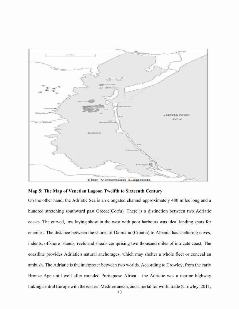
fall of the city-state of Venice from 1000 to 1530 CE. The city of Venice lies in the north most of
the Adriatic Sea. The formation of Venice was in itself a geological phenomenon. Geographically,
Venice is a product of curved bay lagoon called the Gulf of Venice. It was formed along gently
sloping Italian Adriatic coasts and separated from the sea by small islands, reef, and sandbanks
connected to the Adriatic by various inlets (National Oceanic and Atmospheric Administration
U.S Department of Commerce, 2018). At the North most Adriatic River deposits a large quantity
of alluvial material collected from the Alps, which in turn settle to form long stretches of lagoon
and marsh (Crowley, 2011).Crowley notes that Venice emerged in the aftermath of siltation of
Adria as well as flattening of Aquileia, on the coastal plain, by Attila the Hun in 452 making it
unreachable. The smattering of low-lying muddy islets set in a malarial lagoon separated from the
mainland by a few precious miles of shallow water. As a consequence, Venice would become the
entrepôt and interpreter of worlds, the Adriatic its passport (Crowley, 2011, p24).
43
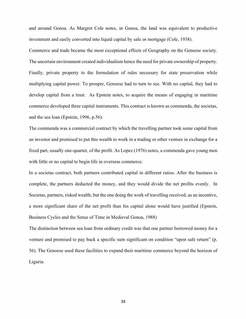
Map 5: The Map of Venetian Lagoon Twelfth to Sixteenth Century
On the other hand, the Adriatic Sea is an elongated channel approximately 480 miles long and a
hundred stretching southward past Greece(Corfu). There is a distinction between two Adriatic
coasts. The curved, low laying show in the west with poor harbours was ideal landing spots for
enemies. The distance between the shores of Dalmatia (Croatia) to Albania has sheltering coves,
indents, offshore islands, reefs and shoals comprising two thousand miles of intricate coast. The
coastline provides Adriatic's natural anchorages, which may shelter a whole fleet or conceal an
ambush. The Adriatic is the interpreter between two worlds. According to Crowley, from the early
Bronze Age until well after rounded Portuguese Africa – the Adriatic was a marine highway
linking central Europe with the eastern Mediterranean, and a portal for world trade (Crowley, 2011,

44
p. 23). The merchant ships used the channel to transport and exchange goods of Arabia, Germany,
Italy, the Black Sea, India and the Far East. Amber bought from the Baltic was sold to Egypt. The
blue faience beads purchased from Mycenae sold to Stonehenge. The Cornish tin sold to the
Levant. The spices of Malacca sold to France. The Cotswold wool was to Cairo. The coast of
Dalamatia promoted the sailing of Timber, slaves, cotton, copper, weapons, seeds, stories,
inventions and ideas (p. 23).
According to Crowley, hundreds of routes converged in the northern Adriatic. The routes from
Britain and the North Sea, down the River Rhine, converged with those across in the Alpine. The
mule trains threaded their way to the top of the gulf, where the merchandise of the East also landed.
The merchandise from East fell to the Greek Adria, then Roman Aquileia, finally Venice.
The geography of Venice provided a catalyst and a series of chain reactions influencing culture,
commerce, trade and state power. Venice was a city grown hydroponically. The city sunk in mud
resting on oak palings. The impermanence of Venice made it fragile to the waves of the sea
conjured out of the marsh, existing perilously on oak palings sunk in mud (Norwich, 1977). The
salt pans were beyond the mullet and eels of the lagoon. The city-state produced nothing – no
wheat, no timber, and little meat. It was vulnerable to famine; its skills were navigation and the
carrying of goods (Crowley, 2011, p.24).
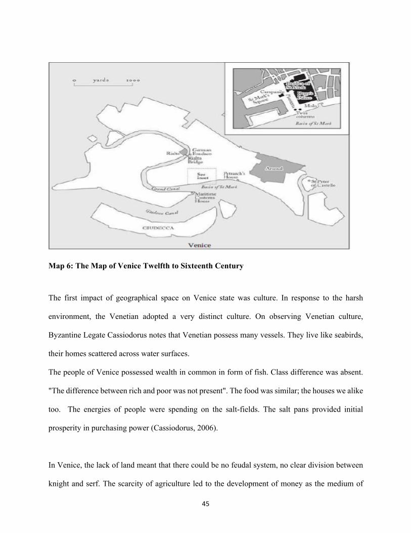
45
Map 6: The Map of Venice Twelfth to Sixteenth Century
The first impact of geographical space on Venice state was culture. In response to the harsh
environment, the Venetian adopted a very distinct culture. On observing Venetian culture,
Byzantine Legate Cassiodorus notes that Venetian possess many vessels. They live like seabirds,
their homes scattered across water surfaces.
The people of Venice possessed wealth in common in form of fish. Class difference was absent.
"The difference between rich and poor was not present". The food was similar; the houses we alike
too. The energies of people were spending on the salt-fields. The salt pans provided initial
prosperity in purchasing power (Cassiodorus, 2006).
In Venice, the lack of land meant that there could be no feudal system, no clear division between
knight and serf. The scarcity of agriculture led to the development of money as the medium of

46
exchange. The uncertain environment of life bound all its people together in solidarity dictating
self-discipline and a measure of equality (Greif, 1995).
Venice was found between the land and the sea. The city-state existed between two worlds. The
east and west, while belonging to none (Norwich, 1977). Venice grew up a subject of the Greek-
speaking emperors in Constantinople and drew its art, its ceremonies and its trade from the
Byzantine world. On another hand, the Venetians were Latin Catholics. They resisted tyrannous
solutions to government. The action of the Doges (leaders) was highly restricted. The government
of the city-state desired to promote trade wherever profit was available without favour or fear
(Crowley, 2011, p. 25).
Geographical space had a significant impact on Venetian culture. First, it led to the emergence of
distinct Venetian culture. The culture in itself was not static. With increasing space and evolving
physical environment so did the Venetian culture (Burke, 2000). As Pietro Casola notes, Venice
was sterile but visibly abundant; the culture was physically fragile; free from feudalism but fiercely
regulated. Its citizens were sober, unromantic and frequently cynical, yet they had conjured a city
of fantasy. Venetian cultural space grew to become a virtual cultural space. The Gothic arches,
Islamic domes and Byzantine mosaics transported the observer simultaneously to Bruges, Cairo
and Constantinople. Casola notes, Venice seemed self-generated. The only Italian city not in
existence in Roman times, its inhabitants had created their antiquity out of theft and borrowings;
they manufactured their foundation myths and stole their saints from the Greek world (Casola,
1907).
While interacting seriously and continuously with Islam, Venice promoted the seepage of oriental
tastes, ideas and influences – as well as certain romantic orientalism – into the European world
through Visual ideas, materials, foods, motifs and words passed through its maritime customs post
(Fabri, 1892).

47
The second impact of geography on the state of Venice was trade and commerce. It is out of the
limited geographical space that Venice found a trade as an instrument of survival. As the Byzantine
Historian Laonicus Chalcondyles notes, the people of Venice neither have any foothold on the
mainland nor can they cultivate the earth. They are compelled to import everything they need by
the sea — it through trade that they have accumulated such great wealth (Chalcondyles, 2011).
With little livelihoods at home, Venetians embarked on to search survival beyond their territory
and the horizons of the sea. First, they expanded their influence over the Adriatic Sea which
enabled them to develop the complex trading system with the Eastern empires. The state
understood that her growth and survival lay far beyond the waters of the lagoon. By mastering the
sea and expanding survival space Venice laid foundation of future wealth and power by
establishing trading links in Alexandria, Syria, Constantinople and the Barbary coast of North
Africa, where spices, silk, cotton, glass and luxurious commodities from East sold to northern Italy
and central Europe (Crowley, 2011, p. 25).
According to Historian William Roscoe Thayer, despite many political upheavals and war in
Venice, commerce was the real business of Venetian life. The scholar notes that Venetian ships
moved across Adriatic, Mediterranean, up the major Italian rivers trading with Greek and Arab,
with Prank and Saxon and Slavs. Further, the leadership was keen on devising, safeguarding and
extending trade to new frontiers (Thayer, 1908).
By strategically expanding geographical space, Venice ascended to fame and wealth through
Trading by sea, using a large number of spices brought in and which foreigners came from
everywhere to buy. Venice managed to transform and tilt space to its favour to the extent of
transforming global trade and commerce. Crowley notes, Venice sharpened the sense of material
desire and facilitated the long-range exchange of goods that satisfied it. As a consequence, become
the central cog that meshed two economic systems – Europe and the Orient – shunting goods across

48
hemispheres, facilitating new tastes and notions of choice. Venice expanded space placed in on
the core of being the middleman and interpreter of worlds (Crowley, 2011, p. 330).
Venice strategically expanded her geographical space by adopting a policy that ensured that the
object of Venice should not necessarily be conquest but commerce. In Thayer's view, this explains
why commercial considerations purely guided the acquisition of colonies by Venice as a principle
that governed her expansion (Thayer, 1908).
By mastering space, Venice was able to trigger a chain of demand and supply creating an empire
that lay in the abstract. This empire led to the blossoming of trade routes and their flourishing cities
such Cairo, the Black Sea, Damascus, Beirut, Baghdad, Smyrna, ports of the Red Sea and the great
cities of the Levant, the great Constantinople. These were linked to other European markets such
as Lisbon, Hungary, Germany, and France by the interpreter of the worlds (Priuli, 1921).
The triggers of demand and supply beyond extending the frontiers of the empire had two other
significant effects. First, the outcome was the development of the regulated formal economy. As
Crowley notes, the Venetian business of the maritime commerce was managed as consistently by
regulation, continuous oversight and recourse to law. The control of trade replicated in miniature
all the normal workings of the whole state and was strictly attended to by the doge and ducal
council (Crowley, 2011, p.225). The elected officials monitored, inspected, organised and fined
both the state and the private sectors: they investigated crews, checked cargoes and collected
custom and freight dues, rated loading capacities and handled legal disputes between shippers,
masters and crew. The protection methods of the maritime trade were mostly policing of rules,
regulation, enforcement of trade policies (Thayer, 1908).
The second effect was that increasing the exchange of goods and services triggered by market
forces of supply and demand hastened the decline of the economic power of the Islamic Middle
East and the rise of the West.

49
According to Ferraro (2012), the Venetian state was able to establish hegemony in Adriatic and
then founded colonies in the Aegean and Mediterranean. The crusading expedition in Cyprus,
Syria, Israel, Cyprus, Palestine and Jordan by supplying ships, food, and money in the process
profiting from long-term travel and exchange made the city-state to become more wealthy
As Crowley note, over centuries many of the industries that had made the Levant so wealthy – the
manufacture of soap, glass, silk and paper, the production of sugar – were either usurped by the
republic or undermined by its transport systems. Venetian merchants moved from buying Syrian
glass to importing the critical raw material – soda ash from the Syrian desert until the superior
glass of Murano was being re-exported to Mamluk palaces. Soap and paper-making followed the
same trend. Sugar production moved from Syria to Cyprus, where Venetian entrepreneurs
employed more efficient production processes to supply western markets (Crowley, 2011, p.331).
Acquisition of state power is the third impact of geographical space on Venice state. To bolster
state power, Venice manipulated space by combining the social organisation of labour alongside
the network of capital, trade and production chains. Social organisation was buttressed by military
power in the form of defensive and coercive capabilities as a consequence of social organisation
and concentrated lethal force. In the Venice case, commerce and military capability had symbiotic
relations. In areas where trade and business were not spatially able to expand, coercive military
force was used to clear the way in protecting maritime interests of the state. The state, on the other
hand, benefited by acquiring more wealth that used to modernise the army and development of
new technologies and industry (Thayer, 1908).
The first limitation of state power to Venice is space. In the lagoon, the geographical area limited
the growth of Venice economically, politically, and military. To overcome the limitation Venice
had to expand its operational space. The new experiment of capturing new area began in 1000
AD. It is during this period took control of Adriatic after clearing the sea of the Narentine pirates
must provide free passage for Venetian ships to the outside world. The activity that took over 150
50
years to accomplish now bequeathed Venice ascent to wealth, power, and Maritime glory
(Crowley, 2011, p. 26).
The experiment did not end at the mouth of Adriatic. By slowly usurping Byzantine power in the
Eastern Mediterranean through the combination of warfare and commerce, Venice established a
presence at Athens, Salonica, Thebes and Antioch and Ephesus, the islands of Chios and Euboea,
principal harbours along the coasts of southern Greece such as Modon and Coron and eventually
Constantinople the capital of Byzantine Empire. Each of the acquired spaces provided valuable
staging posts for the Venetian maritime empire.
Among these spaces, Modon, Coron, Crete, and Negroponte were most valuable. As Crowley
notes, these centres became the Axis of Venetian Maritime Empire. Modon and Coron were twenty
miles apart. These two according to Crowley were so critical to the Republic's maritime
infrastructure popularly called ‘the Eyes of the Republic'. The two became vital stepping-stones
on the great maritime highway and Venice's radar stations collecting intelligence from all ships
returning from the Levant on pirates, warfare and the price of spices (Crowley, 2011, p. 119).
Modon had encircling harbour capable of receiving the most massive ships for arming, ship repair
and collect goods from warehouses. As Crowley notes, Modon and Coron were the turntables of
the Venetian sea. From here one route headed east. The other, more essential trunk route led south
via the barren stepping-stone islands of Cerigo and Cerigotto to Crete – the hub of the Venetian
system.
The other crucial spatial acquisition was the Island of Crete. As Crowley describes it, Crete was
an Island, ninety miles long, lying across the base of the Aegean like a limestone barrier buffering
Europe from the African shore (p.120).
Crete was the nerve centre of the Venetian Maritime Kingdom. It was 25-day sail from Venice.
According to Crowley, Crete was at the crossroads of the Republic's two great trading routes –
those that led to Constantinople and the Black Sea, and those that went on to the spice markets of

51
Syria and Egypt. He adds that the Island was the back station for supplying the crusader ports of
the Holy Land; the place for warehousing and trans-shipping goods; for repairing and re-
provisioning the merchant galleys; for naval operations throughout the Aegean in times of war
(p.123).
According to Ferraro (2012), Crete close to Haifa in Levante became the most significant home to
Venetian estates that produced grain, wine, oil, and fruits and marketed back in Venice as well as
in Jaffa, Acre, and Damascus.
Another significant spatial acquisition was on the eastern coast of Greece known as the Negroponte
otherwise known as (the black bridge). As Crowley notes, Negroponte is a long ribbon of land,
mimicking the rhythm of the mainland into which it interlocks, but separated from it by a drowned
valley, the Euripus, which comprises a minor wonder of the marine world. According to
Ferraro(2012), the Black Bridge between Crete and Constantinople, served as a commercial
stepping-stone to Crete, which was purchased and parcelled out to soldiers, landlords, and
merchants. The narrow channel acts as a hydraulic ram, pumping the water through in a series of
tidal bores at the rate of fourteen a day, seven in each direction at its narrowest point, where the
island and the mainland are separated by a strait only fifty yards wide, the water surges with the
speed of a mill race. The Venetian established Greece settlement of Chalkis at this point. The
harbour and bridge protected the settlement of Chalkis. The dock and bridge linked Chalkis to the
mainland that was surmounted, halfway, by a fortified tower and a double drawbridge to seal the
island from intruders (Crowley, 2011, p. 295).
The acquisition of new spaces had two major significant effects on Venetian state power. This
effects were first the establishment of Venetian military complex and second the development of
bureaucracy to bolster the Venetian state power. The need to protect acquired strategic spaces for
commerce and wealth forced Venice to establish a military complex to deal with the security
challenges of its day. For these reasons, the eastern edge of the city was chosen to serve as a site

52
for state building of boats, and merchant and war galleys, the vehicles that connected the floating
city with the broader Mediterranean and the northern European world (Ferraro, 2012). According
to Ferraro, the emergence of arms industry symbolized Venetian growing commercial and naval
strength as well as the city's most significant development in the medieval industry
By 1500, Venice was capable of building, arming, provisioning and launching eighty galleys at
speed superior to any rival. According to Crowley "the ‘Forge of War' manufactured all the
maritime apparatus of the Venetian state". It provided dry and wet docks, hangars for building and
storing galleys, carpenters' workshops, rope and sail factories, forges, gunpowder mills, lumber
yards, and storehouses for every component of the process and the associated equipment (p.241).
The enormity of the military is captured well by Tommaso Mocenigo oration albeit with
exaggeration. According to Mocenigo narration, Venice owned three thousand vessels of smaller
burden, seventeen large ships, carrying eight thousand seamen; and five-and-forty galleys always
in commission for the protection of commerce (Mocenigo, 2011).
The development of state bureaucracy was another impact of Geographical space on Venetian state
power. The administration comprising of elected leaders and council, state official monitored,
inspected, organised and fined both the state and the private sectors: they inspected crews, checked
cargoes and collected custom and freight dues, rated loading capacities and handled legal disputes
between shippers, masters and crew (Norwich, 1977).
As Crowley notes, the central governing body of Venice called the Savii controlled and organised
voyages for trade. The council planned the economy for the coming year, based on a continuous
stream of intelligence about threats of war, the political stability of destinations, the state of
markets and food stocks and the level of piracy. They could formulate rules fleet sizes, routes,
landing stages, duration of stops, freights to be carried and freight rates. Transport regulations for
high-value cargoes. The transportation of cloth, cash, bullion or spices and the conveying of
important state functionaries, ambassadors and foreign dignitaries (Greif, 1995).

53
2.8 Literature Gap
The available literature on the divergence of state power between Africa and Europe overtime has
mainly been informed by social, economic, and political accounts of Africa and Europe. It is the
view of the study that these accounts do not go far enough to provide a holistic view of variables
intersecting between spatial and non-spatial context. The patterns of differences between the
attributes of state power and development have far more significant underlying factors. They too
can be explained by exogenous factors beyond social, economic, and political dynamics within
these two regions (Sachs & McCord, 2015).Notwithstanding political, economic and social
accounts on the origin of the existing power asymmetries between Africa and Europe, spatial and
geophysical factors have been left out of the equation hence the goal of the study
2.9 Theoretical Framework of Analysis
In attempts to explain world society's development and cultures, political geography field has adopted
various approaches. There are at least three significant frameworks that will be used to rationalise the
problem statement in this study. These include environmental determinism; possibilism or cultural
determinism"; probabilism or cultural ecology. The study will also use Wallenstein World-systems
theory, Mackinder heartland theory; Spykman Rim-land theory and Mahan theory of Sea power.
According to the Environmental determinist human cultures and individual decisions are influenced
by environmental, climatic, and geographical factors (Briney, 2017). Environmental determinism
theory has been championed by Friedrich Ratzel an outstanding German geographer regarded as the
world pioneer of political geography and geopolitics. In his pioneering work political geography,
Ratzel posits that the state and the nation, like a living organism, undergoes successive phases of
development, from simple forms towards more complex ones. This development takes place in the

54
framework of confrontations and military struggles for domination and living space (Lebensraum)
(Eberhardt, 2015).
Illustration of Ratzel’s Organic theory
Source: (Weebly, 2018)
In Ratzel views, "state" is compared to an organism. He emphasises the fact that a state, like some
simple organism, must either grow or die and can never stand still. He further states that the reflection
of internal strength is witnessed when frontiers of the stronger state extend at the expense of a weak
state. The superior nations thus ruling over the inferior peoples fulfil a natural organic
necessity(Ratzel,2017).
Contrary to environmental determinism, the school of determinism rejects environment as a
controlling influence. It claims that development and culture are the results of human agency and
action and that the environment is mostly a non-issue. Paul Vidal de Blache father of the French
school of human geography notes that the elevation, weather, drought, humidity influences
physiological organisation and adaptation of plants in various ways. Plants learn to modify their
exterior features per open landscape, ground, light, food and space. Similar to plants, human
societies find advantage and profit in joining and uniting to dislodge the other (Desbiens, 2012).

55
Balche counters the narrow theological view of progress concluding that there are many possible
outcomes to the interaction between human societies and their environment. He notes, that
geographical unit is not only constituted by Geography and Climate or nature (Desbiens, 2012).
He argues that we must begin with the idea that a region is a reservoir where various potentials lay
dormant, and if their seed was deposited by nature, the use of these potentials depends on Man. By
moulding these energies, the individuality of region comes forth, like a medal imprinted with the
image of a people (Desbiens, 2012).
On its part probabilism or “cultural ecology”, is a compromise or synthesis of Environmental
Determinism and Cultural Determinism. Friedrich Ratzel advances the environmental determinism
approach. On the other hand, Vidal de la Blache champions cultural determinism (Mercier, 2009).
In work his Anthropo-geography, the scholar observes that beside environment, culture plays a
critical role in determining development. He popularises the importance of the diffusion of culture
by migration and by borrowing.
According to Vidal broad range of opportunities, preferences, and choices of man can be
influenced by flexible geography. Nature does not require passive obedience for a man to comply
with every demand. Instead, there abound many opportunities that man can promote through
specific actions and choices. (Mercier, 2009, pp.147-150).
Mercer (2009) notes, it is Vidal's view that social life tends to extend beyond limits of the natural
region which occurs at a higher civilisation and spatial organisation stage. In Vidal's perspective,
the establishment of trade networks is influenced by contacts between neighbouring and adjacent
regions. In this regards, one cannot consider the different parts of the Earth as lifeless juxtaposition,
but as reciprocal centres of acting forces. According to Vidal therefore, any difference, any
inequality, and hence any contrast is a reason for mutual exchanges and relationships. Human
desires are aroused, and needs are fulfilled when natural forces tend to re-establish the upset

56
(Ratzel, 1896b). The scholar observes that reciprocal demands such as the division of terrestrial
land predetermines force relationships between societies into a different natural region to a certain
extent (Ratzel,1902). The dependency of one region was influenced by increasing circulation and
regional division of labour.
World Systems theory
Immanuel Wallerstein formulated the world systems theory. In his opinion, Wallerstein develops
a theoretical framework to understand the historical changes involved in the rise of the modern
world (Wallerstein, 1974). He opines that the current modern world system with capitalist
orientation arose out of the feudal crisis in Europe. The feudal turmoil between 1450 and 1670
explains the rise of Western Europe to the world.
According to Wallerstein, Wallerstein Europe moved towards the establishment of a capitalist
world economy to ensure continued economic growth. The growth of Western Europe was only
possible through the expansion of the geographical size of the world in question through modes of
labour control and the creation of relatively stable state machinery. The scholar notes that in the
fifteenth and early sixteenth centuries following feudal crises, there was the emergence of a world
economic system. The national and political boundaries were superseded through a system that
encompassed the whole world (Wallerstein, 1974, p.15). According to Wallerstein, the new world
economy differed from earlier empire systems because political boundaries did not limit it.
Traditionally, the flow of goods from the periphery to centre was directed by Empires who through
force maintained a commercial monopoly. The commercial monopolies did exist within the
specific political boundaries and which was controlled by a standing army and vast bureaucracy.
The emergence of capitalism unleashed techniques that bolstered political and economic frontiers
beyond the limits of empire.
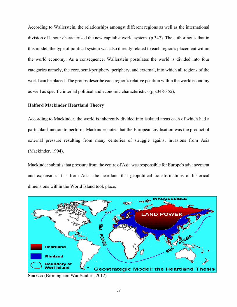
57
According to Wallerstein, the relationships amongst different regions as well as the international
division of labour characterised the new capitalist world system. (p.347). The author notes that in
this model, the type of political system was also directly related to each region's placement within
the world economy. As a consequence, Wallerstein postulates the world is divided into four
categories namely, the core, semi-periphery, periphery, and external, into which all regions of the
world can be placed. The groups describe each region's relative position within the world economy
as well as specific internal political and economic characteristics (pp.348-355).
Halford Mackinder Heartland Theory
According to Mackinder, the world is inherently divided into isolated areas each of which had a
particular function to perform. Mackinder notes that the European civilisation was the product of
external pressure resulting from many centuries of struggle against invasions from Asia
(Mackinder, 1904).
Mackinder submits that pressure from the centre of Asia was responsible for Europe's advancement
and expansion. It is from Asia -the heartland that geopolitical transformations of historical
dimensions within the World Island took place.
Source: (Birmingham War Studies, 2012)

58
Mackinder notes that Heartland was in the most advantageous geopolitical location. Asia is the
centre of the world. The heartland is within the Eurasian continent. In this regards, he submitted
that who rules Eastern Europe commands the Heartland, "Who rules the Heartland commands the
World Island, who rules the World Island commands the world" (Mackinder, 1904)
According to Mackinder, the heartland included the river basins of the Volga, Yenisey, Amu
Darya, Syr Darya, the Caspian and the Aral Sea. In Mackinder's view, the world can sustain large
populations of people as well as being shielded from sea attack. The mobility within the heartland
provided by camels and mules could aid assaults in Europe (Mackinder, 1943)
According to Mackinder, the Pivot the natural centre of force is composed of the inner crescent
coinciding with the Eurasian coastal areas comprising of Europe and Southern, Southwestern, and
Eastern Asia (Pletniova, 1982)
The Rim Land Theory
The Rim Land theory was formulated and advanced by the geostrategist Nicholas Spykman in his
book America’s Strategy in World Politics. The approach combines thoughts of Halford
Mackinder espoused in the heartland theory and theorist Alfred Thayer Mahan on the theory of
sea power. According to Spykman, Eurasia's rimland, the coastal areas, is the key to controlling
the World Island. This is because the rimland contains the Heartland. In the words of Spykman,
“Whoever would control the rimland, would eventually control the World Island. Whoever would
control the World Island would soon control the world (Spykman, 1942).

59
The Rimland theory illustration
Source: (Weebly, 2018)
Alfred Thayer Mahan theory of Sea Power
The significance of geography on state power, trade, and commerce is well articulated in Mahan's
theory of sea power. Admiral Alfred Thayer Mahan is regarded as one of the most outstanding
thinkers on naval warfare and maritime strategy. Though the study of naval history, Mahan brings
to the fore the theory of Sea Power. Mahan examines the role played by navies in determining the
outcome of wars fought by the great European powers during the period between the end of the
seventeenth and the beginning of the nineteenth centuries, and which remain valuable for their
insight into sea power and strategy (Maurer, 2016).
According to Mahan, whoever controls the sea, controls the world. To illustrate this idea, Mahan
notes that Great Britain's economic, military and political strength was the direct result of its naval
force. The empire maintained both a combat fleet and a merchant fleet. The merchant capabilities
were just as important, as they provided wealth and means of supply (Oglesby, 2018).

60
In his theory, Mahan equates Sea to a highway. According to Mahan, the Sea can also be extensive
ordinary serving travellers in different directions. The lines of travel are called trade routes. A sea
is a dangerous place. Notwithstanding the perils of the sea, water has always been more accessible
and cheaper than by land. For instance, Mahan notes that it was because of many waterways and
inlets providing interior access of both Netherlands and Germany for the exchange of commerce
that the two countries developed. The commercial greatness was born out of maritime trade. The
advantage of Sea travel is that carriage by water over that by land is outstanding where or periods
when roads were few and terrible, frequent wars and society unsettled as during the medieval
period. (Mahan, 1890)
According to Mahan, the principal factors affecting the sea power of nations comprises
Geographical Position, physical conformation, climate, the extent of territory, number of
population, character of the people, character of the Government, including therein the national
institutions. The study will look at the first four.
Geographical Position
According to Mahan theory, a nation that does not to defend itself by land or by extending its land
territory surrounded by sea has more advantage compared to those that do not. The admiral notes
that the geographical position favours the concentration of its forces, as well as giving a further
strategic power of a central location and a good base for hostile operations against its probable
enemies. A country with a geographic position that allows easy access to Sea, while at the same
time controlling critical trade networks and traffic such geography contributes significant strategic
value to the respective state (Mahan, 1890, pp. 54).
To emphasise the role of geography in Sea power, the author notes that powerful nations always
endeavour to control the Mediterranean Sea. The desire of powers to control the sheet of the sea

61
is informed by natural commercial and military advantage of the Mediterranean (Mahan, 1890, pp.
57).
Physical Conformation
According to Mahan, the development of sea power is highly influenced by the unique features of
the Gulf coast. The seaboard of the state plays a critical role in allowing contact with the outside
world. The seaboard without good harbours limits sea trade, shipping, and development of the
navy. Mahan notes that ports are a source of strength and wealth. The presence of navigable rivers
facilitates the development of internal trade. However, if not well defended, their very accessibility
and wealth become a source of weakness in war (Mahan, 1890, pp.58). According to Mahan,
countries that are surrounded by sea or separated by sea into two or more parts may acquire
strength to sea power. However, if not controlled, they become powerless (Mahan, 1890, pp.62).
Climate
According to Mahan, favourable climate-meaning climatic conditions that favour land to produce
more than what people need may reduce the eagerness of states to take to the sea in search of
livelihood and power. While explaining the origin of Britain naval supremacy over French, the
admiral notes that England in comparison to France, had very little from nature until her
manufactures were developed. The desire for more land by the British was as consequence poor
land at home. The desire to survive and cater to their wants forced them to seek a solution in the
maritime enterprise. It is out of the need that England produced merchants, colonialist,
manufacturers and finally producers all connected by the sea.
Similarly, more than eight of the population could not be supported by the soil of Holland.
According to Mahan, the Dutch were driven to fishing as a consequence of poor soils and the

62
exposed nature of the coast. Fish provided food as well as the source of revenue from exports
(Mahan, 1890, pp. 59-60).
Extent of Territory
According to Mahan (Mahan, 1890, p. 65), sea power should be considered miles which as
constituting the length of coastline and accompanying nature of harbours. The size of the sea coast
can be a source of strength or weakness depending on whether the population is large or small
geographical and physical conditions being constant. The extensive network of inland water
communications which favours the deep concentration of the enemy.
63
CHAPTER 3
METHODOLOGY 3.0 Research Design
3.1 Research Type
The study is longitudinal exploratory research. By conducting an exploratory longitudinal survey,
the research intended to discover relationships between variables that are not related to various
background. By exploring the significance of geography on commerce, trade, and state power the
study allows the researcher to observe how the variables of the study have changed over time.
Exploratory research has been ideal as a starting point of depth analysis on the correlation between
space, state power, and development in future studies. The exploratory analysis has been suitable
in making empirical investigation where known information is limited. Exploratory research has
also been ideal in investigating a problem where there exist general knowledge in community or
academia that is not scientifically rigorous on the subject matter (Steinberg & Steinberg, 2006).
3.2 Research Approach
The study adopted qualitative and quantitative approaches to exploratory research. The qualitative
method was used for assessment of the researcher's insights, impressions, literature and opinions
of authorities on the problem statement. In this case, the research began by reviewing literature,
developing a conceptual framework, problem statement, objective of the study, and research
questions. The quantitative approach was used to generate empirical data quantitative for
quantitative analysis crucial for an in-depth understanding of problem statement especially in
geospatial context (Kathori, 2004).

64
The qualitative approach was very core to this particular study. A qualitative approach was critical
in providing descriptions of complex phenomena; providing a background understanding of unique
patterns observed in the problem statement. More importantly, in this particular study, the
approach has been used in initial explorations on the problem statement and subsequently research
questions (Austin & Sutton, 2014).
In the study, the quantitative approach has been used to collect data on independent and dependent
variables for in-depth analysis. It has been used to relate and determine the extent of the strength
of association or correlation between variables used in the study. The ability of this methodology
to provide casual inferences have been useful in limiting the overgeneralization of findings on the
research problem to objective facts that can be useful for future studies (Esperón, 2017).
3.3 Qualitative Approach
The analysis of historical secondary data by leading authorities on the subject matter is through a
qualitative approach. While examining the link between geography, State Power and Development
qualitatively, the study is cognizant of the fact that historical information is not able to be
manipulated by use of independent variables to establish causal relationships as in natural sciences.
The study relied on the scholarly observation of authorities on the subject area to document the
significance of geography on commerce, trade and state to establish definite causality (Rand
Corporation, 2018).
3.4 Quantitative Approach
The study sought to examine state power and development in the context of space (geography).
The spatial component is central to the quantitative analysis of the study. The standard statistical
analyses were not likely to provide accurate results if applied to the spatial problem. Unlike the
standard statistics, spatial statistics do not only happen on the X and Y axis. According to (Andy,

65
2005). Spatial statistics integrate space and spatial relationships directly into their mathematics
such as area, distance, and length. The study adopted the Geospatial information system mode of
quantitative analysis. The quantitative geographical information system allows for the correlation
of both qualitative and quantitative data in spatial or geographic context (Steinberg & Steinberg,
2006).
3.5 Quantitative Research Design
The design will be in three phases. These are the conceptual framework for spatial analysis,
methodological context, data exploration and spatial statistics, surface and local statistics, network
and regional analysis, and geo-visualisation (Smith, Goodchild, & Longeley, 2018).
3.6 Framework for Spatial Analysis
The framework for the spatial analysis of the study is based on three pillars. These are Basic
primitives, spatial relationships, and spatial statistics (Smith, Goodchild, & Longeley, 2018).
The basic primitives refer to the building blocks of spatial analysis. They include place, attributes,
objectives, maps, multiple properties of areas, fields, networks, density estimation, detail
resolution and scale, and topology (Smith, Goodchild, & Longeley, 2018).
The spatial relationship pillar includes co-location; distance, direction and spatial weights
matrices; multidimensional scaling, spatial context, neighbourhood analysis, spatial heterogeneity,
spatial dependence, spatial sampling, spatial interpolation, smoothing and sharpening (Smith,
Goodchild, & Longeley, 2018).
The spatial statistics will be used in the application of statistical concepts and methods to data with
the explicit spatial structure in interpreting that data. They will include spatial probability,
probability density, uncertainty, statistical inferences. (Smith, Goodchild, & Longeley, 2018).

66
3.7 Methodological Context
The methodological context was based on five pillars. These are analytical methodology, spatial
analysis process, geospatial analysis and model building. The methods also comprised of data
exploration and spatial statistics; surface and local statistics; network and local analysis and geo-
visualisation of data (Smith, Goodchild, & Longeley, 2018).
3.8 Research Scope
The scope of research is within African locations (30° N, 10° W), (30°N 40° E), (10°N, 30°E), (10°N,
40° E) I and European locations (60°N, 15°W) (60°N, 30°E), (40°N, 15°W), (40°N, 30°E)
3.9 Data Sources
The study heavily relied on the Raster data obtained from various historical sources. In particular,
the study relied on trade maps are drawn by the early historians of the regions under the study. In
selecting the maps, the study considered historical records on the boundaries of the city-states and
the empires of those study. Trade networks and connectivity were considered while selecting
Raster data. The vector data used in the analysis were obtained from the global geographical grid
provided by the United States geological survey and Esri geographical information system
company. Through the use of ESRI resources, the spatial weights matrix is a representing spatial
structure of data was obtained (Mitchelle, 2005). In this case, the weight matrix refers to the
quantification of the spatial relationships that exist among the features in the study data set. The
study used binary strategies namely fixed distance, K nearest neighbour, for creating weights to
quantify the relationships among data features (Getis & Aldstadt, 2004).
67
3.9.1 Sample and Sample Techniques
The sample frame constituted the entire area under study forming African locations (30° N, 10° W),
(30°N 40° E), (10°N, 30°E), (10°N, 40° E) and European locations (60°N, 15°W) (60°N, 30°E),
(40°N, 15°W), (40°N, 30°E). Within the sampling frame area, purposive non-probability sampling
techniques were used for specific local spatial analysis. The chosen space from the sample framework
for regional spatial analysis includes (Kingdom of Mali), 14.8128° N, 5.5030° W. (Kingdom of
Songhay), 17.5707° N, 3.9962° W. (city-state of Venice), 45.4408° N, 12.3155° E (city-state of
Genoa),44.4056° N, 8.9463°E. This was to enable the researcher to deliberately choose population
(Space) to be used for analysis in the study. The deliberate choosing of space (Population) has been
informed by available documented historical data in the selected geographical area. The unavailability
of even historical data for correlation of qualitative and quantitative data in the area chosen has
rendered probability sampling impossible. Available historical and cartographical data have informed
the selected borders.
3.9.2 Data Collection Methods
The data collection methods comprised secondary Vector and Raster model. The Raster data is where
information is stored using a single feature known as cell or pixel. (Steinberg & Steinberg, 2006). The
Raster data collection method, various maps and aerial photographs, images in hard media were
scanned, georeferenced to provide a geographic context for other data (Steinberg & Steinberg, 2006).
The scanning was done using in-depth resolutions. The Raster data was converted to vector data for
analysis. In cases where enough data was not provided through scanning, remote sensing technique
from the third party was used to provide information on space under investigation without physical

68
contact. Through remote sensing method, information is gathered from an amount of electromagnetic
radiation emitted, and scattered from different objects. Data produced from the remote sensing
method is consistent, available for systematic global coverage, and can be repeated in cycles. (GIS
data Collection, 2018)
The vector data is whereby objects on the map are represented by three features namely point, line,
or polygon. The study collected vector data through digitisation of maps and aerial photographs.
Further vector data collection was used in photogrammetry technology. Photogrammetry technology
is the science and technology of making measurements from pictures, aerial photographs, and images.
(GIS data Collection, 2018)
3.9.3 Data Collection Tools
The study used ArcGIS software for data collection and analysis. ArcGIS mapping and analytics
software enable for data analysation, and visualisation of spatial data. The software was used in taking
accurate measurements, spot patterns, and identify spatial relationships (ESRI, 2018).
The ArcGIS software also facilitated Imagery and Remote Sensing of geographic information while
enabling the collection, processing, managing, and sharing imagery. The ArcGIS was also useful in
promoting mapping and visualization in discovering spatial relationships between various variables
of the study (ESRI, 2018).
3.9.4 Data Analysis Methods
The data analysis used in the study has taken into consideration of variables under investigation. In
this case, the study sought to examine how geography impacts commerce, trade, and state power.
There are three significant variables — geography, commerce and trade, and state power. To
adequately understand the interactions of the variables, the study placed Waldo Tobler's first law of
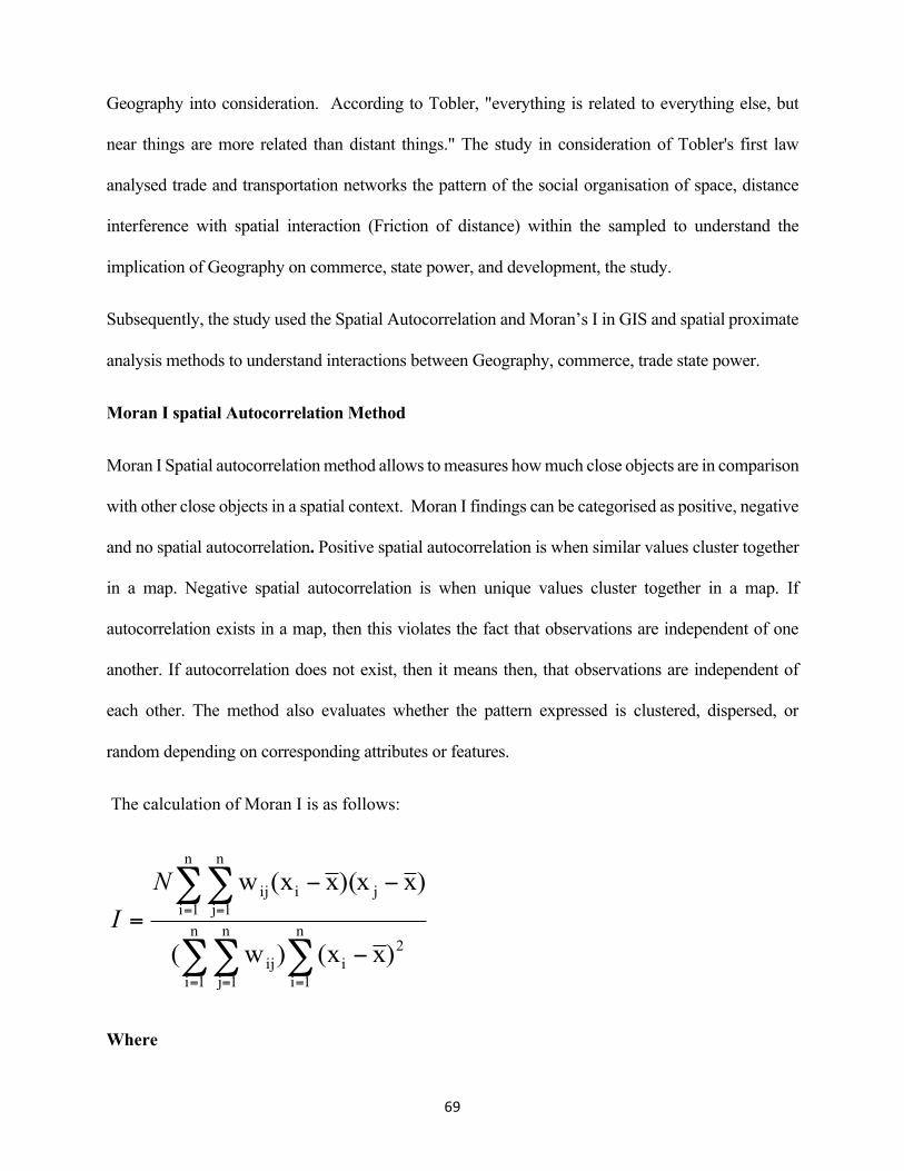
69
Geography into consideration. According to Tobler, "everything is related to everything else, but
near things are more related than distant things." The study in consideration of Tobler's first law
analysed trade and transportation networks the pattern of the social organisation of space, distance
interference with spatial interaction (Friction of distance) within the sampled to understand the
implication of Geography on commerce, state power, and development, the study.
Subsequently, the study used the Spatial Autocorrelation and Moran’s I in GIS and spatial proximate
analysis methods to understand interactions between Geography, commerce, trade state power.
Moran I spatial Autocorrelation Method
Moran I Spatial autocorrelation method allows to measures how much close objects are in comparison
with other close objects in a spatial context. Moran I findings can be categorised as positive, negative
and no spatial autocorrelation. Positive spatial autocorrelation is when similar values cluster together
in a map. Negative spatial autocorrelation is when unique values cluster together in a map. If
autocorrelation exists in a map, then this violates the fact that observations are independent of one
another. If autocorrelation does not exist, then it means then, that observations are independent of
each other. The method also evaluates whether the pattern expressed is clustered, dispersed, or
random depending on corresponding attributes or features.
The calculation of Moran I is as follows:
Where
∑∑∑
∑∑
== =
= =
−
−−
= n
1i
2i
n
1i
n
1jij
n
1i
n
1jjiij
)x(x)w(
)x)(xx(xwNI

70
N- The number of observations (Points or Polygons)
x̄- Mean of the Variable
Xi - The variable value at a particular location
Xj –Variable of another location
Wij- A weight indexing a location of I relative to J
In Moran's method, Index value near +1.0 indicates clustering while an index value near -1.0
indicates dispersion. The features exhibit a clustered pattern when the index value is greater than
zero. The study features exhibit a dispersed pattern when the value is less than zero.
3.9.5 Proximity Analysis Methods
The proximate analysis was used to investigate the proximity of relationships in the sampled
spaces further. In the study, a buffer of 3000KM was used to delineate sampled zones to show
areas of influence.
3.9.6 Research Validity
The review ensures that there exists a relationship between variables used in the study with techniques
used in data analysis.
3.9.7 Research Reliability
The study provides a consistent quality measurement to ensure that the measured outcome will remain
similar in results will be obtained if similar methodology is followed.

71
CHAPTER FOUR
4.0 Findings and Data analysis
4.1 The Significance of Geography on Commerce and Trade
The spatial study of trade routes and towns in the sampled regions in Africa namely Mali and
Songhai shows a Moran I index of 0.347868 and Z –score value of 0.416485. In a Moran's Index
value near +1.0 indicates clustering while an index value near -1.0 indicates dispersion. The value
of 0.3 nears -1.0 meaning that the sampled area had dispersed settlement, trading centres and
towns. Dispersed settlements occur mainly in highlands and the semi-arid regions.
Figure 3 Spatial findings Autocorrelation for Mali and Songhay empires
There is a high possibility that the population density was low. The settlements, trading centres were
not significant. The characteristics of dispersed settlements were pastoralism and trading in the case
of two regions of Mali and Songhai. The findings of spatial autocorrelation bring new insights into
how geography impacted commerce and trade in the sampled area. The study infers that the dispersed
settlements associated with low-density population may have affected the trans-Saharan trade in a
profound way. Whereas the trans-Saharan trade was predominant and influential in the region,

72
scattered spatial characteristics might have limited extensive trade in the area. The trans-Saharan
trade led to the emergence of the development of new business, skills, and economic activities. The
dispersed settlements, with low population density and loosely owing to an absence of fast transport
may have a significantly limited exchange of goods hence limited commerce and trade.
The spatial analysis of trade routes and towns in the sampled regions in Eastern Mediterranean Europe
namely Genoa and Venice shows a Moran I index of 0.871185 and Z –score value of 905.502320.
Figure 4 spatial autocorrelation findings Genoa and Venice
Whereas the spatial analysis of Genoa and Venice are 0.2 units less to be declared a positive
correlation, the settlements can be said to be clustered to a significant degree in comparison to
the analysis of the kingdom of Mali and Songhai. The Moran score of Venice and Genoa exceeds
that of Mali and Songhai by 0.4 units. The significant clustering of Genoa and Venice may have
been a product of Geography. The Venetian lagoon would not have supported dispersed
settlements. Similarly, the Geography of Genoa as alluded to in the literature review was not
suitable to allow spatial distribution of the human settlements. The study infers that Venice and
Genoa had a high density of population.
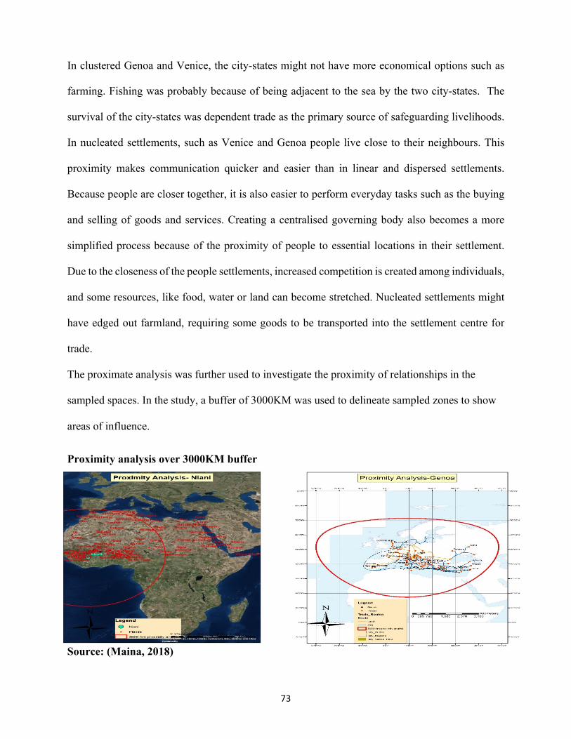
73
In clustered Genoa and Venice, the city-states might not have more economical options such as
farming. Fishing was probably because of being adjacent to the sea by the two city-states. The
survival of the city-states was dependent trade as the primary source of safeguarding livelihoods.
In nucleated settlements, such as Venice and Genoa people live close to their neighbours. This
proximity makes communication quicker and easier than in linear and dispersed settlements.
Because people are closer together, it is also easier to perform everyday tasks such as the buying
and selling of goods and services. Creating a centralised governing body also becomes a more
simplified process because of the proximity of people to essential locations in their settlement.
Due to the closeness of the people settlements, increased competition is created among individuals,
and some resources, like food, water or land can become stretched. Nucleated settlements might
have edged out farmland, requiring some goods to be transported into the settlement centre for
trade.
The proximate analysis was further used to investigate the proximity of relationships in the
sampled spaces. In the study, a buffer of 3000KM was used to delineate sampled zones to show
areas of influence.
Proximity analysis over 3000KM buffer
Source: (Maina, 2018)
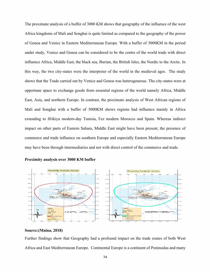
74
The proximate analysis of a buffer of 3000 KM shows that geography of the influence of the west
Africa kingdoms of Mali and Songhai is quite limited as compared to the geography of the power
of Genoa and Venice in Eastern Mediterranean Europe. With a buffer of 3000KM in the period
under study, Venice and Genoa can be considered to be the centre of the world trade with direct
influence Africa, Middle East, the black sea, Iberian, the British Isles, the Nordic to the Arctic. In
this way, the two city-states were the interpreter of the world in the medieval ages. The study
shows that the Trade carried out by Venice and Genoa was heterogeneous. The city-states were at
opportune space to exchange goods from essential regions of the world namely Africa, Middle
East, Asia, and northern Europe. In contrast, the proximate analysis of West African regions of
Mali and Songhai with a buffer of 3000KM shows regions had influence mainly in Africa
extending to Ifrikiya modern-day Tunisia, Fez modern Morocco and Spain. Whereas indirect
impact on other parts of Eastern Sahara, Middle East might have been present, the presence of
commerce and trade influence on southern Europe and especially Eastern Mediterranean Europe
may have been through intermediaries and not with direct control of the commerce and trade.
Proximity analysis over 3000 KM buffer
Source:(Maina, 2018)
Further findings show that Geography had a profound impact on the trade routes of both West
Africa and East Mediterranean Europe. Continental Europe is a continent of Peninsulas and many

75
navigable rivers. The land mass is small and compact. The distances on land relatively short and
connect trading centres from one coast to another through hinterland with good navigable rivers.
In the Eastern Mediterranean Europe city-states of Genoa and Venice had elaborate sea trading
routes in the Middle East, black sea, Iberian, and the British Isles, extending to the Baltic Sea.
Concerning commerce, sea transport has excellent quality overland transport. The maritime trade
was useful the medieval commerce for the city-states of Genoa and Venice. Shipping of trade in
comparison to land transport is cheaper. It is more effective in transporting goods over long
distances. Further, the sea vessels carry vast amounts of products in contrast to the land ship of the
desert-the camel.
Trade route distances
Source:(Maina, 2018)
West Africa was a centre of vibrant trade and commerce. The evidence of trade and commerce can
be seen through dynamic trade routes and trading centres. There were three main trading centres

76
in this area. The western trade linked West Africa to Mauritania, Morroco (Fez) and Al-Andalus
(southern Spain) and western Europe (Davidson, Buah, & Ajayi, 1965).
The second group of routes linked the middle Niger, Tuat, Algeria and the central Maghrib. The
third route linked the Hausa lands and Kanem through Agades, Ghat, Fezzan (Modern Tunisia),
Tripoli and Egypt. The fourth route went through Kanem Bornu to the middle Nile and Egypt
Europe (p.191).
The analysis of West African geography shows a significant influence on commerce and trade in
the kingdom of Mali and Songhai. The Geography of Africa is massive. There is no presence of
fully navigable rivers. In the region under the study, the Niger River is tilted to the west. It rises
280km from the Atlantic in the highlands of Guinea and flows north to Sahara. It penetrates
through Djouf Basin where it develops a network of distributaries resembling delta. The river
reunites as a single channel then flows to West African interior turning 90 degrees into Nigeria
past Djouf Basin. The Niger plunges over great falls then joined by the Benue to form a vast delta
upon entering the Gulf of Guinea (Cole & Blij, 2007). The distance between the coast and another
is in some cases two thirds more than most of the European territories. With the absence of
navigable rivers and a huge relief, the kingdom of Mali and Songhai had to wholly depend on land
transport mainly the ship of the Desert-Camel to transport goods and services between dispersed
key trading centres.

77
Trade routes distances Navigability of rivers in West Africa
Source: (Maina,2019) Source: Cole & Blij,(2007, p. 10)
Similarly, as a result of enormous relief, the evidence of development and subsequent use of sea
trade is not available. Whereas the trans-Saharan trade shows greater sophistication in comparison
to Venice and Genoa up to a certain point, the inability to compete favorably on volume of trade,
variety of goods, the cost of transport, and efficiency of delivery might have significantly inhibited
further expansion of Tran-Saharan trade which was economic lifeline for the kingdom of Mali and
Songhai. The lack of sea power by these African trends constrained their influence and space in
an age of increasing assertion from the city-states of Genoa and Venice as well as other European
powers. In case influence existed at all, such influence was only possible through middle
intermediaries in northern Africa. The right exercise of influence commerce beyond horizon and
shores were absent in West African kingdoms of Mali and Songhai contrary to the city-states of
Venice and Genoa in Eastern Mediterranean Europe.
Further findings show that Geography had an impact on the division of division and specialisation
of labour amongst inhabitants of in both Mali and Songhay empires. Geography in West Africa
divides society into pastoralists and sedentary groups into the two regions.
78
The emergence of commerce in the two kingdoms of Mali and Songhay has its origin in the
symbiotic relationships between pastoral and sedentary groups within the Sahara. The sedentary
communities controlled water sources and means of agricultural production. On the other hand,
the pastoralist controlled access to pack animals as well as related animal products such as milk,
water, fleeces, and leather. Pastoralist groups are likely to have possessed essential navigational
skills that would have been vital to travel between oases.
Oasis agricultural communities established relationships with neighbouring pastoral communities
for the exchange of agricultural goods for animal products and commodities that needed importing
from a distance. Further, pastoralist communities provided guides and security needed for the
caravans.
According to Judith Scheele, the fundamental interdependence between sedentary and the Pastoral
communities within the Sahara was the manifestation of regional Saharan infrastructure in
fostering cross-regional or Saharan trade. Reliance on Agriculture was not sufficient.
Consequently, trade instead of agriculture must have been responsible for the growth of towns
(Scheele, 2017). As Andrew Wilson notes, the role of change over points and entrepots where
different routes meet, break up, sell goods and reform for onward or return trip created a whole
economy geared towards servicing caravans including sale and provision for traders, camels,
slaves while they rested and recuperated after stages of desert crossings and engagement of guides
and cameleers. The abundant the available pastures and water sources, the more traffic could be
handled.
According to research by Baier & Lovejoy (1975), the nomadic pastoralists relied on goods and
opportunities provided by sedentary agriculture to supplement income, and diversify risk.
Similarly, according to Retaille (1998), the relationship between nomads and sedentarism seems
to hold the structure together. The nomadic zones precisely end in a sedentary core that seems to

79
be its outlet or even its pivot. In the southern and central Sahara, communities invested in diverse
activities such as stock breeding, transport, and trade in salt, dates, grains, manufacture, land
ownership, slave labour, and the finance of craft Baier & Lovejoy (1975). According to Mattingly
(2003) these activities were done in combinations.
As the proximal analysis shows, the networks of trade in the Sahara was vast. The trade in the two
kingdoms was mostly regional than international. As Andrew Wilson notes, camels cannot cross
the whole Sahara a fact that led to the establishment of staging post along the way. The staging
posts were in turn connected through local, regional, and trans-regional patterns of exchanges
(Wilson, 2012).
The two Africa kingdoms benefited more quantitatively from Saharan trade than Trans-Saharan
trade. However, as Judith Scheele notes, the two sectors were mutually dependent to a certain
extent that is difficult to ascertain. According to Scheele, the fact that certain goods eventually
crossed the Sahara does not indicate the presence of trans-Saharan traders or purely trans-Saharan
trade. The transport costs were too expensive to allow such trade. Despite wide-ranging networks,
most traders were marginally concerned with the trans-Saharan trade or imported goods (Scheele,
2017).
However, Scheele notes that regional trade and regional cross trade were not always distinctive
enterprises since those who travelled across the Sahara rarely crossed it in a straight line instead
they tended to move from one Pastoral region to another erratically paying more attention to the
regional economic logistics and circumstances rather than by design. The trade was purely based
on regional infrastructure and pastoral resources. The maximum distance travelled by the set of
pack animals was in most cases limited to 500KM. The Sahara was never crossed in a straight line.

80
Geography was essential in bringing together the overlapping networks of political and economic
entities. For trade to develop in the harsh environment, trust was a critical component in the long
distance trade as transactions were seldom based on the simultaneous exchange. Islamic faith was
critical in providing a more extensive imagined space that served to promote trade in faraway
regions. According to Haour (2017) a consequence of geography, the trade networks had to go
beyond essential interconnections between objects. Cultural filters allowed technologies, skill, to
flow or block them. For instance, the author notes that in the central Saharan, the trade networks
were small in number. The members of various networks were strangers at the begging since they
were disconnected and dissembled from local communities as they moved through a network that
was intentionally maintained (Haour, 2017). However, as Muslim belief and practice become
established, the size of the network and some trading centres grew because of decreased network
vulnerability (Aslanian, 2011).
In Mediterranean Europe, the impact of geography on the division of labour is also observed.
Unlike the Mali, Songhay empires where societies were divided into sedentary, and pastoralist
communities, Geography did divide the inhabitants of Mediterranean Europe into Mountain and
the sea people. Mountain people have a distinct culture from sea people. According to Braudel,
(1995) the feudal system as a political, economic and social system failed to influence most of the
mountain regions in Mediterranean Europe. According to Woodburn Hyde, the mountains are
frequently overpopulated to their resources. The optimum level of population is exceeded quickly,
and overflow is sent down to the plains (Hyde, 1935). On another hand, the mountain region offers
a variety of resources from Olive trees, Oranges, and Mulberry trees of lower slopes to the forests
and pasturelands higher up. The mountains can support the raising of sheep, goats, and cattle. The
emergence of commerce occurred when various circumstances forced the population to the plains.
According to Braudel (1995), when the movement happened, the developing western industry had

81
to find markets for its surplus production. As notes, it is the interaction of such pressing needs,
disturbances, and restorations of economic balance through necessary exchanges which guided
and indirectly determined the course of the Mediterranean history.
As Braudel(1995) notes, the seaside villages were basic units, which were not able to create an
active coastal region. Faced with limited resources such as food and land on the plains, the mixture
of mountain and lowlands in Genoa and Venice were forced to turn to the sea. The city-states
turned elsewhere in search of what homeland could not provide. Maritime Trade in the
Mediterranean became indispensable survival.
The engagement in maritime trade by the city-state of Genoa and Venice resulted in the creation
of an extensive network of regular and casual connections giving a lifeline in Mediterranean
Europe. As Braudel notes, the whole Mediterranean consisted of movement in space encompassing
trade, war, fashion, techniques, merchandise ferried over great distances to be taken. In the end,
the Mediterranean as a moving space over route networks, urban centres, lines of force and nodal
points and communication imposed a unifies social construction on geographical space bolstering
commerce and state power (p.227).
4.2 The Significance of Geography on state power
State power in the context of the study refers to economic power, military power, and political
means to extract, transform, distribute, and consume the produce of nature. It is exhibited by
relations frequently permeating in human lives through a combination of the social organisation
of labour alongside a network of capital, trade and production chains. Military power is regarded
as defensive and offensive coercive capabilities as a consequence of social organisation and
concentrated lethal force. The centralised and territorial regulation of social life is a political

82
power. The exercise of political power is upon specific territory and specific people. The analysis
of the West African kingdom of Mali and Songhai, as well as the Eastern Mediterranean city-states
of Genoa and Venice, show that indeed geography had a profound impact on state power.
According to analysis, the West African kingdoms of Mali and Songhai grew from West
Senegambia region, extending East Burkina Faso (Jenne), Nigeria (Kano), Niger (Agadez), and
northwards to Mauritania (Tanghaza). Within the circle, they comprised essential trading centres
of Gao, Timbuktu, Kumbi Saleh, Walata, and Kukiya among others. The analysis shows that the
formation of the two African empires gravitated towards vital trade routes and towns. In the West
Africa it is vital to note that the kingdoms did not seek to expand northwards, or southwards along
the Atlantic. The empires were between entry points of the Berber and Arab traders of the north
and the southern the gold producing zone in the tropical forest.
Further, the analysis shows that perhaps the empires showed little interest in areas outside the
trans-Saharan trade matrix. The study shows that the Sahara trade was highly profitable and
provided necessary resources through tributes and levy to maintain law and order. According to
Niani & Zerbo (1997), the wealth accrued from trans-Saharan trade led to rapid development of
the political and administrative organisation. In Mali, the kingdom developed a centralised
authority under Mansa Musa. In the twelfth century, the kingdom was divided into twelve
kingdoms each headed by a Farin (Governor) According to the two scholars, and the Arab
documentation reveals that the Malian army consisted of 100,000 standing men.
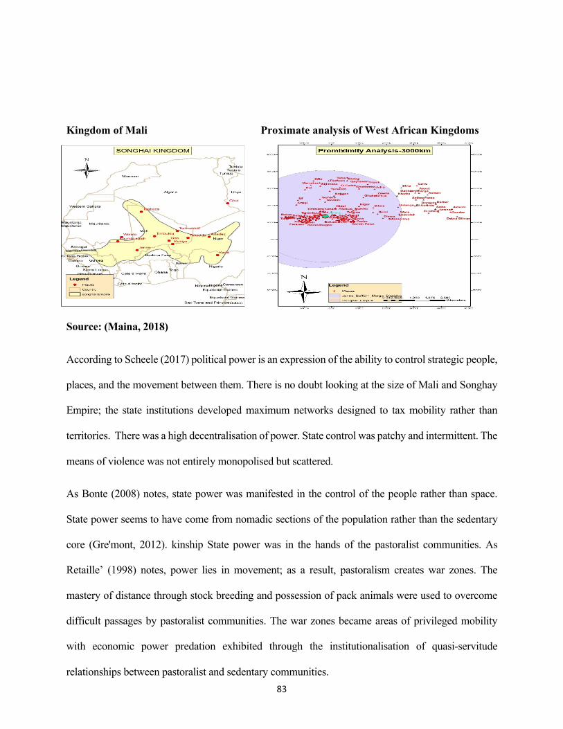
83
Kingdom of Mali Proximate analysis of West African Kingdoms
Source: (Maina, 2018)
According to Scheele (2017) political power is an expression of the ability to control strategic people,
places, and the movement between them. There is no doubt looking at the size of Mali and Songhay
Empire; the state institutions developed maximum networks designed to tax mobility rather than
territories. There was a high decentralisation of power. State control was patchy and intermittent. The
means of violence was not entirely monopolised but scattered.
As Bonte (2008) notes, state power was manifested in the control of the people rather than space.
State power seems to have come from nomadic sections of the population rather than the sedentary
core (Gre'mont, 2012). kinship State power was in the hands of the pastoralist communities. As
Retaille’ (1998) notes, power lies in movement; as a result, pastoralism creates war zones. The
mastery of distance through stock breeding and possession of pack animals were used to overcome
difficult passages by pastoralist communities. The war zones became areas of privileged mobility
with economic power predation exhibited through the institutionalisation of quasi-servitude
relationships between pastoralist and sedentary communities.
84
Geography influenced state power differently in the Eastern Mediterranean. First, Geography had a
significant impact on the internal political organisation of Genoa and Venice. The Unique Geography
of Venice dictated that for the establishment of a political system able to establish the naval, military,
and economic infrastructure required for economic expansion (Greif, 1995). State power lay in the
ability to control maritime commerce. A state city becomes powerful by its ability to entrench
hegemony in maritime commerce (Tracy, 1991).
According to Geoffrey Scammel, Venice large state-owned commercial tool was its diplomatic and
political strategy for the Maritime hegemony. Strict navigation rules ensured that the fleet was able
to bring trade goods to Venice. As the scholar notes, the efficient organisation of the maritime traffic
made Venetian galleys convoys regular, fast, and reliable giving them an edge over the competitors.
The control of maritime colonies such as Cyprus and Crete in addition to skilled diplomacy in the east
provided the needed strategic commercial and security, and protection environment (Scammel, 2006).
At the beginning of the year 1400, the institution of the military become crucial in promoting and
safeguarding the commercial interest of the state. The convergence between economic and political
realities became more visible as commerce was not always conducted through peaceful means.
However, according to Eliot & Koenigsberger (1984), war was seen as a last resort because it was
costly and damaging to the free flow of trade. The use of economic embargoes and diplomatic
pressure were the preferred weapons, combined with a willingness to extend direct control over the
immediate hinterland of the lagoon, to achieve both political security and a particular area of
economic latitude (Eliot & Koenigsberger, 1984).
According to Greif, Genoa and Venice exhibited profound similarities in their political systems. The
city-states were governed by an elected oligarchy and were subject to the law. At the top of the
Venetian political system were the Doge and the ducal council. Genoa's was governed initially by
consuls and, after 1194, one or more executive and a council of rectors (Grief, 1995, pp. 734-735).

85
As Greif notes, both cities had no constitution or clear separation of authority between legislative,
administrative, and judicial bodies instead, customs and precedents guided behaviour and overlapping
authorities of various councils were supposed to verify that it was impartial.
The state stability accorded by such arrangement was sustainable in the long run. Whereas the city-
states became commercial, marine, and naval power in the southern seas, the Mediterranean and the
black sea, state power in the two Republics was hindered by national unity.
According to List(1841), the cities and ruling powers of Genoa and Venice did not act as members of
one body, but made war on and ravaged one another like independent powers and states. While these
wars raged externally, each state was successively overthrown by the internal conflicts between
democracy, aristocracy, and autocracy exposing the state national prosperity and maritime commerce
influence to the predation of by foreign powers.
Further analysis shows that the city-states grew from the north in Liguria in the case of Genoa and
Venetian lagoon in the case of the city-state of Venice extending to the periphery of Southern sea, the
Mediterranean, and the black sea. Whereas the African empires grew from coast to inland of West
Africa, the state power of Genoa and Venice grew outward on the periphery of the entire
Mediterranean coastline. Due to superior sea transport, the city-states were able to exert influence on
the region beyond horizons and nationalities directly. The African empires and the East
Mediterranean city-states had one significant similarity concerning state power. In all the empires and
the city-states, state power and influence followed economic power. Whenever economic power
increased the empires and city-states used the newly acquired wealth to bolster their arsenals, maintain
law and order.

86
Whenever the geography of commerce shifted so did the political power. In the Eastern Mediterranean
Europe for instance, Venetian state power was felt from Corfu, Coron, Crete, Negroponte, the Ionian
Isles and the Cyclades the same spaces used as the gateway for commerce and riches. Venice state
power supplanted and dislodged the Byzantines in the East. Between 1380 and 1420 Venice doubled
its land after strengthening its maritime empire enabling it to cement its position as the dominant
power in the sea and the axis of world trade pressures from the Ottomans or Genoese. However,
when the geography of commerce reduced so did the Venetian state power. In 1430 for instance, the
Ottomans cut off the black sea from Venetians followed by the capture of Gallipoli, and finally the
Constantinople between 1453-1464. The advanced of the Ottomans from East squeezed commercial
space that had made Venice and Genoa powerful merchant states. The emergence of Portugal,
Spanish, the English, and Dutch weakened further these coveted spaces eventually leading to the
decline of the city-states.
The changing contours of the geography of state power and economics had a significant impact on
the African empires of Mali and Songhai. By 1500 the Europeans were beginning to overcome the
geographical barrier that prevented them from establishing influence beyond Europe. By subduing
the control of the Ottoman, Venice and Genoa in the east, the southern and western Europeans
notably Spanish, Portuguese, Dutch, English, and French began expanding financial and military
87
power. The development of Europe technical ability to build ocean-going ships and sail them
beyond horizons enabled them to tilt geography in their favour. The rivalry between Christian
southern Europe and Ottomans advancing through Africa damaged the Western Trans-Saharan
routes. As a consequence, the goods between West Africa and Europe by Way of Tunisia and
Algiers or Egypt were hindered by new frontiers of war as well as new imperial rivalries
(Davidson, Buah, & Ajayi, 1965).
On the western trade routes, the war between Muslims and Christians pushed Muslims out Spain.
In 1471, the Spanish seized some of the Mediterranean trading ports. The Portuguese and Spanish
expanded sphere of influence to Africa. To compensate for lost space and control, Morocco turned
south to capture strategic cities of Sijilmasa and eventual capture of the Songhai Empire. The
conquest of Songhai by Morocco led to a significant interruption in the peaceful flow of trade
between West and North Africa. With reduced volume and value of commerce, the kingdoms were
not able to sustain the expenses of running a state as well as maintaining law and order. By the
beginning of the sixteenth century, the Europeans had pushed frontiers of economic and state
power to West Africa and beyond (Davidson, Buah, & Ajayi, 1965).
4.3 The Significance of Geography on Development
In this study, development is regarded as a product of commerce and state power. The extent of
the impact of Geography on commerce and state power has strong correlation on development.
Development happens in a specific space (Smith A., 2003). The characteristics of the space where
development takes place can hinder or promote its realisation. According to Warnke(1995),
development aspects are as a result of space whose ordering aesthetics drives from the goals and
ambition of regimes. Further Cosgrove (1993) notes that development is a product of spatial
constitution of civil authority. Development is conceived through the totality of the external world
as mediated through human experience. Development arises first when society can satisfying it

88
needs by production hence sustenance of life (Marx, 1986). In this regards, development is marked
by broad shifts in the spatial organisation of social life, commerce, conquest, settlement patterns,
and the advent of government in increasingly politicised aesthetics (Smith,2003).
In the two kingdoms of Mali and Songhay, development takes place within a pattern of migration
and exchange between the pastoralists and sedentary communities. In the European city-states of
Genoa and Venice, development takes place within interactions of the mountain and the sea people.
In West Africa, the development of human activities such as trans-Saharan trade was grafted in
the patterns of migration and exchange providing infrastructure for intricate patterns of
interdependence. In eastern Mediterranean Europe, there is a geographical division of labour
between the mountain and the sea people. The Mediterranean maritime trade infrastructure
provides an avenue of exchange and interdependency. In return, the created exchange and
interdependency between various regions serve to provide a stimulus for the existence of a
commercial unit in the entire Mediterranean (Braudel, 1995). Through increase trade and
subsequently state ability to protect the inhabitants, the production of material life was able to
sustain life in the two regions under study albeit in different degrees due to differences in
geographical factors in the Sahara and Mediterranean.

89
CHAPTER FIVE
5.0 Conclusion
The study significance of Geography on commerce, trade and state power was exploring the role of
geography in shaping International Relations. In particular, the study focused on understanding the
impact of geography on commerce and trade. Secondly, the study sought to understand the
implications of Geography on state power. The study scope was West Africa the case of the empire
of Mali and Songhai and Eastern Mediterranean Europe the case of Venice and Genoa. The study
period is between the eleventh and sixteenth century. Qualitative and quantitative approaches were
used to link social and spatial the variables. To understand how geography influences commerce,
trade and state power, the study used spatial quantitative techniques to correlate the spatial and social
environment. By integrating spatial analysis into qualitative rationalisations and explanations, the
study has been successful in bringing previously unconsidered variables in Africa's marginalisation
in world affairs.
The study has encountered various technical challenges being that it borrows heavily from the field
of history. Historical problems are very complicated especially if they extend long periods as it is in
the study. As historian Peter Novick notes, the itinerary of the historical quest from intuition to clue,
from conjecture to the source, from evidence to interpretation is never easy. There are limited
methods which to predict the ultimate destination of a historical investigation but only pointers when
the probability of obtaining a holistic source base is a near impossibility (Novick, 2008).
The study has also taken cognizant of the historian Joseph Miller postulations that history ultimately
fails as a science. Historians can assemble only random evidence from the debris of the past that
reaches them through processes far beyond their control (Miller, 2009). The historical findings,

90
therefore, should be interpreted first and foremost as involving historian own attempts to reconstruct
and synthesise the past to provide lessons for the present and the future.
To this end, the study has shown how the intersection between geographical and social features led
to a divergence in commerce, trade, and sea power between the African empires of Mali and Songhay
and European city-states of Genoa and Venice. Further, the study has shown that the natural
environment affects production, business, and trade resulting in distinct regional economies. The
differences in economies as a result of geographical context is seen through scale, space, and place of
the flow of goods, money, information and people. The study shows that indeed, there is
interconnectedness of geography, military power, and economics. The environment provides
conditioning influence for the latter three to take part. There is unique quality in geography to order
and focus on human intentions, experiences, and actions spatially.
The influence of geography on spatial actions are very profound. Social, economic, and political
phenomena are a product of spatial, temporal locality and their connectedness and inter-relationships
bring space into being. Space in this regards does not mean a container into which intrinsically non-
spatial things are stuffed, but as Doreen Massey notes, space is a constitute of interactions from the
micro level to intense and immense global interactions. In its communications, different trajectories
co-exist. The heterogeneity of co-existence ensures that space is always under construction. It is ever
in the process of being made. It never gets finished or closed. Whatever entity takes led in its creation,
such an object in the context of this study does dominate commerce, trade and state power.
5.1 Policy Recommendations on Africa The study borrows Kabir Mohamed view that the fundamental basis of the value of history is that
the past has made the present and the present alone can make the future. The understanding of our
immediate world is not possible without knowledge of the past, and the further we delve into

91
history the more in-depth and broader will be our grasp of the present and insight into the future
(Mohammed, 2013). To this end, the study, make the following policy recommendations.
The study has shown, geography was a barrier to the growth of commerce, state power and
development in West African empires of Mali and Songhai in comparison to Eastern
Mediterranean city-states of Venice and Genoa. Further, geography can inhibit the construction of
new spatial relations which can be a source of wealth, poverty or influence at a global stage. The
study shares Doreen Massey views that if the future of Africa must be open, space must open too.
The study makes the following policy recommendations to African leaders, policymakers,
diplomats, and academia on how to overcome geographical and spatial barriers hindering the
progress, prosperity, and the global influence of the continent.
Increased Investments in Transport and Communication
Transport and communication remain of the most significant challenge in Africa. Improving sector
will modify the continent's geography of development economic development, the socio-economic
integration of Africa, as well as the promotion of intra-Africa and extra-African trade. During the
Lagos plan of action for the economic development of Africa meeting, the African states under
auspices of Organization of Africa unity agreed to promote the integration of transport and
communications infrastructures. In the views of the head of states, the combination of transportation
and communication will increase intra-African trade by ensuring the coordination of the various
transport systems to improve their efficiency. According to Thompson (1912), a quarter of the Sahara
Desert lies below sea level. It is possible to construct a canal of fifty miles along the higher land of
northern African coast to create Sahara sea equal to the Mediterranean facilitating trade between the
isolated regions.

92
Further, good infrastructure opens up of the land-locked countries and isolated regions. The
movement of people and goods should be facilitated by the harmonisation of national regulations and
reduction to a minimum of physical and nonphysical barriers. The mobilisation of technical and
financial resources should promote the development and modernisation of transport and
communication infrastructures in Africa on regional projects; sub-regional projects; and national
projects with a local or sub-regional impact. The development of transport and communication
infrastructure should give priority for least developed, land-locked, islands and frontline states and
sub-Saharan Africa.
Annual Africa's infrastructural deficit is estimated at $90 billion according to the Brooklyn Institute.
The study recommends the implementation of the resolutions of the Lagos plan of action on transport
and communication. It is the view of the study improvement of the infrastructure on transportation
and communication are vital in mitigating the tyranny of geography on commerce, trade, and state
power. In line with Lagos plan of action, the study recommends that transport and communications
should be designed to promote the interconnection of national networks with those of neighbouring
countries to provide an active network for the transportation of goods and persons which will facilitate
trade and communication within and between the Member States. In line with Lagos Plan of action
and African Union agenda 2063, the study recommends explicitly connecting all African capitals and
commercial centres by way of increased funding and investment in transport and communication in
roads and road transport, Railways and rail transport, maritime transport, air transport, ports, inland
transport, Telecommunications, satellite communication, and broadcasting. It the view of the study
that increased investment in transportation and communication will be vital altering the geography of
Africa by allowing free movement of people, capital, goods and services resulting to significant
increases in trade and investments amongst African hence strengthening Africa's place in global trade
and political affairs.
93
Increased Investments in Industry and Trade
Geography constrains the development of trade and industry in Africa as the study has shown.
Inadequate development leads to economic marginalisation of the continent from global trade. More
significant, limited trade and commerce lead to rampant unemployment in Africa. According to
World Bank data, Africa has grown at an average GDP of 5.5% per annum in the past decade.
However, since 2008, the study shows that Africa's manufacturing has stagnated at 10%.
Similarly, intra-Africa trade accounts for 18% for global trade. The manufacturing industry is
dominated by countries with an established manufacturing base such as South Africa, Tunisia,
Morocco and Egypt; as well as with countries with emerging manufacturing sectors such as Mauritius,
Kenya and Uganda. Africa trade and industry is dominated with essential commodities limiting
heterogeneity of exports. The study recommends some intervention to transcend geographic barriers.
In line with Lagos plan of action, the study recommends the establishment of primary industries which
can be developed in the short term on a national or sub-regional basis and those which must be
established in the long run and requite sub-regional or regional co-operation. The initiative should
encompass food and agro-industries; construction industries; metallurgical industries; mechanical
industries; electrical and electronic industries; chemical industries; and energy industries. The
regional and subregional operations will boost the African industry and trade by structurally and
geographically diversifying African production, manufacturing, and trade capacity ( OAU, 1980).
Second, to eliminate geographical challenges on trade and industry, African states must push for
increased intra-Africa trade. The push for increased business will include the elimination or reduction
of trade barriers, the establishment of the African common market and currency. In line with African
Union formation of the Continental Free Trade Area for Africa, the study recommends speed
operationalisation of free trade area to boost industry and trade in Africa. It is the view of the survey

94
that the operationalization of the treaty will tame geographical constraints on trade and commerce
bringing together all African countries comprising of 1.2 billion people and a combined GDP of over
$3.4 trillion under a single continental market for goods and services, including free movement of
businesspeople and investments, and expansion of intra-African trade.
Whereas noting the importance of the expansion of intra-Africa trade, the study recommends
innovation in establishing strong influence beyond African borders for the benefit of the continent. In
this regards the research suggests the establishment of supra-territorial trade and industry driving
beyond spatial barriers to dominate not only Africa continent but the entire globe. The mechanism of
establishing supra-territorial business and industry as elucidated by Jan Aart Scholte in the journal
article global capitalism and state should encompass global markets, global production, global
commodities, and global business organisations.
The Global Markets
The Africa governments should encourage the growth of trans-border to boost trans-world marketing
capabilities for their commodities to overcome geographical barriers on trade and industry. As Jan
Aart Scholte notes, with the global reach afforded by telecommunications, computerisation and air
travel, companies in Africa can develop any promising market site, where ever in the world it might
be situated.
Global Production
The study recommends that African governments initiate mechanisms for the development of global
communications, global organisation and global finance to be able to site production operations
wherever labour costs, taxation rates, regulatory frameworks and other variables are most favourable
to them within Africa and beyond. Through global sourcing, African companies will be able to draw
the materials, components, equipment and services it needs from anywhere in the world. Through

95
transnational production, the continent will be able to play critical sectors of the economy such as the
manufacture of many motor vehicles, leather goods, sports articles, toys, optical products, consumer
electronics, semiconductors, aeroplanes and construction equipment.
Global Commodities
The study acknowlwdges the benefits of the regional economy on Africa economy primarily through
profits accrued from agriculture, mining, lumbering, and manufacturing. To bridge the spatial barrier,
however, the study recommends complementarity and if the possible shift from traditional trade and
industry towards virtual industries of finance, information and communications.
Global Business Organizations
The study recommends that Africa governments initiate mechanism for ensuring that the continent
participates fully in the worldwide business organisation mainly multinational and transnational
corporations which have an ability to transcendence distance and borders in in Africa and beyond. It
the view of the study that the rise in multinational companies will boost supra-territoriality of African
trade industries by creating larger national firms that are capable of surviving competition from trans-
border rivals as well as using the enlarged entity to launch or expand trans-border operations in critical
sectors such as manufacturing, construction, electronic, pharmaceutical, and banking industries.
Increased Investment in Global Money and Finance
For most of the past 50 years, Africa has been on the periphery of the global money and finance sector.
In recent times according to consulting firm Mckinsey, Africa is a global leader in mobile payment
and second in the world concerning banking growth and profitability. In five years, the number of
bankers in the continent has almost doubled, and total banking revenue had risen to about $86 billion
from $56 billion in 2012. The success of mobile banking platform such as M-Pesa in Kenya is visible
on how finance can transcend geography and boost economic growth. In line with Lagos plan of

96
action and African Union agenda 2063, the study recommends that member states of African union
to enhance monetary and financial cooperation. African governments must develop and strengthen
fiscal, financial and payments policies, to boost intra-community trade in goods and services. To this
end, further, the study recommends the creation of national, regional and sub-regional money markets,
through the coordinated establishment of stock exchanges and harmonising legal texts regulating
existing stock exchanges intending to making them more useful. In line with AU agenda 2063, the
study recommends liberalisation of payments and the elimination of payment restrictions, if any, and
promote the integration of all existing payments and clearing mechanisms among the different regions
into an African Clearing and Payments House; and establishment of an African Monetary Union
through the harmonisation of regional monetary zones. The study echoes African Union agenda 2063
that transfer of capital funds between member states as well as the elimination of restrictions capital
transfer will go a long way in promoting the free movement of capital within the community.
At the International level, the continent should strive to put in a mechanism that would ensure that the
continent benefits for global money and finance beyond its territory. In particular, the study
recommends investment in Global capital markets and sovereign wealth funds around the globe.
Global Capital Markets
The global market of financial assets was estimated to be $294 trillion in 2015. According to Deutsche
Bank's Sanjeev Sanyal, the current global stock market is $69 trillion. $ 58 trillion is the value of the
public bonds. According to Sanjeev, in 2014 and 2015, the emerging markets attracted more bond
funds as well as country equities. The study recommends that African states take initiatives to
penetrate spaces that will help them gain benefits of global capital markets beyond the African
territory.

97
Sovereign Wealth Funds
Oil, Diamonds, Gold, and rare minerals are some of Africa’s abundant natural resources useful in
running the global economy. The study recommends prudent use of these resources to eliminate
spatial barriers that hinder development on the continent. Such prudent measures should include
establishing a mechanism for investing in sovereign wealth funds around the globe to accrue the
resources that will channel back to Africa. Sovereign wealth funds (SWFs) are government-owned
investment vehicles that are funded by foreign exchange assets as a consequence of current account
surpluses and increased revenues in oil-producing economies, and the size of their overseas
investments. SWFs have better returns than on exchange reserves, and longer-term strategies can
contribute to greater stability in the African financial system. By prudent investment of African
resources beyond the continent shores, African governments can benefit greatly from high returns
associated with foreign investment.
Increased investment in Common Defense Policy
As the study results have shown, geography has an enormous impact on state power. Africa
geographical location at the centre of the world in addition to the abundant natural resources is notable
in the geopolitics of international relations. As a result of unique Africa’s characteristics, the continent
is very vulnerable to spatial encroachment by other great powers from Europe, western and Eastern
hemisphere. For this reason, in line with African Union declaration, the study recommends for
establishment and reinforcement of African defence policy for protecting the territorial integrity of
the continent. The standard defence policy will be critical in linking defence at the national level and
that at the regional and continental levels. Africa's fundamental protection of Africa should include
the armed forces of the state to protect its national sovereignty and territorial integrity of the continent.

98
The non-military aspects should bolster the security of the people's political, cultural, social and
economic values and ways of life. The standard defence will also be critical in safeguarding Africa's
rightful share of the global commons consisting of land, oceans and space.
Increased Investment and Promotion of Africa's Cultural Identity and Heritage
Ideology knows no boundaries. Africa has a strong cultural identity, common heritage, values and
ethics. To boost Africa's influence in commerce, state power and development, Africa must increase
its investments in promoting their heritage and culture to all corners of the world. African culture
must transcend spatial boundaries to influence the world. In line with agenda 2063, the study
recommends the increased promotion of pan African cultural assets consisting of heritage, folklore,
languages, film, music, theatre, literature, festivals, religions and spirituality in Africa and beyond.
The study shares AU agenda 2063 encouraged the development of African creative arts and industries
throughout the continent and the diaspora to contribute significantly to self-awareness, well-being and
prosperity, and world culture and heritage.
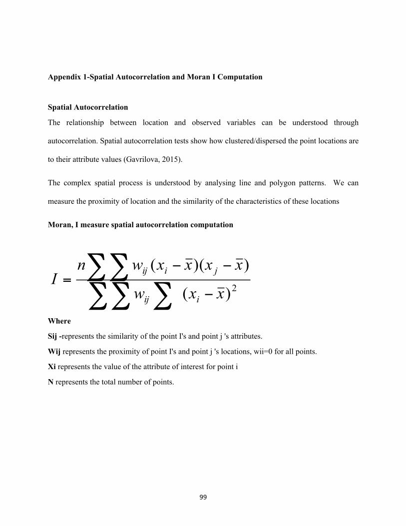
99
Appendix 1-Spatial Autocorrelation and Moran I Computation
Spatial Autocorrelation
The relationship between location and observed variables can be understood through
autocorrelation. Spatial autocorrelation tests show how clustered/dispersed the point locations are
to their attribute values (Gavrilova, 2015).
The complex spatial process is understood by analysing line and polygon patterns. We can
measure the proximity of location and the similarity of the characteristics of these locations
Moran, I measure spatial autocorrelation computation
Where
Sij -represents the similarity of the point I's and point j 's attributes.
Wij represents the proximity of point I's and point j 's locations, wii=0 for all points.
Xi represents the value of the attribute of interest for point i
N represents the total number of points.
∑∑ ∑∑∑
−
−−=
2)(
))((
xxw
xxxxwnI
iij
jiij

100
Appendix 2- Map of Genoa and Venice

101
Appendix 3- Map of the Kingdom of Mali

102
Appendix 4-Map of the Kingdom of Songhay
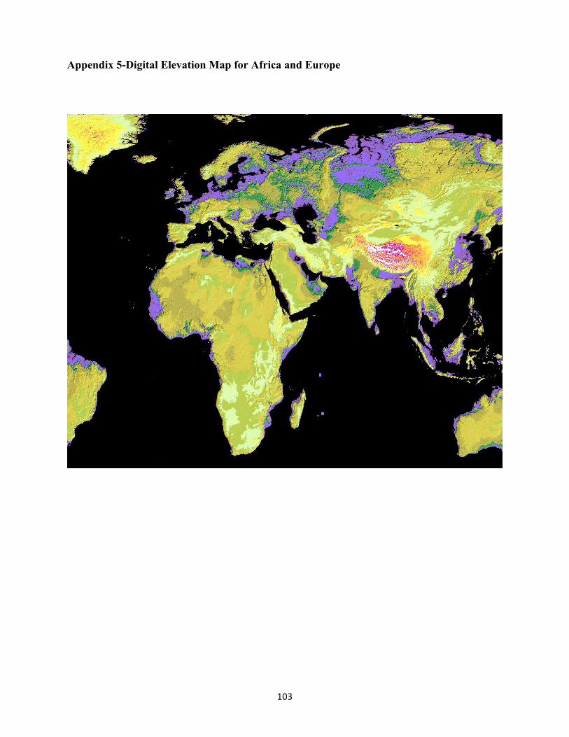
103
Appendix 5-Digital Elevation Map for Africa and Europe
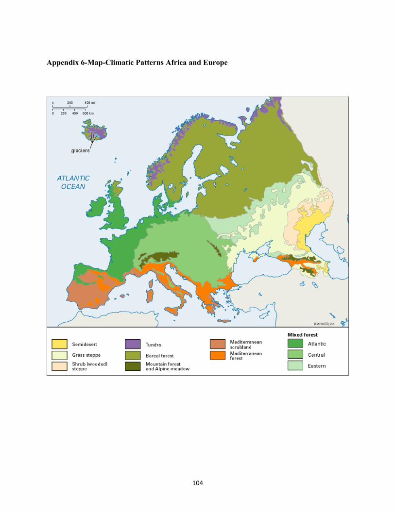
104
Appendix 6-Map-Climatic Patterns Africa and Europe
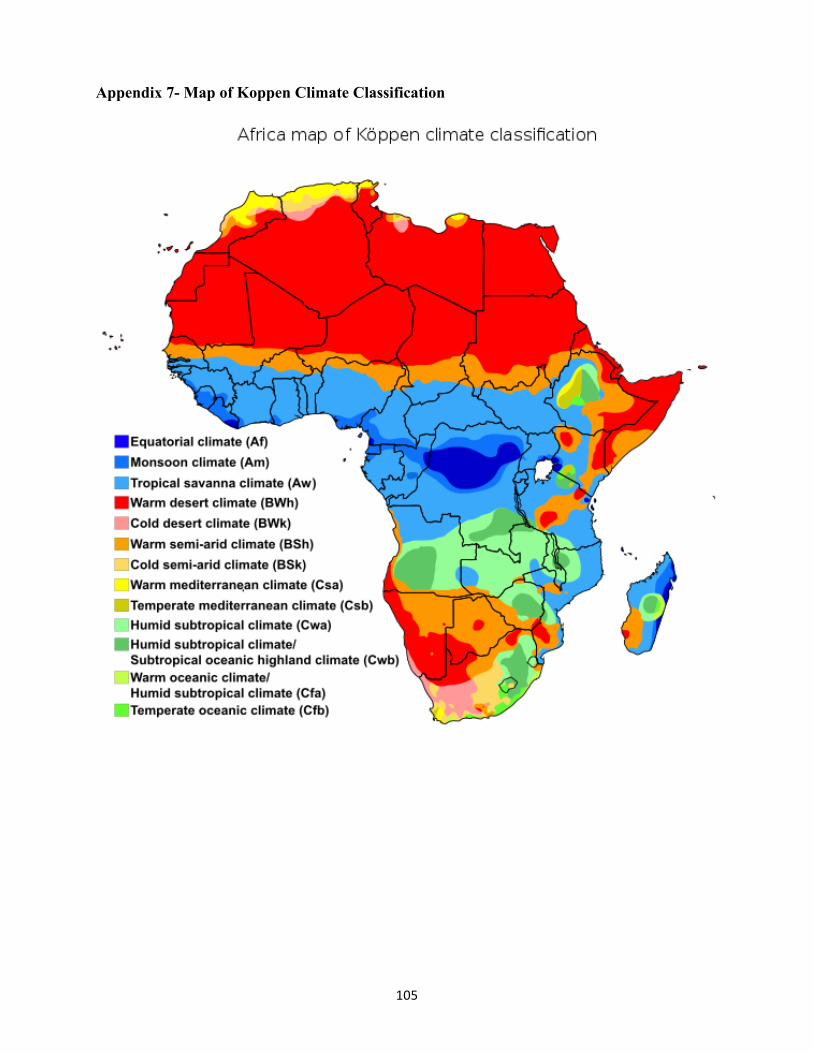
105
Appendix 7- Map of Koppen Climate Classification

106
ReferencesOAU. (1980). Lagos plan of action for economic development of Africa-1980-2000. Addis Ababa:
OAU.
Academy for Math, E. a. (2018, 05 30). Module 1.2: Geographic concepts. retrieved from AP: human Geography: http://aphumangeog.weebly.com/module-12-geographical-concepts.html
Al-Radi, S. (n.d.). A brief history of East African Coast. Retrieved from https://archnet.org/system/publications/contents/3655/original/DPC0257.pdf?1384775881
Andy, M. (2005). The Esri guide to GIS analysis . Esri Press.
Aslanian, S. (2011). From the Indian Ocean to the Mediterranean: The global trade networks of Armenian merchants from new Julfa. Carlifornia: University of Carlifornia press.
Austin, Z., & Sutton, J. (2014). Qualitative research: getting started. The Canadian Journal of Hospital Pharmacy, 67(6), 436–440. Retrieved from US national mibrary for Medicine-national Institute of health: https://www.ncbi.nlm.nih.gov/pmc/articles/PMC4275140/
Baier, S., & Lovejoy, P. (1975 ). The Desert-side economy of the central Sudan. The International Journal of African Historical Studies, pp. 551-581.
Bayart, J.-F. (1996). Lhistoricite de l'Etat (The historicity of the state ). Les Cashier du Ceri, 14-44.
Bearce, D. H., & Fisher, E. O. (2002). Economic Geography, trade, and war. Journal of Conflict Resolution, 365-393.
Biography of Friedrich Ratzel - Geographer. (2017, 11 29). Retrieved from http://www.yourarticlelibrary.com/geography/biography-of-friedrich-ratzel-geographer/24576
Birmingham War Studies. (2012). Archives Mackinder: The role of geography in strategic culture. Retrieved from Birmingham War Studies: https://birminghamwarstudies.wordpress.com/tag/mackinder/
Blij, H. J., & Muller, O. (2002). Realms, Religions, Concepts. John Wiley and Sons.
Bonte, P. (2008). L' emirat del L' Adrar Mauritania: Harim Competition et protections dans un socie'te tribal saharienne (The emirate of Adrar Mauritania: Harim competition and protections in a Saharan tribal society ). Paris.
Braudel, F. (1995). The Mediterranean and the Mediterranean world in the Age of Philip II. Berkeley: University of Carlifornia Press.
Brewer, J. (1983). The Sinew of power:War, money, and English State-16881783. New York.
Briney, A. (2017, 03 03). Environmental determinism. Retrieved from https://www.thoughtco.com/environmental-determinism-and-geography-1434499

107
Burke, P. (2000). Early Modern Venice as a Center of Information and Communication. In J. Martin, & D. Romano, Venice Reconsidered-The History and Civilization of an Italian City-State, 1297–1797 (pp. 39-66). Baltimore, Maryland: The Johns Hopkins University Press.
Casola, P. (1907). Canon Pietro's Casola's Pilgrimage to Jerusalem in 1494. In M. Newett. Manchester .
Cassiodorus. (2006). Varium Libri XII. Retrieved from Letter 24: www.documentacatholicaomnia.com
Ce'saire, A. (2000). Discourse on Colonialism. New York: Monthly Review Press.
Chalcondyles, L. (2011). In R. Crowley, City of Fortune-How Venice Won and Lost a Naval empire (p. 5).
Cole, M. (1938). The Investment of Wealth in Thirteenth-Century Genoa. The Economic History Review, pp. 185-187.
Cole, R., & Blij, H. D. (2007). Survey of Subsaharan Africa. New York: Oxford University Press.
Cosgrove, D. (1993). The Palladian Landscape: Geographical Change and Its Cultural Representations in Sixteenth-Century Italy. Leicester: University.
Crowley, R. (2011). City of Fortune:How Venice won and lost Empire. Faber and Faber.
Davidson, B., Buah, F., & Ajayi, J. A. (1965). A history of West Africa 1000-1800. Longman.
Desbiens, C. (2012). Introduction: From Human to cultural Geography. Universita Degli Studi Di Bergmo.
Devisse, J. (1992). The Almoravids. In UNESCO, Africa from Seventh to Eleventh Century (p. 193). Carlifornia: Heinman.
DuBois, W. E. (1945). Colour and Democracy. New York: Harcourt, Brace & Company.
Eberhardt, P. (2005). Friedrich Ratzel’s views on human geography and geopolitics. Przegląd Geograficzny, 199-224.
Eliot J, H., & Koenigsberger H, G. (1984). The Military organization of a State. Cambridge: Cambridge Studies In Early Modern History.
Epstein, S. (1988). Business cycles and the sense of time in medieval Genoa. The business history review, pp. 238-260.
Epstein, S. (1996). Genoa and Genoese. North Carolina: University of North Carolina Press.
Esperón, J. M. (2017, 02 16). Quantitative research in nursing Science. Rio de Janeiro.
ESRI. (2018, 7 4). ESRI. Retrieved from ESRI: https://www.esri.com/en-us/arcgis/mapping-visualization
Fabri, F. (1892). The Book of Wonderings of Brother Felix Fabri. In S. A, The Book of Wonderings of Brother Felix Fabri. London.

108
Fanon, F. (1963). The Wretched of the Earth. Presence Africaine.
Fasi, M. E., & Hrbek, I. (1992). The coming of Islam and expansion of the Muslim Empire. In UNESCO, General History of Africa - Volume III - Africa from the Seventh to the Eleventh Century (p. 17). Carlifornia: Heinman.
Ferraro, J. (2012). Venice : History of floating city. Newyork: Cambridge University Press.
Gatti, L. (1980). Un Catalogo de Mestieri. In Maestri e Garzoni nella societa genovese fra XV e XVI secolo II(A Catalog of Crafts. In Masters and Garzoni in the Genoese society between the fifteenth and sixteenth centuries I)I. Genoa
Gavrilova, M. (2015, 12 4). Spatial Autocorrelation. Retrieved from Lindsey Webster: https://slideplayer.com/slide/7237311/
Getis, A., & Aldstadt, J. (2004). Constructing weight matrix using a local statistic. Geographycal analysis, 90-104.
GIS data Collection. (2018, 7 4). Retrieved from https://dusk.geo.orst.edu/gis/Chapter9_notes.pdf
Gleditsch, K. S., & D.Ward, a. M. (2000). War and peace in space and time: The role of democratization. International Studies Quarterly, 44:1-29.
Gray, C., & Sloan, G. (1999). Geography and strategy. London, Portland: Frank Cass.
Greif, A. (1995). Political organizations, social Structure, and institutional Success: Reflections From Genoa and Venice during the commercial revolution. Journal of institutional and theoretical economics (JITE) / Zeitschrift für diegesamte Staatswissenschaft, pp. 734-740.
Gre'mont, C. (2012). Villages and crossroads: Changning territorialities among Toureg of northern Mali.
Griffith, S. B. (1963). The art of War Translation. In S. Tzu, The Art of War. OUP.
Haour. (2009). The spread of Islam in West Africa:containment, mixing, and reform from the Eighth to the twentieth century. Spice Stanford.
Harris, J. (1996). Essay upon money and coins. In J. Homwood, sociology of social stratification (pp. 32-33). Cheltenham: The International library of Social Critical Writing on Sociology.
Hausmann, R. (2001). Prisoners of Geography. Washingtonpost.Newsweek Interactive, LLC, 44-53.
Heers, J. (1961). Gênes au XVe siècle(Genoa in the fifteenth century). Paris.
Henderson, J. V., Shalizi, Z., & Venables, A. J. (2001). Geography and development. Journal of Economic Geography, 81-105.
Herbst, J. (2000). States and power in Africa: Comparative Lessons in Authority. Princeton University: Princeton.
Holmwood, J. (1996). The Social Stratification Vol 1. Cheltenham, UK. Brookfield, US: The international library of critical writing in sociology.

109
Hulfaman, T. N. (1992). South Africa to South of Zambezi. In UNESCO, Africa from Seventh Century to Eleventh Century (p. 319). Carlifornia: Heinman.
Hyde, W. W. (1935). Roman alpine routes. Philadelphia: American Philosophical Society.
Ismailov, E., & Papava, V. (2010). Rethinking Eurasia. John Hopkins University SAIS.
Jeffries, L. (2017, 11 27). Africa: A birth Place of humanity. Retrieved from African Origins of Early Humanity: http://www.nbufront.org/MastersMuseums/LenJeffries/BirthplaceOfHumanity.html
John, H. (1988). Geography, technology, and war. In S. Epstein, Genoa and the Genoese (p. 21). North Carolina: University of North Carolina.
Kathori, C. (2004). Research methodology: Methods and techniques. Jaipur: New Age International(p) limited Publishers.
Kirk, T. A. (2005). Genoa and the Sea: policy and power in an early modern maritime republic -1559-1684. Baltimore, Maryland: John Hopkins University Press.
Lew, A., Hall, M., & Timothy, D. (2008). World Geography of travel and tourism. Elsevier.
List, F. (1841). The national system of political economy. liberty fund.
Lopez, R. (1935). L' attivita economica di Genova nel Marzo 1253 secondo li atti notarali del tempo. In S. Epstein, Genoa and Genoese( The economic activity of Genoa in March 1253 according to the notarial acts of the time). In S. Epstein, Genoa and Genoese (p. 142). ASLSP.
Lopez, R. (1937). Aux Origines du Capitalisme genois.( To the Origins of Genoese Capitalism)
Lopez, R. (1976). The commercial revolution of middle Ages. Newyork.
Macharia, M. (2012). Historical reflections on Kenya: Intellectual adventurism, politics and International Relations. Nairobi: University of Nairobi Press.
Mackinder, H. (1904). The Geographical pivot of history.
Mackinder, H. J. (1943). The Round World and the Winning of the Peace. Foreign Policy, Vol. 21, No. 4 pp. 595-605.
Mahan, A. T. (1890). The Influence of sea Power upon History. Boston: Little, Brown and Company.
Maina, W. (2019). Masters thesis: The Significance of Geography on commerce, state power and development. Nairobi.
Mann, M. (1986). The Sources of Social Power. New York: Cambridge University Press.
Marx, K. (1986). Karl Marx: A Reader. Cambridge: Cambridge University.
Masao, F. T. (1992). East African Coast and Comoros Island. in UNESCO, Africa from seventh to eleventh Century (p. 296). Carlifornia: Heinman.

110
Mattingly, D. (2003). The Archaelogy of Fezzan Volume 1. London: Society for Libyan Studies.
Mazrui, A. (1979). The African Condition: The Garden of Eden in Decay. London: British Broadcasting Corporation-TRANSMISSION: 7 November 1979 – Radio 4.
Mazrui, A. (1986). Africa Triple Heritage. London.
Mercier, G. (2009). The Geography of Friedrich Ratzel and Paul Vidal de la Blache: A Comparative Analysis(1) (Vol. Volume 12). International Encyclopedia of Human Geography.
Miller, J. (2009). Africa in History-History in Africa. In G. Lydon, on trans-Saharan trails: Islamic law, trade networks, and cross cultural exchange in nineteenth -century Western Africa (p. 45). Cambridge: Cambridge University Press.
Mitchelle, A. (2005). The ESRI Guide to GIS Analysis, Volume 2. ESRI Press. ESRI.
Mocenigo, T. (2011). Doge Tommaso Mocenigo oration. In R. Crowley, City of fortune: How Venice won and lost and empire. Faber & Faber.
Mohammed, K. (2013). The Role of history, historiography and Historian in nation. International Journal of Humanities and Social Science Invention, pp.50-57.
Moyer, K. (2016, 09 09). Periphery Role in the World Systems Theory. Retrieved from https://medium.com/@kendallgrace15/periphery-role-in-the-world-systems-theory-fa5d291cac55
National Geographic Society. (2018, 07 08). Europe:Human Geography. Retrieved from NatgeoSites: https://www.nationalgeographic.org/encyclopedia/europe-human-geography/
National Oceanic and Atmospheric Administration U.S Department of Commerce. (2018, 06 25). What is a lagoon? Retrieved from National Oceanic and Atmospheric Administration U.S Department of Commerce: https://oceanservice.noaa.gov/facts/lagoon.html
Nkurumah, K. (1965). Neo-Colonialism-the last stage of imperialism. New York: Thomas and Nelson.
Norwich, J. J. (1977). Venice, Rise to Empire. Allen Lane The Penguin Press.
Novick, P. (2008). That noble dream: The objectivity question and American historical profession. in G. Lydon, On Trans-Saharan Trade: Islamic law, trade networks, and cross cultural exchange in nineteenth century (p. pp.45). Cambridge: Cambridge University Press.
Nyerere, J. K. (1974). Man and development. Oxford University Press.
Odell, P. (1974). Geography and Economic Development with special reference to Latin America. Geographical Association, 208-222.
Pletniova, S. (1982). Nomads of the Middle Ages: A search for consistent Historical patterns. Nauka Publishers.

111
Priuli, G. (1921). I driarii. In S. A, Rerum Italicarum Scriptore(Adriarii. S. A, The Italian Writer (pp. Volumen 24 part 3,2). Bologna.
Putterman, L. (2000). Can an evolutionary approach to development economic growth. Journal of Development studies, 1-30.
Rand Corporation. (2018, 06 2018). Methodology for historical Analysis. Retrieved from https://www.rand.org/content/dam/rand/pubs/monograph.../MR1100.chap2.pdf
Ratzel. (1896b). The Territorial growth of states. Scottish Geographical Magazine,. Scottish Geographical Magazine, vol. 12, p. 351-361.
Ratzel, F. (1902). Man as a life phenomenon on the Earth. In Helmot, H. F. (ed.) . In H. Helmot, The History of the World. A Survey of Man's Record, volume 1: Pre-history America and Pacific Ocean (pp. p. 61-106.). New York, : Mead and Company.
Retaille', D. (1998). L' espace nomade (The nomadic space). Geographie de Lyon, pp.71-81.
Rodney, W. (1973). How Europe underdeveloped Africa. London and Dar-Es-Salaam: Bogle-L'Ouverture Publications.
Ross, E. (2011, 01 03). Trans-Saharan book trade. Retrieved from https://ericrossacademic.wordpress.com/2011/01/03/trans-saharan-book-trade/
Rousseau, J. J. (1754). Discourse on the origin and basis of inequality among men. Holland: Marc-Michel Rey.
Sachs, J. D., & McCord, G. C. (2015). Physical Geography and the history of economic development. Faith and Economics, 11-43.
Scammel, G. (2006). At the Center of the old world: Trade manufacturing in Venice and Venetian Mainland 1400-1800. Toronto: Center For Renaissance Studies.
Scheele, J. (2017). Camel herding, raiding, trade, and saharan settlement. In D. Mattingly, A. Cuenod, M. Sterry, & F. Cole, Trade in ancient Sahara and beyond (pp. 55-79). 2017: Cambridge University Press.
Shaw, T. (1992). The Guinea zone. In UNESCO, Africa from seventh to eleventh Century (pp. 230-236). Carlifornia: Heinman.
Smith, A. (2003). The political landscapes: Constellation of authority in early complex polities. Berkeley: University of Carlifornia Press.
Smith, M. J., Goodchild, M. F., & Longeley, P. A. (2018). Geospatial Analysis . Retrieved from Geospatial Analysis: https://www.spatialanalysisonline.com/HTML/index.html
Sowell, T. (1998). Conquests and cultures: An International History. New York: Basic Books.
Spykman, N. J. (1942). America's Strategy in World-United States and balance of power. New York: Harcout, Brace, and Company Ince.
Steinberg, S. J., & Steinberg, S. L. (2006). GIS: Geographic information systems for social sciences. London: Sage Publications.

112
Thayer, W. R. (1908). A short History of Venice. Houghton, Mifflin and Company: Boston and New York.
Thompson, G. A. (1912). A Plan for converting the Sahara Desert Into a Sea. Scientific American, pp.124-pp.125.
Tracy, J. D. (1991). Reviewed Work(s): The Rise of merchant empires: Long distance trade in the early. Journal of the Royal Asiatic Society, pp.335-338.
Ul-Haq, M. (1971). Employment in 1970's: A new Perspective. Society for International Development. Ottawa: World Bank.
Wallerstein, I. (1974). The Modern world system: capitalist Agriculture and the origins of the European world economy in the Sixteenth century. New York: Academic Press. Retrieved from https://www.sociosite.net/sociologists/texts/wallerstein_summary.php
Warnke, M. (1995). Political landscape: The Art History of nature. Cambridge: Mass: Harved Press.
Weebly. (2018, 10 22). AP Human Geography. Retrieved from Weebly: https://apcentral.collegeboard.org/courses/ap-human-geography?course=ap-human-geography
Wilson, A. (2012). Saharan trade in the Roman period: short-, medium- and long-distance trade networks. Azania Archeological Research.
Woods, D. (2003). Bringing Geography back In: civilizations, wealth, and poverty. International Studies Review,, 343-354.
Yogarajah, M. (2012, 04 28). Trade and commerce. Retrieved from Medieval Times: http://www.middle-ages.org.uk/middle-ages-trade-commerce.htm
Zerbo, J. K., & Niani, D. T. (1997). Africa from the twelfth to Sixteenth Century. IV. In J. K. Zerbo, & D. T. Niani, Mali and the Expansion of the Mande (pp. 50-76). California: James currey.

113