the role of telecommunications/icts in disaster management · use of telecommunications/icts in dm...
TRANSCRIPT

The role of Telecommunications/ICTs in Disaster Management
1

2
Disaster Impacts 2005 - 2014
Source: UNISDR

3
Number of Natural Disasters (1966-2016)
In the past 50 years we, humans have experienced :• An increment in number of disasters• Disasters have bigger impacts• We are getting better prepared• We are better measuring disaster impacts

Lost Lives (2000-2016)
Haiti 2010 Earthquake
Indonesia and other affected countries –
2004 Earthquake‐Tsunami
Japan 2011 Earthquake
Myanmar 2008 Storm
China 2008 Earthquake
Pakistan 2005 Earthquake
Prevention, Preparedness and on‐time alerting are key to saving more lives
Even the most resilient nations face large human and economic losses

BUT
DISASTERS AFFECT EVERYONEbut they impact poor and vulnerable the most
LOW INCOME COUNTRIES ACCOUNT ONLY FOR 9% OF THE WORLDS
DISASTERS …
48%OF FATALITIES
9%
91%
Low IncomeCountries
52%48%
Source: WB, http://siteresources.worldbank.org/EXTSDNET/Resources/Sendai‐Brochure‐Map2.pdf

6
Affected Population (2011-2016)
Floods disrupt mostly lives of people and create food and health instability for those affected

7
Economic Losses (2011-2016)
Major of disasters disrupt national economies …
Overall economic loss is higher in developed countries …
Vanuatu (SIDS) LDC graduation was delayed due to the 2015 storm …

Use of Telecommunications/ICTs in DM
8
•Remote sensing, environmental monitoring, etc.Data collection
•Record the sensing data, risk and hazard info, etc.Data recording
•Use ICT tools for analysis, analytics and studyData analysis
•Information obtained, through analysis and studies, is made available via ICT systems Information Management Systems
•Knowledge obtained is stored, shared and managed via ICT platformsInformation Management
•Learning starts with sharing information and knowledge – ICTs are the fastest medium to disseminate knowledge.Dissemination
•ICTs are used as communication tools to plan, coordinate and respond to disaster situationsCommunication
•ICT platforms can facilitate in decision making processes because they provide assess to the required information and knowledge Decision Making
•ICTs are used to record progress in development, implementation, etc.Lessons Learnt

Uses of Information Systems in DRR
9
•Prepare
•Prepare
PreventPrevent
IdentifyIdentify
• Databases of human and institutional resources for emergency response
• Databases of skills and capacities• Preparedness plans for response and recovery• Information systems to manage, communicate
and disseminate information to assist nation in preparedness and response
• Various databases and systems for information on mitigation strategies, policies and legislations
• Knowledge management solutions on best practices and lessons learnt
• Building code management, etc.
• Various databases and systems for information on mitigation strategies, policies and legislations
• Knowledge management solutions on best practices and lessons learnt.
• Hazard mapping• Risks and vulnerability management systems
Voice
Data
Video

PreventionUse of ICTs for:• Development of plans for risk avoidance and minimizing disaster impacts on human lives and economy
• Establishing national social, demographic and economic profiles • Land, water and environment management plans • Maintaining network coverage information services• Map hazards, vulnerabilities and record high‐risk zones • Geological and hydro‐meteorological current and historical information• Risk assessment and management• Awareness creation, etc
PreparednessUse of ICTs for:
• Mapping hazards and vulnerabilities as well as high‐risk zones and population at risk
• Sharing information on hazard profiles for better decision making• Communicating information on locations of shelters and critical infrastructure damage prevention plans
• Maintain information on access to telecommunication and electricity services
• Recording information on equipment, emergency personnel and volunteers for disaster response
• Establishing national multi‐hazard early warning and alerting platforms• Implementation and monitoring of NAMA, NAPA, NEP or NETP
NAMA ‐ Nationally Appropriate Mitigation ActionsNAPA ‐ National Adaptation Programme of Action
NEP – National Emergency PlanNETP ‐ National Emergency Telecommunication Plan

ResponseUse of ICTs for:• Sharing information on network and services availability• Geospatial information on the disaster event: “Where is it? What is in the area? How do we get there?”
• Situational awareness and updates: affected communities, needs for rescue, roads repairs, shelter, etc.
• Connecting ‐ families and friends platforms• Enabling call‐centers for affected citizens
RecoveryUse of ICTs for:• Damage and needs assessment • Infrastructure reconstruction• Risk assessment and management• Communication and coordination
Prevention

Concrete Uses of ICTs in Emergencies
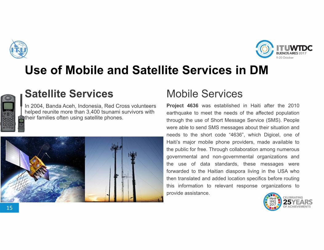
Use of Mobile and Satellite Services in DM
Satellite ServicesIn 2004, Banda Aceh, Indonesia, Red Cross volunteers helped reunite more than 3,400 tsunami survivors with their families often using satellite phones.
Mobile ServicesProject 4636 was established in Haiti after the 2010earthquake to meet the needs of the affected populationthrough the use of Short Message Service (SMS). Peoplewere able to send SMS messages about their situation andneeds to the short code “4636”, which Digicel, one ofHaiti’s major mobile phone providers, made available tothe public for free. Through collaboration among numerousgovernmental and non-governmental organizations andthe use of data standards, these messages wereforwarded to the Haitian diaspora living in the USA whothen translated and added location specifics before routingthis information to relevant response organizations toprovide assistance.
15

16
Early Warning System
Hospitals
Governmentauthority
Fire DivisionHeadquarters
Public-ServiceVehicles(Fire engines)
Public-Safety Vehicle(Official Vehicles)
Indoor receiversCitizens
Public Announcing Systems
Broadcasting
Beach public address systems
Disaster ManagementHeadquarters
Early Warning and Emergency Telecommunication

Japan - 2011
Earth Observation
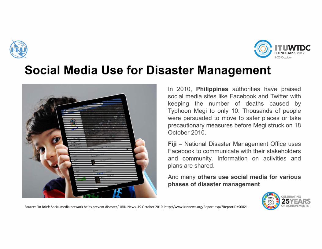
Social Media Use for Disaster ManagementIn 2010, Philippines authorities have praisedsocial media sites like Facebook and Twitter withkeeping the number of deaths caused byTyphoon Megi to only 10. Thousands of peoplewere persuaded to move to safer places or takeprecautionary measures before Megi struck on 18October 2010.
Fiji – National Disaster Management Office usesFacebook to communicate with their stakeholdersand community. Information on activities andplans are shared.
And many others use social media for variousphases of disaster management
Source: “In Brief: Social media network helps prevent disaster,” IRIN News, 19 October 2010, http://www.irinnews.org/Report.aspx?ReportID=90821

Hazard Mapping – GIS Use
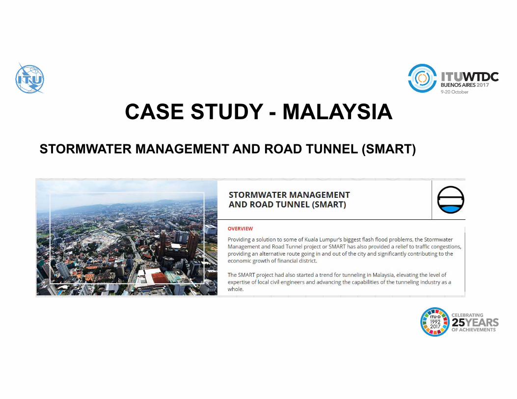
STORMWATER MANAGEMENT AND ROAD TUNNEL (SMART)
CASE STUDY - MALAYSIA

OVERVIEW - SMARTunnel
Malaysia, Kuala Lumpur’s Stormwater Management and Road Tunnel (SMART) diverts
potential floodwater away from the city’s financial district through a 9.7 km long tunnel. The
system is a combination of barriers, flood gates and holding ponds. The unique aspect of this
flood mitigation project is that it has a traffic bypass tunnel in the middle third section that has
two traffic decks, each connected to flood gates that control the amount of water entering the
road tunnel. As the volume of water that needs to pass through the tunnel increases, the road
tunnels are closed one at a time, and water is allowed to flow in. A sophisticated Flood
Detection System is installed to provide adequate warning time to evacuate traffic in the
tunnel, to minimize traffic disruption, and operate tunnel floodgates. It is composed of a
network of automatic and complex ICT systems that record rain estimates, river flow/level
estimating stations, real-time telemetry and control operating system, and an ICT system that
runs set of hydrological and hydraulic forecast models to make better decisions.
Source: https://en.wikipedia.org/wiki/SMART_Tunnel

Three Modes of Operation – SMART
Source: World Bank
GV15

Slide 22
GV15 I would delete this slideGray, Vanessa, 8/24/2017

Drones – Eyes from aboveIn Disaster Management Drones are mostly used for:• Situation Awareness, Reconnaissance,
Surveillance• Structural Inspection• Search and Rescue• Initial Damage Estimation
Drones for Disaster Management must be a complete solution, having:• Data capturing, storage and
processing• Easy to fly, drive or dive• Real time view with ability to
direct, zoom, etc.PrecisionHawk’s Lancaster

Big Data for development: preventing the spread of epidemics

Challenges
• National capacities to analyze data and high resolution satellite images
• Access to raw data/ data sharing/ interoperability of data• Lack of national GIS data infrastructures• Limited of access to high resolution satellite imageries• Missing national, district and/or local level risk assessments• National Emergency Communication Coordination

Opportunities• Establish partnerships with earth observation data providers• Build national capacity to use earth observation data• Implement open data access policy for research and
development• Implement national GIS data infrastructure and risk information
systems• Establish knowledge management systems to manage all
disaster data• Establish partnerships with international partners• Improve coordination on emergency telecommunication

THANK YOU