the riparian zone - the official web site for the state of … · · 2012-06-08does the riparian...
TRANSCRIPT

THE RIPARIAN ZONE
Patrick Ryan Division of Land Use RegulationNew Jersey Department of Environmental Protection

FHA JurisdictionN.J.A.C. 7:13-2.2
• There are two distinct and overlapping areas of jurisdiction:
� The flood hazard area
� The riparian zone

Purpose and Scope
• To minimize damage to life and property from flooding caused by development within the FHA, to preserve the quality of surface waters, and to protect the wildlife and VEGETATION that exist and depend upon such areas for sustenance and habitat.


Riparian ZoneAll waters in New Jersey are regulated except for t he following:
� Any manmade canal, i.e., Delaware Canal & Raritan Canal
� Any coastal wetland regulated under the Wetlands Act of 1970
� Any segment of water that drains less than 50 acres, which has no discernible channel, and/or is within a lawfully existing manmade conveyance structure, and/or is not connected to a regulated water by a channel or pipe
SEE N.J.A.C. 7:13-4.1

Riparian ZoneA RIPARIAN ZONE EXISTS ALONG ALL REGULATED WATERS EXCEPT:
� The Atlantic Ocean
� Manmade lagoons
� Stormwater management basins
� Any oceanfront barrier island, spit or peninsula
� Any lawfully-piped section of an otherwise regulated water (As noted previously, this is not listed in the rules)
SEE N.J.A.C. 7:13-4.1

Riparian Zone
� Measures 50, 150, or 300 ft along both sides of a regulated water

Riparian Zone
� To determine the limits of the riparian zone, you need to know where to measure it from
� It is generally measured outward from the top of bank along a regulated water

Riparian ZoneIf a bank is present


If a discernible bank is NOT present: Along a linear fluvial
or tidal water, such as a small stream, the riparian zone is
measured landward of the feature's centerline


If a discernible bank is NOT present: Along a non-linear fluvial water , such as a lake or pond, the riparian zone is
measured landward of the normal water surface limit
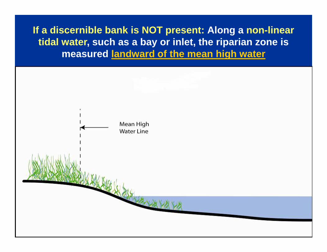
If a discernible bank is NOT present: Along a non-linear tidal water , such as a bay or inlet, the riparian zone is
measured landward of the mean high water

If a discernible bank is NOT present: Along an amorphous feature , such as a wetland complex, through
which a regulated water flows but which lacks a discernible channel, the riparian zone is measured
landward of the feature's centerline

Drainage Area and Riparian Zone

Drainage Area and Riparian Zone

Drainage Area and Riparian Zone

There is no riparian zone along a lawfully piped or culverted section of stream:


Does the riparian zone arc around the “end” of a regulated water?
� Yes: If the feature
“ends” because of
natural causes
� No: If the feature enters
a pipe

The riparian zone will also end at road crossings as follows:

If a stormwater basin was constructed along a stream, the riparian zone is projected from the original top of bank:

If a stormwater basin was constructed along a stream, the riparian zone is projected from the original top of bank:

300-ft Riparian Zone
� 300 ft along: Category One waters and upstream
tributaries within the same HUC-14 watershed
� Category One waters are listed in the Department’s Surface Water Quality Standards at N.J.A.C. 7:9Bhttp://www.nj.gov/dep/wms/bwqsa/swqs.htmAvailable on
� GeoWeb (NJDEP’s Interactive mapping tool)http://www.nj.gov/dep/gis/geowebsplash.htm
SEE N.J.A.C. 7:13-4.1

300-ft Riparian Zone
� Important: The 300-ft riparian zone is not
exactly the same as the Special Water
Resource Protection Area
SEE N.J.A.C. 7:13-4.1

300-ft Riparian Zone vs SWRPA
� Difference #1: The SWRPA applies only to waters that are shown on a USGS quad or County Soil Survey
� The riparian zone applies to regulated waters regardless of any mapping
SEE N.J.A.C. 7:13-4.1 & N.J.A.C. 7:8-5.5(h)

300-ft Riparian Zone vs SWRPA
� Difference #2: The SWRPA applies only to projects that are major developments (under N.J.A.C. 7:8)
� The riparian zone applies to regulated waters regardless of the size of the project
SEE N.J.A.C. 7:13-4.1 & N.J.A.C. 7:8-5.5(h)

300-ft Riparian Zone vs SWRPA
� Difference #3: Location Based vs Activity Based
� The inner half of the SWRPA may not be developed; the outer half may be developed if previously disturbed
� The riparian zone does not have an inner or outer half; it may be disturbed for certain activities, if justified
SEE N.J.A.C. 7:13-4.1 & N.J.A.C. 7:8-5.5(h)

WHAT IS A HUC-14 WATERSHED?
� Watershed area defined by USGS
� 14-digit Hydrologic Unit Code
� NJ’s watersheds boundaries are mapped and numbered
� Available on GeoWeb (NJDEP’s Interactive mapping tool) (Subwatersheds HUC14)
� Statewide map at: www.state.nj.us/dep/watershedmgt/hucmap.htm


150-ft Riparian Zone
1. Trout production waters and all tributaries2. Trout maintenance waters and all tributaries
within one mile 3. Waters that flow through an area that contains
documented T&E habitat (if plant/animal is critically dependent on the regulated water for survival) and all tributaries within one mile
4. Waters that flow through an area that contains acid producing soils
SEE N.J.A.C. 7:13-4.1

TROUT PRODUCTION - 150-ft RIPARIAN ZONE

TROUT MAINTENANCE - 150-ft RIPARIAN ZONE

Threatened or Endangered Species
� The 150-foot riparian zone also applies to any segment of a regulated water flowing through an area that contains documented habitat for a threatened or endangered species of plant or animal, which is critically dependent on the regulated water for survival, and all upstream tributaries within one mile.

Landscape Maps• Available from the Department’s Division of
Fish and Wildlife, Endangered and Nongame Species Program at: http://www.nj.gov/dep/fgw/ensphome.htm
• Or can be viewed through GeoWeb at http://www.nj.gov/dep/gis/geowebsplash.htm
Threatened or Endangered Species

Threatened or Endangered Species
For further information on the occurrence and mapping of threatened or endangered plant species habitat
contact:
Natural Heritage Data Request FormThe New Jersey Natural Heritage ProgramDEP - Office of Natural Lands Management
Mail Code 501-04P.O. Box 420
Trenton, NJ 08625-0404
NOTE - NHP Letter required for a FHA submission

T&E SPECIES - 150-ft RIPARIAN ZONE

ACID SOILS - 150-ft RIPARIAN ZONE


50-ft Riparian Zone
� Along all other waters
� Most common riparian zone width, especially in urbanized areas (except where acid producing soils exist)
SEE N.J.A.C. 7:13-4.1

Riparian Zone Disturbance
What if you want to
conduct regulated
activities in the riparian
zone?


Riparian Zone Disturbance N.J.A.C. 7:13-7.2
� Permits-By-Rule
� For specific activities, where in general no
vegetation will be disturbed
� Some require notification
� An Applicability Determination may be
applied for to obtain a written determination
that an activity meets a permit-by-rule.
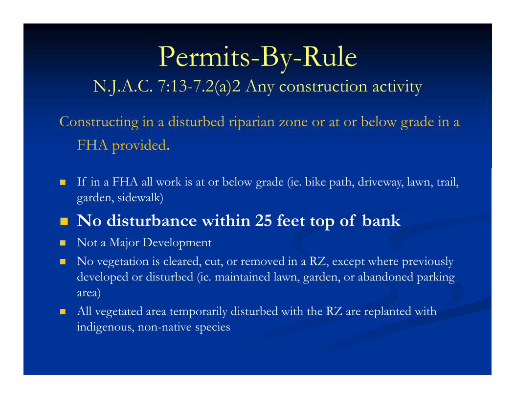
Permits-By-Rule N.J.A.C. 7:13-7.2(a)2 Any construction activity
Constructing in a disturbed riparian zone or at or below grade in a
FHA provided.
� If in a FHA all work is at or below grade (ie. bike path, driveway, lawn, trail, garden, sidewalk)
� No disturbance within 25 feet top of bank� Not a Major Development
� No vegetation is cleared, cut, or removed in a RZ, except where previously developed or disturbed (ie. maintained lawn, garden, or abandoned parking area)
� All vegetated area temporarily disturbed with the RZ are replanted with indigenous, non-native species

Riparian Zone Disturbance N.J.A.C. 7:13-10.2
� The rules are designed to preserve all existing riparian zone vegetation
� All vegetation counts (trees, grass, shrubs, weeds, etc.)


Riparian Zone Disturbance N.J.A.C. 7:13-10.2
Rules do not prohibit construction, but:
� All proposed disturbance must be avoided, justified, and fully minimized
and
� Each activity has limits on disturbance

Riparian Zone Disturbance N.J.A.C. 7:13-10.2
Disturbance within 25 feet of the top of bank is generally prohibited, except for unavoidable situations. For example:
� Road crossings are often justified
� Bank stabilization may be necessary
� Parking lots are unlikely justified


Riparian Zone Disturbance N.J.A.C. 7:13-10.2(d)
� All work must meet 3 basic
criteria:
1. The basic purpose of the project cannot be
accomplished onsite without disturbing
vegetation in the riparian zone.

Riparian Zone Disturbance N.J.A.C. 7:13-10.2(d)
2. Disturbance to the riparian zone is eliminated
where possible; where not possible to eliminate,
disturbance is minimized through methods
including relocating the project, reducing the size
or scope of the project and/or situating the
project in portions of the riparian zone where
previous development or disturbance has
occurred;

Riparian Zone Disturbance N.J.A.C. 7:13-10.2(d)
3. All temporarily cleared, cut or removed
vegetation within a riparian zone is replanted with
indigenous, non-invasive vegetation upon
completion of the project.

Example

Example

Example

Example

Example

Example

Example: not minimized

Example

Example

Example: minimized

Riparian Zone Disturbance
In addition to the basic requirements at N.J.A.C. 7:13-10.2(d):
• Maximum riparian zone disturbance set at Table C
• Additional criteria must be met for each specific activity under 10.2(e) through (r)
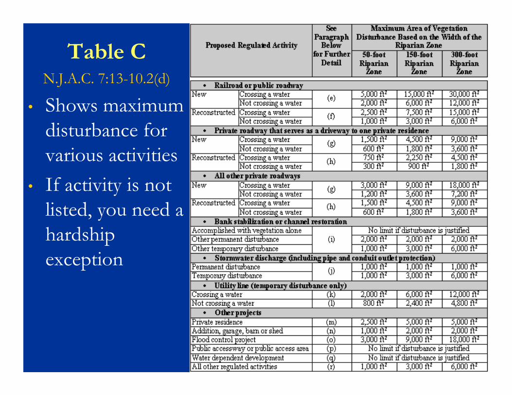
Table CN.J.A.C. 7:13-10.2(d)
• Shows maximum disturbance for various activities
• If activity is not listed, you need a hardship exception

Table C
Includes disturbance for:• Roadways (e) - (h)• Bank Stabilization (i)• Stormwater discharges (j)• Utility lines (k) - (l)• A private residence or appurtenant
structure (m) - (n)• Flood control projects (o)• Tidal developments (p) - (q)• “Other” minor activities (r)


Example: Private roadway (driveway)N.J.A.C. 7:13-10.2(g)


Example: Private roadway (driveway)N.J.A.C. 7:13-10.2(g)

Example: Private roadway (driveway)N.J.A.C. 7:13-10.2(g)

Example: Private roadway (driveway)N.J.A.C. 7:13-10.2(g)

Example: Private roadway (driveway)N.J.A.C. 7:13-10.2(g)

Example: Private roadway (driveway)N.J.A.C. 7:13-10.2(g)

Example (continued):N.J.A.C. 7:13-10.2(g)
(g) The Department shall issue an individual permit for the construction of a new private roadway, which results in clearing, cutting and/or removing vegetation in a riparian zone, only if the following requirements are satisfied:

Example (continued):N.J.A.C. 7:13-10.2(g)
1. The total area of vegetation cleared, cut and/or removed within the riparian zone does not exceed the limits set forth in Table C above;
2. The width of the roadway is minimized;

Example (continued):N.J.A.C. 7:13-10.2(g)
3. Any crossing of a regulated water is designed and constructed as nearly perpendicular to the channel as possible;
4. The roadway accesses a lot that did not receive preliminary or final subdivision approval after October 6, 2006;

Example (continued):N.J.A.C. 7:13-10.2(g)
5. If the roadway does not cross a regulated water, but impacts a 150-foot or 300-foot riparian zone, the applicant demonstrates that there is no other means of constructing a roadway to access the developable area onsitre, which would reduce or eliminate the impact to the riparian zone

Areas Devoid of VegetationN.J.A.C. 7:13-10.2
� All disturbed vegetation counts (trees, grass, shrubs, weeds, etc.) under Table C
� But, if you disturb an area within the riparian zone, which has no vegetation due to previous lawful development, do not count it under Table C
� For example, work within paved roads and parking
areas does not count toward Table C

Example: New road on existing pavement in the riparian zone does not count toward Table C

But: In this example, there may be another entrance to the site that would not disturb the riparian zone

� Table C disturbances cannot be swapped!
Riparian Zone Disturbance

Riparian Zone Disturbance
� If the driveway only disturbs 1000 SF, you cannot “credit” the unused 500 SF towards the house.
� The house would still be allowed a maximum of 2500 SF, if justified.

Remember:
� Just because an activity meets the limits of Table C, it does not automatically mean that you’ll get a permit for it: you must prove that the disturbance is minimized, justified, and unavoidable (N.J.A.C. 7:13-10.2(d))

Temporary DisturbanceN.J.A.C. 7:13-10.2
� Temporary disturbance to lawn and garden areas does not count toward thresholds in Table C, provided all vegetation is restored.
� For example:� Reconstructing a septic system in a lawn
� Relocating structures (trails, sheds, footbridges) in a
park or golf course
� Placing new pavement in grass, then ripping up an
equal area of pavement and replanting the area with
grass

Exceeding Table CN.J.A.C. 7:13-10.2(d)
� A hardship exception is needed if you want to exceed the riparian zone limits of Table C, except for the following projects (in certain cases):
� Improvements to an existing public roadway or
railroad – 10.2(f)
� Bank stabilization and channel restoration projects
– 10.2(i)
� Flood control projects – 10.2(o)

2:1 CompensationN.J.A.C. 7:13-10.2(t)
� Is also required for any project under 10.2(r):
� N.J.A.C. 7:13-10.2(r) allows riparian zone disturbance for any regulated activity not listed in Table C
BUT:
� 2:1 compensation is required for all proposedriparian zone disturbance
� And, you cannot exceed the limits for 10.2(r) without a hardship exception

2:1 CompensationN.J.A.C. 7:13-10.2(t)
� Can be accomplished in two ways:� Removing lawfully existing structures and/or
impervious surfaces in the riparian zone, and replanting the area with vegetation, or
� Planting new trees in the riparian zone in an area that is substantially devoid of trees at the time of application because the trees were removed due to previous, lawful development

RedevelopmentN.J.A.C. 7:13-10.2(v)
� Redevelopment of lawfully non-vegetated areas is not hindered, except that it should be pulled back at least 25 feet from bank where possible

Fisheries ResourcesN.J.A.C. 7:13-10.5
� Requirements in or along a water with a fishery resource. Includes tributaries that drain to a fisheries resource and includes both work in the channel and the Riparian Zone.
� Timing restrictions are met
� Unset or raw concrete does not contact the water
� No logs or boulders providing habitat are removed
� Low-flow conditions are maintained.


Threatened and Endangered Species
N.J.A.C. 7:13-10.6
� GeoWeb rank 3, 4, or 5 and Natural Heritage Priority Database provided in the NHP letter
� NJDEP will only issue an FHA-IP if the activity will not adversely affect T & E or documented habitat.
� A T & E survey for plants or habitat assessment for animals may be required per NJAC 7:13-15.5(c)
� Timing restrictions depending on species


Questions?Patrick Ryan
Division of Land Use Regulation
Mail Code 501-02A
PO Box 420
501 East State St.
Trenton, NJ 08625
(609) 292-9542