the results of field walking, casual observations, test ... haslingfield grey report april...
TRANSCRIPT

The results of field walking, casual observations, test pitting and an earthwork survey undertaken
by CAFG within Haslingfield parish between 1981- 2012

The results of field walking, casual observations, test pitting and an earthworksurvey undertaken by CAFG within Haslingfield parish between 1981- 2012
By Cambridge Archaeology Field Group (CAFG)
Including specialist contributions by Rob Atkins, Paul Blinkhorn, Craig Cessford, MikeColes, Nina Crummy, Terry Dymott, Chris Faine and James Fairbairn
Illustrator: Lucy Offord
Report Date: April 2014
Page 1 of 114

Table of ContentsSummary.............................................................................................................................................61 Introduction.....................................................................................................................................8
1.1 Location and scope of work......................................................................................................81.2 Geology and topography...........................................................................................................81.3 Archaeological and historical background................................................................................91.4 Acknowledgements.................................................................................................................14
2 Aims and Methodology.................................................................................................................162.1 Aims........................................................................................................................................162.2 Methodology...........................................................................................................................16
3 Results...........................................................................................................................................183.1 Introduction.............................................................................................................................183.2 Fieldwalking and an earthwork survey...................................................................................183.3 Casual observations/artefacts within Haslingfield..................................................................223.4 Test pits...................................................................................................................................23
4 Discussion and Conclusions..........................................................................................................284.1 Introduction.............................................................................................................................284.2 Overview by period.................................................................................................................284.3 Significance.............................................................................................................................38
Appendix A. CHER Records............................................................................................................40Appendix B. Trench Descriptions and Context Inventory...............................................................43Appendix C. Finds Reports..............................................................................................................52
C.1 Small Finds.............................................................................................................................52C.2 Pottery....................................................................................................................................52C.3 Brick and Tile.........................................................................................................................65C.4 Clay Pipe................................................................................................................................71C.5 Stone Mortar from near Test Pit 4..........................................................................................72C.6 Queens’ College Plates at Brook Farm...................................................................................73
Appendix D. Environmental Reports...............................................................................................78D.1 Animal bone...........................................................................................................................78D.2 Shell.......................................................................................................................................79
Appendix E. Artefacts and Ecofacts from Field walking.................................................................80Appendix F. Bibliography...............................................................................................................111
Page 2 of 114
List of FiguresFig. 1 Map of Haslingfield parish, showing fields walked and CHER numbers
Fig. 2 Village with casual finds reported and positions of 2012 test pits and date with amended CHER data
Fig. 3 Late Bronze Age/Early Iron Age pottery recovered from field walking with Neolithic and Bronze Age CHER numbers
Fig. 4 Iron Age and Roman pottery recovered from field walking, casual finds,test pits and CHER numbers
Fig. 5 Early/Middle Saxon, Middle/Late Saxon and Late Saxon/Saxo-Normanpottery recovered from field walking, casual finds, test pits and CHER numbers
Fig. 6 Medieval and late medieval pottery recovered from field walking, casual finds, test pits and CHER numbers
Fig. 7 Earthwork survey of River Farm
Fig. 8 Purbeck marble mortar from Test Pit 4
Fig. 9 Vessel 1 showing illustration of Queens’ College viewed from the River Cam
Fig. 10 Rim of vessel 2 showing the college motto “FLOREAT DOMUS”
Fig. 11 Instance of incorrect punctuation on the plate
Fig. 12 Partial word QUEE
Fig. 13 Partial words for J K TAYLO[R] and QUEENS C[OLLEGE] on vessel 4
List of TablesTable 1 Prehistoric to late medieval pottery found by field and period in 100m² areas of
field walking
Table 2 Worked flint from field walking
Table 3 Pottery from test pits
Table 4 CHER records (Mesolithic to medieval)
Table 5 Test Pit 1
Table 6 Test Pit 2
Table 7 Test Pit 3
Table 8 Test Pit 4
Table 9 Test Pit 5
Table 10 Test Pit 7
Table 11 Test Pit 8
Table 12 Test Pit 9
Table 13 Test Pit 10
Table 14 Test Pit 11
Table 15 Test Pit 12
Table 16 Test Pit 13
Page 3 of 114
Table 17 Test Pit 14
Table 18 Test Pit 15
Table 19 Test Pit 17
Table 20 Test Pit 18
Table 21 Test Pit 19
Table 22 Test Pit 21
Table 23 Test Pit 23
Table 24 Test Pit 25
Table 25 Test Pit 26
Table 26 Test Pit 27
Table 27 Test Pit 28
Table 28 Test Pit 29
Table 29 Pottery from field walking analysed by Paul Blinkhorn, by period and fabric
Table 30 Pottery occurrence at Dovecote, High Street by number and weight (in g) of sherds per context by fabric
Table 31 Pottery occurrence at 48 High Street by number and weight (in g) of sherds per context by fabric type
Table 32 Pottery occurrence at 33 High Street by number and weight (in g) of sherds per context by fabric type
Table 33 Pottery from Test Pit 1
Table 34 Pottery from Test Pit 2
Table 35 Pottery from Test Pit 3
Table 36 Pottery from Test Pit 4
Table 37 Pottery from Test Pit 5
Table 38 Pottery from Test Pit 7
Table 39 Pottery from Test Pit 8
Table 40 Pottery from Test Pit 10
Table 41 Pottery from Test Pit 11
Table 42 Pottery from Test Pit 12
Table 43 Pottery from Test Pit 13
Table 44 Pottery from Test Pit 14
Table 45 Pottery from Test Pit 15
Table 46 Pottery from Test Pit 17
Table 47 Pottery from Test Pit 18
Table 48 Pottery from Test Pit 19
Table 49 Pottery from Test Pit 21
Table 50 Pottery from Test Pit 23
Page 4 of 114
Table 51 Pottery from Test Pit 26
Table 52 Pottery from Test Pit 27
Table 53 Pottery from Test Pit 28
Table 54 Pottery from Test Pit 29
Table 55 Brick, floor and roof tile from test pits by number of fragments and weight
Table 56 Brick with measurable dimensions by colour, measurement and possible date
Table 57 Catalogue of brick by test pit and spit
Table 58 Ceramic roof tile from test pits by colour, quantity and weight
Table 59 Catalogue of ceramic roof tiles by test pit and spit
Table 60 Medieval floor tiles by test pit and spit
Table 61 Clay pipe from test pits
Table 62 Animal bone by species distribution in test pits
Table 63 Oyster shell from test pits
Table 64 Catalogue of pottery from field walking by 100m² areas
Table 65 Catalogue of artefacts and ecofacts from field walking HAS 06 (Fields 8 and 9)
Table 66 Catalogue of artefacts and ecofacts from field walking at Brook Farm (Fields
14 and15)
Table 67 Catalogue of artefacts and ecofacts from field walking BR008 (Barton Road)(Fields 11 to13)
Page 5 of 114

Summary
This report records all work carried out by CAFG within Haslingfield parish between1981 and 2012. This comprises fieldwalking of about a quarter of the parish (1981-2007), 10 casual observations including three test pits within the village (c.1985-2011), an earthwork survey at River Farm (Field 2) and 24 test pits within the villageexcavated over a weekend in 2012. This is a significant amount of work which hasadded substantially to our understanding of the development if the parish over time.
Very small quantities of earlier prehistoric material were recovered, with nosignificant artefacts present; although a small concentration of worked flint wasfound in Field 13.
A small quantity of Late Bronze Age/Early Iron Age (LBA/EIA) pottery was found intwo adjacent fields, extending over a 400m by 100m area (Fields 4 and 8). It ispossible that these artefacts imply a long lived settlement from the LBA/EIA period,earlier than previously thought. Over part of this area, within Fields 8 and 9, CAFGfield walking has also found some Mid/Late Iron Age pottery and a mass of Romanmaterial over an area c.500m by 200m. The latter included tesserae, many tiles(including box flue) and metal objects (including a cockerel brooch and a Saxonbrooch). Susan Oosthuizen has recorded this area as a possible estate centre(Roman and Saxon) and the CHER notes an Iron Age cremation, a Roman villa,Roman burials and Saxon cremations from this site.
CAFG fieldwork has found three further probable Mid/Late Iron Age to Romansettlements located in Fields 2, 6 and in an area around TL 4066 5221 within thepresent village. The Field 2 settlement is likely to have been extensive, as artefactscovered a 300m² area and this work greatly adds to the two CHER findspots (a coinand a pot sherd) recorded previously here. The settlement in Field 6, however, wasnot previously known. Mid/Late Iron Age (and Roman) pottery was found duringcasual observations in the village at TL 4066 5221, as well as Roman potterynearby during the 2012 test pit survey, suggesting a settlement over a c.300m byc.150m area. A few Roman artefacts have been recorded in the CHER as findsspots for part of this area, but the CAFG material has not only suggested a Mid/LateIron Age start date but also extends the area of the possible settlement.
A few artefacts dating to the Early-Middle Saxon period have also been found byCAFG. A single Saxon brooch found at TL 411 531 presumably originates from theSaxon burial ground found during coprolite digging in 1874 (CHER 04816). Potteryrecovered from this period suggests the possible presence of two previouslyunknown settlements, both directly to the south-west and north respectively of thelarge Mid-Saxon green postulated by Sue Oosthuizen and Chris Taylor. The formercomprises three Early/Middle and Middle Saxon pottery sherds found during fieldwalking at River Farm (Field 2). In the same location, Saxo-Norman and medievalpottery has also been found during CAFG fieldwalking, perhaps suggestingcontinuous occupation. The second suggested settlement is very uncertain due tothe limited nature of work. This consisted of a casual observation at 36 New Road,where a large sherd of a probable cremation urn was recovered, and 100m to thenorth-west of this, where a single pottery sherd was found in Sidney Gardens, withina test pit.
Casual observations and test pits by CAFG have found Saxo-Norman pottery andother artefacts in 10 sites within the area of the former green and in three places
Page 6 of 114

directly outside it. This evidence, combined with other archaeological work,suggests that final nucleation occurred at Haslingfield in the Saxo-Norman period,with an early 11th or just post-Conquest date probable. No pottery or artefacts ofthis period have been found beyond the present village in other parts of the parish,despite significant areas being fieldwalked.
An increased number of sites datable to the c.12th to mid-14th century period havebeen identified by CAFG, represented by pottery and other artefacts recovered fromcasual observations and test pits. These were within the former green itself andaround it, including along at least two of the roads leading out of the village.Interesting objects recovered include part of a possible Purbeck stone mortar.Earthworks were recorded by CAFG at River Farm (Field 2) and comprised houseplatforms, a road-way and other features. These elements are likely to have datedto the medieval period as, subsequent to the survey, the site was ploughed andfieldwalked with 472 medieval pottery sherds found along with a small number oflate medieval sherds.
In the c.12th century, a new hamlet seems to have been established in the parish atBrook Farm, c.500m to the north of the present village. Medieval and late medievalpottery was found, concentrated over a c.250m by 200m area. It is possible, evenlikely, that this belonged to the former Sternes manor. Haslingfield is an example ofnew settlement(s), or hamlets forming outside the main nucleated settlement.
There was a reduction in the number of artefacts datable to the late medieval periodfound both within the former green and around the outside; sites abandoned includethe River Farm area. In contrast the 'hamlet' at Brook Farm continued throughoutthe late medieval period. Pottery production (fabric 402: see Appendix E) may havebeen undertaken, given the presence of possible kiln waste found here.
Within the main manor (Scales) in the centre of Haslingfield village, a large middenlayer up to c.0.5m thick, dating to the c.mid 16th century, was found in three testpits. Test Pit 4 was the most productive, with a significant quantity of mostly primarymaterial (pottery, bone, tiles (floor and roof), brick, nails, shells etc.).
In the post-medieval period there seems to have been a slow increase in populationwithin the present village, although the hamlet at Brook Farm seems to havebecome diminished in c.16th/17th centuries, becoming just a farm.
Page 7 of 114

1 INTRODUCTION
1.1 Location and scope of work1.1.1 Archaeological work in the parish of Haslingfield has been conducted intermittently by
the Cambridge Archaeology Field Group (CAFG) since 1981. This work has taken fourmain forms, comprising fieldwalking, casual observations (including a few test pits), anearthwork survey and an extensive test pit survey. Fieldwalking occurred between 1981and 2007 with about a quarter of the parish being surveyed. A number of casualobservations were undertaken within the core of the village between the 1980s and2012, mostly when individual buildings or structures were being constructed; three testpits were also hand excavated. Over 16th and 17th June 2012, 24 test pits wereexcavated around the village as a community programme run by CAFG. An earthworksurvey was carried out at River Farm in c.1980.
1.1.2 Over these years CAFG has documented a number of the fieldwalking and casualobservations as interim statements submitted to the Cambridgeshire HeritageEnvironment Record (CHER). It is important to note that none of these statementscontained detailed distribution maps of the artefacts, indeed even the pottery dateswere uncertain as they had not been examined by a specialist. Several areas offieldwalking and the earthwork survey were not formally reported.
1.1.3 This current report brings together the results of all the CAFG work in the parish.Specialists have undertaken analysis of the main artefact and ecofact groupsuncovered. Historical sources, as well as other archaeological work, have beenincluded in order to understand the development of the parish from the Stone Age tothe early post-medieval period. Grants in 2012 by the Haslingfield Society, JIGSAWCambridgeshire and the Eastern region of the Council for British Archaeology havehelped to fund this project.
1.1.4 CAFG has constantly strived to keep the local community involved, not only during thetest pit survey but also in formal events. On 26th May 2013 an open day was held atthe village hall with a display of finds from the test pits as well as talks concerningvarious aspects of CAFG's work. It is anticipated that this current report will be madeavailable as a downloadable pdf document and it is hoped that a paper will besubmitted to the county journal, Proceedings of the Cambridge Antiquarian Society(PCAS), in due course.
1.1.5 The site archive is currently held by CAFG and will be deposited with the appropriatecounty stores in due course.
1.2 Geology and topography1.2.1 The parish of Haslingfield (pre-1934 boundaries) comprised 2,573 acres, and was
bounded on the north and east by the Bourn Brook and the River Cam respectively. Itssouthern boundary with Barrington descends from the summit of the White Hill to theCam, while the western boundary partly follows old watercourses: the Long andCaldwell Brooks (Fig. 1; Wright 1973, 227).
1.2.2 The British Geological Survey (BGS 2001 and 2002) records that the earliest solidgeology comprises Head material in the extreme southern part of the parish. The nextin the geological sequence is Gault Formation (mudstone), which is found in parts ofthe northern area of the parish. This Formation in about half the parish, including mostof the village itself, is sealed by either West Melbury Marly Chalk and/or Zig Zig Chalk
Page 8 of 114

Member. Drift geology is only found along the rivers and brooks along the north andeastern parish boundaries and comprises Alluvium and River Terrace Deposits.
1.2.3 The top of White Hill on the southern side of the parish is at 66mOD sloping sharply tothe village at or just under 20mOD, with the northern half of the parish being fairly flat atbetween c.19m and c.22mOD.
1.3 Archaeological and historical background1.3.1 A search of the Cambridgeshire HER database for the parish was carried out, although
only the data from the pre-1934 parish boundaries have been used; a full CHER listfrom Mesolithic to medieval is included as Appendix A. Further information sourceswere also used, including the Victoria County History (VCH), publications by localhistorians e.g. Stringer and Coles 2009, as well as their unpublished notes, and severalarticles by academics (especially Susan Oosthuizen and Christopher Taylor). Thesesources have enabled the results from the CAFG work to be placed within the contextof the known archaeology and history of Haslingfield and the broader surrounding area.
1.3.2 Relatively few archaeological excavations have taken place in the parish and most ofthese were small and located away from the present village, near to the boundaries ofTrumpington and Barrington parishes, more than 1km from the village centre. Parts ofthe parish were quarried for coprolites in the late 19th century and a few artefacts foundduring this activity were donated to local museums.
Earlier Prehistoric (Mesolithic to Bronze Age) (Fig. 1)Mesolithic CHER records
1.3.3 Four Mesolithic findspots have been recorded in the parish. These comprise a tranchetaxehead and another axe in the same location at the extreme north-east of the parish(CHERs 04350 and 04378), a scatter of Mesolithic flints one km to the south of theseaxes (CHER 04376) and a tranchet axe in the northern part of the village (CHER04351).
Neolithic CHER records and archaeological work
1.3.4 Five Neolithic findspots have been recorded in the parish. In the north-east there wasan arrow head (CHER 04376A), and three adjacent flint scatters (CHERs 04340, 16178and 16356) were found in the far south-west. A Late Neolithic pottery sherd was alsorecovered during fieldwalking at the latter site (Dickens 1999). In addition a few residualEarly Neolithic flints were found in the northern part of the village during a recentexcavation at 30 New Road (Atkins 2011, 53).
Bronze Age CHER records and archaeological work
1.3.5 It has been suggested that a prehistoric trackway ran through Harlton and Haslingfield,crossing the Cam at Hauxton Mill in the south of the parish (Malim 2000, 11). Apossible variation or offshoot of this was the ‘Mare Way’, which followed the ridgeway tothe south. This is undated but may be from the Bronze Age or Iron Age (CHER04718a). Money Hill Bronze Age tumulus was also located along this ridgeway (CHER04718). Nearby, a group of undated ring ditches (CHERs 04719, 04720, 04721, 04722,04723) extending over a 300m distance has also been identified from aerialphotographs, and might be the remains of Bronze Age round barrows.
1.3.6 Scatters of artefacts have also been recorded in the parish, including along the easternparish boundary next to the River Cam (CHERs 16179, 04376B and 10159). The firstmay denote occupation/settlement, as a scatter of pottery was found (undecorated andsome showing burning), with the two others being findspots (an arrowhead and a bridle
Page 9 of 114

bit). In the village itself (CHER 04347) and directly to the west of it (CHER 04344) werea barbed and tanged arrowhead and an Early Bronze Age flint knife respectively. Inaddition, a few residual Bronze Age flints were found in the northern part of the villageduring a recent excavation at 30 New Road (Atkins 2011, 53).
Later Prehistoric to Roman1.3.7 Later prehistoric and Roman records within the parish are far more numerous than
earlier prehistoric records. Some of these records derive from aerial photographs ofcropmarks which are likely to be Iron Age and/or Roman in date. Most settlements ofthis age extend into both periods and, for this reason, settlement cropmark featureshave been mostly assigned to both the Iron Age and Roman periods.
1.3.8 Overall, it is thought that Iron Age settlements in Haslingfield parish comprisedscattered farms and hamlets set in a largely cleared landscape (Oosthuizen 1996, 8)."Each farmstead was surrounded by its own fields, and .... the farmers may havemanaged the woodland, meadow, fen and pasture in common" (ibid, 8). Oosthuizenhypothesised that all these hamlets and farmsteads within the present Haslingfieldparish, and possibly some land to the west in Harlton parish, were part of a probablelarge Iron Age estate (ibid, 8). The northern, eastern and southern boundaries of thisestate survive in the present Haslingfield parish boundaries (respectively, the BournBrook, River Cam and a chalk ridge). The individual farmers probably paid rents to theestate owner. Oosthuizen identifies seven areas of Iron Age (and Roman) occupationwithin Haslingfield parish, based on recorded artefacts (1996, map 1). The sevenareas are spread across the parish, between c.500m and 1km apart.
1.3.9 Oosthuizen (1996, 8) argued for continuity of settlement for most (if not all) ofHaslingfield's Iron Age settlements into the Early Roman period, but with Romanlanguage and culture slowly seeping into the countryside through the Roman garrisonat Cambridge and the Roman town which replaced it. The land was used moreintensively in this period, with loss of further woodland, whilst the former Iron Ageestate may have been controlled from a Roman villa located at the extreme north-eastern part of the parish, near to the Cam (ibid, 10).
Iron Age CHER records and archaeological work
1.3.10 A cremation was found in 1818 in the far north west of the parish, in addition to IronAge pottery denoting a probable settlement (CHER 03323); while a series of sevensettlement cropmarks aligned directly parallel to and south of the Bourn Brook werealso identified between 300m and 500m apart (CHERs 9652, 8945, 9634, 8943, 8941,9643 and 04724). A further three postulated settlements were recorded to the south ofthese settlements, in the far north-east of the parish (CHERs 9644, 9645 and 18433;Fig. 1). The last, at Cantelupe Farm, comprised Late Iron Age and/or Early Romanoccupation revealed during an archaeological evaluation (Newman 2009).
1.3.11 In the central northern part of the parish there are four other settlements withcropmarks (CHER 8962), and two adjacent cropmark sites in the far south of the parish(CHERs 8940 and 9651). An excavation at 30 New Road in the village found part of asettlement dating from the Late Iron Age to the Early Roman periods, with Iron Ageartefacts including a coin as well as pottery and animal bones (Atkins 2011). Threeresidual Early Iron Age sherds from the site may have come from a single feature pre-dating the settlement.
1.3.12 Three Iron Age findspots have been recorded in the parish: Iron Age pottery and aweaving comb were found adjacent to the west of the village (CHERs 04345 and04528) and a Bronze disc just to the north-east of the village (CHER 4507).
Page 10 of 114

Roman CHER records and archaeological work
1.3.13 The two Iron Age/Roman settlements found by archaeological excavations and themany cropmark sites recorded above are not repeated in this section. A combination ofaerial photography, coprolite excavations, fieldwalking and magnetometry survey havefound/identified a villa, an associated field system and a cemetery between c.0.5kmand 0.7km to the north of the village. Aerial photography has recorded a double-ditchedenclosure and a villa; with artefacts from fieldwalking including tile and tesserae (CHER08961; Sanderson 2008). At least three Roman cremations in urns were found to theeast of this area, near Cantelupe Road, where a later Anglo-Saxon cemetery was alsolocated (CHER 04816a). A Roman pottery sherd was found 0.5km to the south-west ofthe cemetery, suggesting that activity may extend further to the south (CHER 04369).
1.3.14 In the village itself there may have been two settlements. Roman pottery found intopsoil layers during an archaeological evaluation on land to the rear of 65 New Road(CHER CB15627; Roberts 2000) may indicate a nearby Roman settlement - perhapspart of the one partly excavated 200m to the south-west at 30 New Road (see above).Here, an Early Roman enclosure and part of a possible domestic structure were found.Residual Late Roman artefacts including roof tile were found in the topsoil. The secondsettlement may be postulated by three separate findspots located around the presentchurch over a c.100m area (CHERs 04347A, 04348 and 04349), which collectivelycomprise four Roman coins and two spindlewhorls.
1.3.15 In the far north-east corner of the parish, three CHER records are c.100m apart andmay denote a former settlement, with coins and pottery being recovered (CHERs04728, 08704 and 08705). Another settlement may be postulated c.300m to the west bythe presence of Roman finds including a coin (CHERs 04726 and 04727). In the north-west corner of the parish near to the Roman road from Cambridge to Arrington Bridge,Roman burials were found in 1817 and 1907 within an oval barrow 68ft long, 30ft wideand 5ft high (CHER 03324).
1.3.16 Directly to the west of the village there is an isolated findspot of a Roman four-sidedglass vessel (CHER 04343), and to the south of the village a coin of Constantine wasfound (CHER 4718b). To the south-east there was a sherd of samian pottery (CHER04363a) and a coin of Trajan (CHER 04367).
Early to Middle Saxon 1.3.17 There are just four CHER entries for the parish relating to the Early to Middle Saxon
period. These comprise an Early Saxon (c. late 5th-6th centuries) inhumation andcremation cemetery, near to the site of the Roman cremation burials described above(CHER 04816; Lethbridge 1967, 313-4; Taylor 2000, 25). The cemetery was foundduring coprolite digging in 1874, when rich grave goods were recovered, including twoswords, spears, 55 brooches (many types), cowrie shells and draughtsmen made fromhorse teeth. Two CHER records comprise single Anglo-Saxon brooch findspots foundduring 19th coprolite digging in close proximity to the south-west of the village (CHERs04341and 04342). These brooches may have originated from another cemetery. In thefar south of the parish a few Early Saxon pottery sherds were found during fieldwalking(CHER 16356; Dickens 1999) but it is uncertain what this record represents.
1.3.18 The village of Haslingfield was recorded in the Domesday Book as Haslingefeld; thename probably means ‘people of Haesel’, where Haesel is an Old English personalname (Reaney 1943). Oosthuizen (1996, 11-14) has suggested that the ending '-field'
Page 11 of 114

is one of the earliest Anglo-Saxon place names and refers to a cleared area within sightof woodland and the ‘-ing’ part of Haslingfield refers to a tribal or political group, theHaeslingas. Oosthuizen believes that there may have been some administrativecontinuity as control of the estate passed from Roman to Saxon incomers (ibid, 13-14).This is based on two factors: 1) the eastern, northern and southern parish boundaries"remain" and 2) Haslingfield was one of seven manors in Cambridgeshire which bothcontained a major Roman site and was counted in 1086 as part of the 'king's ancientdemesne'.
1.3.19 Early documents dating to around AD 700 seem to place Haslingfield within the smallkingdom of West Willa (Hart 1974). West Willa was soon absorbed into the kingdom ofthe Middle Angles and later within the large kingdom of Mercia. Haslingfield wasseemingly one of the Royal estate centres (Oosthuizen 2006, 100).
1.3.20 A probable Saxon route way, the Stulpe Way, has been suggested (Oosthuizen 1996,map 2) and it is likely that the Early and Middle Saxon settlers were still living inscattered farmsteads into the 7th century (ibid, 1996, 13-15). Each community withinthe estate was obliged to provide produce to the estate. The large Haslingfield greenmay have been laid out in the Early Saxon period, or could be a Middle Saxon creation.Several similar greens have been suggested for other parishes in the area (Taylor2002), perhaps suggesting centralised planning in this part of south Cambridgeshire,possibly in the Middle Saxon period. For Haslingfield, there are references to a ‘greatGreen’ from the 14th century (Wright 1973, 229), although its size has been extensivelydebated (RCHM 1968; Oosthuizen 1996; Taylor 1997; Taylor 2002). Two authors havesuggested that the whole ovoid area (a 48ha site) may have been a very large ill-drained former meadow (Oosthuizen 1996; Taylor 2002, 62).
Late Saxon to medievalLate Saxon/Saxo Norman
1.3.21 Late Saxon/Saxo-Norman dates have been assigned to locations where St Neots,Stamford and Thetford pottery have been found. Most of these sherds cannot be tiedspecifically to the Late Saxon period or just afterwards, and therefore they have beengiven the broad date range. The CHER records this Late Saxon/Saxo-Norman potteryjust as medieval (except for CHER 05008) and this 'medieval' dating has been kepthere (Fig. 1). In contrast, in the Results section of this report (Section 3), PaulBlinkhorn's dating has allowed this former wide dating to be sub-divided to LateSaxon/Saxo-Norman, medieval and late medieval periods (See Figs. 5 and 6).
1.3.22 In the CHER records only a single site has been attributed to the Late Saxon period,comprising a few pottery sherds recovered directly to south-east of the village duringdrain digging (CHER 05008).
Saxo-Norman to medieval
1.3.23 Saxo-Norman and medieval features and artefacts are far more common in the parishand these have been found at several locations within and outside the putative green.
1.3.24 Five CHER records relating to Saxo-Norman and medieval activity have been identifiedfrom within the former green. Saxo-Norman and medieval features were found atHaslingfield manor during an evaluation; high status medieval objects were alsorecorded (CHER 1005a; Mackay 2003). Just within the former green a Saxo-Normanboundary ditch probably related to Broad Lane, and five 13th to early 14th centurymedieval pits were found during a small watching brief at Well House Meadow (MCB16656; Atkins 2005). All Saints Church was built in the 12th century (CHER 03943); aclunch feature and medieval floor tile were found within the churchyard (CHER MCB
Page 12 of 114

17731). An evaluation on land behind 65 New Road recorded a St Neots sherd and Elyware pottery from the topsoil. The lack of features within the site may not be significantas the high level of activity over the past few centuries in this location seems to haveobliterated any primary contexts (CHER CB 15627; Roberts 2000, 7). A pond dated asmedieval to 19th century has been found in the western side of the village (CHER11240).
1.3.25 Just outside the green there are CHER records on the periphery of the village. Houseplatforms (of unknown date) have been identified off Back Lane, directly to the south-east of the village, with at least two terraces also being recorded by CAFG (CHER11242). Three medieval pottery sherds were found just to the east of this (CHER05006).
1.3.26 Further away, just to the south-east of these two records, CAFG fieldwalked and foundLate Saxon/Saxo-Norman and medieval artefacts (and earthworks) - CHERs 04363,04364, 04365 and 04366). It should be noted that Paul Blinkhorn has assessed thispottery again as part of this report, with the pottery assigned to each fabric type (Tables29 and 64; Fig. 5). The CHER records state that fieldwalking and geophysical surveyfound evidence for a house platform, a hollow-way and over 200 sherds of Saxo-Norman and medieval pottery (CHER 04363; Flood 1980). Directly to the south-east ofthis site there are three separate fieldwalking episodes by CAFG and also one to thenorth-east. These identified scatters of Saxo-Norman (in at least two of these areas)and, in the main, medieval and late medieval pottery (in all four). The former threescatters were found in association with earthworks (CHERs 04364, 04365 and 04366).Outside the green, just within the northern-western part of the village, there is an L-shaped medieval moat situated near to Pates Farm (CHER 10002).
1.3.27 Outside the present village, domestic medieval occupation has been suggested in twoor three possible locations in the parish. About 500m to the north, a significantconcentration of 13th and 14th century pottery was found at Brook Farm during fieldwalking (CHER 15723; CAFG 1996). Over 1km to the north-east of the village, Saxo-Norman pottery was found at Cantelupe Farm (CHER 04725a; Wilson and Hurst 1962,306). It is uncertain whether three medieval CHER records that are within a c.100marea at the far south-western part of the parish were recording only part of a fieldsystem or, less likely, that medieval occupation had occurred in this location (CHERs15785, 16356 and 16357). There were two medieval and two medieval/post-medievalboundary ditches found respectively at CHER 16357 (Kenny 1999) and 15785 (Cooper2004). A few medieval pottery sherds were found at CHER 16356 during field walking(Dickens 1999).
1.3.28 A clunch quarry, just to the south of the village, may have medieval origins (MCB17718). It is likely that this is the quarry referred to in the 13th century relating toquarrying south of the village (document quoted in Wright 1973, 227). Ridge and furrowhas been identified to the south of the village (CHER 08940a) as well as near the BournBrook (CHERs 5095 and 5096). A single medieval pottery sherd was found during thelaying of a gas pipe in the far north-eastern part of the parish and may have been partof a manure scatter (CAFG 1985).
1.3.29 The green may have been almost obliterated by later encroachment that had alreadybegun by the 12th century, including the parish church and the present nucleated HighStreet. There are different suggestions regarding the Late Saxon/early medieval layoutof the parish. As High Street lies obliquely across the suggested oval green, with thechurch at its western end, it has been suggested that small triangular greens may haveexisted at both ends (RCHM 1968, 136-7). Taylor (1997, 67) argues against the theorythat Haslingfield grew up around a large green and suggests a more complicated
Page 13 of 114

settlement arrangement. This alternative model proposes that there was probably asmaller green, with the present triangular green on the High Street extending to the Halland with the church on its south-west corner. This area may have been the centre ofthe main village, which consisted of several linked hamlets (four are named) with FrogLane to the north (near CHER 10002) and three along the river: at River Lane, theeastern extremity of High Street, and at Back Lane. The route ways probably joined thedifferent hamlets and may largely survive in the modern layout of the village, with themain road running east from Harlton to Haslingfield, where it divided into three roughlyparallel tracks: New Road, High Street and Back Lane (Taylor 1997, 67-68).
1.3.30 Documentary evidence gives some indication of population size within the parish.Domesday Book (1086) shows that Haslingfield was already well established by thelate 11th century and had the largest population of the 12 parishes in the Wetherleyhundred (Taylor 1997, 68; Stringer and Coles 2009, 25). The Domesday survey records81 registered people, although this simply notes the number of heads of households: atrue figure for the population would be four or five times this number. Haslingfield hadbeen a royal manor with 7 hides. No church was recorded, but Robert the priest isnoted as having a hide. The village in total could muster 19 plough teams of eight oxeneach, indicating that approximately 70% of the land was devolved to agriculture(Oosthuizen 2006, 44).
1.3.31 At some date three open fields were founded in the parish. This probably occurred inthe pre-Conquest period, as some of the furlongs were given Norse names (Stringerand Coles 2009, 22). The movement of population from isolated farmsteads to aroundthe green had probably occurred by the time of the Norman Conquest (Oosthuizen1996, 16-17).
1.3.32 Records show that Haslingfield grew to 140 tenants (as many as 700 people) in 1279,but the population was down to 271 adults in 1377, dropping to 53 families in 1563.There are 13th and 14th century references to a manor owned by the Scales family inHaslingfield and this seems to have been located within the centre of the former green.Here, below an upstanding Elizabethan manor called Haslingfield Hall, a recentarchaeological evaluation revealed thick deposits of high status medieval domesticoccupation dating from the 12th century (Mackay 2003). A further manor site may havebeen located within the former moated site on the north-west side of the village near toPates Farm (HER 10002).
Post-medieval and undated1.3.33 A few representative 16th-18th century post-medieval records have been retained in
Figure 1 and these derive from across the present village (CHERs 04909 (17th centuryhouse and barn), 04910 (16th century Pate's Farm), 04368 (listed 17th centurybuilding), 05006A (post-medieval pottery found by CAFG), 10432 (17th centurydovecot) and 10433 (18th century dovecot).
1.3.34 A few other post-medieval items were found in the fields and mostly comprised one ortwo pottery sherds in the far north-eastern part of the parish. These may representmanure scatters (e.g. CHERs 08703 and 08705A). A handful of undated records forthe parish were found.
1.4 Acknowledgements1.4.1 We wish to thank all those many members of CAFG, too numerous to name, who have
spent many hours over the last 30 years fieldwalking etc. and to acknowledge the greatcontribution of Paul Firmin, now sadly deceased, in leading the fieldwalking in the1980s. We also thank the various land owners who allowed us to walk on their fields:
Page 14 of 114

Anthony Pemberton of Trumpington, the late John Rayner, members of the Chiversfamily of Impington, the Banks family of Harlton and Christine Tod & the late Tom Tod.
1.4.2 Excavation of test pits was undertaken by members of CAFG and some familymembers of the owners of the properties. We thank the owners who allowed us toexcavate metre squares in their gardens: Pam & Chris Holt, Bob & Christine Branch,John & Diana Offord, Margaret & Henry Ginger, Giles Winton-Smith, Michael Hendy,Brian Gott, Jane Elliott, Laura & Maria Stringer, Alan Stevens, Betty Hunt, Jill & PaddyKeane, Penny & Roger Willcox, Brian & Sue Gotto, Audrey Buckland, Margaret Long,Honor & Bob Ridout, Michael Kemp, Chris & Vanessa Burgoyne. In addition we thankthose people who volunteered their properties but where test pits were not excavatedas we ran out of time. We are also grateful to those who lent us previous finds fromtheir gardens.
1.4.3 The Methodist Church hall was made available to us for the launch through the supportof Mr and Mrs Kipping and funded by the Village Society. Michael Hendy, chairman ofthe Village Society, made available his barn in School Lane for washing and sortingfinds, and very generously provided tea and cakes for all participants at the end of theexcavations. The Village Society also funded the use of the Village Centre for a day toexhibit the finds and for presentations of the results.
1.4.4 This project was helped by the generosity of the Haslingfield Village Fund who donated£50 for the purchase of digital maps for illustrating this work. The Council for BritishArchaeology (East) also donated £500 towards the project. JIGSAW Cambridgeshirekindly contributed two days of Paul Blinkhorn's time, helped on the day and suppliedsome of the equipment used; Oxford Archaeology East also lent some tools.
1.4.5 Sally Croft at Cambridgeshire HER kindly supplied data for the whole parish and thanksgo in particular to Lucy Offord for all her work on the illustration figures and the sitesurvey. Rachel Clarke kindly edited this report.
Page 15 of 114

2 AIMS AND METHODOLOGY
2.1 Aims2.1.1 The objectives of this project were threefold:
Firstly, and most importantly, it was to collate all work done by CAFG within the parish(fieldwalking, casual finds, an earthwork survey and results of a test pit exercise in2012) as a single grey literature report.
2.1.2 Secondly, this report was to include a history of the parish from the prehistoric to post-medieval periods and record how it evolved over time. To do this, CAFG's results wereintegrated into previously reported historical and archaeological findings in the parish.
2.1.3 Thirdly, the aim is to produce a synthesised version of this grey literature report to bepublished as an article in Proceedings of the Cambridge Antiquarian Society (PCAS).
2.2 Methodology2.2.1 The methodology CAFG used within its work in the parish was as follows:
Fieldwalking2.2.2 Since the early 1980s, CAFG has fieldwalked across large areas of south-west
Cambridgeshire, including about one quarter of the fields within the parish ofHaslingfield. The fieldwalking techniques employed by CAFG have changed over time.At first, from 1981 until 2003, the fieldwalking was recorded within 100m squares basedon OS National Grid co-ordinates. Before walking commenced, the grid lines were laidout using tape measures and with reference to OS maps at a scale of 1:12500.Participants were then placed ten metres apart and instructed to walk in a straight lineacross the square. Finds of all periods were placed in plastic bags and the walkerinstructed not to walk more than twenty paces before placing the bag on a markercane. The position of each cane was marked on a plan and later converted into a gridreference. All finds were taken away, washed and identified at facilities made availableby the County Council and later by Oxford Archaeology East. Records were made inMicroscoft Excel spreadsheets to include find point, OS grid reference, and numbers ofitems by period.
2.2.3 In 2003 a hand held Global Positioning System device (GPS) was purchased, andthereafter the grid lines were not laid out. Walkers continued to be placed ten metres orpaces apart and the GPS was used to record the position of the finds. The OS NationalGrid references in the GPS were downloaded into an Excel spreadsheet and the findsidentifications added. A metal detector was not used during the fieldwalking.
2.2.4 As part of this study all pottery, up to the post-medieval period, recovered by CAFGfrom previous fieldwalking was retrieved from Cambridgeshire County Council storageand sent to a pottery specialist (Paul Blinkhorn) for identification and dating. UsingPaul's pottery dating, the locations of all the pottery were processed by period on mapsproduced by Lucy Offord (Figs. 2-6).
Casual finds from within the village2.2.5 During building work at 31 High Street Haslingfield, a deep trench was dug across the
bank on the line of the manor house park wall. Mid-Late Iron Age, 'Belgic', Roman andmedieval pottery was recovered from below the bank into which the 16th century brickwall of the manor park had been inserted. Subsequently three test pits were excavatedin the vicinity, at 33 High Street and 35 High Street (The Dovecote) and across the road
Page 16 of 114

at 48 High Street. Finds were also recorded at three sites where building work haddisturbed archaeological deposits (5 Fountain Lane, Norbrook, 17 Fountain Lane and36 New Road). Also recorded was pottery from Green Farm, High Street when thebarn footings were replaced in the 1970s.
Test Pits2.2.6 Over the last few years Mike Coles had the idea to do a test pit survey within the
village, but this thought did not become actively implemented until 2010. In this year, itwas decided to sound out an established village group (Haslingfield Village Society) tolead/be a figure head for the test pit project. The Haslingfield Village Society is anactive organisation providing activities of interest to a wide range of people, includingcare of a village archive and support to those interested in the history of the area. Inautumn 2011, the Village Society Committee agreed to co-promote the test pit exercise.A note was published in the parish magazine 'Church & Village' in March 2012, invitinginterested residents to a meeting on Saturday, 14th April. The Village Society hosted adisplay in the Methodist Church hall of archaeological and historical material found inthe parish and, during the event, residents were asked whether they would beinterested in allowing test pits to be excavated in their gardens. As a result, abouttwenty firm commitments from residents were obtained. Word of mouth and otherfactors meant that over the next few weeks a total of 30 sites were identified. Wherepossible all interested residents were visited by Mike Coles and Terry Dymott and theactual location of their 1m square test pit agreed. These positions were suggested bythe owners, where they least interfered with their garden. Owners were asked if theywished to excavate their own square. In the event only six did so; the remainder wereexcavated primarily by members of CAFG with a few external volunteers.
2.2.7 The excavating of the test pits was based on the method devised by Carenza Lewis atAccess Cambridge Archaeology, University of Cambridge. Record books andinstructions were bought from Carenza and used to ensure a satisfactory standard ofwork. Because the soil is derived from a heavy gault clay it proved very difficult to use asieve on all contexts, but very careful attention was given to all excavated material.Finds, of all periods, were collected by context, taken to a barn in School Lane, washedand sorted. The pottery was separated in order to be sent for identification by PaulBlinkhorn.
2.2.8 The site survey of the test pits was carried out by Lucy Offord using a Leica 1200 seriesGPS combined with Leica Smartnet.
Earthwork survey2.2.9 The earthwork survey was carried out in a former meadow at River Farm. It was
ploughed in 1979 and used for cereal crops. As a consequence, the site was surveyedby CAFG as it was thought the former earthworks might be ploughed out within a fewyears. The survey took place over a week, using tapes and an optic square. A base linewas set up with the grid off-set using the optic square. All slopes were calculated byeye with hachures drawn to denote the distance and steepness of the gradients (Fig.7). Soon after the survey it was fieldwalked by CAFG. In the event, the field wasploughed for c.3 years and has now reverted to pastoral farming, with earthworks stillpresent, albeit slightly denuded.
Page 17 of 114

3 RESULTS
3.1 Introduction 3.1.1 The fieldwalking data has been divided into four parts (the areas surveyed in 100m²
grids, HAS 06, Brook Farm and BR008 (Barton Rd)). The artefacts from these fourareas are recorded in Appendix E (Tables 64-67) and by period in the figures (Figs. 2-6). For ease of reporting the data, all fieldwalked fields have been given numbers (1-15)and these are recorded in the report (below) and labelled in the figures (Figs. 1 to 6).
3.2 Fieldwalking and an earthwork survey
100m² areas (Fields 1, 2, 3, 4, 5, 6, 7 and 10; Tables 29 and 64)3.2.1 The 100m² fieldwalking exercise took place in the 1980s with eight fields surveyed.
Only pottery sherds were retained from these fieldwalking areas, comprising 1241sherds dating from the prehistoric to late medieval period (post-medieval and modernpottery has not been counted; Table 1). The vast majority of the pottery came fromField 2 with lesser numbers from elsewhere.
No. pottery sherds Field 1 Field 2 Field 3 Field 4 Field 5 Field 6 Field 7 Field 10 Total
Late Bronze Age/EarlyIron Age
- - - 3 - 2 - - 5
Mid-Late Iron Age/Belgic - 2 - 7 - 3 - - 12
Roman 7 502 1 70 1 18 5 6 610
Saxon - 7 - 1 - 2 - - 10
Medieval 6 472 - 18 - 6 4 2 508
Late medieval 23 14 7 32 3 12 1 4 96
Total sherds 36 997 8 131 4 43 10 12 1241Table 1: Prehistoric to late medieval pottery found by field and period in 100m² areasof fieldwalking
Late Bronze Age/Early Iron Age
3.2.2 Five Late Bronze Age/Early Iron Age pottery sherds (23g) were found, with three sherdscoming from the extreme western part of Field 4 and two from Field 6 (Fig. 3). Theformer would presumably derive from the precursor of a Mid-Iron Age to Romansettlement located in Fields 4/8 (See also section HAS 06 below).
Mid Iron Age/Roman
3.2.3 Ten sherds of Mid/Late Iron Age, two Belgic and 610 Roman sherds were found inthese fields (Fig. 4; Tables 4, 29 and 64). All fields produced at least one Roman potterysherd, although the quantities in each location varied greatly. The vast majority ofthese sherds were concentrated in Field 2, which produced one Mid/Late Iron Age, oneBelgic and 502 Roman sherds - a significant concentration over a c.300m by 200marea.
3.2.4 Lesser quantities came from two other fields, with Field 4 producing six Mid/Late IronAge, one Belgic and 70 Roman sherds in an area where an Iron Age bronze disc(CHER 4507) had already been recorded (Fig. 4). Most of the pottery was located inthe far western side of the field and it is likely that this was a continuation of thesettlement located to the west in Fields 8 and 9 (see below). The other concentrationwas within Field 6, which had three Mid-Late Iron Age and 18 Roman pottery sherds
Page 18 of 114
over a c.300m² area. Virtually no Roman pottery was found to the south of thisconcentration in Field 5, suggesting that it is likely that the pottery in Field 6 was from aformer settlement and not derived from manure scatters.
3.2.5 The other five fields had between one and seven Roman sherds and it is likely thesewere dropped when the fields outside settlements were manured (with the possibleexception of Field 7).
3.2.6 It is possible, even probable, that alluvium may be masking the Iron Age/Romanfeatures near the Brook. Cropmark features recorded as CHER numbers (Fig. 1) showthere are Iron Age/Roman enclosures within the field, just to the south of the stream,but only five Roman pottery sherds were recovered by CAFG from this field (CHERs9643, 9645 and 04724; Fig. 4).
Early Saxon to Saxo-Norman
3.2.7 Four Early to Middle Saxon, two Middle Saxon, and four Saxo-Norman sherds werefound in these fieldwalking areas (Fig. 5). The large majority of these sherds came fromField 2 (two Early/Middle Saxon sherds, one Middle Saxon and all four Saxo-Normansherds). This small concentration, given the lack of pottery of this date elsewhere, islikely to be significant, with a probable settlement located here from the Early/MidSaxon period. One Early/Middle Saxon sherd came from each of Fields 4 and 6 and aMiddle Saxon sherd also came from Field 6 but the significance of these remainsuncertain.
Medieval to late medieval
3.2.8 There were 508 medieval and 96 late medieval pottery sherds from the 100m² fieldwalking areas (Tables 4, 29 and 64). The vast majority of the medieval pottery (472sherds) came from Field 2, in the same area as the majority of the Saxon material.Prior to the fieldwalking in Field 2, the site had been surveyed by CAFG (Fig. 7). Houseplatforms, a road and other features were recorded. The fieldwalking produced, incontrast to the large quantity of medieval pottery, only 14 late medieval sherds here.This suggests that these earthwork features were the last remnants of houses etc.abandoned presumably in the c.mid 14th century.
3.2.9 In the other fields walked in the 100m² pattern, six (Fields 1, 3, 5, 6, 7 and 10) onlyproduced very small quantities of medieval pottery (from 1 to 18 sherds) and these areall likely to have been deposited during manuring (Table 1). Field 4 produced 70medieval sherds, which were largely concentrated in the south-western area. It ispossible there was medieval occupation there, but as the sherd numbers are low it ismore likely that these were also deposited as manuring scatters.
3.2.10 Late medieval pottery was found in all eight fields but in low quantities, and probably allderives from manuring (fields had between 1 and 32 sherds; Tables 1 and 64).Medieval occupation in Field 2 seems have stopped by the late medieval period withonly 14 late medieval sherds found here (see above).
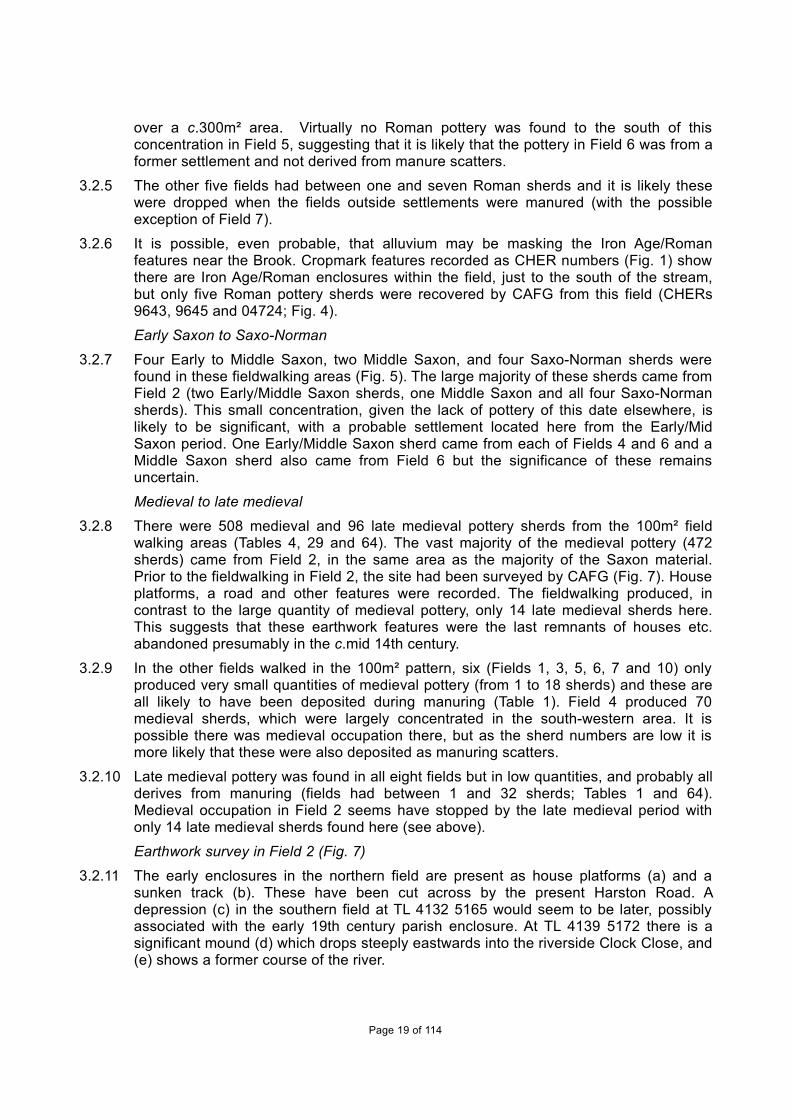
Earthwork survey in Field 2 (Fig. 7)
3.2.11 The early enclosures in the northern field are present as house platforms (a) and asunken track (b). These have been cut across by the present Harston Road. Adepression (c) in the southern field at TL 4132 5165 would seem to be later, possiblyassociated with the early 19th century parish enclosure. At TL 4139 5172 there is asignificant mound (d) which drops steeply eastwards into the riverside Clock Close, and(e) shows a former course of the river.
Page 19 of 114

3.2.12 Broken lines indicate modern field boundaries, and crosses show the national (TL) gridsquares.
HAS 06 (Fields 8 and 9)Late Bronze Age/Early Iron Age
3.2.13 In Fields 8 and 9 there was a concentration of eight and one Late Bronze Age/EarlyIron pottery sherds respectively (Tables 29 and 65; Fig. 3). A single worked flint wasalso found in Field 9 (Table 2) with three burnt flints from Field 8 and one from Field 9(out of only five burnt flints recovered from all fieldwalking). The evidence seems tosuggest these artefacts came from a prehistoric settlement in this location.
Mid Iron Age-Roman
3.2.14 No Mid/Late Iron Age pottery was found within the survey area but the CHER records(CHER 8962) show there were Iron Age rectangular enclosures in Field 9 (Fig. 4). Incontrast to the Iron Age artefacts, there is a significant quantity of Roman artefacts fromboth fields (8 and 9) over a c.500m by c.200m area. It is important to note that this areais recorded by CHER as a known villa complex. The fieldwalking produced 187 Romanpottery sherds from the two fields, but even more tile. In Field 8 there were 49 tilefragments which were recorded as Roman (including tegula and at least three box flue),as well as a whetstone and two oyster shells. Field 9 produced 204 Roman tilefragments, seven tessera fragments, a copper alloy brooch of a cockerel (similar toCrummy 2007, fig. 1.1 but with a small loop on its back; and therefore of a British type),a lead pot mend, a whetstone and 17 oyster shells. This group is extremely interestingand the link between the cockerel brooch and the cult of Mercury is analysed in theDiscussion (see below, Section 4).
Saxon to post-medieval
3.2.15 A Saxon brooch was recorded at TL 411 531 (Field 9) as being from CAFG07Haslingfield Cantelupe Road and seems to have been found during fieldwalking (MikeColes, pers. comm.). It is a small long brooch, cross-head derivative type (Malim andHines 1998 fig. 3.65, 19). It is very likely that the brooch originated from a burial - acemetery is known to have been disturbed by coprolite digging in the 19th century inthis area (CHER 04816; Fig. 5). No Saxon pottery was found fieldwalking these fields.
3.2.16 The recovery of only ten medieval sherds and 15 late medieval sherds (Tables 29 and65) shows that Fields 8 and 9 were not occupied in these periods.
Brook Farm (Fields 14 and 15)3.2.17 140 stints were walked across both fields; their co-ordinates and the artefacts
recovered are recorded in Table 66.
Prehistoric to medieval
3.2.18 Three Roman pottery sherds but no prehistoric or Saxon artefacts were found at BrookFarm (Fields 14 and 15; Tables 29 and 66).
Medieval to late medieval
3.2.19 A notable quantity of 124 medieval pottery sherds and 210 late medieval pottery sherdswere found in both fields (Table 66). The vast quantity of this pottery (for both periods)originated within a relatively small area of c.250m by 200m and this implies there wasoccupation here (Fig. 6). There may have been pottery production on this site in thelate medieval period. Of great interest is Paul Blinkhorn's recording of some pottery aspossible kiln waste in fabric 402 (late medieval oxidized ware; mid 15th to 16th century)
Page 20 of 114

from Field 15 (CAFG sq 281) at TL 40180 53390. It is worth noting that many sherds infabric 402 from this stint were unabraded (38 sherds (553g)). In the three adjacentstints to this kiln waste, fabric 402 sherds were also common (15 sherds (219g), 8sherds (89g) and 16 sherds (289g)).
3.2.20 Relatively large quantities of medieval and late medieval sherds were recorded over 13stints in Field 15 (CAFG sqs 279 to 291) with, collectively, 64 medieval (409g) and 152late medieval sherds (1786g). This comprises half of the medieval and three-quartersof the late medieval pottery from these two fields. For fieldwalking this density isextremely unusual and is very likely of significance. Interestingly, in these same 13stints there were just three tile fragments, 14 post-medieval to modern pottery sherds(plus two sherds late medieval/post-medieval red earthen ware (75g) and one metalobject).
3.2.21 Fifty-five roof-tile fragments (not recorded in greater detail), were found in these twofields but in no real concentrations. Where several were found in the same stint, theywere not in association with either medieval or late medieval pottery. This perhapsimplies that they were not contemporary with the pottery and were post-medieval indate. In addition, 213 late post-medieval/modern pottery sherds were recovered,including 19th century vessels stamped with insignia from Queens’ College, Cambridge(See Craig Cessford Appendix C.6). Only a single shell was recorded in Field 15.
BR008 (Barton Road) (Fields 11 to 13)3.2.22 Fields 11-13 were adjoining fields at the extreme north-western corner of the parish,
directly to the south of the Brook.
Late Bronze Age/Early Iron Age
3.2.23 Two Late Bronze Age/Early Iron Age pottery sherds were found in Field 13, about 700mapart (Fig. 3; Tables 29 and 67). Twelve worked flints were also recovered from Fields11-13, of which eight came from Field 13 (Table 2). In addition, a single burnt flint wasrecorded from this field. This concentration of presumably prehistoric material fromField 13 is possibly significant, as only 13 flints were recorded from all the fieldwalking,and four from the test pitting.
Field TL location Number of flints
9 41010 53085 1
11 40424 53566 1
11 40959 53581 1
11 40950 53530 1
12 40766 53866 1
13 40132 54003 1
13 40208 54060 1
13 40016 54330 2
13 40103 54305 2
13 40029 54329 1
13 40044 54383 1
13
Table 2: Worked flint from field walking
Mid/Late Iron Age-Roman
Page 21 of 114

3.2.24 Two Mid/Late Iron Age pottery sherds were found, one each from Fields 11 and 13 (Fig.4). Eighty-one Roman pottery sherds were recovered over the three fields but in no realconcentration (Tables 29 and 67). It is possible that the lack of artefacts was due tolate/post-Roman alluvium deposits from the Brook overlying the northern part of Field13, which may have resulted in any earlier deposits being protected (this has alsobeen suggested for Field 7 - see above at 3.2.6).
3.2.25 A small quantity of Roman/probably Roman artefacts was found in all three fields but inno discernable concentrations and it is therefore uncertain whether these denotedsettlements or were just manure scatters. A break-down of artefacts from these threefields is:
Field 11 produced 19 Roman pottery sherds, 17 oyster/shell, 190 tile fragments, ofwhich one was definitely Roman.
Field 12 produced 32 Roman pottery sherds, 16 oyster/shell, one whetstone and 178tile fragments, of which one was recorded as Roman.
Field 13 produced 30 Roman pottery sherds, two oyster shells and 69 tile fragments, ofwhich one was definitely Roman.
Saxon
3.2.26 A single Mid Saxon Ipswich ware fragment came from Field 12.
Medieval-late medieval
3.2.27 Sixty medieval pottery sherds were recovered from the three fields; with 23 sherds fromField 11, 31 sherds from Field 12 and six from Field 13. Ninety-two late medievalpottery sherds were found, comprising 31 sherds from Field 11, 53 from Field 12 andeight from Field 13. The pottery quantities from Fields 11 and 12 were not extensivebut, unlike Field 13, there were some concentrations in their distribution. It is unlikelythat these related to any settlement here, especially as a lot more modern pottery wasfound as well (Table 67), with 253 sherds (Field 11), 190 sherds (Field 12) and 146sherds (Field 13). The tile (recorded above) could be of any period from Roman tomodern, but that only three were recorded as definitely Roman out of 423 tiles isprobably significant. Tegula, imbrex and box flue Roman tile are relatively easy torecognise, whereas medieval or post-medieval tiles are more difficult to differentiate. Itis, on balance, much more likely the tiles and post-Roman pottery from these fieldsrepresent manure scatters rather than any occupation.
3.3 Casual observations/artefacts within Haslingfield 3.3.1 The pottery from the ten casual observations has been recorded by Paul Blinkhorn in
Section C.2.4-C.2.14 and is shown on Fig. 2.
Mid-Late Iron Age-Roman
3.3.2 Mid/Late Iron Age pottery was found at one location in the centre of the village (TL 40665221) with two sherds of Mid/Late Iron Age and one Belgic. In the same location, 18Roman pottery sherds were also recovered. Three further Roman sherds were foundc.100m to the south at 33 High Street. This is an area where Roman artefacts werefound in the CAFG test pit survey (see below) and previously (CHER records),suggesting it is, therefore, very likely that there had been an Iron Age/Romansettlement in this area.
Early/Mid Saxon
Page 22 of 114

3.3.3 The only Early/Mid Saxon pottery from the casual observations comprised a singlelarge sherd (128g) found at 36 New Road, and may have been part of a cremationvessel.
Saxo-Norman
3.3.4 Seven sherds of St Neots type ware (Saxo-Norman) were recovered at three sites inthe village (Haslingfield Church, 17 Fountain Lane and at TL 4066 5221), with the threesherds (152g) at 17 Fountain Lane being unabraded.
Medieval to late medieval
3.3.5 Medieval pottery was found across the village in nine of the ten casual observations(see Blinkhorn section C.2.4-C.2.14). The pottery recovered varied from a single sherdat 36 New Road to significant quantities, including some from probable medievalfeatures or layers, from four sites in the village centre. A test pit at The Dovecote (HighStreet) produced 13 medieval sherds pre-dating 1250 and these came from the lowestspit (Table 30). At 33 High Street, the lowest three spits may be medieval in date (Table32). Most of a 13th/14th century vessel and other sherds of this period came from thechurchyard and at 12 High Street there was a significant quantity of pre-14th centurypottery including most of an Ely ware bowl.
3.3.6 Late medieval pottery was far less common and was only recovered from three sites(12, 33 and 48 High Street. Although only represented by a single small sherd in thetwo former sites, at 48 High Street there was a possible layer/feature in spit threedating to this period (Table 31).
3.4 Test pits Introduction
3.4.1 Over a weekend in August 2012, 24 test pits were excavated. These test pits (TPs)were spread across about half the village, although none was excavated within theeastern quarter or part of the western area (Fig. 2). Pottery recovered from the test pitsdated from the Iron Age to modern (Table 3) and found alongside several otherartefacts (Tables 5 - 28 in Appendix B below). These tables contain a breakdown of allartefacts and ecofacts per spit/feature within the test pits. The natural (geologicalsubsoil undisturbed by humans) was encountered in all test pits except Test Pit 8,where modern disturbance was extensive, and Test Pit 21, where the excavators ranout of time and could not finish it. Several of the test pits may have found features (orlayer deposits) but, due to their small size at 1m², this was uncertain in most cases.Only two features were definitely ascribed and these were both probable pits cuttingnatural at the base of Test Pit 3. These features dated to the Saxo-Norman and at leastlate medieval periods respectively. Elsewhere, all spits are described as layers/parts oflayers.
TPNo
IronAge
Roman Early/MidSaxon
Late Saxon/ early med
Medieval Late medieval
Post-medieval
19th/20th Century
1 ------------ ------------
2 ------------ ----------- - ------------
3 ------------ ----------- - ------------ ------------------ ---------------- -------------------
4 ------------ - ------------ ------------------
Page 23 of 114

5 - - - -
7 - -
8 -
9 -
10 - -
11 - - -
12 - - -
13 - - -
14 - -
15 - -
17 - - - -
18 - - - - - -
19 - - - -
21 - -
23 - - - - -
25 -
26 - -
27 -
28 - - - - -
29 - - -
1 sherd 41 sherds 1 sherd 13 sherds 95 sherds c.70 sherds+ Not calculated
Pottery sherds present Modern
Table 3: Pottery from Test Pits
Earlier prehistoric
3.4.2 Four struck flints were recovered from residual contexts in different parts of the village(two from Test Pit 4, one in Test Pit 7 and one from Test Pit 19).
Mid/Late Iron Age
3.4.3 A single Test Pit (17) at the northern end of the village found a small residual Mid/LateIron Age sherd of pottery, which presumably represents a continuation of thecontemporary settlement excavated directly to the north of the test pit at 30 New Road(Atkins 2011).
Roman
3.4.4 Forty-one Roman pottery sherds were recovered from 10 test pits (1-4, 17, 18, 23, 26,28 and 29) and these may relate to two different settlements. The first area of possiblesettlement lay in the area of Test Pits 1-4 and 29, which were in the centre of thevillage, spanning a distance over c.300m. There were 11 Roman pottery sherds withinthose five test pits, but it should also be noted that, in this area, 21 Iron Age/Romanpottery sherds were recovered from casual observation at TL 4066 5221 (see above at3.3.2) and CHER also registers several Roman finds, including from the church arealess than 100m to the south-west. The other postulated Iron Age/Roman settlementwas in the area of Test Pits 17, 26 and 28, where collectively 24 sherds wererecovered. These may relate to a continuation of an Iron Age/Roman settlement found
Page 24 of 114

during recent archaeological work directly to the north-east of this location at 30 NewRoad (Atkins 2011).
Early/Mid Saxon
3.4.5 Test Pit 26 in Sidney Gardens at the northern edge of the village had a single piece ofEarly/Middle Saxon pottery. This location was only c.100m to the north-west of where alarge Early/Middle Saxon sherd was found by casual observations at 36 New Road(see above at 3.3.3).
Late Saxon-early medieval
3.4.6 There were artefacts possibly dating from the Late Saxon period, but none wasdefinitely made before the Conquest period. In Test Pit 4 there was a possible horse bitof the Late Saxon/early medieval period as well as a double ended pin beater, althoughthe latter may have been made at any date during the medieval period (See CrummyAppendix C.1). There were 13 Saxo-Norman pottery sherds, comprising nine St Neotstype ware, one Stamford and three Thetford ware, coming from seven test pits (2-4, 12,17, 18 and 28) (See Blinkhorn section C.2.15-C.2.37). All these test pits were within thearea of the suggested Middle Saxon green.
3.4.7 Test Pit 3 contained a probable Saxo-Norman pit (context 7) which was located at thesouth-western corner of the test pit, and cutting the natural. This pit was more than0.7m in diameter and 0.2m deep and contained two Roman and two Saxo-Normanpottery sherds as well as four animal bones. An adjacent undated pit on the northernedge of this test pit was sealed by a mid-16th century midden deposit (see below).
Medieval
3.4.8 There was possibly an overlap with the Late/Saxon-early medieval period (above).Ninety-five pottery sherds of this period (1100-1400) were found in fifteen test pits (1-5,11-14, 17-19, 23, 26 and 28). The vast majority of this pottery was seemingly found inresidual contexts, although the lowest two spits within Test Pit 14 could be medieval indate (Table 17).
3.4.9 Seven of these test pits (1-4, 12, 17 and 28) were within the area of the postulated MidSaxon green and contained 53 medieval pottery sherds. None of these sherds waswithin medieval layers, and were all residual in late medieval to modern dated spits.Four of these test pits (1, 3, 4 and 12) were near to the medieval manor and these maybe significant as a few spits were probably medieval in date. At least one of the objectsfound near to Test Pit 4 was high status, comprising a stone mortar probably quarried inPurbeck (see Coles, Section C.5; Fig. 8). Other objects from this pit which could date tothis period include the pin beater and an iron key, clearly functional items (see CrummySection C.1; Table 8).
3.4.10 Eight of the test pits were outside the possible former green and within four differentparts of the present village. In three test pits to the south of the postulated green (TestPits 13, 18 and 19) there were 15 medieval pottery sherds, but all came from spits withmixed pottery, including late post-medieval and/or modern pottery sherds and artefacts.Two test pits (5 and 11) along the Barton Road each contained a medieval sherd, butthese were possibly from a late medieval (see below) and a modern spit respectively.Two test pits (14 and 26) to the north of New Road had three and two medieval sherdsrespectively, with the former possibly from a medieval layer/feature whilst the latterwere from a mixed deposit which included modern glass (Table 25). Test Pit 23 to thesouth of Cantelupe Road had a significant quantity of medieval pottery (20 sherds)within four different spits dating from late medieval to modern periods.
Late medieval
Page 25 of 114

3.4.11 Ten of the test pits (3-5, 7, 12, 17-19, 23 and 28) contained c.70 sherds of latemedieval pottery (Table 3). The pottery comprised Late Medieval ware (15th to mid-16thcentury), some German Stonewares (from 1480+) and some early Red Earthenware(pottery of the latter two types has been counted where the deposit is probably 16thcentury). The pottery numbers are therefore estimated. There are several otherartefacts and ecofacts likely to date to this period. Several test pits also contained latemedieval brick, which is likely to date from 14/15th century. It is possible that they werereused and may have been brought by the main manor holder, Dr Wendy, from hisother property Barnwell Priory (Cambridge) in the 16th century after the Dissolution. Itis also possible that medieval brick was being used in the village, as several other testpits outside the manor area appear to have contained medieval brick fragments.Several contexts were well dated to this late medieval period (pre-1600) and the boneand shell etc. found within them would therefore have been contemporary.
3.4.12 The vast majority of the late medieval material derived from the former manor area(Test Pits 1, 3, 4 and 12). Of note is Test Pit 4, which produced a significant range offinds largely dating from the 15th and 16th centuries. This is very likely to be a midden[waste] deposit which survived up to c.0.5m thick. Several high status objects show thatthis deposit would have derived from the manor house, located less than 100m to thenorth (Table 8). This is a semi-primary assemblage, although there are small quantitiesof residual Roman, Late Saxon/early medieval and medieval period artefacts, withsome slight modern contamination in the top spit. It is possibly a clearance dump. Thelarge number of artefacts and ecofacts from this test pit included c.44 late medievalpottery sherds largely dating to around the mid-16th century, five medieval floor tiles,four limestone roof tile fragments, 33 nails, an iron key, a jetton, 102 ceramic roof-tilefragments, 64 brick fragments, 26 countable animal bones (12 sheep/goat bones withbutchery marks, cattle bones and a pig bone) and 159 oyster shells.
3.4.13 Test Pits 1 and 3 each had three spits probably dating to the late medieval period, withpottery, tile, brick and bone artefacts and ecofacts being prevalent (Tables 5 and 7).These deposits may represent a continuation of the large midden deposit recorded inTest Pit 4 although, unlike this test pit, there were fewer artefacts, with no shell or highstatus objects such as floor tiles. The lowest spit within Test Pit 12 may be latemedieval in date but only a single late medieval pottery sherd was found here and sothe evidence is inconclusive (Table 15). All the other spits within this test pit contained afew artefacts of mostly modern material.
3.4.14 Elsewhere in the village, the three lowest spits within Test Pit 5 along the Barton Roadmay be late medieval in date, producing three pottery sherds, two brick, 22 tile and twobone fragments (Table 9). The three upper spits were mixed, containing some earlymaterial as well as some post-medieval artefacts. The two lowest spits in Test Pit 7located to the south of School Lane may be medieval/late medieval in date (Table 10)but the small quantity of artefacts from these spits (a pottery sherd, a tile fragment anda residual flint) means that this dating is uncertain.
3.4.15 The lowest two spits within Test Pit 17 directly to the south of New Road, may also dateto the late medieval period. From these two spits, two late medieval pottery sherdswere recovered, along with a moderate quantity of artefacts dating from the Roman,Saxo-Norman and medieval periods. Artefacts from this test pit included a single smithyhearth bottom, but the significance of the metal working waste (and its date) isuncertain (Table 19).
3.4.16 Test Pits 18 and 19 were located directly to the west of Church Street and outside theMiddle Saxon green (Fig. 2). The lowest spit of Test Pit 19 contained eight possible latemedieval pottery sherds dating into the 16th century (Table 21), whereas all five spits
Page 26 of 114

within Test Pit 18 were very disturbed, with a mixture of Saxo-Norman to modernartefacts including five+ late medieval pottery sherds (Table 20).
3.4.17 The lowest two spits of Test Pit 23, directly to the south of Cantelupe Road, may date tothis period, with medieval pottery, brick and bone fragments found (Table 23). Test Pit28, just to the south of New Road, had modern pottery in all its six spits but includedlate medieval pottery, suggesting activity of this period (Table 29).
Post-medieval to modern3.4.18 Post-medieval and modern remains were found in most of the test pits. Of interest was
a sawn bone piece from a cattle skull in Test Pit 28 (spit 6), which is evidence of boneworking, but unfortunately it was found in a mixed spit which contained Roman tomodern material.
Page 27 of 114
4 DISCUSSION AND CONCLUSIONS
4.1 Introduction4.1.1 This discussion aims to explore how human activity evolved in Haslingfield parish over
time. It brings together the work by CAFG reported in Section 3 (above), excavations byarchaeological units, CHER records, and other relevant archaeological and historicalarticles/books. The village and the rest of the parish has had relatively few modernconstruction developments, which means that most of the parish is still not built on. Thedownside for an archaeologist trying to understand the village history is that this hasalso meant relatively few archaeological investigations have taken place. This hasbeen especially relevant for the Saxon period, where few artefacts have been found;this has meant, for example, that the dating of Haslingfield’s nucleation is veryuncertain (see below).
4.1.2 There are plenty of opportunities for further discoveries in the future across much of theparish, apart from areas destroyed by activities such as Victorian coprolite digging. Theextent of this activity is unknown, although some records of sites where this occurredare quoted in the Victoria County History (VCH, Vol V) volume (Wright 1973). We know,from urns and other artefacts deposited at Cambridge museums, of two probableSaxon burial grounds that were destroyed/damaged as part of the diggings in differentparts of the parish. Bernard O'Connor (pers. comm.), who has written about coprolitedigging in Cambridgeshire, has found no maps or plans for this former practice inHaslingfield and so any accurate mapping of areas destroyed would be difficult.
4.2 Overview by period
Earlier prehistoric4.2.1 No Palaeolithic remains have yet been found within the parish and just four Mesolithic
artefact findspots (three single axe heads and a scatter of flints) are recorded,suggesting there may possibly have been only minimal forest clearance in this period.The quantity of Neolithic material found in the parish is also extremely low, with onlyfive recorded Neolithic flint findspots (see Section 1.3.4) and only a single pottery sherdrecovered. Three of these findspots were next to later Bronze Age burial mounds, but itis uncertain whether this is coincidental.
4.2.2 The parish has several probable Bronze Age burial mounds extending over a c.300mdistance along Money Hill, within the south part of this parish. These mounds arelocated next to a suspected prehistoric trackway called 'Mare Way'. In contrast to thisburial evidence, there is relatively little evidence of occupation in this period exceptalong the eastern parish boundaries next to the River Cam where, in three adjacentareas, pottery, flint and a bridle bit were found (see Sections 1.3.5 and 6). Fieldwalkingand test pitting by CAFG have found remarkably few worked flint pieces (13 flints fromfieldwalking and four artefacts from test pits), although a 'concentration' of flint wasfound in Field 13, in the extreme north-western corner of the parish, which may besignificant given how few flints have been recovered elsewhere (see Section 3.2.23).
Late Bronze Age to end of Roman periodLate Bronze Age - Early Iron Age
4.2.3 An area of possible Late Bronze Age/Early Iron Age occupation may be hypothesisedfrom a scatter of 12 Late Bronze Age/Early Iron Age pottery sherds found by fieldwalking over a c.400m by c.100m area (in Fields 4 and part of 8 - centred on TL 414
Page 28 of 114

53; see Sections 3.2.2 and 3.2.13). This concentration seems to be significant, asfragile pottery of this type does not normally survive - this can be seen by the presenceof only four other LBA/EIA sherds found in all the other areas fieldwalked and nonefrom the casual observations or test pitting carried out by CAFG. It is also possible thatthis area of LBA/EIA occupation/activity continued to be occupied in the Mid/Late IronAge, then became a Roman villa (Fields 8 and 9) and Saxon burial ground. In boththese latter periods this area has been argued as possibly being an estate centrecontrolling the area of the present parish and maybe just beyond, with other lessersettlements in this area paying rents to it (Oosthuizen 1996; see Section 1.3.8 and 9).The question therefore needs to be asked whether the LBA/Early IA material found byCAFG represents an important population centre/headquarters in this early period,which continued in this same location as a 'centre' to the Saxon period?
Iron Age to Roman
4.2.4 Recent work in the parish (aerial photos, CAFG and work by other archaeological units)has dramatically increased the number of known/suggested Iron Age and Roman sitesin the parish from seven settlement sites recorded by Oosthuizen in her 1996 study ofthe parish (1996, map 1) up to c.19 sites (see below). Compared with the earlierprehistoric and Late Bronze Age, there is a major rise in the number of sites dating tothe Mid/Late Iron Age/Roman periods, presumably suggesting an increase inpopulation.
Area of possible estate centre (Fields 8/9)
4.2.5 Work by CAFG has added more detail to the extent of the suggested estate centrelocated in Fields 8 and 9, which took the form of a Roman villa in its later period. Fieldwalking has found Mid/Late Iron Age pottery and a mass of Roman artefacts includinghigh status items such as tesserae, and tiles including box flue, but also a cockerelbrooch (Section 3.2.14). This latter artefact is interesting as the association of thecockerel brooches with the cult of Mercury is assured (Crummy 2007, 225). Sometimesthese brooches are linked to temples and such an association at this site cannot beruled out.
4.2.6 It was noticeable that all other Roman settlement sites/findspots recorded within theparish through fieldwalking and/or excavation etc. have produced far less high statusRoman material, with no tesserae and no extensive or even moderate quantity of tilesrecovered from any. This leads further credence to Oosthuizen's theory that this sitewas by far the most wealthy in this area.
Farmsteads and possible hamlets
4.2.7 Presently up to 18 other Iron Age/Roman settlements have been postulated within theparish, with more than half of these recorded as cropmarks in CHER records (seeSection 1.3.10-1.3.16 above). In addition there were a few isolated findspots andburials dating to these periods. In reality, there were probably fewer than 18settlements, as multiple (relatively adjacent) CHER records may in fact be part of thesame settlement. Even if the number of settlements has been exaggerated, it doessuggest a very busy farming community within the area of the parish.
4.2.8 Two of these 18 settlements have been discovered by CAFG during fieldwalking. Thequantity of artefacts recovered implies a fairly extensive Mid/Late Iron Age to Romansettlement(s) within Fields 2 and 6 respectively with one covering up to at least 300m²(Sections 3.2.3 & 4). As over half the fields in Haslingfield have not yet beenfieldwalked, it is likely that several more settlements remain to be found.
Page 29 of 114

4.2.9 The Bourn Brook was very important to the location of sites: directly to the south of it,10 Iron Age and/or Roman cropmarks of enclosures/field systems, at least threeartefact findspots and two burial sites (Fig. 1) are recorded in the CHER. The spacingof the CHER cropmark and artefact records at c.0.3km-0.5km distance apart representsparticularly dense settlement. As indicated above, density may in reality be less thanthis, as in some cases more than one CHER record may represent only a singlesettlement. Even if this is taken into account, the quantity of records suggests that thebrook was an extremely sought-after location for occupation/farming. Fieldwalking byCAFG in the same location as some of these CHER records found only sparse IronAge/Roman pottery sherds and other artefacts within Field 13 and virtually no pottery inField 7 (Fig. 4; Section 3.2.25). It is possible, even likely, that an alluvium layer sealsthe fields along the banks of the Bourn Brook. Flooding has been recorded nearbyalong the south bank of the River Cam at Brunswick (Cambridge) where 0.64m-thickLate Iron Age/Roman period alluvium deposits are sealed by Roman colluvium, allprobably due to silts being brought into the river by increased farming in these periods(Atkins 2012). Elsewhere in the parish, the CHER and CAFG record far fewer IronAge/Roman sites, and these were up to c.1km apart. This latter density is similar tosettlement density in the east part of the Ely area recorded at 0.5km -1.5km apart(Evans et al 2007, 74).
4.2.10 Evidence from fieldwalking seems to point to several of the settlements starting in theMid/Late Iron Age and continuing through into the Roman period. This continuationfrom the Iron Age to the Roman period seems to be the norm for the area (Oosthuizen1996, 8). The status of the sites is unknown, as the artefacts are invariably smallabraded sherds of pottery. Only one settlement in the parish, at 30 New Road, has hadany significant excavation work and this was still relatively small (Atkins 2011). TheMid/Late Iron Age to Roman farmstead or hamlet produced mostly mundane artefactsbut also a single copper-alloy Iceni Iron Age coin. Whilst Iron Age coins are notcommon from archaeological sites, the Iron Age and Roman pottery found wasgenerally only domestic coarse wares, indicating limited access to high status importsor specialist products. Six residual ceramic roof-tile fragments from the site were found,largely on the north-western part of the site. This may suggest there had been aRomanised building reasonably close to the site, but located beyond the north-westernbaulk.
Fields
4.2.11 CAFG fieldwalking identified several areas where there were sparse spreads of Romanpottery, which were presumably manuring scatters. It is likely that the villa estateincluding hamlets, farmsteads and their associated fields, was fairly well planned. It ispossibly significant that the excavation at 30 New Road (Atkins 2011) found the ditchalignments from this settlement respecting a postulated prehistoric trackway alignmentwhich runs north-west to south-east through Haslingfield parish (Malim 2000, 11).Settlements respecting routeways and their alignments have been identified on manysites across Cambridgeshire, including near Stow Longa (in the district ofHuntingdonshire), where Iron Age/Roman settlements were positioned parallel to apossible prehistoric or Roman routeway called Filman Waye (Atkins 2010a).Oosthuizen (2006, 68) and Knight (2009) demonstrate this in Cambridgeshire’s Bournvalley, where fragments of an earlier system are fossilised within the medieval commonfields. In other places in East Anglia, co-axial arable fields systems are known from theIron Age (Williamson 1987, 425 and 428-9).
Page 30 of 114

SaxonEstate centre
4.2.12 The postulated Roman estate centre may have continued to have an administrativefunction after the end of the Roman period (Oosthuizen 1996, 13-14; see Section1.3.18 above). In the area of the villa estate, a significant Saxon burial ground wasseemingly deliberately placed adjacent to the earlier Roman cemetery (these werefound in the 19th century during coprolite digging; see Section 1.3.17 above). Duringfieldwalking CAFG found a single Saxon brooch at TL 411 531 (Field 9) adjacent toCantelupe Road, probably deriving from this former Saxon burial ground (see Section3.2.15 above). It is uncertain whether the domestic area of this site remained at thesame location as the former villa or whether it moved. No Mid-Saxon pottery, such asMaxey or Ipswich wares were found. By the Late Saxon period, when the Royal manorwas recorded in the Domesday Survey (1086), it would almost certainly not have beenlocated at the former villa area but adjacent to the postulated large green (see below).
Layout of Early to Middle Saxon Haslingfield
4.2.13 Most of the Early/Middle Saxon evidence is very tentative, based on less than a handfulof artefacts in any one location, but it is useful to try and place these findings into thecontext of the postulated settlement. It has been suggested that in the southCambridgeshire area there may have been dispersed farmsteads set around large, low-lying oval greens (Taylor 2002, 67). In Haslingfield, there was a large relatively low-lying 48ha green, which was probably used as communal meadowland and had beenset out for this purpose in either the Early or Middle Saxon period (Oosthuizen 1996;Taylor 2002, 62). Large (mostly sub-oval) greens dating from this period have beensuggested for several parishes in the southern part of Cambridgeshire and also intoHuntingdonshire, on low-lying ground. They include Barrington, Comberton, Harltonand Whittlesford as well as Brampton in Huntingdonshire (Taylor 2002; Oosthuizen2002, 74; Oosthuizen 2006, 51-59; Atkins 2010b). Taylor has argued that this perhapssuggests centralised planning in this part of central eastern England. A smaller, sub-oval green of the same date has been proposed for Stow Longa, Huntingdonshire,which is located on relatively high ground (Atkins 2010a).
4.2.14 No Early to Middle Saxon artefacts or burials have been found within the area of thisformer green, but three or more artefacts/groups of artefacts may relate to areasaround the green:
1) Directly to the north of the former green, a large sherd from a possible cremationvessel was found at 36 New Road (found during a CAFG observation) and a sherd ofEarly/Middle Saxon pottery at Sidney Gardens (CAFG Test Pit 26), 100m to the north-west of it. It is possible there was a settlement and cremation area here.
2) At River Farm (Field 2), directly to the south-east of the green, two Early/MiddleSaxon pottery sherds, one Middle Saxon sherd and four Saxo-Norman sherds werefound during CAFG fieldwalking. They lay in the same location as the Mid/Late IronAge/Roman artefacts (and later early medieval material). The rarity of Saxon pottery ofthis date recovered from other parts of the parish during fieldwalking may suggest thatthe Saxon pottery here does imply a settlement.
3) Around 200m to the south-west of the green, two Early Saxon brooches were foundduring coprolite working in the late 19th century (CHER 4341 and 4342) and this areahas tentatively been identified as a burial ground.
Page 31 of 114

4) The significant burial ground at CHER 04816 has been commented on (above; seeSection 1.3.17). The location of the occupation area linked to this burial site is notknown. Cemeteries were invariably positioned beyond the occupation area and, if thesettlement was to the south of it, the settlement could have extended down to the green- Saxon settlements often covered areas encompassing several hundred metres (e.g.North Hestleton, Yorkshire).
4.2.15 A few artefacts have been found further away from the green but these would havebeen too far away to relate to it (Fig. 5). A possible farmstead has been tentativelysuggested by a few Early Saxon artefacts recovered at the southern side of the parishduring fieldwalking by the Cambridge Archaeological Unit (CAU) (CHER 16356;Dickens 1999). In addition, during field walking by CAFG, two Early-Middle and MiddleSaxon pottery sherds were found in Field 6, one Early/Middle Saxon sherd in Field 4and one Middle Saxon sherd from Field 12 but these may not be significant (seeSection 3.2 above).
4.2.16 Oosthuizen (2006, 100) makes the point that, whilst Haslingfield continued as a RoyalEstate Centre, it is noticeable that the individual Roman farms/hamlets did not continueinto the Saxon period - or at least not in the same location. This theory may need to bere-examined as recent work by CAFG has shown that in two areas a few Saxonartefacts were found during fieldwalking in the same location as former Romansettlements (River Farm (Field 2); see Sections 3.2.3 and 3.2.7). In addition someSaxon material was found in the 36 New Road/Sydney Gardens area, which waspresumably within part of an Iron Age/Roman settlement found at 30 New Road (Atkins2011)). In both cases however, the number of artefacts was extremely small and,without excavation, any continuity of occupation over the two periods cannot be proved.
4.2.17 Elsewhere, nearby villages may provide some indication of layout. Oosthuizen, in asurvey of three settlements in Cambridgeshire, found that in the Saxon period themanor occupied a commanding position in relation to the common (green) entrance(Oosthuizen 1993, 100). This is comparable to the Royal manor at Brampton, whichseems to have been located next to the church although, significantly, both wereoutside the northern corner of the green, adjacent to the Huntingdon Road (Atkins2010b). At Stow Longa it is suggested that the planned layout of this nucleated villagemeant that the Middle Saxon church and estate centre were constructed on oppositesides outside, but adjacent to, the green and next to major roads exiting the settlement(Atkins 2010a). There was often a close relationship between lordly centres and Saxonchurches (Lewis et al 2001, 87-88) and it is, therefore, likely this was the case atHaslingfield.
4.2.18 This link may be significant in that, at Haslingfield, the Saxon estate centre wasseemingly a continuation of the Roman centre (see above). The occupation area,therefore, is likely to have moved (although cemetery areas were seeminglymaintained) c.0.5km to the north of the green. The most likely location of the estatecentre may be near to the junction of Cantelupe Road with the green on the River Camside. If this was the position of the estate centre, where was the Middle Saxon or earlyLate Saxon church?
4.2.19 Haslingfield would almost certainly have had an early church as it was important in thisperiod - in the Domesday Survey (1086) it was one of only seven parishes with a royalmanor. This survey also recorded that Haslingfield had the greatest population in theWetherley Hundred (see Section 1.3.30 above). It may not have been a minster church,as Oosthuizen (2001, 59 and 65) suggests that Meldreth could have been in charge ofthe 12 parishes, including Haslingfield, which made up the Wetherley Hundred.Originally, Oosthuizen states, this Hundred had been within Armingford Hundred, which
Page 32 of 114

was headed by Meldreth. It is worth noting that minster churches normally controlledan area of between five and ten parishes (Oosthuizen 2001) and the area suggested ascontrolled by Meldreth Minster is very large (see above). If there was another minsterchurch for this area, Haslingfield would be a good candidate for its location.
4.2.20 It is significant that, although no church is mentioned in the Domesday book (they oftenweren't), Robert the priest is recorded as having a hide of land (Wright 1973, 229). Ifthe Stow Longa example is correct, the church would be opposite but outside thegreen. The present location of Haslingfield church is on the opposite side to thesuggested location, but within the green. It is almost certainly, therefore, early post-Conquest as "it is situated at a curious angle just inside the southern edge of the green,compared with those properties with regular boundaries which are sited facing thesouthern edge of the green" (Oosthuizen 2002, 75). Could the church have moved? Acomparison may be Harringworth, Northamptonshire, where a Middle to Late Saxonburial ground has been found on the opposite side of the road to a Norman church,suggesting a possible relocation in this period (Atkins 2004).
4.2.21 An alternative location of the estate centre may have been to the east or south-eastcorner of the green at River Farm (Field 2), where CAFG found Saxon artefacts (seeabove). This possible location is problematic in that it is too far away from thepostulated pagan Saxon cemeteries (see above, Section 4.2.14). On a positive point, aposition here would have been near to the river and next to Harston Road, which led tothe south and therefore would have had a commanding position over the green. A thirdpossible location would be near the postulated Saxon burial ground to the south-west ofthe green and just to the south of the medieval church, adjacent to the road toBarrington. If the church had been at the suggested southern site, it is possibly not acoincidence that the manor and church were adjacent. In the later, post-Conquestperiod, the church and manor were both moved to within the green and placed near toeach other (see below).
Nucleation of Haslingfield
4.2.22 An important question to ask is: when was Haslingfield nucleated? This is a difficultquestion to answer, partly because extremely few sherds of definite Middle Saxonpottery have been found within the parish. No Maxey ware has been recovered in theparish and less than a handful of Ipswich ware sherds. These two pottery types are thedefining pottery for the Mid Saxon period and only when these pottery types have beenfound in moderate quantities can we say with some confidence where the Middle Saxonpeople had been lliving. The location of Haslingfield parish also makes it uncertainwhen the parish is likely to have nucleated. Haslingfield falls only about 10km inside thesouthern boundary of the 'central province', the zone of mainly nucleated settlements.This is in contrast to the south, where the 'south-eastern province' comprised the zoneof mainly dispersed settlement (Taylor 2002, fig. 1). The location of Haslingfield nearthe frontier of the two may be significant, as there seems to have been late nucleationon the frontiers (Taylor 2002, 55). This may have taken place at Haslingfield, with theearly green becoming the centre of the later village. The lack of archaeological workwithin the present village area has meant that it is uncertain when Haslingfieldnucleated - it was possibly in the Late Saxon period (this late date would tie in withHaslingfield being near the frontier).
4.2.23 This date would be later than Cottenham, less than 10km to the north of Cambridge,where the indications are that the village became nucleated at or before the arrival ofMiddle Saxon Ipswich ware pottery on the site (Mortimer 2000, 21). A similar MiddleSaxon date is suggested for the nucleation of Brampton (a royal manor), Stow Longa(the head of a large royal estate centre spanning several parishes) and Tilbrook, all in
Page 33 of 114
Huntingdonshire (Atkins 2010a and b). In Northamptonshire, major estate centres suchas Higham Ferrers and Raunds had both seemingly coalesced, and certainlyexperienced deliberate development, before AD 850 (Hardy et al 2007; Audouy andChapman 2009). In contrast, in lesser settlements within the Whittlewood part ofNorthamptonshire, the date tended to be after AD 850 (Jones and Page 2006, 103).
4.2.24 When an Early/Middle Saxon farmstead or hamlet was abandoned, the populationseems to have moved to just one settlement in the territory, and this settlement appearsto have been larger than surrounding farmsteads and perhaps of higher status (Jonesand Page 2006, 81). This occurred at Stow Longa, where an Early to Middle Saxonsettlement located between the present settlement at Stow Longa and Tilbrook wasabandoned in the Late Saxon period and presumably relocated to the main Stow Longavillage (Atkins 2010a). Where statistics have been generated showing how manyMiddle Saxon sites appear to have been abandoned in the Late Saxon period, thenumbers vary depending on the sub-region, and the method of analysis (Lewis et al2001, 82). However, the abandonment of a significant proportion of Middle Saxonsettlements was undoubtedly a key feature of areas where nucleated villages becamethe characteristic later medieval settlement form.
4.2.25 At Haslingfield, River Farm (Field 2) is the only area in the parish where there seems tohave been continual occupation from the Early Saxon to the medieval period. Did theother Saxon farmsteads in the parish become abandoned and nucleate around thisarea? Elsewhere there has been no definite Middle Saxon or even 9th-10th centurysettlement evidence (or even artefacts in any quantity) around the parish. Theexcavation at 30 New Road, directly to the north of the green, for example, found nooccupation dating to before the c.11th century (Atkins 2011).
4.2.26 The likelihood is that open fields of the former settlement would have been integratedinto the expanded settlement at Haslingfield as part of this re-organisation. Thesechanges occurred elsewhere, leading to the interpretation that “open fields were re-planned in the Late Saxon period...contemporary with the replanning of their associatedsettlements” (Lewis et al 2001, 82). The period AD 850 to 1150 saw each vill having twoor more huge arable fields that were cultivated in common by their inhabitants (Taylor1983, 130-131). At Haslingfield some of the furlongs in the three open fields weregiven Norse names, implying a pre-Conquest date (Stringer and Coles 2009, 22).
Saxo-Norman4.2.27 The evidence may, therefore, suggest that final nucleation around the present church in
Haslingfield occurred in the early 11th century at the earliest. There is no evidence ofoccupation before this date within the former green, or adjacent and exterior to it, apartfrom the long-lived occupation suggested at River Farm (Field 2). The work by CAFGseems to confirm this, with Saxo-Norman pottery recorded in more than 10 areas withinthe former green and in three places exterior to it. These results tie in/complementother excavations (e.g. at 30 New Road) and find spots recorded in the CHER (seeSections 1.3.24-1.3.26).
Within the former green
4.2.28 The postulated reorganisation of the locations of the church and manor to within theformer green has been dated as post-Conquest and almost certainly indicates at leastpartial reorganisation of the village in this period. Oosthuizen points out thatHaslingfield’s 11th century parish church was built just within the green, indicating thatencroachment into the former meadowland had just begun at the time the church wasinitially constructed (Oosthuizen 2006 fig. 3.6, 54). The manor is likely to have beenlocated in the middle of the green - high status medieval artefacts were uncovered
Page 34 of 114

dating from the 12th century and it is almost certainly no coincidence that the post-medieval 16th century hall was rebuilt on this site (Fig. 2; CHERs 1005a&b; Mackay2003).
4.2.29 Saxo-Norman features and/or artefacts have been found across the middle third of thegreen. The northern and southern parts of this green have not had any realarchaeological work and so it is uncertain whether occupation continued here. Work inthe middle of the green at Well House Meadow found a ditch perpendicular to BroadLane and this may have been a plot boundary (MCN 16656; Atkins 2005). A pit wasfound at the base of Test Pit 3 to the north of the High Street. Elsewhere, pottery of thisperiod was also found in eight separate places, comprising four of the other test pits (2,4, 12 and 28), at the back of 65 New Road. In casual observations it has been found atHaslingfield Church, TL 4066 5221 and at 17 Fountain Lane, with the latter siteproducing relatively unabraded pottery, presumably derived from a feature.
Exterior to the former green
4.2.30 The dating of pottery is not accurate enough to say definitely whether occupationaround and exterior to the green pre-dates the building of the church, manor etc. withinthe green or was contemporary with it. Along the exterior of the former green there wasprobably a roadway with properties presumably fronting onto it. Excavation at 30 NewRoad has identified the probable back-plot boundary ditch running parallel and c.50mbehind the postulated routeway (Atkins 2011). There was no evidence of houses withinthis excavation but these could be just south of the excavation area or removed by lateractivity. Overall, sufficient moderate quantities of features, artefacts and charred cropremains were recovered to suggest there was domestic occupation here. The RiverFarm site (Field 2), to the south-east of the green, seems to have continued to beoccupied in this period, as four Saxo-Norman pottery sherds were recovered duringfieldwalking. Saxo-Norman pottery was also found directly to the west of the green, inChurch Street within Test Pit 18.
Overall plan
4.2.31 The archaeological evidence gives credence to Susan Oosthuizen's and ChristopherTaylor's suggestion that Haslingfield developed around a large green in this period(Oosthuizen 1996 and Taylor 2002), although the lack of archaeological work withinother parts of the present village has meant that this theory has yet to be proved. Theevidence so far seems, therefore, to go against Alison Taylor's theory that hamlets grewup in this period, linked to the main settlement around the church (see Section 1.3.29;Taylor 1997).
4.2.32 Interestingly, the large green mostly survives in the present plan of the village and thiswould mean the suggested post-Conquest re-organisation at Haslingfield was not asextensive as in some other replanned villages in Cambridgeshire. An extreme exampleof this was Tilbrook, Huntingdonshire, where the village was redesigned as a sub-rectangular settlement on a regular gridded system and overlaying the Middle and LateSaxon boundaries that were on a different alignment (Atkins 2010a).
MedievalHaslingfield expansion (12th-early/mid 14th centuries)
4.2.33 The results of the archaeological work shows that the medieval phase represents acontinuation of occupation where there was evidence of a Saxo-Norman presence.There was possible expansion, both within the area of the former green, and aroundthe outside of it, as well as a new hamlet formed in the area of Brook Farm. Thisevidence ties in with the documentary sources suggesting that in the 12th to 13th
Page 35 of 114
century period, the population of Haslingfield was expanding. The 1086 DomesdaySurvey suggests a population of around 400 (see section 1.3.30), while 140 tenants arerecorded in the 1279 survey, suggesting a population of c.700 people (see Section1.3.32).
4.2.34 The area around the former green was seen to be heavily occupied in at least fourplaces making up around half the area (with the remaining parts having had noarchaeological investigations). It is looking increasingly likely that the whole areaaround and within the green would have been occupied in this period. Haslingfield inthis period may have had up to four manors (centre of green, along the Barton andHarston Roads and at Brook Farm). The first has been partly dug by the CAU (seeabove Section 4.2.28). A moated manor called Pates Manor lies directly to the north ofthe green, adjacent to the east of Barton Road (Fig. 1; CHER 10002). Medieval potteryfound in two test pits (5 and 11; Fig. 2) to the north and west of this manor suggestfurther occupation here. No Saxo-Norman pottery was found in either test pit, whichmay imply that this was an area of expansion in this period. A further manor lay directlyto the south-east of the green near Harston Road (Stringer and Coles 2009). In thisarea, earthworks to the south of Back Lane as well as extensive earthworks (andsignificant quantities of medieval pottery) at River Farm, imply that this corner of thegreen was heavily occupied in this period. To the west of Church Street, medievalpottery was found in three adjacent test pits (13, 18 and 19) suggesting there wasmedieval occupation in this part of the village also.
4.2.35 Excavations at 30 New Road indicated that there was continuation of the Saxo-Normanphase of use in the late 12th and 13th centuries, including the maintenance of a rearplot boundary (Atkins 2011). There was also a possible back-plot structure near thisboundary and a moderate number of pits, including some possibly for storage andothers for quarrying. Analysis of the environmental samples from this phase indicatedthat low level domestic waste was being deposited. Small quantities of medieval potterywere also recovered from two test pits (14 and 26) to the west of 30 New Road, withthe lowest two spits from the former possibly being of medieval date. The two test pitswere far from the road frontage, where occupational remains would be more likely. It istherefore likely that there was occupation along the road in this direction. Likewise, tothe east of 30 New Road, within Test Pit 23 directly to the south of Cantelupe Road,there were several medieval pottery sherds, suggesting there may have beenoccupation here also.
4.2.36 Within the former green, a large quantity of medieval pottery was identified duringseveral of the casual observations and test pits. Most of the pottery was found asresidual artefacts, but the quantity suggests they came from nearby features. It is likelythat a stone mortar, made in Portland and found adjacent to Test Pit 4, derived from thenearby medieval manor as it is a high status object (see Coles Section C.5; Fig. 8).
4.2.37 At Brook Farm (Fig. 6; Fields 14 and 15), settlement appears to have started from thec.12th or even 13th century with 124 medieval pottery sherds recovered, mostly over ac.250m by 200m area at some distance (c.200m) to the west of the road. No Saxo-Norman material was recovered, suggesting a clear early medieval expansion here.This settlement may have continued into Fields 11 and 12, but this is uncertain as only23 sherds and 31 sherds respectively were found in these two fields, over aconsiderable area; these sherds are more likely to have derived from manuringscatters.
4.2.38 It is possible, even likely, that Brook Farm was the location of the fourth manor,Sternes. This manor derived from an estate of around a hide, which before c.1200 hadbelonged to Richard Pellam. The estate later expanded in size, was sold off to
Page 36 of 114

Anglesey Abbey and subsequently owned by Queens College in 1495 (Wright 1973,231-2).
4.2.39 Brook Farm was separate from the main Haslingfield settlement and the parish is likelyto have become 'polyfocal'. The area of Brook Farm's pottery concentration is similar tothe size of the hamlet excavated at West Cotton in the Raunds parish (Northants),which had about six extended families living in a roughly sub-rectangular settlementc.170m by 150m in size (Chapman 2010, figs. 4.1 and 4.2). West Cotton was aplanned settlement in the Late Saxon period which continued into the medieval periodand was contemporary with the larger nucleated settlements of Furnells and Burysteadmanors, also in Raunds parish.
Late medieval 4.2.40 There was a contraction in population within large parts of Haslingfield for at least the
majority of the late medieval period (14th - mid 16th century), although the buying ofthe main manor (Scales) in 1541 by the rich Wendy family did presumably bring someprosperity for the remainder of the 16th century. This decrease can almost certainly berelated to the after-effects of several events in the first half of the 14th century, whenthe problems of famine and plague substantially reduced the population within England.
4.2.41 For Haslingfield, the falling population has been documented (271 adults in 1377 fallingto 53 families in 1563), in line with records for elsewhere in England, which show aroughly 20% fall in the number of people between 1377 and 1524 (Bailey 2007, 183-4).
4.2.42 This decline can be seen in the village itself, with a lesser number of sites containinglate medieval pottery compared with the medieval period. Only three of the ten CAFGcasual observation sites within the village had late medieval pottery (as opposed tonine with medieval pottery), and there were 10 test pits with late medieval potterycompared with 15 for the medieval period. It is likely that plots within the villagebecame vacant/returned back to agriculture. This can be seen at Well House Meadow,where an archaeological evaluation found a medieval occupied site being abandoned inthe 14th century and then becoming used for agriculture (Atkins 2005).
4.2.43 Former medieval settlements on the periphery of the village aligned adjacent to the MidSaxon green seem to have experienced a more extreme reduction in population thanthe village centre within the former green. Archaeological work has shown that threeformer medieval sites outside the former Mid Saxon green were abandoned in this latemedieval period. Earthworks, including house platforms recorded by CAFG at RiverFarm (Fig. 7), seem to show that these former buildings date up to the mid-14th century(pottery found from fieldwalking here produced 472 medieval sherds but only 14 of latemedieval date). It is likely the earthworks at nearby Back Lane also date to this period.At the excavation at 30 New Road there was relatively little stratigraphic evidence forthe use of the site after the mid-14th century to the early post-medieval period (Atkins2011). Indeed, all the features dating to this phase may belong to the post-medievalperiod, implying the site was used entirely as fields.
4.2.44 In the 15th century, the main manor in Haslingfield may have had trouble financially.Michaelhouse (later Trinity College) seems to have bought several small plots of landbetween 1477 and 1485 in Haslingfield including at 30 New Road (which was probablyowned by the main manor) (Atkins 2011). The buying by Queens College of the SternesManor (presumably the Brook Farm area) and several other farms between 1475 and1495 (Wright 1973, 231-2) also shows how wealthy the Cambridge Colleges were. Inboth cases it suggests that these Cambridgeshire colleges had a deliberate strategy ofbuying property as a long-term investment from manors in need of money.
Page 37 of 114

4.2.45 In the 16th century, the main Scales manor was sold off to Thomas Wendy, formerphysician to Henry VIII. Wendy was extremely wealthy, he owned various other plots ofland including Barnwell Priory in Cambridge. He made Haslingfield his headquarters,rebuilding the manor in brick (which his children later expanded), and building a largewall to create a park around his property. Four of the CAFG test pits were placed withinthe grounds of this manor and within three of them an interesting mid-16th centurymidden deposit was found, in varying depths up to 0.5m thick. This midden, especiallyat Test Pit 4, could be classified largely as a primary deposit (relatively few pieces ofearlier material) with a large quantity of pottery, tile (including a few in limestone), brick,iron nails, animal bone and shell as well as five high status floor tile fragments, a jettonand other objects dating to the mid to late 16th century. This material seems to suggestfeasting as well as building/repair of building(s) or even a demolition/clearancedump/deposit.
4.2.46 The brick may have been 'salvaged' from Barnwell Priory, which was also owned by Dr.Wendy. The floor tiles found in this deposit may have also come from the same sourceand brought conveniently up the River Cam to within one km of the manor and thenpresumably carried the remaining distance along roads. The significant numbers ofmedieval brick dating to the c.15th century from several test pits (including from severaltest pits outside the main manor area in the village), would be very unusual for a villagein decline in this period (see above).
4.2.47 The Brook Farm 'hamlet' is one area of settlement in Haslingfield parish where therewas more late medieval pottery recovered than medieval pottery, but it does not appearthat this outlying settlement expanded in size. The 210 late medieval pottery sherdsrecovered by fieldwalking were largely concentrated in the same tight area of c.250mby 200m in size (Fields 14 and 15) where the medieval pottery was found. The reasonthere was more late medieval pottery may be that had been a pottery kiln on this site,as possible kiln waste in fabric 402 and unabraded pottery in this fabric was found in asmall area of three stints.
4.2.48 The continuing survival of the Brook Farm 'hamlet' beyond the mid-14th or 15th centuryis unusual, as in this period there was a national trend towards the desertion of minorparish settlements after the social and economic reorganisation that followed in thewake of the Black Death (Chapman 2010, 245).
Post-medieval and modern4.2.49 This report does not address the post-1600 period in any meaningful way. This is
because the recent publication on Haslingfield by Stringer and Coles (2009) has dealtwith the post-medieval and modern periods in depth.
4.2.50 The exception is one interesting area of new information recorded by CAFG from BrookFarm. The medieval/late medieval hamlet seems to have continued into the early post-medieval period, but it is uncertain when it diminished in size to become only a farmhouse. The pottery dates suggest that this occurred in the c.16th or 17th century, wellafter Queens’ College acquisition in the late 15th century (see above, Section 4.2.28).The College continued running this farm into the 19th century, and fieldwalkingproduced several 19th century Queens’ College plates, illustrating the close links withthe College (see Cessford Section C.6).
4.3 Significance4.3.1 The analysis of large scale work by CAFG over more than 20 years, combined with
CHER records, archaeological work and documentary records, has allowed us to tryand understand the evolution of the parish from early prehistoric times through to the
Page 38 of 114

late medieval village. Large quantities of new data from this work has allowed newinsights and brought significant new interpretations into how the parish developed. It isnoticeable that most parishes in Cambridgeshire (away from the fenland areas) havenot been so studied.
Page 39 of 114

APPENDIX A. CHER RECORDS
CHER No. Site Name Function Co-ordinates
04350 Tranchet axehead, Cantelupe Farm Find spot TL 425 546
04351 Mesolithic tranchet axehead Find spot TL 405 525
04376 Mesolithic flint finds, near Cantelupe Farm Find spot TL 423 536
04378 Mesolithic axe Find spot TL 425 546
04340 Neolithic flints, Chapel Hill Neolithic flints TL 403 514
04376A Neolithic arrowhead find, S of Cantelupe Farm Find spot TL 423 536
16178 Neolithic flint scatter Find spot TL 40 51
16356 Neolithic (and other period) field walking finds, Barrington CementQuarry
Find spot TL 3997 5141
04718A Mare Way (prehistoric trackway) Trackway TL 4064 5141
04344 Bronze Age dagger Find spot TL 40 52
04347 Bronze Age flint arrowheads Find spot TL 403 521
04376B Bronze Age arrowhead find, S of Cantelupe Farm Find spot TL 423 536
04718 Bronze Age barrow, Money Hill Burial TL 4063 5142
04719 Round barrow Burial TL 4068 5144
04720 Round barrow Burial TL 4079 5147
04721 Round barrow Burial TL 4094 5162
04722 Round barrow Burial TL 4070 5150
04723 Round barrow Burial TL 4093 5154
10159 Bronze Age Bridle bit, Lingey Fen Find spot TL 4298 5434
16179 Bronze Age pottery scatter Settlement TL 423 529
03323 Iron Age cremation and pottery Settlement TL 396 546
04345 Iron Age weaving comb Find spot TL 40 52
04507 Iron Age bronze disc Find spot TL 4168 5274
04528 Iron Age remains Find spot TL 40 52
04724 Settlement complex NE of Haslingfield Iron Age/Roman Settlement TL 425 546
08940 Rectangular enclosures Settlement TL 401 508
08941 Field system ?Settlement TL 413 544
08943 Enclosures Settlement TL 410 544
08945 Cropmarks Settlement TL 403 544
08962 Rectilinear enclosures Settlement TL 413 533
09634 Enclosure system, Barton Bridge Settlement TL 407 545
09643 Possible Iron Age enclosure system, Haslingfield Settlement TL 420 545
09644 Enclosure Settlement TL 419 543
06945 Enclosure system Settlement TL 423 544
09651 Settlement system with double ring-ditch Settlement TL 406 508
09652 Enclosure complex Settlement TL 400 544
18433 Late Iron Age/Early Roman remains, Cantelupe Farm Monument Settlement TL 425 543
Page 40 of 114

03324 Hey Hill Roman Barrow Burial TL 394 544
04343 Roman glass vessel Find spot TL 40 52
04347A Roman coin, Haslingfield churchyard Find spot TL 403 521
04348 Roman coins Find spot TL 4033 5214
04349 Roman coin and spindle whorls Find spot TL 405 521
04363A Roman pottery Find spot TL 412 519
04367 Roman coin, River Farm Find spot TL 4121 5206
04369 Roman finds SW of Cantelupe Farm Find spot TL 412 529
04718B Roman coin Find spot TL 4064 5141
04726 Roman coin Find spot TL 426 547
04727 Roman finds ?Settlement TL 436 546
04728 Roman coins and pottery Settlement TL 429 547
04816A Roman cremations Burial TL 413 530
08704 Roman pottery Find spot TL 4289 5461
08705 Roman remains Find spot TL 4294 5454
08961 Roman settlement, Cantelupe Road Villa / settlement TL 411 531
15627 Medieval and Roman pottery, 65 New Road Settlement TL 40667 52332
04341 Saxon brooch Find spot ?burial TL 40 52
04342 Saxon disc brooches Find spot ?burial TL 4052
04816 Anglo-Saxon cemetery, Cantelupe Road Burial TL 413 530
05008 Saxon pottery Settlement TL 4125 5192
16356 Saxon (and other period) fieldwalking finds, Barrington Cement Quarry
Find spot TL 3997 5141
01005A Haslingfield Manor Building TL 4055 5230
03943 All Saints Church Building TL 403 521
04363 Medieval remains Find spot TL 412 519
04364 Medieval pottery scatter Find spot TL 4124 5178
04365 Medieval pottery scatter Find spot TL 4124 5183
04366 Medieval pottery Find spot TL 4122 5182
04725 Saxo-Norman pottery, Cantelupe Farm ?Settlement TL 429 535
05006 Early medieval pottery Settlement TL 4111 5192
05095 Ridge and furrow beside the Cam and Bourn brook, Haslingfield Fields TL 400 544
05096 Ridge and furrow, Haslingfield Fields TL 425 547
08704A Medieval pottery Find spot TL 4289 5461
08940A Ridge and furrow Fields TL 403 511
10002 Medieval moat, Pates Farmhouse Settlement TL 403 526
11240 Pond, Manor Cottage, Haslingfield Settlement TL 403 523
11242 Medieval house platform, Back Lane Settlement TL 410 519
15627 Medieval and Roman pottery, 65 New Road Settlement TL 40667 52332
15723 Medieval pottery scatter, Brook Farm Settlement TL 4019 5340
15785 Medieval and post-medieval field boundaries, Barrington Cement Quarry
Fields TL 39822 51516
Page 41 of 114

16356 Medieval field walking finds, Barrington Cement Quarry ?? TL 3997 5141
16357 Medieval and post-medieval features, Barrington Cement Quarry TL 3983 5165
16656 Saxo-Norman and medieval features, Well house Meadow Settlement TL 4043 5226
17495 Medieval jetton find, Manor Farm Find spot TL 39928 52477
17718 Clunch quarries Settlement TL 4085 5170
17731 Clunch feature and medieval floor tile finds, Haslingfield churchyard
Find spot TL 40380 52113
Table 4: CHER records (Mesolithic to medieval)
Page 42 of 114

APPENDIX B. TRENCH DESCRIPTIONS AND CONTEXT INVENTORY
Test Pit 1
General Description depth(m) 0.5m
Test pit within former manor area. Brick is possibly medieval. Background Roman activity.
Contexts
spit no type comment finds Overall date
1 Layer Topsoil/grass 1 roof tile fragment, 1 brick fragment, 1 animal bone fragment
Modern
2 Layer Cultivation soil 1 medieval pottery sherd, 14 brick fragments, 6 animal bone fragments
14th/15th century +
3 Layer Cultivation soil with grey clay
8 brick fragments, 6 bone fragments 14th/15th century +
4 Layer Pale grey clay with sandy inclusions
1 medieval and 1 Roman pottery sherd, 1 brick fragment, 14th/15th century +
5 Layer Grey clay and chalk lumps
none Natural
Table 5: Test Pit 1
Test Pit 2
General Description depth(m) 0.4m
Disturbed remains with a moderate assemblage of artefacts. Some evidence of Roman activity and Late Saxon/early medieval, but two post-medieval bricks from spit 3 dates this assemblage
Contexts
spit no type comment finds Overall date
1 Layer Topsoil/grass 6 fragments brick, 1 animal bone fragment, 1 piece coal Modern
2 Layer Cultivation soil 3 Roman and 4 late Saxon/early medieval pottery sherds, 9 fragments brick, 4 pieces animal bone, 4 pieces coal
18th century +
3 Layer Grey/brown soil someclay
2 Roman and 5 late Saxon/early medieval pottery sherds, 12 brick fragments brick including 2 in a yellow post-medieval fabric, 15 fragments animal bone, 7 pieces of coal
18th century +
4 Layer Grey clay 1 fragment roof tile, 1 animal bone, 3 pieces coal ?medieval
Table 6: Test Pit 2
Test Pit 3
General Description depth(m) 0.7m
Area of former manor. The lowest four spits are likely to be medieval to late medieval in date (into 16th century for spit 4). Moderate assemblage of artefacts. Some modern disturbance in top three spits. Background Roman scatter.
Contexts
spit no type comment finds Overall date
1 Layer Top soil/grass 1 late medieval and 1 post medieval pottery sherd, 3 pieces metal, 2 pieces glass,1 piece coal, 8 brick, 9 tile fragments
Modern
2 Layer Cultivation soil, chalk flecks
2 medieval, 3 19/20th century pottery sherds, 1 metal 19th/20th century
3 Layer Cultivation soil 1 piece glass, 7 bone, 6 coal, 4 slate, 23 brick 49 tile 19th/20th
Page 43 of 114

century
4 Layer Cultivation soil with some clay
3 Late Saxon, 3 medieval and 2 16th century pottery sherds, 1 piece metal, 7 bones, 4 coal, 16 brick, 14 tile fragments
16th century
5 Layer Grey clay with sand 3 medieval pottery sherds, 9 bones, 3 pieces coal, 2 brick 1 tile fragments
c.14th/15th century +
6 Layer Grey clay with sand 9 medieval pottery sherds, 2 brick; 3 tile fragments c.14th/15th century +
7 Pit fill Grey clay with sand 2 Roman and 2 Late Saxon/early medieval pottery sherds, 4 bones
? AD 1000-1100
Table 7: Test Pit 3
Test Pit 4
General Description depth(m) 0.7m
In grounds of Manor house. A significant midden deposit at least 0.5m thick, with artefacts/ecofacts largely dating to around the mid-16th century; although with some residual domestic artefacts from the Late Saxon/early medieval and medieval periods. Only slight modern contamination in top spit. Background Roman scatter.
Contexts
spit no type comment finds Overall date
1 Layer Top soil/grass 1 medieval, 21 late medieval, 3 post-medieval and 1 Victorianpottery sherds, 12 brick and 48 tile fragments, 2 limestone roof tile, 21 iron nails, 117 bones, 50 oyster shells, 6 coal, 2 struck flints, 1 late 16th century Jetton
Victorian
2 Layer Cultivation soil with some stones
2 late medieval, and 1 post medieval pottery sherds, 20 brick and 10 tile fragments, 1 floor tile, 3 iron nails, 8 bones, 10 oyster shell
16th century
3 Layer Soil with gravel patches
7 late medieval pottery sherds, 3 brick and 12 tile fragments, 2 floor tiles, 3 iron nails, 69 bones, 2 limestone roof tile, 34 oyster shells
15th - mid 16th century
4 Layer Soil with layer of chalk lumps
8 late medieval pottery sherds, 24 brick and 31 tile fragments, 2 floor tiles, 6 iron nails, 118 bones, 12 oyster shells,
15th - mid 16th century
5 Layer Soil with layer of chalk lumps
1 medieval and 4 late medieval pottery sherds, 4 brick and 2 tile fragments, 1 iron nail, 1 iron key 13th century + , 1?Late Saxon iron horse bit, 3 bones, 1 Late Saxon-13th/14th century bone pin beater, 20 oyster shells
15th - mid 16th century
6 Layer Light brown soil 2 Roman and 3 Late Saxon/early medieval pottery sherds, 1 brick 1 tile fragment, 17 bones
14th-15th century+
7 Layer Light brown soil none
Table 8: Test Pit 4
Test Pit 5
General Description depth(m) 0.6m
In grounds of Manor house. Lowest three spits seem to be medieval or late medieval in date but small quantity of artefacts.
Contexts
spit no type comment finds Overall date
1 Layer Top soil/grass 1 brick, 4 tile fragments, Modern
2 Layer Cultivation soil 1 late medieval and 1 post medieval pottery sherd, 5 tile fragments, 1 piece glass, 2 pieces slag
18th century+
Page 44 of 114
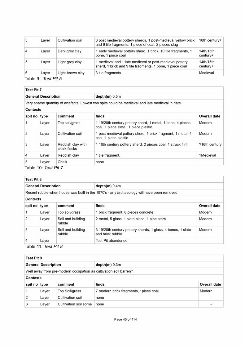
3 Layer Cultivation soil 3 post medieval pottery sherds, 1 post-medieval yellow brick and 6 tile fragments, 1 piece of coal, 2 pieces slag
18th century+
4 Layer Dark grey clay 1 early medieval pottery sherd, 1 brick, 10 tile fragments, 1 bone, 1 piece coal
14th/15th century+
5 Layer Light grey clay 1 medieval and 1 late medieval or post-medieval pottery sherd, 1 brick and 9 tile fragments, 1 bone, 1 piece coal
14th/15th century+
6 Layer Light brown clay 3 tile fragments Medieval
Table 9: Test Pit 5
Test Pit 7
General Description depth(m) 0.5m
Very sparse quantity of artefacts. Lowest two spits could be medieval and late medieval in date.
Contexts
spit no type comment finds Overall date
1 Layer Top soil/grass 1 19/20th century pottery sherd, 1 metal, 1 bone, 4 pieces coal, 1 piece slate , 1 piece plastic
Modern
2 Layer Cultivation soil 1 post-medieval pottery sherd, 1 brick fragment, 1 metal, 4 coal, 1 piece plastic
Modern
3 Layer Reddish clay with chalk flecks
1 16th century pottery sherd, 2 pieces coal, 1 struck flint ?16th century
4 Layer Reddish clay 1 tile fragment, ?Medieval
5 Layer Chalk none
Table 10: Test Pit 7
Test Pit 8
General Description depth(m) 0.4m
Recent rubble when house was built in the 1970's - any archaeology will have been removed.
Contexts
spit no type comment finds Overall date
1 Layer Top soil/grass 1 brick fragment, 8 pieces concrete Modern
2 Layer Soil and building rubble
2 metal, 5 glass, 1 slate piece, 1 pipe stem Modern
3 Layer Soil and building rubble
3 19/20th century pottery sherds, 1 glass, 4 bones, 1 slate and brick rubble
Modern
4 Layer Test Pit abandoned
Table 11: Test Pit 8
Test Pit 9
General Description depth(m) 0.3m
Well away from pre-modern occupation as cultivation soil barren?
Contexts
spit no type comment finds Overall date
1 Layer Top Soil/grass 7 modern brick fragments, 1piece coal Modern
2 Layer Cultivation soil none -
3 Layer Cultivation soil some none -
Page 45 of 114

grey clay
Table 12: Test Pit 9
Test Pit 10
General Description depth(m) 0.3m
Virtually no artefacts implies the site is well away from settlement. Background scatter from post-medieval period.
Contexts
spit no type comment finds Overall date
1 Layer Top soil/grass 2 19/20th century pottery sherds Modern
2 Layer Cultivation soil 1 19/20th century pottery sherd, 5 brick fragments, 12 iron nails, 4 pieces glass, 1 bone, 10 pieces coal, 1 struck flint
Modern
3 Layer Mainly grey clay 2 post medieval and 1 19/20th century pottery sherds, 1 iron nail, 1 metal stud, 3 bones
Modern
Table 13: Test Pit 10
Test Pit 11
General Description depth(m) 0.7m
Deeply disturbed ground with recent artefacts 0.6m below ground level, but also contains background scatter of medieval and post-medieval artefacts.
Contexts
spit no type comment finds Overall date
1 Layer Cultivation soil none Modern
2 Layer Cultivation soil with grey clay
none Modern
3 Layer Grey clay 1 medieval, 1 post-medieval and 1 19/20th century pottery sherd, 3 metal, 8 glass, 2 bones, 1 slag
Modern
4 Layer Chalky clay 6 iron nails, 8 pieces glass, 1 piece sewer pipe Modern
5 Layer Chalky clunch 2 19/20th century pottery sherds, 2 pieces glass, 1 piece coal, 1 piece slag
Modern
6 Layer Cultivation soil 1 post-medieval and 4 19/20th century pottery sherds, 2 metal, 4 glass, 1 bone, 1 piece coal, 4 pieces slate, 1 piece slag (smithy hearth bottom), 1 13th/14th century to late medieval iron key
Modern
7 Layer Grey clay - natural none
Table 14: Test Pit 11
Test Pit 12
General Description depth(m) 0.5m
Deeply disturbed ground with recent artefacts 0.4m below ground level, but also contains some residual late Saxon/early medieval, medieval and post-medieval artefacts.
Contexts
spit no type comment finds Overall date
1 Layer Top soil/grass 1 brick fragment, 1 piece slate, 1 piece concrete Modern
2 Layer Cultivation soil 2 brick and 2 tile fragments, 5 bones, 1 oyster shell Modern
3 Layer Grey/brown soil some clay 1 late Saxon/early medieval, 4 medieval pottery sherds, 2 pieces modern brick, 6 bones
Modern
Page 46 of 114

4 Layer Grey/brown soil some clay 2 pieces modern brick, 1 bone Modern
5 Layer White grey clay top natural 1 mid/late16th century pottery sherd. ?mid/late16th century
Table 15: Test Pit 12
Test Pit 13
General Description depth(m) 0.6m
Modern disturbed soil with just single medieval and post-medieval residual pottery sherds
Contexts
spit no type comment finds Overall date
1 Layer Top soil/grass none Modern
2 Layer Cultivation soil 1 glass, 1 bone, 1 plastic piece Modern
3 Layer Cultivation soil 5 19/20th century pottery sherds, 4 brick fragments, 6 glass, 3 bone, 1 coal
Modern
4 Layer Cultivation soil some grey clay
1 medieval, 1 post medieval, 6 19/20th century pottery sherds,7 metal, 4 glass, 8 coal, 2 slag, 2 pipe – one named Cleaver
Modern
5 Layer Grey clay - natural 4 bone fragments -
Table 16: Test Pit 13
Test Pit 14
General Description depth(m) 0.6m
The lowest three spits may be medieval in date but away from occupation - marginal area
Contexts
spit no type comment finds Overall date
1 Layer Top soil/grass 1 plastic piece Modern
2 Layer Cultivation soil 1 medieval and 1 19/20th century pottery sherd, 1 modern brick fragment
Modern
3 Layer Cultivation soil 2 post -medieval pottery sherds, 1 piece slate Modern
4 Layer Cultivation soil some grey clay
none -
5 Layer Cultivation soil some grey clay
3 medieval pottery sherds, 2 bone fragments ?AD 1150-1200
6 Layer Grey clay some soil 2 bones, 2 pieces coal
Table 17: Test Pit 14
Test Pit 15
General Description depth(m) 0.4m
Modern disturbed area but moderate quantity of 16th century+ artefacts.
Contexts
spit no type comment finds Overall date
1 Layer Top soil/grass 12 post-medieval and 1 19/20th century pottery sherds, 19 brick and1 tile fragments, 1 iron nail, 1 piece glass, 4 bones, 1 piece coal, 1 pipe stem
Modern
2 Layer Cultivation soil 2 post-medieval pottery sherds, 3 brick and 4 tile fragments, 1pipe stem
Modern
3 Layer Cultivation soil 8 post-medieval and 4 19/20th century pottery sherds, 8 brick Modern
Page 47 of 114
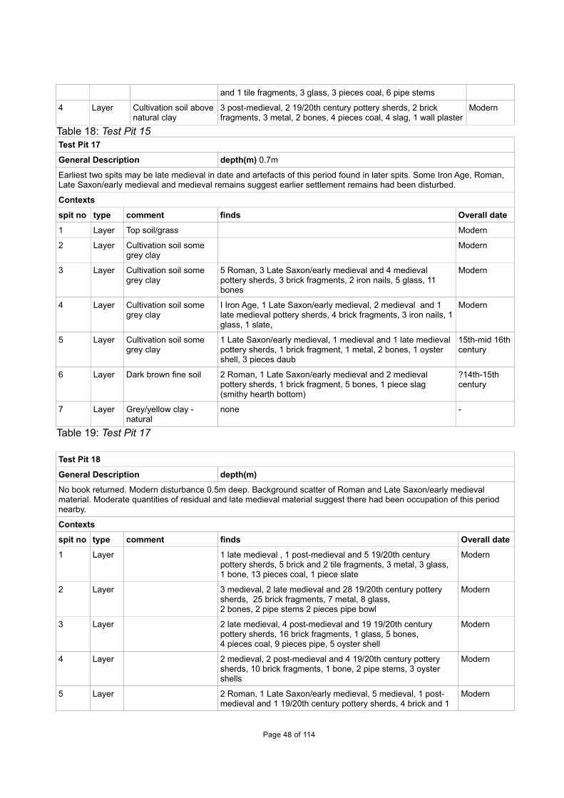
and 1 tile fragments, 3 glass, 3 pieces coal, 6 pipe stems
4 Layer Cultivation soil abovenatural clay
3 post-medieval, 2 19/20th century pottery sherds, 2 brick fragments, 3 metal, 2 bones, 4 pieces coal, 4 slag, 1 wall plaster
Modern
Table 18: Test Pit 15Test Pit 17
General Description depth(m) 0.7m
Earliest two spits may be late medieval in date and artefacts of this period found in later spits. Some Iron Age, Roman, Late Saxon/early medieval and medieval remains suggest earlier settlement remains had been disturbed.
Contexts
spit no type comment finds Overall date
1 Layer Top soil/grass Modern
2 Layer Cultivation soil some grey clay
Modern
3 Layer Cultivation soil some grey clay
5 Roman, 3 Late Saxon/early medieval and 4 medieval pottery sherds, 3 brick fragments, 2 iron nails, 5 glass, 11 bones
Modern
4 Layer Cultivation soil some grey clay
I Iron Age, 1 Late Saxon/early medieval, 2 medieval and 1 late medieval pottery sherds, 4 brick fragments, 3 iron nails, 1glass, 1 slate,
Modern
5 Layer Cultivation soil some grey clay
1 Late Saxon/early medieval, 1 medieval and 1 late medieval pottery sherds, 1 brick fragment, 1 metal, 2 bones, 1 oyster shell, 3 pieces daub
15th-mid 16thcentury
6 Layer Dark brown fine soil 2 Roman, 1 Late Saxon/early medieval and 2 medieval pottery sherds, 1 brick fragment, 5 bones, 1 piece slag (smithy hearth bottom)
?14th-15th century
7 Layer Grey/yellow clay - natural
none -
Table 19: Test Pit 17
Test Pit 18
General Description depth(m)
No book returned. Modern disturbance 0.5m deep. Background scatter of Roman and Late Saxon/early medieval material. Moderate quantities of residual and late medieval material suggest there had been occupation of this period nearby.
Contexts
spit no type comment finds Overall date
1 Layer 1 late medieval , 1 post-medieval and 5 19/20th century pottery sherds, 5 brick and 2 tile fragments, 3 metal, 3 glass, 1 bone, 13 pieces coal, 1 piece slate
Modern
2 Layer 3 medieval, 2 late medieval and 28 19/20th century pottery sherds, 25 brick fragments, 7 metal, 8 glass, 2 bones, 2 pipe stems 2 pieces pipe bowl
Modern
3 Layer 2 late medieval, 4 post-medieval and 19 19/20th century pottery sherds, 16 brick fragments, 1 glass, 5 bones, 4 pieces coal, 9 pieces pipe, 5 oyster shell
Modern
4 Layer 2 medieval, 2 post-medieval and 4 19/20th century pottery sherds, 10 brick fragments, 1 bone, 2 pipe stems, 3 oyster shells
Modern
5 Layer 2 Roman, 1 Late Saxon/early medieval, 5 medieval, 1 post-medieval and 1 19/20th century pottery sherds, 4 brick and 1
Modern
Page 48 of 114

tile fragments, 2 iron nails, 4 bones, 5 shells
Table 20: Test Pit 18
Test Pit 19
General Description depth(m) 0.6m
Lowest spit may date from the 16th century but overlying spits are modern. Background scatter of late medieval pottery.
Contexts
spit no type comment finds Overall date
1 Layer Top soil/grass 1 brick fragment, 1 piece coal, 1 struck flint Modern
2 Layer Cultivation soil 1 late medieval, 1 post-medieval and 2 19/20th century pottery sherds, 3 brick fragments, 2 pieces metal, 15 bones, 18 pieces coal, 3 oyster shells
Modern
3 Layer Cultivation soil 2 medieval, 2 post-medieval and 3 19/20th century pottery sherds, 5 brick fragments, 3 metal, 1 glass, 1 bone, 3 coal
Modern
4 Layer Soil with clay and chalk 8 19/20th century pottery sherds, 6 brick fragments, 1 metal, 5 bones, 10 pieces coal.
Modern
5 Layer Soil with clay and chalk 6 late medieval and 2 c.16th century pottery sherds. ?16th century
6 Layer Chalk/clay natural -
Table 21: Test Pit 19
Test Pit 21
General Description depth(m) 0.4m+
Modern disturbance
Contexts
spit no type comment finds Overall date
1 Layer Top soil/grass 1 19/20th century pottery sherd, 11 brick and 1 tile fragments, 2 metal, 3 glass, 1 bone, 2 pieces coal, 1 pieceslate
Modern
2 Layer Cultivation soil 1 19/20th century pottery sherd, 6 brick fragments, 2 metal, 8 glass, 3 bones
Modern
3 Layer Cultivation soil 8 19/20th century pottery sherds, 4 tile fragments, 5 metal, 6 glass,1 bone, 2 pieces coal,1 piece slate, 2 pipe stems.
Modern
4 Layer Cultivation soil Modern
5 Layer Cultivation soil 1 16th century pottery sherd,1 pipe stem Modern
Table 22: Test Pit 21
Test Pit 23
General Description depth(m) 0.7m
Lowest two spits are probably late medieval. Large scale post-medieval and modern disturbance on the site. Background scatter of residual Roman and medieval artefacts.
Contexts
spit no type comment finds Overall date
1 Layer Top soil/grass 4 Roman,7 medieval, 1 late medieval and15 19/20th century pottery sherds, 1 tile fragment, 1 glass, 3 pieces
Modern
Page 49 of 114

coal, 1 pipe stem, 1 part pipe bowl
2 Layer Cultivation soil 3 medieval, 1 post-medieval and 2 19/20th century pottery sherds, 3 iron nails, 2 glass, 1 bone, 9 pieces coal
Modern
3 Layer Brown soil some clay lumps
4 medieval, 1 post-medieval and 8 19/20th century pottery sherds, 8 brick fragments, 8 iron nails, 20 bone fragments, 20 pieces coal,
Modern
4 Layer Brown soil some clay lumps
1 post-medieval and 6 19/20th century pottery sherds, 3 brick fragments, 5 metal, 2 glass, 2 bones
Modern
5 Layer Brown soil some clay lumps
2 post-medieval pottery sherds, 4 brick fragments, 2 metal,3 bones, 4 pieces coal
18th century
6 Layer Dark grey clay 6 medieval pottery sherds, 1 brick fragment, 1 metal, 4 bones, 2 pieces coal
?14th/15th century
7 Layer Grey/reddish clay 4 brick fragments, 5 pieces bone ?14th/15th century
Table 23: Test Pit 23
Test Pit 25
General Description depth(m) 0.3m
No pre-modern artefacts suggest test pit located away from earlier settlement.
Contexts
spit no type comment finds Overall date
1 Layer Top soil/grass 2 brick fragments, Modern
2 Layer Cultivation soil 1 iron strip, 1 glass, 1 slate piece Modern
3 Layer Brown soil chalk pieces 1 bone -
4 Layer Grey clay - natural none
Table 24: Test Pit 25
Test Pit 26
General Description depth(m) 0.5m
Lower spit may be late medieval in date. Background scatter of Roman, Early/Mid Saxon and medieval artefacts.
Contexts
spit no type comment finds Overall date
1 Layer Top soil/grass none Modern
2 Layer Cultivation soil 1 Roman,1 Early/Mid Saxon and 2 medieval pottery sherds, 1 piece glass
Modern
3 Layer Cultivation soil some clay
1 Roman pottery sherd, 1 brick fragment, 1 shell ?14th/15th century +
4 Layer Light grey clay - natural
1 bone
Table 25: Test Pit 26
Test Pit 27
General Description depth(m) 0.4m
Modern disturbance. No earlier artefacts.
Contexts
spit no type comment finds Overall date
Page 50 of 114

1 Layer Top soil/grass none Modern
2 Layer Cultivation soil 3 brick and 2 tile fragments, 1 glass Modern
3 Layer Cultivation soil some clay
1 19/20th century pottery sherd, 2 brick fragments, 11 iron nails, 2 glass,1 piece slate,1 oyster shell,
Modern
4 Layer Cultivation soil more clay 2 metal, 1 piece coal, modern rubble Modern
Table 26: Test Pit 27
Test Pit 28
General Description depth(m) 0.75m
Test pit dug partly into a modern drain trench recognised at spit 6. Moderate quantities of Roman pottery suggest settlement of this period nearby. Small quantity of Late Saxon/early medieval and some medieval and late medieval artefacts imply occupation of this period had also been close to the site. No post-medieval activity here?
Contexts
spit no type comment finds Overall date
1 Layer Top soil/grass 1 medieval and 2 19/20th century pottery sherds, 1 fragment brick, 1 piece slate
Modern
2 Layer Cultivation soil 1 post-medieval and 1 19/20th century pottery sherd, 1 pipe stem
Modern
3 Layer Soil with gravel/sand 6 pieces slag Modern
4 Layer Soil with gravel/sand some building rubble
3 Roman, 3 medieval and 2 19/20th century pottery sherds,1 brick fragment, 1 metal, 1 glass, 4 bones
Modern
5 Layer Grey/brown soil 6 Roman, 1 Late Saxon/early medieval, 2 medieval and 2 late medieval pottery sherds, 3 brick fragments, 2 metal,6 bones, 1 coal sewer pipe
Modern
6 Layer Grey/brown soil 6 Roman, 1 Late Saxon/early medieval, 5 medieval pottery sherds, 1 glass, 14 bones, 1 slate piece, 2 pieces slag
Modern
7 Layer Grey/brown soil drain pipe
-
8 Layer Grey clay - natural
Table 27: Test Pit 28
Test Pit 29
General Description depth(m) 0.5m
Modern disturbed area. Background scatter of post-medieval artefacts.
Contexts
spit no type comment finds Overall date
1 Layer Top soil/grass 24 19/20th century pottery sherds, 11 brick fragments, 6 iron nails, 1 glass, 1 bone, 1 piece coal, 1 piece slag
Modern
2 Layer Cultivation soil 3 post-medieval and 26 19/20th century pottery sherds, 14 brick and 3 tile fragments, 2 metal, glass, 2 bone, 9 coal
Modern
3 Layer Cultivation soil 2 post-medieval and 11 19/20th century pottery sherds, 39 brick fragments, 2 iron nails, 2 glass, 1 bone, 2 pieces coal
Modern
4 Layer Grey brown soil/clay 1 Roman and 3 19/20th century pottery sherds,14 brick fragments, 1 iron nail, 3 bones, 3 pieces coal
Modern
5 Layer Grey brown soil/clay none -
Table 28: Test Pit 29
Page 51 of 114

APPENDIX C. FINDS REPORTS
C.1 Small Finds
By Nina Crummy with note on Jeton byJames Fairbairn
Introduction and methodologyC.1.1 Four small finds were sent to Nina for identification:
KeysC.1.2 Test Pit 4, spit 5. Iron key, complete. Date could be later medieval (c. 13th cent +) or
post-medieval.
Test Pit 11, spit 6. Iron key with damaged bow. Date could be later medieval (c. 13thcent +) or post-medieval.
Both keys could be for doors, cupboards or chests.
BridleC.1.3 Test Pit 4, spit 6. Iron bridle link, with one round and one rectangular eye. Probably
Late Saxon. See Rees et al. 2008, 289, fig. 162, 2005-7.
Pin-beaterC.1.4 Test Pit 4, spit 6. Single-ended bone pin-beater, used in weaving. Shaft well polished,
as is usual for these tools. Section oval, suggesting a date from Late Saxon to c. 13th-14th century. See Walton Rogers 1997, 1755-7.
JetonC.1.5 Test Pit 4, spit 1. Description: An anonymous and uninscribed 'Rose/Orb' jeton of
Nuremberg, struck during the late 16th or early 17th century. It has a 19.25mmdiameter. Obverse: Three crowns, alternately with three lis, arranged around a centralrose; wedges in border. Reverse: Imperial orb with a double tressure of three archesand three angles; pellets around tressure; wedges in border (Mitchiner 1988, nos.1463-1466).
C.2 Pottery
By Paul Blinkhorn
Introduction and methodologyC.2.1 All pottery from fieldwalking, casual observations and test pits were analysed by Paul
Blinkhorn. The pottery is analysed in each of these three areas in turn.
Fieldwalking C.2.2 A large collection of pottery was recovered through fieldwalking about half the available
land in the parish on and off over 30 years. Paul Blinkhorn was sent all pottery, exceptthe obviously post-medieval and modern, comprising 2348 sherds (15.062kg; Table 29).This table calculates the pottery found in the fieldwalked areas by period and fabric.The detailed location and analysis of this pottery, arranged by area, have been includedin Appendix E and added to the other finds found (Tables 64-67). Most of the post-
Page 52 of 114

medieval and modern pottery was not seen but the numbers of these sherds have beenincluded in these tables.
Period 100m2areas
HAS 06 BrookFarm
BR008 Total
Late Bronze Age BA / Early Iron Age
F1005: LBA/EIA flint tempered 5 (23) 9 (57) - 2(19) 16 (99)
Mid/Late Iron Age
F1007: Mid-Late Iron Age 10 (61) - - 2 (8) 12 (69)
F1010: ‘Belgic 2 (9) - - - 2 (9)
Roman
F1001: Grey Wares 407 (3947) 111 (853) 2 (30) 50 (222) 570 (5052)
F1002: Colour-coated Wares 32 (437) 17 (165) - - 49 (602)
F1003: Samian Ware 8 (47) 2 (9) - - 10 (56)
F1004: Mortaria 5 (105) 1 (20) - 1 (14) 7 (139)
F1006: Miscellaneous R-B 116 (1465) 39 (302) - 27 (138) 182 (1905)
F1008: RB Shelly Wares 42 (355) 17 (158) 1 (49) 3 (23) 63 (605)
Total Roman 610 (6356) 187 (1507) 3 (79) 81 (397) 881 (8339)
Early/Middle SaxonF2: Early/Middle Saxon hand-built sandyware, cAD450-850
4 (21) - - - 4 (21)
Middle Saxon -
F95: Ipswich Ware Group 1, AD725-850 1 (19) - - - 1 (19)
F96: Ipswich Ware Group 2, AD725-850 1 (5) - - 1 (8) 2 (13)
Late Saxon/Saxo-Norman
F100: St Neots Ware type ware, c.AD900-1100
1 (7) - - - 1 (7)
F205: Stamford Ware c AD900-1200. 3 (25) - - - 3 (25)
Medieval
F301: Ely Ware, mid 12th -15th century 1 (13) - 2 (74) 2 (10) 5 (97)
F302: Hertfordshire Grey ware, Mid 12th–14th century
132 (1160) - 48 (397) - 180 (1557)
F303: Bourne 'A' Ware: 13th14th century 27 (405) - 1 (7) - 28 (412)
F327: Hedingham Ware: Late 12th– 14thcentury
29 (232) - 2 (31) - 31 (263)
F328: Grimston Ware: 13th– 15th century - 1 (8) - 1 (3) 2 (11)
F330: Shelly Coarseware, AD1100-1400 54 (431) - 8 (59) 4 (29) 66 (519)
F351: Cambridgeshire Sgraffito Ware. 14th– 15th century
4 (14) - 2 (5) 1(13) 7 (32)
F352: Brill/Boarstall Ware: c. AD1200-?1600
20 (85) - - 1 (8) 21 (93)
F360: Miscellaneous Sandy Coarsewares,AD1100-1400
241 (1850) 9 (54) 61 (358) 51 (230) 362 (2492)
Total medieval 508 (4190) 10 (62) 124 (931) 60 (293) 702 (5476)
Late medieval
Page 53 of 114

F365: Late Medieval Reduced Ware, 14th-16th century
6 (44) - 24 (283) 4 (85) 34 (412)
F401: Bourne ‘D’ Ware: c. 1450-1637 4 (21) - 18 (118) 3 (11) 25 (150)
F402: Late Medieval Oxidized Ware. Mid15th-16th century.
84 (607) 15 (166) 168(2225)
85 (521) 352 (3519)
F403: Tudor Green Wares. c AD1380-1500 2 (4) - - - 2 (4)
Total late medieval 96 (676) 15 (166) 210(2626)
92 (617) 413 (4085)
Post-medieval-modern
F404: Cistercian Ware: c. AD1470-1700 5 (16) - - - 5 (16)
F405. German Stonewares. AD1480+. 3 (17) - 2 (6) 3(38) 8 (61)
F411: Metropolitan Slipware, 17th -18th C 3 (23) - - 6(46) 9 (69)
F413: Cologne/Westerwald Stoneware.17th century+
1 (6) - - - 1 (6)
F416: Staffordshire Slipware. AD1680-1750
- 1 (15) 1 (3) 3 (33) 5 (51)
F425: Red Earthenware, 16th – 19thcentury
212 (3072) 4(73) 11 (530) 22 (354) 249 (4029)
F436 1 (16) - - - 1 (16)
F438: English Stoneware. 1680+. 2 (38) - - - 2 (38)
F1000: Miscellaneous 19th and 20thcentury wares
12 (95) 3 (113) 2 (3) 14 (83) 31 (294)
Total post-medieval to modern 311 (4574)
Total 2348(15062)
Table 29: Pottery from field walking analysed by Paul Blinkhorn by period and fabric
Results of pottery by period
C.2.3 Fieldwalking has produced just 30 sherds (175g) of prehistoric pottery with the earliestdating to the Late Bronze Age/Early Iron Age period. It is in the Roman period thatpottery became relatively common in the fieldwalking dataset with 881 sherds (8.339kg)recovered. Very few Saxon and Saxo-Norman pottery sherds were found andcollectively these comprised 11 sherds (85g). Medieval (702 sherds (5.476kg) and latemedieval pottery (413 sherds (4.085kg) were relatively common. A moderate quantityof post-medieval to modern pottery remained in the assemblage (not discarded) with311 sherds (4.574kg).
Casual ObservationsC.2.4 Pottery from 10 different casual observations across Haslingfield have been analysed
below by individual location:
C.2.5 36 New Road, HaslingfieldF1: Early/Middle Saxon Chaff-tempered Ware, AD 450-850. 1 sherd, 128g.F360: Miscellaneous Sandy Coarsewares, AD1100-1400. 1 sherd, 5g.
The Early/Middle Saxon pottery is a large sherd from the base of a jar. It is in very good condition, and may be a truncated cremation urn.
Page 54 of 114

C.2.6 Norbrook, 17 Fountain Lane, HaslingfieldF425: Red Earthenware, 16th – 19th century. 7 sherds, 1025g.
The collection of Red Earthenware from the replacement of the sole plate comprises fragments of a single large bowl or pancheon, and bases from two jars or jugs. These are very typical mid-16th - 17th century products of the tradition.
The pottery from the foundations of the garage at this site was as follows:
F100: St Neots Ware type ware, c. AD900-1100. 3 sherds, 152g.F302: Hertfordshire Grey ware, Mid 12th-14th century. 1 sherd, 14g.F330: Shelly Coarseware, AD1100-1400. 1 sherd, 11g.F360: Miscellaneous Sandy Coarsewares, AD1100-1400. 2 sherds, 46g.
The sherds of St. Neots ware are all from the same vessel, an inturned-rim bowl, andare in very good condition, suggesting there are Late Saxon or Saxo-Norman remainsin the immediate vicinity.
C.2.7 Burnt Mill, Harston TL412 521F302: Hertfordshire Grey ware, Mid 12th-14th century. 4 sherds, 40g.F330: Shelly Coarseware, AD1100-1400. 1 sherd, 9g.F360: Miscellaneous Sandy Coarsewares, AD1100-1400. 4 sherds, 69g.
C.2.8 5 Fountain Lane HaslingfieldF303: Bourne 'A' Ware: 13th-14th century. 1 sherd, 13g.F330: Shelly Coarseware, AD1100-1400. 1 sherd, 2g.F360: Miscellaneous Sandy Coarsewares, AD1100-1400. 1 sherd, 50g.
C.2.9 Dovecote, High Street, Haslingfield, Cambridgeshire (Site DOV)The following fabrics were noted:
F302: Hertfordshire Grey ware, Mid 12th-14th century F303: Bourne 'A' Ware: 13th-14th centuryF327: Hedingham Ware: Late 12th-14th century. F1000: Miscellaneous 19th and 20th century wares. 19th-20th century
The pottery occurrence by number and weight of sherds per context by fabric type is shown in Table 30. Each date should be regarded as a terminus post quem.
F302 F303 F327 F1000Cntxt No Wt No Wt No Wt No Wt Date Range
1 1 3 1800-19002 3 7 1800-19003 4 10 1800-19004 2 16 10 67 1 2 1150-1250
Total 2 16 10 67 1 2 8 20 Table 30: Pottery occurrence at Dovecote, High Street by number and weight (in g) of
sherds per context by fabric
The first three contexts are all modern, but the range of pottery types from context 4indicates an undisturbed medieval horizon of mid-12th – mid 13th century date.
Page 55 of 114

C.2.10 48 High Street, Haslingfield (Site HAS48)The following fabrics were noted:
F401: Bourne ‘D’ Ware: c. 1450-1637 F402: Late Medieval Oxidized ware. Mid 15th - 16th century. F425: Red Earthenware, 16th – 19th century. F1000: Miscellaneous 19th and 20th century wares. 19th-20th century
The pottery occurrence by number and weight of sherds per context by fabric type is shown in Table 31. Each date should be regarded as a terminus post quem. All the potteryis late- or post-medieval.
F401 F402 F425 F1000Cntxt No Wt No Wt No Wt No Wt Date Range
1 1 4 1 3 1450-19002 1 14 2 18 1550-19003 1 6 1450-1550
Total 1 4 1 6 1 14 3 21Table 31: Pottery occurrence at 48 High Street by number and weight (in g) of sherdsper context by fabric type
C.2.11 33 High Street, Haslingfield (Site PH33)The following fabrics were noted:
F301: Ely Ware, mid-12th - 15th century F302: Hertfordshire Grey ware, mid-12th - 14th century F303: Bourne 'A' Ware: 13th - 14th centuryF319: Lyveden/Stanion 'A' Ware c. AD1150-?1400. F327: Hedingham Ware: Late 12th - 14th century. F330: Shelly Coarseware, AD1100-1400 F351: Cambridgeshire Sgraffito Ware. 14th - 15th century F360: Miscellaneous Sandy Coarsewares. 1100-1400.F1000: Miscellaneous 19th and 20th century wares. 19th-20th centuryF1001: Roman-British Grey Ware, 1st - 4th century
The pottery occurrence by number and weight of sherds per context by fabric type is shown in Table 32. Each date should be regarded as a terminus post quem.F301 F302 F303 F319 F327 F330 F351 F360 F1000 F1001
Spit No Wt No Wt No Wt No Wt No Wt No Wt No Wt No Wt No Wt No Wt Date1 1 5 1800-19002 1 11 4 41 1150-19004 1 2 2 25 1100-12005 3 10 1 17 1 2 1 2 100-15006 9 41 1 14 1 6 1 4 1 6 100-13007 1 27 19 121 1 8 100-12008 1 2 1100-1200
Tot 1 11 3 31 31 172 2 31 1 6 1 4 1 2 2 25 5 46 3 16
Table 32: Pottery occurrence at 33 High Street by number and weight (in g) of sherds per context by fabric type
The range of fabric types indicates that all the medieval activity was limited to the 12th-13th centuries, other than the single sherd of Cambridge Sgraffito Ware.
Page 56 of 114

C.2.12 Pottery from Haslingfield Church
Box 3, Spoil Heap. Rim sherd from the rim and upper body of a medieval sandy ware jar (102g) with heavy sooting on the outer surface, 12th-14th century. Joins the rim from Box 5. Also present is the rim from a St. Neots Ware ‘cylindrical jar’, late 10th- 12th century.
Box 5. Spoil Heap: Base from Romano-British Grey ware vessel, 20g, along with two sherds from the rim and upper body of a medieval sandy ware jar, 188g, 12th-14th century. The medieval jar is heavily sooted on the outer surface.
Churchyard 2009: Body sherd (4g) in Hertfordshire Grey ware, mid-12th - 14th century. The rimsherd (14g)is rather unusual, and is from a bowl, crucible or lamp with a pulled lip. 11th - 13th century? Fabric is possibly Colne or Ely Ware, although most of the calcareous inclusions have been leached out.
Electric Cable Trench: Single sherd, 4g, of medieval Shelley Coarseware, 12tth-14th century.
Grave Find: The single vessel (148g) is very well potted, and in a hard sandy grey fabric. It seems likely to be of 13th-14th century date. The outer surface is heavily sooted, and there is a burnt area in the centre of thebase-pad, showing the vessel had been used on a fire. There are also traces of lime-scaling on the innersurface, suggesting it was used for boiling water.
C.2.13 Green Farm, 12 High St, Haslingfield
The following pottery types were present:
Early Medieval Sandy Coarsewares (EMW), AD1100-1400. A range of quartz-tempered coarsewares that are found throughout the east midlands and East Anglia. 5 sherds, 191g.
Shelly Coarseware, AD1100-1400 (McCarthy 1979). Products of numerous known and very probably many unknown kilns on the Jurassic limestone of west Northants/east Bedfordshire. Pale buff through virtually all colours to black, moderate to dense shelly limestone fragments up to 3mm, and any amount of ironstone, quartz and flint. Full range of medieval vessel types, especially jars and bowls, and 'Top Hat' jars. 1 sherd, 25g.
Hertfordshire Grey ware, reduced sandy wares, probably from a number of sources, some of which are as-yet unknown. Mid-12th - 14th century (Turner-Rugg 1993). 10 sherds, 124g.
Hedingham Ware: Late 12th -14th century. Fine orange micaceous ware . Mainly glazed jugs, but unglazed jars also fairly common (McCarthy and Brooks 1988, 300-2). Glazed: 9 sherds,120g. Unglazed: 12 sherds, 401g.
Ely Ware, mid-12th - 15th century (Spoerry 2008): Generic name for a quartz sand and calcareous tempered group of pottery fabrics mainly manufactured in Ely, but also with a second possible source in the Hunts. Fenland. Jars, bowls and jugs dominate the assemblage. Earlier vessels hand-built and turntable finished, later vessels finer and usually wheel-thrown. wide distribution, including King's Lynn, where it was originally identified as 'Grimston Software'. 5 sherds, 816g,
Sandy Shelly Ware. 13th -14th century? Fairly hard grey sandy fabric with fine calcareous inclusions. Similar to wares from Waterbeach Abbey (McCarthy and Brooks 1988, 273). 11 sherds, 92g.
Glazed Red Earthenware, 16th – 19th century. Fine sandy earthenware, usually with a brown or green glaze, occurring in a range of utilitarian forms. Such 'country pottery' was first made in the 16th century, and in some areas continued in use until the 19th century. 1 sherd, 37g.
The assemblage, although unstratified, seems likely to be of 13th -14th century date, asit mainly comprises wares which were common at that time. One vessel which is particularly well-represented (in terms of completeness) is a bowl in Ely Ware. The vessel has an internal glaze, and incised horizontal lines on the outer surface. The rim-form and
Page 57 of 114
decoration are very typical of the products of this industry (eg. Spoerry 2008, Fig. 5). Conversely, another Ely Ware vessel from this collection, a large storage jar with a horizontal applied strip below the neck, is rather unusual. Two sherds from the body of an Ely Ware jug with splashes of green glaze on the outer surface are very typical, however.
The minor wares also appear typical of the 13th - 14th century. The Hertfordshire Grey Ware assemblage included 3 rimsherds, two from jars and one from a bowl, while the EMW assemblage included another small rimsherd from a bowl, and a much larger one from a jar with a thumb-impressed rim. ‘Piecrust’ rims such as these are very typical of the12th- 13th centuries. Another jar, in a hard orange fabric is quite small and has horizontal incised lines on the outer surface. Similar wares are known from Denny Abbey (McCarthy and Brooks 1988, 273), although their place of manufacture is unknown.
The sherds of glazed Hedingham Ware all appear to be from a single vessel, with thin applied strips and a mottled orange and green glaze. The unglazed sherds are all plain bodysherds apart from a large fragment from the base of a very large jar.
C.2.14 Haslingfield TL4066 5221F100: St Neots Ware type ware, c. AD900-1100. 2 sherds, 83g.F302: Hertfordshire Grey ware, Mid 12th -14th century. 5 sherds, 32g.F330: Shelly Coarseware, AD1100-1400. 4 sherds, 27g.F1001: R-B Grey Wares. 8 sherds, 137g.F1006: Miscellaneous R-B. 10 sherds, 548g.F1007: Mid-Late Iron Age. 2 sherds, 43g.F1010: ‘Belgic’. 1 sherd, 10g.
Test Pits
C.2.15 Pottery from 22 test pits have been analysed in turn. The pottery fabrics from these comprised:
IA: Iron Age. Thick, soft brown to black pottery with varying amounts of shell in the clay. Used between8th – 1st centuries BC.
RB: Roman. An assortment of common types of Roman pottery such as shelly ware, grey ware and Nene Valley Colour-Coated Ware, and was made in many different places in Britain. Lots of different types of vessels.
E/MS: Early/Middle Saxon hand-built chaff-tempered ware, c. AD450-850. Moderate to dense organic voids up to 10mm. No other visible inclusions.
SN: St Neots Ware type ware, c. AD900-1100. Fabric moderate to dense finely crushed fossil shell, with varying quantities of quartz and/or ironstone. Usually purplish-black, black or grey, with fairly fine, dense inclusions. Main forms small jars with sagging bases, although a few lamps are known.
ST: Stamford Ware , c. AD900-1200. Wheel-thrown. White, pink, buff or grey fabric, usually with sparse todense quartz up to 0.5mm, occasional black or red ironstone up to 1mm. Often glazed with yellow, pale or sagegreen glaze.
THET: Thetford-type ware, 10th–12th century. Range of reduced, wheel-thrown and hand-finished fabricsmainly comprising quartz sand up to 1mm. Produced at many centres in eastern England, although most ofthese appear to be the products of the eponymous Norfolk centre.
SHC: Shelly Coarseware, AD1100-1400. Products of numerous known and very probably many unknown kilns on the Jurassic limestone of west Northants/east Bedfordshire. Pale buff through virtually all colours toblack, moderate to dense shelly limestone fragments up to 3mm, and any amount of ironstone, quartz and flint. Full range of medieval vessel types, especially jars and bowls, and 'Top Hat' jars.
Page 58 of 114

EMW: Early Medieval Coarsewares, AD1100-1400. A range of quartz-tempered coarsewares that are found throughout the east midlands and East Anglia.
HG: Hertfordshire Grey ware, reduced sandy wares, probably from a number of sources, some of which are as-yet unknown (Turner-Rugg 1993). Mid-12th - 14th century.
HED: Hedingham Ware: Late 12th -14th century. Fine orange micaceous glazed ware.
GS: German Stonewares. AD1480+. A range of hard, grey, salt-glazed fabrics produced at numerous sites in the Rhineland and beyond.
LMT: Late Medieval Ware. 15th - mid-16th century. Very hard orange sandy ware in a range of developed late medieval utilitarian forms, some with a dark green glaze. Numerous kiln sites throughout the south-east midlands,
GRE: Red Earthenware, 16th-19th century. Fine sandy earthenware, usually with a brown or green glaze, occurring in a range of utilitarian forms. Such 'country pottery' was first made in the 16th century, and in some areas continued in use until the 19th century.
TGE: Anglo-Dutch Tin-glazed Earthenware 17th - early 18th century. Fine white earthenware, occasionally pinkish or yellowish core. Thick white tin glaze, with painted cobalt blue or polychrome decoration, Range of table and display wares such as mugs, plates, dishes, bowls and vases.
SS: Staffordshire Slipware. AD1680-1750. Fine cream fabric with white slip and pale yellow lead glaze, commonest decoration is feathered dark brown trailed slip. Chiefly press-moulded flat wares, although smallbowls and mugs etc are known.
EST: English Stoneware. 1680+. Hard, grey fabric, often with a brown, iron-rich exterior wash. Range ofutilitarian vessels, particularly mugs.
SMW: Staffordshire Manganese Mottled Ware. Late 17th – 18th century. Hard buff fabric with distinctivepurplish-brown glaze. Usually fine drinking pottery, but chamber pots and other more utilitarian vessels alsoknown.
SWSG: Staffordshire Salt-Glazed Stoneware, AD1720-1780. Hard, white fabric with a distinctive white ‘orange peel’ textured glaze. Range of fine tablewares such as mugs, tea bowls and plates.
VIC: Miscellaneous 19th and 20th century wares. Mass-produced white earthenwares, stonewares etc.
Results
C.2.16 Test Pit 1RB EMW HG
Spit No Wt No Wt No Wt Date2 1 2 1150-12004 1 3 1 5 100-1200
Table 33: Pottery from Test Pit 1
This test pit did not produce much pottery, but that which is here suggests that the sitewas used in the Roman and early medieval periods, but probably had a marginal use,such as fields.
C.2.17 Test Pit 2RB SN SHC HG
Spit No Wt No Wt No Wt No Wt Date2 3 9 2 8 2 6 100-12003 2 12 3 27 2 13 100-1200
Table 34: Pottery from Test Pit 2
This site was used in the Roman period, and again in the late Saxon and earlymedieval era. It then appears to have been abandoned, and not used since.
Page 59 of 114

C.2.18 Test Pit 3
RB SN ST EMW SHC HG HED LMT GRE VIC
Spit No Wt No Wt No Wt No Wt No Wt No Wt No Wt No Wt No Wt No Wt Date
1 1 21 1 5 1400-1600
2 2 11 3 23 1100-1900
4 1 11 2 19 1 4 1 20 1 6 2 18 1000-1600
5 2 4 1 14 1100-1400
6 7 73 2 7 1100-1200
7 2 20 2 5 100-1100
Table 35: Pottery from Test Pit 3
This site was used in Roman times, but then appears to have been abandoned until thelate Saxon period, after which time it was in continuous use until the early post-medieval period. It then seems to have been abandoned until the 19th century.
C.2.19 Test Pit 4
RB THET HG LMT GS GRE SS VICSpit No Wt No Wt No Wt No Wt No Wt No Wt No Wt No Wt Date
1 1 2 20 162 1 2 3 10 1 1 1400-19002 1 2 1 3 2 11 1400-16003 7 121 1400-15504 7 63 1 4 1400-15505 1 5 4 25 1150-15506 2 3 3 10 100-1100
Table 36: Pottery from Test Pit 4
This site was used in Roman times, but then appears to have been abandoned until thelate Saxon period, after which time it was in continuous use until the 19th century,although it may have had a somewhat marginal use from the 16th century. It ispossible that the different contexts are all part of a single feature, and joining sherdswere noted across the first five contexts.
C.2.20 Test Pit 4Test Pit 5EMW LMT GRE SS EST SWSG
Spit No Wt No Wt No Wt No Wt No Wt No Wt Date2 1 7 1 4 1400-17503 2 26 1 11 1550-17504 1 8 1 2 1100-1700
Table 37: Pottery from Test Pit 5
The pottery from this test pit suggests that the site had a marginal use from the earlymedieval period to the present, probably as fields.
C.2.21 Test Pit 7GRE VIC
Spit No Wt No Wt Date1 1 32 1800-19002 1 2 1550-19003 1 8 1550-1600
Table 38: Pottery from Test Pit 7
Page 60 of 114

This test pit produced very little pottery, and suggests that the site had a marginal,probably agricultural use from around the 16th century onwards, but was not usedbefore that time.
C.2. 22 Test Pit 8
VICSpit No Wt Date
3 3 5 1800-1900Table 39: Pottery from Test Pit 8
This test pit produced very little pottery, and suggests that the site had a marginal,probably agricultural, use during the 19th century, but was not used before that time.
C.2.23 Test Pit 10
GRE SWSG VICSpit No Wt No Wt No Wt Date
1 2 10 1800-19002 1 1 1800-19003 1 2 1 7 3 12 1550-1900
Table 40: Pottery from Test Pit 10
This test pit produced very little pottery, and suggests that the site had a marginal,probably agricultural, use from around the 16th century onwards, but was not usedbefore that time.
C.2.24 Test Pit 11
HG GRE SS VICSpit No Wt No Wt No Wt No Wt Date
3 1 4 1 1 5 17 1150-19005 2 75 1800-19006 1 6 4 24 1550-1900
Table 41: Pottery from Test Pit 11
This test pit produced very little pottery, and suggests that the site had a marginal,probably agricultural, use from around the 12th century onwards, but was not usedbefore that time.
C.2.25 Test Pit 12
SN EMW HG GRESpit No Wt No Wt No Wt No Wt Date
3 1 6 1 10 3 15 900-12005 1 20 1550-1600
Table 42: Pottery from Test Pit 12
This test pit produced very little pottery, and suggests that the site had a marginal,probably agricultural, use from around the 10th century onwards, but was not usedbefore that time.
Page 61 of 114

C.2.26 Test Pit 13
HG GS VICSpit No Wt No Wt No Wt Date
3 5 23 1800-19004 1 2 1 3 6 28 1150-1900
Table 43: Pottery from Test Pit 13
This test pit produced very little pottery, and suggests that the site had a marginal,probably agricultural, use from around the 12th century onwards, but was not usedbefore that time.
C.2.27 Test Pit 14
SHC HG GRE VICSpit No Wt No Wt No Wt No Wt Date
2 1 7 1 15 1100-19003 2 18 1550-16005 3 19 1150-1200
Table 44: Pottery from Test Pit 14
This test pit produced very little pottery, and suggests that the site had a marginal,probably agricultural, use from around the 12th century onwards, but was not usedbefore that time.
C.2.28 Test Pit 15
GRE TGE SMW VICSpit No Wt No Wt No Wt No Wt Date
1 11 40 1 4 1 2 1550-19002 3 22 7 10 1550-19003 8 126 4 14 1550-19004 1 2 2 2 2 8 1600-1900
Table 45: Pottery from Test Pit 15
All the pottery from this test pit is post-medieval, but suggests that the site has been incontinuous use since the 16th century.
C.2.30 Test Pit 17
IA RB SN SHC EMW HG LMT
Spit No Wt No Wt No Wt No Wt No Wt No Wt No Wt Date
3 5 16 3 12 3 11 1 5 100-1200
4 1 6 1 1 2 13 1 4 200BC-1550
5 1 3 1 3 1 12 900-1550
6 2 6 1 9 1 2 1 1 100-1200
Table 46: Pottery from Test Pit 17
The pottery from this test-pit indicates that there were two phases of activity at the site. The firstwas in the late Iron Age and Romano-British period, the second from the late Saxon era to theend of the medieval period. It does not appear to have been used since that time.
Page 62 of 114

C.2.31 Test Pit 18
RB SN EMW SHC HG LMT GRE SMW EST VIC
Spit No Wt No Wt No Wt No Wt No Wt No Wt No Wt No Wt No Wt No Wt Date
1 1 4 1 21 5 13 1400-1900
2 1 2 2 3 2 5 28 58 1100-1900
3 2 2 2 2 1 6 2 2 1 5 19 42 1100-1900
4 1 1 1 7 2 23 4 35 1100-1900
5 2 6 1 2 2 5 1 5 2 14 1 5 1 1 100-190
Table 47: Pottery from Test Pit 18
This site appears to have had a marginal use in the Roman period, after which time itwas abandoned. It then seems to have been used from the Late Saxon period until thepresent.
C.2.32 Test Pit 19EMW LMT GRE VIC
Spit No Wt No Wt No Wt No Wt Date2 1 3 1 2 2 2 1400-19003 2 4 2 9 3 6 1100-19004 8 11 1800-19005 6 16 2 51 1400-1600
Table 48: Pottery from Test Pit 19
The pottery from this test pit suggests the site had a marginal use through the medievalperiod, and was probably abandoned from the 16th century until the Victorian era.
C.2.33 Test Pit 21
GRE VICSpit No Wt No Wt Date
1 1 10 1800-19002 1 2 1800-19003 8 8 1800-19005 1 5 1550-1600
Table 49: Pottery from Test Pit 21
This test pit produced very little pottery, and suggests that the site had a marginal,probably agricultural, use from around the 16th century onwards, but was not usedbefore that time.
C.2.34 Test Pit 23
RB EMW SHC HG HED LMT GRE SWSG VIC
Spit No Wt No Wt No Wt No Wt No Wt No Wt No Wt No Wt No Wt Date
1 4 50 1 41 4 8 1150-1900
1a 4 30 2 11 1 9 11 48 100-1900
2 3 14 1 30 2 2 1100-1900
3 4 20 1 67 8 37 1100-1900
4 1 4 6 17 1720-1900
Page 63 of 114

5 1 1 1 4 1550-1750
6 2 4 2 8 2 6 1100-1400
Table 50: Pottery from Test Pit 23
This site appears to have had a marginal use in the Roman period, after which time itwas abandoned. It then seems to have been used from the early medieval period untilthe present.
C.2.35 Test Pit 26
RB E/MS EMWSpit No Wt No Wt No Wt Date
2 1 5 1 29 2 20 100-12003 1 1 100-400
Table 51: Pottery from Test Pit 26
This test pit is the only one to have produced Early Saxon pottery, suggesting that thisarea of the village was occupied at that time. There is also a single sherd of Romanand two of medieval, indicating that the site had a marginal use during those periods,but has otherwise remained unused.
C.2.36 Test Pit 27
VICSpit No Wt Date
3 1 1 1800-1900Table 52: Pottery from Test Pit 27
This test pit produced very little pottery, and suggests that the site had a marginal,probably agricultural, use during the 19th century, but was not used before that time.
C.2.37 Test Pit 28
RB SN EMW HG HED LMT SS VICSpit No Wt No Wt No Wt No Wt No Wt No Wt No Wt No Wt Date
1 1 1 2 18 1100-19002 1 6 1 1 1650-19004 3 23 3 27 2 2 100-19005 6 38 1 1 2 4 2 8 100-15506 6 21 1 1 4 10 1 2 100-1400
Table 53: Pottery from Test Pit 28
The pottery from this test pit indicates that there were two main phases of activity at thesite. It appears to have been occupied in Romano-British period, and again throughoutthe medieval period, and was abandoned before the 16th century. It does not appear tohave been used much since that time.
C.2.38 Test Pit 29
RB GRE EST VICSpit No Wt No Wt No Wt No Wt Date
1 24 58 1800-19002 2 28 1 3 26 95 1550-1900
Page 64 of 114

3 2 7 11 51 1550-19004 1 4 3 28 100-1900
Table 54: Pottery from Test Pit 29
The pottery from this test pit indicates that the site had a probably marginal use inRoman times, and was then abandoned until the post-medieval period.
C.3 Brick and Tile
By Mike Coles
Introduction and methodologyC.3.1 This Ceramic building material (CBM) report only analyses those fragments recovered
from the test pits. There was no CBM found during the casual observations and thefragments from field walking have not been reported on, except quantified in Table 57.
C.3.2 CBM was found in 23 of 24 test pits excavated and comprised 726 fragments weighing15.11kg (Table 55). It consisted of bricks, ceramic roof tiles (all of which were peg tileswith no ridge tiles recovered), medieval floor tiles and a post-medieval floor brick. Allfinds were washed, and then assessed off site.
Type No. of test pits No. of fragments Wt (Kg)
Brick (post-medieval to modern)
22 477 7.72
Post-medieval floor brick 1 1 0.25
Medieval floor tile 1 5 1.08
Ceramic peg tile 12 243 6.06
Limestone roof tile 1 4 -
Total 726 15.11Table 55: Brick, floor and roof tile from test pits by no. fragments and weight
C.3.3 No complete bricks or tiles were recovered but where present length, width andthickness was measured. Features such as peg holes in tiles were recorded.
C.3.4 Bricks were recorded by colour and the presence of large inclusions, tiles by colour. Allbrick and tile was retained until after completion of the report; after that only the floortiles and early brick will be retained.
ResultsBrick
C.3.5 There were 477 brick fragments, of which 385 were red brick weighing 5.34kg, and 92were yellow-white brick (1.98kg). The majority of the brick was small broken pieces withnone having widths surviving and only five fragments having thicknesses (Table 56).The fabric of the bricks was divided by colour: red or yellow/white (Table 56), and a notemade of any significant inclusions (present in seven) and the presence of adheringmortar (present on six). One red brick fragment from Test Pit 4, spit 4, was made on avegetative base with a mass of grass/straw vegetative impressions on its base. Most,where they could be discerned, were made on a sanded base. These types of brickswere made from the late 13th century but mostly date to the 14th and 15th centuries
Page 65 of 114

and are likely to have come from the robbing of Barnwell Priory (Rob Atkins, pers.comm; see discussion below).
C.3.6 The brick fragments were very small, and so ageing most of them is impossible. It isextremely likely that bricks from Test Pits 3, 4 and 5, all located within the former manorarea of Haslingfield, all date to the medieval period (except 2 yellow brick fragments inthe upper spit 1 of Test Pit 3 and two fragments from spits 1 and 3 of Test Pit 5). Thesebricks were all made in a 'red' fabric and included the vegetative brick (describedabove). The red brick from these three test pits comprised half the bricks recovered (byweight). Test Pit 3 produced 49 fragments weighing 0.4kg; Test Pit 4 had 64 fragments(2.95kg) and Test Pit 5 two fragments (0.388kg).
C.3.7 Most of the bricks (by numbers) were far more recent than the red brick found in TestPits 3, 4 and 5, and date from the 18th - 20th century. These fragments were foundacross the test pits in no real concentrations (Table 57).
Test pit Spit Brick colour Thick (mm) possible date4 4 Red 70 ?14th century or 15th century
5 5 Red 62 ?16th century or earlier
8 1 Red 62 20th century
29 3 Red 63 18th/19th century
29 3 Yellow/white 69 18th/19th centuryTable 56: Brick with measurable dimensions by colour, measurement and possible date
TP Spit No. Wt Comments1 1 1 0.002 Very small piece red brick1 2 3 0.201 Hard sandy red fabric large flint inclusions and white mortar ?med1 3 18 0.400 Hard sandy red fabric large flint inclusions and white mortar ?med.1 4 1 0.001 Very small piece red brick2 1 6 0.018 Red hard sandy fabric2 2 7 0.031 Red hard sandy fabric white mortar2 3 12 0.090 10 red fabric small flint inclusions 2 yellow/white fabric 18th/ 20th century.3 1 8 0.133 6 small red pieces red fabric small flint inclusions 2 yellow/white fabric 18th/ 20th
century3 2 23 0.210 Red fabric small flint inclusions3 4 16 0.093 Red fabric small flint inclusions3 5 2 0.007 Red fabric 3 6 2 0.014 Red fabric4 1 12 0.600 Red fabric4 2 20 0.273 Red fabric4 3 3 0.374 Red fabric4 4 24 0.821 23 Red fabric (0.598Kg) 1 Red fabric depth 0.7cm (0.223kg) made on vegetative
material /mass of straw impressions on base. It is crudely crudely made with very poorarrises (med/late medieval 14/15th century).
4 5 4 0.223 Red fabric Late medieval ?15th century4 6 1 0.004 Red fabric5 1 1 0.056 Yellow/white fabric 18th/ 20th century5 3 1 0.008 Yellow/white fabric 18th/ 20th century5 4 1 0.075 Red fabric5 5 1 0.313 Red fabric with large flint inclusions 15th or 16th century7 2 1 0.006 Red fabric8 1 1 0.194 Red/pink modern machine made with frog 20th century9 1 7 0.037 Red/pink modern machine made 20th century10 2 5 0.018 Red/pink modern machine made 20th century12 1 1 0.007 Yellow/white fabric 19th/20th century12 2 2 0.010 Red fabric12 3 2 0.051 Red fabric 19th/20th century12 4 2 0.009 Red fabric 19th/20th century13 3 4 0.051 2 Red fabric (0.005kg) 2 Yellow/white fabric (0.046kg) 19th/20th century
Page 66 of 114

14 2 1 0.003 Red fabric 19th/20th century15 1 19 0.109 12 Red fabric (0.061kg) 7 Yellow/white fabric (0.048kg) 19th/20th century15 2 3 0.011 2 Red fabric (0.006kg) 1 Yellow/white fabric (0.007kg) 19th/20th century15 3 8 0.070 2 Red fabric (0.002kg) 6 Yellow/white fabric (0.068kg) 19th/20th century15 4 2 0.004 Red fabric 18th/19th century17 3 3 0.090 2 Red fabric (0.068kg) 1 Red fabric small flint inclusions (0.031kg) 17th/18th century17 4 4 0.083 Red fabric 19th/20th century17 5 1 0.004 Red fabric17 6 1 0.003 Red fabric18 1 5 0.027 Red fabric18 2 25 0.068 Red fabric18 3 16 0.022 Red fabric18 4 4 0.097 Yellow/white fabric 19th/20th century18 5 4 0.001 Red fabric19 1 1 0.093 Yellow/White fabric with white mortar19 2 3 0.025 Red fabric 19th/20th century19 3 5 0.019 2 Red fabric (0.004kg) 3 Yellow/white fabric (0.015kg) 19th/20th century19 4 60 0.050 1 Red fabric (0.007kg) 5 yellow/white fabric (0.043kg) 19th/20th century21 1 11 0.116 8 Red fabric (0.103Kg) 3 yellow/white fabric (0.013KKg) 19th/20th century21 2 6 0.084 Red fabric 23 3 8 0.066 4 Red fabric (0.060kg) 4 Yellow/white fabric (0.006kg) 19th/20th century23 4 3 0.001 Red fabric23 5 4 0.005 Red fabric23 6 1 0.001 Red fabric25 1 2 0.009 Red fabric 20th century26 3 1 0.001 Red fabric27 2 3 0.054 Red fabric 20th century27 3 2 0.040 Red fabric28 1 1 0.006 Yellow/white fabric 19th/20th century29 1 11 0.123 5 Red fabric (0.065kg) 6 yellow/white fabric (0.067kg) 19th/20th century29 2 14 0.351 10 Red fabric (0.308kg) 4 yellow/white fabric (0.043kg) 18th/20th century29 3 39 1.636 5 Red fabric 1x0.63cm deep (0.390kg) 34 yellow/white fabric 1x0.69cm deep (1.246kg)
18th/20th century29 4 14 0.119 10 Red fabric (0.088kg) 4 yellow/white fabric (0.031kg) 18th/20th century
Table 57: Catalogue of brick by test pit and spit
Bricks in the Manor wall, HaslingfieldC.3.8 On the north side of the High Street there is a long length of brick wall, standing on an
earth bank, which divides the High Street from what was a small park surrounding themanor house built by Sir Thomas Wendy in the 16th century. It is believed that buildingthe wall was concurrent with or shortly after the building of the house.
C.3.9 The wall therefore is a standing example of a red brick structure from the 16th century,and a small sample of the bricks has been measured and photographed. Due to anunfortunate incident with a lorry, a short stretch of the wall on the east side of theentrance to No. 33 was demolished, and this opportunity was taken to measure asample which had not been weathered. Of the ten bricks measured, nine were anorange red, but the tenth was a darker red and seemed to be a later addition. Two ofthe orange red bricks had diagonal skintling lines on their inward facing faces,confirming that they are earlier than late 18th century. All the bricks had slightly roundedflint inclusions up to a 1cm width, with occasional 2cm flints. The dimensions of thebricks are given below; all were regular with no evidence of raised arrises. Bricks weremeasured using a hand held tape.
Colour length mm breadth mm depth mm comment diagonal skintling
orange/red 220 103 60 regular shape yes
orange/red 225 103 60 regular shape yes
orange/red 229 102 60 regular shape no
Page 67 of 114
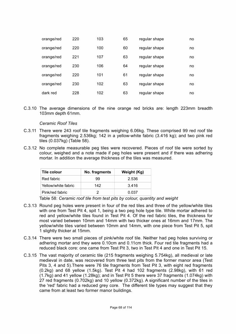
orange/red 220 103 65 regular shape no
orange/red 220 100 60 regular shape no
orange/red 221 107 63 regular shape no
orange/red 230 106 64 regular shape no
orange/red 220 101 61 regular shape no
orange/red 230 102 63 regular shape no
dark red 228 102 63 regular shape no
C.3.10 The average dimensions of the nine orange red bricks are: length 223mm breadth103mm depth 61mm.
Ceramic Roof Tiles
C.3.11 There were 243 roof tile fragments weighing 6.06kg. These comprised 99 red roof tilefragments weighing 2.536kg; 142 in a yellow-white fabric (3.416 kg); and two pink redtiles (0.037kg) (Table 58).
C.3.12 No complete measurable peg tiles were recovered. Pieces of roof tile were sorted bycolour, weighed and a note made if peg holes were present and if there was adheringmortar. In addition the average thickness of the tiles was measured.
Tile colour No. fragments Weight (Kg)Red fabric 99 2.536
Yellow/white fabric 142 3.416
Pink/red fabric 2 0.037Table 58: Ceramic roof tile from test pits by colour, quantity and weight
C.3.13 Round peg holes were present in four of the red tiles and three of the yellow/white tileswith one from Test Pit 4, spit 1, being a two peg hole type tile. White mortar adhered tored and yellow/white tiles found in Test Pit 4. Of the red fabric tiles, the thickness formost varied between 10mm and 14mm with two thicker ones at 16mm and 17mm. Theyellow/white tiles varied between 10mm and 14mm, with one piece from Test Pit 5, spit1 slightly thicker at 15mm.
C.3.14 There were two small pieces of pink/white roof tile. Neither had peg holes surviving oradhering mortar and they were 0.10cm and 0.11cm thick. Four red tile fragments had areduced black core: one came from Test Pit 3, two in Test Pit 4 and one in Test Pit 15.
C.3.15 The vast majority of ceramic tile (215 fragments weighing 5.754kg), all medieval or latemedieval in date, was recovered from three test pits from the former manor area (TestPits 3, 4 and 5).There were 76 tile fragments from Test Pit 3, with eight red fragments(0.2kg) and 68 yellow (1.5kg). Test Pit 4 had 102 fragments (2.98kg), with 61 red(1.7kg) and 41 yellow (1.28kg); and in Test Pit 5 there were 37 fragments (1.074kg) with27 red fragments (0.702kg) and 10 yellow (0.372kg). A significant number of the tiles inthe 'red' fabric had a reduced grey core. The different tile types may suggest that theycame from at least two former manor buildings.
Page 68 of 114
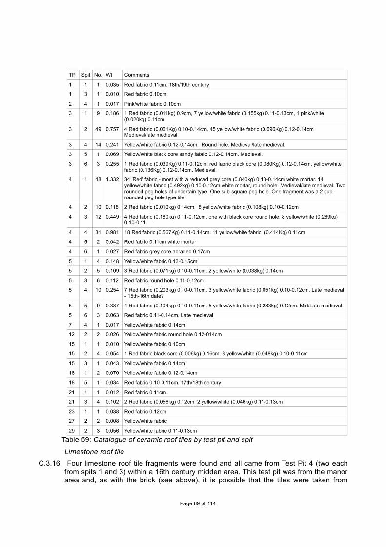
TP Spit No. Wt Comments
1 1 1 0.035 Red fabric 0.11cm. 18th/19th century
1 3 1 0.010 Red fabric 0.10cm
2 4 1 0.017 Pink/white fabric 0.10cm
3 1 9 0.186 1 Red fabric (0.011kg) 0.9cm, 7 yellow/white fabric (0.155kg) 0.11-0.13cm, 1 pink/white (0.020kg) 0.11cm
3 2 49 0.757 4 Red fabric (0.061Kg) 0.10-0.14cm, 45 yellow/white fabric (0.696Kg) 0.12-0.14cm Medieval/late medieval.
3 4 14 0.241 Yellow/white fabric 0.12-0.14cm. Round hole. Medieval/late medieval.
3 5 1 0.069 Yellow/white black core sandy fabric 0.12-0.14cm. Medieval.
3 6 3 0.255 1 Red fabric (0.039Kg) 0.11-0.12cm, red fabric black core (0.080Kg) 0.12-0.14cm, yellow/white fabric (0.136Kg) 0.12-0.14cm. Medieval.
4 1 48 1.332 34 'Red' fabric - most with a reduced grey core (0.840kg) 0.10-0.14cm white mortar. 14 yellow/white fabric (0.492kg) 0.10-0.12cm white mortar, round hole. Medieval/late medieval. Tworounded peg holes of uncertain type. One sub-square peg hole. One fragment was a 2 sub-rounded peg hole type tile
4 2 10 0.118 2 Red fabric (0.010kg) 0.14cm, 8 yellow/white fabric (0.108kg) 0.10-0.12cm
4 3 12 0.449 4 Red fabric (0.180kg) 0.11-0.12cm, one with black core round hole. 8 yellow/white (0.269kg) 0.10-0.11
4 4 31 0.981 18 Red fabric (0.567Kg) 0.11-0.14cm. 11 yellow/white fabric (0.414Kg) 0.11cm
4 5 2 0.042 Red fabric 0.11cm white mortar
4 6 1 0.027 Red fabric grey core abraded 0.17cm
5 1 4 0.148 Yellow/white fabric 0.13-0.15cm
5 2 5 0.109 3 Red fabric (0.071kg) 0.10-0.11cm. 2 yellow/white (0.038kg) 0.14cm
5 3 6 0.112 Red fabric round hole 0.11-0.12cm
5 4 10 0.254 7 Red fabric (0.203kg) 0.10-0.11cm. 3 yellow/white fabric (0.051kg) 0.10-0.12cm. Late medieval - 15th-16th date?
5 5 9 0.387 4 Red fabric (0.104kg) 0.10-0.11cm. 5 yellow/white fabric (0.283kg) 0.12cm. Mid/Late medieval
5 6 3 0.063 Red fabric 0.11-0.14cm. Late medieval
7 4 1 0.017 Yellow/white fabric 0.14cm
12 2 2 0.026 Yellow/white fabric round hole 0.12-014cm
15 1 1 0.010 Yellow/white fabric 0.10cm
15 2 4 0.054 1 Red fabric black core (0.006kg) 0.16cm. 3 yellow/white (0.048kg) 0.10-0.11cm
15 3 1 0.043 Yellow/white fabric 0.14cm
18 1 2 0.070 Yellow/white fabric 0.12-0.14cm
18 5 1 0.034 Red fabric 0.10-0.11cm. 17th/18th century
21 1 1 0.012 Red fabric 0.11cm
21 3 4 0.102 2 Red fabric (0.056kg) 0.12cm. 2 yellow/white (0.046kg) 0.11-0.13cm
23 1 1 0.038 Red fabric 0.12cm
27 2 2 0.008 Yellow/white fabric
29 2 3 0.056 Yellow/white fabric 0.11-0.13cm
Table 59: Catalogue of ceramic roof tiles by test pit and spit
Limestone roof tile
C.3.16 Four limestone roof tile fragments were found and all came from Test Pit 4 (two eachfrom spits 1 and 3) within a 16th century midden area. This test pit was from the manorarea and, as with the brick (see above), it is possible that the tiles were taken from
Page 69 of 114

Barnwell Priory after the dissolution. These roof tiles are very likely to have originallycome from Northamptonshire stone quarries.
Medieval floor tiles
C.3.17 There were five red medieval floor tiles weighing 1.081kg and all came from Test Pit 4(Table 60). The floor tiles were recovered from spits 2, 3 and 4 (which collectively mayhave been part of a single midden layer (the pottery report also suggests this). Theheavy green glaze on the 24mm thick fragment in spit 3 is late 15th or early 16thcentury in date (Dr Paul Spoerry pers. comm), with the tile having a slight chamferededge. It is probable that the piece with a smooth surface was glazed originally. Thesetiles had clearly been used, as they had white mortar adhering.
TP Spit No.
Wt Comments
4 2 1 0.313 Red fabric 0.21cm thick white mortar both faces. 15th century to early 16th century
4 3 2 0.385 1 Red fabric (0.275Kg) 0.24cm thick top light green glaze brown on edges white mortar, 1 Red fabric (0.110Kg) 0.30cm very worn with dark brown glaze on top white mortar
4 4 2 0.383 1 Red fabric (0.321Kg) smooth on top surface white mortar, 1 Red fabric (0.062Kg) 0.29cm very worn withdark green brown glaze . 15th/early 16th century
Table 60: Medieval floor tiles by test pit and spit
Post-medieval floor brick
C.3.18 A single yellow-white floor brick weighing 0.247kg was recovered from Test Pit 5. It issimilar to 12 inch square floor brick found elsewhere in South Cambridgeshire, such asat Mr Ratford's house, Wimpole, dating to the 18th century (CAFG forthcoming).
ConclusionsC.3.19 The majority of all the ceramic building material was recovered from Test Pit 4, weighing
6.33kg (42%) of the total of 15.11kg found in all test pits. The CBM in this test pitconsisted of 2.29kg of brick, 2.95kg peg tiles and 1.08kg of medieval floor tiles, whichwere all from a single midden layer. There was also a significant quantity of CBM fromtwo nearby test pits (Nos. 3 and 5), also from the manor area. The number, type andsmall fragment size of the CBM from these three test pits suggest a major buildingand/or demolishing episode. Other finds from Test Pit 4 imply a middle/late 16th centurydate, which would tie in with the original building of the Tudor Hall. There is nothing tosuggest these deposits derived from the mid-17th century, when there was a majorrebuilding of the hall in brick. The nearby dovecote, built in red brick, seems to be fromthis mid-17th century date (RCHM 1968, 140-1).
C.3.20 Rob Atkins looked at the Haslingfield brick from Test Pits 3, 4 and 5 and thought thesebricks might have come from Barnwell Priory. It is interesting to note that ThomasWendy, who rebuilt Haslingfield Manor house in red brick in the mid-16th century, alsobought Barnwell Priory in 1553 (Danckwerts 1980 211-12). Recent excavations at thelay medieval settlement of Barnwell Priory at Coldhams Lane, Cambridge (Atkins 2013)found similar bricks including some made on a vegetative base. These bricks wererecovered in small quantities in Phase 2.2 contexts (c. 1350-1400) but were recoveredin significant numbers during Phase 3.1 (c. 1400-c.1500/1550).
C.3.21 On the north side of the High Street there is a boundary wall built of red brick set into asubstantial bank, which divides the street from a small Park within which the 16thcentury Manor house resides. These wall bricks, which may be contemporary with the
Page 70 of 114

building of the Manor house or its 17th century rebuilding, have an averagemeasurement of length 223mm breadth 103mm depth 61mm (see above).
C.3.22 No yellow/white bricks were found in Test Pit 4, and those from other test pits appear toall belong to the late 18th to early 20th century. There are good examples of similarbrick on the Old Vicarage, the south range of which was built by the Revd Perkins in1761. It was extended with a parallel range, also in yellow/white bricks, to the north inthe early 19th century. The bricks of the earlier part show diagonal skintling (stacking)impressions, whereas the bricks of the northern range have horizontal skintling marks.This change in technique of production is thought to have occurred around thebeginning of the 19th century (James and Rose 2004). No skintling marks were foundon any brick from the test pits. All the yellow/white bricks are probably dated to the 19tthand early 20th centuries. The ceramic building material from all other test pits waslargely undiagnostic small fragments.
C.4 Clay Pipe
By Terry Dymott
Introduction and methodologyC.4.1 A small collection of 23 clay pipe fragments (43.39g) was recovered from test pits
(Table 61). The clay pipes from field walking are noted in Tables 65-67 but have notbeen commented upon.
ResultsC.4.2 From the test pits there was only one pipe fragment with a maker's mark and one
probable identifiable design characteristic; the remainder could not specifically bedated. All the pipe fragments are likely to be within the late 18th to early-mid 19thcentury date range with a possible single stem fragment with a large bore which mightsuggest an earlier date, and a bowl fragment which could be slightly later (see below).
C.4.3 Test Pit 13, spit 4, had a clay pipe stem with Cleever stamped on one side. Three of theCleever family made pipes in Cambridge – Ann, John and Thomas, all of whom weremanufacturing during the mid-19th century. The part bowl from Test Pit 18 is most likelyto have been made by Samuel McLardy in Manchester and dates to the mid-19th/early20th centuries. The IN comes from the type, and it is likely to be a DUBLIN cutty type.
C.4.4 Some of the bowls have decorated seams covering the joint marks left by the mouldingprocess, but the general lack of any other decoration on them is typical of Cambridgeregion pipes from the early 19th century.
TP Stem Comments
No. ItemBore
cm 64thsDiameter
cmLength
cmWt(g)
TP13/4 2 1 >0.15 4 0.59 - 0.61 4.02 1.84
Stem with .CLEEVER on one side, CAMBRIDG- on the other.
2 n/a n/a n/a 1.42Part bowl (incl rim) with barley ear covering mould joint. 2.3mm wall thickness.
15/2 3 1 <0.3 7 0.93 - 0.97 4.74 5.972 >0.2 6 0.7 - 0.74 4.67 2.953 <0.25 6 0.89 - 0.92 2.13 1.61
Page 71 of 114

18/1 4 1 <0.3 7 0.80 - 084 2.45 2.082 <0.2 5 0.58 - 0.60 4.17 2.15
3 n/a n/a n/a 1.04Part bowl (incl rim), no markings. 2.1mm wall thickness.
4 n/a n/a n/a 2.48
Part bowl (incl rim) with vertical grooved rim. Oval ring containing --RDY'S at top and --IN atbottom. Thick wall ~4mm.
18/3 10 1 <0.2 5 0.61 - 0.73 7.11 4.12 <0.25 6 0.69 - 0.75 3.17 2.143 <0.2 5 0.55 - 0.57 2.55 1.024 <0.2 5 0.59 - 0.65 2.45 1.14
5 <0.3 7 0.84 - 0.88 1.88 1.76 >0.15 4 0.51 - 0.59 1.92 0.737 >0.35 9 0.74 1.87 1.18 <0.2 5 0.64 - 0.66 1.7 0.8
9 n/a 0.83 Part bowl with raised plant design covering joint, wall ~0.23cm thick.
10 n/a 1.21 Part bowl with rim and worn raised plant design covering joint, wall ~0.23cm thick.
21/5 1 1 <0.2 5 0.46 - 0.51 2.95 0.9723/1 2 1 0.2 5 0.52 - 0.62 3.43 1.55
2 n/a 2.66 Part bowl with raised barley edge over joint, wall ~0.25cm thick.
28/2 1 1 <0.2 5 0.61 - 0.67 3.67 1.923 43.39
Table 61: Clay pipe from test pits
C.5 Stone Mortar from near Test Pit 4
By Mike Coles
ResultC.5.1 While digging his garden, the owner of the site of Test Pit 4 found a fragment of a stone
mortar. The mortar is probably made of Purbeck marble, but has been broken inantiquity and re-used, possibly in a floor as one edge shows considerable wearfollowing fracture.
C.5.2 The relative thickness of the surviving part of the vessel suggests that it had not beenheavily used when broken; there was no apparent thinning of the base. The baseappears to be unusual in that there is a foot-ring for which no parallel can be found.There is a lug, rectangular in cross section, on the outer edge, extending to a point42mm from the broken top. After being broken, the mortar suffered considerable wearon the broken edge. The mortar is made of a hard grey fossiliferous limestone whichappears to be from Purbeck in Dorset.
C.5.3 Dunning, in his report on stone objects from excavations at King's Lynn, recorded fourmortars made from Purbeck marble (1977, figs. 144 and 145). Purbeck marble mortarshave been recorded from sites around the south and eastern parts of England (ibid, fig.146). This distribution reflects transport by sea, with those found in Cambridgeshirebeing brought up the River Cam. He suggests the date of their production may be in the13th and 14th centuries. Purbeck marble was used in the Roman period for mortars but
Page 72 of 114

the majority was seemingly used in the medieval period. This stone was also used forarchitecture stonework in churches and cathedrals including effigies, coffins, tombs,altar slabs and fonts. The identification of Purbeck marble requires experience and it ispossible that this example could be a similar stone from Sussex. Mortar base, Purbeck marble, estimated diameter 320mm and 90mm high, weight 2.82kg, vertical lugpointed towards the base (Fig. 8).
Fig. 8: Purbeck marble mortar from Test Pit 4
C.6 Queens’ College Plates at Brook Farm
By Craig Cessford
Introduction and methodologyC.6.1 In 1994 CAFG fieldwalked fields at Brook Farm, Haslingfield and among the finds were
some pieces of plates with the name Queens’ College on them. Recently theopportunity has arisen to have them inspected by Craig Cessford of the CambridgeArchaeological Unit. While acknowledging that further research might produce moredetail, he has sent the following brief explanatory note.
C.6.2 At least four vessels that can be linked to Queens’ College, Cambridge, were recoveredduring field walking by the Cambridge Archaeology Field Group in 1994 near BrookFarm, to the north of the village of Haslingfield, located some 4.8 miles to the southwestof the college.
C.6.3 Queens’ College acquired land in Haslingfield from the Prisot family (1475) and theSterne family (1495). These two farms, which the college leased out to tenants, coveredc.320 acres and at inclosure Queens’ was allotted 385 acres. The college sold thefarms between c.1945-50. It is likely that the presence of the pottery is somehow linkedto this land ownership. The four vessels represent three different patterns. Thissuggests that they may represent some form of general replacement of old pottery bythe college when a new service was introduced.
Page 73 of 114

C.6.4 Two of the vessels are plates with a green transfer-printed design of a view of thecollege from the River Cam (Vessel 1; Fig. 9) and a floral border with the college mottoFLOREAT DOMUS (Latin: May this House Flourish) at the bottom (Vessel 2; Fig. 10).Examples of such plates are known with the names G GERMANY and M PAGE at thetop (Stovin 1999, 56, fig. 8); unfortunately this upper portion is missing in both of thecurrent examples. These two people were Queens’ College porters (George Germany1825-46; Martin Page 1846-71) and Queens’ is unusual in that it was the onlyCambridge college where the porter, rather than the cook, had charge of the crockery.
C.6.5 One of the plates has the text QUEEN'S COLLE[GE] on the rear (Fig. 11). As far as Iam aware this is not present on the other examples, indicating that this was not a platelinked to the college porters and that it may be linked to either the college itself or to thecollege cook. The incorrect punctuation is also noteworthy, as colleges were usuallyquite punctilious about this.
C.6.6 There is also a vessel with different green transfer printed design with floral elementsand name QUEE (Vessel 3; Fig. 12) and a blue transfer printed design with name J KTAYLO[R] /QUEENS C[OLLEGE] and a floral pattern (Vessel 4; Fig. 13). Jasper KingTaylor was born on the 11th February 1806 and baptised at Saint Andrew, Holborn,London on the 20th November 1806.
C.6.7 In the 1851 census Jasper K Taylor was a cook aged 45 living on Silver Street, who hadbeen born in London. There is also a will of Jasper King Taylor, Cook of Queens’College in the University of Cambridge, dated 14th June 1855 (TNA Prob 11/2215). Theexact forms of the two latter vessels are unclear, but neither appears to be a 'standard'circular plate.
C.6.8 The use of the colour green on many of these vessels would have been relativelyunusual, as the vast majority of transfer prints of the period (typically >90%) were blue.
Page 74 of 114

Page 75 of 114
Figure 9: Vessel 1 showing the illustration of Queens’ College viewed from the River Cam
Figure 10: Rim of vessel 2 showing the college motto “FLOREAT DOMUS”
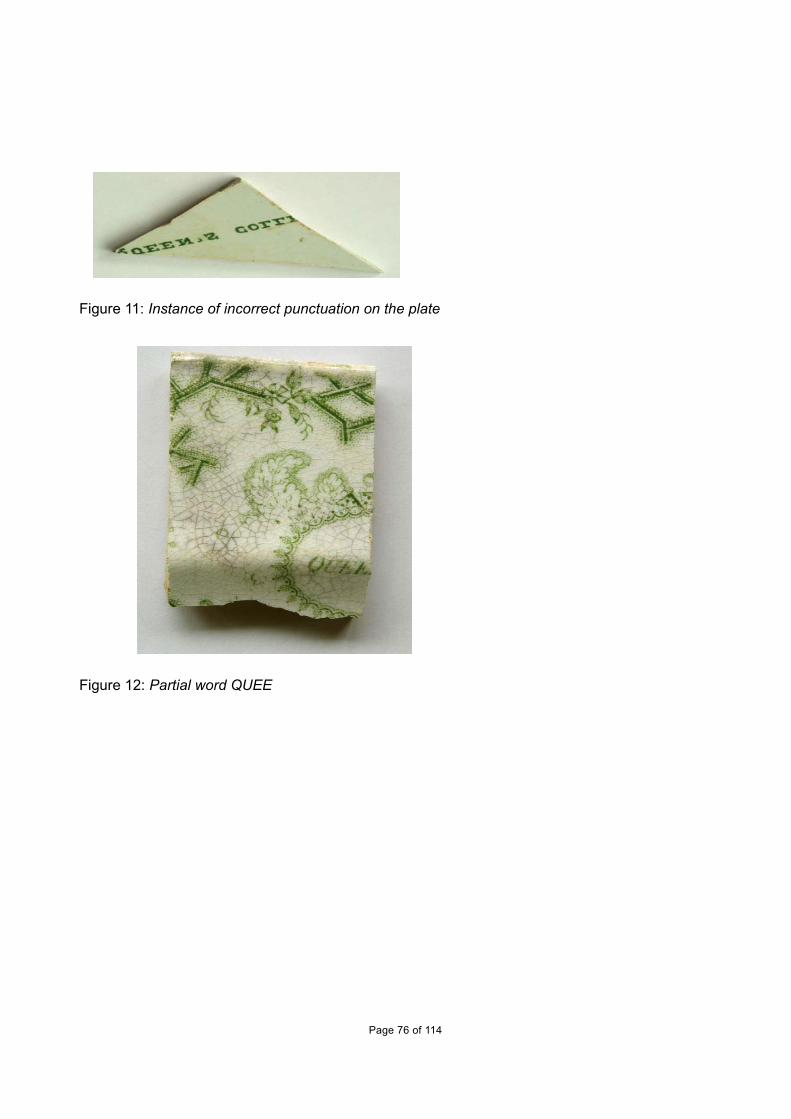
Figure 11: Instance of incorrect punctuation on the plate
Figure 12: Partial word QUEE
Page 76 of 114

Figure 13: Partial words for J K TAYLO[R] and QUEENS C[OLLEGE] on vessel 4
Page 77 of 114

APPENDIX D. ENVIRONMENTAL REPORTS
D.1 Animal bone
By Chris Faine
IntroductionD.1.1 Three point eight kilograms of faunal material was sent for analysis, yielding 65
“countable” bones (see below). All bones were collected by hand; hence a bias towardssmaller fragments is to be expected. Analysis took place on most of the animal bonefound during test pit in the village. Fragments of bone from test pits with moderncontexts were excluded apart from Test Pit 28, which had a worked bone fragment.Faunal material was mostly recovered from contexts dating from the high medievalperiod. Thirty-one animal bone fragments were identifiable to species (46.1% of thetotal sample).
MethodologyD.1.2 All data was initially recorded using a specially written MS Access database. Bones
were recorded using a version of the criteria described in Davis (1992) and Albarellaand Davis (1994). Initially all elements were assessed in terms of siding (whereappropriate), completeness, tooth wear stages (also where applicable) and epiphysealfusion. Completeness was assessed in terms of percentage and zones present (afterDobney and Reilly 1988). Initially the whole identifiable assemblage was quantified interms of number of individual fragments (NISP) and minimum numbers of individualsMNI. The ageing of the population was largely achieved by examining the wear stagesof cheek teeth of cattle, sheep/goat and pig (after Grant, 1982). Wear stages wererecorded for lower molars of cattle, sheep/goat and pig, both isolated and in mandibles.The states of epiphyseal fusion for all relevant bones were recorded to give a broad agerange for the major domesticates (after Getty, 1975). Measurements were largelycarried out according to the conventions of von den Driesch (1976). Measurementswere either carried out using a 150mm sliding calliper or an osteometric board in thecase of larger bones.
The AssemblageD.1.3 Table 62 shows the species distribution for each test pit and context. Sheep/goat are
the dominant taxon in the assemblage with cattle being the next most prevalentspecies. Pig and red deer remains are present in single instances. Test Pit 2 containeda single cattle 1st phalanx from context 3. Test Pit 3 contained fragmentary cattle andsheep coat metacarpals from contexts 2 and 7 respectively. A portion of red deer antlertine was also recovered from context 5 but was too badly preserved to ascertainwhether it was butchered. The largest number of identifiable remains (NISP: 26) wasrecovered from test Pit 4 (contexts 1, 3, 4 & 5). Twelve fragments of sheep/goat wererecovered, consisting largely of butchered lower limb elements. Contexts 1, 3 & 4 alsocontained 5 mandibles. Two were from animals around 6-8 years of age, 2 from animalsaround 8-12 and 1 neonate. Cattle remains from Test Pit 4 consisted largely ofmetapodial and phalanx fragments recovered from all contexts. A single pig astragaluswas recovered from context 1. Evidence of bone working was recovered from Test Pit28 (context 6), in the form of a sawn section of cattle parietal bone.
Page 78 of 114

Species TP2 TP3(2) TP3(5) TP3(7) TP4(1) TP4(3) TP4(4) TP4(5) TP28(6) Total
Sheep/goat(Ovis/Capra)
1 6 5 5 1 18
Cattle (Bos) 1 1 2 2 1 2 1 10
Pig (Sus scrofa) 1 1 2
Red deer (Cervuselaphus)
1 1
Total 1 1 1 1 9 8 6 3 31Table 62: Animal bone by species distribution in test pits
DiscussionD.1.4 This is a small assemblage that most likely represents initial processing waste of whole
carcasses, given the lack of meat bearing elements. The presence of very oldsheep/goat could suggest culling of older and barren breeding animals. There is someevidence of bone working and exploitation of wild resources.
D.2 Shell
By Rob AtkinsD.2.1 A collection of 166 oyster shell fragments (1.107kg) was recovered from the test pit
survey (Table 63). For this report, each shell fragment was defined as one shell,although most were complete. As oysters comprise two halves, it is likely the truenumber of oysters were c.50-60. This is still a significant number, as they derived(except one fragment) from a single one 1m² test pit (Test Pit 4), which was locatedwithin the grounds of the former medieval and post-medieval manor. Over half theoysters were found in the top 0.1m of the test pit, although moderate to relatively largequantities were found in all five spits, which may suggest that this was a single c.0.5mthick midden deposit which may have accumulated over a little time. This test pitcontained large quantities of other artefacts largely dating to c.mid to late 16th century,suggesting a primary deposit.
Test Pit No. ShellsTP1 2nd spit 1 oyster (1g)
TP4 1st spit (2 bags) 94 oysters (630g)
TP4 2nd spit 6 oysters (36g)
TP4 3rd spit 34 oysters (255g)
TP4 4th spit 11 oysters (76g)
TP4 5th spit 20 oysters (109g)
Total 160 (1071g) Table 63: Oyster shell from test pits
Page 79 of 114

APPENDIX E. ARTEFACTS AND ECOFACTS FROM FIELD WALKINGThe fabrics from the prehistoric to post-medieval pottery analysed in the field walking data (Tables 64-67) are included below:
F1001: Grey WaresF1002: Colour-coated WaresF1003: Samian WareF1004: MortariaF1005: Late Bronze Age BA / Early Iron Age flint tempered 16 sherds (99g)F1006: Miscellaneous R-BF1007: Mid-Late Iron AgeF1008: RB Shelly WaresF1010: ‘Belgic’
F1: Early/middle Saxon hand-built chaff-tempered ware, c. AD450-850 Moderate to dense organic voids up to 10mm. No other visible inclusions.
F2: Early/middle Saxon hand-built sandy ware, c. AD450-850. Moderate to dense sub-angular quartz up to 0.2mm. Rare rounded red ironstone up to 2mm, rare calcareous material up to 2mm.
Ipswich Ware, AD725-850 (Blinkhorn 2012) Middle Saxon, slow-wheel made ware, manufactured exclusively in the eponymous Suffolk wic. The material probably had a currency of AD 725x740 - mid 9th century at sites outside East Anglia. There are two main fabric types, although individual vessels which do not conform to these groups also occur:
F95: GROUP 1: Hard and slightly sandy to the touch, with visible small quartz grains and some shreds of mica. Frequent fairly well-sorted angular to sub-angular grains of quartz, generally measuring below 0.3 mm in size but with some larger grains, including a number which are polycrystalline in appearance.
F96: GROUP 2: Like the sherds in Group 1, they are hard, sandy and mostly dark grey in colour. Their most prominent feature is a scatter of large quartz grains (up to c 2.5mm) which either bulge or protrude through thesurfaces of the vessel, giving rise to the term "pimply" Ipswich ware (Hurst 1959: 14). This characteristic makes them quite rough to the touch. However, some sherds have the same groundmass but lack the larger quartz grains which are characteristic of this group, and chemical analysis suggests that they are made from the same clay.
F100: St Neots Ware type ware, c. AD900-1100 (Denham 1985). Fabric moderate to dense finely crushed fossil shell, with varying quantities of quartz and/or ironstone. Usually purplish-black, black or grey, with fairly fine, dense inclusions. Main forms small jars with sagging bases, although a few lamps are known.
F205: Stamford Ware (Kilmurry 1980). c. AD900-1200. Wheel-thrown. White, pink, buff or grey fabric, usually with sparse to dense quartz up to 0.5mm, occasional black or red ironstone up to 1mm. Often glazed with yellow, pale or sage green glaze.
F301: Ely Ware, mid 12th -15th century (Spoerry 2008): Generic name for a quartz sand and calcareous tempered group of pottery fabrics mainly manufactured in Ely, but also with a second possible source in the Hunts. Fenland. Jars, bowls and jugs dominate the assemblage. Earlier vessels hand-built and turntable finished, later vessels finer and usually wheel-thrown. wide distribution, including King's Lynn, where it was originally identified as 'Grimston Software'.
F302: Hertfordshire Grey ware, reduced sandy wares, probably from a number of sources, some of which are as-yet unknown (Turner-Rugg 1993). Mid 12th – 14th century (Turner-Rugg 1993).
F303: Bourne 'A' Ware: 13th-14th century (McCarthy and Brooks 1988, 259). Manufactured in the eponymous south Lincolnshire village. Wheel-thrown, reduced, grey fabric with sparse sand and calcitic inclusions, vessels sometimes with a green or brownish glaze. Full range of medieval vessel types.
F319: Lyveden/Stanion 'A' Ware (McCarthy 1979). c. AD1150-?1400. Handmade/Wheel finished. Moderate to dense, ill-sorted shelly limestone platelets up to 3mm, sparse to moderate red ironstone up to 10mm, occasional quartz, ooliths, black ironstone. Produced at numerous kilns in the villages of Lyveden and Stanionin north-east Northants.
Page 80 of 114

F327: Hedingham Ware: Late 12th – 14th century. Fine orange micaceous glazed ware (McCarthy and Brooks 1988, 300-2).
F328: Grimston Ware: 13th– 15tth century (Leah 1994). Wheel-thrown. Dark grey sandy fabric, usually with grey surfaces, although orange-red and (less commonly) buff surfaces are known. Manufactured at the eponymous production centre near Kings Lynn, Norfolk.
F330: Shelly Coarseware, AD1100-1400 (McCarthy 1979). Products of numerous known and very probably many unknown kilns on the Jurassic limestone of west Northants/east Bedfordshire. Pale buff through virtually all colours to black, moderate to dense shelly limestone fragments up to 3mm, and any amount of ironstone, quartz and flint. Full range of medieval vessel types, especially jars and bowls, and 'Top Hat' jars.
F351: Cambridgeshire Sgraffito Ware. 14th – 15th century (McCarthy and Brooks 1988, 424-5). Fairly hard, smooth red fabric, outer surface of vessels covered in a white slip through which designs were incised to reveal thebody clay, the whole covered in a yellow glaze which occasionally has green copper-spotting. Fairly common in Cambridgeshire, although the production source is as yet unknown.
F352: Brill/Boarstall Ware: c. AD1200-?1600 (Mellor 1994). Wheel-thrown. Hard buff, orange, pale pink or yellow-grey fabric, sometimes with fine 'pimply' surface. Rare to common sub-angular to sub-rounded orange,clear and grey quartzite up to 0.5mm, rare sub-rounded to sub-angular red ironstone up to 1mm. Mottled pale to dark glossy green exterior glaze, often with copper filings. Applied rouletted strips common, sometimes in red-firing clay, rosettes, spirals also occur. Usually 'three-decker' or baluster jugs, although puzzle jugs also known. Jars, bowls, etc occur at end of medieval period. Later vessels plainer, and include the full range of medieval and early post-medieval vessel types.
F360: Miscellaneous Sandy Coarsewares, AD1100-1400. A range of quartz-tempered coarsewares that arefound throughout the east midlands and East Anglia.
F365: Late Medieval Reduced Ware, 14th – 16th century. Hard grey sandy ware, manufactured at a numberof centres in the south-east midlands, such as Higham Ferrers in Northamptonshire (Blinkhorn 2007). Broad range of utilitarian vessels, particularly large bowls, jars and cisterns.
F401: Bourne ‘D’ Ware: c. 1450-1637 (McCarthy and Brooks 1988, 409). Production as the ‘A’ ware. Fairly hard, smooth, brick-red fabric, often with a grey core. Some vessels have sparse calcitic inclusions up to 2mm. Full range of late medieval to early post-medieval vessel forms, jugs, pancheons, cisterns etc. Vessels often have a thin, patchy exterior white slip, over which a clear glaze had been applied.
F402: Late Medieval Oxidized ware. Mid 15th – 16th century. Very hard orange sandy ware in a range of developed late medieval utilitarian forms, some with a dark green glaze. Numerous kiln sites throughout the south-east midlands, at places such as Glapthorn in Northamptonshire (Johnston 1997). Similar to material from many sites in the region, such as the ‘Orange Sandy Ware’ from Denny Abbey (Coppack 1980).
F403: Tudor Green Wares. Green-glazed whitewares produced at several centres in the south of England, such as Farnborough Hill, Hants (McCarthy and Brooks 1988, 450). c. AD1380-1500.
F404: Cistercian Ware: c. AD1470-1700. Hard, smooth fabric, usually brick-red, but can be paler or browner. Few visible inclusions, except for occasional quartz grains. Range of vessel forms somewhat specialized, and usually very thin-walled (c. 2mm). Rare white slip decoration. Manufactured at a number of centres, including Potterspury in Northamptonshire (Mayes 1968) and, during the 16th and 17th centuries, at Ely (Hall 2001, 7).
F405. German Stonewares. AD1480+. A range of hard, grey, salt-glazed fabrics produced at numerous sitesin the Rhineland and beyond (cf Gaimster 1997).
F411: Metropolitan Slipware, 17th – 18th C. Similar fabric to Red Earthenware, with geometric designs in white slip under the glaze. Produced at a number of centres, but particularly Harlow in Essex (Davey and Walker 2009).
F413: Cologne/Westerwald Stoneware. 17th century+ (Gaimster 1997).Hard, grey fabric with clear salt glaze. Vessels include jugs with moulded decoration and chamber-pots, often with blue and purple manganese and cobalt decoration.
F416: Staffordshire Slipware. AD1680-1750. Fine cream fabric with white slip and pale yellow lead glaze, commonest decoration is feathered dark brown trailed slip. Chiefly press-moulded flat wares, although small
Page 81 of 114

bowls and mugs etc are known.
F425: Red Earthenware, 16th – 19th century. Fine sandy earthenware, usually with a brown or green glaze, occurring in a range of utilitarian forms. Such 'country pottery' was first made in the 16th century, and in some areas continued in use until the 19th century.
F438: English Stoneware. 1680+. Hard, grey fabric, often with a brown, iron-rich exterior wash. Range of utilitarian vessels, particularly mugs.
F1000: Miscellaneous 19th and 20th century wares. Mass-produced white earthenwares, stonewares etc.
Field No TL East TL NorthNumber of
sherds WT (g) Pottery Fabric (F) COMMENTS
1 398 517 1 2 425
1 399 516 1 2 303
1 399 517 5 29 402
1 399 517 1 1 403
1 399 517 1 6 404
1 399 517 6 61 425
1 399 517 2 4 1001
1 399 518 3 20 425
1 400 516 1 3 402
1 400 516 4 61 425
1 400 516 1 18 1000
1 400 516 1 7 1001
1 400 517 3 12 402
1 400 517 1 1 404
1 400 517 7 69 425
1 400 517 1 10 1006
1 400 518 2 4 365
1 400 518 6 20 402
1 400 518 1 4 404
1 400 518 1 10 411
1 400 518 5 83 425
1 400 518 1 5 1001
1 400 518 1 5 1002
1 401 515 2 6 302
1 401 515 1 7 411
1 401 515 2 9 425
1 401 516 1 14 330
1 401 516 1 4 402
1 401 516 7 33 425
1 401 517 1 2 303
1 401 517 2 19 402
1 401 517 2 55 425
1 401 517 1 3 1006
1 401 518 1 4 360
1 401 518 4 25 425
1 402 517 2 11 402
1 402 517 9 103 425
1 402 518 1 42 425
10 409 525 1 42 425
10 409 526 1 5 402
Page 82 of 114

Field No TL East TL NorthNumber of
sherds WT (g) Pottery Fabric (F) COMMENTS
10 409 526 11 242 425
10 409 526 1 16 436
10 409 526 1 19 1000
10 409 527 1 8 352
10 409 527 1 25 365
10 409 527 2 13 425
10 409 527 4 34 1000
10 410 525 2 57 425
10 410 525 1 5 1000
10 410 526 2 77 402
10 410 526 3 60 425
10 410 526 2 13 1006
10 410 527 1 4 303
10 410 527 1 31 425
10 410 527 1 21 438
10 410 527 4 31 1006
2 411 518 1 18 425
2 411 518 10 74 1001
2 411 519 1 4 302
2 411 519 1 18 303
2 411 519 2 10 330
2 411 519 5 33 360
2 411 519 1 10 402
2 411 519 2 15 425
2 411 519 1 2 425
2 411 519 2 32 425
2 411 519 1 4 1006
2 411 618 1 18 360
2 412 516 1 10 2
2 412 516 16 95 302
2 412 516 2 57 303
2 412 516 5 13 327
2 412 516 2 11 330
2 412 516 1 4 352
2 412 516 15 106 360
2 412 516 2 9 1001
2 412 516 1 10 1008
2 412 517 1 19 95
2 412 517 38 315 302
2 412 517 5 88 327
2 412 517 2 20 328
2 412 517 6 46 330
2 412 517 2 12 352
2 412 517 18 109 360
2 412 517 1 7 405 Raer
2 412 517 2 53 425
2 412 517 8 55 1001
2 412 517 1 5 1007
2 412 518 39 430 302
2 412 518 3 154 303
Page 83 of 114

Field No TL East TL NorthNumber of
sherds WT (g) Pottery Fabric (F) COMMENTS
2 412 518 5 20 327
2 412 518 1 4 328
2 412 518 5 20 330
2 412 518 4 14 351
2 412 518 1 3 352
2 412 518 43 259 360
2 412 518 2 65 425
2 412 518 47 273 1001
2 412 518 1 45 1006
2 412 519 10 87 302
2 412 519 5 37 327
2 412 519 1 1 328
2 412 519 5 24 330
2 412 519 25 225 360
2 412 519 1 18 402
2 412 519 4 108 425
2 412 519 4 12 1001
2 412 520 1 7 302
2 412 520 1 4 402
2 412 520 1 22 402
2 412 520 1 4 1003
2 412 520 1 2 1008
2 413 516 1 6 302
2 413 516 1 5 327
2 413 516 1 2 328
2 413 516 3 14 330
2 413 516 3 10 352
2 413 516 20 123 360
2 413 516 3 7 401
2 413 516 6 27 402
2 413 516 4 72 425
2 413 516 62 631 1001
2 413 516 3 50 1002
2 413 516 2 9 1003
2 413 516 2 20 1004
2 413 516 21 155 1006
2 413 516 11 112 1008
2 413 517 2 20 205
2 413 517 2 29 302
2 413 517 3 34 303
2 413 517 1 25 327 Twisted handle
2 413 517 1 2 327
2 413 517 10 63 330
2 413 517 3 12 352
2 413 517 10 65 360
2 413 517 117 1242 1001
2 413 517 17 177 1002
2 413 517 1 19 1003
2 413 517 2 56 1004
2 413 517 41 326 1006
Page 84 of 114

Field No TL East TL NorthNumber of
sherds WT (g) Pottery Fabric (F) COMMENTS
2 413 517 12 120 1008
2 413 517 1 6 1010
2 413 518 1 5 205
2 413 518 1 13 301
2 413 518 6 50 302
2 413 518 5 84 303
2 413 518 7 102 330
2 413 518 3 17 352
2 413 518 49 381 360
2 413 518 1 14 401
2 413 518 3 59 425
2 413 518 29 255 1001
2 413 518 8 56 1006
2 413 518 3 21 1008
2 413 519 1 7 100
2 413 519 4 55 330
2 413 519 13 115 360
2 413 519 1 15 425
2 413 519 5 50 1001
2 413 519 1 6 1006
2 413 520 1 14 330
2 413 520 1 5 360
3 413 524 2 10 425
3 413 524 1 17 438
3 413 524 1 4 1003
3 413 525 3 6 402
3 413 525 1 2 405 Frec
3 413 525 2 15 425
4 413 528 9 151 1001
4 413 528 1 2 1005
4 413 528 1 12 1006
4 413 528 1 3 1008
2 414 516 12 100 1001
2 414 516 3 25 1006
2 414 516 1 10 1008
2 414 517 1 5 303
2 414 517 31 687 1001
2 414 517 7 107 1002
2 414 517 9 520 1006
2 414 517 5 46 1008
2 414 518 1 4 2
2 414 518 12 96 302
2 414 518 1 2 303
2 414 518 6 42 327
2 414 518 7 53 330
2 414 518 1 2 352
2 414 518 22 307 360
2 414 518 13 90 1001
2 414 518 3 96 1002
2 414 518 1 4 1003
Page 85 of 114

Field No TL East TL NorthNumber of
sherds WT (g) Pottery Fabric (F) COMMENTS
2 414 519 1 13 302
2 414 519 1 6 303
2 414 519 1 9 1001
3 414 524 2 5 365
3 414 524 2 37 402
4 414 525 2 53 425
4 414 526 7 50 402
4 414 526 1 6 411
4 414 526 4 48 425
4 414 526 1 19 1006
4 414 527 2 5 360
4 414 527 5 16 402
4 414 527 1 1 404
4 414 527 1 8 405 Frec
4 414 527 4 43 425
4 414 527 2 6 1001
4 414 527 1 5 1006
4 414 528 1 5 1000
4 414 528 2 9 1001
4 414 528 1 4 1005
4 415 525 2 29 425
4 415 525 1 2 1003
4 415 525 1 2 1006
4 415 526 2 3 402
4 415 526 6 69 425
4 415 526 1 3 1001
4 415 526 1 3 1006
4 415 527 2 12 402
4 415 527 1 4 404
4 415 527 2 30 425
4 415 527 1 3 1000
4 415 527 3 102 1006
4 415 528 1 11 302
4 415 528 1 3 352
4 415 528 5 52 360
4 415 528 1 6 413 West
4 415 528 1 4 425
4 415 528 28 141 1001
4 415 528 3 34 1007 Scored
4 415 528 5 26 1008
4 415 528 1 3 1010
4 415 529 4 103 425
4 415 529 1 3 1001
4 415 529 1 4 1005
4 415 530 1 13 425
4 416 350 1 3 403
4 416 526 13 215 425
4 416 526 1 4 1000
4 416 526 1 14 1006
4 416 527 1 3 402
Page 86 of 114

Field No TL East TL NorthNumber of
sherds WT (g) Pottery Fabric (F) COMMENTS
4 416 527 1 19 425
4 416 527 2 6 1001
4 416 528 1 6 303
4 416 528 1 2 402
4 416 528 2 17 425
4 416 529 2 6 360
4 416 529 2 11 425
4 417 525 1 10 425
4 417 525 1 2 1006
4 417 527 1 10 425
4 417 527 3 13 1007 Scored
4 417 529 2 10 402
4 417 529 1 19 425
7 417 544 1 13 425
7 417 544 1 4 1001
7 417 545 1 34 425
7 417 546 2 26 425
4 418 525 1 5 303
4 418 525 2 6 360
4 418 525 2 17 402
4 418 525 5 107 425
4 418 525 1 2 1001
4 418 525 1 2 1002
4 418 525 1 3 1008
4 418 526 1 4 402
4 418 526 4 45 425
4 418 527 1 4 2
4 418 527 1 6 303
4 418 527 1 20 402
4 418 527 2 4 1006
4 418 528 1 10 365
4 418 528 2 6 402
4 418 528 5 77 425
4 418 529 1 20 1006
5 418 534 1 40 425
6 418 544 1 7 360
4 419 526 1 62 425
4 419 527 1 5 303
4 419 527 1 3 425
4 419 527 1 4 1001
4 419 527 1 2 1008
4 419 528 2 11 402
4 419 528 2 20 425
6 419 535 1 21 425
6 419 535 1 11 1005
5 420 533 1 23 402
5 420 533 1 5 1000
6 420 534 1 9 402
6 420 534 5 83 425
6 420 534 2 9 1001
Page 87 of 114

Field No TL East TL NorthNumber of
sherds WT (g) Pottery Fabric (F) COMMENTS
6 420 534 4 46 1006
6 420 535 1 7 1001
6 420 535 1 29 1004
6 420 536 1 6 360
4 421 526 1 22 402
4 421 527 1 9 425
5 421 531 1 7 425
5 421 531 1 4 1006
5 421 533 1 2 402
6 421 534 2 2 402
6 421 534 1 22 1001
6 421 534 1 1 1006
6 421 534 3 9 1007
6 421 535 1 5 330
6 421 535 1 14 402
6 421 535 3 43 425
6 421 536 1 15 425
7 421 544 1 4 360
4 422 527 1 3 360
4 422 527 1 6 402
4 422 527 1 6 425
5 422 533 2 22 425
5 422 533 1 2 1000
6 422 534 3 20 402
6 422 534 2 11 425
6 422 534 1 11 1001
6 422 534 3 33 1006
6 422 535 1 5 96
6 422 535 1 4 303
6 422 535 2 25 402
6 422 535 6 29 425
6 422 536 3 20 402
6 422 536 4 41 425
6 422 536 3 10 1001
7 422 543 1 5 425
7 422 544 1 4 302
7 422 545 1 28 425
7 422 545 1 5 1001
7 422 546 1 4 402
7 422 546 1 4 1006
7 422 548 1 41 425
5 423 531 1 2 402
6 423 535 5 52 425
6 423 536 1 3 2
6 423 536 1 5 303
6 423 536 1 2 360
6 423 536 3 15 425
6 423 536 1 4 1001
6 423 536 1 2 1005
7 423 544 1 7 302
Page 88 of 114

Field No TL East TL NorthNumber of
sherds WT (g) Pottery Fabric (F) COMMENTS
7 423 544 1 6 360
7 423 544 4 18 425
7 423 545 2 25 425
7 423 545 2 6 1001
Table 64: Catalogue of pottery from field walking 100m² areas
Field No. CAFGSQ East NorthRoman to post-med pottery (no/wt)
Roman to post-medpottery (Fabric)
ModernPottery
Brick/Tile Metal Glass Other/comments
8 1 41540 530591/91/3
4021002
8 2 41538 53043 - - 1
8 3 41508 53036 - - 1
8 4 41495 53036 - - 2
8 5 41494 53053 - - 1 1
8 6 41484 53030 - - 2 lead
8 7 41502 53022 1/1 1006 1
8 8 41513 53006 1/7 1001 1 1
8 9 41517 52995 - -
8 10 41494 52985 - - 2
8 11 41492 53010 1/8 1002 1 1 modern nut
8 12 41475 53015
8 13 41460 53012 2
8 14 41474 53001 2/8 1001 1
8 15 41454 52995 1
8 16 41478 52983 2 1 burnt flint
8 17 41499 52960 1/2 1001
8 18 41484 52962 2
8 19 41490 52925 1 1
8 20 41451 52938 1/7 1001 4
8 21 41437 52934 1
8 22 41451 529222/121/14
10011002 1 1 tile obviously Roman
8 23 41458 52901 1/8 1001 1 oyster
8 24 41467 52864 1/6 1001
8 25 41450 52890 3
8 26 41438 528921/222/6
10011008
8 27 41424 52896 1/12 1006
8 28 41414 52876 1 1 2 burnt flint
8 29 41407 52911 6
8 30 41412 529232/41/4
10011005 1 4 1 tile obviously Roman
8 31 41422 52946
2/281/91/12
100110021008 1 7
8 32 41435 52959 1 1
8 33 41431 529722/81/1
10011002
8 34 41443 52978 2
8 35 41405 52967 2/16 1001 1 1
8 36 41392 52959 1/3 1001 3
8 37 41405 52939 1 1 clay pipe; 1 tile obviously Roman
8 38 41391 529252/161/2
10051006 3 2 tile obviously Roman
8 39 41386 52888 1/33 1006
8 40 41355 52904 4/87 1001 1 42 tile obviously Roman including tegula
Page 89 of 114

Field No. CAFGSQ East NorthRoman to post-med pottery (no/wt)
Roman to post-medpottery (Fabric)
ModernPottery
Brick/Tile Metal Glass Other/comments
8 41 41352 528931/61/1
10011005
8 42 41345 529111/21/16
10031006
8 43 41356 529182/62/13
10011008 1
8 44 41370 52921
1/81/34/34
3604021001
8 45 41369 52936 2/15 1001 2 7
8 46 41361 52954 3
8 47 41348 52948 1 1 whetstone; 1 tile obviously Roman
8 48 41330 529243/511/4
10011008
8 49 41307 52933 1/5 1001
8 50 41324 529402/291/49
4021002 1 1 tile obviously Roman
8 51 41318 52949 4 4 tile obviously Roman
8 52 41306 52956
8 53 41328 529811/91/1
4021006 2
8 54 41343 52962 5/13 1001
8 55 41354 52965 1 1 1 tile obviously Roman
8 56 41340 52977 1/3 1002 1 Box flue tile
8 57 41380 52975 2
8 58 41389 52995 5 4 tile obviously Roman
8 59 41395 53006 4 4 1 tile obviously Roman
8 60 41405 530031/63/12
3601001
8 61 41417 529981/11/9
10001006 3
8 62 41425 53017 5 3 tile obviously Roman
8 63 41404 53018 5/18 1001 1 7
8 64 41388 53005 1 1 tile obviously Roman
8 65 41377 530141/41/1
10021006 Box flue tile
8 66 41373 53017
1/61/22/136/27
425100110051006 1
8 67 41355 53003 1/10 402 8
8 68 41347 530182/131/5
10061008 4
8 69 41331 53021 6
8 70 41329 53037
1/73/501/7
100510061008 6 6 tile obviously Roman
8 71 41336 53070 6 2 tile obviously Roman
8 72 41347 53064 8 4 tile obviously Roman
8 73 41355 53042
2/223/61/6
100110061008 4
8 74 41367 53033 1 3 1 tile obviously Roman
8 75 41380 530446/661/5
10011002 1 2 1 1 nail; 1 tile obviously Roman
8 76 41388 530621/71/1
10011006 1 3 1
8 77 41382 53078 1/41 1001 1 7 1 Box flue tile
8 78 41370 53075
2/58/381/5
36010011006 9
8 79 41376 53094
2/181/42/16
36010011006
8 80 41380 531062/41/7
3601001 2
8 81 41388 531031/11/13
10011005 1
Page 90 of 114

Field No. CAFGSQ East NorthRoman to post-med pottery (no/wt)
Roman to post-medpottery (Fabric)
ModernPottery
Brick/Tile Metal Glass Other/comments
8 82 41392 530891/34/34
10001001 2 Box flue tile
8 83 41391 53055 2 2 tile obviously Roman
8 84 41401 53041 1 tile obviously Roman
8 85 41402 53040 3/16 1001 3 10 1 oyster
8 86 41412 53032 2 1 1 tile obviously Roman
8 87 41412 53053 1 4
8 88 41431 53062 2 1
8 89 41423 53068 1/3 1008 4 2
8 90 41438 53038 3 2 tile obviously Roman
8 91 41452 53037 3 1
8 92 41463 53038 1 3 1 tile obviously Roman
8 93 41466 53054 1 12
8 94 41462 53060 2 1
8 95 41477 53085 1 2
9 96 40980 53141 1 4 1 tile obviously Roman
9 97 40934 53159 1 1 1
9 98 40915 53115 1
9 99 40896 53105 3
9 100 40889 53074 5
9 101 40927 53069 3
9 102 40927 53075 1
9 103 40985 53071 1
9 104 40983 53063 3
9 105 40982 53103 3
9 106 41005 53098 4
9 107 41010 53085 1 flint
9 108 41022 53124 1 2 1
9 109 41023 53128 1 9
9 110 41032 53093 1
9 111 41029 53084 1
9 112 41028 53066 1/15 425
9 113 41054 53060 4
9 114 41054 53081 1
9 115 41057 53091 2 1 oyster; 1 pipe
9 116 41076 53111 2 oyster
9 117 41074 53070 1 1 tile obviously Roman
9 118 41086 53076 1 5
9 119 41089 53043 5 1 tile obviously Roman
9 120 41100 53053 1
9 121 41102 530492/81/2
10011002 4 2 tesserae; 4 tile obviously Roman
9 122 41110 53056 11 1 tile obviously Roman
9 123 41102 53082 1 1 potmend lead
9 124 41116 53087 1 1 tile obviously Roman
9 125 41118 53105 5
9 126 41132 53084 1 1 tile obviously Roman
9 127 41120 53070 6 1 tile obviously Roman
9 128 41138 53062 17 1 oyster; 1 tile obviously Roman
9 129 41147 53074 2
9 130 41147 53089 8 11 modern metal; 3 tile obviously Roman
9 131 41149 53088 12 1 tile obviously Roman
Page 91 of 114
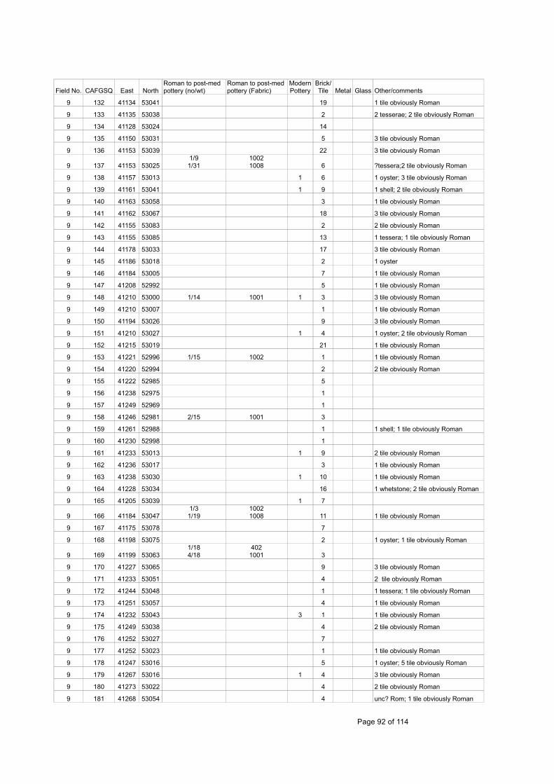
Field No. CAFGSQ East NorthRoman to post-med pottery (no/wt)
Roman to post-medpottery (Fabric)
ModernPottery
Brick/Tile Metal Glass Other/comments
9 132 41134 53041 19 1 tile obviously Roman
9 133 41135 53038 2 2 tesserae; 2 tile obviously Roman
9 134 41128 53024 14
9 135 41150 53031 5 3 tile obviously Roman
9 136 41153 53039 22 3 tile obviously Roman
9 137 41153 530251/91/31
10021008 6 ?tessera;2 tile obviously Roman
9 138 41157 53013 1 6 1 oyster; 3 tile obviously Roman
9 139 41161 53041 1 9 1 shell; 2 tile obviously Roman
9 140 41163 53058 3 1 tile obviously Roman
9 141 41162 53067 18 3 tile obviously Roman
9 142 41155 53083 2 2 tile obviously Roman
9 143 41155 53085 13 1 tessera; 1 tile obviously Roman
9 144 41178 53033 17 3 tile obviously Roman
9 145 41186 53018 2 1 oyster
9 146 41184 53005 7 1 tile obviously Roman
9 147 41208 52992 5 1 tile obviously Roman
9 148 41210 53000 1/14 1001 1 3 3 tile obviously Roman
9 149 41210 53007 1 1 tile obviously Roman
9 150 41194 53026 9 3 tile obviously Roman
9 151 41210 53027 1 4 1 oyster; 2 tile obviously Roman
9 152 41215 53019 21 1 tile obviously Roman
9 153 41221 52996 1/15 1002 1 1 tile obviously Roman
9 154 41220 52994 2 2 tile obviously Roman
9 155 41222 52985 5
9 156 41238 52975 1
9 157 41249 52969 1
9 158 41246 52981 2/15 1001 3
9 159 41261 52988 1 1 shell; 1 tile obviously Roman
9 160 41230 52998 1
9 161 41233 53013 1 9 2 tile obviously Roman
9 162 41236 53017 3 1 tile obviously Roman
9 163 41238 53030 1 10 1 tile obviously Roman
9 164 41228 53034 16 1 whetstone; 2 tile obviously Roman
9 165 41205 53039 1 7
9 166 41184 530471/31/19
10021008 11 1 tile obviously Roman
9 167 41175 53078 7
9 168 41198 53075 2 1 oyster; 1 tile obviously Roman
9 169 41199 530631/184/18
4021001 3
9 170 41227 53065 9 3 tile obviously Roman
9 171 41233 53051 4 2 tile obviously Roman
9 172 41244 53048 1 1 tessera; 1 tile obviously Roman
9 173 41251 53057 4 1 tile obviously Roman
9 174 41232 53043 3 1 1 tile obviously Roman
9 175 41249 53038 4 2 tile obviously Roman
9 176 41252 53027 7
9 177 41252 53023 1 1 tile obviously Roman
9 178 41247 53016 5 1 oyster; 5 tile obviously Roman
9 179 41267 53016 1 4 3 tile obviously Roman
9 180 41273 53022 4 2 tile obviously Roman
9 181 41268 53054 4 unc? Rom; 1 tile obviously Roman
Page 92 of 114

Field No. CAFGSQ East NorthRoman to post-med pottery (no/wt)
Roman to post-medpottery (Fabric)
ModernPottery
Brick/Tile Metal Glass Other/comments
9 182 41277 53046 3 1 tile obviously Roman
9 183 41302 53055 3 1 pipe
9 184 41301 53074 1 5
9 185 41303 53088 2 11
9 186 41302 53097 1
9 187 41283 53107 10
9 188 41288 53098
1/23/161/2
40210011006 2 6
9 189 41280 53089 6 1 pipe
9 190 41284 53078 2/7 1006 2
9 191 41274 530702/131/3
10011005
9 192 41272 53079 4 1 tile obviously Roman
9 193 41271 53100
2/152/282/391/4
1001100210061008 1 15 1 oyster; 3 tile obviously Roman
9 194 41264 53117 14 2 tile obviously Roman
9 195 41255 53090 7 1 oyster; 2 tile obviously Roman
9 196 41253 53088 4
9 197 41234 53084 4/32 1001
9 198 41237 53102 7
9 199 41228 53102 11 4 tile obviously Roman
9 200 41220 53110 7 3 tile obviously Roman
9 201 41220 53120
3/101/11/20
100110061008 22 1
1 buckle; 1 oyster; 4 tile obviously Roman
9 202 41207 531141/541/7
10011003 8 2 tile obviously Roman
9 203 41206 53105 29 8 tile obviously Roman
9 204 41200 53094 1/12 1001 1 3
9 205 41188 53106 23 1 oyster; 13 tile obviously Roman
9 206 41186 53116 18
9 207 41191 53125 181oyster; 1 slate; 3 tile obviously Roman
9 208 41171 53119 16
9 209 41170 53130 38 7 tile obviously Roman
9 210 41163 53123 22 17 tile obviously Roman
9 211 41165 53112 20 6 tile obviously Roman
9 212 41155 53106 7 1bronze cockerel; 5 tile obviously Roman
9 213 41144 53121 2 12 3 tile obviously Roman
9 214 41146 531311/31/4
10011002 18 1 tile obviously Roman
9 215 41148 53140 21 4 tile obviously Roman
9 216 41129 53132 10 2 tile obviously Roman
9 217 41124 53114 2/23 1008 33 tile obviously Roman including boxflue
9 218 41116 53127 9 4 tile obviously Roman
9 219 41109 53140 1 4
9 220 41119 53151 1/13 360 16 1 1 modern; 2 tile obviously Roman
9 221 41084 53164 5
9 222 41074 53154 4
9 223 41073 53143 4
9 224 41052 53171 8
9 225 41031 53156 1/15 416 2 4
9 226 41013 53151 1/5 1001
9 227 41019 53167 1
Page 93 of 114

Field No. CAFGSQ East NorthRoman to post-med pottery (no/wt)
Roman to post-medpottery (Fabric)
ModernPottery
Brick/Tile Metal Glass Other/comments
9 228 41018 53178 1/1 1006 2 4 pipe
9 229 40991 53184 1 9
9 230 40973 53168 3
9 231 40962 53192 1 19
9 232 40937 53179 2 6
9 233 40935 53201 10
9 234 40964 53207 2
9 235 40993 53209 4
9 236 41005 53196 2
9 237 41013 53214 1/38 425 1
9 238 41013 53204 4
9 239 41082 53207 1/9 402 2 2
9 240 41093 53193 1 1 clock key
9 241 41082 53177 3
9 242 41131 53172 1/8 1002
9 243 41135 53163 7 1 tile obviously Roman
9 244 41152 53189 3
9 245 41161 53171 1 4
9 246 41161 53162 5 1 tile obviously Roman
9 247 41161 53155 12
9 248 41187 53155 4
9 249 41190 53145 4
9 250 41195 53161 6
9 251 41213 53169 5 1 tile obviously Roman
9 252 41211 53140 5 gun flint
9 253 41225 53134
1/31/201/2
40210041006 4 2 tile obviously Roman
9 254 41234 53141 3 oyster
9 255 41244 53115
3/72/241/5
100110061008 15 burnt flint
9 256 41262 53139 1 3
9 257 41291 53128 2 1 tessera; 1 tile obviously Roman
9 258 41299 53138 5 1 tile obviously Roman
9 261 41332 53154 1 1
9 262 41316 53148 2
9 263 41301 53150 3 2 tile obviously Roman
9 264 41332 53163 2
9 265 41333 53173 1
9 266 41309 53171 1/3 402 daub
9 267 41311 53181 2
9 268 41316 53190 2
9 269 41305 53207 1
9 270 41272 53203 1 2 1 oyster
9 271 41268 53194 3
9 272 41272 53182 2
9 273 41286 53177 2 1
9 274 41264 53174 1 2
9 275 41251 53186 3
9 276 41234 53169 1/28 1006 1
9 277 41199 53175 6 1 tile obviously Roman
9 278 41196 53192 5 2 tile obviously Roman
Page 94 of 114

Field No. CAFGSQ East NorthRoman to post-med pottery (no/wt)
Roman to post-medpottery (Fabric)
ModernPottery
Brick/Tile Metal Glass Other/comments
9 279 41186 53202 5
9 280 41175 53219 1
9 281 41166 53215 3
9 282 41151 53191 3
9 283 41152 53218 1
9 284 41138 53234 2 1 clay pipe bowl
9 285 41112 53244 1 3
9 286 41114 53252 1
9 287 41096 53237 6
9 288 41072 53240 6
9 289 41059 53256 6
9 290 41040 53244 1 1 clay pipe
9 291 41020 53257 3
9 292 40981 53269 6
9 293 41009 53287
9 294 41011 53287 2 1 clay pipe
9 295 41008 53315 1/8 1001 2
9 296 41006 53337 2 1
9 297 41033 53355 1
9 298 41029 53367 1 1
9 299 41051 53392 3
9 300 41100 53420 3
9 301 41097 53394 8
9 302 41063 53376 1 1
9 303 41039 53403 2
9 304 41045 53440 2 1
9 305 41135 53426 1 1 clay pipe bowl
9 306 41144 53411 1 6
9 307 41125 53385 3
9 308 41092 53375 20
9 309 41094 53364 14
9 310 41121 53367 10
9 311 41121 53356 9 1 tile obviously Roman
9 312 41130 53340 4
9 313 41081 53357 2
9 314 41073 53343 2 4
9 315 41088 53333 1 6
9 316 41064 53314 2
9 317 41058 53328 2
9 318 41054 53311 4
9 319 41078 53306 8
9 320 41076 53305 2 16
9 321 41053 53299 17
9 322 41046 53283 1 1
9 323 41059 53266 12
9 324 41082 53269 5
9 325 41077 53287 1/14 425 14
9 326 41067 53283 6
9 327 41117 53267 1 2
9 328 41122 53275 1
Page 95 of 114

Field No. CAFGSQ East NorthRoman to post-med pottery (no/wt)
Roman to post-medpottery (Fabric)
ModernPottery
Brick/Tile Metal Glass Other/comments
9 329 41122 53287 2
9 330 41155 53267 1 2
9 331 41159 53238 1 1 oyster
9 332 41177 53242 3
9 333 41116 53314 1/8 328 1 1 1 disc
9 334 41118 53318 3
9 335 41145 53358 4
9 336 41170 53370 2
9 337 41192 53348 3 1
9 338 41230 53362 2
9 339 41245 53329 1 5
9 340 41263 53336 5
9 341 41275 53353 3
9 342 41256 53322 5
9 343 41224 53305
9 344 41220 53241 4
9 345 41210 53222 3
9 346 41219 53196 3
9 347 41222 53203 3
9 348 41231 53209 1 3
9 349 41239 53200 1
9 350 41252 53206 1
9 351 41214 53243 1 6 1 clay pipe
9 352 41263 53232 2
9 353 41287 53261 1 1
9 354 41315 53338 1/3 1006
9 355 41326 53325 2 1
9 356 41344 53304 1 1
9 357 41322 53287 1 1
9 358 41398 53285 1/2 1006 3
9 359 41395 53300
9 361 41293 53203 1/109 1000 1 2
9 362 41302 53207 1 1 tile obviously Roman
9 363 41332 53199 2 3 1 clay pipe, oyster
9 364 41359 53194 5 1 clay pipe
9 365 41373 53185 1
9 366 41376 53176 1
9 367 41372 53164 2
9 368 41394 53186 4
9 369 41377 53204 1 1
9 370 41356 53233
9 371 41344 53248 3
9 372 41410 53312 1 1
9 373 41453 53313 3
9 374 41485 53294 1 1 tile obviously Roman
9 375 41463 53284 1
9 376 41454 53275 2 1 iron link
9 377 41418 53257 1
9 378 41400 53233 1
9 381 41084 53453 1 402
Page 96 of 114

Field No. CAFGSQ East NorthRoman to post-med pottery (no/wt)
Roman to post-medpottery (Fabric)
ModernPottery
Brick/Tile Metal Glass Other/comments
9 382 41104 53473 1 1
9 383 41102 53485 1 1
9 384 41064 53496 4
9 385 41074 53521 3
9 386 41147 53537 1
9 387 41148 53508 1 1
9 388 41139 53475
9 389 41171 53453 3
9 390 41178 53505 1
9 391 41181 53522 2
9 392 41194 53585 1 1 tile obviously Roman
9 393 41230 53585 1/2 1001 3
9 394 41239 53567 3
9 395 41265 53548 2
9 396 41275 53565 1
9 397 41287 53582 3
9 398 41300 53568 2 1
9 399 41332 53569 1
9 400 41344 53574 1/28 402 1
9 401 41340 53561 1 2
9 402 41313 53537 1 1
9 403 41325 53521 1
9 404 41282 53514 2
9 405 41236 53506 1 1
9 406 41219 53491 1 1
9 407 41202 53475 1/5 1001
9 408 41201 53440 1
9 409 41215 53448 1 1 slate
9 410 41232 53421 2
9 411 41237 53429 2
9 412 41282 53428 3
9 413 41315 53482 1
9 414 41333 53462 1
9 415 41346 53434 2 2 1 oyster
9 416 41363 53404 1 1
9 417 41369 53380 1 1 oyster
9 418 41359 53372 1 ? button
9 419 41444 53393 1
9 420 41452 53378 2
9 421 41474 53392
9 422 41475 53350 1
9 423 41513 53350 1 1
9 424 41517 53356 1
9 425 41515 53338 2
9 426 41509 53334 1
9 427 41500 53327 2 1 clay pipe stem
9 428 41534 53340 1/5 402 1
9 429 41546 53325 3 1 clay pipe bowl
9 430 41551 53346 1/1 402 1 2
9 431 41551 53370 2
Page 97 of 114

Field No. CAFGSQ East NorthRoman to post-med pottery (no/wt)
Roman to post-medpottery (Fabric)
ModernPottery
Brick/Tile Metal Glass Other/comments
9 432 41573 53372 1
Table 65: Catalogue of artefacts and ecofacts from field walking HAS 06 (Fields 8 and 9)
Field No CAFG SQ East NorthRoman to post-med pottery (no/wt)
Roman to post-medpottery (Fabric)
Pmed- modernpottery Tile Other Comments
14 226 40240 53590 - - 1 - - -
14 227 40220 53540 - - 2 - - -
14 228 40170 53530 - - - - - -
14 229 40180 53470 1/8 402 1 - - -
14 230 40150 53440 1/2 330 - - - -
14 231 40150 53440 1/2 402 - - - -
14 232 40150 53420 1/4 360 - - - -
14 233 40250 53630 - - 1 - - -
14 234 40250 53370 - - 2 - - -
14 235 40290 53580 - - 1 - - -
14 236 40320 53590 - - 1 - - -
14 237 40350 53570 - - - - - -
14 238 40380 53550 - - - 1
14 239 40310 53480 - - 3 - - -
14 240 40280 53520 - - - - -
14 241 40250 53530 1/4 402 1 - - -
14 242 40280 53430 - - 3 - - -
14 243 40250 53450 - - 1 - - -
14 244 40200 53440 1/25 301 - - - -
15 245 40340 533801/61/2
4021000 - - 1 metal -
15 246 40330 53340 - - - 1 -
15 247 40300 53350 1/29 1001 - - - -
15 248 40290 53280 - - - - - -
15 249 40270 53290 - - 1 - - -
15 250 40270 53320 - - 1 1 - -
15 251 40250 53330 - - - 6 - -
15 252 40250 53320 - - - 6 - -
15 253 40280 53340 - - - 1 - -
15 254 40290 53380 1/2 405 1 - - Frec
15 255 40280 53380 - - 1 - - -
15 256 40250 53410 - - - 1 - -
15 257 40240 53410 1/3 351 - - - -
15 258 40260 53380 1/7 360 - - - -
15 259 40240 53380 1/86 402 - - - -
15 260 40230 533801/3
1/68360402 - - - -
15 261 40250 53350 - - 1 - - -
15 262 40230 53310 - - 1 - - -
15 263 40250 53390 - - 2 - - -
15 264 40210 53380 - - 1 - - -
15 265 40200 533001/71/1
3031001 - - - -
15 266 40190 53290 - - 2 - - -
15 267 40190 53290 - - - - 1 drain -
15 268 40180 53270 1/28 425 - - - -
15 269 40220 533301/21/3
360402 1 - - -
15 270 40200 53330 1/6 330 - - - -
Page 98 of 114

Field No CAFG SQ East NorthRoman to post-med pottery (no/wt)
Roman to post-medpottery (Fabric)
Pmed- modernpottery Tile Other Comments
15 271 40220 53390 1/2 302 - - - -
15 272 40220 53410 1/26 327 - - - -
15 273 40220 53390 1/53 425 1 - - -
15 274 40210 53400 1/7 302 - - - -
15 275 40210 533804/251/6
302402 - - - -
15 276 40190 53410 3/88 402 1 - - -
15 277 40190 53410 1/8 365 - - - -
15 278 40180 53410 5/35 402 - - - -
15 279 40190 53380
15/732/204/251/106/471/26
302330360401402425 2 - - -
15 280 40190 53390
4/166/216/65
15/219
302360365402 - - - -
15 281 40180 53390
1/2015/95
38/5531/49
302360402425 2 1 1 metal
Fabric 402 ispossible kiln
waste
15 282 40170 53390
1/51/2
1/148/89
302360365402 - - - -
15 283 40170 53390
3/185/74
16/289
360365402 - - - -
15 284 40190 53370
2/31/22/9
360365402 - - - -
15 285 40190 53380
1/54/351/5
327360402 3 - - -
15 286 40180 533702/145/91
360402 1 - - -
15 287 40170 53380 5/45 402 - - - -
15 288 40170 53380
5/193/40
17/108
360365401 2 2 - -
15 289 40180 533601/392/6
302402 - - - -
15 290 40190 533601/72/11
302402 4 - - -
15 291 40170 53360
5/431/175/223/14
302330360402 - - - -
15 292 40080 53050 - - - 2 - -
15 293 40080 53080 - - 1 - - -
15 294 40080 53120 - - 3 - - -
15 295 40110 53150 - - 2 2 - -
15 296 40090 531601/51/4
402405 3 2 - Fabric 405 is frec
15 297 40120 53130 - - 3 - - -
15 298 40140 53150 - - 3 - - -
15 299 40160 53180 - - - - - -
15 300 40160 53190 1/4 360 - - - -
15 301 40140 53170 - - 4 - - -
15 302 40120 53190 - - 1 - - -
15 303 40140 53220 - - 1 - - -
15 304 40150 53220 - - - 1 - -
15 305 40160 53220 - - 2 - - -
15 306 40140 53230 1/21 402 - - - -
15 307 40100 53230 1/1 1000 7 - - -
Page 99 of 114

Field No CAFG SQ East NorthRoman to post-med pottery (no/wt)
Roman to post-medpottery (Fabric)
Pmed- modernpottery Tile Other Comments
15 308 40110 53250 - - 6 - -
15 309 40130 53250 - - 1 2 - -
15 310 40160 53250 - - 1 - - -
15 311 40170 53260 - - 1 1 - -
15 312 40170 53280 - - 1 1 - -
15 313 40160 53270 - - 8 - - -
15 314 40140 53270 1/3 402 2 6 1 glass -
15 316 40130 53280 2/34 360 2 - - -
15 317 40150 53280 - - 1 - - -
15 318 40130 53270 3/11 360 7 - - -
15 319 40110 53270 - - 3 - - -
15 320 40120 53300 - - 6 2 1 glass -
15 321 40170 53310 - - 7 - - -
15 322 40180 53320 - - 11 - - -
15 323 40170 533301/12/3
360402 - - -
15 324 40120 53320 - - 17 - 1 metal
15 325 40140 53320 1/19 425 2 7 1 marble -
15 326 40160 533301/5
2/43360402 1 - - -
15 327 40170 53350 2/13 330 1 - - -
15 328 40160 533701/7
5/31365402 - - - -
15 329 40160 534001/1
6/90330402 - - - -
15 330 40140 53360 1/14 402 - - - -
15 331 40120 53350 - - 8 1
15 332 40120 53380 - - - - 1 glass; 1 cpipe -
15 333 40140 533801/3
3/83302402 2 - - -
15 334 40130 53340 - - 1 - - -
15 335 40040 53080 - - 1 - - -
15 336 40080 53070 - - 1 - - -
15 337 40060 53120 1/22 402 1 - - -
15 338 40030 53120 - - 3 1 - -
15 339 40020 531101/151/49
4021008 - 1 - -
15 340 40010 53150 - - 2 - - -
15 341 40010 53190 1/31 425 3 - - -
15 342 40030 53210 1/31 425 1 - - -
15 343 40040 53190 1/4 402 - - - -
15 344 40060 53170 1/5 402 - - - -
15 345 40080 53190 - - 1 - - -
15 346 40090 53200 1/3 416 6 - - -
15 347 40060 53230 2/61 425 - - 1 shell -
15 348 40040 53220 1/17 402 1 - - -
15 349 40020 53220 - - 2 - - -
15 350 40030 53250
1/21/151/41
302402425 - - - -
15 351 40050 53270 1/2 402 2 - - -
15 352 40080 53260 1/6 402 - - - -
15 353 40050 53290 - - 1 - 1 bone -
15 354 40050 53310 1/26 402 1 - - -
15 355 40030 53310 - - 1 - - -
15 356 40020 533101/181/191
402425 3 - - -
Page 100 of 114

Field No CAFG SQ East NorthRoman to post-med pottery (no/wt)
Roman to post-medpottery (Fabric)
Pmed- modernpottery Tile Other Comments
15 357 40020 533201/111/12
365402 - - - -
15 358 40110 53260 - - 4 - - -
15 359 40110 53310 - - 7 - - -
15 360 40090 53310 - - 2 - - -
15 361 40120 53340 - - 1 - 1 glass; 1 cpipe -
15 362 40120 53360 - - 1 - 2 glass -
15 363 40120 533901/214/22
365402 5 - - -
15 364 40090 53350
1/491/181/23
301365402 - - -
Twisted handlefabric 301
15 365 40100 533803/232/7
365402 1 - - -
15 366 40100 533707/814/18
302402 3 - - -
15 367 40110 53380
5/741/2
2/335/36
302351360402 1 - - CSW fabric 351
Table 66: Catalogue of artefacts and ecofacts from field walking at Brook Farm (Fields 14/15)
Field CAFGSQ East North Roman to post-medievalPottery No/wt
Roman to post-medpottery Fabric (F)
Modern pottery B/T Metal Glass Other
12 0 Entrance 1/81/28
961000
- - - - -
12 1 40735 53919 - - 1 1 1 nail - -
12 2 40683 53916 - - 1 1
12 3 40680 53907 - - 2 1 1 nail 1 pipe
12 4 40656 53903 1/4 360 2 1 1 pipe
12 5 40639 53914 2/11 402 1
12 6 40615 53872 - - 1 3
12 7 40626 538491/11/21/2
3604251000
1 2 1 charcoal
12 8 40677 53870
1/81/11/21/24
352360402425
3 1 button 1 oyster
12 9 40688 53859 1/10 360
12 10 40697 53845 1/71/1
360401
1 nail 1 shell
12 11 40699 53887 1/9 402 1 1 nail
12 12 40715 53901 - - 1 1 drain
12 13 40733 53879 - - 3 1 pipe, 1 oyster
12 14 40766 53866 1/5 1006 2 1 pipe, 1 flint
12 15 40781 53878 1/31/1
10011006
4 1Elizabethan clay pipe bowl
12 16 40773 53897 1/31/1
360402
2
12 17 40766 53914 1/2 360 1 6
12 18 40790 538411/32/191/1
3604021001
1
12 19 40805 53851 1/81/1
4021001
1 cinder
12 20 40920 53841 1/2 360 1 1 1 shell
12 21 41022 53837 - - 4 1 1 pipe
12 22 41091 53837 1/12 360
12 23 41213 53834 4/8 402 3
Page 101 of 114

Field CAFGSQ East North Roman to post-medievalPottery No/wt
Roman to post-medpottery Fabric (F)
Modern pottery B/T Metal Glass Other
12 24 41322 53874 - - 2 1 lead
12 25 41314 53859 4 402 2
12 26 41351 53877 - -
12 27 41311 539001/31/11/10
40210011006
1 1
12 28 41270 53879 - - 1 2 1 stone, 1 cinder
12 29 41256 53869 - - 1 1 1
12 30 41236 53912 2/10 360 1 3 2 stone, 1 pipe
12 31 41274 53932 - - 3 1 2 pipe
12 32 41271 53969 1/1 1001 1
12 33 41279 53983 - - 2 1
12 34 41267 53993 1/3 402 1 3
12 35 41241 53972 1/2 360
12 36 41216 53965 - - 1 1
12 37 41168 53992 1/8 402 2 5 1
12 38 41167 53971 - - 1 1 pipe
12 39 41200 53862 3/181/3
4021001
1 1 1 pipe
12 40 41161 53867 - - 1 3 1h'shoe
12 41 41119 53900 1/1 402 3
12 42 41083 53867 2/81/1
360402
3 2 1 pipe
12 43 41089 53907 - - 1 4 1 1 clay pig.?
12 44 41097 53952 - - 1 1 nail 1 pipe
12 45 41088 53977 - - 1 1 pipe
12 46 41074 53968 1/2 1006 1 1 pipe
12 47 41047 53996 1/3 1001 1 1
12 48 41025 53976 1/1 1006 1 1
12 49 41038 53922 2/2 402 3
12 50 41027 53894 1/3 1000 1 1 1 pipe
12 51 40984 53871 - - 5 1 stone
12 52 40960 53861 - - 2 3 pipe
12 53 40970 53878 3/14 402 2 1 2 shell
12 54 40950 539072/51/111/10
4024251000
2 4 1 1 pipe
12 55 40977 53916 - - 1 1 pipe, 1 button
12 56 40976 53942 1/4 402 6 1
12 57 40955 53982 1/4 402 1
12 58 40928 53970 1/6 402 5 1 pipe
12 59 40901 53870 1/41/2
301402
5 4 1 bone
12 60 40834 53875 1/3 1001 2 2 1 slate
12 61 40840 53901 1/21/4
3601001
12 62 40823 53917 - - 8
12 63 40829 53947 - - 2 1 pipe
12 64 40871 53981 - - 3
12 65 40790 53957 - - 1 1 pipe
12 66 40755 539951/41/7/2/13
3604251000
2 2
12 67 40719 53976 1/31/10
402425
1
Page 102 of 114

Field CAFGSQ East North Roman to post-medievalPottery No/wt
Roman to post-medpottery Fabric (F)
Modern pottery B/T Metal Glass Other
12 68 40685 53991 1/61/20
4021006
5 2 1 nail 1 slate
12 69 40663 53973 1/31/8
3601000
12 70 40625 53990 - - 1 1 1 shell
12 71 40605 53975 2/51/2
4021001
1 1 1
12 72 40600 53954 1/28 402 1 1 slag
12 73 40597 53910 1/1 360 1
12 74 40604 53897 1/5 402 2 1 clay pig.?
12 75 40589 53878 2/21/5
10001001
2 1 pipe, 1 slate
12 76 40572 53857 - - 2 1 1 slag
12 77 40578 53889 1/1 401 2 2 drain
12 78 40564 53903 - - 1 pipe
12 79 40533 53871 - - 1 2 1 pipe
12 80 40541 53860 - - 1
12 81 40553 53842 1/1 1000 1 1
12 82 40629 53959 - - 2 1 1 pipe
12 83 40504 53989 1/91/1
3301000
2 2 1 shell
12 84 40496 53927 - - 3 1 pipe
12 85 41349 54049 1/11/7
10011006
1 1
12 86 41296 54073 - - 1 1 oyster
12 87 41285 54037 - - 2
12 88 41331 54025 1/51/3
4021001
12 89 41264 54060 - - 2 3
12 90 41240 54007 1/4 402 1 1
12 91 41204 54055 1/21/2
3601001
2 2
12 92 41206 54028 1/11 1001 3
12 93 41151 54008 1/141/2
4021001
2
12 94 41156 54059 1/8 1001 4
12 95 41096 540582/131/31/19
402405425
4 Pottery fabric 405 idLang / Sieg
12 96 41092 54027 2/7 1001 3 1 1 pipe
12 97 41080 54019 1/3 402 1 Rom
12 98 41027 54075 1/2 1000 4 1 slate
12 99 41030 54040 - - 1
12 100 41008 54052 - - 2 1
12 101 41009 54009 1/51/5
4021006
1 2 1 pipe
12 102 40970 54061 1/4 1001
12 103 40969 54061 1/27 416 1keep 1 1 SS (pottery)
12 104 40950 54069 1/11 365 2 1
12 105 40928 54049 - - 1
12 106 40932 540052/4 360
1 2Pottery could be 901
12 107 40914 54064 1/11 402 2
12 108 40886 54071 - - 1 2 1 oyster
12 109 40887 54030 1/13 1006 2 1
12 110 40859 54038 - - 2
Page 103 of 114

Field CAFGSQ East North Roman to post-medievalPottery No/wt
Roman to post-medpottery Fabric (F)
Modern pottery B/T Metal Glass Other
12 111 40842 54030 - - 1 2
12 112 40840 54008 1/2 360 2
12 113 40836 54055 - - 1
12 114 40814 54053 1/4 1001 1
12 115 40808 54062 - - 1 1 1 oyster
12 116 40788 54050 - - 1
12 117 40785 54034 - - 2 1 1 oyster
12 118 40776 540041/5 360
3 1 lead 1 pipe; pottery couldbe 811?
12 119 40754 54013 1/3 1001 1 2 1 slag, 1 oyster
12 120 40758 54023 1/3 1001 1 3 1 pipe
12 121 40753 54063 - - 3 2 1 oyster
12 122 40738 54035 - - 2 1 oyster
12 123 40720 54051 - - 1
12 124 40704 54024 2/12 360 5
12 125 40700 54004 - - 2 1
12 126 40682 54066 - - 4 3
12 127 40665 54035 - - 2 1 pipe
12 128 40652 54024 - - 4 4
12 129 40649 54006 1/21/1
3601001
1 1
12 130 40653 54059 - - 2 1
12 131 40619 54036 - - 1 1
12 132 40617 54015 - - 1 3 slag?
12 133 40600 54003 1/4 360
12 134 40592 54024 - - 4 3
12 135 40609 54054 - - 1 oyster
12 136 40595 54072 - - 1
12 137 40569 54065 - - 6 7 1
12 138 40577 54051 - - 3
12 139 40576 54033 1/9 401 1
12 140 40521 54059 1 2
12 141 40542 54003 - - 2 1 pipe, 1 whetstone
11 142 40952 53785 - - 1
11 143 40958 53793 - - 3 2 1 1 pipe
11 144 40944 53809 - - 4 1 2 pipe
11 145 40946 53825 - - 2 1
11 146 40909 53824 - - 2 1
11 147 40881 53806 - - 1 3
11 148 40859 53826 - - 1 1 button
11 149 40799 53828 1/5 402 2 1
11 150 40811 53812 - - 3 1
11 151 40800 53803 1/3 402 2
11 152 40787 53798 - - 2
11 153 40739 53808 - - 3
11 154 40710 53792 1/5 360 1 1
11 155 40711 53822 1/7 365 1 1
11 156 40705 53827 - - 3 3
11 157 40681 53801 - - 1 3
11 158 40673 53825 - - 3
11 159 40654 53819 - - 1 2
Page 104 of 114
Field CAFGSQ East North Roman to post-medievalPottery No/wt
Roman to post-medpottery Fabric (F)
Modern pottery B/T Metal Glass Other
11 160 40654 53792 - - 1 1
11 161 40620 53829 1/4 1001 2 1 marble
11 162 40606 53810 - - 2 1 1 pipe
11 163 40597 53805 - - 1 2 1 pipe
11 164 40587 53837 - - 2 1
11 165 40568 53822 - - 2 1 1 pipe
11 166 40558 53813 1/1 402 1 1 1 pipe
11 167 40534 53804 - - 1 1 pipe
11 168 40530 53835 - - 3 1 oyster
11 169 40511 53762 - - 1
11 170 40513 53772 1/1 1001 1 2
11 171 40512 53780 - - 2 4 1 pipe
11 172 40589 53759 1/8 1001 2
11 173 40555 53763 1/4 402 3 4
11 174 40563 53775 - - 2 2
11 175 40613 53766 1/6 301 1 2
11 176 40616 53778 - - 1
11 177 40645 53790 - - 3 1
11 178 40666 53761 1/2 416 1 keep 2
11 179 40696 53761 1/2 402 2 2 1 oyster
11 180 40746 53758 - - 1 2
11 181 40782 53770 1/11 360 1 1 pipe
11 182 40805 53765 1/1 1006 2 3 1 nail 2 oyster
11 183 40843 53777 1/5 1001 1 3
11 184 40875 53781 1/6 402 3 1 pipe
11 185 40904 53766 2/8 360 2 1 1 pipe
11 186 40965 53756 2/4 402 1
11 187 40974 53760 1/3 402 1
11 188 40973 537611/8 425
7 1 1 1 oyster; pottery could be 881?
11 189 40939 53738 1/3 402
11 190 40942 53727 - - 3 5
11 191 40900 537201/21/2
4251001 1
11 192 40858 53722 3/11 360 1 bone
11 193 40878 53736 1/41/6
4021007
2
11 194 40860 53746 1/3 360 2
11 195 40821 53731 - - 1 1 pipe
11 196 40800 537301/132/31/2
3313601001
1
11 197 40782 53741 1/1 402 4
11 198 40771 53718 1/1 360 1 1 pipe
11 199 40747 53727 1/3 1006 5 1 1 oyster
11 200 40743 53739 - - 1 1 pipe
11 201 40700 53732 1/1 1001 2 2 1 pipe
11 202 40710 53744 1/1 1001 3 1 pipe
11 203 40687 53746 - - 1 3 1 pipe
11 204 40662 53735 - - 3 5
11 205 40589 53736 - - 3 2
11 206 40559 53745 - - 2 2 pipe
11 207 40532 53737 1/5 1001 3 4 1 oys,1 pipe,1 slate
Page 105 of 114
Field CAFGSQ East North Roman to post-medievalPottery No/wt
Roman to post-medpottery Fabric (F)
Modern pottery B/T Metal Glass Other
11 208 40498 53744 1/19 405 6 keep1 2 1 nail 11 pipe; pottery is frec
11 209 40451 53739 1/10 330 4
11 210 40470 53751 - - 2
11 211 40490 53712 1/1 360 3 1
11 212 40485 53725 1/5 1001 3 1 1 oyster
11 213 40549 53711 1/59 402 5 2 pipe
11 214 40556 53725 1/8 1001 2 1
11 215 40586 53706 1/2 360 3 2
11 216 40612 53719 - - 3 1
11 217 40667 53717 - - 1 1
11 218 40689 53704 - - 3 1 pipe
11 219 40701 53696 1/3 402 2
11 220 40729 53704 - -- 2 1 bone
11 221 40746 53690 - - 3 3 2 pipe
11 222 40782 53692 1/6 1001 3
11 223 40824 53698 1/7 402 3 2 1 pipe
11 224 40862 53680 - - 3 1
11 225 40866 53703 - - 4
11 226 40886 53692 - - 2 2
11 227 40923 53706 1/11 402 2 2
11 228 40936 53690 - - 4 2
11 229 40993 53696 1/61/2
4251000
4 keep2
11 230 40814 53682 1/54 425 3 keep1 1
11 231 40739 53682 1/2 1001 1 2 1 oyster
11 232 40679 53683 - - 1 3
11 233 40625 53683 1/27 425 3 keep1 2
11 234 40575 53687 1/4 360 2 4
11 235 40527 53690 1/41/1
4021001
2
11 236 40472 53834 1/2 1001
11 237 40984 53605 - - 1
11 238 40982 53610 - - 3 1 shell
11 239 40966 53666 - -
11 240 40973 53698 1/16 402 1 bunghole on pottery
11 241 40942 53676 1/4 1001 1
11 242 40925 53658 1/4 402 1 1
11 243 40895 53669 - - 1
11 244 40888 53678 - - 1 pipe stem
11 245 40860 53662 - - 1
11 246 40846 53651 - -
11 247 40848 53634 - - 2
11 248 40816 53629 - - 2
11 249 40801 53656 - - 1
11 250 40803 53675 - - 1 1 1 pumice?
11 251 40809 53713 1/2 411 6 1 stone
11 252 40808 53716 1/2 411
11 253 40792 53704 1/21 425 2 1 shell
11 254 40758 53692 1/251/3
365402
11 255 40757 53687 - -
Page 106 of 114

Field CAFGSQ East North Roman to post-medievalPottery No/wt
Roman to post-medpottery Fabric (F)
Modern pottery B/T Metal Glass Other
11 256 40756 53687 - - 3
11 257 40740 53658 1/24 360 1 1 1 shell
11 258 40744 53648 1/10 360
11 259 40730 53611 - - 1 2 1 stone, 1 pipe
11 260 40732 53691 - - 1 1
11 261 40721 53712 1/4 425 1 1
11 262 40718 53684 - - 1
11 263 40698 53648 - - 2
11 264 40661 53659 - - 1
11 265 40645 53650 - - 1 slag
11 266 40670 53718 1/6 425
11 267 40621 53676 - - 2
11 268 40617 53687 - - 1
11 269 40580 53701 1/13 425 2
11 270 40553 53723 - - 2
11 271 40424 53566 - - 2 1 flint
11 272 40443 53624 - -
11 273 40463 53675 - - 1 stone
11 274 40466 53712 - - 1
11 275 40475 53696 - - 1
11 276 40502 53694 - - 1
11 277 40520 53714 - - 1
11 278 40539 53728 - - 2
11 279 40527 53689 - -
11 280 40534 53676 1/9 425
11 281 40504 53675 - - 1
11 282 40512 53666 - - 2
11 283 40506 53645 - -
11 284 40506 53631 - - 1 2
11 285 40484 53620 - - 1 3 2 stone
11 286 40484 53645 - - 1 1
11 287 40547 53685 - - 4
11 288 40556 53658 - - 1
11 289 40596 53645 - - 1 1 oyster
11 290 40596 53619 1/6 360
11 291 40596 53595 1/4 416 1
11 292 40624 53591 - - 2 2 2 oyster
11 293 40676 53605 1/31 402 3
11 294 40681 53591 - - 1
11 295 40672 53696 - -
11 296 40706 53581 1/4 402 1 1 pipe bowl
11 297 40739 53588 - - 1 1
11 298 40752 53585 - - 1 1 stone
11 299 40765 53601 - - 1
11 300 40783 53567 - - 1 1 stone
11 301 40783 53565 - - 1
11 302 40833 53591 1/2 360 4 1 oyster
11 303 40837 53572 - - 1
11 304 40846 53602 - - 3
11 305 40873 53584 1/3 328 1
Page 107 of 114

Field CAFGSQ East North Roman to post-medievalPottery No/wt
Roman to post-medpottery Fabric (F)
Modern pottery B/T Metal Glass Other
11 306 40911 53589 1/4 402
11 307 40930 53615 1/11 360 3 1
11 308 40914 53578 - - 1
11 309 40920 53559 - - 2
11 310 40959 53581 1/1 402 2 1 flint, 1 oyster
11 311 40920 53539 1/13 425
11 312 40924 53527 - - 1
11 313 40950 53530 - - 1 1 flint
11 314 40984 53524 - - 3
11 315 40897 53514 1/4 1006
11 316 40874 53473 - - 1 stone
11 317 40851 53480 - - 1
11 318 40850 53477 1/42 365
11 319 40836 53460 - - 2
11 320 40827 53500 1/16 405 pottery is frec
11 321 40795 53471 - - 1
11 322 40794 53479 - - 1
11 323 40791 53498 - - 2
11 324 40795 53514 - - 3
11 325 40775 53525 1/9 402 2
11 326 40746 53509 - - 1 2 pipe
11 327 40747 53495 1/1 402 2 1
11 328 40737 53555 - - 3
11 329 40728 53563 1/22 425 1
11 330 40712 53535 - - 2
11 331 40695 53542 - - 1 stone
11 332 40690 53557 1/17 411
11 333 40689 53506 1/69 425
11 334 40676 53473 - -
11 335 40677 53469 - -
11 336 40619 53467 1/2 402
11 337 40652 53540 - - 1 pipe
11 338 40615 53571 - - 2
11 339 40585 53558 - - 1 2
11 340 40575 53544 - -
11 341 40530 53576 1/32 425
11 342 40512 53534 - - 3
11 343 40476 53573 - - 3
11 344 40480 53589 1/1 402 2 3
13 401 40418 53853 1/2 425
13 402 40408 53867 - - 1
13 403 40376 53851 - - 3
13 404 40355 53847 - - 1 1 1 slate
13 405 40342 53831 - - 1 1
13 406 40351 53871 - - 1
13 407 40336 53895 - - 1 1
13 408 40328 53887 1/17 411 2 oyster
13 409 40319 53869 - - 1 1
13 410 40393 53910 - - 2
13 411 40398 53995 - - 2 1 1 1 button
Page 108 of 114

Field CAFGSQ East North Roman to post-medievalPottery No/wt
Roman to post-medpottery Fabric (F)
Modern pottery B/T Metal Glass Other
13 412 40394 53980 - - 1
13 413 40368 53956 - - 2
13 414 40368 53961 - - 1 2
13 415 40342 53959 - - 1 1
13 416 40346 54000 1/4 360
13 417 40266 53998 1/11 1000 1
13 418 40273 53963 - - 2 3
13 419 40261 53897 - - 1 1 pipe
13 420 40270 538821/2 411
1+ 1(Rom)
13 421 40279 53848 - - 1 1
13 422 40191 53899 - -
13 423 40182 53978 - - 1 1 bottle
13 424 40146 53961 - - 1 1
13 425 40128 53964 - -
13 426 40054 53964 - - 1
13 427 39969 54037 - -
13 428 39953 54027 - - 5 1 1 stone
13 429 39913 54056 - - 2
13 430 39836 54097 - -
13 431 39895 54117 - - 2 1 1 flint, 1 pipe
13 432 40132 54003 - - 1 1 1 button
13 433 40256 54001 - - 1 7
13 434 40227 54026 - - 3 2
13 435 40216 54020 1/2 1006
13 436 40214 54007 - - 1
13 437 40201 54003 - - 1 3
13 438 40160 54018 - - 1 2
13 439 40171 54056 - - 2
13 440 40150 54045 1/7 402 2
13 441 40138 54030 - - 1
13 442 40082 54061 1/11 360 2
13 443 40079 54057 - - 1
13 444 40088 54091 - - 1
13 445 40072 54081 - - 2
13 446 40046 54053 1/6 411 4 slipware pottery
13 447 40021 54074 - - 3 2
13 448 40030 54092 1/4 402 2
13 449 40021 54105 - - 1 1
13 450 39995 54097 1/1 1006 2 2
13 451 39957 54106 - - 5
13 452 39973 54123 - - 2
13 453 39969 54136 - - 1
13 454 39946 54162 - - 1 1 1
13 455 39924 54131 - - 1 1 1 marble
13 456 39901 54122 - - 1 1
13 457 39921 54191 - - 1
13 458 39941 54231 - - 1
13 459 39957 54262 - - 2 1
13 460 39964 54193 - -
13 461 39974 54199 1/2 402 1
Page 109 of 114
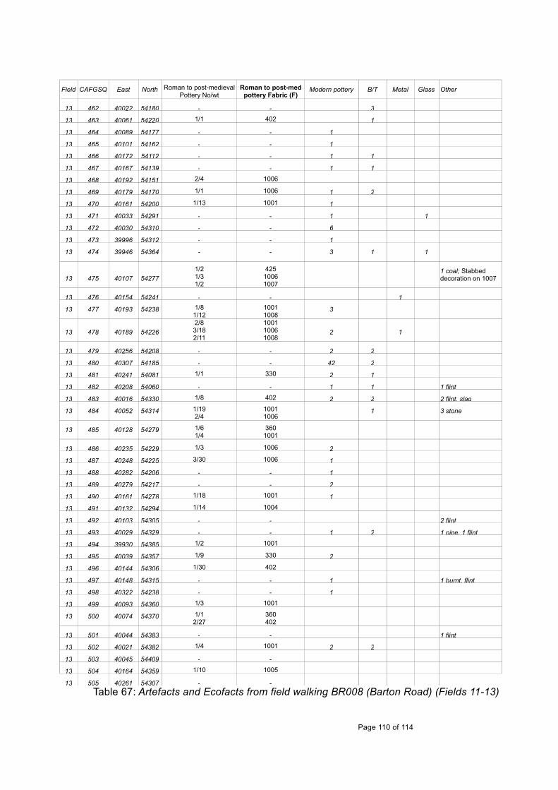
Field CAFGSQ East North Roman to post-medievalPottery No/wt
Roman to post-medpottery Fabric (F)
Modern pottery B/T Metal Glass Other
13 462 40022 54180 - - 3
13 463 40061 54220 1/1 402 1
13 464 40089 54177 - - 1
13 465 40101 54162 - - 1
13 466 40172 54112 - - 1 1
13 467 40167 54139 - - 1 1
13 468 40192 54151 2/4 1006
13 469 40179 54170 1/1 1006 1 2
13 470 40161 54200 1/13 1001 1
13 471 40033 54291 - - 1 1
13 472 40030 54310 - - 6
13 473 39996 54312 - - 1
13 474 39946 54364 - - 3 1 1
13 475 40107 542771/21/31/2
42510061007
1 coal; Stabbed decoration on 1007
13 476 40154 54241 - - 1
13 477 40193 54238 1/81/12
10011008
3
13 478 40189 542262/83/182/11
100110061008
2 1
13 479 40256 54208 - - 2 2
13 480 40307 54185 - - 42 2
13 481 40241 54081 1/1 330 2 1
13 482 40208 54060 - - 1 1 1 flint
13 483 40016 54330 1/8 402 2 2 2 flint, slag
13 484 40052 54314 1/192/4
10011006
1 3 stone
13 485 40128 54279 1/61/4
3601001
13 486 40235 54229 1/3 1006 2
13 487 40248 54225 3/30 1006 1
13 488 40282 54206 - - 1
13 489 40279 54217 - - 2
13 490 40161 54278 1/18 1001 1
13 491 40132 54294 1/14 1004
13 492 40103 54305 - - 2 flint
13 493 40029 54329 - - 1 2 1 pipe, 1 flint
13 494 39930 54385 1/2 1001
13 495 40039 54357 1/9 330 2
13 496 40144 54306 1/30 402
13 497 40148 54315 - - 1 1 burnt. flint
13 498 40322 54238 - - 1
13 499 40093 54360 1/3 1001
13 500 40074 54370 1/12/27
360402
13 501 40044 54383 - - 1 flint
13 502 40021 54382 1/4 1001 2 2
13 503 40045 54409 - -
13 504 40164 54359 1/10 1005
13 505 40261 54307 - -Table 67: Artefacts and Ecofacts from field walking BR008 (Barton Road) (Fields 11-13)
Page 110 of 114

APPENDIX F. BIBLIOGRAPHY
Albarella, U. and Davis, S.J.M., 1994 The Saxon and Medieval animal bones excavated from West Cotton, Northamptonshire London: English Heritage AML Report 17/94
Atkins, R., 2004 'A Middle to Late Saxon cemetery at Seaton Road, Harringworth',Northamptonshire Archaeol. 32, 95-106
Atkins, R., 2005 Medieval Remains at Well House Meadow, Haslingfield, Cambridgeshire: AnArchaeological Watching Brief, CCC AFU report 814 (unpublished)
Atkins, R., 2010a 'Roman, Anglo-Saxon and medieval settlement at Stow Longa and Tilbrook',Proc. Cambridge Antiq. Soc. XCIX, 75-88
Atkins, R., 2010b Land to the south-east of St Mary's Church, Brampton, Huntingdonshire: adesk based assessment OA East report 1161 (unpublished)
Atkins, R., 2011 Archaeological Excavation: Land at No. 30 New Road, Haslingfield,Cambridgeshire OA East report 1235 (unpublished)
Atkins, R., 2012 Between River, Priory and Town: excavations at the former CambridgeRegional College site, Brunswick, Cambridge Proc. Cambridge Antiq. Soc. C, 7-22
Atkins, R., 2013 Medieval to modern settlement at Coldhams Lane, Cambridge PXAassessment OA East report 1440 (unpublished)
Audouy, M. and Chapman, A., 2009 Raunds: The origin and growth of a midland village AD450-1500, Oxbow Books
Bailey, M., 2007 Medieval Suffolk An economic and social history, 1200-1500 Boydell press
Blinkhorn, P., 2007 Late medieval pottery kilns in A Hardy, BM Charles and RJ Williams Deathand Taxes. The archaeology of a Middle Saxon estate centre at Higham FerrersNorthamptonshire, 100-111 Oxford Archaeology Monograph
Blinkhorn, P., 2012 The Ipswich Ware Project: Ceramics, Trade and Society in Middle SaxonEngland Medieval Pottery Res Group Occ Pap 7
British Geological Survey (BGS), 2001 England and Wales Sheet No.204 Biggleswade solidand drift geology map
British Geological Survey (BGS), 2002 England and Wales Sheet No.205 Saffron Walden solidand drift geology map
Cambridge Archaeology Field Group (CAFG), 1985 CAFG report (unpublished report)
Cambridge Archaeology Field Group (CAFG), 1996 Brook Farm, Haslingfield (unpublishedreport)
Cambridge Archaeology Field Group (CAFG), forthcoming - Mr Ratford's House, Wimpole(unpublished report)
Chapman, A., 2010 West Cotton, Raunds A study of medieval settlement dynamics AD 450-1450 Excavation of a deserted medieval hamlet in Northamptonshire, 1985-9(Northamptonshire County Council: Oxbow Books Oxford and Oakville)
Coppack, G., 1980 'Medieval and Post-Medieval Pottery', in Christie, P. M. and Coad, J. G.,Excavations at Denny Abbey Archaeol J 137, 223-52
Cooper, A., 2004 Barrington Cement Quarry. Trial trenching Phase 2. Cambridge ArchaeologicalUnit report 610 (unpublished)
Page 111 of 114

Crummy, N., 2007 Brooches and the Cult of Mercury Britannia XXXVIII, 225-230
Danckwerts, P.V., 1980 The inheritors of Barnwell Priory Proc. Cambridge Antiq. Soc. LXX, 211-228
Davey, W. and Walker, H., 2009 The Harlow Pottery Industries Medieval Pottery ResearchGroup Occasional Paper 3
Davis, S.J.M., 1992. A rapid method for recording information about mammal bones fromarchaeological sites, London: English Heritage AML Report 19/92
Denham, V., 1985 'The Pottery', in Williams, J. H., Shaw, M. and Denham, V., Middle SaxonPalaces at Northampton Northampton Development Corporation Monog Ser 4, 46-64
Dickens, A., 1999 Barrington Quarry, Barrington, Cambridgeshire Archaeological desktop studyand field walking Cambridge Archaeological Unit report 276 (unpublished)
Dobney, K. and Reilly, K., 1988 A method for recording archaeological animal bones: the use ofdiagnostic zones Circaea 5(2), 79-96
Driesch, A von den. 1976. A guide to the measurement of animal bones from archaeologicalsites, Harvard: Peabody Museum of Archaeology and Ethnology Bulletin 1.
Dunning, G.C., 1977 'Mortars', in Clarke, H. and Carter, A., Excavations in King's Lynn 1963-1970 The Society for Medieval Archaeol. Mono. Ser. 7, 320-347
Evans, C., Knight, M. and Webley, L., 2007 Iron Age settlement and Romanisation on the Isle ofEly: the Hurst Lane Reservoir site Proc. Cambridge. Antiq. Soc. 96, 41-78
Flood, R. J., 1980 'The Cambridge Archaeology Field Group Third Annual Report', Proc.Cambridge Antiq. Soc. LXX, xiii-xiv
Gaimster, D., 1997 German Stoneware British Museum Publications
Getty, R., 1975 In Sisson and Grossman The Anatomy of Domestic Animals (London: W.BSaunders Company)
Grant, A., 1982 The use of tooth wear as a guide to the age of domestic ungulates. In B.Wilson, C. Grigson & S. Payne (eds.) Ageing and sexing animal bones from archaeologicalsites. Oxford: BAR British Series 199
Hardy, A., Mair Charles, B. and Williams, R., 2007, Death and Taxes; The archaeology of aMiddle Saxon estate centre at Higham Ferrers, Northamptonshire, Oxford Archaeology
Hart, C., 1974 The hidation of Cambridgeshire (Leicester University Press)
James, E.M., Rose, E.J., 2004 The Norfolk skintling survey: results 1995-2003 Information 93,7-10
Johnston, G., 1997 The excavation of two late medieval kilns with associated buildings atGlapthorn, near Oundle, Northamptonshire Medieval Ceramics 21, 13-42
Jones, R. and Page, M., 2006 Medieval villages in an English landscape: beginnings and ends(Windgather Press: Macclesfield)
Kenny, D. A., 1999 An archaeological evaluation at Barrington Cement Quarry, Barrington,Cambridgeshire Cambridge Archaeological Unit report 338 (unpublished)
Kilmurry, K., 1980 The Pottery Industry of Stamford, Lincs. C. AD850-1250 British Archaeol RepBritish Ser 84
Knight, J., 2009 Morphology of settlement. Diploma thesis (University of Cambridge)
Leah, M., 1994, The Late Saxon and Medieval Pottery Industry of Grimston, Norfolk:Excavations 1962-92. E. Anglia Archaeol 64
Page 112 of 114

Lethbridge, T. C., 1967 'Anglo-Saxon Remains', in Salzman, L. F. (ed.). The Victoria History ofthe Counties of England A history of Cambridgeshire and the Isle of Ely vol 1 (University ofLondon:Dawsons of Pall Mall). Reprinted from 1938 edition
Lewis, C., Mitchell-Fox and Dyer, C 2001 Village, Hamlet and Field. Changing medievalsettlements in central England (Windgather press: Macclesfield)
Mackay, D., 2003 Haslingfield manor, Cambridgeshire: an archaeological evaluation,Cambridge Archaeological Unit report 570 (unpublished)
Malim, T., 2000 'Prehistoric trackways', in Kirby, T. and Oosthuizen, S. (eds.). An atlas ofCambridgeshire and Huntingdonshire History (Anglia Polytechnic University: Lavenham Press)
Malim, T. and Hines, J., 1998 The Anglo-Saxon cemetery at Edix Hill (Barrington A),Cambridgeshire CBA Research report 112
Mayes, P., 1968 A seventeenth century kiln site at Potterspury, Northamptonshire Post-Medieval Archaeol 2, 55-82
McCarthy, M., 1979 'The Pottery' in Williams, J. H., St Peter’s St, Northampton. Excavations1973-76 Northampton Development Corporation Monog Ser 2, 151-242
McCarthy, M. R. and Brooks, C.M., 1988 Medieval Pottery in Britain AD900-1600 LeicesterUniversity Press
Mellor, M., 1994 Oxford Pottery: A Synthesis of middle and late Saxon, medieval and early post-medieval pottery in the Oxford Region Oxoniensia 59, 17-217
Mitchiner, M., 1988 Jetons, Medalets & Tokens: The medieval period and Nuremberg vol 1(Seaby)
Mortimer, R., 2000 'Village development and ceramic sequence: the Middle Saxon to LateSaxon village at Lordship Lane, Cottenham, Cambridgeshire', Proc. Cambridge Antiq. Soc.LXXXIX, 5-33
Newman, R., 2009 Cantelupe Farm, Haslingfield: An archaeological evaluation CAU report no.879 (unpublished)
Oosthuizen, S., 1993 Saxon Commons in Cambridgeshire Proc. Cambridge Antiq. Soc. LXXXII,93-100
Oosthuizen, S., 1996 Discovering the Haslingfield Landscape (Haslingfield Village Society:Camfield Press)
Oosthuizen, S., 2001 Anglo-Saxon minsters in South Cambridgeshire Proc. Cambridge Antiq.Soc. XC, 49-68
Oosthuizen, S., 2002 Medieval greens and moats in the central province: evidence from theBourn Valley, Cambridgeshire Landscape History, vol 24, 73-87
Oosthuizen, S., 2006 Landscape decoded: the origins and development of Cambridgeshire'smedieval fields (University of Hertfordshire press)
Royal Commission on Historic Monuments (RCHM), 1968, An Inventory on Historic Monumentsin the County of Cambridgeshire, Vol. 1. West Cambridgeshire, RCHM (London)
Reaney, P. H., 1943, The Place-names of Cambridgeshire and the Isle of Ely
Rees, H., Crummy, N., Ottaway, P. J. and Dunn, G., 2008 Artefacts and Society in Roman andmedieval Winchester (Winchester)
Roberts, J., 2000, Land to the Rear of 65 New Road, Haslingfield, Cambridgeshire: AnArchaeological Evaluation Cambridgeshire County Council Archaeological Field Unit ReportNo. A163 (unpublished)
Page 113 of 114
Sanderson, I., 2008 Cantelupe Road, Haslingfield Rheesearch report (unpublished)
Spoerry, P., 2008 Ely Wares E. Anglia Archaeol. 122 (CAMARCH: Bar Hill)
Stringer, H. and Coles, M., 2009 Haslingfield an ordinary village? A history of Haslingfield,Cambridgeshire (Blue Ocean: St Ives)
Taylor, A., 1997, Archaeology of Cambridgeshire, Vol. 1: South West Cambridgeshire
Taylor, A., 2000 'Anglo-Saxon cemeteries' in Kirby, T. and Oosthuizen, S. (eds.). An atlas ofCambridgeshire and Huntingdonshire history (Anglia Polytechnic University: Lavenham Press)
Taylor, C.C., 1983 Village and farmstead (London)
Taylor, C.C., 2002, ‘Nucleated settlement: a view from the frontier’, Landscape History, vol 24,53-71
Turner-Rugg, A., 1993 Medieval Pottery in Hertfordshire: a gazetteer of the principle collectionsHertfordshire Archaeol. 11, 30 – 53
Walton Rogers, P., 1997 Textile production at 16-22 Coppergate, The Archaeology of York 17/11(York)
Williamson, T., 1987 Early co-axial field systems on the East Anglian boulder clays Proc PrehistSoc 53, 419-431
Wilson, D.M. and Hurst, G., 1962 medieval Britain in 1961 Medieval Archaeol. 6-7, 306
Wright, A. P. M., 1973, ‘Haslingfield’ in Elrington, C. R (ed)., A Victoria History of the Countiesof England, A History of Cambridgeshire and the Isle of Ely, Vol V
Page 114 of 114

15723
08365
89438945 9634
9644
9645
9652
09654
16656
10004 11241
04346
0471904720
04722
04723
08702
08703
08705A
10432
10433
01005A
04368
0490904910
04933
08704A
10002
11240
05095
05096
CB15627
MCB15785
MCB16357
MCB17731
0434104342
04816
03323
04345
04507
04528
04724
10159MCB18433
04344
04376B
04347
MCB16179
04340
04376A04376A
MCB16178
MCB16356
04350
04351
04376
0437808704
08705
08961
04343
0434804349
04721
04363C05006A
11242
04363
04364
04365 04366
05006
MCB17718
0500804363A
04367
04369
04718b
0472704726
04728
04347A
CB15627
251000 251000
252000 252000
253000 253000
254000 254000
255000 2550005390
0053
9000
5400
0054
0000
5410
0054
1000
5420
0054
2000
5430
0054
3000
5440
0054
4000
Roman
Mesolithic
Neolithic
Bronze Age
Iron Age
Saxon
Medieval
Post Medieval
Undated
Fieldwalked area
Field number
Figure 1. Map of Haslingfield parish, showing fields walked and CHER numbers
3324
8962
17495
8940
9651
9643
8941
04725a
04316a
03943
16356
08940a
04718a04718
N
1:2000
0 100 m
'Reproduced from 1:10,000 colour raster by permission of Ordnance Survey® on behalf of the Controller of Her Majesty's Stationary Office. © Crown Copyright 2012. All rights reserved. Reference number 10001998.'
Bourn Brook
1
Riv
er R
hee/
Cam
Atkins 2011
1
2
3
4
10
5
6
8
9
11
12
14
15
13
7
0 50 km
HaslingfieldCambridge

N
10432
10433
1005A
04368
04909
04910
04348
04349
04367
04347A
15627
04347
0435104351
252000 252000
252500 252500
5400
0054
0000
5405
0054
0500
5410
0054
1000
Test pitMesolithicNeolithicBronze AgeIron AgeRomanSaxon/Saxo NormanMedievalPost MedievalFieldwalked areaField NumberArea of former green
16656
10004 11241
03943
10002
11240
05006
15627
17731
03943
10002
11240
05006
15627
17731
Figure 2: Village with casual fiinds reported and positions of 2012 test pits and date with amended CHER data
1:4000
0 200 m
1
3
10
2
1
3
10
2
1
TP1TP11
TP5
TP18
TP19
TP13
TP7
TP8
TP15
TP29TP21
TP4 TP3
TP1
TP2 TP17
TP28
TP26TP14
TP10
Atkins 2011
TP27TP25
TP9
TP23
TP1TP11
TP5
TP18
TP19
TP13
TP7
TP8
TP15
TP29TP21
TP4 TP3TP12TP12
TP1
TP2 TP17
TP28
TP26TP14
TP10
Atkins 2011
TP27TP25
TP9
TP23

04344
04376B
04347
MCB12039
MCB16179
04340
04376A
MCB16178MCB16356
04507
Bronze Age/ Early Iron Age Bronze Age HER entries
Fieldwalked areaField number
1 Sherd2-5 Sherds
Iron Age
1:1500
0 100 m
N
252000 252000
253000 253000
254000 254000
5390
0053
9000
5400
0054
0000
5410
0054
1000
5420
0054
2000
5430
0054
3000
5440
0054
4000
Reproduced from OS 1:10000 scale raster by permission of Ordnance Survey® on behalf of the Controller of Her Majesty's Stationary Office. © Crown Copyright 2013. All rights reserved. Reference number 10001998
Figure 3: Late Bronze Age/ Early Iron Age pottery recovered from fieldwalking with Neolithic and Bronze Age CHER numbers
Bourn Brook
Riv
er R
hee/
Cam
1
2
3
4
10
5
6
8
9
11
12
14
15
13
7
4

0896108961
04343
04348
04349
04363a
04367
04369
04718b
04316a04316a
MCB4120
04347a
MCB15627
MCB4119
04345
04507
04528
0-25504718a
89438945 9634
9644
96459652
04724
10159MCB18433
08704
08705
04367
0472704726
04728
8962
9643
8941
Test Pit
1 sherd
2-5 sherds
11+ sherds
Iron Age
Roman
Fieldwalked area
Field Number
Figure 4: Iron Age and Roman pottery recovered from fieldwalking, casual finds, test pits and CHER numbers
1:1500
0 100 m
N
252000 252000
253000 253000
254000 254000
5390
0053
9000
5400
0054
0000
5410
0054
1000
5420
0054
2000
5430
0054
3000
5440
0054
4000
Reproduced from OS 1:10000 scale raster by permission of Ordnance Survey® on behalf of the Controller of Her Majesty's Stationary Office. © Crown Copyright 2013. All rights reserved. Reference number 10001998
Bourn Brook
Riv
er R
hee/
Cam
1
2
3
4
10
5
6
8
9
11
12
14
15
13
7
4

0-255
0434204341
04816
05008
Figure 5: Early/Middle Saxon, Middle/Late Saxon, Late Saxon/Saxo-Norman pottery recovered from fieldwalking, casual finds, test pits and CHER numbers
Test Pit
1 sherd
2-5 sherds
Early Saxon
Mid Saxon
Late Saxon
Saxon HER plots
Fieldwalked area
Field number
252000 252000
253000 253000
254000 254000
5390
0053
9000
5400
0054
0000
5410
0054
1000
5420
0054
2000
5430
0054
3000
5440
0054
4000
1:1500
0 100 m
N
Reproduced from OS 1:10000 scale raster by permission of Ordnance Survey® on behalf of the Controller of Her Majesty's Stationary Office. © Crown Copyright 2013. All rights reserved. Reference number 10001998
Bourn Brook
Riv
er R
hee/
Cam
1
2
3
4
10
5
6
8
9
11
12
14
15
13
7
4
16356

0-255
08704A
10002
11240
11242
04363
04364
04365 04366
05006
05095
05096
MCB15785
MCB16357MCB17718
MCB17731
15723
1665601005A
17495
04725a
03943
16356
3410
15723
1665601005A
17495
04725a
03943
16356
3410
Figure 6: Medieval and late medieval pottery recovered from fieldwalking, casual finds, test pits and CHER numbers
08704A
10002
11240
11242
04363
04364
04365 04366
05006
05095
05096
MCB15627MCB15627
MCB15785
MCB16357MCB17718
MCB17731
Test Pit
1 sherd
2-5 sherds
6-10 sherds
11+ sherds
Medieval
Late Medieval
Medieval HER plots
Fieldwalked area
Field Number
252000 252000
253000 253000
254000 254000
5390
0053
9000
5400
0054
0000
5410
0054
1000
5420
0054
2000
5430
0054
3000
5440
0054
4000
1:1500
0 100 m
N
Reproduced from OS 1:10000 scale raster by permission of Ordnance Survey® on behalf of the Controller of Her Majesty's Stationary Office. © Crown Copyright 2013. All rights reserved. Reference number 10001998
Bourn Brook
Riv
er R
hee/
Cam
1
2
3
4
10
5
6
8
9
11
12
14
15
13
7
3
08940a

1:250
0 10 m
a
a
a
b
c
e
d
Figure 7: River Farm earthwork survey