the quarterly hail - national weather service 2011.pdf“the quarterly hail” and we thank you for...
TRANSCRIPT
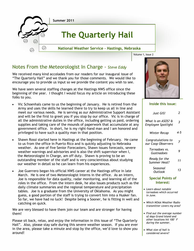
We received many kind accolades from our readers for our inaugural issue of “The Quarterly Hail” and we thank you for those comments. We would like to encourage you to provide us input so we provide the content you wish to see.
We have seen several staffing changes at the Hastings NWS office since the beginning of the year. I thought I would focus my article on introducing these folks to you.
Vic Schoenhals came to us the beginning of January. He is retired from the Army and uses the skills he learned there to try to keep us all in line and meet our various needs. He is serving as our Administrative Support Assistant and will be the first to greet you if you stop by our office. Vic is in charge of all the administrative duties in the office, including getting us paid, ordering supplies and taking care of the mounds of paperwork that accumulate at any government office. In short, he is my right-hand man and I am honored and privileged to have such a quality man in that position.
Shawn Rossi started here in Hastings at the beginning of February. He came to us from the office in Puerto Rico and is quickly adjusting to Nebraska weather. As one of five Senior Forecasters, Shawn issues forecasts, severe weather warnings and advisories and is also the shift supervisor when I,
the Meteorologist In Charge, am off duty. Shawn is proving to be an outstanding member of the staff and is very conscientious about studying our weather in detail so he can learn from his experiences.
Joe Guerrero began his official NWS career at the Hastings office in late March. He is one of two Meteorologist Interns in the office. As an intern, Joe is responsible for data quality, radar monitoring, and learning all of the roles in the office. From the intern desk, he also issues products such as the daily climate summaries and the regional temperature and precipitation tables. Joe is a graduate from the University of Oklahoma. As you might guess, a good portion of the staff is trying to convert him into a Husker fan. So far, we have had no luck! Despite being a Sooner, he is fitting in well and catching on quick.
We are very blessed to have them join our team and are stronger for having them!
Please sit back, relax, and enjoy the information in this issue of “The Quarterly Hail”. Also, please stay safe during this severe weather season. If you are ever in the area, please take a minute and stop by the office, we’d love to show you around!
Notes From the Meteorologist In Charge - Steve Eddy
Special Points of
Interest:
Learn about notable tornadoes which occurred in June.
Which NOAA Weather Radio
transmitter covers my area?
Find out the average number of days Grand Island and other locations hit 100° F during the summer.
What size of hail is
considered severe?
Just GIS!
2
What is an ASOS? & Employee Spotlight
3
Winter Recap
4-5
Congratulations to our Coop Observers
7
Tornadoes vs. Gustnadoes
9
Ready for the Summer Heat?
11
Seasonal Outlook
13
Inside this issue:
Summer 2011
Volume 1, Issue 2
The Quarterly Hail
National Weather Service - Hastings, Nebraska

Page 2 The Quarterly Hail www.weather.gov/hastings
Just GIS - Briona Chester, Meteorological Intern
In last quarter’s newsletter, we talked about what a GIS is and how it is being applied in the NWS. One of the projects mentioned is a history of tornadoes across the region. Taking a look at our 30 county warning area, we have plotted the tornadoes by month from the years 1950 to 2010. The picture to the left is the tornado history for the month of June. As you can see June has been quite an active month and it continues to be, as it falls in the heart of severe weather season across the plains. The major tornado events in June are described below. For more information on the other months, make sure to watch the Top News of the Day section of our webpage http://www.weather.gov/hastings. One point to note is that the legend has both an F-Scale and EF-Scale. The Fujita Scale, or F-Scale, was not developed until 1971, and in 2007 was changed to the Enhanced Fujita Scale, or EF-Scale. Tornadoes which occurred before
the year 1971 were assessed based on newspapers and actual accounts to determine an F-Scale rating and tornadoes after 2007 were rated on the EF-scale.
The most memorable event occurring during the month of June, was the “Night of the Twisters.” A night that has spawned both a novel and a movie, it actually occurred in Grand Island, Nebraska on June 3, 1980. Seven tornadoes touched down during the evening hours on that day, leaving 5 dead and 300 million dollars in damage.
On June 15, 1992, a supercell dropped an EF4 tornado that destroyed 9 farmhouses across Mitchell County, Kansas.
On June 6, 1956, an EF4 tornado developed across Buffalo County, Nebraska, scattering dead chickens for a half mile by Pleasanton.
On June 4, 1955, an EF4 tornado tracked across Osborne County, Kansas, leaving 4 injured in its wake.
On June 7, 1953, an EF4 tornado ripped across Sherman County, Nebraska, killing 11 people, 10 of which were at a family reunion.

The Automated Surface Observing Systems (ASOS) program is a joint effort of the National Weather Service, the Federal Aviation Administration, and the Department of Defense. The ASOS system serves as the nation's primary surface weather observing network, and is designed to
support weather forecast activities and aviation operations.
The ASOS detects basic weather elements and disseminates hourly and special observations and provides computer-generated voice observations directly to aircraft in the vicinity of airports using ground-to-air radio, and the reports are also available via a telephone dial-in port. The ASOS observes, formats, archives and transmits observations automatically and transmits a special report when conditions exceed preselected weather element thresholds, e.g., the visibility decreases to less than 3 miles.
The ASOS reports items such as:
Sky Condition (Cloud height/amount)
Visibility up to 10 statute miles
I was born and raised in Kingman, Kansas and graduated from Kingman High School in 1988. After high school I attended North Central Kansas Technical College. I received an Associate’s Degree through Cloud County Community College while completing the two year electronics program at the vo-tech in 1991. Between my first and second year of school I was hired by the National Weather Service. I was hired through a work study program and began mentoring under a fully trained Electronics Technician at the NWS office in Wichita, Kansas in 1989. I worked at the Wichita office until 2001 while attending NWS equipment schools and promoting to a fully trained technician. In 2001, I transferred over to the Federal Aviation Administration. I worked as an Electronics Technician at Mid-Continent Airport for two years while attending FAA equipment schools and receiving certification on various radar, communication and computer systems. In 2003, I returned to the NWS as an Electronics Technician at the Goodland, Kansas office and worked there until 2008. While working at the Goodland office I studied Linux and Information Technology systems. In 2008, I transferred to the Hastings, Nebraska office and was promoted to my current position. In my current position as an Electronics System Analyst in the National Weather Service, I’m responsible for supervising two Electronics Technicians and for all the electronic and information systems in our office’s warning area. I consider it a great honor to have the opportunity of giving back with my skills and training as a civil servant. My career path seems to have come full circle, since the school where I first learned electronics in Beloit, Kansas is within our office’s area of responsibility. Outside of work I have been involved in Boy Scouts since my son started as a Cub Scout all the way through his earning Eagle rank. I enjoy many other outdoor activities including bicycling, gardening, fishing, hunting, camping, and grilling with all three of my kids and our two dogs.
Employee Spotlight - Electronics System Analyst Mark Fairchild
What is an ASOS? - Scott Gayer, Electronics Technician
Page 3 Volume 1, Issue 2 www.weather.gov/hastings
Present Weather: type and intensity for rain, snow, and freezing rain
Sea-level pressure and altimeter setting
Ambient temperature and dew point temperature
Wind direction, speed/gusts
Precipitation accumulation
Selected significant remarks: variable cloud height and visibility, precipitation beginning/ending times, rapid pressure changes and tendency, wind shift, peak wind.
There are currently 3 units in our coverage area, located at the Hastings Airport, Grand Island Airport, and Ord Airport (pictured).

Page 4 The Quarterly Hail www.weather.gov/hastings
2010-2011 Winter Recap - Briona Chester, Meteorological Intern
With just 14 inches in portions of Furnas County to 43.5 inches in Greeley County, snowfall varied greatly across the Hastings CWA during the 2010 to 2011 snowfall season. This season, which runs from July 1st, 2010, to June 30th 2011, began on a dry note; but just as soon as we rang in the New Year, snow seemed to be piling on our doorsteps. Before December 30th, snowfall amounts across the region were minimal, with the tri-cities reporting just a trace at Grand Island, 0.1” at Kearney and 0.9” at Hastings. The first major snow storm of the season occurred just shy of 2011, on December 30th and 31st. During this storm, the bulk of the snow occurred in the northwest, with areas from Ord to Gothenburg picking up 4 to 6 inches. The lowest amounts were reported across the southeast and east, with some locations picking up less than 1 inch of snow. The next system moved through the region just a little over a week later, starting the year 2011 off with a bang. On January 8th-10th, portions of south central
Nebraska picked up anywhere from 7 to 12 inches of snowfall, while portions of north central Kansas picked up 5 to 9 inches of snowfall. Totals from this storm ranged from 5 inches in Alton, KS to 11.6 inches at the Hastings Weather Office. Yet another round of snow moved across the region on January 19th. This system dropped the heaviest amounts mainly northeast of a line from Lexington to Mankato, where totals of 6 to 8 inches were common, including 8.5 inches at Loup City. Southwest of that line, snowfall totals dropped off gradually with 2 inches or less being common. For the next winter system that rolled through the area, snowfall amounts were much smaller. From January 31st to February 1st, about 1 to 3 inches of snow fell across the region, with lower amounts to the west and near 4 inches across the eastern counties. Unfortunately with this system, cold temperatures and strong northwesterly winds of 30 to 40 mph dropped wind chill values to near 30 degrees below zero. So far this season, it seemed that south central Nebraska had been hogging all the snow. However, by February 7th through the 9th, north central Kansas was back in the race. During this system, much of the

Page 5 The Quarterly Hail www.weather.gov/hastings
2010-2011 Winter Recap - continued
snow fell across portions of Kansas with many locations picking up 5 to 9 inches of snow. Snowfall was lacking across south central Nebraska with the highest totals in the southwest around 4 inches. Moving farther northeast, totals dropped off quickly with less than 1 inch in Hastings and Grand Island. By February 24th, when most of us were hoping that winter was over, Mother Nature did it again. A band of heavy snow set up across the region stretching from Harlan and Phillips counties northeast into Clay and Fillmore counties. Most locations in this band received 5 to 9 inches, although much higher amounts near 12 inches were reported in Blue Hill. South of this band, 2 to 4 inches were common, while north of this band, amounts tapered off quickly. On March 7th through 9th, a 3-day snowfall event dropped 4 to 6 inches of snow mainly northwest of a line from Wilsonville to Fullerton. This included the highest storm totals of 6 and 6.5 inches of snow in Greeley and Ord, respectively. Southeast of that line, some locations picked up as much as 2 inches, but many fell short of anything more than flurries. The last March system skirted across the northeast on March 24th. With this system, 2 to 5 inches of snow fell northeast of a line from Ord to York, with the highest amount of 5 inches near Osceola. Amounts tapered off across south central Nebraska, while not even a flurry occurred across north central Kansas. By the beginning of April, winter finally seemed to be over with record-breaking high temperatures near 90 degrees across the tri-cities on April 9th. However, just a few days later, the white stuff would appear yet again. On April 14th- 15th, a strong spring system made its way across the Plains. The system began with hail-bearing thunderstorms across the region, and even tornadic storms across portions of Kansas, Oklahoma, and Arkansas. As the system spun across the region, cold air surged in behind it, dropping snow on a good portion of Nebraska. The highest totals were across the Nebraska panhandle where some locations got up to 8 inches. The highest totals across this CWA were near Ord and Osceola where 3 inches of snow fell. Most other areas received more rain than snow.
We Say Goodbye To Our Friend…
Long time WFO Hastings Electronics Technician Gary Keller passed away at his residence on April 30th. Originally from Toledo, Ohio, Gary joined the United States Air Force in 1967 and served in numerous locations, including South Korea where he met his loving wife of 33 years, Kyong. While stationed at Fort Hood and residing in Copperas Cove, Texas, Gary worked as an electronics technician and attended Central Texas College, graduating with honors and receiving an Associate Degree in Applied Science. In 1981, he continued his service to his country and transferred to the Army, becoming a Warrant Officer and would eventually become Chief Warrant Officer 2 before his retirement. In 1993, Gary moved to Nebraska where he continued his work in electronics while working for the National Weather Service in Hastings for the next 18 years. In his personal life, Gary served his community by volunteering at the Hastings YMCA and served on the board of directors for a number of years. He lived an ever selfless life, always looking for an opportunity to help others, giving everything and expecting nothing in return. He had a kindred love for the automobile, especially antique Chevrolets and was dedicated to spending his Thursday nights playing poker with friends. Gary enjoyed many summers of working in the garden with his wife and making homemade salsa to give to family and friends. He supremely loved doing anything that involved being with his family. Gary’s skill and commitment to the NWS mission will be sorely missed!

Page 6 The Quarterly Hail www.weather.gov/hastings
Notes from Mind Of Marla - Marla Doxey, Data Acquisitions Program Manager
April showers, bring…Well, I wanted to say bring May flowers, but I think you need sunshine to help those along. May started out a bit on the warm side, but it kinda took a downhill slide with temperatures dropping below normal. Within about a week’s time we broke record high and low temperatures. On top of that, Mother Nature decided to open the spigot and record rainfalls were recorded. What will the rest of spring and summer bring? We have been very fortunate not to have the amount of severe weather that has pummeled other areas. It has been a wicked spring for many. Maybe the cool and wet weather has been a blessing in disguise. By now you should have put the tube and funnel back in your gages. It will make it much easier for you to read the liquid precipitation. Also check it from time to time to make sure nothing has plugged the hole in the funnel. We are looking at future site visits so please let us know of any equipment issues so we can be sure to bring the necessary parts. When you do have hail, put an X in the appropriate box and write down what size the biggest hail stone was in the Remarks section. Please use this Hail Size Reference Chart when reporting hail. Anytime you have hail, please call our office at (800) 528-2914 to let us know what size it is. This really helps support our severe weather operations. You might think “It is just pea size so they really don’t need to know that”. In reality, it is just the opposite. Knowing that a storm is only producing pea size hail helps in the decision making process of deciding whether or not to issue a severe thunderstorm warning. When you send in your form at the end of the month, please be sure and Sign It. Observers using the computer website (WxCoder III) do not need to mail in their forms as I can download them at the end of the month. It is important to also enter zeroes for days you do not have any precipitation. This lets me know you did not just forget to enter the data for that day. You can enter multiple days of no precipitation. Once you have all your data entered for the month, you will notice an End of Month Closeout statement at the bottom of your screen. Closing out your form at the end of the month lets me know you have reviewed your entries and you are ready to have me download the form. I will then review it, print it, and close it out on my end also. This sends an electronic trigger to the National Climatic Data Center for them to download your data. If you have a computer and the internet and would like to try this form of data entry, please let me know. It does not require any type of program downloading. It also allows you to make copies of your reports or to go back and correct mistakes, plus enter remarks about present or past weather. For observers using the phone to enter observations through IV-ROCS; if you enter your data every day, even days with zero precipitation, you will not have to mail in a form either. The two programs, IV-ROCS and WxCoder, have been linked in a computer database and I can retrieve your form also. I can also close out the monthly form. If you do not have a computer, but would like to try IV-ROCS, which is an automated, menu-driven system, just let me know and we can get you set up. Speaking of mailing forms, please do not throw out your envelopes just because the postage on them is incorrect. Continue to use them to mail in your forms. We are billed for the extra postage when it arrives here. So you don’t need to put extra stamps on it either.
Hail Diameter
(Inches)
Reference
Object
0.25 Pea
0.50 Mothball
0.75 Penny
0.88 Nickel
1.00 Quarter
1.25 Half Dollar
1.50 Ping Pong Ball
1.75 Golf Ball
2.00 Hen Egg
2.50 Tennis Ball
2.75 Baseball
3.00 Teacup
4.00 Grapefruit
4.50 Softball
Red indicates severe criteria

Page 7 The Quarterly Hail www.weather.gov/hastings
Congratulations to Our Cooperative Observers
It’s time once again to honor our Cooperative Observers. Several of our observers across our area have been dedicating their time to the program for many years. They are among an elite group of over ten thousand cooperative observers who volunteer their time to record precipitation every day. The 120-year old Cooperative Observer Program is a unique partnership between the National Weather Service and citizen volunteers in every U.S. state and territory. It is an effective way to collect weather data for immediate forecasting needs and longer-term national, regional and local climate outlooks. It is one of the few sources of measuring snow and its water equivalency in the United States. Climate data are used in every aspect of our national economy. Just a few of the many users are transportation companies, the
insurance industry, agriculture, water resource and manufacturing.
In the NWS Hastings service area, we have presented 3 COOP awards thus far this year.
The Hall County/City of Grand Island Emergency Management was presented with an Institution award for 25 years of service. Serving as a back-up observer, the staff of the Emergency Management office has been taking river observations since April 1, 1986. The river gauge is located on the U.S. Highway 34 Bridge southeast of Grand Island. While not tasked with taking observations every day, as a back-up observer, the Emergency Management office is called upon to take river measurements if the automated gauge fails or is unrepresentative, which can be the case during extreme flooding events or ice jams. Flood stage on the Platte River southeast of Grand Island is 6.50 feet. The record flood crest was 7.97 feet on June 30, 1983. The river
crested above 7 feet as recently as May 2008.
John A. Nelson received an award for 20-years Length of Service. John A. is the official cooperative observer rain/snow reporter for the Fullerton area and continues the precipitation history dating back to January of 1904. Since taking over the station in March of 1991, John A. has measured just over 548 inches of rain. This amount would more than cover a 4 story building. It is interesting to note that his snowfall amount comes to 547 inches, just one inch shy of the rainfall and it is not for 12 months a year. In the past 20 years, the driest year was 2002 with only 18.29 inches of rain while the wettest was 1993, the year of the Big Flood, with 40.25 inches. The least snowy season was 1999-2000 with only 14.5 inches while 2009-2010 season came in with 43.8 inches. Looking back at the climate history for Fullerton, 1915 comes in with 43.71 inches of rain/melted snow while the snow season of 1911-1912 has an
amazing 74.1 inches of snow.
Kirk A. Wilson received a 15-year Length of Service Award. Kirk is the official cooperative observer for rain/snow events for the Ionia area and continues the precipitation history dating back to 1956. Since taking over the station in 1996, Kirk has measured nearly 400 (374.94) inches of rain. This amount would cover a 3 story building. Since Kirk took over the station from his father, Waldo, the driest year was 2000 with only 16.15 inches of rain while the wettest was 2008 with 33.98 inches. Going back in the records to 1956, we find the driest year was 1956 with only 10.70 inches of rain while the wettest year was 1993, the year of the Big Flood, with 46.07 inches. The least snowy season for Kirk was 1998-1999 with only 4.5 inches of snow while the 2000-2001 season came in with 31.0 inches. Looking back once again at the climate history for Ionia, the snow season of 1965-1966 came in with only 3.5 inches of snow while
1959-1960 came in with 52.7 inches of snow.
Steve Eddy, WFO Hastings MIC, presents Larry Smith
(Deputy EM Director) and Jon Rosenlund (Grand Island
& Hall County EM) the Institution Award.
John A. and his wife Frieda

Page 8 The Quarterly Hail www.weather.gov/hastings
NOAA Weather Radio All-Hazards
NOAA Weather Radio All Hazards (NWR) is a
nationwide network of radio stations
broadcasting continuous weather information
directly from the nearest National Weather
Service office. NWR broadcasts official
Weather Service warnings, watches, forecasts
and other hazard information 24 hours a day,
7 days a week.
Working with the Federal Communication
Commission's (FCC) Emergency Alert System,
NWR is an "All Hazards" radio network, making
it your single source for comprehensive
weather and emergency information. In
conjunction with Federal, State, and Local
Emergency Managers and other public
officials, NWR also broadcasts warning and
post-event information for all types of
hazards, including natural (such as tornadoes
or floods), environmental (such as chemical
releases or oil spills), and public safety (such
as AMBER alerts or 911 Telephone outages).
Known as the "Voice of NOAA's National Weather Service," NWR is provided as a public service by the
National Oceanic and Atmospheric Administration (NOAA), part of the Department of Commerce. NWR
includes 1000 transmitters, covering all 50 states, adjacent coastal waters, Puerto Rico, the U.S. Virgin
Islands, and the U.S. Pacific Territories. NWR requires a special radio receiver or scanner capable of
picking up the signal. Broadcasts are found in the VHF public service band at these seven frequencies
(MHz):
More detailed maps and information about the NWR transmitters (including frequencies, coverage area, and county SAME codes) covering the Hastings County Warning Area and the rest of the U.S. can be found by going to the following websites:
Hastings NWS County Warning Area - http://www.crh.noaa.gov/gid/?n=nwr Nebraska - http://www.weather.gov/nwr/Maps/PHP/nebraska.php Kansas - http://www.weather.gov/nwr/Maps/PHP/kansas.php Remainder of the U.S. - http://www.weather.gov/nwr/Maps/index.php Frequently asked questions - http://www.weather.gov/nwr/faq.htm
162.400 162.425 162.450 162.475 162.500 162.525 162.550

Spring Weather Brings Tornadoes and “Gustnadoes” to the Region Mike Moritz, Warning Coordination Meteorologist
Page 9 Volume 1, Issue 2 www.weather.gov/hastings
No doubt, severe weather across the United States this spring has dealt a tremendous and sad blow to many areas. Violent and killer tornadoes stretched from the Plains, through the Deep South, and even into New England (Springfield, MA). The Ohio and Lower Mississippi Valleys have already experienced record flooding, and now the Missouri River Basin and its tributaries are into the act with heavy rain and the greatest snow melt in 45 years teaming up to fill rivers and reservoirs to the limit and beyond. Here in south central Nebraska and north central Kansas, we have largely been spared the violent severe weather episodes, although we haven’t missed things all together. One of the more challenging events occurred on Memorial Day evening. After a day of south winds blasting the area with gusts over 55 mph at times, severe thunderstorms erupted near a frontal boundary moving into central Nebraska. The thunderstorms were no surprise, nor were the reports of large hail, damaging winds and some isolated tornadoes, as all had been in the forecast for several days. However, other phenomena observed that day brought concern and confusion: the “gustnado”. First, what is a gustnado? There are a few different definitions of a “gustnado”, but I think the following definition sums it up best. Gustnado: A short-lived, ground-based, shallow vortex which develops on a gust front associated with either thunderstorms or showers. They may extend 30 to 300 feet above with no apparent connection to the convective cloud above. They are usually only visible as a cloud of dust whirling at or near the ground. Wind speeds can reach 60-80+ mph and result in damage similar to that of an EF0 or weak EF1 tornado. It can be difficult to distinguish between a gustnado and tornado, but gustnadoes are not associated with storm-scale rotation (i.e. mesocyclone or rotating updraft) which is involved with true tornadoes. Gustnadoes are likely to be visually associated with a shelf cloud on the forward or front side of the storm.
That is a lot to digest. The short way to say it is a gustnado is a big dust devil which looks a lot like a tornado but isn’t, and is usually associated with strong, non-tornadic wind events which can result in sporadic to widespread damage over a large area. The key limiting factor is a lack of connection to the larger scale circulation of the parent thunderstorm. A “gustnado” type of severe weather event tends to occur in April or May when farmland is freshly tilled or newly planted crops have not yet established a canopy of leaves (i.e. less than 12 inches tall). The ground is dry, either from a prolonged dry period, or from excessive wind battering the area. Remember, on May 30th, blowing dust was already an issue by mid-late
afternoon after 12 to 18 hours of 30 to 55+ mph winds across the region, despite some areas measuring several inches of rain just a few days earlier. (Continued on page 10)
Photo of a “gustnado” looking south at Evelyn Sharp Field northwest of Ord, Nebraska, on
May 30, 2011. There is an overall lack of storm scale rotation or other features typically
associated with a tornado. The ASOS (see page 3) recorded a wind of 83 mph at this time.
This is not a tornado. Photo by Tad and Jenal Melia.

Spring Weather Brings Tornadoes and “Gustnadoes” to the Region - cont. Mike Moritz, Warning Coordination Meteorologist
Page 10 Volume 1, Issue 2 www.weather.gov/hastings
A gustnado type of event also tends to occur along a line of thunderstorms which forms strong outflow winds from individual storms, or along the line as a whole. These outflow winds tap into the dust on the ground and stir it into the air. Winds near a thunderstorm are chaotic, churning at different speeds and different directions, which often results in a whirlwind of dust, and thus the “gustnado”.
From a NWS perspective, “gustnadoes” are often reported as tornadoes by the public or less experienced storm spotters. The local NWS office may receive multiple reports at once from various sources. Meteorologists will attempt to verify reports through Emergency Management, radar data and an understanding of the storm environment. Usually, the NWS will not issue a tornado warning for a gustnado; unless ground truth reports and radar data support the need for a tornado warning (i.e. a tornadic circulation on radar or 80-100 mph winds expected with the line of storms itself). Sometimes, if wind speeds do not exceed 58 mph, there may be no warning issued by the NWS. Every situation is a little different.
Without seeing every single reported “gustnado” or tornado reported on May 30th, no one knows for sure
exactly what occurred. Through some research, experience and a good understanding of the storm
environment and features for the day, the evidence supports the vast majority of the tornadoes reported
that day were in fact “gustnadoes”.
This gustnado occurred on April 13th, 2010 near Grant, NE., which formed
along the leading edge outflow seen in this picture as a shelf cloud. Photo by
Dean Cosgrove.
Do You Know Your NOAA Weather Radio SAME Code?
After buying an NWR SAME receiver, you must program
your county into the radio. Your NWR will then alert
you only of weather and other emergencies for the
county(s) programmed. NWR receivers without the
SAME capability alert for emergencies anywhere within
the coverage area of the NWR transmitter, typically
several counties, even though the emergency could be
well away from the listener.
• When an NWS office broadcasts a warning, watch or
non-weather emergency, it also broadcasts a digital
SAME code that may be heard as a very brief static
burst, depending on the characteristics of the receiver.
This SAME code contains the type of message, county(s)
affected, and message expiration time.
• A programmed NWR SAME receiver will turn on for
that message, with the listener hearing the 1050 Hz
warning alarm tone as an attention signal, followed by
the broadcast message.
• At the end of the broadcast message, listeners
will hear a brief digital end-of-message static burst
followed by a resumption of the NWR broadcast cycle.
Adams 031001
Buffalo 031019
Clay 031035
Dawson 031047
Fillmore 031059
Franklin 031061
Furnas 031065
Gosper 031073
Greeley 031077
Hall 031079
Hamilton 031081
Harlan 031083
Howard 031093
Jewell, KS 020089
Kearney 031099
Merrick 031121
Nance 031125
Nuckolls 031129
Osborne, KS 020141
Phelps 031137
Phillips, KS 020147
Polk 031143
Rooks, KS 020163
Sherman 031163
Smith, KS 020183
Thayer 031169
Valley 031175
Webster 031181
York 031185

Are You Prepared For The Summer Heat?
Page 11 Volume 1, Issue 2 www.weather.gov/hastings
Heat is the number one weather-related killer in the United States. The National Weather Service statistical data shows that heat causes more fatalities per year than floods, lightning, tornadoes and hurricanes combined. Based on the 10-year average from 2000 to 2009, excessive heat claims an average of 162 lives a year. By contrast, hurricanes killed 117; floods 65; tornadoes, 62; and lightning, 48. In the disastrous heat wave of 1980, more than 1,250 people died. In the heat wave of 1995 more than 700 deaths in the Chicago area were attributed to heat. In August 2003, a record heat wave in Europe claimed an estimated 50,000 lives. Heat disorders generally have to do with a reduction or collapse of the body's ability to shed heat by circulatory changes and sweating or a chemical (salt) imbalance caused by too much sweating. When the body heats too quickly to cool itself safely, or when you lose too much fluid or salt through dehydration or sweating, your body temperature rises and heat-related illness may develop. Heat disorders share one common feature: the individual has been in the heat too long, is exercised too much for his or her age and physical condition. Studies indicate that, other things being equal, the severity of heat disorders tend to increase with age. Conditions that cause heat cramps in a 17-year-old may result in heat exhaustion in someone 40, and heat stroke in a person over 60. The Hastings NWS will issue a “Heat Advisory” when a heat index of 105-109° is expected, and an “Excessive Heat Warning” when a heat index of >110° is expected or when a Heat Advisory is in effect for 3 or more days.
Interested in more information about the affects of heat? Visit the following webpage:
http://www.weather.gov/om/heat/index.shtml

Page 12 www.weather.gov/hastings The Quarterly Hail
Last Quarter’s
Answers
Across
4. lightning
5. thunderstorm
10. floods
11. radio
12. watch
13. siren
Down
1. warning
2. hail
3. meteorology
5. thunder
6. drill
7. six
8. forecast
9. two
12. winds
T F 1. When there is lightning, crouch under a tree.
T F 2. Tornadoes do not occur at night.
T F 3. Stay by the window and watch for streaks of lightning.
T F 4. In a thunderstorm, you usually see lightning before you hear the thunder.
T F 5. When the sky lights up, but you can’t see the streaks of lighting, it means the thunderstorm is over.
T F 6. When there is lightning, go to the highest spot on a hill and get out your umbrella for protection.
T F 7. Lightning never strikes the same place twice.
T F 8. You will always notice a funnel before a tornado strikes.
T F 9. A tornado may hit one home but hardly affect the home next door.
T F 10. A tornado can throw cars and trucks into the air.
T F 11. There will seldom be lightning during a tornado.
T F 12. Thunderstorms are only dangerous during the afternoon and evening hours.
T F 13. The sky may be clear at the time you hear a tornado watch has been issued.
T F 14. When a tornado is coming, take a quick picture before taking shelter.
T F 15. When a flash flood warning is issued, it means flash flooding is occurring or expected to occur.
T F 16. Flash floods only occur along rivers and creeks.
T F 17. If you are camping and a flash flood occurs, run to higher ground.
T F 18. Drive as fast as possible through a flooded road to avoid being washed downstream.
T F 19. A flash flood can wash out roads and bridges and uproot trees.
T F 20. It is safe to walk across a flooded street with water half way up to my knees.
T F 21. The fastest way to hear about watches and warnings is by having a NOAA Weather Radio.
T F 22. Straight-line winds from a severe thunderstorm can cause damage comparable to a tornado.
T F 23. On average, floods kill more than any other severe weather hazard.
T F 24. When there is lightning, stay away from anything made of metal.
T F 25. Take shelter in a large room such as a gymnasium if there is a tornado warning.
Answers: 1-F, 2-F, 3-F, 4-T, 5-F, 6-F, 7-F, 8-F, 9-T, 10-T, 11-F, 12-F, 13-T,
14-F, 15-T, 16-F, 17-T, 18-F, 19-T, 20-F, 21-T, 22-T, 23-T, 24-T, 25-F
True or False - Do you know your weather safety information?

The Summer Outlook from the Climate Prediction Center calls for equal chances for either above or below normal temperatures and precipitation amounts. What does that REALLY mean? To understand this fully, we have to look at different elements of the forecast one-by-one.
Time Frame: The NWS considers the “Summer” season to be June, July and August. Although this differs somewhat from the astronomical summer season, using these three calendar months is convenient when referencing meteorological data.
Temperature: The temperature outlook reflects the average temperature for the 3-month period as a whole. We tend to view temperatures in daily or monthly normals, but the 3-month outlook reflects the entire 90-day average temperature. Red/Orange colors represent “warmer” than normal. Blue colors represent “cooler” than normal. The white area labeled “EC”, which includes all of South Central Nebraska and North Central Kansas, reflects places with “Equal Chances” of having above, near or below normal temperatures.
Precipitation: Similar to temperature, the precipitation outlook depicts the total precipitation for the entire 3-month period, and is independent of individual days or months. Green colors represent “wetter” than normal and brown colors represent “drier” than normal. Again, all of South Central Nebraska and North Central Kansas is outlooked to have “Equal Chances” of above, near or below normal precipitation.
So, what does “Equal Chances” really mean? This means there is no clear trend in the forecast analysis to support an outlook of anything other than “normal” for the period. In other words, confidence is too low in the forecast to favor any one of the three possibilities (above, below, or near normal) over the others.
To recap, the outlook for Summer (June-July-August) calls for no clear signal that precipitation and temperatures will be above or below normal.
Summer Outlook Calls For Equal Chances of Below/Above Normal Conditions
Page 13 Volume 1, Issue 2
Precipitation Outlook for Summer 2011
(June-August)
Temperature Outlook for Summer 2011
(June-August)
Find more information about the Climate Prediction
Center at http://www.cpc.ncep.noaa.gov/
Averages From
1971-2000 Data
Average
High/Low
June 15
Average
High/Low
July 15
Average
High/Low
August 15
3-Month Total
Average Rain
(June-August)
Average
Number of
Summer Days
Reaching 100°
Grand Island 83°/59° 87°/65° 85°/63° 9.94” 4
Hastings 84°/60° 88°/64° 86°/63° 10.58” 4
Holdrege 83°/58° 87°/63° 86°/61° 11.00” 3
Osceola 84°/60° 88°/64° 86°/63° 10.58” 2
Mankato KS 85°/58° 91°/64° 89°/62° 10.34” 7
Phillipsburg KS 87°/60° 93°/65° 91°/63° 9.16” 12
Beloit KS 87°/63° 93°/68° 91°/67° 10.59” 12
www.weather.gov/hastings

Weather Forecast Office 6365 Osborne Drive West Hastings, NE 68901
National Weather Service
Phone: 402-462-2127 Website: www.weather.gov/hastings E-mail: [email protected]
Meteorologist-In-Charge
Steve Eddy
Warning Coordination Meteorologist
Mike Moritz
Science and Operations Officer
Rick Ewald
Data Acquisition Program Manager
Marla Doxey
Electronic Systems Analyst
Mark Fairchild
Information Technology Officer
Carol Cartier
Administrative Assistant
Victor Schoenhals
Electronics Technicians
Gary Keller (In Memoriam) ● Scott Gayer
Meteorological Interns / Hydrometeorological Technicians
Briona Chester ● Joe Guerrero / Larry Wirth ● Mike Reed
Meet the Rest of the Staff at WFO Hastings
Lead Forecasters
Merl Heinlein ● Corey King ● Jeremy Wesely
Cindy Fay ● Shawn Rossi
General Forecasters
Julia Berg ● Angela Oder
Scott Bryant ● Ryan Pfannkuch