“the purpose of conservation: the greatest good to...
TRANSCRIPT

104
VIII. CONSERVATION AND OPEN SPACE PLAN ELEMENT
“The purpose of conservation: The greatest good to the greatest number of people
for the longest time”
Gifford Pinchot, US Forest Service
INTRODUCTION The Municipal Land Use Law (N.J.S.A. 40:55D-1 et seq.) authorizes municipalities to plan and zone to promote the general welfare of the citizens of New Jersey. The 15 purposes of the MLUL (NJSA 40:55D-2) explain the State legislature’s rationale for the statutory authorization for municipal land use planning and regulation. Eight of these purposes highlight the importance of conserving natural resources and maintaining a clean healthy environment.
1. The public health and safety (subsection “a”) bear a direct relationship to the use and management of New Jersey’s land and water resources.
2. Securing safety from floods and other natural and manmade disasters (subsection
“b”) and providing adequate light, air and open space (subsection “c”) are similarly directed at conserving natural resources.
3. “Preservation of the environment”, in part through planning for “appropriate
population densities and concentrations” (subsection “e”) is a key underpinning of local land use policy.
4. Providing sufficient space in appropriate locations for a variety of land uses is
intended, according to their respective environmental requirements, to meet the needs of all New Jersey citizens” (subsection “g”).
5. The statute also seeks to promote the conservation of “open space, energy
resources and valuable natural resources in the State and to prevent urban sprawl and degradation of the environment through improper use of land” (subsection “j”).
6. The conservation of energy is cited in subsection “n” (“promote utilization of
renewable energy sources)” and subsection “o” (“promote the maximum practicable recovery and recycling of recyclable materials”).
In furtherance of conservation objectives, the MLUL provides for preparation and adoption of a Conservation Plan Element (N.J.S.A. 40:55D-28b.8.) as follows:

105
“Conservation plan element, providing for the preservation, conservation and utilization of natural resources, including, to the extent appropriate, energy, open space, water supply, forests, soil, marshes, wetlands, harbors, rivers and other waters, fisheries, endangered or threatened species, wildlife and other resources, and which systematically analyzes the impact of each other component and element of the Master Plan on the present and future preservation, conservation and utilization of those resources;”
Bernards contains a multitude of natural resources which together help define the essential character of the Township. The rolling landscape that surrounds the developed environment lends to a sense of place that should be fiercely protected; its vanishing would have a profound effect on the future character of the Township. This Conservation Plan proposes the continuation and expansion of land stewardship efforts and outlines Bernards Township’s strategies to meet the statutory purpose to preserve, conserve and utilize natural resources. Land stewardship involves the actions
of both landowners and government agencies. The Township’s approach to stewardship should be two-fold, including public education and implementation of ordinances for conservation subdivision designs, stormwater management, and protection of stream corridors, steep slopes, ridgelines and forests. Public education on the importance of stewardship in protecting these valuable natural resources is available through existing educational programs offered by the County and State, and private non-profit organizations including the New Jersey Conservation Foundation, the Great Swamp Watershed Association and the Upper Raritan Watershed Association. The Township should seek to partner with these organizations to advance these efforts, and should explore the creation of new programs through Township schools and Township agencies such as Parks and Recreation or the Environmental Commission. While the Conservation Plan Element is designed to function in concert with the other plan elements, the most important linkage will be with the Land Use Plan. Together, these plan elements propose the location, scale and intensity of new development and the resource management strategies needed to protect the environment. By providing for development at densities that the land can support, the Land Use Plan effectively carries out the objectives of the Conservation Plan and vice versa.
The rolling landscape of Bernards lends to its sense of place.
106
This Master Plan recognizes retaining the existing zoning and other zoning options will overtax the natural environment, with substantial degradation of surface water and groundwater quality. It will also entail the removal of substantial forested areas, and farmlands, which are particularly vulnerable to suburban sprawl. It has become increasingly obvious that there are other alternatives available, and that zoning for sprawl does not protect the general welfare, but rather substantially degrades the environment and erodes the quality of life and human interaction. Fragmentation and degradation of vegetation, land and water resources has been a byproduct of human activity. Woodlands, initially cleared for agricultural use, have given way to residential neighborhoods easily developed on these high, dry and usable soils. Water quality has been progressively altered and impacted by human activity. The quality of the air we breathe and the water we drink determines the health of the human organism and all life forms. This Conservation Plan seeks to minimize further degradation of these resources for the 21st century and beyond. This plan recognizes the inherent limitations of our ability to disassemble the natural world and put it back together again. It argues in favor of a lighter touch on the land, one that is more respectful of natural systems, and that limits the resource commitments and impacts of human intervention. This calls for a systems approach to natural resource conservation, where interconnected natural systems are viewed as a collective resource, not a series of separate features.
The variety of biological species is an indicator of the health of an ecosystem. Maintaining biological diversity requires protection of critical habitat areas. While habitats of endangered or threatened plant or animal species are of special importance, threatened or endangered status may be transient. For instance, the great blue heron and bald eagle have been removed from the protected list, yet their critical habitats remain essential to their continued survival. Additionally, the extirpation of rare species removes elements from the food chain that help maintain ecological balance. The explosive deer population in New Jersey is but one example of the damage wrought when this natural balance is lost. Protecting biodiversity requires the protection of terrestrial and aquatic habitats that are highly susceptible to degradation. Pristine waters cannot be maintained without protection of their watershed areas. Freshwater wetlands play an important role in filtering contaminants from the surface water and groundwater regime and, while protected by state statutes, are not immune from impacts that occur beyond the regulated areas. Similarly, prime forested areas, including mature stands of native species, are easily lost or damaged through fragmentation, a manmade impact that reduces bio-diversity. The scenic wonder of ridgelines, slopes and ravines is only one aspect of the value of these natural features, without which certain species will not remain. Similarly, grassland habitats are essential to the nesting, feeding and breeding of a variety of grassland bird species, yet such areas are frequently lost to development. Land development should be

107
arranged to maximize the conservation of substantial masses of critical habitat areas, by limiting the aerial extent of development and promoting conservation techniques targeted to these resources. Aldo Leopold wrote in A Sand County Almanac: "A land ethic, then, reflects the existence of an ecological conscience, and this in turn reflects a conviction of individual responsibility for the health of the land. Health is the capacity of the land for self-renewal. Conservation is our effort to understand and preserve this capacity..." SUMMARY OF CONSERVATION FACTORS Bernards Township possesses a number of unique natural resources. The greatest concentration of these is found at the periphery of the developed suburban core of the Township along the Passaic River to the east, the Dead River to the south and the Second Watchung Ridge, spanning the Township’s entire southwestern border with Bridgewater and Bedminster Townships. The following paragraphs identify these resources and highlight their importance in the ecosystem.
TOPOGRAPHY
The topography of Bernards Township ranges from the higher elevations on the Second Watchung Ridge to the low lying areas of the Great Swamp and Dead River. Elevations are generally between 199 and 609’ above sea level (see Figure VIII-1). The core of the Township is characterized by rolling terrain, with higher elevations on the surrounding ridges to the north and west. The Second Watchung Ridge is part of the Watchung Mountains, extending westward from Millburn Township in Essex County. This topographic feature forms the southern and western borders of Bernards. The western border is a minor extension of the Watchung Ridge, which also serves as a gateway to the Somerset Hills, which fan out through Bernardsville Borough. There are two other distinct ridge features present, one in Basking Ridge running north to south and another south of Lyons Road running east to west. The latter is part of Long Hill, which extends from Chatham Borough to the eastern border of Bernards.
BEDROCK GEOLOGY
The topography of Bernards Township reflects the underlying bedrock geology, depicted in Figure VIII-2. The Preakness Basalt flows which formed the Watchung Mountains are evident on the southern and western borders, in a radial pattern evident in the Second Watchung Ridge. The Towaco Formation, which consists of fine-grained sand and siltstone, extends throughout the central portion of the Township. The Hook Mountain Basalt runs through the southern part of Basking Ridge, south of the railroad line. The Boonton Formation, spanning the northern half of the Township border with Harding,

108
underlies the Great Swamp area. The Hook Mountain Basalt, which underlies Basking Ridge and the portion of Long Hill within Bernards Township, is a fine to coarse grained intrusion similar to the Watchung Mountains. The Boonton Formation is a fine grained sand, silt and mudstone. Protection of groundwater resources requires, in part, that development impacts to aquifers are managed in a way that protects recharge areas. Recharge areas are areas where permeable soils and natural drainage patterns permit the infiltration of surface runoff into the underlying geologic structure. Protecting aquifer recharge areas requires limitations on impervious coverage, to limit the negative effects of contaminated stormwater and to assure that recharge areas remain open to infiltration. Adequate functioning of on-site septic systems is a major concern in this regard. Figure VIII-3 depicts a series of “Conservation Factors” affecting Bernards Township, including streams, forests, wetlands, steep slopes and floodplains. This composite mapping highlights areas of the Township where sensitive resource limitations overlap or converge. These areas merit a high level of protection.
SURFACE WATERS
Bernards Township has approximately 57 miles of streams and rivers, which are depicted on Figure VIII-3. The Passaic River forms the Township’s eastern border with Harding and Long Hill Townships and flows roughly north to south. The two other main flowing water bodies are Harrison Brook and the Dead River. Harrison Brook has its origins in the north-central portion of the Township, north of I-287, and flows south to its confluence with the Dead River. The Dead River originates in the northwestern corner of the Township, north of I-287, and flows south and east along the Township’s southeastern border where it then joins the Passaic River.
FLOODPLAINS
Floodplains flank the streams and rivers that drain the Township, as depicted on Figure VIII-3. By far the most extensive floodplain is associated with the Passaic River in the northeastern portion of the Township. Most of the floodplain areas here are within the Great Swamp watershed and part of Lord Stirling Park, permanently protected as open space and recreation land. The floodplain in this area extends as far as 3000’ from the Township border, and is variable in width. The Dead River also has an extensive floodplain within Bernards, major portions of which are encompassed within Township- owned lands directly south of Spring Valley Boulevard. With the exception of a few elevated areas to the interior of these properties, the floodplain extends to Spring Valley Boulevard. Further north, where the Dead River flows from the northwestern corner of the Township, the floodplain is variable, ranging in width from 200’ to 2500’ at its widest
109
point. Harrison Brook, flowing through the central portion of the Township, also has a variable width floodplain. As the brook flows south, its floodplain fans out further, reaching 1000’ at its widest point. Altogether, floodplains total 2,200 acres and account for roughly 15% of the Township’s acreage.
WETLANDS
Wetlands within the Township account for approximately 20% of the total land area of Bernards. Many of these wetlands correspond to the floodplains of the three major rivers and streams of the Township; however, there are wetlands in various locations that are part of the greater hydrologic system as depicted on Figure VIII-3. The largest concentrations of wetlands occur in the vicinity of Lord Stirling Park/Great Swamp, and along the Dead River floodplain, south of Spring Valley Boulevard. Wetlands within Bernards play an important role in filtering contaminants as well as retaining precipitation and slowly feeding it to headwater streams.
STEEP SLOPES
Steep slopes occur in various locations throughout the Township (see Figure VIII-3), but are primarily found along the Second Watching Ridge on the Township’s southern and northwestern boundaries. Slopes greater than 12% are also found along the extension of Long Hill in the very center of the Township south of Basking Ridge and in the northernmost part of the Township in the vicinity of Hardscrabble Road.
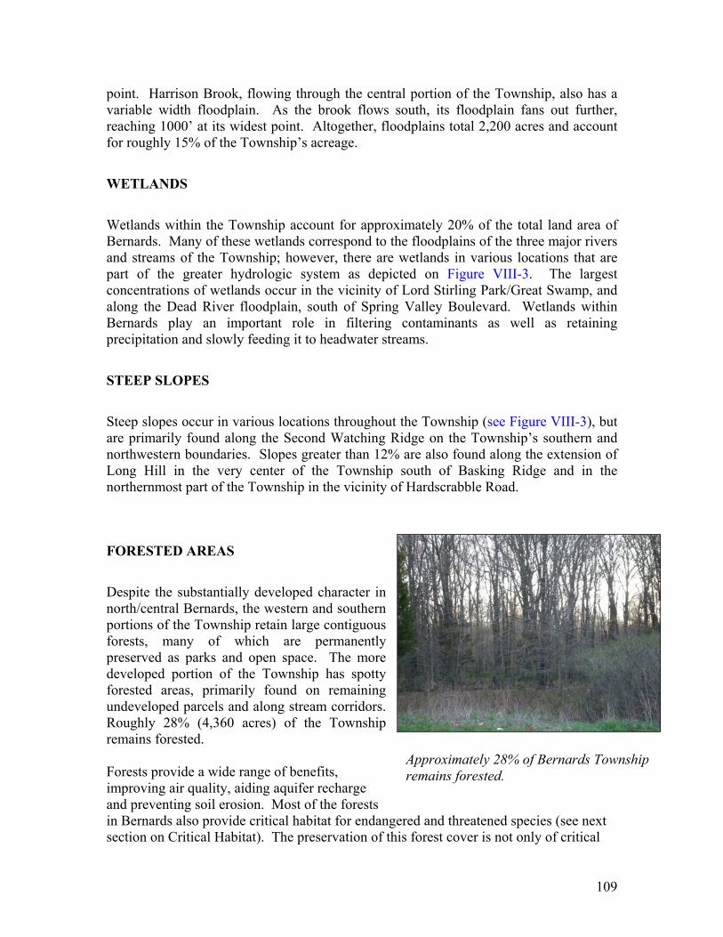
FORESTED AREAS
Despite the substantially developed character in north/central Bernards, the western and southern portions of the Township retain large contiguous forests, many of which are permanently preserved as parks and open space. The more developed portion of the Township has spotty forested areas, primarily found on remaining undeveloped parcels and along stream corridors. Roughly 28% (4,360 acres) of the Township remains forested. Forests provide a wide range of benefits, improving air quality, aiding aquifer recharge and preventing soil erosion. Most of the forests in Bernards also provide critical habitat for endangered and threatened species (see next section on Critical Habitat). The preservation of this forest cover is not only of critical
Approximately 28% of Bernards Township remains forested.

110
importance to the perpetuation of these species, but also to the rural character of the district. The NJDEP publication titled “Protection and Care of Urban Forests” provides a detailed list of the resources protected and offered by forested areas. Forests:
• Modify local climatic conditions near or within their boundaries • Create the feeling of privacy • Serve as recreational facilities • Provide habitats for plants and animals • Reduce surface runoff because of the high moisture holding capacity of the forest soils and tree canopy • Enhance the visual characteristics of the scenic corridors • Reduce noise pollution • Produce oxygen
CRITICAL HABITAT FOR THREATENED AND ENDANGERED SPECIES
In 1993, the New Jersey Department of Environmental Protection Endangered and Non-game Species Program (ENSP) initiated a move to a landscape level approach for endangered species protection. With suburbanization and development occurring in all areas of the State, an increasing amount of habitat suitable for threatened and endangered species was being lost daily. In order to address habitat loss, ENSP partnered with the Center for Remote Sensing and Spatial Analysis (CRSSA) at Cook College, Rutgers University. Utilizing LandSat Thematic Mapper satellite imagery, CRSSA mapped land cover for the entire State of New Jersey, broken down into 20 different habitat/land cover types. After generalized cover types were classified, detailed methodologies were developed to address the habitat suitability issues for each focus category, including beach/dunes, emergent landscapes, forested wetlands, forested areas and grasslands. After reclassifying data based on standards developed for each focus category, the habitat data was intersected or combined with the Natural Heritage Program’s Biological Conservation Database (BCD). This database is a Geographic Information System (GIS) coverage that provides information on the sighting of threatened and endangered species, based on the field work of ENSP scientists and sightings reported by members of the public. It is the most comprehensive data available in digital form on the location of threatened and endangered species. The combination of these two data sets resulted in the data depicted on Figure VIII-4. The Landscape Project data provides users with scientifically sound, peer-reviewed information on the location of critical habitat based on the conservation status of the species that are present. Habitats are ranked on a scale of 1 to 5, based on the criteria outlined in the following table:

111
NJ Landscapes Project Ranking System
Rank Indication
1 Suitable habitat, no special concern, threatened or endangered species sighted
2 Habitat patch with species of special concern present 3 Habitat patch with State threatened species present 4 Habitat patch with State endangered species present 5 Habitat patch with Federal threatened or endangered species present
Bernards Township is rich in habitat that is suitable to support populations of threatened and endangered species. Many of the forest and wetland/forest resources that are present in the Township are ranked 3 and 4, indicating the presence of State Threatened and State Endangered species. Approximately 68% of the Township’s forest resources are Rank 3 while the remaining 32% are Rank 4. Roughly 32% of the wetland/forest resources are Rank 3 with 45% Rank 4. In addition to these high quality habitats, there are also grassland and emergent habitats present within the Township. While forest is the most extensive habitat found in the Township, the wetland/forest habitat is the most critical. There are roughly 730 acres of Rank 4 wetland/forest habitat, primarily within the floodplain of the Passaic River in Lord Stirling Park and along the corridor of the Dead River in the eastern part of the Township. The critical forest habitat of Bernards Township stretches along the southern boundary of the Township with Bedminster and Bridgewater, wrapping around to the eastern boundary with Far Hills and Bernardsville. Some of the critical forest resources also extend north along the Dead River and Harrison Brook corridors. Bernards Township also has critical emergent and grassland habitat. Although not as high ranking as much of the forest and wetland/forest habitat, it nonetheless is worthy of noting. Emergent habitats are those that are critical to the reproduction of many amphibian species, which occur on these early spring pools for this process. The NJDEP is currently undertaking a project to identify and monitor these emergent habitats, with the hopes of giving them the same protection that wetland areas are afforded under State legislation. Rank 1 and Rank 2 emergent habitats are located along the Passaic and Dead River floodplains and total approximately 640 acres. The grassland habitat depicted in Figure VIII-4 is primarily rank 3, with small areas of rank 1 present as well. Grassland resources are concentrated near Lord Stirling Park, the southern tip of the Township and along the eastern border of the Township near Far Hills. There is a total of 664 acres of grassland habitat in the Township. The Landscape Program data was intended to aid municipalities, County and State governments, conservation agencies and citizens by identifying the extent of critical habitat within their respective jurisdictions and communities. A variety of means should be employed to protect these critical habitats, including the following:
112
Prioritizing open space acquisitions based on the presence of habitat for
threatened and endangered species Adopting regulations aimed at protecting critical habitat Adopting management policies for open space that are consistent with
protection of critical habitat Permitting flexibility in development techniques to protect critical habitat Promoting land stewardship practices that are consistent with the protection of
critical habitat More than half of the land area in the Township is categorized as critical habitat for threatened and endangered species, whether it’s forest, grassland, emergent or forested wetland. The Landscape Project data highlights the extent and critical nature of these resources found within Bernards Township.
CARRYING CAPACITY Carrying capacity is a planning technique used to establish the maximum population level of a species based on the availability of natural resources. Carrying capacity had its genesis in ecological studies, used to manage wildlife habitat rangeland for grazing. In the context of land use planning, carrying capacity has been defined as the ability of natural and man-made systems to support a level of population growth and ancillary development while maintaining established standards of performance. When applied to land use planning, an assessment of carrying capacity is useful in establishing maximum densities or intensities of development. However, sustainability requires a margin of safety, not planning for the maximum development that can be supported.
The policies and strategies of this Conservation Plan seek to limit the impacts of development and retain the natural terrain and features to the greatest extent practicable. This plan also promotes the restoration of natural systems that have been degraded by past activities. As new regulatory tools or techniques become available, they should be evaluated for their ability to promote the Conservation Plan objectives and adopted where appropriate. Conservation easements for critical resources should be expanded, and a program of mapping and monitoring instituted. Additionally, open space and woodlands acquisition priorities should support the goals of the Conservation Plan.

113
SUMMARY OF CONSERVATION PLAN POLICIES
ENERGY AND AIR QUALITY
Protection of air quality is a measure difficult for individual municipalities to control given that most impacts to air quality come from outside the region. The combination of coal burning power plants and industry to the west in the Ohio Valley along with prevailing wind directions create the greatest impact to air quality in our region. Promoting sound principles, however, will aid in reducing further effects on local air quality. To effectuate this, the following measures are recommended:
a. Promote alternative means of transit by providing opportunities and access for alternative transportation systems (buses, car and van pooling, bicycling, and walking).
b. Reduce the need for vehicular trips by facilitating better connections
among residential, commercial, office, and recreational uses. c. Encourage staggered work hours for large employment centers.
d. Encourage energy conservation through subdivision design, building
design, building orientation, and the evaluation of microclimate conditions such as solar access and wind direction.
e. Recommend landscaping standards that provide buildings with maximum
solar access, shading, and wind protection.
f. Encourage the maximum recovery of recyclable materials and the use of renewable energy sources.
g. Require air quality assessments at principal intersections for significant
developments (three hundred (300) or more vehicle trips per day) to identify problem areas and mitigation strategies.
h. Design and encourage bikeways, pedestrian walkways and other routes,
where appropriate, to maximize opportunities for non-motorized travel in existing and new development.
FOREST RESOURCES
Woodlands serve a number of important functions in the ecosystem. The most basic is the production of oxygen through the assimilation of CO2; this is critical to the survival of both humans and animals, and gives forests an undeniable intrinsic value and indicates

114
the need for their conservation. Forests are also excellent filters for surface runoff, reducing runoff volume and providing valuable recharge areas for groundwater. Woodlands are the primary habitat areas for a number of plant and animal species, some of which are threatened or endangered. Forests also play an important role in regulating climate, providing shade for water bodies and cooling the environment. Removal of trees and other vegetation results in ecological, hydrological, and economic impacts. Aside from ecological benefits, woodlands and other native vegetation also provide visual diversity in the terrain. They enhance property values and contribute to the latent value of open space and recreation amenities, making them more attractive places within the community.
The following approaches are recommended to preserve, protect and improve the forest resources in the Township.
a. A woodland conservation plan should be required as part of any application for development where critical forest resources have been identified. This plan should include identification of the floodplain, mesic and upland forest stands on the tract and should be a primary consideration in the arrangement of development.
b. Performance standards should be established limiting the extent of forest
removal, based on the quality of the forest type. Priority wooded areas for preservation include unique forest types, woodlands adjacent to public water supply tributaries, habitats critical for endangered and threatened species, specimen trees, large wooded patches, 100-year floodplains, wetlands, stream corridors, and slopes of 15 percent or greater.
c. Performance standards should be developed to encourage the preservation
of habitat areas that are as large and circular as possible, gradual and undulating at the edges and connected by wildlife corridors wide enough to maintain interior conditions (i.e. 300’ or more).
d. Hedgerows and forest areas along traveled roadways and established
property boundaries should be retained and enhanced, where appropriate, with native species. This is especially important on roadways identified in scenic roadway studies. These naturalized features also serve as buffers, providing separation between residential and commercial and industrial areas.
e. Existing and proposed greenways should promote and preserve existing
woodland corridors to the greatest extent possible. This is especially important where greenways are proposed along stream corridors.

115
f. Reforestation and afforestation of open spaces through the use of native species should be required to enhance habitat, promote recharge and reduce surface runoff, erosion and flooding.
g. A construction mitigation plan, which minimizes construction-related
impacts on woodlands, should be required prior to disturbance of more than 10,000 square feet of woodlands.
h. Reduced residential densities and the use of creative development
techniques such as clustering, lot averaging and non-contiguous clustering provide the ability to protect valuable forest resources identified in the Township. Flexibility in design allows development to occur in a manner more consistent with conservation goals and objectives.
GROUNDWATER
The groundwater resources of the Township provide potable water to many of the Township's rural areas. Groundwater also provides base flow to rivers and streams during low flow periods. In order to protect and maintain this critical resource, it is recommended that the Township consider the following activities:
a. A program should be established, or coordinated with an existing County or State program, to ensure that existing septic tanks are regularly pumped and maintained in a manner similar to the revised State Health Code standards for new systems.
b. Ongoing public education should be directed at water conservation and
preventing the discharge of toxic and hazardous pollutants to groundwater.
c. The Environmental Commission, in conjunction with the Health Department, could conduct an environmental audit of groundwater quality, including an analysis of existing groundwater samples and an identification of existing facilities, which could adversely impact groundwater. Among the facilities that should be mapped and inventoried are the following:
(1) Underground storage tanks. (2) Gas, fuel, and sewer line locations. (3) Large septic systems for commercial/industrial users. (4) Permitted community septic systems. (5) Hazardous substance storage areas and facilities. (6) Permitted NJPDES groundwater or surface discharge facilities.

116
d. The Township should consider a wellhead protection program to protect community water supply systems and areas in the Township with clusters of residential wells that might be threatened by inappropriate land uses.
e. Stormwater management ordinances should encourage the implementation
of best management practices (BMP’s) that promote water quality objectives and the recharge of groundwater supplies. Infiltration and water quality basins should be required with new development to the greatest extent practical.
f. Residential densities in unsewered areas should be designed to protect the
potability of groundwater from the impacts of septic systems. g. Landscaping standards should require the use of native and locally adapted
plants, and designs, which minimize irrigation, maintenance and turf areas and require mulches to preserve soil moisture.
h. Irrigation systems for lawns and landscaping should be curtailed or
eliminated in new developments and drip irrigation for localized watering should be encouraged.
i. The Township should evaluate alternative well testing methodologies in
order to assure that groundwater availability is accurately analyzed. Test wells installed as part of a groundwater availability analysis should also be tested for potability.
j. The Township should relate the intensity of permitted development to
conservative estimates of i) available water resources and; ii) the ability of the soil and ground water to sustain on-lot disposal systems without degrading or impairing surface or ground water quality.
k. Limit impervious cover to foster maximum recharge and sustainable
yields in the district and regional watersheds dependent on groundwater supply.
SCENIC RESOURCES
Scenic resources are an important aspect of community character. The protection of scenic vistas, particularly those seen from public rights-of-way, serves to maintain the sense of place that exists within the Township. The Planning Board, as the agency carrying out development review, is the most appropriate agency to promote the maintenance of existing scenic resources within Bernards. The Township should pursue the following activities to develop a program for the protection of scenic resources:
117
a. The scenic resources of the Township should be identified and ranked according to the combination of elements present and proximity to the public way.
b. Design standards should be developed for different categories of attractive
views, including enclosed roadside views, extended roadside views, and distance views.
c. Significant ridgelines in the Township should be identified and offered
protection through the Land Use Ordinance. This could include a ridgeline protection section which defines ridgelines and offers measures to buffer them from residential development.
d. Design standards should be incorporated into the Township's subdivision
and site plan process, in order to guide the location and configuration of development to protect scenic corridors and viewsheds.
e. Enhanced setback standards should be established to limit the intrusion of
new development along scenic roadsides.
STEEP SLOPES
Development on steep slopes has far reaching impacts. Clearing of trees and disturbance in steep slope areas leads to soil erosion and sedimentation of streams and water bodies, even with strict protective measures in place. A number of the steep slope areas in the Township occur on the banks of streams and rivers, where there is a significant threat of environmental damage if these slopes are disturbed. To avoid impacts due to disturbance and clearing of steep slopes, the following are recommended:
a. Strict adherence to development standards limiting the extent of disturbance to slopes greater than 12%, and requiring individual lot grading plans where disturbance is permitted.
b. Develop land use strategies which allow parcels to be developed utilizing
lot averaging and clustering techniques, to avoid disturbance and clearing of trees on steep slopes.
STREAM CORRIDORS
With nearly 57 miles of streams and rivers in the Township, protection of stream corridors is critical. Many streams and rivers form municipal boundaries, suggesting a need for cooperation at an inter-municipal level. Protecting the integrity of the stream corridor will lessen impacts to water quality. To this effect and to protect stream

118
corridors from development impacts, the following management approaches are recommended:
a. Vegetated buffers should be maintained along all stream corridors in the Township. Where past land use practices have resulted in the removal of trees along stream corridors, management practices should include the reestablishment of tree cover. Stream buffers should extend at least 95’ from each side of the stream centerline.
b. A stream corridor protection program should be developed and
implemented which seeks to protect the stream corridor and adjacent wetlands, floodplains, and contributory uplands with steep slopes. The program established by the Delaware and Raritan Canal Commission provides a valuable model.
c. Management strategies and monitoring standards should be developed for
stream corridor areas.
d. Bernards and neighboring municipalities should develop consistent and/or compatible management strategies along stream or river corridors.
SURFACE WATER
Surface water is impacted by both point and non-point source pollution. Non-point source pollution, a major factor affecting Bernard’s surface waters, should be mitigated by local land use strategies and management approaches. Non-point source pollutants include septic system effluent, agricultural runoff, stormwater runoff, and construction activities. In order to mitigate potential impacts to the Township's surface waters, the following management approaches are recommended:
a. Water quality Best Management Practices (BMP’s) should be adopted or refined, to protect the quality of surface waters and promote maximum habitat values. These include:
• Arrange development on the least porous soils, to promote
infiltration and reduce sediment and pollutant loading,
• Buffer strips and techniques to maximize overland flow, such as grassed swales and filter strips,
• Regional stormwater management approaches and extended
detention facilities,

119
• Wet ponds (retention basins) and wetland or marsh creation,
• Infiltration practices to detain runoff, including trenches, basins, drywells and other structural solutions, and
• Water quality inlets and oil/grit separators.
b. Reductions in permitted residential densities and impervious coverage
should be considered to reduce the potential impact to surface waters from non-point source pollution.
THREATENED AND ENDANGERED WILDLIFE SPECIES
With 50% of the Bernards Township land mass categorized as habitat suitable to threatened or endangered species, it is important to protect this habitat from further degradation and promote species diversity. Toward this end, it is recommended that the Township pursue the following actions:
a. An ongoing inventory of threatened and endangered species, combining the records of the Natural Heritage Database with local sighting records should be developed and maintained.
b. Alternative development options should be developed to aid in the
preservation of critical habitat for threatened and endangered species should be studied. Techniques such as clustering and lot averaging, along with conservation easements, should be used to protect habitat areas with a landowner’s utility of his or her land.
c. The Township should develop a list of habitat requirements for
endangered species.
d. The Township should promote the potential re-establishment of habitat on open space lands while also protecting existing habitat through open space purchases.
e. Reductions in permitted residential density will help to preserve critical
habitats.
WETLANDS
Although wetlands are regulated at the State and Federal level, it is important for the Township to remain involved in the conservation of these areas. This is especially important as conservation easements are routinely granted through the development review process. Most of the wetland delineations and conservation easements required in

120
the last few years have been converted to digital data, making management of these areas easier. Given the availability of this data, a system to periodically monitor and enforce conservation easement restrictions should be developed.
a. Wetlands transition areas required by the New Jersey Freshwater Wetlands Protection Act should be included in the definition of critical areas contained in the Land Development Ordinance.
b. Permitted development should be arranged to avoid all significant
wetlands, and when road crossings are unavailable, they should be located at the point of minimum impacts.
LIGHT POLLUTION
While development continues at a rapid pace throughout New Jersey, lighting and light pollution become increasingly critical issues. The State Development and Redevelopment Plan recommends that “In the interest of improved safety, energy conservation and maintenance of environmental integrity, outdoor roadway and area lighting should be designed, installed and maintained to minimize misdirected and upward light and optimize the use of the lighting system.”
This issue led the New Jersey Legislature to form a panel of experts to study the problem of light pollution and to advise the Legislature as to the severity of the problem and recommend legislative or administrative measures to alleviate it.
In 1996 the Light Pollution Study Commission (LPSC) filed its report with the Governor and the Legislature. The LPSC recognizes Light Pollution as a problem and provides the recommendations and actions of its report to the Governor and the Legislature for their information and further consideration. While most of the recommendations pertained to State agencies there are a number of recommendations that are appropriate to local governments and particularly to Bernards Township and its rural character. Some of the recommendations to be considered are:
1. Nationally recognized lighting recommendations for illuminance levels and uniformity ratios should be followed, such as contained in the Illuminating Engineering Society of North America (IESNA) Lighting Handbook.
2. Architectural and sign lighting should be designed to minimize light that does not illuminate the target area.
3. Lighting of building exteriors should be minimized or eliminated during those hours when it is not needed. Lighting controls (such as timers, dimmers, motion sensing devices, and photo sensors) should be encouraged.

121
4. Areas of New Jersey determined to be especially suitable for astronomical observations or which provide nocturnal benefits to flora and fauna should be considered for designation as "dark areas." A "dark area" is an area in which lighting is prohibited or limited in order to 1) address concerns regarding Light Pollution which impact the environment and 2) restore a more natural view of the starry sky.
In 2001 Clinton Township received the Hunterdon County Planning and Design Award for its “light pollution ordinance.” This was a voluntary action on the part of the Township evolving from a perceived need to protect the night sky by fostering good design and safety in lighting. The Township addressed non-mandatory suggestions from the public and quasi-public agencies such as the New Jersey Light Pollution Study Commission and the New Jersey Astronomical Association. It also retained an expert on light pollution.
Bernards Township shares the night sky with New Jersey and its neighboring municipalities. It should therefore consider instituting strict controls on lighting design and incorporating them into the Land Development Ordinance.
OPEN SPACE CONSIDERATIONS
The Township’s goal of developing an open space system, including linear corridors along rivers and brooks, continues to be realized. The preservation of parks and open space advances the Township’s conservation goals while providing active and passive recreation amenities for Township residents. Open space preservation provides a number of benefits, including protection of flood prone and wetland areas from development and disturbance, maintenance of contiguous wildlife
habitats adjacent to rivers and streams and preservation of the natural environment. Open Space and
Conservation Areas are depicted in Figure VIII-5 and listed in Table VIII-1. The creation of linear corridors along rivers and streams also provides an access link between parks, schools and the residential neighborhoods throughout the Township, promoting goals of both the Circulation Plan Element and the Parks and Recreation Plan Element. Figure VII-1 in the Parks and Recreation Element depicts the location of potential open space corridors and greenways. This Conservation and Open Space Plan
Open space preservation advances both conservation and recreation goals.
122
is designed to work in conjunction with the Parks and Recreation Plan and the Circulation Plan to promote connectivity between open space and recreational facilities through non-vehicular travel using greenways and bikeways. The Planning Board should encourage the use of a variety of land development techniques in the Land Use Ordinance to encourage the preservation of open space and further the creation of a cohesive network of recreation amenities. The Planning Board should encourage the establishment or preservation of open space areas that provide linkages to existing parks and recreation facilities, as outlined in the Recreation Plan. The Township Committee has the ability to expand on the Planning Board’s initiatives by providing capital funding for the purchase of property in fee simple, purchase of access and conservation easements from existing developed lands and creation of trails and other recreation amenities. The Township should continue to assess lands for recreation potential as they become available, regardless of the zoning district in which they are located. Somerset County continues to promote the creation of a municipal park system along the Second Watching Ridge and the Dead and Passaic Rivers. These areas of the Township, along the border of Bridgewater and Bedminster Townships (Second Watchung Ridge) and along the border of Warren Township (Dead River) and Harding and Long Hill Townships (Passaic River), are proposed open space corridors in the Parks and Recreation Plan Element. The Township and County have significant land holdings along the two river corridors and the Township is encouraging expansion of its holdings through this plan element. The Land Use Plan recommends reduced residential densities in the area of the Second Watchung Ridge, which will allow buffering of the Ridge from development. Cluster subdivision regulations are a valuable tool, which can protect critical lands as open space. The Great Swamp Watershed is a valuable regional resource shared by the ten towns, which surround it, including Bernards Township. The Township currently participates in the efforts of the “Ten Towns Great Swamp Watershed Management Committee”. The Committee, founded in 1995, provides a cooperative agreement among member towns which studies issues of water quality and management. The Committee is in the process of establishing a common and comprehensive set of regulations and operating practices within the realm of their operating authority, which would prevent and/or minimize adverse impact upon water quality, wildlife and human well-being within the Watershed. Working farms and land in agricultural production are a valuable asset to the community. The pastoral landscapes that endure on the fringe of the more densely developed core of the Township are a reminder of Bernard’s agrarian roots. They also play an important role in imparting a sense of “open space” that is still apparent in many areas of the Township. Encouraging agricultural retention through farmland preservation efforts, agriculturally friendly land use policies and promoting agriculture as a business will help to retain the remaining farmland in the Township.

123
TABLE VIII-1 OPEN SPACE AND CONSERVATION AREAS Block Lot Owner Function Acreage
1. 1 1 Audubon Open Space/Passaic River 0.93 2. 22.02 19 Bernards Township Open Space/ Walnut Circle 1.25 3. 23 22 Bernards Township Southard Park 13.92 4. 23 68.01 Somerset County Park
Commission Lord Stirling Park 18.685
5. 23 68.02 Somerset County Park Commission
Lord Stirling Park 3.885
6. 23 68.03 Somerset County Park Commission
Lord Stirling Park 4.139
7. 23 68.04 Somerset County Park Commission
Lord Stirling Park 839.972
8. 23 69 Bernards Township Crane Farm 4.895 9. 23 74 Somerset County Crane Farm 4.120
10. 35 3.01 Bernards Township Open Space/Morrison Street 0.0015 11. 35 21 Bernards Township Open Space/Pennington St. 0.06 12. 44 1 Bernards Township Open Space/No. Brook Avenue 1.79 13. 44 7.01 Bernards Township Drainage/No. Brook Avenue 0.15 14. 44 11.01 Bernards Township Open Space/No. Brook Avenue 0.1175 15. 44 15 Bernards Township Open Space/I287/No. Brook Avenue 1.047 16. 44 16.01 Bernards Township Open Space/I287/No. Brook Avenue 0.0988 17. 44 16.02 Bernards Township Open Space/I287/No. Brook Avenue 0.0573 18. 44 17.01 Bernards Township Open Space/I287/No. Brook Avenue 1.454 19. 44 17.02 Bernards Township Open Space/I287/No. Brook Avenue 0.01 20. 44 18 Bernards Township Open Space/I287/No. Brook Avenue 0.55 21. 44 19 Bernards Township Open Space/I287/No. Brook Avenue 0.089 22. 44 20 Bernards Township Open Space/I287/No. Brook Avenue 0.29 23. 44 21 Bernards Township Open Space/I287/No. Brook Avenue 1.19 24. 44 22 Bernards Township Open Space/I287/No. Brook Avenue 1.72 25. 44 23 Bernards Township Open Space/I287/No. Brook Avenue 0.014 26. 45 1 Bernards Township Open Space/Conkling Street 0.32 27. 45 1.01 Bernards Township Open Space/Conkling Street 0.04 28. 46 1 Bernards Township Open Space/No. Alward Avenue 0.01 29. 46 2 Bernards Township Open Space/No. Alward Avenue 0.30 30. 46 3 Bernards Township Open Space/No. Alward Avenue 0.06 31. 46 4 Bernards Township Open Space/No. Alward Avenue 0.400 32. 46 5 Bernards Township Open Space/No. Alward Avenue 0.103 33. 46 6 Bernards Township Open Space/No. Alward Avenue 0.01 34. 46 7 Bernards Township Open Space/No. Alward Avenue 0.01 35. 47 1 Bernards Township Open Space/No. Alward Avenue 0.20 36. 47 2 Bernards Township Open Space/No. Alward Avenue 0.07 37. 50 5.01 Bernards Township Drainage/Walking No. Brook Avenue 0.2645 38. 54 1.01 Bernards Township Open Space/18 Conkling St. 0.11 39. 56 1 Bernards Township Open Space/Washington Avenue 0.40 40. 57 1 Bernards Township Open Space/Washington Avenue 0.006 41. 57 2 Bernards Township Open Space/Washington Avenue 1.076 42. 57 4 Bernards Township Open Space/Washington Avenue 0.12

124
Block Lot Owner Function Acreage 43. 60 1 Bernards Township Washington Ave. Field 1.87 44. 73 1 Bernards Township Allen Street Park 1.74 45. 84 41 Somerset County Open Space/Manchester Road 0.726 46. 90 5 Bernards Township Former Land Fill 32.48 47. 90 10.02 Bernards Township Open Space/Meeker Road Ext. 4.23 48. 90 11.02 Bernards Township Open Space/Meeker Road Ext. 9.42 49. 91 2 Bernards Township Open Space/174 W. Oak St. 0.32 50. 94 18.03 Bernards Township Open Space/Chimney Ash Farm 2.806 51. 94 44 Bernards Township Detention Basin/Carteret Trail 5.74 52. 94 45 Bernards Township Open Space/Berkeley Circle 7.7 53. 95 22.01 Bernards Township Open Space/Kinnan Way 2.34 54. 95 44.01 Bernards Township Open Space/Culberson Road 0.20 55. 95 45.01 Bernards Township Open Space/Culberson Road 0.001 56. 95 47.01 Bernards Township Open Space/Culberson Road 0.012 57. 97 18 Bernards Township Brown Tract 5.003 58. 99 9 Bernards Township Open Space/Voorhees Dr. 1.17 59. 103 1 Bernards Township Municipal Complex/Astor Fields 28.31 60. 103 67 Bernards Township War Memorial Fields 11.633 61. 103 68 Bernards Township Loocke Property 6.05 62. 103 72.01 Board of Education So. Maple Ave. Athletic Fields 12.44 63. 105 2.02 Bernards Township Open Space/Whitenack Road 3.499 64. 106 51.04 Bernards Township Open Space/Tamarisk Court 0.897 65. 106 61.01 Bernards Township Open Space/P.E.P. 19.993 66. 106 62 Bernards Township Open Space/Autumn Drive 1.2 67. 106 73.03 Bernards Township Open Space/Harrison Brook 2.00 68. 106 83 Bernards Township Open Space/Galloping Hill Rd. 6.0 69. 106 92 Bernards Township Open Space/Galloping Hill Rd. 2.60 70. 106 132 Board of Education Open Space/Lincroft Drive 14.69 71. 106 132.01 Bernards Township Open Space/Lincroft Drive 0.356 72. 106.01 9 Bernards Township Detention Basin/Wood End 3.840 73. 106.03 10 Bernards Township Open Space/P.E.P 1.463 74. 106.04 4 Bernards Township Open Space/P.E.P 4.093 75. 106.04 22.01 Bernards Township Open Space/P.E.P 6.999 76. 106.04 91 Bernards Township Open Space/Gerard Avenue 1.58 77. 118.02 41 Bernards Township Open Space/Hilltop Rd/Castle Way 1.49 78. 118.02 64 Bernards Township Open Space/Riverside Drive 1.036 79. 118.06 26.01 Bernards Township Open Space/Hilltop Road 0.03 80. 120 1 Somerset County Park
Commission Lord Stirling Park/Croot 22.20
81. 120 3 Somerset County Park Commission
Lord Stirling Park/Croot 20.596
82. 120 15 Bernards Township Open Space/Passaic River 12.879 83. 120 15.01 Bernards Township Open Space/Passaic River 0.22 84. 120 15.02 Bernards Township Open Space/Passaic River < 85. 120 15.03 Bernards Township Open Space/Passaic River < 86. 120 15.04 Bernards Township Open Space/Passaic River < 87. 121 12 Bernards Township Open Space/Castle Way 1.0

125
Block Lot Owner Function Acreage 88. 121 17 Bernards Township Open Space/Riverside Drive 0.828 89. 124 22 Bernards Township Rebel Hill Park 10.42 90. 132.01 17 Bernards Township Open Space/Mine Brook Road 0.92 91. 138.03 32.01 Bernards Township Walkway/Canterbury Way 0.137 92. 138.03 37.01 Bernards Township Walkway/Canterbury Way 0.203 93. 138.03 43.01 Bernards Township Walkway/Stockmar Drive 0.2640 94. 138.04 63.01 Bernards Township Walkway/Canterbury Way 0.131 95. 144 15 Bernards Township Open Space/Grist Mill Drive 1.261 96. 149.01 1 Bernards Township Thompson Island 0.63 97. 152 49 Bernards Township Open Space/Goltra Drive 3.83 98. 153 23 Somerset County Open Space/Harrison Brook 2.00 99. 155 47 Bernards Township Pleasant Valley Park 1.45
100. 155 58 Bernards Township Pleasant Valley Park 24.52 101. 155 59 Bernards Township Pleasant Valley Park 79.14 102. 155 60 United State of America Coakley Russo Golf Course 45* 103. 155 78 Bernards Township Open Space/Penwood Road 4.03 104. 155 85 Bernards Township Open Space/Archgate Road 0.92 105. 161 7 Bernards Township Open Space/Dryden Road 5.77 106. 162 1 Bernards Township Open Space/Summit 15.01 107. 162 1.01 Bernards Township Open Space/Sherbrook 5.514 108. 162 3 United State of America Coakley Russo Golf Course 45* 109. 162 83 Bernards Township Open Space/Sherbrook 0.336 110. 162.03 1 Bernards Township Open Space@Park & Ride 4.7 111. 162.03 2 Bernards Township Open Space/Green Acres 14.902 112. 162.03 29 Bernards Township Open Space/Summit 14.136 113. 162.04 27 Bernards Township Open Space/Summit 3.878 114. 162.04 44 Bernards Township Detention Basin/Summit 2.409 115. 162.06 18 Bernards Township Open Space/Summit 13.884 116. 162.06 18.01 Bernards Township Open Space/Sherbrook 6.246 117. 162.07 9 Bernards Township Open Space/Sherbrook 4.465 118. 162.07 27 Bernards Township Detention Basin 4.587 119. 162.08 17.01 Bernards Township Open Space/Sherbrook 49.469 120. 162.08 22 Bernards Township Detention Basin 2.077 121. 162.08 46 Bernards Township Detention Basin 4.013 122. 164 55 Bernards Township Open Space/49 Overlook Avenue 0.02 123. 164 75 Bernards Township Schmidt Park 5.00 124. 164.01 32 Bernards Township Open Space/Overlook Avenue 0.09 125. 164.01 38.02 Bernards Township Open Space/Pheasant Run Drive 1.9682 126. 168 10 Bernards Township Open Space/Overlook Avenue 0.03 127. 169 1 Bernards Township Schmidt Park 6.73 128. 170 1 Bernards Township Schmidt Park 3.83 129. 172 33.05 Bernards Township Open Space/Dead River 3.727 130. 172 35.03 Bernards Township Open Space/Arrowhead 21.129 131. 172 35.04 Bernards Township Open Space/Mine Brook Road 1.098 132. 172 38.01 Liberty Corner Fire Fireman’s Fields 8* 133. 172.01 39.03 Bernards Township Open Space/Poli Tract 4.911 134. 174.01 1 Bernards Township Dunham Park 69.543

126
Block Lot Owner Function Acreage 135. 174.04 1.01/1.02 Bernards Township Open Space/Hills Entrance 9.046 136. 174.16 21.01 Bernards Township Open Space/Old Stagecoach Road 3.88 137. 174.16 23 Bernards Township Open Space/Old Stagecoach Road 1.76 138. 174.16 23.01 NJDOT Open Space/Old Stagecoach Road 9.59 139. 174.16 34.02 Upper Raritan Watershed
Asso. Open Space/Milito Way 19.25
140. 177 4.02 Bernards Township Open Space/Allen Road 4.978 141. 177 4.03 Bernards Township Open Space/Allen Road 5.228 142. 178.01 4 Bernards Township Little League Fields 23.70 143. 178.01 8 Bernards Township Open Space/Society Hill 118.50 145. 178.01 10 Bernards Township Open Space/Cedars 130.391 146. 178.01 24 Bernards Township Open Space/Society Hill 32.10 147. 182 4.03 Bernards Township Dewy Meadow Field 4.849 148. 182 5.17 Bernards Township Open Space/Crown Ct. 54.1690 149. 182 5.18 Bernards Township Open Space/Crown Ct. 14.0940 150. 182 5.19 Bernards Township Open Space/Crown Ct. 5.8870 151. 182 5.20 Bernards Township Open Space/Crown Ct. 0.2610 152. 182 5.21 Bernards Township Open Space/Crown Ct. 0.3770 153. 182.01 208 Bernards Township Open Space/Dead River 73.524 154. 182.01 209 Bernards Township Open Space/Dead River 25.071 155. 182.01 210 Bernards Township Open Space/Dead River 37.050 156. 183 1 Bernards Township Open Space/Haas Road 3.22 157. 183 6 Bernards Township Open Space/Haas Road 10.22 158. 183 11 Bernards Township Open Space/Bologna Tract 10.74 159. 185 16 Bernards Township Open Space/Passaic River 8.49 160. 185 20.01 Bernards Township Geier Tract 36.4319 161. 186 9 Somerset County Open Space/DeMarco 11.23 162. 186 10 Somerset County Open Space/Milito 11.224 163. 187 4.02 Somerset County Open Space/Knox 6.596 164. 187 14.01 Somerset County Open Space/AT&T 33.904 165. 187 19.01 Somerset County Open Space/AT&T 84.898 166. 187 63 Somerset County Open Space/AT&T 0.633 167. 189 9.02 Somerset County Open Space/McNelis 29.264 168. 189 12 Somerset County Open Space/Mountain Road 25.763 169. 189 13 Somerset County Open Space/Mountain Road 14.20 170. 189 14 Somerset County Open Space/Mountain Road 1.65 171. 189 15 Somerset County Open Space/Mountain Road 0.91 172. 189 16 Somerset County Open Space/Mountain Road 1.19 173. 189 17.02 Somerset County Open Space/Maolucci 31.021 174. 190 5 Bernards Township Open Space/Darren Drive 0.86 175. 190 16.24 Bernards Township Open Space/Darren Drive 13.872 176. 190 28 Bernards Township Pizzo Tract 148.89 177. 190 36 Somerset County Open Space/Long Road 15.24 Total 2,739.12
127
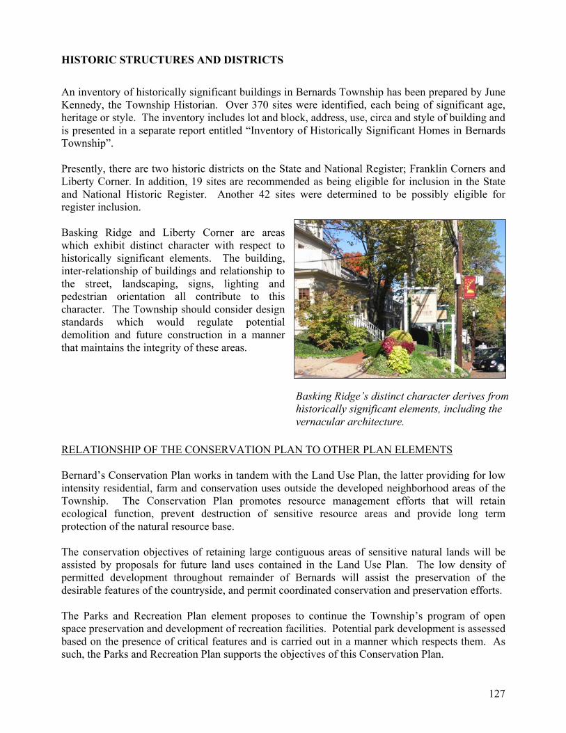
HISTORIC STRUCTURES AND DISTRICTS
An inventory of historically significant buildings in Bernards Township has been prepared by June Kennedy, the Township Historian. Over 370 sites were identified, each being of significant age, heritage or style. The inventory includes lot and block, address, use, circa and style of building and is presented in a separate report entitled “Inventory of Historically Significant Homes in Bernards Township”. Presently, there are two historic districts on the State and National Register; Franklin Corners and Liberty Corner. In addition, 19 sites are recommended as being eligible for inclusion in the State and National Historic Register. Another 42 sites were determined to be possibly eligible for register inclusion. Basking Ridge and Liberty Corner are areas which exhibit distinct character with respect to historically significant elements. The building, inter-relationship of buildings and relationship to the street, landscaping, signs, lighting and pedestrian orientation all contribute to this character. The Township should consider design standards which would regulate potential demolition and future construction in a manner that maintains the integrity of these areas. RELATIONSHIP OF THE CONSERVATION PLAN TO OTHER PLAN ELEMENTS Bernard’s Conservation Plan works in tandem with the Land Use Plan, the latter providing for low intensity residential, farm and conservation uses outside the developed neighborhood areas of the Township. The Conservation Plan promotes resource management efforts that will retain ecological function, prevent destruction of sensitive resource areas and provide long term protection of the natural resource base. The conservation objectives of retaining large contiguous areas of sensitive natural lands will be assisted by proposals for future land uses contained in the Land Use Plan. The low density of permitted development throughout remainder of Bernards will assist the preservation of the desirable features of the countryside, and permit coordinated conservation and preservation efforts. The Parks and Recreation Plan element proposes to continue the Township’s program of open space preservation and development of recreation facilities. Potential park development is assessed based on the presence of critical features and is carried out in a manner which respects them. As such, the Parks and Recreation Plan supports the objectives of this Conservation Plan.
Basking Ridge’s distinct character derives from historically significant elements, including the vernacular architecture.

128
The Circulation Plan element proposes the establishment and expansion of a comprehensive network of sidewalks, bikeways and paths that will promote non-vehicular travel and reduce the air quality impacts of motorized vehicles. These expanding opportunities for access to open spaces, recreation areas and other destinations will also have human health benefits as more residents become involved in these activities. The impacts on natural resources from the circulation and utility service plan elements will be minor, since they do not propose significant alterations to the existing road network and no new infrastructure and utility services are proposed.