the prince frederick town center charrette report · 2013-12-17 · walking distance of this...
TRANSCRIPT

for the Heart of Calvert CountyL AW R E N C E G R O U P | F U S S & O ’N E I L L | C A LV E R T CO U N T Y B OA R D O F CO U N T Y CO M M I S S I O N E R S
The Prince Frederick Town Center Charrette Report

© 2013 by Lawrence Group and the Calvert County Board of County Commissioners. All Photos and Images by Lawrence Group and their sub consultants unless otherwise noted. Reproduction Permitted with Credit in Print.
The Prince Frederick Town Center Plan was prepared for:
Calvert County Board of County CommissionersPat Nutter, Board PresidentJerry ClarkSusan ShawEvan SlaugenhauptSteve Weems
Calvert County Planning CommissionMaurice Lusby, ChairMike Phipps, Vice-chairRoxAnne CumberlandMalcolm FunnRobert ReedBill GlascockCarolyn McHugh
Calvert County Community Planning and BuildingMary Beth Cook, Acting DirectorWill Selman, CNU-a, Community DesignerJenny Plummer-Welker, AICP, Principal PlannerPatricia Haddon, AICP, Principal PlannerYolanda Hipski, AICP, Planning Commission AdministratorRay Alvey, GIS TechnicianKirsti Uunila, RPA, Historic Preservation PlannerLisa Govoni, Intern
Project TeamLawrence Group | Craig Lewis, Project Manager; Monica Holmes, Aleksandra Borisenko, Amanda Huggins, David Walters, Scott Curry, Carolyn Reid, Keihly Moore, Ethan Primm
Fuss & O’Neill | Sarah Lewis, Wade Walker
Doctoral Student Volunteer | Remy Vigneron

iiiT H E P R I N C E F R E D E R I C K TO W N C E N T E R C H A R R E T T E R E P O R T: F O R T H E H E A R T O F C A LV E R T CO U N T Y | D R A F T 12.17.2013 | P R I N C E F R E D E R I C K , MA RY L A N D
Table of Contents1. CONTEXT & THE PLANNING PROCESS
1.1 INTRODUCTION . . . . . . . . . . . . . . . . . . . . . . . . . . . . . . . . . . . . . . . . . . . . . . . . . 3
1.2 EXISTING CONDITIONS . . . . . . . . . . . . . . . . . . . . . . . . . . . . . . . . . . . . . . . . . . 6
1.3 DESIGN CHARRETTE . . . . . . . . . . . . . . . . . . . . . . . . . . . . . . . . . . . . . . . . . . . . . 8
2. THE VISION
2.1 REDEVELOPMENT OPPORTUNITIES . . . . . . . . . . . . . . . . . . . . . . . . . . . . . . . 13
2.2 HOSPITAL AREA . . . . . . . . . . . . . . . . . . . . . . . . . . . . . . . . . . . . . . . . . . . . . . . . 14
2.3 RESIDENTIAL INFILL NEIGHBORHOODS . . . . . . . . . . . . . . . . . . . . . . . . . . . 17
2.4 COLLEGE AREA . . . . . . . . . . . . . . . . . . . . . . . . . . . . . . . . . . . . . . . . . . . . . . . . 18
2.5 CONCEPTUAL REDEVELOPMENT OF THE FOX RUN SHOPPING CENTER . 19
2.6 CONCEPTUAL INFILL DEVELOPMENTS . . . . . . . . . . . . . . . . . . . . . . . . . . . . 22
2.7 HISTORIC DOWNTOWN . . . . . . . . . . . . . . . . . . . . . . . . . . . . . . . . . . . . . . . . . 23
2.8 HALLOWING POINT ROAD . . . . . . . . . . . . . . . . . . . . . . . . . . . . . . . . . . . . . . . 25
2.9 ARMORY SQUARE TOWN CENTER . . . . . . . . . . . . . . . . . . . . . . . . . . . . . . . . 26
2.10 ARMORY SQUARE NEIGHBORHOOD . . . . . . . . . . . . . . . . . . . . . . . . . . . . . . 30
2.11 STREETSCAPE IMPROVEMENTS AT ROUTE 2-4 & DARES BEACH ROAD 32
3. IMPLEMENTATION
3.1 PRINCE FREDERICK TOWN CENTER ZONING . . . . . . . . . . . . . . . . . . . . . . . . 37
EXISTING ZONING ORDINANCE . . . . . . . . . . . . . . . . . . . . . . . . . . . . . . . . . . . . . . . . . 37
KEY POLICY RECOMMENDATIONS . . . . . . . . . . . . . . . . . . . . . . . . . . . . . . . . . . . . . . . 37
3.2 REGULATORY IMPROVEMENTS RECOMMENDATIONS . . . . . . . . . . . . . . . 38
EXPAND EXISTING TOWN CENTER BOUNDARY . . . . . . . . . . . . . . . . . . . . . . . . . . . . 38
PROPOSED DISTRICTS . . . . . . . . . . . . . . . . . . . . . . . . . . . . . . . . . . . . . . . . . . . . . . . . . 38
PEDESTRIAN-ORIENTED DISTRICTS . . . . . . . . . . . . . . . . . . . . . . . . . . . . . . . . . . . . . 39
ORGANIZATION OF A PEDESTRIAN-ORIENTED DISTRICT . . . . . . . . . . . . . . . . . . . . 39
PARKING . . . . . . . . . . . . . . . . . . . . . . . . . . . . . . . . . . . . . . . . . . . . . . . . . . . . . . . . . . . . . 40
DENSITY . . . . . . . . . . . . . . . . . . . . . . . . . . . . . . . . . . . . . . . . . . . . . . . . . . . . . . . . . . . . . 40
HEIGHT . . . . . . . . . . . . . . . . . . . . . . . . . . . . . . . . . . . . . . . . . . . . . . . . . . . . . . . . . . . . . . 40
DESIGN STANDARDS . . . . . . . . . . . . . . . . . . . . . . . . . . . . . . . . . . . . . . . . . . . . . . . . . . 41
3.3 SUSTAINABILITY RECOMMENDATIONS . . . . . . . . . . . . . . . . . . . . . . . . . . . . 42
3.4 GREEN SPACE RECOMMENDATIONS . . . . . . . . . . . . . . . . . . . . . . . . . . . . . . 44
3.5 MOBILITY RECOMMENDATIONS . . . . . . . . . . . . . . . . . . . . . . . . . . . . . . . . . . 46
3.6 IMPLEMENTATION OF ARMORY SQUARE . . . . . . . . . . . . . . . . . . . . . . . . . . 50
3.7 TRANSFER OF DEVELOPMENT RIGHTS. . . . . . . . . . . . . . . . . . . . . . . . . . . . . 50


SECTION 1: CONTEXT &THE PLANNING PROCESS
1.1 INTRODUCTION . . . . . . . . . . . . . . . . . . . . . . . . . . . . . . . . . . . . . . . . . . . . . . . . . 3
1.2 EXISTING CONDITIONS . . . . . . . . . . . . . . . . . . . . . . . . . . . . . . . . . . . . . . . . . . . 6
1.3 DESIGN CHARRETTE . . . . . . . . . . . . . . . . . . . . . . . . . . . . . . . . . . . . . . . . . . . . . 8


3T H E P R I N C E F R E D E R I C K TO W N C E N T E R C H A R R E T T E R E P O R T: F O R T H E H E A R T O F C A LV E R T CO U N T Y | D R A F T 12.17.2013 | P R I N C E F R E D E R I C K , MA RY L A N D
1 : CONTEXT & THE PLANNING PROCESS
1.1 Introduction
THE TOWN OF PRINCE FREDERICK CELEBRATES ITS 325TH ANNIVERSARY
The following comments are excerpts from a speech given by the Mayor of Prince Frederick at the Town Day Festival celebrated at Armory Square
I stand before you today in great thanksgiving for the foresight my predecessors had in establish this great town of ours. What began as a humble crossroads 325 years ago has blossomed into a vibrant community of more than 6500 fantastic, community-minded citizens. In addition we are blessed to have more than 5000 employees working in the town every day, bustling shopping and restaurant venues, a dedicated transit system, and one of the most extensive trail systems in all of Maryland, connecting every aspect of our fair town with the Bay to the east, the River to the west and to our sister communities north and south of here. And like everything that we have done in Calvert County for the past 100 hundred years, good planning has been the underpinning of every decision.
Our predecessors understood that careful planning and managed growth ensured excellent schools that weren’t overcrowded, stable home values, and excellent water quality in our streams and perhaps most importantly in the Chesapeake Bay. And when
the time was right, they carefully began to turn their sights on directing an increased but still managed level of growth into our town centers, particularly Prince Frederick.
It was a time of dramatic demographic upheaval. The generation known as the “Baby Boomers” began to retire and their children, known as the Millennials, including many of you here today, decided to take a different path to the American dream. Your path was one that desired the closeness and camaraderie that only an authentic place can offer, in spite of how dependent we have become with our technological “sidearms.” You sought out places where walkability meant that not only were sidewalks and trails pre-conditions, they were essential connections to those places to meet others, exercise, shop, and work. You also shed the notion that the American Dream requires a house, a lot, and a mortgage in favor of a lifestyle that offered you access to the amenities of our community within a short walk instead of a 3 car garage or an unused 4th bedroom. You understood that true sustainability embraced not only environmentalism, but also economic vibrancy and social infrastructure as critical to each public policy decision. And finally, you embraced the diversity of our American population by adapting our community to our youth, our young adults, our families, and our “55 and better” population.
IN 2040, IN THE TOWN OF PRINCE FREDERICK
Mixed-use neighborhoods with a wide variety of housing serve as the fundamental building block for the TownRoute 2/4 is efficient, attractive and crossableThe Hospital District is flourishing as a center for medical excellence and wellnessShopping centers have been regenerated with high quality tenants and new mixed-use infill development The Historic Courthouse area is enlivened with activities and a formal public lawn for town activitiesPedestrians and bicyclists have safe and attractive paths to get anywhere in town on a new system of paths and trails that connects the Town to the rural land and the water’s edgeOutdoor spaces throughout the town host a variety of sporting events, pleasant outdoor eating spaces, places to stroll around and enjoy the outdoorsJobs relocate from throughout the region to the town to take advantage of its high quality of lifeThe Armory and its Square serve as the centerpiece of a mixed-use village center The Town serves as a model of environmental stewardship, livability, and economic stability
May, 2049Calvert County Times

4 T H E P R I N C E F R E D E R I C K TO W N C E N T E R C H A R R E T T E R E P O R T: F O R T H E H E A R T O F C A LV E R T CO U N T Y | D R A F T 11.1.2013 | P R I N C E F R E D E R I C K , MA RY L A N D
1 : CONTEXT & THE PLANNING PROCESS
Our leaders used a combination of strategic investments in our infrastructure, a change in growth management policy to encourage more development and specifically redevelopment in the town center, and well-crafted pedestrian-oriented districts to guide development using the very highest standards of excellence, to create not only a shopping destination or a place to work, but a truly lovable place.
They preserved our beloved Armory, transformed it into a unique community amenity and surrounded it with a public space and new development so elegant, that even our neighbors up in Annapolis can occasional be seen strolling our streets on a Saturday morning.They encouraged new housing of every variety to be within walking distance of this wonderful Armory Square, our historic downtown, our aquatic center, and our library. They even worked with the hospital to create an award-winning village centered around living healthy lifestyles.They preserved our ages-old Wisteria vine, created a dignified park around it, and established a regular program of activities in our historic core that bring every corner of our community together. They completed a network of streets that gives us lot of options for moving around and through Prince Frederick and once these essential car projects were complete they spent most of their funds on mobility for people in the form of our network of sidewalks, bicycle facilities, and trails that are the envy of all of southern Maryland.And perhaps most importantly they were not content with Route 2/4 being the great dividing line so they implemented their vision of a grand, tree-lined boulevard and those old shopping center parking lots filled in with buildings that rival the grandeur of the Champs Elysees in Paris.
In addition to our town’s 325th anniversary, today we also celebrate the 33rd anniversary of the christening of this Armory Square. You may remember that at one time, the ground on which we stand housed a school, or more specifically its parking lot.
Though the creation of this space was not without controversy, our County never saw as large a crowd gathering as they did on that first Christmas after it was completed and the grand lawn was converted for three months to an outdoor skating rink. Thousands of our residents gathered in what could only be regarded as a Norman Rockwell painting of the near perfect community. Over time, as the blocks around the square began to fill in with all of these wonderful apartments and shops, we came to fully realize that great public space can create tremendous economic value.
And finally, my fellow citizens, we know that our job is still not done. Do your remember back when gas was less than $4 per gallon? Though we were an early adopter of electric vehicles, we knew that our cars alone were still not the complete answer. We continue to fight to extend the rapid transit line from Baltimore and the District of Columbia to our community. This is a fight that we must continue with the same vigor with which we rebuilt our Solomon Island Boulevard that some of you old timers still refer to as Route 2/4. The result of all that hard work is before you today. If you asked your grandparent to cross Route 2/4 on foot back in 2013 they would have seriously and rightfully questioned your sanity. Today, people from all throughout the County know that Prince Frederick is a truly special place and honor both pedestrians and bicyclists up and down the corridor. Not only were lives saved through better roadway design, but we created so much value in the Town, that the County has been able to enjoy one of the most stable property tax rates in the state.
As we cast our eyes forward on the future, I cannot help but think of my great, great, great grandchildren celebrating our 400th anniversary in this same place. Will they finally have the hover cars that television and movies promised back in the 20th century? I do not know. But if our human history is any indication we need only to look to the great international cities and towns which for more than a thousand years have created places of enduring value that play to the most basic of human needs – the need to be together.

5T H E P R I N C E F R E D E R I C K TO W N C E N T E R C H A R R E T T E R E P O R T: F O R T H E H E A R T O F C A LV E R T CO U N T Y | D R A F T 12.17.2013 | P R I N C E F R E D E R I C K , MA RY L A N D
1: CONTEXT & THE PLANNING PROCESS
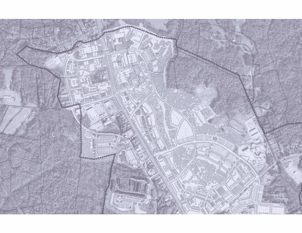
STUDY AREA
WHY THIS PLAN? WHY NOW?
24 years since the Town Center Plan was adopted Time for reflection, evaluation and new goals: – What works?
– What is not working?
– What will the next 25 years in Prince Frederick hold?
THINGS ARE DIFFERENT TODAY
Demographics are changing more rapidly nationally and locallyMore than $460 million in retail sales leaves the county each year (leakage)60% of the population leaves the county each day to work
DEMOGRAPHIC SHIFTS & TRENDS
Most dominant – Generation Y (16-30) – 82 million (25% of population)Decreasing % of Married Couple Family Households (US Dropped 3.25% Since 2000 – Calvert Dropped 4% to 60.7 in 2010)Migration, immigration & diverse culturesGlobal population to increase from 7 to 8 billion by 2020, 9.2 billion by 2050. Average annual growth peaked @ 2.19% in 1963Baby Boomers began retiring in 2011 (24% of population)Elderly are the fastest growing population segment: (65+) 6.5% to 9% by 2020, 17% by 2050
Imag
e Sou
rce: w
ww.sm
eco.co
op
RO
UT
E 2
-4
DARES B
EACH R
D
STOAKLEY RD
HALLOWING POINT RD
MA
IN S
T
– Existing Town Center Boundary
– Study Area Boundary
Image Source: http://www.planning.org/planning/2013/mar/diversityandaging.html
REAL ESTATE TRENDS
from the National Association of Realtors
Future Trends: – 35% Apartments
– 25% Large Lot Housing
– 20% Townhouses
– 20% Small Cottage
54% of Eligible Home Buyers Surveyed Want Walkable Neighborhoods Close to Shopping and Amenities

6 T H E P R I N C E F R E D E R I C K TO W N C E N T E R C H A R R E T T E R E P O R T: F O R T H E H E A R T O F C A LV E R T CO U N T Y | D R A F T 11.1.2013 | P R I N C E F R E D E R I C K , MA RY L A N D
RO
UT
E 2
-4
DARES B
EACH R
D
STOAKLEY RD
HALLOWING POIN
T RD
MA
IN S
T
– Slope > 25%
– Water / Wetlands
– Existing Town Center Boundary
1: CONTEXT & THE PLANNING PROCESS
EXISTING ZONING
– EC: Employment Center
– FFD: Farm & Forest District
– I-1: Light Industrial
– MC: Marine Commercial
– RC: Rural Commercial
– RCD: Rural Community District
– RD: Residential District
– WL: Wetlands
RO
UT
E 2
-4
DARES B
EACH R
D
STOAKLEY RD
HALLOWING POINT RD
MA
IN ST
CURRENT ACTIVITY CENTERS OR NODES
The Town Center is actually composed of a number of nodes of activity including commercial areas, the hospital district, the old downtown and government district as well as some emerging civic nodes around schools, libraries, and community centers.
ZONING
The existing zoning is regulated by The Prince Frederick Master Plan & Zoning Ordinance (prepared by the Calvert County Department of Planning & Zoning) that was originally adopted in July 1989, and amended through March 2008. The zoning ordinance is broken into chapters covering Natural Features, Travelways, Site Design, Building Design & Height Requirements, Sign Design, Development Districts, and Architectural Review Procedures and is illustrated throughout by supporting graphics.
ENVIRONMENTAL CONSTRAINTS WITH CURRENT
TOWN CENTER BOUNDARY
ENVIRONMENTAL CONSTRAINTS
Calvert County benefits from an abundance of natural features. In many ways the waterways and old growth forests are an amenity, however these elements can provide numerous challenges to new development. By mapping the environmental constraints early in the study process, the potential growth of the Town Center can incorporate these areas as features rather than encumbrances making the proposed solutions more realistic and sustainable.
1.2 Existing Conditions
ACTIVITY CENTERS
Middle School
High School
Old Middle School Site
Aquatic Center
Hospital
Library
Senior Center
Old Town / Government Center
Elementary school
Community College
RO
UT
E 2
-4
DARES B
EACH R
D
STOAKLEY RD
HALLOWING POINT RD
MA
IN S
T
– Activity Center
– 5-minute walk (1/4 mile radius)
– Proposed Town Center Boundary
– Existing Town Center Boundary

7T H E P R I N C E F R E D E R I C K TO W N C E N T E R C H A R R E T T E R E P O R T: F O R T H E H E A R T O F C A LV E R T CO U N T Y | D R A F T 12.17.2013 | P R I N C E F R E D E R I C K , MA RY L A N D
1 : CONTEXT & THE PLANNING PROCESS
IMAGES OF EXISTING CONDITIONS

8 T H E P R I N C E F R E D E R I C K TO W N C E N T E R C H A R R E T T E R E P O R T: F O R T H E H E A R T O F C A LV E R T CO U N T Y | D R A F T 11.1.2013 | P R I N C E F R E D E R I C K , MA RY L A N D
1: CONTEXT & THE PLANNING PROCESS
1.3 Design Charrette VISION DRIVEN
CHARRETTE PROCESSCharrette is “little cart” in French. In 19th century Paris, design professors circulated carts to collect final drawings from students. Students jumped on the carts to finish their work as they were pulled through the streets in public view. The term charrette has evolved to mean an open public design process.

9T H E P R I N C E F R E D E R I C K TO W N C E N T E R C H A R R E T T E R E P O R T: F O R T H E H E A R T O F C A LV E R T CO U N T Y | D R A F T 12.17.2013 | P R I N C E F R E D E R I C K , MA RY L A N D
1 : CONTEXT & THE PLANNING PROCESS
KEY WORDS GENERATED BY PUBLIC WORKSHOP ATTENDEES BASED ON THEIR
FREQUENCY OF USE
VISION DRIVEN COMMUNITY DESIGN
CHARRETTE SCHEDULE
Monday June 10
7:00 pm Kickoff Presentation and Public Workshop
Tuesday June 11
9:00 am Open Design Studio9:30 am Environment11:00 am Recreation and Youth2:00 pm Retail and Commercial3:30 pm Middle School / Armory Options7:00 pm Public Review / Pin- up Session
Wednesday June 12
9:00 am Open Design Studio 10:00 am Traffic / Transportation / Corridor Design11:30 am Economic Development2:00 pm Housing Options3:30 pm Parks and Open Space7:00 pm Public Review / Pin- up Session
Thursday June 13
9:00 am Open Design Studio9:30 am Health and Public Safety 11:00 am Homeowners / Civic Associations7:00 pm Public Review / Pin- up Session
Friday June 14
9:00 am Open Design Studio9:30 am Ordinances and Design Standards11:00 am Signage, Lighting, Landscaping7:00 pm Public Review / Pin- up Session
Tuesday June 18
7:00 pm Closing Presentation
PROCESS DRIVEN The more complicated the process, the greater the lack of vision


SECTION 2: THE VISION
2.1 REDEVELOPMENT OPPORTUNITIES . . . . . . . . . . . . . . . . . . . . . . . . . . . . . . . 13
2.2 HOSPITAL AREA . . . . . . . . . . . . . . . . . . . . . . . . . . . . . . . . . . . . . . . . . . . . . . . . 14
2.3 RESIDENTIAL INFILL NEIGHBORHOODS . . . . . . . . . . . . . . . . . . . . . . . . . . . 17
2.4 COLLEGE AREA . . . . . . . . . . . . . . . . . . . . . . . . . . . . . . . . . . . . . . . . . . . . . . . . 18
2.5 CONCEPTUAL REDEVELOPMENT OF THE FOX RUN SHOPPING CENTER . 19
2.6 CONCEPTUAL INFILL DEVELOPMENTS . . . . . . . . . . . . . . . . . . . . . . . . . . . . 22
2.7 HISTORIC DOWNTOWN . . . . . . . . . . . . . . . . . . . . . . . . . . . . . . . . . . . . . . . . . 23
2.8 HALLOWING POINT ROAD . . . . . . . . . . . . . . . . . . . . . . . . . . . . . . . . . . . . . . . 25
2.9 ARMORY SQUARE TOWN CENTER . . . . . . . . . . . . . . . . . . . . . . . . . . . . . . . . 26
2.10 ARMORY SQUARE NEIGHBORHOOD . . . . . . . . . . . . . . . . . . . . . . . . . . . . . . 30
2.11 STREETSCAPE IMPROVEMENTS AT ROUTE 2-4 & DARES BEACH ROAD..32

13T H E P R I N C E F R E D E R I C K TO W N C E N T E R C H A R R E T T E R E P O R T: F O R T H E H E A R T O F C A LV E R T CO U N T Y | D R A F T 12.17.2013 | P R I N C E F R E D E R I C K , MA RY L A N D
2: THE VISION
DEVELOPMENT NUMBERS
DEVELOPMENT TYPES NUMBER OF UNITS / SFDetached Housing 210-230
Townhomes 380-440
Mansion Apartments 330-360
Apartments (Garden and Loft) 1,200
Apartments over Retail 200
Live-Work 40-60
Retirement Village 620
Office 730,000 - 1,134,000 sf
Medical Office 54,000 - 354,000 sf
Hospital 394,000 sf
Retail 700,000 - 825,000 sf
Hotel 100 rooms
Civic Buildings 66,000 - 140,000 sf
Public Space and Athletic Fields 11-15 acres of public space + 10-25 acres of ballfields
Trails 3-6 miles
A master plan looks far into the future and shows a realistic image of the growth that could occur given an ideal set of conditions. This “perfect world” may never occur in the exact condition illustrated but gives residents and administrators alike a vision to guide decisions about future development. It is difficult to determine what the future economic situation may bring so a number of options are considered.
The physical potential for the Town Center to grow and infill with new development is great. These graphics show two possible full-build scenarios that assume the market conditions and regulations are favorable. The potential program of each of these scenario’s is also shown below to demonstrate the possible balance of uses, both public and private, and the variety of housing types that could be included. More details and additional options of the specific areas are shown on the following pages.
2.1 Redevelopment Opportunities
REDEVELOPMENT OPPORTUNITIES
STOAKLEY RD
RO
UT
E 2
-4
DARES BEACH R
D
MA
IN S
T
HALLOWING POINT RD
HospitalDistrict
CulturalDistrict
CivicDistrict
College

14 T H E P R I N C E F R E D E R I C K TO W N C E N T E R C H A R R E T T E R E P O R T: F O R T H E H E A R T O F C A LV E R T CO U N T Y | D R A F T 11.1.2013 | P R I N C E F R E D E R I C K , MA RY L A N D
2: THE VISION
2.2 Hospital AreaLONG RANGE PLAN - PHASE 1
Calvert Memorial Hospital is an important part of Prince Frederick Town Center, not only by providing the necessary medical care but also being a large employer and cooperative neighbor. The hospital is committed to the community and is already considering expansion plans to accommodate additional service requirements. As the needs of the community changes, so does the size and operation of the hospital.
Demographic trends and predictions indicate the Millennials and the Baby Boomers are critical population groups that require an emphasis, although different focuses, on health and wellness. The Medical District has a number of design scenarios that can support these large segments of the population and is located to take advantage of existing and proposed facilities. Campuses of offices and clinics can provide medical support beyond the in-patient hospital services, and the natural features of the area provide plenty of walking/biking.
EXISTING CONDITIONS CONCEPTUAL LONG RANGE PLAN FOR THE HOSPITAL AREA - PHASE 1Potential hospital expansion and supporting buildings for medical offices and clinics
Imag
e Sou
rce: C
alve
rt Co
unty
DEVELOPMENT NUMBERS
DEVELOPMENT TYPES NUMBER OF UNITS / SFApartments (Gardens & Loft) 98
Mansion Apartments 56
Retail 30,000 sf
New Medical Office 354,000 sf
New Hospital 394,000 sf
Retirement Village 115
Off-Street Parking Spaces 1,510 spaces
Existing Hospital
RO
UT
E 2
-4
STOAKLEY RD
AUTO DR
HO
SPIT
AL R
D
HA
RROW
LN
CH
ES
AP
EA
KE
BL
VD
Hospital ExpansionMedical
Offices
MedicalOffices
Retirement Village
Future Hospital
Expansion

15T H E P R I N C E F R E D E R I C K TO W N C E N T E R C H A R R E T T E R E P O R T: F O R T H E H E A R T O F C A LV E R T CO U N T Y | D R A F T 12.17.2013 | P R I N C E F R E D E R I C K , MA RY L A N D
2: THE VISION
CONCEPTUAL LONG RANGE PLAN - EXISTING HOSPITAL AS A RETIREMENT VILLAGE
LONG-RANGE PLAN - PHASE 2
As medical technology changes and improves, the existing hospital building will eventually become obsolete. Removing the existing building provides additional redevelopment potential in the Medical District. The adjacency to the hospital to share staff and facilities could be an ideal location for a Retirement Village – a continuing care community that includes independent living, assisted living, and a nursing home.
DEVELOPMENT NUMBERS
DEVELOPMENT TYPES NUMBER OF UNITS / SFMedical Office 12,000 sf
Retirement Village 500 units
Off-Street Parking Spaces 294 spaces
RO
UT
E 2
-4
STOAKLEY RD
HO
SP
ITA
L R
D
HA
RROW
LN
Retirement Village
CH
ES
AP
EA
KE
BL
VD

16 T H E P R I N C E F R E D E R I C K TO W N C E N T E R C H A R R E T T E R E P O R T: F O R T H E H E A R T O F C A LV E R T CO U N T Y | D R A F T 11.1.2013 | P R I N C E F R E D E R I C K , MA RY L A N D
2: THE VISION
EXAMPLES OF RETIREMENT LIVING HOUSING TYPESClockwise: Bungalow Court, Urban Mansion, Town Homes, Apartments
HOUSING ALONG THE CHESAPEAKE BOULEVARD OPTION
Instead of the medical office campus shown in other plans, this illustration shows the potential for a quiet residential enclave nestled amongst trees but within easy walking distance to the hospital and other areas within the town center. Whether developed privately or as part of the hospital, a varied mix of housing types could be sold at market rate or provide affordable homes for staff and nurses to live close to work.
CONCEPTUAL LONG RANGE PLAN - HOUSING ALONG THE CHESAPEAKE BOULEVARD
DEVELOPMENT NUMBERS
DEVELOPMENT TYPES NUMBER OF UNITS / SFDetached Housing 16
Apartments (Gardens & Loft) 36
Townhomes 25
Mansion Apartments 16
Off-Street Parking Spaces 84
Housing
Retirement Village
Hospital Expansion
CH
ES
AP
EA
KE
BL
VD

17T H E P R I N C E F R E D E R I C K TO W N C E N T E R C H A R R E T T E R E P O R T: F O R T H E H E A R T O F C A LV E R T CO U N T Y | D R A F T 12.17.2013 | P R I N C E F R E D E R I C K , MA RY L A N D
ILLUSTRATIVE PLAN OF COSTLEY PARK INFILL DEVELOPMENT
ILLUSTRATIVE PLAN OF CHAPLINE INFILL DEVELOPMENT
COSTLEY PARK
This proposed new housing development takes advantage of land across Prince Frederick Boulevard with terrific proximity to the library and Market Square. While the market demands will have a large influence on the ultimate program, a mix of town houses and small apartment buildings would provide a good density and the possibility for small office uses.
Food Lion
PRINCE FREDERICK BLVD
CO
ST
LE
Y W
AY
DEVELOPMENT NUMBERS
COSTLEY PARK CHAPLINEDEVELOPMENT TYPES NUMBER OF UNITS / SF NUMBER OF UNITS / SFDetached Housing - 8
Townhomes 92 62
Mansion Apartments 12 8
Apartments (Garden and Loft) - 28
Office 34,000 sf -
Retail - 4,000 sf
Civic Buildings - 1,000 sf
Public Space and Athletic Fields 65,500 sf 98,000 sf
Off-Street Parking Spaces 83 spaces 25 spaces
PR
INC
E F
RE
DE
RIC
K B
LV
D
CAMBRIDGE PL
Existing Chapline
Development
CHAPLINE
The existing Chapline community is comprised of town homes and apartment buildings. The adjacent parcel to the south lends itself to a second phase of this successful neighborhood. A greater mix of unit types (apartments, townhouses, and cottages) with a few small commercial uses to create a complete community in a good location.
ILLUSTRATION OF AN INTIMATE STREET WITH TOWNHOMES
2.3 Residential Infill Neighborhoods
2: THE VISION

18 T H E P R I N C E F R E D E R I C K TO W N C E N T E R C H A R R E T T E R E P O R T: F O R T H E H E A R T O F C A LV E R T CO U N T Y | D R A F T 11.1.2013 | P R I N C E F R E D E R I C K , MA RY L A N D
CONCEPTUAL PLAN FOR THE COLLEGE AREA - NEIGHBORHOOD (OPTION A)
CONCEPTUAL PLAN WITH NEIGHBORHOOD EMPHASIS OPTION
The College of Southern Maryland’s (CSM) Prince Frederick Campus is a new facility, built in 2005, featuring state-of-the-art classrooms and network systems at Hallowing Point Road (Rt. 231) and J.W. Williams Road. As the existing building has already reached capacity and the student body continues to grow, the institution will become an even more important part of the Town Center community.
While CSM functions as a commuter school rather than a residential college, there is adjacent land available that could serve the student body, as well as Prince Frederick at-large, for housing needs. Connecting West Dares Beach Road to J.W. Williams Road gives access.
CONCEPTUAL PLAN FOR THE COLLEGE AREA - EMPLOYMENT CENTER (OPTION B)
HALLOWING POINT RD
W DARES BEACH RD
JW W
ILLIAM
S RD
HE
LE
NA
DR
College of Southern Maryland
EXISTING CONDITIONS
DEVELOPMENT NUMBERS
NEIGHBORHOOD EMPHASIS OPTION EMPLOYMENT CENTER EMPHASIS OPTION
DEVELOPMENT TYPES NUMBER OF UNITS / SF NUMBER OF UNITS / SFDetached Housing 22 -
Mansion Apartments 53 -
Apartments (Garden and Loft) 588 -
Office - 348,400 sf
Retail 27,000 sf 27,000 sf
Civic Buildings 29,000 sf 29,000 sf
Off-Street Parking Spaces 1,114 spaces 1,352 spaces
CONCEPTUAL PLAN FOR AN EMPLOYMENT CENTER OPTION
The Strategic Plan states “CSM effectively addresses the life-long educational, workforce development, cultural, and community needs of a changing Southern Maryland.” As the college continues to grow, the mission will continue to evolve as the employment needs within Calvert County, and the rest of southern Maryland, adapt to changing markets and technologies. This could be an opportunity for an employment center adjacent to the campus with a symbiotic relationship between students and employers.
2.4 College Area
JW W
ILLIAM
S RD
College of Southern Maryland
W D
ARES B
EACH R
D
2: THE VISION

19T H E P R I N C E F R E D E R I C K TO W N C E N T E R C H A R R E T T E R E P O R T: F O R T H E H E A R T O F C A LV E R T CO U N T Y | D R A F T 12.17.2013 | P R I N C E F R E D E R I C K , MA RY L A N D
2.5 Conceptual Redevelopment of the Fox Run Shopping Center PHASE 1
As buildings come to the end of their useful life, it is often financially beneficial for owners to replace rather than repair. This series of studies investigates how the different sections of the Fox Run Shopping Center can be replaced over time in phases to limit the loss of income and considerable construction cost a full redevelopment would require.
Phase 1 suggests removing only the northernmost portion that currently houses the Big Kmart. The redevelopment shown includes single-family homes facing Steeplechase Drive and the woods beyond along with live/work units and some small footprint commercial uses.
PHASE 2
The next section of redevelopment could be further south to the Giant Food store. Shown here are more detached houses and apartment-type dwellings with surface parking provided behind the buildings.
PHASE 3
The final phase would remove the current buildings to Fox Run Boulevard, add additional housing, and create a new retail or restaurant use on the corner of Route 2/4 and Fox Run Boulevard.
PHASE 1 PHASE 2 PHASE 3 EXISTING CONDITIONS
DEVELOPMENT NUMBERS
PHASE 1 PHASE 2 PHASE 3DEVELOPMENT TYPES NUMBER OF UNITS / SF NUMBER OF UNITS / SF NUMBER OF UNITS/SFDetached Housing 14 8 7
Live-Work 40 20 24
Office 24,000 sf 18,000 sf -
Retail 38,000 sf 18,000 sf 14,500 sf
Off-Street Parking Spaces 189 spaces 156 spaces 160 spaces
Existing Fox Run
ShoppingCenter
RO
UT
E 2
-4
HA
RR
OW
LN
FOX RUN BLVD
RO
UT
E 2
-4
HA
RR
OW
LN
FOX RUN BLVD
Existing Fox Run
ShoppingCenter
RO
UT
E 2
-4
HA
RR
OW
LN
FOX RUN BLVD
2: THE VISION

20 T H E P R I N C E F R E D E R I C K TO W N C E N T E R C H A R R E T T E R E P O R T: F O R T H E H E A R T O F C A LV E R T CO U N T Y | D R A F T 11.1.2013 | P R I N C E F R E D E R I C K , MA RY L A N D
ILLUSTRATION FOR FOX RUN REDEVELOPMENT - EXISTING CONDITIONS
ILLUSTRATION FOR FOX RUN REDEVELOPMENT - PHASE 1
CREATION OF A “MAIN STREET”
The existing driveway directly in front of the Fox Run shops is frequently used as part of the street network instead of simply an access to the shopping center. This proposal is to formalize that traffic pattern into a real street with two-way traffic, on-street parking, and wide sidewalks with shade trees and street lights. This street will be an extension of Armory Road and therefore be connected directly to the new town green, and even to historic Main Street.
PROPOSED SECTION FOR THE “MAIN STREET”
SIDEWALK
4’ X 6’ TREE WELL
DECORATIVE STREET LIGHT
40’
20’
16’4’4’
16’8’ 8’10’ 10’36’
RO
UT
E 2
-4R
OU
TE
2-4
LOCATION OF THE
“MAIN STREET”Existing driveway directly in front of the Fox Run shops converted into a formalized street with on-street parking, street trees, and wide sidewalks
RO
UT
E 2
-4
HA
RR
OW
LN
FOX RUN BLVD
“MA
IN” S
TR
EE
T
2: THE VISION

21T H E P R I N C E F R E D E R I C K TO W N C E N T E R C H A R R E T T E R E P O R T: F O R T H E H E A R T O F C A LV E R T CO U N T Y | D R A F T 12.17.2013 | P R I N C E F R E D E R I C K , MA RY L A N D
ILLUSTRATION FOR FOX RUN REDEVELOPMENT - PHASE 2
ILLUSTRATION FOR FOX RUN REDEVELOPMENT - PHASE 3
RO
UT
E 2
-4
RO
UT
E 2
-4
EXAMPLES OF MIXED-USE MAIN STREETSFrom top to bottom: Baxter Village (Fort Mill, SC), Legacy Village (Lyndhurst, OH), Crocket Park (Westlake, OH)
2: THE VISION

22 T H E P R I N C E F R E D E R I C K TO W N C E N T E R C H A R R E T T E R E P O R T: F O R T H E H E A R T O F C A LV E R T CO U N T Y | D R A F T 11.1.2013 | P R I N C E F R E D E R I C K , MA RY L A N D
EXISTING CONDITIONS
2.6 Conceptual Infill DevelopmentsINFILL HOUSING - ARMORY ROAD
While there is significant residential development off Fairground Road, the area between Fairground Road to
Dares Beach Road (Route 402), on Armory Road, and Main Street (Route 765) holds untapped potential for additional residential. A variety of housing types are recommended due to the short walking distance to both Main Street and the new town center.
CONCEPTUAL PLAN FOR INFILL HOUSING ALONG
ARMORY ROAD AND FAIRGROUND ROAD
DA
RES BEACH
RD
AR
MO
RY
RD
FA
IRG
RO
UN
D R
D
CALVERT VILLAGE SHOPPING CENTER STRATEGIC INFILL
Adding pad sites along West Dares Beach Road in front of existing Safeway can provide increased revenues to the property owner while the existing businesses remain. The corner of this property is directly opposite the former Middle School site so the corner location at West Dares Beach Road and Route 2/4 is visually prominent for the new town center.
INFILL HOUSING - FOX RUN BOULEVARD EXTENSION
The master plan proposes that Fox Run Boulevard connect the extended Fairground Road at the High School. The alignment is feasible based on the topography and provides a logical connection to access Chesapeake Boulevard while also allowing new housing development in a location for children to walk to the Middle and High Schools.
CONCEPTUAL PLAN FOR CALVERT VILLAGE
SHOPPING CENTER INFILL
CONCEPTUAL PLAN FOR INFILL HOUSING ALONG THE
FOX RUN BOULEVARD EXTENSION
RO
UT
E 2
-4
DARES BEACH RD
Existing Safeway
FOX RUN BLVD
CHESA
PEAKE BLVD
ExistingCalvert Middle School
DEVELOPMENT NUMBERS
CALVERT VILLAGE SHOPPING CENTER
FOX RUN INFILL HOUSINGARMORY ROAD & FAIRGROUND
ROAD INFILL HOUSINGDEVELOPMENT TYPES NUMBER OF UNITS / SF NUMBER OF UNITS / SF NUMBER OF UNITS / SFDetached Housing - 21 40
Townhomes - 49 50
Mansion Apartments - 6 4
Apartments (Garden and Loft) - - 124
Office 40,000 sf - 40,000 sf
Retail 6,500 sf - 6,500 sf
Public Space and Athletic Fields - 180,000 sf 196,000 sf
Off-Street Parking Spaces existing surface lot 8 spaces 773 spaces
2: THE VISION

23T H E P R I N C E F R E D E R I C K TO W N C E N T E R C H A R R E T T E R E P O R T: F O R T H E H E A R T O F C A LV E R T CO U N T Y | D R A F T 12.17.2013 | P R I N C E F R E D E R I C K , MA RY L A N D
HISTORIC DOWNTOWN - OPTION A
The proposal for the historic downtown is to preserve and enhance. By adding a richer grid of streets, access can be provided to underutilized parcel and the downtown area can infill with new development appropriate to the character of the historic district. A new street parallel to Main Street and an extension of Merrimac Court (two-way traffic with on-street parking) could provide more north-south linkages while and Duke, Church, Old Field Lane are upgraded and remain the east-west.
CONCEPTUAL PLAN THE HISTORIC DOWNTOWN (OPTION A)
OPTION B
HISTORIC DOWNTOWN - OPTION B
This option shows an additional intersection with Route 2/4 for better access to the historic downtown area. Gateway buildings and good signage could invite visitors who may not know about the original downtown Prince Frederick.
AR
MO
RY
RD
ROUTE 2-4
MA
IN ST
CH
UR
CH
ST
DU
KE ST
COMMERCE LN
Calvert County Government
Center
HistoricDowntown
DEVELOPMENT NUMBERS
OPTION A OPTION B
DEVELOPMENT TYPESNUMBER OF UNITS
/ SFNUMBER OF UNITS
/ SFDetached Housing 16 -
Townhomes 27 -
Mansion Apartments 116 -
Apartments (Garden and Loft) 60 -
Apartments over retail 88 -
Office 125,000 sf 62,000 sf
Retail 116,000 sf 156,000 sf
Civic Buildings 15,000 sf -
Public Space and Athletic Fields14.5 acres +2 acres of
ballfields-
Trails 2 miles -
Off-Street Parking Spaces 1,316 spaces 1,440 spaces
EXISTING CONDITIONS
2.7 Historic Downtown
CH
UR
CH
ST
MA
IN S
T
COMMERCE ST
AR
MO
RY
RD
RO
UT
E 2
-4
2: THE VISION

24 T H E P R I N C E F R E D E R I C K TO W N C E N T E R C H A R R E T T E R E P O R T: F O R T H E H E A R T O F C A LV E R T CO U N T Y | D R A F T 11.1.2013 | P R I N C E F R E D E R I C K , MA RY L A N D
ILLUSTRATION OF THE WISTERIA GREEN
MAIN STREET - EXISTING CONDITION MAIN STREET - PROPOSED IMPROVEMENTS TRINITY CIRCLE ILLUSTRATION OF THE TRINITY CIRCLE
WISTERIA GREEN
10’87’-6”
14’14’22’5’-6” 22’
40’
20’
10’87’-6”
20’11’11’15’-6” 4’ 20’
SIDEWALK
DECORATIVE STREET LIGHT
STREETTREE
MA
IN S
T
CH
UR
CH
ST
AR
MO
RY
RD
DUKE S
TM
AIN
ST
PEDESTRIAN FRIENDLY MAIN STREET
If the current parking along Main Street is changed from the perpendicular configuration to angled parking, the asphalt dimension can be narrower and the additional width added to the sidewalks on both sides. Reverse in diagonal parking also allows safer vehicle movements by increasing visibility for drivers as they maneuver.
Wisteria Green celebrates a locally well-known flowering trellis by making it the focal point of a new green space. Trinity Circle is a solution to a difficult intersection as Main Street, Armory Road, and Church Street all combine. While oval in shape the new civic space will function as a traffic circle and provide an opportunity for art or statuary as a visual terminus to Church Street and a gateway feature for the historic downtown area.
2: THE VISION

25T H E P R I N C E F R E D E R I C K TO W N C E N T E R C H A R R E T T E R E P O R T: F O R T H E H E A R T O F C A LV E R T CO U N T Y | D R A F T 12.17.2013 | P R I N C E F R E D E R I C K , MA RY L A N D
CONCEPTUAL REDEVELOPMENT FOR HALLOWING POINT ROAD
Hallowing Point Road (Route 231) is an entry point to Prince Frederick from counties to the west across the Patuxent River. New development of residential and office uses could fill programmatic needs for Calvert County and become an important gateway for visitors by setting an architectural character appropriate to the Town Center before arriving at the Route 2/4 intersection. It should also be noted that Hallowing Point Road connects directly to Church Street and then Armory Road leading directly to the new town center.
DEVELOPMENT NUMBERS
DEVELOPMENT TYPES NUMBER OF UNITS / SFDetached Housing 46
Townhomes 35
Mansion Apartments 68
Apartments (Garden and Loft) 279
Office 461,000
Retail 193,000
Off-Street Parking Spaces 1,768
ROU
TE 2-4
CH
UR
CH
ST
HALLOWING POINT RD
PR
INC
E F
RE
DE
RIC
K B
LV
D
CONCEPTUAL REDEVELOPMENT OF HALLOWING POINT RD EXAMPLES OF CONTEXTUALLY SENSITIVE ROUNDABOUTS
Imag
e Sou
rce: i
nhab
itat.c
om
2.8 Hallowing Point Road
2: THE VISION

26 T H E P R I N C E F R E D E R I C K TO W N C E N T E R C H A R R E T T E R E P O R T: F O R T H E H E A R T O F C A LV E R T CO U N T Y | D R A F T 11.1.2013 | P R I N C E F R E D E R I C K , MA RY L A N D
A NEW TOWN CENTER
The former Middle School site, at the intersection of Route 2/4 and Dares Beach Road, and the iconic National Guard Armory give the county an opportunity to create a centrally located focal point for the town center – a heart to the community. A realignment of Chesapeake Boulevard to avoid wetlands crossing and connecting with Steeplechase Drive and Armory Road would bring local traffic from the loop road to the north directly into the new town center.
The former middle school site could become a new town center for Prince Frederick. Restoring and re-using the Armory provides an iconic building to frame a town formal green. This would be an active civic space with lawn and paved areas, farmer’s market pavilions, a playground space and more. The paving on the streets would be similar to the decorative paving of the plaza areas. This will slow through-traffic and provide opportunity to close side streets if a larger space is necessary for large gatherings and events.
2.9 Armory Square Town Center
ARMORY SQUARE
RO
UT
E 2
-4
DARES BEACH R
D
ARMORY RD
FOX RUN BLVD
AR
MO
RY
RD
*detail shown on the following page
Multi-family Development
ResidentialNeighborhood
Armory SquareTown Center
ExistingArmory Building
ExistingStrip Mall
EXISTING CONDITIONS PROPOSED STREET NETWORK - ARMORY AREA
RO
UT
E 2
-4
PR
INC
E F
RE
DE
RIC
K B
LVD
FOX RUN BLVD
Middle School
Old Middle School Site
ARMORY RD
PLANNED
RECO
MM
END
ED
DARES BEACH RD
– Planned Streets
– Recommended Alternative Street Alignments
– Existing Streets
– Recommended Street Network Components
– Slope > 25%
– Water/Wetlands
2: THE VISION

27T H E P R I N C E F R E D E R I C K TO W N C E N T E R C H A R R E T T E R E P O R T: F O R T H E H E A R T O F C A LV E R T CO U N T Y | D R A F T 12.17.2013 | P R I N C E F R E D E R I C K , MA RY L A N D
TOWN CENTER AT THE ARMORY SQUARE (FORMER MIDDLE SCHOOL SITE)
DEVELOPMENT NUMBERS
DEVELOPMENT TYPES NUMBER OF UNITS / SFTownhomes 42
Mansion Apartments 64
Live-Work 16
Apartments over Retail 117
Office (Corporate) 48,000 sf
Retail 207,000 sf
Hotel 100 rooms + 4,500 sf of conference/meeting space
CIVIC SPACE
Market Stalls 10
Pavilion 1,000 sf
Performance Theater 9,000 sf
Art Studio Space 4,400 sf
Playground 2,000 s
Formal Green 54,500 sf
Ice Rink* 9,000
Civic Buildings 21,000 sf
Off-Street Parking Spaces 1,130 spaces
* portion of the Formal Green would transform to accommodate an ice skating rink in the winter season
RO
UT
E 2
-4
DARES BEACH R
D
ARMORY RD
ExistingArmory Building
FormalGreen
– County Owned Parcels
ARMORY SQUARE - KEY DEVELOPMENT PROGRAM
Walkable network of streetsA wide variety of housing within a 5 minute walkA range of retailing options – from specialty retailer to medium box and possibly one large boxRetention and adaptive reuse of the Armory building (e.g., community center, black box theater, offices, retail market)Highly detailed central public space (1-1.5 acres)Entertainment/hospitality (e.g., restaurants, theater, hotel)Extensive landscaping
2: THE VISION

28 T H E P R I N C E F R E D E R I C K TO W N C E N T E R C H A R R E T T E R E P O R T: F O R T H E H E A R T O F C A LV E R T CO U N T Y | D R A F T 11.1.2013 | P R I N C E F R E D E R I C K , MA RY L A N D
ILLUSTRATION OF RESTORED ARMORY BUILDING & MIXED-USE DEVELOPMENT AROUND THE TOWN CENTER GREEN EXAMPLES OF BUILDING TYPES AND
PUBLIC SPACES APPROPRIATE FOR
THE ARMORY SQUARE SITE
2: THE VISION

29T H E P R I N C E F R E D E R I C K TO W N C E N T E R C H A R R E T T E R E P O R T: F O R T H E H E A R T O F C A LV E R T CO U N T Y | D R A F T 12.17.2013 | P R I N C E F R E D E R I C K , MA RY L A N D
KEYS TO SUCCESSFUL PLACEMAKING
HousingConnectivity + CirculationJobs (Daytime Population)Public SpaceThings to go DoThings to go BuyA
CCES
S A
ND
LIN
KAG
ESU
SES
AN
D A
CTI
VITI
ESCO
MFO
RT A
ND
IMA
GE
2: THE VISION

30 T H E P R I N C E F R E D E R I C K TO W N C E N T E R C H A R R E T T E R E P O R T: F O R T H E H E A R T O F C A LV E R T CO U N T Y | D R A F T 11.1.2013 | P R I N C E F R E D E R I C K , MA RY L A N D
2.10 Armory Square Neighborhood
ARMORY SQUARE - OPTION ACommercial uses lining Dares Beach Road with parking for possible large footprint retail use and multi-family housing on Fox Run Boulevard
ARMORY SQUARE NEIGHBORHOOD - OPTION BLarge footprint retail uses along Dares Beach Road to the east of Armory Road and along Fox Run Boulevard with parking located behind the buildings
RO
UT
E 2
-4
DA
RES BEA
CH R
D
ARMORY RD
FOX RUN BLVD
HousingDevelopment
Potential Site for Big Box Retailer
Armory SquareTown Center
ExistingStrip Mall
DEVELOPMENT NUMBERS
OPTION A & B OPTION C OPTION DDEVELOPMENT TYPES NUMBER OF UNITS / SF NUMBER OF UNITS / SF NUMBER OF UNITS / SFDetached Housing 28 64 28
Townhomes - 85
Apartments (Garden and Loft) 236 162 236
Office 115,000 sf 45,000 sf 45,000 sf
Retail 193,000 - 220,000 sf 44,000 sf 224,000 sf
Off-Street Parking Spaces 1,054 spaces 322 spaces 1,100 spaces
ARMORY RD
FOX RUN BLVD
Potential Site for Big Box Retailer
HousingDevelopment
Armory SquareTown Center
RO
UT
E 2
-4
2: THE VISION

31T H E P R I N C E F R E D E R I C K TO W N C E N T E R C H A R R E T T E R E P O R T: F O R T H E H E A R T O F C A LV E R T CO U N T Y | D R A F T 12.17.2013 | P R I N C E F R E D E R I C K , MA RY L A N D
ARMORY SQUARE NEIGHBORHOOD - OPTION CTownhouse form buildings that could be single-family attached or stacked apartments with a potential school site at the corner of Dares Beach Road and Fox Run Boulevard next to the High School
FOX RUN BLVD
Multi-family Development
ResidentialNeighborhood
RO
UT
E 2
-4
DA
RES BEACH
RD
Armory SquareTown Center ARMORY RD
ExistingStrip Mall
RO
UT
E 2
-4
DA
RES BEA
CH R
D
FOX RUN BLVD
Potential School Site
ResidentialNeighborhood
Armory SquareTown Center
ExistingStrip Mall
ARMORY RD
ARMORY SQUARE NEIGHBORHOOD - OPTION DMedium sized retail footprints and a multi-family (rentals and condominiums) at Dares Beach Road and Fox Run Boulevard
ILLUSTRATION OF A WALKABLE APARTMENT STREET
2: THE VISION

32 T H E P R I N C E F R E D E R I C K TO W N C E N T E R C H A R R E T T E R E P O R T: F O R T H E H E A R T O F C A LV E R T CO U N T Y | D R A F T 11.1.2013 | P R I N C E F R E D E R I C K , MA RY L A N D
2.11 Streetscape Improvements at Route 2-4 and Dares Beach Road Intersection
EXISTING CONDITIONS - ROUTE 2-4 AND DARES BEACH ROAD INTERSECTION
ILLUSTRATION OF INTERSECTION IMPROVEMENTS - PHASE 2
ILLUSTRATION OF INTERSECTION IMPROVEMENTS - PHASE 1
ROUTE 2-4 AND DARES BEACH ROAD INTERSECTION IMPROVEMENTS
This is an important intersection in Prince Frederick and will become more critical as the former middle school site is redeveloped. As Route 2/4 is a state road and an evacuation route, the traffic pattern is expected to remain much the same. However, a change in the streetscape design by adding street trees and sidewalks along both sides and a planted median in the center would improve the driving experience and adding “sharrows” (travel lanes shared by bicycles and motor vehicles) will make the thoroughfare more multi-modal. Increased development in the town center will bring more residents and likely a larger demand for public transportation so a dedicated bus rapid transit lane could be included as the use of single occupancy vehicles decreases.
ROUTE 2-4
DARES BEACH RD
ROUTE 2-4 DARES BEACH RDROUTE 2-4
DARES BEACH RD
2: THE VISION

33T H E P R I N C E F R E D E R I C K TO W N C E N T E R C H A R R E T T E R E P O R T: F O R T H E H E A R T O F C A LV E R T CO U N T Y | D R A F T 12.17.2013 | P R I N C E F R E D E R I C K , MA RY L A N D
PROPOSED ARMORY ROAD IMPROVEMENTS
ROUTE 2-4 WITH PROPOSED STREETSCAPE IMPROVEMENTS - PHASE 1Phase 1 of the Route 2/4 enhancement allows for an elevated level of streetscape as shown in the recommended cross section
ROUTE 2-4 WITH RAPID BUS TRANSIT - PHASE 2Phase 2 of the Route 2/4 enhancement allows for the implementation of a dedicated bus rapid transit (BRT) lane as shown in the recommended cross section
PROPOSED DARES BEACH ROAD IMPROVEMENTS
FROM HIGH SCHOOL TO ROUTE 2-4
40’
20’
18’ 18’8’ 8’11’ 11’4’ 4’
38’
40’
20’
40’
20’
18’ 12’ 18’14’16’ 12’12’12’14’128’
5’6” 8’ 6’ 10’-11’ 10’-11’ 12’ MIN. 10’-11’ 10’-11’ 8’ 5’6”
40’
20’
DECORATIVE STREET
LIGHT
STREETTREE
SIDEWALK
BIKE LANE
MEDIAN / TURN LANE
78’ MIN.
EXISTING CONDITIONS - ROUTE 2-4
18’ 12’ 18’14’16’ 12’12’12’14’128’
2: THE VISION


SECTION 3: IMPLEMENTATION
3.1 PRINCE FREDERICK TOWN CENTER ZONING . . . . . . . . . . . . . . . . . . . . . . . . 37
3.2 REGULATORY IMPROVEMENTS RECOMMENDATIONS . . . . . . . . . . . . . . . 38
3.3 SUSTAINABILITY RECOMMENDATIONS . . . . . . . . . . . . . . . . . . . . . . . . . . . . 42
3.4 GREEN SPACE RECOMMENDATIONS . . . . . . . . . . . . . . . . . . . . . . . . . . . . . . 44
3.5 MOBILITY RECOMMENDATIONS . . . . . . . . . . . . . . . . . . . . . . . . . . . . . . . . . . 46
3.6 IMPLEMENTATION OF ARMORY SQUARE . . . . . . . . . . . . . . . . . . . . . . . . . . 50
3.7 TRANSFER OF DEVELOPMENT RIGHTS. . . . . . . . . . . . . . . . . . . . . . . . . . . . . 50


37T H E P R I N C E F R E D E R I C K TO W N C E N T E R C H A R R E T T E R E P O R T: F O R T H E H E A R T O F C A LV E R T CO U N T Y | D R A F T 12.17.2013 | P R I N C E F R E D E R I C K , MA RY L A N D
3: IMPLEMENTATION
EXISTING ZONING ORDINANCE
The Prince Frederick Master Plan & Zoning Ordinance (prepared by the Calvert County Department of Planning & Zoning, adopted July 11, 1989, and amended through May 4, 2012) needs to be completely rewritten for the Prince Frederick Town Center to grow and redevelop with the vision set by the citizens at the design charrette. While many of the goals are similar in concept to the original master plan, care needs to be taken with the language as the physical and market conditions are very different in 2013 than in 1989.
The master plan portion should be revisited by the Planning Board/Commission and updated/amended, if required, every five (5) years and rewritten every ten (10) years at a minimum. As communities grow and change due to varying influences, the vision of the residents will adapt so the master plan should be as current with those needs as possible. Significant events, such as economic recessions or natural disasters, may force an update more frequently but the wants of one particular individual, whether land owner or public official, should not be the sole cause of an amendment and all amendments should include a public process.
EXISTING ZONING
– EC: Employment Center
– FFD: Farm & Forest District
– I-1: Light Industrial
– MC: Marine Commercial
– RC: Rural Commercial
– RCD: Rural Community District
– RD: Residential District
– WL: Wetlands
RO
UT
E 2
-4
DARES B
EACH R
D
STOAKLEY RD
HALLOWING POINT RD
MA
IN ST
3.1 Prince Frederick Town Center Zoning
KEY POLICY RECOMMENDATIONS
Expand Town Center boundary and create new zoning
sub districts based on frontage conditions
Update the Zoning Ordinance to utilize pedestrian-
oriented districts standards and concentrate growth in
Town Center
Complete the Loop Road System with the proposed
simplified connections
Reform the TDR Program to consider exemptions or
reductions for mixed-use in Town Center
Consider requiring TDRs for single story or strip/big box
retail and development in the one-mile zone
Release the Armory Square for development with the
requirement for key public amenities

38 T H E P R I N C E F R E D E R I C K TO W N C E N T E R C H A R R E T T E R E P O R T: F O R T H E H E A R T O F C A LV E R T CO U N T Y | D R A F T 11.1.2013 | P R I N C E F R E D E R I C K , MA RY L A N D
3: IMPLEMENTATION
3.2 Regulatory Improvements RecommendationsEXPAND EXISTING TOWN CENTER BOUNDARY
The recommended expansion to the Town Center boundary is based on the study of activity centers, existing and proposed, and five-minute walk circles around those nodes (see also page 6). The centers at Barstow Elementary School and the College of Southern Maryland, both education centers that are important to the Town Center, have already spurred nearby development so should logically be included within the boundary. In addition, the area to the south that is presently zoned for forest preservation should be removed so as to not suggest that it is appropriate for development.
PROPOSED DISTRICTS REGIONAL GROWTH DIAGRAM
G3 - Infill Growth
G2 - intended Growth
G1 - Restricted growth
Agricultural reserve
Forest reserve
Water/wetlands
Proposed town center boundary
Activity Node
Growth Sectors
DARES B
EACH R
D
MA
IN S
T
RO
UT
E 2
-4
STOAKLEY RD
HALLOWING POINT RD
PROPOSED DISTRICTS
The Prince Frederick Town Center map should be changed to match new recommended development district designations. The primary areas will be the Hospital District to the north, the Cultural District around the rehabilitated Armory and the proposed Armory Square Town Center, and the Civic District including the Courthouse and the historic downtown. It should also be noted no setbacks or buffers should be required between districts within the town center.
HOSPITAL
DISTRICT
CULTURAL
DISTRICT
CIVIC
DISTRICT
Middle School
High School
Old Middle School Site
Aquatic Center
Hospital
Library
Senior Center
Old Town / Government Center
Elementary school
Community College
RO
UT
E 2
-4
DARES B
EACH R
D
STOAKLEY RD
HALLOWING POINT RD
MA
IN S
T
– Activity Center
– 5-minute walk (1/4 mile radius)
– Proposed Districts
– Proposed Town Center Boundary
– Existing Town Center Boundary
PROPOSED TOWN CENTER BOUNDARY
RO
UT
E 2
-4
DARES B
EACH R
D
STOAKLEY RD
HALLOWING POINT RD
MA
IN S
T
– Proposed Town Center Boundary
– Added Land
– Subtracted Land
EXISTING: 1,689 ACRES
PROPOSED: 2,218 ACRES
NET ADDITION: 529 ACRES
+
–

39T H E P R I N C E F R E D E R I C K TO W N C E N T E R C H A R R E T T E R E P O R T: F O R T H E H E A R T O F C A LV E R T CO U N T Y | D R A F T 12.17.2013 | P R I N C E F R E D E R I C K , MA RY L A N D
3: IMPLEMENTATION
PEDESTRIAN-ORIENTED DISTRICTS
As the zoning regulations for the Prince Frederick Town Center are separate than the Calvert County Zoning Ordinance (http://www.co.cal.md.us/index.aspx?NID=568), it is recommended that pedestrian-oriented districts be written for the town center to replace the current zoning portion of the 1989 document. Emphasizing form more would give the county a number of benefits:
state what the community wants, a communally agreed-upon vision and legal framework, which can achieve a more predictable physical result. encourage independent development by multiple property owners rather than requiring large land assemblies. require less discretionary review, allowing huge savings in time and money for land owners and developers. eliminate the need for design guidelines, which allow too much room for subjective interpretation.are much easier to use than conventional zoning documents because they are more concise and include graphics for simple readability.
It is important to understand the difference between standards and guidelines when considering implementation strategies. Overlay districts and zoning rewrites are regulatory; they specify what must be done. Whereas pattern books and guidelines are advisory only, they suggest what may be done. A good approach is to make sure that the regulations have a primary emphasis on physical form and place-making, with a secondary focus on land uses. Design district overlays are proven for producing results with a specific physical end result in mind, and are both more predictable (less open to interpretation/litigation) and more flexible for promoting good design, both in the short and long term. These regulations address building mass, building placement on lots, the form and creation of streets and other public spaces, heights, fenestration, entrances/doorways—details that directly affect the way a building and street function—to encourage (or discourage) pedestrian activity and mixed-use (where desired).
EXAMPLE OF A REGULATING PLAN FOR A PEDESTRIAN-ORIENTED DISTRICT
ORGANIZATION OF A PEDESTRIAN-ORIENTED DISTRICT
THE REGULATING PLAN is the equivalent of a zoning map and provides specific information for permitted development on each parcel within the district as well as the public spaces shown in the master plan. It shows how each lot relates to the street-space (streets, civic squares, pathways, etc.) and the surrounding neighborhood along with any lots that may have additional requirements based upon the specific location.
THE BUILDING STANDARDS are the basic parameters governing building form. This includes the buildable envelope in three dimensions, certain permitted or required elements, and the boundaries within which things may or must be done.
THE URBAN SPACE STANDARDS ensure coherent street-space and assist property owners with understanding the relationship between the public space of the community and their own building. These standards illustrate typical street configurations and specify the placement of street trees and other amenities (e.g. benches, signs, lighting.)
THE ARCHITECTURAL STANDARDS are to define a quality and character of buildings standards and materials that are

40 T H E P R I N C E F R E D E R I C K TO W N C E N T E R C H A R R E T T E R E P O R T: F O R T H E H E A R T O F C A LV E R T CO U N T Y | D R A F T 11.1.2013 | P R I N C E F R E D E R I C K , MA RY L A N D
3: IMPLEMENTATION
complementary to the best traditions of the local region. They govern a building’s exterior elements and set parameters for allowable configurations and techniques, they do not address architectural style or aesthetics.
PARKING
While the current parking standards maybe acceptable for most areas within the County, the requirements are too high for the town center. Providing too much parking is detrimental to the community’s vision of mixed-use and walkable development. Within Prince Frederick Town Center these recommendations are made for reduced parking requirements:
On-street parallel parking spaces should measure 7 feet by 22 feet and include the gutter pan.Providing more spaces than required should not be permitted.Parking categories should be eliminated.Number of required parking spaces should be tied to General Use categories:
– Office – 3 spaces per 1,000 gross square feet
– Retail – 4 spaces per 1,000 gross square feet (including theaters, concert venues, etc.)
– Food Service – 1 space per seat and 1 space per employee per shift
– Residential – 1 space per dwelling unit plus 1 additional space if two or more bedrooms (2 maximum)
– Civic – 1 space per employee and 1 space per 4 persons legal occupancy (not-for-profit uses e.g. schools or churches)
– Temporary/Seasonal – no permanent spaces required, off-street spaces commensurate with use (e.g. grass field parking for carnival, fair, or circus at retail ratio)
– Overflow Parking – Where tenants and developers believe that additional parking is required for seasonal overflow, it is appropriate that such parking areas are pervious in nature
Visitor parking maybe provided to a maximum of 0.25 spaces per dwelling unit of a residential development with Planning Commission approval at Site Plan Review.Sites abutting one another shall physically connect their surface parking areas (joint parking) at the lot line to create connecting drive aisles where such surface parking areas lie within 50 feet of one another, provided a mutual access easement has been executed. On-street parking spaces located in a public right-of-way may be included in the calculation of parking requirements if more
EXAMPLES OF DESIGN BASED REGULATIONS
PARKING BUILT TO OUTDATED STANDARDS
FOX RUN SHOPPING CENTER
than 50% of the space is adjacent to the property. Each on-street parking space may only be counted for one use, except that an on-street parking space may be used to reduce the combined total parking requirement of a mixed use project. Any off-site parking must be located within a walking distance of 800 feet from the site served by the off-site parking. The off-site parking must be the subject of a lease approved by the County Attorney.Tandem parking is allowed for single-family, multi-family, and the residential component of mixed-use projects. Two parking spaces in tandem shall have a combined minimum dimension of 9 feet in width by 34 feet in length. Up to 75 percent of the total off-street parking spaces provided for residential projects may incorporate tandem parking. For residential projects, both tandem spaces shall be assigned to the same dwelling unit. Shadow parking
DENSITY
Within Prince Frederick Town Center, additional dwelling units and therefore increased density will not be achieved under the current regulations. The policies for Transfer of Development Rights (TDR) must be revisited and coordinated with revisions to the bulk regulations in the Zoning Ordinance. The Agricultural Preservation Advisory Board and the Planning Department need to work closely to encourage residential in the town centers and discourage sprawl development in the one mile radius areas while still protecting the farmer’s interests and land.
It is recommended that only one (1) TDR per dwelling unit, or a gradient scale depending on the type of unit being proposed, be required in the Town Center. The program could work as an incentive to developers to consider denser product types in the town center. As more units will be encouraged in the town center, the lower number per unit will be covered by the increased number of total units. To discourage further development in the one-mile radius, it is recommended that five (5) TDRs be required per unit.
HEIGHT
Within Prince Frederick Town Center, building heights will be increased to improve density. While height is a sensitive topic to many residents, it should not be singled out from other aspects of building design. The building heights are determined by the facing street and are shown on the Building Height Map in the zoning ordinance or as specified in the Pedestrian-Oriented Districts.
However, unless specified by Building Height Map in the zoning
RIGHT-SIZE THE PARKING STANDARDS
Actual parking needs are much less than a decade agoParking is one of the single largest generators of stormwater pollution and velocityRegulate the location of parking, not the amountConsider maximum parking areas (impervious surface)Implement on street parking where it is contextually consistent

41T H E P R I N C E F R E D E R I C K TO W N C E N T E R C H A R R E T T E R E P O R T: F O R T H E H E A R T O F C A LV E R T CO U N T Y | D R A F T 12.17.2013 | P R I N C E F R E D E R I C K , MA RY L A N D
3: IMPLEMENTATION
ordinance or as specified by Pedestrian-Oriented Districts, no building or structure shall exceed 40 feet, including the roof. The maximum height of a building or structure shall be measured from the average elevation of the finished grade at the front of the building facing the street to the highest point of the roof.
DESIGN STANDARDS
Natural Features
All of this language needs to be verified with new Environmental Protection Agency and Army Corps of Engineers standards, along with State of Maryland regulations and requirements.
Travelways
The Prince Frederick Town Center map should be changed to match the new recommended mobility network, including modifications to loop road alignments.
A detailed examination of the referenced Calvert County Road Ordinance and the Department of Engineering specifications should be conducted to determine if the standards are appropriate in a denser urban setting such as the town center. The conventional rural or suburban standards should not be applied to Prince Frederick Town Center.
Site Design
Setbacks should be eliminated along frontages and replaced with build-to lines to ensure consistency of a street wall for improved walkability and pedestrian comfort. If setbacks are to be used, clarification needs to be made as to whether the setback is from the curb or right-of-way line and maximum setback distances should also be specified.
Additional surface parking should be discouraged. Any changes (increase in size or number of spaces) to existing parking lots should include pedestrian pathways and landscaping. See also Parking recommendations above.
Building Design & Height Requirements
It is important to separate guideline elements from zoning – “consider” and “avoid” are not regulatory. Many of the elements included in this chapter, such as building materials and design elements, can be folded into a hybrid zoning or pedestrian-oriented districts. If this format is to remain, it is recommended that other aspects of building forms should be incorporated in this section also, like siting and setbacks, to make the rules easier to follow.
Sign Design
No signs taller than 10 feet, regardless of facing streetNo freestanding or monument signs, except along Route 2/4Blade signs (not more than 2 feet by 3 feet, vertical or horizontal with a minimum 9 feet clear height above the sidewalk) may be mounted to buildings Portable signs permitted only as sandwich boards on sidewalks and taken in nightly.Any sidewalk overhangs shall have a minimum of 10 feet clear height above the sidewalk and be a minimum of 5 feet deep from the building façade. Materials maybe canvas or equivalent (no shiny or reflective fabric/material), metal, or glass and internal illumination is not permitted.
Development Districts
The Prince Frederick Town Center map should be changed to match new recommended development district designations. The existing language regarding boundary definitions is fairly clear but a note should be added that there are no buffers required between districts within the town center. It would be beneficial to have this chapter closer to the front of the document, if this format remains, as these rules set the basic explanation and character of each district.
This document should be as stand-alone as possible as the vision for the town center is extremely different than other parts of the county and should be treated as a completely separate ordinance. Therefore, the land use charts should be greatly simplified to show only uses that are permitted in the town center, agricultural uses are not appropriate for urban settings.
EXAMPLES OF BUILDING TYPES APPROPRIATE FOR THE PRINCE FREDERICK TOWN
CENTER

42 T H E P R I N C E F R E D E R I C K TO W N C E N T E R C H A R R E T T E R E P O R T: F O R T H E H E A R T O F C A LV E R T CO U N T Y | D R A F T 11.1.2013 | P R I N C E F R E D E R I C K , MA RY L A N D
3: IMPLEMENTATION
SUSTAINABLE BUILDING AND INFRASTRUCTURE PRACTICES
Sustainable design is an approach to designing new projects (roads, drainage, parking, buildings, and so on) and programs in a manner that both reduces project life-cycle costs and minimizes the project’s footprint on the environment. The elements such as multi-modal mobility, mix of land uses, drainage and parking, offer tremendous opportunities to incorporate sustainable design practices. The recommendations are divided into general categories for easier reference.
ENERGY CONSERVATION
Launch a public education campaign explaining the benefits of transit use and ride sharing. Allow rain water harvesting, composting, recycling, and outdoor clotheslines in setbacks and required open space on lots. Continue dark-sky provisions for street lighting. Encourage “cool” roofs – green or highly reflective – on new and renovated flat roofed commercial buildings. Include green building standards in urban elements and architecture
– United States Green Building Council’s Leadership in Energy and Environmental Design, Green Building Initiative’s Green Globes system, International Initiative for a Sustainable Built Environment’s SBTool, National Association of Home Builders’ National Green Building Standard, Build-It Green’s Green Point Rated products, or Energy Star Rating System.
Add bicycle parking requirements to the Zoning Ordinance and permit bicycle racks to be located in public space, including the public right-of-way.
ALTERNATIVE ENERGY
Encourage, incentivize, and permit small-scale solar energy equipment as an accessory use in all use categories. Encourage and incentivize geothermal heating and cooling systems, and allow equipment to be located in setbacks and required open space on lots. Study the possibilities for district energy generation and distribution in areas of consolidated redevelopment or at
Imag
e Sou
rce: w
ww.bo
nniep
lant
s.com
complexes of public use buildings (such as Courthouse and the County Office Building).
LOCAL FOOD SYSTEM
Ensure that downtown residents have access to a full-service grocery store for fresh foods and produce within walkable distance via transit. Coordinate with local farmers and support local agriculture by encouraging participation in a permanent Farmer’s Market. Allow home and community gardens to include on-site home-grown sales as a permitted use.
COMPACT AND MIXED-USE
Create policies supportive of increased transit use and alternate modal choices besides automobile travel. Infill development in existing residential neighborhoods with context appropriate building forms instead of creating new subdivisions. Modify the Zoning Ordinance to allow infill homes on non-conforming lots. Redevelop functioning but underused shopping centers into higher density mixed-use places following suburban retrofit examples. Create new standards for additional street connections - match existing residential-scale streets and do not use larger suburban standards for moving vehicles. Constrain automobile-oriented uses (e.g., drive-thrus, car dealerships – new or used, auto service shops, gas stations) to frontages directly facing Route 2/4.
HOUSING AND AFFORDABILITY
Encourage an improved mix of housing types throughout the downtown. Allow single family attached units in existing residential zones. Permit residential type conversions within the downtown area, such as single-family detached being converted to multi-family units and apartments in single-family attached building forms with only staff approval needed. Allow village type small lot single-family detached homes, live/work units, and accessory dwellings by-right. Incorporate inclusionary zoning - mandatory affordability requirements. Provide density or height incentives, parking reductions, and/or expedited approvals for affordable dwelling units.
3.3 Sustainability Recommendations
Imag
e Sou
rce: w
ww.w
indt
urbi
nezo
ne.co
mIm
age S
ource
: www
.win
dene
rgyp
lann
ing.c
om
Imag
e Sou
rce: w
ww.in
habi
tat.c
om

43T H E P R I N C E F R E D E R I C K TO W N C E N T E R C H A R R E T T E R E P O R T: F O R T H E H E A R T O F C A LV E R T CO U N T Y | D R A F T 12.17.2013 | P R I N C E F R E D E R I C K , MA RY L A N D
3: IMPLEMENTATION
The Washington Area Housing Partnership’s Toolkit for Affordable Housing Development is a compilation of policies and planning tools that local governments can use to preserve and promote affordable housing development in their respective jurisdictions. This can be found at http://www.mwcog.org/uploads/pub-documents/9VpbXg20060217144716.pdf
INFRASTRUCTURE PRACTICES
Given the farming and fishing heritage of Calvert County, nature should be respected and celebrated. Prince Frederick Town Center should go beyond Smart Growth to incorporate sustainability concepts throughout and begin to address climate change by both adapting to it and mitigating it. The master plan improves the ability to identify areas prone to greater risk from climate change and restrict development in those areas.
The infrastructure, just as the land uses, of a community, should be compact, connected and complete. Greater development intensity can be achieved, within much of the existing infrastructure, to create a community that reduces energy consumption, generates fewer vehicle miles traveled, and cuts greenhouse gases. The County may be able to provide developer incentives for new sustainably-designed construction within the town center, including tax credits and regulatory reforms, to encourage development that reduces energy consumption and lowers greenhouse gas emissions.
True environmental sustainability can be partly or mostly achieved through the use of green infrastructure techniques. Green, or Natural, infrastructure relies on infiltration as a way to mimic conditions of undeveloped land and abate flooding that sometimes results from intensive development. Green stormwater infrastructure presents a number of useful advantages:
Green infrastructure is typically more cost effective than constructing conventional drainage infrastructure as it avoids more/larger pipes. By imitating natural hydrology, green infrastructure improves base flow and eliminates potential for increased downstream flooding. Infiltration provides stormwater treatment and mitigates stormwater pollution problems, which might otherwise require control via expensive treatment practices. Unlike conventional infrastructure retrofits, green
infrastructure improvements can be installed incrementally, as opportunity presents across the watershed.
Sustainable design is really much more than a buzzword, it is an approach to designing in a manner that both reduces project life-cycle costs but also minimizes the project’s footprint on the environment and our lives. For example, developing designs to minimize runoff and storm water discharges both reduces hydraulic loadings to already stressed culverts and drainage systems but also reduces capital and operation and maintenance required for conventional and closed systems.
Imag
e Sou
rce: S
arah
Lew
is
Imag
e Sou
rce: S
arah
Lew
isIm
age S
ource
: Sar
ah L
ewis
EXAMPLES OF SUSTAINABLE STORM WATER MANAGEMENT TECHNIQUES

44 T H E P R I N C E F R E D E R I C K TO W N C E N T E R C H A R R E T T E R E P O R T: F O R T H E H E A R T O F C A LV E R T CO U N T Y | D R A F T 11.1.2013 | P R I N C E F R E D E R I C K , MA RY L A N D
3: IMPLEMENTATION
PROPOSED GREEN SPACE
Calvert County is home an incredibly rich selection of natural amenities from the river to the bay, from creeks to marsh land, and even beaches. Prince Frederick Town Center is ideally located to take maximum advantage of these features by being central for a trail east to the Chesapeake Bay through the American Chestnut Land Trust property and a trail to the west and the Patuxent River. The Baltimore-Drum Point Railroad bed also runs north south through the town center to make a great trail. With sidewalks and either dedicated lanes or sharrows on all streets and localized trails and paths, hikers and bikers can connect easily to a series of networked open spaces. The open spaces and parks are also proposed to increase as part of this master plan and will range from tot lots or pocket parks, to urban greens (like Armory Square and Wisteria Green), to active parks and athletic fields.
SQUARES AND CIVIC GREENS
Squares and civic greens are typically be designed, planted and maintained according to the following general requirements:
They have at least 60 percent of their perimeter fronting rights-of-way and are almost always surrounded by street trees. They should be designed in a manner appropriate to their pedestrian traffic level. In many cases in higher traffic areas, it is appropriate that they have a higher percentage of paved surface area. There should be a clear view through the square or civic green (from two to eight feet in height), both for safety and urban design purposes.Squares and civic greens typically don’t have large active recreation structures such as ball fields and courts but often contain playground equipment, interactive fountains, and other similar features.
PROPOSED GREEN SPACE & TRAIL NETWORK
PRINCE FREDERICK
TO THE BAY TRAIL
PRINCE
FREDERICK
TO THE RIVER
TRAIL
BALTIMORE-DRUM
POINT RAILROAD TRAIL
Middle School
High SchoolD
ARES BEACH
RD
STOAKLEY RD
HALLOWING POINT RD
MA
IN S
T
Old Middle School Site
Aquatic Center
Old Town / Government
Center
Community College
RO
UT
E 2
-4
– Green Space
– Proposed Regional Trail
– Existing Regional Trail
– Proposed on-street Multimodal Network
– Town Center Boundary
*
3.4 Green Space
Recommendations

45T H E P R I N C E F R E D E R I C K TO W N C E N T E R C H A R R E T T E R E P O R T: F O R T H E H E A R T O F C A LV E R T CO U N T Y | D R A F T 12.17.2013 | P R I N C E F R E D E R I C K , MA RY L A N D
3: IMPLEMENTATION
EXAMPLES OF GREEN SPACES APPROPRIATE FOR THE PRINCE FREDERICK TOWN CENTER

46 T H E P R I N C E F R E D E R I C K TO W N C E N T E R C H A R R E T T E R E P O R T: F O R T H E H E A R T O F C A LV E R T CO U N T Y | D R A F T 11.1.2013 | P R I N C E F R E D E R I C K , MA RY L A N D
3: IMPLEMENTATION
LOOP ROADS
Complete the Loop Road System with the following modificationsPrince Frederick and Chesapeake Boulevards should be built as two-lane facilities incorporating Complete Streets and multimodal principles in accordance with the recommended cross sectionsThe northern intersection of Chesapeake Boulevard and Route 2/4 should connect with an at-grade intersection due to the uncertainty and cost implications of the currently-planned grade separation. The proposed location meets SHA’s signal spacing criteria and allows the completion of the loop road system to not “be held hostage” by one cost-prohibitive element.
OTHER ROADS
The existing drive aisle in front of Fox Run Shopping Center should be converted into an actual street, serving as the Main Street for this area of the Town Center consistent with the recommended cross sectionThe current dogleg intersection at Main Street and Armory/Church Streets should be reconfigured into the “Trinity Square” turbine square concept to resolve vehicular conflicts and create a gateway to DowntownCurrent 90-degree head-in parking on Main Street should be converted to angle parking as shown in the recommended cross section to allow space for widened sidewalks and street treesThe “missing link” on Fox Run Boulevard should be completed to connect the Middle School and High Schools and to provide another connection between Route 2/4 and Dares Beach RoadDares Beach Road should be widened to four lanes between Route 2/4 and Armory Road to accommodate planned development in the corridor. A roundabout at Dares Beach and Armory would allow for a transition back to two lanes east of that intersection
BICYCLE AND PEDESTRIAN
Build out recommended trail system to facilitate day to day movement options, not just as a recreational systemNew streets and retrofits of existing streets should incorporate bicycle facilities (bike lanes or sharrows) and generous pedestrian facilities consistent with the recommended cross section
3.5 Mobility RecommendationsPROPOSED STREET NETWORK - PHASE 1
Many of the Phase 1 recommendations regarding the street network can be implemented, depending on funding, in a short-term timeline. These include Trinity Circle to solve the conflicts at the confluence of Main Street, Church Street, and Armory Road and a possible traffic circle at the High School entrance. For new road construction, an emphasis should be placed on completing the connection of the Fairground Road extension at the High School to Fox Run Boulevard to alleviate the traffic problems associated with circuitous school bus routes.
PROPOSED STREET NETWORK - FULL BUILD-OUT
The full network includes Chesapeake Boulevard being completed to the north of Fox Run Boulevard to connect with Route 2/4 and Auto Drive at a traffic circle. A circle at this location would not impede traffic flow and provides an opportunity for a gateway feature at the northern entrance to the Town Center. Chesapeake Boulevard will also be completed to the southwest and become the intersection at Route 2/4 currently named Steeple Chase Drive. To improve connectivity on the west side of Route 2/4 and provide improved east/west traffic movement, West Dares Beach Road should be extended and connected to J. W. Williams Road near the elementary school and college.
Existing
Phase 1
Phase 2
Phase 3
Existing
Proposed
Existing
Proposed
Streets Traffic Signals Roundabouts
STOAKLEY RD
HALLOWING POINT RD
DARES BEACH R
D
MA
IN S
T
RO
UT
E 2
/4
Old Middle School Site
Aquatic Center
Old Town / Government
CenterCommunity
College
STOAKLEY RD
HALLOWING POINT RD
DARES BEACH R
D
MA
IN S
T
RO
UT
E 2
/4
Old Middle School Site
Aquatic Center
Old Town / Government
CenterCommunity
College
EXAMPLES OF
TRAFFIC-CALMING
TECHNIQUESFrom top to bottom: separated lanes for automobiles and bicycles, bollards, intersection treatment, pedestrian refuge island

47T H E P R I N C E F R E D E R I C K TO W N C E N T E R C H A R R E T T E R E P O R T: F O R T H E H E A R T O F C A LV E R T CO U N T Y | D R A F T 12.17.2013 | P R I N C E F R E D E R I C K , MA RY L A N D
3: IMPLEMENTATION
CONCEPTUAL ALTERNATIVES FOR HOW TO TREAT ROUTE 2/4
There are three basic approaches on how to begin to organize a corridor like Route 2/4 - Continuous Frontage, Parkway, and Parkway and Node. Even though the County has managed to constrain commercial activity in this area of the county to only within the Town Center boundary, it still represents an unsustainable length of commercial activity for the population that it is projected to serve. In addition, the current frontage configuration is not conducive to a “park once and walk” that would encourage pedestrian activity and discourage the use of Route 2/4 as a local circulation route. This plan ascribes to the ideal that an organization of a series of walkable nodes at key intersections with greater access management and landscaping in between is the preferred framework for growth.
ROUTE 2/4 OPTION A - CONTINUOUS FRONTAGE
Route 2/4 services vehicles and walkers/cyclistsBuildings face route 2/4
ROUTE 2/4 OPTION B - PARKWAY
Route 2/4 favors vehicle trafficBuildings face loop roads
ROUTE 2/4 OPTION C - NODE AND PARKWAY HYBRID
Route 2/4 services vehicles between intersectionsRoute 2/4 engages pedestrians at intersectionsBuildings face loop roads and intersections
STOAKLEY RD
HALLOW
ING P
OIN
T RD
DARES BEACH RD
MA
IN S
T
RO
UT
E 2
-4
EXISTING CONDITIONS
STOAKLEY RD
HALLOW
ING P
OIN
T RD
DARES BEACH RD
MA
IN S
T
RO
UT
E 2
-4
STOAKLEY RD
HALLOW
ING P
OIN
T RD
DARES BEACH RD
MA
IN S
T
RO
UT
E 2
-4

48 T H E P R I N C E F R E D E R I C K TO W N C E N T E R C H A R R E T T E R E P O R T: F O R T H E H E A R T O F C A LV E R T CO U N T Y | D R A F T 11.1.2013 | P R I N C E F R E D E R I C K , MA RY L A N D
3: IMPLEMENTATION
PROPOSED STREET NETWORK
HOSPITAL AREA & ARMORY AREA
CHESAPEAKE BOULEVARD OPTIONS
These recommendations include realignment for the proposed loop road involving less distance and fewer wetland crossings. As this critical piece of the network is constructed over time, it is also recommended that the cross section be adjusted as appropriate to the environmental constraints and necessity for on-street parking. Each of the sections shown below are equal or less in dimension than the existing construction and all support sidewalks, planting strips, and dedicated bike lanes.
– Planned Streets
– Recommended Alternative Street Alignments
– Existing Streets
– Recommended Street Network Components
– Slope > 25%
– Water/Wetlands
STOAKLEY RD
Hospital
RO
UT
E 2
-4
PR
INC
E F
RE
DE
RIC
K B
LVD
FOX RUN BLVD
Middle School
Old Middle School Site
ARMORY RD
PLANNED
RECOM
MEN
DED
DARES BEACH RD
ENVIRONMENTALLY
CONSTRAINED OPTION
NO PARKING OPTION PREFERRED SECTION (IF RIGHT-OF-WAY IS
AVAILABLE)
STREET TREE
SIDEWALK
DECORATIVE STREET LIGHTDECORATIVE
STREET LIGHT
40’
20’
5’ 5’ 5’ 11’ 11’ 5’ 5’ 5’52’
40’
20’
5’ 5’ 8’ 5’ 5’ 5’11’ 11’12’80’
5’ 8’
40’
20’
5’ 5’ 5’ 5’ 5’ 5’11’ 11’12’64’

49T H E P R I N C E F R E D E R I C K TO W N C E N T E R C H A R R E T T E R E P O R T: F O R T H E H E A R T O F C A LV E R T CO U N T Y | D R A F T 12.17.2013 | P R I N C E F R E D E R I C K , MA RY L A N D
3: IMPLEMENTATION
PROPOSED STREET NETWORK
PRINCE FREDERICK BOULEVARD
– Planned Streets
– Recommended Alternative Street Alignments
– Existing Streets
– Recommended Street Network Components
– Slope > 25%
– Water/Wetlands–––––
––––
–––––
PRINCE FREDERICK BOULEVARD OPTIONS
For the completed sections of Prince Frederick Boulevard, the recommendation involves improvements within the existing right-of-way. The curb to curb dimension is ample enough to add a median and/or center turn lane along with dedicated bike lanes on both sides while maintaining to two-way traffic movement. The proposed section also suggests pedestrian-scaled street lights and shade trees along the outer edge of the existing sidewalk.
EXISTING CONDITIONS PROPOSED
10’ 12’44’
12’ 10’
40’
20’
12’11’5’ 11’ 5’ 5’44’ SIDEWALK IS
PREFERRED
EXAMPLES OF BOULEVARDS
RO
UT
E 2
-4
MA
IN ST
PLANNED
OPTION 1
HALLOWIN
G POINT R
D
PR
INC
E F
RE
DE
RIC
K B
LV
D
CH
URC
H S
T
OPTION 2

50 T H E P R I N C E F R E D E R I C K TO W N C E N T E R C H A R R E T T E R E P O R T: F O R T H E H E A R T O F C A LV E R T CO U N T Y | D R A F T 11.1.2013 | P R I N C E F R E D E R I C K , MA RY L A N D
3: IMPLEMENTATION
Within Prince Frederick Town Center, additional dwelling units and therefore increased density will not be achieved under the current regulations. The policies for the Transfer of Development Rights (TDR) must be revisited and coordinated with revisions to the bulk regulations in the Zoning Ordinance. The Agricultural Preservation Advisory Board and the Planning Department need to work closely to encourage residential in the town centers and discourage sprawl development in the one mile radius areas while still protecting the farmer’s interests and land.
It is recommended that only one (1) TDR per dwelling unit, or a gradient scale depending on the type of residential unit being proposed, be required in the Town Center. For example; one per multi-family, two per attached single-family unit, and three for detached single-family units with footprints less than 1500 square feet. To discourage further development in the one-mile radius, it is recommended that five (5) TDRs be required per unit with possible additional requirements for larger houses and no reduction to the minimum lot size. Tailored this way, the program could work as an incentive to developers considering denser product types in the town center. As more units will be permitted in the town center, the lower TDR requirement per unit will be covered by the increased total number that will be required.
Other techniques to consider include TDR/APF exemptions, or requirement reductions, for development in the Town Center such as mixed-use development with housing over retail. A vertically stacked combination of uses is the preferred method of new development and should be as simple a process as possible. Also, worth considering is the requirement of TDRs for new strip shopping centers, big box retail, and/or single story development. These building forms may be perceived as positive for growth but do not contribute to the vision the community has set for Prince Frederick.
REGIONAL GROWTH
All new regional growth should be encouraged and concentrated in the Town Center. New construction in other areas should be highly discouraged or restricted. The rewrite of the regulations, zoning ordinance and TDR program, should reinforce this approach.
3.7 Transfer of Development
Rights
3.6 Implementation of Armory
SquareAs owner of the former Middle School site along Route 2/4, Calvert County has a significant opportunity to contribute to the economic growth, vibrancy, and managed development of the area with the creation of a new town center for Prince Frederick. The County should seek a private partner to develop the site and to restore the old National Guard Armory building as anchor for a formal town green.
Selection for a developer of a project of this complexity and prominence typically is best handled through a Request-of-Qualifications (RFQ) or a Request-for-Proposals (RFP) process. An RFQ submittal package typically includes a development team’s experience, examples of previous similar projects, and a general description of the type of interest and vision for the project. An RFP is a much more involved submittal that, in addition to qualifications, may include a detailed proposal for the project, site and perspective renderings, a purchase price and deal structure, and financials.
Many communities utilize the RFP process. Yet, this process, which often focuses mainly on quantitative issues, such as purchase price, may not address the best partner to meet the vision. Additionally, since RFPs often require upfront costs in the development of a design concept, potential private sector partners may shy away from such submittals. Selecting a private developer based on qualifications first, and then negotiating a deal, can be the most beneficial to the community. The Request-for-Qualifications allows for a transparent process, opportunity to find the best qualified partner, and the ability to collaborate on design and implementation of the project.
KEY ACTION ITEMS
Complete some initial due diligence on the site, including performing a survey, of the property, a real estate appraisal, and a Phase I environmental study. Draft a Request-for-Qualifications.Solicit Request-for-Qualifications through a variety of venues, including the County’s website, public procurement advertisements, professional organizations, and direct e-mail. Cast a wide net to attract regional and national groups, and to provide all interested parties the opportunity to participate.
Review submittals and select a short list of developers for interview.Interview short list of developers and select best qualified team.Negotiate and enter into a Memorandum of Understanding (MOU) outlining the intention to enter into a Public-Private Partnership and benchmarks to achieve a formal Public-Private Partnership (PPP). These items may include developing a shared vision for project design through a public input process, creating a deal structure, and identifying implementation responsibilities.Negotiate specifics of a PPP agreement, in conjunction with a sale, lease and/or management agreement, with specific responsibilities and benchmarks. The deal structure should benefit both parties, yet, maximize the leveraging of public funds. Public leveraging on the project may include the realignment of Chesapeake Boulevard, construction and maintenance of civic spaces, and value of the land.
The level of transparency may be tailored to the political environment, as long as the process respects proprietary information and business sensitivity. The process most likely to attract quality private partners will be one that maintains confidentiality through negotiations, vetting the deal publicly through the Board of County Commissioners’ review and approval of the MOU and PPP agreements.

