the potential effect of modern erosion on surface runoff using lidar to estimate erosion melissa...
TRANSCRIPT

The Potential Effect of Modern Erosion on
Surface RunoffUsing LIDAR to Estimate Erosion
Melissa Albino HegemanOctober 27, 2014Advisor: Dr. Patrick Drohan

In the news...

Allegheny Plateau
Piedmont
Coastal Plain
Ridge &Valley
WE-38
Klingerstown, PA
WE-38 Watershed (7.3 km2)
FD-36 (40 ha)
Mattern (11 ha)
Variable Source Area hydrology of Chesapeake Bay uplands


The Fertilizer Forecaster Project
● Penn State’s Soil Characterization Laboratory has a long term project with the USDA-ARS to predict surface runoff on agricultural landscapes.
● This will eventually result in an application that can advise farmers when and where to apply fertilizer and manure.

Three basic mechanisms that generate surface runoff
Runoff generation mechanisms
Infiltration rate
runoff
Partial area IE overland flow
Saturation excess (SE) overland flow
Perched SE overland flow
Infiltration excess (IE) overland flow Rainfall rate
Infiltration rate
Rainfall rate
runoff
return flow
runoff
Rainfall Rainfall
runoffreturn flow
Rainfall Rainfall
RainfallRainfall rate
Infiltration rate
RainfallInfiltration excess (IE) runoff
Runoff generation mechanisms
Infiltration rate
runoff
Partial area IE overland flow
Saturation excess (SE) overland flow
Perched SE overland flow
Infiltration excess (IE) overland flow Rainfall rate
Infiltration rate
Rainfall rate
runoff
return flow
runoff
Rainfall Rainfall
runoffreturn flow
Rainfall Rainfall
Rainfall
Saturation excess (SE) runoff
Rainfall
Rainfall
return flowrunoff
restrictive
Perched SE runoff
layer

Restrictive layers in subsoils enhance surface runoff
generationInfiltration excessSaturation excess 46 L
92 L
4620 L
Albrights soilrestrictive layer, poorly drained
Berks soilNo restrictive layer, well drained
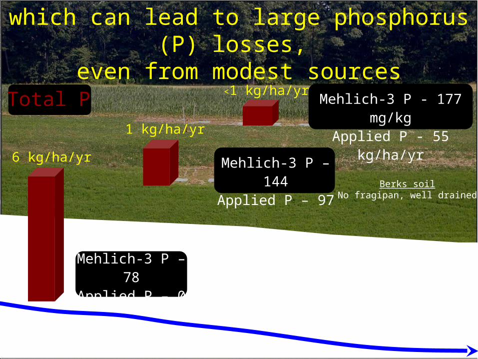
1 kg/ha/yr
<1 kg/ha/yr
which can lead to large phosphorus (P) losses, even from modest sources
6 kg/ha/yr
Total P
Albrights soilFragipan, poorly drained
Berks soilNo fragipan, well drained
Mehlich-3 P - 177 mg/kgApplied P - 55 kg/ha/yr
Mehlich-3 P – 144Applied P – 97
Mehlich-3 P – 78Applied P – 0

Runoff producing areas
Phosphorus Index – a strategic tool for critical source area (CSA) identification

CSAs represent regions with the highest P loss potential

Near-stream
Mid-slope
Up-slope

Linear regression between depth to restrictive layer and geomorphic variables (e.g., slope, aspect, etc.)
0.65 m 0.85 m
Depth to restrictive layer
Results and outcomesDigitally modeling and mapping soil restrictive layers
LiDAR DEM (0.5 m resolution)


My Hypothesis
Modern erosion creates perched water that may increase surface runoff
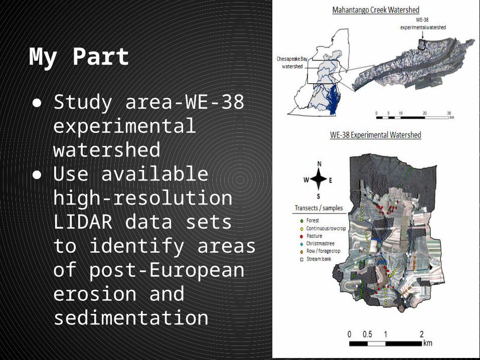
My Part
● Study area-WE-38 experimental watershed
● Use available high-resolution LIDAR data sets to identify areas of post-European erosion and sedimentation

The Data
● High Resolution LIDAR (0.5 m resolution)● Ground level LIDAR from postprocessing of
the data● 15 cm vertical accuracy● 2007● 2011

Methods
LIDAR data
LIDAR data
Raster Calculator
Raster:Highlight
areas with gains/losses in elevation.
QC data: make sure differences
aren’t due to errors within
the data

Methods
LIDAR data
LIDAR data
Raster Calculator
Raster:Highlight
areas with gains/losses in elevation.
QC data: make sure differences
aren’t due to errors within
the data

Methods
LIDAR data
LIDAR data
Raster Calculator
Raster:Highlight
areas with gains/losses in elevation.
QC data: make sure differences
aren’t due to errors within
the data

Anticipated Results
• A raster that highlights areas with a change in elevation – is there a significant difference between the two datasets?
• If there is a difference, does it match• Corroborate to geomorphic and GPR
mapping

Potential Presentation Venues
Northeast Organic Farming Association of NY
Pennsylvania Association of Sustainable Agriculture
Empire State Growers Expo
Mid Atlantic Fruit and Vegetable Conference
Norther Grain Growers Association Conference

References
Buda, Anthony R., Peter J.a. Kleinman, M.s. Srinivasan, Ray B. Bryant, and Gary W. Feyereisen. "Effects of Hydrology and Field Management on Phosphorus Transport in Surface Runoff." Journal of Environment Quality 38.6 (2009): 2273. Print.
Buda, Anthony R., Peter J. A. Kleinman, M. S. Srinivasan, Ray B. Bryant, and Gary W. Feyereisen. "Factors Influencing Surface Runoff Generation from Two Agricultural Hillslopes in Central Pennsylvania." Hydrological Processes 23.9 (2009): 1295-312. Print.

Thank you
Partners
STATE CONSERVATION COMMISSI ON
Middle Atlantic River Forecast
Center