the pleistocene of the thames - jnccjncc.defra.gov.uk/pdf/v7chap1.pdf · bridgland, d.r., (1994),...
TRANSCRIPT

Chapter 1
The Pleistocene of the Thames
D.R. Bridgland
From:Bridgland, D.R., (1994), Quaternary of the Thames, Geological Conservation Review Series, No. 7, Chapman and Hall, London, 441 pages, illustrations, A4 hardback, ISBN 0 41248 830 2For more information see: http://www.jncc.gov.uk/page-3009


The Quaternary record of the River Thames
THE QUATERNARY RECORD OF THERIVER THAMES
Few rivers of so modest a size have had so muchattention devoted to their deposits and geologi-cal history as the Thames. The present size ofthe river belies its importance to British Quater-nary geology, however, since Thames sedimentsprovide a framework for this the latest part of
the geological record in Britain. Indeed, there isabundant evidence to show that the modernThames is a mere shadow of its Pleistocene fore-bear. Not only did it once flow from the LondonBasin out across East Anglia to north Norfolk,but there are indications that its headwaters mayonce have drained a large part of the West Mid-lands and even North Wales (Figure 1.1). DuringMiddle and Late Pleistocene cold episodes,
3
Figure 1.1 Map of southern and central England, showing the division into the catchments of the modernThames, Severn and Trent rivers. As is described in the text, the area to the north-west of the Cotswolds escarp-ment was probably drained by the Thames in the early Pleistocene. In the early Middle Pleistocene it wasdrained by the Trent system (the proto-Soar of Shotton, 1953).

The Pleistocene of the Thames
4
when sea level was much lower and Britain wasjoined to the continent, the river extended formany kilometres over areas that now lie off-shore; during these episodes it was a tributary ofthe Rhine system. Thus Thames deposits pro-vide a potential means for correlation betweenthe London Basin and other areas of Britain, aswell as with the North Sea Basin and surround-ing parts of the European continent.
The river has undergone a number of signifi-cant changes during the Pleistocene, some as aresult of glaciation. It appears initially to havebeen a ‘consequent stream’, flowing along theapproximate centre of the London syncline andreceiving tributaries from the north and south.Many of the latter would have been of evengreater antiquity, having originated on the thennewly formed Weald and Chiltern uplands anddraining into the sea that covered the LondonBasin during the Palaeogene. The central drain-age of the western end of the London Basin isthe province of the River Kennet, the Thamesupstream from Reading probably having origi-nated as an early river flowing southwards intothe basin down the northern limb of the syn-cline. The presence of quartz pebbles in thePalaeocene deposits of Buckinghamshire sug-gests that a fluvial route through the Chilterns,tapping pre-Cretaceous strata beyond, was inexistence by that time. The relative lowering ofsea level, which brought about marine regres-sion in the late Neogene, was responsible for theinitiation of the Middle and Lower Thames asthe main drainage line along the emergent sea-floor.
It appears that, by the Early Pleistocene, theThames had acquired a much more extensivecatchment, with Midlands and Welsh detritalmaterial being brought into the London Basinvia the Upper Thames system. There is still con-troversy as to whether the Thames once drainedthese areas directly, or whether glacial transportcarried this ‘exotic’ material into its catchmentduring the Early Pleistocene. It is apparent thatthis supply ended by the Middle Pleistocene andthat the Upper Thames was at that time confinedto the south-east of the Cotswold escarpment.
THE THAMES TERRACE SYSTEM
Research on the Thames terrace system firstbegan over a hundred years ago, although therewas relatively little progress until the early years
of this century. The description by Trimmer(1853) of a gravel terrace 150 ft (46 m) abovetidal level at Dartford is one of the earliest suchrecords from the Thames. But the ‘type area’ forthe Thames terrace sequence was established atabout the turn of the century as the region in theMiddle Thames around Maidenhead, Slough andBeaconsfield, where the lower parts of the suc-cession were recognized and defined by officersof the Geological Survey. The Survey appliedthis scheme throughout the Middle and LowerThames valleys, classifying the terrace gravels asBoyn Hill, Taplow or Floodplain Gravel. Thesenames replaced what had become a confusion ofterms based on height above river level, relativeelevation (High, Middle and Low terraces) ornumerical schemes (First, Second etc. terraces)in which numbering from high to low or viceversa was employed by different authors (forsummary, see Gibbard, 1985).
The system of named terraces accounted onlyfor the ‘valley gravels’, which extend up to c. 40 m above the modern floodplain. Depositsabove this level were generally mapped as‘Glacial Gravel’ or, higher still, ‘Pebble Gravel’,the latter being regarded by most authors asmarine rather than fluviatile. The view thatmany of these high-level deposits are theremains of older terraces of the Thames wasalready in existence by the turn of the centuryand has progressively gained widespread accept-ance, although there is still a degree of contro-versy over whether the highest gravels may bemarginal marine deposits. The full terracesequence, as recognized at present, has beenbuilt up over the last sixty years by additions to the original Geological Survey scheme, the most important work being by S.W.Wooldridge, F.K. Hare, R.W. Hey and P.L.Gibbard. Prior to the 1960s, work on the MiddleThames was generally based on geomorphologi-cal mapping, which led to the recognition offurther terraces both between and above thoseof the original scheme. These were (in strati-graphical order) the Harefield, Rassler, WinterHill and Black Park Terraces, all above the BoynHill, and the Lynch Hill Terrace, between theBoyn Hill and the Taplow (Hare, 1947; Sealy and Sealy, 1956; see below. Additional, less well-developed terrace features have beendescribed at various times, but their existence asproducts of fluvial aggradation has not beenconfirmed.

The diversion of the Thames
5
Later studies have concentrated on the aggra-dational deposits themselves, rather than theterrace ‘flats’ formed by their upper surfaces.The latter are geomorphological features andthus may be recognized independently from thesediment bodies underlying them, whichformed as a result of aggradation by the riverfrom an earlier, lower base level to the level ofthe terrace surface. The study of gravel rem-nants, as opposed to terrace geomorphology,allowed several earlier Thames aggradations tobe recognized, despite the fact that the depositslaid down during these events are now highlydegraded and fragmentary. Thus the highest andearliest elements of the sequence, the Nettlebed,Stoke Row, Westland Green, Satwell,Beaconsfield and Gerrards Cross Gravels, haveall been defined in recent years. A refined clas-sification of terrace deposits, based on litho-stratigraphy, was pioneered in East Anglia (Roseet al., 1976; Rose and Allen, 1977) and has beenapplied to the sequences in the Middle Thames(Gibbard, 1985), in the Lower Thames(Bridgland, 1988a; Gibbard et al., 1988) and inEssex (Bridgland, 1988a).
Work in the Upper Thames basin has generally been carried out entirely in isolationfrom that downstream of the Chiltern escarp-ment. The Upper Thames represents an impor-tant link between the London Basin and theMidlands, both of which have complexQuaternary sequences. Correlation ofPleistocene deposits between these areas hasbeen hampered by the difficulty in tracing ter-race aggradations between the Upper andMiddle Thames valleys through the constrictionof the Goring Gap, where terrace preservation isminimal. Biostratigraphical evidence from fos-siliferous sites in the Upper Thames valley hasprovided some grounds for correlation, but theinterpretation of all the key localities has beenthe subject of controversy. An important markerwithin the Upper Thames sequence is providedby the first appearance of glacially derived mate-rial, mainly fresh flint, which was introducedthrough gaps in the Cotswolds escarpment. Theglaciation that carried flint to the Cotswolds hasbeen attributed to the Wolstonian (Saalian)Stage (Shotton, 1973a). However, recent workin the Midlands has raised important questionsabout the established chronology in that area,suggesting in particular that the glaciation of theCotswolds occurred during the Anglian Stage(see below; Table 1.1)
Several important review articles havedescribed the Thames sequence, from differentviewpoints, in recent years. The most significantand useful of these are by Evans (1971), Brown(1975), Hey (1976a), Clayton (1977), Green andMcGregor (1980) and Gibbard (1983). Severalmajor works have described and discussed theformation of the Thames terraces (Wooldridgeand Linton, 1939, 1955; Zeuner, 1945, 1959;Wymer, 1968; Gibbard, 1985).
THE DIVERSION OF THE THAMES
The suggestion that the Thames formerly flowedto the north of London, through the Vale of StAlbans, dates back to the turn of the century,when this old drainage route was recognized bySalter (1905). Sherlock and Noble (1912) con-sidered that glaciation of the Vale of St Albansended Thames drainage by this northern route.Wooldridge (1938, 1960), however, recognizedtwo previous courses of the Thames, the firstbeing that recognized by Salter and the secondan intermediate route through the Finchley area.He suggested that separate glacial advances wereresponsible for the demise of both routes, thefirst as a result of a ‘Chiltern Drift’ ice advanceand the second in response to the main ‘ChalkyBoulder Clay’ (Anglian Stage) glaciation. Recentworkers have found little evidence to supportthe existence of a pre-Anglian glaciation in theLondon Basin (Moffat and Catt, 1982; Avery andCatt, 1983; Green and McGregor, 1983), buthave determined that the Thames flowedthrough the Vale of St Albans until blocked by iceduring the Anglian Stage (Gibbard, 1977; Greenand McGregor, 1978a; Cheshire, 1986a). Inaddition, Gibbard (1979) has demonstrated thatthe Thames was diverted from the Vale of StAlbans directly into its modern valley withoutusing Wooldridge’s intermediate route, which infact represents the pre-Anglian valley of theMole-Wey tributary.
Gibbard (1977) showed that the Anglian gla-cial deposits of the Vale of St Albans provide astratigraphical marker that enables correlation ofthe Thames terrace sequence with the estab-lished British Pleistocene chronology. Hedemonstrated that the Winter Hill Gravel of theMiddle Thames was accumulating at the time ofthe glacial advance, thus implying an Anglian agefor that formation. The next terrace aggradation(topographically lower) in the sequence, theBlack Park Gravel, is also regarded as contempo-

The Pleistocene of the Thames
6

The continuation of the Thames into Essex
7
raneous with the occupation of the Vale of StAlbans by ice, but this formation has been tracedinto the modern Thames valley through London,whereas the Winter Hill Formation can be traceddownstream into the Westmill Lower Gravel ofthe Vale of St Albans, which underlies Anglianglacial deposits. This indicates that the diversionof the Thames occurred between the aggrada-tion of the Winter Hill and Black Park Terracedeposits, at the time of the Anglian glacial maxi-mum.
THE CONTINUATION OF THETHAMES INTO ESSEX
The first evidence for the route of the pre-diver-sion Thames downstream from the Vale of StAlbans was derived from subdrift contour map-ping by Wooldridge and Henderson (1955), whorecognized in their ‘Mid Essex Depression’ aburied valley system extending eastwards fromWare to Bishops Stortford, Chelmsford andColchester. Detailed subdrift mapping of partsof this area was subsequently published in vari-ous Geological Survey (Mineral AssessmentUnit) reports, which include exhaustive bore-hole records but no regional interpretation.Green et al. (1982) suggested correlations ofisolated gravel samples from this area with theMiddle Thames sequence on the basis of ‘clast-lithological analysis’ (which is the identificationof the clasts that make up a deposit and the cal-culation of their relative proportions – seeBridgland, 1986a), but their work lacked theadded control of geological mapping. The firstattempt to combine both types of evidence andto trace terrace aggradations through this areaby reconstructing their downstream profiles hasrecently been made by Whiteman (1990; seebelow).
Confirmation of the extension of the pre-diversion Thames system into East Anglia camewith the recognition of early Thames gravels inEssex, Suffolk and Norfolk, important early con-tributions to this work being made by S.H.Warren, R.W. Hey, J. Rose and P. Allen. The dis-tribution of these various aggradations, whichmake up the Kesgrave Sands and Gravels (Roseet al., 1976), reflects a progressive southwardmigration of the pre-diversion Thames valley.
This migration culminated in a course throughChelmsford and Colchester, recognized in thelowest part of the ‘Mid Essex Depression’.Gravel representing this final pre-diversionfloodplain has been traced to the Clacton area,where it forms the lowest of a sequence ofKesgrave Group formations and is in close juxta-position with post-diversion Thames deposits(Bridgland, 1988a). The distinction in this areabetween pre- and post-diversion gravels is basedon differences in their clast composition, assist-ed by the recognition of an influx of distal out-wash from the Anglian glaciation at the end ofthe last pre-diversion aggradational phase.Using the stratigraphical evidence for the glacia-tion and the diversion of the Thames, thesequence in the Clacton area can be correlateddirectly with that in the Middle Thames and theVale of St Albans (Bridgland, 1988a).
The post-diversion terrace formations of theLower Thames continue into eastern Essex,where they make up the Low-level East EssexGravel Subgroup (Bridgland, 1988a). These for-mations extend northwards from the Southenddistrict, running approximately parallel to thecoast, but only the oldest (immediately post-dating the diversion) reaches the Clacton area.Earlier terrace deposits are preserved in south-eastern Essex, however, representing formationswithin a High-level East Essex Gravel Subgroup,but these are products of the River Medway thatpre-date the diversion of the Thames. Thesequence in eastern Essex therefore indicatesthat the Medway formerly flowed northwardsacross this area, towards its confluence with thepre-diversion Thames. This early Medway valleywas never glaciated and continued to operatethroughout the Anglian glaciation. It is apparentthat the newly diverted Thames took over theformer Medway route between Southend andClacton, where it rejoined its former valley(Bridgland, 1988a). In the southern North Sea,Anglian (Elsterian) ice is thought to have pond-ed the waters of the Thames-Medway and thecontinental Rhine system, forming a hugeproglacial lake (see Gibbard, 1988a). This lakeeventually spilled over the watershed that thenexisted between North Sea drainage and EnglishChannel drainage, to form a through valley, flow-ing south-westwards, in the position of thepresent-day Straits of Dover. After the AnglianStage it appears that, during phases of low sealevel, the Rhine and Thames united in the areaof the southern North Sea and flowed south-
Table 1.1 Correlation of Quaternary deposits with-in the Thames system. Rejuvinations that haveoccurred since the Anglian glaciation are indicated.

The Pleistocene of the Thames
8
westwards through the English Channel to theAtlantic Ocean (Gibbard, 1988a).
Later onshore terrace formations record thecontinued southward migration of the Thames.This migration culminated in the valley system,submerged by the Holocene transgression, thathas been mapped beneath modern marine sedi-ments on the floor of the southern North Seausing seismic techniques (D’Olier, 1975;Bridgland and D’Olier, 1989). Following thediversion, and as the Thames migrated south-wards, the modern drainage system of Essexbecame established, rivers such as theBlackwater and Crouch being initiated as left-bank tributaries of the Thames. LaterPleistocene deposits in the areas of northern,central and eastern Essex formerly drained bythe Thames are invariably the products of thesetributary rivers.
CLASSIFICATION OF THAMES TERRACES AND DEPOSITS
Two types of classification are used in parallel inthis volume; one for the series of morphologicalfeatures, the terrace surfaces, and the other forthe deposits that the Thames and its tributarieshave laid down during the Pleistocene. The ter-race surfaces are geomorphological featuresformed by alternating periods of fluvial aggrada-tion and downcutting, the surfaces representingformer floodplains that were abandoned as aresult of rejuvenation. Terrace surfaces can alsobe formed by erosion, but features of this typeare almost entirely unrepresented in the Thamessystem. Thus, wherever morphological terracefeatures are recognized in the Thames valley, theparallel geological classification of the depositscan also be applied. In contrast, remnants of flu-vial deposits can be recognized in areas wheresevere post-depositional modification, such aserosion or burial by later sediments, preventsthe recognition of original terrace surfaces.Consequently, the geological (lithostratigraphi-cal) method of classification is generally moreuseful.
Geomorphological classification
The system of naming terraces after type locali-ties is favoured here, rather than numbering orother alternatives (see above). The establishedsequence of Thames terrace features is as follows:
Terrace Underlyinglithostratigraphical formation
9. Lower Floodplain Shepperton Gravel8. Upper Floodplain Kempton Park Gravel7. Taplow Taplow Gravel6. Lynch Hill Lynch Hill Gravel5. Boyn Hill Boyn Hill Gravel4. Black Park Black Park Gravel3. Winter Hill Winter Hill Gravel2. Rassler Rassler Gravel1. Harefield Gerrards Cross Gravel
Lithostratigraphical classification
Formal lithostratigraphical classification was firstapplied to the type-sequence of Middle Thamesterrace deposits by Gibbard (1983, 1985),although a number of earlier workers had classi-fied the sediments rather than the terrace sur-faces, particularly when describing older dissect-ed aggradations (Wooldridge, 1938; Hey, 1965).Gibbard adopted the scheme for lithostrati-graphical nomenclature recommended by thestratigraphical guides (Hedberg, 1976; Hollandet al., 1978), in which the following hierarchicaldivisions are applied:
Group Two or more formations
Formation The primary unit, into which theentire stratigraphical column isdivided
Member Named unit within a formation
Bed Named distinctive layer within aformation or member
Gibbard considered individual terrace aggrada-tions to be of member status and grouped theseinto a ‘Middle Thames Valley Gravel Formation’.He sought to differentiate between his variousmembers on the basis of clast-lithological differ-ences, applying techniques of statistical evalua-tion (Gibbard, 1985, 1986). A similar methodwas adopted by McGregor and Green (1986),who also regarded the study of clast lithology asa lithostratigraphical method but did not advo-cate formal nomenclature. Hey (1986) adoptedthe Gibbard model in subdividing the NorthernDrift of the Upper Thames, again on the basis of clast-lithological differences. However,Bridgland (1988b, 1990a), citing the various

The stratigraphical framework: Pleistocene chronostratigraphy
9
stratigraphical guides, observed that lithostrati-graphical classification should be based on grosslithological properties rather than on laboratorytechniques such as clast-lithological analysis.The former properties may include major breaksin sedimentary continuity (unconformities),such as occur at the base and top of each indi-vidual terrace aggradation. These allow theindividual aggradations to be separated usingbasic techniques of geological mapping (includ-ing geomorphological mapping), thus makingthem primary units. For this reason Bridglandproposed that individual terrace aggradationsshould be classified as formations, rather thanmembers. In some cases several of these can becollected together to form a group, for which nosingle type locality is necessary, although otherlithostratigraphical units must be defined at atype locality. Members and beds may be definedwithin some of the primary units: for example,the Swanscombe Lower Gravel and other Swans-combe units are members or beds within theBoyn Hill/Orsett Heath Gravel Formation, sincethey fall within the body of sediment that can bemapped as the Boyn Hill/Orsett Heath Gravel.
Although the Middle Thames is regarded asthe type area for the Thames sequence, recentwork in Essex has revealed that there are a num-ber of terrace formations in that area for whichno Middle Thames equivalent is recognized(Bridgland, 1988a; Whiteman, 1990). It is there-fore necessary to refer to type localities outsidethe Thames valley to define these formations. Infact, separate nomenclature has been estab-lished in recent years for the Lower Thames,Essex and southern East Anglia and has been inexistence since the earliest research in the UpperThames (where the nomenclature used in theLondon Basin has never been applied). Theoverriding reason for this proliferation of namesis that correlation between these various areashas been problematic, usually because of breaksin the continuity of recognisable terrace rem-nants. The most important breaks of this typecoincide with the Goring Gap, central Londonand the Essex till sheet; in the first of these therehas been little preservation of terrace depositsbecause of the constriction of the valley, where-as in the other two the evidence is preserved butlargely inaccessible. Once correlation is on asounder footing, however, it would be desirableto suppress synonyms and use a single nomen-clature, probably that established in the MiddleThames (Table 1.1).
THE STRATIGRAPHICAL FRAMEWORK: PLEISTOCENECHRONOSTRATIGRAPHY AND CORRELATION
The interpretation of the floral and faunal con-tent of temperate deposits, taken together withgeological evidence for the deposition of othersediments under intensely cold or even glacialconditions, has been used as a basis for ‘climato-stratigraphical’ subdivision of Pleistocene time.During the middle part of this century a schemefor climato-stratigraphical (relative) dating of theBritish Pleistocene succession was establishedusing palynology (West, 1963, 1968). Thisscheme, which is still in use, distinguishes dif-ferent interglacial episodes on the basis of theirdistinctive patterns of vegetational development,as determined by the analysis of pollen assem-blages from successive horizons within deposi-tional sequences. Moreover, climatic fluctuationhas been accepted as a guide for the division ofPleistocene time (Shotton, 1973b), so that timeperiods corresponding with interglacials andglacials have been defined as chronostratigraph-ical stages. Thus palynological analyses allowedpollen-bearing sequences to be allocated to par-ticular stages, enabling a chronostratigraphy forthe British Pleistocene to be developed, as sum-marized by Mitchell et al. (1973). The followingstages were recognized by these authors in thesequence post-dating the marine crags of EastAnglia (in stratigraphical order):
Flandrian (warm) = HoloceneDevensian (cold)Ipswichian (warm)Wolstonian (cold)Hoxnian (warm)Anglian (cold)Cromerian (warm)Beestonian (cold)Pastonian (warm)Baventian (cold)*
(* most recent stage within the Norwich Crag, theyoungest marine crag)
Mitchell et al. recognized two interglacialsbetween the Anglian Stage and the Holocene.These correspond with the Hoxnian Stage (typelocality at Hoxne in Suffolk) and the IpswichianStage (type locality at Bobbitshole, near Ipswich,Suffolk). The Ipswichian and the Holocene wereseparated by the last glaciation, within the

The Pleistocene of the Thames
10
Devensian Stage. The time interval between theHoxnian and Ipswichian Stages was ascribed byMitchell et al. (1973) to the Wolstonian Stage,which replaced the Gipping Stage of West(1963). This stage, regarded by Mitchell et al. asa cold episode, was defined at Wolston,Warwickshire, where a detailed sequence ofgravels, sands, clay and till occurs, entirelyascribed to the Wolstonian (Shotton, 1973a,1973b). The absence of earlier or later sedi-ments at Wolston underlines the acknowledgeddifficulties in relating the type-Wolstoniandeposits to the local Pleistocene sequence, letalone the British climato-stratigraphical scheme(Bowen, 1978). In recent years it has been sug-gested that the glacial sequence at Wolston is infact equivalent to the Anglian Stage deposits ofEast Anglia, therefore invalidating the termWolstonian (Perrin et al., 1979; Sumbler, 1983a,1983b; Rose, 1987, 1988, 1989, 1991).Furthermore, there is mounting evidence fromother research that more than a single climaticcycle separates the Hoxnian and Ipswichianinterglacials (see below and Table 1.1). As noredefinition of this time interval has been forth-coming, the corresponding continental term,Saalian, is used in this volume. This is not with-out some problems, as the definition and subdi-vision of the European Saalian Stage is alsounder scrutiny at present. It is widely accepted,however, that this stage incorporates a series ofclimatic fluctuations separating the continentalequivalents of the Hoxnian and Ipswichian, theHolsteinian and Eemian Stages respectively(Zagwijn, 1985, 1986; Bowen et al., 1986b;Sibrava, 1986a, 1986b; de Jong, 1988; seebelow). Whatever the result of any review of thecontinental Saalian, the term is used in this vol-ume for the time interval between theSwanscombe interglacial and the Ipswichiansensu Trafalgar Square (for definitions of these,see below and Table 1.1).
The pollen-based ‘climato-stratigraphical’model has formed the basis for BritishPleistocene studies since its inception, otherbiostratigraphical evidence generally being relat-ed to the palynological sequence. Within theThames system, well-documented interglacialsites at Swanscombe and Trafalgar Square havebeen attributed to the Hoxnian and Ipswichianrespectively, providing a biostratigraphicalframework for Thames terrace stratigraphy thatcontinues to be used. However, the relative dat-ing of various sites within the Lower Thames ter-
race sequence at intermediate heights betweenSwanscombe (23–30 m O.D.) and TrafalgarSquare (around Ordnance Datum) has provedcontroversial. Misgivings have been expressedabout the above model on the basis of discrep-ancies between the palynological record and theevidence from Pleistocene mammals (Sutcliffe,1964, 1975, 1976, 1985; Shotton, 1983; Green etal., 1984). At several sites, including examplesin the Lower Thames, different mammalian fau-nas have been found in deposits that appeared,from their palynology, to represent theIpswichian Stage. This led to the suggestion,first made by A.J. Sutcliffe, that there had beentwo separate interglacials since the Hoxnian.These had similar patterns of vegetational devel-opment and are therefore indistinguishable onthe basis of palynology. The morphological sep-aration of apparent Ipswichian sites in the LowerThames into separate terraces has been cited insupport of this suggestion. Corroboration hascome from radiometric dating of bone andtravertine (Szabo and Collins, 1975; Green et al.,1984), from studies of molluscan palaeontology(Allen, 1977) and from the analysis of the aminoacid content of these same fossils (Miller et al.,1979; Bowen et al., 1989; see below).Stratigraphical evidence from the WarwickshireAvon (Bridgland et al., 1989; Maddy, 1989;Maddy et al., 1991a) goes even further, in sug-gesting that two additional climatic cyclesoccurred between the Anglian and IpswichianStages.
With the current uncertainty about thechronological significance of the palynologicalbiostratigraphical framework, although pollenanalyses remain critically important in the studyof Quaternary sites, the search for an alternativescheme has occupied many workers in the pastfew years. An obvious basis for a stratigraphicalstandard is the record provided by ocean-bedsediments, since these are from environmentswhere sedimentation during the Pleistocene ispresumed to have been uninterrupted. The pat-tern of climatic fluctuations during thePleistocene has been recognized in these sedi-ments from the study of oxygen isotopes (16Oand 18O) in the remains of foraminifera(Emiliani, 1955, 1957; Shackleton, 1969;Shackleton and Opdyke, 1973). Changes in therelative frequencies of the isotopes reflect paral-lel changes in the isotopic composition of sea-water in direct response to fluctuations of globalclimate through time. The lighter isotope (16O)

The stratigraphical framework: Pleistocene chronostratigraphy
11
is relatively common in water evaporated fromthe oceans, so during cold episodes, when muchof this water goes to form long-term accumula-tions of ice, the sea water becomes enriched inthe heavy isotope (18O). Fluctuations in therelative frequencies of these two isotopes havebeen plotted against time, as represented by theoceanic sedimentary record, to provide a graph-ic representation of climatic change through thePleistocene, the ‘oxygen isotope curve’ (Figure1.2). The climatic fluctuations observed in thiscurve also form the basis for ‘oxygen isotopestratigraphy’, in which a scheme of ‘oxygen iso-tope stages’ is recognized. These stages repre-sent alternate cold and warm episodes and arenumbered in reverse stratigraphical sequencefrom Stage 1, the equivalent of the Holocene(Figure 1.2 and Table 1.1; see Bowen, 1978, forexplanation). Thus even-numbered 18O stagesrepresent cold episodes and odd-numberedstages represent warm intervals. It must beemphasized that the oxygen isotope record canonly indicate an episode of ice-cap depletionand gives no direct indication of global climateor vegetational development. Nevertheless, theoceanic record affords a truly global frameworkfor Pleistocene chronology, since the samesequence can be recognized in oceans through-out the world. More problematic, however, isthe correlation of the deep-sea record with dis-continuous terrestrial sequences, for whichradiometric dating methods are rarely available.On land, relative dating methods are generallyused, relying on land-based fauna and/or florathat cannot be related directly to the oceanicstratigraphy.
One approach to this problem that has beenpursued in recent years is an attempt to establisha stratigraphy based on a relative dating methodin which the progressive alteration of aminoacids in mollusc shells is measured. The aminoacid L-isoleucine epimerizes to form D-alloisoleucine progressively through time,although the rate of change is dependent ontemperature. During life only L-isoleucine ispresent in a shell, but after death and incorpo-ration in sediments, progressive epimerizationcauses increasing amounts of D-alloisoleucine tobe present, until an equilibrium level is reached.Therefore the ratio between these two aminoacids gives an indication of relative age, whichcan be calibrated using radiometric datingwhere available (Wehmiller, 1982; Bowen et al.,1985, 1989). This method has been applied to
shells from a number of important sites in theThames system (Miller et al., 1979; Bowen et al.,1989).
The desirability of relating terrestrialsequences such as that of Thames terraces to theoxygen isotope record is obvious. However,apart from a general consensus that theIpswichian interglacial represents OxygenIsotope Substage 5e (Gascoyne et al., 1981;Shotton, 1983; Bowen et al., 1985; Stringer etal., 1986; Bowen and Sykes, 1988; Campbelland Bowen, 1989), there has been little agree-ment about correlation between the British andEuropean sequences and the deep-sea cores. Ofcritical importance is the position, in relation tothe oxygen isotope record, of the Anglian Stage,which is well-established in the British stratigra-phy and particularly important within theThames sequence. The Anglian Stage has gener-ally been correlated with Oxygen Isotope Stage12, primarily because this appears to representone of the most severe cold episodes within theMiddle Pleistocene deep-sea record (Shackletonand Opdyke, 1973; Shackleton, 1987; Bowen etal., 1986a, 1986b; Bowen and Sykes, 1988;Campbell and Bowen, 1989). Support for thisview is provided in this volume from the numberof post-diversion (post-Anglian) climatic fluctua-tions recognized within the Lower Thamessequence.
Evidence from amino acid ratios suggests thatthe Hoxnian Stage interglacial, as represented atSwanscombe and Clacton (see respective sitedescriptions), equates with Oxygen IsotopeStage 11 (Bowen et al., 1986a, 1989; Table 1.1),but similar evidence from Hoxne suggests corre-lation with Stage 9 (Bowen et al., 1989). If theseratios provide an accurate indication of age, theThames sites that have traditionally been regard-ed as Hoxnian may prove to belong to a hither-to undefined temperate episode that followedimmediately after the Anglian glaciation, where-as later temperate deposits within the Thamessequence might be true equivalents of thesequence at Hoxne. However, the type-Hoxniansequence has been interpreted as a kettle-holeinfill, formed immediately following deglacia-tion late in the Anglian Stage (West, 1956).Thus, if the Anglian equates with Stage 12, it isdifficult to envisage the type-Hoxnian sedimentspost-dating Stage 11. For the deposits atSwanscombe and Clacton, which unequivocallypost-date the diversion of the Thames, to equatewith Stage 11 and those at Hoxne with Stage 9,

The Pleistocene of the Thames
12
Figu
re 1
.2T
he
oxy
gen
iso
top
e re
cord
, as
rep
rese
nte
d i
n a
bo
reh
ole
(si
te 6
07)
in t
he
mid
-Atl
anti
c at
lat
itu
de
c. 4
1°N
. N
um
bere
d s
tage
s ar
e sh
ow
n a
t th
e to
p;
even
-nu
mbe
red
on
es a
re r
elat
ivel
y co
ld (
mo
re i
ce)
and
od
d-n
um
bere
d o
nes
rel
ativ
ely
war
m (
less
ice
).
No
te t
hat
th
e am
plit
ud
e an
d w
avel
engt
h o
f th
e cu
rve
incr
ease
s at
aro
un
d 0
.7 m
illio
n y
ears
ago
(th
e 18
O s
cale
is
a ra
tio
obt
ain
ed b
y co
mp
arin
g th
e p
rop
ort
ion
of
18O
to
16 O
in
sam
ple
s to
th
at i
n a
mea
n s
ea-w
ater
stan
dar
d).
C
om
pile
d f
rom
dat
a p
ubl
ish
ed b
y R
ud
dim
an e
t a
l. (
1989
).

The stratigraphical framework: Pleistocene chronostratigraphy
13
the till underlying the latter would have to post-date the glaciation that effected the diversion.As the East Anglian glacial deposits have beenattributed to a single pre-Hoxnian glaciation(since the post-Hoxnian Gipping glaciation wasdisproved), there is a clear conflict between theinterpretation of the Hoxne sequence as a kettle-hole infill and the amino acid ratios from the site(see, however, below for discussion of the possi-bility that a post-Stage 12 glaciation is represent-ed in the Cotswolds). It is perhaps appropriateto question whether the origin of the lake-bedsat Hoxne in a kettle-hole can be demonstratedunequivocally. Lake basins have been formed inEast Anglia in other ways, as is indicated by theoccurrence of several large closed depressionscontaining modern lakes and/or substantialinfills of Holocene sediments. The formation ofthese features, the ‘meres’ of central East Anglia,is attributed to solution of bedrock Chalkbeneath the cover of Anglian till (Bennett et al.,1991).
It is possible that the amino acid ratiosobtained from Hoxne are misleading and thatthe type-Hoxnian sequence equates withOxygen Isotope Stage 11 (and is therefore thesame age as the Swanscombe deposits).Correlation of the British Hoxnian and conti-nental Holsteinian sequences on the basis ofpalynology is considered by many workers to behighly convincing, it being possible to matchimportant aspects of vegetational evolution inboth (Turner, 1975). If the Hoxnian is taken toequate with Oxygen Isotope Stage 11, Stage 9remains to be identified within the British ter-restrial succession, falling within the intervalcalled ‘Wolstonian’ by Mitchell et al. (1973), andhere referred to as the Saalian Stage. The Stage9 temperate episode is believed to be represent-ed by deposits in the Upper and Lower Thamessequences and in eastern Essex (Table 1.1). It isnotable that shells from sediments at Grays andPurfleet in the Lower Thames, considered fromstratigraphical evidence to represent Stage 9,have produced amino acid ratios suggestive ofgreater antiquity. This may indicate that aminoacid analyses of shells from deposits older than200,000 years in the Lower Thames are as yetproblematic, although these ratios do provideimportant evidence in support of the pre-Ipswichian age of the Grays and Purfleet sedi-ments, which remains a subject of some contro-versy. Shells from a site a few kilometresupstream from Purfleet, at Belhus Park, have
recently yielded amino acid ratios consistentwith a Stage 9 age (Bowen, 1991).
An undefined interglacial, palynologically sim-ilar to the type-Ipswichian, is now well-estab-lished from several sites in southern andMidland England as representing OxygenIsotope Stage 7 (Shotton, 1983; Bowen et al.,1989). Many deposits formerly attributed to theIpswichian may represent this earlier inter-glacial, which (like the Stage 9 temperateepisode) falls within the Saalian (Wolstonian)Stage. Deposits now attributed to Stage 7include those previously distinguished fromIpswichian sediments on the basis of mammals(Sutcliffe, 1975, 1976, 1985; Green et al., 1984).Separation may also be possible using molluscs.The age of Oxygen Isotope Stage 7 has been esti-mated at 245 000–186 000 years and (Martinsonet al., 1987), largely on the basis of dating by theuranium-series method at a number of impor-tant sites. Worthy of mention in this respect isPontnewydd Cave, North Wales, where a rangeof uranium-series dates, with corroborationusing the thermoluminescence dating tech-nique, suggests an age of 225 000–160 000 yearsfor the fossiliferous Lower Breccia (Green, 1984;Campbell and Bowen, 1989). At Marsworth,Buckinghamshire, travertine clasts containingleaf-impressions from interglacial tree specieshave provided three dates, pointing to an agebetween 200 000 and 140 000 years (Green etal., 1984). Other uranium-series dates attrib-uted to Stage 7 are from Stoke Goldington,Buckinghamshire, where an age of 200 000–180 000 years is suggested (Green et al., inBridgland et al., 1989). These dates contrastwith indications, again using the uranium-seriestechnique, of an age of 130 000–100 000 yearsfor Ipswichian deposits at Victoria Cave, Settle,North Yorkshire (Gascoyne et al., 1981) and inMinchin Hole and Bacon Hole caves, SouthWales (Bowen et al., 1985; Stringer et al., 1986;Bowen and Sykes, 1988; Campbell and Bowen,1989). A ‘marine stratotype’ for Oxygen IsotopeStage 7 has been proposed at Minchin Hole(Bowen et al., 1985). At this site, raised beachdeposits that are attributed to Stage 7 underliecold-climate cave deposits. The last-mentionedare in turn overlain by further raised beach sed-iments from which uranium-series dates indica-tive of the Ipswichian Stage have been obtained(see above). Temperate-climate sedimentsattributed to Stage 7 are recognized at severalsites within the Thames system. There is sup-

The Pleistocene of the Thames
14
port for a Stage 7 age for Thames deposits atAveley, Crayford and Stanton Harcourt, and fortheir separation from sites representing theIpswichian Stage (Substage 5e), from amino acidgeochronology (Bowen et al., 1989).
This complex stratigraphical scheme, in whichfour separate interglacials are recognizedbetween the glaciations of the Anglian andDevensian Stages, receives considerable supportfrom some of the more complete Pleistocenesequences on the continent. There is a long-standing correlation of the British Ipswichianand the continental Eemian Stages and of theBritish Hoxnian and continental HolsteinianStages (Mitchell et al., 1973). In recent years‘climato-stratigraphical’ schemes in a number ofEuropean countries have been claimed toinclude one or more additional temperateepisodes between the Holsteinian and Eemian.This interval is classified on the continent as theSaalian, which is the equivalent of theWolstonian Stage as defined by Mitchell et al.(1973). The Saalian succession, named after theRiver Saale in north Germany, comprises thedeposits of two glaciations, the Drenthe andWarthe (for English summaries, see Evans(1971), Bowen (1978), Sibrava (1986a, 1986b)and Gibbard (1988a)). Many German authorshave regarded these as separate advances withina single glacial episode (Duphörn et al., 1973;Ehlers, 1981), the only early suggestions to thecontrary being based on equivocal geomorpho-logical evidence such as the relative ‘freshness’of depositional features (moraines) related tothe two ice sheets (Bowen, 1978). There have,however, been recent claims that an intra-Saalianinterglacial cycle separated these glaciations, onthe basis of evidence from biostratigraphy, sealevels and cycles of soil formation in thick loesssequences (Wiegank, 1972; Kukla, 1975, 1977;Turner, 1975; Brunnacker, 1986; Cepek, 1986;Grube et al., 1986; Sarnthein et al., 1986;Sibrava, 1986a, 1986b). Kukla (1975), Sarntheinet al. (1986) and Sibrava (1986a, 1986b) havealso presented arguments for a second addition-al temperate episode between the Holsteinianand Eemian Stages.
Intra-Saalian temperate episodes have beenrecognized in several areas of northern Europe,predominantly on the grounds of biostratigra-phy or from the study of soil horizons withinloess sequences. Evidence for a single addition-al climatic cycle between the Holsteinian andEemian has been described in Germany, from
the Middle Rhine valley and from the type areaof the Holsteinian Stage in Schleswig-Holstein(Brunnacker et al., 1982; Brunnacker, 1986;Sarnthein et al., 1986). However, a significantnumber of areas have now produced evidencefor two intra-Saalian temperate episodes. Kukla(1975, 1977) based his recognition of two post-Holsteinian but pre-Eemian interglacials on soilswithin the loess sequence of central Europe. Asimilar sequence of palaeosols has beendescribed from Normandy, where four temper-ate-climate soils are recognized within a thickloess succession at St-Pierre-les-Elbeuf. The low-est of these is correlated with the Holsteinianand the highest with the Eemian (Lautridou etal., 1974, 1983; Lautridou, 1982; Sarnthein etal., 1986). Evidence for two intra-Saalian tem-perate half-cycles is also recognized in eastGermany (Cepek and Erd, 1982; Cepek, 1986;Sarnthein et al., 1986). In their summary ofPleistocene correlation in Europe, Bowen et al.,(1986b) also recognized three post-Elsterian andpre-Eemian interglacials in Poland, Russia andthe Carpathians. The names that have beenmost commonly applied to the two additionaltemperate episodes are ‘Domnitz’ or ‘Wacken’for the earlier and ‘Treene’ for the later interval(Bowen et al., 1986b).
In northern Holland, palynological studieshave revealed two temperate episodes withinthe Saalian sequence, both pre-dating theDrenthe glaciation. These have been named theHoogeveen and Bantega Interstadials (Zagwijn,1973, 1986; de Jong, 1988). In the south, at asite near Maastricht, a fully temperate molluscanfauna was described by Meijer (1985), whoascribed it to an intra-Saalian interglacialepisode. Although classifying the Hoogeveenand Bantega episodes as interstadials, de Jong(1988) admitted that the former has many of thefeatures of a full interglacial and is difficult todistinguish from the Holsteinian when incom-plete fragments of vegetational sequences arestudied using palynology. This implies that thefauna described by Meijer might relate to thissame episode. Zagwijn (1973) had previouslysuggested a correlation between the HoogeveenInterstadial and the ‘Wacken Warmzeit’ as recog-nized in Schleswig-Holstein.
The same problems in correlating the terres-trial stratigraphy with the oxygen isotopechronology apply on the continent as in Britain;the absence of reliable dating methods and thefrequency of gaps within the sequences on land

The stratigraphical framework: Pleistocene chronostratigraphy
15
mean that all correlation schemes of this typeare tentative at present. Notwithstanding thesereservations, it has been widely agreed that theEemian Stage and Oxygen Isotope Substage 5eare equivalent (see, for example, Sibrava, 1986b;de Jong, 1988), supporting correlation with theBritish Ipswichian. However, there is consider-able doubt about the oceanic equivalent to theHolsteinian, with stages 7, 9, 11 and 13 all beingcontenders (Kukla, 1975, 1977; Bowen, 1978;Zagwijn, 1978; Linke et al., 1985; Sarnthein etal., 1986 (provides summary); de Jong, 1988;Grün et al., 1988; Schwarcz and Grün, 1988).De Jong (1988) favoured correlation of theHolsteinian with Stage 9 in a tentative scheme inwhich he linked the Elsterian glaciation to Stage10. He considered both the Hoogeveen andBantega temperate intervals to fall withinOxygen Isotope Stage 7. However, Sarnthein etal. argued from biostratigraphical evidence, sup-ported by geochronometric dating, for a correla-tion between the Holsteinian Stage of north-west Europe and Oxygen Isotope Stage 11. Thisis more easily reconciled with the evidence fromcentral Europe, Germany and Normandy, wheretwo full climatic cycles appear to separate theHolsteinian and Eemian. The Dutch recordcould also be accommodated within such ascheme if the Hoogeveen and Bantega episodeswere separately correlated with Stages 9 and 7respectively. The attribution of the type-Holsteinian to Stage 11 has been questioned,however, by Schwarcz and Grün (1988), whofavoured correlation with Stage 7.
The British sequence can be accommodatedreadily in the scheme of Sarnthein et al. (1986).The Anglian Stage, which is generally regardedas the equivalent of the Elsterian, has beenequated by most authorities with Stage 12(Wymer, 1985a; Bowen et al., 1986a, 1986b).This would imply a Stage 11 age for theHolsteinian, which follows the Elsterian, and forthe Hoxnian, which is regarded as being imme-diately post-Anglian in age (Turner, 1973). Thusthe correlation of the Hoxnian-dated Thamessites at Clacton and Swanscombe with theHolsteinian is confirmed; these have beenascribed on stratigraphical grounds to Stage 11.However, doubts remain about the Hoxniantype locality. If suggestions that this representsStage 9 are correct (see above), correlation ofthe Hoxnian sensu Hoxne with a post-Holsteinian temperate episode in Europe, suchas the ‘Wacken (Domnitz) Warmzeit’, might be
implied. Because of this uncertainty, subsequentreferences to the Hoxnian in this volume willdistinguish, where appropriate, betweenHoxnian sensu Hoxne and Hoxnian sensuSwanscombe, the latter equating with OxygenIsotope Stage 11 and the former of uncertainage.
Some discussion of the pre-Anglian sequenceis also required here, as it is now clear that theearliest Thames deposits date back to the EarlyPleistocene or even the Pliocene, although bio-stratigraphical evidence for precise dating isextremely limited. Recent research, particularlyon the Norwich Crag Formation, has led to con-siderable revision of the pre-Anglian stratigraph-ical scheme of Mitchell et al. (1973). West(1980) added a series of climatic cycles to thescheme, under the names Pre-Pastonian a–d.From comparisons with the continental record ithas become apparent that the British succession,which is effectively confined to East Anglia, con-tains several important hiatuses. The followingrevised scheme was outlined in the latest sum-mary of the East Anglian sequence by Zalasiewiczand Gibbard (1988), with an additional modifi-cation from Gibbard et al. (1991):
AnglianCromerian
HIATUSBeestonian
HIATUS(added by Gibbard et al. (1991))PastonianPre-Pastonian d SubstagePre-Pastonian c SubstagePre-Pastonian b Substage
HIATUSPre-Pastonian a
HIATUSBaventian
A number of workers have argued in recentyears that the British sequence includes evi-dence for a further climatic cycle between thetype-Cromerian and the Anglian (Bishop, 1982;Currant in Roberts, 1986). This is based on asingle but important difference in the mam-malian faunas from some sites that would other-wise be classified as Cromerian. MostCromerian small-mammal assemblages, includ-ing those from the stratotype and from siteswithin the Thames system at Sugworth and LittleOakley, contain the extinct water vole Mimomyssavini (Hinton). Sites at Ostend, Norfolk (Stuart

The Pleistocene of the Thames
16
and West, 1976; Stuart, 1982a), Boxgrove,Sussex (Roberts, 1986), and Westbury-sub-Mendip, Somerset (Bishop, 1982), have yieldedsimilar faunas, but with the vole Arvicola can-tiana (Hinton) instead of M. savini. The formerspecies has been interpreted as the evolutionarydescendant of the latter (von Koenigswald,1973; Sutcliffe and Kowalski, 1976; Stuart,1982a, 1988). Not all authors accept this faunalchange as evidence for an additional climaticcycle, however. An alternative explanation thathas been proposed is that the sites with A. can-tiana represent the later part of the Cromeriansensu West Runton, whereas the assemblageswith M. savini date from the early part of thesame temperate episode (Stuart and West, 1976;Stuart, 1982a, 1988).
The same controversy exists on the continent,where mammalian assemblages of Cromerianaspect containing both M. savini and A. can-tiana occur. For example, freshwater depositsbeneath Elsterian till at Voigstedt, Germany, haveyielded an assemblage of small mammalsremarkably similar to that of the West Runtonfreshwater bed, including M. savini (Kahlke,1965; Stuart, 1981). Pollen spectra from over-lying clays suggest that the Voigtstedt mam-malian assemblage may relate to Cromerianpollen biozones CrII or early CrIII. Mimomyssavini also occurs in the sparse fauna of smallmammals from the upper part of a sequencecapped by Elsterian till at Süssenborn, Germany(Kahlke, 1969). The rich assemblage of largemammals from this locality probably dates part-ly from the Cromerian and partly from the pre-vious cold episode (Stuart, 1982a, p. 118). EarlyMiddle Pleistocene sites yielding faunas with A. cantiana include Mosbach (Germany),Vértesszöllós (Hungary) and Stránská Skala(Czechoslovakia) (Kahlke, 1975; Janossy, 1975,1987).
Comparison with the lower MiddlePleistocene sequence in The Netherlands(Zagwijn et al., 1971; Zagwijn, 1985, 1986; deJong, 1988), which is more complete than that inBritain, indicates that the hiatus between theCromerian and Beestonian Stages correspondsto several climatic cycles. It has been suggestedthat the British Beestonian and Anglian Stagescorrelate with the Dutch Menapian and ElsterianStages respectively (Zalasiewicz and Gibbard,1988). Further reappraisal of correlationbetween The Netherlands and Britain hasrecently indicated that the Beestonian is much
older than hitherto believed; an age of over 1.5million years has been suggested (Gibbard et al.,1991). Dutch geologists currently recognize asequence of at least six interglacial and five coldoscillations between the Menapian and Elsterian(Zagwijn, 1986; de Jong, 1988), as follows:
The four interglacials of the ‘CromerianComplex’ are defined on palynology alone.However, evidence from palaeomagnetismenables the first of these to be separated fromthe remainder of the complex, since theMatuyama–Brunhes magnetic reversal roughlycoincides with the transition from Interglacial Ito Glacial A (de Jong, 1988). Deposits from theWaardenburg interglacial are therefore the mostrecent sediments to show a reversed geomag-netic polarity. The Matuyama–Brunhes magnet-ic boundary, dated at around 780 000 years BP(Shackleton et al., 1990), has been suggested asthe base of the Middle Pleistocene (Richmondand Fullerton, 1986), which would therefore fallwithin the ‘Cromerian Complex’.
At Noordbergum, the most recent of the‘Cromerian Complex’ interglacials (IV) has yield-ed the vole A. cantiana, suggesting that it post-dates the type-Cromerian of West Runton (vanKolfschoten, 1988). On the other hand,Bridgland et al. (1990) have presented a palyno-logical argument against correlating the WestRunton and Little Oakley sites with the three ear-liest interglacials from the Dutch ‘CromerianComplex’. If the suggestion (above) that faunaswith A. cantiana represent a later temperateepisode than the type-Cromerian is correct,there would appear to be no equivalent of the
alInterglaci BavelGlacial Linge
alInterglaci LeerdamGlacial Dorst
rg)(Waardenbu I alInterglaciA Glacial
en)(Westerhov II alInterglaciB Glacial
(Rosmalen) III alInterglaciC Glacial
um)(Noordberg IV alInterglaci
‘Cromeriancomplex’
‘Baveliancomplex’
Elsterian Stage
Menapian Stage (upper boundary c. 1 000 000years BP)

Terrace Formation
17
West Runton interglacial yet recognized in TheNetherlands, implying that the Dutch sequenceis also incomplete (Bridgland et al., 1990).
Pre-Cromerian (sensu West Runton) inter-glacials may be represented within the KesgraveGroup at Ardleigh and Broomfield, both inEssex, and may equate with one or more of thepost-Menapian temperate episodes recognizedin The Netherlands (Gibbard, 1988b).
TERRACE FORMATION
There has been considerable debate about thepossible correlation between the formation ofriver terraces and climatic fluctuation during thePleistocene (Zeuner, 1945, 1959; Wymer, 1968;Clayton, 1977; Rose, 1979; Green andMcGregor, 1980, 1987). Zeuner (1945, 1959)considered depositional fluviatile terraces to fallinto two groups, climatic and thallassostatic. Inthe lower reaches of rivers, he believed that thal-lassostatic terraces were predominant, formedby aggradation in response to rises in sea level.In the higher and middle reaches of rivers,remote from the effects of sea-level change, heenvisaged aggradation in response to climaticdeterioration (and its effect on river energy andsediment supply), forming climatic terraces.Since sea-level changes during the Pleistocenewere climatically controlled, both types of ter-race formation are potentially related to climaticfluctuation. Recognising these two types of ter-race, many authors have regarded terrace aggra-dations in the higher reaches of river valleys asthe product of cold-climate environments,whereas those in the lower reaches have fre-quently been attributed to aggradation inresponse to relative rises in sea level duringinterglacials (see, for example, Evans (1971)).Direct correlation between these two types ofterrace in the lower and higher reaches of rivervalleys should not be possible, although inter-digitation of the two sets of deposits would beexpected, especially as the cold-climate aggrada-tions were laid down when sea level was muchlower, so that the present lower reaches of riverswould then have been a considerable distanceinland from the contemporary coast.
Zeuner believed that the major downcuttingevents (rejuvenations) in all parts of river valleysoccurred in response to falls in sea level. In thecase of the Thames, he recognized a series oferosional ‘benches’, overlain by sheets of cold-climate gravel, that he attempted to correlate
with phases of low sea level. The mechanism ofrejuvenation is poorly understood, however.Investigations in the North Sea have indicatedthat fluvially formed valley floors and terracescontinue offshore beneath Holocene marinedeposits (D’Olier, 1975; Bridgland and D’Olier,1987, 1989). It is apparent that the Holocenesea-level rise brought about a considerable accu-mulation of estuarine and marine alluvium inthe lower reaches and estuaries of rivers such asthe Thames; presumably a return to a low sealevel similar to that of the Devensian Stagewould cause these deposits to be dissected asthe rivers returned to their pre-Holocene flood-plain levels. However, there is no reason why afall in sea level should cause rivers to cut downto a lower level than they have previously occu-pied, as has happened at each ‘rejuvenation’between different terraces of the Thames.Instead, their valleys would merely be extendedfurther and further beyond the interglacial coast-line with the progressive decline in eustatic sealevel during the onset of ‘glacial’ conditions,reoccupying the channels (like those beneaththe southern North Sea) that were submerged atthe end of the previous cold episode.
Evans (1971) presented a model for thechronostratigraphical interpretation of theThames terrace sequence, in an early attempt atcorrelation with the deep-sea record. In Evans’scheme, cycles of river aggradation and rejuve-nation were superimposed against the back-ground of a progressive decline in relative sealevel since the Pliocene, which is indicated byevidence for successive interglacial sea levelsfrom raised beaches and shorelines both inBritain and abroad. Despite doubts in recentyears about the marine origin of some of thehigh-level features used by Evans to formulatehis views, it remains clear that fluvial base levelsin most areas have been progressively loweredduring the Pleistocene, irrespective of cycles ofriver aggradation and rejuvenation. This mayreflect a gentle tectonic (isostatic) adjustment tothe redistribution of material by rivers over thisperiod; an uplift of terrestrial areas in responseto erosion and a downwarping of marine areasunder the weight of fluvially derived sediment.The reconstruction of Early Pleistocene flood-plain levels of the Thames indicates that a vastamount of material has been removed from theland area of Britain since that time. Since landmasses can be shown to rise over thousands ofyears following the removal, by deglaciation, of

The Pleistocene of the Thames
18
the weight of ice sheets (isostatic rebound), it isclear that the removal of solid rock over hun-dreds of thousands of years must result in a sim-ilar, if more gradual, tectonic adjustment.
This process of tectonic adjustment providesa possible explanation for the progressive lower-ing of fluvial base levels that is required for theformation of a terrace sequence. Given this pro-gressive uplift of land areas, the initiation of acycle of aggradation and downcutting, either inresponse to climatic or thallassostatic factors,would bring about terrace formation. The evi-dence from the Thames allows some insight intothis process. Firstly, it is clear that during coldepisodes the river was a considerably moreactive agent of both deposition and erosion thanduring temperate intervals, such as the presentinterglacial (the Holocene). This is partlybecause (1) there would have been a greater dis-charge during the spring melt season thanwould have occurred under temperate condi-tions and (2) the paucity of vegetation duringcold intervals would have allowed more readytransfer of sediment to river channels. Secondly,it is apparent from the common preservation oftemperate sediments in the Upper Thames thataggradation during interglacials was not restrict-ed to the lower reaches of the valley. In all partsof the Thames system the preservation of inter-glacial sediments seems to be restricted to minorchannel-fills or lenses within much larger bodiesof cold-climate sand and gravel. In the LowerThames, more extensive sheets of interglacialsediment appear to have accumulated underestuarine conditions, providing the only evi-dence in support of the theory of thallassostaticterrace formation. In fact, rises in relative sealevel during interglacials appear to havedrowned the lower reaches of river valleys, lead-ing to accumulations of predominantly fine-grained estuarine sediment, such as those pre-served within the Lower Thames sequence.
It is also apparent, from the stratigraphicalposition of many of the occasional sedimentaryremnants from temperate episodes that occurwithin terrace aggradations, that more than onecold-climate episode is often represented by asingle aggradational sequence. Even when inter-glacial sediments occur close to the base of asequence, they are usually underlain by a basalgravel that is suggestive of a colder climate(examples are the basal gravels at Swanscombeand Clacton and the basal gravels of buriedchannels in eastern Essex (Bridgland, 1988a)).
It is therefore possible to suggest a modified cli-matic model for terrace formation, which may bedirectly related to the climatic cycles recorded inthe oxygen isotope curve:
Phase 1 Downcutting by rivers during a time ofhigh discharge, under cold climaticconditions. The limits of this rejuve-nation would be controlled by baselevel.
Phase 2 Aggradation of sand and gravel and theformation of floodplains at the newlevel; energy levels remain high, butsedimentation now exceeds erosion,leading to a vertical accumulation ofsediment (final part of cold half cycle).
Phase 3 Limited deposition by less powerfulrivers under temperate conditions(interglacial). This usually takes placein single thread channels covering onlysmall areas of floodplains, althoughoverbank deposits may be more exten-sive. Estuarine sediments accumulateabove phase 2 deposits (often over-lapping these) in the lower reaches ofvalleys.
Phase 4 Climatic deterioration results inincreases in discharge coupled withenhanced sediment supplies, broughtabout by the decline of interglacial veg-etation and increases in erosion andmechanical weathering. This causesthe removal and/or reworking of exist-ing floodplain deposits and therenewed aggradation of sand and gravel.
Then Discharge exceeds sediment supply,causing renewed downcutting (repeatof phase 1).
In the above model, the aggradation of sandsand gravels occurs both at the beginning (phase4) and end (phase 2) of cold climatic episodes.Of these, the latter is probably the principalaggradational phase, represented by most of theclassic terrace gravel accumulations within theThames system. Deposits from the three depo-sitional phases may occur in superposition, butare likely also to be variously represented in dif-ferent parts of former floodplains, so that laterdeposits may be banked laterally against earlierones. The gravels of phases (2) and (4) are,however, indistinguishable without the recogni-

The stratigraphy of the Thames sequence
19
tion of interglacial sediments (phase 3) withinthe system. This presents an important strati-graphical problem, because these two phaseswould have been separated by an entire warmclimatic half-cycle and are of differentgeochronological ages, yet they are representedbeneath a single terrace surface, often at identi-cal elevations. This makes it particularly impor-tant to fully assess the complex aggradationalsequences that underlie terrace surfaces, as pre-viously emphasized by Green and McGregor(1980, 1987) and Gibbard (1985).
The above model resembles the scheme forclimatic terrace formation outlined by Zeuner(1945, 1959), although Zeuner considered thatdowncutting, once initiated in cold episodes bya fall in sea level, continued to work upstreamduring the subsequent temperate period. Hetherefore attributed downcutting in the higherreaches of valleys to interglacials. Similar cli-matic terrace models have been proposed byWymer (1968) and Green and McGregor (1980,1987). Wymer followed Zeuner in linking down-cutting phases to falls in sea level, whereasGreen and McGregor considered that bothdowncutting and aggradation may be triggeredby hydrological changes as well as changes inbase level.
Most of the depositional sequences within theThames system can be interpreted according tothe model outlined above. The main exceptionsoccur where sediments from more than a singleinterglacial episode are recorded from a particu-lar terrace aggradation (for example, theSummertown-Radley sequence of the UpperThames). In these cases rejuvenation appearsnot to have occurred between the two temperateepisodes represented. No temperate depositshave yet been found within the Winter Hill orBlack Park aggradations (excepting, perhaps, theSugworth deposits – see below). These aggra-dations are correlated with the glaciation(Anglian Stage) of parts of the Thames catch-ment and the rejuvenation that separated themappears to have directly resulted from the diver-sion of the river.
THE STRATIGRAPHY OF THETHAMES SEQUENCE
The earliest stratigraphical scheme for the inter-pretation of the Thames terraces, in which acomplex sequence of climatic fluctuations wasenvisaged, was proposed by King and Oakley
(1936). Evidence from biostratigraphy andPalaeolithic artefact assemblages formed theprincipal bases for this scheme, in which numer-ous alternating phases of downcutting andaggradation by the river were recognized, fargreater in number than the mapped terraces.Phases of downslope movement of solifluctedcolluvium, which is locally interbedded with theThames terrace deposits, were also used as anindication of periglacial episodes. Considerablecomplexity was necessary in order to reconcilesimilarities between the archaeological and fossilcontent of deposits within different terraces, aswell as the occurrence of different Palaeolithicindustries within single terraces. The schemetherefore reflected what at that time wasregarded as a progressive typological evolutionof Palaeolithic implements through the Middleand Late Pleistocene. It also sought to correlatethe Thames sequence with the limitedPleistocene chronology then recognized. Thegreat complexity of King and Oakley’s schemeoffered little prospect for extending the stratig-raphy from areas in which both interglacial andartefact-bearing deposits are commonly pre-served, such as the Lower Thames (where thescheme was established), to other less informa-tive parts of the catchment.
Repeated rejuvenation and aggradation with-out a progressive lowering of base level, as envis-aged by King and Oakley, is necessary to accom-modate the post-Anglian Thames sequence with-in the Pleistocene climato-stratigraphical schemeof Mitchell et al. (1973), since the latter recog-nizes fewer climatic cycles than the number ofpost-diversion Thames terraces. Perhapsbecause of this, King and Oakley’s schemeremained in favour until quite recently.However, the realization that there is little basisfor the Palaeolithic typological successionfavoured in the middle part of this century hascoincided with the recognition, from the ocean-ic record, that a greater number of climatic fluc-tuations has occurred since the Anglian Stage.Furthermore, a stratigraphical reappraisal of theterrace system suggests that the sequence can bereconstructed satisfactorily using a new, simplermodel that relates downcutting and aggradationto palaeoclimatic fluctuations and which can becorrelated with the oxygen isotope record.
The only previous attempt to relate theThames sequence to the oceanic record was byEvans (1971), who based his correlation on esti-mates for successive interglacial sea levels, many

The Pleistocene of the Thames
20
of which were extrapolated from terrace projec-tions. Evans assumed that each major terraceaggradation could be correlated with a particularinterglacial sea level, the successive fall in fluvi-atile terrace levels corresponding to a paralleldecline in sea level maxima during thePleistocene. He attempted to correlate thissequence of levels with the warm cycles of theoxygen isotope curve. Despite the fact that theThames gravel aggradations are now recognizedas the products of cold-climate episodes, and thedemonstrable invalidity of his conclusionsregarding sea level, the correlations of inter-glacial sites with the oceanic record suggested byEvans show remarkable similarities with thoseoutlined below. This fact suggests that there is aclear correlation between terrace formation andclimatic fluctuation, so that simply countingbackwards from the present interglacial andriver level provides at least an approximatemeans for correlation.
It has been shown in recent years that theAnglian glaciation and the resultant diversion ofthe river provides an important stratigraphicalmarker within the Thames succession, both inthe form of changes in sediment constituents(the addition of glacial ‘erratics’) and in the obvi-ous change in drainage routes (Gibbard, 1977;Bridgland, 1980, 1988a; Cheshire, 1986a).Biostratigraphical evidence, derived from theoccasional preservation of fossiliferous sedi-ments within the terrace sequence, has provedvaluable for relative dating with reference to thestandard British Pleistocene stratigraphy (seeabove). Important early interglacial remnantshave come to light in recent years at Sugworth,in the Upper Thames, at Nettlebed on theChiltern dip slope and at a number of sites with-in the Kesgrave Sands and Gravels of Essex.Post-Anglian Stage interglacial sites are morenumerous, occurring in the Upper Thames,Lower Thames and in Essex.
In the present volume, suggested correlationsof the post-diversion Thames sequence with theoxygen isotope curve (Table 1.1) are based on anumber of lines of evidence. Firstly, thesequence of cold-climate terrace aggradationshas been traced throughout the Thames system,primarily by reconstructing the three-dimension-al form of the now-dissected sediment bodies,particularly their downstream profiles (Figure1.3). Biostratigraphical evidence providesimportant support for this scheme, which isdescribed in detail below. Secondly, interglacial
sediments (representing phase 3 of the terracemodel described above) preserved within theprimarily cold-climate gravel sequences provideevidence of climatic events that can be related tothe standard British Pleistocene chronology.Correlation with the oxygen isotope record canthen be attempted with reference to climato-stratigraphical markers, such as the presumedequivalence of (1) the Anglian Stage and OxygenIsotope Stage 12 and (2) the Ipswichian Stagewith Oxygen Isotope Substage 5e. Interglacialdeposits at Aveley and Stanton Harcourt, widelyaccepted as correlating with Stage 7, provideimportant evidence for correlation between dif-ferent parts of the Thames valley and betweenthe terrace system and the oxygen isotoperecord. Four post-diversion (post-Anglian) tem-perate episodes are recognized within theThames sequence (Table 1.1).
Many of the deposits ascribed here to OxygenIsotope Stage 7 have previously been attributedto the Ipswichian Stage. For this reason, whenreference is made in this volume to Substage 5e,the term ‘Ipswichian (sensu Trafalgar Square)’will be used. Similarly, there is some doubtwhether the Hoxne type sequence and depositsin the Thames system at Swanscombe andClacton, attributed to the Hoxnian Stage, are ofequivalent age (see above). As the deposits atSwanscombe and Clacton are considered here torepresent Oxygen Isotope Stage 11, the term‘Hoxnian (sensu Swanscombe)’ will be appliedin this volume to that stage. The term‘Swanscombe interglacial’ (Bowen et al., 1989)will also be used. If the indications, from aminoacid stratigraphy, that the type-Hoxnian corre-lates with Oxygen Isotope Stage 9 were to beconfirmed (Bowen et al., 1989), the implicationwould be that the Swanscombe and Clacton sed-iments are pre-Hoxnian (sensu Hoxne) and thatthe true correlatives of the Hoxne sedimentswithin the Thames system are the deposits atWolvercote, Purfleet and Grays (Table 1.1).Although the Wolvercote and Grays depositshave been claimed to be Hoxnian by someauthors, their age has remained controversial.
Considerable advances have been made inrecent years in the dating of pre-diversionThames deposits. The first evidence for the cli-mato-stratigraphical dating of such depositscame from southern East Anglia, where the grav-els of the Kesgrave Group were recognized asproducts of the pre-Anglian Thames (Rose et al.,1976; Rose and Allen, 1977). The upper levels

The stratigraphy of the Thames sequence
21
of the Kesgrave Group sands and gravels wereshown to have been subjected to pedogenesisduring both warm and cold episodes, beforeburial by Anglian Stage glacial sediments. Theseprocesses resulted in the formation of the ValleyFarm Soil, a temperate-climate palaeosol, super-imposed upon which was the Barham Soil,formed under intensely cold conditions. Roseand Allen concluded that the Kesgrave Groupgravels were laid down during the Beestonian(at that time considered to immediately pre-datethe Cromerian) and that the temperate ValleyFarm Soil was developed during the CromerianStage.
This interpretation has since been shown tobe oversimplified. Subsequent work hasallowed the subdivision of the Kesgrave Group(Hey, 1980; Allen, 1983, 1984; Bowen et al.,1986a; Bridgland, 1988a; Whiteman, 1990),which is now regarded as a series of individualformations dating from numerous periglacialepisodes within the Early and early MiddlePleistocene (Bowen, 1986a; Zalasiewicz andGibbard, 1988). Studies of the Valley Farm Soilhave shown that at many sites it is highly com-plex, with evidence for repeated climatic fluctu-ation, particularly where developed on higherand older formations within the Kesgrave Group(Kemp, 1985a, 1987a, 1987b; Zalasiewicz andGibbard, 1988). A discussion of the currentstratigraphical scheme for the pre-AnglianThames sequence appears below.
Hey (1980) correlated early Kesgrave Groupdeposits in Norfolk with the ‘Pre-Pastonian a’Stage, as defined by West (1980; see above), onthe basis of the first appearance in the EastAnglian marine sequence of a clast assemblageincluding quartzites from the Midlands andGreensand chert from the Weald, which he con-sidered to have been introduced by the KesgraveThames. This is of considerable significance, asthe recent reappraisal of the correlationbetween the East Anglian and Dutch stratigra-phies suggests that the Pastonian Stage, hithertoplaced near the end of the Early Pleistocene, isin fact equivalent to the European Tiglian C5–6(Gibbard et al., 1991). Since this part of theTiglian has an estimated age of over 1 600 000years, considerable antiquity is implied for theearliest formations of the Kesgrave Group. Heyclassified the deposits in question as WestlandGreen Gravels, which he differentiated fromlower-level Kesgrave Group formations on thebasis of clast lithology. Allen (1983, 1984) rec-
ognized two divisions of this high-level gravel inSuffolk, which he termed Baylham CommonGravel and Westland Green Gravels (in strati-graphical sequence).
Allen (1983, 1984) found that a lower forma-tion, below the Westland Green Gravels, couldbe distinguished within the Kesgrave Group insouth-eastern Suffolk, on the basis of clastlithology and mapping. He named this theWaldringfield Gravels. Bridgland (1988a)described three lower formations within theKesgrave Group on the Tendring Plateau, north-ern Essex. Therefore the full sequence of for-mations within the Kesgrave Group of pre-diversion Thames deposits (and equivalentThames-Medway deposits, marked *) is as fol-lows:
As shown, this group of six formations can bedivided, on the basis of clast lithology and geo-morphological criteria, into two subgroups. Thelowest formation, the St Osyth/Holland Gravel,has been correlated (Bridgland, 1988a) with the(Anglian Stage) Winter Hill/Westmill Gravel ofthe Vale of St Albans, on the grounds that it isoverlain by deposits representing an unglaciatedMedway, formed while the Thames was blockedby Anglian ice. In north-eastern Essex, inter-glacial sediments are interbedded with gravels ofthe Ardleigh/Oakley and Wivenhoe/Cooks GreenFormations (Bridgland et al., 1988). Assessmentof biostratigraphical evidence from these sug-gests that the two formations were laid down inthe interval between the Beestonian and AnglianStages, which is otherwise poorly represented inBritain (see above).
Recent re-evaluation of the correlation of pre-diversion Thames gravels between the MiddleThames and Essex by Whiteman (1990) hasmajor stratigraphical implications. By collatingall available borehole information, Whitemancompiled a three-dimensional picture of the var-ious Thames gravels buried beneath the Angliantill sheet of central Essex. He found that thesedeposits could be divided into several well-pre-
Gravels Common BaylhamAllen) (sensu
Gravels Green Westland
Gravel eldWaldringfiGravel *akleyArdleigh/O
Gravel *Green ooksWivenhoe/CGravel *andOsyth/Holl St Low-level
KesgraveSubgroup
High-levelKesgraveSubgroup

The Pleistocene of the Thames
22
Figure 1.3 Longitudinal profiles of Thames terrace surfaces throughout the area covered by the present vol-ume. The main sources of information used in the compilation of this diagram are as follows: Arkell (1947a,1947b), Briggs and Gilbertson (1973), Briggs et al. (1985), Evans (1971) and Sandford (1924, 1926) for theupper Thames; Gibbard (1985) and Sealy and Sealy (1956) for the Middle Thames; Bridgland (1983a, 1988a)and Bridgland et al. (1993) for the Lower Thames and eastern Essex; Whiteman (1990) for central Essex.

The stratigraphy of the Thames sequence
23

The Pleistocene of the Thames
24
served terrace formations and that these couldbe traced both upstream to the Vale of St Albansand Middle Thames and downstream to theareas around Colchester and Ipswich, where thesubdivisions of Allen (1983, 1984) had alreadybeen established. Whiteman found that the unitclassified as Westland Green Gravels in Suffolkis, in fact, a continuation of the Gerrards CrossGravel of the Middle Thames, the youngest pre-Winter Hill formation according to Gibbard(1983, 1985). From Whiteman’s evidence, theBaylham Common Gravel of Suffolk appears toequate with the Beaconsfield Gravel, leavingolder formations in the Middle Thames withoutequivalents in East Anglia. Therefore only for-mations within the older High-level KesgraveSubgroup would appear to have equivalentsupstream, with the exception of the StOsyth/Holland Gravel (see above). The nameWestland Green Gravels, as used in Suffolk andNorfolk, is invalidated by this reappraisal, whichimplies that the gravels correlated by Hey withthe ‘Pre-Pastonian a’ Stage are equivalents of theGerrards Cross or Beaconsfield Formations.This has major implications for the ages of high-er parts of the Middle Thames sequence.
Whiteman has argued that the older High-level Kesgrave Subgroup formations, and theirupstream equivalents, reflect the maximumextent of the Thames catchment, when the riverdrained a considerable region beyond theCotswolds. In contrast, the Low-level KesgraveSubgroup represents a series of aggradationsreflecting a much reduced catchment, a changethat gave rise to the differences in compositionbetween the two subgroups, effectively a reduc-tion in far-travelled material. In the MiddleThames the absence of any significant gravel for-mations (with the possible exception of theRassler Formation – see below) in the intervalbetween the Gerrards Cross Gravel and theWinter Hill Gravel (in effect, a hiatus in thesequence in that area), implies that, between the‘Pre-Pastonian a’ and Anglian stages, terrace gen-eration was restricted to southern East Anglia.The sequence of just four formations represent-ing this interval in the latter area, one of whichis of Anglian age, is clearly fewer than the corre-sponding number of climatic cycles now recog-nized. Thus the climatic model for terrace for-mation breaks down during this interval. It maybe that the beheaded river, of much reduced dis-charge and flowing in an oversized valley, wasless effective at both erosion and aggradation, so
that rejuvenations affected only its lowerreaches. This would explain the selectivepreservation in Essex of aggradation-productsrepresenting the interval between the ‘Pre-Pastonian a’ and the Anglian. Only after itsdiversion by Anglian ice into a new course didthe river resume the aggradation of terraces inall parts of its basin. The severity of climatic fluc-tuation during the post-Anglian period, asopposed to the earlier part of the Pleistocene,may have had an important influence on terraceformation, as climatic change is seen as thedriving force in the model for terrace generationoutlined above.
Whiteman’s reinterpretation of the sequencein East Anglia has major implications throughoutthe Thames catchment. The most important ofthese is that the Gerrards Cross Gravel and allearlier formations are very much older than washitherto believed. They are all Early Pleistoceneor older and so, therefore, are their upstreamequivalents recognized by Hey (1986) within the‘Northern Drift’ of the Upper Thames. Prior toWhiteman’s work, the Gerrards Cross Gravel washeld to be of early Anglian age or only slightlyolder (Gibbard, 1983, 1985). This posed diffi-culties in reconciling Hey’s interpretation of the‘Northern Drift’ with the recently revised MiddlePleistocene sequence in the Midlands proposedby Sumbler (1983a, 1983b) and Rose (1987,1989). Rose’s work, in particular, suggests that amajor eastward-draining valley existed in thearea north of the Cotswolds for an unknowninterval of time leading up to the Anglian. Thisis the proto-Soar valley originally recognized byShotton (1953), containing the Baginton Graveland Baginton Sand of the type ‘Wolstonian’sequence, originally defined in the Coventryarea. Rose concluded that the Wolston sequencerepresents the Anglian Stage rather than equat-ing with the continental Saalian, as envisaged byShotton (1953, 1973b). It was difficult to seehow the ‘Severn-Thames’, the river consideredto have deposited the ‘Northern Drift’, couldhave co-existed with the ‘proto-Soar’ in theimmediate pre-Anglian and early Anglian period.According to Rose (1987, 1989), the ‘proto-Soar’deposited gravel and sand in the Stratford-upon-Avon district to an elevation of c. 100 m O.D. atthis time. This is approximately 60 m lower thanan upstream projection of the FreelandFormation (the lowest division of the ‘NorthernDrift’ – see below) would allow a contemporarySevern-Thames valley-floor to have traversed the

Evidence from Palaeolithic artefacts in Thames deposits
25
area of the modern Avon valley. By erecting ascheme in which the Thames ceased to flowfrom the Midlands before the MiddlePleistocene, Whiteman appears to have resolvedthese difficulties. It is still evident (from theirgradients in the Upper Evenlode) that the earlierMiddle Pleistocene formations in the Evenlodevalley reflect a larger Thames catchment than atpresent, but the Thames may have been behead-ed by the proto-Soar well before the depositionof the Freeland Formation. A comparableupstream projection of the Gerrards CrossGravel, the lowest Thames formation consideredby Whiteman to reflect a catchment beyond theCotswolds, crosses the Stratford area onlyslightly higher than the projection of theFreeland Formation, largely because there is noindication for a marked upstream steepening ofthe older formation (perhaps because of thescarcity of data points) as there is with theFreeland. The considerable early MiddlePleistocene erosion by the proto-Soar that musthave occurred between Gerrards Cross Graveland Anglian times (if the reinterpretation of theWolston sequence as Anglian is correct) appearsto have coincided with a relative quiescence ofthe Thames, as described above. Further con-sideration of the important evidence for correla-tion between the Midlands and the Thamesbasin through the headwaters area of theEvenlode is given in Chapter 2.
EVIDENCE FROM PALAEOLITHICARTEFACTS IN THAMES DEPOSITS
Support for the revised chronostratigraphicalinterpretation of the Thames sequence outlinedin this chapter is derived from the distribution ofPalaeolithic artefacts within the Thamessequence, although the role of archaeology inthis scheme is very much reduced in comparisonwith many earlier models. The occurrence ofLower Palaeolithic artefacts in the lower terracesof the Thames sequence (within the Black ParkGravel and all later formations) is extremely welldocumented, most material of this type beingcollected, before mechanisation, by gravel dig-gers in commercial pits. For this reason largecollections of Palaeolithic tools were assembled,but there is little information available abouttheir exact provenance. Much has been learned,however, from the few sites that have beensystematically excavated in recent years. Theseinclude the type site of the Clactonian Industry,
itself part of the Thames story, and Swanscombe,the only site in England to have produced LowerPalaeolithic human remains.
Assemblages of Lower Palaeolithic artefactsare broadly divisible into industries with formaltools (hand-axes) and those in which only flak-ing from cores was carried out. Early assem-blages comprising only cores and flakes areassigned to the Clactonian Industry, in whichflaking was simplistic, involving minimal priorshaping of the core, which might also have beenserviceable as a crude ‘chopper’. Moreadvanced flake-core industries appear later inthe sequence, of a type that is characteristic ofthe Middle Palaeolithic (Mousterian). Theseinvolved the use of a more advanced flint knap-ping method, known as the Levallois technique,in which cores were carefully prepared in orderto yield flakes of a desired size and shape.Although some assemblages showing evidenceof the Levallois flaking technique lack hand-axes,many include large numbers of such imple-ments.
Hand-axe industries, both with or without evi-dence for the use of the Levallois technique, arecollectively termed Acheulian. Until recently theAcheulian Industry was subdivided using ascheme in which collections of cruder imple-ments were regarded as being earlier thanassemblages showing more skilful or painstakingworkmanship. This industry was also held tomake its first appearance later in the Britishstratigraphical record than the Clactonian,largely on the basis of the evidence fromSwanscombe (Wymer, 1968, 1974). The recentdiscovery at Boxgrove, West Sussex, of skilfullymade hand-axes in conjunction with a lateCromerian fauna (Roberts, 1986) has led to therealization that typological subdivisions withinthe Acheulian Industry, and other hand-axe clas-sifications such as the ‘Abbevillian’ and‘Chellean’, have no chronological significance.On biostratigraphical grounds, the Boxgroveindustry is now widely believed to pre-date theClactonian assemblages from Clacton andSwanscombe. However, a flake/core industryfrom High Lodge, Suffolk, regarded asClactonian (J. McNabb, pers. comm.), may be ofsimilar antiquity. The evidence from Boxgroveand High Lodge would appear to indicate thatboth the Clactonian and Acheulian industrieswere in operation in Britain before the AnglianStage glaciation. Wymer (1988) regarded boththe Boxgrove and High Lodge industries as pre-

The Pleistocene of the Thames
26
Anglian and included more controversial collec-tions from Kent’s Cavern, Devon, and Westbury-sub-Mendip, Somerset, in the same category.
Some doubt remains about the age of theBoxgrove artefacts. They are associated with a‘late Cromerian’ mammalian fauna (Roberts,1986; see above), but amino acid ratios frommarine shells from the site suggest a post-Anglian age, in Oxygen Isotope Stage 11 (Bowenand Sykes, 1988; Bowen, 1991).
The Palaeolithic content of the Thames ter-race deposits continues to yield important strati-graphical information, however, in that the firstappearance of artefacts in the sequence of grav-els provides a marker. The first appearance inthe terrace sequence of artefacts showing theLevallois flaking technique is also stratigraphical-ly significant. Evidence from the Lower Thamessuggests that this technique was first being usedon a large scale during Oxygen Isotope Stage 8,since it appears in the uppermost levels of theCorbets Tey Formation. It is also well-represent-ed in the basal deposits of the MuckingFormation, also attributed to Stage 8 (Table 1.1).Deposition of the latter formation continuedinto the Stage 7 temperate episode. It is inter-esting to note that the Levallois technique is rec-ognized in the Palaeolithic assemblage fromPontnewydd Cave, North Wales, in deposits thathave recently been ascribed to Stage 7 (Green,1984; Campbell and Bowen, 1989).
CORRELATION OF THAMES TERRACES
The last systematic attempt at correlationbetween the terraces of the different parts of theThames catchment was that by Evans (1971).Gibbard (1985) traced individual terrace forma-tions in detail within the Middle Thames valleyand suggested correlations with both the Upperand Lower Thames, but he failed to provide acomparison of his data for different terraces byplotting all the information on a single long-pro-file diagram. Without this comparison thedegree of separation of terraces and differencesin their downstream gradient are difficult toassess.
The long-profile diagram provided here(Figure 1.3) forms an important part of the evi-dence for correlating terraces across the princi-pal zones of demarcation that separate the vari-ous parts of the Thames basin; namely, theGoring Gap, the urban area of London and the
till sheet of Essex. The main problems in pro-viding a composite long-profile diagram of thistype arise from differences in the courses fol-lowed by different formations. In particular, thelater gravels appear to follow markedly more sin-uous courses, although this may be a reflectionof the fact that they are better preserved and it istherefore possible to reconstruct their routes ingreater detail. In general it is possible to over-come this problem by plotting gravel heightsagainst a simplified Thames course, but this hasthe effect of greatly shortening the more sinuousparts of some formations, causing apparentincreases in gradient that are artefacts of the car-tographic technique.
The Middle Thames sequence as plotted inFigure 1.3 differs from that outlined by Gibbard(1985) in a number of important ways. The firstof these concerns the important Winter HillGravel Formation, which represents the finalphase of aggradation by the Thames prior to itsdiversion. The Winter Hill Gravel can be traceddownstream into the Westmill Lower Gravel ofthe Vale of St Albans, which is overlain byAnglian glacial deposits. Sealy and Sealy (1956)recognized upper and lower divisions of theWinter Hill Terrace, an elevation in status of twofacets of the terrace previously mapped by Hare(1947). Gibbard (1983, 1985) reinterpreted thisdouble terrace feature in the area north ofSlough as the dissected remnants of a sequence,formerly in superposition, of fluvial deposits(Winter Hill Lower Gravel) overlain by deltaicdeposits (Winter Hill Upper Gravel). Hebelieved the deltaic gravels to be restricted tothis area and to have prograded into an ice-dammed lake that formed in the Vale of StAlbans when the Thames route through that areawas blocked by the Anglian glaciation. Upstreamfrom the Marlow area, the Winter Hill Formationis poorly preserved, except in the region of the‘Ancient Channel’, which represents an aban-doned course of the Thames last used during theaggradation of the Black Park Gravel. Gibbard(1985), in his reconstruction of the Winter Hill(Lower) Gravel, included in this formationdeposits to the north and south of the ‘AncientChannel’ that had been attributed by Sealy andSealy (1956) to their Rassler Terrace. This cor-relation requires a marked steepening of the gra-dient of the formation upstream from WinterHill. However, an alternative interpretation canbe presented. The Sealys mapped the gravelflooring the ‘Ancient Channel’, now correlated

Correlation of Thames terraces
27
with the Black Park Gravel, as Lower Winter HillTerrace, but also recognized a few small rem-nants of an additional terrace formation, inter-mediate between this and the Rassler Terrace.The two most significant remnants of this addi-tional formation, which the Sealys classified astheir Upper Winter Hill Terrace, are atBellehatch Park (SU 748803) and Crowsley Park(SU 725 804), at 86.5 and 88 m O.D. respec-tively. If the Winter Hill/Westmill Gravel of theSlough–Watford area is projected upstream tothe vicinity of the ‘Ancient Channel’, its elevationconforms closely to that of the Sealys’ UpperWinter Hill Terrace remnants. This suggests thatthe latter are in fact part of the Winter HillFormation, whereas the higher gravel correlatedby Gibbard with this unit represents a separate,earlier formation. As the Rassler Wood typelocality (SU 822 854) of the Rassler Terrace isincluded in that earlier formation, the nameRassler Gravel is here given to this previouslyundefined unit (see Figure 1.3 and Table 1.1).
This reinterpretation of the Winter Hill Graveland adjacent deposits in the Reading area is notbased solely on the longitudinal projection offormation levels. There are stratigraphical argu-ments, based on the correlation of the Middleand Upper Thames terraces (see Figure 1.3), insupport of the revised stratigraphy outlinedimmediately above. The steep gradient of theWinter Hill Gravel implied in Gibbard’s recon-struction requires the contemporaneous flood-plain level in the Upper Thames valley to havebeen in excess of 110 m O.D., apparently con-verging upstream with the Gerrards CrossGravel. This is problematic, since the SugworthChannel interglacial deposits, ascribed by mostauthors to the Cromerian Stage, occupy a loweraltitudinal position within the Upper Thamesterrace ‘staircase’ than this. The interglacial sed-iments at Sugworth lie at under 90 m O.D. andare overlain by a decalcified gravel attributed tothe Freeland Formation, which has been corre-lated with the late Anglian Black Park Gravel (seeFigure 1.3). According to Gibbard’s reconstruc-tion, the earlier of the two Anglian Stage forma-tions, the Winter Hill Gravel, forms a higher ter-race than the late Anglian Freeland Formation.This interpretation would appear to imply thatthe Winter Hill Gravel is also older than the(Cromerian) Sugworth channel-fill, whichunderlies the Freeland Formation. Such a con-clusion is clearly untenable. The revised inter-pretation outlined above, in contrast, suggests
that the Winter Hill aggradation and the (lower)Black Park Gravel converge upstream and thatboth can be correlated with the FreelandFormation (Figure 1.3). This allows a more sat-isfactory interpretation of the sequence atSugworth, with decalcified Anglian Stage graveloverlying Cromerian deposits. The convergenceof the Winter Hill and Black Park formations canalso be readily explained. It has already beennoted that the rejuvenation that occurredbetween deposition of these two units was thedirect consequence of the diversion of theThames. The Black Park Gravel was laid downwhile ice still occupied the Vale of St Albans.The two gravels are therefore closely associatedand the time interval between them was short.
The second important difference between thescheme presented here and that of Gibbard(1985) is that the latter author recognized anadditional aggradation between the TaplowGravel and the Kempton Park Gravel in theReading area, his Reading Town Gravel.Reassessment of the altitudinal distribution ofgravel remnants in the Middle Thames associat-ed with the Taplow aggradation suggests a ratherdifferent interpretation, however. Projection ofthe Taplow Gravel upstream from the type areaindicates that the Reading Town Gravel ofGibbard (1985) is the true upstream continua-tion of the Taplow Formation (confirming thegeomorphological interpretation of Sealy andSealy (1956)). It is suggested in Chapter 3 thatinterglacial sediments underlying the Taplow(Reading Town) Gravel at Redlands Pit, Reading,ascribed by Gibbard (1985) to the IpswichianStage, may instead be correlatives of an intra-Saalian interglacial correlated with OxygenIsotope Stage 7.
This re-evaluation of the terrace stratigraphyin the Reading area has major repercussions forcorrelation with the Upper Thames. Gibbard(1985) correlated the Summertown-Radleyaggradation of the Upper Thames, which he con-sidered to have culminated in the earlyDevensian, with his Reading Town Gravel; thiscorrelation appears highly plausible on altitudi-nal grounds. However, the Summertown-Radleyaggradation is seen by many workers to be ahighly complex succession of temperate- andcold-climate deposits, the main part of whichwas deposited during the latter part of theSaalian Stage. At Stanton Harcourt the maincold-climate gravel of the Summertown-Radleyaggradation overlies a temperate channel-fill

The Pleistocene of the Thames
28
that has been claimed as representative ofOxygen Isotope Stage 7 (Shotton, 1983),although other workers, including Gibbard(1985), have regarded it as Ipswichian. TheStage 7 age is supported by amino acid ratios(Bowen et al., 1989) and correlations based onmammalian faunas (Shotton, 1983).
Correlations based on this revised terracestratigraphy have implications for the dating ofanother important site upstream from theReading area, but this time in the tributaryKennet valley, at Brimpton. At Brimpton asequence of gravels incorporates fossiliferoussilt and clay lenses at several stratigraphical lev-els. These have been attributed, on biostrati-graphical grounds, to a series of interstadialepisodes within the Devensian Stage (Bryant etal., 1983). However, projection of the MiddleThames terrace formations up the Kennet valley,even allowing for the probable increased gradi-ent in the tributary, strongly indicates correla-tion of the Brimpton deposits with the TaplowGravel. This would appear to imply a pre-Devensian age, as the deposition of the TaplowFormation in the Slough area is considered hereto have occurred between Oxygen IsotopeStages 8 and 6 (Table 1.1). In the MiddleThames the main post-interglacial phase ofaggradation (phase 4 of the climatic terracemodel) of the Taplow Formation is thereforeascribed to early Stage 6. In the Summertown-Radley Formation of the Upper Thames, which isalso correlated with the Taplow Gravel, the mainStage 6 gravel aggradation is overlain by sedi-ments attributed to the Ipswichian (sensuTrafalgar Square) and, probably, the early stagesof the Devensian. This unusually long sequenceis believed to be repeated in the Reading area.This is thought to indicate that the Stage 6 reju-venation (phase 1 of the terrace model) onlyoccurred in the Thames valley below Reading. Itis therefore possible for the Taplow Formationabove Reading to include sediments ranging inage from late in Oxygen Isotope Stage 8 to themid-Devensian Stage (Table 1.1).
The results of the correlation between theUpper and Middle Thames described above haveconsiderable significance for the correlation ofglacial events between the London Basin and theMidlands. As has been noted, the Thames wasdiverted, between the Winter Hill and Black Parkaggradational phases, by a glacial advance intoHertfordshire during the Anglian. This stage iswidely regarded as the equivalent of Oxygen
Isotope Stage 12 of the deep-sea record (seeabove). Glacial deposits also impinge on thesequence in the headwaters of the UpperThames around Moreton-in-Marsh, reputedlyoverlying deposits correlated with theHanborough Gravel and supplying outwashmaterial to the Wolvercote Gravel (Arkell, 1947a,1947b; Briggs and Gilbertson, 1974). The corre-lation scheme between the Upper and MiddleThames shows that the Hanborough Gravel is anupstream equivalent of the Boyn Hill Gravel andthe Wolvercote of the Lynch Hill Gravel. It issuggested that the glacial input into theWolvercote Gravel may have occurred during thepre-interglacial aggradational phase (phase 2 inthe scheme for terrace formation outlined earli-er in this chapter) of the Wolvercote/Lynch Hillaggradation. The combination of terrace corre-lation and climato-stratigraphy suggests that theinterglacial represented within the Wolvercote/Lynch Hill aggradation, as seen in theWolvercote Channel, equates with OxygenIsotope Stage 9. The Hanborough and Boyn HillGravels are believed to include remnants ofdeposits laid down during Oxygen Isotope Stage11 (Hoxnian sensu Swanscombe), although inthe Upper Thames this interglacial is represent-ed only by derived mammalian remains in thedominant post-interglacial (phase 4) aggrada-tion. The Hanborough/Boyn Hill Formationclearly post-dates the diversion of the Thamesand, therefore, the Anglian (Oxygen IsotopeStage 12) glaciation of Hertfordshire. The glacia-tion of the Cotswolds appears, therefore, topost-date the phase 4 aggradation of theHanborough Gravel, which, according to the ter-race model outlined above, occurred earlier inthe same cold episode as the phase 2 aggrada-tion of the Wolvercote Gravel. The glaciationmust have taken place during this same coldepisode, since it fed outwash material into theWolvercote Gravel. The implication of the cor-relations proposed here is that this cold episodeis equivalent to Oxygen Isotope Stage 10 and notStage 12.
This is of great significance, because it impliesthat glacial deposits that have been ascribed tothe Anglian may in fact be the products of twoseparate glacial episodes (equivalent to OxygenIsotope Stages 10 and 12). This interpretationrelies heavily, however, on Arkell’s account ofthe stratigraphy of the Moreton-in-Marsh areaand on the recognition of a glacial input into theWolvercote Gravel. In a recent review of the

Conclusions
29
stratigraphical significance of glacially derivedflint in the Wolvercote Terrace deposits, Maddyet al. (1991b) have challenged the notion thatsuch material appears for the first time in thisformation. It is interesting to note that Arkell(1943, 1947b) was initially inclined to correlatethe Moreton glaciation with his FreelandTerrace, which would allow correlation withboth Stage 12 Anglian terrace formations in theLondon Basin, the Winter Hill and the Black ParkGravels (see Figure 1.3 and Table 1.1). Herejected this correlation following his assess-ment of the stratigraphy in the watershed areabetween the Evenlode and Stour valleys.Kellaway et al. (1971) recorded high-levelquartzite-rich sands and gravels at Sarsden, wellabove the level of the Hanborough Gravel,which they interpreted as outwash of the‘Northern Drift’ glaciation. Although theyreported that flint was absent from thesedeposits, Tomlinson (1929) had previouslydescribed a gravel at a similar height on theopposite side of the Evenlode valley, at Miltonunder Wychwood (c. SP 264 182), in which flintwas present. Tomlinson suggested that thismight represent an upstream continuation ofthe Hanborough Terrace, but it occurs in associ-ation with Northern Drift (mapped as till) andwas mapped as ‘Glacial Gravel’ on theGeological Survey map (sheet 236). Both theSarsden and Milton gravels are at elevations thatcould suggest correlation with the FreelandFormation, providing a possible link betweenthat deposit and the glaciation of the Cotswolds.However, Briggs (1973) described gravels, whichhe attributed to glacial outwash, overlying theHanborough Formation in the Upper Evenlode,thus supporting Arkell’s later interpretation.
It is worth noting that there are breaks in thedownstream continuity of all the Evenlode grav-els and miscorrelation between the lower andupper parts of the valley cannot be ruled out.This could mean that the gravels underlying theMoreton glacial deposits, the ‘BledlingtonTerrace’ of Arkell (1947b), are older than theHanborough Formation. The limestone contentof these deposits would seem to preclude corre-lation with any pre-Hanborough formation, butburial by till could have effected the preservationof calcareous clasts in an older deposit. If thelongitudinal profile of the Freeland Formationdownstream from the type area in the LowerEvenlode was to be continued upstream at thesame gradient, instead of at the increased gradi-
ent needed to take it up to the level of theSarsden and Milton deposits described above(see Figure 1.3), it would pass through theMoreton-in-Marsh area at exactly the altitude ofthe Bledlington Gravels. Thus the Bledlingtonand Paxford Gravels could be upstream equiva-lents of the Freeland Formation rather than theHanborough Formation, which would allow cor-relation of the Cotswolds and Vale of St Albansglaciations. The steepness of the floodplain gra-dient in the Upper Evenlode during FreelandFormation times is dependent to a large extenton the size of the catchment at that time. Theolder Northern Drift formations are believed tohave shallow gradients throughout the area,reflecting a catchment that extended wellbeyond the present Stour–Evenlode watershed,whereas the later Evenlode terraces are muchsteeper, being confined to the modern catch-ment. The obvious importance of the interpre-tation of the Upper Thames terraces and theirrelation to the glacial deposits of the Moreton-in-Marsh area, both for studies of the Thamessequence and for British glacial and interglacialstratigraphy in general, indicates that a reap-praisal of the evidence in the Evenlode valley isurgently required.
CONCLUSIONS
In this volume a radically new scheme for terracestratigraphy in the Thames basin is proposed.This results from the incorporation of the latestevidence for Pleistocene chronostratigraphy andgeochronology into a critical review of the evi-dence from which the Thames sequence hasbeen reconstructed. Although much of the latterderives from previously published work span-ning more than a century, new investigations,carried out as part of the GCR project, aredescribed here for the first time.
The proposed new scheme for Thames ter-race stratigraphy attempts to correlate this frag-mentary, but complex, terrestrial sequence withthe more continuous sedimentary and climaticrecord from deep-sea cores. This is based onbiostratigraphical evidence, with support fromamino acid geochronology, and on assumptionsabout the correlation between cycles of terraceformation, as represented in the Thamessequence, and climatic fluctuation during thePleistocene.
Although many of the new interpretationsbased on these premises will be regarded as con-
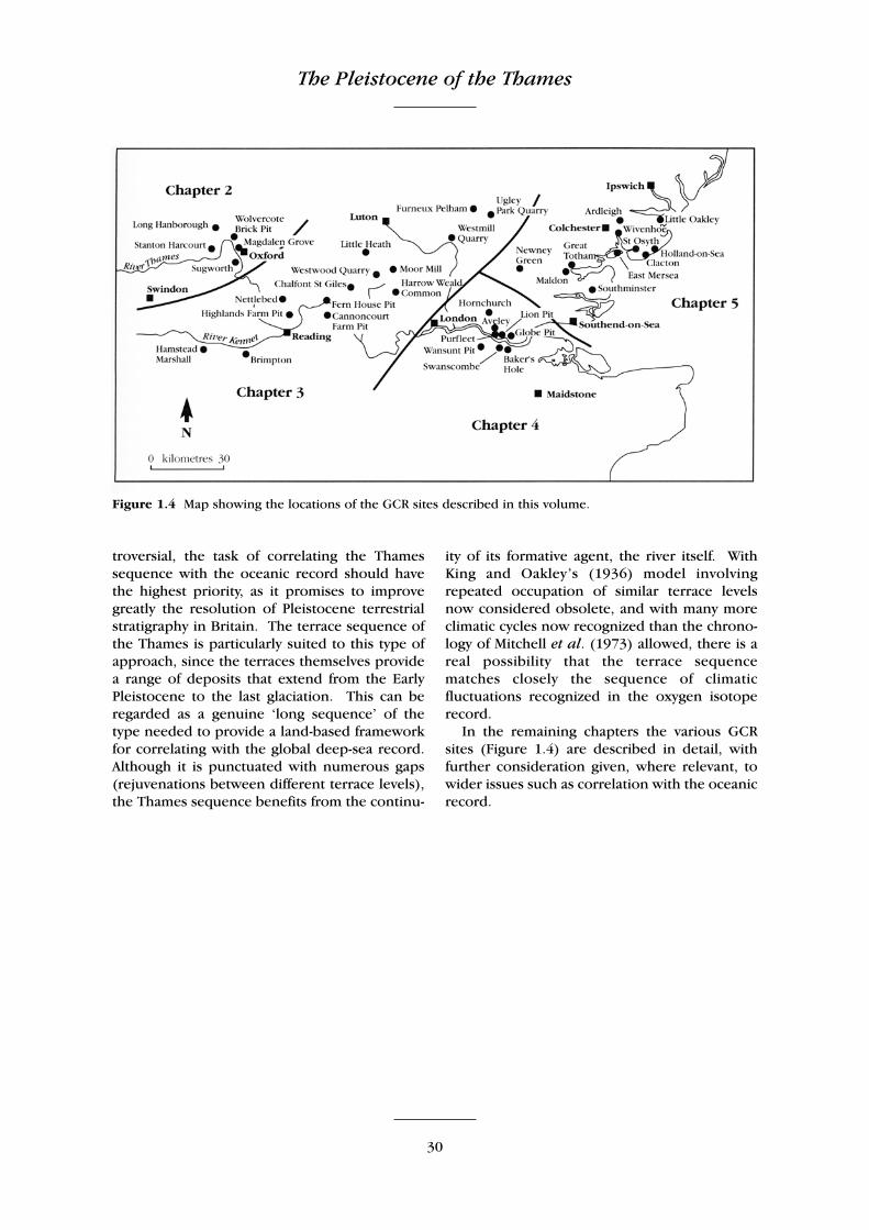
The Pleistocene of the Thames
30
troversial, the task of correlating the Thamessequence with the oceanic record should havethe highest priority, as it promises to improvegreatly the resolution of Pleistocene terrestrialstratigraphy in Britain. The terrace sequence ofthe Thames is particularly suited to this type ofapproach, since the terraces themselves providea range of deposits that extend from the EarlyPleistocene to the last glaciation. This can beregarded as a genuine ‘long sequence’ of thetype needed to provide a land-based frameworkfor correlating with the global deep-sea record.Although it is punctuated with numerous gaps(rejuvenations between different terrace levels),the Thames sequence benefits from the continu-
ity of its formative agent, the river itself. WithKing and Oakley’s (1936) model involvingrepeated occupation of similar terrace levelsnow considered obsolete, and with many moreclimatic cycles now recognized than the chrono-logy of Mitchell et al. (1973) allowed, there is areal possibility that the terrace sequencematches closely the sequence of climaticfluctuations recognized in the oxygen isotoperecord.
In the remaining chapters the various GCRsites (Figure 1.4) are described in detail, withfurther consideration given, where relevant, towider issues such as correlation with the oceanicrecord.
Figure 1.4 Map showing the locations of the GCR sites described in this volume.