the petroleum system: a new classification scheme based on ... · petroleum system,’’ source...
TRANSCRIPT
ORIGINAL PAPER
The petroleum system: a new classification scheme based on reservoirqualities
Jing-Zhou Zhao1,2 • Jun Li1,2 • Wei-Tao Wu1,2 • Qing Cao1,2 • Yu-Bin Bai1,2 • Chuang Er1,2
Received: 7 February 2018 / Published online: 13 December 2018� The Author(s) 2018
AbstractA new classification of petroleum systems (PSs) based on reservoir qualities is proposed. We classify PSs into the
following three basic types: (1) source-rock petroleum system (SPS); (2) tight-reservoir or tight petroleum system (TPS);
and (3) conventional-reservoir or conventional petroleum system (CPS). The CPS is a PS in which hydrocarbons accu-
mulate in conventional reservoirs, and all the essential elements and processes are significant and indispensable. Oil and
gas accumulations are geographically discrete and therefore exist as discontinuous accumulations. The TPS is a PS where
hydrocarbons accumulate in tight reservoirs and the source rock, reservoir, seal, migration, and trap are also indispensable,
but the traps are mostly non-anticlinal and the accumulations are primarily quasi-continuous and secondarily discontin-
uous. The SPS is a PS where both hydrocarbon generation and accumulation occurred in source rocks and traps and
migration are unnecessary or inconsequential; the hydrocarbon distribution is extensive and continuous and has no distinct
boundaries. The aforementioned three PSs can be derived from a common hydrocarbon source kitchen and are closely
linked in terms of their formation and distribution. Therefore, to maximize the exploration efficiency, a comprehensive
study and different strategies are needed by considering the SPS, TPS, and CPS as parts of a greater whole.
Keywords Petroleum system � Classification � Conventional petroleum system � Unconventional petroleum system �Source-rock petroleum system � Tight petroleum system
1 Introduction
Since the notion of the PS was introduced in the 1970s,
studies on the PS have mainly focused on the research and
exploration of conventional oil and gas accumulations. On
this basis, it was proposed that a PS consists of such essential
elements as source rock, reservoir, seal, and overburden
rocks, and such processes as petroleum generation, migra-
tion, accumulation, and entrapment (Magoon and Dow
1994). The concept of the ‘‘total petroleum system’’
advanced later by Magoon and Schmoker (2000) also
emphasized the necessity of the aforementioned elements
and processes. The difference from the widely accepted PS
concept is that the ‘‘total petroleum system’’ includes not
only the discovered oil and gas seepages, shows, and
reservoirs, but the undiscovered hydrocarbons as well, and
the hydrocarbon source can be either one or more active
pods of source rocks (Magoon and Schmoker 2000). Fur-
thermore, Magoon and Schmoker (2000) noted that the
‘‘total petroleum system’’ concept presumes that migration
pathways exist, either at present or in the past, to connect the
source with the accumulations. In addition, similar to the
nomenclature of the PS, as proposed by Magoon and Dow
(1994), the ‘‘total petroleum system’’ is also named after the
stratigraphic names of the source rock plus the reservoir.
Thus, it can be seen that in both traditional and the ‘‘total
petroleum system,’’ source rock and reservoir are regarded
as two separate rock units, and the necessity and importance
of migration to petroleum accumulation is highlighted.
However, the increasing discovery of and the in-depth
research into unconventional oil and gas accumulations in
recent years has indicated that the traditional PS theories
Edited by Jie Hao
& Jing-Zhou Zhao
1 School of Earth Sciences and Engineering, Xi’an Shiyou
University, Xi’an 710065, Shaanxi, China
2 Shaanxi Key Laboratory of Petroleum Accumulation
Geology, Xi’an Shiyou University, Xi’an 710065, Shaanxi,
China
123
Petroleum Science (2019) 16:229–251https://doi.org/10.1007/s12182-018-0286-2(0123456789().,-volV)(0123456789().,-volV)

and practices established on the basis of conventional
petroleum accumulation studies seem to have become
unable to completely satisfy the needs of current hydro-
carbon exploration and development. For example, source
rocks and reservoirs are commonly regarded as two distinct
stratigraphic units in the general practice of traditional PS
studies and exploration. Nevertheless, they correspond to a
common stratigraphic unit in some unconventional petro-
leum accumulations, such as those of shale oil and gas and
coalbed methane (CBM), where the unit acts not only as a
source rock but also as a reservoir. Furthermore, in the
studies of traditional PS, traps are underlined as an indis-
pensable element in petroleum accumulation, but are usu-
ally unnecessary or even completely ineffective in the
formation of shale oil and gas and many CBM accumula-
tions, although seals are still necessary. In addition,
migration is less important for many unconventional pet-
roleum accumulations than it is for conventional petroleum
accumulations, and even the driving force, and migrating
pattern, pathway, and distance are quite different from
those of conventional petroleum accumulation (Zhao et al.
2016a). On the other hand, studies have indicated that a
hydrocarbon source kitchen can lead to both conventional
and unconventional petroleum accumulations and that they
can coexist in a basin and are closely related to each other
in the formation and distribution, but cannibalize each
other in terms of resource potential (Zhao et al. 2016a). It
follows that the studies of PS ought to shift from the tra-
ditional, conventional accumulation dominated thinking
toward a new paradigm that is compatible with both con-
ventional and unconventional accumulations. Because the
focus of petroleum exploration is switching from conven-
tional to unconventional resources, the PS studies need to
adjust accordingly. Therefore, comprehensive studies of
the major characteristics, mutual relationships, and the
formation and distribution rules of conventional and
unconventional PSs have become necessary for petroleum
exploration.
2 Classification of petroleum systemsand their characteristics
A variety of opinions have been put forward with respect to
the classification of PSs. Among them, Magoon (1989)
classified PSs of the USA based on the complexity of the
overlying rock (purebred versus hybrid), reservoir lithol-
ogy (siliciclastic versus carbonate), and kerogen type (I, II,
and III). Demaison and Huizinga’s (1991) division was
based on the features of hydrocarbon charging, migration,
and entrapment. Magoon and Dow (1994) classified PSs
into single-sourced and multiple-sourced systems in terms
of the number of source kitchens. Considering the
coexistence of multiple source kitchens in many superim-
posed basins and the resultant complexity of hydrocarbon
migration and accumulation, Zhao and He (2000) intro-
duced the concept of ‘‘composite petroleum system’’ and
discussed the classification of it. In addition, a PS can be
subdivided into different petroleum migration–accumula-
tion systems in terms of the migration and accumulation
characteristics (Zhao and Al-aasm 2012).
Nevertheless, a PS classification based on reservoir
qualities has not been discussed in previous studies on PS
classification, and almost all the PS classifications are
based on the accumulations in conventional reservoirs. In
fact, the quality of reservoirs plays a key role in affecting
hydrocarbon charge, migration, and accumulation; reser-
voirs of different qualities generally have different char-
acteristics of hydrocarbon migration and accumulation
(Zhao et al. 2016a). As a result, in this article, we base our
classification of PSs on reservoir qualities, in combination
with the corresponding characteristics of hydrocarbon
migration and accumulation, and divide them into the
following three basic types: source-rock PS (SPS), tight-
reservoir PS or tight PS (TPS), and conventional-reservoir
PS or conventional PS (CPS). The SPS, TPS, and CPS are
dominated and characterized by continuous, quasi-contin-
uous, and discontinuous accumulations, respectively
(Fig. 1). Tables 1 and 2 show the major characteristics of
the three PSs and some typical examples of conventional,
tight, and source-rock reservoirs, respectively.
It should be noted that the PS classification
scheme proposed in this article is not a substitute for the
traditional proposals on PS classification, but a supplement
to them. In addition, this is a generalized classification of
PSs. Therefore, although different reservoirs with similar
qualities can be attributed to the same category of PS in our
classification, they were identified, according to Magoon
and Dow (1994), as different PSs in specific practices of PS
identification in a basin.
2.1 Source-rock petroleum system (SPS)
This petroleum system, formed within source rocks, is a
self-sourcing and self-storing PS. In terms of the litholog-
ical types of source rocks, the SPS includes shale SPS,
carbonate SPS, and coal SPS. Typical representatives
include shale oil/gas and CBM systems. The major char-
acteristics of the SPS are as follows:
(1) Phase States of Hydrocarbons
Unlike hydrocarbons stored mostly as free oil and gas in
non-source-rock reservoirs, hydrocarbons accumulated in
source-rock reservoirs can be in a free state, an absorbed/
adsorbed state, or even a dissolved state. This is particu-
larly true for natural gas storage, while oil is stored
230 Petroleum Science (2019) 16:229–251
123

primarily in a free state. In reality, the existence of more
absorbed/adsorbed hydrocarbons is one of the most dis-
tinctive features of the SPS. For instance, CBM occurs
mainly in an absorbed/adsorbed state. For shale gas, the
free, absorbed/adsorbed and dissolved states are significant,
but the ratio among them is variable (Curtis 2002; Wang
and Sheng 2017). According to Jarvie (2012), the propor-
tion of absorbed/adsorbed gas in the major shale gas
accumulations of North America is 10%–70%, and that of
free gas accounts for 30%–90%. Indeed, it is the existence
of absorbed/adsorbed gas that enables oil/gas accumula-
tions inside source rocks to have typical characteristics of
continuous accumulations, while a relatively higher pro-
portion of free-state hydrocarbons are more favorable for
the high yield of oil and gas.
(2) Reservoirs
One of the most prominent attributes of the SPS’s
reservoirs is that they are tight (microdarcies) to ultra-tight
(nanodarcies). However, there are also reservoirs with
Fig. 1 Distribution of continuous, quasi-continuous, and discontinuous petroleum accumulations in a petroleum basin, showing they typically
occur in source rocks (gray), tight reservoirs, and conventional reservoirs, respectively
Table 1 Comparison of the source petroleum system, tight petroleum system, and conventional petroleum system
Types of petroleum systems Source petroleum system Tight petroleum system Conventional petroleum system
Essential elements
Source rocks Shales, carbonates, coals Shales, carbonates, coals Shales, carbonates, coals
Reservoirs Source rocks Tight sandstones and carbonates Conventional reservoirs
Seals Self-sealing Self-sealing; mudstones,
carbonates, etc.
Mudstones, carbonates, etc.
Traps Not required Non-anticlinal traps are necessary,
while anticlinal trap functions for
some
Indispensable
Essential processes
Generation No particular requirement for timing After the reservoir gets tight Prior to or contemporaneous with
trap formation
Migration Insignificant or over short distances Primary migration is important,
and secondary migration is
mostly over short distance.
Migration is mainly
overpressure-driven flow
Both primary and secondary
migrations are significant. And
secondary migration is
commonly buoyancy-driven flow
and sometimes overpressure-
driven flow
Accumulation Mostly continuous Quasi-continuous or discontinuous Discontinuous
Preservation Commonly excellent Moderate to excellent Critical
Types of accumulation Mostly continuous Primarily quasi-continuous, and
secondarily discontinuous
Discontinuous
Typical accumulation Shale oil and gas Tight oil and gas Conventional reservoirs
Petroleum Science (2019) 16:229–251 231
123

higher permeabilities. As reservoirs of continuous accu-
mulations, source rocks, no matter if they are shales, car-
bonates, or coals, belong to the most inferior type of
reservoirs for hydrocarbon accumulation. Their matrix
permeability generally ranges from a few nanodarcies (nd)
to a few millidarcies (md). Among the various source-rock
reservoirs, shales are commonly the tightest. According to
Curtis (2002) and Jarvie (2012), the permeabilities of major
North America shale gas reservoirs are in the range of
0–5000 nd, with average values ranging from 10–1000 nd,
while the porosity is in the range of 1%–14%, with average
values of 4%–8% (Jarvie 2012). Nevertheless, the perme-
ability of CBM reservoirs is highly variable due to the
development of cleats and fractures to some degree.
Despite this, the matrix permeabilities of coals are com-
monly quite low, and, hence, many CBM accumulations
can be attributed to the continuous type. In general, the
permeability of high-ranked coals is the lowest, followed
by medium-ranked coals. For example, the high-ranked
Carboniferous–Permian coals from the southern Qinshui
Basin have an effective porosity of 1.1%–7.7% (gener-
ally\ 5%) and a permeability of 0.1–6.7 md (usually\ 2
md) (Lin and Su 2007). However, the Cretaceous Fruitland
Formation coals in the San Juan Basin are medium-ranked,
with permeabilities mainly in the range of 5–60 md in gas-
producing areas (Ayers Jr 2002). The coals in the Black
Warrior Basin are mostly low-ranked (bituminous) and
have a permeability of 1–25 md (Jenkins and Boyer II
2008).
It is because of the poor reservoir qualities and the small
and variable pore throats that make it nearly impossible for
hydrocarbons in source rocks to migrate over long dis-
tances and to accumulate in a concentrated area. Instead,
hydrocarbons in such reservoirs tend to form a widespread
and continuous distribution. On the contrary, if source-rock
reservoirs were similar to conventional reservoirs with high
porosities and permeabilities, discontinuous or conven-
tional trap-controlled accumulations rather than continuous
accumulations would tend to occur in them. Some coal
reservoirs, particularly coals of low to medium rank, are
quite similar to conventional reservoirs. The permeabilities
of low-ranked coals in the Powder River Basin are, for
instance, usually between 10 md and a few darcies (Ayers
2002). The Walloon Formation coals in the Australian
Surat Basin are lignite, belonging to typically low-ranked
CBM reservoirs, and have relatively good qualities, with an
average porosity of approximately 17% and a permeability
of roughly 1–300 md. The Blackwater Group coals in the
Northern Bowen Basin are at a low metamorphic rank, and
their porosities are 6%–13%, while their permeabilities are
5–30 md (Li et al. 2014).
As far as the factors controlling the qualities of source-
rock reservoirs are concerned, the organic matter features
(content, type and maturity), mineral composition, com-
paction and diagenesis, and structural deformation
Table 2 Some typical examples of conventional, tight, and shale reservoirs
Reservoir
type
Basin or
oil/gas field
Formation Lithology Porosity (%) range/
average
Permeability (md)
range/average
Source
Conventional reservoirs
Penglai-193 oilfield
(China)
Minghuazhen Fm. and
Guantao Fm. (N1)
Sandstones \ 37/27 \ 30,000/750 Halbouty (2003)
Masila oilfield (Yemen) Upper Qishn Fm. (K1) Sandstones 15–28/20 \ 10,000/1500 Halbouty (2003)
Panphandle-Hugoto gas
Field (USA)
Wolfcamp Fm. (P1) Dolomites 16–30 1–5 Zhang (1990)
Urengoy (Russia) K1–K2 Sandstones 13–27 8–495 Zhang (1990)
Tight reservoirs
Ordos Basin (China) Yanchang Fm. (T3) Sandstones 2–12 0.01–1 Zhao et al. (2012b)
Sulige gas field (China) Xiashihezi Fm. and Shanxi
Fm. (P2)
Sandstones 5.0–21.8/10.3 0.1–1.0/0.38 Zhao et al. (2012a)
Hechuan gas field (China) Xujiahe Fm. (T3) Sandstones 8–9/8.5 0.2–0.4/0.3 Li et al. (2013a)
Piceance Basin (USA) Mesaverde group (K2) Sandstones 2–10 0.0001–0.1 Hood and
Yurewicz (2008)
Source-rock reservoirs
Sichuan Basin (China) Wufeng Fm. (O3). and
Longmaxi Fm. (S1)
Shale 4.2–6.2 0.000042–0.000348 Dong et al. (2016)
Appalachian Basin (USA) Marcellus shale (D2) Shale 4.0–12.0/6.2 0–0.00007/0.00002 Jarvie (2012)
Fort Worth Basin (USA) Barnett shale (C1) Shale 4.0–6.0/5.0 0–0.0001/0.00005 Jarvie (2012)
232 Petroleum Science (2019) 16:229–251
123

(fractures) are among the most significant. The total
organic matter (TOC) content has remarkable effects on
pore development in organic-rich shales. According to
Milliken et al. (2013) regarding the relationship between
the porosity and TOC of the Devonian Marcellus shales in
Pennsylvania (Fig. 2a), the shale porosity is positively
correlated with TOC when TOC\ 5.5%, but does not
increase when TOC[ 5.5%. In contrast, the porosity
remains basically unchanged or even slightly decreases,
which has been interpreted as a potential result of the
‘‘collapse’’ of pores caused by hydrocarbon expulsion.
Nevertheless, studies on the Chang-7 lacustrine shales of
the Yanchang Formation in the Ordos Basin have shown
that pore volumes are negatively correlated to TOC
(Fig. 2b), which is similar to the case noted by Jarvie
(2011) for the Doig shales. This is probably due to the fact
that the maturities of Chang-7 shales (Ro * 0.7%–1.2%)
are not high enough, and, hence, the pore development is
affected primarily by compaction. Based on a study on the
New Albany Shale by Mastalerz et al. (2013), the rela-
tionship between its total pore volume and Ro differs sig-
nificantly and is affected by the stage of thermal evolution.
Figure 3a shows that the total pore volume and Ro are
negatively correlated when the organic matter is at the
immature to mature stage, resembling the Chang-7 lacus-
trine shale of the Ordos Basin (Fig. 3b). However, when
the organic matter has achieved high maturity, the rela-
tionship between them becomes positive. This is particu-
larly true for the porosities of organic matter, as they are
related to thermal maturation of organic matter and are the
result of hydrocarbon generation (Loucks et al. 2009). For
instance, organic porosity of the Woodford Shale was
observed to be absent in samples with vitrinite reflectance
values of up to 0.90%, while the first appearance of sec-
ondary pores is observed with the 1.23% Ro sample (Curtis
et al. 2012).
The major cause is that compaction is predominant in
early burial stages of shales and pore volumes thus
decrease with the increase in Ro during a compaction-
dominated stage. However, pore volumes increase gradu-
ally with Ro in later stages due to the effect of hydrocarbon
generation and the resultant increase in organic matter
pores (Mastalerz et al. 2013).
(3) Accumulations and Traps
In the SPS, hydrocarbon accumulations are predomi-
nately the continuous type because they occurred in
effective source rocks, in which hydrocarbons are thought
to be ubiquitous, albeit in varying abundances. The concept
of ‘‘continuous accumulation’’ was first introduced in the
mid-1990s by Schmoker (1995) to characterize hydrocar-
bon accumulations with extensive spatial distribution and
no defined boundaries that are more or less independent of
a water column. Schmoker (1995, 2002) contended that
continuous accumulations belong to unconventional
hydrocarbon resources and attributed CBM, basin-centered
gas, tight gas, shale gas, and natural gas hydrate to this
category. According to Zhao et al. (2016a), however, a
genuine continuous accumulation probably only occurs
within a source rock interval, which is typically represented
by shale gas and CBM. Nevertheless, not all shale oil and
gas accumulations and CBM accumulations are continu-
ous; in reality, some of them could possibly be discontin-
uous accumulations if structural elements become
dominant controlling factors for hydrocarbon
accumulation.
A significant feature of continuous accumulations is that
each of them consists of only a single oil or gas reservoir,
and, hence, an oil or gas field of continuous accumulation
should be non-compartmentalized. Moreover, their spatial
distribution is extensive and the reserve scales are gener-
ally quite large (Schmoker 1995, 2002), such that the
10
8
6
4
2
00 5 10 15 20
0.035
0.030
0.025
0.020
0.015
0.010
0.005
00 5 10
Por
osity
, %B
V
TOC, wt.%
R2 = 0.8209
TOC < 5.6%Well 1, Ro = 1.0%Well 2, Ro = 2.1%
Well 2, Ro = 2.1%Well 1, Ro = 1.0%
TOC > 5.6%
TOC, wt.%
Por
e vo
lum
e, m
3 /g
(a) (b)
Fig. 2 Relationship between shale porosity and total organic carbon content. a Devonian Marcellus shales from Pennsylvania (Milliken et al.
2013). b Triassic Chang-7 shales from the Ordos Basin (Zhao et al. 2016b), in which the parallel double lines are trend lines
Petroleum Science (2019) 16:229–251 233
123

resultant oil and gas fields can commonly attain giant or
even supergiant sizes in terms of resources scales (see
Tables 3, 4). Field areas are usually thousands, tens of
thousands, and even up to hundreds of thousands of square
kilometers. As accumulations in source rocks, the distri-
bution area of effective source rocks is also the potential
area for hydrocarbon accumulation, but a commercial
accumulation in a source rock is commonly determined by
sweet spots, which are dependent on the presence of many
other factors and will be discussed later.
Secondly, hydrocarbons in continuous accumulations
are continuously distributed, implying that hydrocarbons
are ubiquitous in the entire areal extent of an accumulation,
and neither dry holes nor dry beds would be encountered
when such a reservoir is drilled, although variation of
hydrocarbon abundances and production rates is commonly
remarkable across the extent of the accumulation. More-
over, continuous accumulations also have no explicit
boundaries, oil/gas water contact, or edge water or bottom
water.
In addition to continuous accumulations, discontinuous
accumulations can also occur in source-rock reservoirs, if
their permeabilities are high enough. This is relatively
more common in CBM reservoirs because the permeability
of coals is highly variable, ranging from less than 1 md to
more than 1000 md. Generally, the permeability of low-
ranked coals is higher and almost comparable to that of
conventional reservoirs. Thus, accumulations in such per-
meable coals could often be governed by structural traps
and more concentrated at high structural positions. The
variation in the permeability of medium-ranked coals is
also fairly large, and thereby both continuous and discon-
tinuous accumulations are possible.
As far as the roles of traps are concerned, studies of the
characteristics of continuous accumulations in source rocks
indicate that they are essentially not confined by traps.
Instead, they are largely controlled by the distribution of
effective source rocks, the quality of top and bottom seals,
and other factors. Despite this, the existence of structural
traps often has certain and even significant effects on the
enrichment of a continuous accumulation. In that case, the
function of a structural trap is similar to the role of a sweet
spot. For source-rock reservoirs with medium to high
permeabilities, the accumulations are influenced by traps to
some degree and thus might take the shape of a discon-
tinuous type.
(4) Migration
Continuous accumulations, as redefined by Zhao et al.
(2016a), are those that occur within source rocks. In our
opinion, continuous accumulation can only form within a
source rock. Such types of oil/gas accumulations caused
within source rocks mainly occur in situ or are close to
where the hydrocarbons are generated, and usually neither
significant migration nor a dominant migration pathway is
needed. Otherwise, if dominant migration pathways are
developed inside source rocks, then oil/gas accumulations
therein will probably be subject to conventional traps (such
as fractured oil/gas accumulations in mudstones), and more
hydrocarbons generated in the source rocks can be expelled
and migrate outward. It should be noted that some con-
ventional accumulations, notwithstanding the large areal
and ‘‘continuous’’ distribution they may have, possess edge
water or bottom water and distinct boundaries in general,
which is a diagnostic feature of discontinuous (conven-
tional) accumulations.
00
0.5 1.0 1.5
Vitrinite reflectance (Ro), % Vitrinite reflectance (Ro), %
0.01
0.02
0.03
0.04
Tota
l por
e vo
lum
e, c
m3 /g
MICP
He porosimetry
(a) (b)
0.6 0.8 1.0 1.2 1.4
Lang
mui
r vol
ume,
m3 /t
0
4.0
5.0
3.0
1.0
2.0
Fig. 3 Illustration of pore volume or Langmuir volume variation with
vitrinite reflectance. a The relationship between Ro and pore volume
of the New Albany shales (Mastalerz et al. 2013), showing the
evolution of pore volume decreasing with Ro if Ro\ 1.15%, and
increasing with Ro if Ro[ 1.15%. (MICP is mercury injection
capillary pressure). b The relationship between Ro and the Langmuir
volume of the Triassic Chang-7 shales from the Ordos Basin (Zhao
et al. 2016b) indirectly indicates a similar evolutionary trend in
porosity, but the inflexion point is at about 0.9% Ro
234 Petroleum Science (2019) 16:229–251
123

(5) Controls on hydrocarbon enrichment
Hydrocarbon enrichment in the SPS primarily depends
on source rock qualities, reservoir sweet spots, and sealing
conditions. Moreover, hydrocarbons can even be quite
abundant at low structural positions, differing from most
conventional accumulations.
a. Hydrocarbon-generating condition
The hydrocarbon-generating condition is a primary
factor affecting hydrocarbon enrichment. Studies indicate
that there is a positive correlation between shale gas con-
tent and organic matter abundance. The higher the TOC
values, the higher the shale gas content (Ross and Bustin
2009; Jarvie 2011; Guo 2013). Furthermore, source rocks
should be thick enough so that the hydrocarbons generated
cannot be readily expelled. In general, the greater the
thickness of source rocks, the more difficult it is for the
hydrocarbons to be expelled from the innermost of the
source rocks, and the more hydrocarbons are retained in
them. Analyses of high-yield regions of marine shale gas in
North America show that those shales share some crucial
attributes, including TOC[ 1%, Ro[ 1.4%, and shale
thicknesses generally[ 30 m (Jarvie 2012). Otherwise,
there would be insufficient shale gas accumulation and
enrichment in the source rocks, given that their thermal
maturities are not high enough nor their thicknesses great
enough. For instance, the gas produced from the Barnett
Shale is revealed to have been generated within the con-
densate–wet gas window (1.3–2.0% Ro) and probably
derived from both kerogen cracking and secondary crack-
ing of previously generated non-migrated hydrocarbons
(Rodriguez and Philp 2010). As another example, the
Chang-7 shale source rocks of the Triassic Yanchang
Formation in the Ordos Basin are dominated by type I and
II kerogen and their Ro is 0.7%–1.2% (i.e., mainly in the
‘‘oil generation window’’); hence, the generated hydro-
carbons are oil-dominated, and the gas content is extremely
limited (Zhao et al. 2016b).
In addition to the requirement for sufficient amounts of
hydrocarbon generation, hydrocarbon expulsion efficien-
cies of shales are another key factor affecting shale
hydrocarbon richness. The lower the hydrocarbon expul-
sion efficiency or the greater the amount of hydrocarbons
retained in source rocks, the larger would be the quantity of
hydrocarbons accumulating in the shales. According to
studies by Pepper (1992) and Jarvie et al. (2007), the
hydrocarbon expulsion efficiency of the Barnett Shale is
approximately 60%. Thus, we can infer that large-scale
continuous shale gas accumulation will be possible in
shales if the amount of retained hydrocarbon is approxi-
mately 40% or more of the total hydrocarbon generated.
Table 4 Undiscovered technically recoverable resources (TRR) of some major shale oil plays
Location Shale play Oil NGL Source
MMBO MMTO MMBO MMTO
Midland Basin (Permian Basin Province) Wolfcamp 19,948 2733 1596 219 Gaswirth (2017)
U.S. Gulf Coast Region Eagle Ford 853 117 2043 280 Dubiel et al. (2012)
Williston Bakken and Three Forks 7375 1010 527 72 Gaswirth et al. (2013)
MMBO, million barrels of oil; MMTO, million tons of oil; NGL, natural gas liquid
Table 3 Technically recoverable resources (TRR) of some major shale gas plays
Location Shale play Area TRR Source
mi2 km2 TCF TCM
Appalachia Marcellus 94,893 245,773 410.34 11.61 EIA (2011)
Sichuan Basin Longmaxi and Qiongzhusi 93.29 2.64 Dong et al. (2014)
U.S. Gulf Coast Haynesville 20,584 53,313 74.71 2.11 Paxton et al. (2017)
Bend Arch-Fort Worth Basin Barnett 53 1.50 Marra et al. (2015)
U.S. Gulf Coast Region Eagle Ford 51.93 1.47 Dubiel et al. (2012)
Arkoma Basin Fayetteville 9000 23,310 31.96 0.90 EIA (2011)
Arkoma and Ardmore Basins Woodford 4700 12,173 22.21 0.63 EIA (2011)
Michigan Basin Antrim 12,000 31,080 19.93 0.56 EIA (2011)
mi2, square miles; km2, square kilometers; TCF, trillion cubic feet; TCM, trillion cubic meters
Petroleum Science (2019) 16:229–251 235
123

b. Reservoir heterogeneity and sweet spots
Source rocks as a reservoir, such as shales and coals, are
not only usually poor in quality but may be also more
heterogeneous relative to many other reservoirs, particu-
larly those of conventional accumulations. The hetero-
geneity of a source-rock reservoir, however, is generally a
propitious factor for the occurrence of abundant hydro-
carbon accumulations because sweet spots can only be
developed in reservoirs with certain heterogeneity. Other-
wise, hydrocarbon enrichment might be unlikely if the
source-rock reservoirs are highly uniform in terms of their
properties. It is the reservoir heterogeneity and develop-
ment of sweet spots that control the specific locations of
hydrocarbon enrichment. The sweet spots in source rocks
can be classified into two types: structural and non-struc-
tural. The former is represented by anticlinal sweet spots,
while the latter includes geochemical sweet spots (favor-
able regions for TOC, Ro, thickness, etc.) and petrophysical
(porosity and permeability) sweet spots. Accordingly,
continuous accumulations can be divided into two types,
namely structural sweet-spot accumulations and non-
structural sweet-spot accumulations. In general, structural
sweet-spot accumulations are characterized by higher
resource abundance and producibility and relatively smal-
ler areas of oil/gas distribution than non-structural sweet-
spot accumulations. For example, the Fuling Field in the
Sichuan Basin seems to be a structural sweet-spot type of
shale gas accumulation (Zhao et al. 2016a).
It is noteworthy that good-quality reservoirs are not
always an advantageous condition for the formation of
continuous hydrocarbon accumulations. That is because the
accumulations would probably be of conventional nature,
or oil/gas would likely escape from source rocks if the
source-rock reservoirs were permeable enough to attain the
quality level of conventional reservoirs. Although it is
widely believed that the minimum permeability of com-
mercial shale gas reservoirs exceeds 100 nd and shales with
a permeability[ 500 nd are optimal (Zagorski et al. 2012),
shale porosities of high-yield marine gas shales in North
America are\ 15%, mainly in the range of 4%–7%, and
the permeabilities are\ 1000 nd (Jarvie 2012).
The brittleness is also a pivotal factor affecting shale oil
and gas production. It has been demonstrated that pro-
ducible shale ought to contain sufficient brittle minerals
(e.g., quartz, feldspar, and carbonates) and their clay
mineral contents should not be too high (Bowker 2007;
Jarvie 2012). Furthermore, relatively high contents of
brittle minerals and low contents of clay minerals not only
can make shale fracturing easier, but also enable them to
have higher porosity and permeability and thus be more
favorable for shale oil/gas enrichment and production.
Statistics and analyses have shown that most productive
marine gas shales in North America are quartz rich, car-
bonate rich, or dominated by a combination of multiple
brittle minerals, while the content of clay is subordinate
(Jarvie 2012; Wilson et al. 2016; Chalmers et al. 2012).
Bowker (2007) claimed that the clay mineral content of the
Barnett Shale is usually less than 50%. Rezaee and Roth-
well (2015) noted that low clay content (\ 50%)/high
brittle mineral content ([ 40%) is one of the key geological
characteristics of a successful shale gas play. In reality,
some statistics (e.g., Jarvie 2012; Wilson et al. 2016) have
shown that clay mineral contents of the most successfully
exploited shales in North America are less than 45%.
Apart from the relative proportion of clay versus non-
clay minerals, the provenance and origins of the compo-
nents in shales are also critical in determining the richness
and production of shale oil and gas. The components of
most shales can be categorized as those of terrigenous
(detrital) and autochthonous (including diagenetic) in terms
of their provenance and can also be categorized as biogenic
components and abiogenic components. As one of the most
significant brittle minerals, quartz in shales includes bio-
genic, diagenetic, and detrital types. It has been suggested
that the abundant presence of biogenic silica has the
potential to increase rock brittleness and ‘‘fracability’’
(Passey et al. 2010; Slatt 2011). The primary sources of
biogenic silica are diatoms, radiolaria, and sponge spicules
(Katz and Everett 2016). In fact, the presence of abundant
biogenic and diagenetic quartz is a crucial factor leading to
the success of many marine shales in North America. By
contrast, the impact of abiogenic quartz on the enrichment
and production of shale oil and gas is more complicated
because of the complexity of its origins, which includes
detrital quartz and authigenic quartz. For most commercial
marine shales, authigenic and biogenic quartz is dominant
over terrigenous abiogenic quartz, while terrigenous abio-
genic quartz is commonly more abundant in shales
deposited in continental environments (including lacus-
trine, paludal and fluvial facies), in which lacustrine and
paludal shales are assumed to be two most potential types
of shale plays as revealed by the exploration in the Ordos
Basin (Zou et al. 2017), the Bohai Bay Basin (Sun 2017;
Zhao et al. 2018), and the Songliao Basin (Zhang et al.
2016) of China. For this reason, higher contents of quartz
are not always conducive to hydrocarbon enrichment and
production from continental shales, nor are lower contents
of clay minerals. Studies of the Triassic Chang-7 lacustrine
shale in the Ordos Basin indicated that the TOC content is
negatively correlated with the quartz content, but positively
correlated with the clay mineral content (Er et al. 2013;
Zhao et al. 2016b). Because clay minerals are usually one
of the major components of shale, an unduly high content
of terrigenous detrital quartz or an overly low content of
clay minerals is associated with a decrease in organic
236 Petroleum Science (2019) 16:229–251
123

matter content in shale, which is a disadvantage to the
generation of sufficient shale oil/gas, although either can
increase shale brittleness, porosity, and permeability. As a
result, finding an optimal balance between the contents of
brittle minerals and clay and TOC in shale should be
regarded as the linchpin of successful exploration and
exploitation for shale oil and gas. In addition to clay con-
tent, the provenance and varieties of clay minerals appear
to play an equally significant role in affecting the produc-
tion of shale oil and gas. It has been suggested that the clay
mineralogy of practically all of the shale reservoirs older
than Upper Cretaceous is dominated by illitic clays, both in
discrete form and as illite-dominated, mixed-layer, illite–
smectite (I/S) (Wilson et al. 2016).
In reality, the content of clay minerals versus non-clay
minerals or brittle minerals in shale and the origins of the
minerals including quartz are essentially determined by
depositional settings and diagenesis. It has been revealed
that marine-deposited shales tend to have lower clay con-
tent and higher content of brittle minerals such as quartz,
feldspar, and carbonates (Ju et al. 2014; Wilson et al.
2016), and most productive shales are siliceous, calcareous
or dolomitic mudstones, or mudstones where one or a few
key brittle minerals and non-swelling clay are both abun-
dant. Moreover, the distribution of mineral components
and reservoir properties in marine shales are more
stable than their continental counterparts. In spite of this,
the development of shale plays has revealed strong
heterogeneities in marine shales (Bustin and Bustin 2012).
By contrast, continental shales including lacustrine shales
tend to be higher in clay content, more ductile and less
responsive to hydraulic stimulation (De Silva et al. 2015),
and their heterogeneities are commonly stronger. Their
mineralogical composition appears to be more diverse, and
the reservoir properties are presumed to be more variable.
Such a more diverse nature of continental shales, particu-
larly lacustrine shales, makes many of them probably less
exploitable, while some others might have significant
potential for shale oil and gas enrichment and production.
For instance, the average clay mineral contents of both the
Triassic Chang-7 lacustrine organic-rich shales and Upper
Paleozoic paludal organic-rich mudstones (carbonaceous
shales) in the Ordos Basin are commonly higher than 45%,
while the brittle mineral contents are relatively low (Zhao
et al. 2016b; Jiang et al. 2016). The lacustrine-deposited
Cretaceous Qingshankou Formation shales in the Songliao
Basin may also be clay rich, with an average content of
clay minerals of 55.1% at well ZK-01 (Liu et al. 2017).
Nonetheless, the lacustrine shales of the upper Es4 and
lower Es3 of the Eocene Shahejie Formation in the
Dongying Depression, Bohai Bay Basin, are carbonate rich
and clay poor, with an average content of authigenic car-
bonate of 37%, clay 25%, quartz 29%, and feldspar 5% (Li
2013), which is probably one of the crucial factors
accountable to the breakthrough of oil production in this
shale play. According to Sun (2017), 37 wells, as of 2016,
have produced shale oil at commercial rates from the Es4and Es3 shale of the Shahejie Formation in the Jiyang
Depression, the Bohai Bay Basin.
Consequently, petroleum exploration and development
of continental shales might face greater challenges com-
pared to those of marine shales. Despite this, because some
lacustrine shales are similar to producible marine shales in
that non-clay minerals are preponderant and mainly
authigenic, opportunities still exist for substantial discov-
eries of hydrocarbon accumulations in continental shales.
c. Top and bottom sealing conditions
Favorable top and bottom sealing conditions are also
critical for the enrichment of continuous hydrocarbon
accumulation. As far as the accumulations of shale oil/gas
or CBM are concerned, the premise of their enrichment is
that the hydrocarbons generated in organic-rich shales or
coals were not completely expelled. The less hydrocarbons
that are expelled, the more hydrocarbons are retained in the
source rocks, and the more abundant the accumulated shale
oil/gas and CBM. The quantity of hydrocarbons trapped
within source rocks is not simply affected by the quality of
source rocks per se, but also by the sealing conditions or
the conditions of hydrocarbon expulsion. The conditions of
sealing and expulsion of source rocks depend on the fol-
lowing three major factors. The first is the thickness of
source rocks; the greater the thickness, the more difficult it
is for the hydrocarbon to be expelled and the more
hydrocarbons that are retained. The second is the top and
bottom sealing conditions, as more hydrocarbons would be
held in source rocks with effective top and bottom seals.
The third is the intensity of tectonic activities, as strong
tectonic activities can lead to the development of more
fractures, and thus conditions would become more favor-
able for hydrocarbon expulsion from source rocks and less
favorable for hydrocarbon accumulation within them. As a
consequence, source rocks with sufficiently great thickness
and good quality, and propitious top and bottom sealing
conditions, but moderately developed fractures, are
advantageous for shale oil/gas and CBM enrichment. The
major gas-rich shales in North America are exactly those
possessing good to excellent top and bottom sealing con-
ditions. For instance, the Barnett Shale in the Fort Worth
Basin and the Devonian–Carboniferous New Albany Shale
in the Illinois Basin have tight limestones acting as both top
and bottom seals; for the Devonian Marcellus Shale in the
Appalachia Basin and the Devonian Antrim Shale in the
Michigan Basin, the top seals are shales, while the bottom
seals are limestones; the top seal of the Devonian Wood-
ford Shale in the Acoma Basin is comprised of limestones,
Petroleum Science (2019) 16:229–251 237
123

while the bottom seal consists of sandstones/limestones;
the Upper Jurassic Haynesville Shale in the East Texas–
North Louisiana Basin is overlain by sandstones and
underlain by limestones, whereas the Carboniferous
Fayetteville Shale in the Acoma Basin is overlain by a
limestone interval and underlain by a sandstone formation
(Ground Water Protection Council 2009).
Similarly, the Fuling Shale Gas Field in the Sichuan
Basin also has excellent top and bottom sealing conditions,
which play a crucial role in the shale gas enrichment and
preservation (Zhao et al. 2016a). The top seal of this Sil-
urian Longmaxi Formation Shale Gas Field is a thick
mudstone sequence with lower organic matter abundance
and low porosity and permeability, while the bottom seal is
the widely distributed tight limestones of the Ordovician
Jiancaogou Formation (O3j), which is 45–50 m in thickness
and has a porosity of 0.61%–1.66% (averaging 1.01%) and
a permeability of 0.0058–0.1092 md (averaging 0.0201
md) in well DS1 (Guo 2013). In spite of this, diffusion of
natural gas in the Fuling Shale Gas Field might be
noticeable. According to Dai et al. (2016, 2017), shale gas
from this field displays a complete carbon and hydrogen
isotopic reversal (i.e., d13C1[ d13C2[ d13C3; d2H1[ d2-
H2[ d2H3), which they interpreted as the result of sec-
ondary alteration like, among others, oil or gas cracking
and diffusion at high temperatures.
Likewise, good sealing is also significant for CBM
enrichment (Song et al. 2015).
2.2 Tight petroleum system (TPS)
In this article, tight oil and gas accumulation refers to that
occurring in low-permeability reservoirs that are not source
rocks or shale, which primarily includes petroleum accu-
mulations in tight sandstone and tight carbonate reservoirs.
Accordingly, such reservoirs are known as tight reservoirs.
Two models were proposed to interpret hydrocarbon
accumulations in such tight reservoirs as tight sandstones,
which are: (1) the deep-basin or basin-centered gas model,
also known as the continuous accumulation model; and (2)
the conventional trap-controlled accumulation model.
Recently, Zhao et al. (2012a, 2013, 2016a) proposed a new
model termed quasi-continuous accumulation and demon-
strated that tight oil and gas are dominated by quasi-con-
tinuous accumulation, while discontinuous (conventional
trap-controlled) accumulations are of subordinate impor-
tance. Zhao et al. (2016a) also argued that the so-called
continuous (basin-centered) accumulations actually do not
exist in non-source-rock tight reservoirs such as tight
sandstones. Hence, two types of hydrocarbon accumula-
tions can be caused in tight petroleum systems, namely the
quasi-continuous accumulation and discontinuous
accumulation.
2.2.1 Quasi-continuous tight accumulations (QTA)
The quasi-continuous hydrocarbon accumulation is defined
as an accumulation consisting of a group of petroleum
reservoirs that are adjacent and closely related with no
distinct boundaries. They are common in tight reservoirs,
especially tight sandstones. Examples of such accumula-
tions include the Upper Paleozoic tight sandstone gas
accumulations and the Triassic Yanchang Formation tight
sandstone oil accumulations in the Ordos Basin, the Tri-
assic Xujiahe Formation tight sandstone gas accumulations
in the central Sichuan Basin, the Cretaceous Fuyu and
Gaotaizi tight sandstone oil accumulations in the Songliao
Basin, some tight Ordovician carbonate oil and gas accu-
mulations in the Tarim Basin, and many tight sandstone
oil/gas accumulations in North American basins. The main
characteristics of quasi-continuous accumulations are
elaborated below.
(1) Reservoirs
Quasi-continuous accumulations dominantly occur in
tight reservoirs with permeabilities of approximately\ 1
md. It should be noted that the upper and lower porosity
and permeability limits of tight reservoirs are not uniform,
but are dependent on the specific geologic circumstances of
petroleum accumulations, and hence vary in different
basins or regions. For example, Cao et al. (2013b) have
demonstrated that the upper and lower limits of the reser-
voir properties for the Upper Paleozoic tight gas accumu-
lations even differ among various pay zones in the eastern
Ordos Basin.
Moreover, reservoirs of quasi-continuous accumulations
commonly become tight prior to hydrocarbon charging. In
the Ordos Basin, for instance, the Upper Paleozoic sand-
stones were charged mostly in the Early Cretaceous when
the sandstones had already become tight (Zhao et al. 2005;
Fu et al. 2008). Tight sandstone reservoirs in the Triassic
Xujiahe Formation of the central Sichuan Basin and the
Middle Jurassic Shaximiao Formation of the western
Sichuan Basin, where quasi-continuous accumulations are
widely distributed, also became tight mostly prior to
hydrocarbon charging (Zhu et al. 2008; Lu et al. 2015).
According to Zhu et al. (2008), during the formation of
Triassic Xujiahe tight sandstone reservoirs in central and
western Sichuan Basin, mechanical compaction con-
tributed most to porosity reduction, while quartz over-
growths of stages II and III were another significant
contributor. The evolution of the reservoirs into the tight
state primarily occurred in stage A of the mid-diagenesis
phase (roughly equivalent to the burial depth of 2000–3500
m, and the Ro was approximately 0.5%–1.3%) or even
earlier, while the organic matter became mature during the
stage II quartz overgrowths. However, the content of
238 Petroleum Science (2019) 16:229–251
123

hydrocarbon gas is significantly higher in fluid inclusions
of the stage III quartz overgrowths than that of stage II,
indicating that large quantities of natural gas were trapped
during the stage III quartz overgrowths. In other words, the
major gas-charging event occurred after the Xujiahe
sandstones became tight. Similarly, the Yinan 2 Jurassic
gas reservoir in the Tarim Kuqa Foreland Basin was also
shown to have become tight prior to hydrocarbon charging.
The tight reservoirs (porosity\ 12%) were formed in the
Neogene Kangcun Period (12–8 Ma), and natural gas was
charged during 5–0 Ma (Li et al. 2013b).
Because the reservoirs of quasi-continuous accumula-
tions have mostly become tight prior to hydrocarbon
charging, they do not simply play a critical role in self-
sealing so as to avoid substantial escaping of the charged
hydrocarbons, but also make long-distance migration of the
oil and gas impossible. Since pore throats of tight reser-
voirs are extremely fine, and their capillary resistance and
reservoir heterogeneity are strong, it is unlikely for the
charged hydrocarbons to concentrate over a restricted area
and form a conventional accumulation. Meanwhile, a
continuous accumulation or basin-centered gas accumula-
tion typically characterized by gas–water inversion also
can hardly occur in such a highly heterogeneous reservoir.
On the other hand, it is more likely for quasi-continuous
accumulations to occur in such reservoirs over large areas.
Otherwise, if the reservoir had been charged prior to the
major period of porosity loss, then long-distance migration
would have taken place due to good reservoir qualities.
Under such circumstances, hydrocarbons would tend to
migrate toward and accumulate at high structural positions
to form conventional hydrocarbon accumulations. After the
accumulation, the original oil and gas accumulations might
still remain around the paleo-high positions, even if the
reservoirs become tight afterward and the previously
formed conventional accumulations might be modified to
some extent. Hence, in reservoirs becoming tight after
hydrocarbon charging, a quasi-continuous accumulation
extending from a basin center to the flanks and uncon-
trolled by structure highs would be implausible unless the
supply of hydrocarbons were extremely plentiful.
(2) Oil/gas and water distribution
Similar to continuous accumulations, quasi-continuous
accumulations are also characterized by extensive distri-
bution and large volumes of reserves. Their distribution
generally ranges from hundreds to thousands of square
kilometers, with some even reaching tens of thousands of
square kilometers. For example, the geologic reserves of
natural gas in the Sulige Field of the Ordos Basin are as
much as 3.9 9 1012 m3 as of the end of 2013, and the gas-
bearing area is[ 60,000 km2 (Zou et al. 2015). With
respect to gas accumulations in the Triassic Xujiahe
Formation tight sandstones of the central Sichuan Basin,
the Anyue, Hechuan, and Guang’an fields are estimated to
have gas-bearing areas of 749 km2, 1058 km2, and
579 km2, and geologic reserves of 2082 9 108 m3,
2299 9 108 m3, and 1356 9 108 m3, respectively (Wei
et al. 2013; Li et al. 2013a). The areal distribution of the
Cretaceous Fuyang tight oil accumulations in the Songliao
Basin is up to 11,000 km2, while that of the Gaotaizi tight
oil accumulations is at least 2000 km2.
Unlike continuous accumulations, a quasi-continuous
accumulation consists of multiple small- to medium-sized
reservoirs adjacent to each other, and the distribution of
petroleum reservoirs appears to be ‘‘continuous’’ on the
plane view, but discontinuous on the profile view (Fig. 4).
On the plane view, the stacking of multiple intervals of
oil/gas reservoirs makes the accumulation appear to be
‘‘continuous,’’ while the distribution of the oil/gas reser-
voirs is laterally discontinuous on a profile view due to the
discontinuity of the reservoirs. That is why such a group of
reservoirs is referred to as a quasi-continuous accumula-
tion. As a result, no real dry holes are usually present in
such a petroleum accumulation, but dry beds are possible.
Moreover, edge water or bottom water is absent or only
partially present, which is also a significant attribute of
quasi-continuous accumulations. For example, giant tight
Upper Paleozoic gas fields, such as the Sulige and Shenmu,
and nearly all the large tight oil accumulations in the
Chang 6, 7, and 8 pay zones of the Triassic Yanchang
Formation in the Ordos Basin, are typical quasi-continuous
accumulations with no edge water or bottom water, or with
edge water limited to only the lower southwest structural
positions of the Yulin and Zizhou tight gas fields (Zhao
et al. 2013). In addition, incomplete edge/bottom water can
also be found in some giant Triassic Xujiahe Formation
tight gas fields such as the Guang’an and Hechuan fields in
the central Sichuan Basin (Bian et al. 2012). This is in
contrast with conventional oil and gas accumulations,
which have clear boundaries because of the presence of
complete edge/bottom water. There are two possible rea-
sons for the lacking or the incompleteness of edge/bottom
water in quasi-continuous accumulations. First, the reser-
voirs had already become tight before the charging of
hydrocarbons, leading to possibly negligible free water left
in the reservoirs when the accumulation occurred. Second,
such a type of accumulation usually occurs in relatively
gentle structural settings, such as gentle sags and slopes, so
that the differentiation of oil/gas and water is poor, leading
to the complex distribution of oil/gas and water in the tight
reservoirs. However, if the structural relief is big enough,
some degree of oil/gas–water differentiation and resulting
edge/bottom water will be possible. The occurrence of
partial edge water in the Yulin, Zizhou, Guang’an, and
Petroleum Science (2019) 16:229–251 239
123

Hechuan gas fields might be related to structural
differentiation.
It is noteworthy that the phenomenon of water occurring
at high structural positions with oil/gas located in down-
ward positions in a reservoir interval was frequently con-
sidered to be an oil/gas–water inversion, and widely
believed to be a key signature of basin-centered or deep-
basin oil/gas accumulations as defined by Masters
(1979, 1984) and Law (2002). Nevertheless, with the
expansion of exploration and development and the increase
of drilling intensity, it has been confirmed that what was
once thought to be the phenomenon of regional oil/gas–
water inversions is virtually just an illusion such that the
basin-centered gas hypothesis was even regarded as a
‘‘chimera’’ by Fassett and Boyce (2005). It has been
ascertained that the observed downdip hydrocarbon-filled
reservoirs and the juxtaposed updip water-filled reservoirs
in the same interval do not make up of a continuity of
reservoirs, but are separated from each other. In other
words, they are mutually independent and constitute sep-
arate traps. Consequently, it is believed that the so-called
oil/gas–water inversions are invalid and could not be
viewed as an indicator of the basin-centered accumulation
model. In reality, such a phenomenon is frequently
observed in the formation and distribution of conventional
oil and gas accumulations and is caused by the inadequate
supply of hydrocarbons. Indeed, no genuine regional oil/-
gas–water inversion in a continuous reservoir has been
confirmed. In actuality, even if a regional oil/gas–water
inversion could have been caused in geologic history, it
would be hard for it to be preserved, because the presence
of a regional oil/gas–water inversion is a hydraulic
imbalance. The eventual result of its evolution would be
the disappearance of such an imbalance and the establish-
ment of a normal distribution of oil/gas and water (Zhao
et al. 2013). Thus, it would be improbable for a regional
oil/gas–water inversion to be formed and sustained over a
long geological time frame. As a consequence, the tradi-
tional basin-centered gas model has been doubted and
denied by an increasing number of researchers (e.g.,
Shanley et al. 2004; Fassett and Boyce 2005; Camp 2008;
Cumella et al. 2008; McCullagh and Hart 2010; Cant 2011;
Zhao et al. 2012a, 2013, 2016a).
(3) Hydrocarbon charging and migration
Unlike continuous accumulations that occur within
source rocks, quasi-continuous accumulations are
GR
RT
C35 55
0
600
650
700
750
GR
RT
Y73
400
450
500
550
600
Y74
GR
RT
350
400
450
500
550
Y10
3G
RR
T
500
550
600
650
Y93
GR
RT
350
400
450
300
Y72
GR
RT
350
400
300
500
550
450
Y66
GR
RT
400
450
500
350
Y65
GR
RT
Ch6
-1
Ch6
-2
Ch6
-3
Ch6
-4
Ch-
7
Ch4
+5
Ch6
-1
Ch6
-2
Ch6
-3
Ch6
-4
Oil
laye
rIn
ferio
r oil
laye
r W
ater
-bea
ring
oil l
ayer
Ch2
+3
01.
02.
0 km
E
bFig. 4 Cross section of a quasi-continuous oil accumulation in the
Chang-6 tight sandstones of the Triassic Yanchang Formation in the
Ordos Basin, showing quasi-continuous distribution of oil-bearing
beds and absence of bottom water and edge water. The Chang-6
reservoirs are predominated by tight sandstones in the Ordos Basin
240 Petroleum Science (2019) 16:229–251
123

dominated in tight reservoirs that are adjacent to source
rocks. They are also distinguished from conventional
accumulations in terms of migration. While dominant
migration pathways that enable hydrocarbons to migrate
over long distances are developed and necessary for con-
ventional accumulations, they are unnecessary for quasi-
continuous accumulations. Although the charging and
migration pathways for quasi-continuous accumulations
can be either of a pore throat type or a fracture type,
fractures must be numerous, widespread in distribution,
and small in scale so that no dominant migration pathway
occurs. In fact, the charging of hydrocarbons from source
rocks into tight reservoirs is pervasive over large areas and
the migration within tight reservoirs is in short distance.
Hence, quasi-continuous accumulations are the outcome of
primary migration and short-distance secondary migration.
Analyses of the relationship between gas components and
source rock maturity show that methane content, dryness
index (C1/C1 - 5), d13C1, and d13C1–d
13C2 of natural gases
from each Upper Paleozoic tight sandstone pay zone in the
Ordos Basin have a strong positive correlation with the
in situ Upper Paleozoic source rock maturities, indicating
that the variation in gas composition and carbon isotopes is
closely related to the thermal evolutionary degree of in situ
or nearby source rocks, and there is no notable fractiona-
tion of the gas component and carbon isotopes caused by
lateral migration (Zhao et al. 2014). This implies that the
natural gas accumulations are the result of short-distance
migration instead of long-distance or large-scale lateral
migration.
With regard to the driving force of hydrocarbon
migration, it has been argued that abnormally high pres-
sures derived from hydrocarbon generation are the major
contributor, while diffusion forces caused by hydrocarbon
concentration gradients are also significant for gas migra-
tion. Nevertheless, buoyancy is insignificant or even neg-
ligible. Consequently, the main flow mode is presumed to
be in the form of overpressure-driven flow, followed by
diffusion flow caused by the difference of hydrocarbon
concentrations. Both types of migration have been revealed
in the Upper Paleozoic tight gas accumulations of the
Ordos Basin.
(4) Traps
In contrast to continuous accumulations, quasi-continu-
ous accumulations are controlled by some traps to a certain
degree, but the traps are mainly non-anticlinal (especially
stratigraphic) rather than anticlinal. Tight reservoirs are
generally thin and small in terms of the scale of single
reservoirs, and their rock properties vary greatly relative to
conventional reservoirs. In such cases, most tight reservoirs
can easily be charged sufficiently such that the hydrocar-
bon accumulations could surpass the boundary of an
anticlinal trap, if any, because the base of anticlinal traps is
open. On the other hand, stratigraphic traps are generally
well developed and therefore are dominant for hydrocarbon
accumulations in tight reservoirs, because tight reservoirs
commonly have stronger heterogeneities and larger lateral
variation of lithologies and rock properties compared to
conventional reservoirs.
For tight sandstones, most quasi-continuous accumula-
tions are formed in fluvial, lacustrine, deltaic, and marine
deposits. The tight sandstones of these deposits, particu-
larly those deposited in continental environments, com-
monly exhibit strong heterogeneities and poor lateral
continuities and generally consist of numerous lenticular
sand bodies close to each other but unequal in size.
Therefore, an accumulation caused in a tight formation is
usually composed of numerous lenticular oil/gas reservoirs
adjacent to each other. Because each lenticular reservoir is
a self-sealing body, preservation conditions for such oil/gas
accumulations are generally excellent.
The strong heterogeneity of tight reservoirs determines
that quasi-continuous accumulations are mainly formed in
stratigraphic traps, followed by structural-stratigraphic
traps governed primarily by lithological variation and
secondarily by structural factors. For instance, almost all
the Upper Paleozoic tight sandstone gas fields and Triassic
tight sandstone oil fields in the Ordos Basin, and some
Triassic Xujiahe Formation tight sandstone gas fields, such
as the Anyue Field in the central Sichuan Basin, are formed
in typical stratigraphic traps. Although there is an anticlinal
background to the Xu-2 gas accumulation of the Hechuan
Field (Bian et al. 2012), the gas and water distribution is
basically independent of the structure, as the reservoirs are
sufficiently gas-charged at low structural positions below
the spill-point of the anticlinal trap, while the reservoirs at
the high structural positions are not always sufficiently gas-
filled. In effect, the distribution of the Xu-2 pay zones in
the Hechuan Field is principally controlled by the variation
of reservoir lithologies and rock properties and the traps are
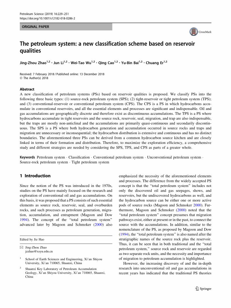
primarily stratigraphic (Fig. 5). Nevertheless, the Guan-
g’an Gas Field is mainly ruled by a structural-stratigraphic
combination trap (Li et al. 2013a).
In addition, multiple fault traps or numerous fault blocks
adjacent to each other can also lead to quasi-continuous
accumulations. The Fuyang tight oil accumulation in the
Songliao Basin was, for instance, once thought to be a
deep-basin oil accumulation (e.g., Hou et al. 2006), but is
actually a different type of quasi-continuous accumulation,
similar to the Cretaceous Gaotaizi tight oil accumulation in
the same basin. Both comprise numerous oil accumulations
controlled by fault-block traps or fault-stratigraphic traps,
and no notable edge water and bottom water have been
detected. The water-bearing sandstone reservoirs at higher
structural positions are actually disconnected from the
Petroleum Science (2019) 16:229–251 241
123
downdip oil-producing sandstones because the sandstone
intervals are faulted into multiple segments and each of
them constitutes a separate fault trap or fault-stratigraphic
trap. Obviously, such oil–water distribution pattern is not a
genuine oil–water inversion. Thus, it can be concluded that
the Fuyang and Gaotaizi tight oil accumulations should not
be attributed to deep-basin or basin-centered oil accumu-
lation; instead, they belong to quasi-continuous accumu-
lations comprising multiple neighboring faulted reservoirs.
(5) Controls on hydrocarbon enrichment
Investigations have revealed that quasi-continuous
accumulations mainly occur in gentle depressions and
slopes and that source kitchen, reservoir, seal, and migra-
tion conditions are major factors in controlling the abun-
dance of the accumulations. The reason why quasi-
continuous accumulations occur primarily in gentle
depressions and slopes is that such settings favor the
deposition of large areas of source rocks and tight reser-
voirs compared to those deposited in a steep and narrower
basin, and their gentle stratigraphic framework is disad-
vantageous for buoyancy-driven migration that could result
in local oil/gas concentrations. As a result, such structural
settings are more suitable for the occurrence and enrich-
ment of extensive quasi-continuous oil and gas
accumulations.
Among all the relevant factors, hydrocarbon-generating
conditions are fundamental in affecting the enrichment of
quasi-continuous accumulations. Large areal distribution of
source rocks and high organic matter contents are more
favorable for the occurrence of quasi-continuous accumu-
lations. For instance, the extensive tight sandstone oil
accumulations of the Triassic Chang 6, 7, and 8 pay zones in
the Ordos Basin are closely linked to the high-quality
Chang-7 shale source rock. This source rock is widely dis-
tributed, with an effective distribution area of approximately
10 9 104 km2 and high-quality source rocks of nearly
5 9 104 km2. Its thickness generally ranges from 30–60 m,
with a maximum thickness of 130 m. The residual organic
carbon content is mainly in the range of 6%–22%, with an
average TOC of 13.75% and the highest reaching up to
30%–40%. The Ro is 0.85%–1.15%, while the average
hydrocarbon expulsion rate can reach 72% (Zhang et al.
2006). In addition, the formation of the giant Upper Paleo-
zoic tight sandstone gas fields including the Sulige, Yulin,
Zizhou, Shenmu, and Daniudi in the Ordos Basin is also
closely connected with the basin-wide distribution of Upper
Paleozoic coal source rocks. This set of source rocks covers
almost the whole basin and is commonly in a highly mature
to over-mature stage, with the gas-generating intensity
mainly in the range of (10–40) 9 108 m3/km2. Hence, the
conditions are favorable for the formation of widespread
tight gas accumulation. Exploration has shown that almost
Hechuan 001-9-X4
Hechuan 1
Hechuan 001-9-X2
Hechuan 001-46-X3
Hechuan 001-46-X1
Xu-3
Elevation, m
Gas layer-1940
-1920
-1900
-1800
-1860
-1840
-1820
-1800
-1780
-1760
2240X
u-2 3
Xu-
2
Xu-
2 2X
u-2 1
Inferior gas layer Gas-water layer
Fig. 5 Cross section of the Xu-2 tight gas accumulation of the
Triassic Xujiahe Formation in the central Sichuan Basin (Bian et al.
2012). Both the gas beds and gas–water beds are tight sandstone
reservoirs and can occur at either structural low or high positions,
showing the distribution of gas and water is independent of structural
relief. Note that the curves beside each well are GR (dark), RT (red)
and porosity (green) from left to right, respectively
242 Petroleum Science (2019) 16:229–251
123

all regions in the Ordos Basin with gas-generating intensity
greater than 10 9 108 m3/km2 are potential places for large
tight gas accumulations (Zhao et al. 2012a; Cao et al.
2013a).
In addition to source kitchen conditions, reservoir and
sealing conditions are two other essential factors. With
respect to reservoirs, not only widespread distribution and
certain heterogeneities are indispensable for quasi-contin-
uous accumulations, but the development of sweet spots is
also significant to hydrocarbon enrichment and production.
As far as the controlling effects of sealing conditions (in-
cluding top and bottom seals) are concerned, it can be
observed that vertical distribution of high-quality sealing
beds usually determines the uppermost intervals of the
accumulations above the source rocks or lowest intervals
below the source rocks. Moreover, sealing conditions are of
great significance to the richness of tight oil and gas
accumulations, whereby high-quality seals favor the
enrichment of oil/gas in tight reservoirs.
It should be noted that although hydrocarbon enrichment
is favored by better conditions of source rocks, reservoirs,
seals, and other necessary elements, it is virtually impos-
sible for all these factors to concurrently achieve their
respective best conditions. In nature, the sufficient devel-
opment of any one of the above factors is commonly at the
expense of other conditions. For instance, assuming that
the condition of hydrocarbon generation in a given region
is adequately developed (i.e., the thickness of source rocks
and the abundance of organic matter attain their maxi-
mum), the reservoir condition therein is commonly less
developed. In contrast, if the reservoir quality is excellent
(large reservoir thickness and excellent rock properties),
then the hydrocarbon-generating and sealing conditions
may be relatively inferior. As a result, the most favorable
conditions for the enrichment of tight oil/gas exist where an
optimal association of source, reservoir, sealing, and all
other necessary conditions is realized. This ought to be a
universal rule for various oil and gas enrichment.
2.2.2 Discontinuous tight accumulations (DTA)
Discontinuous tight accumulations (DTA) are remarkably
different from quasi-continuous accumulations, but similar
to conventional accumulations in many aspects. For
instance, both are discontinuous and confined by conven-
tional traps (see the following part regarding CPS for
details). The following is a discussion of the main char-
acteristics of the DTA.
(1) Traps
Different from the QTA, which is mainly controlled by
non-anticlinal traps, the DTA is strictly governed by vari-
ous conventional traps, especially structural traps. In fact,
most DTAs have been found to occur in anticlinal traps,
followed by fault traps and stratigraphic-structural combi-
nation traps.
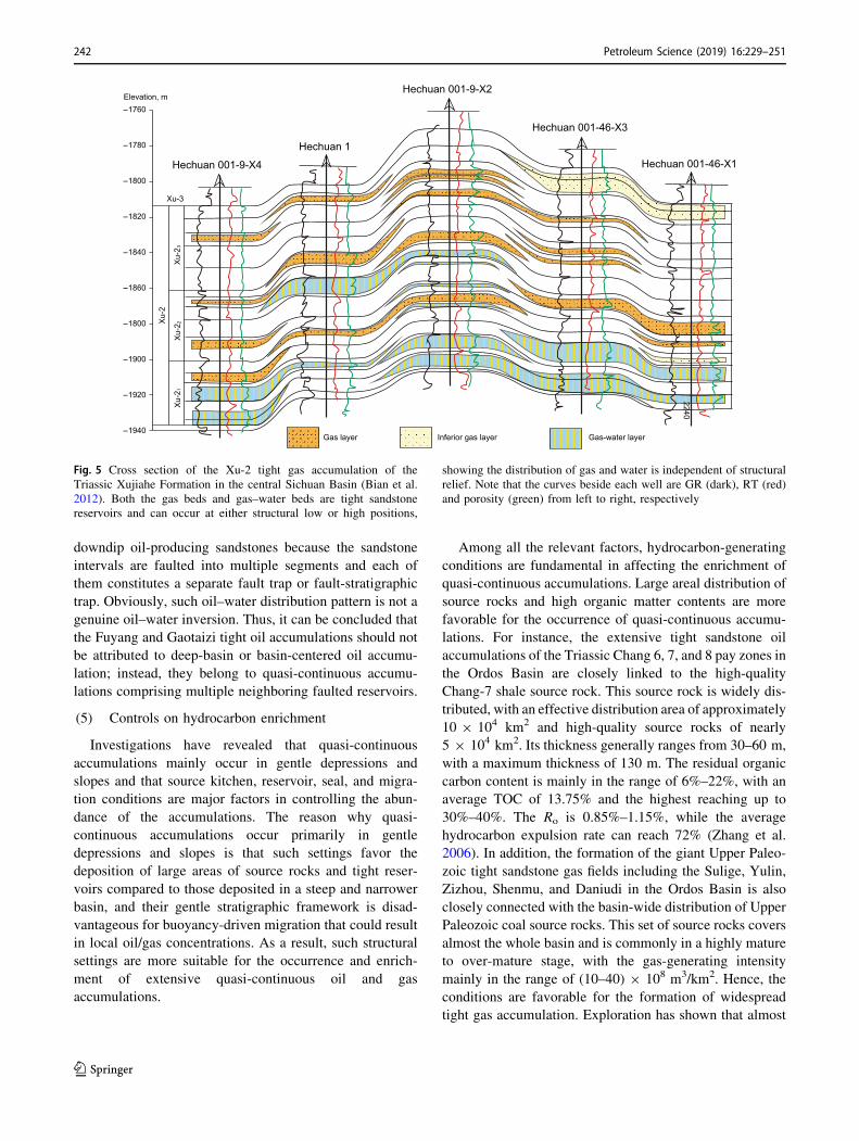
The anticlinal trap is the most common type of trap for
DTAs. The Dina 2 and Dabei Gas Fields in the Kuqa
foreland region of the Tarim Basin, and the Zhongba,
Pingluoba, and Bajiaochang Gas Fields in the foreland
region of the western Sichuan Basin are typical examples.
In the Dabei Gas Field (Fig. 6), natural gas is confined in
an anticlinal or a faulted anticlinal trap. This field’s major
pay zone of the Lower Cretaceous Bashijiqike Formation
(K1bs) is a tight sandstone gas-producing reservoir, with
porosities ranging from 5.7% to 7.9% (averaging 7.0%)
and permeabilities in the range of 0.06–0.29 md (averaging
0.12 md) (Li et al. 2013a). The proven reserves of natural
gas are as much as 1093 9 108 m3. As another example,
the Dina 2 Gas Field is also a typical anticlinal trap, with a
gas-bearing area of 125 km2, and proven reserves of
1752 9 108 m3. The porosity of its Paleogene reservoirs
ranges from 7.5% to 10.6%, with an average of 9.5%, and
the permeability ranges between 0.20 and 1.41 md, with an
average of 1.08 md (Wei et al. 2013).
Fault traps are a subordinate type of trap in terms of
their importance to DTAs. The Jonah Gas Field in the
Greater Green River Basin of the Rocky Mountains is
likely a typical example. As a field of fault traps, the Jonah
was once considered to be a basin-centered gas accumu-
lation, but Hanson et al. (2004) and Shanley et al. (2004)
showed its trap type is structural. In fact, it is a tight
sandstone field ruled by fault traps, with an area of only
91 km2 and reservoirs of compartmentalized fluvial sand
bodies in the Upper Cretaceous Lance Formation (Camp
2008). The field is bounded by two nearly vertical shear
faults on the south and west sides, forming a wedge block
that rises toward the southwestern corner, with the fault
displacement being usually less than 60 m. It has been
argued that gas production rate at the high structural
position is better than that at the low structural position
(Hanson et al. 2004), indicating that gas production is
affected to some extent by the structure.
Stratigraphic-anticlinal combination traps can also be
discerned in some discontinuous tight oil and gas accu-
mulations. This type of accumulation is mainly controlled
by structural features and secondarily by lithology. For
instance, the Lower Jurassic Badaowan gas accumulation
in the Baka Gas Field of the Tuha Basin occurs in a long,
narrow E–W-trending nose-shaped structure plunging
eastward. The reservoir is a braided river delta deposit, and
the major sand bodies were deposited in the braided dis-
tributary channels of a delta plain and a delta front. The
reservoir porosity ranges between 2% and 7%, with an
average of 4.4%, while the air permeability is less than 0.2
md, with samples\ 0.05 md accounting for at least 50% of
Petroleum Science (2019) 16:229–251 243
123
the total samples. According to the analysis of the test and
production data, nearly all gas-producing wells are located
at higher positions of the faulted anticline, while low-yield
wells are distributed at both the higher positions and the
eastern and western flanks, but dry wells are mainly
observed at the southern and northern flanks of lower
structural positions (Wang et al. 2014).
(2) Edge water and bottom water
This type of oil/gas accumulation may or may not
contain edge water and bottom water. Accordingly, the
DTAs can be divided into typical DTAs (with edge water
or bottom water) and atypical DTAs (without edge water
and bottom water) (Zhao et al. 2013).
The typical DTA is identical to conventional oil/gas
accumulations in that both have complete edge water or
bottom water. For instance, notable edge water has been
indicated in the Dabei Gas Field (Fig. 6). Another example
is the Dina 2 Gas Field, where bottom water was reported
(Li et al. 2013b).
The atypical DTA is an accumulation with neither edge
water nor bottom water. The Lower Jurassic Badaowan
Formation gas accumulation in the Baka Gas Field of the
Tuha Basin might belong to this type (Wang et al. 2014).
(3) Reservoirs
One of the significant differences between DTAs and
conventional accumulations is the quality of reservoirs.
The former has a tight reservoir, while the latter has a
good-quality or conventional reservoir. The tight properties
of the reservoirs are the only common features of DTAs
and QTAs. However, the major difference is that the QTA
reservoirs generally have porosity reduced prior to hydro-
carbon charging, whereas the DTA reservoirs could have
become tight either predating or postdating hydrocarbon
charging event. Accordingly, DTAs can be divided into the
following two categories:
a. Primary DTA
The reservoirs of this type have their porosity reduced
mainly prior to hydrocarbon charging. Yang and Pang
(2012) argued that the Xu-2 and Xu-4 reservoirs of the
Upper Triassic Xujiahe Formation in the western Sichuan
Depression had become tight primarily during the Middle–
Late Jurassic (with a porosity of 12%), while the major
oil/gas-charging process occurred at two stages: (1) Early–
Late Jurassic oil charging, slightly earlier than the reservoir
becoming tight; and (2) Late Jurassic to Late Cretaceous
gas charging. Considering that natural gas in this region is
dominantly generated from coals of the Triassic Xujiahe
Formation, and only a very small quantity of oil was
generated from such source rocks (Yang and Pang 2012),
we believe that gas charging in this region took place
primarily after the reservoir had become tight. A study by
Luo et al. (2012) on the diagenetic history of the Xu-2
reservoirs in the Dayi region of the western Sichuan
D202 D103 D1W
-3
-4
-5
0 4 km
-6
mk ,noit avelE
Gas layer Water layer Fault
K1bxK1bx
K1bsK1bs
E1-2k
E1-2k
E2-3sN1-2k N1j N1j
Fig. 6 Cross section of the Dabei Gas Field in the Kuqa Foreland
Depression of the Tarim Basin (Dai et al. 2012), showing the presence
of edge water. The gas-producing K1bs is dominated by tight
sandstones. N1-2k—Miocene-Pliocene Kangcun Formation; N1j—
Miocene Jidike Formation; E2-3s—Eocene–Oligocene Suweiyi For-
mation; E1-2k—Paleocene-Eocene Kumugeliemu Formation; K1bs—
Lower Cretaceous Bashijiqike Formation; K1bx—Lower Cretaceous
Baxigai Formation
244 Petroleum Science (2019) 16:229–251
123

Depression has obtained similar results. In this region, the
porosity reduction of Xu-2 reservoir occurred during the
Middle–Late Jurassic, with a final porosity of approxi-
mately 7%–8%, while the timing of oil generation and
emplacement predated that period, and extensive gas gen-
eration and expulsion occurred after the tight transforma-
tion of the reservoir.
Another example is the Lower Jurassic Badaowan gas
accumulation in the Baka Gas Field of the Tuha Basin. In
this region, the gas generation and expulsion of the Lower
Jurassic coal-bearing source rocks occurred during the
Himalayan Stage, while the reservoir achieved tightness in
the Late Jurassic when the porosity was reduced to less
than 10% (Wang et al. 2014).
b. Secondary DTA
The reservoirs of this type are charged prior to their
porosity loss. Because the reservoir had not been trans-
formed into a tight state during the period of hydrocarbon
charging, buoyancy is commonly the principal driving
force for hydrocarbon migration. Oil/gas would migrate
toward and accumulate at structural highs, forming struc-
tural or structural-stratigraphic accumulations with either
edge water or bottom water. After accumulation, the for-
merly formed oil/gas accumulations with edge water or
bottom water would be left nearby where they occurred as
long as the structural deformation is not too strong,
although the reservoir becomes tight due to diagenesis and
the original accumulation might be altered to some extent
because of structural changes.
An example is the Dina 2 Gas Field, where the gas
charging of the Paleogene gas reservoir was initiated at
roughly 5 Ma, and the sandstone reservoir had not evolved
into tight state until the Xiyu Period (2–0 Ma) (Li et al.
2013b). Therefore, this gas accumulation is a secondary
DTA. Hanson et al. (2004) argued that gas charging in the
Lance Formation of the Jonah Field occurred before the
reservoir became tight and that the accumulation is the
result of vertical and lateral migration driven by buoyancy.
Another significant difference between the two types of
DTAs is that the primary DTAs normally have neither edge
water nor bottom water, but only incomplete edge water or
bottom water, which is similar to QTAs. On the other hand,
the secondary DTAs commonly have either edge water or
bottom water, resembling conventional accumulations or
discontinuous accumulations.
(4) Hydrocarbon Distribution
Because DTAs are controlled by various conventional
traps, especially structural traps, they occur primarily in
areas where folds and faults are developed, such as in
foreland basins. The aforementioned Kuqa and western
Sichuan Basins are typical examples. In addition, DTAs
can also occur in areas where the dip angle of strata or the
amplitude of anticlines, if any, is big enough.
2.3 Conventional petroleum system (CPS)
The CPS occurs in conventional reservoirs (air perme-
ability generally[ 1 md) and is characterized by discon-
tinuous or conventional hydrocarbon accumulations. The
main features of CPSs are well known, and a brief sum-
mary is provided herein for the purpose of comparison with
the aforementioned types of PS.
(1) Accumulation
Conventional oil/gas accumulations can occur singly,
but more often are formed in zones. Such accumulations
have unambiguous boundaries and complete edge water or
bottom water, and their distribution is discrete or discon-
tinuous, which is in a remarkable contrast with the con-
tinuous and quasi-continuous accumulations. Thus, this
type of accumulation is termed the discontinuous accu-
mulation or conventional accumulation.
(2) Migration
Discontinuous (conventional) accumulations mainly
occur in reservoirs that either possess good qualities or are
close to a fault. As a result, migration pathways are
developed so that oil and gas can readily migrate. Under
such circumstances, hydrocarbons tend to migrate toward
and concentrate at higher structural positions. The driving
force for secondary migration is primarily buoyancy.
Where overpressure is developed, it also plays a significant
role as a driving force for oil/gas migration, particularly for
primary migration.
(3) Traps
The occurrence of discontinuous (conventional) accu-
mulations is strictly controlled by trapping mechanisms,
including structural, stratigraphic, and combination traps.
Among various traps governing conventional accumula-
tions, anticlinal traps are the most typical variety. By
contrast, anticlines can hardly function as a trap for the
occurrence of continuous and quasi-continuous
accumulations.
(4) Controls on hydrocarbon enrichment
Unlike continuous and quasi-continuous accumulations,
all of the essential elements and processes, including
source rock, reservoir, seal, trap, migration, accumulation,
and preservation, play significant roles in the formation of
discontinuous or conventional oil/gas accumulations.
Hence, their hydrocarbon enrichment is controlled by
multiple factors. Due to good conditions of hydrocarbon
migration, such types of oil and gas accumulations are
Petroleum Science (2019) 16:229–251 245
123

often more abundant at higher structural positions (such as
uplifts and upper slopes) or relatively shallower strata in a
depression or a slope.
3 Origin and distribution of different typesof petroleum systems
The SPS, TPS, and CPS can coexist in many petroleum
basins worldwide. Moreover, they can result from a com-
mon hydrocarbon source kitchen in a basin, where they are
closely linked and have unique distribution features.
In terms of spatial distribution, both the SPS and the
TPS mainly occur in hydrocarbon-generating depressions
and slopes, while the CPS tends to have accumulations
enriched at the updip parts of a slope and even higher
structural positions around a depression or in the shallower
formations that are more distant from the effective source
rock intervals (Fig. 7). The accumulations in the three PSs
often may occur in different stratigraphic intervals more
frequently than in a same interval. Generally, their occur-
rence is vertically sequenced, and the sequence is, from the
source rock interval upward or downward, the continuous,
quasi-continuous, and discontinuous accumulations,
respectively. Usually, quasi-continuous accumulations
occur adjacent to the source rock interval, while discon-
tinuous accumulations are more distant. This is because
source rock intervals often represent a turning point of
sedimentation in the evolution of depositional environ-
ments, before and after which are usually transgression
cycles and regression cycles, respectively. Thus, the sedi-
mentary sequence is normally graded (coarsening down-
ward) below the source rock interval, while it is reversely
graded (coarsening upward) above the source rock interval.
As a result, the closer to the source rocks, the finer the
deposits become and more likely that tight reservoirs
would occur. In contrast, conventional reservoirs are more
developed in formations vertically distant from source
rocks. Because of the above-mentioned sedimentary
cycles, the SPS, TPS, and CPS are frequently formed and
coexist in a basin. That should be the primary mechanism
for the origin of the three PSs. Thus, it can be predicted that
the SPS, TPS, and CPS might coexist in almost all petro-
liferous basins and can even be derived from the same
source kitchen. Indeed, such a phenomenon has been
confirmed in many basins worldwide, such as the Ordos
Basin, the Songliao Basin, and the Bohai Bay Basin in
China, and the Fort Worth Basin (Pollastro 2007), the
Piceance Basin (Yurewicz et al. 2008), and the San Juan
Basin (Fassett and Boyce 2005) in the USA. In reality, as
Forster and Horne (2005) noted, most Rocky Mountain
Basins have both conventional and unconventional gas
accumulations.
An example is the Ordos Basin, where shale oil, tight
oil, and conventional oil accumulations have been found in
the Triassic Chang 7 shales (major source rocks of the
basin), Chang 9 to Chang 4 ? 5 tight sandstones, and
Chang 3 to Jurassic Yanan Formation good-quality sand-
stones (Fig. 8). The Chang 7 shales constitute a SPS in
which continuous oil accumulations might occur. Above
and below the Chang 7 shales, the Chang 9 to Chang 4 ? 5
tight sandstone pay zones belong to TPSs in which oil
accumulations are dominated by quasi-continuous accu-
mulations. The Chang 3 to Yanan Formation oil accumu-
lations are mostly conventional and therefore belong to
CPSs. Another example is the Upper Paleozoic natural gas
accumulation in the Ordos Basin, where coals in the Benxi,
Taiyuan, and Shanxi Formations constitute major source
rocks (Zhao et al. 2014). In the coal beds, CBM is wide-
spread mostly as continuous accumulations. The fluvial
sandstone reservoirs close to the coal measures are mostly
tight reservoirs, and thus quasi-continuous accumulations
are predominant. However, some accumulations in the
Shiqianfeng Formation may belong to conventional accu-
mulations or discontinuous accumulations due to the good
qualities of the reservoirs.
For the SPS, TPS, and CPS derived from a common
hydrocarbon source kitchen, the resulting accumulations in
source-rock, tight, and conventional reservoirs must be
inversely related to each other. Clearly, the proportion of
continuous accumulations in the SPS of the total amount of
hydrocarbons generated from the source rocks (namely, the
retention ratio) is crucial. The higher the retention ratio of
hydrocarbons within the source rocks or the lower the
hydrocarbon expulsion efficiency, the higher the proportion
of hydrocarbon resources in the SPS and the lower the
proportion of resources in the TPS and CPS would be. The
major factors influencing the retention ratio of hydrocar-
bons in source rocks include the thickness of effective
source rocks, abundance of organic matter, source rock
type, and the top and bottom sealing conditions, etc. The
thicker the effective source rocks, the higher the organic
matter content, and especially, the better the top and bot-
tom sealing conditions, the more abundant the hydrocar-
bons to be retained in the source rocks. In contrast, if a
source rock is too thin and its top and bottom sealing
conditions are not good enough, the hydrocarbon expulsion
efficiency (reciprocal of the retention ratio) is generally
higher and more hydrocarbons generated in the source rock
would be expelled and accumulate in non-source rock-
reservoir intervals or be lost elsewhere. As far as the
resource potentials of the TPS and CPS are concerned, they
are highly affected by the distribution and quality of tight
reservoirs, quality of sealing rocks, and the amount of
hydrocarbons expelled from source rocks. It has been
found that the better the conditions of tight reservoirs and
246 Petroleum Science (2019) 16:229–251
123

sealing rocks, the more favorable it is for hydrocarbons to
accumulate in tight reservoirs. The hydrocarbon resource
potential of the TPS is likely to be greater than that of the
CPS; otherwise, the CPS would be of greater potential for
hydrocarbon resources. This phenomenon can be demon-
strated from the distribution of hydrocarbon resource
potentials of various accumulations in the Ordos Basin.
Because both Mesozoic and Upper Paleozoic source rocks
are widely distributed in the basin, but their thicknesses are
relatively small, the resources retained in the corresponding
source rocks, including shale oil/gas and CBM, appear to
be less than expected. Nevertheless, tight oil and gas are
more plentiful, which is also due to the fact that both tight
reservoirs and their cap rocks are well developed in the
SE
L149
L93L180 B117 B286
Z89C83
Chang-2
Yan-10
Oil layer Water layer Dry layer The Zhangjiatan Shale
Chang-3
Chang-4+5
Chang-6
Chang-7
Chang-8
0 5 10 km
lanoitnevnoC
sriovreser thgiT
dna
ecruos-
kcor
sriovreser
Fig. 8 Cross section showing the distribution of oil accumulations in
the Triassic Yanchang Formation of the Ordos Basin. Shale oil is
found in the major source rocks (the Zhangjiatan Shale of Chang-7),
while closely above and below the Zhangjiatan Shale are abundant
tight sandstone oil accumulations. However, accumulations are
mostly conventional in the Chang 2–3 and above intervals, which
are more distant from the source rock interval
Source rock
Discontinuous accumulation
Quasi-continuous accumulation
Continuous accumulation / SPS
Discontinuous accumulation
Quasi-continuous accumulation
Tight reservoir Conventional reservoir Seal
Oil/gas accumulation
SP
CS
PC
SPT
SP T
Sweet spot
Fig. 7 Schematic illustration of the vertical distribution of the source petroleum system (SPS), tight petroleum system (TPS), and conventional
petroleum system (CPS)
Petroleum Science (2019) 16:229–251 247
123
basin. The hydrocarbon resources of conventional accu-
mulations are, therefore, somewhat limited. By corollary,
in those basins or regions that are rich in petroleum
resources, the potential of unconventional resources would
be relatively smaller if their conventional resources are
preponderant.
Based on the above discussions, we can conclude that
both conventional and unconventional PSs or the CPS,
TPS, and SPS can often coexist in petroliferous basins, and
are closely linked, but inversely correlated with each other
in terms of resource potentials. However, previous studies
of the formation and distribution of oil and gas accumu-
lations as well as petroleum exploration are largely focused
on conventional PSs and part of unconventional PSs.
Consequently, more holistic studies of the entire process
and all types of PSs and various petroleum accumulations
need to be enhanced to maximize exploration efficiency.
4 Conclusions
(1) Petroleum systems can be categorized into three
basic types in terms of reservoir qualities as well as
the resultant characteristics of hydrocarbon migra-
tion and accumulation, namely source-rock petro-
leum systems (SPS), tight petroleum systems (TPS),
and conventional petroleum systems (CPS). In the
SPS, continuous hydrocarbon accumulations are
predominant, which are typically represented by
shale oil/gas and CBM accumulations. The TPS is
dominated by quasi-continuous accumulations, but
discontinuous accumulations are sometimes signifi-
cant. In the CPS, however, discontinuous accumu-
lations or conventional trap-controlled
accumulations are predominant.
(2) All essential elements and processes, including
hydrocarbon generation, charging, sealing, migra-
tion, entrapment, and preservation, are indispensable
for the CPS, in which hydrocarbon distribution is
generally controlled by multiple factors. Moreover,
both primary migration and secondary migration are
commonly necessary for the CPS, and secondary
migration can occur over long distances and is
primarily driven by buoyancy. With regard to the
TPS, however, migration is dominated by primary
and short-distance secondary migration, and the
dominant driving force for secondary migration is
overpressure instead of buoyancy. The occurrence of
petroleum accumulations is primarily controlled by
such factors as effective source rocks, reservoirs, and
seals. As far as the SPS is concerned, hydrocarbon
generation, storage, and sealing are most important
factors, whereas migration and trap are of limited
importance, as oil and gas accumulate mostly in situ
and there is no notable migration, and traps do not
function in petroleum accumulation. In the SPS,
hydrocarbon enrichment is mainly controlled by
source rock attributes, reservoir qualities, and sealing
conditions.
(3) In petroliferous basins, conventional and unconven-
tional PSs or the SPS, TPS, and CPS can often
coexist, and close relationship is present between
them, as observed in many basins across the world,
such as the Ordos Basin, the Songliao Basin, and the
Bohai Bay Basin in China, and the Fort Worth Basin,
the Piceance Basin, and the San Juan Basin in the
USA. However, they adversely impact each other
with respect to the resource potential. Hence, com-
prehensive studies of both conventional and uncon-
ventional PSs should be strengthened and different
strategies ought to be adopted to maximize the
exploration efficiency.
Acknowledgements This research was supported by National Science
and Technology Major Project of China (Project No. 2016ZX05050,
2011ZX05018001-004) and National Natural Science Foundation
Project of China (No. 41402121 and 41502132). We are indebted to
those organizations and individuals who provide us with various
support.
Open Access This article is distributed under the terms of the Creative
Commons Attribution 4.0 International License (http://creative
commons.org/licenses/by/4.0/), which permits unrestricted use, dis-
tribution, and reproduction in any medium, provided you give
appropriate credit to the original author(s) and the source, provide a
link to the Creative Commons license, and indicate if changes were
made.
References
Ayers WB Jr. Coalbed gas systems, resources, and production and a
review of contrasting cases from the San Juan and Powder River
Basins. AAPG Bull. 2002;86:1853–90.
Bian CS, Wang HJ, Wang ZC, Xu ZH. Exploration status and
potential evaluation of tight gas in Sichuan Basin. China Eng
Sci. 2012;14:74–80 (in Chinese).Bowker KA. Barnett shale gas production, Fort Worth Basin: issues
and discussion. AAPG Bull. 2007;91:523–33.
Bustin AMM, Bustin RM. Importance of rock properties on the
producibility of gas shales. Int J Coal Geol. 2012;103:132–47.
Camp WK. Basin-centered gas or subtle conventional traps? In:
Cumella SP, Shanley KW, Camp WK, editors. Understanding
exploring, and developing tight-gas sands—2005 Vail Hedberg
Conference, vol. 3. Tulsa: AAPG Hedberg Series; 2008.
p. 49–61.
Cant D. ‘‘Unconventional’’ hydrocarbon accumulations occur in
conventional traps. CSPG CSEG CWLS Conv. 2011;2011:1–2.
Cao Q, Zhao JZ, Fu JH, et al. Gas source conditions of quasi-
continuous accumulation of the Upper Paleozoic in Ordos Basin.
Oil Gas Geol. 2013a;34:584–91 (in Chinese).
248 Petroleum Science (2019) 16:229–251
123

Cao Q, Zhao JZ, Liu XS, et al. Determination of physical property
limits for the gas accumulation in tight sandstone reservoirs in
the eastern Ordos Basin. Acta Pet Sin. 2013b;34:1040–8 (inChinese).
Chalmers GR, Bustin RM, Power IM. Characterization of gas shale
pore systems by porosimetry, pycnometry, surface area, and field
emission scanning electron microscopy/transmission electron
microscopy image analyses: examples from the Barnett, Wood-
ford, Haynesville, Marcellus, and Doig units. AAPG Bull.
2012;96:1099–119.
Cumella SP, Shanley KW, Camp WK. Introduction. In: Cumella SP,
Shanley KW, Camp WK, editors. Understanding, exploring, and
developing tight-gas sands—2005 Vail Hedberg Conference,
vol. 3. Tulsa: AAPG Hedberg Series; 2008. p. 1–4.
Curtis JB. Fractured shale-gas systems. AAPG Bull.
2002;86:1921–38.
Curtis ME, Cardott B, Sondergeld C, Rai CS. Development of organic
porosity in the Woodford Shale with increasing thermal matu-
rity. Int J Coal Geol. 2012;103:26–31.
Dai JX, Ni YY, Wu XQ. Tight gas in China and its significance in
exploration and exploitation. Pet Explor Dev. 2012;39:277–84.
Dai JX, Ni YY, Gong DY, et al. Geochemical characteristics of gases
from the largest tight sand gas field (Sulige) and shale gas field
(Fuling) in China. Mar Pet Geol. 2017;79:426–38.
Dai JX, Zou CN, Dong DZ, et al. Geochemical characteristics of
marine and terrestrial shale gas in China. Mar Pet Geol.
2016;76:444–63.
Demaison G, Huizinga BJ. Genetic classification of petroleum
systems. AAPG Bull. 1991;75:1626–43.
De Silva PNK, Simons SJR, Stevens P, et al. A comparison of North
American shale plays with emerging non-marine shale plays in
Australia. Mar Pet Geol. 2015;67:16–29.
Dong DZ, Gao SK, Huang JL, et al. A discussion on the shale gas
exploration and development prospect in the Sichuan Basin. Nat
Gas Ind. 2014;12:1–15 (in Chinese).Dong DZ, Wang YM, Huang XN, et al. Discussion about geological
characteristics, resource evaluation methods and its key param-
eters of shale gas in China. Nat Gas Geosci. 2016;27:1583–601
(in Chinese).Dubiel RF, Pitman JK, Pearson ON, et al. Assessment of undiscov-
ered oil and gas resources in conventional and continuous
petroleum systems in the upper Cretaceous Eagle Ford Group,
U.S. Gulf Coast region, 2011. 2012. https://pubs.usgs.gov/fs/
2012/3003/FS12-3003.pdf.
EIA. Review of emerging resources: U.S. shale gas and shale oil
plays. https://www.eia.gov/analysis/studies/usshalegas/pdf/ussha
leplays.pdf 2011; p. 82.
Er C, Zhao JZ, Bai YB, et al. Reservoir characteristics of the organic-
rich shales of the Triassic Yanchang Formation in Ordos Basin.
Oil Gas Geol. 2013;34:708–16 (in Chinese).Fassett JE, Boyce BC. Fractured-sandstone gas reservoirs, San Juan
Basin, New Mexico and Colorado: stratigraphic traps, not basin-
centered gas deposits—with an overview of Fruitland Formation
coal-bed methane. In: Bishop MG, Cumella SP, Robinson JW,
Silverman MR, editors. Gas in low permeability reservoirs of the
Rocky Mountain Region. Rocky Mountain Association of
Geologists 2005 Guidebook CD 2005;109–85.
Forster JR, Horne JC. The interpretation of fluids and pressures in
determining conventional and unconventional gas resources in
the Rocky Mountain Region. In: Bishop MG, Cumella SP,
Robinson JW, Silverman MR, editors. Gas in low permeability
reservoirs of the Rocky Mountain Region. Rocky Mountain
Association of Geologists 2005 Guidebook CD 2005; 187–213.
Fu JH, Wei XX, Ren JF. Distribution and genesis of large-scale Upper
Palaeozoic lithologic gas reservoirs on Yi-Shaan slope. Pet
Explor Dev. 2008;35:664–7.
Gaswirth SB. Assessment of continuous oil resources in the
Wolfcamp shale of the Midland Basin, Permian Basin Province,
Texas, 2016. U.S. Geological Survey Open File-Report 2017;
1013: 14 https://doi.org/10.3133/ofr20171013.
Gaswirth SB, Marra KR, Cook TA, et al. Assessment of undiscovered
oil resources in the Bakken and Three Forks Formations,
Williston Basin Province, Montana, North Dakota, and South
Dakota 2013. https://pubs.usgs.gov/fs/2013/3013/fs2013-3013.
pdf.
Ground Water Protection Council. Modern shale gas development in
the United States: a primer. Oklahoma City: Ground water
protection; 2009. p. 116.
Guo TL. Evaluation of highly thermally mature shale-gas reservoirs
in complex structural parts of the Sichuan Basin. J Ear Sci.
2013;24:863–73.
Halbouty MT. Giant oil and gas fields of the decade 1990–1999.
AAPG Memoir. 2003;78:275–332.
Hanson WB, Vega V, Cox D. Structural geology, seismic imaging,
and genesis of the giant Jonah gas field, Wyoming, U.S.A. In:
Robinson JR, Shanley KW, editors. Jonah field: case study of a
giant tight-gas fluvial reservoir,vol. 52. Tulsa: AAPG Studies in
Geology; 2004. p. 61–92.
Hood KC, Yurewicz DA. Assessing the Mesaverde basin-centered gas
play, Piceance Basin, Colorado. In: Cumella SP, Shanley KW,
Camp WK, editors. Understanding, exploring, and developing
tight-gas sands—2005 Vail Hedberg Conference, vol. 3. Tulsa:
AAPG Hedberg Series; 2008. p. 87–104.
Hou QJ, Wei ZS, Zhao ZY, et al. Deep basin reservoir in Songliao
Basin. Pet Explor Dev. 2006;32:406–11 (in Chinese).Jarvie DM. Unconventional oil petroleum systems: shales and shale
hybrids. AAPG International & Conference Exchange, Calgary,
Alberta, Canada, September 12–15, 2010. Search and Discovery
Article #80131 2011; p. 1–21.
Jarvie DM. Shale resource systems for oil and gas: Part 1—shale-gas
resource systems. In: Breyer JA, editor. Shale reservoirs—giant
resources for the 21st century, vol. 97. Tulsa: AAPG Memoir;
2012. p. 69–87.
Jarvie DM, Hill RJ, Ruble TE, et al. Unconventional shale-gassystems: the Mississippian Barnett Shale of north-central Texas
as one model for thermogenic shale-gas assessment. AAPG Bull.
2007;91:475–99.
Jiang FJ, Chen D, Wang ZF, et al. Pore characteristic analysis of a
lacustrine shale: a case study in the Ordos Basin, NW China.
Mar Pet Geol. 2016;73:554–71.
Ju YW, Wang GC, Bu HL, et al. China organic-rich shale geologic
features and special shale gas production issues. J Rock Mech
Geot Eng. 2014;6:196–207.
Katz BJ, Everett MA. An overview of pre-Devonian petroleum
systems—unique characteristics and elevated risks. Mar Pet
Geol. 2016;73:492–516.
Law BE. Basin-centered gas systems. AAPG Bull.
2002;86:1891–919.
Li J. Analysis on mineral components and frangibility of shales in
Dongying depression. Acta Sed Sin. 2013;31:616–20 (inChinese).
Li J, Wei GQ, Xie ZY, et al. Accumulation mechanism and main
controlling factors of large tight sandstones gas fields in China:
case study on Ordos Basin and Sichuan Basin. Acta Pet Sin.
2013a;34(s1):14–28 (in Chinese).Li Z, Jiang ZX, Pang XQ, et al. Genetic types of the tight sandstone
gas reservoirs in the Kuqa Depression, Tarim Basin, NW China.
Ear Sci J China Univ Geosci. 2013b;38:156–64 (in Chinese).Li ZH, Li SL, Yu XH, et al. Coalbed methane enrichment regularities
and controlling factors in Bowen-Surat Basin, Australia. Coal
Geol Explor. 2014;42:29–33 (in Chinese).
Petroleum Science (2019) 16:229–251 249
123
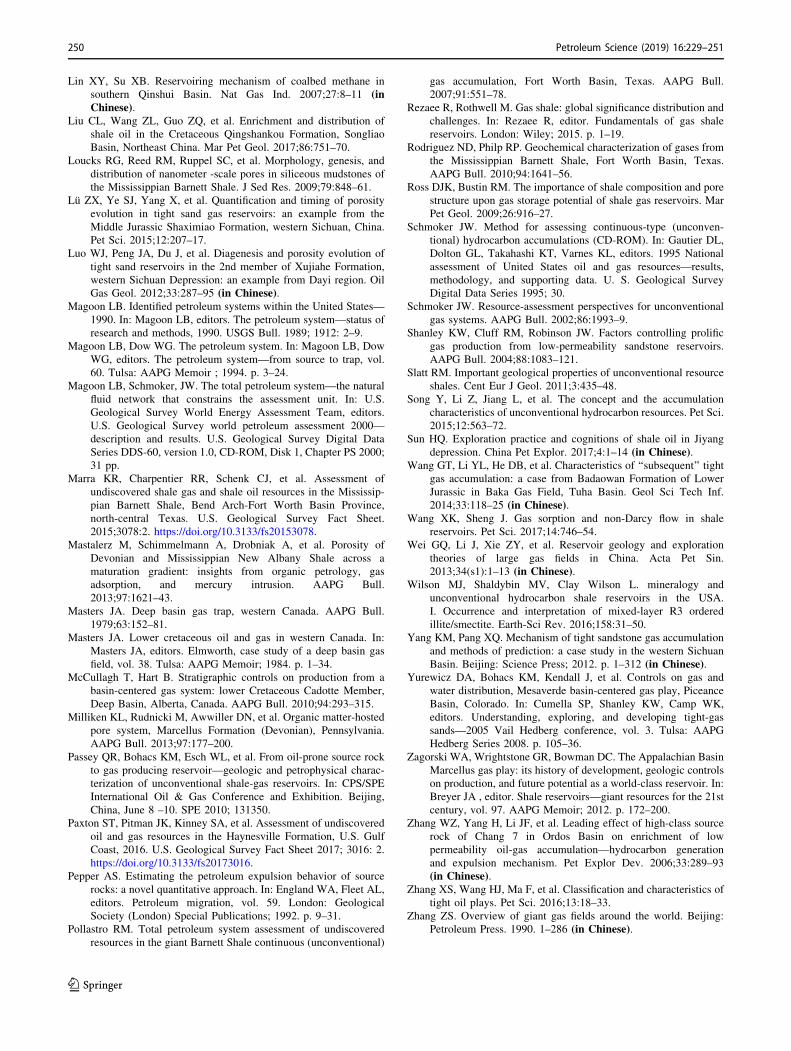
Lin XY, Su XB. Reservoiring mechanism of coalbed methane in
southern Qinshui Basin. Nat Gas Ind. 2007;27:8–11 (inChinese).
Liu CL, Wang ZL, Guo ZQ, et al. Enrichment and distribution of
shale oil in the Cretaceous Qingshankou Formation, Songliao
Basin, Northeast China. Mar Pet Geol. 2017;86:751–70.
Loucks RG, Reed RM, Ruppel SC, et al. Morphology, genesis, and
distribution of nanometer -scale pores in siliceous mudstones of
the Mississippian Barnett Shale. J Sed Res. 2009;79:848–61.
Lu ZX, Ye SJ, Yang X, et al. Quantification and timing of porosity
evolution in tight sand gas reservoirs: an example from the
Middle Jurassic Shaximiao Formation, western Sichuan, China.
Pet Sci. 2015;12:207–17.
Luo WJ, Peng JA, Du J, et al. Diagenesis and porosity evolution of
tight sand reservoirs in the 2nd member of Xujiahe Formation,
western Sichuan Depression: an example from Dayi region. Oil
Gas Geol. 2012;33:287–95 (in Chinese).Magoon LB. Identified petroleum systems within the United States—
1990. In: Magoon LB, editors. The petroleum system—status of
research and methods, 1990. USGS Bull. 1989; 1912: 2–9.
Magoon LB, Dow WG. The petroleum system. In: Magoon LB, Dow
WG, editors. The petroleum system—from source to trap, vol.
60. Tulsa: AAPG Memoir ; 1994. p. 3–24.
Magoon LB, Schmoker, JW. The total petroleum system—the natural
fluid network that constrains the assessment unit. In: U.S.
Geological Survey World Energy Assessment Team, editors.
U.S. Geological Survey world petroleum assessment 2000—
description and results. U.S. Geological Survey Digital Data
Series DDS-60, version 1.0, CD-ROM, Disk 1, Chapter PS 2000;
31 pp.
Marra KR, Charpentier RR, Schenk CJ, et al. Assessment of
undiscovered shale gas and shale oil resources in the Mississip-
pian Barnett Shale, Bend Arch-Fort Worth Basin Province,
north-central Texas. U.S. Geological Survey Fact Sheet.
2015;3078:2. https://doi.org/10.3133/fs20153078.
Mastalerz M, Schimmelmann A, Drobniak A, et al. Porosity of
Devonian and Mississippian New Albany Shale across a
maturation gradient: insights from organic petrology, gas
adsorption, and mercury intrusion. AAPG Bull.
2013;97:1621–43.
Masters JA. Deep basin gas trap, western Canada. AAPG Bull.
1979;63:152–81.
Masters JA. Lower cretaceous oil and gas in western Canada. In:
Masters JA, editors. Elmworth, case study of a deep basin gas
field, vol. 38. Tulsa: AAPG Memoir; 1984. p. 1–34.
McCullagh T, Hart B. Stratigraphic controls on production from a
basin-centered gas system: lower Cretaceous Cadotte Member,
Deep Basin, Alberta, Canada. AAPG Bull. 2010;94:293–315.
Milliken KL, Rudnicki M, Awwiller DN, et al. Organic matter-hosted
pore system, Marcellus Formation (Devonian), Pennsylvania.
AAPG Bull. 2013;97:177–200.
Passey QR, Bohacs KM, Esch WL, et al. From oil-prone source rock
to gas producing reservoir—geologic and petrophysical charac-
terization of unconventional shale-gas reservoirs. In: CPS/SPE
International Oil & Gas Conference and Exhibition. Beijing,
China, June 8 –10. SPE 2010; 131350.
Paxton ST, Pitman JK, Kinney SA, et al. Assessment of undiscovered
oil and gas resources in the Haynesville Formation, U.S. Gulf
Coast, 2016. U.S. Geological Survey Fact Sheet 2017; 3016: 2.
https://doi.org/10.3133/fs20173016.
Pepper AS. Estimating the petroleum expulsion behavior of source
rocks: a novel quantitative approach. In: England WA, Fleet AL,
editors. Petroleum migration, vol. 59. London: Geological
Society (London) Special Publications; 1992. p. 9–31.
Pollastro RM. Total petroleum system assessment of undiscovered
resources in the giant Barnett Shale continuous (unconventional)
gas accumulation, Fort Worth Basin, Texas. AAPG Bull.
2007;91:551–78.
Rezaee R, Rothwell M. Gas shale: global significance distribution and
challenges. In: Rezaee R, editor. Fundamentals of gas shale
reservoirs. London: Wiley; 2015. p. 1–19.
Rodriguez ND, Philp RP. Geochemical characterization of gases from
the Mississippian Barnett Shale, Fort Worth Basin, Texas.
AAPG Bull. 2010;94:1641–56.
Ross DJK, Bustin RM. The importance of shale composition and pore
structure upon gas storage potential of shale gas reservoirs. Mar
Pet Geol. 2009;26:916–27.
Schmoker JW. Method for assessing continuous-type (unconven-
tional) hydrocarbon accumulations (CD-ROM). In: Gautier DL,
Dolton GL, Takahashi KT, Varnes KL, editors. 1995 National
assessment of United States oil and gas resources—results,
methodology, and supporting data. U. S. Geological Survey
Digital Data Series 1995; 30.
Schmoker JW. Resource-assessment perspectives for unconventional
gas systems. AAPG Bull. 2002;86:1993–9.
Shanley KW, Cluff RM, Robinson JW. Factors controlling prolific
gas production from low-permeability sandstone reservoirs.
AAPG Bull. 2004;88:1083–121.
Slatt RM. Important geological properties of unconventional resource
shales. Cent Eur J Geol. 2011;3:435–48.
Song Y, Li Z, Jiang L, et al. The concept and the accumulation
characteristics of unconventional hydrocarbon resources. Pet Sci.
2015;12:563–72.
Sun HQ. Exploration practice and cognitions of shale oil in Jiyang
depression. China Pet Explor. 2017;4:1–14 (in Chinese).Wang GT, Li YL, He DB, et al. Characteristics of ‘‘subsequent’’ tight
gas accumulation: a case from Badaowan Formation of Lower
Jurassic in Baka Gas Field, Tuha Basin. Geol Sci Tech Inf.
2014;33:118–25 (in Chinese).Wang XK, Sheng J. Gas sorption and non-Darcy flow in shale
reservoirs. Pet Sci. 2017;14:746–54.
Wei GQ, Li J, Xie ZY, et al. Reservoir geology and exploration
theories of large gas fields in China. Acta Pet Sin.
2013;34(s1):1–13 (in Chinese).Wilson MJ, Shaldybin MV, Clay Wilson L. mineralogy and
unconventional hydrocarbon shale reservoirs in the USA.
I. Occurrence and interpretation of mixed-layer R3 ordered
illite/smectite. Earth-Sci Rev. 2016;158:31–50.
Yang KM, Pang XQ. Mechanism of tight sandstone gas accumulation
and methods of prediction: a case study in the western Sichuan
Basin. Beijing: Science Press; 2012. p. 1–312 (in Chinese).Yurewicz DA, Bohacs KM, Kendall J, et al. Controls on gas and
water distribution, Mesaverde basin-centered gas play, Piceance
Basin, Colorado. In: Cumella SP, Shanley KW, Camp WK,
editors. Understanding, exploring, and developing tight-gas
sands—2005 Vail Hedberg conference, vol. 3. Tulsa: AAPG
Hedberg Series 2008. p. 105–36.
Zagorski WA, Wrightstone GR, Bowman DC. The Appalachian Basin
Marcellus gas play: its history of development, geologic controls
on production, and future potential as a world-class reservoir. In:
Breyer JA , editor. Shale reservoirs—giant resources for the 21st
century, vol. 97. AAPG Memoir; 2012. p. 172–200.
Zhang WZ, Yang H, Li JF, et al. Leading effect of high-class source
rock of Chang 7 in Ordos Basin on enrichment of low
permeability oil-gas accumulation—hydrocarbon generation
and expulsion mechanism. Pet Explor Dev. 2006;33:289–93
(in Chinese).Zhang XS, Wang HJ, Ma F, et al. Classification and characteristics of
tight oil plays. Pet Sci. 2016;13:18–33.
Zhang ZS. Overview of giant gas fields around the world. Beijing:
Petroleum Press. 1990. 1–286 (in Chinese).
250 Petroleum Science (2019) 16:229–251
123

Zhao JZ, Al-aasm IS. New insights into petroleum migration-
accumulation dynamic systems and their division within
petroleum systems. J Ear Sci. 2012;23:744–56.
Zhao JZ, Cao Q, Bai YB, et al. Petroleum accumulation from
continuous to discontinuous: concept, classification and distri-
bution. Acta Pet Sin. 2016a;37:145–59 (in Chinese).Zhao JZ, Fu JH, Yao JL, et al. Quasi-continuous accumulation model
of large tight sandstone gas field in Ordos Basin. Acta Pet Sin.
2012a;32(s1):37–52 (in Chinese).Zhao JZ, Li J, Cao Q, et al. Hydrocarbon accumulation patterns of
large tight oil and gas fields. Oil Gas Geol. 2013;34:573–83 (inChinese).
Zhao JZ, Wang R, Er C. Adsorption characteristics of Chang 7 shales
from Triassic Yanchang Formation and the controlling factors,
the Ordos Basin. Ear. Sci. Fron. 2016b;23:146–53 (in Chinese).Zhao JZ, Zhang WZ, Li J, et al. Genesis of tight sand gas in the Ordos
Basin, China. Org Geochem. 2014;74:76–84.
Zhao WZ, Wang ZC, Zhu YX, et al. Forming mechanism of low-
efficiency gas reservoir in Sulige gas field of Ordos Basin. Acta
Pet Sin. 2005;26:5–9 (in Chinese).
Zhao WZ, He DF. Concept and its significance of composite
petroleum system in China. Pet Explor. 2000;5:1–11 (inChinese).
Zhao XZ, Zhou LH, Pu XG, et al. Geological characteristics of shale
rock system and shale oil breakthrough in a lacustrine basin: a
case study from the Paleogene 1st sub-member of Kong 2
Member in Cangdong sag, Bohai Bay Basin, China. Pet Explor
Dev. 2018;45:377–88.
Zhao ZZ, Du JH. Tight oil and gas. Beijing: Petroleum Press, 2012b;
p. 199 (in Chinese).Zhu RK, Zou CN, Zhang N, et al. Diagenetic fluids evolution and
genetic mechanism of tight sandstone gas reservoirs in Upper
Triassic Xujiahe Formation in Sichuan Basin, China. Sci China
Ear Sci. 2008;51:1340–53.
Zou CN, Zhai GM, Zhang GY, et al. Formation, distribution, potential
and prediction of global conventional and unconventional
hydrocarbon resources. Pet Explor Dev. 2015;42:14–28.
Zou CN, Zhao Q, Dong DZ, et al. Geological characteristics, main
challenges and future prospect of shale gas. Nat Gas Geosci.
2017;12:1781–96 (in Chinese).
Petroleum Science (2019) 16:229–251 251
123