the paths of regina: web mapping to promote slow tourism
TRANSCRIPT

Web Mapping to promote slow tourism
THE PATHS OF REGINA
1 Politecnico di Milano - Como Campus, GEOlab – 2 SUPSI, Istituto Scienze della Terra
Maptime Milan,February 25, 2016
Marco Minghini1, Maria Antonia Brovelli1, Candan Eylül Kilsedar1, Giorgio Zamboni1, Massimiliano Cannata2, Milan antonovic2, Mirko Cardoso2

SVIZZERA
Via Regina: a European cultural route✔ Via Regina defines a cross-border area between Italy and Switzerland
➔ trade and cultural route since Roman times➔ transalpine system of soft mobility links
Maptime Milan – February 25, 2016

Via Regina: a European cultural route✔ Via Regina defines a cross-border area between Italy and Switzerland
Via Regina
Tabula Peutingeriana (IV century AD)
Maptime Milan – February 25, 2016

The project “The Paths of Regina”✔ “The Paths of Via Regina” INTERREG project (http://www.viaregina.eu)
➔ purpose: to valorise the cultural heritage of the area and foster tourism➔ beneficiaries: local communities, administrations, pilgrims, tourists➔ expertise involved: cultural heritage, land use and design, geomatics
✔ Partners:
➔ universities
➔ local administrations
➔ cultural associations
Maptime Milan – February 25, 2016

Slow tourism at a glance✔ A special case of sustainable tourism focused on:
➔ environmental friendliness➔ rediscovery of local traditions and cultural knowledge
accommodation (simple)
gastronomy (local)
leisure (peaceful)
services (provided in arelaxing atmosphere))cultural
sustainable
movement(no car/plane)
Maptime Milan – February 25, 2016

The Via Regina geoportal✔ Entry point to the Web Mapping applications developed in the project
➔ main WebGIS for planning routes
✔ Link: http://viaregina3.como.polimi.it/ViaRegina
➔ mobile app for slow tourism➔ 3D Web viewer➔ mobile app for surveying paths➔ virtual tour application
Maptime Milan – February 25, 2016

The main WebGIS of Via Regina project
Maptime Milan – February 25, 2016
SERVER CLIENT

The main WebGIS of Via Regina project✔ Displays all the geospatial data surveyed during the project:✔
➔ Via Regina and the related historical paths➔ the points of interest available along them
Maptime Milan – February 25, 2016

The main WebGIS of Via Regina project✔ Displays all the geospatial data surveyed during the project:✔
➔ Via Regina and the related historical paths➔ the points of interest available along them
Maptime Milan – February 25, 2016

The main WebGIS of Via Regina project✔ Displays the bus routes and bus stops in the project area✔
➔ kindly provided by ASF Autolinee➔ each bus stop has the link to its real time schedule
Maptime Milan – February 25, 2016

The main WebGIS of Via Regina project✔ Displays the bus routes and bus stops in the project area✔
➔ kindly provided by ASF Autolinee➔ each bus stop has the link to its real time schedule
Maptime Milan – February 25, 2016

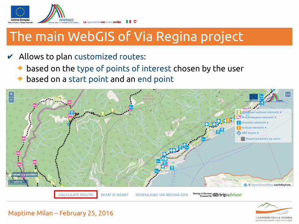
The main WebGIS of Via Regina project✔ Allows to plan customized routes:✔
➔ based on the type of points of interest chosen by the user
Maptime Milan – February 25, 2016
The main WebGIS of Via Regina project✔✔ Allows to plan customized routes:✔
➔ based on the type of points of interest chosen by the user➔ based on a start point and an end point
Maptime Milan – February 25, 2016

The main WebGIS of Via Regina project✔✔ Allows to plan customized routes:✔
➔ based on the type of points of interest chosen by the user➔ based on a start point and an end point
Maptime Milan – February 25, 2016

The main WebGIS of Via Regina project✔✔ Allows to plan customized routes:✔
➔ based on the type of points of interest chosen by the user➔ based on a start point and an end point
Maptime Milan – February 25, 2016

The main WebGIS of Via Regina project✔✔✔ Allows to plan customized routes:✔
➔ based on the type of points of interest chosen by the user➔ based on a start point and an end point
Maptime Milan – February 25, 2016

The main WebGIS of Via Regina project✔✔✔ Allows to plan customized routes:✔
➔ based on the type of points of interest chosen by the user➔ based on a start point and an end point
Maptime Milan – February 25, 2016

The main WebGIS of Via Regina project✔✔ Allows to plan customized routes:✔
➔ based on the type of points of interest chosen by the user➔ based on a start point and an end point
Maptime Milan – February 25, 2016

The main WebGIS of Via Regina project✔✔ Print the information on the computed route:✔
➔ 2D/3D distance, average slope, height increase/decrease
Maptime Milan – February 25, 2016

The main WebGIS of Via Regina project✔✔ Print the information on the computed route:✔
➔ 2D/3D distance, average slope, height increase/decrease
Maptime Milan – February 25, 2016

The main WebGIS of Via Regina project✔✔ Print the information on the computed route:✔
➔ 2D/3D distance, average slope, height increase/decrease
Maptime Milan – February 25, 2016

The main WebGIS of Via Regina project✔ Integration with TripAdvisor database:✔
➔ access to the info/reviews of hotels, restaurants & attractions
Maptime Milan – February 25, 2016

The main WebGIS of Via Regina project✔ Integration with TripAdvisor database:✔
➔ access to the info/reviews of hotels, restaurants & attractions
Maptime Milan – February 25, 2016

The main WebGIS of Via Regina project✔ Integration with TripAdvisor database:✔
➔ access to the info/reviews of hotels, restaurants & attractions
Maptime Milan – February 25, 2016

The main WebGIS of Via Regina project✔ Integration with TripAdvisor database:✔
➔ access to the info/reviews of hotels, restaurants & attractions
Maptime Milan – February 25, 2016

The main WebGIS of Via Regina project✔ Download of Via Regina GPS track (in GPX format):✔
➔ useful for people willing to walk along the path!
Maptime Milan – February 25, 2016

Inclusion of Via Regina into OpenstreetMap✔ Hiking route, relation named “Antica Via Regina” ✔
Maptime Milan – February 25, 2016

The Via Regina app – Purpose✔ Allows everyone to report georeferenced points of interest:✔
➔ historical and cultural elements➔ morphological elements➔ tourism elements➔ critical elements
Maptime Milan – February 25, 2016

The Via Regina app – Reportable categories ✔ Historical and cultural elements
➔ museum✗ ethnographic✗ thematic✗ gallery✗ collection
➔ religious building ✗ church✗ oratory✗ sanctuary✗ chapel✗ via crucis✗ fresco✗ abbey
➔ civil building✗ historical building✗ contemporary building✗ traditional building✗ monument
➔ rural building✗ pasture/shed✗ snow deposit✗ graa/metato (chestnuts drier building)✗ roccolo (system designed to catch birds)✗ casello o turbino✗ hydraulic structures✗ masseria (farm)
Maptime Milan – February 25, 2016

The Via Regina app – Reportable categories ✔ Historical and cultural elements
➔ archaeological element✗ archaeological element✗ archaeological site✗ element inside a building✗ single element
➔ military building✗ castle✗ tower✗ defensive wall✗ fort✗ trench✗ redoubt (secondary fort)✗ bunker
➔ factory✗ furnace✗ trip hammer✗ mill✗ sawmill✗ quarry✗ mine✗ rural factory
Maptime Milan – February 25, 2016

The Via Regina app – Reportable categories ✔ Morphological elements
➔ surface✗ pavement✗ natural material✗ gravel✗ asphalt✗ steps✗ ford
✗ tree-lined avenues✗ fence/barrier✗ vertical plate
➔ bounding escarpment✗ rock✗ ground escarpments✗ rock escarpments✗ support walls✗ boundary walls and railings
➔ traffic support & mfd products✗ kilometric stone✗ border stone✗ stone marker✗ isolated tree✗ panoramic viewpoint✗ fountain✗ ancient laundry✗ rest of bridge✗ tomb
✗ underpass✗ tunnel✗ inscription
Maptime Milan – February 25, 2016

The Via Regina app – Reportable categories ✔ Tourism elements
➔ accomodation and overnight✗ hotel✗ hostel✗ B&B✗ hut/shelter✗ camping✗ private accomodation✗ free accommodation✗ agritourism✗ apartment
✗ school✗ public safety✗ spring✗ city hall✗ post office✗ wc✗ info point✗ wifi hotspot✗ bike sharing✗ bank✗ park area✗ ATM
➔ services✗ pharmacy✗ parking
Maptime Milan – February 25, 2016

The Via Regina app – Reportable categories ✔ Tourism elements
➔ transport✗ bus stop✗ dock ferry✗ train station✗ funicular and ski lift
➔ products✗ wine shop✗ craft✗ food/typical products✗ clothing shop
➔ food services✗ restaurants✗ crotto✗ bar✗ food shop
Maptime Milan – February 25, 2016

The Via Regina app – Reportable categories ✔ Critical elements
➔ morphological✗ ford✗ lanslide
➔ structural✗ crossing with traffic light✗ crossing without crossing stripes✗ crossing with crossing stripes
Maptime Milan – February 25, 2016

The Via Regina app – Data collection✔ Cross-platform app:
➔ desktop and mobile browsers✗ http://viaregina3.como.polimi.it/app
➔ Android app✗ http://viaregina3.como.polimi.it/app/viaregina.apk ✗ on Google Play soon!
➔ iOS app✗ on Apple Store soon!
✔ Main features:
➔ offline data collection➔ points rating➔ integrated maps showing collected points
Maptime Milan – February 25, 2016

The Via Regina app – Data collection
Maptime Milan – February 25, 2016
✔ Cross-platform app:
➔ open source architecture

The Via Regina app – Data collection✔ Report a new point, classify and rate it
Maptime Milan – February 25, 2016

The Via Regina app – Data collection✔ Report a new point and take/upload a picture of it
Maptime Milan – February 25, 2016

The Via Regina app – Data collection✔ Report a new point and take/upload a picture of it
Maptime Milan – February 25, 2016

The Via Regina app – Data collection✔ Visualize the map of points added by you or by all the users
Maptime Milan – February 25, 2016

The Via Regina app – Data collection✔ Query the points collected and access the app info
Maptime Milan – February 25, 2016

La app per la Via Regina – Mapping party✔ Mapping party Cernobbio-Piazzola, May 3 2014
http://viaregina.como.polimi.it/mapparty
Maptime Milan – February 25, 2016

Via Regina 3D Web viewer
Maptime Milan – February 25, 2016
✔ Link: http://viaregina2.como.polimi.it/ViaRegina2.0/ViaRegina20.jnlp
✔ Based on PoliCrowd platform: http://geomobile.como.polimi.it/policrowd2.0

Via Regina 3D Web viewer ✔ Access to the project geospatial contents
Maptime Milan – February 25, 2016

Via Regina 3D Web viewer ✔ Visualization/query of data collected through mobile devices
Maptime Milan – February 25, 2016

Via Regina 3D Web viewer ✔ Database enrichment with additional multimedia contents
Maptime Milan – February 25, 2016

GeoIVS – Professional survey of paths✔ Mobile app to support the professional survey of cultural routes
Maptime Milan – February 25, 2016
✔ Based on the following open source technologies:
➔ Android➔ Couchdb lite➔ JTS (Java Topology Suite)➔ JSON➔ GeoJSON➔ OpenLayers 3➔ Proj4js
✔ Link: https://geoservice.ist.supsi.ch/camre/tour/geoIVS/geoIVS.apk

GeoIVS – Professional survey of paths
Maptime Milan – February 25, 2016
✔ Report location, notes and metadata of elements found along the way➔ surface, left and right side
Surface
Artefact
Morphology
Morphology
➔ results in digital data following a predefined data model

Transguardi – Virtual tour
Maptime Milan – February 25, 2016
✔ Emotional and immersive solution providing a virtual tour along paths➔ associates geo-information, storytelling and multimedia
✔ Based on the following open source technologies:➔ OpenLayers 3➔ Bootstrap➔ jQuery➔ D3.js➔ Less.js➔ GeoJSON➔ Pano
✔ Link: https://geoservice.ist.supsi.ch/camre/tour/main

Transguardi – Virtual tour
Maptime Milan – February 25, 2016
dynamic mapaudio
videophotosphere

Maptime Milan – February 25, 2016
Thanks for your attention!
Politecnico di MilanoGEOlab – Polo Territoriale di Como
Via Valleggio 11, 22100 Como (Italy)
Marco Minghini
@MarcoMinghini
Contacts
http://www.viaregina.eu