the palaeolandscapes of the tsalka plateau in the late...
TRANSCRIPT
Rescue ARchAeology in geoRgiA: the BAku-tBilisi-ceyhAn And south cAucAsiAn PiPelines 587
introduction. The reconstruction of palaeolandscapes through palynological investigation of archaeo-logical material holds great promise. The palynological study of samples from ancient cultural strata provides the opportunity of restoring both wild and cultivated vegetation. There has long been a discussion in the scientific literature on the late Pleistocene and Holocene landscape of Tsalka and its environs (Ketskhoveli 1959; Maruashvili 1970; Margalitadze 1977; 1995), but the only place on the Tsalka Plateau where palyno-logical study had occurred was in a single section of sediment at Bareti Lake in the 1970s, and none of the levels were dated by radiocarbon methods. The palynological spectrum did not record remains of crops or other cultivated plants. It was generally believed that throughout the Holocene period open steppe cenoses were spread over Tsalka Plateu and, like the Javakheti Plateau, no forests grew here (Margalitadze 1977). We must emphasize the charcoal macro-remains from the cultural stratum of the Beshtasheni Cyclopean fortress, which when subjected to paleobotanical analysis showed that in the Eneolithic period a forest dominated by alder grew in the environs of Beshtasheni, while in Early Bronze Age it was oak that prevailed (Yatsenko-Khmelevskii, Kandelaki 1941). New investigations also mention the presence of a forest on Tsalka Plateau in the Bronze Age (Kvavadze, Connor 2005: Kvavadze et al. 2007).
Physical and geographical situation. Tsalka Plateau is situated in the eastern part of a volcanic plateau in South Georgia. In orographic terms, it is a raised mountainous plateau-depression (Maruashvili 1973). The region is confined by the Trialeti range to the north, by northern slopes of the Samsari range to the west, by the River Algeti basin to the east and by the northern slope of the Javakheti range, Chochiana and Bedena Plateaux to the south. The absolute altitude of the area varies between 1400-1500 and 1900-2000. The geo-logical structure is composed of the Neogene sedimental layers of volcanic provenance Only the northern-most part of the area adjoining the Trialeti Ridge consists of Palaeogene and Upper Cretaceous layers of the Adjara-Trialeti system. (Maruashvili 1970; Maruashvili 1973).
the hydrographic net is quite well developed. The main river of the region is the Ktsia, which starts in the Trialeti range and joins the River Mtkveri on the Kvemo Kartli plain. It is 220km long. There are many lakes of volcanic and tectonic origin on Tsalka Plateau. The largest natural lake is Baretisa (Bashkois). Among smaller lakes Uzungeli, Aligeli and Imera lakes (Apkhazava 1975) are worthy of note. Some of the lakes were covered by the Tsalka reservoir which occupies 30-31 km2 in years with a high rainfall. The absolute level of this ar-tificial lake is 1510m. The River Ktsia flows into it to the west and to the east it is joined by the Korsu. Water drains from the reservoir through the Khrami hydroelectric station, as well as by underground arrangements for water filtering.
climatic conditions, thanks to data from two meteorological stations (Tsalka and Olianki) can be said to be mild. The average annual temperature is 5-6o C. In January the temperature falls to -6-5o C. In July it reaches 15-16o C. The amplitude of temperature variability per month is 21-21.5o C. Annual precipitation is between 538 and 662 mm. (Lominadze, Chirakadze 1971). The greatest precipitation is in May and June. Air humidity does not vary during the year and is 72-76 % on average. (Atlas of Georgia, 1964).
e l i s o k v a v a d z e g o d e r d z i n a r i m a n i s h v i l i
the PAlAeolAndscAPes of the tsAlkA PlAteAu in the lAte Pleistocene And holocene
(in the light of palynological data from archaeological and geological material)
e l i s o k v a v a d z e , g o d e r d z i n a r i m a n i s h v i l i

588 baqo-Tbilisi-jeihani samxreT kavkasiis milsadeni da arqeologia saqarTveloSi
eliso kvavadze, goderdzi narimanishvili
The main soil type in this district is black earth. Moderately alkalized black earth spreads from the moun-tains to the southern slopes of the Tsalka highland region. The alpine meadow soils cover the marginal north-ern foothills of the Trialeti Ridge. At the bottom of the basin, near the lakes and on the banks of the River Ktsia the swamps and meadows have moist clayey soil (Atlas of Georgia, 1964).
the vegetation of the region is of a secondary nature. These are mainly meadows turned into steppes where cereals dominate. Sparse patches of forest survive on the eastern slopes of Mount Tavkvetili, in the basins of the rivers Kusretistsqali and Khrami, in the environs of the villages of Dashbash, Kushch, Sapar-Kharaba, etc. Oak, beech, hornbeam, elm grow in the forest. In the sub-forest are rowan, Salix caprea and other components of mountain forests. A well-developed artificial coniferous forest was planted in the 1960s, and as far as we could observe, the renovation of the conifers is proceeding normally.
Material and methods. Archaeological material consists of organic remains in vessels, fossilized soil, lay-ers of ash, remains of wood and leather found in burials and settlements. This material was collected during fieldwork in 2002-2005. Sediments from the bottom of the Aligeli and Imera lakes were drilled with a hand drill. Two lake-swamp and four soil sections, and a series of fossilized soils and other organic remains have been investigated (pl. I).
Samples come from the Imera and Sapar-Kharaba cemeteries, and from the Jinisi and Ai-Ilia settlements. The interval between the samples received in sections is about 4-5 cm.
The first stage of laboratory treatment involves boiling the sample in alkali, the second centrifugation in a heavy cadmium liquid, and the third is acetolysis or dying according to the Erdtmann standard method. Ra-diocarbon dating was carried out with the help of the accelerator mass spectrometer (AMS) at the Melbourne University laboratory.
For the correct interpretation of fossilized dust spectra, the modern palynological spectra of soil, lake, swamp and moss of the region were been investigated. Identification of the material was carried out by means of atlases of modern etalon collections and dust. The material was studied using a Leitz microscope (x300-600). The material studied is preserved in the Institute of Palaeobiology.
Results of the research and review. Fossilized soil and organic remains from the SaparKharaba cemetery. The site is situated north of the village of Sapar-Kharaba. The cemetery measures 1500 m E-W, and 700 m N-S. During construction work in connection with the BTC pipeline, over 120 burials were excavated. Judging by the archaeological data the site, like the Imera cemetery, is dated to the 15th-14th centuries BC (Narimanishvili 2006; Narimanishvili G. 2006; Kvavadze, Narimanishvili 2006 a,b).
About 300 samples from 30 burials were studied using palynological methods. These samples included fossilized soil, the remains of pottery with organs of the deceased in them, the remains of timbers from the roofs of burial chambers, clothes, etc. The collection of the samples took place at pre-defined places (pl. II, 1-2).
The palynological spectra of the organic formations we investigated showed a high cereal content, es-pecially wheat. Among crop-weeds there was plenty of thistle (Carduus), knotweed (Polygonum), cornflower (Centaurea), buckwheat (Fagopyrum), and convolvulus (Convolvulus arvensis). Among arboreal plants there was much pollen of wide-leaf trees, especially oak and lime. Pollen of pine and Nordmann fir predominated among coniferous trees. 50-45% of the sampled pollen consisted of forest components. In the spectrum from Vessel No. 4 (inv. No. 99) of Burial No. 10 there was plenty of pollen from honey plants which was clearly fos-sil honey. The same sample contains many forest components. It is important that many burials produced spores of warm climate forest ferns: Adianthum capillus veneris and Anogramma leptophyllum. The former does not currently grow above the middle zone, while the latter belongs to a group of rare plants that grows on damp rocks in Adjara.
These palynologic spectra very often contained the pollen of walnut (Juglans regia), hazelnut (Corylus), cultivated vine (Vitis vinifera). The pollen of the cultivated vine has been found not only in the spectrum of fos-silized soil, but also in samples of organic remains found in the teeth (pl. III) and stomach area of the deceased.

Rescue ARchAeology in geoRgiA: the BAku-tBilisi-ceyhAn And south cAucAsiAn PiPelines 589
the palaeolandscapes of the tsalka Plateau in the late Pleistocene and holocene
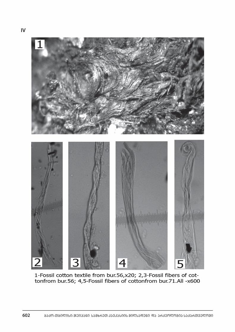
A large amount of vine pollen was discovered in the sample collected from the floor beneath the vessel in Burial No. 54 (inv. No. 338). Among non-palaeological fossils the parenchymal cells of oak bark are numerous in the remains of the timber roofs that once covered the burials. Parenchymal cells of pine bark are recorded beneath skeletons and ceramic vessels. It should be said that almost 50% of the burials studied were covered with timbers. Beneath the skeletons were abundant remains of flax and cotton cloth fibres (pl. IV). This is the earliest find of cotton not only in Georgia but anywhere in Transcaucasia (Kvavadze, Narimanishvili 2006b). A smaller amount of wool fibres were also recorded. In some burials the eggs of human helminths, in particular, those of Taenia solium were recovered in the stomach and the foot area of the deceased.
cultural layers of the jinisi settlement. The settlement is situated in the western part of the Tsalka Pla-teau, at an altitude of 1569-1572 m. Judging by the archaeological material, the lower levels of the settlement are dated to the 17th-16th centuries BC, while the upper levels and household pits date to the 8th-7th centuries BC (Amiranashvili, Narimanashvili 2005, 42-43). Eight samples from the lower levels, and six from the upper were selected for palynological investigation. In the spectrum of the levels dated to the 17th-16th century BC is plentiful pine and birch pollen present in equal amounts (38% – 38%). There were also elm, hazelnut, alder pollens. Among sporadic plants there were spores of forest components, e.g. of wood ferns (Dryopteris filixmas). Among grasses there are many weeds. Crops were represented by wheat pollen. There was not very much pollen of crop-weeds. It is noteworthy that the spectrum of samples from the upper layers of the settle-ment and the household pits is completely different from the spectra of the lower layers. There are no pollens of birch in the upper layers or household pits, but hornbeam and oriental hornbeam pollens occur plentifully. In the household pit No. 3 of House No. 1 there was chestnut pollen. There are many crops including wheat and rye. Wheat grains bear traces of fire. There are numerous weeds of cereals like cornflower (Centaurea), knotweed (Polygonum), thistle (Carduus), lambsquarter (Chenopodium), etc.
fossilized soil and organic remains from the imera cemetery. The site lies south-west of Imera Lake, at an altitude of 1600 m. Judging by the archaeological material the cemetery should be dated to the 15th-14th centuries. Six samples were studied palynologically. They came from four burials and consist of fossilized soil and organic remains recorded in ceramic vessels. Particularly interesting are: Burial No. 7 in which one of the vessels (inv. No. 187) contained fat; and material from Burial No. 6 where there were remains of honey in vessel No. 180. Both samples contained the pollen of lime, hornbeam, alder, willow and beech. Among conif-erous trees pine and nordmann fir predominated, with a small amount of fir pollen. In a vessel in Burial No. 7 (inv. No. 187) there were numerous fern spores, especially of maidenhair (Asplenium), Polypodium vulgare, and parsley fern (Cryptogramma crispa). There were many pollens of grains, including wheat. The grasses in the sample from a vessel from Burial No. 6 (inv. No. 180) is also interesting. It contained abundant pollen of honey plants, including many forest components, such as Symphytum. Such melliferous plants as Lathyrus, Pulmonaria, Trifolium, Alkanna orientalis predominate in the spectrum. It is noteworthy that, generally speak-ing, the pollen of these plants survives badly and consequently hardly ever occurs in soil. Alkanna orientalis is very rarely preserved even in lake and swamp sediments. As for honey, which is an excellent preservative in itself, it preserves the pollen of this plant perfectly. The pollen of Alkanna orientalis has been recorded in many honey samples. The ecology of the melliferous plants listed here is remarkable. Except for Trefolium, all the plants are forest varieties, but today they grow in the forests of low and middle mountain zones (Grossgeim 1946, 1949; Ketskhoveli 1964).
cultural layers of the Ai-ilia settlement of the classical period. A Classical period settlement was exca-vated on the south slope of Mount Ai-Ilia, at an altitude of 1660m, dated to the 5th century BC. Six samples from the site were investigated. The palynological spectrum displays plenty of pine and highland oak pollen, and moderate amounts of Nordmann fir and fir pollen. Among broad-leaf plants were oak, beech, hornbeam and oriental hornbeam. Grasses were present in fairly large quantity. There are many ruderal pollens coming from yards, roads, dumps. The pollen of cereals where wheat predominates was found in small amount. There was plenty of dust of the Pasqual group. Besides, the existence of intensive cattle breeding is indicated by the

590 baqo-Tbilisi-jeihani samxreT kavkasiis milsadeni da arqeologia saqarTveloSi
eliso kvavadze, goderdzi narimanishvili
prevalence of spores of coprophyllic fungi: Sordaria, Neurospora, Sporormiella, in the palynological spectrum. Among non-palynological fossils sheep wool should be mentioned, which points to the development of sheep breeding.
section of Aligeli lake (near the village of santa). The depth of the drilled layers was 3.1 m and con-sisted of alternating lacustrine clay and sapropel. Six palynozones can be distinguished on the palynological diagram (pl. V, A). Palynozones 1 and 2 are characterized by a minimal concentration of dust. The content of arboreal plants is also low in the zone in question (in the diagram the percentage of separate arboreal plants is calculated from the size of the arboreal group). In the grass pollen, cold and dry steppe components pre-dominate. These are pollens of wormwood, lambsquarter and wild cereals. The first palynozone displayed ephedra and juniper pollen. The level at a depth of 309 cm, which goes into the first palynozone, has a radio-carbon date of 12,400±90 BC. Although it resembles the first palynozone in some respects, the second paly-nozone is nevertheless very different. Sub-alpine components were observed, e.g. birch. Here the amount of ephedra and hazelnut increases. The absolute age of the sediments a depth of 285 cm is 10,102±90 BC, while at 252 cm it dates to 9,045±160 BC (Connor 2006; Kvavadze et al. 2007).
The third palynozone is characterized by an increased amount of pollen, especially that of forest ele-ments (pl. V, A). There is a lot of Nordmann fir (Abies), beech (Fagus), oak (Quercus), hornbeam (Carpinus), elm (Ulmus), hazelnut, (Corylus) pollen. The pollen of such warm climate plants as Zelkova and Tilia emerges here and reaches its maximum. The amount of pollen of broad-leafed plants also increases, including that of maple (Acer), chestnut (Castanea), and bast (Pterocarya). At the same time, there is a significant drop in the amount of cold climate components common to highland forests, e.g. birch. It is in the third palynozone that the pollen of cereals like barley, wheat and rye emerge and acquire great importance. The cultivated vine (Vitis vinifera) appears here too. In the upper part of this zone numerous carbon particles were recovered, indicating fires related to the development of farming. The absolute date of the carbon particles discovered at a depth of 219 cm is 3095±40 BC, while those recovered at 203 cm can be dated to 3375±50 BC.
The fourth palynozone is distinguished by a rise in pollen concentration. The amount of pollen of mes-ophilic tree-plants, beech and Nordmann fir, decreases, while there is increase in number of such drought-resisting elements as pine and oak. The juniper content increases compared to the previous palynozone. Among grasses there are many cereals. Carbon particles are not recorded at all. The date of the sediment layers situated at a depth of 165 cm is 2517±50 BC.
Samples of the fifth palynological zone are characterized by the maximum concentration of pollen. The role of humid climate plants rises considerably, especially beech and hornbeam. A dramatic fall of oak pol-len and a rise of that of pine was observed (pl. V, A). Cereals predominate among grasses. The simultaneous growth in the pollen of cereals and vines is interesting. Carbon particles are also numerous here. Sediment layers at a depth of 147 cm are dated to 829±40 BC and those at 110 cm to 549±40 AD.
The sixth palynozone is characterized by a significant decrease of pollen and increase of carbon particles. The palynological spectrum shows a rise of pollen of plants of the anthropogenic indicator group, especially of indicators of grazing (lambsquarter and wormwood). It is interesting that in the upper part of the palyno-zone the number of spores of coprophilic fungus (Sporormiella, etc.) increases, which usually occurs in the excrement of phytophagic animals. The absolute date of the sediment layers is AD 1091±40 at a depth of 70 cm, while at 38 cm it is 1780±40.
section of imera lake. The depth of the drilled sediment strata was 3.3 m and included clay and sapropel layers. In the upper part of the section there emerged layers of soil origin. The diagram of the pollen of Imera Lake contains 5 zones (pl. V, b).
The first zone displays an abundance of pollen of arboreals and corresponds to the third zone of Aligeli Lake. There are several warm climate elements here: Carpinus caucasica, Tilia, Fraxinus, Zelkova, Castanea, Ulmus, Fagus. Among grasses pollen of cereals and Compositae predominate. Anthropogenic indicators such as wheat, rye, and flax, should be mentioned. There is also pollen of crop weeds. The upper layer of the section

Rescue ARchAeology in geoRgiA: the BAku-tBilisi-ceyhAn And south cAucAsiAn PiPelines 591
the palaeolandscapes of the tsalka Plateau in the late Pleistocene and holocene
yielded a large amount of carbon particles. The radiocarbon date of the layers at a depth of 271 cm is 5521±60 BC (Connor 2006; Kvavadze et al. 2007).
Palynozone 2 is identical to Zone 4 of the Aligeli section and has the following characteristics: oak is the predominant arboreal. There is pollen of lime and hazelnut. Among grasses cereals predominate; there are many anthropogenic indicators: wheat (Triticum), barley (Hordeum), rye (Secale), millet (Panicum) and their accompanying weeds. Vine pollen was also observed. Carbon particles are abundant at the beginning of the zone. The absolute date of the sediment layers at a depth of 230 cm is 2897±50 BC, while at 198 cm it is 2517±110 BC.
Palynozone 3 is characterized by a decrease in the amount of oak and an increase of Nordmann fir and pine pollen. This is especially clear in the lower layers of the zone. There are very few carbon particles. In the upper part of the palynozone, at a depth of 146 cm the radiocarbon date is 400±40 BC. This zone corresponds to Zone 5 of the Aligeli section. Most of the similarities occur in the spectrum of the lower part.
Among the arboreals of the lower part of Palynozone 4 pine pollen predominates, but the amount grad-ually decreases in the upper part. Near the next palynozone (Zone 3) the content of grass pollen increases; components typical of open landscapes are particularly noticeable. There is dramatic rise of the number of carbon particles. The radiocarbon date of the sediment layer at a depth of 115 cm is 421±40 AD.
Zone 5 is characterized by a growth in the role of secondary forest elements. There is plenty of pollen of oriental hornbeam and hazelnut. Grasses display a considerable growth of synanthropic vegetation. Wheat and cereal weeds are present in abundance. It is interesting, that the role of olive increases in the spectrum, the pollen of which first emerges in Zone 4.
Alongside olive there are cultivated vine, walnut and hazelnut, which points to the intensive develop-ment of horticulture. Pasture indicators and ruderal elements of human occupation were also observed. There are many carbon particles. The radiocarbon date at a depth of 54 cm is 1020±40 AD. All the dates are absolute and they are calibrated in Chart 1.
Ai-ilia section 1. This section came from a slightly inclined area at the crest of Mount Ai-Ilia. A layer of earth 150 cm thick was removed from a trench. An upper humus layer 40 cm thick merged into yellow loam. The palynological spectrum of the lowest layer is characterized by the maximum content of tree-plants, among which there are plenty of thermophilic elements: oak (Quercus), hornbeam (Carpinus), walnut (Juglans regia), and hazelnut (Corylus) (pl. VI).
Eight palynological zones were distinguished in the section. At a depth of 150-105 cm (Palyno-zones 1 and 2) there is a good deal of alder (Alnus) pollen. In the group of anthropogenic indicators there is much ruderal plant pollen. Pollen of cereals and their accompanying weeds should also be mentioned. Among sporadic plants there are lots of ferns. Zone 1 corresponds to the end of Zone 2 of the Aligeli section, while Zone 2 completely reflects the nature of Palynospectrum 3 of the Aligeli diagram.
The layer situated at a depth of 105-90 cm includes Palynozone 3, in which there is a reduction of the pollen of mesophilic elements and an increase of that of drought-resistant plants. Among anthropogenic indicators there is substantial decrease in the amount of pollen of ruderal plants, while the role of pasture indicators increases. Cereals and their attendant weeds were not detected at all. This palynozone corresponds to Zone 4 of the Aligeli section.
At a depth of 97-70 cm in the spectrum of Palynozone 4, a growth in the amount of arboreals, especially pine, was observed. The amount of pollen of anthropogenic indicators, including cereals, also grows. This palynozone corresponds to Zone 5 of the Aligeli section.
In a layer at a depth of 70-52 cm (Palynozone 5), there was a substantial reduction in the number of arbo-reals, especially pine. In the anthropogenic pollen group there was a dramatic rise in components indicating the existence of intensive grazing. The section from Aligeli Lake did not contain an equivalent zone.
The curves in the upper part (Palyno-zones 6-8 [pl. VI]) of the Section 1 diagram of the Ai-Ilia earth cor-respond to Palynozone 6 at Aligeli Lake and are characterized by an abundance of pine pollen and all the

592 baqo-Tbilisi-jeihani samxreT kavkasiis milsadeni da arqeologia saqarTveloSi
eliso kvavadze, goderdzi narimanishvili
components of the group of anthropogenic indicators. Unlike the lake sediments, three sub-zones could be distinguished in the soil section.
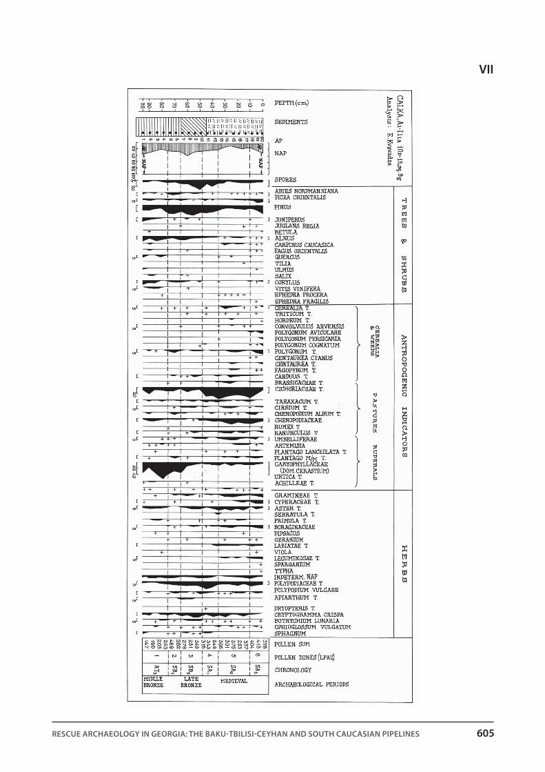
Ai-ilia section 2 was situated 100 m north of Section 1. A trench 95 cm deep contained a humus layer 45 cm thick that gradually merged into a yellowish layer. The earth in the section, and especially lower down, is characterized by a greater humidity compared with Ai-Ilia 1. Generally speaking, the material from Section 2 contained a large amount of pollen. Six palynological zones could be distinguished (pl.VII).
The spectra of the lower parts (Palynozone 1, depth 95-75 cm) of the palynological diagram are char-acterized by a substantial content of arboreal and weed pollen. Pollen of cereals, the cultivated vine and hazelnut were also recorded. This zone is similar to the lower part of Palynozone 4 of the Aligeli Lake section.
A layer at a depth of 75-45 cm (Palynozones 2 and 3) revealed the same peculiarities as Palynozone 5 of the Aligeli section: an increase in arboreal, especially pine, pollen.
The upper part of the diagram (Palynozones 4-6) corresponds to zone 6 of Aligeli Lake section.Ai-ilia section 3 is situated 60-65 m west of Section 2. A trench 75 cm deep was cut in a relatively flat area
where the soil was damp. The upper humus layer was 46 cm thick, and the pollen and spore content was high. There are more sporadic plants here than in Ai-Ilia Section 2. The lower part of the diagram (Palynozone 1, depth 75-55 cm) was characterized by a maximum amount of arboreal pollen and forest fern spores. Among arboreals pine and alder predominate and in the group of anthropogenic indicators there are almost no weeds but plenty of pollen of plants that point to presence of pastures.
The upper part of the diagram (depth 55 cm) belongs to Palynozone 2, in which three sub-zones can be distinguished. The proportion of arboreals gradually decreases, while that of synanthropic pollen increases. Sub-zone 2 revealed plenty of cereal pollen including wheat and barley. Palynozones 1 and 2 correspond to Aligeli zones 5 and 6.
the nature of the modern pollen spectrum. There is a detailed analysis of the sub-fossil palynological spectra of lakes and lake-swamp formations at the Gareji-Trialeti-Javakheti transect in a recent article “A sur-vey of modern pollen and vegetation along an altitudinal transect in south Georgia, Caucasus region” (Con-nor et al. 2004). It is estimated that the amount of arboreal pollen in the lake and the lake-swamp spectrum across the area of forest landscape is strongly reduced and comprises about 30-40%. An analogous situation
chart 1. The radiocarbon dating of samples from sediment layers of Imera and Aligeli lakes; the calibrated date has
been calculated according to Stuiver-Reimer system (Stuiver, Reimer 1993).
Place, depth Lab. Nos Radioncarbon dating Calibrated datingImera, 54 sm OZG-619 1010±40 968-911
Imera, 115 sm OZG-624 1630±40 1566-1509Imera, 146 sm OZH-067 2360±40 2363-2335Imera, 189 sm OZG-623 4903±110 4648-4405Imera, 230 sm OZH-399 4290±50 4877-4822Imera, 271 sm OZH-398 6590±60 7505-7434Aligeli, 38 sm OZH-397 190±40 209-146Aligeli, 70 sm OZH-396 930±40 873-816
Aligeli, 110 sm OZH-395 1510±40 1420-1333Aligeli, 147 sm OZH-394 2700±40 2798-2763Aligeli, 165 sm OZH-393 4030±50 4530-4424Aligeli, 203 sm OZH-393 4660±50 5460-5364Aligeli, 219 sm OZH-391 4450±40 5063-4972Aligeli, 252 sm OZH-390 9340±160 11115-10677Aligeli, 285 sm OZH-389 10250±90 12168-11892Aligeli, 309 sm OZH-388 12430±90 14949-14147

Rescue ARchAeology in geoRgiA: the BAku-tBilisi-ceyhAn And south cAucAsiAn PiPelines 593
the palaeolandscapes of the tsalka Plateau in the late Pleistocene and holocene
was recorded while investigating the soil of the pine forest on the south slope of Mount Ai-Ilia. The forest was started in the 1960s and is now well developed as it experiences self-renovation. The spectrum of the pine forest contains an average of 40% of arboreal pollen (pl. VIII), while it is normally 80-95% in similar forests elsewhere in the Caucasus (Klopotovskaya 1973; Kvavadze, Rukhadze 1989; Kvavadze 1993). The content of arboreal pollen is also reduced in the black soil in the environs of Tqemlara (Tetritsqaro district) (Kvavadze et al. 2004). This leads us to conclude that when an overall reconstruction of vegetation is made, the content of all forest components should be taken into account, for example, that of fern spores, which are perfectly pre-served in forest soil. In compiling the diagram, the calculation of the percentage of separate arboreals should not be on the basis of the total amount of pollen, as is usual today, but according to the content of arboreal pollen.
Given the data surveyed here, the following stages of landscape development can be distinguished at Tsalka Plateau over the past 15,000 years: After the last ice age of the Wurm period whose maximum phase occurred 18,000 years ago on the Eurasian landmass, the climate began gradually to improve (Tarasov et al. 1999). But 15,000 years ago the temperature fell again, as is indicated by the content of the pollen spectrum of the Aligeli Lake section. The vegetation on Tsalka plateau was of upper-alpine type which also contained components of the sub-nival zone. Here there grew sparse low grass, lichen, lycopodia and moss. We con-sider the pollen of ephedra and other arboreals to have been introduced from the lower zones. The pollen of lambsquarters and wormwood, which can easily spread over long distances, cannot be considered local. In the modern sediment layers of the sub-nival lakes of the Caucasus they are always in abundance, although they do not grow in the Caucasian highlands (Kvavadze, Efremov 1995).
At the second stage, 13,000 years ago, the landscape became lower-alpine, which also displayed sub-alpine components. Cereal grasses predominated on alpine meadows, while in deep gorges grew sub-alpine forests of deciduous trees including birch and Salix caprea, which might have withstood the ice age in deep gorges of the rivers (e.g. the Khrami River).
At the third stage, 9000 years ago, the climate became warmer and forests generated in which Quercus macranthera predominated.
The later stage 4 of both vegetation and climatic development totally reflects the first peak of global warming of the Atlantic period. The amount of rainfall also increases. This process took place 6.5-6 thousand years ago in Europe and South Caucasia (Tarasov et al. 1998). During this period hornbeam, beech, Georgian oak, zelkova, and lime grew over the Tsalka Plateau, although admittedly chestnut and bast grew in deep gorges, for example, in the Khrami Valley. In the neighbouring high mountains Nordmann fir predominated, which by comparison with fir, is a plant of warmer and more humid climates. In this period humans were in-tensively occupied in arable farming, encouraged both by the warm and humid climate and the presence of fertile black soil. Horticulture and viticulture were well developed too.
At stage 5 of vegetation and climatic development, there is a noticeable reduction in the area of ther-mophilic varieties: hornbeam, beech, zelkova and lime forests. Quercus macranthera and birch forests, by contrast, begin to spread widely. The types of cultural landscape altered too, in that arable farming no longer predominated, and the area of pastures grew and viticulture vanished. Judging by radiocarbon dates, these landscape changes occurred 5300 years ago and was caused by a drop in temperature.
Stage 6 of landscape development belongs to the second maximum of Atlantic period warming which took place 5000-4600 years ago, i.e. in the Early Bronze Age. The area of thermophilic vegetation expanded once more, and intensive arable farming, horticulture and viticulture emerged. This was a very intense warm-ing that was reflected in both the foothills and highlands of South Georgia. For example, near the village of Tambovka in Javakheti, at an altitude of 2100 m, in the spectrum of fossilized soil of a kurgan near Paravani Lake, we discovered plenty of hornbeam, lime, oak and box pollen. Pollen of cereals, including wheat, was abundant. The kurgan was dated to the beginning of the 3rd millennium BC (Kvavadze, Kakhiani 2007). South of the village of Sakire, at an altitude of 2289 m, in the remains of fossilized soil and fossil honey of Kodiani

594 baqo-Tbilisi-jeihani samxreT kavkasiis milsadeni da arqeologia saqarTveloSi
eliso kvavadze, goderdzi narimanishvili
kurgan there appeared the pollen of broad-leaved thermophilic arboreals and perfectly preserved timbers and branches of trees. Judging by the associated finds Kodiani kurgan is dated to the 26th-24th centuries BC (Kvavadze et al. 2004; Kvavadze 2006; Kvavadze et al. 2006).
Stage 7 of vegetation and climatic development witnessed a sub-boreal cold spell and a reduction in rainfall. In Tsalka region the maximum drop in temperature occurred 4000-3700 years ago. Forests of Quercus macranthera, birch and pine, which grow at the upper border of the forest zone, spread once more. In the palynological spectra of occupation levels at Jinisi there was plenty of birch pollen, attesting to the presence of birch forests in the area. Among grasses sub-alpine elements are present. Cattle breeding replaced arable farming completely.
At stage 8, 3500-3400 years ago, the climate became warmer again, but not as warm as it had been in the Early Bronze Age, although there were noticeable reflections in the landscape. Oak and hornbeam for-ests appeared with lime participation. Arable farming developed more intensively than in previous periods. Horticulture and viticulture flourished, to which the rich finds from Sapar-Kharaba and Imera cemeteries bear witness.
Stage 9 reflects a glaciation of the sub-Atlantic period, which was also global and took place 2500 years ago. The palynospectra of the Mount Ai-Ilia settlement clearly indicate a worsening of climatic conditions. Among arboreals there are no such thermophilic plants as lime, there are fewer cereals, and there are no cul-tivated vines at all. Livestock breeding plays the leading role in economy.
Stage 10 of landscape development covers the Middle Ages (1350-800 years ago). There occurred a substantial warming which is clearly recognisable throughout Georgian territory (Kvavadze, Connor 2005). Arable farming, livestock breeding and viticulture are intensively developed on Tsalka Plateau. At this time olives (Olea europea) grew here too, as is clearly on the section diagram of Imera Lake. Olive plantations that had run wild in the Khrami Valley are mentioned by Vakhushti Bagrationi (Life of Kartli 1973).
Besides, a section of Didadjara peatbog on the neighbouring Arsiani range, situated at an altitude of 1850 m, contained olive pollen in layers of the Classical period (J. van Leeva, University of Bern, personal com-munication). Olive cultivation at this period was also recorded in the pollen spectrum of the Tsavkisi section (Connor, Kvavadze 2005). It would appear that the olive was introduced to the coastal area of western Georgia in the Classical period and was also cultivated in other regions during warmer periods.
1350-800 years ago livestock breeding on Tsalka plateau was secondary to arable farming, but was nev-ertheless very well developed. The pollen of weeds accompanying human occupation areas rose to a maxi-mum, which points to a high population density. This is also indicated by archaeological and historical data. There was a clear human impact on the environment; witness the destruction of forests.
Minor glaciations that took place 300 years ago are reflected in the spectrum of deposits in the sections by an increase in the amount of fir pollen. It is especially clear in the diagrams of the Ai-Ilia sections. We must consequently allow the presence of coniferous forests in Tsalka region during these short-term but intensive glaciations. According to Vakhushti, fir and pine forests grew around Tabatsquri Lake, at an altitude of 1900-2000 m (Ketskhoveli 1959, 277). It was then that many thermophilic plants vanished both in wild and cultivat-ed cenoses. In the 17th century the population left these areas through invasions. The complete destruction of the forests was probably continuing in the 19th-20th centuries, when the population began recovering the territory.
The data received as a result of the investigation of earth sections from stunted shrub stands of beech on Mount Tavkvetili were rather remarkable. Palynological spectra of oak and hornbeam forests were revealed in Early and Late Medieval strata at an altitude of 2100 m (Arabuli et al. 2008).
A comparison of the results of the palynological analysis of lake and swamp deposits with the archaeo-logical finds thus shows that in Trialeti the maximum of the Atlantic climatic optimum falls at the end of the 4th millennium and the beginning of the 2nd millennium BC. This stage coincides with the Early Bronze Age (second half of the 4th to mid-3rd millennium BC). Archaeological sites of this period were excavated at several

Rescue ARchAeology in geoRgiA: the BAku-tBilisi-ceyhAn And south cAucAsiAn PiPelines 595
the palaeolandscapes of the tsalka Plateau in the late Pleistocene and holocene
places on Tsalka Pateau, at Beshtasheni, Ozni, Avranlo, Tashbashi.This warm period coincides with the first (26th-24th centuries BC), second (23rd-22nd centuries BC) and
third (21st-20th centuries BC) stages of the Middle Bronze Age. Archaeological sites of the first stage (Bedeni) were studied at 5 places: Beshtasheni, Sanomeri, Shipiaki, Santa, Tsintsqaro. Groups I and II of Trialeti Culture kurgans belong to the sites of the second and third stages.
In Tsalka region the sub-boreal cold spell started at the beginning of the 2nd millennium BC and contin-ued through the 17th century BC. Group III of the Trialeti Kurgan Culture belongs to this period.
A new warming stage began in the region in the 15th century BC and continued almost to the 5th century BC. At the time Tsalka Plateau was intensively exploited by man. Apart from the palynological data this is in-dicated by the existence of numerous settlements and cemeteries in the area. Archaeological finds point to an advanced economy.
The period from the 5th century BC onwards is characterized by a dramatic worsening of climatic condi-tions which lasted for several centuries. There are fewer archaeological sites in this period.
In the 7th century AD there began the so-called abnormal warming period in Trialeti and it lasted almost to the 12th century. The economy experienced a period of prosperity. In the 13th-14th centuries there was a dramatic fall in temperature that brought about a weakening of the economy and a reduction in the size of the population. It was a time of numerous invasions by external enemies. As a result, people had abandoned Tsalka Plateau by the second half of the 18th century.
Archaeological and palynological data thus indicate that economic development and intensive occupa-tion of the territory occurred exactly during lengthy periods of warming.
conclusion. Physical evidence and historical data (Trifonov, Darakhanyan 2004) thus combine to show that in the history of civilization climatic changes substantially conditioned the economic activities of the population.
The revival of arable farming on Tsalka Plateau coincided with warm climatic conditions, while at periods of climatic optima horticulture and viticulture also developed. In periods of glaciation the role of farming diminished, and horticulture and viticulture vanished altogether. The worsening of the climate promoted the development of livestock breeding. The palynological material discussed here suggests that the climate has changed several times over the past 15,000 years. Climatic changes were global and tended towards warm-ing. It is remarkable, that the global warming that took place in the Holocene was occasionally interrupted by short-term glaciations. An analogous situation has been proposed for other regions of Georgia and the Cau-casus (Kvavadze, Rukhadze 1989; Efremov, Kvavadze 1995: Kvavadze 1999; Kvavadze, Efremov 1994, 1996: Trifonov, Karakanyan 2004; Kvavadze, Connor 2005).
At the end of the Pleistocene the landscape of Tsalka Plateau at the first stage of development was free of forests. The climate was cold and dry. At the beginning of the Holocene the landscape remained open. From the Atlantic period, there began a dramatic rise in temperature and rainfall accompanied by the gradual generation of forest massifs.
Forestation was a long and gradual process that continued ceaselessly. Cold spells and human industrial activity interfered with this process, however. An analogous phenomenon can be observed in many regions of southern Europe and the Near East. For example, the areas around Vani, Urmia and Zeribar Lakes were forest-free in the Late Pleistocene. Forests appeared here during the warm and humid phase of the Middle Holocene (Van Zeist, Bottema 1991; Wick et al. 2003; Wright et al. 2003; Wasylikowa, Witkowski 2008).
On Tsalka Plateau broad-leaved forest massifs appeared during the maximum warming of the Middle and Late Holocene. Georgian oak, hornbeam and elm predominated. There also grew lime, oriental horn-beam, alder, hazelnut, maple, ash, and zelkova. Wooden constructions found in burial chambers and other types of burials in Trialeti kurgans also point to presence of forest massifs in this region.
Short-term cold stages are recorded in the Holocene. Some of these cold spells were very short but in-tense (e.g. 300 years ago). At these times the make-up of forests also underwent changes. Thus deciduous
596 baqo-Tbilisi-jeihani samxreT kavkasiis milsadeni da arqeologia saqarTveloSi
eliso kvavadze, goderdzi narimanishvili
thermophilic forests were replaced by pine and birch forests, where Quercus macranthera also grew. The role of arable farming gave way to intensive livestock breeding.
Our research also shows that the first stage of deforestation began in the Middle Ages, at a time when the density of the population on Tsalka Plateau was very high. The process of deforestation continued through the 19th century at the hands of the newly settled Armenian and Greek population. In the first half of the 20th century forest massifs were destroyed. Natural forests survived only in the deep gorges of the Ktsia basin.
Bibliography:
Amiranashvili dzh., narimanashvili g. 2005: Poselenie epokhi srednei bronzy iz Trialeti. (Middle Bronze Age
settlement in Trialeti). In: T. Bunyatov (ed.), Archaeology, Ethnology, Folklore of the Caucasus, 42-43. Baku (in Russian).
Apkhazava n. 1975: Ozera Gruzii (Lakes in Georgia). Tbilisi.
Arabuli g., kvavadze el., kikodze d., connor s., kvavadze er., Bagaturia n., Murvanisze M., Arabuli t. 2008: The
Krummholz beech woods of Mt.Tavkvetili (Javakheti Plateau, Southern Georgia), a relict ecosystem. Proceedings
of the Institute of Zoology 23, 194-213.
Atlas Gruzii 1964: Tbilisi.
connor s.e. 2006. Late Quaternary vegetation history of Southern Georgia. Caucasus. Doctoral thesis. Melbourne.
connor s.V., kvavadze e.V. 2005: Climatic and human influences on vegetation dynamics around Tbilisi over the past
6000 years. Proceedings of the Georgian Academy of Sciences. Biological series B, 3/4, 64-76.
connor s., thomas i., kvavadze e., Arabuli g., Avakov g., sagona A. 2004: A survey of modern pollen and vegetation
along an altitudinal transect in southern Georgia, Caucasus region. Review of Palaeobotany and Palynology 129,
229-250.
grossgeim A. 1946: Rastitel’nie resursi Kavkaza (Vegetation resources of the Caucasus). Baku.
grossgeim A. 1949: Opredelitel’ rastenii Kavkaza (The determiner of vegetation in the Caucasus). Moscow.
efremov B., kvavadze e. 1995: Istoria ozer Kavkaza. (A history of lakes in the Caucasus). In V.A. Rumiantsev (ed.),
Istoria ozer severa Azii, 192-205. St Petersburg.
yatsenko-khmelevskii A., kandelaki g. 1941: Drevesnye ugli iz raskopok Beshtashenskoi tsiklopicheskoi kreposti
(Tsalka) (Charcoal from the excavations of Beshtasheni Cyclopean fortress). Soobshch. Gruz. Filial AN SSSR 2/5, 14-
21.
ketskhoveli n. 1959: sakartvelos mtsenareuli saphari (Vegetation in Georgia). Tbilisi.
ketskhoveli n. (ed.) 1964: Opredelitel’ rastenii Gruzii. (The determiner of vegetation in Georgia) 1. Tbilisi.
klopotovskaia n. 1973: Osnovnye zakonomernosti formirovaniya sporovopil’cevykh spektrov v gornykh raionakh
Kavkaza (Principal regularities of the formation of sporadic spectra in the highlands of Caucasus). Tbilisi.
kvavadze e. 1999: Golocenovye kolebaniya urovnya ozera Lisi i izmeneniya polozhenii nizhnei granitsi lesa (Holocene
variation of the level of Lisi and changes of the lower border of the forest). Problemi paleobiologii 1, 75-87. Tbilisi.
kvavadze e. 1993: On the interpretation of subfossil mountain spore-pollen spectra. Acta Palaeobotanica 33(1), 347-
360.
kvavadze e.V., connor s.V. 2005: Zelkova carpinifolia (Pallas) K. Koch in Holocene sediments of Georgia: an indicator
of climatic optima. Review of Palaeobotany and Palynology 133, 69-89.
kvavadze e. V. 2006: Fossilnii med kak ob’ekt dlya paleoekologicheskikh rekonstruktsii (po palynologicheskim
Rescue ARchAeology in geoRgiA: the BAku-tBilisi-ceyhAn And south cAucAsiAn PiPelines 597
the palaeolandscapes of the tsalka Plateau in the late Pleistocene and holocene
dannym arkheologicheskogo materiala iz Gruzii. (Fossil honey as an object for palaeoecological reconstruction).
Palaeontological journal 6. Tbilisi.
kvavadze e. V., connor s. V., narimanashvili g. k. 2007: Pozdnepleistotsenovaya i golocenovaya istoriya razvitiya
landshaftov okrestnostei Tsalki (Yuzhnaya Gruziya) po palynologicheskim dannym ozernykh i pochvennykh
obrazovanii. (The Late Pleistocene and Holocene history of the development of landscapes in the environs of
Tsalka [South Georgia] according to palynological data from lake and soil formations). Problems of palaeobiology
2, Tbilisi.
kvavadze e., efremov yu. 1994: Palynological studies of Holocene lake sediments in the headwaters of the river
Bezymianka (West Caucasus). Acta Palaeobotanica 35(2), 205-214.
kvavadze e., efremov yu. 1995: Peculiarites of recent pollen spectra of lake sediments in the Caucasus. Acta
Palaeobotanica 35(1), 57-72.
kvavadze e., efremof yu. 1996: Palynological studies of lake and lake-swamp sediments of the Holocene in the high
mountains of Arkhyz (Western Caucasus). Acta Palaeobotanica 36(1), 107-119.
kvavadze e., gambashidze i., Mindiashvili g., gogochuri g. 2004: Sledy sushchestvovaniya drevnego pchelovodstva
(III tisyacheletie do n.e.) na territorii Gruzii po palynologicheskim dannym (Traces of ancient apiculture [3rd
millennium BC] on the territory of Georgia according to palynological data). Proceedings of the Institute of Zoology
22, 438-449. Tbilisi.
kvavadze e., gambashidze i., Mindiashvili g., gogochuri g. 2006: The first find in southern Georgia of fossil honey
from the Bronze Age based on palynological data. Vegetation History and Archaeobotany 16,5, 399-404.
kvavadze e., kakhiani k. 2007: Extrafossils in pollen spectra of the samples of organic formation from the Paravani
Kurgan (the Early Bronze Age, Georgia). Vegetation History and Archaeobotany (in press).
kvavadze e., narimanishvili g. 2006a: An experimental approach to the palynology of remains from Middle Bronze
Age burials in Saphar-Kharaba, southern Georgia. Abstracts of the 7th European PalaeobotanyPalynology Conference,
77-78. Prague.
kvavadze e., narimanishvili g. 2006b: The remains of Gossipium, Linum and sheep hairs as textile fibers of cotton, flax
and wool in palynological material from Bronze Age burials. PalynoBulletin 2. No. 1-4, 34-37. Innsbruck.
kvavadze e. Rukhadze l. 1989: Rastitel’nost’ i klimat golotsena Abkhazii (Vegetation and climate in Holocene Abkhazia).
Tbilisi.
kvavadze e., shatberashvili Z., Amiranashvili j., Arabuli g. 2004: Palynological investigations of two burial mounds
of the Middle Bronze Age of Tkemlara (Eastern Georgia). Acta Palaeobotanica 44(2), 267-279.
Life of Kartli 1973: vakhushti bagrationi, aghtsera samephosa sakartvelosa (Vakhushti Bagrationi, Description of the
Kingdom of Georgian). Kartlis Tskhovreba (Life of Kartli) ed. S. Qaukhchishvili, 4. Tbilisi.
lominadze V., chirakadze g. 1971: Klimat i klimaticheskie resursy Gruzii (The climate and climatic resources of Georgia).
Leningrad.1
Maruashvili l. (ed.) 1973: Geomorfologiya Gruzii (The geomorphology of Georgia). Tbilisi.
Maruashvili l. 1979: sakartvelos phizikuri geographia (Georgian Physical Geography) 2. Tbilisi.
Margalitadze n. 1977: Istoria rastitel’nosti Dzhavakhetskogo nagor’ya i Tsalkinskogo plato v golotsene (The history of
the vegetation of Javakheti and Tsalka Plateau in the Holocene). In: I. I. Tumadzhanov (ed.), Palynological researches
in Georgia, 124-147. Tbilisi.
Margalitadze n. 1995: Istoria golotsenovoi rastitel’nosti Gruzii (The history of the Holocene vegetation of Georgia). Tbilisi.
narimanishvili g. 2006: Trialeti v II tisyacheletii do n.e. (po dannym arkheologii). (Trialeti in the 2nd millennium BC).
Abstract. Tbilisi.
narimanishvili g. 2006: saphar-kharabas samarovani (Sapar-Kharaba cemetery). Dziebani 17-18, 92-126.
tarasov P.e., Volkova V.s., Andreev A.A., Bezusko l.s, kvavadze e. 1998: Present-day and middle-Holocene biomes

598 baqo-Tbilisi-jeihani samxreT kavkasiis milsadeni da arqeologia saqarTveloSi
eliso kvavadze, goderdzi narimanishvili
reconstructed from pollen and plant macrofossil data from the Former Soviet Union and Mongolia. Journal of
Biogeography 25, 1029-1054.
tarasov P.e., Peyron o., guiot j., Brewer s., kvavadze e. at al. 1999: Last glacial maximum climate of the Former Soviet
Union and Mongolia reconstructed from pollen and plant macrofossil data. Climate Dynamics No. 15, 227-240.
trifonov V., karakhanian A. 2004: Geodinamika i istoriya tsivilizacii (The geodynamics and history of civilization).
Moscow.
Van Zeist w., Bottema s. 1991: Late Quaternary vegetation of the Near East. Beihefte zum Tübinger Atlas des Vorderen
Orients, Reihe A 18, 1-156
wasylikowa k., witkowski A. (eds.) 2008: The Paleoecology of Lake Zeribar and Surrounding Areas, Western Iran, during
the last 48,000 years. Diatom Monographs 8. Ruggell.
wick l., lemcke g., sturm M. 2003: Evidence of Late-glacial and Holocene climatic change and human impact
in eastern Anatolia: high-resolution pollen, charcoal, isotopic, and geochemical records from the laminated
sediments of Lake Van, Turkey. The Holocene 13 (5), 665-675.
wright h., Ammann B., stefanova i., Atanassova j., Margalitadze n., wick l., Blyakharchuk t. 2003: Late-glacial and
early-Holocene dry climates from the Balkan peninsula to Southern Siberia. S. Tonkov (ed.), Aspects of Palynology
and Palaeoecology, 127-136.
illustrations:
pl.I. Map of the flat-bottomed hollow of Tsalka and the location of places investigated: 1. Jinisi settlement; 2. Aligeli
Lake; 3. Mount Ai-Ilia; 4. Spar-Kharaba cemetery; 5, Imera Lake; 6. Imera cemetery
pl. II. 1. Sapar-Kharaba cemetery, Burial No. 67 (a: beginning of excavations; b: end of excavations. Photo G.
Narimanishvili). Circles and arrows mark the places where samples were collected for palynological analysis; 2.
Sapar-Kharaba cemetery, Burial No. 85 (a: beginning of excavations, b: end of excavations. Timbers covering the
chamber are visible. Photo G. Narimanishvili). Circles and arrows mark the places where samples were collected
for palynological analysis.
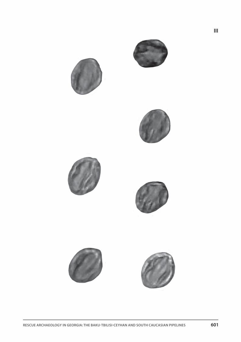
pl. III. Sapar-Kharaba cemetery, Burial No. 67. Pollen of the cultivated vine (Vitis vinifera) recovered from between the
teeth of the deceased (x600).
pl. IV. Sapar-Kharaba cemetery. Remains of cotton cloth and fibres: 1. Burial No. 56, remains of cloth (x20); 2, 3. Burial
No. 56. Thread fibres of cotton cloth (x600); 4,5. Burial No. 71. Thread fibres of cotton cloth (x600)
pl. V. A. Diagram of spores and pollen of a section of Aligeli Lake sediments (dominants and ecologically important
components are displayed); B. Diagram of spores and pollen of a section of Imera Lake sediments (dominants and
ecologically important components are displayed) [From Kvavadze et al. 2007)
pl. VI. Spore and pollen diagram of sediments of Ai-Ilia Section 1
pl. VII. Spore and pollen diagram of sediments of Ai-Ilia Section 2
pl. VIII. Soil spectrum of pollen and spores from the north slope of Mount Ai-Ilia (samples 1-3 were collected in the
pine forest, the rest on the meadow).

Rescue ARchAeology in geoRgiA: the BAku-tBilisi-ceyhAn And south cAucAsiAn PiPelines 599
i

600 baqo-Tbilisi-jeihani samxreT kavkasiis milsadeni da arqeologia saqarTveloSi
ii
1
2
Rescue ARchAeology in geoRgiA: the BAku-tBilisi-ceyhAn And south cAucAsiAn PiPelines 601
iii
602 baqo-Tbilisi-jeihani samxreT kavkasiis milsadeni da arqeologia saqarTveloSi
iV

Rescue ARchAeology in geoRgiA: the BAku-tBilisi-ceyhAn And south cAucAsiAn PiPelines 603
V

604 baqo-Tbilisi-jeihani samxreT kavkasiis milsadeni da arqeologia saqarTveloSi
Vi
Rescue ARchAeology in geoRgiA: the BAku-tBilisi-ceyhAn And south cAucAsiAn PiPelines 605
Vii

606 baqo-Tbilisi-jeihani samxreT kavkasiis milsadeni da arqeologia saqarTveloSi
Viii