the november 7, 2012 m7.4 guatemala earthquake and … 7, 2012 m7.4 earthquake. the main purpose ......
TRANSCRIPT

The November 7, 2012 M7.4 Guatemala Earthquake and its Implications for Disaster Reduction and Mitigation
A joint report of EERI and AGIES

© 2013 Earthquake Engineering Research Institute, Oakland, California 94612-1934. All rights reserved. No part of this report may be reproduced in any form or by any means without the prior written permission of the publisher, Earthquake Engineering Research Institute, 499 14th St., Suite 220, Oakland, CA 94612-1934, email: [email protected], website: www.eeri.org. This report is published by the Earthquake Engineering Research Institute, a nonprofit corporation. The objective of the Earthquake Engineering Research Institute is to reduce earthquake risk by advancing the science and practice of earthquake engineering by improving understanding of the impact of earthquakes on the physical, social, economic, political, and cultural environment, and by advocating comprehensive and realistic measures for reducing the harmful effects of earthquakes. Funding for the Field Study Trip and this resulting report has been provided by the Global Facility for Disaster Risk Reduction of the World Bank. Any opinions, findings, conclusions, or recommendations expressed herein are the authors’ and do not necessarily reflect the views of EERI, the GFDRR, the World Bank, or the author’s organizations. Production Managers: Maggie Ortiz, Brijhette Farmer Cover Photo: View of San Marcos from the MiralValle Hotel. San Marcos was the region most affected by the November 7, 2012 earthquake.

The November 7, 2012 M7.4 Guatemala Earthquake and its Implications for Disaster Reduction and Mitigation
A joint report of EERI and AGIES
CONTENTS
Executive Summary ...................................................... 1
Introduction & Background .......................................... 3
1. Acknowledgements ............................................ 3 2. Background and summary of investigation ........ 3 3. Motivation behind EERI field study trip .............. 3 4. Background of social, economic and
technological development in Guatemala .......... 3 5. Description of current design and construction
state of practice .................................................. 4 6. State of disaster risk management policy and
practice .............................................................. 5
Part I: Seismicity of Region, Geotechnical Effects, and Building Performance .......................................... 6
1. Seismicity .................................................................. 6 1.1. Tectonic setting ................................................. 6 1.2. Historical Subduction Seismicity of Western
Guatemala ........................................................ 6 1.3. November 2012 event ...................................... 8 1.4. Ground motion records ..................................... 8 1.5. Areas affected ................................................... 9
2. Geotechnical Effects ............................................... 10 2.1. Geologic context ............................................. 10
2.1.1. Regional Geology .................................. 10 2.1.2. Subduction zone and consequence
of volcanic activity ................................... 10 2.1.3. Coastal region geologic setting and
highlands in western Guatemala............. 10 2.1.4. Ash, coastal, alluvial deposits and
pyroclastic soils ....................................... 10 2.2. Effects of soil conditions on building
performance .................................................... 11 2.3. Landslides and ground settlement .................. 11 2.4. Liquefaction ..................................................... 12
3. Structural Engineering Observations ...................... 14 3.1. Adobe and bahareque .................................... 14 3.2. Confined masonry ........................................... 14 3.3. Reinforced concrete ........................................ 19 3.4. Historical buildings .......................................... 19
4. Infrastructure Performance ..................................... 20
4.1. Electric power ................................................. 20 4.2. Telecommunications ....................................... 20 4.3. Water systems ................................................ 21 4.4. Transportation systems .................................. 21
4.4.1. Highways ............................................... 21 4.4.2. Bridges ................................................... 21 4.4.3. Airports ................................................... 21
4.5. Hospitals ......................................................... 21 4.6. Fire stations .................................................... 22 4.7. Police stations ................................................ 22
5. Social and economic impact .................................. 23 6. Emergency response ............................................. 23 7. Recovery and reconstruction.................................. 24 8. Lessons Learned .................................................... 25
8.1. Confined masonry construction ...................... 26 8.1.1. The empirical construction sector ........... 26 8.1.2. Risk reduction approach ......................... 27
8.2. Older adobe dwellings .................................... 27 8.2.1. Risk reduction approach ......................... 27
8.3. Pre-1970 non-ductile reinforced concrete multi-story buildings ........................................ 28
8.3.1. Risk reduction approach ......................... 28 8.4. Small and middle-sized tier buildings ............. 28
8.4.1. Risk reduction approach ......................... 28 8.5. Site hazards .................................................... 28 8.6. Near fault hazards .......................................... 29
8.6.1. Risk reduction approach ......................... 29 8.7. Other vulnerability aspects ............................. 29
Part II: Recommendations for Improving Seismic Risk Mitigation Practices .......................................... 30
A. Education, capacity building and training .............. 30 B. Strong Motion Monitoring Program ........................ 31 C. Risk Reduction of existing buildings and
infrastructure .......................................................... 32 D. Improvement of design and construction
practices ................................................................. 33 References ................................................................... 34
Appendix 1: List of Participants ................................ 35
1

The November 7, 2012 M7.4 Guatemala Earthquake and its Implications for Disaster Reduction and Mitigation
A joint report of EERI and AGIES
Executive Summary During the first week of April 2013 a group of engineers from EERI and AGIES, along with consultants from the World Bank, visited some of the areas affected by the November 7, 2012 M7.4 earthquake. The main purpose of the visit was to collect information about the effects of the earthquake and to gain insight into current construction practices in the regions damaged. This report is the first in a series of case studies being developed by EERI on recovery and resilience in developing countries. It was funded by a grant agreement between EERI and the Global Facility for Disaster Recovery and Reconstruction (GFDRR) at The World Bank. The field study conducted by AGIES, EERI, and the World Bank, is a best practice worthy of replication for understanding the causes of structural damage and improving building codes and standards accordingly.
As AGIES is actively trying to improve building practices in the country, this reconnaissance visit provided a great opportunity for the EERI team to gain a better understanding about challenges related to resilience and recovery in a developing country. At the same time, it gave the AGIES members the opportunity to discuss their concerns and exchange knowledge with EERI experts on various aspects of Guatemalan construction practice including earthquake design of engineered and non-engineered structures, construction material quality, and enforcement policy. This report, which provides technical information and engineering insight into damage and recovery needs, it also compliments existing reports of socio-economic loss and recovery needs from the November 2012 earthquake.
One remarkable aspect of this earthquake is that the intensity of the ground shaking in the affected regions was rather low. Although there are a few strong motion records available from this event, all showed peak ground accelerations less than .04 g, even in the epicentral region. The complex topographical setting of the region, combined with the complex geological setting of the country and the lack of adequate strong motion instrumentation in the country, make it very difficult to provide a clear explanation of why the levels of shaking and damage were low.
The geology of Guatemala is characterized within a very well-defined physiographic environment comprising four geological provinces. The area of San Marcos and San Pedro Sacatepéquez lies in the volcanic zone which is aligned with the Pacific Ocean shoreline. This zone is characterized by diverse large volcanic structures, such as calderas and stratified volcanoes. This zone can be divided into segments based on seismic and volcanic alignments. Several left lateral slip faults cross Guatemala from the northeast corner and extend
towards Mexico. The main system of faults is the Motagua-Polochic.
Landslides in the mountains and on steep slopes were officially reported by CONRED (National Coordinator for Disaster Reduction). Most of the landslides occurred in the cuts along the Pan American Highway CA-1, and along roads located along the volcanic physiographic province near the epicentral area. The poor design of the slope cuts made along the Pan American Highway and other roads triggered many of the slides. Slides along the roads were also caused by the failure of hillsides previously weakened by Tropical Storm Agatha in 2010. Human activity along the toe of bluffs and slope continues to be a problem. The total number of landslides was not as great as it was in the 1976 earthquake, but most landslides were caused by human-related activities. However, there were incidents of loss of life due to geotechnical hazard
Soil liquefaction was mainly observed in the Port of Ocós and along the southwestern coastal area near the epicenter. Settlement and lateral spreading in Coatepeque, on the banks of a small river, was also observed. In Puerto Champerico substantial damage, including cracks in structures, slabs and the ground; tilted walls; displaced piles; settlements; and liquefaction, was also reported. Most of the damage was evident along the Champerico wharf.
While the San Marcos province was not affected by the 1976 earthquake, in the 2012 event, a general failure of adobe and bahareque buildings was observed. Damage was prevalent in the urban area of San Marcos and San Pedro Sacatepéquez, where most of the houses built with this material collapsed or suffered severe structural damage that warranted demolition. The adobe and bahareque houses that suffered severe damage or collapse showed the following types of damage: cracking and separation of the walls in the corners; separation of the roofs from the supporting walls; diagonal cracking of walls due to shear stresses; and overturning of walls, especially those that supported heavy inclined tile roofs. The damage and casualties caused by the 1976 earthquake triggered a migration to use a better construction system than adobe masonry, which was the preferred method of construction among the population in rural areas. Today, the vast majority of construction in urban and rural areas of Guatemala uses confined masonry made with lightweight concrete blocks, as these are available in any region of the country. Structural damage in confined masonry structures can be attributed to four factors: 1) Deficient construction material, 2) Poor detailing of confinement and anchoring of structural elements, 3) Inadequate structural configuration, and 4) Abuse of the construction system.
2

The November 7, 2012 M7.4 Guatemala Earthquake and its Implications for Disaster Reduction and Mitigation
A joint report of EERI and AGIES
Reinforced concrete buildings are usually combined with some form of masonry structural elements. The damage in structures with reinforced concrete structural systems was primarily caused by inadequate structural configuration and poor structural detailing. As with masonry construction, many reinforced concrete buildings showed considerable variations of the perimeter stiffness of structures, generating torsional effects that especially damaged structural elements on the perimeter of the building. There was also plenty of evidence of short column effects due to the lack of separation of masonry infills from the main concrete structure and failure by the designer to consider this effect in the structural design. In most cases, infill walls were severely damaged or destroyed as they became part of the lateral force resisting system.
The damage and economic losses caused by the earthquake of November 7, 2012 exceeded USD 128 million. The majority of the economic losses were associated with partial or total destruction of housing. The earthquake had its greatest effect in eight provinces of Western Guatemala: Retalhuleu, Quetzaltenango, Sololá, Quiche, Totonicapán, San Marcos, Huehuetenango and Suchitepequez. These provinces have the highest population density in rural areas (61%), and high indigenous populations.
After the November 7 earthquake, the President declared a state of public calamity in the provinces affected by the event. In order to assess the extent of damages, the National Coordinator for Disaster Reduction, CONRED, provided the EDAN forms (Damage Assessment and Needs Analysis) and worked with the emergency operations centers (COEs) at departmental and municipal levels to get food and household goods to those affected. Over 33,000 were left homeless after the disaster, but only about 15 thousand were admitted to shelters. San Marcos was the province with the highest number of displaced people and represented about 10% the total population. In Sololá, the number of displaced people was about 4% of the total population; in Quetzaltenango about 2% of the total population of that region was displaced.
One of the most troubling aspects of the damage observed after the earthquake is the large number of public buildings that were evacuated due to structural damage. Among the institutions that were affected are hospitals, health centers, fire and national police stations, municipal buildings, schools, court buildings, jails and provincial government buildings. The structures that house these institutions are classified by the Guatemalan building code, AGIES NSE-2010, as essential buildings and should remain operational during and after an earthquake of great magnitude, to serve the population and coordinate the emergency response. According to the report "Assessing the Impact of the Earthquake of November 7, 2012 in Guatemala", prepared by the Office of Planning and Programming of
the Presidency of the Government of Guatemala, SEGEPLAN, there were 215 schools, 32 health institutions (including hospitals) and 16 public buildings with some kind of damage. Following the earthquake, the Guatemalan President appointed the Vice President to lead the recovery and reconstruction process and to quickly provide permanent housing to the most vulnerable families. To achieve this goal, the Vice President established a Reconstruction Commission to coordinate the activities of the various ministries and international partners. The Reconstruction Coordinator worked closely with the Ministry of Planning and SE-CONRED. The government of Guatemala is committed to a complete reconstruction and has distributed responsibilities among the Ministries, InterAmerican Development Bank, and affected communities.
The Secretaría de Coordinación Ejecutiva de la Presidencia (SCEP) is focused on closing shelters and providing over 7,000 permanent houses to the most vulnerable families. To implement this program, three government agencies are working with local mayors to build new homes. These ministries are the Ministry of Communications, Infrastructure and Housing, Ministry of the Interior and the Ministry of Development. The Ministries of Health and Education are working closely with the Inter-American Development Bank to rebuild schools and health facilities, and have reprogrammed IADB financing for these purposes. Other ministries, including the Ministry of Cultural and Historic Preservation are responsible for using their existing limited resources to make needed repairs in their sector.
Based on the vulnerabilities observed during the November 7, 2012 earthquake in Guatemala, and the assessment of the current state of practice in structural and earthquake engineering, a number of recommendations are presented to improve seismic risk mitigation practices in the country. The proposed recommendations are classified into four categories: A) education, capacity building and training; B) strong motion monitoring program; C) risk reduction of existing buildings and infrastructure; and D) improvement of design and construction practices. The targeted stakeholders, implementation methods, outcomes, cost estimates, and expected duration are provided for each.
The November 7th earthquake was only the most recent experience the country has had with earthquake-related deaths, collapse of older adobe housing, heavy damage to some of the newer but still inadequate local construction, and significant damage to older public and private buildings as well as newer ones. Nothing new was revealed by the November earthquake—rather, it reinforced important lessons and necessary recommendations for making Guatemala a more earthquake-resistant country.
3

The November 7, 2012 M7.4 Guatemala Earthquake and its Implications for Disaster Reduction and Mitigation
A joint report of EERI and AGIES
Introduction & Background1. Acknowledgments
The EERI team was ably assisted by members of the Asociación Guatemalteca de Ingeniería Estructural y Sísmica (AGIES) during their time in Guatemala. The team also benefitted greatly from the participation of individuals from many agencies in the country during a round table discussion on Friday, April 5. A list of those who participated can be found in Appendix 1 of this report. Financial support for the EERI team was provided as part of a grant agreement with the Global Facility for Disaster Risk Reduction (GFDRR) of the World Bank.
2. Background and summary of investigation
During the first week of April 2013 a group of engineers from EERI and AGIES, and consultants from the World Bank, visited some of the areas affected by the M7.4 earthquake that struck Champerico on November 7, 2012. The EERI team was led by Carlos Ventura, University of British Columbia, and included Manuel Archila, University of British Columbia; Marcial Blondet, Pontifica Universidad Católica de Peru; Jeff Dragovich, Independent Consultant; Ronaldo Luna, Missouri University of Science and Technology; Maggie Ortiz, EERI; and Sahar Safaie, Sage on Earth Consulting Group. The AGIES team was led by their current President Hector Monzón, SismoConsult, and included Roberto Chang; José Carlos Gil, JC Gil, Ingeniero Estructural; and Mario Yon, Mario Yon & Asociados. World Bank consultants, Jeanette Fernandez and Yaprak Servi, from the Latin American and Caribbean Region, also travelled with the AGIES-EERI team. The main purpose of the visit was to collect information about the effects of the earthquake and to gain insight into current construction practices in the regions damaged in the November event.
The field study conducted by AGIES, EERI, and the World Bank, is a best practice worthy of replication for understanding the causes of structural damage and improving building codes and standards accordingly.
3. Motivation behind field study trip
This report is the first in a series of case studies being developed by EERI on recovery and resilience in developing countries. It was funded by a grant agreement between EERI and the Global Facility for Disaster Recovery and Reconstruction (GFDRR) at The World Bank. As part of the World Bank support for recovery after the November 2012 earthquake, AGIES also has a grant agreement with the World Bank. The two agreements facilitated the collaboration between EERI and AGIES to carry out the post-earthquake
investigations described in this report. As AGIES is actively trying to improve building practices in the country, this reconnaissance visit provided a great opportunity for the EERI team to gain a better understanding about challenges related to resilience and recovery in a developing country. At the same time, it gave the AGIES members the opportunity to discuss their concerns and exchange knowledge with EERI experts on various aspects of Guatemalan construction practice including earthquake design of engineered and non-engineered structures, construction material quality, and enforcement policy and practice. This report, which provides technical information and engineering insight into damage and recovery needs, is also complimentary to existing reports of socio-economic loss and recovery needs from the November 2012 earthquake.
The EERI-WB collaboration has great potential and should be seen as a continued engagement for damage assessment and capacity building related to seismic risk reduction. EERI’s expertise on assessing structural damage can significantly complement the Damage and Loss Assessment (DALA) carried out by the Bank in alliance with ECLAC.
4. Background of social, economic and technological development in Guatemala
Guatemala is a lower-middle-income country with a total population of 14.76 million (2011) and a GDP of USD 46.9 billion (in 2011 USD), which is lower than the average GPD in the Latin America and Caribbean region (World Bank, 2013). It is the most populous country in Central America with the highest population growth rate: 2.53% (World Bank, 2013). Almost half of Guatemala’s population is under age 19, giving the country the youngest population in Latin America.
The agricultural sector accounts for 13% of GDP and 38% of the labor force. The 1996 peace accords, which ended 36 years of civil war, removed a major obstacle to foreign investment, and since then Guatemala has pursued important reforms and macroeconomic stabilization. The Central American Free Trade Agreement (CAFTA-DR) came into effect in July 2006, spurring increased investment and diversification of exports. From 2002 to 2007, Guatemala experienced strong economic growth--from 3.2 % to 6.3 %--which slowed down in 2008 when inflation reached a peak of 11.4 %, the highest in 15 years (ACI, 2013). Given Guatemala's large expatriate community in the United States, it is the top remittance recipient in Central America, with inflows serving as a primary source of foreign income equivalent to nearly two-fifths of exports or one-tenth of GDP.
4

The November 7, 2012 M7.4 Guatemala Earthquake and its Implications for Disaster Reduction and Mitigation
A joint report of EERI and AGIES
High levels of financial inequality continue to be a problem in Guatemala, as in most countries in LAC. The richest 20% of the population accounts for more than 51% of Guatemala's overall consumption. More than half of the population is below the national poverty line and 13% of the population lives in extreme poverty. Poverty among indigenous groups, which make up 38% of the population, averages 73%, and extreme poverty affect 28%. Poverty is higher in rural (72 %) compared to urban (35 %) areas. Overall poverty increased in the last five years, although less in rural areas. At present, one of the goals of the National Government of Guatemala (GoG) is to reduce the high rates of malnutrition, as nearly one-half of Guatemala's children under age five are chronically malnourished.
5. Description of current design and construction state of practice
An adequate, properly followed building code is a key component of safe construction and seismic risk reduction. Until recently, Guatemala has had no formally recognized building code. However, the professional construction sector has generally used US design codes and provisions for decades as a basis for engineered projects and the fundamental theory behind these codes has also been taught in the local universities. The provisions for Seismic Zone 4 of the Uniform Building Code have generally been used for seismic design, and the American Concrete Institute ACI 318 provisions have been used for reinforced concrete design. Despite widespread usage, the US codes have not been uniformly applied. Some builders may have followed them closely while others may have used them more as guidelines, thus cutting many corners. Additionally, many of the finer points of the code specifications are blurred because they are in English. As a result, larger projects generally have more expertise in the design process and smaller projects tend to have fewer standards applied.
Regarding specifications for the quality of materials, many ASTM provisions have been legally adopted under a local designation, by the government agency COGUANOR (Guatemalan Commission for Norms), but mainly for trading purposes.
Reinforced masonry is the most common construction system for dwellings in the country. Confined masonry has been used for over half a century and a set of required construction standards was developed decades ago for mortgage and insurance purposes under the auspices of the autonomous government agency FHA (Instituto de Fomento de Hipotecas Aseguradas). The rules are fully empirical, but when stated limits are not overstepped, the resulting seismic performance has been quite satisfactory over time.
The “formal” construction sector is always expected by users to have taken seismic loading into account, explicitly as for tiered buildings which are numerically calculated, or implicitly, applying certain rules, as for confined masonry low rise buildings. The question is how well different practitioners fulfill the task.
The organizational and legal framework to improve construction does exist in the country, but needs to be fully developed and used. The chronic shortage of economic resources is of course a hard reality, often used as an excuse for not taking action. Engineering societies, universities, and the national guilds of engineers and architects could all more actively promote a higher culture of earthquake prevention and increased development of applied technology for risk reduction.
AGIES was created in 1996 to help improve formal code provisions in the country and has issued recommended provisions for structural design and construction (Normas Estructurales de Diseño y Construcción Recomendadas para Guatemala, NR-1, NR-2, NR-3, NR-4, NR-6, Ediciones 1996 y 2001-200). These provisions followed the ATC-3 model. Currently they follow an SEI/ASCE 7 format (Normas de Seguridad Estructural para Guatemala NSE-1, NSE-2, NSE-3, NSE-6, 2010 Edition, available from the AGIES website). For the seismic zoning of Guatemala, AGIES adapted the results of the RESIS II Project (Benito et al, 2009), a regional seismic hazard evaluation undertaken by CEPREDENAC (Centro de Coordinación para la Prevención de los Desastres Naturales en América Central/the Central American agency for disaster prevention). Regarding reinforced concrete, AGIES uses the ACI 318S provisions in agreement with the local ACI Chapter. For other materials, US design standards are used, but the task of improving the formal code provisions is still not complete.
Since 2010, the Guatemalan emergency management agency, CONRED (Coordinadora Nacional para la Reducción de Desastres), has required the application of AGIES provisions as the reference structural code for public works. However, municipalities in the country are autonomous and entitled to require other provisions for private construction permits. Since 2012, the Municipality of Guatemala City has required that the CONRED risk-reduction mandates be followed in order to issue a construction permit; this includes the application of the AGIES provisions. This requirement has focused the attention of the local engineering and construction profession on the AGIES building code. These requirements have generally been well received. The application of uniform design and construction provisions among university-educated building professionals is well established, but many aspects of construction have yet to be fully covered. Reinforced masonry and the evaluation and retrofitting of existing
5

The November 7, 2012 M7.4 Guatemala Earthquake and its Implications for Disaster Reduction and Mitigation
A joint report of EERI and AGIES
buildings are two priorities for the AGIES code-completion program.
To address the gaps in coverage for reinforced masonry, AGIES is preparing a Confined Masonry Handbook meant for non-professional small-town contractors, and a model document on Confined Masonry Prescriptive Rules meant for small to medium-sized municipalities. This will be the first time that rules and methods are provided specifically for smaller towns and rural areas in Guatemala. For professional engineers, AGIES will provide Reinforced and Confined Masonry Provisions based on ACI 530 and South American technical literature adapted for Guatemalan practices. For the evaluation and retrofitting of existing buildings, AGIES is revising its previous recommendations based on ATC-22 guidelines into a format akin to ASCE/SEI 31-03 and 41-06 adapted to local construction types. While developing these technical tools is an important step, increasing public awareness is also an important task in and of itself.
6. State of Disaster Risk Management Policy and Practice
Over the past decades, Guatemala’s economic and social development has been regularly disrupted by natural disasters. The recovery and reconstruction responsibilities have diverted government resources away from strategically planned development activities in education, health and infrastructure. Additionally, these disasters disproportionately affect the country’s poor by jeopardizing their livelihoods and interrupting the delivery of basic services. Guatemala is located in one of the most volcanic and seismically active regions on the planet and global climate change and increased climatic variability is likely to increase the country’s exposure to floods, erosion, landslides, hurricanes and droughts. Without a conscious effort on behalf of the government to link development with environmental sustainability, gains in growth will be shaky in the long run.
According to the Economic Commission for Latin America and the Caribbean’s (ECLAC) damage and loss assessments (DaLAs) conducted after several disasters between 1980 and 2010, Guatemala had 67 major disaster events which affected more than 4 million people and left over 4,000 dead; with estimated total economic damages at USD 3.4 billion. The major disasters in recent Guatemalan history are summarized in Table 1.
The National Coordinator for Disaster Reduction (CONRED), established in 1996, is the leading agency for disaster risk management in Guatemala. CONRED works as a coordinating mechanism providing a platform and the legal framework for inter-ministerial coordination in cases of emergency and disaster prevention. The National Council for Disaster Reduction (Consejo Nacional para la Reducción de Desastres), led by the Vice-President of the Republic, oversees CONRED. An Executive Secretariat, SE-CONRED, supports the National Coordinator through seven areas of expertise: (1) coordination, (2) financial management, (3) comprehensive disaster risk management, (4) response, (5) preparedness, (6) mitigation, and (7) logistics. This structure is replicated at the regional, municipal, and local levels. The coordinators are cross-sector committees that include public, private, and civil society organizations and providers of emergency services. They are convened by the most senior government representative in the affected location (World Bank, 2012).
Acknowledging its vulnerability to disasters and their negative impacts on citizens and the nation’s economy, the Government of Guatemala incorporated linkages to disaster risk reduction into its policy program of 2008-2012, adopted the 2009-2011 National Program for Disaster Prevention and Mitigation (NPDPM), and is currently reviewing the 2012-2017 National Strategy for Disaster Risk Reduction (NSDRR). The government of Guatemala also drafted a disaster risk financing strategy in 2012 to develop tailored instruments to address Guatemala’s needs and practices.
Table 1. Guatemala: Damage and Losses by Disaster (million of 2012ª USD)
Year Event Total Damage Losses Total (% of previous year's GDP)
1976 Earthquake 3040.4 829.6 2210.8 23.0 1998 Hurricane Mitch 1061.4 408.4 653.0 4.7 2001 Droughts 29.3 17.6 11.7 0.1 2005 Tropical Storm Stan 1166.0 669.2 496.8 4.1 2010 Tropical Storm Agatha & Pacaya's eruption 1041.7 636.6 405.1 2.6 2011 Tropical Depression 12-E 352.9 84.2 268.7 0.8 2012 Nov. 7, 2012 Earthquake 128.5 97.4 31.3 0.3 TOTAL 6820.3 2742.8 4077.5
a Deflated by the Consumer Price Index for the United States in October 2012. (Source: ECLAC-DALA reports for each event)
6

The November 7, 2012 M7.4 Guatemala Earthquake and its Implications for Disaster Reduction and Mitigation
A joint report of EERI and AGIES
Part I: Seismicity of Region, Geotechnical Effects, and Building Performance 1. Seismicity 1.1 Tectonic Setting
Guatemala is located at the junction of the North America, the Caribbean, and the Cocos tectonic plates. The boundary between the North American and Caribbean plates is manifested in the Motagua-Polochic fault system, which is a strike-slip tectonic setting with left lateral movement and results in moderate to low seismic activity. The boundary between the Caribbean Plate and the Cocos Plate is a subduction zone where the Cocos Plate is moving beneath the Caribbean Plate. Consequently, this area has higher seismic activity (See Figure 1).
The “traditional tectonic framework” of Guatemala has been recently explored through a series of investigations, largely based on GPS measurements on the current plate motions surrounding the Motagua-Polochic fault system (Lyon-Caen et al, 2006). This recent kinematic model (Figure 1b), together with the evidence provided by Correa-Mora et al. (2009) – also supported on GPS measurements, suggest poor seismogenic coupling of the subduction interphase at the Middle America Trench; at least in the portion spanning from Central Guatemala and to the southeast to El Salvador and Nicaragua.
(a)
(b)
Figure 1. The traditional framework (a) has been reviewed and a new framework (b) is currently being studied. The latter setting suggests a partial thrust seismogenic decoupling of the subduction zone; induced by a buffering influence of a Costal Microplate.
These arguments has questioned the capability of Guatemala’s subduction zone of generating large thrust earthquakes; and suggest that an alternative intraslab normal-faulting liberation of subduction earthquake energy has been responsible of the major part of the historic destructive offshore seismicity.
The recent M 7.4 Nov 7, 2012 earthquake, is an obvious thrust subduction seismogenic coupling event. This earthquake may also suggest that the new tectonic model of the region (Figure 1b), is limited to a certain geographical extent, and changes its nature to the western part of Guatemala and South Chiapas, México; where the occurrence of thrust earthquakes is more common during the last century of seismic activity.
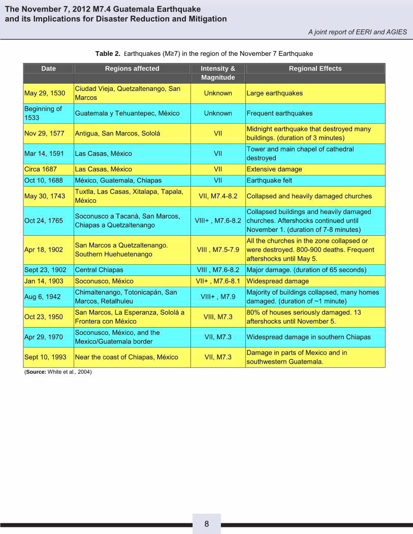
1.2 Historical Subduction Seismicity of Western Guatemala The western region of the subduction zone in the south of Guatemala and the state of Chiapas Mexico has a long history of seismic activity. Over the past 40 years, the region within 250 km (155 mi) of the epicenter has had 50 earthquakes of M6 or greater. At least 15 earthquakes of M ≥ 7 have been documented, which demonstrates the significant seismic hazard of this region. Table 2 presents a summary of these events and their effects in the region. Studies conducted by White et al. (2004) on the subduction activity in Guatemala show that events of this nature with magnitude Mw 7.75 ± 0.3 have a recurrence of 71±17 years (see figure 2).
Figure 2. Intensity contours of destructive earthquakes, located in the vicinity of the Nov. 7, 2012 M 7.4 event. For clarity and distinction of events, the intensity contours are split into different timing windows a-d. (modified after White, et al., 2004).
7
The November 7, 2012 M7.4 Guatemala Earthquake and its Implications for Disaster Reduction and Mitigation
A joint report of EERI and AGIES
Table 2. Earthquakes (M≥7) in the region of the November 7 Earthquake
Date Regions affected Intensity & Magnitude
Regional Effects
May 29, 1530 Ciudad Vieja, Quetzaltenango, San Marcos Unknown Large earthquakes
Beginning of 1533 Guatemala y Tehuantepec, México Unknown Frequent earthquakes
Nov 29, 1577 Antigua, San Marcos, Sololá VII Midnight earthquake that destroyed many buildings. (duration of 3 minutes)
Mar 14, 1591 Las Casas, México VII Tower and main chapel of cathedral destroyed
Circa 1687 Las Casas, México VII Extensive damage
Oct 10, 1688 México, Guatemala, Chiapas VII Earthquake felt
May 30, 1743 Tuxtla, Las Casas, Xitalapa, Tapala, México VII, M7.4-8.2 Collapsed and heavily damaged churches
Oct 24, 1765 Soconusco a Tacaná, San Marcos, Chiapas a Quetzaltenango VIII+ , M7.6-8.2
Collapsed buildings and heavily damaged churches. Aftershocks continued until November 1. (duration of 7-8 minutes)
Apr 18, 1902 San Marcos a Quetzaltenango. Southern Huehuetenango VIII , M7.5-7.9
All the churches in the zone collapsed or were destroyed. 800-900 deaths. Frequent aftershocks until May 5.
Sept 23, 1902 Central Chiapas VIII , M7.6-8.2 Major damage. (duration of 65 seconds)
Jan 14, 1903 Soconusco, México VII+ , M7.6-8.1 Widespread damage
Aug 6, 1942 Chimaltenango, Totonicapán, San Marcos, Retalhuleu VIII+ , M7.9 Majority of buildings collapsed, many homes
damaged. (duration of ~1 minute)
Oct 23, 1950 San Marcos, La Esperanza, Sololá a Frontera con México VIII, M7.3 80% of houses seriously damaged. 13
aftershocks until November 5.
Apr 29, 1970 Soconusco, México, and the Mexico/Guatemala border VII, M7.3 Widespread damage in southern Chiapas
Sept 10, 1993 Near the coast of Chiapas, México VII, M7.3 Damage in parts of Mexico and in southwestern Guatemala.
(Source: White et al., 2004)
8

The November 7, 2012 M7.4 Guatemala Earthquake and its Implications for Disaster Reduction and Mitigation
A joint report of EERI and AGIES
1.3 November 2012 event
On November 7, 2012 at about 10:35 am (local time), a magnitude Mw 7.4 earthquake occurred south of Champerico, Guatemala in the south-east region of the Central America country. The hypocentral coordinates of this event were determined to be: latitude =13º 59’ 13.2” North and longitude = 91º 57’ 54” West. The location of this event (see Figure 3) was estimated from the records of the more than 700 stations of the Global Seismograph Network. The depth of the hypocenter was estimated at 24.1 km (15 mi), and the rupture lasted about 32 seconds.
Figure 3. Epicentral location of the November 7 event – caused by the subduction of the Cocos Plate, along the lenth of the Middle America trench (Source: J.P. Ligorria).
Due to the location of the source of this event, its mechanism has been attributed to the subduction activity of the Cocos Plate thrusting under the Caribbean Plate, along the Middle America Trench. In this region, the Cocos plate moves north-northeast with respect to the Caribbean and North America plates at a velocity of approximately 71 mm per year (2.76 in/yr). It is generally accepted by the scientific community that this region can generate earthquakes with magnitudes of up to M 8.1 (Benito et al., 2012). Figure 4 shows the focal mechanism, the tensor solution and the rate of energy release as a function of time.
(a)
(b) (c)
Figure 4. Different aspects of the November 7 earthquake. (a) Focal mechanism indication the principal axes of tension (T) and compression (C). (b) Surface projection of the energy distribution during the rupture. (c) Time function of the source, indicating the significant seismic release at about 32 seconds. (Source: Modified from USGS). 1.4 Ground motion records Ground motion records for this earthquake are available from three stations in Guatemala. The Mina Marlin record was the closest at 158 km (98 mi) from the epicenter, where the recorded PGA was .04g and the corresponding Intensity was V. The Guatemala City record was 175 km (109 mi) from the epicenter, where the PGA was .02g and the Intensity was IV. The third record was obtained at Quixal in Alta Verapaz at about 235 km (146 mi) from the epicenter. At this site the PGA was .01g and the Intensity was III. The recorded motions and corresponding acceleration response spectrum are shown in Figure 5 (Guatemala City) and Figure 6 (Marlin Mine and Quixal).
(a) (b)
Figure 5. Recorded ground accelerations and corresponding 5% damped acceleration spectrum from the Guatemala City site
Nodal Plane
Azimuth Dip
Angle Orientation
1 126º 69º 98º
2 285º 23º 70º
9

The November 7, 2012 M7.4 Guatemala Earthquake and its Implications for Disaster Reduction and Mitigation
A joint report of EERI and AGIES
(a) (b)
Figure 6. Recorded ground accelerations at the Marlin Mine (a) and Quixal (b) sites. 1.5 Areas affected by the November 2012 event
The map shown in Figure 7 shows the estimated distribution of intensities in the region affected by the earthquake. Intensities from VI to VII were felt in cities on the coast near the epicenter. In Guatemala City, intensities were V. The extensive damage in the areas of San Pedro/San Marcos, which are ~130 km (81 mi) away from the epicenter, is likely due to the propagation of waves through a nearby volcano, which amplified the waves, or to site effects.
Figure 7. Estimated intensities for the affected area (Source: after H. Monzon)
10

The November 7, 2012 M7.4 Guatemala Earthquake and its Implications for Disaster Reduction and Mitigation
A joint report of EERI and AGIES
2. Geotechnical Effects 2.1 Geologic context
2.1.1 Regional Geology
The geology of Guatemala is characterized within a very well-defined physiographic environment comprising four geological provinces (See Figure 8). The area of San Marcos and San Pedro Sacatepéquez lies in the volcanic zone which is aligned with the Pacific Ocean shoreline. This zone is characterized by diverse large volcanic structures, such as calderas and stratified volcanoes. This zone can be divided into segments based on seismic and volcanic alignments. Several left lateral slip faults that cross Guatemala from the northeast corner and extend towards Mexico. The main system of faults is the Motagua-Polochic.
Figure 8. Physiographic provinces of Guatemala
2.1.2 Subduction zone and consequence of volcanic activity
The consequences of volcanic activity and the existing subduction zone are associated with the evolution of an island arc that is the product of the subduction of one plate under the other. The old volcanic edifices are Tertiary and Quaternary structures. Thickening Caribbean plate active volcanic structures migrate south towards the coastline.
2.1.3 Coastal region geologic setting and highlands in western Guatemala
The coastal region, or Pacific coastal plain, forms the other geological province and consists of Quaternary deposits resulting from volcanic activity.
2.1.4 Ash, coastal, and alluvial deposits, pyroclastic soils
Geologically, San Marcos and San Pedro are located within a volcanic-tectonic environment formed by a former possible caldera structure. The Tajumulco Volcano is also located within an arched structure, caused by a volcano collapsing in an earlier time (see Figure 9).
Figure 9. Geological and geomorphological map of San Marcos and San Pedro. Red: initial caldérica structure, orange: arch structure that marks the collapse of the volcanic edifice, and brown: Tajumulco Planice or original boiler valley.
The cities are built on a deposit created by pyroclastic fill formed by a thick pumice ash of a Tertiary origin. It is identified on the map in Figure 6 as a Quaternary pumice ignimbrite deposit of San Marcos type Qpim. The deposit consists of tuffaceous large rock fragments and fine to medium-size ash up to 30m or more thick. The upper part is alluvium which slopes from the city of San Marcos in the north toward the lower valley around San Pedro Sacatepéquez, its thickness varies but in some places reaches up to 5m. (See Figure 10)
Figure 10. Cut northeast of San Marcos showing the pyroclastic flow deposit of ash and lithic fragments (yellow arrow), which underlie the alluvial deposits that make up the organic soil layer (orange arrow).
11

The November 7, 2012 M7.4 Guatemala Earthquake and its Implications for Disaster Reduction and Mitigation
A joint report of EERI and AGIES
2.2 Effects of soil conditions on building performance
The regional official report of damages, which included the provinces of San Marcos, Retalhuleu, Huehuetenango, Quetzaltenango, Quiche, Sololá, and Mazatenango, as well as the report from quick field reconnaissance after the event showed that the majority of the damage was concentrated in the plain and valley regions.
In order to gain more understanding of the potential site amplification and site period at locations across San Marcos and San Pedro, a series of microtremor tests were conducted by the reconnaissance team. The measurements were taken at sites where damage was observed in surrounding buildings. These sites are shown in Figure 11. The records were processed using the Nakamura (1989) technique to estimate site frequency and amplification. The results suggest that site amplifications occur at frequencies common to low-rise buildings.
Figure 11. Locations and results of microtremor tests
The organic soil layer carried by the deposition and sedimentation along the valley or basin beneath the cities is significantly thick (see figure 12) and most adobe house foundations are very shallow and lie within this layer. Poor foundation conditions are another factor that may have contributed to the damage observed during the earthquake.
Figure 12. Depth of foundation of adobe home (orange arrow) and of organic alluvial soil (yellow arrow). San Pedro Sacatepéquez
2.3 Landslides and ground settlement Landslides in the mountains and on steep slopes were officially reported by CONRED. Most of the landslides were photographed in the cuts along the Pan American Highway CA-1, and along roads located along the volcanic physiographic province near the epicentral area. The poor design of the slope cuts made along the Pan American Highway and other roads triggered many of the slides, as shown in Figures 13 and 14. Slides along the roads were also caused by the failure of hillsides previously weakened by Tropical Storm Agatha in 2010. The landslide debris was removed from roadways quickly so that traffic was not impeded for too long.
Figure 13. Landslides triggered along the CA-1 highway up to Nahualá, Kilometers 148-152.5. The instability was in part caused by poor design and cutting of the slopes.
Figure 14. Landslides near the road to San Cristobal Cucho south of San Marcos. There was slight removal of material in the earthquake, but many of these had been landslides were induced during Tropical Storm Agatha in 2010.
The landslides that caused loss of life were largely in areas where there had been informal mining of sand and aggregates. South of the City of San Marcos, seven miners who were underground at the time of the earthquake were buried and died (see Figure 15). Additionally, the municipality of San Cristobal Cucho reported the seven dead from a family that was buried by a triggered landslide. The total number of landslides was not as great as it was in the 1976 earthquake, but most landslides were caused by human-related activities. Table 3 shows a summary of the most significant landslides in the region.
12

The November 7, 2012 M7.4 Guatemala Earthquake and its Implications for Disaster Reduction and Mitigation
A joint report of EERI and AGIES
Figure 15. Southern sector of San Marcos showing aggregate quarries and sand excavations. The circle shows where seven people died.
2.4 Liquefaction
Soil liquefaction was mainly observed in the Port of Ocós and along the southwestern coastal area near the epicenter, as would be expected in alluvial deposits such as coastal beaches. Figure 16 shows lateral spreading on the beach of Ocós. Settlement and lateral spreading in Coatepeque on the banks of a small river, was also observed as shown in Figures 17 and 18.
Table3. Landslides caused by the November 7 Earthquake
Location Type of Landslide Injuries/Deaths Source Cantón La Esperanza, San Cristóbal Cucho, San Marcos
Translational 10 deaths “Al Día” Jueves 8 de noviembre, 2012. Año 16 No. 5757 Pag. 3
San José El Recreo, San Marcos
Slope failure, excavation of sand and other construction materials
7 deaths
“Al Día” Jueves 8 de noviembre, 2012. Año 16 No. 5757. Pag.3
Aldea Tuipox, Concepción Chiquirichapa, Quetzaltenango
Slope failure, excavation of sand and other construction materials
8 deaths “Al Día” Jueves 8 de noviembre, 2012. Año 16 No. 5757 Pag. 5
Carretera Quetzaltenango-San Marcos Km. 222 y 236
Slope failure on highway Obstruction of the highway
“Al Día” Jueves 8 de noviembre, 2012. Año 16 No. 5757. Pag. 5
Volcán Cerro Quemado, Quetzaltenango.
Rock fall 1 death “Al Día” Jueves 8 de noviembre, 2012. Año 16 No. 5757.Pag. 5
Zunil, Quetzaltenango. Basurero Slope failure 2 deaths Prensa Libre. Jueves 8 de noviembre, 2012. AñoLXII,No. 20,419. Pag. 3
Carretera Panamericana CA-1, Km. 148-152.5-160; Nahualá, Sololá.
Slope failure on highway Obstruction of the highway
“Al Día” Jueves 8 de noviembre, 2012. Año 16 No. 5757. Pag. 6
Carretera Panamericana CA-1 Km. 176; Totonicapán
Slope failure on highway Obstruction of the highway
“Al Día” Jueves 8 de noviembre, 2012. Año 16 No. 5757 Pag. 7
Carretera Panamericana CA-1 Km. 309 La Mesilla, Huehuetenango
Slope failure on highway Obstruction of the highway
“Al Día” Jueves 8 de noviembre, 2012. Año 16 No. 5757 Pag. 7
Carretera CA-1 Km. 245, Malacatancito, Huehuetenango
Failure of highway embankment, undermining
Obstruction of the highway
“Siglo 21” Jueves 8 de noviembre de 2012. Año 23, No. 9048. Pag. 3. Recuadro daños en carreteras
Carretera o Ruta 01 entre Patzún y Godínez, Chimaltenango
Slope failure on highway Obstruction of the highway
“Nuestro Diario” Jueves 8 de noviembre de 2012. Año 15. No. 5342. Pag. 3.
Tramo Esquipulas-Palo Gordo, San Marcos. Km 260
Slope failure on highway Obstruction of the highway
“Siglo 21” Jueves 8 de noviembre de 2012. Año 23, No. 9048. Pag. 3. Recuadro daños en carreteras.
Carretera al Pacífico. Km. 157.5, 180, y 193. Retalhuleu.
Slope failure on highway Obstruction of the highway
“Siglo 21” Jueves 8 de noviembre de 2012. Año 23, No. 9048. Pag. 3. Recuadro daños en carreteras
Carretera CA-9 Atlántico. Km. 30-55-70
Slope failure on highway Obstruction of the highway
“Prensa Libre” Jueves 8 de noviembre, 2012. AñoLXII,No. 20,419. Pag. 5
13

The November 7, 2012 M7.4 Guatemala Earthquake and its Implications for Disaster Reduction and Mitigation
A joint report of EERI and AGIES
Figure 16. Lateral spreading of sand on Ocós Beach in San Marcos.
Figure 17. Settlement caused by liquefaction of a creek bank located in the Municipality of Colomba, Coatepeque,Quetzaltenango.
Figure 18. Lateral Spreading of soil due to liquefaction. Cracks in the house caused by its location on the creek bank can be seen and are consistent with the ground motion. Municipality of Colomba, Coatepeque, Quetzaltenango.
Substantial damage, including cracks in structures, slabs and the ground; tilted walls; displaced piles; settlements; and liquefaction, was also observed in the area of Puerto Champerico (See Figure 19). Most of the damage was evident along the Champerico wharf. Local witnesses mentioned that floating dock anchor piles could be moved easily by hand and anchor supports attached to piles were broken.
(a) (b)
(c)
Figure 19. Structural damage caused by liquefaction. (a) masonry wall tilted (28 mm (1.1 in) at the top), (b) slab on grade settlement (6mm (.025 in) vertical, and 22 mm (.085 in) horizontal), (c) Wharf slab separation
14
The November 7, 2012 M7.4 Guatemala Earthquake and its Implications for Disaster Reduction and Mitigation
A joint report of EERI and AGIES
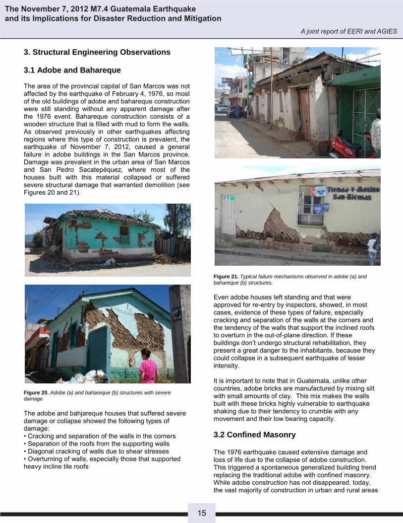
3. Structural Engineering Observations 3.1 Adobe and Bahareque The area of the provincial capital of San Marcos was not affected by the earthquake of February 4, 1976, so most of the old buildings of adobe and bahareque construction were still standing without any apparent damage after the 1976 event. Bahareque construction consists of a wooden structure that is filled with mud to form the walls. As observed previously in other earthquakes affecting regions where this type of construction is prevalent, the earthquake of November 7, 2012, caused a general failure in adobe buildings in the San Marcos province. Damage was prevalent in the urban area of San Marcos and San Pedro Sacatepéquez, where most of the houses built with this material collapsed or suffered severe structural damage that warranted demolition (see Figures 20 and 21).
Figure 20. Adobe (a) and bahareque (b) structures with severe damage The adobe and bahjareque houses that suffered severe damage or collapse showed the following types of damage: • Cracking and separation of the walls in the corners • Separation of the roofs from the supporting walls • Diagonal cracking of walls due to shear stresses • Overturning of walls, especially those that supported heavy incline tile roofs
Figure 21. Typical failure mechanisms observed in adobe (a) and bahareque (b) structures. Even adobe houses left standing and that were approved for re-entry by inspectors, showed, in most cases, evidence of these types of failure, especially cracking and separation of the walls at the corners and the tendency of the walls that support the inclined roofs to overturn in the out-of-plane direction. If these buildings don’t undergo structural rehabilitation, they present a great danger to the inhabitants, because they could collapse in a subsequent earthquake of lesser intensity. It is important to note that in Guatemala, unlike other countries, adobe bricks are manufactured by mixing silt with small amounts of clay. This mix makes the walls built with these bricks highly vulnerable to earthquake shaking due to their tendency to crumble with any movement and their low bearing capacity.
3.2 Confined Masonry The 1976 earthquake caused extensive damage and loss of life due to the collapse of adobe construction. This triggered a spontaneous generalized building trend replacing the traditional adobe with confined masonry. While adobe construction has not disappeared, today, the vast majority of construction in urban and rural areas
15

The November 7, 2012 M7.4 Guatemala Earthquake and its Implications for Disaster Reduction and Mitigation
A joint report of EERI and AGIES
of Guatemala is done by using confined masonry made with lightweight concrete blocks, as these are available in any region of the country (see Figure 22).
Figure 22. Traditional silt-adobe construction at left; low-cost confined masonry at right; in the center, a confined masonry dwelling showing the impact of the funds that immigrants send to their families from abroad.
It is difficult to estimate the actual intensity of the earthquake in the affected areas, as there are very few accelerometers in operation throughout Guatemala and most are concentrated in the capital city. The closest station to the affected area is located in the Marlin mine in the San Marcos province (see Figure 23) and reported a peak acceleration of only 4% g.
Figure 23. A shows the Marlin Mine location where a peak acceleration of 4% g was reported. B shows the location of the most affected area. (Source: Google Maps) Although there were not many confined masonry and reinforced concrete structures in the San Marcos province that collapsed, for the estimated accelerations, which are within a range from 20% to 40% of the design acceleration for the region, there were many buildings with major structural damage. Most of the minor construction in Guatemala, as shown in Figure 24, is made of confined masonry using lightweight, low capacity—1.23 MPa (12.5 kg/cm2, 176 psi over net area)—concrete blocks made with pumice. In rural areas it is generally constructed using empirical methods by foremen who lack any formal technical training, who have learned their craft through a process
of learning by observation and practice, and who started first as apprentices and then as masons.
Figure 24. Zunil, Quetzaltenango. Entire towns throughout Guatemala have substituted adobe with confined masonry construction, not recognizing the height limits (~3 stories) of the empirical system. Confined masonry has shown satisfactory earthquake-resistant behavior for minor construction, even if done in an empirical way. The good record includes satisfactory performance during the high-intensity 1976 Motagua earthquake and during medium-intensity events such as Cuilapa in 2011, Pochuta in 1991 and Uspantán in 1985 and during the recent November 7, 2012 seismic event, except, of course, when materials are of poor quality or the wall layout is very deficient. Figures 22 and 22 A show the main features of the Guatemalan empirically built confined masonry dwelling units Although confined masonry has shown good earthquake-resistant behavior for minor construction, even if done in an empirical way (see Figure 25), problems arise when the system is abused by builders due to their unfamiliarity with both the limitations of the system and the materials that compose it. The problem is compounded when the municipalities, who are autonomous and the only ones with the power to regulate construction in their counties, do not exercise any control or enforce restrictions to builders and owners of construction projects.
(a) (b) Figure 25. (a) Confined masonry dwelling in Western Guatemala. Unlike most confined masonry construction throughout the world, an intermediate horizontal bonding element (@ 1.20 meters) is customarily used, there are also intermediate vertical bond elements (@1.50 to 2.0 meters). Roof slabs are very common. (b) Confined masonry dwelling in North Western Guatemala – Note again presence of intermediate horizontal bonding element and roof slab.
16

The November 7, 2012 M7.4 Guatemala Earthquake and its Implications for Disaster Reduction and Mitigation
A joint report of EERI and AGIES
Confined masonry construction in Guatemala consists of masonry walls (made mainly with concrete blocks units) and reinforced concrete confining elements consisting of horizontal beams (soleras) and vertical columns (mochetas). The vertical elements are usually placed at the ends of the walls, at the intersections between walls and at distances that are typically no longer than 2.50m (8.2 ft). The reinforcing steel in the “mochetas” is usually at least four No.3 steel bars (although it is quite common to see the No.3 bars replaced with No. 4 and No.5 bars at the corners and at the intersection of two or more walls). For confinement of the vertical elements stirrups made with 6.35 mm (.25 in) diameter bars are used with a maximum separation of 20/25 cm (8/10 in). The horizontal elements are usually placed at ground level, at slab level and it is also customary to place an intermediate one between the floor and slab levels. The typical reinforcement for “soleras” is 4-No. 3 bars with stirrups made with 6.35 mm (.25 in) diameter bars with a maximum separation of 20/25 cm (8/10 in). Mochetas and soleras are also placed around doorways and windows. The wall footings usually are made of reinforced concrete and the mortar paste that is most often used is a mixture of water, lime, cement and sand. Overstepping the capacity of the system
Potential problems arise when the confined masonry system is abused by builders due to over-confidence in the system and lack of knowledge on the possible limits. The problem is compounded when the municipalities, who are autonomous and the only ones with the power to regulate construction in their jurisdiction, do not exercise any control or enforce restrictions to builders and owners of construction projects. Figure 26 depicts cases in which the capacities of the empirical system seem to have been overstepped.
Figure 27. (a) Multistory, empirically constructed small building in a town in Western Guatemala. Note same features as for two-story dwellings and, in this case, lack of walls in transverse direction. (b) Example of odd layout of a confined masonry dwelling
Observed seismic damage Structural damage in confined masonry structures can be attributed to four factors:
1. Deficiency in material, especially in the quality of lightweight concrete blocks and lack of special details of confinement and anchoring of structural elements
2. Inadequate structural configuration 3. Abuse of the construction system 4. Site effects
Examples of such damage are shown in Figure 27.
Figure 27. Reinforced concrete (top) and confined masonry (bottom) structures with severe damage
17

The November 7, 2012 M7.4 Guatemala Earthquake and its Implications for Disaster Reduction and Mitigation
A joint report of EERI and AGIES
Although most of the flaws in confined masonry structures were due to a combination of the factors described above, it was detected that the main reason for these failures was the poor quality of the concrete blocks used. The data obtained from a random sampling conducted by the Cement and Concrete Institute of Guatemala, ICCG, from craft block factories located in the area near the province capital of San Marcos days after the earthquake, show a variation in the compressive strength of concrete blocks (made with pumice) ranging from 1.27 MPa (13 kg/cm2, 185 psi) to 3.11 MPa (31.78 kg/cm2, 452 psi) on gross area. Most of the blocks sold in this region come from artisanal factories (see Figure 28), located mainly in the provinces of San Marcos and Quetzaltenango. They are usually run by a family and lack any form of quality control throughout the manufacturing process (material selection, dosing, mixing and curing), so it is common for the compressive strength of the blocks to have drastic variations daily. In the area, block coming from industrial manufacturing processes, which allows for the production of blocks of higher quality and less variation
in strength, is also marketed. The problem is that most of these factories sell blocks, in an effort to compete on cost with handmade block factories, of low compressive strength, 2.45 MPa ((25 kg/cm2, 356 psi) on gross area) which is not included in the Guatemalan Technical Standard for concrete blocks, NTG 41054. Tables 4 and 5 show typical values of compressive load bearing capacity of concrete blocks collected from factories in the San Marcos region.
Figure 28. View of a typical artisanal block factory in Quetzaltenango
Table 4. Average compressive strengh of artisinal block factories in the province of San Marcos
Factory Province Average Strength (kg/cm2)
CF1 San Marcos 37.0 CF2 San Marcos 24.5 CF2 San Marcos 36.5 CF3 San Marcos 35.5 CF3 San Marcos 35.5 CF3 San Marcos 32.5 CF4 San Marcos 17.5 CF5 San Marcos 12.0 CF6 San Marcos 16.0 CF6 San Marcos 12.0 CF6 San Marcos 11.0 CF7 San Pedro 43.0 CF8 San Pedro 13.0 (source: Rubén López)
Table 5. Capacities of concrete blocks from San Marcos collected after the November 7 earthquake No Test Date Length (mm) Width (mm) Height (mm) Capacity (Kg/cm2)
1 2012.11.22 401 149 199 25.74 2 2012.11.22 402 149 203 31.78 3 2012.11.22 401 148 198 19.64 4 2012.11.22 403 149 198 29.71 5 2012.11.22 400 149 202 24.46 6 2012.11.22 388 140 189 15.11 7 2012.11.22 390 139 188 13.28 8 2012.11.22 391 139 190 18.48 9 2012.11.22 388 140 189 18.98 (source: ICCG)
18

The November 7, 2012 M7.4 Guatemala Earthquake and its Implications for Disaster Reduction and Mitigation
A joint report of EERI and AGIES
Another important factor affecting the good performance of confined masonry structures was the poor structural configuration of many buildings, resulting from the absence, in most cases, of a proper structural design. Typical problems of poor structural configuration in the area affected by the earthquake are as follows: Corner houses: This type of structure has most of the walls on the two sides that face the neighbors (see Figure 29), causing eccentricity problems that concentrate stresses on the exterior perimeter walls and columns due to the torsion that is generated. The problem is compounded because the slabs are built with concrete which largely increase the weight of the structure and, many times, the walls of the upper levels do not continue at the first level in order to have large rooms for commercial use.
Figure 29. Structural configuration of corner homes.
Box (Tunnel) type structures: In this type of construction (see Figure 30) the wall density in the short direction of the structure is very low and the walls are concentrated in the rear of the building because of the need to have open fronts for garage or store doors. The large imbalance in perimeter strength and stiffness result in large torsional forces. The problem is compounded because the slabs are built with concrete which largely increase the weight of the structure and, many times, the walls of the upper levels do not continue at the first level in order to have large rooms for commercial use, as shown in Figure 31.
Figure 30. Inadequate structural configuration, typical “tunnel” type structure
Figure 31. Inadequate structural configuration, typical “tunnel” structure
Short column effects: In many cases structural elements failures caused by stress concentration due to the effects of short column could be observed (see Figure 32), mainly because of the interaction between masonry partitions and concrete columns. This structural configuration deficiency was frequently found at wall openings for upper windows.
Figure 32. Short column effects
The performance of buildings with confined masonry was also affected by abuse of the system, because builders using empirical techniques generally do not understand that the system has limitations. The construction process of a property in rural areas is usually done in stages; depending on the resources the family has available at the time. Many times people start building the foundation and walls of the first level and sheet-metal is used for the roof. At this stage, a homeowner usually buys the cheapest blocks which tend to be of lower quality. When the family has access to more resources the tin roof is removed and a concrete roof that allows the construction of one or more additional floors is built. At the end of the whole process is a confined masonry buildings of 4-5 levels that is highly vulnerable to earthquakes, as shown in Figure 33, because it was built with inferior materials and without any design and control.
Figure 33. Examples of abuse of confined masonry system
19

The November 7, 2012 M7.4 Guatemala Earthquake and its Implications for Disaster Reduction and Mitigation
A joint report of EERI and AGIES
3.3 Reinforced concrete In rural areas, it is difficult to find purely reinforced concrete buildings as they are usually combined with some form of masonry structural elements. The damage in the structures where the structural system is primarily reinforced concrete was primarily caused by inadequate structural configuration and poor structural detailing. Figure 34 shows one such a case.
Figure 34. Municipal fire station, San Pedro Sacatepéquez, San Marcos. The structure was at the verge of collapse due to a deficient structural system.
As with masonry construction, many reinforced concrete buildings show considerable variations of the perimeter stiffness of structures, generating torsional effects that especially damaged structural elements on the perimeter of the building. There was also plenty of evidence of short columns effects due to the lack of separation of masonry infills from the main concrete structure and failure by the designer to consider this effect in the structural design (when there was one at all). In most of these cases (see Figure 35), infill walls were severely damaged or destroyed as they became part of earthquake-resistant system.
Figure 35. Court building in San Marcos. Suffered severe damage due to problems from torsion and short column effects
3.4 Historical Buildings Historical buildings in western Guatemala are mostly buildings from the beginning of the 20th century or earlier, made with unconfined masonry walls. These
walls are 60-90 cm (24-26 in) thick, and are constructed of various materials such as adobe, calicanto (stone and lime) and brick. A peculiar fact of these structures is that they have been rebuilt several times throughout their lifetime due to damage suffered by the various earthquakes that have affected this region of the country. Although the walls of these structures have a considerable width they lack vertical and horizontal reinforcement and there are no rigid diaphragms or reinforcing elements to keep the wall from separating and overturning during an earthquake. For this reason it was common to see cracks, sometimes of considerable width, which can be attributed to the tendency of the walls to open, especially in the facade and corner walls, just as seen in the adobe houses. This type of buildings includes churches and old houses that currently are being used to house public and private institutions. Most of these structures, which are in the process of being renovated, suffered damage. Unfortunately there is a lack of provisions for structural retrofitting to improve the structural performance of historical buildings during a major earthquake. It was observed that the time and resources invested in refurbishing these heritage buildings were wasted due to the severity of the damages caused by the November 7 earthquake. Many structures of this type, such as the ones shown in Figure 36 and 37, are at risk of collapse in an earthquake of greater intensity.
Figure 36: Palacio Maya, Municipality of the city of San Marcos. Recently remodeled, the building suffered severe damaged and had to be evacuated.
Figure 37. Damage reported at the Quetzaltenango Cathedral
20

The November 7, 2012 M7.4 Guatemala Earthquake and its Implications for Disaster Reduction and Mitigation
A joint report of EERI and AGIES
4. Infrastructure Performance One of the most troubling aspects of the damage observed after the earthquake is the large number of public buildings that were evacuated due to structural damage. Among the institutions that were affected are hospitals, health centers, firefighter and national police stations, municipalities, schools, court buildings, jails and provincial government buildings. The structures that house these institutions are classified by the Guatemalan building code, AGIES NSE-2010 as essential buildings and should remain operational during and after an earthquake of great magnitude, to serve the population and coordinate humanitarian efforts for the victims of the tragedy. While it was not the same case as in Haiti, where most public institutions collapsed, almost all of the public sector was affected in some way by the earthquake of November 7. According to the report "Assessing the Impact of the earthquake of November 7, 2012 in Guatemala", prepared by the Office of Planning and Programming of the Presidency of the Government of Guatemala, SEGEPLAN, there were 215 schools, 32 health institutions (including hospitals) and 16 public
buildings with some kind of damage. 4.1 Electric Power The electrical flow was suspended as a result of seismic event Nov. 7. According to records Energuate, which distributes electrical power service in the West, after the earthquake were reported 266.491 people without electricity in this sector. (Editorial, 2012). It is not known the causes that led to the cutting fluid. The following table presents a summary of major damage to the infrastructure presented.
4.2 Telecommunications There were reports related to suspension in the telephone system, but does not mention the cause of the interruption, only mentioned temporary damage, (Editorial, 2012). Moreover Moviestar and Claro companies only reported saturation with calls; after the quake, but the service was normalized minutes later. Tigo reported no damage to their infrastructure and service remained stable throughout the day. (Morales, S.
Table 7. Total Amount of damage to Energy Infrastructure in San Marcos
Components Measure Average Cost (Thousand Quetzales)
Quantity Estimated Amount (Thousand Quetzales)
Intermediate Tension Posts, Trancept,
Insulators Units 5.5 3 16.5
Network Tranformers/Controllers
Units 14.8 6 88.8
middle tension line km 15 2 30 Low tension Meter device/fusibles unit 0.46 30 13.8 Low tension line km 8.5 2 17 Warning labels Emergency Brigade days 1.2 39 46.8 Emergency labels unit 0.46 755 347.3 TOTAL 560.2 Source: MEM SEGEPLAN (2012).
Table 6. Damage and Loss Summary by Sector: National Consolidation
Sector Damage Losses Total Public Sector
Private Sector
Identified Needs
Infrastructure 67 112 179 158 21 497 Transport 35 106 141 123 18 167 Energy 3 - 3 1 2 - Water and
Sanitation 13 1 14 14 — 116
Institutional Infrastructure
16 5 21 20 1 214
Source: own elaboration, taking into account, oficial information provided by CONRED and the different Institutions involved at the crisis attention. (SEGEPLAN,2012).
21

The November 7, 2012 M7.4 Guatemala Earthquake and its Implications for Disaster Reduction and Mitigation
A joint report of EERI and AGIES
2012) No damage was reported in telephone central plants and also with the collapse in cell phone towers. 4.3 Water systems Most of the country’s water system is designed and constructed by non-government organizations, NGOs, (with little supervision or control) but is not in great condition due to the lack of design guidelines as well as a lack of maintenance budget and provisions.
According to data collected in an assessment made by the Instituto Fomento Municipal (Municipal Development Institute) an equivalent pipeline length of 80km in the potable water system suffered damage. The damage was mainly broken pipelines which caused service interruptions and irregularities. In the head of the province alone, an equivalent pipeline length of 44 km was damaged, which affected the wells that supply water to more than 20, 000 people. The irregular water supply led to rationing in the first few days, but after repairs were made service was restored. The water supply system also failed in the following municipalities: Esquipulas Palo Gordo, San Cristobal Cucho, La Reforma and El Quetzal. (España M. 2012). In the head of the province, no damage was reported to the water treatment plant, the collection system, or to water storage tanks and there were no reports of changes in water quality. 4.4 Transportation Systems 4.4.1 Highways Roadways obstructed by landslides was the main damage to transportation systems. In sections of the road between Quetzaltenango and San Marcos, there were failure of slopes and road banks (See Figure 38). In San Juan Ostuncalco where pumice sand mining for the fabrication of concrete block is informal, cuts made for the removal of material caused destabilization of the slopes. See Figure. The same occurred on the road leading to San Cristobal Cucho. The material that blocked the roads was removed overnight and roadways were blocked for no more than 48 hrs. Table ## showing the landslides that affected roadways can be found in Section 2.4.
Figure 38. Damage to slopes of the highway between Quetzaltenango and San Marco at the top of San Juan Ostuncalco.
4.4.2 Bridges In the affected region there were 17 damaged bridges reported. Media reports, like one developed by SEGEPLAN, do not specify which bridges were damaged, nor the main cause of damage. Damage is assumed to be minimal as the press would have reported traffic disruptions if there were serious damage. 4.4.3 Airports San Marcos has one airstrip, primarily for small aircraft such aircraft and helicopters. The perimeter wall of the track overturned and collapsed due to a poor foundation (See figure 39). The track asphalt suffered cracking in the transverse direction. The crack width was approximately 3 mm (See Figure 40). The airport did not suspended its regular activities.
Figure 39. Damage to a perimeter wall at the San Marcos Airport.
Figure 40. Cracks in the runway of the San Marcos Airport 4.5 Hospitals There are total of 44 hospitals in the country and according to PAHO’s assessment after the earthquake, only one out of six hospitals evaluated are were in good physical condition to resist various hazards. In San Marcos and San Pedro, the main damage to the health sector, including the collapse of the Health Center of San Pedro, was mainly due to short column effects (See
22

The November 7, 2012 M7.4 Guatemala Earthquake and its Implications for Disaster Reduction and Mitigation
A joint report of EERI and AGIES
Figure 41). The health clinic which was built in the 1960’s and ten years ago a second story was added to it without any assessment or structural enhancement of the first level (personal interview 2013). Activities at the health center were suspended and the building was demolished. In the National Hospital of San Marcos, the main damage was nonstructural damage to the hospital ceilings (See Figure 42). Service at the hospital was reestablished the day after the event.
Figure 31. Damage to the false cielings at the National Hospital of San Marcos.
Figura 32. Column damage in the San Pedro Health Center
4.6 Fire Stations The San Marcos Fire Station suffered severe damage due to soft story effects caused by configuration problems on the ground floor. As the building did not collapse, no ambulances or fire engines were damaged. While service was uninterrupted, the building is being rehabilitated and rebuilt (See Figure 34). 4.7 Police Stations The San Marcos Police Station 42 was severely damaged (See Figure 43). It was necessary to evacuate and relocate prisoners to the Cantel prison in Quetzaltenango. According to a Interior Ministry report a provisional station based in the military reserves was established while rebuilding the police station. Computers and communication equipment in the building were also damaged. (Vázquez B. R. 2012)
Figure 43. Damaged police station in San Marcos.
23

The November 7, 2012 M7.4 Guatemala Earthquake and its Implications for Disaster Reduction and Mitigation
A joint report of EERI and AGIES
5. Social and Economic Impact
The damage and economic losses caused by the earthquake of November 7, 2012 amounted to 1,027 million Quetzales (more than USD 128 million), of which Q766 million represent partial or total destruction of housing (see Figure 35); Q423 million damage to schools (Q215 million) and costs associated with their use as shelters; and damage to road infrastructure (Q35 million), with economic effects of transportation interruption estimated at Q106 million.
Figure 44. Earthquake damage and losses by sector (Source: SEGEPLAN)
The earthquake had its greatest effect in eight provinces of Western Guatemala: Retalhuleu, Quetzaltenango, Solola, Quiche, Totonicapan, San Marcos, Huehuetenango and Suchitepequez. These departments have the highest population density in rural areas (61%), and a high concentration of indigenous people. This constituency, in turn, has higher rates of poverty and malnutrition than anywhere else in the country.
Due to the vulnerability of the affected social groups (rural, engaged in subsistence agriculture, and female-headed households with very low income levels), the government has been funding most of the rehabilitation and reconstruction required (Gobierno de Guatemala, 2013).
An estimated one-fifth of the families with damaged homes are headed by women. Based on the damage and loss to 5,649 households headed by women in the departments of Solola, Quetzaltenango, and San Marcos, the Presidential Secretariat for Women (SEPREM) believes that total economic losses for them are Q49.78 million. Not only were their houses damaged or destroyed, but also they have lost their incomes because their homes were their business locales. In the medium term, assistance is needed for
the small businesses run by the women in their now-damaged housing.
This would also be a good time to design a training program for foremen, masons, and construction workers to ensure better seismic behavior of houses in future events.
In the medium term requires the reactivation of production support in general of small businesses, especially those living in the housing, with emphasis on those headed by women. Families will have loss of income due to the destruction of their livelihoods primarily related damage to the houses that functioned as micro.
6. Emergency response
After the November 7 earthquake, the President declared a state of public calamity immediately (Government Decree 3-2012) in the departments of Retalhuleu, Quetzaltenango, Solola, Quiche, Totonicapan, San Marcos and Huehuetenango. Subsequently, Government Decree 4-2012 (published on November 13, 2012) included the Suchitepéquez department and expanded the powers of the executive to execute the construction, reconstruction, rehabilitation and repair of the dwelling units in the affected departments. The Congress ratified it by Decree 33-2012 of the same date.
In order to assess the extent of damages, the National Coordinator for Disaster Reduction, CONRED, provided the EDAN forms (Damage Assessment and Needs Analysis) and worked with the emergency operations centers (COEs) at departmental and municipal levels to get food and household goods to those affected. The following graph shows the evacuated population, hosted and self-hosted (in the homes of relatives or friends), noting that 33,379 were homeless after the disaster. Up to 15,299 were admitted to shelters. According to information received at the end of November 2012, Q79.8 million had been spent in support of the sheltered population. Figure 45 shows a chronology of the placement of people in shelters after the earthquake.
San Marcos was the department with the highest number of displaced people (87,808), which represented 9.92% the total population. In Solola, the number of displaced people was about 18,003, or about 4.41% of the total population; and in Quetzaltenango, about 12,413 were displaced, which is about 1.62% of the total population of that region.
24

The November 7, 2012 M7.4 Guatemala Earthquake and its Implications for Disaster Reduction and Mitigation
A joint report of EERI and AGIES
7. Recovery and Reconstruction
Following the earthquake, the Guatemalan President appointed the Vice President to lead the recovery and reconstruction process and to quickly provide permanent housing to the most vulnerable families. To achieve this goal, the Vice President established a Reconstruction Commission to coordinate the activities of the various ministries and international partners. The Reconstruction Coordinator worked closely with the Ministry of Planning and SE-CONRED (which, according to disaster recovery protocols, would normally lead the process).
The government of Guatemala (GoG) is committed to a complete reconstruction and has distributed responsibilities among the Ministries, InterAmerican Development Bank, and affected communities. The Secretaría de Coordinación Ejecutiva de la Presidencia (SCEP) is focused on closing shelters and providing over 7,000 permanent houses to the most vulnerable families. To implement this program, three government agencies are working together to construct homes. These agencies are the Armed Forces Army Corps of Engineers, the Ministry of Public Works (Ministerio de Communicaciones), and FONAPAZ (Fondo Nacional para la Paz). The Ministries of Health and Education are working closely with the Inter-American Development Bank to rebuild schools and health facilities, and have reprogrammed IADB financing for these purposes. Other ministries, including the Ministry of Cultural and Historic Preservation (Patrimonio Cultural), are responsible for using their existing limited resources to make needed repairs in their sector.
Over 7000 of the most vulnerable families affected by the earthquake are eligible to have their severely damaged homes demolished and replaced with small homes that meet seismic construction norms. After the earthquake, the GoG wanted to set an example of building back better and contracted AGIES to provide a design for the homes it would build. To receive a home, families must officially request assistance and meet certain socio-economic and legal requirements. Local governments and neighborhood councils are actively engaged in assisting families to compile the required documentation. At the national-level, a working group has been established to resolve problems of missing documentation for home owners, schools and health facilities.
The 19,000 residents whose homes experienced light or moderate damage are responsible for repairing or rebuilding their own homes and enterprises. The chart below in Figure 37 shows that in the most heavily damaged departments, over 18,000 households and businesses will likely engage in some sort of repair or reconstruction without GoG assistance. The governors and mayors of the affected jurisdictions should take a major role in encouraging community members to employ good building standards and use quality construction materials. For example, the Mayor of San Marcos is currently attempting to enforce the existing building regulations.
By law, the GoG is not allowed to repair or rebuild homes or buildings in high-risk areas, so other organizations have undertaken the repairing or rebuilding task. Non-government organizations (NGOs) like Caritas, Oxfam, and Techos por Mi Pais are helping poor families with no means to relocate or rebuild their homes. For many families, this has meant a switch away from traditional adobe construction.
Figure 45. Evolution of the population in shelters (Source: CONRED)
33,059
32,741 32,741 32,282
26,682 26,094 23,526 23,548 23,548 23,548 23,548 22,940
26,975
26,975
0 5,000
10,000 15,000 20,000 25,000 30,000 35,000 40,000
07/Nov 09/Nov 11/Nov 13/Nov 15/Nov 17/Nov 19/Nov 21/Nov
TOTAL EVACUADOS AUTOALBERGADOS O EN LA CALLE TOTAL DE ALBERGADOS
25

The November 7, 2012 M7.4 Guatemala Earthquake and its Implications for Disaster Reduction and Mitigation
A joint report of EERI and AGIES
The GoG housing program provides assistance only to homeowners. Because of this, there are approximately 1200 families who do not qualify for housing assistance, and their situation is still unresolved. The chart below in Figure 46 shows a comparison of homeowners with renters in the most damaged provinces, highlighting that San Marcos has the greatest concentration of renters affected by the earthquake. (Source: Analítico Boleta Evaluación Daños–SINIT).
Figure 46. Homeowners and Renters in the Most Affected Areas (Source: Analítico Boleta Evaluación Daños –SINIT)
Due to poor quality construction materials in the affected jurisdictions, most building material procured by the GoG for the housing reconstruction has come from either Guatemala City or outside of the country The local shortage of quality building materials makes it difficult for the families and businesses responsible for repairing and rebuilding their own assets to build back better. There is enforcement of construction material quality standards, and there is rarely assurance from local companies that building materials produced or available locally are high quality. As a result, driven by the economic hardship the cheaper building material is the preferred option for families seeking to rebuild their own livelihoods. Both GoG and communities may soon confront a shortage of qualified labor. The GoG seeks to build 1,000 homes a month, in a region that generally constructs far fewer a year. Each new home is estimated to take 14 days to build, with two foreman and two helpers (albañiles y ayudantes). As the rate of housing construction increases, workers people will also be needed to unload building materials and deliver them to sites. While families benefitting from the housing reconstruction program are likely to carry materials and work as helpers, there is no official certification process for foreman (albañiles). Companies like Cementos Progreso, a private producer of cement, are trying to fill this gap by offering training on better building standards to workers; however, it remains challenging for home and business owners to verify that construction workers are trained in better building standards and norms.
Another reconstruction challenge facing the GoG is the repair of underground water and waste water infrastructure systems that cannot easily be checked for damage. The extent of damage and costs of repair are currently unknown. Construction standards for seismic-resistant systems will also be needed.
While the focus of the recovery and reconstruction process has thus far been on rebuilding homes and infrastructure, there are tools to address the recovery of people’s lives and livelihoods. After the initial assessments coordinated by SE-CONRED, Segeplan conducted a socio-economic survey of 7,000 households. Segeplan’s analysis of these surveys shows which communities have potentially more vulnerable female-headed households and children. The design and targeting of recovery strategies and programs, including information campaigns on better building norms and techniques, could potentially be more effective by taking into account the socio-economic impacts of the disaster. For example, from the information below in Figures 47 and 48, one could expect more women than men to be involved in decisions regarding rebuilding in the most heavily affected departments; and for families in Sololá and Quetzaltenango, where the number of children affected exceeds that of adults, one might expect people to have heightened economic hardships influencing their decisions on whether to spend money on quality repairs or immediate recovery needs.
Figure 47. Affected Persons by Gender (Source: Analítico Boleta Evaluación Daños –SINIT)
26

The November 7, 2012 M7.4 Guatemala Earthquake and its Implications for Disaster Reduction and Mitigation
A joint report of EERI and AGIES
8. Lessons Learned Note: This section was prepared by members of AGIES and reflects their views of what are the important lessons for Guatemala learned from the November 2012 earthquake. The team members involved in the preparation of this report share the same sentiment expressed by AGIES.
The seismic hazard in Guatemala is high. The damage and disruption caused by the recent earthquake is a strong reminder of the vulnerability of the built environment. Loss reduction in future earthquakes is a high priority for the country. The November 7th earthquake was only the most recent experience the country has had with earthquake-related deaths (fortunately many fewer than in 19761
Guatemalans are earthquake-conscious people. When a strong quake strikes and damage is assessed, the population is reminded that many issues remain outstanding. Concerns are expressed to improve construction standards and reduce earthquake damage; however, the voices tend to fade away along with the aftershocks. The sense of urgency decreases, for both the people and the decision makers. The officials both from CONRED and the Vice Presidency Office claim that this earthquake has been a wakeup call for the disaster risk management strategy of the country, especially regarding the use and enforcement of construction norms and guidelines. CONRED is in the process of developing the mechanisms to identify the construction cases that are not complying and fine them accordingly. The Vice Presidency Office which oversees the municipalities also has developed the draft plans for enforcement but is awaiting the budget to implement it.
Lack of knowledge, technical and budget capacity of the municipalities are the main obstacles for implementing enforcement of codes and guidelines. This section describes some of the issues that must be confronted in the near term in order to reduce the seismic vulnerability in the country.
); collapse of older adobe housing (fortunately a diminishing stock); heavy damage to some of the newer but still inadequate local construction; and significant damage to older public buildings and to some newer ones, both public and private. Nothing new was revealed in the November earthquake--all were recurring problems.
8.1 Confined masonry construction
In Guatemala, smaller construction projects are typically done in three ways: 1) by professional university-educated engineers, architects and managers; 2) by an “informal” sector of empirically trained, self-employed “maestros de obra” (foremen); or 3) by untrained people building their own structures.
8.1.1 The empirical construction sector
Engineers and architects are employed mostly in metropolitan areas by higher-income individuals, loan-backed developments, and government projects. Fortunately, there are fewer untrained one-time builders than in the past. The sector in the middle--the Maestros de Obra (masons and foremen)—is the best target to focus efforts to improve design and construction practices. The November 7th earthquake, as well as a previous localized earthquake in 2011, clearly demonstrated a view that AGIES has held for some time: these Maestros require formal training because they are responsible for the bulk of construction volume in the country. Without training it will not be possible to improve the confined masonry they invariably use.
The Maestros de Obra have gradually positioned themselves as the backbone of the housing and small-scale construction industry in small to medium-sized urban centers as well as in semi-rural areas. The Maestros are recognized specialists in their towns and offer generally affordable construction services.
A complementary sector--the small artisanal cement-block factories—has developed in recent years, and now buying cement blocks is as easy as buying a soda, with
Figure 48. Affected Persons by Age (Source: Analítico Boleta Evaluación Daños –SINIT)
Sololá Totonicapán Quetzaltenango San Marcos Adultos 15,194 1,440 7,657 52,617 Niños 16,165 1,644 12,621 48,790 Total general 31,359 3,084 20,278 101,407
- 20,000 40,000 60,000 80,000
100,000 120,000
Num
ber o
Affe
cted
Per
sons
27

The November 7, 2012 M7.4 Guatemala Earthquake and its Implications for Disaster Reduction and Mitigation
A joint report of EERI and AGIES
the trucks to transport them always just around the corner. Small-town construction is usually done by these people using these materials, and the significant sums being sent back home by migrants working in the US and Canada has increased this practice.
Confined masonry has been well described in the international technical literature (e.g., Meli et al, 2011) and needs no further description in this text. The system has been in use in Guatemala since the 1930s, originally with clay bricks rather than cement blocks and largely restricted to higher-income housing and public buildings. A local variant of the generic system has developed in Guatemala: In the 1960s, the system was extensively used for loan-backed serial dwelling construction in Guatemala City and detailed empirical construction rules were developed; from there it trickled out to smaller towns. Confined masonry was judged a success in the 1976 earthquake since those structures were the only ones left almost undamaged in the midst of destroyed adobe towns. The system was extensively used by the government and NGOs during the reconstruction phase.
However, as good as the system sounds at first, its application has not been without flaws: poor quality of blocks, untested materials, poor structural layout, and, in the past decade, no structural limit on height. Three-story housing is rather common, with the first story for commercial purposes; four to five stories is not uncommon in certain towns; and six seems to be the practical self-imposed limit. Municipal authorities do not understand, or wish to see the risk embodied in the structures, perhaps because the construction permits being issued represent good income for the town.
In the medium-sized cities of San Marcos and San Pedro, most confined masonry construction is two and three stories. None collapsed as a consequence of the recent earthquake (local intensities MMI VI-VII), but some had to be demolished afterwards because of serious damage.
8.1.2 Risk reduction approach
The Maestros de Obra and artisanal block manufacturers are responsible for more than half of the new dwellings and small-commercial buildings outside metropolitan areas. There are a few technical schools to train these foremen, some of them very good, for example, the training centers in the INTECAP network. Adequate materials for the blocks can be readily found, and improvement is feasible with aggregate selection and proper proportions. But again, education is the key. Access to testing laboratories is currently limited; they are scarce and distant, but mobile testing labs are one solution.
Governmental requirements are necessary to improve quality. Specific national legislation is needed to force municipalities to adopt requirements, preferably taken
from model codes. However, such model codes are not available, and the usual engineering codes are not applicable. Direct and straightforward models are needed, along with companion guidelines. AGIES is currently developing such technical guidelines and model codes with simplified provisions, specifically targeted at Maestros de Obra and municipalities. We have partial funding support from the World Bank for this purpose. In parallel, we are revising the masonry code provisions for engineers and architects. We foresee that technical schools for masons and foremen will also benefit from this material.
In Guatemala there are four engineering schools and at least two applied research centers that could be testing our modality of confined masonry and widening the scope of engineering study programs. Our capabilities and resources seem to be underused.
8.2 Older adobe dwellings
Older housing in Guatemala, outside the metropolitan areas is unreinforced adobe or “bahareque,” which is an adobe-over-wood-lattice. Both systems crack at low earthquake intensities (MMI I- V) and tend to collapse even at medium intensities (MMI VI-VII). Because clay and cohesive soils are scarce throughout the seismic area of the country, most adobe is made from geologically recent non-cohesive volcanic materials or silts—very weak materials.
8.2.1 Risk reduction approach
Over 90% of earthquake fatalities in Guatemala in the past 40 years have been caused by adobe and bahareque collapses2. This is not to say that there are no other potentially lethal hazards, but the older adobe dwellings in towns that have not yet been struck by earthquakes are there, almost waiting their turn to be destroyed. To date there are no effective programs to replace the adobe structures. After an earthquake, the government feels politically compelled to replace housing, but such a policy only works in rural areas where the single design option of the replacement unit may fit the land plot; in urbanized areas, the needs are more complex and people do not apply for the replacement. Obviously, such a policy is not a solution for the remaining stock of hazardous adobe housing.
In neighboring El Salvador, where the adobe quality issue is similar, the Japanese International Cooperation Agency (JICA) undertook research and tests on adobe; the resulting improved non-baked units were a combination of cohesive and non-cohesive materials that had to be imported from different geographic zones. AGIES believes that properly manufactured cement blocks are a more practical solution.
Confined silt-adobe masonry is occasionally seen in the rural areas, but concrete elements around the weak silt
28

The November 7, 2012 M7.4 Guatemala Earthquake and its Implications for Disaster Reduction and Mitigation
A joint report of EERI and AGIES
units are not readily compatible, and the solution has not proliferated. For existing silt-adobe construction, the technically appropriate risk-reduction approach seems to be replacement, but that is, of course, an economic (and political) issue.
8.3 Pre-1970 non-ductile reinforced concrete multi-story buildings
This is a largely unrecognized risk, especially in Guatemala City, but most pre-1970 buildings are brittle at high risk for collapse. In Central America this was demonstrated beyond doubt in the 1972 Managua and the 1986 San Salvador earthquakes. The 1985 Mexico City earthquake added more related case-histories. However, during the 1976 Guatemalan earthquake very few multistory buildings of this kind collapsed. A few buildings had to be demolished and many others underwent extensive repairs,3 but these instances have been largely forgotten; the buildings acquired a reputation of proven strength and most owners would not believe they are highly vulnerable. The 1976 earthquake was a high-frequency event that only reached about 0.25 g in Guatemala City, 30 km (18.6 mi) away from the fault rupture, which resulted in less damage to the medium-frequency multistory buildings of interest. Unfortunately, there is only circumstantial evidence and no hard data to prove it and convince skeptics of the risk. An intense, near-source shallow event near Guatemala City, or another city, will produce the necessary evidence. CONRED, the risk-reduction agency, issued directives to evaluate all public buildings in 2011, but so far very few, if any, public building managers have performed a comprehensive evaluation of the risk in many educational and health-care buildings that are brittle, though the November earthquake severely damaged one such administrative building and caused a health care facility to be demolished.
8.3.1 Risk reduction approach
Relatively few inadequate buildings have been retrofitted to date; of those that have been, most are privately owned or belong to universities or foreign entities. One exception in the public sector was the retrofitting of the main terminal of the international airport.
Currently, the local branch of PAHO4 has been promoting structural evaluations of hospitals and health care facilities; there are straightforward methods to undertake rapid visual evaluations to single out the largest risks. The World Bank is also promoting the rapid screening of educational facilities through a Latin American initiative called the CAPRA Program. But since these initiatives do not come from within the potentially affected sectors, their efficacy is questionable.
It is clear that the initial risk-reduction step must be increasing public awareness of the risk. And decision-makers must come to understand not only the risk, but also the process of improvement: 1) relatively low-cost rapid structural screening, 2) intermediate detailed structural evaluation and planning of retrofit, and 3) actually funding the retrofit.
Even if there is determination to go through the initial rapid screening and the second step, there will not be enough engineers with the know-how to undertake the task. So again education is critical to risk-reduction. Two universities5 are currently providing training in structural retrofit approaches to the existing buildings.
8.4 Small and middle-sized tier buildings
The design and construction of these buildings is often awarded to less experienced or inexperienced engineers who undersize or under-reinforce their projects just because they are thought to be “small.” It is assumed that the smaller structure is not subject to the same rules as larger projects. And many of these projects turn out to be hybrids of poorly detailed frame structures and box-system confined masonry assemblages. In fact being neither of the two, they turn out to be very vulnerable. These projects are typical in small towns and villages, and include schools, health care facilities, fire stations, medium-sized municipal buildings, and public assembly rooms. Guatemala is already full of such half-hearted “small projects” due to decades of not enforcing the use of minimum code provisions. On top of that, a component of corruption is often added, so we should not be surprised by the number of seismic problems these buildings display
8.4.1 Risk reduction approach
This is another problem with not having a uniform code. The solution for new facilities is simple: choose an adequate structural system and apply the code. For one- or two-story buildings, especially outside larger cities, the adequate solution is to avoid complex ductile details and rely on the lateral capacity of confined masonry walls.
For existing buildings, adding properly located and sized walls is usually the simplest solution, but it requires good evaluation and retrofitting techniques, which brings us back to the previously mentioned lack of knowledge among engineers on how to evaluate and retrofit. More university programs and continuing education programs for practicing engineers are part of the solution.
8.5 Site hazards
Site hazards are covered elsewhere and will not be discussed in this text, but it is important to emphasize that ignorance of the potential problem is an important issue. Landslides and mudflows may be better
29

The November 7, 2012 M7.4 Guatemala Earthquake and its Implications for Disaster Reduction and Mitigation
A joint report of EERI and AGIES
understood by a low-educated population but soil liquefaction, subsidence, and spreading may be more difficult to grasp as a hazard. Low-probability events are also rarely perceived as an immediate hazard: “I have lived here all my life and no such thing has happened.”
One low-probability hazard that has received very little consideration is tsunami. In fact, it has only occurred twice in 100 years along the entire coast of Central America. Possible tsunamis will be generated by local subduction earthquakes, so there will be very little warning time; a complicating factor is that many coastal settlements are between the ocean and a natural back-channel that precludes rapid evacuation. Education and the construction of high safe platforms are the best risk reduction approaches for this event.
8.6 Near-fault hazards
This is a threat in many locations in Guatemala, but it is especially important in the valley of Guatemala City. The valley is a seismically active tectonic graben about 15 km (.93 mi) wide and some 400 km2 (154 sq mi) in extension. About 2.5 million people live within the graben and on both flanks. Each flank is a fault zone; a third fault zone appears to be along a portion of the graben center. At the time of the 1976 Guatemala earthquake, a secondary normal displacement on the west flank caused hundreds of ground cracks on a segment of the valley floor that is a deep volcanic ash infill; many of the cracks caused increased damage to buildings as they propagated. If the same would happen today on the opposite east flank of the graben, damage would be intense in a densely populated section of the valley.
However, there has been no assessment of the potential activity of the various fault zones, and the code requires no seismic load increment due to near-fault effects because there is no basis for singling out some locations over others. The code does provide a means to account for increased shaking (the same method that UBC 97 once indicated), but its application is up to the design team and is not legally required. Methodologies are available for assessing the hazard, but quantitative geologic information is lacking.
8.6.1 Risk reduction approach
A long-term geologic investigation of the Guatemala City graben should be undertaken. The seismicity of the graben is not fully understood. What we know was investigated some decades ago, and research should be
resumed. Several academic teams have been studying the tectonics of Guatemala in recent years (for instance Caen et al, 2006) and it is feasible to extend the scope of the research with the same teams or new ones. The Guatemalan Geologic Society (SGG) could certainly outline a program.
8.7 Other vulnerability aspects
Among other issues not covered in this report are:
Construction of infrastructure: too broad a scope to be discussed in this article. Larger-tier buildings: covered by the current code, they are generally designed and built by the more experienced consulting firms and contractors. They may present fewer life safety risks, but they represent some economic risk because operations could be interrupted by damage. Until recently there has been a non-uniform approach to drift control and hence collateral damage to contents; many elevator shafts are partially reinforced masonry, which will take longer to repair after they are damaged. Industrial buildings: Some industries, especially cement and mining, are extremely careful with the seismic vulnerability of their assets; others see themselves as being housed in lighter sheds and pay less attention to earthquakes. Still others seem to trust their fate and insurance policies and the next major earthquake in an industrial zone may hold surprises for many industrialists. Insurance industry: insurance rates are set largely independent of structural quality and seismic prevention measures; insurers try to remain competitive and rely on their re-insurance. By regulation, insurers are required to take a minimum reinsurance based on a 13% expected ground-losses regardless of how careful they are (or are not) in taking earthquake risks. Public assets are generally not insured.
1 In current circumstances, it is unlikely that the 23,000 death toll of 1976 would be repeated, but it could total a few thousand under certain conditions with shallow earthquakes. 2 At least 22,000 out of a total 23,000 fatalities in February 1976 were in adobe construction; in the November 2012 quake, over 40 of 50 fatalities were in adobe construction, the rest being due to landslide. 3 Typically, the damaged buildings were repaired to their initial state and few were retrofitted and strengthened. 4 PAHO is the Pan American Health Organization 5 Universidad Mariano Gálvez in Guatemala City and CUNOC/San Carlos University in Quetzaltenango
30

The November 7, 2012 M7.4 Guatemala Earthquake and its Implications for Disaster Reduction and Mitigation
A joint report of EERI and AGIES
Part II: Recommendations for Improving Seismic Risk Mitigation Practices Based on the vulnerabilities observed during the November 7, 2012 earthquake in Guatemala, and the assessment of the current state of practice in structural and earthquake engineering, a number of recommendations are presented to improve seismic risk mitigation practices in the country.
The proposed recommendations are classified into four categories: A) education, capacity building and training; B) strong motion monitoring program; C) risk reduction of existing buildings and infrastructure; and D) improvement of design and construction practices. The targeted stakeholders, implementation methods, outcomes, cost estimates, and expected duration are provided for each of the four categories.
A. Education, Capacity Building and Training
1. Increase number of local specialists in geology, seismology and earthquake engineering a. Stakeholders:
1. Instituto Nacional de Sismología, Vulcanología, Meteorología e Hidrología (INSIVUMEH). 2. Coordinadora Nacional para la Reducción de Desastres Naturales (CONRED). 3. Secretaria de Planificación y Programación de la Presidencia (SEGEPLAN). 4. Asociación Guatemalteca de Ingeniería Estructural y Sísmica (AGIES). 5. Universities in Guatemala.
b. Implement methods: 1. Require that professors and instructors at universities in Guatemala hold advanced graduate degrees,
preferably earned from universities abroad. 2. Provide and promote scholarships for young professors and professionals to earn graduate degrees
abroad. It is important to provide incentives to these graduates for their prompt return and integration into the academic and economic activity.
3. Grant professors support to conduct research in collaboration with other institutions. c. Outcomes:
1. A transfer of technology will take place, which will result in a modern and safe built environment and infrastructure.
2. A better education will be provided to future professionals and research capabilities at universities will be improved.
3. Young professors with a graduate degree from abroad will play an important role in updating the curriculum of civil engineering programs taught at Guatemalan universities.
d. Cost Estimate: $1 million e. Duration: 5-7 years
2. Internships for Guatemalan professors in research institutions in North America/Europe/Asia:
a. Stakeholders: 1. Instituto Nacional de Sismología, Vulcanología, Meteorología e Hidrología (INSIVUMEH). 2. Coordinadora Nacional para la Reducción de Desastres Naturales (CONRED). 3. Secretaria de Planificación y Programación de la Presidencia (SEGEPLAN). 4. Asociación Guatemalteca de Ingeniería Estructural y Sísmica (AGIES). 5. Universities in Guatemala.
b. Implement methods: 1. Sponsor young professors in Guatemala to conduct collaborative research abroad. 2. Improve relationships with universities and research institutes abroad. The challenges of investigating
and mitigating the seismic risk in Guatemala are common in other countries around the world. This is an opportunity to partner with institutions abroad and work together on research projects.
3. Establish collaborative agreements with other earthquake engineering organizations, such as the: i. International Association of Earthquake Engineering.
http://www.iaee.or.jp/worldlist.html ii. Earthquake Engineering Research Institute.
https://www.eeri.org/member-center/get-involved/become-a-member/ c. Outcomes:
1. Long-term relationships can be established with research institutes and colleagues around the world.
31

The November 7, 2012 M7.4 Guatemala Earthquake and its Implications for Disaster Reduction and Mitigation
A joint report of EERI and AGIES
2. It will help to keep professors updated on research and state-of-the-art practice in earthquake engineering.
d. Cost Estimate: $400,000 e. Duration: 5-7 years
3. Implementation of a qualification program for Professional Engineers
a. Stakeholders: 1. Colegio de Ingenieros de Guatemala (CIG). 2. Asociación Guatemalteca de Ingeniería Estructural y Sísmica (AGIES). 3. Instituto del Cemento y del Concreto de Guatemala (ICGG). 4. Comisión Guatemalteca de Normas (COGUANOR).
b. Implementation methods: A four-step process to become a Professional Engineer, with specialization in earthquake engineering design, as follows 1. Earn a degree from a recognized Civil Engineering Program. 2. Register as an Engineer in Training. 3. Undergo an internship of three years, working under direct supervision of an experienced Professional
Engineer. 4. Pass a technical and ethical exam.
c. Outcomes: 1. Better qualified practicing engineers will provide higher-quality engineering services in consulting,
design, construction, retrofit, supervision and maintenance of built infrastructure. 2. Through the process of becoming a Professional Engineer, engineers will be better qualified to
assume their responsibilities in the design and construction practice. d. Cost Estimate: $400,000 e. Duration: 3-4 years
4. Continuing education programs (seminars, webinars)
a. Stakeholders: 1. Colegio de Ingenieros de Guatemala (CIG). 2. Asociación Guatemalteca de Ingeniería Estructural y Sísmica (AGIES). 3. Instituto del Cemento y del Concreto de Guatemala (ICGG). 4.
b. Implementation methods: 1. Promoting access to international webinars. 2. Establishing a program of continuing education for Professional Engineers through AGIES. 3. Documentation of earthquake damage and risk through publications in journals and conferences.
c. Outcomes: 1. An engineering community that is updated on new design and construction practice. 2. The interaction among the engineers will help to further build a stronger community and engage them
in future AGIES projects. d. Cost Estimate: $150,000 e. Duration: continuous
5. Capacity building and training of contractors and construction workers:
a. Qualification of contractors and construction workers b. Outreach to general public and local authorities. c. Multi-sector committee for seismic risk management.
B. Strong Motion Monitoring Program
1. Installation of a new Strong Motion Network, and development of a program for instrumentation of buildings and infrastructure. a. Stakeholders:
1. Municipalities and government agencies.
32

The November 7, 2012 M7.4 Guatemala Earthquake and its Implications for Disaster Reduction and Mitigation
A joint report of EERI and AGIES
2. Instituto Nacional de Sismología, Vulcanología, Meteorología e Hidrología (INSIVUMEH). 3. Coordinadora Nacional para la Reducción de Desastres Naturales (CONRED). 4. Secretaria de Planificación y Programación de la Presidencia (SEGEPLAN). 5. Asociación Guatemalteca de Ingeniería Estructural y Sísmica (AGIES). 6. Guatemalan universities. 7. Consulting engineers.
b. Implementation methods: 1. Collaboration among private organizations and government institutions to deploy and maintain
instruments and monitoring equipment at key locations across the country. 2. Engage in collaborative research programs with research institutions abroad.
c. Outcomes: 1. Improvement of emergency response capacity of government agencies by real-time development of
ground shaking maps and notification of seismic events and their severity. 2. Verification of the adequacy of ground motion prediction equations used for seismic hazard
assessments and development of seismic design provisions. 3. Strategic information for post-earthquake evaluation of existing buildings and infrastructure. 4. Improvements of seismic design provisions based on performance of instrumented structures during
severe earthquake d. Cost estimate: $500,000-$800,000 e. Duration: 5-7 years.
C. Risk Reduction in Existing Buildings and Infrastructure
1. Development of risk assessment and retrofit protocols for buildings and essential infrastructure. a. Stakeholders:
1. Municipalities and government agencies. 2. Building owners; building users and tenants. 3. Private industry. 4. Consulting engineers, and building contractors. 5. Emergency response organizations (i.e., CONRED, Red Cross, etc).
b. Implementation methods: 1. Development of existing building and infrastructure inventories using GIS technology. 2. Development of vulnerability indexes, like fragility curves, for each type of building and
infrastructure common to Guatemalan construction practice. 3. Generation of earthquake damage scenarios using specialized software that incorporates the
information on items 1 and 2 above 4. Studies to determine ways to minimize seismic risk of existing buildings and infrastructure, like
cost-effective seismic retrofit techniques 5. Evaluation of impact of seismic risk reduction measures on the overall regional seismic risk (repeat
step 3 with database of upgraded buildings and infrastructure). 6. Development of a national plan to support the implementation of proposed seismic risk reduction
strategies developed as part of this project. c. Outcomes:
1. A transfer of technology will take place, which will result in a safer and more resilient built environment and infrastructure.
2. Education of engineers and contractors on seismic retrofit techniques. 3. Education of engineers and contractors on how to determine the vulnerability of existing buildings. 4. Significant risk reduction in dangerous buildings and infrastructure. 5. Information to the public about the safety and expected performance of types of buildings and
infrastructure considered highly vulnerable to earthquake shaking. d. Cost estimate: $3-5 million e. Duration: 4-5 years.
33

The November 7, 2012 M7.4 Guatemala Earthquake and its Implications for Disaster Reduction and Mitigation
A joint report of EERI and AGIES
D. Improvement of Design and Construction Practices
1. Develop standards and best practice guidelines for design and construction of buildings, and installation of non-structural, operational and functional elements; strategies for approving structural systems not described in the code recommendations. a. Stakeholders:
1. Municipalities and government agencies (i.e., COGUANOR). 2. Cámara Guatemalteca de la Construcción (CGC) 3. Consulting engineers and building contractors. 4. Universities and technical institutes like INTECAP. 5. Engineering associations (I.e., AGIES).
b. Implementation methods: 1. Collaborate with foreign institutions and experts in the field to develop design guidelines. 2. Work with local associations, local experts, and universities to implement design guidelines. 3. Develop training programs for contractors on how to properly implement design guidelines. 4. Work with municipalities and other government agencies on the development and implementation
of design guidelines. 5. Develop strategy to sustain the revision of design guidelines over the long term. 6. Research program to understand the characteristics of Guatemalan masonry construction. 7. Shake table tests on Guatemalan masonry constructive systems. 8. Triggers for structural evaluation when modifying buildings or architectural improvements.
c. Outcomes: 1. Set of documents with guidelines. 2. Improvement of construction practices and quality of design and construction work. 3. Enforcement of quality construction for public buildings. 4. Implementation of peer review process of design of essential facilities. 5. Enforcement of quality of concrete blocks through on-site testing and certification 6. Non-technical information that can be used for public awareness programs.
d. Cost estimate: $800,000-$1 million e. Duration: 2-3 years.
34

The November 7, 2012 M7.4 Guatemala Earthquake and its Implications for Disaster Reduction and Mitigation
A joint report of EERI and AGIES
REFERENCES 1. SEGEPLAN (2012) “Evaluación del Impacto del Terremoto del 7 de Noviembre de 2012 en Guatemala.
Para una Reconstrucción Segura. Gobierno de Guatemala, Secretaría de Planificación y Programación de la Presidencia –SEGEPLAN.
2. Instituto Geográfico Nacional. Mapa Geológico República de Guatemala, Escala 1:500,000. Guatemala, 1970. Primera Edición.
3. Instituto Geográfico Nacional. Mapa Geológico Hoja Quetzaltenango. Escala 1:250,000. Guatemala 1970. 4. Deléón Susana. “El Recuento de los daños”. El Periódico. Domingo 11 de noviembre de 2012 Año 17. No.
5723 pp. 16-17. Guatemala.
35

The November 7, 2012 M7.4 Guatemala Earthquake and its Implications for Disaster Reduction and Mitigation
A joint report of EERI and AGIES
APPENDIX 1. List of Contributors
No. Name Institution Position
1 Raúl Rolando Enríquez Ministerio de Finanzas Públicas Director de Crédito Público
2 Mynor Argueta Ministerio de Finanzas Públicas
Director departamento de Negociación de la deuda
3 Juan Manuel de La Cruz Ministerio de Finanzas Públicas Unidad de cambio climático
4 Jorge Guillermo Escobar MINFIN Dirección Técnica del Presupuesto 5 Ekaterina Parrilla SEGEPLAN Secretaria General
6 Luis Catalán SEGEPLAN Subsecretario de Inversión Publica
7 Hugo Gómez SEGEPLAN Subsecretario de Planificación Regional 8 Luis Ovando SEGEPLAN Director de Gestión de Riesgo 9 Rhina de León SEGEPLAN Enlance de Cooperación Internacional 10 Henry Daniel Castaneda SEGEPLAN 11 Marcia Roxana Sobenes Garcia Ministerio de Ambiente y
Recursos Naturales Ministra del MARN
12 Alejando Maldonado L. SE-CONRED Secretario Ejecutivo 13 Angela Leal SE-CONRED Directora de Gestión de Riesgo 14 Tatiana Acuña SE-CONRED Asesora Técnica 15 Lisbeth Padilla CONRED
16 Jorge Mario Hurtarte Vicepresidencia de la Republica
Subsecretario Ejecutivo Coordinador del proceso de reconstrucción
17 Juan Carlos Monzón Vice-Presidencia de la República Secretario Privado de la Vice-Presidencia
18 Eddy Sánchez INSIVUMEH Director Ejecutivo 19 Roberto Catalán INSIVUMEH Asesor Financiamiento Externo 20 Victor M. Jacinto INSIVUMEH Coordinador de Planificación 21 Abraham Velásquez MINEDUC Ministerio de Educación 22 Oscar Mendoza MINEDUC Especialista en Gestión de Riesgos
23 Rolando Torres U. Mariano Gálvez Instituto de Investigaciones de Ingeniería
24 José Carlos Gil U. Mariano Gálvez/ AGIES Instituto de Investigaciones de Ingeniería
25 Jorge Recinos Universidad Rafael Landivar
26 Antonio Jimenez UVG 26 Emilio Beltranena ICCG y AGIES 27 P. Estuardo Herrera ICCG 28 Luis Alvarez Valencia ICCG 29 Xiomara Sapon Roldan ICCG Gerente de Capacitación y Divulgación 30 Emilio Beltranena ICCG/AGIES
36

The November 7, 2012 M7.4 Guatemala Earthquake and its Implications for Disaster Reduction and Mitigation
A joint report of EERI and AGIES
31 Ana Campos Garcia Banco Mundial Project Team Leader 32 Osmar Velasco Banco Mundial Consultant 33 Victoria Salinas Banco Mundial GFDRR 34 Jeannette Fernandez Banco Mundial Senior Disaster Risk Management Specialist 35 Yaprak Servi Banco Mundial Consultant
36 Carlos Estuardo Ventura EERI/UBC Professor, Department of Civil Engineering, The Uni. Of British Columbia
37 Manuel Archila EERI/UBC Structural and Earthquake Engineering Ph.D. Candidate
38 Maggie Ortiz EERI Program Associate 39 Sahar Safaie EERI Structural Engineer 40 Jeff Dragovich EERI 41 Marcial Blondet EERI Professor Principal, Pontifica Universidad
Catolica del Peru
42 Ronaldo Luna EERI Professor & Asst, Chair of Civil Engineering, Missouri Uni. Sci. & Tech.
43 Adhemar Argueta FOPAVI (Fondo para la Vivienda)
44 Hermam Padilla FHA 45 Juan Pablo Ligorria AGIES/CONRED Ingeniero Geofísico 46 Hector Monzon AGIES Coordinator 47 Omar G. Flores AGIES Geotechnical Engineer 48 Oscar Sequeira Garcia AGIES 49 Mario Yon AGIES Civil Engineer
50 Roberto Chang AGIES 51 Enrique Molina U. Mariano Gálvez 52 Ruben Lopez Cempro 53 Gustavo Adolfo Polanco Cempro Monitor de Vivienda 54 Karen Wantland Arce OPS/OMS Guatemala Consultora Desastres y Emergencias
55 Carlos Bran Colegio de Ingenieros de Guatemala
56 Ricardo Obiols CGC Camara Construcción 57 Fernando Cajas CUNOC Quetzaltenango 58 Fernando Callejas MultiProyectos Director of Planning
37

View of the city of San Marcos from the MiralValle Hotel