the new england air quality study
TRANSCRIPT

The New England Air Quality StudyScience to Support Decisionmaking
Draft Science Plan
October 2001

ii

iii
Table of Contents
Background 1New England Air Quality 1AIRMAP 3Health of the Atmosphere 3Summertime Ozone Episodes 4Regional Emissions 5
Study Themes and Objectives 8
Approach 12Staging Field Intensives 13
Measurement Systems 14Regulatory Network 14The AIRMAP Network 14Atmospheric Physical Measurements 16Mobile Platforms 18NOAA Ship Ronald H. Brown 18NOAA WP-3 26NOAA Airborne LIDAR 27
Expected Outcomes and Benefits 30
Coordination With Other Programs

iv

1
Background
New England Air Quality
In recent years, it has become increasingly evident that the most persistent air pollutants(e.g., ground-level ozone and fine particles) are inherently a regional problem requiring aregional approach. The problem is particularly difficult in the case of ozone and fineparticles since both of these pollutants are formed by a complex series of chemicalreactions that occur in the atmosphere and involve pollutants emitted from a variety ofsources, often far away and hence involving transport from long distances.
Figure 1. Areas in New England that exceed current and proposed national air quality standardsfor ozone and/or fine particles (PM).
Nowhere is the regional nature of this problem more evident than in New England. Thereare currently several counties in southern New England where ozone and/or particulatematter (PM) levels exceed the standard established by EPA to protect public health andwelfare (Figure 1). The number of counties in the region that are expected to violateEPA's proposed new standards is considerably greater1.
The meteorological conditions responsible for pollution episodes vary across the country.In the Southeast, the highest pollution levels are usually accompanied by stagnant air 1 A.S.L. & Associates, Helena, Montana USA.

2
masses that allow pollution to build up in the region. However, pollution episodes inNew England often occur during periods of reasonably strong winds (Figure 2)2.
Figure 2. Typical transport winds and ozone concentrations during ozone episodes. The arrowsindicate the average wind speed (the longer the arrow the greater the wind speed) and directionduring the days with the highest ozone concentrations (see color code).
The sulfur dioxide, nitrogen oxide, and volatile organic emissions responsible for thesehigh pollution levels come not only from the cities and industries in the region, but arealso transported on these strong winds from the industrial Midwest and the urbanizedeastern seaboard. The situation is further complicated by the natural organic emissionsfrom the abundant forests in New England that also contribute to the formation of ozoneand fine particles.
Significant progress has been made in understanding the sources of pollution and theatmospheric processes that control their fate. However, significant knowledge gaps inkey areas still remain. The AIRMAP (Atmospheric Investigation, Regional Modeling,Analysis, and Prediction) collaborators have made significant contributions to the currentbody of knowledge. It is upon this foundation that the proposed program will be built.
2 Ozone Transport Assessment Group Executive Report, 1997.

3
Figure 3. Map showing location of the AIRMAP air qualityresearch monitoring network.
AIRMAP
AIRMAP is a NOAA Cooperative Institute, a joint collaboration involving researchers inNew Hampshire (University of New Hampshire, Plymouth State College, MountWashington Observatory and the New Hampshire Department of EnvironmentalServices) and NOAA's AeronomyLaboratory (AL) and ForecastSystems Laboratory (FSL).AIRMAP is focused onatmospheric chemical andphysical observations in rural andsemi-remote areas of NewHampshire with the goal ofunderstanding the inter-relationships in regional airquality, meteorology, and climatephenomena.
A network of rural air qualitymonitoring stations has beenestablished under AIRMAP(Figure 3). These stations providecontinuous measures of ozone andfine particles and their precursorcompounds as well asmeteorological parameters inrural New Hampshire. Throughthe analysis of these data, aclearer picture of the factorscontrolling air quality in NewEngland is emerging.
Health of the Atmosphere
NOAA's Health of the Atmosphere (HoA) research program is "focused on theatmospheric science that underlies regional and continental air quality with the goal ofimproving our ability to predict and monitor future changes, leading to improvedscientific input to decision-making." NOAA's participation in the New England AirQuality Study is being supported, in part, by the HoA program. The New England regionprovides a very useful contrast with past studies conducted under the HoA program in theSoutheast, Texas, and the Mountain West. This contrast is a key part of the HoA long-term strategy to examine the role of regional differences (in emissions and meteorology)in shaping air quality.
4
Summertime Ozone Episodes
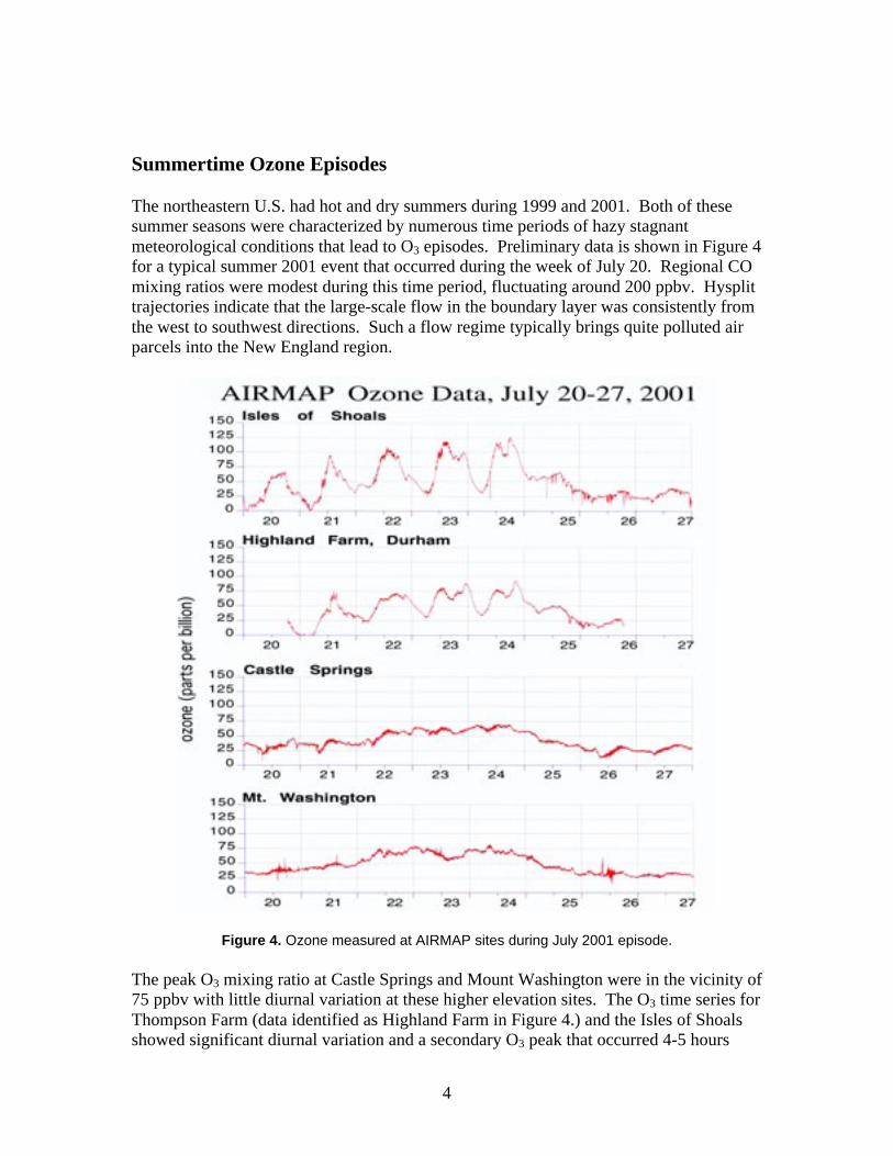
The northeastern U.S. had hot and dry summers during 1999 and 2001. Both of thesesummer seasons were characterized by numerous time periods of hazy stagnantmeteorological conditions that lead to O3 episodes. Preliminary data is shown in Figure 4for a typical summer 2001 event that occurred during the week of July 20. Regional COmixing ratios were modest during this time period, fluctuating around 200 ppbv. Hysplittrajectories indicate that the large-scale flow in the boundary layer was consistently fromthe west to southwest directions. Such a flow regime typically brings quite polluted airparcels into the New England region.
Figure 4. Ozone measured at AIRMAP sites during July 2001 episode.
The peak O3 mixing ratio at Castle Springs and Mount Washington were in the vicinity of75 ppbv with little diurnal variation at these higher elevation sites. The O3 time series forThompson Farm (data identified as Highland Farm in Figure 4.) and the Isles of Shoalsshowed significant diurnal variation and a secondary O3 peak that occurred 4-5 hours

5
after the initial peak in the early afternoon. At both sites the secondary peak was 5 –15ppbv higher than the first one. One of the goals of the 2002 measurement campaign willobviously be to determine the nature of these multiple peaks, which commonly occur inthe New England region. This will involve accessing daily O3 production, entrainmentfrom aloft, long-range transport, and recycling due to processes such as the sea breezeand nocturnal jets. The magnitude of the daily fluctuations of O3 at the Isles of Shoals isimpressive (∼ 100 ppbv), and points to important local dynamics and associated synopticforcing that needs to be investigated to understand these data. The coincident timing ofthe fluctuations at Thompson Farm and the Isles of Shoals suggests that it is a much morecomplicated than a simple sea breeze scenario. The data that collected during thesummer of 2001 will be critical for planning the spatial distribution of AIRMAP andNOAA’s measurement resources during 2002.
Figure 5. Distribution of ozone throughout New England during two days of the episode.
Regional Emissions
Although New England's emissions of air pollutants are reasonably modest in comparisonto other regions of the U.S. there are significant natural and anthropogenic sources thathave to be considered in a study of air quality in the region. Emissions of several majorpollutants are given for each state in Table 1.

6
Table 1. Annual state-level anthropogenic emissions and rank for New England states (1998).3
Emissions are in thousands of short tons.
NOx VOC SO2 PM2.5
State Emissions Rank Emissions Rank Emissions Rank Emissions Rank
Connecticut 153 41 156 35 66 41 30 45Maine 94 45 109 40 53 44 102 36Massachusetts 304 31 264 29 264 24 72 40New Hampshire 82 46 74 45 148 34 17 47Rhode Island 35 50 49 49 12 49 8 50Vermont 46 49 44 50 16 48 18 46
The distribution of the NOX and VOC emissions between area and point sources andthroughout the region is shown in Figures 5 and 6.
Figure 6. Distribution of NOx emissions in New England.4
The contribution of the major metropolitan areas in Connecticut and Massachusetts aswell as some isolated point sources (primarily power plants) is evident.
3 EPA National Air Pollutant Emissions Trends, 1900-1998, EPA-454/R-00-002, March20004 Taken from the New Hampshire Department of Environmental Services (NHDES) website (http://www.des.state.nh.us/ard_intro.htm)

7
Figure 7. Distribution of VOC emissions in New England4.
It is clear from the data presented in Figure 7 that natural sources of VOC dominate theemissions and may play an important role in shaping air quality on New England. In factthe most recent inventories suggest that natural sources of VOCs (primarily forests)account for more than 75 percent of the summertime emissions. The relative significanceof these emissions is further enhanced when their greater reactivity, compared toanthropogenic emissions, is considered.

8
Study Themes and Objectives
Clearly, resolving the issues described above is a daunting task requiring a detailedunderstanding of the processes that control the formation and distribution of air pollutionin New England. In order to optimize the management of air quality in New England, thefollowing science questions need to be addressed:
• How well do current air models represent pollution sources and atmosphericprocesses that shape air quality in New England? How can these models beimproved?
• How well can these models forecast air quality (3-5 days in advance)?• What measurement networks are required to develop and evaluate regional air
quality management strategies?• What is the relative importance of local and transported pollution to air quality in
New England?• What is the relative importance of natural and man-made emissions to air quality
in New England?• What are the linkages between the atmospheric processes responsible for ozone
and fine particle pollution? What are the implications for a coordinatedmitigation strategy?
• What are the linkages between regional air quality and weather/climatevariability?
These needs will be addressed in the research program, which is described below, thatbuilds on an existing collaboration between the scientists in the region, scientists fromNOAA's Office of Oceanic and Atmospheric Research (OAR) laboratories, and otherinterested participants from throughout the U.S. and Canada.
While the regular monitoring of key pollutants and their precursors being conductedunder AIRMAP, the state agencies in the region and others provide a valuable data setwith which to characterize the air quality and chemical climatology of the region,experience has shown that the information from these networks is most useful whenaugmented with intensive study periods during which a more comprehensive set ofmeasurements can be made over a wider region. These enhanced measurements canprovide detailed information on the controlling atmospheric processes and the inputsneeded to properly exercise and constrain air quality models. Therefore, the AIRMAPconsortium is proposing to expand its research program to include a series of intensivefield experiments focused on New England that will bring together the extensivecapabilities of the AIRMAP and other research teams. The proposed new research willbe organized under a series of themes, which are described below:

9
1. The role of long-range transport in shaping the regional and extra-regional airquality of New England
Although New England does have air pollution sources of its own, they are relativelymodest in comparison to those in much of the rest of the United States. However,polluted air masses from the Northeast Corridor, the Midwest, and Southern Canada cansignificantly impact air quality in New England. A more predictive understanding of therole of long-range transport will serve to guide more effective management strategieswhile enhancing the overall understanding of the processes that control the formation anddistribution of air pollution. Specific scientific questions to be addressed include:
• What is the role of nighttime chemistry and transport in determining thedistribution and composition of the regional pollution mix?
• How do the chemical processes in the atmosphere vary with the seasons? Whatare the main chemical processes that determine atmospheric transformationsduring the winter months?
• What is the role of the region's complex terrain in promoting the exchange ofpollution between the polluted boundary layer and the free troposphere?
• How does the mixing of aged pollution with fresh emissions during transportaffect pollution formation and distribution?
• Which source regions have the greatest impact on air quality in New England?What is the magnitude of the impact relative to local sources?
2. The role of biogenic emissions in local and regional air quality in New England
Ozone is formed in the atmosphere through a complex series of reactions involvingvolatile organic compounds (VOCs) and nitrogen oxides (NOx) in the presence ofsunlight. The abundant forests of New England are a significant source of reactive(VOCs) that contribute to the production of ozone and the formation and growth of fineparticles. Intensive field campaigns conducted by NOAA in the Midwest and Southeasthave demonstrated the important role that biogenic VOCs can play in pollutionformation. However, this work has focused on isoprene, which is emitted from southerndeciduous forests. The ozone- and particle-producing properties of pinenes and otherterpenoid compounds emitted by the coniferous forests of the North are very differentthan those of isoprene (e.g., temperature). The impact of these natural emissions onregional air quality is not well understood. Specific scientific questions to be addressedinclude:
• What is the relative role of biogenic and anthropogenic VOCs in the formation ofozone in the region?
• What is the relative role of biogenic and anthropogenic VOCs in the formationand growth of fine particles in the region?
• How does the atmospheric chemistry of biogenic VOCs vary from day to night?• How does this affect the seasonality of pollution formation?

10
3. The role of the sea-breeze/land-breeze circuit in influencing air quality in NewEngland
The sea-breeze/land-breeze circuit (SBLB) is a meso-scale circulation of air caused bythe differential heating and cooling of the land- and sea-surfaces in the coastal zone. It isdriven by the diurnal cycle of solar insolation and the differing heat capacities of landsurfaces and seawater. The SBLB phenomenon has the potential to profoundly effectNew England's air quality. Re-circulation of polluted air between the coastal marine andeastern New England coastal areas is evidenced by the ozone episodes shown in Figures4 and 5. The chemical processing of continental air in the local marine environmentcould, for example, substantially alter its reactive nitrogen content. This processingcould subsequently influence the photochemical state and ozone production potential ofthe polluted air parcels. These processes are known to involve complex heterogeneouschemistry, which need to be studied in detail. Specific scientific questions to beaddressed include:
• What geographic area in eastern New England is most influenced by the SBLBcirculation?
• What role does the nocturnal jet play in the SBLB circulation?• What important chemical processing of polluted continental air occurs in the
coastal zone?• How does the chemical processing differ from daytime to nighttime?• What are the time scales of these chemical processes?
4. Evaluation of air quality forecast systems
Air quality forecasts are currently being performed for all of the major metropolitan areasof the U.S. EPA collects and displays ozone forecasts for U.S cities on its AIRNOW website (http://www.epa.gov/airnow/). The methods used to produce these forecasts varyfrom relative simple climatological approaches to the application of sophisticatedphotochemical grid models5. The need for reliable air quality forecasts is clear andgrowing. However it is important to continuously evaluate the skill of the techniques toselect the most suitable approach for each application and to improve the skill of thetechniques being employed. Two kinds of evaluations are needed:
• Operational evaluation – a direct comparison between the forecast pollution fields(e.g., ozone concentrations) and the observed pollution distribution (e.g., ozonemeasured in the regulatory network). An operational evaluation is designed toanswer the question – How close was my prediction to what actually occurred?
5 CENR Air Quality Research Subcommittee, Air Quality Forecasting – A Review ofFederal Programs and Research Needs(http://www.al.noaa.gov/AQRS/reports/Forecasting.html)

11
• Diagnostic evaluation – an evaluation on the performance of the processes ofprediction. In other words, a diagnostic evaluation will tell you if you got theright answer for the right reason. As the name implies, a diagnostic evaluationrequires the measurement of parameters (both meteorological and chemical) thatcontrol pollution formation and distribution.
Ozone forecasts for the New England region are currently being performed by a numberof groups including: MCNC, NOAA's Forecast System's Laboratory, NESCAM, and theair quality groups in each of the states. An evaluation of forecast performance for thesesystems is ongoing.
5. Linkages between air quality and climate
The meteorological conditions that promote adverse air quality in New England aretightly coupled to the climate systems. The relative frequency of air mass stagnation, thedevelopment of shallow inversion, which lead to "home-grown" pollution events andtransport patterns that bring pollution from the industrial Midwest and urban areas alongthe East Coast determine the quality of the air to which the citizens of the region areexposed. Also, the polluted air that leaves New England can ultimately influence airquality in Eastern Canada and ultimately the North Atlantic and Europe. A betterunderstanding of the linkages between climate and air quality is needed if we are to beable to reliably predict the influence of predicted changes in climate on future air quality.

Approach
The primary goal of the New England Air Quality Study is an improved understandingof the atmospheric process that control the production and distribution of airpollutants in the New England region. The Science plan to accomplish this goal hasthree components:
Long term monitoring – The University of New Hampshire has taken the lead inestablishing a new comprehensive air quality monitoring network in New England. Themeasurements made at these sites will augment the data already being collected in theexisting regulatory monitoring network and at nearby research sites (e.g., WhitefaceMountain and Harvard Forest). The data collected at this ensemble of sites will provideinsights into the chemical climatology of the region, long-term trends in air quality, andinformation on meteorological and chemical processes.
Intensive field studies – The basic set of measurements plan for the AIRMAP network,although extensive, provides only a partial view of the chemical and physical processesthat control pollution formation and transport. Insight into these processes requires thatthat view be expanded to include a wider array of chemical and physical measurementsand an examination of key parameters over the full three-dimensional extent of theatmosphere. The intent is to conduct two major field intensives (during the summers of2002 and 2004) that will make more extensive use of additional measurement capability,remote sensing technology, and instrumented aircraft than is feasible in a long-termmonitoring effort. The data collected during these intensives will provide a morecomplete picture of the atmosphere in the New England Region, its dynamics andconstituents than has been previously possible. The use of instrumented aircraft will alsoallow the tracking of polluted air masses as they enter and leave the New England region.
Modeling analyses – Air quality models are the main conduit for the transfer of scientificunderstanding of the atmospheric processes that control air quality to the management ofair quality. The decisions and strategies developed by the regulatory and policycommunities are only as good as these models are in describing the key atmosphericprocesses. Thus in the New England Air Quality Study we plan to use air quality modelsin three distinct ways:
• As tools to be evaluated – The data collected in the long-term modeling effort andthe intensive field studies will be used to evaluate model performance and skill.The comprehensive data sets obtained during the intensives can be used toconstrain the models in such a way that performance of individual modules(emissions, meteorology, chemistry, etc.) can be properly evaluated. Initialevaluation efforts will focus on the photochemical grid model being used toproduce ozone forecasts.

13
• As forecast tools – The air quality forecasts currently being produced will be usedon a campaign basis to plan the deployment of mobile sampling platforms (shipsand aircraft). The availability of reliable forecasts will greatly improve theprobability that mission goals will be accomplished and increase the productivityof these expensive assets.
• To aid in data analysis – The use of air quality models will be an integral part ofthe analysis of data from both the long-term monitoring network and the intensivefield campaigns. Models provide a very effective mechanism for integrating datasets from ground-based and airborne platforms.
Staging of Field Intensives
The two field intensives have been scheduled to take advantage of an evolvingunderstanding of the factors that shape air quality in New England. The intent of the2002 intensive is to map out the surface concentrations of ozone and fine particles andtheir precursors. The knowledge gained in this effort will be used to refine the goals andmeasurement strategies for the 2004 intensive when the aircraft will be used to extend thehorizontal and vertical extent of the measurements. Thus, the 2002 scoping study willhelp to maximize the use of the aircraft facilities planned for 2004.

14
Measurement Systems
Regulatory Network
The network of regulatory monitors that is operated by states in New England provides avaluable source of information on the distribution and trends in air quality. The states inthe region operate approximately 55 ozone monitoring stations during the ozone season(i.e., April 1 through September 30)6. The network of stations is shown in Figure 7. Forthe four-year period from 1997 through 2000 EPA reports an average of 28 days peryear (summer months) when New England's air exceeded the 8-hour ozone standard.The data from some of these stations are available through the EPA AIRNOW system.Several sites in New Hampshire are being polled daily and included in the AIRMAPdatabase.
Figure 7. Location of regulatory ozone monitors operated by the states in New England.
The AIRMAP Network
AIRMAP has established three long-term measurement sites for documenting andstudying persistent air pollutants such as ozone and fine respirable aerosols on varioustime scales in the New England atmosphere. These sites represent strategically chosenlocations to provide a gradient in elevation from sea level (Highland Farm in Durham) to400 m at Castle in the Clouds (Moultonboro) and up to 2000 m at the summit of MountWashington (North Conway). Each of these sites is being equipped with research-gradeinstrumentation for measuring critical air pollutants in the non-urban atmosphericenvironment of New England (Figure 3).
6 EPA Region 1, http://www.epa.gov/region01/eco/dailyozone/omssites.html

15
The air quality monitoring instrumentation is being custom fabricated and tested in theAIRMAP/Climate Change Research Center laboratories at UNH. At each site all of theinstruments are controlled by a central computer to provide continuous data of the highestquality with an average one-minute time resolution. A National Instruments dataacquisition interface is being used to control the instruments and store the raw signals.Internet access at the sites allows instrument monitoring, data archiving, and real-timedisplay of atmospheric data.
AIRMAP instrumentation is being implemented with the highest regard for qualitymeasurements in the non-urban environment. The instrumentation at each site isoperated in consultation with scientists and staff at the NOAA Aeronomy Laboratory.The extensive database being generated by AIRMAP is rigorous and defendable.
Table 2. The AIRMAP Core Measurement Package.
PARAMETERS
All SitesO3
COCO2
NONOy
SO2
JNO2
CNAerosol Scattering (450, 550, 700 nm)Aerosol Absorption (550 nm)Aerosol Soluble IonsHydrocarbons/HalocarbonsWind Speed/ DirectionTemperature/ HumidityBarometric Pressure
Additional at Thompson Farm
PM2.5 aerosol massPM2.5 aerosol compositionDirect-normal, total-horizontal, Diffuse-horizontal irradiances
METHOD
TEII Model 49CTEII Model 48C – modifiedLicor IRTEII Model 42C-TL – modifiedTEII Model 42C-TL – modified (Mo converter)TEII Model 43C – modifiedMetcon, Inc.TSI 3022ATSI Model 3563Radiance Research PSAPTeflon Filter/Dionex ICEntech /ShimadzuQualimetrics Model 2020Qualimetrics Model 5190Qualimetrics Model 7120
URG Custom BuiltURG Custom BuiltYankee Environmental MFR-7

16
Atmospheric Physical Measurements
The physical or meteorological situation in New England is quite complex. Some of theimportant physical questions are:
• How often and where is air near the surface well-mixed with respect to air abovethe surface (at a few hundred meters, for example)?
• What is the role of coastal phenomena such as the sea breeze in transport ofpollutants toward or away from population centers and monitoring sites?
• What is the role of complex terrain such as that of northern New Hampshire invertical mixing?
• How is the diurnal cycle of atmospheric stability in New England similar to ordifferent from that in other areas?
Long-range pollutant transport preferentially occurs well above the surface, where windspeeds are higher and fewer obstacles are present. In order for pollutants transported atupper levels to affect the surface environment, vertical mixing must take place. This canbe caused by daytime surface heating, by transport of cooler air over a warmer surface, orby mechanical mixing over rough terrain. Conversely, warm polluted air transportedover a cooler surface (such as cool ocean water) becomes stable and isolated from thesurface. A likely scenario is that warm polluted air from the East Coast metroplex isisolated above the surface during transport over the cool ocean and Gulf of Maine. Whensuch air masses reach warm land again in New England during the day, they can bemixed vertically to the surface.
Instruments capable of measuring verticalprofiles of physical quantities are key tounderstanding these phenomena. Oneboundary layer wind profiling radar(profiler) has been deployed at Portsmouth,NH to provide preliminary data forplanning purposes and will remain in placethroughout the study. A second profilerwill be deployed on the Isles of Shoalsduring the 2002 intensive. A DopplerLIDAR to be deployed at a coastal location(Rye Harbor State Park) during intensiveperiods will provide high-resolution data oncoastal flows. Figure 8 shows an exampleof the passage of a bay breeze frontobserved by a Doppler lidar during the2000 Texas Air Quality Study. Theconvergence at the head of the fronttypically produces substantial verticalmixing. The bay breeze, indicated by thepositive velocities at the surface beyond 4
Figure 8: NOAA/ETL Doppler lidar range-heightscans depicting the reversal of wind flow due to theintrusion of the bay breeze, measured at the LaPortesite. The blue numbers indicate distance, in km, fromthe lidar, which is located at x=z=0. The color scaleat the bottom of each plot indicates the radial wind
17
km horizontal range, is quite distinct as it propagates in opposition to the offshore flow.In the middle plot, the bay breeze front was ~2 km from the lidar, and as is common withsuch a front, a small cloud formed near the converging winds. The bottom plot showsweak onshore flow at least 1 km deep.
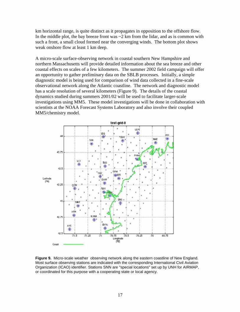
A micro-scale surface-observing network in coastal southern New Hampshire andnorthern Massachusetts will provide detailed information about the sea breeze and othercoastal effects on scales of a few kilometers. The summer 2002 field campaign will offeran opportunity to gather preliminary data on the SBLB processes. Initially, a simplediagnostic model is being used for comparison of wind data collected in a fine-scaleobservational network along the Atlantic coastline. The network and diagnostic modelhas a scale resolution of several kilometers (Figure 9). The details of the coastaldynamics studied during summers 2001/02 will be used to facilitate larger-scaleinvestigations using MM5. These model investigations will be done in collaboration withscientists at the NOAA Forecast Systems Laboratory and also involve their coupledMM5/chemistry model.
Figure 9. Micro-scale weather observing network along the eastern coastline of New England.Most surface observing stations are indicated with the corresponding International Civil AviationOrganization (ICAO) identifier. Stations SNN are "special locations" set up by UNH for AIRMAP,or coordinated for this purpose with a cooperating state or local agency.

18
Mobile Monitoring Systems
During the 2002 and 2004 intensive periods the long-term AIRMAP measurements willbe augmented with data from a variety of mobile platforms. These platforms will be usedto extend the spatial coverage of the measurements both within and outside the region.Current plans call for the use of NOAA Ship Ronald Brown to study air quality in thecoastal region of New England during the summer of 2002 and to deploy twoinstrumented aircraft during the summer of 2004. These platforms and the proposedapplications are described below.
NOAA Ship Ronald H. Brown
Some of the highest ozone concentrations in New England havebeen recorded at monitoring sites on or near the coast. Theseepisodes can result from the re-circulation of polluted air from within the region or long-range transport from outside the region (e.g., Figure 10). A more complete understandingof the relative importance of local versus distant sources on air quality in New England isan important first step in the development of an effective plan to improve air quality forthe citizens of the region.
Figure 10. The circulation set up by the Bermuda High during the summer months can bringpolluted air from densely-populated areas of the Eastern Seaboard into the Gulf of Maine. Localsynoptic flow within the Gulf (land – sea breeze) can then bring the polluted air into coastal NewEngland7.
7 Ray, J.D. et al., Surface level measurements of ozone and precursors at coastal andoffshore locations in the Gulf of Maine, J. Geophys. Res., 101, 29005-29011, 1996.

19
The study planned for the summer of 2002 will focus on the coastal area of New Englandand will take advantage of the heavily instrumented area along the New Hampshireseacoast to better understand the interplay between the land – sea breeze, and thesynoptic flow in the coastal boundary layer to determine the cause of the high pollutionepisodes along the coast. The University of New Hampshire has established acomprehensive atmospheric monitoring site at Durham New Hampshire (ThompsonFarm) and has added additional measurements to a site on Appledore Island, one of theIsles of Shoals, approximately eight miles offshore. UNH has also established a high-density meteorological network along the coast. NOAA has augmented thesemeasurements with a radar wind profiler at Pease N.H. and a Doppler lidar at Rye HarborState Park, an air monitoring site operated by the state of New Hampshire.
Proposed Deployment of the Ronald H. BrownClearly the transport of polluted air within the Gulf of Maine plays an important role inshaping the air quality in coastal New England. The source of the polluted air is lessclear. Re-circulation of pollution from urban areas within New England and long-rangetransport (e.g., from the Washington – New York corridor) both have to be considered.The conditions in the Gulf are also expected to play a role as the marine boundary layer isexpected to act as a huge chemical reactor converting primary pollutants like nitrogenoxides and organics into more-toxic secondary pollutants like ozone and fine particles.
Figure 11. The NOAA Research Vessel Ronald H. Brown.

20
An instrumented ship is an ideal way to study the meteorological and chemical processesthat are occurring of the coast of New England. A ship can be used to sample polluted airmasses as they move offshore, study the chemical transformations in the polluted marineboundary layer, and characterize polluted air masses at they move onshore. Previousattempts to perform these measurements from sites on shore have resulted in data that isdifficult to interpret due to contamination by local land-based sources.
The operational capabilities, and facilities on the Ron Brown (Figure 11) make it theideal platform for these kind of studies. The availability of an on-board radar windprofiler is particularly important.
InstrumentationThe Aeronomy Laboratory and the Environmental Technology Laboratory have in recentyears conducted several highly successful air quality studies. The experience developedin these joint studies has resulted in a comprehensive suite of instrumentation that allowsthe characterization of atmospheric dynamics and chemistry in complex environments.Of particular importance for this study are the techniques that have been developed todistinguish among various source types and regions.
Table 3. Proposed air quality instruments for deployment on the Ron Brown.
Parameter Method PerformingLaboratory
Ozone UV Absorbance ALOzone NO Chemiluminescence ALCarbon Monoxide Nondispersive IR ALCarbon Dioxide Nondispersive IR ALSulfur Dioxide Pulsed Fluorescence ALNitric Oxide Chemiluminescence ALNitrogen Dioxide Photolysis Cell ALTotal Nitrogen Oxides Au Tube Reduction ALPANs GC/ECD ALAlkyl Nitrates GC/FID ALPhotolysis Rates Spectral Radiometer ALIonic Aerosol Composition PILS PMEL/GITSize-resolved aerosol composition andgravimetric mass
Impactor (IC, XRF, and thermal-optical OC/EC).
PMEL
Aerosol Size and Composition Aerosol Mass Spectrometer AL/AerodyneAerosol scattering (450, 550, 700 nm) TSI Model 3563 Nephelometer PMELAerosol absorption (550 nm) Radiance Research PSAP PMELAerosol number CNC PMELAerosol size distribution twin DMAs and an APS PMELContinuous Specation of VOCs PTR-MS/CIMS ALVOC Speciation GC/MS ALOzone/Aerosol Vertical Profiles DIAL lidar/Aerosol backscatter ETL

21
Operational PlanningNOAA's Forecast System's Laboratory is running an experimental air quality forecastmodel over the eastern U.S, during the summer months. The model employs fullycoupled meteorological (MM5) and chemical modules to predict ozone fields up to 36hours in advance. The AIRMAP routine and intensive measurements provide one ofseveral data sets that will be used to evaluate and improve this model. The availability ofthese forecasts also affords the opportunity to optimize the deployment of a samplingplatform like the Ron Brown through the selection of sampling strategies tailored to theexpected meteorology and air quality. This process would be farther facilitated throughthe use of one of FSL's FX-Net systems that are being updated to include real time airquality data and model forecasts under the current AIRMAP program.
Sampling StrategyThe instrumentation planned for deployment on the Ronald Brown will allow thecharacterization of a wide range of gaseous and particulate pollution. This will beaccomplished primarily through fast-response in situ sampling augmented with theozone/aerosol profiling capability of the DIAL lidar. The lidar is particularly importantwhen sampling in a stable marine boundary layer as it will provide a vertical context forthe ship-board measurements.
As discussed above, the sampling cruises planned for the Ronald Brown are intended toprovide insight into the processes that control the high pollution episodes along the coastof New England. The sampling on board the Ronald Brown will be focused on threemajor scientific objectives:
1. Characterization of Sources – It is important to characterize the mix of emissionsthat impact the region whether they come from sources within or outside theregion. To meet this objective a number of near-shore survey tracks are plannedunder conditions when the polluted continental air would be expected to transportinto the surface marine layer (i.e. nighttime, early morning, or late day)
2. Study of Transport and Transformation Processes – The marine environment isunique both in terms of the dynamics (mixing and transport) and chemistry.Although a great deal is known about the transport and chemistry of polluted airmasses and plumes over land very little is known about the processing that occursin the marine environment. The compliment of instruments on-board the RonBrown will be used to document the evolution of polluted air masses in the Gulfof Maine during the entire diurnal cycle.
3. Study of Coastal Impacts – The impact of polluted air masses transported over theGulf of Maine is evident in the ozone monitoring record for the region. It hasbeen hypothesized that the complex dynamics of the sea-breeze/land-breezecircuit (SBLB) plays a major role in transporting polluted air off the Gulf ofMaine into coastal New England. To address this objective the Ron Brown willbe deployed near the heavily instrumented region along the New Hampshire coast(e.g. Figure 9) to participate in a coordinated study of the SBLB.

22
Sample Ship TracksA number of generic ship tracks are proposed below that are designed to address theobjectives listed above. These should be considered as preliminary and subject to changeas the planning for the intensive proceeds and upon review by NOAA's Office of Marineand Aviation Operations. Naturally, the exact orientation and location of the ship trackswill have to be adjusted in accordance with safety considerations and the pollution andweather forecasts. Also a series of measurement comparisons with the monitors on theIsles of Shoals are planned when the Ron Brown is located in the vicinity and are notdiscussed here.
Sampling During TransitWe would propose to integrate the air quality instrumentation at the Ron Brown's homeport, Charleston S. C. This would afford the opportunity to collect data during the transitcruise to and from the Gulf of Maine. NOAA/OAR has conducted several studies in thepast to better understand pollutant transport off the east coast of the United States. The insitu data and the profiles provided by the ETL DIAL lidar that could be obtained on thetransit cruise will provide valuable new data and important new information on themagnitude and composition of pollution leaving the eastern United States. Some optionsfor the transit cruise are shown in Figure 12.
Figure 12. Proposed ship track options for transit cruise to and from the Gulf of Maine.

23
The timing for this cruise will be dictated to a large extent by the schedule for the study.The ship has been assigned to the study for the period July 10 through August 9, 2001.The choice of transit track would be determined based on the weather forecast for theperiod of the cruise. For example, the inshore track might be more appropriate for thereturn to avoid following winds (and the associated contamination from the ship exhaust)resulting from the circulation around the Bermuda high.
This track will primarily address objective number 1, characterization of emissions.
Boston/NY Plume StudyAn analysis of data collected on the Isles of Shoals during the summer of 2001 indicatesthat the highest ozone concentrations (sometimes in excess of 120 ppb) were associatedwith transport from the southwest. This suggests that transport of the Boston urbanplume into the Gulf of Maine may be a significant source of regional ozone during theseepisodes. The Boston plume may be a composite of fresh, local emissions and more agedemissions since Boston is often downwind of the NY/NJ metropolitan complex, which
Figure 13. Proposed ship tracks Boston/NY urban plume study.

24
could result in a composite plume containing emissions and byproducts from severalurban areas8. Three ship tracks are proposed to sample these plumes (Figure 13). Onesurvey track is proposed to map out the various plumes that enter the Gulf of Maineunder southwesterly transport. A second track is confined to Massachusetts Bay tocharacterize the Boston plume in the early stages of transport. This track could berepeated throughout the day to document the vertical distribution of the offshore pollutionas the land warms. The third track is designed to capture the mixed plume from theNY/NJ area as it enters the Gulf of Maine. Tracks one and two would begin early in themorning. If the NY/NJ plume is located during the survey track the cruise could continuefollowing track three.
The tracks are oriented cross-wind to account for the expected heterogeneity of theseplumes. The Brown would work its way downwind following the chemical evolution ofthe plume as it is transported away from the immediate area of Boston. If possible theseplumes would be tracked into the night either on a single cruise or on separate cruises.
These tracks will address objectives one (characterization of sources) and two (study oftransport and transformation processes).
Sea-breeze/ Land-breeze CirculationThe study of the SBLB circulation is a major objective the New England Air QualityStudy. The ship tracks shown in Figure 14. are designed to augment the intensivemeasurements planned for the New Hampshire coast to address this issue.
Figure 14. Proposed ship tracks designed to study the sea-breeze/land-breeze circulation.
8 Sillman, S. et al., Ozone production in urban plumes transported over water:Photochemical model and case studies in the northeastern and Midwestern United States,J. Geophys. Res., 98, 12687-12699, 1993.

25
The proposed tracks run along and perpendicular to the sea-breeze front. Thisexperiment would be conducted under reasonably weak synoptic forcing when theSea/Land breeze would be expected to have a significant impact on local transport. Theparallel and perpendicular tracks shown in Figure 14 would be alternated as feasibleduring the day beginning at dawn to capture as much of the diurnal cycle as possible.The cruise up into Portsmouth Harbor and the Piscataqua River would provide a cross-sectional view of the front. Each of these legs also provides an opportunity to comparewith measurements on the Isles of Shoals. The parallel track should be performed asclose as possible to the coast consistent with safe operation of the vessel.
These tracks would address objective number three (coastal impacts) above.
Onshore Flow – Northern SectorMany parts of the Maine coast are impacted by pollution that has been transported longdistances. Acadia National Park has recorded 1-hr averaged ozone concentrations inexcess of 200 ppb even though it is located in a remote part of the coast far from anylocal pollution sources. A survey cruise is proposed (Figure 15) to examine the transportof polluted to the northern sector of the New England coast. This experiment would beconducted under southerly or southeasterly flow that is bringing polluted air from theWashington/N.Y. corridor into the Gulf of Maine and then ultimately to the Maine coast.
Figure 15. Proposed cruise to examine transport of polluted air onto the coast of Maine.

26
If possible, the cruise would be timed to take advantage of an alongshore sea-breeze frontthat is producing onshore flow. Under favorable conditions this cruise would provideadditional insights into the dynamics of the sea/land breeze circulation.
NOAA WP-3
During the summer of 2004NOAA proposes to use aninstrumented aircraft to studythe transport and transformationof air pollution into and within New England. This aircraft has sufficient range andendurance to survey large areas. Over the past few years the Aeronomy Laboratory hasdeveloped and integrated a set of in-situ instruments to study photochemistry and aerosolprocesses on this platform. The current instrument package is described in Figure 15.This platform would be deployed to address three main objectives:
• To quantify the transport of ozone and fine particles and their precursors into andout of the New England region. Pollution from major upwind source areas will betracked and the changes in pollution distribution that results from chemicalprocessing, depositional losses, and venting to the free troposphere quantified.
• To determine the rate and efficiency of ozone and fine particle formation withinNew England. Plume studies downwind of the major urban areas and pointsources (e.g., power plants) within the region will provide a perspective of therelative contribution of regional sources to air quality in New England. Theinfluence of natural VOCs will be investigated through the study of plumes inregions with differing biogenic VOC emissions. The NOAA WP-3 instrumentpackage included the capability to characterize the composition and morphologyof atmospheric particles with fast time response, which will be particularly helpfulin the study of aerosol formation and growth.
• To determine the mechanisms and quantify the rates of chemical transformationsthat occur during the night. Nighttime processing of air pollution is believed to bevery important during multi-day transport. These process may, to a large degree,determine the mix of pollution that reaches distant impact areas, such as NewEngland. NOAA's measurement capabilities have recently been expanded toinclude two species that play an important role in nighttime chemistry (NO3 andN2O5). This capability, when combined with the other measurements on theNOAA WP-3, will allow the nighttime chemical system to be characterized indetail.

27
Figure 15. Instrument layout on the NOAA WP-3 research aircraft.
NOAA Airborne Lidar
The NOAA Environmental TechnologyLaboratory (ETL) airborne ozoneDifferential Absorption LIDAR (DIAL)has been deployed on a variety of aircraftin past air quality studies (the DC-3 used inthe TEXAQS 2000 study is shown on theright). The downward-looking LIDAR system provides vertical profiles of ozone andaerosol backscatter below the flight path. The aircraft usually flies at a constant altitude(~3500 m above the surface). In addition to providing valuable information on thedistribution of ozone and aerosols in the atmosphere, the aerosol backscatter can also beused to map the depth of the polluted boundary layer.
During the 2004 intensive field campaign, ETL hopes to add a downward lookingDoppler lidar to the remote aircraft to provide simultaneous observations of wind andozone profiles. Such measurements would yield detailed information on the spatialvariability of the transport of ozone and aerosols, as well as provide importantintercomparison data for diagnosing and validating model performance.
This platform would be deployed to address three main objectives:
• To characterize the transport and vertical structure of ozone and fine particlesunder land-sea breeze recirculation. The coastal environment has extremelycomplex transport and mixing dynamics especially under light wind conditions.During these periods the land-sea breeze circulation can move local pollution

28
offshore and return that pollution, or pollution transported into the marineenvironment from other regions, when the sea breeze sets up. The ETL airborneLIDAR has been used very successfully previously in Houston TX to study asimilar situation where high ozone levels were associated with land-sea breezerecirculation (e.g., see figure 16).
Figure 16. Ozone cross section from the NOAA ETL airborne LIDAR overlaid on a map of theHouston/Galveston Bay area. The highest ozone concentrations (> 200 ppb) are indicated by theareas colored in black. Note the rapid rise in the depth of the polluted layer as the sea/baybreeze bring the polluted air onshore.
• To determine the structure and productivity of urban and power plant plumes inthe region. By flying multiple cross sections downwind of these sources, it willbe possible to describe the areas influenced by these sources in three dimensions.In addition the total flux of ozone, and to a more limited extent aerosols, can bederived by combining data from the airborne LIDAR with the wind fieldsmeasured by an on-board Doppler lidar or derived from the network of radar windprofilers that will be deployed during the study.
• To characterize the variations in boundary layer height that occur as a result ofsynoptic weather patterns and land use. Previous studies9 have shown that large
9 Banta, R.M., C.J. Senff, A.B. White, M. Trainer, R.T. McNider, R.J. Valente, S.D.Mayor, R.J. Alvarez II, R.M. Hardesty, D.D. Parrish, and F.C. Fehsenfeld, Daytimebuildup and nighttime transport of urban ozone in the boundary layer during a stagnationepisode. J. Geophys. Res., 103, 22519-22544, 1998.

29
variations in the height of the mixed layer can occur as a result of changes in landuse. These variations can have a significant effect on pollution levels and mayaffect venting to the free troposphere.
• To investigate the role of complex terrain in enhancing vertical mixing. Complexterrain can increase vertical mixing as a result of both differential heating andenhanced turbulence. The combined ozone/aerosol/wind profile measurementsfrom a dual lidar aircraft deployment will permit examination of the relationshipbetween winds, turbulence and ozone concentration over different types of terrainand over the ocean surface.

30
Expected Outcomes and Benefits
The proposed research will address significant information gaps and deliver soundscience leading to an improved understanding of the processes that influence the airpollution levels to which the citizens of New England are exposed. More specifically, theproposed research program will advance the understanding of the following:
• The distribution of ozone and fine particles throughout the region.• The relative importance of local and distant sources to measured pollution levels.• The interaction between air quality and the weather, and ultimately climate.• Levels of pollution exposure and deposition to sensitive ecosystems.
The study will also provide an educational opportunity for the students from UNH andPlymouth State College who participate in the measurement program and subsequent dataanalysis. These students are the future researchers and air-quality managers and policymakers who will be charged with the difficult task of protecting the quality of the air weall breathe. The opportunity to participate in this regional study will afford a uniqueopportunity to see the problem first hand.
The proposed effort will be an integral part of efforts to develop the tools needed toprovide reliable air quality forecasts. The New England area will be an initial test bed forthe proposed air quality forecasting system.The routine and intensive data sets willprovide a means to evaluate alternativeforecast approaches and fine-tune thechemical observing system that will beneeded in a nationwide implementation. Thestudy will also provide the opportunity toexpand the existing undergraduatemeteorological curriculum at UNH andPlymouth State to include training in airquality forecasting. These two institutionscan play a leadership role while providingopportunities for their graduates in thisexciting new area of atmospheric science.
The results of this research will beincorporated into ongoing efforts to providepolicy relevant information in a timely anduser-friendly manner to environmental decisionmakers. These assessment activitiescommunicate new science to those charged with developing effective environmentalpolicies for the Nation. As a result of this proposed program, the researchers in NewHampshire will be important new partners in these assessment endeavors.
Direct Payoffs for Decisionmakers
• Evaluation of skill of modelsused to develop air qualitymanagement strategies.
• Quantification of impacts oflocal and distant sources onNew England air quality.
• Identification of the uniqueproperties of New Englandaerosols that may impact publichealth.
• Identification of the role thatforest emissions play in shapingNew England Air Quality andhow they can be impacted.

31
Coordination With Other Programs
The AIRMAP consortium will provide the primary resources and expertise needed toexecute the New England Air Quality Study. However, the scope of the problem is large,both in terms of spatial extent and the complexity of the processes involved. Therefore,the study will be closely coordinated with a number of other research programs withsimilar goals to maximize the benefits of the planned research.
UNH’s New England Integrated Sciences and Assessment - The basis of the New EnglandIntegrated Sciences and Assessment (NEISA) is the integration of scientific inquiry,climate related economic and human dimensions research, and the transformation andcommunication of relevant research results to meet specific needs. The ultimate goal is tobuild a basic understanding of human-environment interactions and provide informationand responsive tools to decision makers. The NEISA will rely fundamentally upon theresearch efforts of AIRMAP. While the final definition of issues that will be addressed inthe NEISA will depend upon information gathered from stakeholders and the public overthe coming year, we expect to address three key climate-society issues in New England:
(1) The effect of air quality and extreme temperatures on human health;(2) Extreme weather events and emergency management; and(3) Climatic variation and New England's ski industry.
Intercontinental Transport and Chemical Transformation (ITCT) – The ITCT is beingconducted under the auspices of the International Global Atmospheric Chemistry Project(IGAC). The goal of the program is to investigate intercontinental transport ofanthropogenic pollution and to determine the chemical transformation that occurs duringthis transport. An important goal of this research is to estimate how the transport of thischemical from one continent can influence the air quality in another. The investigationwill be initially focused in the Northern Hemisphere that contains most of the worldlandmasses, where most of the world's population resides, and where most of theanthropogenic pollution is generated. In many respects the New England regionrepresents the starting point for pollution transport from North America to the NorthAtlantic and Europe. Thus a more complete quantification of the air quality andcontrolling processes in this region would provide a valuable input to the ITCT goals andobjectives.
Potential Additional Collaborations – Discussions have been initiated with a number ofadditional potential collaborators who have a similar interest in the air quality of the NewEngland region. These include:
• Intercontinental Chemical Transport Experiment (INTEX) - The NASA-sponsored INTEX field campaign is being proposed as an integrated fieldexperiment that uses surface, airborne, and satellite platforms together withmodels to assess the impact of human induced emission on the composition and

32
chemistry of the atmosphere in the Northern Hemisphere. This experiment willbe conducted under ITCT/IGAC.
• Meteorological Service of Canada – This group is planning a series of intensivefield campaigns to better understand the factors that control air quality in variousparts of Canada. An intensive field campaign is tentatively planned for theWindsor Quebec City corridor for the 2004-2005 time period.
• Harvard Forest – This group has a long history of high-quality measurements attheir research facility in central Massachusetts. Their presence in the region andtheir proximity to the AIRMAP network would make a collaboration beneficial.
• Whiteface Mountain – This site operated by SUNY-Albany also has a longhistory of research in a region adjacent to the proposed study region.
• DOE Atmospheric Chemistry Program – This focus of this program is similar toand, in many ways, complements, NOAA's Health of the Atmosphere program.NOAA and DOE have conducted a variety of intensive field campaigns togetherover the years.
Each of these programs has their own unique goals and objectives. Althoughdifferent, these goals and objectives are linked, both in terms of the processes studiedand the region of interest. A closer collaboration with benefit all and result incapabilities and perspectives that no single group could generate.