the narrow neck of land
TRANSCRIPT

The Narrow Neck of Land
A Touchstone of Book of Mormon Geography
Lynn and David Rosenvall, August 2012
Since the coming forth of the Book of Mormon in
1830 a narrow neck of land has been a touchstone
of its geography. It is the physical feature most
readily perceived in the mental maps of Book of
Mormon readers. Nearly all want to know its
location, and many attempt to find it. It is deemed an
essential piece of a geographical puzzle—if we could
only identify it, everything else should fall into place.
This hour-glass-shaped landform, some have
assumed, would be so obvious that surely it could
be located quickly on any map of the western
hemisphere. But alas, after some 180 years, and
many models of Book of Mormon geography later,
there is still much discord over its location. And the
search, for some, still continues.
The narrow neck of land is not just a relatively narrow
geographical landform—it had a geopolitical role far
beyond that of a confined physical feature between
two seas. It was the pivotal point for dividing the
“land northward” from the “land southward.” It was
the location of a fortified Nephite defense line and
two defendable passes leading northward, and
served as a converging point for controlling the
movement of people and animals. It was the often-
sought gateway to freedom for the hemmed-in Lamanites. It was a location for
launching Hagoth’s ill-fated ships into the western sea. And it was part of the
geographical context for captain Moroni’s emblematic Title of Liberty.
Land of Zarahemla
Narrow Strip of Wilderness
Sea East
Sea West
Land of Nephi
Narrow Neck of Land
Land of Bountiful
Land of Desolation
Land of First Inheritance
N
The Narrow Neck of Land, August 2012 1

There are numerous references scattered among the chapters of the Book of Mormon
describing the physical features of the narrow neck land, the historical events within its
confines and its sometimes crucial security role in the ongoing Book of Mormon story.
It stands to reason that the human and physical setting of our candidate location for
the narrow neck of land in Baja
California would need to fully match
everything in the scripture text impinging
on that constricted landform before
affirming the location as “the narrow
neck of land.” We suggest being able to
match only some of the numerous
details, but not all, would place the
candidacy of a narrow neck of land in
question. Any narrow neck of land on
the earth’s surface advanced by us or
others would also need to match the
Book of Mormon descriptions for the
adjoining regions and the surrounding seas in “the land northward” and “the land
southward.” We submit that our proposed location in Baja California, and its inherent
landscape features, not only matches the relevant references in the Book of Mormon
account, but also all the recorded geographical details. Moreover, this narrow neck of
land fits correctly within the required historical setting and timeline of the Book of
Mormon.
The Book of Mormon TimelineThe story of father Lehi’s family starts suddenly in the land of Jerusalem and abruptly
ends some 1,000 years later in the land of Cumorah. As dissensions and population
pressures increased, descendants of the small group that landed in the far south of
Baja California moved towards empty lands to the north during several phases of their
long history. Along the way they merged with the people of Zarahemla (the Mulekites)
and then later settled north of the narrow neck of land in the lands left desolate by the
destroyed Jaredite civilization. We note that in the Book of Mormon account there is no
mention of any events, activities, settlements, or the existence of more distant lands, to
The wilderness looking south from the “narrow neck of land” in Baja California.
The Narrow Neck of Land, August 2012 2
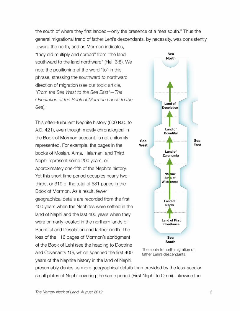
the south of where they first landed—only the presence of a “sea south.” Thus the
general migrational trend of father Lehi’s descendants, by necessity, was consistently
toward the north, and as Mormon indicates,
“they did multiply and spread” from “the land
southward to the land northward” (Hel. 3:8). We
note the positioning of the word “to” in this
phrase, stressing the southward to northward
direction of migration (see our topic article,
“From the Sea West to the Sea East”—The
Orientation of the Book of Mormon Lands to the
Sea).
This often-turbulent Nephite history (600 B.C. to
A.D. 421), even though mostly chronological in
the Book of Mormon account, is not uniformly
represented. For example, the pages in the
books of Mosiah, Alma, Helaman, and Third
Nephi represent some 200 years, or
approximately one-fifth of the Nephite history.
Yet this short time period occupies nearly two-
thirds, or 319 of the total of 531 pages in the
Book of Mormon. As a result, fewer
geographical details are recorded from the first
400 years when the Nephites were settled in the
land of Nephi and the last 400 years when they
were primarily located in the northern lands of
Bountiful and Desolation and farther north. The
loss of the 116 pages of Mormon’s abridgment
of the Book of Lehi (see the heading to Doctrine
and Covenants 10), which spanned the first 400
years of the Nephite history in the land of Nephi,
presumably denies us more geographical details than provided by the less-secular
small plates of Nephi covering the same period (First Nephi to Omni). Likewise the
Sea East
Sea West
Sea South
Sea North
Land of Desolation
Land of Zarahemla
Land of Bountiful
Land of First Inheritance
Land of Nephi
Narrow Strip of
Wilderness
The south to north migration of father Lehi’s descendants.
The Narrow Neck of Land, August 2012 3

Book of Fourth Nephi records nearly 300 years of the history in only four pages and,
understandably, with almost no geographical details. Because little is recorded about
the land of Nephi in the Book of Mormon, the better-known lands are the lands of
Zarahemla, Bountiful and Desolation—the lands progressively located toward the north.
Historic Setting of the Narrow Neck of LandIt is noteworthy that there is no mention of the narrow (small) neck of land in the Book
of Mormon until Mormon’s extensive geographical description in chapter 22 of the
Book of Alma, an account of events between 90 and 77 B.C., over 500 years after the
arrival of Lehi’s family in their promised land. Moreover, the Nephites and Lamanites did
not occupy the narrow neck of land and the lands to the north in substantial numbers
until 55 B.C.
After living nearly 400 years in the land of Nephi at the southern end of the Book of
Mormon lands, the Nephites “departed out of the land [of Nephi] into the wilderness, as
many as would hearken unto the voice of the Lord,” and they were led northward “by
the power of his arm, through the [narrow strip of] wilderness until they came down into
Timeline relative to Pages
A.D. 421600 B.C. 500 400 300 100 200 300
1 Nephi 2 Nephi Mosiah Alma Heleman 3 Nephi
JacobEnosJaromOmni
Words of Mormon
4 NephiMormon
EtherMoroni
200 100 A.D. 1
The timeline of the Book of Mormon in relationship to the number of pages in each of the books.
Alma 22 First mention of the
“narrow neck of land” (90 - 77 B.C.)
The Narrow Neck of Land, August 2012 4

the land which [was] called the land of Zarahemla,” which bordered on the river Sidon
(Omni 1:13; Alma 2:15). The land of Nephi, their previous home, was south of the
narrow strip of wilderness, and a journey of “many days” north of the “land of first
inheritance,” the place of their landing following a
long ocean voyage. In about 200 B.C., after many
“serious” wars in the land of Nephi, “the more
wicked part of the Nephites were destroyed” (Omni
1:5), and the more righteous Nephites abandoned
their troubled homeland under the direction of king
Mosiah (the first), the father of king Benjamin, and
departed northward into the wilderness seeking a
refuge (Omni 1:12; see also, “Historic Setting of
River Sidon Area.” in our topic article, The River Sidon—A Key to Unlocking Book of Mormon
Lands).
Starting in 55 B.C., at the time when Helaman and
Shiblon, the sons of Alma, were the record keepers,
large groups of Nephites migrated northward from
the land of Zarahemla into the abandoned and
desolated Jaredite lands. These northern lands had
been deforested by the Jaredites, that is, the trees
had been cut down, and the land had “been
rendered desolate and without timber, because of
the many inhabitants who had before inherited the
land” (Hel. 3:5–7; see also, Alma 63:4). Some “five
thousand and four hundred men, with their wives
and their children, departed out of the land of
Zarahemla into the land which was northward” and
emigrated to the northern land of Desolation from
the lands of Bountiful and Zarahemla to the south (Alma 63:4). In the next year “there
were many people who went forth into the land northward” (Alma 63:9). Eight years
later, there were “an exceedingly great many who departed out of the land of
Zarahemla, and went forth unto the land northward to inherit the land” (Hel. 3:3). And
“many of the people of Ammon, who were Lamanites by birth, did also go forth into
this land” (Hel. 3:12). These companies of Nephite and Lamanite emigrants would have
Land of Zarahemla Sea
EastSea West
Land of Nephi
Land of Bountiful
Land of Desolation
Land of First Inheritance
N
580 B.C.
200 B.C.
Narrow Strip of Wilderness
55 B.C.
The Narrow Neck of Land, August 2012 5

traveled through “the narrow neck which led into the land northward” (Alma 63:5).
Several groups traveled northward by ship (Alma 63:5–8, 10; Hel. 3:14). In total, tens of
thousands of people relocated to these northern lands.
Thus after some 535 years of living in
the lands of Nephi, Zarahemla and
Bountiful to the south, the Nephites
and the people of Ammon migrated to
these northern lands suddenly and in
substantial numbers (see Alma 63:4).
The reason is not clear. The record,
however, states “there was much
contention and many dissensions”
among the people of Nephi at the time
they left the land of Zarahemla (Hel.
3:3). Moreover, the Nephites may have
determined they should wait until a
sufficient number of regenerated trees
had grown and matured before they could settle the deforested Jaredite lands with a
reasonable chance of success. The record states that there was a “little timber upon
the face of the land” when they arrived (Hel. 3:7). We do not know how many years
elapsed between the final battle of Jared’s descendants and the Nephite migration into
this land, but possibly a couple of hundred years.
For nearly all of their first 600 years in the promised land, the narrow neck of land was
the northern bounds of the Nephite occupied territory and not its center—contrary to
what one might expect or sometimes represented in models of Book of Mormon
geography. This one-sided settlement pattern—centered only within lands to the south
of the narrow neck of land—was the setting for the Book of Mormon record keepers
from Nephi to Jacob to Mosiah to Alma and to Helaman, and their place of residence.
Others of their brethren may have migrated to the northern lands, but these prophets—
with a few exceptions by Helaman—recorded activities in the area to the south of the
narrow neck of land for their entire history.
Scarcity of trees in central Baja California matches the description given in the Book of Helaman.
The Narrow Neck of Land, August 2012 6

Mormon’s Placement of the Narrow Neck of LandMormon in an extensive description of all the Book of Mormon lands sets out the
relative placement of the small neck of land (Alma 22:27-34):
Thus the land on the northward was called Desolation, and the land on the southward was called Bountiful, it being the wilderness which is filled with all manner of wild animals of every kind, a part of which had come from the land northward for food.
And now, it was only the distance of a day and a half’s journey for a Nephite, on the line Bountiful and the land Desolation, from the east to the west sea; and thus the land of Nephi and the land of Zarahemla were nearly surrounded by water, there being a small neck of land between the land northward and the land southward. (Alma 22:31-32; bolded words added here and in other references)
The small neck of land in Mormon’s
description extends “from the east to
the west sea” and is the integral point
around which two geographical regions
are positioned—the land Desolation in
“the land northward” and the land
Bountiful in “the land southward.” This
constricted land area is called a “small
neck of land” by Mormon in verse 32,
but a “narrow neck of land” in a later
reference (Alma 63:5). Moroni in his
account of the Jaredites also calls it a
“narrow neck of land” (Ether 10:20). It
should be noted that in older English,
“small” meant “narrow or slender.” We
refer to this confined land area as the
“narrow” neck of land.
The narrow neck of land in Mormon’s description has a width equal to a distance of “a
day and half’s journey.” The land Bountiful on the south of the narrow neck of land is
described as a wilderness area, “filled with all manner of wild animals of every kind, a
Sea West
Land of Bountiful
Sea East
Land of Zarahemla
Land of Desolation
“The sea divides
the land”River Sidon
“A day and a halfʼs journey”
Land Northward
Land Southward
The Narrow Neck of Land, August 2012 7

part of which had come from the land northward for food” (Alma 22:31). This implies
the land of Desolation to the north also had areas of wilderness with wild animals. Our
proposed narrow neck of land of Baja California is a wilderness area of wild animals,
bordered by geographical areas with wild animal habitats on both the north and the
south.
An understanding of Mormon’s extensive geographic description is essential in placing
the narrow neck of land in its relative context (Alma 22:27-34). At this point in his
abridgment of the Book of Alma, Mormon relates how Lamoni’s father, the king of the
Lamanites in the land of Nephi, converted to the gospel through the preaching of
Aaron, one of the sons of Mosiah. The king then sent a proclamation to all his people
declaring the four sons of Mosiah
could preach the gospel in all parts of
the land, without hinderance.
Mormon then pauses the narrative of
this missionary event and inserts in his
own words a geographical account of
the converted king’s land, including a
description of the land of Nephi, the
land of the people of Zarahemla, the
lands previously occupied by the
Jaredites and the small (narrow) neck
of land positioned between the lands of the people of Zarahemla (the Mulekites) and
the Jaredites (Alma 22:27-34). No explanation for the inclusion of these geographical
positioning scriptures (GPS) is given. However, these eight verses, providing some 22
geographical details, in sequence, are without equal for finding and matching a
proposed location for the Book of Mormon story. In his geographical description,
Mormon also defines the shape of the combined land area, the relative location of the
lands within the larger area and the spatial location of wilderness regions, the small
(narrow) neck of land, the river Sidon and the west and east seas.
We suggest any proposed location for the Book of Mormon lands—including the
positioning of a narrow neck of land—would be required to pass the test of fully
matching these 22 geographical descriptions provided by Mormon. In our main article,
A typical view of the proposed “narrow strip of wilderness” in southern Baja California.
The Narrow Neck of Land, August 2012 8

A New Approach to Book of Mormon
Geography, under the subtopic, Mormon’s Description of Book of
Mormon Lands, we illustrate with
several maps the results of our
correlating all 22 geographical points
to the area and landforms of Baja
California. We recommend the reader
view these maps point by point, while
studying the corresponding scripture
text. We propose the configurations
and alignments of the Baja California
peninsula, including the location of the
narrow neck of land, fully match the
22 geographical points in Mormon’s
description of the Book of Mormon
lands (see also our topic article, “From the Sea West to the Sea East”—The Orientation
of the Book of Mormon Lands to the Sea, and, Mormon’s Description of the Book of
Mormon Lands, a video presentation on our web site).
Within his geographical description, the narrow neck of land is positioned by Mormon
in the area north of the two Nephite-held lands of Zarahemla and Bountiful—lands that
extend in sequence to the north of the narrow strip of wilderness (Alma 22:29–33). The
land of Nephi included the narrow strip of wilderness and the land to the south (Alma
22:28, 33–34).
The Jaredites before their destruction possessed the land of Desolation “in the land
northward” (Omni 1:22; Alma 22:30). The people of Zarahemla (the people of Mulek)
initially landed in this northern area and many moved south to a place they called the
city and land of Zarahemla, located to the north of the narrow strip of wilderness (Alma
22:30–31).
Mormon’s description leaves little question as to the relative location of the narrow neck
of land within the northern extent of the Book of Mormon lands, all of which trend
north–south in sequence (see our topic article, “From the Sea West to the Sea East”—
Dictionary Definitions
In our studies of the Book of Mormon text, we
have found it helpful to search for word definitions that were acceptable and appropriate before the
Book of Mormon was first printed in 1830. These older definitions have been selected, with that date as a benchmark, from the Oxford English
Dictionary, the accepted authority on the evolution of the English language over the last
millennium. Current definitions often obscure the original meanings of scripture text. We have found these older definitions often parallel the pattern of
word usage in the King James version of the Bible. Where appropriate, these older definitions
are provided in our analysis of the Book of Mormon text.
The Narrow Neck of Land, August 2012 9

The Orientation of the Book of Mormon Lands to
the Sea). This pivotal location accurately matches
the setting of the narrow neck of land in the
northern half of the peninsula of Baja California, a
location that also conforms to the relative positions
required for all the adjoining Book of Mormon lands,
both in “the land southward” and “the land
northward.”
Mormon wrote these 22 geographical descriptions
as a supplement to his abridgment in about A.D.
385, some 460 years after the missionary event he
is recording in the Book of Alma (between 90 and
77 B.C.). We should stress that Mormon does not
mention any changes to the configuration of the
Book of Mormon lands in the intervening 460 years,
such as the wide-scale destruction which took
place at the time of the Savior's crucifixion, when
“the whole face of the land was changed” (3 Ne.
8:12). The “face of the land” in older English and in
Hebrew refers to the “upper or outer surface” of the
land (earth) and not its periphery or its general
shape or its extent. It would appear these changes
to the surface of the land did not adversely affect
the shape and locations of the land configurations
mentioned in Mormon’s narrative, and, therefore,
the geographical descriptions of all the Book of
Mormon lands, including the relative location, shape
and alignment of the narrow neck of land, were still
accurate and identifiable in his day.
Sea East
Sea West
Land of Bountiful
Land of Desolation
N
Narrow Neck of Land
Land of Zarahemla
Land of Nephi
Land of First Inheritance
Narrow Strip of Wilderness
Nephites hemmed in the Lamanites
on the south
Mormon’s description of the relative locations of Nephite and Lamanite lands. For defense, the Nephites “hemmed in” the Lamanites on the south.
The Narrow Neck of Land, August 2012 10

Distinctive Features of the Narrow Neck of LandThe following is a geographical analysis of the narrow neck of land, based on relevant
references within the Book of Mormon record—references that help establish 10
distinctive features such as width, relative location and terrain alignments for
designating and confirming a location on the earth’s surface. We then match these
physical criteria and landmarks to a conforming narrow neck of land in Baja California.
Defining a “narrow neck of land”
The narrow neck of land is not given the distinction of a proper name in the Book of
Mormon, only a three-word descriptive phrase indicating its breadth as “narrow,” its
form as a “neck,” and its surface area as a “land.” Each of these descriptive words has
helpful and precise meanings.
A “Narrow” Land Area
The word “narrow” as an adjective refers to something
“of small width.” Narrow also denotes a landform that is
shorter in width relative to the width or breadth of
adjacent areas. Thus the narrow neck of land would
have less width than the lands of Zarahemla and
Bountiful to the south and the land of Desolation to the
north. Narrow can also describe something that is
“restricted” or “limited in extent, amount, or scope.”
Using its older English roots, the word narrow indicates
something that is “strait” or “confined.”
We are sometimes asked how the Book of Mormon
people would know the narrow neck of land and the
narrow strip of wilderness were “narrow” given their
lack of sophisticated measuring devices, precise
satellite maps and triangulation technology. The best
answer is provided by the Jesuit fathers who in the late
1600s scaled a peak along a mountain crest in the
southern half of the peninsula of Baja California, just west of their mission base at
Loreto on the Sea of Cortez. The mountain peak is near our proposed location of the
Sea East
Sea West
Land of Desolation
Land of Zarahemla
Land of Bountiful
Schematic map showing the “narrow neck of land” between the land of Bountiful and the land of Desolation.
The Narrow Neck of Land, August 2012 11

Book of Mormon city of Helam in the narrow strip of wilderness. The Jesuits reported
they could see both the Pacific Ocean on the west and the Sea of Cortez on the east
from this single vantage point. In like manner, the terrain of the other narrow feature, the
“narrow neck of land” in the northern extent of Baja California, has high peaks along its
crest where one can see both seacoasts simultaneously. Certainly the Book of Mormon
people could have done the same.
A “Neck” of Land
A “neck” of land refers to a “narrow piece of terrain” of “approximately uniform
breadth,” or “the same width throughout its length,” A narrow land area described as a
“neck,” implies that the land area could extend for a distance, even to a length
matching or exceeding its width, like the corresponding anatomical part of a human,
rather than being only a short convergence point.
A Wilderness Landscape
In the Book of Mormon account, the narrow neck of land spans the northern part of
the land of Bountiful and the southern extent of the land of Desolation, both of which
are described as containing “wilderness” landscapes, with all that implies (Alma 22:31).
A wilderness landscape by definition is an “uncultivated, uninhabited and inhospitable
region.” It is a land inhabited by wild
animals: the “wild” in the word
wilderness refers to wild animals.
Wilderness in its Biblical meaning is
“not a barren desert but a district or
region suitable for pasturing sheep
and cattle; an uncultivated
place” (Easton’s Bible Dictionary).
These definitions match the
descriptions of the wilderness areas
in the Book of Mormon. And in the
major Book of Mormon lands there
are wilderness areas almost
everywhere, some 250 scripture
references to wilderness altogether, starting with the wilderness immediately outside of
Jerusalem when Lehi and his family leave their homeland (1 Ne. 2:2-6). Wilderness was
God commanded Moses to bring the Israelites to the mountain, where He would give them His law. This photo shows a traditional wilderness site of Mount Sinai.
The Narrow Neck of Land, August 2012 12

encountered at the place of their first landing in the new land (1 Ne. 18:25), in the land
of Nephi (2 Ne. 5:5-7), and, of course, “the narrow strip of wilderness.” There were four
wilderness areas surrounding the land of Zarahemla (see the section, Directional Flow
of the River Sidon, in our topic article, The River Sidon: A Key to Unlocking Book of
Mormon Lands). Thus the wilderness areas of the land of Bountiful and the land of
Desolation are not unexpected landscape features (Alma 22:31; see also the numerous
references to wilderness in verses 27-34). All the Book of Mormon lands, as well as the
cities, towns and villages, are described as having wilderness areas close by.
The Book of Mormon does not describe wilderness areas with jungle-like, tropical
landscapes. It portrays a wilderness landscape with open vegetation such that one can
see approaching armies coming for some distance, unlike thickly treed, tropical areas
(Mosiah 19:6; 20:8). It is a landscape where traveling groups get lost in spite of its open
vegetation (Mosiah 7:2-4; 8:8; 23:30). It is a landscape where one cannot follow the
tracks of others, unlike a path through heavy tropical vegetation which leaves broken
Satellite view of Baja California depicting the “narrow neck of land” relative to other major lands of the Book of Mormon and to the sea west and the sea east.
N
Narrow Strip of Wilderness
Narrow Neck of Land
Sea East
Sea West Land of
Bountiful
Land of Desolation
Land of Zarahemla
Sea East
Sea West
The Narrow Neck of Land, August 2012 13

branches as obvious signposts along the exit path (Mosiah 22:11-12,16). It is a dry
landscape where travelers suffer from thirst (Mosiah 7:16; Alma 17:5). It is a landscape
containing thickets of small trees that provide places to hide (Mosiah 18:5) and some
forested areas (1 Ne. 18:5; Enos 1:3; Mosiah 18:30). And in the land northward it was
a sparsely treed landscape where “they did suffer [allow] whatsoever tree should spring
up upon the face of the land that it should grow up, that in time they might have timber
to build their houses ... and all manner of their buildings” (Hel. 3:9).
These Book of Mormon references
describe a Mediterranean-type
landscape that is characterized by
woodlands, scrublands, some
forested areas at higher elevations,
with areas of open, arid, semi-arid
or steppe plant communities (see
“Mediterranean Climate” in
Wikipedia). Hugh Nibley discusses
the character and role of Book of
Mormon wilderness areas, such as
described above, in his article, “The
Nature of Book of Mormon
Society,” published in his work, An Approach to the Book of Mormon. It should be
noted that both the land of Jerusalem and the Book of Mormon lands have a similar
climate, topography and natural vegetation (see The Nature and Location of
Mediterranean Climates and The Ecology of Planting Seeds in our main article, A New
Approach to Book of Mormon Geography and also section on “Cement” in our topic
article, Searching for Book of Mormon Ruins—What should we expect to find?).
A Sea on the West and a Sea on the East
Not unlike the “narrow strip of wilderness” which ran from the west sea to the east sea
between the land of Zarahemla and the land of Nephi, the “narrow neck of land” was
bordered by a sea on the east and a sea on the west (Alma 22:27, 32). The
narrowness of its “neck” was the result of the constriction of the land between these
two seas. The western seacoast of the “narrow neck of land” was where Hagoth
launched forth his ships “on the borders of the land Bountiful, by the land
Wilderness area southeast of the proposed land of Zarahemla in Baja California.
The Narrow Neck of Land, August 2012 14

Desolation, ... into the west sea, by the narrow neck which led into the land
northward” (Alma 63:5). According to this description, the lands of Bountiful and
Desolation and the “narrow neck” of land all shared the same sea on the west.
Mormon in his extensive geographical description
uses a shortened phrase when referring to the seas
on both sides of the small or narrow neck of land:
“from the east to the west sea” (Alma 22:32-33; see
also, Hel. 4:7). To create a narrower “narrow neck of
land” to fit within their overly wide geographical
models, some researchers have suggested that
because the word “sea” in this phrase does not
follow the word “east,” “east” refers not to a sea, but
to a closer land-based point or place the Nephites
called “east.” We suggest, however, that Mormon’s
shortened description, “from the east to the west
sea,” is not unlike the wording, “from the Atlantic to
Pacific Ocean,” when referring to the east to west
coastal extent of the United States, even though the
word ocean is only used once within the phrase to
indicate both the Atlantic Ocean and the Pacific
Ocean.
Mormon, elsewhere in his record, clarifies what is
meant by this shortened description, “from the east
to the west sea.” He describes Lehi’s army
encountering the people of Morianton by the
“borders of the land Desolation, ... by the narrow
pass which led by the sea into the land northward,
yea, by the sea, on the west and on the east” (Alma
50:34). This description of the borders of the land of Desolation implies there was a sea
on the west and a sea on the east of the narrow neck of land, the narrow landform that
comprised the southern extent of the land of Desolation. Throughout the Book of
Mormon text, as in older English, the phrase that follows the word “yea” reinforces and
enlarges upon a parallel preceding phrase. “Yea” means “even, truly or verily,” similar to
our use of the word “indeed” today. Thus Mormon is emphasizing that the two seas,
Sea East
Sea West
Sea South
Narrow Strip of
Wilderness
Narrow Neck of
Land
The Narrow Neck of Land, August 2012 15

“the sea, on the west and on the east,” were indeed “the borders of the land
Desolation” and “the land northward.” It is clearly not “the narrow pass which led by the
sea into the land northward” that extended between the two seas (see section on
“Textural Antecedence” in our topic article, The River Sidon: A Key to Unlocking Book
of Mormon Lands).
The “narrow neck of land” was the natural feature that
visually, physically and geopolitically divided the larger
realms the Nephites called the “land northward” and
the “land southward” (Alma 22:31-32). And both the
land northward and the land southward are portrayed
as being bordered by a sea west and a sea east:
And thus it did come to pass that the people of Nephi began to prosper again in the land, and began to build up their waste places, and began to multiply and spread, even until they did cover the whole face of the land, both on the northward and on the southward, from the sea west to the sea east. (Hel. 11:20)
In Mormon’s extensive geographical account the land
of Bountiful is described as being occupied by the
Nephites “even from the east unto the west sea” (Alma
22:29, 33). As we have noted, this implies the land of
Bountiful had a sea on the west and a sea on the east.
North of the land of Bountiful was the land of
Desolation. A west to east Nephite defense line
separated these two lands creating a major north–
south geopolitical division such that “the land on the
northward was called Desolation, and the land on the
southward was called Bountiful” (Alma 22:31). If the
land of Bountiful were bordered by a sea on the west
and a sea on the east then the adjoining land of
Desolation also extended from the sea west to the sea east.
Given all the collateral descriptions of these sea-based boundaries, it is difficult to claim
that Mormon’s phrase, “from the east to the west sea,” describing the width or extent
Sea East
Sea West
Sea South
Land of Desolation
Land of Zarahemla
Land of Bountiful
Land of First Inheritance
Land of Nephi
Narrow Strip of
Wilderness
The Narrow Neck of Land, August 2012 16

of the narrow neck of land, was not merely a shortened version of the longer phrase,
“from the sea east to the sea west.”
A Place Where the Sea Divides the Land
In his account of the Jaredites, Moroni refers to a coastal location along the narrow
neck of land as a division of the sea:
And they built a great city by the narrow neck of land, by the place where the sea divides the land. (Ether 10:20)
This statement, “the place where the sea divides the land,” implies the Nephites were
able to observe another land mass somewhere beyond the coast of the “narrow neck
of land.” The record does not indicate if this dividing body of water was part of the sea
east or the sea west. If we assume the sea west was the expansive ocean crossed by
Lehi’s family (with no visible continent to the west), it would follow that it was a narrower
Here at the “narrow neck of land,” the island of Tiburón on the coast of mainland Mexico can be dimly seen on the far horizon, some 40 miles across the sea of Cortez (sea east).
Island of Tiburón
The Narrow Neck of Land, August 2012 17

sea east that divided the Book of Mormon lands from another, but visible, land mass,
such as the mainland of Mexico to the east of Baja California. (For a commentary on
the western location of Lehi’s landing, see, “The Land of First Inheritance” in our topic
article, “From the Sea West to the Sea East”—The Orientation of the Book of
Mormon Lands to the Sea)
On the eastern or Sea of Cortez side
of the “narrow neck of land” in Baja
California are two bays, Bahía de los
Ángeles and Bahía de las Animas.
From the crest of the 5,000-foot
mountains—rising abruptly inland from
the bays—one can dimly see on a
clear day the 2,700-foot peaks of the
large island of Tiburón, some 40 miles
to the east on the coast of the state of
Sonora in mainland Mexico. This 25-
mile-wide island is separated from the
mainland by only a one-mile strait and
visually blends with the Sonoran
coastline as if it were contiguous.
Certainly the Book of Mormon people
could have observed these distant
shores. This Sea of Cortez side of the
peninsula of Baja California is the only
location where the coastline of another
continental land mass can be seen,
matching the Book of Mormon
geographical description as “the place
where the sea divides the land.”
A Fortified Defense Line
A fortified defense line—a military endeavor of the Nephites—spanned the narrow neck
of land from west to east across its entire breadth:
N
Narrow Neck of
Land
Sea East
Sea West
Land of Zarahemla
The Sea Divides the
Land
Land of Desolation
Land of Nephi
Narrow Strip of
WIlderness
There is only one place along the east coast of Baja California where one can see across the sea of Cortez (sea east) to mainland Mexico. This is where the “sea divides the land” at the narrow neck of land.
Island of Tiburón
The Narrow Neck of Land, August 2012 18

And there [at the narrow neck of land] they did fortify against the Lamanites, from the west sea, even unto the east; it being a day’s journey for a Nephite, on the line which they had fortified and stationed their armies to defend their north country. (Hel. 4:7)
With orders to Teancum, his field commander,
captain Moroni stipulates the Nephite defense
strategy:
And [Moroni] also sent orders unto [Teancum] that he should fortify the land Bountiful, and secure the narrow pass which led into the land northward, lest the Lamanites should obtain that point and should have power to harass them on every side. (Alma 52:9)
This fortified line, located on the line between
the land of Bountiful and the land of
Desolation, was part of the Nephite strategy of
“hemming in the Lamanites on the south” of
the lands of Zarahemla and Bountiful and then
defending the lands to the north as a last-
chance region where the Nephities, if facing
being “overrun,” “might have a country whither
they might flee, according to their
desires” (Alma 22:32-34).
Mormon describes the Nephite-fortified
defense line as extending across the narrow
neck of land “from the west sea, even unto the
east.” It would have been impossible to prevent the movement of the Lamanites into
the northern lands by a fortified line if the defense system only extended across part of
the total width of the narrow neck of land. The “narrow pass” and the northern extent
of the land of Bountiful—ordered by captain Moroni to be secured and fortified by
Teancum—were integral to the defense line spanning the narrow neck of land.
N
Narrow Neck of
Land
Sea East
Sea West
Land of Zarahemla
Narrow Strip of
WIlderness
Land of Bountiful
Fortified Defense Line
Proposed fortified defense line across the “narrow neck of land” between the land of Bountiful and the land of Desolation.
Land of Desolation
The Narrow Neck of Land, August 2012 19

The Length of the Fortified Defense Line
In one of the best-known geographical descriptions in the Book of Mormon, Mormon
reports the distance of the fortified “line” in journey time:
And now, it was only the distance of a day and a half’s journey for a Nephite, on the line Bountiful and the land Desolation, from the east to the west sea; and thus the land of Nephi and the land of Zarahemla were nearly surrounded by water, there being a small neck of land between the land northward and the land southward. (Alma 22:32)
Note that Mormon uses the phrase “only the distance of a day and a half’s journey.”
We suggest the word “only” implies and possibly emphasizes that this distance was
relatively short compared to typical Nephite military journeys extending for multiple
days. Later in his abridgment Mormon states this fortified distance could be travelled in
a single day:
And the Nephites and the armies of Moronihah were driven even into the land of Bountiful;
And there they did fortify against the Lamanites, from the west sea, even unto the east; it being a day’s journey for a Nephite, on the line which they had fortified and stationed their armies to defend their north country. (Hel. 4:6-7)
Possibly over time the trail along the
defense line was improved or even
the line was repositioned, allowing a
reduced travel journey from a day and
a half down to one day. We note the
travel time of “a day and a half’s
journey” was recorded by Mormon
while relating events between 90 to
77 B.C., whereas his reference to “a
day’s journey” was included in a
description of events that happened in
34 B.C., some 43 to 56 years later.
Mormon in the above reference indicates the defense line “defended their north
country,” by extending “from the west sea, even unto the east.” This suggests the
constricted seacoast boundaries of the narrow neck of land provided the best location
The trail along the proposed defense line in the “narrow neck of land.” The mountainous area is southward.
The Narrow Neck of Land, August 2012 20

for devising the shortest possible fortified line, a line which was designed to stop the
Lamanites from capturing territory in the land northward (Alma 22: 32-34). The Nephite
numbers throughout most of their history were about one-half the Lamanite population
(Jarom 1:6; Mosiah 25:3; Alma 43:51; 58:2, 15, 18, 36). This population disparity
would have compelled the Nephite defenders to employ effective strategies, with their
more limited personnel, such
as stationing their armies
within the minimal span of
the narrow neck of land.
Mormon calls these
strategies the “wisdom” of
the Nephites (Alma 22:33-34;
49:5, 15).
Our proposed “narrow neck
of land” in Baja California is
about 40 miles wide, with a
walking distance of some 50
miles over readily traversed
terrain. At a rate of three to
four miles per hour, a seasoned hiker can walk this distance in 13 to 16 hours—a
journey which fits well within the daylight hours of a day and a half, any season of the
year, and matches the walkable hours of light, of even a single day, during many
months of the year. A power walker could increase the pace to about four to five miles
per hour reducing the travel time to 10 to 13 hours. Understandably, a race walker or a
long distance runner could further reduce these times, but a typical hiker can
comfortably cross the narrow neck of land in Baja California within Mormon’s recorded
journey times of a day, or a day and a half. Traveling between the Sea of Cortez on the
east and the Pacific Ocean on the west, we have crossed this “narrow neck of land”
multiple times by vehicle in little over an hour’s driving time.
In these same two references Mormon curiously mentions the traveling time across the
narrow neck of land as a “journey for a Nephite” (Alma 22:32; Hel. 4:6-7). Much
speculation has centered on this phrase. We suggest that this qualifying statement
merely reflects the status of the fortified defense line as a Nephite-controlled military
zone, and, therefore, only a Nephite would have been allowed to make a journey of any
N
Sea East
Sea West
Fortified Defense Line (some 50
miles in length)
Land of Bountiful
Following natural water courses, the walking distance from the sea east to the sea west is approximately 50 miles.
The Narrow Neck of Land, August 2012 21

speed or duration between the two seas at this contentious period of conflict between
the Lamanites and the Nephites (38 to 30 B.C.; see Hel. 4). Note the text says a
“journey for a Nephite,” and not a “journey of a Nephite.” If allowed, certainly a
Lamanite could have travelled this distance at the same rate of speed as a Nephite.
Mormon’s travel times, and the resultant calculated distance of some 50 miles, provide
a basis for the approximate width of the narrow neck of land. A 50-mile width, by
implication, also provides the relative dimensions and scale of the adjoining Book of
Mormon lands of Bountiful and Desolation and possibly the relative width of the
similarly named, “narrow strip of wilderness,” farther to the south.
Two Natural Passes leading to the Land Northward
The Book of Mormon account describes two north–south trending passes within the
narrow neck of land. One is an inland narrow passage, and the other is a narrow pass
along the seacoast at the eastern end of the Nephite defense line (Morm. 2:29; and
Alma 50:34; 52:9; Morm. 3:5).
Sea West
Land of Bountiful
Sea East
Land of Desolation
Narrow Pass by the Sea
Narrow Passage
N
Fortified Defense Line
(50 miles)
The Narrow Neck of Land, August 2012 22

A Narrow Pass by the Sea
Mormon in two references identifies a pass within the narrow neck of land which led
“into the land northward.” He calls this pass, “the narrow pass which led by the sea.”
And it came to pass that [Lehi’s army] did not head [the people of Morianton] until they had come to the borders of the land Desolation; and there they did head them, by the narrow pass which led by the sea into the land northward, yea, by the sea, on the west and on the east. (Alma 50:34)
And [captain Moroni] also sent orders unto Teancum that he should fortify the land Bountiful, and secure the narrow pass which led into the land northward, lest the Lamanites should obtain that point and should have power to harass them on every side. (Alma 52:9)
A pass is “a place on a way or route
which affords a strategically important
point for attack, ambush, or defense,
especially one affording an entrance
to or exit from a region or city.” In
older English a pass was “a point on a
road which cannot be passed except
by fighting the person who defends.”
A narrow pass by the sea where an
army could be stopped—at a location
that led into the land southward and
the land northward—suggests a pass
with steep-sided mountains on one
side and the sea on the other. The
pass would have funneled travelers
from the south, such as a military force, into the land northward at this point. The
encounters mentioned in these references—involving the armies of Moroni, Lehi and
Teancum and the people of Morianton—took place along the east sea by the narrow
neck of land, confirming the eastern location of “the narrow pass which led by the
sea” (see Alma, chapters 50 to 53; especially verses, 50:13-15; 51:21-22, 25-27, 32;
52:15, 22-23). This defensive confrontation along the east sea gives further support to
the assertion that the eastern extent of the narrow neck of land was not an inland point
or location but a seacoast.
The “narrow pass by the sea” at Bahia Los Angeles on the east coast of Baja California. This defendable “pass” is less than a half mile wide. The camera location is at the seashore.
The Narrow Neck of Land, August 2012 23

The Nephites “secured” this pass at the eastern end of their fortified defense line to
stop the Lamanite armies from advancing into the land northward, thus preventing
them from having “power to harass
them on every side” (Alma 52:9). As
Mormon reminds us, it was “the
narrow neck which led into the land
northward” (Alma 63:5). The
Lamanites at this time controlled lands
that surrounded the Nephites in the
land of Zarahemla virtually on three
sides—on the south, west and east
(Alma 22:27-34, especially verse 29;
see also, Alma 50:11-12). It would
appear the Nephites were terror-
stricken by the potential consequences of being completely surrounded in their lands of
Zarahemla and Bountiful, a situation that would have developed if they ever
surrendered the northern frontier to the Lamanites—the fourth side.
While reporting military battles some 400 years later, Mormon mentions a “narrow pass
which led into the land southward”:
And it came to pass that I [Mormon] did cause my people that they should gather themselves together at the land Desolation, to a city which was in the borders, by the narrow pass which led into the land southward. (Morm. 3:5)
In this reference, the “city which was in the borders, by the narrow pass,” was the city
of Desolation in the land of Desolation (Morm. 3:6-7). The city of Desolation was near
the city of Teancum, and “the city Teancum lay in the borders by the seashore” (Morm.
4:3). Triangulating the locations mentioned in these references places the city of
Desolation and the city Teancum along the eastern coast of the the narrow neck of
land, north of the fortified defense line in the southern borders of the land of Desolation
(Morm. 3:5-7; 4:3). Thus this “narrow pass” in Mormon’s military account (Morm. 3:5) is
“the narrow pass which led by the sea into the land northward” and, understandably,
into the land southward (see also, Alma 50:34; 52:9). We suggest this pass along the
seacoast of the sea east formed the eastern terminus of the fortified defense line.
View of east sea (sea of Cortez) from a point near the “narrow pass by the sea” in the narrow neck of land.
The Narrow Neck of Land, August 2012 24

A Narrow Passage
In the following reference Mormon mentions a “narrow passage which led into the land
southward”:
And the Lamanites did give unto us the land northward, yea, even to the narrow passage which led into the land southward. And we did give unto the Lamanites all the land southward. (Morm. 2: 29)
Note this is a “narrow passage” and not a “narrow pass” by the sea. We suggest the
use of the term “passage” instead of “pass” is significant and implies a second narrow
way through the narrow neck of land at another location. The phrase, “narrow
passage,” as a landscape feature refers to a narrow corridor with steep-sided terrain on
both faces, unlike the single steep face of a “narrow pass” by the sea.
At this point in his record (A.D. 350),
Mormon is describing military
campaigns under his command to the
north of the narrow neck of land
among his own people. The
geopolitical perspective had changed
from the time of captain Moroni some
400 years earlier. Mormon’s concern
was holding only the northern lands for
his people—lands north of the “narrow
passage which led into the land
southward.” This “narrow passage”
would have been located within the narrow neck of land, the only location where the
Lamanites could give the Nephites “the land northward,” and the Nephites could give
“the Lamanites all the land southward” (Morm. 2:29). The “narrow passage,” in this
context, served as a known point for dividing their lands and not as a strategic pass to
be held at any cost.
Thus in the Book of Mormon account there are two natural passes positioned within
the narrow neck of land. The land surrounding these two passes—land that extended
from sea to sea—appears to be rugged and lofty wilderness terrain that served as a
View looking north along the “narrow passage” in the narrow neck of land in central Baja California.
The Narrow Neck of Land, August 2012 25

barriers to travel, forcing both the Lamanites and the Nephites through the passes to
advance towards the land northward or the land southward.
Our proposed narrow neck of land in Baja California has two distinct narrow passes, in
locations matching the Book of Mormon record—one along the eastern seacoast and
the other inland on the western side. These passes could be readily defended as choke
points for the movement of people traveling north and south through the narrow neck
of land. The two passes breach
rugged wilderness terrain that would
otherwise be difficult to traverse from
north to south and are inline with our
proposed location for a fortified
Nephite defense line. The “narrow
pass by the sea,” where “the sea
divides the land,” funnels down to a
minimal width of less than a half mile
with a north–south length of the same
extent. The steep mountains forming
the inland or western side of this
narrow coastal pass soar abruptly to a height of over 5,000 feet. In contrast, the
“narrow passage” on the western side of the peninsula is a “V”-shaped gorge with a
minimal width at its lowest elevations of about a hundred yards. Its length stretches for
about one mile, and a source of water meanders through the narrow route.
It would appear that these two natural passes—serving as migration and fortified
defense routes for the Nephites and Lamanites—were conspicuous landmarks and,
therefore, could not be ignored by the Book of Mormon record keepers when
describing military campaigns. And these two passes cannot be ignored when
attempting to locate the narrow neck of land on the surface of the earth today, nor can
they simply be placed on a map where we wish them to be. They are where they are. If
the record says two passes were located within the narrow neck of land, with one of
the passes by the sea, we should be able to match the Book of Mormon account to
actual defendable passes in rational locations along a plausible route of a fortified
defense line. Indeed the successful matching and aligning of these two natural passes
and a route for a defense line within the narrow neck of land in Baja California on
View looking south along the “narrow passage” in the narrow neck of land in central Baja California.
The Narrow Neck of Land, August 2012 26

Google Earth, and especially while viewing them on the ground, was an incredible and
defining moment for us.
A Natural Harbor for Launching Ships into the Sea West
The Book of Mormon record mentions only limited shipping. Nephi with the Lord’s
instruction built a ship to transport his family to the promised land. But it is not until 55
B.C., some 550 years after their arrival, that there is any mention of shipping: Hagoth,
“an exceedingly curious [in older English, skillful] man … went forth and built him an
exceedingly large ship, on the borders of the land Bountiful, by the land Desolation,
and launched it forth into the west sea, by the narrow neck which led into the land
northward” (Alma 63:5). The ship
was built to carry people and
provisions from the land
southward to the land northward
(Alma 63:4-10). This description
places the launch location on the
western coast of the narrow neck
of land, “on the borders of the
land Bountiful, by the land
Desolation.”
Mormon includes this account of
Hagoth’s ships carrying people to
the land northward as an
explanation of why the sacred
records of his people were
transferred unexpectedly from
Shiblon to his nephew Helaman.
Shiblon had received the records
from his brother, Helaman, who received them from their father, Alma. Mormon explains
that Shiblon died only three years after receiving the sacred records from his brother
Helaman. Shiblon’s brother, Corianton, should have received the records, but
“Corianton had gone forth to the land northward in a ship, to carry forth provisions unto
the people who had gone forth into that land. Therefore it became expedient for
Shiblon to confer those sacred things, before his death, upon the son of Helaman, who
N
Sea East
Sea West
Hagothʼs ships sailed
northward
Land of Bountiful
Land of Desolation
Narrow Neck of
Land
Hagoth launched his ships into the west sea at the “narrow neck of land” between the lands of Bountiful and Desolation.
The Narrow Neck of Land, August 2012 27

was called Helaman, being called after the name of his father” (Alma 63:10-11; see
also, 50:38; 63:1-2, 12-13). This Helaman, the son of Helaman (the brother of
Shiblon), was Shiblon’s nephew (Alma 31:7; 49:30). He is the Helaman the Book of
Helaman is named for (see heading to the Book of Helaman).
Hagoth “built other ships. And the first ship did also return, and many more people did
enter into it; and they also took much provisions, and set out again to the land
northward. And it came to pass that they were never heard of more. And we suppose
that they were drowned in the depths of the sea. And it came to pass that one other
ship also did sail forth; and whither
she did go we know not” (Alma 63:8).
There is no mention of the fate of
Corianton, the brother of Shiblon.
Other ships were used by the
Nephites to “send forth” people,
timber and provisions, “by the way of
shipping,” to the land northward (Hel.
3:10; see also, Alma 63:10; Hel. 3:14).
The Nephite’s seafaring abilities
appear to have been fairly modest, not
only from the scarcity of shipping
information in the record, but also by
the stark reality that one of the small number of ships mentioned did not reach its
northern destination and was “never heard of more,” and another “did sail forth; and
whither she did go we know not.”
Where Hagoth would have launched his ships “forth into the west sea,” the narrow
neck of land in Baja California is flanked by a beautiful sweeping bay that has long-
served as the location of commercial fishing villages and recently as the construction
site of a maritime port facility for launching yachts and other vessels into the Pacific
Ocean. The north to south longshore currents along this coast sometimes produce
treacherous sailing conditions, and in historic times these Pacific waters have become
the graveyard for dozens of vessels. One such doomed ship, the Black Warrior, is
commemorated by the Spanish name of the largest town and the gray whale calving
lagoon at the southern end of the long, sweeping fishhook-shaped bay that forms the
Maritime port facility at Santa Rosalillita on the west coast of Baja California. This bay is a potential site for launching Hagoth’s ships at the “narrow neck of land.”
The Narrow Neck of Land, August 2012 28

Pacific side of the narrow neck of land: Guerrero Negro. This American whaling ship
grounded near the coast in the 1850s.
The Changing Role of the Narrow Neck of Land
Mormon records the changing dynamics of the widespread migration to the northern
lands in 29–28 B.C. and the sudden intermixing among the Lamanite and Nephite
populations. This change came with the conversion to the gospel of large numbers of
Lamanites in the area surrounding the land of Zarahemla and the larger land of Nephi
to the south. These conversions came about through the missionary work of the two
sons of Helaman—Lehi and Nephi (see Hel. 5-6).
And it came to pass that when the sixty and second year of the reign of the judges *had ended, all these things had happened and the Lamanites had become, the more part of them, a righteous people, insomuch that their righteousness did exceed that of the Nephites, because of their firmness and their steadiness in the faith. (Hel. 6:1)
And it came to pass that many of the Lamanites did go into the land northward; and also Nephi and Lehi went into the land northward, to preach unto the people. And thus ended the sixty and third year.
And behold, there was peace in all the land, insomuch that the Nephites did go into whatsoever part of the land they would, whether among the Nephites or the Lamanites.
And it came to pass that the Lamanites did also go whithersoever they would, whether it were among the Lamanites or among the Nephites; and thus they did have free intercourse one with another, to buy and to sell, and to get gain, according to their desire.
And it came to pass that they became exceedingly rich, both the Lamanites and the Nephites; and they did have an exceeding plenty of gold, and of silver, and of all manner of precious metals, both in the land south and in the land north. (Hel. 6:6-9)
This pent-up migration to the northern lands was motivated and sanctioned by the
sudden collapse of the containment strategy of the Nephites, allowing Lamanites and
Nephites of all persuasions to migrate northward. With the conversion of the Lamanites
there was no longer a need to “hem them in” on the south. The geopolitical role of the
narrow neck of land quickly changed from being a barrier spanned by a fortified
defense line to a narrow corridor of travel and freedom for all.
The Narrow Neck of Land, August 2012 29

Mormon then interposes two names for orienting
the lands of the Lamanites and Nephites—names
that do not appear elsewhere in the Book of
Mormon record.
Now the land south was called Lehi, and the land north was called Mulek, which was after the son of Zedekiah; for the Lord did bring Mulek into the land north, and Lehi into the land south. (Hel. 6:10; see also, Alma 22:30-31)
Mormon explains why the “land south was called
Lehi, and the land north was called Mulek” but
does not indicate if these are new names or
names that had been in use by his people for
some time, but unmentioned in his record. (For a
commentary on the people of Mulek, see,
“Historic Setting of River Sidon Area” in our topic
article, The River Sidon—A Key to Unlocking
Book of Mormon Lands)
Mormon resumes his narrative of this
unrestrained migration within the Lamanite and
Nephite lands:
And behold, there was all manner of gold in both these lands, and of silver, and of precious ore of every kind; and there were also curious workmen, who did work all kinds of ore and did refine it; and thus they did become rich.
They did raise grain in abundance, both in the north and in the south; and they did flourish exceedingly, both in the north and in the south. And they did multiply and wax exceedingly strong in the land. And they did raise many flocks and herds, yea, many fatlings.
Behold their women did toil and spin, and did make all manner of cloth, of fine-twined linen and cloth of every kind, to clothe their nakedness. And thus the sixty and fourth year did pass away in peace. (Hel. 6:11-13)
Sea East
Sea West
Land of Mulek
N
Land of Lehi
Land of Jaredites
Land
Nor
thLa
nd S
outh
The Narrow Neck of Land, August 2012 30

Starting in 55 B.C., some 26 years before this newly sanctioned migration to the land
northward, the Nephites and “many of the people of Ammon, who were Lamanites by
birth,” had migrated to the land northward suddenly and in substantial numbers (see
Alma 63:4; Hel. 3:12; and the section, Historic Setting of the Narrow Neck of Land,
above). The people of Ammon were Lamanites who joined the church through the
missionary labors of the four sons of Mosiah. We suggest these righteous Ammonites
and their descendants—the first Lamanites, according to the record, to locate north of
the narrow neck of land—were not considered a threat to the Nephite defense strategy
of hemming in “the Lamanites on the south” with “their guards and their armies” (Alma
22:33).
Rocks “Rent in Twain” and “Found in Seams and in Cracks”
Samuel the Lamanite prophesied that at the time of the Savior’s crucifixion there would
be extensive destruction “upon the face” of the Book of Mormon lands. During the
devastation the sun would be “darkened,” for the “space of three days,” and
“thunderings and lightnings” would last “for the space of many hours” (Hel. 14:20-21).
Also there would “be great tempests,” and “many mountains” would be “laid low, like
unto a valley,” and “many places” which are “called valleys” would “become mountains,
whose height is great” (Hel. 14:23). Mormon later recorded that there was “more great
and terrible destruction in the land northward” (3 Ne. 8:11-12).
Samuel also predicted that during this horrendous destruction,
... the earth shall shake and tremble; and the rocks which are upon the face of this earth,
which are both above the earth and beneath, which ye know at this time are solid, or the more part of it is one solid mass, shall be broken up;
Yea, they shall be rent in twain [split in two], and shall ever after be found in seams and in cracks, and in broken fragments upon the face of the whole earth, yea, both above the earth and beneath. (Hel. 14:21-22)
Thus Samuel foresaw that for “ever after” these shattered rocks would “be found in
seams and in cracks, and in broken fragments.” This suggests the rock formations and
surface seams and cracks would be prominent and conspicuous today. Cracks are
“fissures or openings formed by the cracking, breaking, or bursting of a hard
The Narrow Neck of Land, August 2012 31

substance.” Seams, in older English, referred to the “intervening strips” between the
cracks rather than serving as a synonym for the word, “cracks.”
In his account of the three days of destruction, Mormon confirms the fulfillment of
Samuel’s prophecy:
And thus the face of the whole earth became deformed, because of the tempests, and the thunderings, and the lightnings, and the quaking of the earth.
And behold, the rocks were rent in twain; they were broken up upon the face of the whole earth, insomuch that they were found in broken fragments, and in seams and in cracks, upon all the face of the land. (3 Ne. 8:17-18)
As we have noted above, the “face of the land” in older English and in Hebrew refers to
the “upper or outer surface” of the land (earth) and not its periphery or its general
shape or its extent.
This central region of Baja California near Cataviña contains extensive rock fields laced with innumerable “seams and cracks.” The rocks in this vast area are “rent in twain.”
The Narrow Neck of Land, August 2012 32

During the three days of darkness, the voice of the Lord enumerates by name the cities
destroyed by fire, sinking or being covered up by the depths of the earth and then
declares the cause of the devastation (3 Ne. 9:1-12):
Wo, wo, wo unto this people; wo unto the inhabitants of the whole earth except they shall repent; for the devil laugheth, and his angels rejoice, because of the slain of the fair sons and daughters of my people; and it is because of their iniquity and abominations that they are fallen! (3 Ne. 9:2)
And many great destructions have I caused to come upon this land, and upon this people, because of their wickedness and their abominations. (3 Ne. 9:12)
Mormon assures that some escaped the destruction:
And [the more righteous part of the people] were spared and were not sunk and buried up in the earth; and they were not drowned in the depths of the sea; and they were not burned by fire, neither were they fallen upon and crushed to death; and they were not carried away in the whirlwind; neither were they overpowered by the vapor of smoke and of darkness. (3 Ne. 10:12-13)
Mormon then describes the conditions that prevailed “in the morning” after the three
days of devastation:
And it came to pass that thus did the three days pass away. And it was in the morning, and the darkness dispersed from off the face of the land, and the earth did cease to tremble, and the rocks did cease to rend, and the dreadful groanings did cease, and all the tumultuous noises did pass away.
And the earth did cleave together again, that it stood; and the mourning, and the weeping, and the wailing of the people who were spared alive did cease; and their mourning was turned into joy, and their lamentations into the praise and thanksgiving unto the Lord Jesus Christ, their Redeemer.
And thus far were the scriptures fulfilled which had been spoken by the prophets. (3 Ne. 10:9-11, 16; see prophecies of Nephi, 2 Ne. 26:3-9; Zenos, 1 Ne. 19:10-12; and Zenock, Alma 33:15)
The Narrow Neck of Land, August 2012 33

Greater Destruction in the Land Northward
Mormon in his account of the widespread destruction throughout their lands, records
that even though,
... there was a great and terrible destruction in the land southward ... there was a more great and terrible destruction in the land northward; for behold, the whole face of the land was changed, because of the tempest and the whirlwinds, and the thunderings and the lightnings, and the exceedingly great quaking of the whole earth” (3 Ne. 8:11-12).
It stands to reason that the northern half of the narrow neck of land, as an integral part
of the land northward, would not have escaped this “more great and terrible
destruction.” It would be difficult, however, to discern which specific mountains and
valleys would have been formed during the devastation—there are many hundreds of
such landforms visible today—or to readily evaluate the lasting effects from quaking,
whirlwinds and tempests on the landscape of Baja California.
Nonetheless, while traveling
through the northern half of the
narrow neck of land, and the
extended area to the north, one
suddenly and stunningly
encounters a massive area of “rent”
rocks with extensive surface cracks
and seams. This vast area of
thousands of square miles of
broken rocks—going on for mile
after mile—is covered with
boulders the size of marbles up to
the size of houses, all broken in
“twain” and “in seams and in cracks.” The surface of this area, known as the Cataviña
boulder field, has the appearance of shattered glass when viewed with satellite
imagery. This rugged but scenic area has the greatest number of endemic cactus
species found anywhere the world. Some like the Cardon and the Cirio (or Boojum)
extend to 60 feet in height, with a life span measured in hundreds of years. These cacti
are interspersed among the rock formations, appearing to grow right out the rocks.
This botanically and geologically intriguing area within the Desierto Central de Baja
Rocks that have been “rent in twain” are strewn over a vast area in central Baja California near Cataviña.
The Narrow Neck of Land, August 2012 34

California has been designated a protected environmental reserve. On local maps the
jumbled area of cracked rocks and seams is named, Roco, Roco, Roco, which
translates from Spanish as Rocks, Rocks, Rocks.
This renown boulder-strewn landscape in northern Baja California is a testament to the
fulfillment of Samuel’s prophecy, that these rocks “shall be broken up” and “shall ever
after be found in seams and in cracks, and in broken fragments upon the face of the
whole earth, yea, both above the earth and beneath” (Hel. 14:22). And these broken
rock formations provide another landmark for matching the Book of Mormon account
to a narrow neck of land in Baja California.
El Pedregoso is a singular pile of broken rocks in central Baja California near Cataviña in the northern half of the “narrow neck of land.” This pile of massive rocks is some 300 feet high.
The Narrow Neck of Land, August 2012 35

The Jaredites and the Narrow Neck of Land
The land northward was also the former domain of the
Jaredite record keepers. The Jaredites were
essentially located to the north of the narrow neck of
land during their tenure on the promised land, and at
the time of their destruction, the “bones [of the
Jaredites] lay scattered in the land northward” (Omni
1:22; Alma 22:29-31). The descendants of the families
of Jared and his brother and the numerous families
who came with them, however, could have dispersed
to more distant locations (see “Arriving in the Promised
Land” in our topic article, Jared, his Brother and their
Friends: A Geographical Analysis of the Book of Ether;
section on “Cement” in our topic article, Searching for Book of Mormon Ruins—What should we expect to
find?). Two challenging events in the Jaredite record
took place in the narrow neck of land:
Drought, Famine and Serpents upon the Land
Because of iniquity among the people, a widespread
catastrophe beset the Jaredites in the land northward.
The unforeseen calamity was of such a magnitude that
it was deemed worthy of placement in Moroni’s highly
abridged record. There was a great dearth (shortage
of food) “upon the land, and the inhabitants began to
be destroyed exceedingly fast because of the dearth,
for there was no rain upon the face of the earth” (Ether
9:30). Iniquity was the cause, and no rain (a drought)
was the heaven-sent retribution. “And there came forth
poisonous serpents [large snakes] also upon the face of the land, and did poison many
people. And it came to pass that their flocks began to flee before the poisonous
serpents, towards the land southward, which was called by the Nephites Zarahemla.
And it came to pass that there were many of them which did perish by the way;
nevertheless, there were some which fled into the land southward” (Ether 9:31-32). The
Moron
Land Northward
Land Southward
Sea East
Sea West(Ripliancum)
Hill Ramah
Proposed locations of Jaredite settlement in Baja California.
Sea Divides
the Land
The Narrow Neck of Land, August 2012 36

land southward comprised the contiguous Nephite lands of Bountiful and Zarahemla
located south of the narrow neck of land. The narrow neck of land was situated
between the land Bountiful on the
south and the land Desolation on
the north. The land Desolation was
an integral part of the Jaredite lands
and later became a Nephite land
after 55 B.C. (Ether 7:6; Alma
22:29-34). Today, the
corresponding area of Baja
California is rife with snakes of
many kinds in a conducive
environment.
The Lord caused “the serpents that
they should pursue them no more,
but that they should hedge up the way that the people could not pass, that whoso
should attempt to pass might fall by the poisonous serpents” (Ether 9:33). The people
followed “the course of the beasts, and did devour the carcasses of them which fell by
the way, until they had devoured them all. Now when the people saw that they must
perish they began to repent of their iniquities and cry unto the Lord” (Ether 9:34). The
term “beast” in older English referred to any four-legged animal, either wild or
domesticated.
The people humbled themselves and the Lord sent “rain upon the face of the earth;
and the people began to revive again, and there began to be fruit in the north
countries, and in all the countries round about. And the Lord did show forth his power
unto them in preserving them from famine” (Ether 9:35). The word “fruit” in older
English included vegetables and nuts. These calamitous events of drought, famine and
a plague of snakes occurred where the southern lands of the Jaredites and the later
northern lands of the Nephites spatially overlapped north of the narrow neck of land.
The “north countries” mentioned by Moroni are the lands to the north of the narrow
neck of land, which included the land Desolation and the adjoining lands to the north.
Rattlesnake (crotalus catalinensis) found in Baja California.
The Narrow Neck of Land, August 2012 37

Hunting Wild Game
Some years later, in the days of Lib, a Jaredite king, “the poisonous serpents were
destroyed. Wherefore they did go into the land southward, to hunt food for the people
of the land, for the land was covered with animals of the forest. And Lib also himself
became a great hunter. And they built a great city by the narrow neck of land, by the
place where the sea divides the land. And they did preserve the land southward for a
wilderness, to get game. And the whole face of the land northward was covered with
inhabitants” (Ether 10:18-21). The
“land southward,” where the
Jaredite hunters went “to hunt food
for people,” could not have been
too far from the “land northward”
which was “covered with
inhabitants.” The meat from game
animals would be difficult to haul
long distances and would spoil
beyond a short time. The Nephites
called this area the land of
Bountiful, a wilderness “filled with all
manner of wild animals of every
kind, a part of which had come
from the land northward for food” (Alma 22:31). Today, the corresponding area of Baja
California continues to be a highly favorable habitat for wild game, such as deer,
pronghorns, wild goats, bighorn sheep, mountain lions, game birds and rabbits.
A Touchstone of Book of Mormon Geography
As we have noted, the image of a narrow neck of land is possibly the most prominent
geographical feature in the mental maps of Book of Mormon readers, and this reality
has elicited much discussion as to its location on the earth’s surface. Ever since the
Book of Mormon was first published, identifying the narrow neck of land on the earth’s
surface has been a touchstone of its geography, a criterion by which something is
judged or recognized.
The desert pronghorn is endemic to Baja California but under international protection because of encroachment into its habitat. The pronghorns above are young animals.
The Narrow Neck of Land, August 2012 38

Our proposed touchstone, a narrow neck of land on the peninsula of Baja California,
links two land areas matching the geographical descriptions in the Book of Mormon,
including the required wilderness areas that comprise its terrain. It is positioned
between the Pacific Ocean on the west and the Sea of Cortez on the east. The 50-mile
width of this neck of land could be readily spanned by a fortified defense line. And there
are two passes in required locations that breach the rugged wilderness areas. There is
no need to twist the wording of the Book of Mormon text to match the physical
environment of this narrow neck of land, nor do we need to ignore any recorded
features.
The translation of the Book of Mormon came by the gift and power of God, and we
have found the book’s numerous geographical details to be correctly recorded, and in
harmony with existing topographical and environmental features on the earth. We know
the Book of Mormon to be a true and correct account of the Nephite, Lamanite and
Jaredite cultures and civilizations. We also believe the most important contribution of
the Book of Mormon is not it’s geography or its cultural details, but its clear and
masterful contributions to our understanding of gospel doctrines of salvation, correct
principles of behavior, and the consequences of unrighteous choices.
Sea West
Land of Bountiful
Sea East
Land of Desolation
Narrow Pass by the Sea
Narrow Passage
N
Fortified Defense Line
(50 miles)
The Narrow Neck of Land, August 2012 39

We conclude our geographical analysis of the narrow neck of land with the prophetic
words of Captain Moroni—proclaimed in 73 B.C. during dark days of dissension and
iniquity, a time that required the rallying of the people in the defense of the nation, the
gospel of Jesus Christ and their way of life (Alma 46). Moroni, “chief captain over the
armies of the Nephites,” named all the land south of the land Desolation “a chosen
land, and the land of liberty.” At that time, this fought-for land of liberty was bordered
on the north by the defense line in the narrow neck of land, the fortified line between
the land of Desolation and the land of Bountiful. The land of Bountiful and the adjoining
land of Zarahemla on the south—both occupied by the Nephites, but nearly
surrounded on three sides by the Lamanites—formed this chosen land. Moroni
decreed that those who take upon them the “name of Christ” shall not be destroyed
upon this land of liberty unless by their “own transgressions.” This solemn message
should fortify our resolve and serve as a warning for today.
And it came to pass that [captain Moroni] rent his coat; and he took a piece thereof, and wrote upon it—In memory of our God, our religion, and freedom, and our peace, our wives, and our children—and he fastened it upon the end of a pole.
And he fastened on his head-plate, and his breastplate, and his shields, and girded on his armor about his loins; and he took the pole, which had on the end thereof his rent coat, (and he called it the title of liberty) and he bowed himself to the earth, and he prayed mightily unto his God for the blessings of liberty to rest upon his brethren, so long as there should a band of Christians remain to possess the land—…And it came to pass that when he had poured out his soul to God, he named all the land which was south of the land Desolation, yea, and in fine, all the land, both on the north and on the south—A chosen land, and the land of liberty.
And he said: Surely God shall not suffer that we, who are despised because we take upon us the name of Christ, shall be trodden down and destroyed, until we bring it upon us by our own transgressions. (Alma 46:12-13, 17-18)
And thus it was.
Web: www.achoiceland.com
Blog: achoiceland.blogspot.com
Copyright © 2012. Lynn and David Rosenvall, Olive Leaf Foundation. All rights reserved.
The views expressed are the opinions of the authors and are not intended to represent the position of The Church of
Jesus Christ of Latter-day Saints, nor any other organization.
The Narrow Neck of Land, August 2012 40