the missouri watershed initiative building science into watershed management decisions university of...
Post on 20-Dec-2015
219 views
TRANSCRIPT

The Missouri Watershed InitiativeBuilding Science into Watershed
Management Decisions
University of Missouri ExtensionWatershed Science and Stewardship Center

Do We Start With the Science?
Identify local concerns and issues Locate documentation to support or reject
concerns and issues Identify local and state resource people to
provide assistance and education Provide ample opportunity for local
watershed community to have input

Identifying Watershed Issues - Process
* Community representation
* Issues reflect local concerns
* Objective assessment – data collection, base line data
* Peer-reviewed research - professional, WIAC
* Local communities assisted with interpretation and implementation of findings
* Process is monitored and evaluated
Assessment
Action PlanningPlan Development Plan Implementation

State-level water quality issues
Ranking by WIAC1) management practices to minimize off-site movement of
nutrients and chemicals;2) design of manure waste handling and land application
systems to reduce losses to the environment;3) nutrient, chemical and sediment loading in
groundwater, streams and lakes;4) ecological impacts of nutrient, chemical and sediment
contamination in streams and lakes;5) identify and quantify social benefits and costs of
alternative strategies regarding the issue of water quality;6) watershed-based documentation and representation of
social, economic and environmental data for watershed planning and policy analysis.

Locally Identified Watershed Concerns
Seasonally stratified lake Generally high levels of turbidity, nutrients, manganese
and iron; vary by season. Pesticides concerns: atrazine, alachlor, cyanazine,
metoachlor, metribuzin, simazine, treflan. Sedimentation Fecal coliform Taste and odor

Assessment Process
To characterize the physical, biological, social and economic dimensions of the watershed and its residents/stakeholders.
Evaluated known information and data and gathered other needed data and information to provide a complete description of the watershed.- Water resources - Plant resources- Soil resources - Air resources- Animal resources - Human resources

Assessment Process
Conducted 11 assessment projects:
- Water biology - Fish species
- Macro-invertebrates - Geology
- Tourism - e. coli sources
- Sediment sources - Groundwater
- Economics baseline
- Environmental baseline
- Farm and farmer characteristics

Watershed Characteristics - Farms
Crop producers - 59% grow commercial crops Livestock producers - 72% have cattle
mean = 75 (6-300 head) Crop rotations:
- Continuous soybeans - Com-Soybeans
- Com-Soybeans-Wheat
Practices:
- Cropping - 43% - no-till; 48% minimum-till
- Information - from bag or container labels, custom applicator or dealer

Watershed Characteristics - Farmers
Age - low 50's (27-72) Education - 1/3 college degree- 2/3 high school diploma Employment - 45% - had a non-farm job
- 42% - farm income provided 20% or less of total household income
- 38% - all farm income from family

Watershed Characteristics- Septic Systems
58% - Septic tank w/ open pipe to pasture, road, ditch or creek
- 60% had never serviced their tank
- 20% serviced tank every 5-1 0 years
- 20% serviced tank every few years or even more frequently
16% - Sewage lagoon without a septic tank 10% - Septic tank with soil absorption fields

Sediment, Invertebrates, Fish
Sediments - sediment entering the lake is deposited in the upper arms with little material reaching the southern end.
- A cursory geological assessment found that the predominate source of sediment in the reservoir comes from shoreline erosion.
Benthic invertebrates - Total number of taxa, species diversity, biotic index. Values indicated Long Branch Creek was in a "fair" condition compared to other similar streams in the Prairie Region.
Fish - Fish species collected in Long Branch Creek were tolerant of highly variable conditions - low dissolved oxygen, high temperature and high turbidity and sediment loads.

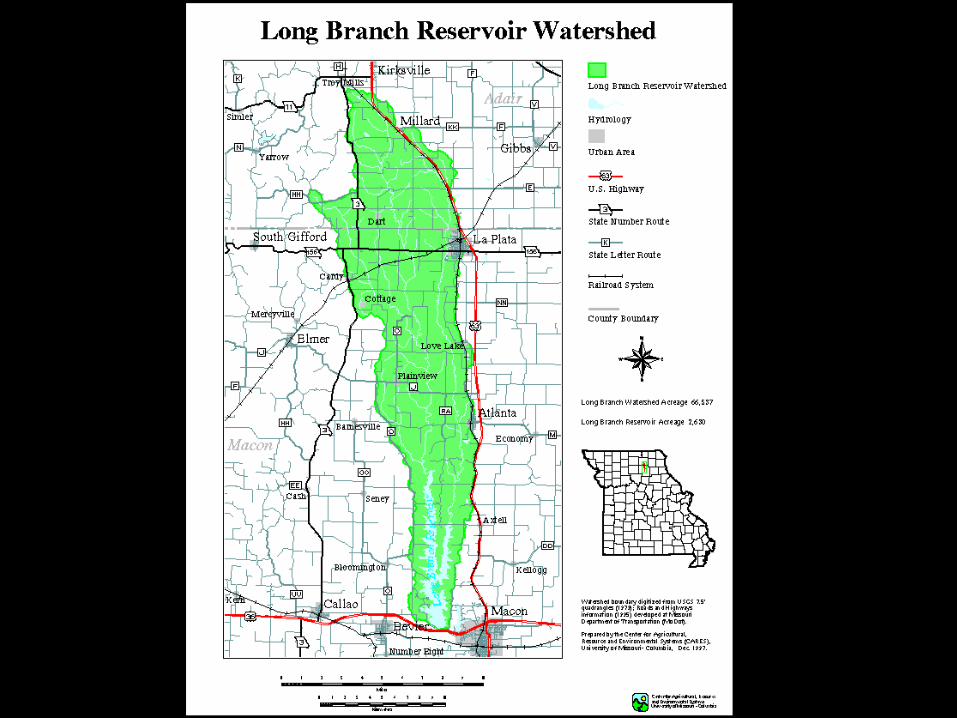
Long Branch Watershed Sub-basins
Sub-basin Acres 1 9,809 2 3,481 3 6,532 4 9,662 5 15,286 6 10,567 7 10,954 Total 66,291

Land Use, by Sub-basin - baseline
0
4,000
8,000
12,000
16,000
1 2 3 4 5 6 7
Sub-basin
Acr
es
Corn Beans Wheat Grassland Trees Urban Water

Conservation Reserve Enhancement Program (CREP) Analysis
Designed to reduce nutrients, pesticides, and sediment in drinking water reservoirs
Replace rowcrops with grass More than 3,300 acres enrolled
– Approximately 5% of the watershed– 17% of cropland acres– Concentrated in northern end of watershed
Revise SWAT to reflect change– Assign CREP acres to sub-basins
Predict environmental benefits of CREP

CREP Land Use Changes
-1500
-1000
-500
0
500
1000
1500
2000
1 2 3 4 5 6 7
Sub-basin
Acr
es
Beans Corn Wheat Grassland Trees Urban Water

Annual Sediment Yield, by Sub-basin
0
5000
10000
15000
20000
25000
30000
35000
40000
1 2 3 4 5 6 7
Sub-basin
Ann
ual S
edim
ent Y
ield
(to
ns)

Annual Average Sediment Loss
-35
-30
-25
-20
-15
-10
-5
0Sed. Yield Cropland
Per
cent
Cha
nge
sb 4 sb 5 sb 6 sb 7

Annual Atrazine Loss, by Sub-basin
050
100150200250300350400450
1 2 3 4 5 6 7
Sub-basin
Ann
ual A
traz
ine
Los
s (l
b ai
/yr)

Annual Average Atrazine Loss
-35
-30
-25
-20
-15
-10
-5
0Runoff Corn
Per
cent
Cha
nge
sb 4 sb 5 sb 6 sb 7
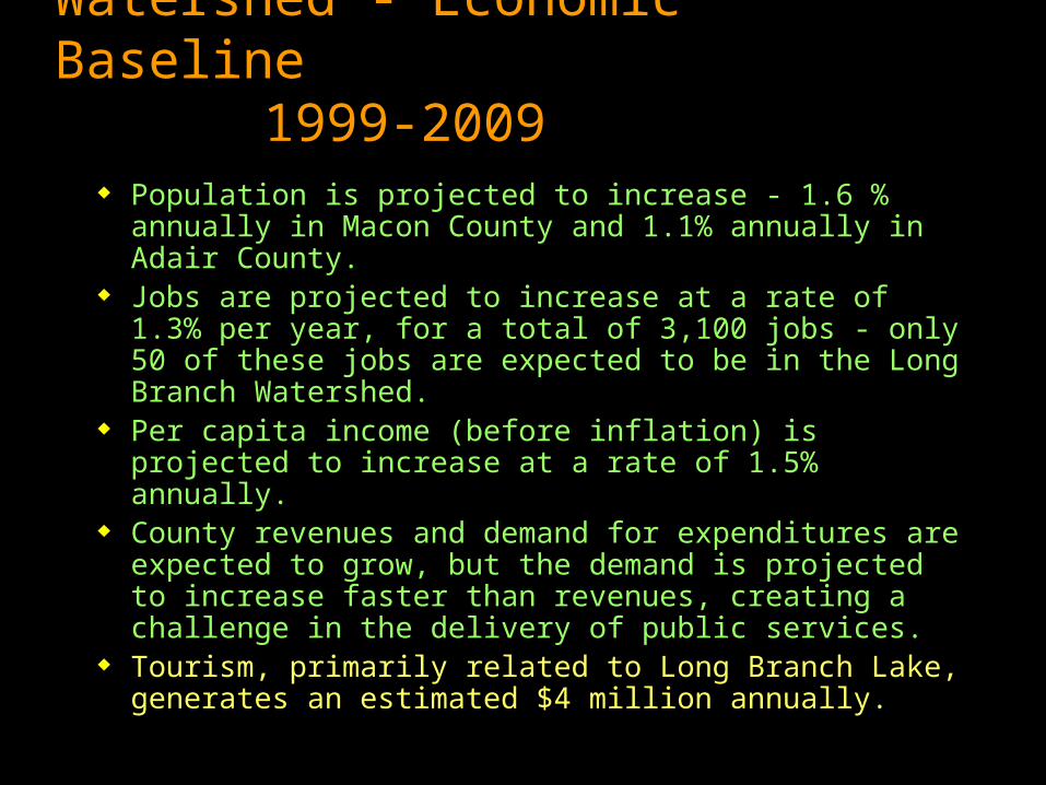
Watershed - Economic Baseline 1999-2009
Population is projected to increase - 1.6 % annually in Macon County and 1.1% annually in Adair County.
Jobs are projected to increase at a rate of 1.3% per year, for a total of 3,100 jobs - only 50 of these jobs are expected to be in the Long Branch Watershed.
Per capita income (before inflation) is projected to increase at a rate of 1.5% annually.
County revenues and demand for expenditures are expected to grow, but the demand is projected to increase faster than revenues, creating a challenge in the delivery of public services.
Tourism, primarily related to Long Branch Lake, generates an estimated $4 million annually.

Economic effects of Implementing CREP Into the Watershed
Year 1 - Add 5.5 jobs and TPI of $106K Year 2 - Total payments decrease as CREP
incentive payments go from 75% to 25% - this results in a loss of 1.9 jobs and reduction of $38K in TPI
Year 3 – Only the annual CRP payment is made – the result is a loss of 1 job and $18K in TPI
15-year total - $3.4 million in incentives and payments put into the hands of a few producers
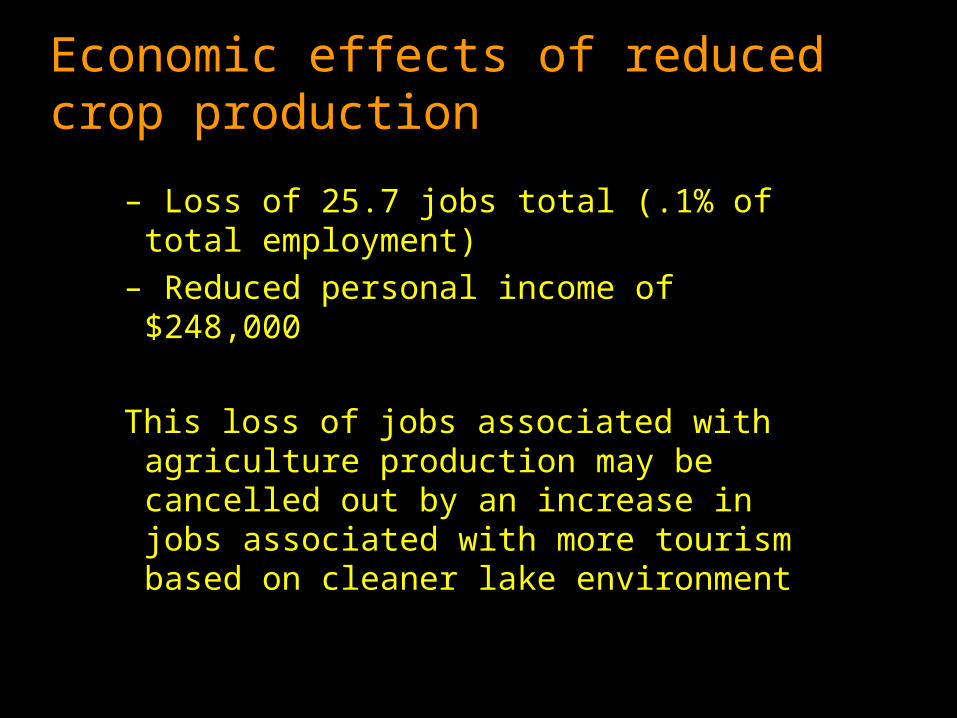
Economic effects of reduced crop production
– Loss of 25.7 jobs total (.1% of total employment)
– Reduced personal income of $248,000
This loss of jobs associated with agriculture production may be cancelled out by an increase in jobs associated with more tourism based on cleaner lake environment

E. coli source tracking
Bacterial pollution associated with human or animal feces may contain pathogenic microbes which can cause human disease.
Fecal E. coli are non-pathogenic “indicators” of the possible presence of disease-producing organisms from human or animal feces.
Each strain of fecal E. coli has a “personal” DNA pattern/signature


Long Branch Watershed CharacteristicsFecal coliform
Fecal coliform – At 2 of 6 sites sampled, E. coli were beyond the state level of 200 pp/100 ml. Total count Source identified
2800 Human, horse, cow2000 Cow, human, horse, sewage4500 Cattle, goose, human, sewage 920 Sewage 138 Sewage, human 200 Cattle, horse, human 890 Sewage, human, chicken

How this has worked….. Watershed community asked to respond to a
TMDL for bacteria DNR tells them to write plans to address horse
and cattle concerns in the watershed DNA source tracking identifies human sewage as
a significant component Watershed residents ask DNR to look at what the
science has identified as contributors to problem Watershed plan written addressing not only cattle
and horse issues but also on-site sewage and human waste.

What is underway?
Based on lake erosion assessment, the city, Corps of Engineers and Mo. Department of Conservation are examining feasibility plan for bank stabilization and water outlet control structure, establishing riparian vegetation, and wetland development at points where creeks empty into lake.

What is underway? AgNPS SALT Project
Funding to implement BMPs to address nutrient, pesticide and soil run-off. * $750,000* 7 years* Macon and Adair County SWCDs* Cost-sharing funds for conservation practices - $457,500* Educational programming funds – $21,300* Equipment - $22,500

Science in the public interest
Action planning process1. Water Management - Promote long-term public awareness
and participation.
2. Environmental & Economic Impacts from Agricultural Practices - Encourage responsible land use that promotes environmental and economic viability through educational endeavor that improve water quality
3. Water Quality - Monitoring and modeling of water quality to determine changes
4. Water Conservation & Management – Incorporate BMPs that reduce pesticide and nutrient loading, bacteria loading and erosion runoff.

Conclusions
Provide science based information to watershed citizens so they have the knowledge to make decisions that will have long term effects on improving water quality and their local communities.
This must incorporate the economic and environmental aspects of the community and must incorporate local citizens that are willing to work towards improving their watershed communities.
