the medieval parish in scotland - clann tuirc taylor.pdf · the medieval parish in scotland 97 the...
TRANSCRIPT
The Journal of Scottish Name Studies 8, 2014, 93–114
1 I would like to thank this Group for input and comments on this article, especially Piers Dixon (RCAHMS), Alasdair Ross (University of Stirling) and Eila Williamson (University of Glasgow).2 For the names of other major contributors, who included the well-known Scottish historian Joseph Robertson, see OPS i, p. xli (1851), ii (1), p. xx (1854) and ii (2) p. xxii (1855).
The Medieval Parish in Scotland
Simon TaylorUniversity of Glasgow
This article is based on a paper I gave to the conference ‘Scottish Society and the Parish’, held in Stirling Tolbooth, Stirling, on 24 November 2010, organised by the Scottish Records Association and the Economic & Social History Society of Scotland to mark the 450th anniversary of the Reformation in Scotland. It explores the emergence of the parish in our earliest records, as well as its ‘territoriality’, looking at how it took on the spatial extent that it did, how that area evolved over the centuries, and how far earlier parochial footprints can still be traced in the modern landscape and place-names. This very much reflects my own interests, as well as the work of the ‘Mapping of the Historical Parishes of Scotland Group’,1 a small group which consists of representatives of NRS, RCAHMS and the Universities of the Highlands and Islands, Glasgow and Stirling.
I will start by looking briefly at what we know of the early evolution of the Scottish parish as a legal and ecclesiastical entity, which will inevitably also be a historiographical survey of the subject. The real start of the serious study of the Scottish parish as a historical entity has to be the Origines Parochiales Scotiae, a splendid production overseen and edited by Cosmo Innes and James Brichan.2 Published by the Bannatyne Club between 1851 and 1855, it has the grand subtitle ‘The Antiquities Ecclesiastical and Territorial of the Parishes of Scotland’. I choose this as my starting point rather than the Statistical Accounts of Scotland, the first of which appeared in the 1790s, now known as the Old Statistical Account. These were indeed organised by parish, but by the parishes as they existed at the time, and the evolution of those units was touched upon unsystematically, dependent to a large extent on the interests of the individual minister-authors.
OPS is a quite different matter, fully recognising as it does the historical importance of medieval ecclesiastical organisation for the social and political history of the kingdom. Each chapter deals with a medieval parish, and the overall shape of the volumes is determined by the medieval dioceses, and within them, the medieval deaneries. Furthermore each volume is accompanied by detailed maps of these units, constituting a bold and pioneering attempt to map medieval Scotland, though it is debateable whether the use of older spellings

Simon Taylor94
The Journal of Scottish Name Studies 8, 2014, 93–114
3 OPS Vol. 1 is devoted to the diocese of Glasgow, covering all parishes in the deaneries of Lanark, Lennox, Peebles, Rutherglen and Teviotdale. However, in the deanery of Kyle and Cunningham only the parishes of Largs & Cumbray and Kilbirnie are covered, and there is no coverage at all of the deaneries of Annan, Carrick, Desnes, Esk or Nith. OPS Vol. 2 is in two
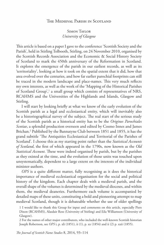
Fig. 1: Detail from OPS i (1851), map of Glasgow Diocese. It shows the medieval parishes of Glenholm 76, Kilbucho 75, with Broughton a dependent chapel of Stobo 81. These were later combined as the single parish of Broughton, Glenholm & Kilbucho. It also shows parts of Biggar 59, Culter 74, Skirling 77 and Lyne 82. All are in the deanery of Peebles, except for nos. 59 and 74, which are in the deanery of Lanark. The spelling of many of the names is taken from medieval sources.
We had with OPS the makings of the Scottish equivalent of England’s Victoria County Histories, but unfortunately the impetus and energy ran out after two volumes, and only the dioceses of Glasgow (part), Argyll, The Isles, Caithness and Ross were covered.3
for all places on the map is an asset. An extract from one of these maps is given in Fig. 1, below.
The Medieval Parish in Scotland 95
The Journal of Scottish Name Studies 8, 2014, 93–114
parts: Vol. 2 i covers all parishes in the diocese of Argyle and the diocese of the Isles; Vol. 2 ii covers all parishes in the diocese of Ross and the diocese of Caithness.4 SHR 40, 43–55; re-published in Cowan 1995, 1–11.5 David I Chrs. no. 172, p. 137 = Dunf. Reg. no. 2, p. 6.
Before moving on from OPS, mention has to be made of the Preface to Vol. 1. This is an extremely well informed, if somewhat tendentious, survey of the development of the parish in Scotland – with more footnotes than text on most of its 23 pages.
Scotland had to wait over a 100 years for the next serious study of its medieval parishes. This was carried out by the late Ian B. Cowan (1932–1990), whose tireless and meticulous scholarship has done so much to advance our knowledge and understanding not just of the medieval parish system, but also of the medieval Ecclesia Scoticana in general. Cowan’s 1961 article ‘The development of the parochial system’4 remains the best introduction to the subject, coupled with his unsurpassed Parishes of Medieval Scotland brought out by the Scottish Record Society in 1967. This contains the most complete inventory to date of all the medieval parishes of Scotland, along with brief histories of provision and appropriation for each one.
In his 1961 article Cowan traces the changing use of the word parochia in Scotland in the medieval period: when it first appears in Scottish sources in the early 12th century it has its earlier meaning of diocese or sphere of influence of a bishop or important early minster church. By the mid-12th century it was being used both in this earlier sense and in its later sense of an area ‘within the jurisdiction of a baptismal church’ (Cowan 1995 [1961], 1).
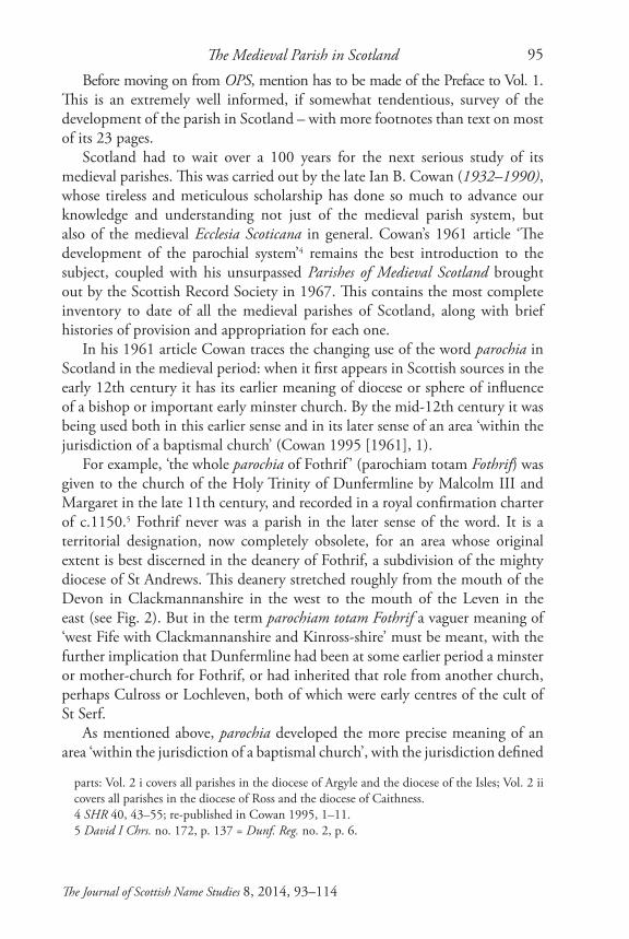
For example, ‘the whole parochia of Fothrif ’ (parochiam totam Fothrif) was given to the church of the Holy Trinity of Dunfermline by Malcolm III and Margaret in the late 11th century, and recorded in a royal confirmation charter of c.1150.5 Fothrif never was a parish in the later sense of the word. It is a territorial designation, now completely obsolete, for an area whose original extent is best discerned in the deanery of Fothrif, a subdivision of the mighty diocese of St Andrews. This deanery stretched roughly from the mouth of the Devon in Clackmannanshire in the west to the mouth of the Leven in the east (see Fig. 2). But in the term parochiam totam Fothrif a vaguer meaning of ‘west Fife with Clackmannanshire and Kinross-shire’ must be meant, with the further implication that Dunfermline had been at some earlier period a minster or mother-church for Fothrif, or had inherited that role from another church, perhaps Culross or Lochleven, both of which were early centres of the cult of St Serf.
As mentioned above, parochia developed the more precise meaning of an area ‘within the jurisdiction of a baptismal church’, with the jurisdiction defined
Simon Taylor96
The Journal of Scottish Name Studies 8, 2014, 93–114
Fig. 2 Map of the sheriffdoms of Clackmannan, Fife and Kinross, showing medieval parishes with their dioceses indicated by shading. The Deanery of Fothrif, diocese of St Andrews, stretched from Cults CLT in the east to Clackmannan CLK in the west. Map from PNF 5, 78. For parish abbreviations, see any volume of PNF, Introduction. See also <http://www.spns.org.uk/parishes/index.html>.

The Medieval Parish in Scotland 97
The Journal of Scottish Name Studies 8, 2014, 93–114
6 ecclesiam Sanct<e> Trinitatis parochialem in Kilrimund 1163 × 1164 St A. Lib. 132; see also PNF 3, s.n.7 Glas. Reg. i nos. 52–53; see Cowan 1995 [1961], 8 for more details.8 Moray Reg. no. 5; RRS ii no. 281, where the editor G. W. S. Barrow dates it ‘1185 × 1189, probably 1187 × 1189’.9 omnes rectitudines ecclesiasticas et omnes decimas vestras de blado et lana et lino, de pullis et vitulis, de purcellis et agnis, de butiro et caseo, de piscariis et de omnibus aliis rebus que Dei operante gratia vobis per annum fuerint innouata, et de omnibus aliis rebus de quibus sancta ecclesia exigit decimas dari.10 Barrow translates this as ‘neyf ’ (RRS ii, p. 306).11 Prohibeo eciam firmiter ne quis decimas suas siue alias rectitudines ecclesiasticas eis iniuste detineat, super meam plenam forisfacturam. Si quis autem decimas vel rectitudinem ecclesiasticam detinere presumpserit, precipio ut compellatur decimam vel rectitudinem illam simil cum forisfacto reddere secundum quod asisa fuit Regis Dauid aui mei, et sicut mos fuit in eius tempore et adhuc est consuetudo in episcopatu Sancti Andree. Scilicet ut si villanus fuerit qui decimam suam vel aliam rectitudinem ecclesiasticam dare noluerit, Theynus sub quo rusticus est vel dominus eius si dominum habuerit, distringat illum decimam illam siue aliam rectitudinem ecclesiasticam ecclesie reddere, et suum ab eo forisfactum accipiat, scilicet unam vaccam et unam ovem. Si vero Theynus sub quo rusticus iste fuerit vel dominus
by the payment of teinds or tenths (in England tithes), and by baptismal and burial rights enforceable through fines and other sanctions. This more precise meaning can be seen emerging almost at the same time as the vaguer usage already seen in Fothrif. For example in the mid-1160s we find a reference to the parish church of the Holy Trinity in Kilrymont6 (ecclesiam Sanct<e> Trinitatis parochialem in Kilrimund), i.e. St Andrews FIF. And in the 1180s we have reference to parochia ecclesie de Libertun ‘the parish of the church of Libberton’ LAN, out of which the parish of Carnwath is in the process of being carved.7
It would seem that the reign of David I (1124–53) was important for setting the parish on a more formal and universal basis. The key document which gives substance to this generally held assumption is a royal brieve issued by William I to the bishop of Moray in the late 1180s.8 In the brieve the king commands all his ‘good and faithful men of Moray’ to pay to their churches, and to the rectors and officers (rectoribus et ministris) ‘all ecclesiastical rights and all your teinds of corn and wool and flax, of foals and calves, of piglets and lambs, of butter and cheese, of fisheries, and of all other things which by the working of God’s grace are year by year renewed for you, and from which Holy Church requires teind to be given’.9 If anyone withholds his teind, he is to be compelled to pay it along with the forfeiture according to the assize of King David ‘and as was the custom in his day and still is in the diocese of St Andrews’. If a villanus or rusticus10 refuses to pay his teind he is to be forced to pay it as well as to be fined one cow and one ewe. The assize then goes on to detail the fines to be imposed on those higher up the secular food-chain, including the lord (dominus), the thane and the sheriff, both for failure to pay their own teind and, just as importantly, for failure to enforce a defaulter to pay teind.11 So already in the 12th century we see
Simon Taylor98
The Journal of Scottish Name Studies 8, 2014, 93–114
Church and State hand in glove to ensure the material provision of the parish.12 Such enforcement depends of course on everyone in a locality knowing
exactly who they had to pay their teinds to: ignorance of or imprecision concerning the physical limits of a parish could lead to serious complications, including even the possibility of being forced to pay twice over. However, the close connection we have already seen between the secular and the ecclesiastical in the so-called David I assize suggests in fact that the two jurisdictions, secular and ecclesiastical, coincided to a large extent.
It was this coincidence that was explored in great detail, and to great effect, by John Rogers in his pioneering 1992 PhD thesis ‘The Formation of the Parish Unit and Community in Perthshire’, University of Edinburgh, under the supervision of Geoffrey Barrow. With a wealth of detail, both documentary and geographical, Rogers showed beyond doubt that the boundaries of the medieval parishes in Perthshire were determined by those of pre-existing secular units of lordship. And furthermore there was nothing to suggest that Perthshire was in any way atypical within a medieval Scottish context. Rogers’s thesis contains hand-drawn maps which attempt to define the exact extent of every medieval parish in central and eastern Perthshire, and it can thus be assumed that these maps also delineate early units of secular lordship.
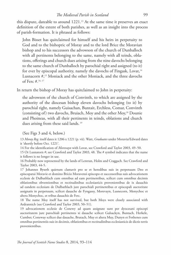
The diocese of Moray provides good corroborative evidence for this close correlation between the secular territorial unit and the parish. In the early 13th century a dispute had arisen between the bishop of Moray and the local lord, John Bisset, regarding the advowson or patronage of the churches of Dunballoch (later Wardlaw) and Convinth, which lay south-west of Inverness, and south of Beauly (see Fig. 3). Moray Reg. no. 51 records the settlement of
eius si dominum habeat illum ad hoc non distrinserit, vel si propriam decimam vel aliam rectitudinem ecclesiasticam detinuerit, Vicecomes in cuius balliua hoc fuerit compellat detentorem decimam vel rectitudinem suam ecclesie soluere, et comtemptorem assise Regis Da<ui>d et mandati mei, siue Theynus siue dominus rustici fuerit, mihi forisfactum suum reddere, scilicet .viiito. vaccas. Si autem Vicecomes huius mandati negligens executor fuerit, vel propriam decimam vel aliam rectitudinem ecclesiasticam detinere presumpserit, Justic<ia> mea compellat detentorem quicunque fuerit ecclesie decimam suam vel aliam rectitudinem ecclesiasticam reddere, et transgressorem asise Regis Da<ui>d et precepti mei quicunque fuerit, siue Vicecomes, siue Theynus, siue dominus rustici, mihi forisfactum reddere, scilicet .viii. vaccas. Ut nos ita qui filii sancte matris ecclesie esse debemus ei amore et timore divino iura sua integra conseruemus et illibata, ut qui ei rebelles fuerint non impune ferant, nec per proteruitatem suam et obstinationem iura et rectitudines sancte matris ecclesie vel diminuant vel auferant.12 It should not necessarily be assumed from this that parishes were only now (in 1180s) being established along these lines in Moray. It may be that the brieve is re-establishing them after the disruption of the MacWilliam uprising (1181-87). I am grateful to Alasdair Ross for making this point.
The Medieval Parish in Scotland 99
The Journal of Scottish Name Studies 8, 2014, 93–114
13 Moray Reg. itself dates it 1206 x 1221 (p. vii). Watt, Graduates under Moravia/Edward dates it ‘shortly before Oct. 1221’.14 For the identification of Morevayn with Lovat, see Crawford and Taylor 2003, 49–50.15 Or Lusnatorn #; see Crawford and Taylor 2003, 48. The # symbol indicates that the name it follows is no longer in use.16 Probably now represented by the lands of Lentran, Holm and Craggach. See Crawford and Taylor 2003, 44-5.17 Johannes Byseth quietum clamavit pro se et heredibus suis in perpetuum Deo et episcopatui Moravie et domino Bricio Moravensi episcopo et successoribus suis advocationem ecclesie de Dulbathlach cum omnibus ad eam pertinentibus, scilicet cum omnibus decimis oblationibus obventionibus et rectitudinibus ecclesiasticis provenientibus de ix dauachis ad eandem ecclesiam de Dulbathlach jure parochiali pertinentibus et episcopali auctoritate assignatis in perpetuum, scilicet dauache de Fyngassy, Morevayn, Lusnecorn, Monychoc et altera Monychoc, et tribus dauachis de Ferc.18 The name Moy itself has not survived, but both Moys were closely associated with Ardrannich (see Crawford and Taylor 2003, 50–51).19 advocationem ecclesie de Conewy ad quam assignate sunt per dyocesani episcopi auctoritatem jure parochiali pertinentes xi dauache scilicet Gulsackyn, Buntach, Herkele, Cumber, Coneway scilicet due dauache, Brutach, Muy et altera Muy, Dunyn et Fothenes cum omnibus pertinentiis suis in decimis, oblationibus et rectitudinibus ecclesiasticis de dictis terris provenientibus.
this dispute, dateable to around 1221.13 At the same time it preserves an exact definition of the extent of both parishes, as well as an insight into the process of parish-formation. It is phrased as follows:
John Bisset has quitclaimed for himself and his heirs in perpetuity to God and to the bishopric of Moray and to the lord Brice the Moravian bishop and to his successors the advowson of the church of Dunballoch with all pertinents belonging to the same, namely with all teinds, obla-tions, offerings and church dues arising from the nine davochs belonging to the same church of Dunballoch by parochial right and assigned (to it) for ever by episcopal authority, namely the davochs of Fingask, Lovat,14 Lusnacorn #,15 Moniack and the other Moniack, and the three davochs of Ferc #.16, 17
In return the bishop of Moray has quitclaimed to John in perpetuity:
the advowson of the church of Convinth, to which are assigned by the authority of the diocesan bishop eleven davochs belonging (to it) by parochial right, namely Guisachan, Buntait, Erchless, Comar, Convinth (consisting of ) two davochs, Bruiach, Moy and the other Moy,18 Dounie and Phoineas, with all their pertinents in teinds, oblations and church dues arising from these said lands. 19
(See Figs 3 and 4, below.)
Simon Taylor100
The Journal of Scottish Name Studies 8, 2014, 93–114
Fig. 3. Map of part of north-east Inverness-shire, showing the medieval parishes of Convinth, Kilmorack, Kiltarlity, Farnway # and Wardlaw. From Crawford and Taylor 2003, 13.
The Medieval Parish in Scotland 101
The Journal of Scottish Name Studies 8, 2014, 93–114
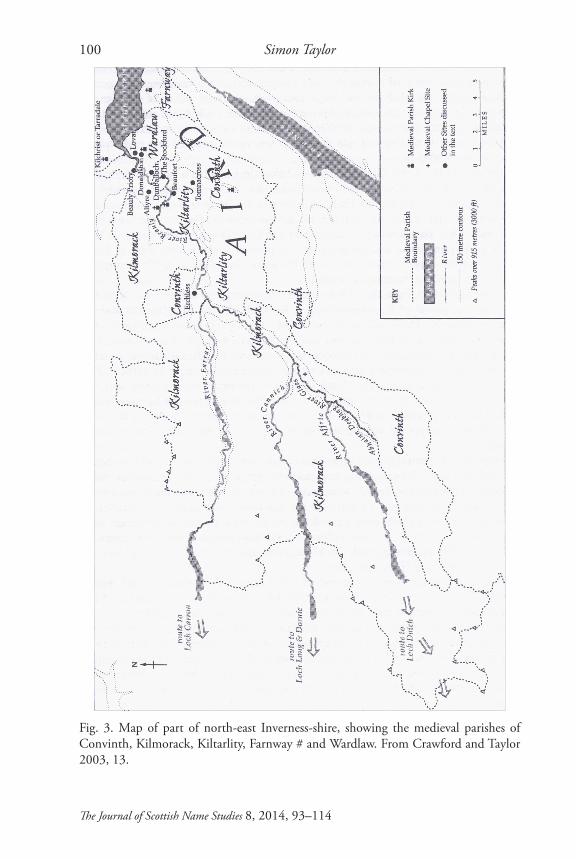
Fig. 4. The davochs assigned to the parish churches of Convinth and Dunballoch (Wardlaw) by the agreement of c.1221 (Moray Reg. no. 51). From Crawford and Taylor 2003, 36.

Simon Taylor102
The Journal of Scottish Name Studies 8, 2014, 93–114
20 The same applies to Ross, Sutherland, parts of Caithness, and (probably) the Hebrides north of the Ardnamurchan peninsula. See Ross, forthcoming. I am grateful to Alasdair Ross for this reference.21 Probably a scribal or editorial error for Lecheni Michel.
Just as the parish is the building-block of the diocese, it clearly emerges from the foregoing that the building-block of the parish itself, at least in Moray, was the davoch.20 This can be defined as a sizeable measurement of land of variable area, with each davoch possessing ‘the necessary resources for a group of people to survive throughout the year’. I quote here from the doyen of davochs, Alasdair Ross (2006, 66). The davoch was also the basic unit of assessment north of the Forth for obligations such as army service.
There is no doubt that Convinth was in origin a secular unit, and this is reinforced by its name, which belongs very much to the sphere of secular lordship. ‘Convinth’ derives from OG *conmed, later *coinmheadh ‘billeting, quartering’, referring to a tribute due to the king or other lord in respect of his lordship, specifically hospitality, entertainment and accommodation, or some payment in lieu of these. No doubt the place called Convinth was already the central place to which the inhabitants of the 11 named davochs brought their tribute to be consumed by the lord, with the parish very sensibly being imposed on this pre-existing pattern. That factors other than simple convenience for the parishioners were at play is also indicated by the fact that the davochs making up the parish of Convinth do not form a continuous block of territory (see Figs 3 and 4).
In an important article published in 1989 in Northern Scotland 9, on the Church in Badenoch and Strathspey 1130–1312, Geoffrey Barrow skilfully reconstructs the pattern of provision of pastoral care in this area just before the development of fully-fledged parishes. As with so much of Barrow’s work, it is an impressive combination of various types of evidence: the medieval documentary record, toponymic evidence, above all that of hagiotoponyms or place-names containing saints’ names, local traditions and local geography.
Barrow’s map (Fig. 5, below) attempts to reconstruct the pre-parochial provision of Stratha’an in Banffshire, a territory stretching about 25km north to south. In a charter dateable to about 1200 Richard of Lincoln bishop of Moray leased to Earl Duncan of Fife 9 half-davochs in Stratha’an, all of which are named, and at least 6, probably 7, of which have a saint’s name attached, while one includes the name of Christ himself (Nevie Christ). It was out of this patch-work of chapels that in the course of the 13th century two parishes evolved: in the north that of Inveravon, near where the Avon meets the Spey, and in the south Kirkmichael, the germ of which was Achlichnie (Letheni Michel 21 of Moray Reg. no 16), chosen presumably as the focal point for the new

The Medieval Parish in Scotland 103
The Journal of Scottish Name Studies 8, 2014, 93–114
parish because of its relatively central position, not geographically, since the parish stretched as far south as Ben Macdui, but in terms of settled population.
Generally speaking the choice of the site of a parish kirk was no doubt determined by various factors, ranging from venerable and sacred tradition to secular and practical considerations. And there would also have been some experimentation, and some failure.
For example, remaining in the diocese of Moray, and returning to the church of Dunballoch by Beauly, we know that in around 1221 it was moved to a new
Fig. 5. Map from Barrow 1989, 5, Fig. 2: Stratha’an.
Simon Taylor104
The Journal of Scottish Name Studies 8, 2014, 93–114
22 ‘Johannes Byseth ... contulit et concessit in puram et perpetuam elemosinam ecclesie de Dulbatelach septem acras terre in loco competenti et propinquo ecclesie parochiane de Dulbatelach cum fuerit translata ad Fingasc ad locum qui dicitur Wardelau(e) scotice Balabrach/Balcabrac’ Moray Reg. nos. 21, 51. Forms confirmed by the ms from which the printed version was taken, NLS Adv. MS 34.4.10 fos 19r (Balabrach’), 28v (Balcabrac). For more discussion of this name, see Crawford and Taylor 2003, 25, 53–54 (under Cabrich).
site a few kilometres to the north-east. We learn this from the same charter which records the agreement between John Bisset and Bishop Brice of Moray concerning the churches of Dunballoch and Convinth (see above). At the same time as quitclaiming the advowson or patronage of the church of Dunballoch to the bishop, Bisset ‘has conferred and granted in pure and perpetual alms to the church of Dunballoch seven acres of land in a suitable place and near to the parish kirk of Dunballoch when it has been moved to Fingask to the place which is called Wardlaw, in Gaelic Balcabrac.’22 While no reason is given for the move, the place-name Dunballoch, earlier Dulbatelach, gives a clue, as it probably means ‘haugh liable to flooding’ (literally ‘drowning’). It may have been originally chosen as the site of the parish kirk because of an early religious association, but a flood shortly before 1221 may have caused practical considerations to outweigh religious ones, with Wardlaw, as the name indicates, being on the top of a hill, the eponymous hill in the modern name of the parish, Kirkhill (see Fig. 6, below).
We have a less well documented instance of the shift of a parish centre at around the same time (the 1220s) in north Fife, when the parish kirk of Coultra shifted to Balmerino (see PNF 4, 146–50). It is noteworthy that both these shifts involved a name-change. The name of a parish regularly derives from the name of the place where the kirk originally stood, if it does not explicitly refer to the kirk and/or its dedication. However, once the parish name had become established, it usually persisted even when the site of the parish kirk moved. For example, in the 17th century the church of Portmoak KNR moved from its original site on the shore of Loch Leven, where the eponymous port (Gaelic for ‘harbour’) was, 1.6km to the north-east, near Scotlandwell, which lay much more conveniently for the bulk of the parishioners (see PNKNR forthcoming, under Portmoak). A counter-example is the parish kirk of Kilgour FIF, which moved almost 3km eastwards into the burgh of Falkland in the early 17th century, the parish thereafter becoming known as Falkland. However, even in the case of this fairly drastic move, the old name hung on for almost two centuries, a sasine of 1782 (no. 374) still referring to the parish church of Kilgour or Falkland (PNF 2, 137). The fact that neither Dunballoch or Coultra survived as parish names is further evidence that as parishes they were not long established at the time of the move.
The Medieval Parish in Scotland 105
The Journal of Scottish Name Studies 8, 2014, 93–114
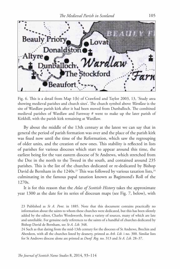
Fig. 6. This is a detail from Map 1(b) of Crawford and Taylor 2003, 13, ‘Study area showing medieval parishes and church sites’. The church symbol above Wardlaw is the site of Wardlaw parish kirk after it had been moved from Dunballoch. The combined medieval parishes of Wardlaw and Farnway # went to make up the later parish of Kirkhill, with the parish kirk remaining at Wardlaw.
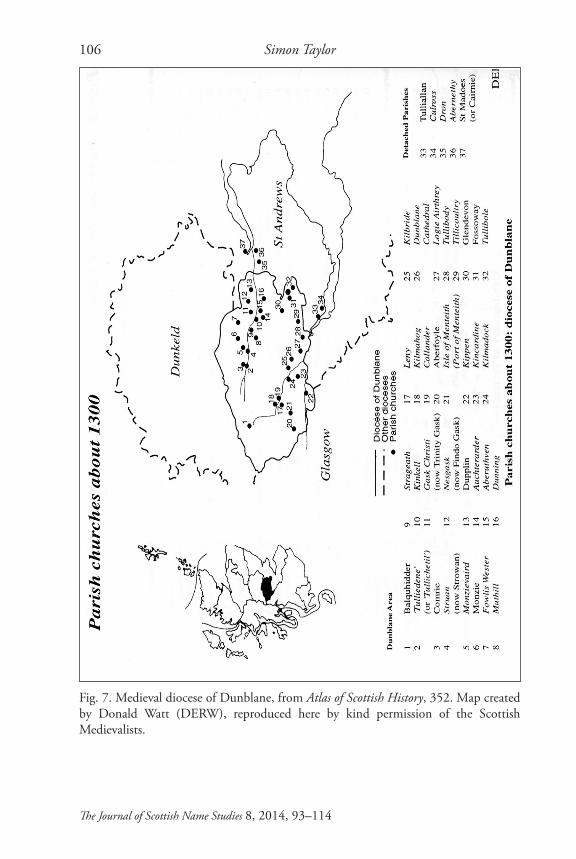
By about the middle of the 13th century at the latest we can say that in general the period of parish formation was over and the place of the parish kirk was fixed now until the time of the Reformation, which saw the regrouping of older units, and the creation of new ones. This stability is reflected in lists of parishes for various dioceses which start to appear around this time, the earliest being for the vast eastern diocese of St Andrews, which stretched from the Dee in the north to the Tweed in the south, and contained around 235 parishes. This is the list of the churches dedicated or re-dedicated by Bishop David de Bernham in the 1240s.23 This was followed by various taxation lists,24 culminating in the famous papal taxation known as Bagimond’s Roll of the 1270s.
It is for this reason that the Atlas of Scottish History takes the approximate year 1300 as the date for its series of diocesan maps (see Fig. 7, below), with
23 Published as St A. Pont. in 1885. Note that this document contains practically no information about the saints to whom these churches were dedicated, but this has been silently added by the editor, Charles Wordsworth, from a variety of sources, many of which are late and unreliable. For genuine early references to the saints of a handful of churches dedicated by Bishop David de Bernham, see St A. Lib. 348.24 Such as that dating from the mid-13th century for the dioceses of St Andrews, Brechin and Aberdeen, with all the churches listed by deanery, printed as Arb. Lib. i no. 300. Similar lists for St Andrews diocese alone are printed as Dunf. Reg. no. 313 and St A. Lib. 28–37.
Simon Taylor106
The Journal of Scottish Name Studies 8, 2014, 93–114
Fig. 7. Medieval diocese of Dunblane, from Atlas of Scottish History, 352. Map created by Donald Watt (DERW), reproduced here by kind permission of the Scottish Medievalists.
The Medieval Parish in Scotland 107
The Journal of Scottish Name Studies 8, 2014, 93–114
25 The Atlas of Scottish History to 1707 arose out of collaborative work by the Scottish Medievalists and the Department of Geography, University of Edinburgh. Published in 1996, it partly replaced a smaller Historical Atlas of Scotland c.400–c.1600 published by the Scottish Medievalists in 1975.26 By modern is meant the quoad omnia parishes whose boundaries were depicted on OS maps until the late 1970s.27 This list, which is still very much a ‘work in progress’, can be accessed on <http://www.spns.org.uk>. It includes very brief notes on individual parishes, with some information on the dedication of the parish kirk, as well as the names of scholars who have worked or are working on parish evolution in different parts of Scotland. Similar, but more extensive, notes on individual parishes, but without dedicatory information, can be found on <http://www.scotlandsplaces.gov.uk/>, which also brings together a very useful set of sources relating to individual parishes in their most recent incarnation (i.e. 1891–1975), and makes available the relevant sections of Shennan 1892.28 <http://saintsplaces.gla.ac.uk/>.29 For examples of this, see Márkus 2008 and PNF 4, 55, 146, 163, 338.
the site of every parish kirk known to exist at the time. This was the first such attempt to map the whole of the medieval Scottish Church.25
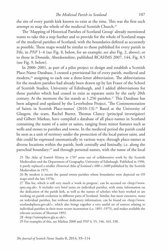
The ‘Mapping of Historical Parishes of Scotland Group’ already mentioned wants to take this a step further and to provide for the whole of Scotland maps of the medieval parishes of Scotland, with the boundaries defined as accurately as possible. These maps would be similar to those published for every parish in Fife, in PNF 1–4 (see Fig. 8, below, for an example; see also Fig. 2, above); or to those in Donside, Aberdeenshire, published RCAHMS 2007, 144, Fig. 8.5 (see Fig. 9, below).
In 2000–2001, as part of a pilot project to design and establish a Scottish Place-Name Database, I created a provisional list of every parish, medieval and modern,26 assigning to each one a three-letter abbreviation. The abbreviations for the modern parishes had already been drawn up by Ian Fraser of the School of Scottish Studies, University of Edinburgh, and I added abbreviations for those parishes which had ceased to exist as separate units by the early 20th century. At the moment the list stands at 1,256 parishes.27 This Database has been adapted and updated by the Leverhulme Project, ‘The Commemoration of Saints in Scottish Place-names’ (2010–13).28 Based at the University of Glasgow, the team, Rachel Butter, Thomas Clancy (principal investigator) and Gilbert Márkus, have compiled a database of all place-names in Scotland containing the name of a saint or saints, ranging from minor features such as wells and stones to parishes and towns. In the medieval period the parish could be seen as a unit of territory under the protection of the local patron saint, and this could be expressed onomastically in various ways: through place-names at diverse locations within the parish, both centrally and liminally, i.e. along the parochial boundary;29 and through personal names, with the name of the local
Simon Taylor108
The Journal of Scottish Name Studies 8, 2014, 93–114
Fig. 8. Map of Dunbog parish, north Fife, showing the older (medieval) boundaries. PNF 4, 337.
The Medieval Parish in Scotland 109
The Journal of Scottish Name Studies 8, 2014, 93–114
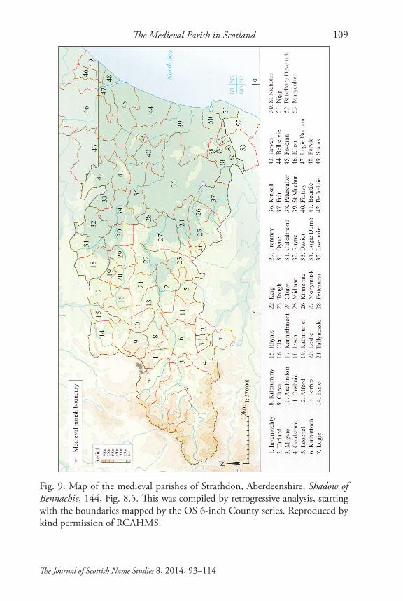
Fig. 9. Map of the medieval parishes of Strathdon, Aberdeenshire, Shadow of Bennachie, 144, Fig. 8.5. This was compiled by retrogressive analysis, starting with the boundaries mapped by the OS 6-inch County series. Reproduced by kind permission of RCAHMS.
Simon Taylor110
The Journal of Scottish Name Studies 8, 2014, 93–114
30 For example, Gillemachoi of Kinclaith, Glasgow, ‘the servant of St Mungo’, along with his children and dependants, whom King William quitclaimed to Glasgow Cathedral, whose patron saint is Mungo or Kentigern (1175 x 1190 RRS ii no. 217; see also editor’s comments ibid., p. 265); and the two, possibly three, men called Gillmohegu (Gilla mo Fhécu), ‘the servant of St Féchín’, associated with Lesmahagow LAN, ‘the enclosure of St Féchín’, in the second half of the 12th century (Kel. Lib. nos. 107, 109, 110, 114; see also Watson 1926, 196 and Taylor 2009, 72, footnote 37).31 See <http://arts.st-andrews.ac.uk/~cmas/>.
saint combined with elements such as Gille and Maol, both signifying ‘servant’ or ‘devotee’.30 In such a study it is therefore of prime importance to define the medieval parochial units, while conversely the data itself provides unique evidence regarding the extent of these units, as well as regarding the dedication of the medieval parish kirk which can in some cases have been otherwise lost.
Other work on the medieval parish is the Corpus of Scottish Medieval Parish Churches. This is based at the Universities of St Andrews and Stirling. From 2008 to 2011 an AHRC-funded pilot project surveyed the Dioceses of Dunblane (38 churches) and Dunkeld (67 churches). Further AHRC funding is enabling an extension of this study to the medieval dioceses of St Andrews and Brechin. Its principal focus is the surviving medieval fabric of the churches. While there is some parochial history included, it does not deal with the spatial extent of the medieval units which lay to the individual churches.31
Sources for Reconstructing the Medieval ParishAny attempt to reconstruct the medieval administrative geography of Scotland must start with the parish and county boundaries as shown on Ordnance Survey maps such as the 1 inch and 6 inch to the mile series published prior to 1891. It was in this year that these units were extensively rationalised as part of the setting up of the County Councils. All the parish and county boundary changes which came into effect in that year are described in detail in Shennan 1892.
Many of the post-Reformation changes to parish boundaries can be found detailed in APS vol. 12 (General Index) under PLANTATION of Kirks (Union, Disjunction and Erection of Kirks and Parishes), pp. 979–81. There are detailed descriptions of the extent of some parishes in the 1620s in Reports on the State of Certain Parishes in Scotland (Maitland Club 1835). Information about some early modern changes to individual parishes can also be found in the Old and New Statistical Accounts. In the Bibliography and References, below, I have given some sources, published and unpublished, for medieval parish development in various parts of Scotland.
The Medieval Parish in Scotland 111
The Journal of Scottish Name Studies 8, 2014, 93–114
Bibliography and ReferencesThis section includes works relating to individual parishes and groups of parishes, not all of which are mentioned in the above article. Where appropriate, the relevant pre-1975 county abbreviations (for which see below) are given in bold in square brackets following the reference.
Aberdeen-Banff Coll.: Collections for a History of the Shires of Aberdeen and Banff, ed. J. Robertson (Spalding Club 1843) [ABD and BNF].
Aberdeen-Banff Ill.: Illustrations of the Topography and Antiquities of the Shires of Aberdeen and Banff, ed. J. Robertson, Spalding Club 1847–69 (4 Vols.) [ABD and BNF].
Adam, R. J., 1993, ‘Meathie-Lour: a parish exploration’, Records of the Scottish Church History Society 25, 1993, 41–67 [ANG].
APS: The Acts of the Parliaments of Scotland, ed. T. Thomson and C. Innes 1814–75 [see also RPS, below].
Arb. Lib.: Liber S. Thome de Aberbrothoc (Bannatyne Club, (2 volumes) 1848–56).
Atlas of Scottish History: Atlas of Scottish History to 1707, ed. P. G. B McNeill and H. L. MacQueen (Scottish Medievalists and the Department of Geography, University of Edinburgh, Edinburgh 1996). Available on <http://www.scotlandsplaces.gov.uk/digital-volumes/published-gazetteers-and-atlases/atlas-scottish-history-1707>.
Bagimond’s Roll: ‘Bagimond’s Roll: Statement of the Tenths of the Kingdom of Scotland’, ed. A. I. Dunlop, SHS Misc. vi (1939), 3–77.
Barrow, G. W. S., 1989, ‘Badenoch and Strathspey, 1130–1312: The Church’, Northern Scotland 9, 1–16.
Brooke, Daphne, 1994, Wild Men and Holy Places (Edinburgh) [map of medieval parishes of KCB and WIG, with some boundaries, p. viii].
Cowan, I. B., 1961, ‘The Development of the Parochial System in Medieval Scotland’, SHR 40, 43–55 [re-published in Cowan 1995, 1–11].
Cowan, I. B., 1967, The Parishes of Medieval Scotland, Scottish Record Society vol. 93 (Edinburgh). Now available on <http://www.stir.ac.uk/cehp/mapping-parishes-medieval-scotland/parishes-medieval/>.
Cowan, I. B., 1995, The Medieval Church in Scotland, ed. James Kirk (Edinburgh).
Crawford, Barbara E., and Taylor, Simon, 2003, ‘The Southern Frontier of Norse Settlement in North Scotland: Place-Names and History’, Northern Scotland 23, 1–76 [maps of the medieval parishes of Convinth, Fernua #, Kilmorack, Kiltarlity and Wardlaw (modern Kilmorack, Kiltarlity & Convinth and Kirkhill INV].
Simon Taylor112
The Journal of Scottish Name Studies 8, 2014, 93–114
Dunf. Reg.: Registrum de Dunfermelyn (Bannatyne Club, 1842).Gibbon, Sarah Jane, 2006, ‘The origins and early development of the parochial
system within the Orkney earldom’, unpublished PhD thesis, University of the Highlands and Islands Millennium Institute [ORK].
Gibbon, Sarah Jane, 2007, ‘Medieval Parish Formation in Orkney’, in West over Sea: studies in Scandinavian sea-borne expansion and settlement before 1300. A Festschrift in honour of Dr Barbara E. Crawford, ed. B. Ballin Smith, S. Taylor and G. Williams (Leiden and Boston), 235–50 [ORK].
Kel. Lib.: Liber S. Marie de Calchou (Bannatyne Club, 1846).Márkus, Gilbert, 2008, ‘Saints and Boundaries: the Pass of St Mocha and St
Kessog’s Bell’, Journal of Scottish Name Studies 2, 69–84 [STL].Márkus, Gilbert, 2009, ‘Balinclog: A Lost Parish in Ayrshire’, Journal of Scottish
Name Studies 3, 47–64 [AYR].McNiven, Peter E., 2011, ‘Gaelic Place-names and the Social History of Gaelic
Speakers in Medieval Menteith’, unpublished PhD, University of Glasgow [<http://theses.gla.ac.uk/2685/>] [Menteith PER].
Moray Reg.: Registrum Episcopatus Moraviensis (Bannatyne Club, 1837).Morrison, Jenni, Oram, Richard and Ross, Alisdair [sic for ‘Alasdair’], with
a contribution by J. Franklin, 2009, ‘Gogar, archaeological and historical evidence for a lost medieval parish near Edinburgh’, Proceedings of the Society of Antiquaries of Scotland 139, 229–55 [MLO].
Nicolaisen, W. F. H., et al., 1970, The Names of Towns and Cities in Britain, compiled by Margaret Gelling, W. F. H. Nicolaisen and Melville Richards, ed. W. F. H. Nicolaisen (London).
Nicolaisen, W. F. H., 1976, Scottish Place-Names (London; 2nd impression with additional information 1979; new edition with minor changes, Edinburgh 2001).
NSA: The New Statistical Account of Scotland, by the ministers of the respective parishes, under the superintendence of a committee of the Society for the Benefit of the Sons and Daughters of the Clergy (Edinburgh 1845) [<http://stat-acc-scot.edina.ac.uk/sas/sas.asp?action=public>].
OPS: Origines Parochiales Scotiae : The Antiquities Ecclesiastical and Territorial of the Parishes of Scotland, Bannatyne Club, 1851–55.
Vol. 1 <https://archive.org/details/originesparochia01bann> Vol. 2 parts i and ii presented as one volume: <https://archive.org/details/
originesparoc97a02unknuoft> Vol. 2 part ii (pp. 391 ff.): <https://archive.org/details/originesparv2pt297
_inneuoft> OSA: The [Old] Statistical Account of Scotland 1791–99 (Edinburgh; reissued
county by county in 20 volumes, with new introductions, 1978)
The Medieval Parish in Scotland 113
The Journal of Scottish Name Studies 8, 2014, 93–114
<http://stat-acc-scot.edina.ac.uk/sas/sas.asp?action=public>.PNF 1: Place-Names of Fife Vol. 1 (West Fife between Leven and Forth),
Simon Taylor with Gilbert Márkus (Donington 2006) [FIF].PNF 2: Place-Names of Fife Vol. 2 (Central Fife between Leven and Eden),
Simon Taylor with Gilbert Márkus (Donington 2008) [FIF].PNF 3: Place-Names of Fife Vol. 3 (St Andrews and the East Neuk), Simon
Taylor with Gilbert Márkus (Donington 2009) [FIF].PNF 4: Place-Names of Fife Vol. 4 (North Fife between Eden and Tay),
Simon Taylor with Gilbert Márkus (Donington 2010) [FIF].PNF 5: Place-Names of Fife Vol. 5 (Discussion, Elements Glossaries, Edited
texts, etc), Simon Taylor with Gilbert Márkus, (Donington 2012) [final volume of a 5-volume series].
PNKNR forthcoming: Place-Names of Kinross-shire, Simon Taylor with Peter McNiven and Eila Williamson.
RCAHMS 2007: In the Shadow of Bennachie: A Field Archaeology of Donside, Aberdeenshire (Edinburgh).
Reid, John, 1993, ‘The Parishes of East Stirlingshire during the Feudal Period’, Calatria 4, 79–88 [STL].
Reports: Reports on the State of Certain Parishes in Scotland (Maitland Club, 1835).
Rogers, John M., 1992, ‘The Formation of the Parish Unit and Community in Perthshire’, unpublished PhD, Edinburgh University [PER].
Rogers, John M., 1997, ‘The formation of parishes in twelfth-century Perthshire’, Records of Scottish Church History Society 27, 68–96 [PER].
Ross, Alasdair D., 2003, ‘The Province of Moray, c.1000–1230’, 2 vols., unpublished PhD thesis, University of Aberdeen.
Ross, Alasdair, 2006, ‘The Dabhach in Moray: A New Look at an Old Tub’, in Landscape and Environment in Dark Age Scotland, ed. Alex Woolf (St Andrews), 57–74.
Ross, Alasdair, forthcoming, Medieval Landscape and Land Assessment in Medieval Northern Scotland (Turnhout, Belgium).
RPS: Records of the Parliaments of Scotland to 1707, University of St Andrews, <http://www.rps.ac.uk>.
RCAHMS: Royal Commission on the Ancient and Historical Monuments of Scotland.
Shennan, H., 1892, Boundaries of Counties and Parishes in Scotland (Edinburgh). Available on <http://www.scotlandsplaces.gov.uk/>.
St A. Lib. Liber Cartarum Prioratus Sancti Andree in Scotia (Bannatyne Club, 1841).
St A. Pont.: Pontificale Ecclesiae S. Andreae, The Pontifical Offices used by David de
Simon Taylor114
The Journal of Scottish Name Studies 8, 2014, 93–114
Bernham Bishop of St Andrews 1239–53, ed. Charles Wordsworth (Edinburgh 1885).
Taylor, Simon, 2009a, ‘Place-names of Lesmahagow’, Journal of Scottish Name Studies 3, 65–106.
Thomas, Sarah E., 2008, ‘From Rome to “the ends of the habitable world”: the provision of clergy and church buildings in the Hebrides, circa 1266 to circa 1472’, PhD thesis, University of Glasgow.
Watson, Angus, 2002, ‘Place-Names, Land and Lordship in the Medieval Earldom of Strathearn’, unpublished PhD thesis, University of St Andrews [western Strathearn PER].
Watson, William J., 1926, The History of the Celtic Place-Names of Scotland (Edinburgh and London; reprinted with an Introduction by Simon Taylor, Edinburgh 2004; and, with an extended Introduction, Edinburgh 2011).