the maryland state highway administration · 2012-07-26 · prepared for: the maryland state...
TRANSCRIPT


Prepared for:
The Maryland State Highway Administration 707 N. Calvert Street
Baltimore, MD 21202
Prepared by: Lardner/Klein Landscape Architects, P.C.
814 King Street, 4th FloorAlexandria, VA 22314
Jim Klein, ASLA / [email protected]
in association with Oldham Historic Properties, Inc.
Sally Oldham / [email protected]
Project Manager:Mr. Terence Maxwell, Scenic Byways Coordinator, Maryland SHA / 410-545-8637
Context Sensitive Solutions for the
Maryland Historic National Road Scenic Byway

Acknowledgments
Maryland Historic National Road Context Sensitive Solutions Committee
Thank you to the following people for their thoughtful advice and participation in the development of this guidebook. Special thanks to Mr. Charles Adams for his overall vision and support for the preservation, maintenance and enhancement of Maryland’s Historic National Road and to Mr. Fred Crozier, District Engineer and Mr. K.C. Keith, Traffic Engineer in District 6 for their on the ground knowledge and contributions on behalf of Maryland’s Historic National Road.
Mr. Terence Maxwell, Scenic Byways Coordinator, Maryland SHAMr. Charles Adams, Director, Office of Environmental Design, Maryland SHA
Mr. Dennis Adams, National Scenic Byways Program, Federal Highway Administation,
Mr. Joe Adkins, Frederick City Historic District CommissionMr. Jim Brown, ARME, District 7, Frederick Shop, Maryland SHAMs. Liz Buxton,Cultural Resources, Project Planning Division, Maryland SHA,Mr. David Coyne, District 7, Maintenance, Maryland SHA, Mr. Fred Crozier, District Engineer, Maryland SHAMr. Tim Davis,TSP Planner, City of FrederickMr. Jack Dillon, The Valleys Planning Council, Inc.Ms. Carol Ebright, Archeologist, Maryland SHAMr. John Feiseler, Executive Director, Frederick County Tourism CouncilMs. Brigitte Fessender, Baltimore City Commission for Historical and
Architectural PreservationMr. Mark Flack, District 7, Construction, Maryland SHA Mr. George Frankenberry, Jr., ADE, District 6, Maintenance, Maryland SHA Mr. Mike Galvin, Forest Division, Maryland Department of Natural ResourcesMr. Dennis German, Chief, Community Design Division, Maryland SHA, Ms. Jenifer German, Baltimore County Office of PlanningMr. Ed Gorski, Chief, Frederick County Comprehensive PlanningMr. Larry Gredlein, Engineering Access Permits Division, Maryland SHAMr. Don Halligan, Transportation and Land Use Planning Manager, MDOTMr. Robert Healy, Office of Bridge Development, Maryland SHAMr. Thomas Heimiller, Office of Real Estate, Maryland SHA Ms. JoAnn Holback, Md. Department of Housing and Community
DevelopmentMs. Ann Jones, The Valleys Planning Council, Inc.Mr. K.C. Keith, District 6, Traffic, Maryland SHAMs. Joyce Kimble,Landscape Architect, Whitney, Bailey, Cox and MagnaniMs. Vicki Koch, Westmar ToursMs. Kathleen Kotarba, Baltimore City Commission for Historical and
Architectural PreservationMr. Vaughn Lewis, Regional Planner, Maryland SHAMr. Larry Logan, Town Manager, Town of HancockMs. Kathy McKenney, Cumberland Historic Preservation CommissionMr. Patrick Minnick, District 7, Right-of-Way, Maryland SHAMr. John Nelson, Garrett County, Planning and ZoningMr. William Park, Sr. ADE, District 6, Project Development, Maryland SHA Mr. Tony Pellegrino, Frederick County Department of Public WorksMr. Mel Poole, National Park Service, Catoctin Mountain ParkMs. Cindi Ptak, Maryland National Road Byway Manager, Maryland
Department of PlanningMr. Robert Quilter, Baltimore City, Department of PlanningMr. Nasser Rahimi, Highway Design Section, Baltimore City DOTMr. Dan Rogers, Frederick County Office of Transportation EngineeringMs. Cheryl Schreiber, Office of Traffic and Safety, Maryland SHAMs. April Stitt, District 7 Traffic, Maryland SHAMr. Ed Strocko, Maryland Department of TransportationMs. Diane Szekely, Landscape Architect, Streetscapes, Inc.Mr. W. James Torrington, Permits and Inspections, Garrett County Planning
and Zoning Mr. Dan Uebersax, Landscape Architecture Division, Maryland SHAMr. Bowden Ward, Assistant Division Chief, Engineering Access Permits
Division, Maryland SHAMr. David Wasmund, Citizens Advisory Group, Maryland National Road
AssociationMs. Wendy Wolcott, District 4, Engineering Systems Design, Maryland SHAMr. J. Theodore Wolford, Director, Washington County Highway Department

Table of Contents
Introduction ..................................................................................................................................... 1Determining Appropriate Treatments for Work along the Historic National Road ................... 2Identification of Character-defining Features ................................................................................................................. 2Preservation of Character-defining Features .................................................................................................................. 2Maintenance of Character-defining Features .................................................................................................................. 2Enhancing the Byway to Support Its Special Character .................................................................................................. 2Significance of the Historic National Road .................................................................................. 3The Purpose of These Guidelines .................................................................................................................................. 4Using an Appropriate Design Process ............................................................................................................................. 5Safety ............................................................................................................................................... 6Maintaining the Continuity of the Historic National Road Travel Experience .................................................................. 6Design Speed Versus Operational and Posted Speed .................................................................................................... 8Transforming a Rural Highway into a Village Street ........................................................................................................ 8Rural Crossroads and Intersections .............................................................................................................................. 12Alignment and Geometry ............................................................................................................. 14Roadside Barriers ........................................................................................................................ 15Grading and Drainage ................................................................................................................. 16Soil Bio-Engineering ...................................................................................................................................................... 16Retaining Walls .............................................................................................................................................................. 17Roadside Drainage ........................................................................................................................................................ 17Stormwater Runoff Management .................................................................................................................................. 18Traffic Control Devices ............................................................................................................... 19Sign Backs and Post Supports ...................................................................................................................................... 19Traffic Control Hardware ............................................................................................................................................... 19Utilities........................................................................................................................................... 20Landscape ..................................................................................................................................... 22General Suggestions ..................................................................................................................................................... 22Special Situations .......................................................................................................................................................... 23Maintenance Implications .............................................................................................................................................. 24Bridges and Small Structures ..................................................................................................... 25Maintaining the Character of Bridges Along the Historic National Road ...................................................................... 28Signs .............................................................................................................................................. 33Sign Backs and Posts ................................................................................................................................................... 34Route Identification ........................................................................................................................................................ 35Feature Trailblazer Signs/Rural TODS .......................................................................................................................... 35Billboards ....................................................................................................................................................................... 35Lighting ......................................................................................................................................... 36Techniques to Use in Meeting Design Goals ................................................................................................................. 37SHA’s Role .................................................................................................................................................................... 38Access .......................................................................................................................................... 39Techniques to Use in Meeting Design Goals ................................................................................................................. 40Maintenance Implications .............................................................................................................................................. 42Enhancing the Byway .................................................................................................................. 43Bicycles ......................................................................................................................................... 47Design Goals ................................................................................................................................................................. 48Techniques to Use in Meeting Design Goals ................................................................................................................. 48Maintenance ................................................................................................................................. 49Design Goals ................................................................................................................................................................. 49Techniques to Use in Meeting Design Goals ................................................................................................................ 49Management of Publicly Owned Land ........................................................................................ 51Bibliography .................................................................................................................................. 53
Please note: The purpose of this publication is to serve as a plan-ning, design and management tool and to provide general information that will assist the Maryland State Highway Administration in their efforts to pre-serve, maintain and enhance Maryland’s Historic Na-tional Road Scenic Byway– an All-American Road designated as such by the Federal Highway Adminis-tration. It is not intended to provide specific techni-cal data, design criteria, or legal interpretation for use on individual projects or activities. The guidelines are intended for use by SHA staff to be consulted as they develop individual projects or implement broad programs and activities, recognizing the importance of this historic facility and the need to gain concur-rence from the relevant regulatory agencies, while at the same time considering safety, operational, maintenance, constructability, stakeholder input, impact on the route’s users and neighbors, and cost. The authors, their employees and agents shall bear no responsibility for any use of the contents of the
publication.
The organization and development of these guide-lines began as an outgrowth of the Maryland Historic National Road Corridor Partnership Planning effort conducted from January of 2000 to May of 2001 and in the Maryland State Highway Administrations ongoing efforts at encouraging Context Sensitive Solutions as a way of doing business for all projects following the 1998 “Thinking Beyond the Pavement” Workshop and Conference. A more general guideline document (draft) has been prepared to offer assis-tance in applying Context Sensitive Solutions to all of Maryland’s 31 Scenic Byways.
Special acknowledgment should also be given to previous work by Lardner/Klein Landscape Archi-tects, P.C. in association with Ken Kruckemeyer and Scenic America on the development of draft planning and design guidelines for Connecticut’s Scenic Roads. These draft guidelines were prepared in 1994-1995 and used in the development of eight corridor management plans for fourteen Connecticut towns and the Connecticut Department of Transporta-tion between 1994 and 1998.
Illustrations and photographs in this document were prepared by Lardner/Klein Landscape Architects, P.C. except as otherwise noted in the caption. Thank you to the many contributors of illustrative drawings and photographs. An illustrated companion slide show has been prepared for use in educational and training sessions.

Context Sensitive Solutions for the Historic National Road 11
IntroductionThe Maryland State Highway Administration (SHA) is proud of the recent recognition and designation of the Historic National Road as an All-American Road from the Federal Highway Administration’s Scenic Byway Program. The entire Maryland Congressional and State delegations supported this designation along with six state agencies (including SHA) and dozens of localities and civic groups.
As the agency charged with maintaining the public right-of-way along the Historic National Road, it is important to think ahead to the full range of actions by SHA that impact its historic qualities and appearance. To this end, SHA, with the assistance of an
interdisciplinary advisory group, has developed a set of guidelines to assist SHA engineering staff and field personnel in applying “Context Sensitive Solutions” and design principles to the state’s system of scenic byways in general, and Maryland’s Historic National Road in particular.
SHA is widely recognized for its implementation of “context sensitive solutions” (CSS) – a collaborative, interdisciplinary approach to developing and implementing transportation projects, involving all stakeholders to ensure that transportation projects are in harmony with communities and preserve and enhance environmental, scenic, aesthetic and historic resources while enhancing safety and
mobility.
Of those elements of the route that SHA is responsible for, probably the greatest threat to the continuity of the appearance and historic qualities of the road and right-of-way is the cumulative effect that many small actions can have– from access permit requirements, to safety improvements and maintenance practices.
The purpose of this guidance
is to help project staff and other stakeholders understand the special qualities of the Maryland Historic National Road (MHNR) and make project and operations decisions that will reinforce and enhance these qualities. It is understood that actions by SHA regarding preserving, maintaining and enhancing the special features of the MHNR are only a portion of all actions that will affect the appearance of the byway corridor. Actions on privately or publicly held land along the MHNR but outside the right-of-way, can either support or erode the visual quality and historic character of the corridor. Guidance regarding these actions is outside of the scope of this document. However, in a number of places in these guidelines, reference is made to areas for cooperation between the SHA project team and local officials to achieve project and community objectives.
This document is intended to provide decision makers with an approach and a set of ideas about how to balance the performance and safety features of the travel route with the need to preserve, maintain and enhance its character-defining features. The key to the success of this approach is to encourage planners and designers to think creatively to find ways to achieve a balanced outcome that is both safety conscious and sensitive to the historic context of this nationally significant travel route. This approach requires flexibility when applying design guidance to each of the 14 design elements that have an effect on its character-defining features. This guidebook is intended to help stimulate the creative thinking necessary to achieve that flexibility.
The Historic National Road through the Narrows

Context Sensitive Solutions for the Historic National Road 2
JANUARY 2006
2
Significance of the Historic National Road Originally called the Cumberland Road, the National Road was the first federally planned and funded highway in the United States. In 1806, Congress approved the construction of a national road, beginning at Cumberland, to connect the port of Baltimore with the burgeoning Northwest Territories. The purpose of the roadwas to facilitate a direct overland route by cutting straight
across the Appalachian Mountains. The route was seen as a “portage” between the waters of the Ohio and the Baltimore Harbor.
The route west from Cumberland to the Ohio River was constructed with federal funds, a controversial and major internal improvement commissioned by the Federal Government. A small monument and an historic marker on Greene Street in Cumberland mark the location where the National Road began. A system of turnpikes comprised the connecting routes
from Baltimore to Cumberland, since Maryland was already involved in the construction of several privately funded turnpikes at that time. Together, the system of turnpikes and the federally funded Cumberland Road form Maryland’s portion of the six-state Historic National Road Scenic Byway, designated as an All-American Road by the Federal Highway Administration in 2002.
Various segments of the historic route have had other names at one time or another, such as the Bank Road, the Baltimore Pike, the Frederick Pike, the Boonsboro Pike and the National Pike. On contemporary street maps, the historic route also goes by several names, such as the Old National Pike, Western Pike, or National Pike. The route is also labeled on highway maps as MD 144, US 40, US Alt. 40 and Scenic US 40 in various segments.
Period lighting from the Town Hill Hotel served as a beacon for travelers during the Revival period.

Context Sensitive Solutions for the Historic National Road 3
JANUARY 2006
3
The Purpose of These Guidelines One of the important goals of the Corridor Partnership Plan is to make the Maryland Historic National Road Scenic Byway look and feel different from the other roads and corridors in Maryland and the Mid-Atlantic region. Obviously, this cannot happen overnight. The recommended approach to accomplishing this goal is to develop a set of design guidelines for transportation projects, highway safety measures and routine maintenance and management of the Byway right-of-way in conjunction with localities, that when implemented over time would result in the desired character of the byway by preserving, maintaining or enhancing various roadside design elements.
Context sensitive solutions are needed to assist SHA staff, along with other key stakeholders to both understand the special qualities of the Historic National Road and to solve transportation related problems in a manner that will continue to preserve, maintain or enhance the Historic National Road as a leisure travel route.
The focus of these guidelines is necessarily on the road and right-of-way– those elements that are under the control of the Maryland State Highway Administration. The other major elements that affect the travel experience are the views and adjacent land use issues. These issues are the responsibility of the landowner, local government and non-profit conservation organizations. The Maryland Department of Planning is beginning the process of establishing a companion volume that would identify context sensitive solutions for land use, historic preservation and view conservation along the corridor.
Maryland Historic National Road Corridor Partnership Plan In the Fall of 2001 and the Spring of 2002, all of the jurisdictions along its 170-mile length endorsed the Historic National Road Corridor Partnership Plan. The Corridor Partnership Plan was developed as a collaborative effort among six state agencies, seven County governments and various municipal governments along the Route. The Corridor Partnership Plan establishes the following transportation goals and objectives as part of the overall preservation and enhancement effort:
Goal: To manage the byway as an historic and scenic travel route serving regional visitor traffic and providing local access to communities and neighborhoods.
• Utilize special details to distinguish the Byway from other more commuter-oriented routes (e.g. low-contrast guardrails, special bridge details, tourist-oriented destination signs, environmentally sensitive treatments of embankments and drainage ways and preservation of roadside architecture
• Develop roadside pull-offs at scenic views, historic sites and small towns and hamlets as places for travelers to get out of their cars and enjoy the countryside, urban neighborhoods, and small towns
• Develop a coordinated wayfinding system to make it easier for visitors to follow the byway
• Address transportation safety concerns utilizing context sensitive approaches to enable visitors to enjoy the special places found along the National Road in a safe and appropriate manner
When to Use These GuidelinesThese guidelines are intended to be used by SHA personnel with responsibilities for making decisions about projects and programmed activities along the Maryland Historic National Road including:
• Project Planning and Design• Construction • Operations
County and municipal public works staff should also find these guidelines useful in areas where they have jurisdiction for projects and programmed activities along the MHNR.
There are four types of highway construction: new, reconstruction, 3R (resurfacing, restoration, and rehabilitation), and maintenance. Approximately 80% of the work that is likely to occur along the MHNR will fall into the 3R and maintenance categories. These include:
• Changes to highway alignment to lengthen sight lines (the distance a driver can see) or address high accident areas;
• Changes to intersections to lengthen sight lines and accommodate turning movements (especially for new subdivisions) or to slow down traffic
• Changes to roadway widths to accommodate volume;
• Streetscape or pedestrian safety related projects
• Bridge reconstruction (widening, redecking, etc.)
• Addition of acceleration and deceleration lanes
• Addition of left turn lanes• Changes to roadside drainage• Shoulder stabilization• Guardrails• Resurfacing (“mill and fill”)• Addition of bicycle lanes or paths• Utilities, signs, etc.

Context Sensitive Solutions for the Historic National Road 4
JANUARY 2006
4
The character of the Historic National Road representing the first half of the twentieth century can still be found in many places, including Poplar Springs (right). Maintaining the character of the HNR is a major challenge in the high growth counties of Frederick and Howard.
Determining Appropriate Treatments for Work along the Historic National Road Prior to beginning any work on the Historic National Road, the character-defining features need to be identified. Then a decision needs to be made about whether to preserve, maintain or enhance the character-defining features that contribute to a resident’s or visitor’s special experience when traveling the route.
Identification of Character- defining Features The Maryland Historic National Road Corridor Partnership Plan identifies the specific intrinsic qualities or resources for which the byway was designated as an All-American Road (primarily historic and scenic qualities in the western sections, and historic and cultural qualities in the eastern sections). The plan identifies those specific elements of the road and roadside that contribute to the byway’s character-defining features. Of most importance are the few remaining resources from the “Heyday” period and the “Revival” period of the Historic National Road.
Preservation of Character- defining Features Preservation is defined as the act or process of applying measures necessary to sustain the existing form of identified character-defining features of a byway. Most often preservation will apply to road
features that are judged to be historically significant. Where a historic feature is identified, work will generally focus on the ongoing maintenance and repair of historic materials and features rather than extensive replacement and new construction. Preservation would apply to the old alignments of the western section of the Historic National Road, for example, including alignments that are no longer used but have remains of the original road and related structures. Preservation might also be appropriate to retain a specific scenic view that has been recognized and valued by travelers for many years along a byway.
Maintenance of Character- defining Features Maintaining the character of the scenic byway is a key concept. The character of the byway derives from the distinctive qualities, attributes or characteristics of the road and right-of-way as well as from the specific intrinsic qualities found outside the right of way. It may derive from physical attributes such as the vertical and horizontal alignment of the road or from the relationship of the alignment to scenic views of dramatic natural features or of pastoral farm scenes. Concern for maintaining the character-defining features applies to planning and design phases of a project, to project construction, to
the issuance of access permits and to traditional maintenance activities of planting, mowing and snow removal along a byway – really to all actions that affect the context of the byway.
Enhancing the Byway to Support Its Special Character Where a proposed action does not affect an identified character-defining feature, consideration should be given as to how the action undertaken can support the road’s special character. Stated another way, can the project be done in a manner to enhance the visual and physical quality of the byway? For example, although the physical character and appearance of the Historic National Road in the commercial area of LaVale has changed greatly from the historic appearance of the road in this area, actions could be taken to support the resources that do remain from the historic period and to make this section of the road less out of character with historic sections of the road.
Once an appropriate treatment has been selected– whether to preserve, maintain, or enhance the character defining features– then an appropriate design approach must be developed that enables the necessary design flexibility needed to meet the treatment goals.

Context Sensitive Solutions for the Historic National Road 5
JANUARY 2006
5
AASHTO’s Highway Subcommittee on Design requested a bridging document to accompany the 1997 Flexibility in Highway Design report that will include information on environmental design, geometric design, roadside safety, and tort liability . This report “A Guide for Applying AASHTO Policies to Achieve Flexibility in Highway Design” was approved by AASHTO members early in 2004 and is scheduled to be published by mid-2004. This report will assist designers in achieving appropriate context sensitive solutions for highway projects along the Historic National Road if used in tandem with the design approach outlined in the “When Main Street is a State Highway” document.
Using an Appropriate Design Process The first step in implementing a more flexible approach to highway design along scenic and historic roads in general, and the Historic National Road in particular, is to utilize a highly interactive process involving all of the stakeholders along the route with an interest in the Historic National Road. In planning for any safety improvements within a scenic or historic road corridor, it is important that a cooperative working arrangement be established whereby all of the interested points of view are included from conception to implementation.
For a complete discussion of this type of approach please refer to “When Main Street is a State Highway – Blending Function, Beauty and Identity – A Handbook for Communities and Designers.” This handbook guides community representatives and SHA staff through a step-by-step, comprehensive process that will allow them to identify and achieve community goals.
The Historic National Road is essentially a collection of “Main Streets” linked together by open rural highways in the western part of the state and suburban roads or urban streets in the eastern section. In order to achieve the delicate balancing act between safety and sensitivity to the historic context, the following steps should be incorporated into the approach outlined in the “Main Street” document noted above.
Step 1: Set the Stage for FlexibilityThe first step for addressing highway safety improvements along a scenic or historic road must be to establish a set of goals for the project that fairly represent all the aspirations of the
various participants. The project description should enumerate the full set of design constraints, which can form the basis for any future design exceptions or waivers that may be required.
Step 2: Select Relevant GuidelinesMost work on scenic roads will fall into the category of maintenance or rehabilitation – usually referred to as 3R (Resurfacing, Restoration and Rehabilitation). The “Green Book” of the American Association of State Highway Transportation Officials (AASHTO), the standard reference for design guidance on highways, “is not intended as a policy for resurfacing, restoration, or rehabilitation (3R) projects” according to its own foreword. Instead, the foreword refers to Transportation Research Board (TRB) Special Report 214, “Designing Safer Roads: Practices for Resurfacing, Restoration and Rehabilitation” and related publications for guidance. These reports describe procedures for 3R projects and the relationships among safety, cost, tort liability and geometric design.
Step 3: Utilize Design Strategies that Improve Safety While Preserving Scenic and Historic QualityThe intent of the guidance of TRB Special Report 214 is to begin with the existing conditions and performance of the road, rather than to design by attempting to meet the numerical design guidelines of the AASHTO Green Book. On a scenic byway or historic road, the design of highway upgrades should be based on this “careful fit” approach to ensure that a section of highway targeted for a proposed highway improvement will not look substantially different from the rest of the road afterwards.

Context Sensitive Solutions for the Historic National Road 6
JANUARY 2006
6
SafetyScenic byways and historic travel routes, such as the Historic National Road are different than traditional high-speed roadways whose purpose is to move people from Point A to Point B as fast as possible. Byways tend to attract visitors to the state who see the act of “getting there” as important as the act of “being there.” Byway travelers are often unfamiliar with the travel route and tend to drive at a more leisurely pace than someone who travels the route regularly.
The Historic National Road is part of a six-state nationally designated “All-American Road.” The route is being managed by all six-states as a nationally significant heritage tourism and leisure travel route.
The traditional methods of trying to improve safety on state highways may not be possible or appropriate for leisure travel routes. Traditional methods have concentrated on physical modifications to the roadway and roadside such as widening lanes and shoulders, adding guardrails, cutting trees and changing the vertical and horizontal geometry. These techniques, if not carefully implemented, may permanently alter the scenic and historic qualities that led to the designation of the byway as a recommended leisure travel route. In addition, by creating a more wide-open look to the road, traditional techniques may reduce the apparent dangers for the driver and result in higher operating speeds. This is especially problematic for scenic and historic roads, since a substantial proportion of the users of these
Design speed is a critical factor in determining required sight distances and clear areas for side streets and driveways associated with new development.
roads are new to the road, wish to drive slowly to enjoy the view and often include bicyclists.
For scenic and historic roads, therefore, an increase in accidents could possibly be the result of traditional strategies to improve safety, since these techniques would be likely to increase the speed differential between different types of users (leisure travelers versus commuters). Guidance is needed in tandem with related engineering design criteria and guidelines to assist the SHA and those stakeholders with a keen interest in preserving and enhancing the Historic National Road and managing it as a leisure travel route.
Maintaining the Continuity of the Historic National Road Travel Experience The original routing of the National Road was designed to stimulate development along the corridor’s entire route. The grand plan for the road itself spawned the development of linear shaped towns– dominated by a focus on “Main Street,” a common model of settlement along the National Road and Pike. Residents prospered
from the business that the road provided. During its Heyday, several stagecoaches per day needed rest and refreshment (both people and horses). “Staging Stops” as they were called, were built by the stagecoach companies about every 11 miles or so. Horses were changed and the stagecoaches continued through the night. Wagoners, on the other hand, stopped traveling at nightfall, after traveling about 12-15 miles on a good day.
This early pattern of use established a rhythm to the settlement of the regions through which it passed. Towns grew up around the major stops, while smaller settlements evolved along locations that serviced the road. The early automobile era added another layer to the support services needed for the road especially along ridgetops and in the major urban centers as daily travel distances increased.
The resulting settlement pattern– hamlets, small towns, or large cities separated by sections of open and rural landscapes– can still be seen today and is an integral part of a visitor’s travel experience and the intrinsic quality of the Historic National Road.

Context Sensitive Solutions for the Historic National Road 7
JANUARY 2006
7
This pattern should be preserved, maintained or enhanced.
For historic reasons, as well as safety reasons, it is essential for drivers to slow down when approaching and within these historic town centers. Appropriate design techniques must be developed and applied to reinforce this behavior.
Highway design engineers have typically interpreted the need for continuity in driver expectations to mean that a uniform roadway design speed and cross section should apply continuously to both town and country portions of a rural highway. A different approach is required here.
By identifying town centers through signage and by reinforcing the difference between town and country through the creative variation of highway alignment and cross-section, driver behavior can be influenced, historic values reinforced and greater safety achieved. The most critical part of the driving experience in terms
Diagram illustrating application of transition areas along the Historic National Road in Poplar Springs, MD.
Sequential views approaching Poplar Springs from the west starting from the rural residential area looking towards the transition area (top), approaching the village center (middle) and within the village center (bottom).
Context Sensitive Solutions for the Historic National Road 8
JANUARY 2006
8
of safety is the transition between the rural and open segments and the hamlet, small town or city segments. Traffic calming measures may be needed to give drivers more clues that they are entering a town center or neighborhood and that they need to slow down.
Design Speed Versus Operational and Posted Speed One of the most important factors in the overall safety of the road, and in shaping its eventual roadside character, is the design speed used as the basis for engineering design decisions. The relationship between design speed, posted speed and actual operational speeds is often not consistent and this sometimes creates potential safety issues. This is especially true on a scenic byway or historic road with its high proportion of leisure travelers.
The operating speed of a roadway is determined by a driver’s perception of the existing physical character of the roadway (lane width, horizontal and vertical geometry) and roadside (topography and proximity of fixed objects). Establishing the design speed for a 3R project on scenic byways or historic roads should be based upon an analysis of existing operating speeds and the need to limit speed for reasons of safety. Consistency and driver expectations are also important factors for selecting an appropriate design speed. Since 3R work does not anticipate reconstruction or
major changes to existing highway geometry, existing physical constraints will establish the upper limits for design speed unless there are safety reasons that would lower the speed (i.e. built-up areas, schools, or a busy intersection).
Research has shown (NCHRP Report #504, for example) that operating speeds are typically higher than posted speeds. In order to increase both the perceived and actual safety of the leisure travel experience along the Historic National Road, it will be particularly important to ensure that all design elements are chosen to be compatible with, and reinforce, a design speed that is the same as the desired operating speed as a maximum. In some cases it may be necessary to introduce traffic calming measures to further reinforce the desired operating speed along the roadway to achieve safety goals.
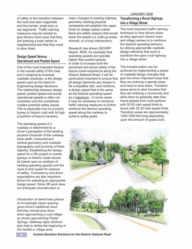
Transforming a Rural Highway into a Village Street The most important traffic calming technique to slow drivers down as they approach historic town and village centers is to reinforce the desired operating behavior by utilizing appropriate roadside design elements that work to transform the open rural highway into a village street.
This transformation can be achieved by implementing a series of roadside design changes that give the driver important clues that they are entering a special place and need to slow down. Transition areas serve to alert travelers that they are entering a community and allow them to gradually alter their travel speeds from rural sections with 50-55 mph speed limits to towns with 25-35 mph speed limits. Transition areas are approximately 1200-1500 feet long depending upon the amount of speed zone
Introduction of street trees placed at increasingly closer spacing gives drivers additional clues that they should slow down when approaching a rural village as shown approaching Poplar Springs. Gateway signs (bottom) also help to define the beginning of the hamlet or village area.

Context Sensitive Solutions for the Historic National Road 9
JANUARY 2006
9
adjustment needed (in 5, 10 or 15-mph increments). The Manual of Uniform Traffic Control Devices (MUTCD) should be consulted for guidance on speed zone transition signing including applicable advance warning distances.
Traffic calming techniques that can be used to help self-enforce the desired operating speeds include the following:
Visual FrictionDriver behavior will be improved by a consistent set of highway geometry and roadside details. Where the goal is to lower driving speeds in order to reduce the
Diagram describing the proposed transition sequence design for the Route 50 Traffic Calming Project, a National Demonstration Project for Rural Traffic Calming (courtesy of VDOT and H.W. Lochner, Lardner/Klein Landscape Architects, P.C. and Glatting Jackson).
speed differential between users, it will be useful to increase the “visual friction”. Roadside landscape improvements are often used to increase texture and visual complexity (trees, stone walls, naturalistic planting and shaping of cut slopes) in order to give drivers more clues that they are coming to a settled area and to improve the appearance of intersections.
District 6 has been narrowing lane widths, adding on-street parking, changing from open section to closed section, and decreasing the spacing of delineation posts as the driver gets closer to town to give drivers more cues to slow down when approaching towns.
Along the Historic National Road, this can be achieved by utilizing more naturalistic planting at the beginning of the transition (such as a mass grouping of trees with large spacing between groupings) and gradually transition to more formal tree planting approaching town.
A lower speed byway can be further differentiated from a higher
speed road by planting low shrubs close to the pavement with larger canopy trees farther back. Varying the finished contour of uphill cutbanks can also help to add “visual friction” to the character of the roadside and give a more natural landscape appearance.
Shoulder TreatmentTo alert drivers of an upcoming change in the road cross-section and the need to reduce their travel speed, the shoulder treatment should transition to a well-defined curb treatment on the approach to a village, town or rural traffic calming element. The transition should occur in stages to cue drivers to gradually decrease travel speeds.
The following example was utilized for the Route 50 Traffic Calming project in Loudoun and Fauquier Counties in Virginia:
• Zone 1 (reduce speed to 35 mph)- 12-foot travel lanes.- Textured pavement strip.- Rural landscaping
treatment.
• Zone 2 (approaching town entranceway)
- 11-foot travel lanes.- 1-foot wide concrete band
or paver at edge of travel lane.
- Rural landscaping treatment.
• Zone 3 (enter town at 25 mph speed zone)
- 10-foot travel lanes.- 2 foot wide concrete band- More structured
landscaping and less spacing at edge of travel lane.

Context Sensitive Solutions for the Historic National Road 10
JANUARY 2006
10
Some traffic calming objectives may also be accomplished through creative use of striping. District 6, for example has doubled the width of edgelines to both improve the visibility of the curve and to narrow the travel lane to encourage drivers to slow down (top photo).
District 6 has also modified the edgelines approaching towns, such as Clear Spring and Hancock to transition from the edge to center of town. The narrow paved shoulder in the rural area widens out approaching and entering town to accommodate parking and is marked by a solid edgeline (middle right photograph). Once inside the town, the edgeline changes to a parking space pavement marker every 20’ or so (below right).
Unfortunately, research has shown that striping usually only affects first-time drivers (good for themed tourism travel routes such as the Historic National Road) but the effect wears off when the daily driver recognizes that it is just paint.
In order to have an actual long-term effect on speed approaching towns and achieve self-enforced speed reductions, the roadway needs to be physically modified .
Historic National Road near Cool Hollow Road illustrates the current use of a wide edgeline treatment to help guide drivers around the sharp curve.
Photograph approaching Clear Spring from the East shows current use of solid edge line delineation at the edge of town (center) and then the marking of actual parking space locations in the core of the town (bottom). Photographs of Clear Spring entry by K.C. Keith, (SHA)

Context Sensitive Solutions for the Historic National Road 11
JANUARY 2006
11
Horizontal and Vertical Alignment ShiftsThe most effective means of self enforcing the reduction in operating speeds through speed zone transition areas is to shift either the vertical or horizontal alignment of the roadway.
Vertical alignment shifts include the use of speed tables, speed humps, raised pedestrian crosswalks and raised intersections. SHA has not endorsed the use of vertical alignment shifts on state highways regardless of location and therefore, those techniques are not recommended at this time for use within villages along the Historic National Road.
Shifting the horizontal alignment can be accomplished through the use of landscaped splitter islands or roundabouts, as well as introducing new curves in the road. Since the Historic National Road was originally designed to connect towns with the shortest and most direct route possible, introducing curves may not be the most sensitive approach to the historic context. Alignment shifts did occur
at bridge crossings (see page 29, under the discussion of Bridges.)
In many of the turnpike sections of the route approaching towns located east of Cumberland (such as Hagerstown and Funkstown shown on the map below) there are turns in the route.
The use of landscaped splitter islands is another technique to slow drivers by shifting the alignment around a landscaped median, sometimes designed in conjunction with a protected left turn lane at intersections. An example of a splitter island proposed for the Route 50 Traffic Calming project in Upperville is shown below.
Before and after sketch illustrates proposed use of splitter island to self-enforce desired operating speed within a 25 mph speed zone in Upperville (sketch by Larder/Klein for Route 50 Traffic Calming Project, courtesy of VDOT and H.W. Lochner, Lardner/Klein Landscape Architects, P.C. and Glatting Jackson).
Map from the 1916 Guide to the National Road (Bruce) showing the typical alignments of long and straight sections that now induce higher operating speeds under modern conditions.

Context Sensitive Solutions for the Historic National Road 12
JANUARY 2006
12
Rural Crossroads and Intersections The rural intersections along the Historic National Road are home to many of the significant historic sites and structures from both the “Heyday” and “Revival” periods of the Historic National Road. As land uses change from rural to suburban and traffic increases, the function and capacity of the intersection is diminished. The standard engineering practice of increasing intersection capacity with the addition of signalized turn lanes changes the once rural crossroads into a highway-dominated intersection.
For the Historic National Road, when capacity issues increase to the point of requiring signalized turn lanes, a roundabout should be considered. Modern roundabouts can fit within about same amount of right-of-way as a multi-turn lane signalized intersection.
Modern roundabouts tend to be safer when it comes to accidents (vehicles are going slower through the intersection) and modern roundabouts provide for more attractive amounts of landscape with less visual contrast and hard surfaces than the large signalized intersection.
Maryland SHA has installed many roundabouts throughout the State. The use of single-lane modern roundabouts along the Historic National Road in lieu of multi-lane signalized intersections will generally be preferred from the point of view of both safety and aesthetics. There is a single-lane roundabout already installed in Lisbon (photograph below). As of 2001, average annual accidents had gone from 7.3 to 1.9 after the roundabout’s installation.
Maryland’s first modern roundabout was constructed on the Historic National Road at its intersection with Route 94 replacing a 2-way stop controlled intersection (photo courtesy of SHA).
For intersections requiring large turning radii (for trucks, large school buses, recreational vehicles and tour buses) paving surfaces can be changed so that a larger drivable intersection surface is available to the truck, but not apparent to the regular driver. This can be accomplished through the use of different types of pavers, either color or texture and flush or mountable curbing in the area where the trucks may need more space to make the turn.
Pedestrian movements can still be accommodated in these intersections by placing bollards in locations to mark the beginning of the crosswalk area. Maintenance issues (bollard replacement, snow removal, paver replacement, etc.) must be addressed prior to implementing any alternative intersection design approach.
MD 94 @ MD 144-A Lisbon Roundabout 1/1/90 to 4/11/93 4/12/93 to 12/31/00 Average Annual Accidents (Before) 7.3 Average Annual Accidents (After) 1.9 Annual Average Injury Accidents (Before) 4.3 Annual Average Injury Accidents (After) 0.4 Accident Rate / MVE (Before) 2.1 Accident Rate / MVE (After) 0.5 Injury Accident Rate / MVE (Before) 1.2 Injury Accident Rate / MVE (After) 0.11
Million Vehicle Entering = 11,180,590 Million Vehicles Entering = 28,211,226

Context Sensitive Solutions for the Historic National Road 13
JANUARY 2006
13
Impact of Traffic Calming Measures on Character-defining Features Traffic calming measures and roundabouts must only be installed along the Historic National Road when compatibility with the character-defining features can either be preserved (in the most historically significant areas) or maintained. Maintenance of character-defining features can be accomplished by minimizing the impact on existing right-of-way, being compatible with the scale of the historic roadway, being sensitive to the location of an intersection within the historic fabric of the town and taking advantage of intersections within transition areas (approaching town or between neighborhoods).
In assessing new projects to improve safety along the Historic National Road, including the introduction of various types of traffic calming measures or alternative street and intersection design measures, the impact on the significance, character and appearance of the area should be a primary consideration in determining which type of safety measure is most appropriate.
In areas along the Historic National Road where preservation is the primary goal (see Corridor Partnership Plan), the introduction of the various types of safety measures including traffic calming measures and alternative intersection designs should be tested for compatibility with the character-defining elements. Road widening, the addition of speed-change lanes, traffic calming measures, roundabouts and traffic islands are measures that were typically not utilized along the Historic National Road in the Heyday or Revival periods.
Preserving Character-Defining FeaturesIn order to assess the compatibility of such features it is essential to consider the particular purpose of the measures and their particular physical requirements. Standard designs are often recommended for road safety measures. Occasionally, modifications to the standard designs may be appropriate to satisfy preservation and Section 106 considerations. Original, traditional or historically significant road treatments and details should be retained and conserved. New treatments which introduce materials, patterns, details and colors that are foreign to the traditional character of the area should be avoided when preservation is the goal.
Maintaining Character-Defining FeaturesFor the majority of the route, however, the character-defining features need to be “maintained.” This can be accomplished by ensuring that new safety measures are designed to be recessive in terms of scale and materials. They should not be visually intrusive when viewed within the overall context of the route. They may be visible in the background, but should not attract particular attention with excessive visual contrast.
When deciding whether to use an alternate street or intersection design to address speed management or intersection capacity and safety issues, the following criteria should be used in tandem with good engineering practices:
Minimize Impact on Available right-of-way: Existing right-of-way is typically 66’ along the Historic National Road. Modern roundabouts constructed in Maryland range in size from
approximately 100-130’ inscribed diameter. The Lisbon roundabout is one of Maryland’s smaller roundabouts at 100’ inscribed diameter.
Be compatible with the historic roadway scale: A single lane roundabout can accommodate approximately 20,000-27,000 Average Annual Daily Traffic (AADT) depending upon the amount of left-turning traffic. When capacity issues increase to a point above this level, two-lane roundabouts need to be considered. Along the rural portions of the Historic National Road the two-lane roundabout would be out of scale with the nature of the travel route. This issue will be most critical in the eastern sections of the byway.
Be sensitive to the intersection location on the historic fabric of the town (historic district or area): Roundabouts and splitter islands located outside the limits of an historic village function as a speed reduction measure and help transform the roadway character from a rural highway to a village street. Locations inside the historic village or area need to respect the scale of adjacent buildings and the linear form of the original town layout.
Take advantage of intersection within transitions: Most of the towns along the Historic National Road are long and narrow. Often there are slight shifts or changes in the layout of the town that might allow for the use of a roundabout or splitter island as a means of changing from a residential neighborhood to the downtown (such as Funkstown or Hagerstown) - helping to shift the driver’s cues and expectations.

Context Sensitive Solutions for the Historic National Road 14
JANUARY 2006
14
Alignment and GeometryAlthough there are currently no major construction projects planned along the Historic National Road, there may from time to time be a need for adjustments to the alignment and geometry of the roadway as part of a normal resurfacing or safety project. Along the more rural sections of the route adjustments are typically
only made if the road gets “out of section” after much repairing. During road resurfacing, the roadway alignment and grade will be adjusted to return it to its original design speed. This is only accomplished when a need is demonstrated, such as a history of accidents. In the more urban and suburban sections adjustments may occur where there is an increase in traffic volume, operating speeds, or other factors
leading to a determination that sight lines need to be lengthened for both vertical and horizontal curves.
Roads that are reconstructed with longer sight distances and wider clear areas generally allow for higher operating speed. This would typically result in the loss of scenic and historic character (as shown in the simulation below left).
Along the Historic National Road, more sensitive ways must be found to reduce the impact and improve safety without sacrificing scenic and historic quality. The following techniques could be utilized: • Consider ways to slow driver
operating speeds in advance of the area of concern through the use of warning signs or traffic calming measures.
• Consider improving the visibility of the area of concern rather than removing it. For example, laying back slopes to improve sight distance without changing the road’s actual alignment. See grading techniques listed below.
• When modifications to the roadside need to be made, consideration should be given to matching the existing edge conditions prior to construction. For example, if a stone wall needs to be removed, it should be replaced in its new location with a similar kind of wall.
• Where additional shoulder area is needed, consider the use of stabilized turf shoulders, rather than paved or aggregate shoulders, to minimize visual contrast.
• Where additional lane capacity is needed, consider the entire network of roads before adding capacity to road sections along the Historic National Road. Often, a parallel system of roads at the edge of a town will serve to be a natural extension of the town’s grid of streets and can work better than putting the extra capacity along one route.
Simulation (below) illustrates potential impact of straitening out a curve on Route 169 (existing condition above). The simulation illustrates an increase in design speed of approximately 10 mph requiring longer sight lines, and removing more roadside vegetation. The result is an overall loss of scenic quality and a greater difference in operating speeds between leisure travelers and commuters.

Context Sensitive Solutions for the Historic National Road 15
JANUARY 2006
15
Roadside BarriersRoadside barriers are typically used along the Historic National Road in Maryland when it is not economically or environmentally feasible to remove a fixed object or other area of concern from the roadside clear area. Originally, boulders were used along the route to guide wagons and keep them from veering off the muddy route.
The Maryland Historic National Road Corridor Partnership Plan recommends that the standard “W-beam” guardrail systems be replaced by an alternative that has less visual contrast. Using a dark color or rusting steel has much less visual contrast than thestandard galvanized steel currentlyin use. Given that the Steel W-Beamwith weathering steel finish isalready in use on I-68, it would bean appropriate guardrail to use onthe Historic National Road, despiteits thicker profile.
The steel backed timber guardrail is another aesthetic alternative. It has been used along the Historic National Road as part of the recently completed reconstruction of the Meadow Run Bridge (see photo above right) and along MD 235 near Lexington Park. These rail systems are bulkier and would be out of scale with the urban and village sections of the Historic National Road. They may be more appropriate for open agricultural areas that run through State Parks and Forests, such as near Casselman River Bridge State Park.
Steel-backed Timber Guardrail with dark brown stain was recently installed along the National Road approaching the Meadow Run Bridge (photograph by K.C. Keith, SHA). Advantages• Compatible with broad scale views in pastoral settings• Compatible with bridge approaches • Rigid – 2-4’ deflection minimizes recovery area behindDisadvantages• High cost• Terminal ends may need to be buried • Incompatible in built-up areas (scale) • Replacement parts need to be stockedCOST~ $80/LF
W-Beam with steel or wood post, weathering steel finish was installed along I-68 and rebuilt sections of Maryland 144 as shown hear near Rocky Gap resort (photograph by Richard Langton).Advantages• Closest to SHA standard with some common parts• Similar in cost to SHA standard• Functions well in most locations for vehicles• Rigid – 2-5’ deflection minimizes recovery area behind Disadvantages• Variable appearance when parts replaced• High visual contrast with scenic/historic road character• Thick profile blocks views • Incompatible with bridge approachesCOST ~ $15/LF and $550/end assembly

Context Sensitive Solutions for the Historic National Road 16
JANUARY 2006
16
Grading and Drainage Various work including modifying the alignment, widening shoulders or improving drainage along the Historic National Road may require that an uphill or downhill slope along the roadside be modified or a roadside drainage ditch be modified or constructed. This can have a substantial impact on the visual and historic quality of the road.
Where a cut into an existing hillside is required, slope stabilization may be necessary. Large scale, hard-material solutions (precast or cast-in-place concrete retaining walls, including “green walls” and metal “bin-walls”) are undesirable. Walls of smaller scale materials (stone walls or simulated stone using form liners) can be more compatible. Other methods of stabilizing the slope such as a crushed stone blanket or wood chip mulch are extremely unpleasant because they prevent the natural growth that would otherwise camouflage the cut over time.
Soil Bio-Engineering A cost-effective and good-looking solution to stabilizing uphill cuts is a technique called “soil bio-engineering”. This process uses live plant materials to stabilize the slope and allows the hill to eventually return to a mature forested condition. Landscape planting can be used to camouflage a newly cut slope. It is important to determine whether the visual effect of the planting should be formal and controlled, or be informal in an attempt to look “natural”. Indigenous plant materials are usually best.
The shape of uphill slopes have as much impact as their landscape treatment. The “knife through butter” look of a precisely engineered and constructed slope
has a super-highway character and should be avoided. Through careful predetermination, or by giving the contractor and field personnel freedom to create an intimate topography, it is possible to manicure uphill slopes so that they will look like they are a part of the natural landscape. This approach means accentuating a natural drainage swale, or steepening or relaxing a slope according to the specific soil and rock materials found. In some cases this will require agreements with abutting owners since some additional land may be involved. The result, however, can be more stable and less expensive, as well as better looking.
Soil bio-engineering was utilized to stabilize a failed slope along US 50 west of Annapolis (top). Live fascines and brush cuttings (center) were used to return the slope to a more natural looking appearance (bottom) at a much reduced cost (design by and photographs courtesy of KCI Technologies)

Context Sensitive Solutions for the Historic National Road 17
JANUARY 2006
17
Retaining Walls Where there is not enough room to lay back a slope in a manner that is sensitive to the context, retaining walls can be constructed using stone veneers or a form liner to simulate the appearance of stone. Stone or brick should be used whenever there is a high degree of pedestrian or slow moving traffic that would appreciate the authentic details. For higher speed roadways, form liners can be used to simulate a stone wall. Form liners simulating brick should not be used due to the difficulty of simulating the brick pattern and color in an accurate manner.
Roadside Drainage Roadside drainage is a particularly important function required for the long-term maintenance of the road as well as the safety of the highway user. Surface runoff should not flow onto the surface of the travel lane, nor should it seep underneath the road. On the Historic National Road drainage projects are often undertaken as part of ongoing resurfacing work as needed.
Where practical, alternatives to the extensive use of rip-rap to stabilize drainage channels should be examined. Soil bio-engineering is one such technique that uses soil stabilization with natural vegetation instead of structural measures. The natural vegetation method, if installed correctly, has an aesthetically pleasing natural appearance, lower initial cost, lower long-term maintenance
costs and improved strength over time as the plant roots establish themselves. Soil bio-engineering can be adapted in many situations from slopes to streambanks and is considered to have more benefits for improving water quality associated with roadside drainage.
Its limitations are mostly related to the need to have experienced installers and a good source of plant materials. The soil bio-engineering methods may also take up slightly more right-of-way and installation is limited to the dormant season.
Example of erosion control improvements for a roadside drainage swale (top) interplanting rip-rap with live willow cuttings and example of roadside slope erosion control using a brush layering system (bottom) with live branch cuttings interplanted in a criss-cross configuration (illustration by Lardner/Klein for ConnDOT)
Soil bio-engineering concepts were used by Maryland State Highway Administration and Maryland Department of Natural Resources to restore Porter Run adjacent to the Historic National Road near Clarysville. Willow whips were interplanted to help stabilize the streambank. (photographs by SHA)

Context Sensitive Solutions for the Historic National Road 18
JANUARY 2006
18
Stormwater Runoff Management The design of stormwater management facilities needs to be more carefully considered along the Historic National Road, particularly in the urbanizing sections of Baltimore, Howard and Frederick Counties. Stormwater management facilities often are designed in a utilitarian manner and often placed near the highway in a visually prominent position.
New thinking can generate softer, more naturalistic landforms; larger, shallower facilities with interesting water surface shapes; and planting schemes that blanket the surrounding landforms with natural plant masses and colors. This new type of thinking also requires more thought about how the landscape associated with the facilities will be maintained.
Stormwater management facilities need to be designed in a manner that integrates them more carefully with the natural system of surface water flow. The size and scale of
embankments need to be adjusted to minimize the visual contrast with their setting. This can be accomplished using biological methods by working with the natural hydrological system instead of against it. Biological slope stabilization methods similar to those shown on page 17 can and should be used for stormwater management ponds that are visible from the Historic National Road.
Alternative stormwater runoff management techniques, such as infiltration and rain gardens, given enough room to perform, will also work to reduce the rate and
Here are two examples of different approaches: using seasonal color and massing of plant materials to provide visual interest in a park-like setting (top); or using a more naturalistic planting scheme (bottom) to try and blend the facility into its adjacent context (Photographs courtesy of the Maryland State Highway Administration).
quantity of stormwater flow, and improve the quality of that flow to achieve stormwater management goals and state stormwater requirements associated with highway and development projects.
For additional information see Prince George’s County’s bioretention web site at http://www.goprincegeorgescounty.com/pgcounty/government/agencyindex/der/ppd/lid/bioretention.asp

Context Sensitive Solutions for the Historic National Road 19
JANUARY 2006
19
Traffic Control Devices Reducing sign clutter (including removing signs that are no longer necessary), makes the messages to users more clear and reduces the visual impact of the signs on character defining features.
There are three distinct types of traffic related signs along the Historic National Road: safety, directional and informational. In addition, there are several different types of traffic control devices in use along the Historic National Road: signalized intersections (plus one roundabout), hazard identification beacons and some channelization devices to limit turning movements.
The design and placement of traffic related signs and devices are guided by the Manual of Uniform
Traffic Control Devices (MUTCD). There are several important aesthetic variations that could be utilized when signs are placed along the Historic National Road that would help further identify this route as a recreational or leisure travel route.
Sign Backs and Post Supports The backs of all signs along the Historic National Road should be a dark color, such as brown or black, similar to signs utilized by the National Park Service on Parkways such as the Baltimore Washington Parkway (see page 34). A similar treatment should be applied to the post supports. Given the large number of signs in use to guide or regulate traffic along the route, this would have a significant and positive visual impact by reducing
the overall visual contrast created by the metallic backs of the existing signs. This will also help to give the route a distinctive look (coupled with other measures identified further in this guideline). In rural sections, brown or dark green would be appropriate colors. In urban or suburban sections, black would be appropriate, or the color should be coordinated with other streetscape elements (see below).
Traffic Control Hardware In urban sections within historic districts there is also a need to be concerned about elements such as mast arms, signal control boxes, valve boxes and other support elements for traffic signals. There is a wide range of mast arm types that can be used to support signals and that should be designed in tandem with lighting and other streetscape elements. Some of the communities have already put these in place and they should be replicated throughout the corridor.
In urban or suburban areas in need of enhancement, or where there has been an extensive amount of new development, a more modern design vocabulary can and should be used. It is important to try not to recreate an historic look in locations that are obviously no longer that historic. Retro styles from the 1950’s and 1960’s are also widely available and would be appropriate for the suburban sections of the route.
Given the many “Main Street” revitalization projects that have
In Clear Spring, the traffic signal controllers, mast arms, wires, pedestrian signals and light standards add up to a significant visual effect and could be better coordinated. In Frostburg, MD the visual effect of relocating or consolidating overhead utility lines is very positive (wires located in the alley behind buildings).
Context Sensitive Solutions for the Historic National Road 20
JANUARY 2006
20
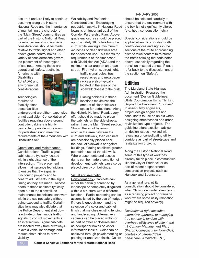
occurred and are likely to continue occurring along the Historic National Road and the importance of maintaining the character of the “Main Street” communities as part of the Historic National Road travel experience, some special considerations should be made relative to traffic signal and other above grade control boxes. A variety of considerations govern the placement of these types of cabinets. Among these are operational, safety, aesthetics, Americans with Disabilities Act (ADA) and environmental considerations.
Technologies required to feasibly place these facilities underground are either expensive or not available. Consolidation of facilities requiring above ground controller cabinets is highly desirable to provide more room for pedestrians and meet the requirements of the Americans with Disabilities Act.
Operational and Maintenance Considerations -Traffic signal cabinets are typically located within sight distance of the intersection. This placement allows maintenance technicians to ensure that the signal is functioning properly and to confirm adjustments to the signal timing as they are made. Access doors to these cabinets typically open out to the sidewalk so maintenance technicians can work within the cabinet safely without being exposed to traffic. Certain situations may also dictate that the Police Department shut down, reactivate or flash mode traffic signals to control movements at an intersection. Signal cabinets are located away from driveways to avoid vehicular damage and reduce obstructions to driver visibility.
Illustration at right describes alternative approach to managing tree canopy in tandem with overhead utility lines (Route 4 and 41 Corridor Management Plan, Sharon Connecticut for ConnDOT, courtesy of Lardner/Klein Landscape Architects, P.C.)
Walkability and Pedestrian Considerations - Encouraging pedestrian activity in National Road towns is an important goal of the Corridor Partnership Plan. Above grade enclosures should be placed approximately 18 inches from the curb, while leaving a minimum of 42 inches of clear sidewalk area for pedestrian use. This meets the requirements of the Americans with Disabilities Act (ADA) and the minimum clear area on an urban street. Fire hydrants, street lights,
traffic signal poles, trash receptacles and newspaper racks are also typically located in the area of the sidewalk closest to the curb.
Placing cabinets in these locations maximizes the amount of clear sidewalk space for pedestrians. Along
the Historic National Road, every effort should be made to place the cabinets on the side streets, rather than the Main Street section. Should there not be enough room in the area between the curb and sidewalk, then cabinets are occasionally placed near the back of sidewalks or against buildings, if doing so allows greater pedestrian use of the sidewalk. Where easements and access rights can be made a condition of development, cabinets can also be placed directly on buildings.
Visual and Aesthetic Considerations - Cabinets can either be partially screened by landscape or completely disguised within a structure with a different function. Partial screening can be accomplished by the use of hedges if there is enough room and the selection of a color and cabinet finish that matches existing fencing and landscaping. Alternatively cabinets can be placed within or as part of other enclosures such as newspaper boxes or visitor information kiosks. Color can be achieved through powdercoating or painting or anodized finish. Colors
should be selected carefully to ensure that the environment within the box is not significantly altered (e.g. heat, condensation, etc.)
Special considerations should be applied when incorporating traffic control devices and signs in the sections of the route approaching historic town centers to reinforce the traffic calming methods noted above, especially regarding the transition in speed zones. Please refer back to the discussion under the section on “Safety”.
UtilitiesThe Maryland State Highway Administration Prepared the document “Design Guidelines: Utility Coordination Using Thinking Beyond the Pavement Principles” to assist utility engineers, project design engineers and consultants to use as an aid when designing streetscapes and urban revitalization type projects. The guideline offers excellent advice on design issues involved with relocating or consolidating utility corridors as part of streetscape and revitalization projects.
Along the Historic National Road some of this type of work has already taken place in communities like the City of Frederick or as part of recent neighborhood conservation projects such as Hancock and Boonsboro.
As a general rule, utility consolidation should be considered when 3R work is undertaken (such as a repaving project or drainage work where some utility relocation might be required anyway).

Context Sensitive Solutions for the Historic National Road 21
JANUARY 2006
21

Context Sensitive Solutions for the Historic National Road 22
JANUARY 2006
22
Example of a setting where the existing landscape character should be preserved near Bolivar.
LandscapeNew landscaping may be added to the right-of-way along the MHNR as part of state or community initiated projects. Examples include: use of landscape to reinforce traffic calming goals as described previously under Safety; streetscape improvement projects (usually initiated by the community); and mitigation efforts that are implemented in response to highway related projects when existing trees are removed. In addition there is a need to work with private developers on entry “statements” associated with providing access to new development projects. Finally, some buffering and screening of undesirable views may be desirable to enhance the byway and could be undertaken as community-based planting projects within the right-of-way.
General Suggestions Community-initiated roadside planting should be considered throughout the corridor for a wide range of purposes. Planting design
be taken to ensure that open views are preserved. Fencing also plays an important role in identifying the desired character. A good example of the desired character of the Historic National Road is found near Bolivar, MD (top left). Mature trees with branches overhanging the road should be preserved. Turf shoulders should be maintained up to the pavement edge (use a topsoil-aggregate mix to stabilize shoulder to provide a medium for maintaining turf along the road edge). Alternatively, wildflowers found along the roadside (such as Bachelor’s Buttons) can and
Limited planting space is available in many of the linear towns along the Historic National Road, such as New Market (right). Continuous tree-planting pits can provide room for the roots to grow parallel to the road.
concepts should be incorporated that are sensitive to the context within which the project is initiated:• In forested areas, planting
design should seek to establish a forest edge plant community that reinforces the natural characteristics of the landform position within which the area sits (south or north facing slopes, bottom lands, ridgetops, etc.)
• In rural and agricultural areas, the vocabulary of hedge and fence rows, windbreaks, tree groves, specimen trees and tree-lined farm roads should influence the planting design concepts. Great care should

Context Sensitive Solutions for the Historic National Road 23
JANUARY 2006
23
Recommended street tree planting concept for LaVale, Maryland incorporates grass medians to narrow the look and feel of the road, street trees planted at regular intervals, signs lowered and placed on stone, wood or brick bases, pedestrian paths and underground utilities (from MHNR Corridor Partnership Plan).
should be maintained through monitoring of the mowing cycles, as they are a cherished element of the rapidly changing rural landscape.
• In suburban and developing areas, planting can be used to enhance the character of the route by creating a new focal point or providing unity to a scene that is particularly chaotic or complex. Establishing the Historic National Road as a tree-lined Avenue (such as found approaching Boonsboro) is a good model to follow and helps to narrow the look and feel of the road.
• In urban sections, street trees can be planted to establish a tree canopy over the sidewalk and other pedestrian areas making a more attractive area for visitors to get out of their cars and enjoy the sites
and attractions in the many town centers along the Historic National Road.
Trees are an important part of any improved landscape. Tree species selection should consider infrastructure (tree lawn width, overhead wires) to minimize conflicts between green and grey infrastructure elements.
Special Situations There are a number of conditions throughout the byway corridor that require special attention including urban soils, overhead utility lines, relationship to traffic calming goals and community and private entrances that when carefully considered will help to maintain and enhance the character-defining features of the Historic National Road in Maryland.
Urban SoilsIn urban sections, special attention needs to be paid to the environment within which the tree is planted. Continuous planting pits are highly recommended to provide enough space for roots to spread throughout the tree planting area as shown below right and in more detail on page 5-28 of the MHNR Corridor Partnership Plan.

Context Sensitive Solutions for the Historic National Road 24
JANUARY 2006
24
Utility LinesAppropriate trees should be selected for planting underneath overhead utility lines. Where space is available, larger trees should be planted along the outside of the utility lines clearance area, with smaller trees underneath. This provides for the best opportunity to minimize the visual intrusion of the overhead utility line (see page 21).
Traffic CalmingPlanting to reinforce traffic calming goals should follow the general principle that more naturalistic planting design concepts should be utilized at the beginning of the transition zones shifting to more formal planting concepts closer to and within the town centers. Native vegetation should be used to landscape rural traffic calming measures. Landscaping in the towns and villages should match existing landscaping treatments, as well as historic tree planting and landscape design styles that are compatible with the existing historic town character. Planting design techniques can also be used to establish a rhythm to the spacing between street trees, with trees getting progressively closer and closer together to reinforce the desired slower and slower operating speeds approaching towns.
Community and Private Entrances A special concern has been heard about the preponderance of “entry statements” associated with new developments. Many of these developer initiated efforts are well-intentioned, with the goal of making the entry to the new subdivision more attractive, while at the same time capturing the attention of potential customers.
Along the Historic National Road, efforts should be made to
scale back the size of the entry statements so that they do not detract from the through traveler’s experience and its character-defining features.
In order to maintain the character-defining features, understatement is better than overstatement. Scale and proportion are important. In rural areas, private developer entrances should be similar in scale to farm entrances. As developments move closer to urban sections, the scale of entrance features should be more in keeping with nearby features when they exist such as fences, stonewalls, entrances to historic estates and properties. It is critical that the scale of the entrances do not exceed that of the entrance to the community since it serves as an important traffic calming measure.
Continuous tree planting pit with amended soil is recommended for urban and suburban areas to facilitate street tree survival, as shown here for Frederick Avenue project in Baltimore (see page 43).
Stormwater Management See page 18 for discussion of landscape approaches to maintaining the character-defining features of the Historic National Road when constructing stormwater management facilities and roadside drainage.
Maintenance Implications Great care should be taken in selecting species of trees, shrubs and groundcovers that are appropriate for their location. Growth rates of vegetation should be well understood and plants located in such a manner so that their mature height and spread will not block future roadside clear areas and therefore require extensive pruning.
StreetContinuous planting strip parallel to curb
Brick pavers with porous joints (sand set) on top
Sidewalk

Context Sensitive Solutions for the Historic National Road 25
JANUARY 2006
25
Bridges and Small StructuresThe purpose of this guideline is to assist the Maryland State Highway Administration (SHA) in their efforts to both preserve and maintain the character defining features of the Historic National Road in Maryland associated with the many bridges and small structures (less
than 20’ in length) that have been constructed since the original “Heyday” and the “Revival” period.
Bridges and small structures that are over 50 years old are considered potential historic resources that are evaluated for significance by SHA under the preservation laws and Section 106 regulations (36 CFR Part 800 for federally funded projects and Article 83B of the Annotated Code of Maryland, Sections 5-617 and 5-618 for state funded projects).
SHA’s Cultural Resources (CR) Group within SHA’s Project Planning Division is responsible for reviewing all projects to ensure that
historic resources are not adversely impacted. The CR group consults with the Maryland Historical Trust (MHT) and works with the Office of Bridge Development (OBD) to ensure that the eligible bridges are maintained and preserved within the limits of AASHTO guidance and other safety and engineering considerations.
All of the bridges owned and maintained by SHA along the Maryland Historic National Road have been inventoried and evaluated for the National Register of Historic Places (NRHP), but not all of the small structures. SHA defines historic significance for bridges and small structures as being eligible for listing in the National Register of Historic Places. SHA is not required by law to preserve bridges that are not eligible for the NRHP.
An update of the bridge inventory is currently being completed for bridges constructed between 1948-1960. While the priority for preservation actions in the Corridor Partnership Plan remain for the Heyday and Revival Period historic sites, preservation options should be considered for the more recent structures when they are added to the NRHP.
Casselman River Bridge as it appeared in the Revival period (top, historic photo from The National Old Trails Road Photo Gallery, USDOT, FHWA) and preserved today as a National Historic Landmark (middle). The 1932 replacement for US 40 Alternate over the Casselman River and 1980’s version on I-68 in aerial view illustrate the different eras of bridge construction along the route (courtesy of Maryland State Highway Administration).

Context Sensitive Solutions for the Historic National Road 26
JANUARY 2006
26
Semicircular stone masonry arches and culverts were the preferred bridges constructed along the route of the National Road. There are two stone arch bridges on the Maryland Inventory from the Heyday period that are still operational (Kline’s Mill Bridge over Little Beaver Creek and the Funkstown Turnpike Bridge over Antietam Creek). Both of the operational bridges have been modified with concrete.
Several additional Heyday era bridges (Puzzly Run, Big Shade Run, Casselman River, Clarysville, and Wilson Bridge, and the footings of the original tollhouse bridge over the Monocacy River) are not on the inventory and the bridges are no longer operational. These bridges are a high preservation priority for National Road byway Advocates since they are part of the original “Heyday” period of the Historic National Road. The series of stone arch bridges over Big Shade Run on an old alignment adjacent to the Fuller-Baker Log House just
west of Grantsville are particularly vulnerable and have been rapidly deteriorating.
There are fourteen additional bridges on the Maryland Inventory from the “Revival” Period of the Historic National Road. These bridges are primarily concrete arch bridges constructed between 1923 and 1938. These concrete arch bridges generally have architectural treatments along the parapet walls and abutments.
Some, if not most, of the bridges and small structures that remain are no longer in SHA ownership or
Remnant small structure over Big Shade Run (photo courtesy of Terry Maxwell, State Highway Administration)
maintained by SHA. SHA staff are currently researching ownership for those structures that are no longer operational.
As the eastern section of the MHNR corridor continues to grow, as well as areas around Frederick,
The Puzzly Run Bridge in the early 1900’s (top) and today is now privately owned and needs to be preserved (historic photo from The National Old Trails Road Photo Gallery, USDOT, FHWA).

Context Sensitive Solutions for the Historic National Road 27
JANUARY 2006
27
Hagerstown and Cumberland, there will be an increasing need to consider widening bridges. A new bridge or underpass of the Historic National Road is being considered as part of the US 219 Corridor Study. At the same time many of the bridges built in the
1950’s and beyond will begin to need either rehabilitation or replacement in the coming years. From the perspective of the byway, it will be important to maintain the character-defining features of the bridge structures and approach sections through the use of context sensitive design techniques.
Preserving Historic Bridges along the MHNRHistorically significant bridges should be maintained and rehabilitated on a strict schedule to avoid the need for replacement. Rehabilitation of significant structures should be emphasized
over replacement. The first replacement bridge over the Monocacy River, for example, deteriorated to a point where it too had to be replaced.
If a bridge or small structure is owned and/or maintained by SHA, then it will be evaluated for significance (eligibility for NRHP) before establishing a preservation priority. Some structures, regardless of ownership, may no longer retain sufficient integrity to be eligible for the NRHP.
SHA’s Cultural Resources group works with OBD to ensure that the Secretary of the Interior’s Standards for Rehabilitation – ten basic principles created to help preserve the distinctive character of a historic site, while allowing for reasonable change to meet new needs– are followed when work is proposed on an eligible bridge. (See http://www2.cr.nps.gov/tps/tax/rehabstandards.htm). Many of these bridges are no longer in State right-of-ways and require immediate preservation action through a public/private partnership utilizing the expertise of the State Highway Administration and private funding in cooperation with the current landowners.
Where the bridge or small structure is now owned by local government or private property owner, then the Maryland National Road Association or other private group would need to seek outside funding to develop a preservation plan for priority locations and to fund work perhaps in cooperation with the SHA OBD as well as MHT.
Historic photograph of Jug Bridge from 1910 showing ‘S’-Curve (top) and the remnants of the footings today (middle), now an historic artifact. The replacement concrete arch bridge is now also closed (bottom photo in foreground with current truss bridge behind).

Context Sensitive Solutions for the Historic National Road 28
JANUARY 2006
28
Maintaining the Character of Bridges Along the Historic National Road Changes to any of the existing bridge structures should be done with the intrinsic qualities of the scenic byway in mind. Along the Historic National Road that means that the design character of the concrete arch bridges of the Revival Period should be used as a basis for work on contemporary bridges requiring upgrades. The following design issues are often raised by localities when thinking about widening, resurfacing or other types of bridge repair work.
Some questions that need to be asked from the start include:• Is the existing bridge historically
significant, and if so, from what period and what type of construction?
• Where are the key views and observation points that a bridge can be seen from (e.g. (nearby sensitive viewpoints, from underneath, approaching the bridge, etc.)?
How can the context of the bridge be described in terms of the character of the surrounding landscape and in terms of the other types of bridges that are built nearby (within the same physiographic province, for example)?
Changes to the visual characteristics associated with transportation projects along scenic routes are generally evaluated according to the degree of visual contrast with the setting. Form, line, color, and texture are terms used to describe the changes and the relationships to intrinsic qualities.
As seen from nearby areas (its context), including views from below and approaching the bridge, form is most affected by the geometry and the type of bridge structure chosen. Line
is most affected by decisions regarding the highway geometry (horizontal and vertical), depth of the bridge, the type of structural system (including decisions about the piers and abutments, the design of the parapet wall and approach railing. Whether or not a sidewalk is incorporated into the design also determines the types of lines that are visible along the approach to the bridge. Color and texture can be utilized to reduce or enhance the visual contrast depending upon the design goals and can be applied to all of the design elements of the bridge and approach.
Design GoalsAlong the Historic National Road in Maryland it is important that the following design goals be considered:• Create a design that is in scale
and fits in harmony with its historic and cultural setting as part of the Historic National Road
• Create a design that is in harmony with the natural environment of its site
• Where feasible, utilize authentic regional forms and materials that
Recently reconstructed bridge over Meadow Run illustrates how small structures similar in scale and proportion to the old structures can be done. The stipulations in the Memorandum of Agreement between SHA and the Maryland SHPO (see sidebar, page 29)were simple and strait forward (photo by K.C. Keith, Maryland SHA)
reflect the surrounding context, but do not create false allusions about the time and place within which this bridge is being reconstructed or rebuilt.
Recreating at least the appearance of concrete or stone arch bridges may be possible on the smaller bridges and structures (see Meadow Run Bridge, below). However, where higher volumes must be carried, the design should reflect more contemporary design characteristics since the scale of the bridge is already out of proportion with the scale of bridges built during the “Heyday” or “Revival” period. Instead, efforts should be made to create a new architectural style that reflects the period within which the bridge is being constructed (or reconstructed). Efforts should be made to minimize the visual contrast with the context within which the bridge is being designed.
Techniques to Use in Meeting Design GoalsThere are a number of context sensitive solutions that can be considered in widening or replacing bridge structures along the Historic

Context Sensitive Solutions for the Historic National Road 29
JANUARY 2006
29
National Road. The following examples are intended to illustrate some of the techniques that can be utilized.
Bridge Width and AlignmentMuch of the initial discussion for bridge widening or replacement within context sensitive locations will focus on whether or not to build a new bridge on a new alignment, build a new bridge adjacent to the existing bridge and then tear the old bridge down, or build additional lanes on a separate structure immediately adjacent to the existing bridge. As part of these discussions, the following should be kept in mind: For the Historic National Road,
the original locations of bridges often utilized an “s” configuration that allowed the bridges to be built perpendicular to the river crossing while maintaining the general alignment of the road. This configuration can easily be seen at both the Casselman River Bridge and at the Wilson Bridge. During successive eras of
construction, new bridges and alignments were built adjacent to the existing bridge, but higher up, often removing the need for
the ‘S’ configuration by utilizing longer spans and skewed approaches. In several locations the multiple era of replacements can easily be seen (Casselman River Bridge, the Monocacy River Bridge and the Wilson Bridge over the Conococheague, for example). Many of the bridges that were
replaced are still standing and used as pedestrian bridges or are part of parks providing river access.
This consistently repeating pattern suggests that the next era of replacement bridges be respectful of the remaining existing bridges (perhaps using them for pedestrian and bicycle access) and be sympathetic to the opportunities available for preserving the existing alignment in favor of adding a new bridge nearby (rather than replacing and removing the existing bridge and alignment).
The geometric design of a bridge is often established early in the design process. Design criteria from the AASHTO Green Book for new or replacement bridges primarily address the width of the bridge deck and its relationship
Creative use of steel backed timber rail to protect the bridge parapet wall on the Meadow Run Bridge help to retain the existing width of the historic bridge (photo by K.C. Keith, Maryland SHA)
Excerpts from Memorandum of Understanding between SHA and Maryland SHPO Concerning Small Structure No. 11099X0, US 40 over Meadow Run
I. Design
A. Materials
New stone ashlar masonry shall be first class cut stone laid in regular courses and shall include all work, in which, the individual stones are dressed or tooled to exact dimensions. For the wall facing the stone in the existing walls will be used, as necessary, in the proposed structure. The stone shall be cleaned, stockpiled and reset, as practical, to the original location. If the original stone is damaged, additional stone shall be furnished from a source native to the vicinity of the work and approved by the Project Engineer. The stone for the wall facing shall consist of coursed rubble of superior quality with horizontal beds and approximately vertical joints. The facing shall have a mortar backing and each stone shall be anchored to the reinforced concrete wall with corrosion resistant metal ties.
All joints including those at the backing wall, shall be completely filled with mortar. The mortar shall be a Portland cement mortar. A sample of the mortar will be provided to and approved both by the SHA Project Engineer and the Architectural Historian.
B. Construction
1. Wall
The Contractor shall build a sample wall at a location adjacent to the structure to be readily visible to the masons. It shall show examples of face, ends, top, and corners along with forming joints. The sample wall shall be approved by the project Engineer and the Architectural Historian in a meeting on site to be set up two weeks in advance of laying any masonry. The compliance officer from the SHPO staff will be asked to attend.

Context Sensitive Solutions for the Historic National Road 30
JANUARY 2006
30
to the approach road. The horizontal and vertical alignment, the number and width of travel lanes and techniques used for accommodating pedestrians and bicycles are particularly influential on the overall form and appearance of the bridge structure. Assistance from road engineers, architects and landscape architects as well as key stakeholders can be beneficial for a bridge designer trying to balance many different factors within a scenic and historic area. Minor adjustments to the horizontal and vertical profiles, structural design and architectural detailing can help to achieve a design that is in harmony with its historical setting.
The AASHTO Green Book, page 430, generally recommends that the lane widths for bridges on rural roads with high volume traffic (over 2000 ADT) be the same as that used for the approach roads (in bridges less than 100 feet). However, AASHTO recognizes that some existing bridges that “tolerably” meet the roadway width criteria may be retained.
In the case of historic bridges being retained, lane widths approaching and on the bridge structure should be consistent. Research has found that wider lane widths encourage higher speeds (according to a Texas Transportation Institute study, a 1-foot lane width increase resulted in a 2.9 mph increase in the 85th percentile speed, when all other factors were equal).
When bridges are reconstructed, efforts should be made to retain the lane widths and shoulder widths of the bridge approaches. Research has also shown that increased amounts of pavement width (including paved shoulders) increases the comfort level of the driver and therefore also their speed.
On bridges longer than 100 feet, it is often necessary to make provisions for a breakdown lane, snow storage and other elements that increase the width of the shoulder. The increased width often leads to higher operating speeds. Consideration should be given to using ‘a “chipseal” or other “modified epoxy binder” treatment to make the shoulder look different than the travel way (either color or texture). In addition, this added width can be considered for bicycle /pedestrian accommodations.
When decisions are made about how to best accommodate pedestrians and bicycles, three options are typically available:• All accommodations incorporated
into bridge deck• All accommodations built as
separate structure• Divide between bridge deck and
separate structure
On historic bridges it may be necessary to construct a separated multi-use pathway to accommodate pedestrian and bicycle traffic. This may be one technique that
Gwynn’s Falls Bridge is slated for reconstruction by the City of Baltimore The proposed preliminary design concept maintains the character-defining features of the bridge (courtesy of Whitney, Bailey, Cox and Magnini).

Context Sensitive Solutions for the Historic National Road 31
JANUARY 2006
31
Context sensitive approach is used for new bridge for Dulaney Valley Road over I-695.
Open rail system is used on MD 161 over Deer Creek to retain open views.
Reconstructed Pocomoke River bridge matches what previously existed, and was able to strengthen moveable portion of existing bridge so that it could remain.
can be used to maintain adequate vehicular lane widths.
The design of new structures should seek to establish the same character as the existing bridge, yet not just rebuild the existing style of the bridge only larger. Instead, the scale and proportion of the new bridge should be compatible with the old bridge. Great care should be taken in the design of the pier structures and abutments, barrier and parapet walls, “keystone” details, pedestrian scaled details, lighting and approach, so they are compatable with the historic context of the NR.
Piers, Fascias, Abutments and Wing WallsThe location of key observation points for any bridge project will determine the degree of visual sensitivity that is required of the appearance of the bridge from the non-roadway viewpoint. Along the Historic National Road, many of the river crossings are associated with existing or planned greenways such as at Gwynn’s Falls in Baltimore and the Monocacy in Frederick.
Bridge piers, abutments, fascias and wing walls are the primary design elements that can
be seen from adjacent, non-roadway viewpoints. The visual contrast of these elements can be greatly reduced by seeking a careful proportioning between the thickness of the bridge deck (fascias and wing walls) to the length and spacing of the support structure (piers and abutments). Where possible, the design of these elements should appear to be integral to the landscape utilizing a consistent family of materials for all of the design elements.
The appearance of the materials used for the piers, abutments, fascias and wing walls should be sympathetic to the forms, line, color and texture of the adjacent landscape and cultural context. For the Historic National Road this means that in rural areas, judicious use of native stone on piers, abutments, fascias and wing walls will help to blend the bridge with its surroundings. In urban areas with extensive use of brick (such as Baltimore and Frederick), brick should be used as a surface treatment.
Where budget limitations preclude the use of native stone, form liners can be used as a substitute. However, in urban areas with high pedestrian activity, simulated stone or brick should not be used. Instead use authentic brick or stone to establish a unique pattern or texture that can withstand the scrutiny of close-up viewing. The source of authentic brick or stone must be carefully considered. Other historic structures, ruins, or archaeological sites should not be damaged in order to procure materials to repair or reconstruct the structure in question.
Bridge Railing/Parapet WallsRequests for barrier treatments and bridge rails that contribute to the overall aesthetic experience

Context Sensitive Solutions for the Historic National Road 32
JANUARY 2006
32
are increasing. Concrete safety-shape (jersey) barriers used as the bridge railing are especially out of character for scenic byways and historic roads because of their association with high-speed highways, and because one cannot see through them.
There are some alternatives to the standard types of concrete barriers (e.g., New Jersey and F-shapes and single slope and vertical face designs) often used on bridge projects. • On local and collector roads
with favorable conditions and a small number of heavy vehicles, where the aesthetics of the railing/barrier is a prime concern, the use of the Texas Type C411 concrete barrier is an option.
• The use of a barrier with an outside face treatment using one of the many types of form liners should also be considered.
• Concrete barrier can be colored by staining the cured concrete for an aesthetic effect.
• Several horizontal tube bridge railing systems are tested and are reasonably transparent and are used on the George Washington Parkway and other Federal Lands highway design projects.
• New York State uses a two-rail timber railing for use in areas such as the Adirondack and Catskill Parks where a rustic appearance is desired.
Preserving Historic Bridge RailingsHistoric bridge railings have seldom, if ever, been crash-tested. They can be retained, however if properly protected by the installation of an additional rail on the traffic side of the existing rail or between the sidewalk and the traffic. Tested systems, using a curb and horizontal round or box-beam, have been successfully employed to preserve the visual
delight and transparency of an old bridge railing.
Bridge Approach Rails The problem still remains of connecting the bridge rail to the approach rail. This may be best accomplished by consciously identifying the ends of the bridge with an end-post, to which the two rail systems are both attached. This design strategy may be the
The new Knapps Narrows bridge (foreground) retains much of the look of its predecessor (background).
most historically reminiscent as well.
More information: Maryland Department of Transportation. AestheticBridges: Users Guide. MDSHA, 1993.
The bottom image shows the new bridge as it is today. The old bridge has been moved to the grounds of a local museum.

Context Sensitive Solutions for the Historic National Road 33
JANUARY 2006
33
SignsExisting roadway related signage along the Historic National Road consists of traffic control and traveler information. Signage regulating vehicular, bicycle and pedestrian travel along the Historic National Road shall follow the regulations set forth in the Manual on Uniform Traffic Control Devices (MUTCD), the supplement to the MUTCD and the State Highway Administration’s Office of Traffic and Safety’s specific Guidelines and Directives.
Coordinated roadway signage is an important strategy identified
in the Maryland Historic National Road Corridor Partnership Plan to help create a relatively seamless travel experience along Maryland’s 170-mile long section. As visitor use increases along the Maryland Historic National Road there will be a need to assist travelers that are generally unfamiliar with the route with finding their way along the byway and to nearby historic sites and features. Drivers unfamiliar with the route who are looking for a particular feature or historic site along a scenic byway tend to drive slowly and may present a conflict with the traveler that knows the road conditions and is trying to get
Following the Maryland Historic National Road is difficult, especially through urban areas such as Frederick’s Patrick Street (top) or the Golden Mile (bottom).
Maryland’s Scenic Byway logo is used to assist travelers in finding the byway route. FHWA is encouraging National Scenic Byways and All-American Roads to use a common logo. Approximately 18 of the America’s Byways signs have been installed.
to their destination as quickly as possible.
Some form of wayfinding and directional signage will be needed to minimize these potential conflicts while still giving absolute priority to traffic control. SHA currently marks its system of scenic byways, including the Historic National Road, with a sign incorporating the scenic byway program logo and the name of the route on a plate below. However, additional directional information is sometimes needed to follow the byway, especially in the more urbanizing sections (Baltimore, Ellicott City, Mt. Airy,

Context Sensitive Solutions for the Historic National Road 34
JANUARY 2006
34
specific destinations or attractions. The Historic National Road should be one of the themed travel routes based on its designation as an All-American Road.
In anticipation that some future program may be developed to coordinate wayfinding needs, and in an effort to minimize visual clutter that may occur with the proliferation of signs along the Historic National Road, the following context sensitive solutions are suggested for consideration.
Brown-backed sign (left) along GW Parkway
Frederick, Hagerstown, and Cumberland).
In addition there are a number of visitor destinations that are off the primary route that require “Trailblazer Signs” to direct travelers to their destination. These include nearby historic sites, state and national parks, and visitor information centers, etc.
Maryland has an extensive array of programs that already have or may require similar wayfinding and directional signage (State Parks, Civil War Trails, Heritage Areas, other scenic byways, etc.). Too many signs would detract from the intrinsic qualities of the Historic National Road and create confusion amongst both visitors and through travelers.
The Maryland State Highway Administration’s Office of Traffic and Safety and MDOT initiated an effort to coordinate these sign requirements in 2001, and is currently implementing a program in Easton (see below). The main thrust of the effort is to relate all wayfinding and directional signs to themed travel routes, rather than
Sign Design and Installation Placement and installation methods for all signs must follow SHA’s Book of Standards and the Roadside Design Manual to maintain the proper vertical and horizontal offsets and type of support (breakaway or non-breakaway). On scenic byways, the look of the backs of signs and sign posts should be taken into consideration. The National Park Service uses brown sign backs and posts along most of their parkways, including the George Washington
Maryland Office of Tourism Development will be implementing a pilot program to test a wayfinding system related to themed travel routes in Easton (Graphics courtesy of State Highway Administration).

Context Sensitive Solutions for the Historic National Road 35
JANUARY 2006
35
Rural TODS signs for Pennsylvania’s Laurel Highlands
Parkway in Virginia and the Baltimore Washington Parkway in Maryland. Use of this technique along scenic byways would be one relatively low cost way of establishing a distinctive identity for the byway. District 6 has already installed the byway identification signs using dark brown posts.
Route Identification Additional directional signs beyond those already installed are needed to make it easier to follow the byway in certain places, especially in the urbanized sections of Baltimore City, Mt. Airy, Ellicott City, Frederick, Hagerstown and Cumberland. One simple way to achieve this would be to place the existing route marker signs (e.g. 144) on a brown rectangular back with the Historic National Road name plate below.
In complex settings such as Frederick’s Golden Mile or travel through Cumberland, the word “FOLLOW (and then the route #)” can be added to the scenic byway route marker in advance of the major decision points. West Virginia Division of Highways has adopted a similar approach for byways traveling through congested or commercial areas, or where the byway has been segmented.
Feature Trailblazing and Identification A large number of historic sites and visitor attractions require several turns off the byway. While internet and printed media (guidebooks, for example) can provide some assistance in providing directions, further directional assistance will help to minimize the potential conflicts between through and leisure travelers.
For scenic byways in general, the preferred approach to feature trailblazing is to use some kind of logo identification sign relating the feature to the byway. This has been used effectively as part of an overall signage program for the Laurel Highlands in western Pennsylvania (lower right). In Maryland, the Statewide Signing Program or the Tourism Area and Corridor Signing Program (see page 34), should meet most of the byway feature trailblazing needs. However, the program may need to be adjusted to meet the needs of all the state’s system of byways.
Many state Departments of Transportation are reluctant to allow the use of logo programs due to the difficulty and cost of managing the program, as well as the potential for sign clutter. Many state DOT’s have established rural “Tourist Oriented Destination Sign” programs to address the issue of driver orientation. Similar to the Interstate TODS program, rural visitor attractions that meet certain criteria (hours of operation, distance, etc.) are identified on a smaller sized blue, brown, or sometimes green sign and the travel direction. Vermont, Minnesota, and Iowa have implemented this program. West Virginia has a modest version of it, primarily for historic sites, bed and breakfasts, etc.), and New York State is currently evaluating its use along scenic byways.
West Virginia Division of Highways has adopted the use of the “Follow” sign plate to help drivers find their way along the Washington Heritage Trail through Martinsville, West Virginia.
Although, Maryland’s new Tourism Area and Corridor Signing Program should meet the trailblazing needs, it is generally not suitable as an alternative approach for removing billboards. Tourist Oriented Destination Sign (TODS) programs in other states have been successfully used as replacements for off-premise signs and billboards for non-interstate routes (Vermont, for example). Maryland’s Historic National Road would benefit by expanding the state signing program to include policies for rural TODS as a means of removing billboards.
Billboards No new billboards can be erected along those portions of the byway that are on the National Highway System (or on the old Primary System Routes if there are any that are not now on the NHS). SHA has control over billboard erection on the National Highway System and Primary Routes (Route 40, for example). However, the major part of controlling sign proliferation lies with local government ordinances.

Context Sensitive Solutions for the Historic National Road 36
JANUARY 2006
36
LightingRoadway and pedestrian lighting along the Historic National Road in Maryland exists primarily in the built up sections of the route within existing cities and towns, outlying commercial areas and in selected rural areas where traffic conditions may warrant. Additional sources of lighting and glare sometimes come from adjacent private commercial businesses along the roadway (such as illuminated signs, parking lot lighting or security lights).
The first use of nighttime illumination along the Historic National Road took place in commercial areas of Baltimore with the installation of fixed gas lamps in 1784 and then converted to oil in 1818. Early automobile travel along the Historic National Road took place in the daytime. The distance between towns was often established by how far one could travel during the daylight hours. Lighting highways was down played by engineers in the 1920’s in favor of auto headlights. The countryside was pitch black and the faint glow of lights on the horizon served as a beacon for those few drivers that ventured after dark.
Lighting engineers began to promote intensive illumination of the streets to promote safety and the cities and towns adopted street lighting programs as a sign of progress. Lighting along roadways was typically installed with increasing levels of intensity starting with low levels in the residential areas and increasing towards its highest level in the commercial districts at the center of town.
Rural and suburban examples of differing styles of roadway lighting along the Historic National Road: Cobrahead fixtures along Scenic 40 in Washington County (top); and near LaVale (middle); and in Baltimore City (bottom).

Context Sensitive Solutions for the Historic National Road 37
JANUARY 2006
37
Today, the significant intrinsic qualities associated with the spacing of towns and services based on one day of travel time are becoming increasingly more difficult to see. This is especially true with lighting. The pattern has been reversed with the brightest lighting occurring in the commercial areas at the outskirts of towns typically having the brightest and harshest light and the original historic cores often installing decorative street lamps with “historic” fixtures made to look like the original gas lamps.
Design GoalsLighting design along the Historic National Road in Maryland
Within city and town streetscape efforts, decorative “acorn” fixtures have been installed as part of streetscape improvements in Frostburg (top) and colonial fixtures in New Market (bottom).
presents an opportunity to help reinforce the goal of recapturing the intrinsic qualities associated with the historic settlement pattern based on daytime travel. Lighting design also presents the opportunity to address the more contemporary issues of night sky pollution, energy conservation, and aesthetics. In order to accomplish this goal:• Roadway and pedestrian
lighting should be designed and selected to maximize energy conservation, and minimize light pollution, glare and light trespass from public rights-of-way.
• The design lighting levels should generally be the minimum prescribed by the Illuminating
Engineering Society of North America. If a particular situation requires higher lighting levels, the design levels should be the minimum necessary to meet the need.
• The daytime appearance of the fixture and standard should be compatible in scale (form and line), color (the fixture, the standard, and the light quality) and texture (the materials used for the standard) with the context within which it is being placed.
• Fixtures and standards should be selected that are maintainable by SHA or by the local jurisdiction.
Of particular concern along the Historic National Road is the light trespass that occurs from private property onto the public right-of-way, such as is often found at big-box and other auto-oriented retailers at the outskirts of towns and cities along the Historic National Road. This issue will need to be addressed as part of the companion model development guidelines to be prepared through the Maryland Office of Planning.
Techniques to Use in Meeting Design Goals The following techniques are suggested:
Use Pavement Markings and ReflectorsIt may be possible to reduce the need for lighting in rural areas through the use of pavement markings, signing and reflectors to alert motorists to changing operating conditions, provided that other conditions, such as poor horizontal or vertical alignment or a history of traffic accidents do

Context Sensitive Solutions for the Historic National Road 38
JANUARY 2006
38
not warrant the use of roadway lighting.
Convert to Full-Cutoff Shielded FixturesConverting to the use of full cutoff shielded fixtures on roadway lighting will help to contain the distribution of light to the intended street area. These fixtures are in place on numerous roads in Maryland and numerous segments along the Historic National Road. Continued efforts are needed to replace the remaining drop-lens cobra headlights with the full cut-off fixtures.
For streetscape projects, use of non-cutoff luminaires should be considered where it can be demonstrated that less light will be directed skyward (due to reflected light and the increased number of cut-off luminaires required to achieve uniform lighting).
Appropriately Scaled Luminaire Supports and SpacingThe height and spacing of poles coupled with the luminaire-lamp combinations result in a determination as to whether or not performance measures for illumination can be met. Often several combinations are possible to achieve the same result. Care should be taken to compare the difference between higher poles w/brighter lamps versus more frequently spaced poles with less output. Within the cities and towns of the Historic National Road, pole heights should be relative and in proportion to the height of adjacent buildings and the entire width of the streetscape section (building to building).
Historically Appropriate FixturesCare should be taken to select fixtures that are appropriate to the historic context of the setting. Cities and towns have different
historic contexts and therefore a lighting style that is appropriate for one town, may not be appropriate for all towns. Therefore, a consistent architectural style of lighting should not be adopted for the entire length of the Historic National Road. Lighting styles should be kept simple. Overly ornate fixtures should be discouraged in the smaller towns. Instead, simplicity is preferred. Fixtures and supports should be black or dark green.
In general, luminaires and poles should be selected to be compatible with the adjacent architecture, and in scale with the proportion of the adjacent buildings. Lighting should provide good contrast and color rendition and high efficiency, avoiding low-pressure sodium lamps.
SHA’s Role SHA is responsible for reviewing and approving all lighting installed along state maintained roadways. As part of streetscape projects that have been built in Maryland, the communities typically provide the decorative lighting at their cost and are responsible for maintenance. SHA has worked with communities by installing the conduits at SHA
This decorative fixture in Catonsville (top)is in proportion to its adjacent building compared to one that is out of scale with the adjacent historic building in Ellicott City (bottom).
cost as part of the streetscape construction project. When bulbs burn out or luminaires are damaged, this becomes a problem for some of the communities. The utility company will usually lease the lights and include maintenance in the cost, but they may limit the type of fixture allowed. Alternatively, the lights in New Market, for example are actually connected to individual properties that pay for the electricity.
Any future lighting projects will need to be sensitive to the implications on the town’s ability to pay for and operate the decorative lighting.

Context Sensitive Solutions for the Historic National Road 39
JANUARY 2006
39
Access Access to the Historic National Road was initially a desirable outcome of its construction. Communities were established and settled to service travelers at regular intervals along the route. This held true through the early years of the Revival period until automobiles became more reliable and moved more quickly. The “Good Roads” movement soon pressed for improvements to both road and right-of-way after World War I. Roadways were designed to handle faster moving errant vehicles by increasing the width of the right-of-way to handle gentler slopes. Broader road shoulders improved visibility so that drivers
could see oncoming traffic at a greater distance. Traffic entering from a side road became more visible. Driver speeds increased tremendously.
Automobile and truck-oriented services soon emerged to serve the travelers on the rejuvenated road system with better surfaces, longer but flatter grades, new concrete or steel trussed bridges and better roadside conditions. In response to congestion from the increased travel, merchants started to move out from the central city where automobiles could gain easy access to new roadside development. As the number of travelers increased so did the number of businesses seeking to
serve the travelers. Congestion resulted in the construction of bypasses and higher speed roads with limited access (US 40 in Maryland, for example), leaving remnant shells of old businesses along the Historic National Road.
Today, new residential developments continue to spread out from the commercial corridors. Access to the Historic National Road in Baltimore, Howard and Frederick Counties is primarily for servicing these new residential communities. Catonsville (just west of I-695), Mt. Airy, the Golden Mile in Frederick, Hagerstown (east and west approaches) and Cumberland/LaVale are the five primarily commercial corridors along the entire route. Growth in the Middletown area is both commercial and residential and congestion is a significant problem along the Historic National Road in this area. New Market, Boonsboro, Hancock, and Frostburg, still primarily retain their integrity as identifiable communities where the 19th century town development and pre World War II era growth can still be readily discerned.
Design GoalsThe overall goal of trying to maintain the 2-lane rural character of the Historic National Road in between cities and towns (thereby preserving the intrinsic quality of towns spaced according to the daylight travel times) is becoming increasingly more difficult to achieve within the rapidly growing eastern sections of the Historic National Road. As residential communities develop, access to the state routes that comprise the Historic National Road Scenic Byway will require measures that make it safer to turn into and out of the neighborhood. As traffic speed
Increasing development pressures have resulted in the addition of turn lanes along the Historic National Road.

Context Sensitive Solutions for the Historic National Road 40
JANUARY 2006
40
Conceptual plan illustrating how the Context Sensitive Design approaches might be applied to access issues along the Historic National Road to a development proposed near Marriottsville Road
sections of the Historic National Road. Although Maryland’s current access management efforts are aimed at certain corridors (US 301, US 50, US 113 and MD 2/4) the concepts behind it should be applied to the Maryland Historic National Road as a means of reducing the impacts on the route’s intrinsic qualities. The web site of the Transportation Research Board’s Access Management Committee (http://accessmanagement.gov/resources.html) offers “ten ways to manage roadway access in your community” many of which are already being utilized by localities along the Historic National Road but are worth repeating here:1. Lay the foundation for access
management in your local comprehensive plan.
2. Restrict the number of driveways per lot.
3. Locate driveways away from intersections.
4. Connect parking lots and consolidate driveways.
5. Provide residential access through neighborhood streets.
6. Increase minimum lot frontage on major roads.
7. Promote a connected street system.
8. Encourage internal access to out parcels.
9. Regulate the location, spacing,
and volume increases, so does the need for wider travel lanes, wider shoulder widths, increased sight distances, bigger drainage ditches and facilities and more regulating signs.
The State Highway Administration regulates access to State Highways, including almost all of the Historic National Road travel route as a means of maintaining the safety of the “motoring public”. SHA cannot necessarily and legally deny access to abutting properties. SHA uses acceleration and deceleration lanes and increases in the number and width of travel lanes to maintain safety and smooth traffic operations. SHA is authorized to require an entrance permit as a means of limiting the width of entrances and exits and determining the locations of access points in order to assure that access points are at their safest location. SHA is also authorized to review the potential impacts of new development to the roadway drainage system. SHA’s Cultural Resource Group has the authority to review all access permits and give information to the applicant about nearby cultural resources. It is then up to the developer to address the cultural resource issue.
Techniques to Use in Meeting Design Goals While it would be difficult to eliminate the need for increasing lane widths, providing turn lanes or providing acceleration or deceleration lanes associated with new development projects along the Historic National Road, there are a number of techniques that can be used to reduce their need, their scale and to reduce the visual contrast associated with them.
Access ManagementAccess management is the process of balancing access for land development while preserving safe operation and mobility along the highway system. The history of the Historic National Road is filled with cases where uncontrolled access to businesses has caused congestion, driving customers away to businesses with safer, more convenient access. Residential property values are also threatened when it no longer is safe for a resident to enter and leave their property due to unpredictable turning movements or congestion.
Access management programs can help stop the cycle of functional obsolescence that is so readily visible along the urbanized

Context Sensitive Solutions for the Historic National Road 41
JANUARY 2006
41
and design of driveways.10. Coordinate with the
Department of Transportation.
SHA and each of the counties should set up a program to work together to reduce the adverse impacts of development related access management issues on the character-defining features of the Historic National Road (especially items 1, 5, 6 and 7 above).
Reduced Length and WidthIt may be desirable to shorten or narrow acceleration and deceleration lanes to maintain character-defining features of the roadway. Field observations may be useful to determine if a reduced acceleration and deceleration lane will suffice to meet project and safety needs. For example, Anne Arundel County denied access to a large planned unit development in South River Colony onto Brick Church Road in order to preserve the character-defining features of this scenic road and to focus circulation and access to Routes 214 and 2. In the County’s Martha’s Vineyard subdivision off of Mill Swamp Road, acceleration and deceleration lanes were reduced in size to protect the character-defining qualities of this scenic road and to reduce the
need for grading which would have diminished the scenic qualities of the road. SHA does this on a case by case basis to reduce impacts.
Design SpeedSlowing down the design speed through traffic calming measures is another technique to consider as a means of reducing the length and width of turn lanes (see pages 7-11). SHA’s Office of Traffic and the District Offices would need to do a speed study to look at the overall potential of this technique to reduce impacts.
Context Sensitive DesignAfter applying the basic principles of access management to new development along the Historic National Road, there may (more likely, will) be a need for acceleration and deceleration lanes, increased lane widths, left turn lanes or other intersection changes. The visual effects of these changes can be made to be more sensitive to the historic context by applying the following techniques:
Use Landscaped Splitter IslandsWhere a single entry point has been identified, consider the use
of a landscaped splitter island (rather than painted left turn lanes) to protect left turn movements and to reinforce the visual cues to drivers that they are approaching a heavily used entrance. Trees can be accommodated within splitter islands if design speeds are low enough to allow for the use of barrier curb (usually less than 45mph).
Use Pavers for Accel/Decel Lanes and Turn LanesAcceleration, deceleration, and left turn lanes should be marked with textured pavement, such as a heritage concrete paver, rather than asphalt. This helps to maintain a more narrow look and feel to the travel way and gives the entrance a distinct appearance. Different patterns and colors of paver can be selected so that they are visually distinct from each other and the asphalt travel lanes.
Establish a Distinctive Entrance/Intersection DesignThe entrance design should extend out into the right-of-way to give a distinctive and recognizable appearance to the intersection. In certain situations, it may be desirable to use pavers through the entire intersection as a technique

Context Sensitive Solutions for the Historic National Road 42
JANUARY 2006
42
Sketch above illustrates the resulting character that could be achieved for the entrance to a new development planned in the vicinity of Marriottsville Road if context sensitive solutions were applied. Note that the placement of trees closer to the roadway edge can be achieved through the use of barrier curb at intersections (see plan on pages 28-29).
to slow drivers. Large canopy trees, small trees and shrubs should also be used to establish a distinctive spatial relationship in the intersection such that the driver feels that they are entering an “outdoor room” that is different than the approach areas. Where extensive turning movements are anticipated (such as where traffic generated from new development is being directed
to an intersecting side street rather than directly on to the Historic National Road), roundabouts should be considered as a way to reduce the amount of pavement associated with turn lanes (see page 12-13, Rural Crossroads and Intersections.
Entrance Islands Entrance islands are helpful to both channel turning movements and to break up the large expanse of pavement that would otherwise result. Entrance islands should
be large enough to accommodate a large canopy tree (including enough space to accommodate required clear zones and sight distances).
Maintenance Implications Many of the areas that may benefit from these type of access management techniques are not within incorporated localities. Therefore SHA would generally be responsible for maintenance of any concrete pavers, chip seals, median or other right-of-way planting. Each local government and SHA need to discuss the relationship between the cost and maintenance implications of using context sensitive solutions to access management as a long-term investment whose benefit may be in reduced enforcement needs, fewer accidents and more attractive communities. The need for access management stems from private development and each locality needs to make a determination as to who should be financially responsible for both the construction and operational costs for these types of measures.

Context Sensitive Solutions for the Historic National Road 43
JANUARY 2006
43
Recommended Streetscape and pedestrian safety improvements to the NationalRoad through Southwest Baltimore:
Tree plantings - 21 new street trees in continuous planting beds to insure street treesurvival. Soil amendments are recommended. Brick pavers could partially cover thebeds to allow for pedestrian traffic as well as water and air flow to tree roots.Custom Bus Shelter - Replace existing shelter at main entrance to WestsideShopping Center with custom bus shelter. More shelters could be installed in theshopping center vicinity as determined by ridership and additional planning.Interpretive Panels - To be embedded in the custom bus shelter(s). Panelsguaranteed to be graffiti and vandalism-proof are available at relatively low cost.The panels can be installed directly into the custom bus shelters duringconstruction.Custom Benches - For bus stops unable to be served with shelters, custom bencheswith arm rests (to prevent sleeping) are recommended. Interpretative panels mayalso be installed into the backs or even seats of the benches if desired.Permanent 8’ Median with Planter - Recommended to replace left turn lane fromFranklintown Road to S. Catherine Street in order to narrow the look and feel of theroad. The right-of-way along the sidewalks in this vicinity is too narrow to plantstreet trees next to the row-houses.Hazard Identification Beacon and Pedestrian Warning Sign - Recommended towarn motorists of heavy pedestrian traffic at Landwehr Lane, which is used byresidents of the new Hollins Phoenix complex.Brick Paver Crosswalks - Recommended to replace painted crosswalks to addcolor to streetscape.
daoR n
wotnilknarF
retnalP htiw naideM tnenamreP
loohcS yratnemelE kcirederF
SchoolParking Lot
48’ Width4-10 Lanes plus8’ Median
teertS enirehtaC .S
Custom Bus Shelter withInterpretive Panels (replace existing)
CustomBench
.evA kci
wraW .S
evA kcirederF
TrafficSignal
seerT gnitsixE
AmocoGasStation
.tS dralliW Vacant
Rent-A-Center
Westside Shopping Center
Fast Food Restaurants
Parking Lot(Fenced)
uolatneB .S
enaL rhe
wdnaL
Hazard Identification Beaconand Pedestrian Warning SignLocation T.B.D.
Hollins Phoenix HousingComplex
CustomBench Traffic
Signal
CustomBench
CustomBench
CustomBench
1
2
34
Tree planting pit detail. To facilitate street treesurvival, a continuous planting bed with amendedsoil is recommended. Brick pavers on gravel baseallow for pedestrian traffic and add color
Example bus shelter detail. Custom bus sheltersavailable from the Mass Transit Authority lend anhistorical flavor to the streetscape. Interpretativepanels about the National Road can be embeddeddirectly into the shelter. Custom benches can beinstalled in areas where a shelter is unwarranted.
Roadside Enhancement ProjectsThe roadside enhancement projects that are likely to be constructed within SHA right-of-way include measures that support the byway travel experience or make those portions of the byway more attractive that no longer retain their intrinsic qualities. According to the Corridor Partnership Plan, enhancements may include:• Wayfinding (directional and
visitor information);• Waysides and pull-offs;• Streetscape improvements
(including gateways, traffic calming, pedestrian safety
measures, landscape, lighting and signs);
• Trailheads (recreational access along the byway);
• Community Development.
Of the potential enhancement projects, SHA will primarily be responsible for wayfinding (see pages 33-34) and the construction of waysides and pull-offs within their own right-of-way. Streetscape improvements are typically accomplished through local initiative but with SHA often taking the lead role. Maryland State Highway Administration has completed many enhancement projects along the Historic National Road that serve as exemplary
Enhancements proposed for Frederick Avenue near the Westside Shopping Center incorporate interpretive facilities into a new bus shelter
models for other communities to follow including Neighborhood Conservation Projects in Frostburg, Hancock, and Hagerstown, among others. The document “When Main Street is a State Highway” provides extensive guidance for streetscape projects.
Trailheads are primarily constructed and maintained through trail user and community groups, such as the Gwynn’s Falls Greenway project. Community Development projects, like streetscape projects are usually accomplished through local initiative and often involve economic development activities including those related to heritage tourism and community revitalization. Operation Reach Out Southwest’s (OPROS) efforts along Frederick Road in Baltimore are an example of this type of activity.
Town gateways serve both to improve the appearance of the byway and to give drivers visual cues that they are entering a special place.

Context Sensitive Solutions for the Historic National Road 44
JANUARY 2006
44
The remainder of this section addresses the design issues associated with waysides and pull-offs.
Design Goals for Waysides and Visitor FacilitiesThe design of waysides and pull-offs along the Historic National Road represent an outstanding opportunity to establish a distinctive character that reflects both the historical context within which the wayside sits as well as to provide a minimum degree of coordination among waysides and pull-offs along the entire Historic National Road Scenic Byway.
Maryland SHA and the Maryland Department of Planning are currently coordinating the installation of interpretive panels at approximately twenty-five locations throughout the corridor with funding from the Federal Highway Administration. The locations of these sites are identified in the Corridor Partnership Plan. There are two types of sites: those where interpretive panels can simply be installed within an existing landscaped area open to the public; and sites where parking, access and public use areas need to be improved.
A consistent overall identity for visitor facilities along the Historic National Road is highly desirable– one that is sensitive to the context within which the facility is placed. Visitor facilities constructed in the rural areas should strive for a look that will reinforce the desire to interpret the “Heyday” or “Revival” periods. Visitor facilities constructed in urban areas should strive to fit in with the existing historic context as much as possible, serving as a neutral background to the rich setting that is the primary reason a particular site was selected (for example at the B&O Train Stations in Baltimore and Ellicott City). In both cases,

Context Sensitive Solutions for the Historic National Road 45
JANUARY 2006
45
deceleration lanes should utilize textured or contrasting materials (such as a chip seal with a different aggregate or pavers, as discussed on page 29.) If guardrails are needed, consideration should be given to installing weathering steel or color galvanized box beam guardrails or steel-backed timber guardrails to differentiate the pull-off section of the roadway from the typical through-travel segments.
the design of the visitor facility should be subservient to the view or feature that is being showcased.
Techniques to Use in Meeting Design GoalsA distinctive identity that is responsive to the character-defining features within which the wayside is located can be achieved through the careful design and selection of the various elements that comprise the wayside or visitor facility. Establishing a clear order to the visitor experience and selecting appropriate materials to reinforce the desired experience using the following guidance is the best way to achieve the overall design goal:
ApproachThe entrance to the visitor facility or wayside should be clearly visible and attractively marked. Elements should include an advance warning sign that is consistent with the guidance provided on pages 23-24. On rural sections the shoulder treatment should be differentiated through the use of reinforced turf shoulders in order to maintain the character-defining feature of the narrow two-lane road, while recognizing that shoulder use may result with the installation of a new pull-off. Any required acceleration or

Context Sensitive Solutions for the Historic National Road 46
JANUARY 2006
46
Entrance and ParkingThe entrance and parking areas should be designed as “outdoor rooms” defined by landscape. Each identifiable room helps the visitor to relate their experience to a more personal scale. In both rural and urban areas this can be accomplished through the use of fencing, hedges, and canopy trees. In order to meet the more contemporary needs of screening and directing visitor flow, a fence design should be selected that utilizes similar materials (stone and wood), but assembles them in a way to meet more contemporary needs. Recreating the old timber fence style from the Revival Period would not be an appropriate response at a new pulloff since it may imply that the fence was there originally (unless it really was there).
The surface of the pull-off should also be considered as an important design element. In urban areas consideration should be given to the use of concrete pavers or brick to clearly differentiate the parking area associated with the pull-off. In some cases parking is provided on an urban street and it may be possible to use a textured asphalt surface that would be similar to the nearby walkway to the interpretive site, thereby linking the parking with the interpretive site. In rural areas the pavement surface could utilize materials that would be reminiscent of the old macadam surface using the “Maryland System” to contain the macadam (such as was preserved at the LaVale Toll House). Where old alignments are present, the “Heyday” period surface could be recreated through the use of a soil seal that preserves the color and texture of the ground surface while
accommodating contemporary needs.
Walkways Visitors should be able to clearly walk to the desired destination on shaded sidewalks directly to the interpretive viewpoint or feature. Walkways (and parking) must meet the needs of all types of visitors as required by the Americans with Disabilities Act (ADA).Walkway surfaces should incorporate the same type of materials as the parking surface with a different color or pattern.
Structures and FurnishingsAs with the fencing, the architectural style of any structure built to support or contain interpretive facilities should take its cues from the regional character-defining features of the Historic National Road. Walls, kiosks, seating, benches, and waste receptacles should reflect the extensive use of stone and wood in the rural sections and brick masonry in the urban sections of the byway.
MaintenanceLitter and vandalism will be a concern when pull-offs are re-opened along the Historic National Road. SHA in District 6 follows the lead of the Maryland Department of Natural Resources in establishing
Interpretive panels will be installed at the B&O Museum within the existing cobble pavement surface (bottom). A brick surface was used in Grantsville (top).
“Carry In-Carry Out’ polices for litter. No trash cans are provided. Signage may also be needed to post use times to prohibit overnight parking or night time use. Groups have been identified to adopt each of the waysides and interpretive panels currently being installed along the MHNR, and any future waysides will not be installed unless a group comes forward for adopting the area or site.

Context Sensitive Solutions for the Historic National Road 47
JANUARY 2006
47
BicyclesOne of the most important character-defining features of the Historic National Road is its narrow 2-lane cross-section through the rural areas that separate cities and towns within a days travel time from the early periods of the roads construction and Revival. The historic character of certain
Along the Historic National Road through the Middletown Valley, there are likely to be numerous situations where expanding shoulder and lane widths for bicycle use would likely cause adverse impacts to the character-defining features (such as the narrow scale of the roadway (middle) and the stone house and trees (bottom).
sections of the route are also attractive to bicyclists seeking rural touring routes.
Maryland State Highway Administration recently adopted a policy whereby SHA “Shall make accommodations for bicycling and walking a routine
and integral element of planning, design, construction, operations and maintenance activities as appropriate.” SHA’s policy also states that a “minimum four (4) foot wide outside shoulder is preferred on all roadways with open sections.” This policy may apply when doing resurfacing work. The policy will only be applied if it is reasonable to do so and pavement would not be widened just for bicycle use.
Decisions regarding requirements for bicycle accommodations should be made carefully taking into consideration the importance of maintaining the character-defining features of the Historic National Road. The features of the Historic National Road’s context that should be maintained include rural roads with a narrow scale, usually with a close proximity of trees and/or other landscape features. In this situation, a design waiver may be requested to minimize or eliminate the proposed bike lane in order to lessen the potential adverse effect. In addition, the Historic National Road incorporates segments where the town character of a narrow street with buildings close to the right-of-way line (such as found in New Market, Frederick, Middletown, Boonsboro, and Hancock, among others), may also require a design waiver.
If widening is required to accommodate new development, then additional pavement width

Context Sensitive Solutions for the Historic National Road 48
JANUARY 2006
48
will be added for bicycles unless an exception to SHA policy is granted. In urban sections, given the narrowness of the right-of-way, bicycles generally are allocated the remainder of the available space after on-street parking and travel lanes are accommodated.
Design Goals A review of the Statewide 20-Year Bicycle and Pedestrian Access Master Plan reveals that the primary conflict areas are likely to occur where “Tier 1 and Tier 2” priority improvements (poor cycling accommodations and an established community priority) have been identified as part of the statewide inventory located along sections of the Historic National Road where lanes are narrow and shoulders are insufficient for safe bicycling.
If the routes have not been identified as a priority, then a waiver should be granted to preserve the character-defining features of the route (for example the section of Alternate 40 between MD 68 and Funkstown).
Many of the priority improvements are located in urban sections such as LaVale, Cumberland, and Hagerstown (east of I-81) where the intrinsic qualities of the route are no longer readily apparent and the additional shoulder width would not significantly impact character-defining features. Of particular concern, however, are the sections where priorities have been identified on segments of the route that still retain the rural 2-lane or “townscape” character. Addition of bicycle lane width may also adversely impact sidewalk widths in communities trying to attract more visitors to stay longer. Examples of these potential conflict areas include the following Tier 1 priorities: • US ALT 40 from MD 68 to MD
34 in Washington County
(Boonsboro) – where the narrow streetscape might be adversely affected by the construction of additional roadway width
• US 40 from Old Hagerstown Road to Ridge Road (Middletown) – primary issue is with turn lanes and roadway widths accommodating new development
• MD 144 from the Baltimore/Howard County Line to Rolling Road – primary issue is with preserving the narrow, tree-lined character of the route.
Techniques to Use in Meeting Design Goals For those locations where bicycle accommodations are a priority and conditions are poor, efforts should be made to both improve bicycle conditions and maintain the character-defining features. In locations where there is only a 2-foot or less shoulder, adding a total of 4-8 feet of pavement width may also require changes to roadside drainage, additional cut and fill, removal of roadside trees and other significant changes to the roadside areas. Techniques for minimizing these impacts are discussed on pages 16-18.
Narrowing of vehicular travel lanes is one possible technique to reduce the amount of additional pavement
Example of modified epoxy binder application in Great Britain (photo courtesy of Jarvis-USA) preferred for bicycle use over chip seal.
required to accommodate bicycles. This works better on 4-lane roads with 11-foot travel lanes, where 1 foot can be taken from each travel lane to gain an additional 4-feet assuming traffic conditions are suitable.
An additional concern with widening shoulders is the potential for increased operational speeds. In order to clearly differentiate between what is a travel lane and a bicycle lane or wide shoulder suitable for bicycle use, a different tint or color could be used for the shoulder area.
Newly developed modified epoxy binders are now being used for bicycle lane and other traffic calming applications. The system comprises a cured epoxy based binder (usually pigmented), which is dressed with natural colored or pigmented aggregate, typically bauxite or granite, providing a durable, skid-resistant surface.
Aggregate with a similar color to the adjacent soil color along the route can be selected to reduce the visual contrast between the paved shoulder and the adjacent roadside. Care must also be taken in selecting alternate pavement materials that are both suitable for winter weather and for bicycle use.

Context Sensitive Solutions for the Historic National Road 49
JANUARY 2006
49
Maintenance The Maryland Historic National Road should receive the level of maintenance necessary for safe public travel by auto, bicycle and agriculture related equipment while still preserving the character-defining qualities of the route.
The primary purpose of maintenance practices along state highways, including scenic byways, is to maintain appropriate clear areas and sight distances, remove rapidly decaying and dying branches and trees (to minimize hazards of falling branches along the roadway and along utility easements) and maintain drainage facilities (to keep water from ponding on the road and minimize non-point pollution from surface runoff).
Design Goals Recognizing that maintenance funds are limited and responsibilities for maintenance are extensive among the three SHA districts that include the Historic National Road, the goals for maintenance must necessarily focus on finding ways to meet safety goals with reduced maintenance requirements while preserving the character-defining features or enhancing roadside appearance.
Techniques to Use in Meeting Design Goals The right-of-way width along the Historic National Road is also more narrow than typical (66 feet in much of District 6 for example) thereby limiting what can and cannot be done in the way of maintenance.
Preservation of Historic Roadside ElementsThe most important strategy for preserving, maintaining and
enhancing the character-defining features of the Historic National Road is the preservation of the existing mile markers, toll-gate posts and other historic resources located within the right-of-way. Many of the mile markers have been lost and great care needs to be taken to ensure they are not damaged during routine maintenance. District 6 has inventoried the locations of the mile markers and many of the original steel markers have now been restored.
MowingMowing can be reduced to only those areas where sight distances need to be maintained and clear areas where woody vegetation needs to be prevented from getting established.
Warm season grasses can remain unmown within controlled areas as a landscape feature that is consistent with the Heyday and Revival eras. Mowing practices can also be adjusted to maximize flowering times of roadside wildflowers. Landscape design plans can be developed that
Participation by adjacent owners in maintenance of right-of-way is one strategy that should be encouraged along the Historic National Road (approaching Clear Spring, for example).
Although this toll-gate post has now been restored, the landscape conditions around it will continually be problematic. Planting native shrubs, perennials and grasses that will compete with invasive weeds is one strategy to eliminate this problem.

Context Sensitive Solutions for the Historic National Road 50
JANUARY 2006
50
encourage natural revegetation to minimize mowing requirements.
Selective ClearingNatural growth and succession can be guided through the use of selective clearing (to remove exotic and invasive species, for example) to establish sweeps of native shrubs and small trees without large scale interventions. Selective removal of plants can result in an orderly regime that showcases the native plants as the early travelers would have seen them along the Historic National Road.
Within woodland areas, this concept can help to establish a desired plant community at the woodland edge that can compete with invasive and exotic species that often establish themselves in recently cutover lands. By establishing shrub species at the woodland edge, future tree pruning may be reduced or eliminated to maintain clear areas along the roadside. In all cases, tree removal and vegetative clearing or pruning should be selective and follow good arboricultural practices in order to maintain the character of the roadway.
Selective tree cutting may be deemed a necessary periodic maintenance technique to maintain the scenic vistas of a designated roadway. Such a determination should be made in consultation with SHA’s scenic byways coordinator.
Adopt-a-Highway and Partnership Planting ProgramsPrivate citizens and community groups are enabled to adopt the maintenance of landscapes at community entrances, medians, street tree planting beds, roadside pull-offs and special planting areas (such as described above). In addition to the traditional “Adopt-a-Highway” program for litter patrol, Maryland SHA has an adoption program in place that allows for groups to plant and maintain new landscapes through a memorandum of agreement that spells out both SHA and the local groups responsibilities.
SHA develops partnerships with local governments, community organizations and garden clubs for the purpose of beautifying highways and improving the environment through its “Partnership Planting Program”. Once identified, SHA typically develops a landscape plan for the area within the right-of-way that meets both community and state highway needs.
Some organizations sponsor plantings by participating in the cost of projects. Others participate
Grant funding is being pursued to prepare and implement landscape design plans for this area near the Clarysville Bridge. Invasive plants need to be removed and a new sustainable plant community should be established that reflects the landscape character that would have been found around the Clarysville Bridge during the Heyday period.
by providing volunteers to do the work. These arrangements are decided on a project by project basis. SHA may also ask for long term support to maintain the project. Planning well in advance is necessary because of the time needed to develop plans, coordinate activities, acquire volunteers and stockpile materials. Often, there is a waiting list for sponsors because of demands on the program. SHA should communicate more directly with communities along the MHNR about available programs. In response, MHNR communities should develop specific proposals and submit them to SHA. Once received, SHA will work with the communities to implement the projects.
Wildflower ProgramMany of the landscape techniques described above could also be achieved through SHA’s wildflower program. Although typically used on interstate highways, scenic byways are an appropriate use for the program resources and efforts should be made to give priority to projects on the Historic National Road or other federally designated scenic byways.

Context Sensitive Solutions for the Historic National Road 51
JANUARY 2006
51
Management of Publicly Owned LandPublicly owned land adjacent to the Historic National Road should be managed in a manner that supports preserving, maintaining and enhancing the byway. There are several situations along the Historic National Road that may require additional management efforts by SHA or through partnerships with private preservation groups. These include:• Old road alignments – especially
where existing bridges or culverts from the Heyday or Revival Period are still standing. These include: Puzzly Run, Big Shade Run, Casselman River, Clarysville, Wilson Bridge, St. Paul’s Church, and the Monocacy River, among other smaller segments. Some of these former alignments are no longer in SHA ownership and efforts need to be made to establish partnerships with the current owners (public or private) to preserve these resources.
• Maryland Department of Natural Resources lands – including several state Forests and Parks and the Negro Mountain pull-off
• Old pull-offs now closed (such as the Sideling Hill pull-off in Washington County (apparently now owned by the County).
The Maryland Historic National Road Corridor Partnership Plan contains an inventory of the locations for many of these resources.
Under state law, SHA is mandated to dispose of all excess land. The sale or transfer of SHA property is considered an action that must be reviewed by the Maryland Historical Trust (MHT). MHT preservation easements are required as part of the sale if the property is eligible for the National Register of Historic Places.
Sideling Hill pull-off should be reopened and redesigned using similar strategies as shown on page 33
Preservation or stabilization of these stone arch bridges along old alignment over Big Shade Run is desperately needed.

Context Sensitive Solutions for the Historic National Road 52
JANUARY 2006
52
SHA generally will make an effort to shift ownership or control of these properties to private or public entities whose mission it is to preserve them. Other state agencies that own land adjacent to the byway should consider retaining ownership to maintain the current condition of the land. If SHA or other state agencies dispose of land, they should consider placing a perpetual easement on the land prior to sale that will not allow uses or visual intrusions that would degrade the byway.
A partnership approach is the preferred way to preserve the remaining bridges and small structures, to reopen pull-offs, and install new waysides. SHA would assist the byway organization in helping to secure outside funding and provide resources to assist in their preservation (along with other agencies). A locality or community-based organization would take on the responsibility for the ongoing management.

Context Sensitive Solutions for the Historic National Road 53
JANUARY 2006
53
Bibliography
Caltrans. California Highway Barrier Aesthetics. Edition 1a. California: Caltrans, June 2002.
Center for Urban Transportation Research. “Ten Ways to Manage Roadway Access in Your Community.” Tampa, Florida: Center for Urban Transportation Research, n.d.
CTC & Associates LLC and Wisconsin Department of Transportation RD&T Program. “Aesthetic Considerations for Context-Sensitive Design.” Transportation Synthesis Report. Wisconsin: Wisconsin Department of Transportation, February 10, 2003.
Egebjerg, Ulla, et al. Beautiful Roads – A Handbook of Road Architecture. Trans. Martha Gaber Abrahamsen. Copenhagen, Denmark: Danish Road Directorate, 2002.
Eslinger, George. “Quality Street Lighting.” Presentation to Virginia Section of International Dark-Sky Association. Information Sheet 61. October 1992.
Federal Highway Administration. Flexibility in Highway Design. Report No. FHWA-PD-97-062. Washington, D.C.: US Department of Transportation, Federal Highway Administration, 1997.
Fitzpatrick, Kay, et al. “Design Speed, Operating Speed, and Posted Speed Practices.” National Cooperative Highway Research Program. Report 504. Washington, D.C.: Transportation Research Board, 2003. Franklin Regional Council of Governments. Design Alternatives for Rural Roads. Greenfield, MA: Franklin Regional Council of Governments, 2002.
Hirsch, T.J., and C. E. Buth. “Aesthetically Pleasing Combination Pedestrian-Traffic Bridge Rail.” Transportation Research Record 1367 (1992): 23-35. H.W. Lochner, Inc., et al. Virginia’s Route 50: Traffic Calming Project Design Memorandum. Fauquier and Loudon Counties, Virginia: Virginia Department of Transportation and The Route 50 Task Force, February 2003.
Lardner/Klein Landscape Architects, et al. Corridor Partnership Plan for the Maryland Historic National Road Scenic Byway. Maryland: The Maryland National Road Partnership Development Team, May 2001.
Lardner/Klein Landscape Architects, et al. Route 2 Scenic Byway Management Plan. Rensselaer County Department of Economic Development, September 2000.
Lardner/Klein Landscape Architects, et al. Route 41 and 4 Corridor Management Plan. Connecticut Department of Transportation, Dec. 1997.
Lardner/Klein Landscape Architects, et al. Route 7 Corridor Management Plan. Connecticut Department of Transportation, July 1998.
Maryland Department of Transportation, State Highway Administration. “Design Guidelines: Utility Coordination Using Thinking Beyond the Pavement Principles.” Maryland: State Highway Administration, September 24, 2001.
Maryland Department of Transportation, State Highway Administration. Maryland Scenic Byways. Maryland State Highway Administration, July 2000
Maryland Department of Transportation, State Highway Administration. When Main Street is a State Highway: Blending Function, Beauty and Identity. Maryland: State Highway Administration, 2001.

Context Sensitive Solutions for the Historic National Road 54
JANUARY 2006
54
Merritt Parkway Working Group, The. Merritt Parkway Guidelines for General Maintenance and Transportation Improvements. Connecticut: Merritt Parkway Working Group, June 1994.
National Center for Bicycling & Walking. Vermont Pedestrian and Bicycle Facility Planning and Design Manual. Vermont: Vermont Agency of Transportation, December 2002.
Neuman, Timothy R., et al. “A Guide to Best Practices for Achieving Context Sensitive Solutions.” National Cooperative Highway Research Program. Report 480. Washington, D.C.: Transportation Research Board, 2002.
Nevada Department of Transportation. Pattern and Palette of Place: A Landscape and Aesthetics Master Plan for the Nevada State Highway System. Carson City, Nevada: Nevada Department of Transportation, July 3, 2002.
New York State Department of Transportation. “Context Sensitive Solutions (CSS).” Engineering Instruction EI 01-020. New York: New York State Department of Transportation, n.d.
Smiley, Alison. “Driver Speed Estimation: What Road Designers Should Know.” Transportation Research Board: 78th Annual Meeting Workshop on Role of Geometric Design & Human Factors in Setting Speed. Washington, D.C. January 1995.
Texas Department of Transportation. Landscape and Aesthetics Design Manual. Texas: Texas Department of Transportation, November 2001.
Vollmer Associates, LLP and Lardner/Klein Landscape Architects, P.C. Palisades Interstate Parkway Corridor Management Plan. New York State Department of Transportation and the Palisades Interstate Parkway Commission. December 1999.