the maritime cultural landscape of kangaroo island, south australia
TRANSCRIPT
THE MARITIME CULTURAL LANDSCAPE OF
KANGAROO ISLAND, SOUTH AUSTRALIA:
A STUDY OF KINGSCOTE AND WEST BAY
Thesis submitted by Andrea Smith
June 2006
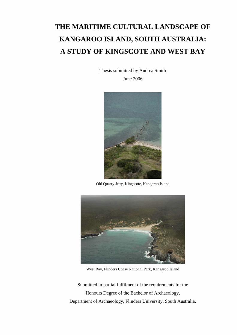
Old Quarry Jetty, Kingscote, Kangaroo Island
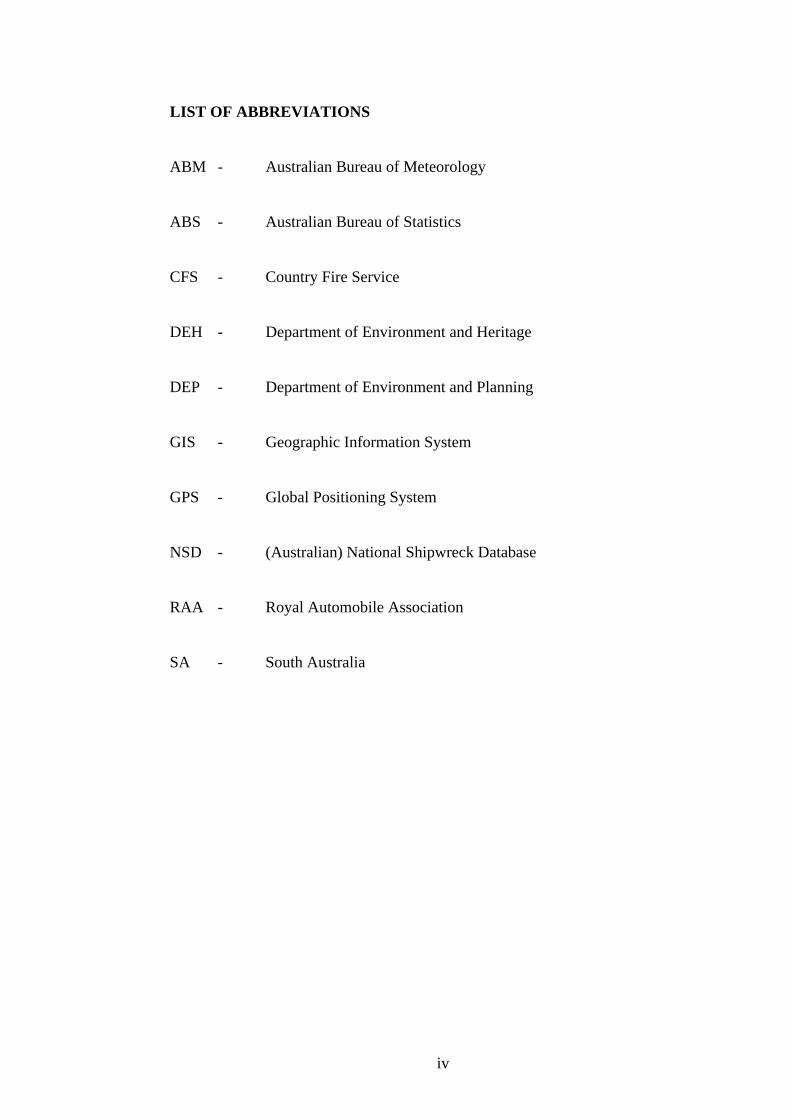
West Bay, Flinders Chase National Park, Kangaroo Island
Submitted in partial fulfilment of the requirements for the
Honours Degree of the Bachelor of Archaeology,
Department of Archaeology, Flinders University, South Australia.

ABSTRACT
Maritime Cultural Landscape Theory seeks to implement a holistic approach to the
study of humans and their activities associated with the sea. This is achieved by
complementing underwater archaeological investigations with land-based
investigations of the associated maritime infrastructure that is to be found alongside
every human interaction with the ocean.
This thesis will address how well the concept of a Maritime Cultural Landscape
explains the archaeological patterning in the historical period of Kangaroo Island.
The thesis will achieve this by viewing two case studies; Kingscote, the main town,
as an example of a dedicated maritime infrastructure and an outwards looking natural
construct approach and West Bay, in Flinders Chase National Park, as an example of
a reactive response to the environment and an inwards looking mental construct
approach.
Kangaroo Island provides an opportunity to examine this idea in a context not
previously studied in a dedicated manner, an island, which contributes another
dimension to the literature regarding maritime cultural landscapes. This thesis
addresses the limitations inherent in taking a landscape approach, as well as outlining
the possible outcomes of this work and further research opportunities.
i

DECLARATION
‘I certify that this thesis does not incorporate without acknowledgement any material
previously submitted for a degree or diploma in any university; and that to the best of
my knowledge and belief it does not contain any material previously published or
written by another person except where due reference is made in the text’.
Signed by Candidate:
__________________________________
Date:
__________________________________
ii

ACKNOWLEDGEMENTS
I would like to thank my supervisor Associate Professor Mark Staniforth for his time,
ideas, knowledge, experience and help for the duration of my Honours year. Without
his assistance I would have been going in circles, he has pointed me in the right
direction with my research and fieldwork on numerous occasions, as well as loaned
me his own copies of various books. He has also stated the obvious about facts and
ideas that one tends forget all about when you are thinking of the million and one
things you have to get done. Thank you.
I would like to thank Jennifer McKinnon for coming up with the funding to finance
our second trip to Kangaroo Island to do more fieldwork. This second trip was much
needed and not possible without your help, knowledge and experience. Thank you
also to Jason Raupp and Claire Dappert for your help and experience in conducting
historical and maritime fieldwork. Thank you to Ian Moffat for doing the
magnetometer survey of West Bay and for teaching me how to use the
magnetometer.
Thank you very much to Andrew Geering and Kate Linnett for housing and feeding
us on our first research trip to Kangaroo Island, we could not have afforded to go if
you had not been so generous. Double thanks go to Andrew for taking me up in his
helicopter to get some fantastic aerial photographs of the island.
Thank you to my parents, Roger and Lydia Smith and to my grandmother, Gladys
Smith, for financially supporting me throughout this year whilst I have been studying
and not working, this could truly not have happened without your support. Thank
you to my sister Vanessa Smith, who thought she had escaped by moving to
Brisbane, but ended up listening to me talk just as much as usual.
Thank you so very, very much Simon Geering, for your love, support, coercion in
making me sit down and study and participation in the fieldwork. Thank you also for
listening to me whine and complain and talk about my thesis, your ideas and help
have been wonderful. I could not have done this without you.
iii
LIST OF ABBREVIATIONS
ABM - Australian Bureau of Meteorology
ABS - Australian Bureau of Statistics
CFS - Country Fire Service
DEH - Department of Environment and Heritage
DEP - Department of Environment and Planning
GIS - Geographic Information System
GPS - Global Positioning System
NSD - (Australian) National Shipwreck Database
RAA - Royal Automobile Association
SA - South Australia
iv

TABLE OF CONTENTS Page No.
CHAPTER 1 - INTRODUCTION 1
1.1 Introduction 1
1.2 Kangaroo Island, South Australia 1
1.3 Significance of the Study 2
1.4 Research Question and Aims 3
1.5 Chapter Outlines 4
CHAPTER 2 - HISTORICAL BACKGROUND 6
2.1 Aboriginal Occupation of Kangaroo Island 6
2.2 European Discovery of Kangaroo Island 7
2.3 Sealers and Whalers 9
2.4 Colonial Settlement 10
2.5 Climate 11
2.6 Geography 12
2.7 Vegetation 13
CHAPTER 3 - LITERATURE REVIEW 14
3.1 Introduction 14
3.2 Cultural Landscape Theory 14
3.3 Maritime Cultural Landscape Theory 16
3.4 The Archaeology of Maritime Infrastructure 20
3.5 The Archaeology of Kangaroo Island 22
3.5.1 Indigenous Sites 22
3.5.2 Whaling and Sealing Sites 23
3.5.3 Lighthouses 24
3.5.4 Jetties 24
3.5.5 Shipwrecks 25
CHAPTER 4 - METHODOLOGY 26
4.1 Research Parameters 26
4.1.1 Time Period 26
4.1.2 Definition of Survey Area 26
4.1.3 Limitations 27
v

4.2 Archaeological Investigations 28
4.2.1 Introduction 28
4.2.2 Pre-disturbance Survey 30
4.3 Archival Research 33
4.3.1 Historical Records 33
4.3.2 Secondary Sources - Books 34
4.3.3 Archaeological Surveys 34
4.3.4 Maps and Charts 35
4.3.5 Newspapers 35
CHAPTER 5 - RESULTS 36
5.1 Introduction 36
5.2 Kingscote 36
5.2.1 Ozone Hotel 38
5.2.2 Old Police Station and Stables 39
5.2.3 Old Well 41
5.2.4 Hope Cottage Museum 42
5.2.5 Swimming Pool 43
5.2.6 Wharf and Warehouses 45
5.2.7 New Jetties 47
5.2.8 Old Quarry Jetty 49
5.2.9 ‘The Bluff’ Boat Ramp 51
5.2.10 Shipwrecks near Kingscote 52
5.3 West Bay 53
5.3.1 Loch Vennachar Anchor 55
5.3.2 Memorial Cross - Unknown Sailor 56
5.3.3 Shelter Hut 57
5.3.4 Magnetometer Survey 61
5.3.5 Shipwrecks near West Bay 61
CHAPTER 6 - DISCUSSION 61
6.1 Introduction 62
6.2 Kingscote and the Maritime Cultural Landscape 62
6.3 West Bay and the Maritime Cultural Landscape 62
6.4 Kangaroo Is. and Maritime Cultural Landscape Theory 70
6.5 Limitation of Research Design 72
vi
6.6 Potential for further Archaeological Research 72
6.7 Conclusion 74
CHAPTER 7 - CONCLUSION 75
7.1 Introduction 75
7.2 Outcomes of the Thesis Research 75
7.3 Conclusion 76
REFERENCE LIST 77
APPENDIX 1 85
1.1 National Shipwreck Database - Kangaroo Island 85
1.2 Kingscote Wrecks 86
1.3 West Bay Wrecks 90
APPENDIX 2 92
2.1 SA Government Gazette re: Lighthouse Reserve 92
2.2 Letter from Trooper Thorpe 94
2.3 Marine Board - Action re: Shipping Casualties 97
APPENDIX 3 99
3.1 Lands Titles - Historic Search of Crown Land Record 99
3.2 SLSA Letter - Permission to use Image 100
vii

LIST OF FIGURES Page No.
Figure 1.1 Map of Kangaroo Island, South Australia 2
Figure 2.1 Vegetation of Kangaroo Island 13
Figure 5.1 Detailed Map of Kingscote 37
Figure 5.2 Ozone Hotel 38
Figure 5.3 Holding Cells at Old Police Station 39
Figure 5.4 Stables at Old Police Station 40
Figure 5.5 Old Police Station 40
Figure 5.6 Old Well at Reeves Point 41
Figure 5.7 ‘Hope’, ‘Charity’ and ‘Faith’ Cottages 42
Figure 5.8 ‘The Basin’ Natural Rock Swimming Pool 43
Figure 5.9 Jetty Swimming Pool 44
Figure 5.10 Tidal Swimming Pool 44
Figure 5.11 Kingscote Wharf, 1899 45
Figure 5.12 Main Warehouse on Kingscote Wharf 46
Figure 5.13 Aerial Photograph of Kingscote Wharf, 2005 46
Figure 5.14 Two Main Kingscote Jetties 48
Figure 5.15 Fishermen’s Jetty 48
Figure 5.16 Steel Jetty 49
Figure 5.17 Old Quarry Jetty, 2005 50
Figure 5.18 Old Quarry Jetty, 2006 50
Figure 5.19 ‘The Bluff’ Boat Ramp 51
Figure 5.20 ‘The Bluff’ Boat Moorings 52
Figure 5.21 Map of West Bay Region 54
Figure 5.22 Detailed Map of West Bay 54
Figure 5.23 Loch Vennachar Anchor 55
Figure 5.24 Memorial Cross to Unknown Sailor 56
Figure 5.25 Detail of 1913 Admiralty Chart, West Bay 58
Figure 5.26 Shelter Hut at West Bay, National Trust picture 59
Figure 5.27 Shelter Hut at West Bay, SLSA picture 59
Figure 5.28 Location of Shelter Hut, northern hills face 60
Figure 5.29 Location of Shelter Hut, sand dunes 60
Figure 5.30 Magnetometer Survey of West Bay 61
viii
CHAPTER ONE
INTRODUCTION
1.1 Introduction
Maritime Cultural Landscape Theory seeks to implement a holistic approach to
the study of humans and their activities associated with the sea. This is being
achieved by complementing underwater archaeological investigations with land-
based investigations of the associated maritime infrastructure that is to be found
alongside every human journey onto the ocean. Whilst maritime archaeology in
the past has primarily focused upon shipwrecks, which are specific individual
sites, new attention is being given to ports, navigational structures, jetties and
towns in order to fully appreciate the importance these other types of sites have
played in the maritime archaeological environment. The idea behind a maritime
cultural landscape is that you cannot investigate one aspect without investigating
the other (underwater remains vs. coastal/land-based remains); the two must
compliment each other in order to reach integrated understanding of human’s
activities on and around the sea.
1.2 Kangaroo Island, South Australia
Kangaroo Island is located in the South Eastern portion of South Australia and is
separated from the mainland at the southern tip of the Fleurieu Peninsula. The
island is 150 km long and 55km wide and is Australia’s third largest island (SA
Tourism Commission: accessed 20/09/05). The island has four main towns,
Kingscote, Penneshaw, American River and Parndana. As of the most recent 2001
Australian Bureau of Statistics census Kangaroo Island had a total population of
4384 persons living on the island (Australian Bureau of Statistics: accessed
6/10/05). Access to the island is by boat or aircraft as there is no bridge to the
island from the mainland. The more popular option is arriving by the commercial
passenger ferry service, SeaLink, at Penneshaw from the mainland at Cape Jervis.
1

Figure 1.1 - Kangaroo Island, South Australia (source: CFS Map Book Kangaroo
Island 2002)
1.3 Significance of the Study
There have only been a small number of previous studies of both an
archaeological and historical nature that have been conducted on Kangaroo Island.
Those studies that have been done have focussed primarily upon the extinct
indigenous population of the island. More recently, archaeological surveys have
been undertaken with regards to the whaling and sealing sites on the island, some
have been undertaken regarding shipwreck sites, as well as one about the
lighthouses of the island. Considering how much of the island is ‘untouched’ and
in its ‘natural’ state, this provides a perfect opportunity to conduct archaeological
survey without too many layers of human based site formation processes to
contend with.
2

This thesis will be the first study conducted that focuses upon the maritime
cultural landscape of Kangaroo Island and will fill a gap in our historical
archaeological knowledge that has been previously overlooked. The thesis will
also be the first one aimed at examining the concept of a maritime cultural
landscape with a dedicated focus to an island context that will allow for an
assessment to be made regarding the value and applicability of this theory to
future research in this area.
By looking at the maritime cultural landscape of Kangaroo Island and the way in
which the sea has influenced buildings and public works, economic development
and population growth, it will be possible to construct a picture of how the island
fits within the concept of a maritime cultural landscape. Simply by virtue of being
an island, and the enormous influence the sea plays on everyday life, there are
many possibilities for potential historic and maritime research that can be studied.
1.4 Research Question and Aims
How well does the concept of a Maritime Cultural Landscape explain the
archaeological patterning in the historical period on Kangaroo Island?
This thesis will:
1. Assess how well Kangaroo Island fits within the concept of a maritime
cultural landscape and explore the opportunity this island presents for
examining this theory in a new context.
2. Identify two specific areas on the island and view them as case studies in
order to answer the research question.
3. Address the importance of the coastal landscape in adequately interpreting
and managing the heritage of Kangaroo Island.
4. Propose future avenues of archaeological investigation on Kangaroo
Island.
3

This thesis will address the research question by looking at two specific survey
areas on the Island. The first survey area is the main town of Kingscote and will
assess the way in which the sea and maritime nature of the island has influenced
the buildings and public works resulting from development and population growth
by examining the dedicated maritime infrastructure that exists in the town. The
second survey area involved the search for an isolated rural archaeological site in
the coastal sand dunes at West Bay, consisting of a ‘Relief Station for
Shipwrecked Mariners’ (Admiralty Chart 1913 - see figures 5.25 and 5.26 in
Chapter 5). It will assess the impact the sea had on stranded persons in an
inhospitable and unpopulated area by examining the reactive manner to the
perceived risk in the environmental conditions that resulted in the erection of the
shelter hut.
1.5 Chapter Outlines
Chapter 2 - Historical Background
This chapter will give a brief overview of the history of the island, from
Aboriginal occupation to European settlement and the climate, geography and
vegetation of the region. Whilst this thesis focuses predominantly upon the late
19th century and early 20th century, the earlier periods of history are relevant with
regards to both the isolation and development of the island.
Chapter 3 - Literature Review
Chapter three will look at the current literature that has been published concerning
cultural landscape theory, maritime cultural landscapes, the archaeology of
maritime infrastructure and the archaeology of Kangaroo Island.
Chapter 4 - Methodology
This chapter will outline the research parameters and survey areas as well as the
methods used to conduct the archaeological investigations mentioned in chapter
five, specifically with regards to pre-disturbance survey and magnetometer survey
and the use of prior archaeological surveys, primary and secondary source
documents, maps and charts.
4

Chapter 5 - Results
Chapter five will use the results and information gathered from archival research,
fieldwork and information obtained from the museums on the Island. This chapter
will focus upon the maritime landscapes of the two survey areas, Kingscote and
West Bay.
Chapter 6 - Discussion
This chapter will discuss and interpret the outcome of the fieldwork and answer
the research question as mentioned earlier in this chapter. It will also look at the
problems with the research methodology; the effectiveness of the thesis research
aims and will address any biases that have arisen with the archaeological
interpretation.
Chapter 7 - Conclusion
This chapter outlines the outcomes of the thesis research, and uses the two case
study areas to conclude as to whether this work has addressed the idea of
Kangaroo Island fitting within the concept of a maritime cultural landscape.
5

CHAPTER TWO
HISTORICAL BACKGROUND
2.1 Aboriginal Occupation of Kangaroo Island
Despite the absence of an Aboriginal population on Kangaroo Island at the time of
European settlement, there is material evidence to suggest that the island was
inhabited by an indigenous population at certain times in its history. Beginning
with studies by Tindale, Cooper and Maegraith in the early 1930’s (Cumpston
1986:1), many stone tool implements have been discovered that support the notion
of an extinct population. Kangaroo Island was known as Karta by the nearby
mainland Aboriginal group the Kaurna and with this name in hand and with
extensive similarities in tool types found on the island appearing to be closely
related to the Sumatran implements of Southeast Asia, Tindale named the tools
found on Kangaroo Island as Kartan (Lampert 1981:1).
There were twelve Aboriginal groups that had territory located adjacent to the
ocean along the south-eastern coastline of South Australian at the time of
European settlement. These groups (holding territory from north to south) are the
Narangga, Kaurna, Ramindjeri, Warki, Portaulun, Jarildekald, Meintangk,
Bunganditj, Gunditjmara, Kirrae and the Kolankngat (based upon Tindale’s work
of 1974 as cited by Lampert 1981:178). There are no documented ethnographic
stories of a relationship between any of the nearby mainland tribes and their
ancestors using the island. This is supported by archaeological evidence that
suggests a marked difference in the types of tools found on the island compared
with those found on the mainland, namely the use of heavy Kartan tools made
from quartzite found on the island compared to small tool sites with implements
made from flint or quartz on the mainland (Lampert 1981:146).
There are two main arguments regarding the Aboriginal population of Kangaroo
Island; one, did a relict population remain on the island when it was separated
from the mainland? And two, was the island frequently visited by outside
Aboriginal groups from the mainland over a long period of time?
6

Both arguments are valid and both have certain evidence that supports them.
Kangaroo Island is of an appropriate size to support and be the territory of one
large Aboriginal tribe. It is possible that even after access to the mainland was cut
off by rising sea levels that the population was large enough to support itself
without contact from any other groups from the mainland (Lampert 1986:178). A
more arid climate began about 5000-4000 years ago, however, and there is a
change in the burning patterns of the vegetation occurring at around 2000 years
ago which suggest that the deterioration of the environment played a roll in the
decline of a relict Aboriginal population on the island (Lampert 1986:185).
The idea of Aboriginal people swimming across Backstairs Passage is highly
unlikely although a possible feat for a very strong and experienced swimmer,
however swimming would not allow for the old or the young to join tribe
members on the island (Lampert 1986:171). Another possibility is the incidence
of watercraft crossing either Backstairs Passage or Investigator Strait. The general
consensus of people such as Jones (1976) and Spencer and Gillen (1904) suggest
that an Aboriginal canoe-raft built for an inland waterway may have been capable
of making short ocean journeys.
2.2 European Discovery of Kangaroo Island
Kangaroo Island was officially discovered by Mathew Flinders who anchored in
Nepean Bay in March 1802 (Ruediger 1980:10). He recorded his first impressions
of the island in his diary:
There was little doubt, that this extensive piece of land was separated
from the continent; for the extraordinary tameness of the kangaroos
and the presence of seals upon the shore, concurred with the absence
of all traces of man to show that it was not inhabited (Cumpston
1970:9).
Flinders named the island after his crew had spent an afternoon killing and
skinning a large quantity of Kangaroos for their meat supply:
7
A delightful regale they afforded, after four months privation from
almost any fresh provisions … in gratitude for so seasonable a supply, I
named this southern land Kangaroo Island (Fornasiero et.al. 2004:139).
At the same time as Flinders was scouting the waters south of Australia from the
West, Nicolas Baudin was also assessing the southern waters and coastline from
the East as his orders had directed him “to search for a supposed strait dividing
Australia longitudinally into two great and nearly equal islands” (Cumpston
1970:17). The French had already claimed the western half of Australia during a
1770 expedition to Western Australia. Great Britain and France were in direct
competition with each other to secure empires away from their homelands.
Despite their competition, and despite the fact that the waters around Australia
had already been claimed by the British, the French felt that if they could prove
that Australia was actually two islands, not one, the two nations could live happily
side by side. This feeling of mutual friendship and recognition was based upon the
principles of scientific exploration that continued unhindered (for the most part)
despite both countries being at war with each other (Fornasiero et.al. 2004:154).
On the evening of 8th April 1802 Flinders and Baudin sailed across each other’s
paths in a bay on the mainland to the east of Kangaroo Island that was named
Encounter Bay after their meeting. The two captains exchanged news of their
respective voyages to date and Flinders gave Baudin some more complete, up to
date charts of the region (Fornasiero et.al. 2004:159). Flinders then continued on
his way heading east and Baudin decided to continue west and head towards
Kangaroo Island and the Spencer and St. Vincent Gulfs to have a look for himself
in case Flinders had missed something, namely a great river separating the
continent in half.
Baudin’s first priority was to examine the two gulfs before returning to explore
Kangaroo Island, but with a discontent crew, low supplies and rampant illness,
Baudin was forced to return to Port Jackson. In January 1803 he returned to the
south of the country to finish what he had started the year before (Fornasiero et.al.
2004:230). Flinders had only charted and named the northern and eastern portions
of the Kangaroo Island coastline on his voyage of the south coast.
8

However Baudin sailed all the way around the island and re-named all of the
capes and bays along the coast. At least half of these places on the island still bear
the French names that Baudin gave to them during his voyage, such as Cape
Borda, Cape du Couedic, Cape Gantheaume and D’Estrees Bay to name a few.
2.3 Sealers and Whalers
From around 1803 to 1830 gangs of men who were employed by merchants to
conduct sealing and whaling operations in the southern ocean occupied Kangaroo
Island on a seasonal basis, working from shore based camps to collect oil, meat
and kangaroo skins for the international market. Some of these men decided to
settle on the island on a permanent basis from around the mid 1820’s onwards
after having left the crews they arrived with in order to set up on their own
(Taylor 2002:23).
At around this time quite a substantial settlement had sprung up at Three Wells
River, as many as 30 men along with their wives and children living in brush huts
with large established vegetable gardens (Taylor 2002:25). Unfortunately many of
the ‘wives’ of these men were actually abducted Aboriginal women from Van
Diemen’s Land and the nearby mainland. Although some of these women had
come with the consent of their families in order to help with the sealing in return
for goods or meat, many of them would not be allowed to go home and had to stay
on the island indefinitely. These women were kept because of their skills of
survival in the bush; they could find water in a dry area, they could make clothes
from kangaroo skins and they could always find food even when it was scarce
(Taylor 2002:28).
Despite the harsh living conditions on Kangaroo Island, the access it provided to
the ocean and its profitable sealing and whaling grounds, as well as the safe
harbour that Nepean Bay offered, allowed the hunting to go on unchecked. By the
time the South Australian Company arrived in the new colony in 1836, the
industry was on its last legs. Most of the sealing gangs had left and the only men
that stayed were those who were involved less with sealing and more with
hunting, farming wheat and growing vegetables (Cumpston 1986:139).
9

2.4 Colonial Settlement
After the initial exploration of the southern coast of Australia by Flinders and
Baudin, not much more was done until 1830 when Captain Charles Sturt went
down the Murray River to Lake Alexandrina and the sea. He was disappointed to
find the mouth of the river chocked by sandbars and ended up returning overland
to Sydney. In 1831 Captain Collet Barker was instructed to examine St. Vincent’s
Gulf more thoroughly and to report on the channel that was the mouth of the
Murray River. Unfortunately, after Barker had swum across the channel to see
what was on the other side, he disappeared and was never seen again (Elder
1984:25).
Once Sturt returned to London he published a book in 1833 entitled Two
Expeditions into Southern Australia that was accompanied by maps of the region
(Elder 1984:27). On the basis of his information as well as that of various other
whaling and sealing boat captains who operated in the area, the South Australia
Act was passed by the British parliament in August 1834 to allow for the
formation of a new colony, with commissioners appointed in February 1835 to
manage the endeavour, along with the South Australia Company formed in
October 1835 as a private enterprise hoping to make money from whaling and
agriculture in the new colony, which was “proclaimed the new British Province of
South Australia in February 1836” (Howell 2002:8).
On the 4th February 1836 Colonel William Light was gazetted as Surveyor-
General and the government vessel Rapid left for South Australia on 4th May 1836
with Colonel Light as commander (Elder 1984:23). His instructions were to
deposit the passengers and stores carried by the fleet at Nepean Bay, Kangaroo
Island where they were to establish a settlement, before continuing on to conduct
an in-depth survey of the coastline for a secure harbour that was close to decent
agricultural land and a permanent fresh water supply. When he found such a
destination he was to immediately survey the land and establish a town site and
then to survey the country sections that would all be allocated to the settlers by a
ballot (Elder 1984:125).
10

Initially it was anticipated that Nepean Bay would prove to be a satisfactory
location to have a town, based upon the reports of others that had been to the
island and it was on this basis that the South Australia Company arrived there on
the 27th August 1836 and the town of Kingscote was established. The
Colonisation Commissioners were less certain about the potential of the Island,
which is why they had instructed Light to continue searching the coast for a better
harbour, next to which he was supposed to situate the main town of South
Australia (Parsons 1986:17).
Eventually (after many disputes with the parties involved) the site of Adelaide on
the River Torrens was chosen because it was next to a permanent source of fresh
water without the ground being prone to flooding, it was reasonably close to
Glenelg and Holdfast Bay (the first mainland landing place, settlement and
harbour) and it was also near to Port Adelaide which was expected to be
developed as the main transit area and harbour for the province.
2.5 Climate
South Australia experiences a Mediterranean type of climate with hot dry
summers and mild winters (Lampert 1981:9). Kangaroo Island’s climate is more
stable than that of the mainland and does not experience the same fluctuations in
temperature. The Australian Bureau of Meteorology (accessed 13/05/06) gives the
average daytime temperature for Kingscote (data recorded from 1877 to 2002) as
19.1 degrees Celsius. West Bay does not have a weather station however both
Cape Borda and Cape du Couedic do and West Bay is situated almost exactly in
the middle of these two points; the average daytime temperature for Cape Borda
(data recorded from 1865-2004) is 18.1 degrees Celsius and for Cape du Couedic
(data recorded from 1907-1973) is 17.9 degrees Celsius. The average daytime
temperature for West Bay could be assumed to be in a similar range of around 18
degrees Celsius.
The Australian Bureau of Meteorology (accessed 13/05/06) states that Kingscote
experiences a mean annual rainfall of 485.1 millimetres with July being the month
of highest rainfall with an average of 77.3 millimetres (data gathered from 1877-
2002).
11

Cape Borda has a mean annual rainfall of 623.1 millimetres with June being the
month of highest rainfall with an average of 106.8 millimetres (data gathered from
1865-2004). Cape du Couedic has a mean annual rainfall of 637.9 millimetres
with July being the month of highest rainfall with an average of 110.5 millimetres
(data gathered from 1907-1973). West Bay would most likely fall in between the
data gathered for the two Cape’s with an annual average rainfall of approximately
630 millimetres and with either June or July being the months of highest rainfall.
2.6 Geography
Kangaroo Island is a southwestern extension of the Mount Lofty Ranges and is
comprised of deep, ancient sedimentary rocks that over time have tilted slightly
downwards towards the southeast (Lampert 1981:3). The main geological core of
Kangaroo Island is Cambrian in age and is comprised of the Kanmantoo series of
phyllites and quartzites (Howchin 1929:61). Many of the island’s coastal cliffs are
exposed Kanmantoo series rocks as are the islands pebble beaches that have been
formed by eroded rocks of this series. Younger Aeolian sediments of marine
origin, mainly unconsolidated calcareous sand, are found along the south and west
coasts of the island forming a sixteen kilometre section on the south coast and a
belt of up to six kilometres wide on the elevated west coast (Lampert 1981:4).
Aeolianite is the surface rock for almost all of the west coast and is exposed in
many places which has allowed for fissures to develop that can support low lying
shrubs and vegetation (Lampert 1981:5). The Nepean embayment is a plain that is
inland of the Bay of Shoals and Nepean Bay; towards its seaward margin the plain
consists of tidal flats and marshes with the inland area comprising of the alluvial
flood plain of the Cygnet River (Howchin 1929:218).
Studies of sea level depth-age curves for the Australian region suggest that
Kangaroo Island was cut off by the submergence of Investigator Strait between
9500 and 9300 years ago. Between 9700 and 9500, Backstairs Passage was
submerged, although a channel about three kilometres wide remained for perhaps
a few centuries after the island was finally separated. By 8500 years ago, due to
steepening shorelines, the distances between the island and the mainland were
essentially the same as those today (Lampert 1981:17).
12

2.7 Vegetation
The majority of vegetation on Kangaroo Island consists of Eucalyptus shrub land
with most plants ranging from 2.5 metres to 10 metres in height, although there
are also plants of the Acacia and Melaleuca species to be found (Lampert
1981:10). The vegetation of Kangaroo Island is low-lying and very dense, with E.
cneorifolia (narrow-leaf mallee) and E. rugosa (black mallee) being the most
dominant species of vegetation in the Kingscote (Nepean Embayment) region; at
West Bay the most dominant species of vegetation are E. diversifolia (white
mallee) and E. rugosa (black mallee) (see figure 2.1).
Figure 2.1 - Vegetation of Kangaroo Island (source: Lampert 1981:10)
13
CHAPTER THREE
LITERATURE REVIEW
3.1 Introduction
Since the early 1990’s Australian maritime archaeology has seen a shift away
from viewing underwater maritime sites as the only important and significant
entities in a maritime setting and is beginning to look at the larger picture. This
has come about as a result of a change in perspective regarding what is actually
important in our cultural heritage. It is now recognised that shipwrecks and other
submerged structures do not constitute the only valid form of maritime cultural
heritage in this country. The line between a submerged site and a land site is
becoming increasingly blurred when discussing the archaeological maritime
context in which an event or cultural activity has occurred. The idea of a maritime
cultural landscape further allows for this distinction between site types to
disappear and to propagate a better and more cohesive understanding of maritime
archaeology.
3.2 Cultural Landscape Theory
According to Ashmore and Knapp, “landscape is an entity that exists by virtue of
its being perceived, experienced and contextualised by people” (1999:1). James
Deetz defines the term cultural landscape as denoting “that part of the terrain
which is modified according to a set of cultural plans” (1990:2). Edward Hood
also defines cultural landscapes as “the physical spaces perceived and created by
humans, imbued with meaning and understood in culturally specific terms such
that function and meaning are inseparable” (1996:139). Archaeologists use
cultural landscape theory in an attempt to interpret the features that exist in all
types of landscapes that have been formed by human interaction with their
environment.
In addition to cultural landscapes you also have natural landscapes, built (or
constructed) landscapes, maritime landscapes (or seascapes) and associative (or
intangible) landscapes.
14
In a report by Australia ICOMOS to the World Heritage Committee in 1995, it
was recognised that “the consideration of properties of outstanding universal
value needs to be contextual (recognising a place in its broader intellectual and
physical context) rather than specific (as in the limited approach to viewing
heritage solely as monuments or wilderness)” (Feliu, 1995:447). This is important
because how a person views a landscape is not static and neither will the
landscape itself remain static as a ‘landscape is active and dynamic” (Robertson &
Richards 2003:7).
Another important aspect of a cultural landscape to consider is the relationship
between a seascape and an intangible landscape as interpreted by a non-western
community. Bender (1999) suggests that a landscape as viewed by an indigenous
person rarely separates the natural landscape, built landscape, maritime landscape
and cognitive landscapes into separate categories. This is because physical places
and stories regarding spiritual beliefs are seen as one and the same. In addition,
indigenous communities do not draw a line at the waters edge when viewing their
landscape, for them it is all encompassing. This indigenous perspective of a
landscape is supported by Taylor (2002:20) when she relates the Ngarrindjeri
story of how The Pages islands came to be situated in Backstairs Passage. Whilst
chasing his wives who were trying to escape punishment, the creation figure
Ngurunderi sees the mainland, Kangaroo Island and the ocean as his territory and
the Ngarrindjeri community’s spiritual beliefs reflect the ideology of a landscape
that draws no distinction between differing landscape types.
However the term landscape is used frequently and in many contexts. How a
landscape is perceived in Indigenous use differs from how it is perceived in a
Western framework especially since it is the Western mindset that further divides
a landscape into categories. Tracy Ireland looks at how the landscape was viewed
by the Australian colonisers when they first arrived by saying that “nature in this
context is the opposite of culture, and in the Australian settler context, nature is
the enemy of culture and the opponent of civilisation” (Ireland 2003:56).
15

Although this view looks at a natural landscape, Ireland went on to say that “the
culture of the settlers provided the forms and descriptions through which the
landscape was given a meaning and shape that was comprehensible to them”
(2003:58). Marcy Rockman supports this idea of an intangible landscape and
identifies it as a ‘Landscape Learning Process’ which is defined as:
the social response to situations in which there is a lack of knowledge
of the distribution of natural resources in a region and a lack of access
to previously acquired knowledge about that distribution (2003:12).
A key part of this is the ability on the part of the settlers to identify the locations
and physical characteristics of any necessary resources, as well as having the
means to relocate these resources subsequent to their discovery. Landscape
learning leads to the use of maps and charts by settlers, navigators and
governments as a way to permanently define and structure the landscape. Harley
sums this up well by saying “both in the selectivity of their content and in their
signs and styles of representation maps are a way of conceiving, articulating and
structuring the human world” (1994:278).
3.3 Maritime Cultural Landscapes
The concept of a Maritime Cultural Landscape was first introduced to maritime
archaeology in 1992 by Christer Westerdahl in his paper aptly titled The Maritime
Cultural Landscape. He was of the opinion that looking at underwater sites and
land sites as individual and separate entities no longer satisfied his need of
adequate archaeological interpretation of the various and diverse archaeological
remains that are to be found in Sweden. Part of the reason for his dissatisfaction
stems from the fact that over hundreds of years the sea level around Sweden has
risen and many culturally important sites that were once on land have now been
submerged. Westerdahl defined the application of his idea by saying:
the maritime cultural landscape signifies human utilisation
(economy) of maritime space by boat: settlement, fishing, hunting,
shipping and its attendant sub-cultures such as pilotage, lighthouse
and sea-mark maintenance (Westerdahl, 1992:5).
16
Westerdahl went on to further refine his original idea of a maritime cultural
landscape by including the additional concept of Centres of Maritime Culture.
“Culture implies maritime economies … it is clear that, towns or other
commercial centres apart, activities concentrate in certain areas or at certain
points” (1994:267). When examining a maritime landscape it is important to
include all factors relating to, and influencing, maritime activity in a certain area.
A lot of knowledge will be lost from the archaeological interpretation of a site if it
is not studied by looking at these additional categories used by Westerdahl
(1992:7-8) in his own work, Shipwrecks, Land Remains, the Tradition of Usage,
Natural Topography and Place Names.
Australian practitioners have been using this holistic approach to maritime
archaeology for some years albeit in an informal manner. There are “very few
members of the public who understand, or even value, the academic difference
between maritime history and maritime archaeology” (McCarthy 2003:25) which
has made a combined approach to the maritime culture of Australia a necessity.
In 1992 Gaye Nayton, for example, investigated the influence of water-borne
transport upon historical terrestrial sites. This research assessed the importance of
ships in transporting goods and services across the huge continent of Australia,
which was more economically viable, and quicker, than transporting goods via
land or rail. The running theme of her paper was the interrelationships between
the sea and the development of remote towns and communities in Australia, which
cannot be separated from each other when assessing development from either an
archaeological or historical context.
Much more closely aligned with Westerdahl’s theory of a maritime landscape than
Nayton, is Sarah Kenderdine’s work where she applied the concept of a maritime
cultural landscape to multiple archaeological sites along the River Murray basin
by assessing “in a broad approach … the remains of an inland boat culture”
(Kenderdine 1993:11). She looked at both the archaeological remains of the
riverine shipping industry as well as the physical environment and the impact that
local economics and farming had upon the cultural history of the area (1995a:
312).
17

She sees that human culture, both under and above the water, is inclusive with a
natural landscape because it is the natural landscape that dictates all human
actions and processes within a defined geographical region (1993:12). The project
documented 87 land sites, 61 shipwrecks and 16 historic vessels and aimed to
provide a useful tool for heritage managers and tourism operators working around
the River Murray and in the Murray-Darling basin.
With a slightly less developed approach, Jeffery (1994), recognised that
archaeologists should be looking beyond individual sites, be they underwater i.e. a
shipwreck, or on land i.e. port facilities and start to view archaeological remains
in a wider context that includes the people and places that influenced the
construction and use of these other artefacts. Jeffery used the term “maritime
heritage landscape” (Jeffery, 1994:6) as opposed to a ‘maritime cultural
landscape’ and his work was a step forward for heritage practitioners working in
Australia.
In the United Kingdom, Nigel Bannerman and Cecil Jones conducted an
archaeological survey of the different Fish-trap types that were used in Britain.
They felt that “in any attempt to define a maritime cultural landscape the fish-trap
or fishing weir has a special place” (Bannerman & Jones 1999:70) because it is
usually associated with settlements and trade patterns, as well as being able to
provide clues to changes in sea level and differences in the configuration of the
coastline. Fish-traps form only one component of the maritime landscape but
provide a useful link to older cultures and the development and adaptation of these
cultures to the landscape.
Also in the United Kingdom, A.J. Parker assessed the maritime cultural landscape
of the port of Bristol in the Middle Ages. He argues that the town has developed
on the basis of the curvature of the rivers Avon and Frome and the crossing places
that existed during the Middle Ages (Parker 1999:326). Despite a lack of physical
or cultural evidence of these crossing places, i.e. a bridge, the alignment of
Temple street near the River Avon and of the rising ground at St. Bartholomew’s
Hospital near the River Frome suggest that they could have been forded at low
tide provided they were well maintained.
18
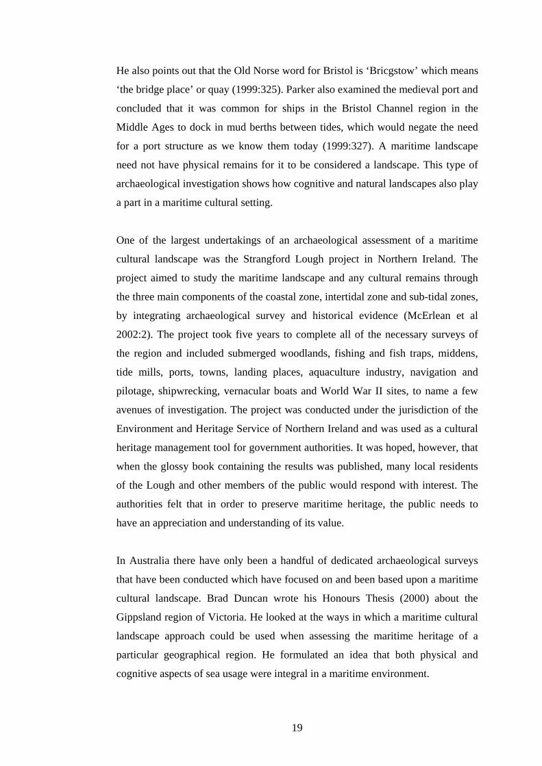
He also points out that the Old Norse word for Bristol is ‘Bricgstow’ which means
‘the bridge place’ or quay (1999:325). Parker also examined the medieval port and
concluded that it was common for ships in the Bristol Channel region in the
Middle Ages to dock in mud berths between tides, which would negate the need
for a port structure as we know them today (1999:327). A maritime landscape
need not have physical remains for it to be considered a landscape. This type of
archaeological investigation shows how cognitive and natural landscapes also play
a part in a maritime cultural setting.
One of the largest undertakings of an archaeological assessment of a maritime
cultural landscape was the Strangford Lough project in Northern Ireland. The
project aimed to study the maritime landscape and any cultural remains through
the three main components of the coastal zone, intertidal zone and sub-tidal zones,
by integrating archaeological survey and historical evidence (McErlean et al
2002:2). The project took five years to complete all of the necessary surveys of
the region and included submerged woodlands, fishing and fish traps, middens,
tide mills, ports, towns, landing places, aquaculture industry, navigation and
pilotage, shipwrecking, vernacular boats and World War II sites, to name a few
avenues of investigation. The project was conducted under the jurisdiction of the
Environment and Heritage Service of Northern Ireland and was used as a cultural
heritage management tool for government authorities. It was hoped, however, that
when the glossy book containing the results was published, many local residents
of the Lough and other members of the public would respond with interest. The
authorities felt that in order to preserve maritime heritage, the public needs to
have an appreciation and understanding of its value.
In Australia there have only been a handful of dedicated archaeological surveys
that have been conducted which have focused on and been based upon a maritime
cultural landscape. Brad Duncan wrote his Honours Thesis (2000) about the
Gippsland region of Victoria. He looked at the ways in which a maritime cultural
landscape approach could be used when assessing the maritime heritage of a
particular geographical region. He formulated an idea that both physical and
cognitive aspects of sea usage were integral in a maritime environment.
19

Duncan also looked at how risk mitigation policies could have influenced the
structuring of a maritime landscape (or seascape as he uses the term). He
considers both the natural environment in influencing the occurrence of
shipwrecks as well as the man-made environment e.g. lighthouses and how these
have spatially shaped the landscape.
In 2004, Aidan Ash wrote an Honours Thesis about the maritime cultural
landscape of Port Willunga, South Australia. He looked at shipping, loading and
docking facilities and land structures associated with commerce at Port Willunga,
at the shipwrecks submerged in the harbour and at the recreational usage of the
jetty, beach, sea, cliffs and caves. Ash took for granted the concept of a maritime
cultural landscape as previously documented by other authors and did not attempt
to expand upon it, but took it at face value and used it effectively when he
assessed Port Willunga and its maritime landscape.
With regards to viewing Kangaroo Island as a maritime cultural landscape, in
discussing the importance of a comprehensive approach to landscapes to the
World Heritage Committee, Australia ICOMOS recommended that the term
‘landscape’ should “include seascapes, so important to island and maritime people
and environments” (Feliu, 1995:450). This comment was made in 1995 and
Kangaroo Island has yet to benefit from such a holistic approach to its maritime
landscape, despite the fact that it is Australia’s third largest island and has a
history of shipwrecks, trade and occupation based upon its relationship with the
sea and ships.
3.4 The Archaeology of Maritime Infrastructure
Maritime infrastructure includes but is not limited to, jetties, wharfs, slips, docks,
landing places, harbours, boat sheds, warehouses, workers cottages, public
houses, lighthouses, light stations, shelter huts, passenger terminals, breakwaters,
and commercial aquaculture industries such as Cray-fishing and Oyster beds.
20
In 2000, Julie Ford examined the use and maintenance of jetties in South Australia
that were under state government control for her Honours thesis. South Australia
has a very large coastline and the government played an integral part in the
construction of a large number of jetties and the quality of the maintenance
conducted on them. Ford discovered that as a result of legislation and the rising
costs of management, many working commercial jetties became public
recreational jetties, ultimately under the jurisdiction and financial control of local
councils. She also found that there was a lack of published theory regarding
jetties, with the exception of engineering techniques and small quantities of
English and American literature surrounding wharfs and piers. Her archaeological
investigation was a much-needed critique about the use of jetties, the social and
economic needs of the community and the changes in construction and
maintenance techniques of jetties.
Most commonly port related structures are viewed as being jetties, wharfs and
places of commerce and public gathering. Published in 2002, Michael McCarthy
of the Western Australian Maritime Museum summarised a series of surveys and
excavations of jetties, groynes and landings that had occurred in Western
Australia since 1984. Whilst not looking specifically at the maritime cultural
landscapes that these structures appear within, he still took into account artefacts
of personal belongings of passengers, the recreational value of jetties in addition
to their original purpose and how these two things were representative of the use
of anti-social behaviours in the region.
In 2003, Peter Davis and Susan Lawrence excavated the Gabo Island Jetty Shed
situated off the coast of Victoria. The aim of the project was to use the results and
artefacts from the excavation to link the building together with whaling and
sealing maritime activities in the early 19th century. This archaeological survey
did not attempt to investigate the cultural landscape that may have existed on the
island in relation to the jetty shed in any detail as it was more concerned with the
anomaly of the jetty shed being made of stone and its use as a port structure.
21
3.5 The Archaeology of Kangaroo Island
The archaeology and heritage of Kangaroo Island was summarised by a
Department of Environment and Planning survey and report that was published in
1991. This report identified land based sites of heritage interest from the historical
and indigenous periods of settlement on Kangaroo Island.
One of the most outstanding and important finds of this report with regards to this
thesis’s notion of a maritime cultural landscape was noted by the report in saying
“the primacy of sea over road transport is reflected in the seawards orientation of
many of the homesteads, farmhouses, tracks and other relics, such as threshing
floors” (Dept. Environment & Planning 1991: Part 1, paragraph 1.2.3). This report
did not undertake to identify any underwater sites of heritage importance,
however, it did identify a few sites of maritime interest such as the lighthouses
and their associated features, as well as some whaling and sealing sites.
3.5.1 Indigenous Sites:
Kangaroo Island, or Karta as it is known by the nearby mainland tribe, the
Kaurna, has been uninhabited by an indigenous population for quite some time.
Ronald Lampert has identified that around 10 000 years ago the Island began to be
separated from the mainland and that its separation was complete around 8500
years ago. He has argued that even if a relict population survived on the island
after this date, the evidence suggests that with the increasingly arid conditions that
occurred between 5000-4000 years ago, the population would have died out by
2500 at the latest.
There have been numerous archaeological investigations carried out on Kangaroo
Island with regards to Aboriginal occupation of the Island. According to Lampert
(1981:1) the first stone tools were discovered by a geologist named Howchin in
1903. Subsequent to his discoveries the first surveys were conducted by Tindale,
Meagraith and Cooper of the South Australian Museum in the 1930’s. They
published their findings of the various stone tools they discovered including their
thoughts and observations in journals and in the South Australian Museum
Records.
22

Ronald Lampart, as part of his PhD research (1981) conducted a very detailed and
intensive survey into aboriginal occupation of the island and the possible reasons
why they were no longer living there when Mathew Flinders visited the island in
1802. In 1999, Lydia Mathews conducted research about the cross-cultural hunter-
gatherers on Kangaroo Island for her Honours thesis. She collected artefacts in
order to examine the cross-cultural issues inherent in such a diverse community, a
place where indigenous and European values and cultural backgrounds came
together. However Lampert’s study still stands out to date as the most
comprehensive archaeological answer so far as to the fate of the Indigenous
population.
The exception to this may be the work of Rebe Taylor who has written a very
comprehensive and fascinating historical account (2002) of the Aboriginal
Tasmanian women of Kangaroo Island and their descendants. Her study focuses
upon the Aboriginal women brought to the island by European whalers and
sealers in the early 19th century, not about the extinct indigenous population, but is
a comprehensive overview of life on the island nonetheless. Also in 2002, Keryn
James examined the slavery of Aboriginal women taken to Kangaroo Island in the
early 1800’s to be wives to the sealers and whalers that had set up camp on the
island. Her Honours thesis (2002) parallels the work of Taylor (although with an
emphasis on archaeology not history) and attempts to use physical evidence and
landscape archaeology to provide one of the first examples of slavery that has
previously been undocumented in Australia.
3.5.2 Whaling and Sealing Sites:
Parry Kostoglou and Justin McCarthy (1991) conducted an archaeological survey
of the whaling and sealing sites that are known to be in South Australia. They
documented five main sites on Kangaroo Island, mostly on the North and South
coasts. Little material evidence remains of these enterprising businesses, as they
were very transient in nature. Their survey mainly identified wells cut into the
rocks in order to collect water, remains of walls of houses, fragments of
whalebone, locations of possible base camp sites and identification of previously
removed artefacts such a trypot.
23

In 1998 Nick Nelson wrote his Honours thesis about the economics of bay
whaling in South Australia, focussing upon Kangaroo Island. He examines this
topic using Wallerstein’s neo-Marxist World Systems Theory which relates to
world economic development, combined with archaeological fieldwork to
discover the extent of the material remains on various whaling stations sites on the
island. Nelson concluded that Australia in the 1840’s was a peripheral player on
the world economic stage, relying upon an industry that once taken away from its
core users rapidly becomes obsolete. The transient nature of the whaling sites he
discovered on Kangaroo Island was supported by their lack infrastructure and
material evidence.
3.5.3 Lighthouses:
To date, only one archaeological survey has been completed regarding the
lighthouses and keepers cottages on Kangaroo Island. In 2005 Shane Lyons
surveyed Cape du Couedic, Cape Borda and Cape Willoughby lighthouses. He
also surveyed the keeper’s cottages; the landing places, flying foxes and jetties for
the delivery of the lighthouses stores and provisions; the middens and the
cemetery at Cape Borda. The only other source of historical information for the
lighthouses is the logbooks and records of each individual lighthouse, the majority
of which are held by the National Archives of Australia.
3.5.4 Jetties:
To date there is no completed archaeological survey written regarding the jetties
of Kangaroo Island. There is however, a Masters Thesis by Amer Khan in press at
the time of this publication (2006) that looks at the development of jetties in South
Australia, including Kangaroo Island. In addition there is an excellent and very
comprehensive book written by Neville Collins (2005) about all of the jetties,
both past and present, that can be found in South Australia. He goes into great
detail about not only the historical background of the jetties and towns they are
found in, but also into technical detail about the design, construction and
measurements of the jetties. Collins goes on further to examine the nine jetties
that have existed on Kangaroo Island throughout its history namely, Emu Bay,
Kingscote (all four jetties), Ballast Head, American River, Muston, Penneshaw,
Antechamber Bay, Vivonne Bay, and Cape du Couedic.
24

He also has a brief historic look at the two original jetties built by the South
Australia Company in 1836 at Reeves Point, as well as the Old Quarry Jetty at
Reeves Point erected sometime after 1850.
3.5.5 Shipwrecks:
There have been a handful of archaeological surveys conducted regarding the
shipwrecks that lie off the Coast of Kangaroo Island. The Department of
Environment and Heritage, South Australia, implemented an interpretative
Maritime Heritage Trail around the island. This includes not only handheld maps
indicating the location of the wrecks, but also numerous interpretative signposts
and memorials to shipwrecked vessels and crews.
In 1977 members of the Society for Underwater Historical Research conducted
and archaeological survey of the wreck site of the Loch Vennachar, their maps,
site plans and photographs are now on display at the Hope Cottage National Trust
Museum in Kingscote. Most of the 83 ships (National Shipwreck Database
accessed 24th April 2006) that are known to have been wrecked around the
Kangaroo Island coastline have not yet been found.
Robert McKinnon conducted a literature survey of the wrecks that have occurred
off the coast of Kangaroo Island in 1991. He felt that it was important that these
wrecks be located and surveyed as many early Australian built vessels were
wrecked around the island and that construction details of the vessels had not
previously been recorded (McKinnon 1991:39). He also stated that other items of
heritage significance, such as the lighthouses, landing places and graves should
also be recorded (which has subsequently been done by Shane Lyons in 2005), as
they also form an integral part of the maritime record (1991:37).
25

CHAPTER FOUR
METHODOLOGY
4.1 Research Parameters
4.1.1 Time Period:
Kangaroo Island was inhabited before official settlement in 1836, predominantly
by sealers and whalers who did not establish a permanent settlement on the island
as they were only in the region on a seasonal basis, from around 1802 until the
1840’s (Ruediger 1980:30). Official settlement was sanctioned in 1836 but most
settlers only remained on the island for a few months due to a lack of water. Only
a small proportion of the population remained and the Island was virtually
abandoned within a few years of settlement in 1836 until around 1890 when the
population, trade, and agriculture began to expand (Kingscote CWA 1951:9).
From the early 1900’s an enormous amount of construction and building work
occurred and the Island has progressed to the point it is at today, whereby
numerous visitors flock to the island to experience nature at its best.
This thesis will focus research upon the historical period on Kangaroo Island,
from approximately the 1890’s until the mid 1930’s. However it is very important
not to forget that the earlier periods of settlement from the sealers in 1802 and of
the colonial settlement in 1836, have played an important part in the development
of a unique maritime culture, and so as a result specific points of interest will be
included from these times if they have significantly contributed to the later period
of development on the Island.
4.1.2 Definition of Survey Area:
Kangaroo Island was chosen as the survey area because it is a clearly defined
region as it is an island. As a result of its isolation, the people on the island have
developed a clearly defined sense of themselves and have a long established
relationship with the sea and maritime culture. The island also presents an
opportunity to examine the concept of a maritime cultural landscape in a context
not previously studied in a dedicated manner, an island, which contributes another
dimension to the literature regarding maritime cultural landscapes.
26

It was beyond the scope of this present study to investigate more than two sites;
therefore the survey area has been further narrowed down from a large regional
study of the whole island to focus upon two case study areas, the main town of
Kingscote and the isolated rural landscape of West Bay in Flinders Chase
National Park. Kingscote has been chosen because of its continuous inhabitation
by the people of the island since colonisation and as an example of a dedicated
maritime infrastructure that has an outwards looking approach. Kingscote has
always been an important town as it is on the trade route for vessels heading
southeast towards Tasmania or west towards Fremantle. Nepean Bay is one of
only a few safe harbours along the northern coastline of the island and this has
increased the town’s value and importance.
West Bay has been chosen as an example of a rural landscape that is ruled by the
violent ocean and harsh terrain that exists in a location almost completely void of
a human population. It provides an outstanding example of the nature of a
community bound by water evidenced by the attempts taken to provide safe haven
from the sea in the form of a Shipwrecked Mariners Relief Station, search parties
and the community spirit of the local residents. West Bay is an example of a
reactive response to perceived risk and that has an inward’s looking approach.
4.1.3 Limitations:
Whilst this thesis is about the maritime cultural landscape of the island and
attempts to promote a holistic approach to study of the maritime landscape by
looking at both underwater and land-based influences, it is unfortunate that
underwater survey of any portions of both survey areas was unable to be
considered at this time. This thesis will have to suffice in using other people’s
underwater surveys in lieu of first hand underwater survey information and will
not be able to account for other author’s methods of research and fieldwork.
Therefore this thesis may unfortunately be biased in favour of land-based
historical archaeological interpretation and may not be as fully ‘integrated’ as one
might have hoped. However this does provide the opportunity for further research,
underwater survey included, at a later date.
27
This thesis only looked at the material culture aspects of population growth,
economic development, building and public works as part of the research. It did
not attempt to address the relationship between the ocean, maritime culture and
agricultural development, as it was too large an area to study as part of this thesis.
Data collection was hampered by only two visits to Kangaroo Island to conduct
research, with a lack of structural remains at West Bay being a disappointing
outcome. By only studying two sites, Kingscote and West Bay, the data gathered
was not a representative sample of the possible quantity of information available
on Kangaroo Island that could be used to answer the research question.
Please see Figures 5.1, 5.21 and 5.22 for detailed maps of the survey areas of
Kingscote and West Bay, respectively.
4.2 Archaeological Investigations
4.2.1 Introduction:
In order to gain an understanding of the survey areas of Kingscote and West Bay,
a pre-disturbance survey has been carried out at both locations as well as a
magnetometer survey of West Bay. In addition to this, research was conducted by
attending two local museums, a public display centre and by informally chatting
to local residents. To achieve this several steps were taken to ensure that adequate
and relevant information was gained within the allocated time frame. Practical
research was carried out in the course of two separate trips to the island, the first
one in November 2005 and the second in April 2006
Kangaroo Island is accessible by boat or aircraft and a vehicle is needed,
preferably a four-wheel drive, whilst on the island as there is no public
transportation system. During the first field trip the author drove her own personal
car from Adelaide to Cape Jervis, caught the vehicular SeaLink ferry from Cape
Jervis to Penneshaw and then drove the car from Penneshaw to Kingscote. Whilst
staying on Kangaroo Island, accommodation was arranged for the two participants
in the fieldwork to stay free of charge with a family member who was a local
resident of Kingscote.
28
During the second visit, there were a total of five people involved in the
fieldwork, with four people driving to the island in a four-wheel drive and the fifth
person flying in. Accommodation was arranged for three nights at the Research
Station at Flinders Chase National Park and camping for two nights.
From verbal reports given by our host from the first trip (A. Geering pers com
Nov 05), we were informed that Kingscote has properly surfaced and well
maintained tarmacked roads and West Bay has an unsealed but generally well
maintained gravel road of reasonable quality and that the author’s personal car
should suffice quite nicely to conduct the fieldwork in. For the second trip, the
group was lucky enough to have a four-wheel drive which made getting around on
the island’s dirt roads much more comfortable.
Fieldwork was conducted on both the first and second trips to Kangaroo Island.
Certain pieces of equipment were necessary in order to conduct the fieldwork and
were brought along supplied courtesy of the Flinders University Archaeology
Department. Whilst not all items of equipment were necessarily instrumental in
conducting the survey, it was prudent to carry a wider selection of equipment in
case of unforseen circumstances or finds, especially since it was highly likely that
due to financial constraints the first trip was anticipated as going to be the one and
only visit to Kangaroo Island for practical research regarding this thesis. This
equipment included: two digital cameras; SLR camera; range pole; GPS; drawing
kit and board; 30m and 50m tape measures; pegs/stakes; compass; topographic
map; four-wheel drive road map; scales and north arrow; plastic bags and marker
pens; as well as personal equipment such as laptop; chargers and extra batteries;
field journal; paper and recording sheets; clipboard; pens; basic first aid kit,
mobile phone; wet weather gear; dry weather gear including hat and sunscreen, as
well as ample food and water. On the second research trip to the island additional
equipment included a magnetometer, extra GPS units and camping equipment
such as tents, swags, food cooler, gas bottle, table and chairs, cooking utensils and
cold weather clothing.
29
4.2.2 Pre-Disturbance Survey:
It is not the intention of this research to interfere or disturb in any way the
surroundings of the survey areas in general, or any specific sites of interest that
may be located. Practical research was carried out by conducting a pre-
disturbance survey of the intertidal zone, beach and nearby land surfaces in the
coastal areas of Kingscote and the beach, sand hills and cliffs at West Bay. In
addition to this, some buildings and structures on the wharf and near the shore at
Kingscote have relevance to the maritime culture of the island, such as the storage
sheds for goods and the local swimming pool and have been included in the
survey.
The first trip to Kangaroo Island surveyed Kingscote and West Bay and had a
total of three days allocated to the project including travel time. Arriving on the
ferry at Penneshaw in the mid morning on the 17th November 2005 and driving
directly to Kingscote, this day consisted of surveying the coastal areas of
Kingscote, the town itself and by visiting the National Trust Museum. The entire
day of the 18th November was spent on a day trip to West Bay. Driving from
Kingscote to Flinders Chase Visitor Centre and from there onto West Bay took
just over an hour and a half, which was longer than expected due to the terrible
road conditions caused by recent heavy rainfall damaging the track. The day
consisted of surveying the beach, sand hills and surrounding area for the remains
of or at least the possible location of the “Shipwrecked Mariners Relief Station”
(Admiralty Chart 1913) before driving back to Kingscote in the evening. The
morning of 19th November was set aside for tying up loose ends and re-visiting a
couple of sites within Kingscote, such as the old jetty and old police station.
Driving from Kingscote to Penneshaw in the mid-afternoon allowed time for a
visit to the Penneshaw Maritime and Folk Museum before the night ferry departs
for the mainland.
Whilst on Kangaroo Island, the manner in which the surveys were conducted was
the same for both sites. Using the car, a drive around the town of Kingscote (a
walk around for West Bay) and the immediate surrounding countryside allowed a
feel for the landscape to develop, as well as indicating the potential for the
possible location of valid sites.
30
Once the relevant sites were identified, a mud map of the area was sketched
noting relevant features and other information such as topography, vegetation,
ground surface visibility and any artefacts and structures visible. The mud maps of
specific sites were paced off by foot accordingly and included compass bearings
and directional arrow.
Within each case study area, i.e.: Kingscote and West Bay, there was a number of
smaller sites that are relevant to the maritime cultural landscape of the town and to
Kangaroo Island as a whole. At Kingscote these included the old jetty, the newer
jetties, the warehouses, the original police station, the swimming pool and the
wharf and docking facilities. At West Bay there are few material remains and
therefore only include the preserved anchor from the Loch Vennachar shipwreck
and the cross memorial for the grave of the unknown sailor. Further information
about all of the relevant sites within each case study area, including underwater
sties, will be examined in more depth in chapter five when the results of the
surveys will be discussed.
Each of these sites that contained material evidence that has survived has been
recorded, photographed and documented in a field journal, or on an appropriate
site recording form such as a photography pro-forma where applicable. It was
ultimately not necessary to conduct any accurate mapping to scale therefore the
intended survey method of baseline/offset with the basic equipment brought along
including tape measures, compass and GPS was not required.
At West Bay there was an extensive area to be covered by field walking to assess
the area for the location of the Shelter Hut. With only two people going through
this process, any formal transects walked would have only covered a very narrow
area, approximately four meters in width at a time. Because of the short time
window allocated to practical research conducted on Kangaroo Island and the fact
that walking enough transects to cover a broad enough stretch of land at one time
is unfeasible, especially since West Bay contains cliffs within the survey area, this
method was not used.
31

Instead, the area was assessed by walking through the southern cliffs first,
following as straight a line as possible, going along, up and doubling back and so
forth; and then onto the beach and the sand dunes using the same method.
The second research trip to Kangaroo Island was conducted over the course of six
days, from the 7th to 12th April 2006. Only approximately two and half days were
allocated to the survey of West Bay and less than half a day allocated to
Kingscote. This research trip combined the interests of other members of the
group therefore the remainder of days were spent researching other sites.
With more people, it was easier to conduct field walking covering a larger area at
West Bay. In the previous survey, the southern hills, beach and sand dunes were
surveyed, in the second survey the northern hills face and the sand dunes were
looked at in much greater detail. In teams of two the hills and dunes were assessed
for the location of the shelter hut based upon an old photograph of the hut that
exists in the photographic collection of the National Trust Museum at Kingscote
(see figure 5.24). The photograph shows the shelter hut situated in the dunes at a
mid point in the dune formation although it is unfortunate that neither the author
nor date is known which makes it difficult to place the picture of the hut in any
sort of spatial context or time frame as the sand dune system is very active and
shifts frequently. Once again it was not possible to walk in transects, however the
region was adequately covered with two people assessing the northern hills and
upper portion of the sand dunes and the other two people walking the sand dunes
lower down covering the gullies and ridges of the sand dunes.
After narrowing down the possible location of the hut, a magnetometer survey of
part of the sand dunes was conducted collecting data in five meter transects at
three-second intervals. Due to very bad weather the magnetometer survey was cut
short but the main area was surveyed and had been completed in time. Additional
photographs of the area were taken as well as notes on the geomorphology of the
sand dunes and the vegetation cover.
32

The time spent in Kingscote was focused upon the Reeves Point Historic Site,
specifically looking for the remains of the two oldest jetties, as well as viewing
the old quarry jetty. The group walked from the Point to Kingscote along the
beach looking for material evidence such as wooden piles, nails and metal chains
and then walked along the cliff top back to Reeves Point. Photographs were the
only form of recording done on this site during that visit.
The majority of sites surveyed are mostly large man-made sites that have been
built since the late 19th century, whose location or approximate location is already
known. The survey sites have been limited to areas that are open to public access
i.e.: roads, parks, beach, jetties etc. No prior access to private property was
arranged, nor was it felt necessary to arrange such access, as the sites that have
been surveyed were known to be in the abovementioned public areas.
4.3 Archival Research
4.3.1 Historical Records:
The historical documents that have been used in this thesis consist of primary
sources including the South Australian Government Gazette to search for any
tenders for the construction of the shelter hut at West Bay, the South Australian
Parliamentary Papers and the South Australian Marine Board Minutes & Reports
in order to look for any maps of the shelter hut or reports detailing visits to the hut
and various correspondences between Government Officials at different points in
time. These documents were obtained primarily from the State Library of South
Australia and the South Australian Archives. These documents have proved to be
invaluable as they have provided further supporting evidence for many points of
interest and contention. In addition, the Cape Borda Light Station logbooks were
viewed at the National Archives of Australia, as the shelter hut fell under the
jurisdiction of the lighthouse reserve for part of its history. The Lands Titles office
also proved to be an interesting resource by providing a historical search of survey
and land use in the West Bay area.
33
4.3.2 Secondary Sources - Books:
Many history books about Kangaroo Island in general have been consulted such
as Kangaroo Island 1800-1836 by Cumpston, Border’s Land: Kangaroo Island
1802-1836 by Ruediger The Great Kartan Mystery by Lampert and Unearthed:
The Aboriginal Tasmanians of Kangaroo Island by Taylor; as well as books
referring to the history of South Australia such as Southern Passages by Parsons,
William Light’s Brief Journal edited by Elder and Encountering Terra Australis
by Fornasiero et al. In addition to these, books with information relating to
maritime structures such as lighthouses, jetties and wharfs i.e. The Jetties of South
Australia by Collins, as well as books about the shipwrecks of Kangaroo Island
and the South Coast of South Australia have also been perused i.e. Kangaroo
Island Shipwrecks by Chapman and Wrecks on the South Australian Coast by
Loney. These sources have been used to gain an overall understanding of the
history of Kangaroo Island and South Australia and have come from the State
Library of South Australia, The Flinders University Library and The Barr Smith
Library of The University of Adelaide.
4.3.3 Archaeological Surveys:
Whilst there have only been a handful of published of archaeological surveys
conducted regarding Kangaroo Island specifically these have none the less proved
to be of immense value in this current work by outlining what has been done and
what still needs to be done. Some of the surveys referred to include Lampert’s
book based upon his PhD thesis The Great Kartan Mystery, Mathew’s Honours
Thesis The Cross Cultural Hunter gatherers on Kangaroo Island, James’s
Honours Thesis Wife or Slave? The kidnapped Aboriginal women workers and
Australian Sealing Slavery on Kangaroo Island and Bass Strait Islands, as well
surveys such as the Department of Environment and Planning report The Heritage
of Kangaroo Island, Whaling and Sealing sites in South Australia by Kostoglou
and McCarthy and Lyon’s Masters Thesis The Lighthouses of Kangaroo Island.
These archaeological surveys have come from The Australian National
University, The South Australian Department of Environment and Heritage and
The Flinders University Library including their Special Thesis Collections.
34

4.3.4 Maps and Charts:
This thesis has used many maps and charts to obtain the majority of the initial
information that has lead to the decision to survey the two sites. Namely, British
Admiralty Charts from the 1840’s to the 1920’s and Australian Navy Charts from
the 1960’s onwards. Out of these, the British Admiralty Charts have proved to be
the most useful as they contain consistent information across the span of years
about the entire island. The Australian Navy Charts are quite good, however too
recent for the purposes of studying West Bay. A selection of other maps has been
consulted such as a Royal Automobile Association four-wheel drive road map as
well as a Country Fire Service topographic map of the island. Theses maps and
charts have come from The Mortlock Library of South Australia, the Royal
Automobile Association of South Australia and The South Australian Department
of Environment and Heritage’s MapLand.
4.3.5 Newspapers:
Various Newspapers have been used in gathering background historical
information about Kangaroo Island. The Register (Circulation: South Australia)
from 1836, The KI Courier from 1909 until 1948 (Circulation: Kangaroo Island)
and The Islander (Circulation: Kangaroo Island) from 1967 onwards. Out of these
newspapers, the two that have proved to be the most beneficial have been The KI
Courier and The Islander. These newspapers can be obtained on microfilm and in
hard copy from The State Library of South Australia.
35

CHAPTER FIVE
RESULTS
5.1 Introduction
To examine every archaeological aspect of Kangaroo Island that could
conceivably fit within a maritime cultural landscape would have been an
impossible task to achieve within such a short time frame given to the completion
of this project. With this in mind this thesis has focused upon two case study
areas, Kingscote and West Bay and the results of the archaeological survey have
been set out below. See Chapter Six for a detailed analysis and discussion of the
implications of the archaeological surveys of Kingscote and West Bay.
5.2 Kingscote
Please see Figure 5.1 for a detailed map of Kingscote, Kangaroo Island.
Based upon a visual perspective of historic photographs at the State Library of
South Australia and the Hope Cottage National Trust Museum, Kingscote has not
changed in any great manner since it was first settled. The only exception is that
of natural population growth and its resultant expansion of public buildings and
residential blocks. Along with modern times and a larger population the town has
also experienced surfaced roads and a surfaced wharf, telephone and power lines,
as well as access to common modern technology such as mobile phone service,
satellite television and internet capabilities.
But for all that Kingscote has moved into the 21st century, it has still retained its
charm as both a historical and remote town cut off from the mainland and from
Adelaide, the capital city of South Australia. There is an outstanding amount of
material evidence from early settlement 170 years ago and from the 1890’s
onwards that is still in multiple locations around the town.
36

The initial settlement of Reeves Point (north of Kingscote) was an important
historical event in South Australia’s history that was only possible through the use
of ships. Because of this, the results of the archaeological survey of Kingscote will
include some of these sites of interest. In keeping with the true nature of a
maritime cultural landscape, the survey will incorporate terrestrial, partially
submerged and completely submerged sites of interest.
Figure 5.1 - Detailed map of Kingscote, Kangaroo Island
(source: RAA Road Map No. 7, Kangaroo Island 2003)
37
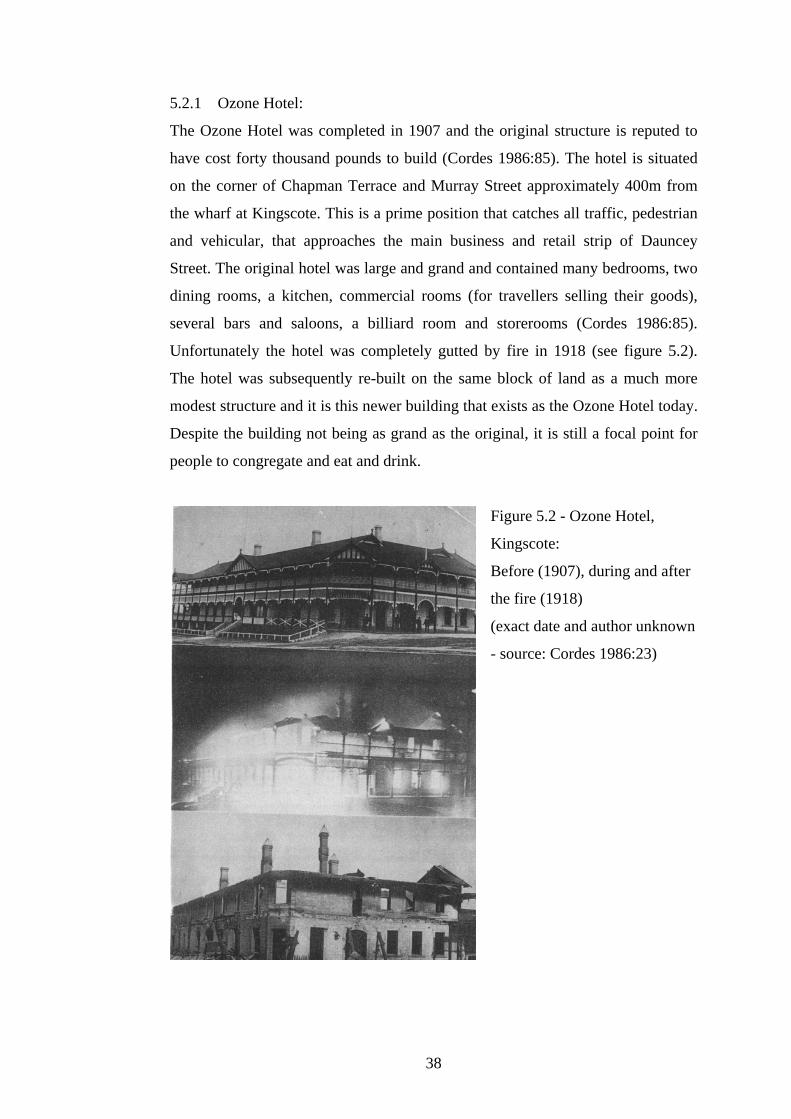
5.2.1 Ozone Hotel:
The Ozone Hotel was completed in 1907 and the original structure is reputed to
have cost forty thousand pounds to build (Cordes 1986:85). The hotel is situated
on the corner of Chapman Terrace and Murray Street approximately 400m from
the wharf at Kingscote. This is a prime position that catches all traffic, pedestrian
and vehicular, that approaches the main business and retail strip of Dauncey
Street. The original hotel was large and grand and contained many bedrooms, two
dining rooms, a kitchen, commercial rooms (for travellers selling their goods),
several bars and saloons, a billiard room and storerooms (Cordes 1986:85).
Unfortunately the hotel was completely gutted by fire in 1918 (see figure 5.2).
The hotel was subsequently re-built on the same block of land as a much more
modest structure and it is this newer building that exists as the Ozone Hotel today.
Despite the building not being as grand as the original, it is still a focal point for
people to congregate and eat and drink.
Figure 5.2 - Ozone Hotel,
Kingscote:
Before (1907), during and after
the fire (1918)
(exact date and author unknown
- source: Cordes 1986:23)
38
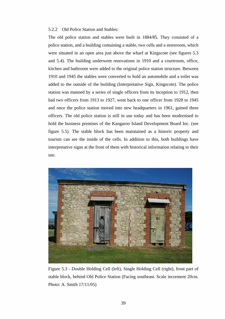
5.2.2 Old Police Station and Stables:
The old police station and stables were built in 1884/85. They consisted of a
police station, and a building containing a stable, two cells and a storeroom, which
were situated in an open area just above the wharf at Kingscote (see figures 5.3
and 5.4). The building underwent renovations in 1910 and a courtroom, office,
kitchen and bathroom were added to the original police station structure. Between
1910 and 1945 the stables were converted to hold an automobile and a toilet was
added to the outside of the building (Interpretative Sign, Kingscote). The police
station was manned by a series of single officers from its inception to 1912, then
had two officers from 1913 to 1927, went back to one officer from 1928 to 1945
and once the police station moved into new headquarters in 1961, gained three
officers. The old police station is still in use today and has been modernised to
hold the business premises of the Kangaroo Island Development Board Inc. (see
figure 5.5). The stable block has been maintained as a historic property and
tourists can see the inside of the cells. In addition to this, both buildings have
interpretative signs at the front of them with historical information relating to their
use.
Figure 5.3 - Double Holding Cell (left), Single Holding Cell (right), front part of
stable block, behind Old Police Station (Facing southeast. Scale increment 20cm.
Photo: A. Smith 17/11/05)
39
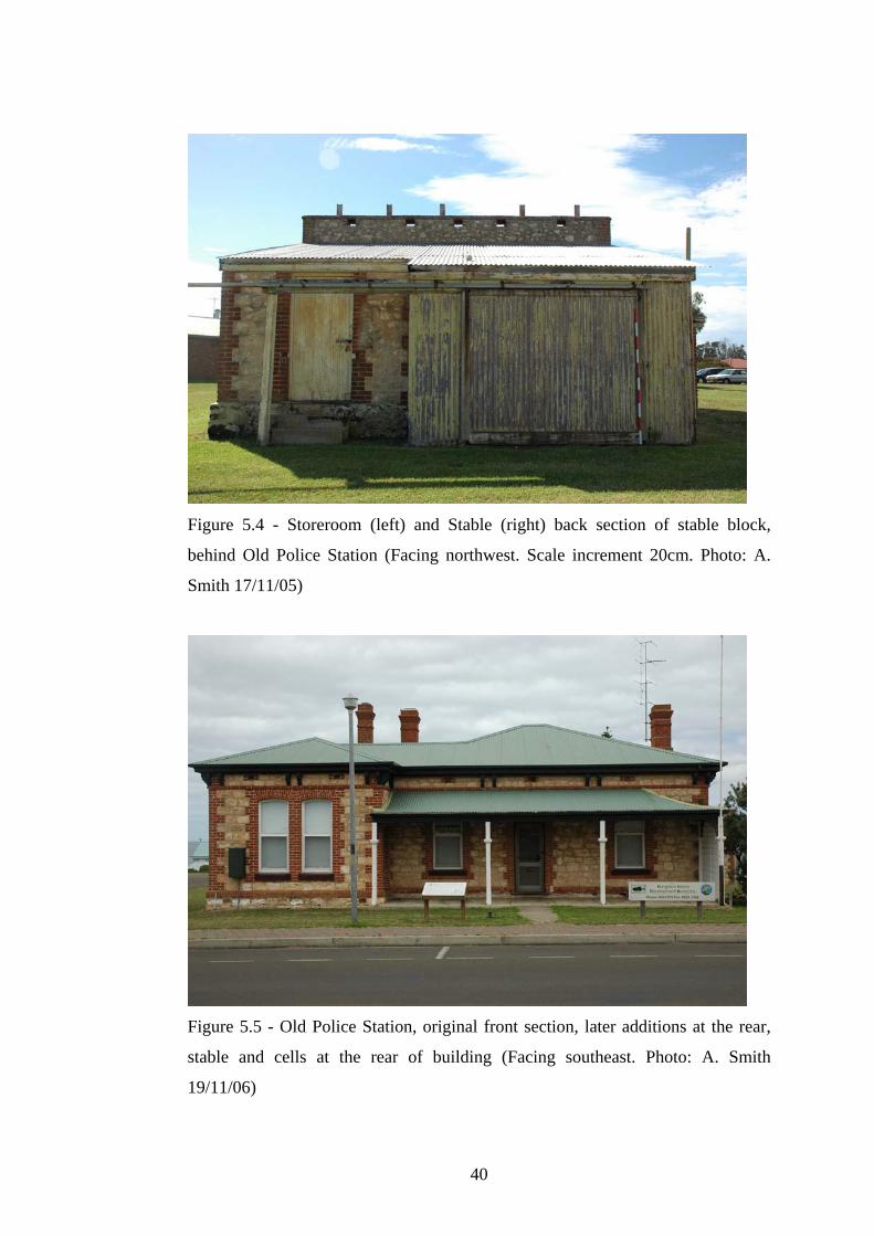
Figure 5.4 - Storeroom (left) and Stable (right) back section of stable block,
behind Old Police Station (Facing northwest. Scale increment 20cm. Photo: A.
Smith 17/11/05)
Figure 5.5 - Old Police Station, original front section, later additions at the rear,
stable and cells at the rear of building (Facing southeast. Photo: A. Smith
19/11/06)
40

5.2.3 Old Well:
Kangaroo Island as a whole has very little access to fresh water and Kingscote is
no different. In the early days of settlement water had to be brought in by boat
from wells dug near the beach at the Bay of Shoals (Cordes 1986:24). It was quite
a few years after initial settlement that a well was dug at Reeves Point to supply
the residents. However the water supply was apparently ruined when the settlers
bored too deeply in order to augment the supply and the well became permanently
salty (Kingscote CWA 1951:14). Today the residents of Kingscote are supplied by
the Middle River dam as well as by rainwater tanks. The old well has a stone
foundation, a metal hand pump and is covered up (nailed in place) by large planks
of pine (see figure 5.6).
Figure 5.6 - Old Well at Reeves Point (exact date and author unknown source:
Cordes 1986:24)
41

5.2.4 Hope Cottage Museum:
‘Hope’ Cottage was built in 1858 by Michael and Charles Calnan and was one
three identical houses made from local stone (Cordes 1986:29). ‘Faith‘ fell into
disrepair by the early 1900’s and was demolished in the 1920’s; ‘Charity’ was
also in bad condition but was bought as a private home and renovated in the
1980’s and is now in reasonably good condition (see figure 5.7). ‘Hope’ was
bought and restored by the Kingscote branch of the National Trust and houses a
fantastic and unique collection of furniture and household items. There are
additional buildings on the premises that house many pieces of farm machinery, a
maritime collection bearing amongst other items the old Cape Willoughby
Lighthouse Light and the life boat from the SS Karatta and a very significant
photographic display containing some of the earliest images of island life
(National Trust website accessed 16th April 2006).
Figure 5.7 - left to right - ‘Hope’, ‘Charity’ and ‘Faith’ Cottages c.1920’s (exact
date and author unknown) (source: Cordes 1986:29)
42

5.2.5 Swimming Pool:
The tidal swimming pool is an important feature in the maritime landscape of
Kingscote. Initially the Kingscote swimming pool was little more than a fairly
shallow natural rock pool called ‘The Basin’ (see figure 5.8) and subsequent to the
new pool being built in the 1970’s, an area between the two main jetties was
fenced off with mesh and became a popular swimming venue (Cordes 1986:144)
(see figure 5.9). The tidal swimming pool has been constructed from local rocks
and makes use of the natural rock pool that used to exist on the site. The depth of
the water is approximately the same inside and out, hence a tidal pool, the only
intervention into the landscape by man is the landscaping around the pool and the
deposition of the rocks into the water to form the walls of the pool. The bottom of
the pool is made up of natural sand, seaweed and rock outcrops (see figure 5.10).
Figure 5.8 - ‘The Basin’ Natural Rock Swimming Pool, Kingscote (exact date and
author unknown) (source: Cordes 1986:144)
43
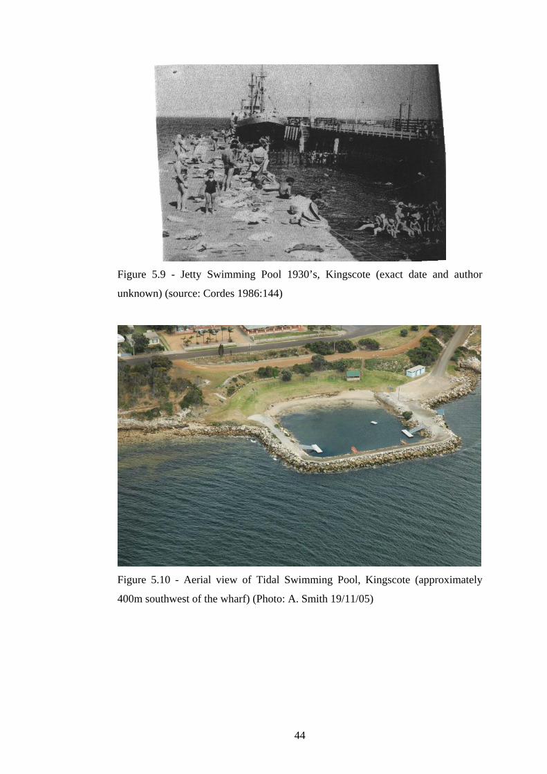
Figure 5.9 - Jetty Swimming Pool 1930’s, Kingscote (exact date and author
unknown) (source: Cordes 1986:144)
Figure 5.10 - Aerial view of Tidal Swimming Pool, Kingscote (approximately
400m southwest of the wharf) (Photo: A. Smith 19/11/05)
44

5.2.6 Wharf and Warehouses:
From the time that the main settlement moved from Reeves Point slightly south to
Kingscote, the town has always had a wharf. For many years the wharf consisted
of a handful of sheds built from either wood or from corrugated iron sheets,
situated on dirt and rubble foundations. There were livestock pens and fencing,
the main jetty and the only solid structure buildings were those of the Police
Station and the Post Office/Beare Family Home (which no longer exists) (see
figure 5.11). Today the wharf is a much more solid structure although probably
not much larger. Only minimal amounts of land have been reclaimed in the
process of creating the walls of the wharf and the wharf itself is fully surfaced
right to the edge of the walls and jetty entrances. The wharf contains one large old
aqua coloured warehouse (see figure 5.12), three medium sized reasonably new
warehouses/sheds, a large aqua coloured building containing an aquarium and
retail outlet, a smaller older white building, a brown brick building and two small
sheds by the waters edge that house utilities services, winches and gas products
associated with the wharf. On a slightly raised hill at the back of the wharf are
remnants from the old livestock pens used to contained animals as they were
loading to or from a waiting vessel at the end of the jetty. The wharf also has four
jetties and a winched boat ramp going from it into the water (see figure 5.13). On
the grassy area above the wharf you will find the old police station and stables.
Figure 5.11 - Kingscote Wharf 1899 (author unknown) (source: Cordes 1986:30)
45

Figure 5.12 - Main Warehouse at Kingscote Wharf (Facing northeast. Scale
increment 20cm. Photo: A. Smith 17/11/05)
Figure 5.13 - Aerial view of the Kingscote Wharf and Warehouses (to the left out
of view is the old police station and stables) (Photo: A. Smith 19/11/05)
46

5.2.7 New Jetties:
Kingscote has a collection of four jetties in the same vicinity as each other. The
longest jetty (the main jetty) was built in 1910 (Kelly 1988:22) and currently has a
length of 302 metres (Collins 2005:217). In 1956 modifications were made to the
existing structure and the jetty was widened to allow for a railway to handle
increased traffic that created a double lane. The width of the jetty for the first half
of its length became 8.4 metres and the second half remained at 3.3 metres. At a
later date a loading gantry was installed to accommodated for the roll-on roll-off
passenger vessels of the Troubridge and Island Seaway (Collins 2005:217). This
main jetty is still used to receive vessels carrying some freight to and from the
Island, however the majority of shipping and transporting of goods is done via the
Penneshaw jetty and SeaLink. The smaller of the two jetties that stand side by
side is the first Kingscote jetty built on this site. It was constructed in 1886 and its
current length is 55 metres (Collins 2005:216). This jetty was used constantly for
all passenger and goods services to the island until the new jetty opened in 1910
and it is currently used for recreational purposes (see figure 5.14). In 1956 the
Harbours Board agreed to erect a new jetty to the north of the other two jetties, to
be sole used for the purposes of recreational fishing. This jetty is called the
Fishermen’s Jetty and is still used for this activity today (see figure 5.15). In
addition to these three jetties, a fourth was erected sometime in the 1970’s mid
way between the others and was constructed out of steel. This jetty is 32.6 metres
long and 1.4 metres wide and is also used for recreational fishing purposes
(Collins 2005:217) (see figure 5.16).
47
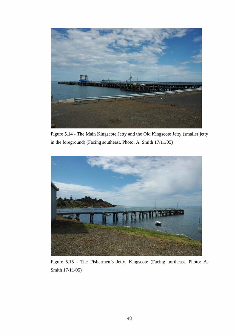
Figure 5.14 - The Main Kingscote Jetty and the Old Kingscote Jetty (smaller jetty
in the foreground) (Facing southeast. Photo: A. Smith 17/11/05)
Figure 5.15 - The Fishermen’s Jetty, Kingscote (Facing northeast. Photo: A.
Smith 17/11/05)
48

Figure 5.16 - Steel Fishermen’s Jetty, Kingscote (Facing east. Photo: A. Smith
17/11/05)
5.2.8 Old Quarry Jetty:
The Old Jetty was built at Reeves Point after 1850 and was known as the Quarry
Jetty. It was built by Adelaide interests for the purpose of shipping basalt stone to
Port Adelaide to be used in road making (Collins 2005: 12). This old jetty still
stands and is comprised of 29 wooden piles many of which are still in pairs that
were visible in November 2005 at low tide, as well as a single pile further out
partially submerged in the water (see figure 5.17). At high tide the water covers
the beach and the stone foundation the piles sit upon also disappear under a
minimum of 20 centimetres of water (figure 5.18). Reeves Point was also home to
two other earlier jetties, the first ones to be built in South Australia. The first one
was built at Beatrice Point near the sand spit, the landing place of the first settlers
and the second one was built slightly to the south of Beatrice Point where the
ground gradually rises to form a gully. In November 2005 and April 2006 there
was no evidence of either of these two jetties, although it was high tide on both
occasions.
49
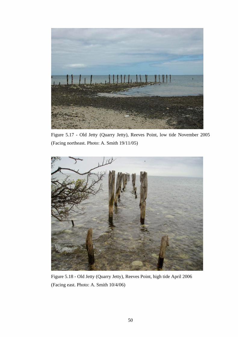
Figure 5.17 - Old Jetty (Quarry Jetty), Reeves Point, low tide November 2005
(Facing northeast. Photo: A. Smith 19/11/05)
Figure 5.18 - Old Jetty (Quarry Jetty), Reeves Point, high tide April 2006
(Facing east. Photo: A. Smith 10/4/06)
50

5.2.9 ‘The Bluff’ Boat Ramp:
‘The Bluff’ is a quarry that is situated approximately 1.5 kilometres around the
coastline from Reeves Point, in the Bay of Shoals. The quarry is still in use today
and there is no public access. However approximately 200 metres to the east of
the quarry is a boat ramp and scaffolding used by local fishermen. The boat ramp
extends out from the shore and has a tarmacked surface built upon a base of earth
and large rocks. The wooden scaffolding appears to be used as a place to tie up
boats, as well as in use as a mini jetty (see figure 5.29). A further 150 metres or so
east of the boat ramp are two wooden piles surrounded by tyres implanted in the
mud approximately 50 metres from shore. The piles are about 20 centimetres in
diameter and around four metres high, each comprised of two poles around two
metres high joined together to form the four metre height of the structure. Both
piles are half covered from the bottom up with used tyres and have long metal
nails/rods sticking out at the top of each pile. There also appears to be wooden
planking with nails extending out from the base of each pile at ground level under
the water. The original purpose of these piles is unknown, however it is possible
that they were used to moor boats in the shallow water (see figure 5.20).
Figure 5.19 - ‘The Bluff’ Boat Ramp, Bay of Shoals (Facing northwest. Photo: S.
Geering 17/11/05)
51

Figure 5.20 - ‘The Bluff’ Boat Moorings (east of the boat ramp), Bay of Shoals
(Facing north. Photo: A. Smith 17/11/05)
5.2.10 Shipwrecks:
According to the Australian National Shipwrecks Database, Kangaroo Island has
83 wrecks that are classed at being located around the immediate vicinity of the
island (National Shipwrecks Database website accessed 24th April 2006 - See
appendix 1 for a complete list of Kangaroo Island wrecks). Kingscote has five
wrecks located in the immediate vicinity of the wharf area, one located at the
mouth of the Cygnet River to the south of Kingscote and two located just off the
sand bar at Point Marsden, which is slightly north of Kingscote. Out of the eight
wrecks located near Kingscote, two have been found, the Fannie M (built 1877,
wrecked 1885) and the Robert Burns (built 1857, wrecked 1908), which are both
protected under federal legislation, namely the Historic Shipwrecks Act 1976, as
historic wrecks due to the blanket protection afforded to wrecks older than 75
years. Kangaroo Island, including Nepean Bay, is actually protected under the
commonwealth legislation and Act of 1976, not the South Australian Historic
Shipwrecks Act 1981 (Jeffery 1987:245). (See appendix 1 for a list of wrecks
located in the immediate vicinity of Kingscote).
52

5.3 West Bay
Please see figures 5.21 and 5.22 for a map of West Bay, Kangaroo Island.
West Bay is quite a remote place situated within Flinders Chase National Park on
the western coastline of Kangaroo Island. Flinders Chase is comprised of three
separate parks, Rocky River in the southwest corner of the island, Cape Borda in
the northwest and the Gosse Lands in the northeast totalling an area of around
32,600 hectares. The three sections of national park surround the Ravine des
Casoars Wilderness Protection Area, which also forms the northern boundary of
the West Bay region and has a total area of around 41,320 hectares (Parks Web
accessed 24th April 2006).
European settlers have never inhabited West Bay or the surrounding region and
the closest property is located at Rocky River, 22 kilometres to the east.
According to the Department for Administrative and Information Services Lands
Titles office, West Bay has always been crown land and has never been surveyed
or subdivided into pastoral leases (see appendix 3 - historical search of crown land
record). When the Cape Borda Lighthouse was built in 1858 (Barker and
McCaskill 1999:38) a large portion of land consisting of nearly the whole length
of the western coastline of the island as well as extending inland approximately 20
kilometres, was placed under the jurisdiction of the Marine Board of South
Australia and named as being part of the Lighthouse Reserve (SA. Government
Gazette 19th July 1900 and 29th April 1909 - see appendix 2). West Bay remained
under the jurisdiction of the Marine Board until the land was granted to Flinders
Chase National Park under the Fauna and Flora Reserve Act 1919 (SA.
Government Gazette 20th September 1923 - see appendix 2).
West Bay has changed very little since European settlement of the island. In the
late 19th Century a Shelter Hut was established in the sand dunes and subsequently
removed. In recent years the only changes to the bay have been in the installation
of a campground with a toilet block and rainwater tank, a car park, picnic tables, a
lookout and a wooden boardwalk through the sand dunes down to the beach. The
bay retains its natural landscape and beauty and its historical cultural usage is an
indication of the importance West Bay plays in the island’s maritime landscape.
53

Figure 5.21 - West Bay Region, Flinders Chase National Park, Kangaroo Island
(source: CFS Map Book Kangaroo Island, Map 49 & 50, Ed. 1 2002).
Figure 5.22 - Detailed Map of West Bay, Flinders Chase National Park
(No scale. No source - mud map)
54

5.3.1 Loch Vennachar Anchor:
The Loch Vennachar was a three masted fully rigged iron ship of 1552 tons gross
and was built in 1875 in Glasgow, United Kingdom (Chapman 1972:44). The
Loch Vennachar went missing when it failed to arrive in port at the designated
time. This would have been later than the 6th September 1905, which is when the
vessel exchanged the ‘all well’ signal with another vessel in the area, the Yongala.
Conclusive evidence of a disaster having befallen the ship was found on the 29th
September when a reel of blue printing paper was found floating in St. Vincent’s
Gulf which was identified as belonging to the ship according to its bills of lading
(Chapman 1972:46). Wreckage washed up all around the island for months after
the event without ever disclosing the location of the wreck. On November 26th
1905 Trooper Thorpe and Mr May found huge quantities of wreckage as well as a
decomposed body on the beach at West Bay whilst they were doing a tour of
inspection of the shelter huts on the south coast (Chapman 1972:48 and Loney
1993:33). It was only in 1977 that the wreck was finally located off the northern
tip of the cliffs that form West Bay. Members of the Society for Underwater
Historical Research carried out excavations and surveys of the site and the wreck
was mapped and the anchor of the Loch Vennachar was raised using airbags. The
anchor was then preserved and placed in the car park at West Bay as a memorial
to the crew that lost their lives in the wreck (see figure 5.23).
Figure 5.23 - Anchor from the wreck of the Loch Vennachar, lost 1905, West Bay
(Facing northwest. Photo: A. Smith 18/11/05)
55
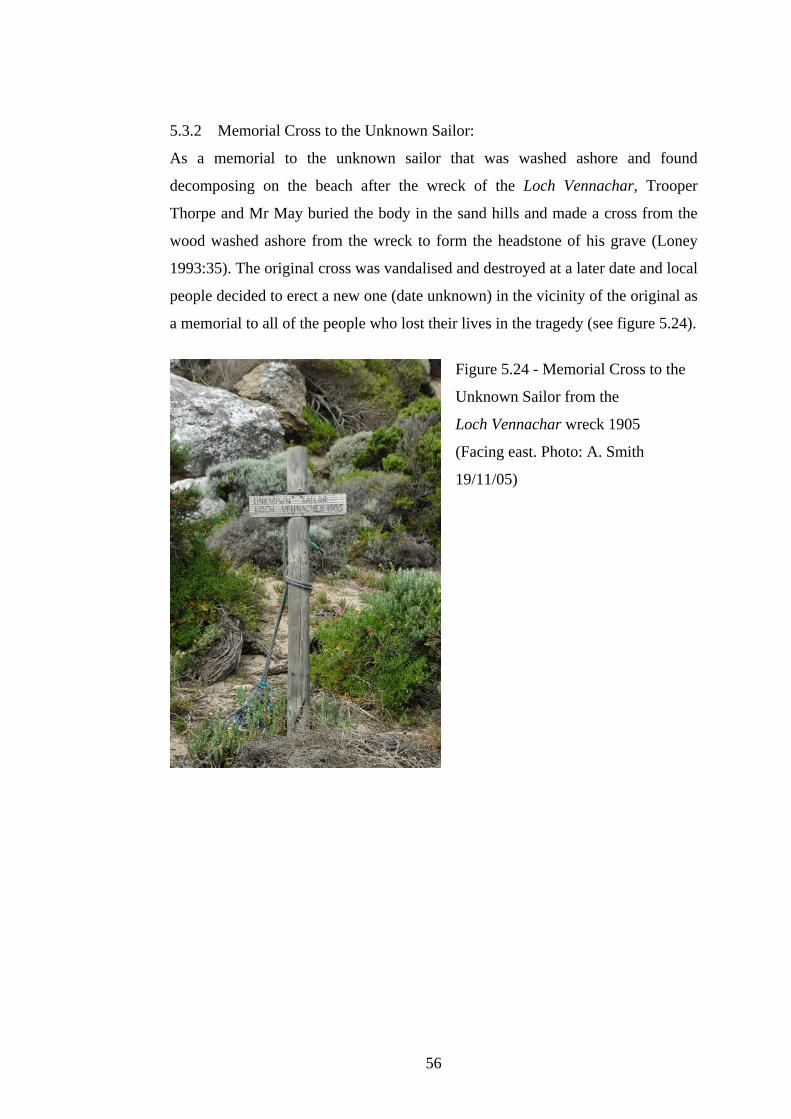
5.3.2 Memorial Cross to the Unknown Sailor:
As a memorial to the unknown sailor that was washed ashore and found
decomposing on the beach after the wreck of the Loch Vennachar, Trooper
Thorpe and Mr May buried the body in the sand hills and made a cross from the
wood washed ashore from the wreck to form the headstone of his grave (Loney
1993:35). The original cross was vandalised and destroyed at a later date and local
people decided to erect a new one (date unknown) in the vicinity of the original as
a memorial to all of the people who lost their lives in the tragedy (see figure 5.24).
Figure 5.24 - Memorial Cross to the
Unknown Sailor from the
Loch Vennachar wreck 1905
(Facing east. Photo: A. Smith
19/11/05)
56

5.3.3 Shelter Hut:
In response to the numerous shipwrecks that had occurred on the southern and
western coastlines of Kangaroo Island “the government had built a small hut at
West Bay and stocked it with blankets, food and medical supplies in the hope of it
being found by sailors in distress” (Chapman 1972:1) (see also - appendix 2 -
Marine Board Minutes 1899 - debate regarding the necessary action surrounding
recent shipwreck events around Kangaroo Islands coastline).
The shelter hut is also noted on a 1913 Admiralty Chart and is named as a ‘Relief
Station for Shipwrecked Mariners’ (see figure 5.25). According to the information
noted on a display board at the Hope Cottage National Trust Museum in
Kingscote, the shelter hut was erected in 1899 and removed in 1934. There is no
evidence to suggest that any shipwrecked sailors ever found the hut and used it,
certainly the body of the sailor from the Loch Vennachar wreck of 1905 found on
the beach at West Bay did not make it to the hut, although there are tales of local
people intermittently raiding it for its supplies (Chapman 1972:2).
In the course of his search for the Loch Vennachar, Trooper Thorpe went to West
Bay to check the shelter hut where he found huge quantities of wreckage and the
decomposing body of a sailor. Whilst he waited for a government vessel to come
to West Bay and pick up 44 casks of whisky from the wreck, he wrote a letter to a
friend describing the remoteness of the area and complaining about how
unpleasant it was to have to stay there for an extended period of time without
knowing when the ship would arrive (he arrived on 26th November 1905 and was
still at West Bay when the letter was written on 9th December 1905) (Loney
1993:32).
In November 2005 and April 2006 there is no indication of any surviving
structure matching that of the Shelter Hut. It was supposedly built upon the sand
dunes according to two historic photographs; the first one is taken at a distance
and the second taken with seven men in the picture in addition to the hut (see
figures 5.26 and 5.27).
57
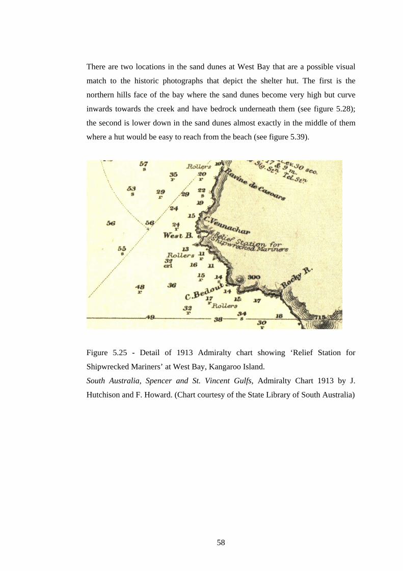
There are two locations in the sand dunes at West Bay that are a possible visual
match to the historic photographs that depict the shelter hut. The first is the
northern hills face of the bay where the sand dunes become very high but curve
inwards towards the creek and have bedrock underneath them (see figure 5.28);
the second is lower down in the sand dunes almost exactly in the middle of them
where a hut would be easy to reach from the beach (see figure 5.39).
Figure 5.25 - Detail of 1913 Admiralty chart showing ‘Relief Station for
Shipwrecked Mariners’ at West Bay, Kangaroo Island.
South Australia, Spencer and St. Vincent Gulfs, Admiralty Chart 1913 by J.
Hutchison and F. Howard. (Chart courtesy of the State Library of South Australia)
58

Figure 5.26 - Original photograph of the West Bay Shelter Hut (date and author
unknown - courtesy Hope Cottage National Trust Museum)
(Photo: J. McKinnon 11/4/06).
Figure 5.27 - West Bay Shelter Hut 1906 (author unknown - Photograph courtesy
of the State Library of South Australia - PRG 280/1/4/129)
59

Figure 5.28 - Possible location of Shelter Hut at West Bay (view from northern
hills face out towards Bay) (Facing West. Photo: J. McKinnon 12/4/06)
Figure 5.29 - Possible location of Shelter Hut at West Bay (lower down the sand
dunes towards the middle of dunes near the beach) (Facing west. Photo: J.
McKinnon 8/4/06)
60

5.3.4 Magnetometer Survey:
A proton magnetometer survey was carried out on the portion of land higher up in
the northern hills face sand dunes at West Bay in the hope of finding evidence of
human occupation or material culture from the shelter hut, namely ferrous
materials such as nails and sheets of corrugated iron used in the construction of
the building or metal boxes containing food and medical supplies. The results of
the magnetometer survey showed no unusual anomalies in the area that could be
attributed to remnant material culture (see figure 5.30).
Figure 5.30 - Magnetometer Survey of possible location of Shelter Hut at West
Bay (northern hills face location)
5.3.5 Shipwrecks:
There have been many ships wrecked on the south, southwest and western costs of
Kangaroo Island. West Bay has four wrecks in the immediate vicinity, the Loch
Vennachar (built 1875, wrecked 1905), Winnie (built 1900, wrecked 1942),
Jeanette S (built 1913, wrecked 1966) and the Mars (built 1877, wrecked 1885)
(see appendix 1 for detailed information regarding all four wrecks). Out of the
four wrecks only the Loch Vennachar has been found; it is also the only one that
is protected under federal legislation, namely the Historic Shipwrecks Act 1976.
61

CHAPTER SIX
DISCUSSION
6.1 Introduction
An analysis of the results gathered during archival research and fieldwork
activities needs to be conducted in order to place the results into a relevant context
that can be used in assessing the maritime cultural landscape of Kangaroo Island.
A discussion concerning the maritime sites found at Kingscote and West Bay will
examine in detail the role these two sites have played in shaping the maritime
environment. This discussion will address the research question (see below) and
the aims of the thesis as stated in the Introduction in Chapter 1.
Research Question:
How well does the concept of a maritime cultural landscape explain the
archaeological patterning in the historical period on Kangaroo Island?
6.2 Kingscote and the Maritime Cultural Landscape
The archaeological patterning of historical sites of cultural interest at Kingscote
revolves around trade, goods, personal livelihood and transport. Colonial
settlement brought about the establishment of three jetties and a well to supply the
town with water at Reeves Point; the early 1900’s saw the development of the
wharf, construction of the main jetty, redevelopments to the police station and the
rebuilding of the Ozone Hotel; and the late 1900’s brought about the renovation of
Hope Cottage, construction of ‘The Bluff’ boat ramp and the development and
landscaping of the tidal swimming pool. Interweaving throughout all of these time
periods is the incidence of shipwrecks, either sinking at sea or being driven upon
the shore by inclement weather. All of these features are part of the maritime
cultural landscape that is Kingscote. (Please see figure 5.1 for a reference map of
the relevant historical period sites at Kingscote.)
62
Reeves Point was the landing place of the first settlers in South Australia and the
site of the first small town; as such it needed to have the capabilities to support the
development of the town and its population. To assist with the loading and
unloading of people, animals and goods, the first jetty was built at Beatrice Point
near the sand spit. There is only one sketch of this first jetty and its exact
dimensions and length are unknown. However the second jetty erected near a
gully approximately 200 metres south of the first jetty has been depicted in a
painting of Reeves Point circa 1840 (E.C Frome 1840 - Art Gallery of South
Australia). It is thought that the South Australia Company constructed both the
first jetty and the gully jetty, with the materials believed to have come from the
area near the Cygnet River (Collins 2005:9).
There is no historical information available that details why the first jetty was
demolished and the second gully jetty built. The water current at Nepean Bay in
this area is not particularly fast flowing, not enough to have caused massive
amounts of erosion in such a short period of time, although the first jetty may
have been exposed enough (being so close to the point) that it made holding a
vessel steady at this location against a rickety jetty difficult. A third structure was
built for shipping stone to Adelaide and was not used for transporting passengers
or goods. This ‘Quarry’ jetty was built purely for commercial purposes and was
privately owned. Considering how little physical evidence remains of the gully
jetty at Reeves Point and that it was many years before the wharf and jetty were
constructed at Kingscote to service the needs of the residents, it is interesting to
consider the condition the gully jetty would have been in by the time it was
finished with. Especially considering that next to nothing remains of this
particular structure today and that it is unknown if this second jetty was
demolished and the materials reused or if it was just abandoned.
The Old Well was dug at the Point in order to supply the residents with fresh
water. The area near the beach (where the well is) slopes gently down towards the
sand spit known as Beatrice Point, as a result of this and due to the well being dug
too deep, the water supply became salty and undrinkable. The settlers ended up
moving south to the current day site of Kingscote and establishing a permanent
settlement.
63

It is not clear if the well was solely responsible for the decision to move town
sites, but it would have played a huge part in the decision making process as there
are only a few places on Kangaroo Island where fresh water is readily available
and a move to the south was a move closer to the entrance of American River
where there were a couple of fresh water creeks that flowed out to the river.
The end of the 19th century and the beginning of the 20th century saw the
construction and development of more permanent structures of all kinds at
Kingscote. This was due, in part, to the increase of the population of Kangaroo
Island, with 400 people in 1838, down to only 170 people in 1860, increasing to
700 people in 1901 (Department of Environment and Planning 1991, paragraph
1.2.2). This allowed the Kingscote District Council to undertake public works for
the benefit of its residents. One its major projects was the development of the
wharf and the building of the new jetty (Kelly 1988:22). Whilst Kingscote had
always had a wharf structure lying adjacent to the coastline, it was only with the
erection of the new jetty in 1910 that the wharf was surfaced and warehouses
constructed. These community developments changed the face of the landscape by
layering a cultural factor on top of the natural landscape.
It is important to remember that maritime cultural landscape theory defines human
utilisation of maritime space by boat, including the establishment of settlements
(Westerdahl 1992:5). Renovations to the police stations occurred in 1910, with the
addition of a courthouse and office to the original structure. The development
reflects the growing population and the need to establish a serious and
professional police presence on the island. The police station is an important part
of the maritime landscape because it is situated just above the wharf and is
geographically part of the wharf and warehouse region. Dauncey Street (which is
the main road, shopping area and thoroughfare in Kingscote) was not actively
built upon as the main community precinct until the 1930’s (Kelly 1988:87). This
means that the foreshore, especially the wharf and jetty area, including the various
buildings that are situated in the area, were the focus of a large proportion of
community interaction in Kingscote.
64
Another building that is part of the foreshore area is the Ozone Hotel located on
the corner of Murray Street and Chapman Terrace (which is the main parade
following the curve of the coastline of Nepean Bay). This hotel has always been,
and still is, a focal point for gathering of local residents and visitors coming up
from the wharf into the town. The original hotel burned to the ground in 1907 but
was re-built by 1918 and it is this structure that still stands today (Cordes
1986:23). The hotel is very close to the wharf and is one of the largest and most
prominent structures that have ever graced the Kingscote landscape.
From the mid to the late 1900’s, as Kingscote has gradually expanded, the
maritime landscape has changed with the addition of two more jetties to the wharf
and the construction of the landscaped tidal swimming pool to the south of the
wharf area. The two additional jetties were added to cater for local fishermen,
both are situated to the north of the main jetty, with the steel framed jetty located
running parallel to the wharf. These jetties are indicative of the cultural
association the residents of the island have with maritime endeavours, even as a
recreational pastime. Before the construction of the tidal swimming pool, local
people used to swim in the space between the main jetty and the shorter older one
at the wharf. The tidal swimming pool was erected for recreational pursuits and
has imposed itself upon the natural line of the coast by encroaching ever so
slightly into Nepean Bay. The tidal pool makes use of a natural stone feature
called ‘The Basin’ located in the same position that has been further shaped to suit
the purpose for which it is intended, a public swimming pool. The tidal pool is a
permanent structure that has altered the physical landscape as well as added an
additional feature to the cultural landscape.
Another cultural component of the landscape is ‘The Bluff’ boat ramp. The ramp
is located approximately 1.5 km around the coastline from Reeves Point in the
Bay of Shoals and is used by local fishermen. There is no indication as to whether
or not the structure was specifically built with the fishermen in mind or if at one
time the boat ramp serviced the quarry that operates just to the west of the ramp.
65

There is a connecting road that runs all the way along the shoreline from the
quarry to the Beatrice Point sand spit at Reeves Point, but this road did not exist at
around the time of settlement as members of the community had to travel by boat
to the Bay of Shoals to collect fresh water from a well they had dug there
(Ruediger 1980:43). The land is not overly steep or inhospitable in this area; it
would have been easy to beach a boat on the shore and it would have been
unlikely that any structure as a prelude to the boat ramp would have been built in
the same area. To the east of the boat ramp are two wooden piles surrounded by
old tyres that could possibly have been used as boat moorings. These moorings
are not particularly old and most likely were built at around the same time as the
boat ramp. They do not appear to be in use and it is unknown as to why there are
wooden logs coming out from the base of each structure below the waterline and
vegetation that head in the direction of the shore. ‘The Bluff’ and boat moorings
form part of the archaeological patterning of historic sites at Kingscote, with one
maritime structure in use and the other seemingly abandoned.
The arrival of the colonial settlers brought about the construction of dwellings to
house the new arrivals. One of these homes is Hope Cottage built near the top of
the hill at Reeves Point. This cottage is one of three that were built in the 1850’s
and was restored by the National Trust as a folk museum that honours the first
South Australian settlers and houses their personal belongings and farm
machinery. The cottage also pays respect to the many vessels that serviced the
island and its people throughout its history. It acknowledges the role that the
lighthouses have played and the unfortunate circumstances that have brought
about some of the many shipwrecks that have occurred around the coast. Whilst
the museum is not on the foreshore and a part of the immediate maritime
landscape, its relationship with the first settlers and the way in which it
encompasses all aspects of Kangaroo Islands cultural heritage, including its
maritime heritage, makes Hope Cottage an integral part of the maritime cultural
landscape of Kingscote and Kangaroo Island.
66

6.3 West Bay and the Maritime Cultural Landscape
The archaeological patterning of sites of interest at West Bay is sparse and only
ever contained the bare necessities of material culture. There is very little
interaction with the landscape on a large scale, which is evidenced by the
complete lack of remains of the Shelter Hut at West Bay. The only visible
physical remnants of material culture at West Bay are the Loch Vennachar
Anchor and the Memorial Cross to the Unknown Sailor. However, one of the
most important aspects of archaeology is that just because you cannot see it, does
not mean that it does not exist. This idea ties into maritime cultural landscape
theory, which links the importance of both terrestrial and underwater sites
together in the interpretation of a region without forgetting one particular aspect
over and above another. With this in mind it becomes relevant to search for any
archaeological remains of the Shelter Hut for Shipwrecked Mariners.
The Shelter Hut was named on the 1913 Admiralty chart as a “Relief Station for
Shipwrecked Mariners” (see figures 5.25 and 5.26) and by Chapman (1972:1)
who indicated that “the government had built a small hut at West Bay, and
stocked it with blankets, food and medical supplies”. The intention of the hut was
to provide relief to sailors in distress on the western side of the island (which is
the route most interstate vessels took, rather than go through Backstairs Passage)
if they were unable to make it to Cape Borda lighthouse to signal that they were in
trouble. At the time the shelter hut was built in 1899 (according to the display
information at the Hope Cottage National Trust Museum), Cape du Couedic
lighthouse had not yet been built (construction started in 1907) and the hut was
supposed to fill this gap in the maritime infrastructure on Kangaroo Island.
The only reasonable way to get to the shelter hut was by ship, although it would
have been possible but very undesirable to follow the Rocky River creek from the
Rocky River Homestead (located at the current day Park Headquarters at Flinders
Chase National Park) down to the sea and then follow the coastline around until
you reached West Bay. It is thought from the descriptions of his journey, that
Trooper Thorpe in his 1905 search for the Loch Vennachar may have done
something similar to this, although he states that he started out at Cape du
Couedic and then followed the coastline (see Appendix 2.2).
67

It is interesting to note that Cape du Couedic did not have proper road access until
the 1930’s when the West End Highway and South Coast Roads were built
linking the lighthouse with Cape Borda (Kelly 1988:70). The West Bay track, that
links Cape Borda with the Rocky River Homestead and crosses the West Bay
creek quite near the beach, was not built until 1941 (Kelly 1988:89). Since the
shelter hut was supposedly built in 1899 and demolished in 1934 (according to
Hope Cottage National Trust Museum), all activity, repairs and reprovisioning etc
would have had to been carried out by boat.
There are two known photographs of the shelter hut (see figures 5.27 and 5.28)
but no known drawings, sketches, maps or plans of the area that pin points the
exact location of the hut at West Bay. It was stated by Chapman (1972) that ‘the
government’ built the hut, which means that it would have been under the
jurisdiction of the Marine Board of South Australia. More specifically, it would
have come under the control of the Naval Commandant of the Marine Board
(Parsons 1986:248). But there is no record of the hut in their documents. The
closest information found in relation to the erection of some kind of a provision
for mariners is a series of discussions in the 1899 Marine Board Minutes
regarding the unsafe nature of the coastline (see Appendix 2.3). A possible
outcome of these discussions may have been the installation of a shelter hut at a
later date, but these particular enquires resulted in a new lighthouse on the South
Neptune Island, not a shelter hut.
Because of this, locating the position of the hut was based primarily upon the two
photographs. This was difficult because the scale, the author and what type of lens
was used in the pictures are unknown. As a result, two possible locations were
picked that may match the original location of the shelter hut based upon a visual
analysis of the pictures whilst on site. The first was a position dubbed the northern
hills face because of its location high up in the northern sand hills of the Bay and
the second was located further down the dunes, near the middle of them just above
the beach.
68

There is no physical evidence of material culture at either of the locations,
however the dune system is very active and changes frequently; as an example,
from November 2005 to April 2006, the creek bed had altered its course slightly,
was shallower and straighter. This means that any material remnants would have
either been buried or washed away by a storm surge and would have shifted from
their original location.
With this in mind, a proton magnetometer survey was carried out on the northern
hills face location as it was felt this position resembled the possible location of the
hut according to the photographs. The magnetometer survey picked up no unusual
anomalies in the vicinity which was the expected result considering the shelter hut
was removed and sold, indicating that it would have been taken down intact, not
scattered around.
The shelter hut provides a link between the ocean and the land for sailors who
were in distress and looking inwards for a place of safety to land. There is no
indication that anyone ever found or used the shelter hut for its intended purpose,
which may be why the hut was sold and removed. It is doubtful that any further
magnetometer investigation of the area would yield any more information, as the
dunes are so active and it has been over 70 years since the hut was removed.
There is the option of searching for evidence of Trooper Thorpe’s long-term stay
in the area, especially near the creek further inland, although since he would have
been travelling very light with only the bare essentials, it is unlikely he left
anything behind.
Residing in the car park at West Bay is the raised anchor from the Loch
Vennachar shipwreck. It has been established as a memorial to ship that was lost
and the people who lost their lives when the vessel sunk off the tip of the West
Bay coast.. The anchor draws a lot of visitors, people who have empathy for the
lost lives, as well as people who have interest in this archaeological artefact that
has been raised from the sea floor.
69
In addition to the anchor, West Bay has another memorial, one that pays tribute to
the people that died on the Loch Vennachar by memorialising the Shipwrecked
Sailor that was found by Trooper Thorpe decomposing upon the beach whilst he
was searching the coastline for evidence of the wreck. In a letter to a friend,
Trooper Thorpe describes his find; “we found the de-composed body of a poor
young fellow, probably not more than 17 or 18. It smelled awfully bad”; and the
unfriendly and lonesome environment that characterises West Bay; “My mate and
I carried the body up to a flat and buried it in its lonely grave. It is a dreadfully
lonely place, high towering sand hummocks, and cliffs, and dense scrub” (see
Appendix 2.2 for the complete letter). Both the anchor and the memorial cross
provide a cultural link between the ocean and the land that make them part of the
maritime cultural landscape of West Bay.
6.4 Kangaroo Island and Maritime Cultural Landscape Theory
Analysis of the archaeological patterning of sites containing maritime
infrastructure on Kangaroo Island shows that an island context is different to a
mainland context in the approaches taken to the installation of maritime
infrastructure. Duncan (2000:143) pointed out that a lack of shipping facilities
(i.e. dedicated maritime infrastructure) might indicate minimal use of an area.
This may be the case on the mainland where there are substantial port facilities in
clearly defined regions and a lack of maritime infrastructure, shipwrecks or
material culture debris could indicate minimal use or abandonment of a port.
Parker’s (1999) study of the port of Bristol indicates that Duncan’s preposition is
not necessarily true, as he found that evidence of crossing places, berths and
quay’s in the Middle Ages were not designed with dedicated maritime
infrastructure in mind. They were made of transient materials (in the case of the
berths they were in the mud) but were not temporary in nature as historical
evidence suggests that they were in position over a long period of time, long
enough for place names in Bristol to have origins in the Middle Ages and the
maritime structures that existed such as they were at the time (1999:325).
70

Parker’s work in Bristol supports the results gained on Kangaroo Island in
researching the maritime cultural landscape. His work affirms that maritime
infrastructure need not be dedicated in order to serve the needs of the community.
An island landscape, as evidenced by Kangaroo Island, shows that infrastructure
exists continuously around the whole island, not just in one place. Even though
Kingscote is an example of dedicated maritime infrastructure that addresses the
needs of the community, West Bay is an example of a reactive response to the
environment (in this case, the ocean as well as the inhospitable terrain on land), as
are the various lighthouses, beacons, landing places and jetties. Most of these
elements, perhaps with the exception of the lighthouses, are single structures that
have no mechanisms in place to create a supportive backup to the uses and
intentions that they were built for. Even so, these maritime elements serve the
community of the island as a whole, placed at various locations around the island
in order to cover the entire geographical space and are located at relevant places
and intervals around the island.
Whilst this thesis has not attempted to analyse all aspects of material culture that
exist on Kangaroo Island in relation to the maritime cultural landscape, an
overview of the various maritime sites on the island shows a distinct pattern.
Archaeological sites that have a maritime perspective are situated at locations
around the island whereby the geographical landscape influences the positioning
of these sites. This is exemplified by the three main lighthouses that have been
placed upon high cliffs overlooking submerged rocky outcrops; ‘The Bluff’ boat
ramp has been placed at a point where the land slopes gently down to the sea; and
the Shelter Hut at West Bay that has been located at the only place in the natural
landscape on the southern and western coastline that is conveniently located and
able to receive boats if necessary.
71

6.5 Limitations of Research Design
The research design has been successful in assessing the maritime cultural
landscape of Kangaroo Island through the survey of the two sites of Kingscote and
West Bay. However the potential scope of this study has been constrained by the
time allocated to the completion of the thesis. Therefore the research design has
been structured to encompass as much data collection as possible in order to
answer the research question (see Methodology in Chapter 4 for research
parameters and limitations). This is not a negative factor; it simply provides an
opportunity to expand the research design at a later date to allow for further
archaeological investigation.
6.6 Potential for Future Archaeological Investigation
The most logical next step for future archaeological investigations is to continue
the work already started with this thesis and expand the project to look at the
whole of Kangaroo Island and its maritime cultural landscape. If the scope of a
survey of the whole island is too large, it could be narrowed down to focus upon
the other main towns on the island such as Penneshaw or American River and
examine these in relation to the maritime landscape.
It must be noted that there were no GPS or GIS coordinates taken for any of the
sites at Kingscote and only a handful of GPS coordinates were taken at West Bay
in the course of the magnetometer survey. Therefore there is no scale map of
either area that plots the relevant features in their exact locations, only the CFS
and RAA topographic and road maps (which have a scale) were used to plot the
sites in an approximate position (see figures 5.1, 5.21 and 5.22 in the Results in
Chapter 5 for these maps).
Another possibility is to excavate the dumpsites that are located at both the Cape
du Couedic and Cape Borda lighthouses (as suggested by Lyons in his 2005
thesis) and analyse the material culture to determine what relationships exist
between the lighthouses, West Bay and Kingscote.
72

This investigation would further the ideals put forward by maritime cultural
landscape theory and could be used to support both this current thesis, its research
question and its aims, as well as answer questions that remain regarding Lyons
(2005) work with the three lighthouses on the island and the relationships that
exist between the lighthouse structure and the lighthouse keepers and their
families.
In the case of Kangaroo Island it can be seen that the ocean has strongly
influenced the development of the island (“the primacy of sea over road transport
is reflected in the seawards orientation of many of the homesteads” - Dept.
Environment and Planning 1991:Paragraph 1.2.3) and the importance placed upon
maritime ventures by the island’s residents. Further research could include an in-
depth statistical analysis of the economic development of the island and a
breakdown of the occupations and trades of its residents, as well as analysis of
agriculture and the movement of goods to and from the island and the mainland to
examine the prevalence of maritime travel and trade.
Whilst the locations of many shipwrecks situated around the island are unknown,
there are a couple of wrecks whose approximate locations are known, such as the
Winnie at West Bay or the Ada at the mouth of the Cygnet River (SA Shipwreck
Atlas accessed 28/5/06). An investigation and archaeological survey into some of
these wrecks would compliment all aspects of maritime research to do with
Kangaroo Island as well as contribute knowledge to South Australia’s heritage.
Kingscote was South Australia’s first colonial settlement and two jetties were
built at Reeves Point between 1836 and 1841 (Collins 2005:10). No visible
remains of the two original jetties exist today at high tide (2005/2006 thesis
survey), however this provides an excellent opportunity to conduct an underwater
survey around the Point to search for any remains of the piles. In addition, the Old
Quarry Jetty (built circa 1850) was only mentioned in the results of this thesis and
not properly surveyed. By examining the quarry jetty and surveying the
underwater surrounds there is a strong likelihood of finding more jetty piles
underneath the sediment at the tip of the jetty.
73
The information gained about the three jetties would be of great value to South
Australia’s historical record and if the two original jetties are found, will provide
the opportunity to show conclusive evidence of the construction materials and
perhaps the construction methods used in the earliest jetties in the colony.
6.7 Conclusion
The coastal landscape of Kangaroo Island has played an enormous role in shaping
the way in which the island has developed over time. The islands buildings and
public works, such as the wharf, jetties, warehouses and hotel at Kingscote, have
been constructed to cater for goods and trade, the transportation of people and a
place for travellers to stay in comfort, as well as providing a safe haven in Nepean
Bay from bad weather afflicting South Australian waters. Kingscote has
developed looking outwards towards the ocean and embracing all that it offers.
West Bay and the shelter hut were placed on the edge of the coastal landscape to
provide relief to sailors who had run into trouble on the treacherous south and
west coastlines of Kangaroo Island. Due to the inhospitable nature of the
vegetation and the impossibly rough, high and rocky terrain that runs almost
continuously along the southern and western coasts, the shelter hut offered an
opportunity for mariners to look inwards towards safety and leave behind any
foundering vessel in order to land at one of the only inviting places in the
landscape.
Human interaction with the environment produces material culture, as evidenced
by shipwrecks, buildings and other maritime structures that alter the landscape in
response to both human activity and natural forces. These aspects form the basis
behind the archaeological patterning of a site or region that is then used by
archaeology to interpret the landscape. Kangaroo Island is the perfect combination
of a beautiful natural landscape that has been manipulated by cultural concerns to
produce a maritime cultural landscape that still strongly and visibly identifies with
all aspects of its creation.
74

CHAPTER SEVEN
CONCLUSION
7.1 Introduction
This thesis examined the concept of a maritime cultural landscape and used it to
explain the archaeological patterning in the historical period of Kangaroo Island.
The thesis achieved this by viewing two case study sites, Kingscote and West
Bay, the first as an example of a dedicated maritime infrastructure and the second
as an example of a reactive response to environmental conditions.
This work contributes to the significance of historical and maritime archaeology
by examining maritime cultural landscape theory in a dedicated and previously
unstudied context by focussing upon an island and its inherent relationship to the
ocean.
7.2 Outcomes of the Thesis Research
Maritime cultural landscape theory provides the opportunity to reduce the
distinction that exists between western and indigenous cultural landscape
interpretation. Maritime cultural landscape theory assesses the landscape in a
holistic manner i.e. there is no distinction between a terrestrial site and an
underwater site provided that they both have a maritime context. An indigenous
interpretation of the landscape also sees no distinction between a terrestrial and an
underwater site and further sees no distinction between these and associative
landscapes, all of these site types are interpreted as one. This holistic approach
could have far reaching implications for Aboriginal Native Title claims by
documenting new sites in previously uncontested areas.
This thesis can be used a springboard for further archaeological enquiry into
landscape studies, especially ones that promote an even more integrated approach
to interpretation of the cultural landscape than maritime cultural landscape theory
does by focusing purely upon the maritime context.
75

7.3 Conclusion
Maritime Cultural Landscape Theory is an appropriate tool that can be used in an
island context when assessing the archaeological and heritage significance of an
individual site or an overall region. This approach works especially well for an
island the size of Kangaroo Island due to every aspect of life in the historical
period of the island being governed by the sea, which had far reaching effects for
population growth, economic development, building and public works. This
remained true until the advent of air travel to the island which took some of the
pressure off the importance of sea travel. However even with the introduction of
air travel and air freight, the significance of the ocean to the residents of Kangaroo
Island still remains, since the easiest and most convenient way to access the island
from the mainland is via the SeaLink ferry travelling from Cape Jervis to
Penneshaw.
76

REFERENCES Primary Sources:
Frome, E.C. 1840. Reeves Point, Kangaroo Island. Watercolour on Paper,
11.1x38cm. Art Gallery of South Australia. Adelaide.
Geering, Andrew. 2005. Abalone Fisherman. Greenlip Enterprises Pty Ltd.
Personal Communication. 20th October.
Interpretative Sign, Kingscote. Outside of the Old Police Station, Courthouse,
Stables and Cells. 17th November 2005.
Minutes of the Marine Board of South Australia - 1898-1904
GRG 51/4: 000004/00000, Unit:000016, Type: Vol. 51
South Australian Government Gazette 1900. Printed by Authority by the
Government Printer. Victoria Square.
South Australian Government Gazette 1909. Printed by Authority by the
Government Printer. Victoria Square.
South Australian Government Gazette 1923. Printed by Authority by the
Government Printer. Victoria Square.
Maps and Charts:
Admiralty Chart 1913. South Australia, St. Vincent and Spencer Gulfs. Surveyed
by Comm. J. Hutchison RN and Comm. R. Howard RN 1863-73. Published by the
Admiralty 25th November 1913. Corrections to 1918. London.
Country Fire Service (CFS) Map Book Kangaroo Island, Part Region 1 - Edition 1
2002. Published by the CFS. South Australia.
Royal Automobile Association (RAA) Road Map No. 7, Kangaroo Island, 2003.
Published by the RAA of South Australia. Adelaide.
77

World Wide Web Sites
Atlas of South Australia. 2006. Kangaroo Island, Coastal Management,
Shipwrecks. http://www.atlas.sa.gov.au Accessed 20th May 2006.
Australian Bureau of Meteorology. 2006. Rainfall and Temperature Data,
Kingscote, Cape Borda and Cape du Couedic.
http://www.bom.gov.au/climate/averages/tables/ca_sa_names.shtm Accessed 13th
May 2006.
Australian Bureau of Statistics. 2001. Population Data, Kangaroo Island.
http://www.abs.gov.au Accessed 6th October 2005.
National Shipwrecks Database. South Australian Shipwrecks Index.
http://eied.deh.gov.au/nsd/public/welcome.cfm. Accessed 24th April 2006.
National Trust of South Australia. Hope Cottage Museum Web Page.
www.nationaltrustsa.org.au/properties/kingscote_hope_cottage.htm. Accessed
16th April 2006.
Parks Web. South Australian National Parks and Wildlife Service. Flinders Chase
National Park. http://www.parks.sa.gov.au/flinderschase/about/index.htm.
Accessed 24th April 2006.
South Australian Tourism Commission. 2005. Kangaroo Island Tourist
Information. http://www.southaustralia.com/product.asp?product_id=9002764
Accessed 20th September 2005.
Secondary Sources:
Ash, Aidan. 2004. A nice place for a harbour or is it? Investigating a maritime
cultural landscape: Port Willunga, South Australia. Unpublished Honours Thesis.
Department of Archaeology, Flinders University. South Australia.
78

Ashmore, Wendy and Bernard Knapp (eds). 1999. Archaeologies of Landscape:
Contemporary Practices. Blackwell Publishers. Massachusetts.
Bannerman, Nigel and Cecil Jones. 1999. Fish-trap types: a component of the
maritime cultural landscape. The International Journal of Nautical Archaeology.
28(1): 70-84.
Barker, Sue and Murray McCaskill. 1999. Discover Kangaroo Island. Royal
Geographical Society of South Australia. Adelaide.
Bender, B. 1999. Subverting the western Gaze: Mapping Alternative Worlds. In
Ucko, P.J and Layton, R (eds). Routledge. London.
Chapman, Gifford. 1972. Kangaroo Island Shipwrecks: An account of the Ships
and Cutters wrecked around Kangaroo Island. Roebuck Society Publications.
Canberra.
Collins, Neville. 2005. The Jetties of South Australia: Past and Present. Self
Published. Woodside, South Australia.
Cordes, Neville. 1986. Kangaroo Island 184 great years: A History in
Photographs 1802-1986. The Island Press. Kingscote.
Cumpston, J.S. 1986. Kangaroo Island 1800-1836. Roebuck Society Publication.
Canberra.
Davies, Peter and Susan Lawrence. 2003. The Gabo Island Jetty Shed. Bulletin of
the Australasian Institute for Maritime Archaeology. 27: 19-24.
Deetz, James. 1990. Landscapes as Cultural Statements. In Kelso, W and R, Most
(eds). Earth Patterns: Essays in Landscape Archaeology. pp1-4. University Press
of Virginia. Charlottesville.
79

Department of Environment and Planning. Heritage of Kangaroo Island. 1991.
Department of Environment and Planning. South Australia.
Duncan, B. 2000. Signposts in the Sea: An investigation of the shipwreck
patterning and cultural seascapes of the Gippsland region, Victoria. Unpublished
Honours Thesis. School of Anthropology, Archaeology and Sociology. James
Cook University. Queensland.
Elder, David. 1984. William Light’s Brief Journal and Australian Diaries.
Wakefield Press. Adelaide.
Feliu, C. 1995. Annex VI - Extract from report of the ‘Asia-Pacific Workshop on
Associative Cultural Landscapes’. A report by Australia ICOMOS to the World
Heritage Committee. Pp447-455. In von Droste, B; Platcher, H and Rossler, M
(eds). Cultural Landscapes of Universal Value: Components of a Global Strategy.
Gustav Fisher Verlag Jena. Stuttgart.
Ford, Julie. 2000. The Use and Abuse of Jetties: State Government Control in the
Construction and Maintenance of Jetties in South Australia. Unpublished
Honours Thesis. Department of Archaeology. Flinders University. South
Australia.
Fornasiero, Jean; Peter Monteath and John West-Sooby. 2004. Encountering
Terra Australis: The Australian Voyages of Nicholas Baudin and Mathew
Flinders. Wakefield Press. South Australia.
Harley, J.B. 1994. Maps, Knowledge and Power. In Cosgrove, Denis and Stephen
Daniels (eds). The Iconography of Landscape. Cambridge University Press.
Cambridge.
Hood, Edward. 1996. Social Relations and the Cultural Landscape. In Yamin,
Rebecca and Karen Bescherer Metheny (eds). Landscape Archaeology: Reading
and Interpreting the American Historical Landscape. The University of
Tennessee Press. Knoxville.
80

Howell. P.A. 2002. South Australia and Federation. Wakefield Press. Adelaide.
Ireland, Tracy. 2003. The Absence of Ghosts: Landscape and Identity in the
Archaeology of Australia’s Settler Culture. Historical Archaeology. 37(1) 56-72.
James, Keryn. 2002. Wife or Slave? The kidnapped Aboriginal women workers
and Australian Sealing Slavery on Kangaroo Island and Bass Strait Islands.
Unpublished Honours Thesis. Department of Archaeology. Flinders University.
South Australia.
Jeffery, Bill. 2001. Some views on the Historic Shipwrecks legislation in South
Australia. In Staniforth, Mark and Michael Hyde (eds). Maritime Archaeology in
Australia: A Reader. Southern Archaeology, South Australia.
Jeffery, Bill. 1994. National Shipwrecks Research Project. The Bulletin of the
Australian Institute for Maritime Archaeology 18(1) 5-10.
Jones, R. 1973. Tasmania: aquatic machines and off-shore islands. In Sieveking,
Longworth and Wilson (eds). Problems in Economic and Social Archaeology. pp.
235-264. Duckworth. London.
Kelly, D. G. 1988. People, Places and Serious Business: District Council of
Kingscote 1888-1988. Lutheran Publishing House. Adelaide.
Kenderdine, S. 1993. Muddy waters: accessing the cultural landscape of the River
Murray. Bulletin of the Australasian Institute for Maritime Archaeology. 17(2):
11-16.
Kenderdine, S. 1995a. Historic Shipping on the River Murray: A guide to the
Terrestrial and Submerged Archaeological sites in South Australia. State Heritage
Branch. Department of Environment and Land Management. Adelaide.
81

Kingscote Country Women’s Association (CWA). 1951 (?). Kangaroo Island
Past and Present. Kingscote Country Women’s Association.
Kostoglou, Parry and Justin McCarthy. 1991. Whaling and Sealing sites in South
Australia. Australian Institute for Maritime Archaeology Special Publication No.
6.
Lampert, Ronald. 1981. The Great Kartan Mystery. Terra Australis #5. The
Australian National University. Canberra.
Loney, Jack.1993. Wrecks on the South Australian Coast: Including Kangaroo
Island. Lonestone Press. Victoria.
Lyons, Shane. 2005. The Lighthouses of Kangaroo Island: A Survey of the
Archaeological Potential on Historic Lighthouse sites. Unpublished Masters
Thesis. Department of Archaeology. Flinders University. South Australia.
Mathews, Lydia. 1999. The Cross-Cultural Hunter-Gatherers On Kangaroo
Island. Unpublished Honours Thesis. Department of Archaeology. Flinders
University. South Australia.
McCarthy, Michael. 2002. The archaeology of the Jetty: an examination of jetty
excavations and ‘port-related structure’ sites in Western Australia since 1984.
Bulletin of the Australasian Institute for Maritime Archaeology. 26: 7-18.
McCarthy, Michael. 2003. The holistic approach to the maritime heritage: the
Western Australian case study after 30 years. Bulletin of the Australasian Institute
for Maritime Archaeology. 27: 25-34.
McKinnon, Robert. 1991. The Kangaroo Island shipwreck survey and community
involvement. Bulletin of the Australasian Institute for Maritime Archaeology.
15(2): 37-40.
82

McErlean, Thomas; Rosemary McConkey and Wes Forsythe. 2002. Strangford
Lough: An archaeological survey of the maritime cultural landscape. Blackstaff
Press Limited and the Environment and Heritage Service, Northern Ireland.
Nayton, Gaye. 1992. The importance of the maritime perspective to the
understanding of Australian historical archaeological sites. Bulletin of the
Australasian Institute for Maritime Archaeology. 16(2): 17-24.
Nelson, Nick. 1998. Right Place Wrong Time: The Archaeology of Bay Whaling,
Kangaroo Island, South Australia 1840-1845. Unpublished Honours Thesis.
Department of Archaeology. Flinders University. South Australia.
Parsons, Ronald. 1986. Southern Passages: A Maritime History of South
Australia. Wakefield Press. Adelaide.
Parker, A.J. 1999. A maritime cultural landscape: the port of Bristol in the Middle
Ages. The International Journal of Nautical Archaeology. 28(4):323-342.
Rockman, Marcy. 2003. Knowledge and Learning in the Archaeology of
Colonisation. In Rockman, Marcy and James Steele (eds). Colonisation of
Unfamiliar Landscapes: The Archaeology of Adaptation. Routledge. New York.
Robertson, Iain and Penny Richards (eds). 2003. Studying Cultural Landscapes.
Hodder Arnold. London.
Ruediger, Wynnis. 1980. Border’s Land: Kangaroo Island 1802-1836. Lutheran
Publishing House. Adelaide.
Society for Underwater Historical Research. 1977. Survey of the Loch Vennachar
wreck site. National Trust Museum, Kingscote.
Spencer, B and F.J Gillen. 1904. The Northern Tribes of Central Australia.
Macmillan. London.
83

Taylor, Rebe. 2002. Unearthed: The Aboriginal Tasmanians of Kangaroo Island.
Wakefield Press. South Australia.
Westerdahl, C. 1992. The Maritime Cultural Landscape. The International
Journal of Nautical Archaeology 21(1) 5-14.
Westerdahl, C. 1994. Maritime cultures and ship types: brief comments on the
significance of maritime archaeology. The International Journal of Nautical
Archaeology 23(4) 265-270.
84

APPENDIX 1.1
Australian National Shipwreck Database - Kangaroo Island Shipwrecks:
Ada Hilarity Mermaid
Adelaide Renown Hunter Midge
Afric Ida Mimosa
Albert Isla Mindoro
Amberstar Island Girl Minnie Sims
Armadale Janet Montebello
Atalanta Jeanette S Nola Too
Bonnie Mac Joan Magaret Origin
Breeze Judy I Osmanali
Brittania Jutta Pam
Brothers Kate Portland Maru
Chum Kona Queen Maria
Cookaburra Kookaburra Quoma
Corona Astror L and M Robert Burns
Daring Latona Ruby
Ekalta Lilly May Savar
Emily Smith Lismore Star Seaspray
Eva Loch Sloy Stella
Ewbank Loch Vennachar Storm Eagle
Fairfield Lyncrad Storm Bird
Fanny M Macca Stormy Petrel
Faird Fares Magic Treasure Trove
Fides Mars 1885 Vale
Gambi Mars 1957 William
Gemini Mary Winnie
Golden Hope Master Jack You Yangs
Goulburn May
85

APPENDIX 1.2
Atlas of South Australia - Shipwrecks
Kingscote Shipwrecks:
Wreck Name: Fannie M Wreck Number: 175 Location: Kingscote, Kangaroo Island, 3 miles SE of Point
Marsden Easting (x) 1242004 Northing (y) 1595371 Latitude -35.6275599179823 Longitude 37.664602916699 Date of Wreck: 15/06/1885 Cause of Wreck: Stranded During NW Gale and Totally Destroyed
by Fire Date Built: 1877 Country Built: Canada Port Built: St Johns, near Brunswick Type of Vessel: Barque Hull: Wood Length: 48.6 Tonnage: 673 Wreck Found: Yes Wreck Inspected: Yes Wreck Protected: Yes Jurisdiction: Federal Wreck Name: Robert Burns Wreck Number: 262 Location: Kingscote Easting (x) 1243015 Northing (y) 1590062 Latitude -35.6659071769336 Longitude 137.685324672621 Date of Wreck: 04/12/1908 Cause of Wreck: Went Aground Outside Spit Date Built: 1857 Country Built: Australia Port Built: Long Bay, Hobart Type of Vessel: Ketch Hull: Wood Length: 20.3 Tonnage: 45 Wreck Found: Yes Wreck Inspected: Yes Wreck Protected: Yes Jurisdiction: Federal
86
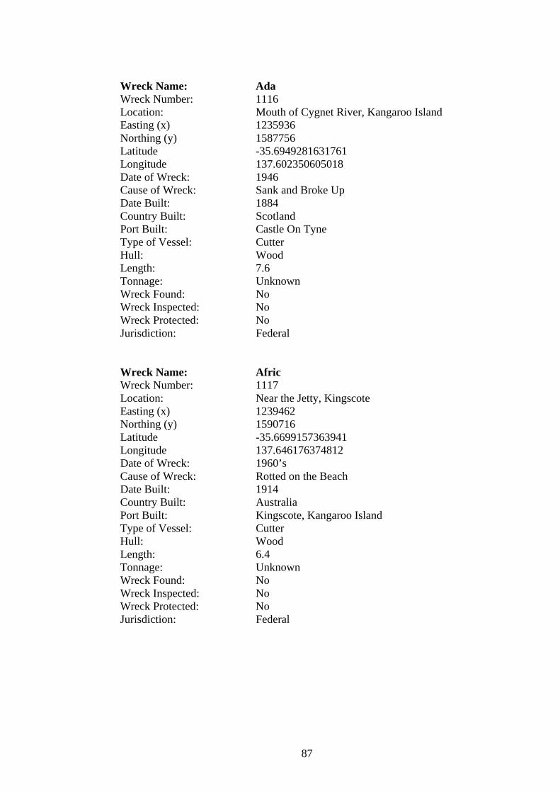
Wreck Name: Ada Wreck Number: 1116 Location: Mouth of Cygnet River, Kangaroo Island Easting (x) 1235936 Northing (y) 1587756 Latitude -35.6949281631761 Longitude 137.602350605018 Date of Wreck: 1946 Cause of Wreck: Sank and Broke Up Date Built: 1884 Country Built: Scotland Port Built: Castle On Tyne Type of Vessel: Cutter Hull: Wood Length: 7.6 Tonnage: Unknown Wreck Found: No Wreck Inspected: No Wreck Protected: No Jurisdiction: Federal Wreck Name: Afric Wreck Number: 1117 Location: Near the Jetty, Kingscote Easting (x) 1239462 Northing (y) 1590716 Latitude -35.6699157363941 Longitude 137.646176374812 Date of Wreck: 1960’s Cause of Wreck: Rotted on the Beach Date Built: 1914 Country Built: Australia Port Built: Kingscote, Kangaroo Island Type of Vessel: Cutter Hull: Wood Length: 6.4 Tonnage: Unknown Wreck Found: No Wreck Inspected: No Wreck Protected: No Jurisdiction: Federal
87

Wreck Name: Armadale Wreck Number: 1118 Location: Near the Jetty, Kingscote Easting (x) 1239462 Northing (y) 1590716 Latitude -35.6699157363941 Longitude 137.646176374812 Date of Wreck: 1930’s Cause of Wreck: Broke Up on Beach Date Built: 1910 Country Built: Australia Port Built: Kingscote, Kangaroo Island Type of Vessel: Cutter Hull: Wood Length: 7.9 Tonnage: Unknown Wreck Found: No Wreck Inspected: No Wreck Protected: Yes Jurisdiction: Federal Wreck Name: Hilarity Wreck Number: 1123 Location: Kingscote Beach, Kangaroo Island Easting (x) 1239462 Northing (y) 1590716 Latitude -35.6699157363941 Longitude 137.646176374812 Date of Wreck: 1940’s Cause of Wreck: Rotted Away on Beach Date Built: Unknown Country Built: Unknown Port Built: Unknown Type of Vessel: Cutter Hull: Wood Length: 8.2 Tonnage: Unknown Wreck Found: No Wreck Inspected: No Wreck Protected: No Jurisdiction: Federal
88

Wreck Name: Isla Wreck Number: 1125 Location: Kingscote Beach Easting (x) 1239462 Northing (y) 1590716 Latitude -35.6699157363941 Longitude 137.646176374812 Date of Wreck: 1940’s Cause of Wreck: Rotted Away on Beach Date Built: Unknown Country Built: Australia Port Built: Port Adelaide Type of Vessel: Cutter Hull: Wood Length: 9.1 Tonnage: Unknown Wreck Found: No Wreck Inspected: No Wreck Protected: No Jurisdiction: Federal Wreck Name: Judy I Wreck Number: 1126 Location: Kingscote, Kangaroo Island Easting (x) 1239462 Northing (y) 1590716 Latitude -35.6699157363941 Longitude 137.646176374812 Date of Wreck: 13/02/1947 Cause of Wreck: Broke Loose from Moorings in SE Gale, Washed
Ashore and Wrecked Date Built: Unknown Country Built: Unknown Port Built: Unknown Type of Vessel: Unknown Hull: Wood Length: 9.8 Tonnage: Unknown Wreck Found: No Wreck Inspected: No Wreck Protected: No Jurisdiction: Federal
89

APPENDIX 1.3
West Bay Shipwrecks:
Wreck Name: Winnie Wreck Number: 490 Location: West Bay, Kangaroo Island Easting (x) 1139824 Northing (y) 1567366 Latitude -35.8978193218361 Longitude 136.549029730157 Date of Wreck: 07/01/1942 Cause of Wreck: Washed Ashore Date Built: 1900 Country Built: Australia Port Built: Port Adelaide Type of Vessel: Cutter Hull: Wood Length: 11.6 Tonnage: Unknown Wreck Found: No Wreck Inspected: No Wreck Protected: No Jurisdiction: Federal Wreck Name: Mars Wreck Number: 176 Location: West Bay, Kangaroo Island Easting (x) 1147694 Northing (y) 1558962 Latitude -35.972510852903 Longitude 136.637615124691 Date of Wreck: 16/06/1885 Cause of Wreck: Stranded During Heavy Weather and Became Total
Wreck Date Built: 05/1877 Country Built: Scotland Port Built: Milford, Warlow Type of Vessel: Barque Hull: Wood Length: 45.7 Tonnage: 508 Wreck Found: No Wreck Inspected: No Wreck Protected: No Jurisdiction: Federal
90
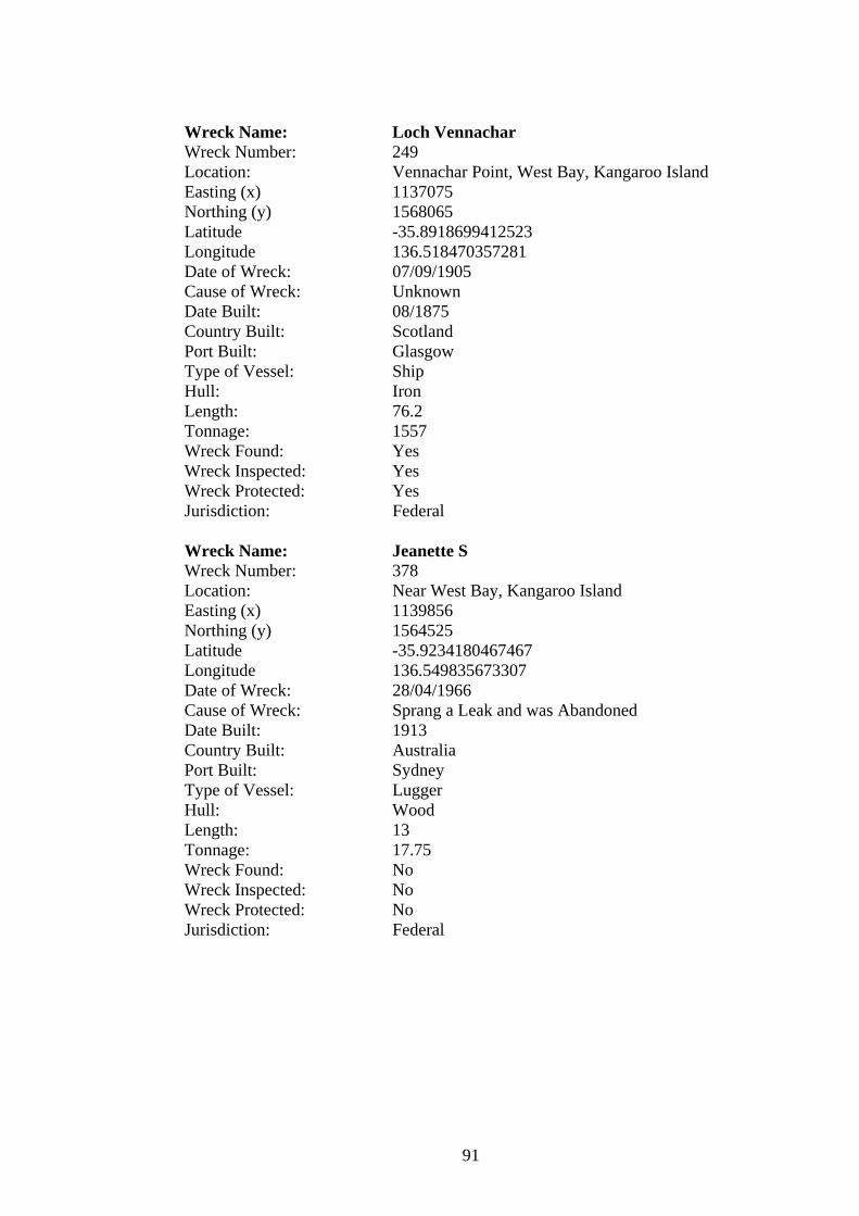
Wreck Name: Loch Vennachar Wreck Number: 249 Location: Vennachar Point, West Bay, Kangaroo Island Easting (x) 1137075 Northing (y) 1568065 Latitude -35.8918699412523 Longitude 136.518470357281 Date of Wreck: 07/09/1905 Cause of Wreck: Unknown Date Built: 08/1875 Country Built: Scotland Port Built: Glasgow Type of Vessel: Ship Hull: Iron Length: 76.2 Tonnage: 1557 Wreck Found: Yes Wreck Inspected: Yes Wreck Protected: Yes Jurisdiction: Federal Wreck Name: Jeanette S Wreck Number: 378 Location: Near West Bay, Kangaroo Island Easting (x) 1139856 Northing (y) 1564525 Latitude -35.9234180467467 Longitude 136.549835673307 Date of Wreck: 28/04/1966 Cause of Wreck: Sprang a Leak and was Abandoned Date Built: 1913 Country Built: Australia Port Built: Sydney Type of Vessel: Lugger Hull: Wood Length: 13 Tonnage: 17.75 Wreck Found: No Wreck Inspected: No Wreck Protected: No Jurisdiction: Federal
91

APPENDIX 2.1
The South Australian Government Gazette:
Adelaide, Thursday, July 19, 1900
Lighthouse Reserves.
By virtue of the provisions of “The Crown Lands Act, 1888”, and the “Marine
Board and Navigation Act, 1881”, I, the Governor, with the advice and consent of
the Executive Council, do hereby reserve the Crown lands respectively described
in the schedule hereto for lighthouse purposes, and place the said reserves under
the care, management, and control of the Marine Board of South Australia.
The schedule referred to.
Cape Borda Reserve - Comprising that portion of county Carnarvon west of
pastoral lease 252 and west of pastoral blocks 331 and 323, as delineated on run
plan No. 3a deposited in Land Office.
Given under my hand and the public seal of South Australia, at Adelaide, this
eleventh day of July, one thousand nine hundred.
By Command, J.G. Jenkins, Chief Secretary.
Adelaide, Thursday, April 29, 1909
Lighthouse Reserve, Cape Borda.
By virtue of “The Crown Lands Act, 1903”, and all other powers enabling, I, the
said Governor, with the advice and consent of the Executive Council and the said
State, do hereby -
1. Resume the lands which were, by a proclamation published in the
Government Gazette on the 19th day of July, 1900, dedicated as a reserve
for lighthouse purposes at Cape Borda.
2. Reserve the lands described in the schedule hereto as a reserve for
lighthouse purposes, and place the said reserve under the care,
management, and control of the Marine Board of South Australia.
The Schedule.
Cape Borda Lighthouse Reserve - Comprising that portion of county Carnarvon
commencing at a point on the telegraph line (running from Kingscote to Cape
Borda) 2 miles and 30 chains west of the western boundary of pastoral lease No.
725; thence true south for 64 chains; thence west at right angles for about 1 mile
92

and 64 chains to the sea coast; thence north-easterly and easterly following the sea
coast to a point true north of the starting point; and thence south to the point of
commencement, exclusive of all necessary roads.
Given under my hand and the public seal of South Australia, at Adelaide, this
seventh day of April, one thousand nine hundred and nine.
By command, F.S. Wallis, Chief Secretary.
Adelaide, Thursday, September 20, 1923
Area within which the Fauna and Flora Reserve Act, 1919, to apply.
By virtue of the provisions of the Fauna and Flora Reserve Act, 1919, I, the said
Governor, with the advice and consent of the Executive Council, do hereby,
dedicate the Crown Lands, the boundaries whereof are described in the schedule
hereto, for the purposes of the said Act.
The Schedule.
Comprising that portion of the hundred of McDonald, Kangaroo Island, bounded
on the north by the northern boundary of block 1, on the east by the eastern
boundary of said block and its production south to the sea coast, on the south by
the sea coast and the northern boundary of the landing reserve gazetted September
2nd, 1909; and on the west by the sea coast and portion of the western boundary of
the said hundred.
Given under my hand and the public seal of South Australia, at Adelaide, this 12th
day of September, 1923.
By command, John G. Bice, Chief Secretary.
93

APPENDIX 2.2
(source: Loney, Jack.1993. Wrecks on the South Australian Coast: Including
Kangaroo Island. Lonestone Press. Victoria.)
The following letter, written at “Torture Camp”, West Bay, Kangaroo Island, on
Saturday, 9-10-05, by Trooper Thorpe, dramatically illustrates the difficulties in
locating shipwrecks off remote regions.
Doubtless you have seen in the papers the result of my visit of inspection
to the Shipwreck Shelter Hut at this bay, and the sad discovery we made – I had a
man named May with me for company, as it is both a rough, scrubby and
dangerous place to come to alone. He is a farmer living 15 miles from here. We
first visited the Cape De Condie (Du Couedic) shelter shed two days previous to
coming to this one and found all the stores, etc., intact.
On Sunday, the 26th November, we rode to this bay and tied our horses up
at this creek where I have pitched my camp. We walked to the beach through
dense scrub for a mile. My mate was walking some distance from the creek
whereas I was keeping close to the bank, and after going nearly half a mile I
called out, “Hullo, there's some casks from the Loch Vennachar.”
He came to me, and as we walked towards the mouth of the creek where it
empties into the sea, we saw casks all over the beach, some full, some three-
quarters full, some half and quarter full of whisky. A lot of it was “Vanguard”
whisky in 18 gallon casks; also a hogshead full of English draught ale, also some
casks of “Taymouth” whisky, also some casks of “Bon Accord” whisky, also some
“Dewars” whisky, also one cask of oil. All were consigned to Melbourne.
There was also a number of casks of whisky consigned to Adelaide firms.
Also a host of bales of paper, same as this piece I have written this letter on.
There are a lot of reels of greenish blue paper consigned to the “Observer” Office
Adelaide; it is the coloured paper they generally use for the cover of their weekly
paper “The Observer”. Loose tins of “Davidson's” tinned fish is also strewn all
over the place. We found two casks intact; they are consigned to a Melbourne
firm. Such articles as hair brushes, clothes brushes, brooms, etc., are also to be
found, and pipes that have been smoked out of, pieces of flannel, under shirts, and
94

under pants, white linen shirts, pieces of serge, and tweed trousers with pieces of
braces attached, also pieces of ladie's (sic) underclothing marked “B. Patterson”
and a man's sock marked “J. H. Patterson”. The last named two articles were
part of Captain Patterson's (deceased) effects which Captain Hawkins was
bringing out for Mrs Patterson. She came to Melbourne in one of the mail liners,
her husband had died aboard his sailing ship en route to England – and as
Captain Hawkins of the Loch Vennachar was a great personal friend of Captain
and Mrs Patterson, he promised to bring the late Captain's effects out and
probably she put some of her own underclothing in the same boxes, which
accounts for them washing up.)
“There are also two 60-foot spars and a number of smaller ones, all
chewed about by the rocks, which are very sharp on either side of the bay. There
are piles of wreckage from almost every part of the ship's cabin doors, legs of
tables, settees, pillows, mattresses. Some of the wreckage is to be found in
crevices and on ledges of rocks over twenty feet from the level of the sea, showing
clearly what a dreadful sea there must have been the night or day the poor old
gallant “Vennachar” met her fate. I can quite understand why it is none of the
poor fellows reached shore alive. The rocks would chop them to pieces, so sharp
and hard are they, besides this coast is teeming with sharks, and the sea that must
have been running then, why nothing could live in it. We have some dreadful seas
off our southern and south-west coast. The island is one continuous formation of
high rugged cliffs over 350 feet in many places and a straight drop into the
seething waters. There are heavy pieces of the ship's bulwarks over 20 feet long,
with the top rail and sides and great heavy iron stays attached. The spars have
long pieces of wire rope and heavy iron hooks, etc., attached. I gather from these
that the ship must have struck a sunken rock not far out from the mouth of West
Bay because such terrible heavy wreckage could not possibly float far. The ship
has probably been dismasted during the terrible weather she met and drifted
inshore. It is only twelve miles to the south of Cape Borda lightilouse.
We then turned our eyes to the north end of the beach, and seeing
something dark lying on the sand just near the shelter hut, I said to my mate, “I
believe that's a body.” We could not tell for certain owing to the distance. We
however drew nearer and there we found the de-composed body of a poor young
fellow, probably not more than 17 or 18. It smelled awfully bad. It was lying on its
95

back, the skin was dry, all the features were completely gone and the flesh was
leaving the skull; the left leg was thrown clean across the body and was almost
detached at the hip joint. The right leg and arms were somewhat naturally
shaped, they did not appear to be as shrunken as the left leg. It was a rather
prettily shaped body, being slight yet compact, about 5 ft 7 or 8, remarkably tiny
hands and feet (more like a female), the teeth were evidently perfect, no hair or
clothing, It was too much decomposed to get a good description.
My mate and I carried the body up to a flat and buried it in its lonely
grave, without a friendly tear, except our own. It is a dreadfully lonely place, high
towering sand hummocks, and cliffs, and dense scrub, which made our sad task
ever so much harder. The place, save for the roaring waves, is as still as death. I
got a brass tipped capstan bar and nailed a cross piece on to form a cross, and
with the aid of a stick and tin of black paint recovered from the wreck, I marked
on the cross, “Body from the Loch Vennachar 26-11-05.”
Since then the Government has appointed me Receiver of Wrecks for
Kangaroo Island, and as I have recovered 44 casks of whisky etc.(majority full), I
must remain in this terribly lonely camp for God knows how long; anyway until a
vessel can get in the bay to take it away. It will be a risky job whoever takes it on.
I shall be glad to get home to my family again – 30 miles away.
We have to live on wallaby and damper and black tea from brackish
water. I left home on Wednesday 22nd November and am in camp still. I have had
a terribly rough job of late riding and walking over the terribly rugged cliffs and
through dense scrub; I have at times been fairly dead beat. I have secured you
some nice pieces of wood and will forward them to you as soon as I get home.
Yours Faithfully,
(Signed) R.C.Thorpe, Mounted Constable.
96

APPENDIX 2.3
Marine Board Minutes 1899 - regarding the necessary action surrounding recent
shipwreck events around Kangaroo Islands coastline.
Marine Board Minutes 18th May 1899 (pp174; ref: 462/99:9)
“The President laid on the table information with reference to the wreck of the
Loch Sloy near Cape Couedic, Kangaroo Island, on the 24th April and it was
decided to hold an enquiry as soon as the attendance of the witnesses (the three
sole survivors of the wreck) could be arranged”.
Marine Board Minutes 1st June 1899 (pp185-186; ref: 541/9).
“The second keeper, Cape Borda lighthouse (Mr. W. Smith) forwarded a
specimen of ore which he had found on Kangaroo Island while engaged in
searching for the survivors of the Loch Sloy. The ore referred to, he believed to be
magnetic iron ore and he thought it might have some influence on the compasses
of vessels approaching the coast of Kangaroo Island and therefore felt it his duty
to report this matter to the Board. Further information to be obtained”.
Marine Board Minutes 15th June 1899 (pp193-194; ref: T.O 369/99:1)
“The Honorable The Treasurer forwarded a request from the Chairman of
Commerce with reference to the placing of a light on the South Neptune Islands,
and asked that the Marine Board might report thereon. He also asked that a return
might be prepared showing what wrecks had occurred during the last 30 years on
the south or west coast of Kangaroo Island and the relative advantages of a light
on or near Cape du Couedic. The President suggested and the Board agreed that a
circular be issued with a view of ascertaining the opinions of practical shipmasters
as to the advisability of establishing a light.
(a) on one of the Neptune Islands, or
(b) on Cape du Couedic
Also as to whether one would be sufficient, and, if so, which one, or whether an
additional light in the vicinity was necessary at all”.
Marine Board Minutes 27th July 1899 (pp232-233; ref: T.O 369/7)
97

“The Honorable The Treasurer asked the Board to furnish a report showing the
number of casualties which had occurred on the south and southwest coast of
Kangaroo Island during the past 30 years, also the relative advantages of a light on
the South Neptune and on Cape du Couedic. The President laid on the table 54
reports received from shipmasters and others with reference to the best position
for a light. As a large majority were in favour of the South Neptune Island and the
Board also were of the opinion that the South Neptune was the better site it was
recommended that a light be placed there with as little delay as possible”.
Marine Board Minutes 7th September 1899 (pp278; ref: 38:8)
“The President referred to an article in the ‘Nautical Magazine’ of June 1899 in
which it was stated that it was impossible for a lode of magnetic iron ore to
materially influence the compasses on board a ship at sea”.
98
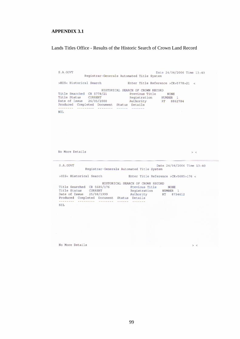
APPENDIX 3.1
Lands Titles Office - Results of the Historic Search of Crown Land Record
99

APPENDIX 3.2
State Library of South Australia - letter granting permission to use image.
100