the mallet project: from an earthquake laboratory to
TRANSCRIPT
The Mallet Project:from an earthquake laboratory to laboratories on the territory
Graziano Ferrari
Istituto Nazionale di Geofisica e Vulcanologia, Bologna, Italy
ANNALS OF GEOPHYSICS, 55, 3, 2012; doi: 10.4401/ag-5654
ABSTRACT
On December 16, 1857, an earthquake wreaked havoc across a hugearea of the regions of Basilicata and Campania (Val d’Agri and Vallodi Diano). More than 180 villages in an area of over 20,000 km2 sufferedvery severe damage. More than 6,000 houses collapsed or becameuninhabitable, and 19,000 people were killed. In the months ofFebruary and March 1858, the Irish engineer Robert Mallet undertooka mission to study the earthquake with a grant from the Royal Societyof London. In 1862, he published his extraordinary study diary, inwhich the technical and scientific observations mingled with descriptiveand literary details. This represents, from different angles, a unique‘observatory’ over the landscape and the social, economic and culturalaspects of Val d’Agri and Vallo di Diano. In 2003, the Provinces ofSalerno and Potenza started up a joint venture with the Storia GeofisicaAmbiente of Bologna and with the scientific partnership of the IstitutoNazionale di Geofisica e Vulcanologia, with a view to setting upprovincial laboratories dedicated to environmental education, and namedafter Robert Mallet. The Mallet Project proceeded up to 2009 on threeagreements. Within the framework of the idea of a ‘Mallet Laboratories’Project, there has been the opportunity to set up a network of studycenters in the territories of these two provinces (Salerno and Potenza),which can promote research with great national and internationalbreadth, starting with the world of schools and local communities. Thestudy entitled Viaggio nelle aree del terremoto del 16 dicembre1857 was published through the period from 2004 to 2009.
1. IntroductionOn December 16, 1857, at around 10:15 pm, an earth-
quake devastated a vast area of Basilicata and part of Cam-pania (southern Italy). The present-day province of Potenzaand the central-eastern zone of the province of Salernowere hit in particular. The most serious damage occurred inthe mountain areas, and mainly in Val d’Agri and Vallo diDiano. The most deaths were recorded for the villages ofMontemurro, Grumento Nova, Viggiano, Tito, MarsicoNuovo and Polla. As a result of this shock and the numerousaftershocks, including destructive ones that followed, more
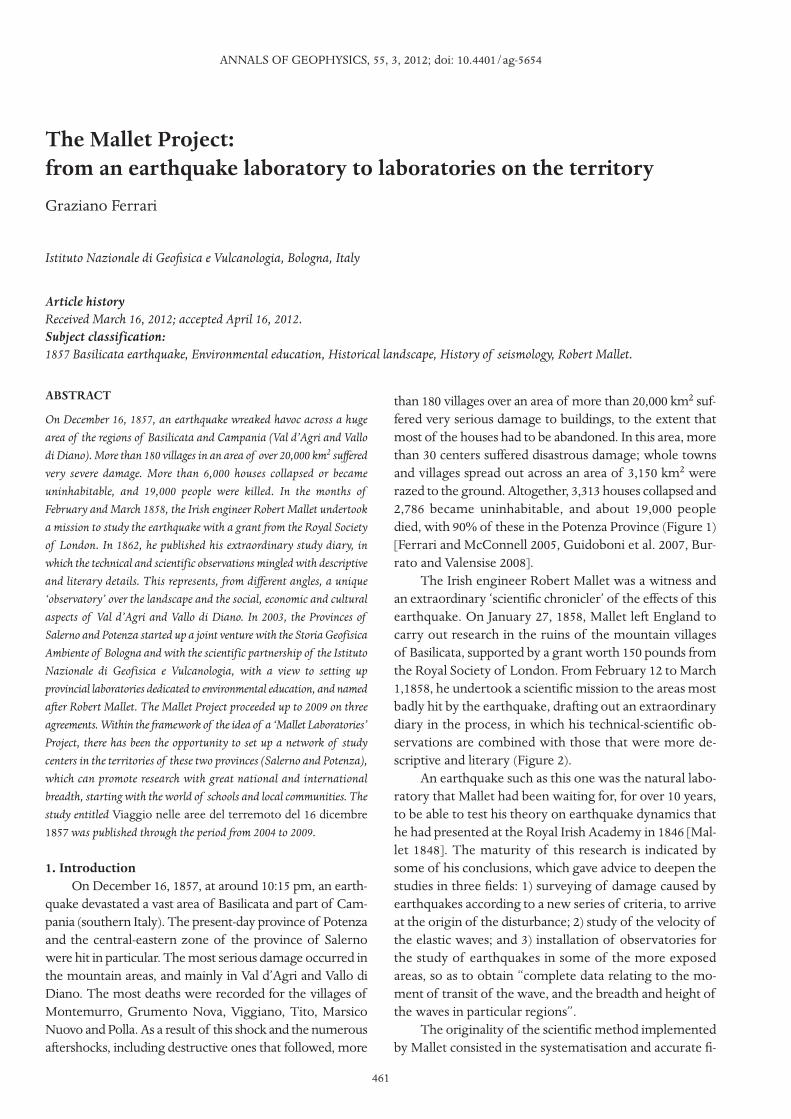
than 180 villages over an area of more than 20,000 km2 suf-fered very serious damage to buildings, to the extent thatmost of the houses had to be abandoned. In this area, morethan 30 centers suffered disastrous damage; whole townsand villages spread out across an area of 3,150 km2 wererazed to the ground. Altogether, 3,313 houses collapsed and2,786 became uninhabitable, and about 19,000 peopledied, with 90% of these in the Potenza Province (Figure 1)[Ferrari and McConnell 2005, Guidoboni et al. 2007, Bur-rato and Valensise 2008].
The Irish engineer Robert Mallet was a witness andan extraordinary ‘scientific chronicler’ of the effects of thisearthquake. On January 27, 1858, Mallet left England tocarry out research in the ruins of the mountain villagesof Basilicata, supported by a grant worth 150 pounds fromthe Royal Society of London. From February 12 to March1,1858, he undertook a scientific mission to the areas mostbadly hit by the earthquake, drafting out an extraordinarydiary in the process, in which his technical-scientific ob-servations are combined with those that were more de-scriptive and literary (Figure 2).
An earthquake such as this one was the natural labo-ratory that Mallet had been waiting for, for over 10 years,to be able to test his theory on earthquake dynamics thathe had presented at the Royal Irish Academy in 1846 [Mal-let 1848]. The maturity of this research is indicated bysome of his conclusions, which gave advice to deepen thestudies in three fields: 1) surveying of damage caused byearthquakes according to a new series of criteria, to arriveat the origin of the disturbance; 2) study of the velocity ofthe elastic waves; and 3) installation of observatories forthe study of earthquakes in some of the more exposedareas, so as to obtain “complete data relating to the mo-ment of transit of the wave, and the breadth and height ofthe waves in particular regions”.
The originality of the scientific method implementedby Mallet consisted in the systematisation and accurate fi-
Article historyReceived March 16, 2012; accepted April 16, 2012.Subject classification:1857 Basilicata earthquake, Environmental education, Historical landscape, History of seismology, Robert Mallet.
461
nalization of observations of the earthquake effects, whichhad previously been used only partly with the aim of quan-titative assessment. Upon his return to England, Mallet puthis observations down in a weighty report, which he pub-lished in London in 1862, with the title: The Great Neapoli-tan Earthquake of 1857. The First Principles of Observational
Seismology. With this title, Mallet gave a name to the nas-cent science of earthquakes: seismology.
However, this earthquake had another peculiarity, whichwas not a seismological one: it was the first earthquake wherethe effects were documented by photographic reportage,which consisted of over 200 photographs, most of which are
GRAZIANO FERRARI
462
Figure 1. Summary map of the area struck by the earthquake and involved in the Mallet Project. Coloured patterns, black lines and black trianglesrepresent the intensity distributions of the seismic effects (MCS scale), the path of Mallet’s journey, and the locations of the geosites mapped duringthe Project, respectively.
463
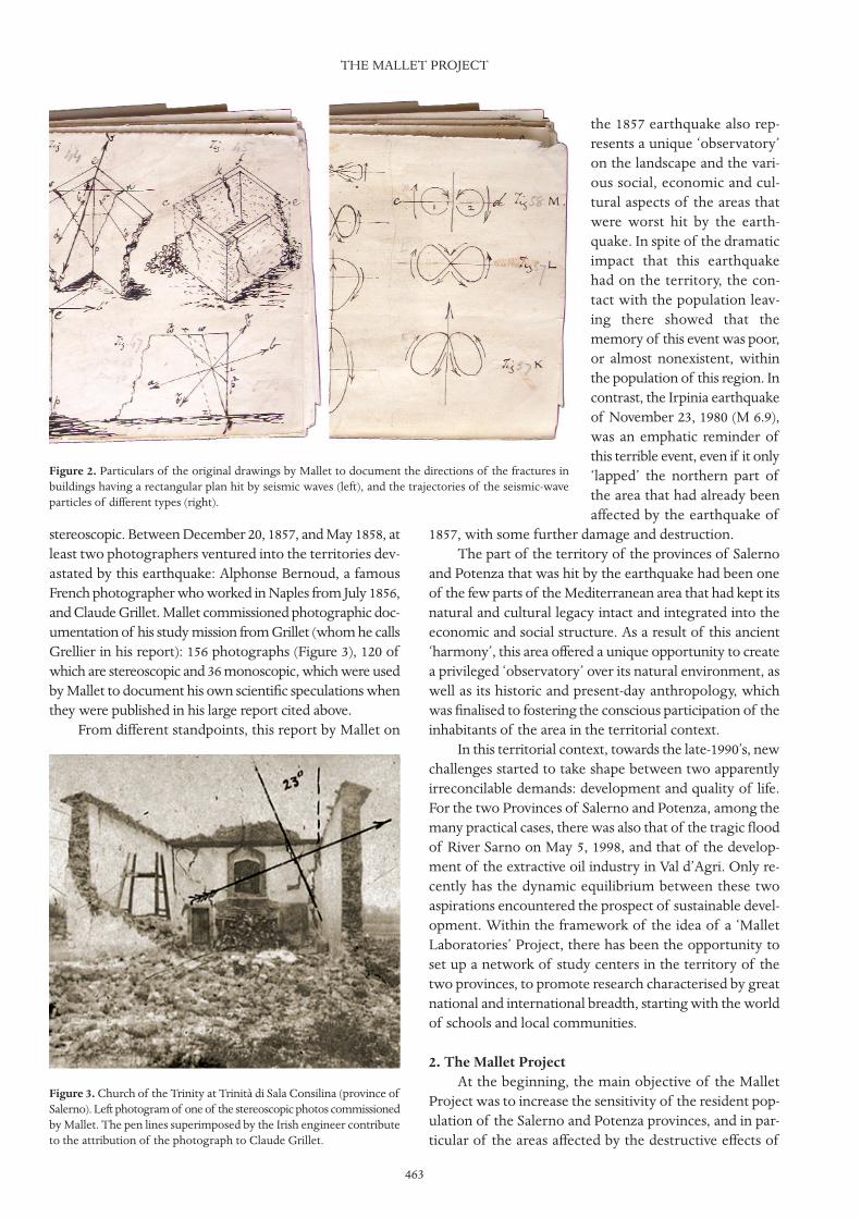
stereoscopic. Between December 20, 1857, and May 1858, atleast two photographers ventured into the territories dev-astated by this earthquake: Alphonse Bernoud, a famousFrench photographer who worked in Naples from July 1856,and Claude Grillet. Mallet commissioned photographic doc-umentation of his study mission from Grillet (whom he callsGrellier in his report): 156 photographs (Figure 3), 120 ofwhich are stereoscopic and 36 monoscopic, which were usedby Mallet to document his own scientific speculations whenthey were published in his large report cited above.
From different standpoints, this report by Mallet on
the 1857 earthquake also rep-resents a unique ‘observatory’on the landscape and the vari-ous social, economic and cul-tural aspects of the areas thatwere worst hit by the earth-quake. In spite of the dramaticimpact that this earthquakehad on the territory, the con-tact with the population leav-ing there showed that thememory of this event was poor,or almost nonexistent, withinthe population of this region. Incontrast, the Irpinia earthquakeof November 23, 1980 (M 6.9),was an emphatic reminder ofthis terrible event, even if it only‘lapped’ the northern part ofthe area that had already beenaffected by the earthquake of
1857, with some further damage and destruction.The part of the territory of the provinces of Salerno
and Potenza that was hit by the earthquake had been oneof the few parts of the Mediterranean area that had kept itsnatural and cultural legacy intact and integrated into theeconomic and social structure. As a result of this ancient‘harmony’, this area offered a unique opportunity to createa privileged ‘observatory’ over its natural environment, aswell as its historic and present-day anthropology, whichwas finalised to fostering the conscious participation of theinhabitants of the area in the territorial context.
In this territorial context, towards the late-1990’s, newchallenges started to take shape between two apparentlyirreconcilable demands: development and quality of life.For the two Provinces of Salerno and Potenza, among themany practical cases, there was also that of the tragic floodof River Sarno on May 5, 1998, and that of the develop-ment of the extractive oil industry in Val d’Agri. Only re-cently has the dynamic equilibrium between these twoaspirations encountered the prospect of sustainable devel-opment. Within the framework of the idea of a ‘MalletLaboratories’ Project, there has been the opportunity toset up a network of study centers in the territory of thetwo provinces, to promote research characterised by greatnational and international breadth, starting with the worldof schools and local communities.
2. The Mallet ProjectAt the beginning, the main objective of the Mallet
Project was to increase the sensitivity of the resident pop-ulation of the Salerno and Potenza provinces, and in par-ticular of the areas affected by the destructive effects of
THE MALLET PROJECT
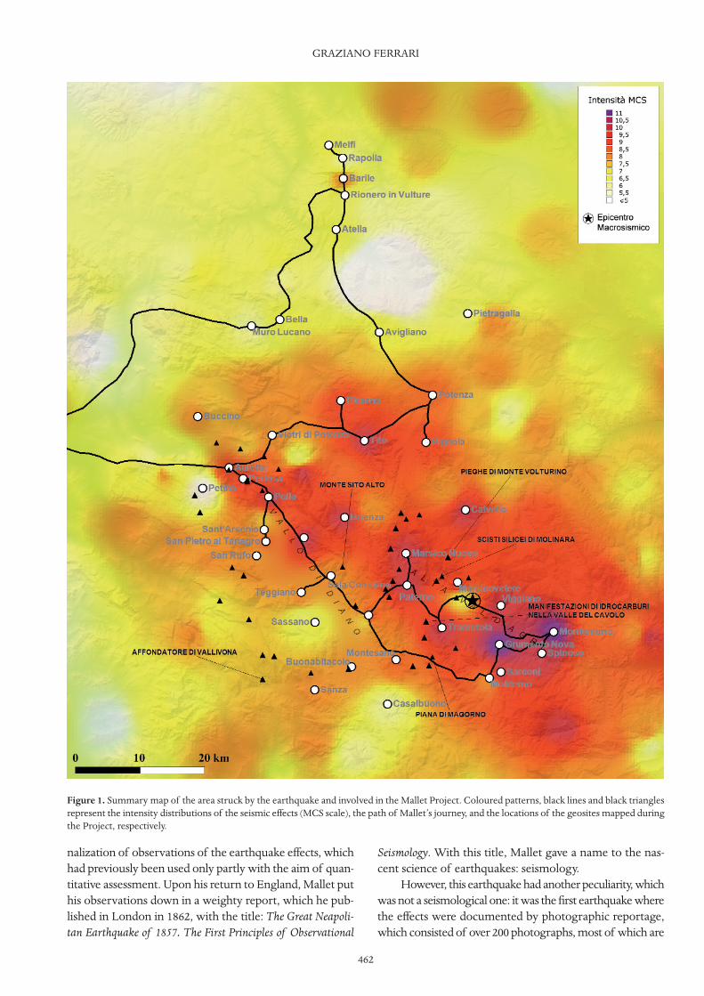
Figure 2. Particulars of the original drawings by Mallet to document the directions of the fractures inbuildings having a rectangular plan hit by seismic waves (left), and the trajectories of the seismic-waveparticles of different types (right).
Figure 3. Church of the Trinity at Trinità di Sala Consilina (province ofSalerno). Left photogram of one of the stereoscopic photos commissionedby Mallet. The pen lines superimposed by the Irish engineer contributeto the attribution of the photograph to Claude Grillet.

the 1857 earthquake. It was also designed to prevent therisks associated with natural catastrophes, such as earth-quakes, landslides and floods, and to educate a new cul-ture of security.
Despite many bureaucratic difficulties, the Project of-ficially started in 2003, as a concrete sign that strategies pro-moting research and environmental education were beingachieved. These aspects are indeed of great importance inthe drafting and the enforcement of plans for safeguardingthe territory, in which the regional administrations of theItalian State, first and foremost the Regions and theProvinces, are increasingly called upon to operate.
The Project has involved 52 municipalities of theprovinces of Salerno and Potenza (all of the Alta Val d’A-gri, the Vallo di Diano, the Valle del Bradano, and the Vul-ture), and since its beginning there have been three mainphases envisaged: (i) the creation of a publication as a bib-
liographical point of reference and awareness; (ii) the real-ization of initiatives of dissemination at all levels of society;and (iii) the design and creation of the Mallet Laboratories,to provide education in sustainable development. The firsttwo phases have continued over the duration of the Proj-ect, as described here (2003-2009), while the third phasewas launched in 2007, and is still in progress.
At the beginning of the Project, there were no prede-fined guidelines to achieve the main goal, but priority wasgiven to the knowledge of the territory, which was fol-lowed as the same journey that Mallet made 150 years ago.We tried to be in ‘contact’ with the local people, to under-stand the different cultures, and to find the best languagein which to communicate. So, indirectly, and sometimesdirectly, the recipients of the objectives of the Project be-came involved in the construction of the Project itself, andin the construction of the communication process.
GRAZIANO FERRARI
464
Figure 4. Scheme of the work phases that led to the realisation of the virtual historical landscapes for the three-dimensional navigational softwareGEOviewer.
465
2.1. PublicationsThe publishing activities started in 2003, with two
volumes and a multimedia DVD-ROM, which have sincebeen extended to a further four volumes and two updatesof the multimedia product. The great narrative value ofMallet’s work produced the idea of a virtual journey intothe territories hit by the earthquake. To achieve this, it wasnecessary to create a high-immersion environment bymeans of multimedia instruments, while rigorously ad-hering to the historical reality of the mid-eighteenth cen-tury in the area of Lucania.
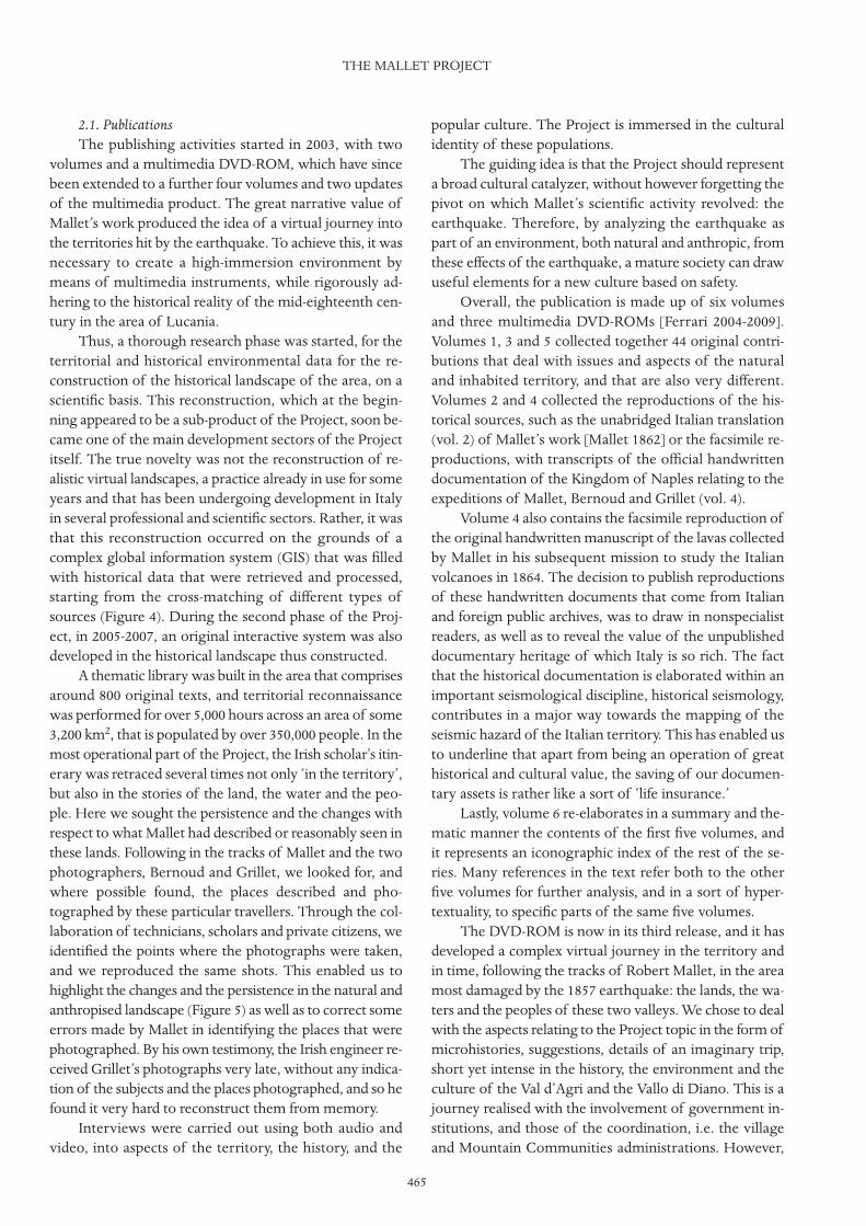
Thus, a thorough research phase was started, for theterritorial and historical environmental data for the re-construction of the historical landscape of the area, on ascientific basis. This reconstruction, which at the begin-ning appeared to be a sub-product of the Project, soon be-came one of the main development sectors of the Projectitself. The true novelty was not the reconstruction of re-alistic virtual landscapes, a practice already in use for someyears and that has been undergoing development in Italyin several professional and scientific sectors. Rather, it wasthat this reconstruction occurred on the grounds of acomplex global information system (GIS) that was filledwith historical data that were retrieved and processed,starting from the cross-matching of different types ofsources (Figure 4). During the second phase of the Proj-ect, in 2005-2007, an original interactive system was alsodeveloped in the historical landscape thus constructed.
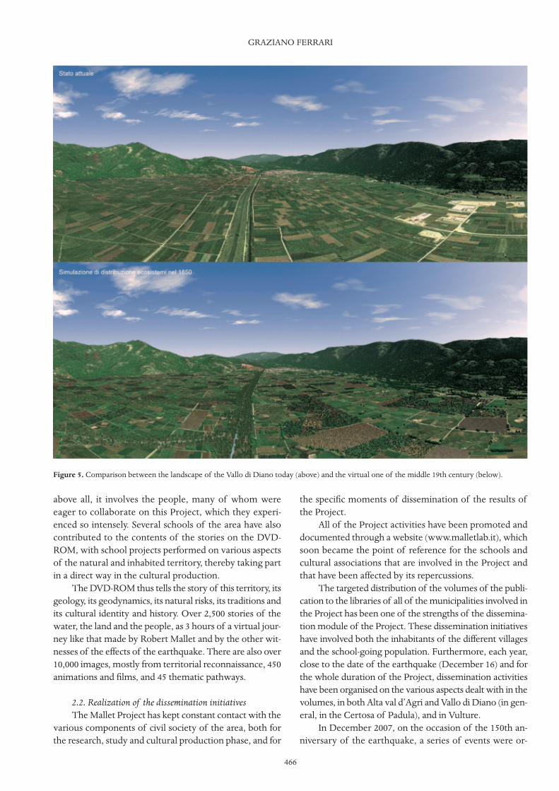
A thematic library was built in the area that comprisesaround 800 original texts, and territorial reconnaissancewas performed for over 5,000 hours across an area of some3,200 km2, that is populated by over 350,000 people. In themost operational part of the Project, the Irish scholar’s itin-erary was retraced several times not only ‘in the territory’,but also in the stories of the land, the water and the peo-ple. Here we sought the persistence and the changes withrespect to what Mallet had described or reasonably seen inthese lands. Following in the tracks of Mallet and the twophotographers, Bernoud and Grillet, we looked for, andwhere possible found, the places described and pho-tographed by these particular travellers. Through the col-laboration of technicians, scholars and private citizens, weidentified the points where the photographs were taken,and we reproduced the same shots. This enabled us tohighlight the changes and the persistence in the natural andanthropised landscape (Figure 5) as well as to correct someerrors made by Mallet in identifying the places that werephotographed. By his own testimony, the Irish engineer re-ceived Grillet’s photographs very late, without any indica-tion of the subjects and the places photographed, and so hefound it very hard to reconstruct them from memory.
Interviews were carried out using both audio andvideo, into aspects of the territory, the history, and the
popular culture. The Project is immersed in the culturalidentity of these populations.
The guiding idea is that the Project should representa broad cultural catalyzer, without however forgetting thepivot on which Mallet’s scientific activity revolved: theearthquake. Therefore, by analyzing the earthquake aspart of an environment, both natural and anthropic, fromthese effects of the earthquake, a mature society can drawuseful elements for a new culture based on safety.
Overall, the publication is made up of six volumesand three multimedia DVD-ROMs [Ferrari 2004-2009].Volumes 1, 3 and 5 collected together 44 original contri-butions that deal with issues and aspects of the naturaland inhabited territory, and that are also very different.Volumes 2 and 4 collected the reproductions of the his-torical sources, such as the unabridged Italian translation(vol. 2) of Mallet’s work [Mallet 1862] or the facsimile re-productions, with transcripts of the official handwrittendocumentation of the Kingdom of Naples relating to theexpeditions of Mallet, Bernoud and Grillet (vol. 4).
Volume 4 also contains the facsimile reproduction ofthe original handwritten manuscript of the lavas collectedby Mallet in his subsequent mission to study the Italianvolcanoes in 1864. The decision to publish reproductionsof these handwritten documents that come from Italianand foreign public archives, was to draw in nonspecialistreaders, as well as to reveal the value of the unpublisheddocumentary heritage of which Italy is so rich. The factthat the historical documentation is elaborated within animportant seismological discipline, historical seismology,contributes in a major way towards the mapping of theseismic hazard of the Italian territory. This has enabled usto underline that apart from being an operation of greathistorical and cultural value, the saving of our documen-tary assets is rather like a sort of ‘life insurance.’
Lastly, volume 6 re-elaborates in a summary and the-matic manner the contents of the first five volumes, andit represents an iconographic index of the rest of the se-ries. Many references in the text refer both to the otherfive volumes for further analysis, and in a sort of hyper-textuality, to specific parts of the same five volumes.
The DVD-ROM is now in its third release, and it hasdeveloped a complex virtual journey in the territory andin time, following the tracks of Robert Mallet, in the areamost damaged by the 1857 earthquake: the lands, the wa-ters and the peoples of these two valleys. We chose to dealwith the aspects relating to the Project topic in the form ofmicrohistories, suggestions, details of an imaginary trip,short yet intense in the history, the environment and theculture of the Val d’Agri and the Vallo di Diano. This is ajourney realised with the involvement of government in-stitutions, and those of the coordination, i.e. the villageand Mountain Communities administrations. However,
THE MALLET PROJECT
above all, it involves the people, many of whom wereeager to collaborate on this Project, which they experi-enced so intensely. Several schools of the area have alsocontributed to the contents of the stories on the DVD-ROM, with school projects performed on various aspectsof the natural and inhabited territory, thereby taking partin a direct way in the cultural production.
The DVD-ROM thus tells the story of this territory, itsgeology, its geodynamics, its natural risks, its traditions andits cultural identity and history. Over 2,500 stories of thewater, the land and the people, as 3 hours of a virtual jour-ney like that made by Robert Mallet and by the other wit-nesses of the effects of the earthquake. There are also over10,000 images, mostly from territorial reconnaissance, 450animations and films, and 45 thematic pathways.
2.2. Realization of the dissemination initiativesThe Mallet Project has kept constant contact with the
various components of civil society of the area, both forthe research, study and cultural production phase, and for
the specific moments of dissemination of the results ofthe Project.
All of the Project activities have been promoted anddocumented through a website (www.malletlab.it), whichsoon became the point of reference for the schools andcultural associations that are involved in the Project andthat have been affected by its repercussions.
The targeted distribution of the volumes of the publi-cation to the libraries of all of the municipalities involved inthe Project has been one of the strengths of the dissemina-tion module of the Project. These dissemination initiativeshave involved both the inhabitants of the different villagesand the school-going population. Furthermore, each year,close to the date of the earthquake (December 16) and forthe whole duration of the Project, dissemination activitieshave been organised on the various aspects dealt with in thevolumes, in both Alta val d’Agri and Vallo di Diano (in gen-eral, in the Certosa of Padula), and in Vulture.
In December 2007, on the occasion of the 150th an-niversary of the earthquake, a series of events were or-
GRAZIANO FERRARI
466
Figure 5. Comparison between the landscape of the Vallo di Diano today (above) and the virtual one of the middle 19th century (below).

467
ganised with educational, scientific and cultural natures,along with an opening concert of nineteenth centurymusic on the theme of Nature.
In 2006, the Project was presented in Dublin, uponinvitation, at the Italian Institute of Culture and at theDublin Institute of Advanced Studies. The latter initiativefostered the knowledge of Mallet in the Irish geophysicalworld in which he was practically unknown.
With the publication of the last box-set with volumes5 and 6, the first phase has been completed and the dis-semination module has entered its more mature phase.Volume 6 has been printed as over 2,500 copies in a pa-perback version, for distribution to the secondary schoolstudents of the territory involved in the Project. The nu-merous hypertext links from volume 6 to the other fivevolumes, as mentioned previously, stimulate the studentsto analyse in greater depth the topics that are summarisedin volume 6.
2.3. Design and creation of the Mallet Laboratories forEducation in Sustainable Development
The aims that we wanted to achieve were clear fromthe start, at least on a macro-scale, with the realization ofthe Mallet Laboratories for Education in Sustainable De-velopment. However, it was only in the course of the Proj-ect that it was possible to outline more accurately thestructural, operational and communication model of thelaboratories that were to be set up. This was accomplishedthrough the analysis of the specificities of the territorystudied and described, with an understanding of its envi-ronmental and cultural vocation.
During the intense activity of territorial reconnaissance,the great wealth of the cultural producers was assessed:e.g. of individual scholars and associations. Most of theseprotagonists of the local cultural production operate inisolated ways, and so the idea has been to bring them to-gether within a sort of cultural network. Thus, along thelines of the far more famous academy that funded Mal-let’s original expedition, this network can function as acultural catalyst and as a point of reference for the MalletLaboratories, as the ‘Mallet Virtual Academy’.
The Mallet Laboratories were first of all intended asa center of cultural aggregation for the environmental,historical and ethno-anthropological issues of the area. Itwould have its own center of documentation and point ofconsultation for the publications of the Mallet Project.The activities of the Laboratories are oriented towards de-veloping training and information. Indeed, the central ful-crum around which the individual actions provided for inthe Mallet Laboratories Project is the involvement of thelocal population in the environmental education and in-formation processes. Specific collaboration was plannedwith the schools in the territory, both primary and sec-
ondary, as well as with the cultural associations, wheretheir specific aims are to address sustainable developmentand environmental protection.
After a first start-up phase, the users themselves be-came the protagonists of the actions of the Mallet Labo-ratories: the teachers and the cultural workers, such asleaders of study groups consisting of students and thelocal population. Then there are the students, teachers,cultural operators, researchers and local population as theproducers of the content that contributes to the enrich-ing the digital archive.
The sectors of activity in the training and informationalfields include:– environmental research into the different territorialecosystems and biodiversities; – enrichment of the contents of the web portal for theMallet Laboratories, on the cultural, environmental, his-torical and ethno-anthropological aspects of the territory;– setting up and endowment of a library and a specialisedmedia library;– monitoring artistic and natural emergencies;– didactic syllabus design;– production of teaching and dissemination materials;– dissemination and training on seismic risk, the earth-quakes, and the constructions in seismic areas; – creation and updating of the archives of knowledge andmemories;– periodic meetings, seminars, congresses and exhibitionsand events;– observatory on alternative energy;– network with the school institutions, and with publicand private institutions;– promotion of the Mallet Project, of its activities, and itsproducts.
The foundation of the first two laboratories, one in SalaConsilina (in the province of Salerno) and the other inPotenza, has allowed us to work actively on the increase invalue of the geological sites of special value, and to developeducational courses (teaching methods) for their study forhigh school students. Some of these geosites were publishedas the geosites in Tarabusi and Lizza [2009].
3. ConclusionsThis all started from one of the most destructive
earthquakes in the seismic history of southern Italy thatoccurred on December 16, 1857, and the subsequent studymission undertaken by Robert Mallet. Then, almost 150years later, the idea was born to develop an educationalproject for sustainable development in the present-day ter-ritories that at that time were devastated by the earth-quake: the Mallet Project.
As well as the issue of the earthquake and its eco-nomic and social implications, and of the aspects linked
THE MALLET PROJECT
to seismic risk and its prevention, a broad range of cul-tural, historical and ethno-anthropological issues havebeen developed.
The Project has involved 52 municipalities of theprovinces of Salerno and Potenza, over an area of over3,200 km2, populated by over 350,000 people, and it hasbeen carried out with the financial support of the twoprovincial administrations.
A complex and articulated editorial project has alsobeen carried out, consisting of six volumes and three mul-timedia DVD-ROMs that represent the knowledge baseof the Project. These contain 44 contributions on histori-cal, scientific and environmental matters, as well as a sub-stantial corpus of published sources and manuscripts. TheMallet Laboratories have subsequently been developedwith the involvement of the world of schools and all ofthe individual and associated cultural producers. All ofthese activities have been accompanied by numerous dis-semination activities that have involved a very large part ofthe population that resides in the territory of the Project.
The Mallet Project started with the target of prevalentlyspreading the issue of natural hazards, and it has gone onto characterize the rising involvement of the population, ofthe administration, of the scholars, of the cultural producers,and of the schools to achieve these objectives. It has alsobeen possible to develop and transfer to different citizensat different levels the analysis of the scientific, cultural andenvironmental identity, which are the peculiarities of theidentities of these populations. In particular, we found thatthe results obtained have contributed to enhancing a senseof cultural identity between the two valleys, which has beenrecalled on a number of occasions by the scholars.
Furthermore, as the Project has been followed veryclosely by the political administrators of these territories,this has also served to stimulate the citizens’ knowledge, witha view to asking the politicians the right sorts of questions.All too often, the politicians ask themselves questions andgive themselves their own answers: answers that are oftendistant from the real needs of the citizens, or that the cit-izens, being unprepared, often fail to understand.
ReferencesBurrato, P., and G. Valensise (2008). Rise and fall of a hy-
pothesized seismic gap: source complexity in the Mw 7.016 December 1857 southern Italy earthquake, B. Seis-mol. Soc. Am., 98, 139-148; doi:10.1785/0120070094.
Ferrari, G., ed. (2004-2009). Viaggio nelle aree del terre-moto del 16 dicembre 1857, (six vols. and three DVD-ROMs), Bologna, SGA Storia Geofisica e Ambiente.
Ferrari, G., and A. McConnell (2005). Robert Mallet andthe ‘Great Neapolitan Earthquake’ of 1857, Notes andRecords of the Roy. Soc. of London, 59, 45-64.
Guidoboni, E., G. Ferrari, D. Mariotti, A. Comastri, G.
Tarabusi and G. Valensise (2007). CFTI4Med, Cata-logue of Strong Earthquakes in Italy (461 B.C.-1997)and the Mediterranean Area (760 B.C.-1500), website:storing.ingv.it/cfti4med/.
Mallet, R. (1848). On the Dynamics of Earthquakes; beingan attempt to reduce their observed phenomena to theknown laws of wave motion in solids and fluids, Trans.Roy. Irish Acad., 21, 50-106.
Mallet, R. (1862). The Great Neapolitan Earthquake of1857, The First Principles of Observational Seismol-ogy, 2 vols, London, Chapman and Hall.
Tarabusi, G., and C. Lizza (2009). I geositi del Vallo diDiano e dell’Alta val d’Agri, In: G. Ferrari (ed.), Viag-gio nelle aree del terremoto del 16 dicembre 1857, (sixvols. and three DVD-ROMs), Bologna, SGA Storia Geo-fisica e Ambiente, vol. 5, 285-322.
Corresponding author: Graziano Ferrari,Istituto Nazionale di Geofisica e Vulcanologia, Bologna, Italy;email: [email protected].
© 2012 by the Istituto Nazionale di Geofisica e Vulcanologia. Allrights reserved.
GRAZIANO FERRARI
468