the list of solar-b mission-wide fits...
TRANSCRIPT
The List of SOLAR-B Mission-Wide FITS Keywords
2006/08/25 Ver.0.9: Masumi Shimojo
I. Introduction After the launch of SOLAR-B, we will get large amounts of observational data from three
instruments SOT, XRT and EIS. In order to select one data file from the data, the database
with the search function is the indispensable system for SOLAR-B data analysis. Especially,
we need the database system that can survey the data of three instruments from one
interface.
The database accumulates the information of the observations, and the search function of
the database selects the data based on the information. Although there are several ways for
accumulating of the information of the observations, it is easiest to get the information from
the FITS header (PHU) of the SOLAR-B FITS files. If we use the FITS header for searching
the data of three instruments, we have to unify the definition of some FITS keywords.
The aim of this document is to list the common FITS keywords (SOLAR-B Mission-Wide
Keyword) of three instruments and unify the definition of the SOLAR-B Mission-Wide
keywords for the search function of the database. The SOLAR-B MODA WG requests all
instrument teams to include all SOLAR-B Mission-Wide FITS keywords in the FITS header
of each instrument and adapt the definition in the document to these FITS keywords.
The Mission-Wide keyword list includes only the common keywords for the search function.
Hence, we need the other FITS keywords for the data search of each instrument data. The
keywords are defined by each instrument team.
II. Structure of SOLAR-B Mission-Wide Keywords The SOLAR-B Mission-Wide Keywords are classified into the following parts. In the section,
we summarize the subject matters of the parts.
1 Standard keywords for the FITS standard The FITS keywords are the essential keywords for the standard FITS files. Hence,
the keywords are based on the FITS standard.
2 Information of the instrument The part indicates the information of the instrument/the satellite
3 Information of the time The keywords indicate the date and the time of the observation. And, the keyword
in the part is also defined the time system (UTC, TAI or UT) of the SOLAR-B FITS
files.
4 Information of the coordinates The keywords indicate the coordinates of the Image data. The FITS standard
method of the coordinate specification is adapted to the section, basically. And, the
some non-FITS standard keywords also are included
5 Information of the observation plan The keywords present the properties of the observation. Basically, the values of
the keywords are decided by the proposer of the observation or the chief observers.
The values of the keywords are inputted to the SOLAR-B operational database
using the planning tool, and the reformat program gets the data for the keywords
from the operational database
.
6 Information of the data quality The keywords in the part indicate how to compress the data in MDP. And the
environments of the satellite (SAA, HLZ) are also indicated.
7 Information of the reformat and etc. The keywords indicate the information of the reformat. For example, the date of the
reformat, the version of the reformat program and etc...
III. The list of SOLAR-B Mission-wide Keywords
Legend:
Header Keyword : Name of the Keyword
Format : Indicate the format (String, Integer....) of the value
Unit/Option : Unit of the Value / Possible Objects for the keyword
Category : Indicate the keyword from FITS standard, SSW or
Solar-B Special
Data Source : Data source(s) of the value
Sample : Example of the value of the keyword
Description : Description of the keyword
Note : Notes or the points for discussion in MODA WG
1. Standard keywords for the FITS standard
Header Keyword : SIMPLE
Format : Logical
Unit/Option : T or F
Category : FITS
Data Source : Reformatter (Fixed value)
Sample : T
Description : Indicate that the FITS file is a FITS standard file or not.
Header Keyword : BITPIX
Format : Integer
Unit/Option : 8, 16, 32, -32, -64
Category : FITS
Data Source : Reformatter (Fixed value)
Sample : 16
Description : Number of bits per pixel
Header Keyword : NAXIS
Format : Integer
Unit/Option : -
Category : FITS
Data Source : Telemetry (Image data)
Sample : 2
Description : Number of data array dimensions
Note : Since the FITS file of EIS uses the binary table extension, the
value is 2 in EIS FITS files.
Header Keyword : NAXISn
Format : Integer
Unit/Option : -
Category : FITS
Data Source : Telemetry (Image data)
Sample : 128
Description : Number of pixel (data point) in “n”-dimensions of the data array
Note : Since the FITS file of EIS uses the binary table extension, the
values indicate the bytes of row [NAXIS1] or the number of row
[NAXIS2].
2. Information of the Instrument
Header Keyword : TELESCOP
Format : String
Unit/Option : -
Category : FITS
Data Source : Reformatter (Fixed value)
Sample : SOLAR-B
Description : Name of the satellite
Header Keyword : INSTRUME
Format : String
Unit/Option : EIS, XRT, SOT/FG, SOT/SP, SOT/CT
Category : FITS
Data Source : Telemetry (Image data) or Reformatter
Sample : EIS
Description : Name of the Instrument
3. Information of the time
Header Keyword : TIMESYS
Format : String
Unit/Option : UTC
Category : FITS
Data Source : Reformatter (Fixed value)
Sample : UTC
Description : Indicates the time system of the FITS file
Note : The time convert (TI to Time) software developed by ISAS outputs
the number of seconds from 2000/1/1 00:00:00. At 2005, the
output of the software is consistent with UTC. If the leap second is
inserted, the consistency is broken. Then, the reformat program
needs the information of the leap seconds
Header Keyword : DATE_OBS
Format : String
Unit/Option : UTC / YYYY-MM-DDThh:mm:ss.sss
Category : FITS
Data Source : Telemetry (Image data)
Sample : 2006-12-31T05:53:29.300
Description : Start time of the exposure or the raster
Note : XRT team proposed TIME_OBS for the name of the keyword.
Header Keyword : OBT_TIME
Format : Integer
Unit/Option : TI clock
Category : SOLAR-B
Data Source : Telemetry (Image data)
Sample : 12345
Description : Start time of the exposure or the raster in TI counter
Header Keyword : DATE_END
Format : String
Unit/Option : UTC / YYYY-MM-DDThh:mm:ss.sss
Category : FITS
Data Source : Telemetry (Image data)
Sample : 2006-12-31T05:53:29.300
Description : End time of the exposures and the raster
Note : The keyword is only used for SOT/SP, EIS, and certain
observables of SOT/NB (e.g. magnetograms, Dopplergrams,
Stokes parameters).
Header Keyword : OBT_END
Format : Integer
Unit/Option : TI clock
Category : SOLAR-B
Data Source : Telemetry (Image data)
Sample : 12345
Description : End time of the exposures or the raster in TI counter
Note : The keyword is only used for SOT/SP , EIS, and certain
observables of SOT/NB.
Header Keyword : EXPTIME
Format : float
Unit/Option : second
Category : SOLAR-B
Data Source : Telemetry (Image data)
Sample : 0.128
Description : Exposure time (request)
Note : The FITS file of SOT/SP and SOT/NB includes the
images that are taken by multiple exposures. In the case, the
value of the keyword is the single exposure time, not the total

exposure time of the exposures.
4. Information of the coordinates
Header Keyword : CRPIX1 (CRPIX2 in SOT/SP)
Format : Float
Unit/Option : pixel
Category : FITS
Data Source : Reformatter
Sample : 128.5
Description : Coordinates (X) of the reference pixel in the data
Note : 1. In SOT/SP, the X-axis is 2nd dimension of the data array. Hence,
the keyword in SOT/SP FITS files is CRPIX2.
2. Each instrument team can decide the location (CRPIX) of the
reference pixel in the image. But, they should announce the
location of the reference pixel for SOLAR-B MODA team.
3. The value is counted from 1 to N.
Header Keyword : CRPIX2 (CRPIX3 in SOT/SP)
Format : Float
Unit/Option : pixel
Category : FITS
Data Source : Reformatter
Sample : 128.5
Description : Coordinates (Y) of the reference pixel in the data
Note : 1. In SOT/SP, the Y-axis is 3rd dimension of the data array.
Hence, the keyword in SOT/SP FITS files is CRPIX3.
2. Each instrument team can decide the location (CRPIX) of the
reference pixel in the image. But, they should announce the
location of the reference pixel for SOLAR-B MODA team.
3. The value is counted from 1 to N.
Header Keyword : CRVAL1 (CRVAL2 in SOT/SP)
Format : Float
Unit/Option : arcsec
Category : FITS
Data Source : Telemetry (Image data and AOCS data) and the calibrations
before the launch and on the orbit
Sample : 200.36
Description : Coordinates (X) of the reference pixel in heliocentric-coordinate
Note : 1. In SOT/SP, the X-axis is 2nd dimension of the data array.
Hence, the keyword in SOT/SP FITS files is CRVAL2.
2. It is very hard to determine the value of the keyword in high
accuracy just after the observations. Hence, the permission
accuracy of the values in LEVEL-0 data is ∓15 arcsec.
3. After the launch and the calibration of alignments between,
UFSS, SOT, XRT, EIS and ground-base observation, we will
improve the calculation of the value.
Header Keyword : CRVAL2 (CRVAL3 in SOT/SP)
Format : Float
Unit/Option : arcsec
Category : FITS
Data Source : Telemetry (Image data and AOCS data) and the calibrations
before the launch and on the orbit
Sample : 200.36
Description : Coordinates (Y) of the reference pixel in heliocentric-coordinate
Note : 1. In SOT/SP, the Y-axis is 3rd dimension of the data array.
Hence, the keyword in SOT/SP FITS files is CRVAL3.
2. It is very hard to determine the value of the keyword in high
accuracy just after the observations. Hence, the permission
accuracy of the values in LEVEL-0 data is ∓15 arcsec.
3. After the launch and the calibration of alignments between,
UFSS, SOT, XRT, EIS and ground-base observation, we will
improve the calculation of the value.
Header Keyword : CDELT1 (CDELT2 in SOT/SP)
Format : Float
Unit/Option : arcsec
Category : FITS
Data Source : Reformatter
(Based on the calibrations before the launch and on the orbit)
Sample : 0.15
Description : Pixel size (X) of data array
Note : 1. The value is not the physical pixel size of CCD. It is the pixel
size of the data array. If the instruments have the binning
function, please take care.
2. In SOT/SP, the X-axis is 2nd dimension of the data array.
Hence, the keyword in SOT/SP FITS files is CDELT2.
3. After the launch and the calibration of alignments between,
UFSS, SOT, XRT, EIS and ground-base observation, we will
improve the calculation of the value.
Header Keyword : CDELT2 (CDELT3 in SOT/SP)
Format : Float
Unit/Option : arcsec
Category : FITS
Data Source : Reformatter
(Based on the calibrations before the launch and on the orbit)
Sample : 0.15
Description : Pixel size (Y) of data array
Note : 1. The value is not the physical pixel size of CCD. It is the pixel
size of the data array. If the instruments have the binning
function, please take care.
2. In SOT/SP, the Y-axis is 3rd dimension of the data array.
Hence, the keyword in SOT/SP FITS files is CDELT3.
3. After the launch and the calibration of alignments between,
UFSS, SOT, XRT, EIS and ground-base observation, we will
improve the calculation of the value.
Header Keyword : CUNIT1 (CUNIT2 in SOT/SP)
Format : String
Unit/Option : -
Category : FITS
Data Source : Reformatter (Fixed Value)
Sample : arcsec
Description : The unit of CRVAL1(2), CDELT1(2), XCEN, FOVX
Note : In SOT/SP, the X-axis is 2nd dimension of the data array.
Hence, the keyword in SOT/SP FITS files is CUNIT2.
Header Keyword : CUNIT2 (CUNIT3 in SOT/SP)
Format : String
Unit/Option : -
Category : FITS
Data Source : Reformatter (Fixed Value)
Sample : arcsec
Description : The unit of CRVAL2(3), CDELT2(3), YCEN, FOVY
Note : In SOT/SP, the Y-axis is 3rd dimension of the data array.
Hence, the keyword in SOT/SP FITS files is CUNIT3.
Header Keyword : CTYPE1 (CTYPE2 in SOT/SP)
Format : String
Unit/Option : -
Category : FITS
Data Source : Reformatter (Fixed Value)
Sample : Solar-X
Description : Label of axis 1(2)
Note : In SOT/SP, the X-axis is 2nd dimension of the data array.
Hence, the keyword in SOT/SP FITS files is CTYPE2.
Header Keyword : CTYPE2 (CTYPE3 in SOT/SP)
Format : String
Unit/Option : -
Category : FITS
Data Source : Reformatter (Fixed Value)
Sample : Solar-Y
Description : Label of axis 2(3)
Note : In SOT/SP, the Y-axis is 3rd dimension of the data array.
Hence, the keyword in SOT/SP FITS files is CTYPE3.

Header Keyword : SAT_ROT
Format : Float
Unit/Option : degree
Category : SOLAR-B
Data Source : Telemetry : ACU1_ERROR_ANG_Z
APID[HEX]: 440
Word[DEC]:219-221
Number of bits[DEC]:24
[Convart the telemetry to “degree”]
θz = 180/223 x X (X: Telemetry [DEC])
Sample : 0.12
Description : 1.The deference between the north of Sun and the Y-axis of the
satellite.
2. It is very hard to determine the value of the keyword in high
accuracy just after the observations. Hence, the permission
accuracy of the values in LEVEL-0 data is ∓15 arcsec.
3. After the launch and the calibration of alignments between,
UFSS, SOT, XRT, EIS and ground-base observation, we will
improve the calculation of the value.
Header Keyword : INST_ROT
Format : Float
Unit/Option : degree
Category : SOLAR-B
Data Source : Reformatter
(Based on the calibrations before the launch and on the orbit)
Sample : 0.0
Description : The deference between the Y-axis of the satellite and the images
Note : 1. keyword is reserved for Level-1 files (after the pointing
calibration). Hence, the value is 0.0 at Level-0 files.
2. The value is determined by the results of the alignment between
three instruments, UFSS and the ground-base observations.
Header Keyword : CROTA1
Format : Float
Unit/Option : degree
Category : FITS
Data Source : SAT_ROT + INST_ROT
Sample : 0.12
Description : The deference between the north of Sun and the Y-axis of images
Note : 1. It is very hard to determine the value of the keyword in high
accuracy just after the observations. Hence, the permission
accuracy of the values in LEVEL-0 data is ∓15 arcsec.
2. In SOT/SP, the X-axis is 2nd dimension of the data array.
Hence, the keyword in SOT/SP FITS files is CROTA2.
Header Keyword : CROTA2
Format : Float
Unit/Option : degree
Category : FITS
Data Source : SAT_ROT + INST_ROT
Sample : 0.12
Description : The deference between the north of Sun and the Y-axis of images
Note : 1. It is very hard to determine the value of the keyword in high
accuracy just after the observations. Hence, the permission
accuracy of the values in LEVEL-0 data is ∓15 arcsec.
2. In SOT/SP, the Y-axis is 3rd dimension of the data array.
Hence, the keyword in SOT/SP FITS files is CROTA3.
Header Keyword : XCEN
Format : Float
Unit/Option : arcsec
Category : SSW
Data Source : CRPIXn, CRVALn, CROTA
Sample : 250.34
Description : The heliocentric coordinate (X) of the center of the image.
Note : 1. It is very hard to determine the value of the keyword in high
accuracy just after the observations. Hence, the permission
accuracy of the values in LEVEL-0 data is ∓15 arcsec.
2. After the launch and the calibration of alignments between,
UFSS, SOT, XRT, EIS and ground-base observation, we will
improve the calculation of the value.
Header Keyword : YCEN
Format : Float
Unit/Option : arcsec
Category : SSW
Data Source : CRPIXn, CRVALn, CROTA
Sample : 250.34
Description : The heliocentric coordinate (Y) of the center of the image
Note : 1.It is very hard to determine the value of the keyword in high
accuracy just after the observations. Hence, the permission
accuracy of the values in LEVEL-0 data is ∓15 arcsec..
2. After the launch and the calibration of alignments between,
UFSS, SOT, XRT, EIS and ground-base observation, we will
improve the calculation of the value.
Header Keyword : FOVX
Format : Float
Unit/Option : arcsec
Category : SOLAR-B
Data Source : NAXIS1 x CDELT1
(SOT/SP: NAXIS2 x CDELT2, EIS: XW x CDELT1)
Sample : 300.3
Description : The width of Field of View (X-axis)
Note : 1.In SOT/SP, the X-axis is 2nd dimension of the data array.
Hence, the value is NAXIS2 x CDELT2.
2. Since EIS uses the binary table extension and NAXIS1 indicate
the bytes of row of the binary table, the “NAXIS1 x CDELT1” is
not equal to FOVX. EIS team proposes “XW” keyword for the
indicator of the number of pixel in X-axis. Then, FOV in EIS is
“XW x CDELT1”.
3. It is very hard to determine the value of the keyword in high
accuracy just after the observations. Hence, the permission
accuracy of the values in LEVEL-0 data is ∓15 arcsec.
4. After the launch and the calibration of alignments between,
UFSS, SOT, XRT, EIS and ground-base observation, we will
improve the calculation of the value.
Header Keyword : FOVY
Format : Float
Unit/Option : arcsec
Category : SOLAR-B
Data Source : NAXIS2 x CDELT2
(SOT/SP: NAXIS3 x CDELT3, EIS: YW x CDELT2)
Sample : 300.3
Description : The width of Field of View (Y-axis)
Note : 1.In SOT/SP, the X-axis is 3rd dimension of the data array.
Hence, the value is NAXIS3 x CDELT3.
2. Since EIS uses the binary table extension and NAXIS2 indicate
the number of row of the binary table, the “NAXIS2 x CDELT2” is
not equal to FOVY. EIS team proposes “YW” keyword for the
indicator of the number of pixel in Y-axis. Then, FOVY in EIS is
“YW x CDELT2”.
3. It is very hard to determine the value of the keyword in high
accuracy just after the observations. Hence, the permission
accuracy of the values in LEVEL-0 data is ∓15 arcsec.
4. After the launch and the calibration of alignments between,
UFSS, SOT, XRT, EIS and ground-base observation, we will
improve the calculation of the value.
Header Keyword : TR_MODE
Format : String
Unit/Option : TR1, TR2, TR3, TR4, and FIX
Category : SOLAR-B
Data Source : Telemetry : HK2_TRAGET_ID
APID[HEX]:428
Word[DEC]:210
The position of Bits[DEC]:0-2
Number of bits[DEC]:3
HK2_TARGET_ID = 0 ⇒ FIX

HK2_TARGET_ID = 1 ⇒ TR1
HK2_TARGET_ID = 2 ⇒ TR2
HK2_TARGET_ID = 3 ⇒ TR3
HK2_TARGET_ID = 4 ⇒ TR4
Sample : TR1
Description : Indicate that the AOCS is in tracking mode (TR) or fix pointing
mode (FIX). The number after “TR” indicates the number of the
tracking curve.
Note: Telemetry of AOCS data
In order to get the heliocentric coordinate of the direction of the Z-axis of the SOLAR-B, we can
use the telemetries of UFSS1 and the gyroscope. Figure 1 indicates the relationship between the
heliocentric coordinate, the UFSS coordinate and the telemetries of AOCS. Based on the figure,
the heliocentric coordinate of the Z-axis of UFSS is given by
Xhelio = SQRT((XUFSS+Xoffset)2+(YUFSS +Yoffset)2) x
COS(TAN-1((YUFSS+Yoffset)/(XUFSS+Xoffset))-θz)
Yhelio = SQRT((XUFSS+Xoffset)2+(YUFSS +Yoffset)2) x
SIN(TAN-1((YUFSS+Yoffset)/(XUFSS+Xoffset))-θz)
X(Y)helio : Heliocentric coordinate X(Y) of the Z-axis of UFSS,
X(Y)UFSS : ACU1_UFSS-A(B)_X(Y)ANG_AS, θz: ACU1_ERROR_ANG_Z_AS.
X(Y) offset: The offset between the z-axis of UFSS-A(B) and the z-axis of the instruments. The
values are calculated from the observing data. We predicted that the offset values are
decided after a few weeks from the first-light of the instruments.
SOLAR-B loads two UFSSs (UFSS-A and UFSS-B) for redundancy. If you calculate the
coordinate from UFSS data, you use the coordinate data of the UFSS whose telemetry
“HK2_UFSS-A(B)_USE” is “USE”. The telemetry “HK2_UFSS-A(B)_USE” indicates which of the
UFSSs is used by the AOCS system and guarantees that the UFSS-A(B) operates in normal.
Although the UFSS is not broken, the data of ACU1_UFSS-A_X(Y)ANG_AS is not the same as
that of ACU1_UFSS-B_X(Y)ANG_AS, because there is misalignment between the z-axis of
UFSS-A and UFSS-B. Hence, X(Y) offset has two values. One is the offset between the z-axis of
1 UFSS (Ultra Fine Sun Sensor) is a high-accuracy sun sensor of SOLAR-B.
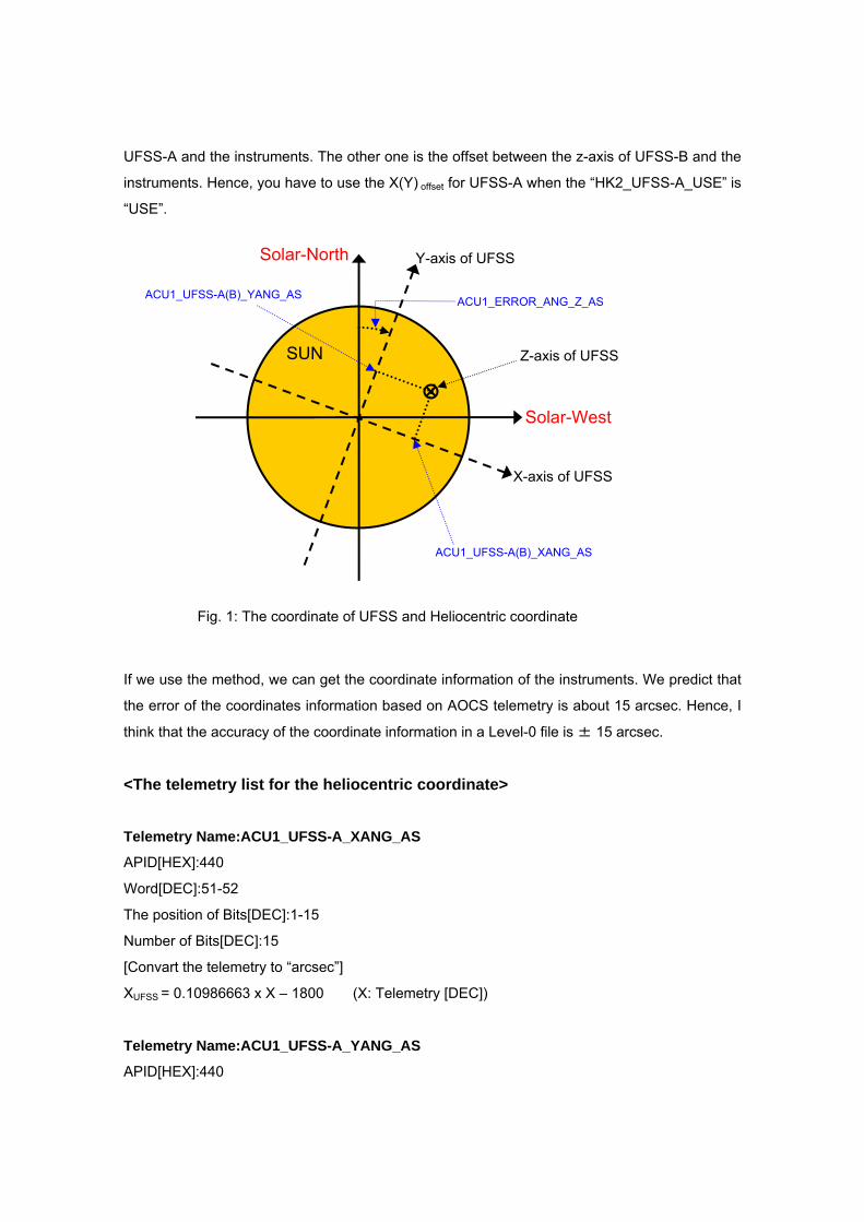
UFSS-A and the instruments. The other one is the offset between the z-axis of UFSS-B and the
instruments. Hence, you have to use the X(Y) offset for UFSS-A when the “HK2_UFSS-A_USE” is
“USE”.
SUN
Solar-North Y-axis of UFSS
If we use the method, we can get the coordinate information of the instruments. We predict that
the error of the coordinates information based on AOCS telemetry is about 15 arcsec. Hence, I
think that the accuracy of the coordinate information in a Level-0 file is ± 15 arcsec.
<The telemetry list for the heliocentric coordinate>
Telemetry Name:ACU1_UFSS-A_XANG_AS
APID[HEX]:440
Word[DEC]:51-52
The position of Bits[DEC]:1-15
Number of Bits[DEC]:15
[Convart the telemetry to “arcsec”]
XUFSS = 0.10986663 x X – 1800 (X: Telemetry [DEC])
Telemetry Name:ACU1_UFSS-A_YANG_AS
APID[HEX]:440
X-axis of UFSS
Solar-West
Z-axis of UFSS
ACU1_UFSS-A(B)_XANG_AS
ACU1_UFSS-A(B)_YANG_AS ACU1_ERROR_ANG_Z_AS
Fig. 1: The coordinate of UFSS and Heliocentric coordinate

Word[DEC]:53-54
The position of Bits[DEC]:1-15
Number of Bits[DEC]:15
[Convart the telemetry to “arcsec”]
YUFSS = 0.10986663 x X – 1800 (X: Telemetry [DEC])
Telemetry Name:ACU1_UFSS-B_XANG_AS
APID[HEX]:440
Word[DEC]:55-56
The position of Bits[DEC]: 1-15
Number of Bits[DEC]:15
[Convart the telemetry to “arcsec”]
XUFSS = 0.10986663 x X – 1800 (X: Telemetry [DEC])
Telemetry Name:ACU1_UFSS-B_YANG_AS
APID[HEX]:440
Word[DEC]:57-58
The position of Bits[DEC]:1-15
Number of Bits[DEC]:15
[Convart the telemetry to “arcsec”]
YUFSS = 0.10986663 x X – 1800 (X: Telemetry [DEC])
Telemetry Name:ACU1_ERROR_ANG_Z_AS
APID[HEX]:440
Word[DEC]:219-221,
Number of Bits[DEC]:24
[Convart the telemetry to “arcsec”]
θz = 648000/223 x X (X: Telemetry [DEC])
Telemetry Name:HK2_UFSS-A_USE
APID[HEX]:440
Word[DEC]:221
The position of Bits[DEC]:4
Number of Bits[DEC]:1
X=0: NO_USE, X=1:USE (X: Telemetry [DEC])

Telemetry Name:HK2_UFSS-B_USE
APID[HEX]:440
Word[DEC]:221
The position of Bits[DEC]:5
Number of Bits[DEC]:1
X=0: NO_USE, X=1:USE (X: Telemetry [DEC])
5. Information of the observation plan
Note:
All values of the keywords in the part are inputted to the operational database (TBD) of each
instrument by the chief observer using planning tool. The reformat software has the interface
with the database, and gets the data for the keywords from the database.
Header Keyword : OBSTITLE
Format : String
Unit/Option : Free style (one sentence)
Category : SOLAR-B
Data Source : Chief observer or Proposer of the observation
Sample : The temperature analysis of pre-flare site
Description : Title of the observation
Note : The value is decide by the proposer of the observation or at the
daily operation meeting. Chief observer input the value to the
planning tool based on the decision.
Header Keyword : TARGET
Format : String
Unit/Option : Active Region, Quiet Region, Coronal Hole, Flare Site
Category : SOLAR-B
Data Source : Chief observer or Proposer of the observation
Sample : Active Region
Description : Indicate the observation region, not the target phenomenon of
observation.
Note : 1. The value is decide by the proposer of the observation or at the
daily operation meeting. Chief observer input the value to the
planning tool based on the decision.
2. “Flare Site” only used when the instruments are in FLARE mode
that is triggered by the XRT-FLD function. If the instruments
observes a flare in the normal mode, “Flare Site” is not used.
Header Keyword : SCI_OBJ
Format : String
Unit/Option : (see List 1.)
Category : SOLAR-B
Data Source : Chief observer or Proposer of the observation
Sample : AR, AFS, EFL, FL
Description : Indicate the target phenomena (scientific objects) of the
observation. The value is selected from the possible objects and
we can input 5 objects from List 1.
Note : The value is decide by the proposer of the observation or at the
daily operation meeting. Chief observer input the value to the
planning tool based on the decision.
Header Keyword : OBS_DEC
Format : String
Unit/Option : A few sentences. (Free style)
Category : SOLAR-B
Data Source : Chief observer or Proposer of the observation
Sample : Filters and time resolution are optimized for Temperature Analysis.
Description : Describe the properties of the observation
Note : The value is decide by the proposer of the observation or at the
daily operation meeting. Chief observer input the value to the
planning tool based on the decision.
Header Keyword : JOIN_SB
Format : String
Unit/Option : ESX, ES, SX, EX, E, S, X
Category : SOLAR-B
Data Source : Chief observer or Proposer of the observation
Sample : ESX
Description : Indicate the joint observation of the instruments on board
SOLAR-B. If all instruments join the observation, the value is
“ESX”, If SOT and EIS join the observation, the value is “ES”. If
the observation uses only XRT, the value is “X”.
Note : 1. The value is decide by the proposer of the observation or at the
daily operation meeting. Chief observer input the value to the
planning tool based on the decision.
2. The value indicates the planned joint observation. Hence, if the
observed region of EIS is the same as that of SOT incidentally,
the value is not “ES”
Header Keyword : OBS_NUM
Format : Integer
Unit/Option : -
Category : SOLAR-B
Data Source : SOLAR-B Science Coordinator
Sample : 100
Description : All observations using SOLAR-B are numbered by the Solar-B
Science Coordinator, sequentially. The value of “OBS_NUM” is the
number.
Note : The value is decide at the monthly/weekly operation meeting.
Chief observer input the value to the planning tool based on the
decision.
Header Keyword : JOP_ID
Format : Integer
Unit/Option : -
Category : SOLAR-B
Data Source : SOLAR-B Science Coordinator
Sample : 200
Description : The joint observations between SOLAR-B and the other
instruments (ground-base and satellites) are numbered by the
Solar-B Science Coordinator. The value of “JOP_ID” is the
number.
Note : The value is decide at the monthly/weekly operation meeting.
Chief observer input the value to the planning tool based on the
decision.
Header Keyword : NOAA_NUM
Format : Integer
Unit/Option : -
Category : SOLAR-B
Data Source : Chief observer or Proposer of the observation
Sample : 11345
Description : The NOAA number of the active region.
Note : If the target region does not have NOAA number, the value is “-1”.
Header Keyword : OBSERVER
Format : String
Unit/Option : LAST First, M.
Category : SOLAR-B
Data Source : Chief Observer
Sample : SHIMOJO Masumi
Description : Name of the Chief Observer
Note : Chief observer input the value to the planning tool.
Header Keyword : PLANNER
Format : String
Unit/Option : LAST First, M.
Category : SOLAR-B
Data Source : Chief Planner
Sample : MURPHY Edward, A.
Description : Name of the Chief Planner
Note : Chief observer input the value to the planning tool.
Header Keyword : TOHBANS
Format : String
Unit/Option : LAST First, M. & LAST First M.
Category : SOLAR-B
Data Source : Real-Time (RT) TOHBANs
Sample : NANASHINO Gonbei, HENOHENO Moheji

Description : Name of the RT Tohbans
Note : Chief observer input the value to the planning tool.
6. Information of the data quality
Header Keyword : DATATYPE
Format : String
Unit/Option : SCI, ENG
Category : SOLAR-B
Data Source : Chief Observer
Sample : ENG
Description : Indicates the data for the science or for the engineering test.
Header Keyword : BITCOMPn
Format : Integaer
Unit/Option : 0-7
0: No Bit Compression
1: 16 bits unsigned to 12 bits
2: 14 bits unsigned to 12 bits
3: 16 bits signed to 12 bits
4: 14.5 bits signed to 12 bits
5: 13 bits signed to 12 bits
6: 12 bits unsigned to 12 bits
7: 14 bits unsigned to 12 bits
Category : SOLAR-B
Data Source : Telemetry (Image Header Packet, Word 48 Start bit: 1, End bit: 4)
Sample : 0 Description : Indicate that the mode of Bit compression.
Note : “n” is integer. XRT and EIS uses BITCOMP1 (n=1 only). SOT
sometime uses BITCOMP1, BITCOMP2….(n=1,2, …n)
Header Keyword : IMGCOMPn
Format : Integaer

Unit/Option : 0-7
Category : SOLAR-B
Data Source : Telemetry (Image Header Packet, Word 48 Start bit: 5, End bit: 7)
Sample : 3 0: No Image Compression
3: DPCM Compression (lossless compression)
7: DCT Compression (lossy compression):
Description : Indicate that the mode of Image compression.
Note : “n” is integer. XRT and EIS uses IMGCOMP1 (n=1 only). SOT
sometime uses IMGCOMP1, IMGCOMP2….(n=1,2,…n)
Header Keyword : BITC_VER
Format : Integer
Unit/Option :
Category : SOLAR-B
Data Source : Telemetry (Image Header Packet, Word 10 and 11:2 bytes)
Sample : 1
Description : The serial number of the bit-compression table.
Note : One SOT/FG file includes some images. And the serial numbers of
compression tables for each image sometimes are different.
Hence, SOT/FG uses “***VERn” instead of “***_VER”.
“n” is integer that indicates the image number in a SOT/FG file.
Header Keyword : DCHF_VER
Format : Integer
Unit/Option :
Category : SOLAR-B
Data Source : Telemetry (Image Header Packet, Word 12 and 13:2 bytes)
Sample : 1
Description : The serial number of the Huffman–DC table for JPEG comp.
Note : One SOT/FG file includes some images. And the serial numbers of
compression tables for each image sometimes are different.
Hence, SOT/FG uses “***VERn” instead of “***_VER”.
“n” is integer that indicates the image number in a SOT/FG file.
Header Keyword : ACHF_VER

Format : Integer
Unit/Option :
Category : SOLAR-B
Data Source : Telemetry (Image Header Packet, Word 14 and 15:2 bytes)
Sample : 1
Description : The serial number of the Huffman–AC table for JPEG comp.
Note : One SOT/FG file includes some images. And the serial numbers of
compression tables for each image sometimes are different.
Hence, SOT/FG uses “***VERn” instead of “***_VER”.
“n” is integer that indicates the image number in a SOT/FG file.
Header Keyword : QTAB_VER
Format : Integer
Unit/Option :
Category : SOLAR-B
Data Source : Telemetry (Image Header Packet, Word 16 and 17:2 bytes)
Sample : 1
Description : The serial number of the Q table for JPEG comp.
Note : One SOT/FG file includes some images. And the serial numbers of
compression tables for each image sometimes are different.
Hence, SOT/FG uses “***VERn” instead of “***_VER”.
“n” is integer that indicates the image number in a SOT/FG file.
Header Keyword : SAA
Format : String
Unit/Option : IN / OUT
Category : SOLAR-B
Data Source : ISACS-PLN: The SOE (Sequence of Events) file for SAA
Sample : OUT
Description : Indicate that the satellite in SAA or not.
Note : At the observation planning, the chief planner calculates the
environments (DAY/NIGHT, SAA, HLZ) of the satellite and puts the
results to ISACS-PLN and the SOLAR-B database. The value of
the keyword is made from the result of the calculation.
Header Keyword : HLZ

Format : String
Unit/Option : IN / OUT
Category : SOLAR-B
Data Source : ISACS-PLN: The SOE (Sequence of Events) file for HLZ
Sample : OUT
Description : Indicate that the satellite in HLZ or not.
Note : At the observation planning, the chief planner calculates the
environments (DAY/NIGHT, SAA, HLZ) of the satellite and puts the
results to ISACS-PLN and the SOLAR-B database. The value of
the keyword is made from the result of the calculation.
Header Keyword : FLFLG
Format : String
Unit/Option : FLR / NON
Category : SOLAR-B
Data Source : Telemetry (Image data)
Sample : NON
Description : Indicate that the instrument operated on FLARE mode triggered by
XRT-FLD function, or not.
Note : In the other words, the instrument used the FLARE observing table
or not. Hence, if the instrument observed a flare using the normal
observing table, the value is “NON”.
7. Information of the reformat and etc.
Header Keyword : DATE
Format : String
Unit/Option : UTC / YYYY-MM-DDThh:mm:ss.sss
Category : FITS
Data Source : Reformatter
Sample : 2005-12-02T13:10:11.100
Description : Indicates when the file was made.
Note : The value is rewritten by Level-1, Level-2 Reformatter and the
software for data analysis.
Header Keyword : ORIGIN
Format : String
Unit/Option : JAXA/ISAS, NAOJ, MSSL, LMSAL, GSFC....
Category : FITS
Data Source : Reformatter
Sample : JAXA/ISAS
Description : Indicates where the files was made.
Note : The value is rewritten by Level-1, Level-2 Reformatter and the
software for data analysis. The keyword of the Level-0 is
“JAXA/ISAS” since Level-0 reformat is done at JAXA/ISAS,
basically.
Header Keyword : DATA_LEV
Format : Float
Unit/Option : 0, 1, 2
Category : FITS
Data Source : Reformatter
Sample : 0
Description : The level of Data.
Header Keyword : DATE_RF0
Format : String
Unit/Option : UTC / YYYY-MM-DDThh:mm:ss.sss
Category : SOLAR-B
Data Source : Reformatter
Sample : 2005-12-02T13:10:11.100
Description : Indicates when the level-0 reformat was done.
Note : The value of the keyword is the same as that of “DATE” in a
Level-0 file.
Header Keyword : ORIG_RF0
Format : String
Unit/Option : JAXA/ISAS, NAOJ, MSSL, LMSAL, GSFC....
Category : SOLAR-B

Data Source : Reformatter
Sample : JAXA/ISAS
Description : Indicates where the Level-0 reformat was done.
Note : The value of the keyword is the same as that of “ORIGIN” in a
Level-0 file.
Header Keyword : VER_RF0
Format : String
Unit/Option : -
Category : SOLAR-B
Data Source : Reformatter
Sample : SOT_Lev0_Reformatter Ver. 1.0b
Description : The version of the level-0 reformat program.
Header Keyword : DATE_RF1
Format : String
Unit/Option : UTC / YYYY-MM-DDThh:mm:ss.sss
Category : SOLAR-B
Data Source : Reformatter
Sample : 2005-12-02T13:10:11.100
Description : Indicate when the level-1 reformat was done.
Note : The keyword is reserved for Level-1 data file
Header Keyword : ORIG_RF1
Format : String
Unit/Option : JAXA/ISAS, NAOJ, MSSL, LMSAL, GSFC....
Category : SOLAR-B
Data Source : Reformatter
Sample : JAXA/ISAS
Description : Indicates where the Level-1 reformat was done.
Note : The keyword is reserved for Level-1 data file
Header Keyword : VER_RF1
Format : String
Unit/Option : -
Category : SOLAR-B

Data Source : Reformatter
Sample : SOT_Lev1_Reformatter Ver. 2.3c
Description : The version of the level-1 reformat program.
Note : The keyword is reserved for Level-1 data file

List 1: The list of possible objects for “SCI_OBJ” Keyword (The list is made based on IPA “OBJECT” keyword for SOHO.)
AFS :arch filament system
ANE :anemone
AR :active region
ARC :arcade
BP :bright point
CR :coronal rain
CH :coronal hole
COR :corona
CHR :chromosphere
CS :coronal streamer
CT :coronal transient
CUS :cusp
DB :disparation brusque
DC :disk center
DFL :disappearing filament
DFX :disapppearing flux
DF :downflow
DSS : delta sunspot
ECL :eclipse
EFR :emerging flux region
EPR :eruptive prominence
EFI :erupting filament
EMB :Ellerman bomb
EVA :evaporation
EVF :Evershed flow
FAC :faculae
FC :filament channel
FLC :flux cancellation
FIL :filament
FLR :flare
FP :footpoint
FS :full sun
FT :flux tube

FL :flow
GR :granulation
JET :jet
LB :loop brightening
LE :loop evacuation
LMB :solar limb
LO :loop
LOO : loop oscillations
CME :coronal mass ejection
MBP : magnetic bright points
MFL :microflare
MS :magnetic shear
MT :Mercury transit
MW :Moreton wave
MMF :moving magnetic features
NET :network
NFL :nanoflare
NL :neutral line
PC :polar crown
PCH :polar coronal hole
PEN :sunspot penumbra
PFL :postflare loops
PHO :photosphere
PLG :plage
POR :pore
PP :polar plume
PR :prominence
QS :quiet sun
RIB :two-ribbon flare
SPR :spray
SG :supergranulation
SPI :spicule
SR :surge
SS :sunspot
SSM : sunspot moat
SW :solar wind
SYN :synoptic observation
SEI : Seismology
TR :transition region
UF :upflow
UMB :sunspot umbra
UMD :umbral dots
VT :Venus transit
WAV :wave
WLF :white light flare
XBP : X-ray Bright Point
Change Log Legend: <A>: Add / <C>: Change / <D>: Delete
Ver. 0.6 : by Masumi Shimojo
• Keyword: TIMESYS
<C>Unit/Option: UT, UTC, TAI, and etc. → UTC
• Keyword: DATE-OBS
<C>Header Keyword: DATE-OBS → DATE_OBS
• Keyword: OBT-TIME
<C>Header Keyword: OBT-TIME → OBT_TIME
• Keyword: DATE-END
<C>Header Keyword: DATE-END → DATE_END
• Keyword: OBT-END
<C>Header Keyword: OBT-END → OBT_END
• Keyword : SCI_OBS
<C>Header Keyword: SCI_OBS → SCI_OBJ
• Keyword : OBS_ID
<C>Header Keyword: OBS_ID → OBS_NUM
<C>Description: The value of “OBS_ID” is the number.
→ The value of “OBS_NUM” is the number.
<D>Note: 2. The keyword name conflicts with a SOT keyword for “Observable ID”.
• Keyword: JOP_ID
<C> Data Source: SOHO Science Working Group? →SOLAR-B Science Coordinator
<A> Description: The joint observations between SOLAR-B and the other instruments (ground-base and
satellites) are numbered by the Solar-B Science Coordinator. The value of “JOP_ID” is the number.
<C> Note: The keyword is proposed by EIS team. I (Shimojo) can not identify who decide the JOP ID for an
observation. SOHO/SWG? SOLAR-B/SSC? Please teach me the system of JOP numbering.
→ The value is decide at the monthly/weekly operation meeting. Chief observer input the value to the
planning tool based on the decision.
• Keyword: TOHBANS
<C> Data Source : KSC TOHBANs → Real-Time (RT) TOHBANs
<C> Description: Name of the KSC Tohbans →Name of the RT Tohbans
• Keyword: DATATYPE
<D> Note: The keyword is used to divide the scientific data from engineering data (ex. Dark image, Flat
image, etc...). However, there is not any indicator for the purpose in the image header, now. Hence, we
propose that some serial version numbers of PROGRAM, SEQUENCE and PARAMETER in the
observation table are reserved for the engineering observation, and we use the serial number for dividing
the engineering data.
• Keyword: BITC_VER
<C> Data Source : Telemetry (Image Header Packet, Word 10 and 11:4bits)
→Telemetry (Image Header Packet, Word 10 and 11:2bytes)
• Keyword: DCHF_VER
<C> Data Source : Telemetry (Image Header Packet, Word 12 and 13:2bits)
→Telemetry (Image Header Packet, Word 12 and 13:2bytes)
• Keyword: ACHF_VER
<C> Data Source : Telemetry (Image Header Packet, Word 14 and 15:2bits)
→Telemetry (Image Header Packet, Word 14 and 15:2bytes)
• Keyword: QTAB_VER
<C> Data Source : Telemetry (Image Header Packet, Word 16 and 17:3bits)
→Telemetry (Image Header Packet, Word 16 and 17:2bytes)
• <A> keyword: NOAA_NUM
[Delete the following sentence from the title page.]
Caution:
This is the draft of the list of SOLAR-B Mission-Wide FITS Keywords. In the list, there are some conflicts with
the FITS keywords of each instrument. The conflicts will be discussed in SOLAR-B MODA Working Group.
[Change at “Note: Telemetry of AOCS data”]
SOLAR-B loads two UFSSs (UFSS-A and UFSS-B) for redundancy. In nominal case, the data of UFSS-A is similar to
that of UFSS-B. However, you have to use the data of the UFSS that the telemetry “HK2_UFSS-?_USE” is “USE”. When
the “HK2_UFSS-?_USE is “NO_USE”, there is possibility that the UFSS is broken.
↓
SOLAR-B loads two UFSSs (UFSS-A and UFSS-B) for redundancy. If you calculate the coordinate from UFSS data, you
use the coordinate data of the UFSS whose telemetry “HK2_UFSS-A(B)_USE” is “USE”. The telemetry
“HK2_UFSS-A(B)_USE” indicates which of the UFSSs is used by the AOCS system and guarantees that the UFSS-A(B)
operates in normal.
Although the UFSS is not broken, the data of ACU1_UFSS-A_X(Y)ANG_AS is not the same as that of
ACU1_UFSS-B_X(Y)ANG_AS, because there is misalignment between the z-axis of UFSS-A and UFSS-B. Hence, X(Y)
offset has two values. One is the offset between the z-axis of UFSS-A and the instruments. The other one is the offset
between the z-axis of UFSS-B and the instruments. Hence, you have to use the X(Y) offset for UFSS-A when the
“HK2_UFSS-A_USE” is “USE”.
Ver. 0.7 : by Masumi Shimojo
• <A> keyword: COMPMOD
• Keyword: INSTRUME
<C> Unit/Option: EIS, XRT, SOT/WB, SOT/NB, SOT/SP SOT/CT
→ Unit/Option: EIS, XRT, SOT/FG, SOT/SP SOT/CT
Ver. 0.8 : by Masumi Shimojo
[List 1: The list of possible objects for “SCI_OBJ” Keyword]
• <D> FGL “filigree”
• <A> MBP “magnetic bright points”
Ver. 0.9 : by Masumi Shimojo
• <D> keyword: COMPMOD
• <A> Keyword: BITCOMPn
• <A> Keyword: IMGCOMPn
• Keyword: NOAA_NUM
<A> Note : If the target region does not have NOAA number, the value is “-1”.
• Keyword: BITC_VER, DCHF_VER, ACHF_VER, QTAB_VER
<A> Note: One SOT/FG file includes some images. And the serial numbers of compression tables for each
image sometimes are different. Hence, SOT/FG uses “***VERn” instead of “***_VER”. “n” is integer that
indicates the image number in a SOT/FG file.