the late roman military baths of the wadi arabah: a survey
TRANSCRIPT
SyriaArchéologie, art et histoire
92 | 2015Dossier : Bains de Jordanie, actualité des étudesthermales
The Late Roman military baths of the WadiArabah: a survey of recent archaeological work
Robert Darby
Electronic versionURL: http://journals.openedition.org/syria/3194DOI: 10.4000/syria.3194ISSN: 2076-8435
PublisherIFPO - Institut français du Proche-Orient
Printed versionDate of publication: 1 June 2015Number of pages: 67-83ISBN: 9782351597149ISSN: 0039-7946
Electronic referenceRobert Darby, « The Late Roman military baths of the Wadi Arabah: a survey of recent archaeologicalwork », Syria [Online], 92 | 2015, Online since 01 June 2017, connection on 19 April 2019. URL : http://journals.openedition.org/syria/3194 ; DOI : 10.4000/syria.3194
© Presses IFPO

Résumé – Les recherches archéologiques entreprises depuis une vingtaine d’années sur les sites militaires
romains du Wadi Arabah ont mis au jour un corpus de bains qui partagent une même architecture régionale.
Construits à la fin du III e s. - début du IV e s. apr. J.-C. lors d’une période de reprise économique et de redynamisation
du commerce régional, ces petits bains militaires romains apportent beaucoup à notre compréhension du contexte
socio-économique et historique de l’ Arabia/Palaestina à la fin de l’Antiquité. L’article passe en revue les récents
travaux sur les bains militaires romains du Wadi Arabah et offre de nouvelles analyses en termes de planification
urbaine et architecturale.
Mots-clés – Bains, époque romaine tardive, militaire, Arabia Palaestina , Wadi Arabah, caravansérail, ʿAïn
Hosob, Bir Madhkour, ʿAïn Gharandal, ʿAïn Ghadian
Abstract – Archaeological investigation over the past two decades at several Late Roman military sites in
the Wadi Arabah has revealed a corpus of bathhouses that share a geographically distinct architectural design.
Constructed in the late 3rd – early 4th cent. CE during a short-lived period of economic resurgence and revitalization
of regional trade, these small Roman military baths can add much to our understanding of the broader socio-
economic and historical contexts of Arabia/Palaestina in Late Antiquity. This paper reviews recent work on the
Late Roman military baths of the Wadi Arabah and offers new analyses regarding their placement and architectural
planning.
Keywords – Baths, Roman, military, Arabia Palaestina , Wadi Arabah, caravanserai, ʿAyn Hosob, Bir Madhkur,
ʿAyn Gharandal, ʿAyn Ghadian
ر الروماني صْ واقع عَسكرية تعود للعَ ـدة مَ ـديـن الماضيين في عِ قْ كتشافات الأَثـريّة وعلى مَدى العَ ص – أظهرت ا ملخّيّدت ـماري، والتي شُ غرافية والتّصميم المِعْ ترك في المنطقة ا امات التي تَشْ مّ ـربه على عـَدد مِن ا المُتَأخـر في منطقة وادي عَقتصادي والتجارة الإقليمية النّشطة زْدهار ا ل الفترة القصيرة من ا دي خِ ر القرن الثالث وبداية القرن الرابع المي َواخِ في أياقات السّ ـوْل حَ المَعلومات مِن الكثير لنا تضيف أن غيرة الصَ الرومانيّة كرية سْ العَ امات مّ ا لهذه ن ْكِ يمُ و المنطقة. في على الضوء الــوَرقة هذه وستلقي القديمة. الفترات في فلسطين – العربية ية للو اريخية والتّ قتصادية وا جتماعية ايتعلق فيما ً جديدا ً تحْلي لنا م قـدّ وتُـ ـربة عَ وادي منطقة في الرّومانية كريّة سْ العَ امات مّ با ً ؤخرا مُ ريت أُجَ التي مال الأعْ
بموقعها وتَخْطيطها وطرازها المِعْماري.
ب، ينْ حوسَ ـربة، عَ قاطعة فلسطين الثالثة، وادي عَ كري، المُقاطعة العربية، مُ امات، الرّومان، عـسْ كلمات محورية – حمّبيـر مَذْكور، عَينْ غَـرَنْـدل، عَينْ غَـدْيان
THE LATE ROMAN MILITARY BATHS OF THE WADI ARABAH:
A SURVEY OF RECENT ARCHAEOLOGICAL WORK
Robert DARBY University of Tennessee
Syria 92 (2015), p. 67 à 83
68 Syria 92 (2015)R. DARBY
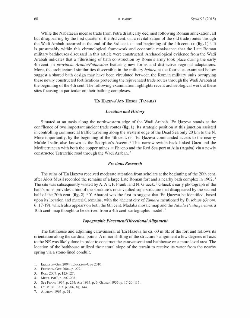
While the Nabataean incense trade from Petra drastically declined following Roman annexation, all
but disappearing by the first quarter of the 3 rd cent. CE , a revitalization of the old trade routes through
the Wadi Arabah occurred at the end of the 3 rd cent. CE and beginning of the 4 th cent. CE ( fig. 1 ) 1. It
is presumably within this chronological framework and economic renaissance that the Late Roman
military bathhouses discussed in this article were constructed. Archaeological evidence from the Wadi
Arabah indicates that a flourishing of bath construction by Rome’s army took place during the early
4 th cent. in provincia Arabia/Palaestina featuring new forms and distinctive regional adaptations.
More, the architectural similarities discernible in the military balnea at the four sites examined below
suggest a shared bath design may have been circulated between the Roman military units occupying
these newly constructed fortifications protecting the rejuvenated trade routes through the Wadi Arabah at
the beginning of the 4 th cent. The following examination highlights recent archaeological work at these
sites focusing in particular on their bathing complexes.
ʿEN ḤAẒEVA/ʿAYN HOSOB (TAMARA)
Location and History
Situated at an oasis along the northwestern edge of the Wadi Arabah, ʿEn Ḥaẓeva stands at the
confluence of two important ancient trade routes (fig. 1). Its strategic position at this junction assisted
in controlling commercial traffic traveling along the western edge of the Dead Sea only 20 km to the N.
More importantly, by the beginning of the 4 th cent. CE, ʿEn Ḥaẓeva commanded access to the nearby
Maʿale Tsafir, also known as the Scorpion’s Ascent. 2 This narrow switch-back linked Gaza and the
Mediterranean with both the copper mines at Phaeno and the Red Sea port at Aila (Aqaba) via a newly
constructed Tetrarchic road through the Wadi Arabah. 3
Previous Research
The ruins of ʿEn Ḥaẓeva received moderate attention from scholars at the beginning of the 20th cent.
after Alois Musil recorded the remains of a large Late Roman fort and a nearby bath complex in 1902. 4
The site was subsequently visited by A. Alt, F. Frank, and N. Glueck. 5 Glueck’s early photograph of the
bath’s ruins provides a hint of the structure’s once vaulted superstructure that disappeared by the second
half of the 20 th cent. ( fig. 2 ). 6 Y. Aharoni was the first to suggest that ʿEn Ḥaẓeva be identified, based
upon its location and material remains, with the ancient city of Tamara mentioned by Eusebius ( Onom.
6. 17-19), which also appears on both the 6 th cent. Madaba mosaic map and the Tabula Peutingeriana, a
10 th cent. map thought to be derived from a 4 th cent. cartographic model . 7
Topographic Placement/Directional Alignment
The bathhouse and adjoining caravanserai at ʿEn Ḥaẓeva lie ca. 60 m SE of the fort and follows its
orientation along the cardinal points. A minor shifting of the structure’s alignment a few degrees off axis
to the NE was likely done in order to construct the caravanserai and bathhouse on a more level area. The
location of the bathhouse utilized the natural slope of the terrain to receive its water from the nearby
spring via a stone-lined conduit.
1. ERICKSON-GINI 2004 ; ERICKSON-GINI 2010.
2. E RICKSON-GINI 2004, p. 272.
3. ROLL 2007, p. 125-127.
4. MUSIL 1907, p. 207-208.
5. See FRANK 1934, p. 254; ALT 1935, p. 6; GLUECK 1935, p. 17-20, 115.
6. Cf. MUSIL 1907, p. 206, fig. 144.
7. AHARONI 1963, p. 31.
Syria 92 (2015) 69THE LATE ROMAN MILITARY BATHS OF THE WADI ARABAH
Figure 1. Map of Wadi Arabah showing Late Roman military sites with bathhouses highlighted in black
(after ROLL 2007).

70 Syria 92 (2015)R. DARBY
Architectural Plan
The bathhouse at ʿEn Ḥaẓeva was comprised of seven
rooms set around a paved courtyard/ apodyterium , a piscina
or cold-plunge bath, a latrina with urinal, a latrina featuring
stone bench toilet seats, frigidarium , two adjoining heated
rooms, the tepidarium and caldarium , and a praefurnium
enclosure or furnace room ( fig. 3 ). The plan of the bathhouse
conforms generally to both the “angular row” and the so-
called “southern” type featuring both an off-set frigidarium
and a paved, entry court. 8
The bathhouse, like the castellum , experienced two
primary phases of use before and after the earthquake of
May 19 th , 363 CE , which likely caused significant damage to
parts of the bath as it did to the other buildings at the site and
towns in the region. 9 While the fort and caravanserai were
almost entirely demolished by the earthquake, the extent of
the damage to the bath is less clear. However, repairs to its
superstructure were observed by the excavators. 10 Despite
this evidence, the damage suffered by the bathhouse may have
been substantially less than that of the neighbouring structures
8. For the angular-row type see NIELSEN 1993 II, p. 51, fig. 1; For the so-called “southern-type” in Palaestina see GICHON
1978; Also HOSS 2005.
9. ERICKSON-GINI 2007, p. 274.
10. ERICKSON-GINI 2007, p. 273.
Figure 2. Photo showing the no longer extant ruins of the Late Roman military bathhouse at ʿEn Ḥaẓeva
(after GLUECK 1935, 19, fig. 7).
Figure 3. Plan of the bathhouse at ʿEn
Ḥaẓeva (after COHEN & ISRAEL 1996).

Syria 92 (2015) 71THE LATE ROMAN MILITARY BATHS OF THE WADI ARABAH
due to the advanced construction techniques and materials used in its construction. 11 It does not appear
that substantial alterations were made to the plan of the bath in the period immediately following the
earthquake in 363 CE . Rather, the integrity of the primary bathing block and subsidiary rooms was largely
maintained. There is some evidence, however, suggesting that the courtyard/ apodyterium underwent
minor reconfigurations, perhaps the result of its roof collapsing, but this remains speculative.
In its initial configuration, the bathhouse was entered from the adjoining caravanserai via a central
doorway in the NW wall opening onto a large square paved courtyard containing a small square pool
at its center. In a later reconfiguration the courtyard was partitioned into a space approximately half its
original size by the insertion of two walls which form the bathing suites. A low bench ran the length of the
NW partition wall above which was a row of rectangular niches built into the wall that served as storage
cubicles for patrons’ clothing indicating use of the room as an apodyterium (fig. 4) . 12 It is possible
that NE partition wall also featured a bench and lockers. In this later phase, the courtyard/ apodyterium
featured four stone piers at its center which probably supported a roof to provide shade from the sun’s
intense rays. However, it is possible that they were not architectural features at all, but instead decorative
in nature.
The courtyard /apodyterium also featured a large, rectangular piscina or cold plunge bath on its
southwestern side. The piscina was raised slightly higher than the paved courtyard and accessed by a
stone step. It was further lined with a stone bench for immersion in the bath. The deep, plastered tub
received its water directly from a large settling basin located on the bathhouse’s W exterior. In situ
voussoirs suggest it may have been partially roofed by a vault.
11. See SHERESHEVSKI 1991, who notes that, in the Negev baths, with their use of concrete, were the most highly advanced
architectural forms built during the Late Roman and Byzantine periods.
12. See De VRIES & LAIN 2006, p. 214, fig. 7.1, pl. 7.1; The presence of storage niches and benches in the courtyard area
compares well to those found in the legionary bathhouse at Lejjun.
Figure 4. View of the courtyard/ apodyterium with bench and storage lockers © R. Darby.
72 Syria 92 (2015)R. DARBY
Adjacent to the piscina on the S were two rooms that served as the latrinae of the bathhouse. The
latrinae were accessed from the apodyterium /courtyard by a doorway in the SW corner. This doorway
first entered a small, square room with an open channel for the waste water of the neighboring plunge
bath running along its SE wall. A secondary drain, presumably from the courtyard pool, bi-sects the
room and empties into the primary channel. 13 The open water channel suggests that the room might have
served as a urinal since the adjoining room to the S assuredly served a similar purpose.
One entered the second latrina , a small rectangular room, from the first latrina by a doorway in the
S wall. 14 A continuation of the water-channel from room lined the SE and SW walls forming an “L”
shaped latrine with a bench of stone toilet seats of which three remain.
From the courtyard/ apodyterium one entered the main bathing block through a doorway in the
SE corner opening into the frigidarium . This room was not directly connected to the hypocaust, and,
as such, was only heated by excess thermal transfer through a doorway in its northeast wall adjoining
the tepidarium . In fact, the location of the jambs in the two doorways indicates that both doors swung
inward. It was, therefore, possible to control the temperature of the frigidarium by closing or opening the
doors connecting it to both the courtyard/ apodyterium outside and the tepidarium . There is no evidence
that the frigidarium itself contained a bath suggesting that it was likely served by the nearby piscina or
a labrum .
The tepidarium was entered from the SW by the door exiting the frigidarium . The floor of the
tepidarium was paved with rectangular flagstones set in opus signinum that covered the hypocaust below.
Portions of flagstone floor and its opus signinum matrix remain in situ along the edges of the room.
Based on the fact that it contained neither alcoves for tubs, nor any connection to the hydraulic system
of the bathhouse, the tepidarium likely functioned much like a sudatorium or sauna. The remains of a
possible bench along its NW and NE walls would seem to support this interpretation. The tepidarium
was connected to the caldarium via a doorway in the SE wall which, like those in the frigidarium ,
contained a jamb that would have allowed for the opening and closing of the door between the two
rooms to control heat distribution.
The caldarium itself consisted of a central square room (ca. 3.44 x 3.44 m) and two rectangular
alcoves (ca. 2.5 x 1.87 m) containing alvea or hot plunge baths. The SE alveus was built directly over
the main praefurnium channel, while the SW alveus sat over an extension of the hypocaust system
specifically constructed to heat its bath. Inaccessible from the caldarium was the praefurnium enclosure
that stands just outside its SE wall.
The praefurnium enclosure could only be accessed from outside the bath complex proper as it
controlled direct access to the praefurnium and the hypocaust system. An entryway near the S corner of
the structure permitted entry inside the small service room. The surrounding enclosure walls protected
the praefurnium from wind. It is, however, unlikely that the room was roofed given the presence of the
furnace. The thick NW wall of the enclosure abutting the SE exterior wall of the caldarium contained
the praefurnium itself.
While the praefurnium enclosure was, as noted, probably left unroofed, evidence indicates that
the caldarium , tepidarium , and possibly, the frigidarium , were either barrel vaulted or domed using
a combination of finely cut ashlar voissoirs and opus caementicium . How the remaining rooms of the
bathhouse were roofed is less certain.
13. The excavators interpreted an opening in the SW wall of the latrina as a door. This cannot have been the case as it would
have been blocked by the raised aqueduct along the exterior face of the SW wall. The reason for the lacuna on this portion
of the wall might more plausibly be related to the location of a window providing ventilation and light for the latrina .
14. Cf. HOSS 2005, p. 147, who places the entrance to the latrina via the frigidarium .

Syria 92 (2015) 73THE LATE ROMAN MILITARY BATHS OF THE WADI ARABAH
BIR MADHKUR (MOA?)
Location and History
The site of Bir Madhkur is situated among the barren desert foothills of the Edomite Mountains
on the eastern edge of the Wadi Arabah roughly at the midway point between the Dead Sea and the
Gulf of Aqaba ( fig. 1 ). Of utmost importance in regards to the site’s location is Bir Madhkur’s close
proximity (ca. 10 km SE) to the metropolis of Petra. Its commanding position helped control mercantile
access along an important E-W trade route across the Wadi Arabah, but there is little doubt that it also
monitored caravan traffic traversing N-S along the valley as well. The modern Arabic name for the site
denotes the presence of a well ( bir ) indicating the important water resources that the site also contains.
Numerous deep-water wells and a nearby spring supply the otherwise arid site with water today as they
did in Antiquity.
The identification of Bir Madhkur’s place name during the Late Roman and Byzantine periods is
unknown. Various proposals have been put forth by scholars seeking to associate its ruins with named
locations in the surviving historical sources. Perhaps the most tenable of these hypotheses associates
Bir Madhkur with Moa , an ancient caravan station and settlement along the so-called Incense Road
connecting Petra and Gaza. 15 Listed in the Be’er Sheeba Edicts (ca. 6 th cent.), Moa’s taxation burden of
15 gold coins per annum suggests that it maintained at least a moderate level of economic prosperity. 16
Its depiction among the other towns of the Negev on the Madaba mosaic map further indicates its
regional significance by the Byzantine period. Others have, however, plausibly suggested that Bir
Madhkur instead be identified with Calamona listed in the Noticia Dignitatum (ca. 400 CE ). 17 Despite
the enigma of Bir Madhkur’s name in the ancient sources, its substantial archaeological remains, which
include a Late Roman castellum and a presumed caravanserai with an adjoining bath complex, leave
little doubt of its role as both a satellite community of Petra and another fortified way-station in the
N-S chain of forts extending the length of the Wadi Arabah.
Previous Research
Exploration of Bir Madhkur and its ruins by modern scholars did not initiate until just before the middle
of the last century. 18 Visits to the site by Fritz Frank (1934) and Nelson Glueck (1935), both of whom
incorporated their findings into broader regional surveys, marked the earliest field-work conducted at Bir
Madhkur. 19 Renewed interest in the site occurred only in the last quarter of the 20 th cent. with several
different archaeological survey projects visiting the site. The first of these was led by David McCreery
(1979), followed by Andrew Smith, Michele Stevens, and Tina Niemi (1994) under the auspices of the
Roman Aqaba Project directed by S. Thomas Parker. 20 Smith’s work at the site continued in 1997 as the
Bir Madhkur Excavation and Survey Project which would later become the Bir Madhkur Project (BMP),
a currently ongoing long-term archaeological investigation of Bir Madhkur and its surroundings. 21
The identification of a Late Roman military bathhouse at Bir Madhkur is a recent one. 22 Earlier
visitors to the site such as Glueck took note of the large rectangular structure near the ruins of the fort
but believed it to be the ruins of a birkeh . 23 Further confusing its function was an extensive ash dump
15. ALT 1935; ERICKSON-GINI 2004, p. 15; S MITH 2010, p. 144.
16. SMITH 2010, p. 145.
17. ROTHENBERG 1971, p. 217; SMITH 2010, p. 145.
18. SMITH 2010, p. 145.
19. FRANK 1934; GLUECK 1935.
20. For McCreery see SMITH 2005, p. 61, 75; SMITH, STEVENS & NIEMI 1997.
21. S MITH 2005; SMITH 2010.
22. See SMITH 2005 who first proposes the presence of a military bath at the site. Cf. GLUECK 1935 and FRANK 1934 who both
hypothesized a ceramic production center.
23. GLUECK 1935, p. 36.

74 Syria 92 (2015)R. DARBY
stretching the entirety of the structure’s S face. Both Frank and Glueck believed the ash lens to be
associated with possible kilns and ceramic production. 24 Smith, however, noting a lack of slag or wasters
and an abundance of hypocaust tile fragments postulated it originated from a bath complex associated
with the Roman and Byzantine military occupation at the site. 25 Further, Smith has convincingly argued
that the adjoining structure was not in fact a water reservoir as Glueck proposed but rather something
more substantial as it clearly featured rows of rooms set around a central space. 26 The first attempt
to identify specific architectural elements of the bath complex through stratigraphic excavation was
undertaken in 2008 by the BMP. 27
Topographic Placement/Directional Alignment
The bathhouse and adjoining complex, most likely a caravanserai, lie along the edge of a small
wadi ca. 35 m SE of the castellum (fig. 5). 28 Although the bath complex and presumed caravanserai are
still under investigation and a detailed plan of their rooms has yet to be published, the remains of the
structures are visible on the surface to the degree that allows the naked eye, as well as aerial and satellite
photography, to see the clear association of the fort and bath/caravanserai.
The two structures are in parallel alignment despite the fact that the bath complex stands at a
noticeably higher elevation than the castellum . More, the fort and bath were both constructed on axis
with the cardinal compass points, which clearly differentiates them from other ancient structures at the
site, in particular those in the large ruin field immediately W of the fort, and the complex of modern
buildings to the NW. Even without additional archaeological data connecting the two it would be difficult
to imagine their construction as anything but contemporaneous. It is thus not surprising that preliminary
interpretation of the archaeological materials recovered at the site by the Bir Madhkur Project in 2008
confirm the architectural relationship between the bathhouse/caravanserai and castellum . 29
Architectural Plan
At present, little can be said regarding the architectural plan of the bathhouse due to its incomplete
state of excavation. This lacuna will hopefully be clarified in the near future through the ongoing work
at the site by the BMP. Nevertheless, despite our lack of knowledge regarding the individual rooms of
the bathhouse, a general overview of the bath/caravanserai’s plan can be ascertained.
To date, two (possibly three) rooms of the bath/caravanserai have been published. 30 The function
of only one room is ostensibly lucid, that being a small, rectangular room in the SW of the complex
identified as a latrina . The presence of a latrine in close proximity to the bathing facilities is paralleled at
numerous other Roman military baths across the empire and was, of course, a common feature of urban
baths as well. Moreover, the design and location of the latrina within the larger architectural plan of the
complex is extremely similar to those at the nearby presumably contemporary sites of ʿEn Ḥaẓeva and
ʿAyn Gharandal. 31 Additionally, based upon the apparent similarities with those neighbouring sites it is
possible to hypothesize about the location of the latrine at Bir Madhkur in relation to the primary bathing
block of the bath complex.
24. FRANK 1934, p. 228; GLUECK 1935, p. 36.
25. SMITH 2005, p. 58.
26. SMITH 2005, p. 58.
27. See SMITH 2010, p. 147-148.
28. S MITH 2010, p. 147.
29. SMITH 2010.
30. See SMITH 2010, p. 147-148; Excavation of Trenches B.1 and B.3 were supervised by the author in 2008 as a member of
the Bir Madhkur Project.
31. See COHEN & ISRAEL 1996, fig. 1, for ʿEn Ḥaẓeva; See DARBY & DARBY 2012a, p. 742, for ʿAyn Gharandal.

Syria 92 (2015) 75THE LATE ROMAN MILITARY BATHS OF THE WADI ARABAH
The bathhouse and adjoining caravanserai (ca. 20 x 25 m) 32 appear to be comprised primarily of
a large, square open courtyard surrounded by stone-built walls on all four sides which presumably
contained rooms. A gap in the center of the W wall of the structure may indicate a gate accessing the
courtyard. Also clear in aerial photographs of the structure and visible on the surface are numerous
additional wall lines incorporated into the building’s southern quadrant. There is little doubt that amongst
these toppled stones are the bathing suites. The enormous ash deposit lying just S of the ruined structure
is the most telling evidence for the heated rooms of the bath that surely must be nearby.
The aforementioned latrina stands along the W wall of the structure and, perhaps more importantly,
is slightly downhill from the probable location of the bathing suites along the S wall. The placement of
the latrine near the end of the bathhouse’s water system follows the standard arrangement seen at other
military baths in the region. Based upon such comparanda it is likely that the frigidarium is located close
to the latrine amongst the collapse and debris adjacent on its eastern side.
Given the close comparison (and proximity) of the Bir Madhkur latrine with that at ʿEn Ḥaẓeva
and ʿAyn Gharandal, it is feasible, although uncertain, that the frigidarium occupied the immediately
adjacent room as it does at the other sites. While hypothetical, this arrangement would suggest that the
plan of the bathhouse follows an arrangement typical to other auxiliary military baths in the Wadi Arabah
featuring an “L” shaped design of the angular-row type. 33 Furthermore, the apparent incorporation of
the bathhouse within the caravanserai again finds a close regional parallel with the bath/caravanserai
complex at ‘En Ḥaẓeva and other sites. 34
This architectural arrangement carried certain obvious advantages for whoever made use of the way-
station, be it civilian or soldier. More, the regularity in which this architectural fusion occurs within the
32. This measurement for the bath/caravanserai is derived from aerial and satellite photos of the site and comparing it to the
known dimensions of the castellum (ca. 30 x 30 m).
33. NIELSEN 1993, II, p. 51, fig. 1; Present at ʿAyn Gharandal, ʿEn Ḥaẓeva, and Yotvata.
34. See e.g. C. Durand in this volume on the bath/caravanserai at Khirbet edh-Dharih.
Figure 5. The late Roman castellum and bath/caravanserai at Bir Madhkur
(after GLUECK 1935, 168, pl. 6).

76 Syria 92 (2015)R. DARBY
relatively limited geographic confines of the Wadi Arabah hints at more than mere coincidence in the
repetition of the general design of these bath buildings. 35
ʿAYN GHARANDAL ( ARIELDELA )
Location and History
The site of ʿAyn Gharandal is located ca. 70 km N of the gulf of Aqaba and some 40 km SW of
Petra on the eastern edge of the Wadi Arabah (fig. 1). The presence of an artesian spring in the mouth of
the nearby Wadi Gharandal presumably served as the primary reason for occupation at the site during
Antiquity as it does today. During the Nabataean and Roman periods ʿAyn Gharandal commanded an
important pass through the Edomite mountains to Zodocatha (modern Sadaqa) in the Sheraʿa highlands
ca. 25 km NE as well as overland routes to Hauarra (Humayma) and Petra. 36 More, in the Late Roman
period it occupied a strategic position in the line of fortifications guarding the trade route connecting the
Red Sea port at Aila (Aqaba) to the Mediterranean at Gaza.
Previous Research
ʿAyn Gharandal and its surroundings were visited by many of the early 20th cent. explorers to the
region. 37 Alois Musil was the first to record the ruins of a Roman castellum at ʿ Ayn Gharandal in 1902. 38
Musil’s description of the site also includes at least two additional structures near the fort, as well as
miscellaneous walls, towers, and a basin in the vicinity of the spring. T. E. Lawrence also passed through
ʿAyn Gharandal in 1914 as part of the Palestine (Wilderness of Zin) Survey.
Investigation of the site by the ʿAyn Gharandal Archaeological Project (AGAP) in 2009 revealed
that two rooms of a bath complex associated with the nearby remains of a Late Roman castellum had
fallen victim to illegal digging. 39 As a result, a portion of the building’s architectural remains were
unearthed, including several well-preserved and heavily plastered walls, exposing them to the extreme
environmental conditions of the Wadi Arabah. Following the completion of the 2009 survey the AGAP
carried out two seasons of excavations in 2010 and 2011. 40 The 2010 season focused on the presumed
Late Roman castellum and the nearby auxiliary bathhouse situated ca. 60 m E of the fort.
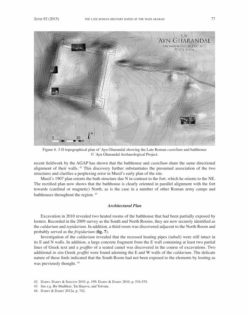
Topographic Placement/Directional Alignment
The castellum and bathhouse stand in an alluvial plain ca. 200 m W of the mouth of Wadi Gharandal
(fig. 6). The importance of the site as a fortified caravan station along the trade corridor in the Wadi
Arabah during the Late Roman and Early Byzantine periods is likely in part due to several natural and
topographical advantages in spite of the extreme environmental conditions posed by its location in the
desert. Abundant water resources, control over trade and travel, and the site’s relatively close proximity
to both the metropolis of Petra and the Red Sea port at Aila (Aqaba) are presumably the reasons the site
was fortified in the Late Roman period.
There is little reason to doubt the bathhouse and fort are contemporaneous, and preliminary
assessment of the ceramic finds from both structures appears to support this conclusion. 41 In addition,
35. See DARBY & DARBY 2012b.
36. KENNEDY 2004, p. 210.
37. MUSIL 1907, p. 193-97; WOOLEY & LAWRENCE 1914, p. 14-15; FRANK 1934, p. 231-232; GLUECK 1935, p. 39-40.
38. MUSIL 1907, p. 193-197; fig. 142 .
39. DARBY & DARBY 2010, 2013; DARBY, DARBY & SHELTON 2010.
40. DARBY & DARBY 2012a; DARBY & DARBY , 2012b.
41. DARBY & DARBY 2012a; DARBY & DARBY, 2012b.
Syria 92 (2015) 77THE LATE ROMAN MILITARY BATHS OF THE WADI ARABAH
recent fieldwork by the AGAP has shown that the bathhouse and castellum share the same directional
alignment of their walls. 42 This discovery further substantiates the presumed association of the two
structures and clarifies a perplexing error in Musil’s early plan of the site.
Musil’s 1907 plan orients the bath structure due N in contrast to the fort, which he orients to the NE.
The rectified plan now shows that the bathhouse is clearly oriented in parallel alignment with the fort
towards (cardinal or magnetic) North, as is the case in a number of other Roman army camps and
bathhouses throughout the region. 43
Architectural Plan
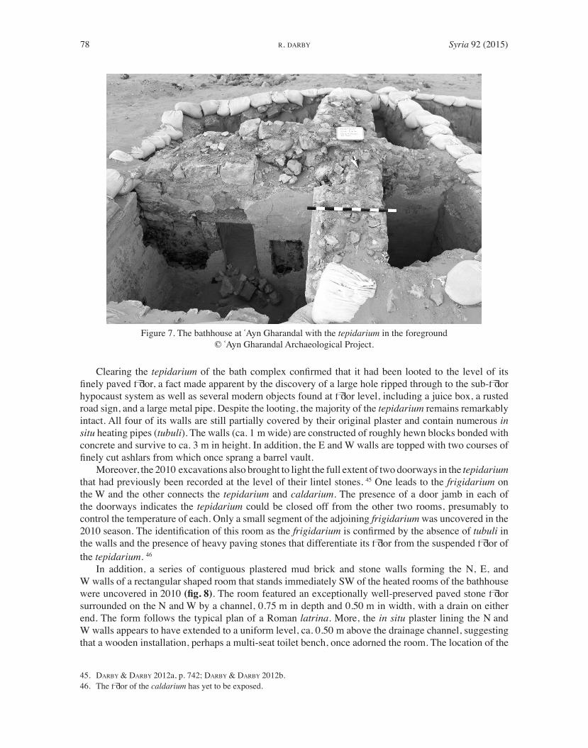
Excavation in 2010 revealed two heated rooms of the bathhouse that had been partially exposed by
looters. Recorded in the 2009 survey as the South and North Rooms, they are now securely identified as
the caldarium and tepidarium . In addition, a third room was discovered adjacent to the North Room and
probably served as the frigidarium ( fig. 7 ).
Investigation of the caldarium revealed that the recessed heating pipes ( tubuli ) were still intact in
its E and N walls. In addition, a large concrete fragment from the E wall containing at least two partial
lines of Greek text and a graffito of a seated camel was discovered in the course of excavations. Two
additional in situ Greek graffiti were found adorning the E and W walls of the caldarium . The delicate
nature of these finds indicated that the South Room had not been exposed to the elements by looting as
was previously thought. 44
42. DARBY, DARBY & SHELTON 2010, p. 199; DARBY & DARBY 2010, p. 534-535.
43. See e.g. Bir Madhkur, ʿEn Ḥaẓeva, and Yotvata.
44. DARBY & DARBY 2012a, p. 742.
Figure 6. 3-D topographical plan of ʿAyn Gharandal showing the Late Roman castellum and bathhouse
© ʿAyn Gharandal Archaeological Project.
78 Syria 92 (2015)R. DARBY
Clearing the tepidarium of the bath complex confirmed that it had been looted to the level of its
finely paved floor, a fact made apparent by the discovery of a large hole ripped through to the sub-floor
hypocaust system as well as several modern objects found at floor level, including a juice box, a rusted
road sign, and a large metal pipe. Despite the looting, the majority of the tepidarium remains remarkably
intact. All four of its walls are still partially covered by their original plaster and contain numerous in
situ heating pipes ( tubuli ). The walls (ca. 1 m wide) are constructed of roughly hewn blocks bonded with
concrete and survive to ca. 3 m in height. In addition, the E and W walls are topped with two courses of
finely cut ashlars from which once sprang a barrel vault.
Moreover, the 2010 excavations also brought to light the full extent of two doorways in the tepidarium
that had previously been recorded at the level of their lintel stones. 45 One leads to the frigidarium on
the W and the other connects the tepidarium and caldarium . The presence of a door jamb in each of
the doorways indicates the tepidarium could be closed off from the other two rooms, presumably to
control the temperature of each. Only a small segment of the adjoining frigidarium was uncovered in the
2010 season. The identification of this room as the frigidarium is confirmed by the absence of tubuli in
the walls and the presence of heavy paving stones that differentiate its floor from the suspended floor of
the tepidarium . 46
In addition, a series of contiguous plastered mud brick and stone walls forming the N, E, and
W walls of a rectangular shaped room that stands immediately SW of the heated rooms of the bathhouse
were uncovered in 2010 (fig. 8). The room featured an exceptionally well-preserved paved stone floor
surrounded on the N and W by a channel, 0.75 m in depth and 0.50 m in width, with a drain on either
end. The form follows the typical plan of a Roman latrina . More, the in situ plaster lining the N and
W walls appears to have extended to a uniform level, ca. 0.50 m above the drainage channel, suggesting
that a wooden installation, perhaps a multi-seat toilet bench, once adorned the room. The location of the
45. DARBY & DARBY 2012a, p. 742; DARBY & DARBY 2012b.
46. The floor of the caldarium has yet to be exposed.
Figure 7. The bathhouse at ʿAyn Gharandal with the tepidarium in the foreground
© ʿAyn Gharandal Archaeological Project.

Syria 92 (2015) 79THE LATE ROMAN MILITARY BATHS OF THE WADI ARABAH
latrine adjacent to the balneum probably allowed the latrine to make secondary use of water exiting the
baths. Additional walls of the bath complex were also revealed immediately N of the latrine; these walls
comprise at least two more rooms whose functions are, as yet, unknown.
YOTVATA/ʿAYN GHADIAN ( OSIA/COSTIA )
Location and History
Yotvata/ʿAyn Ghadian lies on the NW edge of the Tabah Sabkha, an expansive saline marsh, located
in the southern Wadi Arabah ca. 40 km N of the Gulf of Aqaba and the ancient port of Aila (fig. 1). The
abundance of water, both from the main spring, as well as numerous watering holes on the desert surface
undoubtedly attracted human occupation at the site long before the arrival of the Romans and continued
to do so after their departure.
The remains of the Roman fort and bathhouse are ca. 350 m W of the main spring near the foot of
a steep limestone escarpment and stand very near to the modern paved highway to Eilat. The modern
road presumably follows a similar N-S track to an ancient one that traversed the Wadi Arabah in the late
3 rd - early 4 th cent. 47 The gentle terrain along the western edge of the valley, as opposed to the steep
alluvial embankments on it eastern side, likely contributed to its use as a caravan route especially in the
later Roman period. Thus, Yotvata’s advantageous position controlling both water access and caravan
traffic presumably made it an ideal location for a military way-station to monitor and police those using
the oasis and the desert road.
47. See ROLL 2007, p. 119-130.
Figure 8. Latrina serving the ʿAyn Gharandal bathhouse
© ʿAyn Gharandal Archaeological Project.

80 Syria 92 (2015)R. DARBY
Previous Research
Exploration of the Yotvata/ʿAyn Ghadian oasis by western scholars commenced with Alois Musil’s
brief visit in 1898. 48 Musil noted three stone-lined wells and described the main spring enclosure but
made no mention of any substantial architectural ruins. T. E. Lawrence passed through in 1914 and was
the first to interpret the low square mound W of the oasis concealing the remains of the Roman fort as an
ancient building, which he postulated was a late Classical or Byzantine police post guarding the water
source. 49 He makes no mention of the outlying bathhouse to the N. as his focus, however, like Musil’s
before him, centered on Yotvata/ʿAyn Ghadian’s springs and wells about which he offered the following
lucid description, “Ghadian today is not attractive: there are eight smelly pits in which water collects a
few feet down, and the land about is a bush-covered, salty, sandy waste, fit for camels.” 50
It was Zeʿev Meshel who first noted the exposed remains of the bathhouse ca. 50 m N of the
castellum . 51 Their omission in all of the previous surveys suggests that they had, prior to Meshel’s work
at the site in the 1970’s, remained more or less buried from view. 52 Two excavation seasons were carried
out by Meshel on behalf of the Institute of Archaeology at Tel Aviv University in 1975 and 1976. 53
While much of the focus was directed at the castellum , “trial excavations” were also conducted in the
bath complex revealing a significant portion of its two heated rooms or what remained of them. 54 The
relatively poor state of preservation in which the bathhouse was initially found, having suffered from
exposure to the harsh elements of the Wadi Arabah as well as damage from later Bedouin burials and the
cutting of the oil pipeline trench along its eastern side, led Meshel to conclude that there was little left of
the structure to be found. 55 For the next 30 years, it remained partially exposed and in a state of decay.
New excavations of the bathhouse were supervised by the author in 2006 and 2007 under the auspices
of the Yotvata Roman Fort Project, co-directed by Jodi Magness and Gwyn Davies. 56 These renewed
investigations in many cases confirmed Meshel’s hypotheses regarding the baths’ architectural plan, its
relationship to the fort, and its destruction. However, substantial amounts of new data were also collected
that, along with many surprising new discoveries, cast doubt upon some of Meshel’s suggestions and
contradict others. The final excavation report was recently published. 57 Since the conclusion of the
Yotvata Roman Fort Project in 2007 conservation work on the bathhouse has been ongoing in an effort
to preserve it for public display. 58
Topographical Placement/Directional Alignment
The ruins of the bathhouse lie ca. 50 m N of the castellum near the edge of a small wadi emanating
from the steep scarp to the W (fig. 9). The bath structure was built on a parallel axis with the nearby fort
whose corner towers are aligned to the cardinal compass points. Thus, the bathhouse was oriented at a
45° angle NW by SW in alignment with the NE wall of the castellum . This close parallel arrangement
of the two structures suggests that they were built in conjunction with one another. 59
48. MUSIL 1907, p. 253-254.
49. WOOLEY & LAWRENCE 1914, p. 13-14.
50. WOOLEY & LAWRENCE 1914, p. 14.
51. MESHEL 1989, p. 234.
52. It is also possible that they were periodically exposed and then reburied by spring flooding of the adjacent wadi.
53. MESHEL 1989, p. 229.
54. MESHEL 1989, p. 235.
55. MESHEL 1989, p. 234-235.
56. DAVIES & MAGNESS 2007; AVNER, DAVIES & MAGNESS 2004.
57. DAVIES & MAGNESS 2015.
58. The conservation work at the site is being done by the Israel Antiquities Authority and the Eilat Regional Council.
59. See MESHEL 1989, who believed the two structures to be contemporary. Cf. DAVIES & MAGNESS 2011, p. 474.

Syria 92 (2015) 81THE LATE ROMAN MILITARY BATHS OF THE WADI ARABAH
Architectural Plan
While a portion of the bath complex remains unexcavated, the majority of its rooms and installations
have been exposed and identified (fig. 9). In its current state six rooms of the bathhouse are visible: a paved
courtyard, a piscina or cold-plunge pool, a large apodyterium / frigidarium , a tepidarium , a caldarium , and
a praefurnium enclosure. Additional rooms may yet lay buried to the NE, as indicated by the remnants
of other walls extending from the exterior of the tepidarium and the presence of toppled architectural
materials in that area. Additional rooms could also remain to the S of the apodyterium/ frigidarium where
they may have lined the courtyard. 60
The various rooms and bathing installations of the bathhouse were built around an open courtyard
that provided direct access to the main heated bathing block as well as the apodyterium / frigidarium and
piscina . A low row of finely tooled stone blocks borders the courtyard on the W and N demarcating it
from the bathing facilities. 61 Facing onto the courtyard on its NE side is a large rectangular piscina ca.
1 m in depth containing four stone steps in its NW corner. The plunge bath is ca. 1.50 m across; its full
60. See MESHEL 1989.
61. See DAVIES & MAGNESS 2011, p. 474, who only note the blocks in relation to the apodyterium/frigidarium .
Figure 9. The late Roman castellum and bathhouse at Yotvata/ʿAyn Ghadian (after DAVIES & MAGNESS 2007).

82 Syria 92 (2015)R. DARBY
dimensions were, however, unable to be recorded due to the overhanging acacia trees and surrounding
brushes. The careful placement of the steps in the corner of the tub nearest to the adjoining room to
the W, the apodyterium / frigidarium , is a clear indication that the piscina functioned as a cold plunge
bath serving the frigidarium . Its propinquity near the entrance to the heated bathing suites meant it
could serve as an initial immersion or a final rinse in the bathing sequence. Further, its proximity to
both the courtyard and apodyterium conveniently allowed a visitor to the baths relatively quick access
to bathing without having to enter the heated rooms. 62 More, a close parallel can be drawn with the
piscina at ʿEn Ḥaẓeva which also faces directly onto a courtyard in close proximity to the apodyterium
and frigidarium .
On the W side of the courtyard is a large rectangular room (ca. 9 x 11 m) that likely served a dual
function as both apodyterium and frigidarium . Six piers (ca. 1 x 1 m) arranged in two parallel rows
divided the interior space of the room into three approximately equal spaces; a central aisle and two
flanking galleries on either side. The N and S galleries probably served as changing areas, while the
W end of the room may once have contained a plastered tub. 63 More, the room features long plastered
benches along its N and S wall, further indicating the room’s use as an apodyterium , while its proximity
to the piscina and tepidarium indicates it also functioned as the bath’s frigidarium . The northern bench
contained a plastered step in its center that most likely led to another adjacent unexcavated room or bathing
installation. In the NW corner of the room a single projecting step granted access to the tepidarium . All
remnants of the door that must have once separated the two rooms are now lost. However, two long
flagstones that presumably served as a threshold for the tepidarium remain in situ .
The majority of the tepidarium was recorded by Meshel, particularly its northern half. 64 Details of its
southern half were not clarified until 2006. 65 The superstructure of the small tepidarium is preserved only
to the level of its suspended floor surmounting the hypocaust below. Large pieces of collapsed concrete
vaulting litter the surface nearby and presumably once roofed both the tepidarium and caldarium . 66 A
short cross-wall divided the tepidarium from the caldarium with a doorway connecting the two rooms.
Only the foundation for the cross-wall between the tepidarium and caldarium now remains.
The caldarium was entered from the E. Its poor state of preservation was noted by Meshel with only
a small portion of the plastered floor, minus its paver stones, remaining in place. 67 However, based upon
the design of the caldarium ’s hypocaust system and suspensura its plan and function are discernible.
The small rectangular room was divided, with the western one-third being used as an alveus or hot
tub, while the remaining eastern two thirds functioned as a sauna. 68 The caldarium was covered by a
concrete vault the remains of which can still be seen lying next to the structure. 69 The praefurnium flue
entered the caldarium in the center of the W wall.
A small external room lies to the West of caldarium and served as the praefurnium enclosure. Centered
on the opening of the furnace, the room contains a sloping floor made of hard-packed clay or mortar
surrounded by two semi-circular walls with a central entry. The two walls extended W from a plastered
rectangular platform that sat directly above the furnace. The platform would have once held a water tank.
Yotvata’s bathhouse, like its counterparts in the Wadi Arabah, also conforms to the angular row type. 70
62. Musil notes that the temperature of the water flowing from the main spring at Yotvata was only 22°C, which helped to
counter its unpleasant sulphuric smell when drinking MUSIL 1907, p. 254.
63. DAVIES & MAGNESS 2011, p. 474.
64. MESHEL 1989, p. 235.
65. DAVIES & MAGNESS 2007.
66. DAVIES & MAGNESS 2011, p. 474.
67. MESHEL 1989, p. 235.
68. See MESHEL 1989, p. 235, who notes the wall dividing the caldarium ’s hypocaust basement and assumed that it was only
for supporting the floor above. He, however, failed to note the significant differences in the hypocaust system between the
two spaces.
69. DAVIES & MAGNESS 2011, p. 245.
70. See e.g. NIELSEN 1993, p. 51, fig. 1, II.