the kluane region - department of zoology, ubckrebs/downloads/kluane book - ch02... ·...
TRANSCRIPT

2
The Kluane Region
CHARLES J. KREBS & RUDY BOONSTRA

The Kluane Region of the Yukon has been particularly well studied for two reasons. The Arctic Institute of North America established a research station on the south shore of
Kluane Lake in 1959. This is one of few research stations north of 60° in Canada, and it has focused scientific studies in this part of the Yukon for the last 40 years. In 1972 The Canadian government established Kluane National Park just to the west of Kluane Lake, and the designation of the park has brought with it a flurry of studies on the descriptive ecology of the Kluane area. In this chapter we summarize the general setting of the Kluane region and what is known about its physical and biological setting.
2.1 Geography and Geology
The Kluane region of the Yukon is cut by a number of major geological fault systems that usually trend from northwest to southeast. The Denali fault system cuts from central Alaska to northern British Columbia and transects the study area. The Shakwak Fault is part of the Denali system, and it follows the western edge of the Shakwak Trench from the southern end of Kluane Lake toward Haines Junction to the southeast. The eastern slopes of the St. Elias Ranges rise abruptly to 2600 m to form the western edge of the Shakwak Trench, while the Kluane Ranges form the eastern edge, rising to 1600 m. The Shakwak Trench ranges from 8 to 12 km in width just to the south of Kluane Lake. There is no apparent activity along any of these fault blocks at the present time. The major sign of volcanic activity in the Kluane region is the deposit of White River ash from a volcanic eruption near the Klutan Glacier north of Kluane National Park about 1250 years ago in 735 A.D. This ash provides a soil marker about 2-6 em deep in the valley south of Kluane Lake and has been mapped by Bostock (1952).
Glaciation has been the dominant geological process that has determined the soils and landforms of the Kluane region (Muller 1967). The most recent glaciation event was the Kluane glaciation from about 29,600 years ago to about 12,500 years ago. The entire Shakwak Trench was ice filled at that time. The glacial maximum occurred about 14,000 years ago, and rapid melting followed until the valley was largely ice free by 12,500 years ago (Denton and Stuiver 1967). During deglaciation, large areas of outwash sediments were exposed to winds corning off the retreating glaciers. These sediments were wind blown and deposited as loess on top of the glacial moraines. Loess in the Kluane region varies from 30 to 150 em deep and is the typical basic soil material of the study area.
The Kluane region lies in the zone of discontinuous permafrost, and scattered throughout the valley are areas underlain by permanently frozen ground. North-facing slopes are more likely to have permafrost, as are areas of peat accumulation and poor drainage. Recent burns typically lose any permafrost they may have had, as do areas cleared for roads or pipelines.
Land use in the Kluane area has been largely centered on placer gold mining and big game hunting. Both of these activities have been reduced or eliminated with the establishment of Kluane National Park in 1972. All of the area south and west of the Alaska Highway between Haines Junction and Burwash Landing is either in the park or in the Kluane Game Sanctuary. The Kluane Game Sanctuary was established in 1942 when the Alaska Highway was built to protect wildlife from overexploitation. Although mining is allowed in the sanctuary, none is currently being done there. Land claims by native groups
10
THE KLUANE REGION 11
0 15 30 ~
Kilometers J. Haines, Alaska
Figure 2.1 Location of the Kluane study area in the southwestern Yukon.
are now completed or nearing completion in this region, and this has changed the status of some of the lands that were formerly protected in the sanctuary. The Alaska Highway bisects our study area (figure 2.1), and thus about one-half of our area is within the protected area of the sanctuary. Hunting of large mammals (moose) still occurs within the sanctuary either by poaching or by native people who are allowed to hunt anywh~re for subsistence. The only other major human activity in the Kluane region is fur trappi ;· . The

12 ECOSYSTEM DYNAMICS O F THE BOREAL FOREST
Yukon maintains a system of exclusive trapping areas under license, and our study area included two trap lines. During the 1980s fur prices were exceptionally low, and in general there was little effort expended in trapping in the Shakwak Trench during our study. Trapping of arctic ground squirrels along the highway occasionally occurred but was minimal, and hunting of snowshoe hares by local people was also minimal. There has been no logging in the Shakwak Trench, and the only tree cutting has been for firewood on a local scale around Silver Creek at the south end of Kluane Lake and on areas to the south of our study zone.
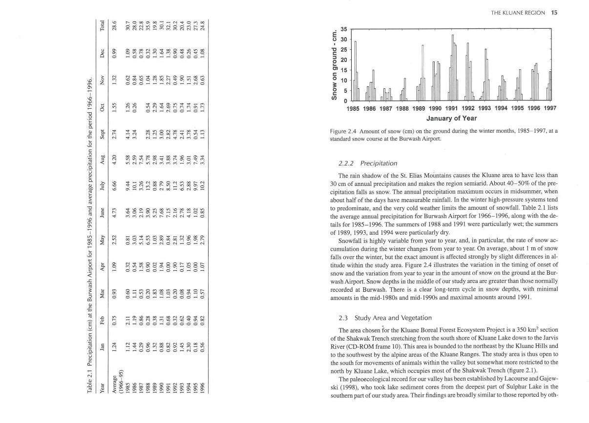
2.2 Weather and Climate
The Kluane region lies in the rain shadow of the St. Elias Mountains with its massive ice fields, and this topographic effect, along with the strong seasonality of the high latitude (61 °N), dominates the climate (Webber 1974). The southwestern Yukon displays steep environmental gradients owing to its proximity to alpine glaciers and to its high elevation. It lies at the boundary between two major climate systems, that of the cold, dry arctic air masses, and that of the warm Pacific air masses which are modified in transit of the St. Elias Mountains. Because the region is sparsely settled, there are few long-term weather records. There are weather stations at Burwash Airport and at Haines Junction that form the nucleus of the available data. Some weather data were collected at Kluane Research Station (KRS) during the 1960s and 1970s, but there is not a continuous record from this location. Because of mountain topography, no weather station will be typical of all the conditions within our study area. Burwash is typically slightly colder than KRS, and Haines Junction is slightly warmer, and we chose Burwash data as closer to the conditions observed at KRS.
2.2.1 Temperature
The average temperature range for Burwash is shown in figure 2.2 for 1966 to 1996. The cold climate in the Kluane region enforces a short growing season for the vegetation. The average frost-free period for Burwash is only 30 days (range 11-50 days) and for Haines Junction only 21 days (range 0 - 63 days), so that typically only July can be expected to have continuous freedom from frosts. The cold winter temperatures cause the lakes in the region to freeze early in the autumn. Kluane Lake freezes over completely on average about November 23 (range November 6-December 6) and is free of ice on average about June 7 (range May 25 - June 20). The ice thickness on Kluane Lake averages about 130 em and is almost always more than 1 m thick.
There is considerable variation in temperature from year to year at Kluane, and this variation is superimposed on the general climatic trend toward warmer weather as a result of C02 accumulation in the atmosphere. Figure 2.3 shows the average temperature deviations for Burwash Airport for the 10 years of our study at Kluane. The months are grouped into four seasons: winter (November- February), spring (March- April), summer (May- August), and autumn (September- October). Figure 2.3 shows that the summer temperatures in general have been at or above normal since 1986. Winter temperatures, by contrast, were below normal for the three winters from 1988-1989 through the winter of 1990-1991. Most of the temperature deviations during this study were less than 2oC.
30
20
0 10
<D ..... :::l ....... C1l ..... 0 <D c. E
-10 <D 1-c: C1l
-20 <D ~
-30
-40
0 Mean maximum ..
0
0
. . 0 · 0 . 0
~ ,('
~Mean minimum
0
Jan. Feb.MarchApril May June July Aug. Sept. Oct. Nov. Dec.
Month
Figure 2.2 Mean monthly temperatures for Burwash Airport for 1966- 1996, along with the average maximum and average minimum temperatures for each month. The horizontal line is the annual mean temperature of-3.83°C. (Data from Atmospheric Environment Services, Environment Canada, Whitehorse.)
6
Q) ..... 4 :::l -cu .....
<D 0.. 2 E <D -c 0 c: 0
:.= -2 cu ·:; Q)
0 -4
-6
_[ _6 ~ M n J1l mJl ~, ~ l} ~ u sl L s 's u f-E
.
1985 1986 1987 1988 1989 1990 1991 1992 1993 1994 1995 1996
Year
Figure 2.3 Deviations in mean temperature CC) at Burwash Airport from the long-term temperature average for 1966- 1995, for the period of our study (1985-1996). Averages are given for four seasons; S marks the summer season on the histograms. Winter is November- February, and summer is May:....August. (Data from Atmospheric Environment Services, Environment Canada, Whitehorse.)
E ~ c
.Q ~ :e. u Q)
c:t
<) c :::> -.
V) r-0
g~~~g;:b~§;~~~~ ·ooo.....: · ·oooo ·
~~:£~~~~~§;.,~;() coo · ·_;N o· ·r-io
;1;~~$~r:
16 ECOSYSTEM DYNAMICS OF THE BOREAL FOREST
ers for this region (Ritchie 1987, Cwynar 1988). Between 12,000 and 11,250 years B.P.,
the vegetation was dominated by an open alpine tundra dominated by the presence of Artemisa (sage). By 11,250 years B.P., this tundra was replaced by a birch shrub tundra indicative of more continuous vegetative cover. The birch shrub tundra in turn was replaced by a poplar woodland by 10,250 years B.P. It too was replaced, initially by Juniperus populations at 9,500 years B.P. and later by spruce at about 8,400 years B.P. The white spruce forest (Picea glauca) that occupies our valley was established about 8000 years B.P. Interestingly, black spruce (P. mariana) was not recorded extensively in the paleoecological record, though it was found at many other sites in the Yukon, nor is it found in the present day vegetation. Finally, though a significant increase in green alder (Alnus crispa) occurred about 6000 years B.P., and alder is still common in the paleoecological record today, we have not recorded it on our study areas. Lacourse and Gajewski (1998) argue that neither long-distance pollen transport, nor its presence in the adjacent vegetative communities, is the explanation.
The vegetation of the study area is typical of the Kluane sector of the boreal forest described by Rowe (1972). White spruce is the dominant tree in the region, and open and closed stands of spruce occupy the majority of the valley floor. The vegetation can be divided into three ecological zones based on elevation (Douglas 1974, 1980): montane valley bottom forests (760-1080 m), subalpine forests (1080-1370 m), and alpine tundra (above 1370 m). The two lower zones are complex mosaics of forests of white spruce, stands of balsam poplar and aspen, and shrub-dominated areas of willow (mostly Salix glauca) and dwarf birch. The subalpine vegetation, consisting of open canopy spruce mixed with tall willow shrubs, grade into the low shrub-dwarf plant communities of the alpine.
To measure the vegetation of the valley, we mapped the vegetation and developed a fire history of the area. The fire history is described in chapter 7 (see 7.2.1; CD-ROM frame 49). Based on three bands of LANDSAT image, we created both supervised and unsupervised classification maps of the vegetation. Useful as these images were for a broad classification, they did not provide sufficient detail to serve as a precise map of vegetation types, and their resolution was not appropriate to serve as a base for a fire history study. We decided, therefore, to use air photo interpretation for these purposes.
We flew over the valley for airphotos in July 1992 and the 317 1:10,000 black-andwhite photos provide complete coverage of the study area. Using a Bausch and Lomb zoom transfer scope, we produced a 1:32,000 vegetation map from these photos, which used four cover classes for each of three forest types: mature spruce, immature spruce, and aspen. There were also separate categories for water, shrub, wetland, and unvegetated. The resulting map (figure 2.5; Hucal and Dale 1993) has also been imported into the Geographic Information System and is provided on the CD-ROM that accompanies this book (frame 48). Table 2.2 gives the area of the valley occupied by the different habitat types. Closed spruce habitats were judged on the basis of 50% or higher canopy cover of white spruce; areas with less than 50% spruce canopy (but more than 15%) were placed in the open spruce category. The major difference between these two classifications results from the airphoto classification having included a larger section of the subalpine forest zone above 1080 m elevation, virtually all of which is classified as willow-shrub habitat. There is very good agreement between these two independent habitat classifications, which show that the valley vegetation is nearly equally one-third closed spruce, one-third open spruce,
E .::£ l{)
I t>l) Q)
>
18 ECOSYSTEM DYNAMICS OF THE BOREAL FOREST
Table 2.2 Vegetation classes of the Kluane study area.
lANDSAT Classification Airphoto Classification
Vegetation Type Area (km2) Percent Area (km2) Percent
Closed spruce• 103.1 32.18 65.27 17.96 Open spruce" 96.69 30.18 89.96 24.74 Poplar-aspen 8.78 2 .74 16.56 4.55 Willow shrub 82.32 25.69 162.9 44.81 Grass-open 29.50 9.21 28.89 7.94 Totals 320.41 100.00 363.62 100.00
Two estimates are given: one from a LANDSAT supervised classification and one from a more detailed airphoto analysis.
•closed spruce with > 50% canopy cover, open spruce with <50% canopy.
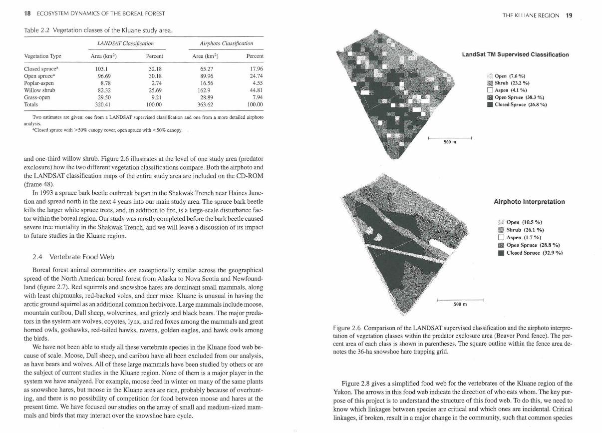
and one-third willow shrub. Figure 2.6 illustrates at the level of one study area (predator exclosure) how the two different vegetation classifications compare. Both the airphoto and the LANDSAT classification maps of the entire study area are included on the CD-ROM (frame 48).
In 1993 a spruce bark beetle outbreak began in the Shakwak Trench near Haines Junction and spread north in the next 4 years into our main study area. The spruce bark beetle kills the larger white spruce trees, and, in addition to fire, is a large-scale disturbance factor within the boreal region. Our study was mostly completed before the bark beetle caused severe tree mortality in the Shakwak Trench, and we will leave a discussion of its impact to future studies in the Kluane region.
2 .4 Vertebrate Food Web
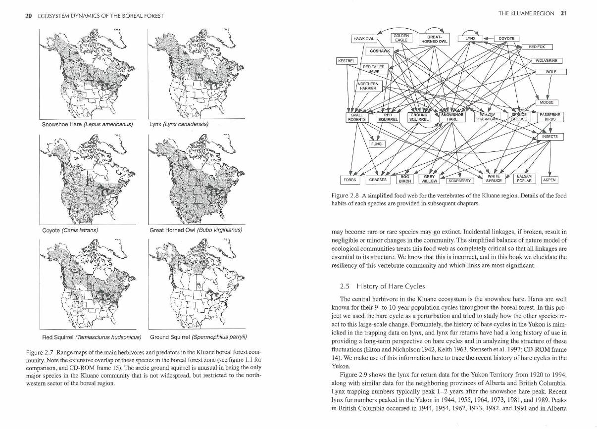
Boreal forest animal communities are exceptionally similar across the geographical spread of the North American boreal forest from Alaska to Nova Scotia and Newfoundland (figure 2.7). Red squirrels and snowshoe hares are dominant small mammals, along with least chipmunks, red-backed voles, and deer mice. Kluane is unusual in having the arctic ground squirrel as an additional common herbivore. Large mammals include moose, mountain caribou, Dall sheep, wolverines, and grizzly and black bears. The major predators in the system are wolves, coyotes, lynx, and red foxes among the mammals and great horned owls, goshawks, red-tailed hawks, ravens, golden eagles, and hawk owls among the birds.
We have not been able to study all these vertebrate species in the Kluane food web because of scale. Moose, Dall sheep, and caribou have all been excluded from our analysis, as have bears and wolves. All of these large mammals have been studied by others or are the subject of current studies in the Kluane region. None of them is a major player in the system we have analyzed. For example, moose feed in winter on many of the same plants as snowshoe hares, but moose in the Kluane area are rare, probably because of overhunting, and there is no possibility of competition for food between moose and hares at the present time. We have focused our studies on the array of small and medium-sized mammals and birds that may interact over the snowshoe hare cycle.
THF Kl I JANE REGION 19
LandSat TM Supervised Classification
• ~~ Open (7.6 %)
~ Shrub (23.2 %)
0 Aspen (4.1 °1.•)
S Open Spruce (38.3 %)
• Closed Spruce (26.8 %)
Airphoto Interpretation
~[i;j Open (10.5 %)
e Sbmb (26.1 %)
0 Aspen (1.7 %)
fll!ll Open Sp1·ucc (28.8 %)
• Closed Spruce {32.9 '%)
Figure 2. 6 Comparison of the LANDSAT supervised classification and the airphoto interpretation of vegetation classes within the predator exclosure area (Beaver Pond fence). The percent area of each class is shown in parentheses. The square outline within the fence area denotes the 36-ha snowshoe hare trapping grid.
Figure 2.8 gives a simplified food web for the vertebrates of the Kluane region of the Yukon. The arrows in this food web indicate the direction of who eats whom. The key purpose of this project is to understand the structure of this food web. To do this, we need to know which linkages between species are critical and which ones are incidental. Critical linkages, if broken, result in a major change in the community, such that common species
20 ECOSYSTEM DYNAMICS OF THE BOREAL FOREST
Coyote (Canis Jatrans) Great Horned Owl (Bubo virginianus)
~ .. -..
~~ ~
Red Squirrel (Tamiasciurus hudsonicus) Ground Squirrel (Spermophilus parryii)
Figure 2.7 Range maps of the main herbivores and predators in the Kluane boreal forest community. Note the extensive overlap of these species in the boreal forest zone (see figure 1.1 for comparison, and CD-ROM frame 15). The arctic ground squirrel is unusual in being the only major species in the Kluane community that is not widespread, but restricted to the northwestern sector of the boreal region.
THE KLUANE REGION 21
Figure 2.8 A simplified food web for the vertebrates of the Kluane region. Details of the food habits of each species are provided in subsequent chapters.
may become rare or rare species may go extinct. Incidental linkages, if broken, result in negligible or minor changes in the community. The simplified balance of nature model of ecological communities treats this food web as completely critical so that all linkages are essential to its structure. We know that this is incorrect, and in this book we elucidate the resiliency of this vertebrate community and which links are most significant.
2.5 History of Hare Cycles
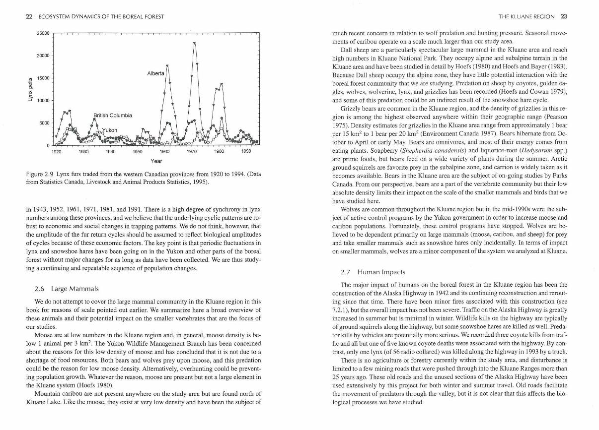
The central herbivore in the K.luane ecosystem is the snowshoe hare. Hares are well known for their 9- to 10-year population cycles throughout the boreal forest. In this project we used the hare cycle as a perturbation and tried to study how the other species react to this large-scale change. Fortunately, the history of hare cy_cles in the Yukon is mimicked in the trapping data on lynx, and lynx fur returns have had a long history of use in providing a long-term perspective on hare cycles and in analyzing the structure of these fluctuations (Elton and Nicholson 1942, Keith 1963, Stenseth et al. 1997; CD-ROM frame 14). We make use of this information here to trace the recent history of hare cycles in the Yukon.
Figure 2.9 shows the lynx fur return data for the Yukon Territory from 1920 to 1994, along with similar data for the neighboring provinces of Alberta and British Columbia. Lynx trapping numbers typically peak 1- 2 years after the snowshoe hare peak. Recent lynx fur numbers peaked in the Yukon in 1944, 1955, 1964, 1973, 1981, and 1989. Peaks in British Columbia occurred in 1944, 1954, 1962, 1973, 1982, and 1991 and in Alberta
22 ECOSYSTEM DYNAMICS OF THE BOREAL FOREST
20000
.l!l 15000 Qi 0. X c >.
....J 10000
1920 1930 1940 1950 1960
Year
1970 1980 1990
Figure 2.9 Lynx furs traded from the western Canadian provinces from 1920 to 1994. (Data from Statistics Canada, Livestock and Animal Products Statistics, 1995).
in 1943, 1952, 1961, 1971, 1981, and 1991. There is a high degree of synchrony in lynx numbers among these provinces, and we believe that the underlying cyclic patterns are robust to economic and social changes in trapping patterns. We do not think, however, that the amplitude of the fur return cycles should be assumed to reflect biological amplitudes of cycles because of these economic factors. The key point is that periodic fluctuations in lynx and snowshoe hares have been going on in the Yukon and other parts of the boreal forest without major changes for as long as data have been collected. We are thus studying a continuing and repeatable sequence of population changes.
2.6 Large Mammals
We do not attempt to cover the large mammal community in the Kluane region in this book for reasons of scale pointed out earlier. We summarize here a broad overview of these animals and their potential impact on the smaller vertebrates that are the focus of our studies.
Moose are at low numbers in the Kluane region and, in general, moose density is below 1 animal per 3 km2 . The Yukon Wildlife Management Branch has been concerned about the reasons for this low density of moose and has concluded that it is not due to a shortage of food resources. Both bears and wolves prey upon moose, and this predation could be the reason for low moose density. Alternatively, overhunting could be preventing population growth. Whatever the reason, moose are present but not a large element in the Kluane system (Hoefs 1980).
Mountain caribou are not present anywhere on the study area but are found north of Kluane Lake. Like the moose, they exist at very low density and have been the subject of
THE KLUANE REGION 23
much recent concern in relation to wolf predation and hunting pressure. Seasonal movements of caribou operate on a scale much larger than our study area.
Dall sheep are a particularly spectacular large mammal in the Kluane area and reach high numbers in Kluane National Park. They occupy alpine and subalpine terrain in the Kluane area and have been studied in detail by Hoefs (1980) and Hoefs and Bayer (1983). Because Dall sheep occupy the alpine zone, they have little potential interaction with the boreal forest community that we are studying. Predation on sheep by coyotes, golden eagles, wolves, wolverine, lynx, and grizzlies has been recorded (Hoefs and Cowan 1979), and some of this predation could be an indirect result of the snowshoe hare cycle.
Grizzly bears are common in the Kluane region, and the density of grizzlies in this region is among the highest observed anywhere within their geographic range (Pearson 1975). Density estimates for grizzlies in the Kluane area range from approximately 1 bear per 15 km2 to 1 bear per 20 km2 (Environment Canada 1987). Bears hibernate from October to April or early May. Bears are omnivores, and most of their energy comes from eating plants. Soapberry (Shepherdia canadensis) and liquorice-root (Hedysarum spp.) are prime foods, but bears feed on a wide variety of plants during the summer. Arctic ground squirrels are favorite prey in the subalpine zone, and carrion is widely taken as it becomes available. Bears in the Kluane area are the subject of on-going studies by Parks Canada. From our perspective, bears are a part of the vertebrate community but their low absolute density limits their impact on the scale of the smaller mammals and birds that we have studied here.
Wolves are common throughout the Kluane region but in the mid-1990s were the subject of active control programs by the Yukon government in order to increase moose and caribou populations. Fortunately, these control programs have stopped. Wolves are believed to be dependent primarily on large mammals (moose, caribou, and sheep) for prey and take smaller mammals such as snowshoe hares only incidentally. In terms of impact on smaller mammals, wolves are a minor component of the system we analyzed at Kluane.
2.7 Human Impacts
The major impact of humans on the boreal forest in the Kluane region has been the construction of the Alaska Highway in 1942 and its continuing reconstruction and rerouting since that time. There have been minor fires associated with this construction (see 7 .2. 1), but the overall impact has not been severe. Traffic on the Alaska Highway is greatly increased in summer but is minimal in winter. Wildlife kills on the highway are typically of ground squirrels along the highway, but somesnowshoe hares are killed m1 well. Predator kills by vehicles are potentially more serious. We recorded three coyote kills from traffic and all but one of five known coyote deaths were associated with the highway. By contrast, only one lynx (of 56 radio collared) was killed along the highway in 1993 by a truck.
There is no agriculture or forestry currently within the study area, and disturbance is limited to a few mining roads that were pushed through into the Kluane Ranges more than 25 years ago. These old roads and the unused sections of the Alaska Highway have been used extensively by this project for both winter and summer travel. Old roads facilitate the movement of predators through the valley, but it is not clear that this affects the biological processes we have studied.

24 ECOSYSTEM DYNAMICS OF THE BOREAL FOREST
Literature Cited
Bostock, H. S. 1952. Geology of the northwest Shakwak Valley, Yukon Territory. Geological Survey of Canada Memoirs 267. Geological Survey of Canada, Ottawa, Ontario.
Cwynar, L. C. 1988. Late Quaternary vegetation history of Kettlehole Pond, southwestern Yukon. Ecological Monographs 52:1 -24.
Denton, G. H., and M. Stuiver. 1967. Late Pleistocene glacial stratigraphy and chronology, northeastern St. Elias Mountains. Geological Society of America Bulletin 78:485-510.
Douglas, G. W. 1974. Montane zone vegetation oftheAlsekRiver region, south western Yukon. Canadian Journal of Botany 52:2505-2535.
Douglas, G. W. 1980. Biophysical inventory studies of Kluane National Park. Unpublished report to Parks Canada, Winnipeg.
Elton, C., and M. Nicholson. 1942. The ten-year cycle in numbers of the lynx in Canada. Journal of Animal Ecology 11:215-244.
Environment Canada. 1987. Kluane National Park Resource Description and Analysis. Natural Resource Conservation Section, 2 vols. Environment Canada, Parks Prairie and Northern Region, Winnipeg, Manitoba.
Hoefs, M. 1980. Horns and hooves. in J. Theberge (ed.). Kluane: pinnacle of the Yukon, page 175. Doubleday, Toronto, Ontario.
Hoefs, M., and M. Bayer. 1983. Demography of a Dall sheep population. Canadian Journal of Zoology 61:1346-1357.
Hoefs, M., and I. M. Cowan. 1979. Ecological investigation of a population ofDall sheep (Ovis dalli dalli Nelson). Syesis 12 (Suppl. 1): 1-83.
Hucal, T., and M.R.T. Dale. 1993. Habitat map of the Kluane Boreal Forest Ecosystem Project study area. 1:32000 scale vegetation map (unpublished).
Keith, L. B. 1963. Wildlife's ten-year cycle. University of Wisconsin Press, Madison, Wisconsin.
Lacourse, T. , and K. Gajewski. 1998. Post-glacial vegetation history of Sulphur Lake, southwest Yukon. Canadian Association of Geographers, Ottawa, Ontario.
Muller, J. E. 1967. Kluane Lake map area, Yukon Territory. Geological Survey of Canada Memoirs 340. Geological Survey of Canada, Ottawa, Ontario.
Pearson, A.M. 1975. The northern interior grizzly bear, Ursus arctos L. Canadian Wildlife Service Report Series No. 34.
Ritchie, J. C. 1987. Postglacial vegetation of Canada. Cambridge University Press, Cambridge. Rowe, J. S. 1972. Forest regions of Canada. Canadian Forestry Service Publication no. 1300.
Canadian Forestry Service, Ottawa, Ontario. Stenseth, N. C., W. Falck, 0. N. Bjornstad, and C. J. Krebs. 1997. Population regulation in
snowshoe hare and Canadian lynx: asymmetric food web configurations between hare and lynx. Proceedings of the National Academy of Sciences USA 94:5147-5152.
Webber, B. L. 1974. The climate ofKluane National Park. Project Report no. 16. Atmospheric Environment Service, Environment Canada, Kluane National Park, Haines Junction, Yukon.