the indo-parthian frontier-robert h. mcdowell
TRANSCRIPT
7/26/2019 The Indo-parthian Frontier-robert h. Mcdowell
http://slidepdf.com/reader/full/the-indo-parthian-frontier-robert-h-mcdowell 1/21
Volume
XLIV] ly,
I939
[Number
4
X t e r it a n S o r t f c a l t b t e
THE
INDO-PARTHIAN
FRONTIER
A
STUDY
IN
POLITICAL GEOGRAPHY
THE
purpose of this article is to employ the literary
and
numismatic
evidence to define more accurately and clearly
than has
hitherto
been
done the successive boundaries of the political
units
which
oc-
cupied the area east of Parthia and between the Hindu Kush Mountains
and the Indus valley from the second century B.C. to the second century
A.D.1
The
principal Greek and Roman
sources
for
the
geography
of the
area during that period are Strabo, Pliny, Arrian, and Ptolemy, as well
as
Isidor
of Charax and the anonymous author of the Periplus of
the
Erythrean Sea. The major units which they recognize represent in both
name
and outline a fusion of the Achemenid organization with
that
installed
by Alexander the Great. Apparently
the
short-lived
Maurya
Empire which succeeded Alexander did little to change
this
organiza-
tion,
and
the
coinages of the subsequent Yavana and Saka kingdoms
reflect the persistenceof these same nuclei of power. Still later, Chinese
envoys
and
Arab geographers down to the Middle Ages
describe the
political
and
commercial centers of this area in terms which for the
most
part identify them as essentially the units inherited or organized
by
Alexander.
In the Indus basin Alexander
left five principal political units. In
the
south
the
territory
from
the junction of the Punjab rivers with the
Indus as far as the sea, in general comprising Sind and the delta, fell
within
the
satrapy
of Pithon. In the north
the client kingdom of
Abhisares
occupied
lower Kashmir and the
Indus
valley above the
Punjab.
East of the
Jhelum River,
in
eastern
Punjab, lay the kingdom
of Poros.
The
satrapy
of
Philip
was
made
up
of
western
Punjab,
the
1
In
other studies
I
hope
to
discuss the mint areas of
ParthianIran, basing my con-
clusions
on
evidence
gathered
in Iran
during
I935
as
a
fellow
of
the
John Simon
Guggenheim
Memorial Foundation; the
nomad
invasions
of
northeastern Iran, with a
review of the literature on the subjectof the Yueh-chi and the Sakai; and the political
history
of Parthian
Iran in
terms
of
geographical
an(l
economic
factors.
78I
This content downloaded from 62.204.192.85 on Thu, 1 Jan 2015 07:06:33 AMAll use subject to JSTOR Terms and Conditions

7/26/2019 The Indo-parthian Frontier-robert h. Mcdowell
http://slidepdf.com/reader/full/the-indo-parthian-frontier-robert-h-mcdowell 2/21
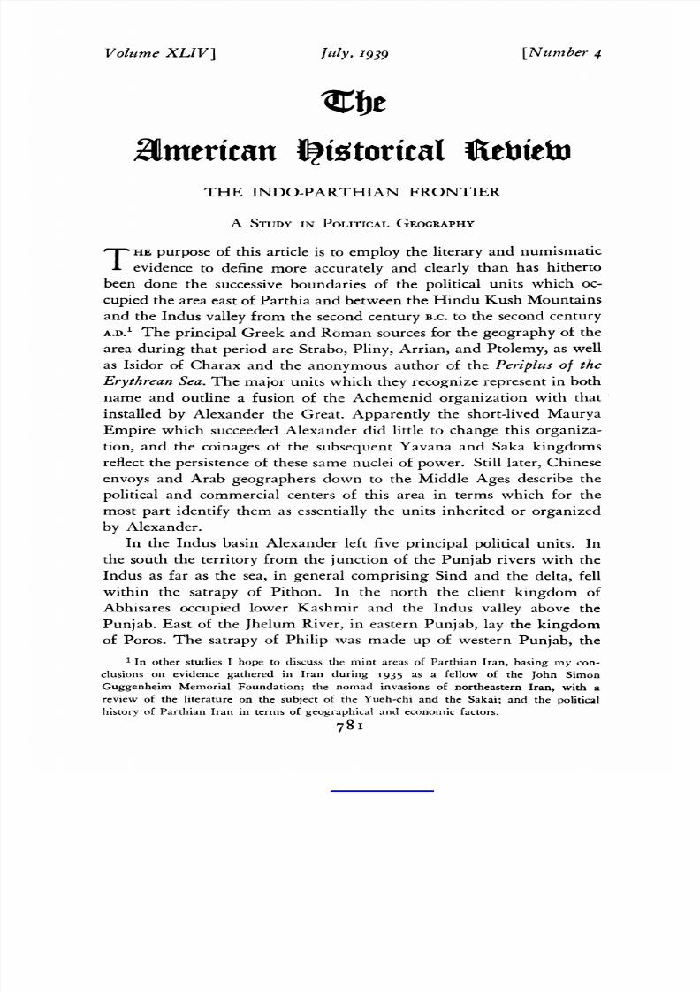
782
Robebrt
H.
McDoTvell
-A
:
B
C
I
D
E
I
G
R
I_
I
\
*&X0AMARKAID
2~~~~GLH
Ak
M~~~~~~BM
'1V
I
I3NAA
Abitso+/
IN3B
M4ARACNA
Ab-i-Istada
kE
H
4
Ak-su
iver.HO aRlatWar
(city)
Aracho6ia
.E-G,
t
Areia.BC5
Dragina
.
B_6_
_
aAk Gandh_a
Banjawayect)D Ghzi(ct)F
B1hr
(ity
.
C Ghoban
Rive
.
F2
Bks
ie
... ... ....
DolantPassE
hr
(city)
C6........ . .......
Carmhania.A7
ie
Gi.....E7Frishk
(city)
..................B
Cohariar
(city)
F4
I......homandiver
F6G
Bol~Dan Ps .............Ghr(ityA.....C
Camna.....
,8...Grsk(iy. ..
7
Charikar
(city)
.................
F4 Gumal
Rivr
..........
............
F6-G
This content downloaded from 62.204.192.85 on Thu, 1 Jan 2015 07:06:33 AMAll use subject to JSTOR Terms and Conditions

7/26/2019 The Indo-parthian Frontier-robert h. Mcdowell
http://slidepdf.com/reader/full/the-indo-parthian-frontier-robert-h-mcdowell 3/21
The
Indo-Parthian
Frontier
783
districts
of
Rawal
Pindi
east of
the
Indus
and
Peshawar
on the
west
bank,
which
together
omprised
Gandhara,
ndthe
valley
of theKabul
Riverbelow the KunarRiver.Adjoiningon the northlay the satrapy
of
Nikanor,
made up
of
the
Kunar
and Swat
river
valleys with an
extension
eastward
o an
undefinedborder
with
Gandhara;
his
unit
represents
he area
personally raversed
nd
conquered
by
Alexander
upon
his
entryinto
India,
and too little
attentionhas
been
paid
to
its
wealth,
high
culture, nd the
strategic
mportance
f
this
alternate
oute
from Kabul
Cityto the Indus.2
Within a veryshortperiodafter heirestablishmenthekingdomof
Eastern
Punjab
the
kingdom
of
Poros)
and
Gandhara
the
satrapy
f
Philip) absorbedhe otherthreeunits.
Though
the latter
retained heir
identities
as
important
nuclei
throughout
he
succeeding
periods,
East-
2
For
this
campaign
of
Alexander see
Arrian,
Anabasis,
IV, 23-28. The
route
has
been
described
by
Sir Thomas
Holdich
(The
Gates
of
India
[London,
1910],
pp. IOO-IOi,
II3,
I29)
as
the oldest
and
probably
the
best trodden
between
Kabul
and
the
Punjab;
he points
also
to its
strategic
importance
and
to
the
high
culture of
the
Swat
valley.
For the
satrapies
see E.
R.
Bevan,
"Alexander the
Great",
Cambridge
History
of
India,
I
(New
York, 1922),
351-52.
Harud
River ..................
B5-A7
Oxus
River
.............
H3-Bi
Helmand River
.........
E5-B7
P'ak-tat:
district of
Balkh.
Herat
(city)
......
B5
Pamirs
............
HI2,
3
Herat River
.....
B5-A4
Panjhir
River
............
F4
Hindu
Kush
Mountains
...-.-.B-G4, 5
Paropamisadae
C-F5
Hunza
(city)
.........1..
I3
Parthia
A4,
5
Hyrcania
... .I, 2
Peshawar
(city)
..................
G5
Indian
Ocean.
A-Ei2
Punch
River.
I
Indus River ............. I3-E12 Punjab (East) ..... .... H16,7
Jelalabad
(city)
.........
.
..
G5
Punjab
(Southwest)
.........
GH7, 8
Jhelum
River.
15-H7
Quetta
(city)
.E8
Kabul
River
.....
.....
FGs
Rawal
Pindi
(city).
H
Kafiristan
... ...............
G4
Samarkand
(city)
............
EI
Kalat
(city)
....E...........
9
Seistan
.....................
A-C8,
9
Kandahar
(city).D7
...........
Shibar
Pass
............
Es
Kashmir
..........................
I5
Sind
.F.......
FGio,
i i
Ke-pin:
Gandhara;
Kingdom
of
the
Sogdiana
.......
i.... D-F2,
3
House
of Eucratides. Swat
River
...
H4-5
Ko-hu:
Paropamisadae;
Arab
King-
Tarim
Basin
.
...II,
2
dom of Bamian.
T'ien-tok:
Eastern
Punjab;
Kingdom
Kunar
River
........
..
H3-G5
of the
House of
Euthydemus.
Kunduz
River
........
F4-3
Tiz
(city)
........
AiI
Lasbela
........................
DII
Tochi
River
.....................
G6
Makran
.................
BCI I
UniPs.............E
akra.BCiiUnai
Pass
..E
Margiana ...........
.......
B3,
4
Mula River
.Eg
Wakhan.Hv
..........
..
3
Multan
(city)
.
...........
H8
a...
kh
8
Washer
iv.Gi-F3
Murghab
River
..
D-B4
Yueh-chi
territory
just
prior
to.rise
of
Muruchak
(city)
.
.
c4 the
Kushana dynasty:
Pamirs,
Obeh
(city)
..
Cs
Wakhan,
Upper
Chitral,
Badak-
0-ik-san-li: Arachosia,includingSouth- shan, and the Kunduz River valley.
western
Punjab;
Kingdom of
Vonones
Zarangiana
...
.....
B7
and
of
Soter
Megas.
Zaranj
(city)
...
.....
A7
This content downloaded from 62.204.192.85 on Thu, 1 Jan 2015 07:06:33 AMAll use subject to JSTOR Terms and Conditions

7/26/2019 The Indo-parthian Frontier-robert h. Mcdowell
http://slidepdf.com/reader/full/the-indo-parthian-frontier-robert-h-mcdowell 4/21
784
Robert
H.
McDowell
ern
Punjaband
Gandhara tand out as paramount, nd this
relation-
ship can be traced
with little interruption
rom the Achemenid
period
to the Middle Ages.
On
the
west between
the Hindu Kush
and the
Indian
Ocean
the
Greek and Romansourcesrecognizethree
units as bordering
ndia:
the Paropamisadae,
rachosia, nd Gedrosia.North
of
these
units
and
of the Hindu Kush
lay Bactria,extending
east only to
the Kunduz
River
valley,which
was considered sourceof the Oxus; Sogdiana,
x-
tendingsouth to include
all of Badakshan; nd, northeast f
Sogdiana,
the countryof the
highlandSakai,that
is, Ferghana, he Pamirs,and
the watershedbetweenthe Indus and Tarim basins.3 nsofaras they
can be checked, he earlier ourcesagree
with Ptolemy n locating
the
northwesternorner
f Indiaat the head
of the
Panjhir
valley, ust south
of
the headwaters
f the eastern ributary
f the Kunduz. This places
within India all of
the Kunarbasinand
the lower Kabul valley,
rom
a point betweenKabuland Jelalabad. trabo
and Pliny,however,
ocate
the Indian rontier
n the Kabulvalleyratherbelow Jelalabad.4
great
deal of errorhas crept into our interpretationf the geographyand
historyof the Kabul
valley hrougha rather eneral ailure o
appreciate
the sense in which
the Hellenistic
writersused the nameKophen.
It
does not represent
he length of the KabulRiverof our day
but rather
theunited streamof the Kabuland the
Kunarriversbelow
Jelalabad.5
The districtof Kabul,
the Kabulistan
f the early Arab geographers,
from above
Jelalabad
o the Ghorband alley
was attached
o,
but
not
an integralpartof, the Paropamisadae.n all periods t appearsas a
passageway
ather
han as
a centerof power.
References o
the Paropamisadae
n
our earlier
Westernsources
are
3Strabo,XV,
2,
9; Ptolemy,Geographia,
I, II-13, I8-2I, and
mapsnos. 7,
9-10.
I
have used the edition of Ptolemy prepared by
Edward Luther
Stevenson (New York,
I932) and have benefited from the
commentary of Andre
Berthelot, L'Asie ancienne
centrale et sud-orientale,
d'apres PtolMme'eParis, 1930).
4
Strabo, XI, 8,
9;
Pliny,
Natural
History,
VI,
2I,
6-8.
5 Arrian, Anab., IV,
22,
5-7. Coming from Bactria on his way to India Alexander
arrived at
Alexandreia,
near Charikar. While
there he appointed Turiaspes satrap of
"the
country of the Paropamisadaeand of the
rest as far as to the
river Kophen". From
Alexandreia he proceeded
to
Nikaia, which is
generally identified as
Kabul City.
From
Nikaia he "advanced
oward the Kophen", at the
same time sending heralds to the Indian
princes of the Indus
ordering
them to
come to
meet him. "Here he divided the army";
this
can apply only to his
point
of
contact
with
the princes on the Kophen, which must
have been some distance
below Kabul. It
is clear that the name
Kophen cannot be
applied
to
any
stream
much
above
the
junction
of
the Kunar
(the
Choes
of
Arrian
and the Koa
of Ptolemy) with the Kabul, and so this junction seems to provide the basis for a new
name.
There
are
repeated
instancesin this same area of the
application
of a new
name
to
the
union of two
streams.
This content downloaded from 62.204.192.85 on Thu, 1 Jan 2015 07:06:33 AMAll use subject to JSTOR Terms and Conditions

7/26/2019 The Indo-parthian Frontier-robert h. Mcdowell
http://slidepdf.com/reader/full/the-indo-parthian-frontier-robert-h-mcdowell 5/21
T7he
ndo-Parthian
Frontier 785
vague,
indicatinglittle
more than
that
it includedthe head
of the
Kabul
valley,but they
do not permit
an assumption
hat
it
extended
eastof the valley
to include
partsof Kafiristan.
tolemy
ncludes
n it
the eastern imits of the satrapyof Turiaspes,hat is, the Ghorband,
Panjhir,
and
Kabul City districts.-Westward
t included
Bamian
and
the
Herat Rivervalley
down to
about
midway
betweenDaolatyar
nd
Obeh,
where it
bordered n Arei.
Becauseof
the
paucity
of
reference
in
the Hellenistic
iterature,present-day
istorians
have failed to see
in it
a politicalcenterof
great significance.
Bamian,
however,
s recog-
nizedas one of
the great
Buddhist enters
of the
Middle
East. As late
as the nineteenth enturywhathas been described s the best and the
most
generally
used route
from the
Oxus to
Kabul
passed
through
Bamian
and thenceeither
by the
easy
Shibar
Pass
into the Ghorband
valleyor south
into the
upperHelmand
River
valley
and so, by
the
Unai Pass, to
Kabul.
The earlyArab geographers
escribedanother
route
from
the
Oxus through
Bamian
o Ghazni
and thence
southto
the greatport
of Tiz in
Makran,or Gedrosia.
t
appears,ndeed,
that
the only route known to the ArabsbetweenHeratand Kabulpassed
through
Bamian.Other
routes,practicable
or
both
commerce nd war,
connectedBamian
hrough
heHerat
and Farah
river
valleys
with
the
Ghur
country
and
Seistan.It was
this
strategicposition
that led
the
Arabs
to call
Bamian"the
trade port
of
Khorasan
and the treasure
house
of
Sind
[the India
of the Arabs]."
Bamian
City
was variously
escribed s
half the size of
and as
large
as
Balkh tself,andthe kingdom ncludedmany
arge
citiesscatteredver
centralAfghanistan
rom
the Kabul valley
to the
borders
of Herat.
Besides ts commercial
mportance
nd thefertility
of its valleys,
t was
said to possessmportant
old and
silvermines.The
cultural
affiliations
of
Bamian with India
were remarked
n the MiddleAges,
and this
traditionhas
persisted nto
moderntimes.
The military
mportance
f
the Bamian
route is attestedby
its repeated
use
during the Afghan
civil
wars,by
the passageof Nadir
Shah
with an
army thatincluded
artillery,
nd
by the
recorded onquests
of Bamian
by the Khwarzim
shahs
and
the
Mongols.
For our present
purposes
he
value of these
Arab records
ies in the evidence hat the
kingdom
of Bamianof the
early
Middle
Ages
correspondedlosely
with
the
limits of
the Paro-
pamisadae
escribed
yPtolemy,
and
at times
t extended o
the eastern
limitsof
the
satrapy f
this name.6
6 Ptolemy, VI, i8; Guy Le Strange, The Lands of the Eastern Caliphate (Cambridge,
I905),
pp.
4I6-I8,
432;
Holdich,
pp.
2I7-I8,
259-68, 438;
cf. pp.
205,
211-24.
AM.
HIST.
REV.,
VOL.
XLIV.-54
This content downloaded from 62.204.192.85 on Thu, 1 Jan 2015 07:06:33 AMAll use subject to JSTOR Terms and Conditions

7/26/2019 The Indo-parthian Frontier-robert h. Mcdowell
http://slidepdf.com/reader/full/the-indo-parthian-frontier-robert-h-mcdowell 6/21
786 Robert
H. McDowell
The Arachosia f Ptolemy omprisedhe
upper
and middle
Helmand
River valley, the districts
around Ghazni and
Lake
Ab-i-Istada,
nd
probably ncluded the passesof the Gumal and Tochi riversto the
Indus plain. The boundary
on this
easternside cannot
be
accurately
traced,but it appears
o
have extended o
the
plain.
The borderon
the
south,that is, with
Gedrosia, an only a little
to the
southof
the
lake,
which is
called
by Ptolemy
"the
Lake of
Arachosia".
he
Kandahar
district,
which is so commonly dentified
with
Arachosia
y present-day
writers,
s included
by Ptolemywithin the
borders
f Gedrosia.
Strabo,
Pliny, Arrian,and Isidor of Charaxconfirmin a general way this
concentrationof
Arachosia toward
Ghazni rather than
toward
Kandahar.
Further upport s
offeredby the sources
f the earlyIslamicperiod.
The
Kandahar
district,
alledby the ArabsRukhkhaj,with its
capital,
Banjaway, ormed
part of what they called
Sijistan.This unit repre-
sentedan expansion
of northernGedrosia,
he Sakastan f Isidor, or
Zarangiana nd Drangianawere included.Above Sijistan ay the Arab
Zabulistan,which comprisedhe highland
countryof the middle and
upperHelmandvalley,
the upperreachesof
the Kandahar ivers,and
the district f Ghazni,with which the name
Zabulistan as most closely
connected.North of
Zabulistan n the frontiers
of Bamian lay the
Arab Kabulistan.8
It is clearthat the Arachosia f our Greek
and Roman sourcesand
the Zabulistan f the early Arabs represent ssentially he same area
7
For
Arachosia see
Ptolemy, VI, 20.
Strabo
(XI, 8,
9)
and
Pliny (VI, 2I,
6-8),
in
a
series of
measured
distances
between
Alexandria of
Areia
(Herat) and
India,
ignore the
existence of any
center
near
Kandaharand
pass
from Prophthasia
of
Drangiana (Farah)
directly to
what they call
the
city of
Arachosia, and
both
sets of figures
(each
is correct
when
properly
interpreted)
locate this city
near Lake
Ab-i-Istada.If the
route
of Isidor is
properly
traced (Parthian
Stations,
edited by
Wilfrid H.
Schoff
[Philadelphia,
I914i,
sect.
i6- i9),
his
"metropolisof
Arachosia"
ies
north
of the
lake; the rest
of
Arachosia,
with
Ghazni as the center, lay outsidethe Parthianborder.Arrian(Anab., III,
25,
8; III, 28,
1)
shows
Alexander
arriving in
the
district of
Zarangiana
(Zaranj
on
the
Seistan
lake)
and
proceeding thence
"toward
Bactriaand against
Bessus,reducing
on
the
way the
Drangians
and
Gadrosians".
Drangiana
extended
east
from
Farah to
include
Girishk; Gedrosia
is
here shown
extendingnorth of
Kandahar.
8
Le Strange,
pp.
334, 344-49;
cf.
Holdich, pp.
136,
474,
5I2. Kandaharis
largely
ignored by
the
early
Arab
geographers, and
the important routes
left
it to one side.
The Bolan
Pass to
the
Indus does not
appear
to
have
been used in
antiquity,
and
the
Mula River
Pass was connected with
Kalat rather than
Kandahar.
The
idea of
a
great
natural
highway
of
ancient trade
and
migration
passing
between
Kandahar
and
the
Indus, which
has
been
accepted
as
historical,
is
largely
a
creation of
British
strategists
of
the
nineteenth
century.
This content downloaded from 62.204.192.85 on Thu, 1 Jan 2015 07:06:33 AMAll use subject to JSTOR Terms and Conditions

7/26/2019 The Indo-parthian Frontier-robert h. Mcdowell
http://slidepdf.com/reader/full/the-indo-parthian-frontier-robert-h-mcdowell 7/21
The Indo-Parthian
Frontier
787
and
the same
center f
powerwithin he
area.
Both
groups
f sources
areveryvague
withrespect
o the eastern
order f the
area,
but
the
Arabs learly raspedhe significancef theGumaland Tochipasses
to the Indus,
which erved othGhazni
andthe
lake
country.
Ghazni
was
called
"the
port
of India",ndfrom t the great
Sultan
Mahmud
raided
ndia
and destroyed
he Arab
power
n Multan.The
strategic
position
f Ghazni n
relation
o both heOxusandthe
Indus uggests
that
the
Indian
ountry
outhof
Peshawar nd southeasto
Multan,
extreme outhwestern
unjab,
was
closely
elated
o Arachosia
roper
and,givena leadern Ghazni, ecame ependentpon t.
The eastern
rontiers
f
Gedrosia,he remaining
oliticalunit
bordering
ndiaon the west,
musthave
ncluded
hepresent istricts
of
Kandahar,
uetta,
Kalat, ndLasbela.
s in
the case
of Arachosia,
Ptolemy
hows
he eastern oundary
unning
lose o the
Indus
plain.
The characternd mportance
f Gedrosiaave
beenbadly
misjudged
throughasualnterpretation
f the accounts
ortraying
he sufferings
of theMacedonianrmyn thisregion.Arrian'sccounts explicitn
the
statementshat t
was hecoastwhich
was
desert nd hat
Alexander
deliberatelyhose
hemoredifficult
oute
n order
o maintain
ontact
with the
fleet.9The
early
Arab
sources
resent
more
detailed
nd
balanced
icture,
nd
his
receives
orroborationromaccountsy
more
recent ravelers.
he
Makran
f theArabsxtended
orth
rom hesea
only
o
Turan,which
orresponds
o theKalat
district;
n theeast, ike
the earlierGedrosia,
t
closelyapproachedhe Indusmouthandex-
tended n
thewest otheborders
f Carmania
r Kerman.
t possessed
many
fertile
valleys
n an
advancedtage
of
cultivation
nd
many
wealthy itiesnear he
coast
and in theinterior.
Commerce
as the
principal
ource f wealth:
y
seato the
greatportof Tiz,
thence
ver-
land o India;by caravanrom
Syria
andBagdad;
nd,as has
already
been
noted,
by caravanrom
Khorasan
nd theOxus
valley
by
wav
of Ghazni.Tiz replacedHormuzn the tenthcentury s theportof
Sijistan.
his picture f Makran,
r southern
Gedrosia,n the
Middle
Ages
s supported
y
numerousndextensive
ncient iteswhich
have
been
reported
y
travelersf the present
ay.
On the basisof evidence
as
opposed
o
surmisehe route
o andfrom ndia
by
wayof southern
Gedrosiamust be recognized
s one
of the most significant
f the
9
Anab.,
VI,
23-24.
Note
that
Alexander was
so impressed
with the
possibilitiesof
the
country
of
the Oreitai, in a
general sense
the
Lasbela
district, that he inaugurateda
foundation
there which
he
expected would become a
large
city
(ibid., VI, 21.5; Quintus
Curtius,
IX,
io).
This content downloaded from 62.204.192.85 on Thu, 1 Jan 2015 07:06:33 AMAll use subject to JSTOR Terms and Conditions

7/26/2019 The Indo-parthian Frontier-robert h. Mcdowell
http://slidepdf.com/reader/full/the-indo-parthian-frontier-robert-h-mcdowell 8/21
788
Robert H.
McDowell
ancient
Middle East,
equalled
only,
if at
all, by
that through
the
Kabul valley.'0
Though
it will never be possible o
localize
accurately y
means
of
their coinages
all of
the
political
nuclei
established n India
and
Afghanistanby
the
Greekand
Saka chiefs
who followed
Alexander
the
Great,
the
numerouscoins
which have
survived
do provideim-
portant
data for the
recognition
f units
the
approximate
rontiers
of
which
havebeen
established
y means
of other
evidence."1
t is
gen-
erallyagreed
that
no coins
of the
Yavanaor
Bactrian
dynasties
were
struck
n the Oxus
and
Jaxartesalleys
after he
reign
of
Heliocles, hat
is,
after
about I35
B.C.
In
Seistan
and Kandahar,
and to an extent in
Ghazni,
numerous
Yavana
coins
have
been
found
which
cover the
period down
to
and including
the
reign
of Eucratides,
the contemporary
of
Mithradates
I of Parthia.
Coins
of a contemporary
prince,
Anti-
machus,
have
been reported
for
the Murghab
River
valley region
of
Margiana. Supported
as they
are by
fragmentary
literary
references,
these collections
of coins lead
to the
conclusion
that
for a generation
at
least prior to the expansion of Parthia under Mithradates I, Greek
princes
had held
all of
Arachosia
and parts
at
least
of Gedrosia,
Zarangiana,
Areia,
and
Margiana.
For the
period succeeding
the reign
of
Eucratides
no
coins of the
Yavana
princes
appear
to have circulated
in
Seistan (Zarangiana),
Kandahar
(northern
Gedrosia),
and
Ghazni
(Arachosia).
Odd pieces,
of course,
find their
way
beyond areas
of
circulation,
but
a study
of the surviving
Yavana
coinages
justifies
the
conclusion that there is no numismatic evidence pointing to the inclu-
sion of these
areas
within
the kingdoms
of
the eastern
Greeks
after
about I55
B.C.
10
Le Strange, pp. 329-33;
Holdich, pp.
I93,
209,
292-31I.
Northern Gedrosia, in
general the
districts of Quetta
and Kandahar, was classed by the
Arabs as a part
of
Sijistan.
11
The standard publication
on the coins still
remains Percy
Gardner's
Coins
of the
Greek
and
Scythic Kings of Bactria and India
(London, i886). He
was much indebted
of course to the earlier work of Alfred von Sallet, and he summarizes the data gathered
together by Sir Alexander
Cunningham covering the
find spots of the
coins. Cunningham
devoted himself for years to the
collection of coins
and of information in regard to
their
find
spots. This was published
as
The Coins
of
Alexander's Successors in
thle East
(London, 1873). It is
important
to
note that since the work of
Cunningham
relatively
few
ancient coins have been recovered
from
Afghanistan.
Among
a number of con-
tributions by the English
numismatist
R. B.
Whitehead,
I
have
cited
his "Notes
on
Indo-Greek
Numismatics",
Numismatic
Chronicle, ser. 5, pt. 3,
1923, pp.
294-343.
The Cambridge
History of India,
Volume I, contains three very
important studies
based
in part on the numismatic evidence: "The Hellenic Kingdoms of Syria, Bactria, and
Parthia"
by
Sir
George
Macdonald
and "The
Successors of Alexander the Great"
and
"The Scythian
and
Parthian
Invaders"
by
Professor
E.
J. Rapson.
This content downloaded from 62.204.192.85 on Thu, 1 Jan 2015 07:06:33 AMAll use subject to JSTOR Terms and Conditions

7/26/2019 The Indo-parthian Frontier-robert h. Mcdowell
http://slidepdf.com/reader/full/the-indo-parthian-frontier-robert-h-mcdowell 9/21
The Indo-Parthian
Frontier
789
The
Yavana
principalities
f the
Indusbasin
ook
shape
rom
about
155 B.C.
to
some time
prior to the middle of the
first
centuryB.C.,
and
undernew dynastiesheypersisted t leastto the middleof thesucceed-
ing
century.The
outline
which
follows
s
based
argely
on the
very
able
and
generally
uccessful
econstructionf the
numismatic
vidence
by
Professor
Rapson.The
princes
of
the House of
Euthydemus
ad
their
center n
the
eastern
Punjab,
where
they
represented
continuation
f
the earlier
kingdomof
Poros.
In
periods
of
expansion
hey
dominated
also
the lower
Indus
valleyand the
seacoast,
hough
for
the most
part
these
areasdo
not
appear o have
been
effectively
held
by
the Yavana
kingdoms,and to the
north
hey
expanded
nto Kashmir
and
the
upper
Indus
valley;at
shorter ntervals
heir
rule
extended
westward
o
in-
clude
much of
the
territory
normally
held
by
the rival
House
of
Eucratides.
The
greatest
center
of the
House of
Eucratides
was
undoubtedly
Gandhara,and
their
kingdom
is
generally
equatedwith
the
com-
bined
satrapies
f
Philipand
Nikanor.To
this
I would
add,
for
much
of
this
period,
he
satrapy
f
the
Paropamisadaend
would
distinguish
more
specifically
han does
Rapsona
dependent
unit
in
southwestern
Punjab
which
had
formed
part
of the
satrapy f
Philip.12
After
Gand-
hara
the
most
important
olitical
unit
heldby
the
House of
Eucratides
was
Kapica,
which,
as the
kingdom
of
Hermaeus,
urvived
after
the
valleyof
the
Indus
had
passed
nto
the
hands
of a
new
dynasty.
Rapson
equates
his
name
with
the
upper
Kabul
valley
and
Kafiristan, ut
the
evidencedoesnot support his.Kapicacertainlyncludedpartsof the
Kabul
valley
and
Kafiristan,but
the
study
of
its
characteristicoin
types
in
relation o
the
areas n
which
these
types
are
known
to have
circulated
equires
hat
the
centerof
this
unit
be.
ocated
within
the
area
embracedy
the
Kunar
and
Swat
valleys,
hat s,
within
the
satrapy
of
Nikanor.
The
coinsof
Hermaeus
are
found in
large
numbers
not
only
in
the
Kabul
valley
but to
the
east
in the
Indus
valley
and
the
Punjab,wherethisprincemustlonghavedisputed he riseof the new
dynasty.
The
late
Chinese
references
o
Kapica,
citedby
Rapson,refer
not
to
the
upper
Kabulvalley
but to the
Swat
valley,
whichwas a
great
Buddhist
center
and
lay
near
the
well-known
southern
road
from
China to
India.'3
12
Rapson,
"The
Successors
of
Alexander
the
Great",
Cam.
Hist.
India,
I,
545-60.
13
For
the
holdings
of
Hermaeus
see
Whitehead,
pp.
340,
342; for
the
discussion
of
Kapica see Rapson, Cam. Hist. India, I, 555-56. Imitation of the coinage of Hermaeus
must
be
attributed
to
the
Yueh-chi
prior
to
the
rise of
the
Kushana
dynasty
rather
than
to
Pahlava
kings
of
the
Kabul
valley.
The
boundaries of
Kapica
in
the
seventh
century
This content downloaded from 62.204.192.85 on Thu, 1 Jan 2015 07:06:33 AMAll use subject to JSTOR Terms and Conditions

7/26/2019 The Indo-parthian Frontier-robert h. Mcdowell
http://slidepdf.com/reader/full/the-indo-parthian-frontier-robert-h-mcdowell 10/21
790
Robert H.
McDowell
Another
mportantnucleus
of the
House
of
Eucratides
as
hitherto
beenknownonly by the monogram
which
distinguished
ts
mint,
kappa
withrho."4 considerable odyof data s available or theidentification
of this mint areaand pointsvery definitely o
the
territory
which
had
its
center in the Bamian valley, the earlier Paropamisadae
nd
the
kingdomof Bamianof the Middle Ages.
The
mint was
employedby
at least fifteen Yavanaprincesandchada longer
life than
any
of
the
other
Greek mints of the
East,
from the
reign
of
Euthydemus to
just prior to
the accessionof
Hermaeus,
he
last
of the Yavana
ines.
In it was struckmoreof the silverof Euthydemus than in anyother
one
mint, and it shared n the issueof his bronze.Since
the greater
part
of
the
known coins of this reign have been foundnorthof the Hindu
Kush, this mint must have been adjacentto the
Oxus valley. An
analysisof the coins of Demetrius I points to the
same conclusion.
Of
thosecoinsof Euthydemus
which
have been recovered
outhof the
Hindu Kush, by far the greater part come from the upper Kabul
valley; the mint, therefore,must have been adjacent o this area.On
the Qther and,the greaternumberof the princeswho
made use of this
mint ruled
only
southof
the
Hindu
Kush; it follows
of course hat it
cannot
have been located n Bactria.These conditions
an be satisfied
only by an assignment f the mint to eitherBamianor the headof the
Kabul valley, but the latter must be ruled out becauseof other con-
siderations.
In his study of the YavanacoinagesWhiteheadhas noted a group
of
five mint markswhich he was unableto place in the Indus valley,
Punjab,or Kapica,and which appeared o have beenparticularly s-
sociatedwith the region of the Kabul valley. The
mint distinguished
by kappa-rhos one of these five, but the evidence
uggests hat it was
less directly onnectedwith the Kabul valley tself thanwere the other
four.
The English numismatistdiscusses n detail
ninety-seven ilver
coins found in the upper Kabul valley which cover
nine reigns and
mav
not be applied to the first
century
B.C.
in
the absence of corroborative
evidence.
Cunningham and
Rapson did not
have access to the Chinese
material which
has been
made
fully available
by
De
Groot. The common
view that the
city of Katisa, named by
Ptolemy for the
Paropamisadae,
representsKapica
is a pure surmise.
14Macdonald
(Cam.
Hist.
India,
I,
443)
recognizes
this
monogram
as
a true mint
mark and discusses its
importance.
Cf. Whitehead,
pp.
3I1 and
3I5-I6.
It
should
be
emphasized
that such mint
marks
do not
necessarilyrepresent
names of
cities. All of
the
great Parthianmints of Iran from about
70
B.c.
are so
distinguished,
and
the
Parthian
practice
appears
to have been borrowed
directly
from
the
Bactrian.
This content downloaded from 62.204.192.85 on Thu, 1 Jan 2015 07:06:33 AMAll use subject to JSTOR Terms and Conditions

7/26/2019 The Indo-parthian Frontier-robert h. Mcdowell
http://slidepdf.com/reader/full/the-indo-parthian-frontier-robert-h-mcdowell 11/21
T'he
Indo-Parthian
Frontier
79I
show
thirteen
different
mint
marks.
The
four
mints for
the
upper
valley are
represented
by
i6, 26,
I7,
and
ii
specimens
each,
the
fifth
mint by only one coin.'5 Even more opposed to the attribution of this
mint
to
the
Kabul
valley
is
the
evidence
that it was
employed
by
the
Parthians
from
about
70
B.C.
to
about
25
B.C.
A
large
series
of
Parthian
coins
for
this
period,
thoroughly
homogeneous
in
their
style,
bear
either the
kappa-rho
r
kappa
alone.
The
latter form
occurs
also
in
the
Yavana
coinage
of
this
mint.
The
Parthian
series
cannot be
as-
signed
to
areas
further
west,
and
their
style
had led
me
to associate
them with the Bactrian region before my attention was called to the
Yavana
series.'6
The
latter
antedates
70 B.C.,
though
the mint
area was
very
probably
temporarily
occupied
also
by
Mithradates
I
and
Mith-
radates II.
The
interest
of
both
Parthians
and Greeks
of the
East
in
the
Bamian
region
may be
explained
by the
presence there of
silver
mines as
well
as
by its
commercial
and
strategic
importance
as
a
passageway.
This location of an importantYavana nucleus in the Paropamisadae
throws
new
light
on
the
history
of
Greek
dominationof
the
Middle
East.
Though
Bactria
itself
was lost,
we
find
Greeks
holding
a
solid
block
of
territory
from
the
Punjab
north
and
west
to
the
whole
line
of
the
mountain
crest
which
overlooked
Bactria
and
possessed
of
lines
of
com-
munication
not
only
with
the
Oxus
but
with
Areia
and
thence to
Media,
farther
west.
In
this
arrangement the
Kabul
valley
stands
out
in
the
perspective
which
we
know was appropriate or the earlierperiod
of
Alexander
and
the
later
Islamic
period-never
an
important
center
in
its
own
right,
it
was
essentially
a
passageway
and a
dependency
of
adjoining
centers.
This
conclusion is
supported
by
the
extremely
varied
character
of
the
numerous
coins
found
there.
Sometime
early in
the
first
century
B.C.
a Saka
dynasty,
that
of
Maues
and
Azes,
had
risen
in
the
Indus
valley
and by
the
middle of
the
century
had
occupied
Gandhara
and
the
Punjab.
This
consolidation of
all
of
the
Yavana
holdings
in
the
Indus
basin,
with
the
exception of
Kapica
where
for a
brief
period
Hermaeus
continued
to
rule,
had
Gandhara for
its
center
and
was
equivalent
to
the
satrapy
of
Philip
with
the
kingdoms of
Poros and
Abhisares.
In
the
latter
area
lay
the
15
Whitehead,
pp.
315-I6.
16
These
Parthian
coins
wvillbe
discussed in
greater
detail
in
a
later
study.
Warwick
Wroth
(Catalogue
of
the
Coins
of Partthia
[London,
1903],
p.
48,
n. i)
has
failed
to
note the rho combinedwith the kappa,but I have observedit
repeated s, and
it
has been
recorded
by
Alexander
von
PetroNvicz
(Arsaciden-Tvtiinzen
[Vienna,
1904],
p.
42,
no.
23).
This content downloaded from 62.204.192.85 on Thu, 1 Jan 2015 07:06:33 AMAll use subject to JSTOR Terms and Conditions

7/26/2019 The Indo-parthian Frontier-robert h. Mcdowell
http://slidepdf.com/reader/full/the-indo-parthian-frontier-robert-h-mcdowell 12/21
792 Robert H. McDowell
original nucleus of the new dynasty, and this nev development
is
significant.1
Rapsonhas insistedthat the Sakai of whom Maueswas the chief
had formed part of the group which had attacked Parthia
and
must
have entered India by way of the lower Indus valley.
His
argument
rests on a number of fallacies. Contrary to the statement
of
Rapson,
the
displacement of Sakai by the Yueh-chi, which
is described
in
the
Chinese annals, took place, not in the country
north
of
Bactria,
but
in
a district northeast of the Pamirs, 0-sun, and
must be
distinguished
from the displacement mentioned by our Western sources. Rapson
rejects the possibility that the Sakai
of Maues
entered
India
by way
of
the upper Indus or through one of
the
Kabul
valley approaches
because
he assumes that they came in a body within a short period of time and
in a state of political advancement requiring the issue of their own
coinage. Neither of these assumptions is valid. We have already noted
the Saka country shown by Ptolemy along the whole northern and
eastern border of the upper Indus basin; these were the Sakai who had
much
earlier been conquered by Cyrus the Great, who had played an
important part in Alexander's conquest of India, and who may be
presumed to have filled a similar role under the Yavana feudal lords.
It is only reasonable to assume a gradual infiltration of Saka elements
into the upper Indus basin over a long period of time. As a final cul-
mination of a long process we have the event cited by Rapson from
the Chinese sources: Saka princes driven out by the Yueh-chi went
south and became chiefs in the new land. All of the evidence thus
points
to
the upper
Indus
valley as the
nucleus
of
the
power
of the
new dynasty, and within the new kingdom of Gandhara which they
established there was effectively included, probably
for
the first
time,
all of
the upper Indus basin which Ptolemy
shows
as
an
integral part
of
western India.
Coins of Maues and Azes, as well as of their successorsAzilises and
17
For a general
discussion
of these
Sakai in India
see Rapson,
"The Scythian
and
ParthianInvaders", Cam.
Hist.
India, I,
563-7I.
Cf.
Whitehead, p. 338,
and
Gardner,
p. xl.
The coins of
Maues have
been found chiefly
in
northwestern
Punjab. A number
of
his
early types have
been copied from
the coins
of
the
much earlier
Menander and
Demlletrius,who had
extended the Yavana
frontiers into
regions not
retained by their
successors,
with the
exception
of
Hippostratus.The
latter
appears
to
have
ruled
in the
Punch valley of
Kashmir,
and
his issues
are
closely
related to
those of
both
Maues and
Azilises. The
evi(lence suggests
that
the nev dynasty rose in the upper Indus valley and
retained that area
in
the
subsequent period
of
contraction.
For
the
Sakai
see
also
PtolelmY,
VI,
13.
This content downloaded from 62.204.192.85 on Thu, 1 Jan 2015 07:06:33 AMAll use subject to JSTOR Terms and Conditions

7/26/2019 The Indo-parthian Frontier-robert h. Mcdowell
http://slidepdf.com/reader/full/the-indo-parthian-frontier-robert-h-mcdowell 13/21
The
Indo-Parthian Frontier
793
Azes
II,are
not
known
for the
Ghazni
country
or
for
the
Kabul
valley
above
Jelalabad.
There
does occur in
the
valley,
and
apparently nly
there,a seriesof issuesbelonging o a Vononesand an associatedroup
of
Saka
rulers.The
style
and
typesof
these
coins
are so
closely
related
to
thoseof
the Sakai
n
Gandhara
nd
the
Punjab
hat
thetwo
groups
of
princes
must be
classed
together,and
it is
generally
accepted hat
Azes
II
represents fusion of both elements.'8
Rapson
states
that
the
family
of
Vonones
ruled over
"Drangiana
Seistan]
and
Arachosia
[Kandahar]".
n this
he
disregards
ompletely
he essential
actor
of
find spotsand baseshimself on the characteristicypesfound on the
coins of
Vonones,
which,
he
says,
were
"presumably"
truck
n
some
districtof
Arachosia.But
these same
types
were
employedby
Azes,
Azilises,or
Hermaeus,
who by no stretchof the
imagination
an be
thoughtto
have
ruled Seistan,
Kandahar,or even Ghazni.
The
as-
sumption
of
Rapson
s
reasonable
hat the
character
f
the
legend
on
this class
of
coins,
with
its reference
o
jointrulers,
points
to
two
dif-
ferentareascontrolledby one paramount hief.As one area I would
suggest
the
Kabul valley,
where the
coins
occur, with
Arachosiaas
we
have
defined it,
excluding
the
Kandahar
district.As
the
second
area,
joined to
the first by
the
Gumal and Tochi
passes, outhwestern
Punjab, outh
of the
Peshawar
istrict,
presentstself
as a
logicalchoice.
Identifiedwith
this
area,
the
types of
Vonones
and
his
associates
fulfill
all of
the
requirements f their
occurrence n
other
reigns.
Before he
fusionof thetwvoroupsunderAzesII, theprinces f Kabul
and
Arachosia ppear
t
times o
have
extended
heir
rule
over
Peshawar
and
parts
of
Gandhara.
t is
not
necessary o
assume,
as
do
Rapson
and
Thomas,
that
Vonones
occupiednot
only
the Kabul
valley but
brought
to
an
end the
rule of
Hermaeus
n
what
had been
left of
Kapica.
During this
period
Azilises
continued to rule
in
parts of
Gandhara
ndthe
Punjab,
and
theChinese
ources uggest
hat
Kapica,
in
partat least,
became
unitedto
Gandhara.The date
given
by
Rapson
for
Vonones
is
approximately
orrect,
though it
will be
suggested
below
that he
had
established
himself in
the
Kabul
valleyprior to
36
B.C. For
our
present
purposes he
particular
ignificance f
the rise
of
Vonones ies
in
the
evidence t
affords
of the
development f
a new
nucleus
and,
for the first
time
since the
reign
of
Eucratides,
f an
18
Gardner,
pp. xl-xli;
Rapson,
Camii.
Hist.
India., I,
568-74.
Vonones
himself
pre-
sumably
was no
Saka, but an
Iranian
prince
who
had
joined
himself
to
this
group.
He may have been an Arsacid,but, as vill be
shown
belov, the
date
limits of
his
reign
do
not
permit of
his identification
as
Vonones
I
of
Parthia,
as
has
been
suggested.
This content downloaded from 62.204.192.85 on Thu, 1 Jan 2015 07:06:33 AMAll use subject to JSTOR Terms and Conditions

7/26/2019 The Indo-parthian Frontier-robert h. Mcdowell
http://slidepdf.com/reader/full/the-indo-parthian-frontier-robert-h-mcdowell 14/21
794 Robert
H. AMIcDowell
extension
of
the Indian
frontier
to include
Arachosia,
he
region of
Ghazni and of Lake
Ab-i-Istada.
The successor f Azes II in Gandhara nd the Punjabwas Gondo-
pharnes, nd
his reign in Gandhara egan n
A.D.
i9.19
These
admitted
facts,however,
determineneither he
original
nucleusof
his
power
nor
the
date
at which
he
established imselfoutside
Gandhara. he bulk
of
the extantcoinsof
Gondopharnesave been found
n
the Kabul
valley,
and
a
considerable uantity n the Punjab.
Relatively
ew
have
been
reported rom Kandahar
nd Seistan.He
countermarked
oins of
his
contemporaryArtabanus I of Parthiaand of the earlierOrodesII.
On
his early
coins he copied
one of the types
of this same
Arsacid
and
borrowed the
title
A#itokrator
rom the
still
earlier Sinatruces
of
Parthia.Withoutciting finds
of his coins
Rapson
assumes hat
Gondo-
pharnes eigned n
"Arachosia"ecause f a
supposed elationship
with
Vonones;that
is,
he assumes
or Gondopharneshe argumentswhich
he
applied o
the types of Vonones.
Though I find no evidenceof a relationship etweenGondopharnes
and
Vonones,
I would
accept he
assumption f Rapsonas applied o
Arachosia s here defined.
There can be
no doubt that
Gondopharnes
interfered n Parthian
affairs and
territory,but the
evidence of the
coins points
only to this and
not to
prolonged rule over districts which
had
hitherto
beenParthian.
would suggest,rather, hat
Gondopharnes
rose
to powerin a region
of Arachosia,
bove Lake Ab-i-Istada,hat
hadonce beenParthianbutwas so no longer.There he imitatedcoins
of
former
reigns.From an earlypoint in
his reign he
must have ruled
also
in the Kabul valley,
and to that area I
would assignat least one,
perhaps
both,
classesof his
coins with the
Nike reverse.
Thus far his
coinage
remainsentirelydistinctfrom
that
of his Saka
predecessors.
The
greater
numberof his known types,
however,closely
ollow those
of Azes
and Azilises, and
they must be
assigned to the succeeding
period of his rule in
Gandharaand the
Punjab. The date for his
accessiongbasedon an
inscriptionmade n
Gandhara nd
is expressed
in
termsof an
Indianera; it can be takento
indicateonly
the acknowl-
edgmentof
his successiono
the throneof
this ancientcenter.The date
19
Rapson,
Cam.
Hist. India,
I, 576-78.
For the
find
spots of the coins of
Gondo-
pharnes
see
Gardner,pp. xlv, 1. Ernst
Herzfeld
("Sakastan",
ArchaeologischeMitteilungen
aus
Iran, IV [Jan.,
1932],
91-102) has
argued that the center
of power
of Gondopharnes
lay in
Seistan,
and in this he
has
seriously altered the
chronology
of the preceding
reigns. Though there is much of value in his discussion,his disregardof the essential
unity of the
numismatic
evidence makes
unacceptable
his
argument for the
location
of
the
kingdom of
Gondopharnes as
well as
that of the Chinese unit
known
as
Ke-pin.
This content downloaded from 62.204.192.85 on Thu, 1 Jan 2015 07:06:33 AMAll use subject to JSTOR Terms and Conditions

7/26/2019 The Indo-parthian Frontier-robert h. Mcdowell
http://slidepdf.com/reader/full/the-indo-parthian-frontier-robert-h-mcdowell 15/21
The Indo-Parthian Frontier
795
A.D.
I9
is
importantas fixing the definite
union
of the Punjab,
Gand-
hara,Kapica, he Kabul valley,and Arachosia.
In this connectionwe must consider he coinageof the "nameless
king" of this period, who called himself on his
issues
simply
Soter
Megas.20The great majorityof his coins represent complete
break
with
the types and style which had characterized
he
coinages
of
the
Mauesand Vononesgroup as well as with the
later
issues of
Gondo-
pharnes.On all of the latter a horseman s shown
on the
obverse,
whereasSoterMegas, ike the Arsacids,displayed
he
royalportrait n
the obverse. The reverseof his coins invariablybears
the
figure
of
a
horseman,but it is done in a style closely similarto
that on
contem-
porary
and
later Parthiancoins. The
coins of
Soter
Megas
occur
ill
great numbers n the Kabul valley and are noted by
Gardner
or no
other
area.
For the period ucceedingGondopharnes,
owever,
he
issues
of
the
Kushanadynasty ccur n that valley n
even
greater
abundance.
This fact togetherwith the wide diversityof styleseparating
he
coin-
ages of the Kushanasand Soter
Megas
equires he assignment
f the
latter o the period mmediately receding
Gondopharnes,nd it
follows
that he must have been the successor f Vonones in the Kabul
valley
and, presumably,n Arachosia.
Soter
Megas, suggest,was the firstof the
so-calledPahlava
rulers.
From some nucleus n Arachosia ear the Parthianborderhe rose and
destroyed
he
power of Vonones. While
Soter
Megas
controlled he
Kabul valley and Arachosia,and perhaps
ts
extension
through
the
Gumal Pass to the Indus, Azes II continued o rule in Gandhara,
partof the Punjab,and probablyn the Swat valley
of
Kapica.
would
suggest, further,that Gondopharnesnheritedthe
kingdom of Soter
Megas and continuedto rule his territory or some
years before he
invadedand conqueredGandhara.The rise of Soter
Megas represents
a
reactionagainstthe earlierrise of Vonones and his Saka associates,
but
the
two mustbe considered s the founders f a
kingdomwhichfor
perhaps ifty yearsmaintained tself betweenIndiaand Parthia.
The
united
kingdom of Gondopharnes,which centered n Gand-
hara, was broken up by the rise of the Kushanadynasty. n Pacores
and
Orthagneswe have two Pahlavaprinceswho maintained hem-
selves orsomeyears hereaftern Arachosia nd
southwestern
unjab.Y
20Gardner,
pp.
xlvii, 1,
I14-i6. Rapson
(Cam. Hist.
India,
I,
58I)
suggests
that
Soter
Megas
may have
been
a
subordinate
of the
Kushana
dynasty,
but the
style and
types of his coins are definitelyearlier and are completelyforeign to those of KadphisesI
and
his
successors.
21
Rapson,
Cam.
Hist.
India, 1,
58,
580.
Rapson
has
made
Orthagneq
a
predecessor
This content downloaded from 62.204.192.85 on Thu, 1 Jan 2015 07:06:33 AMAll use subject to JSTOR Terms and Conditions

7/26/2019 The Indo-parthian Frontier-robert h. Mcdowell
http://slidepdf.com/reader/full/the-indo-parthian-frontier-robert-h-mcdowell 16/21
796
Rober-t H.
McDowell
The types of
the former
associate
him in particular
with the Indian
side
of the Gumal
Pass, whereas
the
lattercan have
ruled only in
Arachosia,
ut
the coinsof both
occur
n Kandahar
nd
Seistan.
This
advance s to
be connected
with the
civil wars
in
Parthiaduring the
reign
of Volagases
I.
There are known
coins of
Phraates
V of
Parthia
which have
been
countermarked
y an unnamed
Saka ruler;these coins appear
o have
been
struck in the Parthian
mint
of southern
Gedrosia.Sanabares,
another
Sakaor Pahlavaprince,
mitated
coins of Volagases
which
must be attributedo
this same
mint.On the
basis
of
these associations
both of theseprincesmustbe assignedo the deltacountryof the Indus
valley,
immediately
adjoining
Gedrosia,
where,
as
we
learn
from the
Periplus,
uring
this very period
"Parthian"
ords
ruled in
a state
of
constantcivil
war.22
This outline
of
the political units
which
borderedthe
eastern
frontiersof
Parthia
during the periods
of Greek
and
Saka rulein the
Middle East can
be filled in
and rendered
more
completeby
evidence
from contemporaryChineseannals.We are here concernedchiefly
with
data to
be foundin the
Ch'ien-han-sut,
houghrecourse
s had to
the
earlier
Shi-ki
nd
the later
Hou-han-su.The
picture
here
presented
appliesto the
first century
B.C. and to that
part of
the next century
whichprecededhe rise
of the
Kushanadynasty.23
or
this periodand
the
areaembracingnorthwestern
ndia
and the Afghan
country
north
of
Gondopharneson
the basis of
an issue
wvhich, n the
obverse,
bears the name of
the
former as
paramount
king and, on the
reverse,
the name of
Gondopharnes. I
suggest,
rather, that it
was
struck after the defeat
of
Gondopharnes but before
his death.
This
supposition
appearsto be necessitated
by
the fact that
all of
the coins
of
Orthagnes
mitate
the
portrait of
Volagases I of
Parthia,
who came to the
throne
in A.D.
5I.
I
refer
in
particular
o
an
issue
of drachms
of
Volagases
struck,
I
believe,
in
the mint of
Drangiana,
of
which I have seen
several
examples.
Petrowicz (p.
129,
no.
I4)
has
published
what
appearsto be a
similar
piece.
22Wroth,
p.
I14,
nos. 96-I02. For
the coins
of
Sanabaressee Gardner,
p.
I13, nos.
I-5.
The first
of these coins
bears the
mark of the Parthian
mint of
Ecbatanaand a
date
which may be "IT" rather than as given. Though dates rarely occur on the Parthian
coinage of Iran, when
employed
they are
invariably based
on the
Arsacid
Era,'
and
the
date
in this
instance,
too, should be
read as A.D.
62/63.
Though
apparently of
the
delta
country
by origin, there
are some
grounds for
classing
Sanabares as a king
of
Parthia; his
successor n
Parthiamay have
been
Mithradates
V. See also
Le
Pe'riple
de
la
n2er
trythre6e, dited by
H. Frisk
(G6teborg, I927),
no. 38.
23
For the
most
part
I
shall
cite the
now
standard
translationand
commentary
of
J. J.
M. de
Groot,
Chinesische
Urkunden
ztir Geschichte Asiens
(2 vols.,
Berlin,
I92I-
I926),
especially Volume
II,
Die Westlande
Chinas
in
der
vorchristlichen
Zeit.
I
have
made use, also, of 0. Franke, Geschichtedes chinesische Reiches, Volume I (Berlin,
1930),
and Sten Konow, "Notes
on
Indo-Scythian
Chronology",Journalof
Indian
History,
XII
(Apr., 1933), 1-46.
This content downloaded from 62.204.192.85 on Thu, 1 Jan 2015 07:06:33 AMAll use subject to JSTOR Terms and Conditions

7/26/2019 The Indo-parthian Frontier-robert h. Mcdowell
http://slidepdf.com/reader/full/the-indo-parthian-frontier-robert-h-mcdowell 17/21
The Indo-Parthian
Frontier
797
to the Oxus
River,the Chinese
recognized
o the
east
of Parthia
wo
so-calledgreat
kingdoms,
Ke-pin and
0-ik-san-li, together
with a
numberof smaller
kingdoms
or dependent
districts.Among
the
latter
we are particularly
oncerned
with Ko-hu,
P'ak-tat,
and the country
occupied
by
the fiveclans
of the
Yueh-chi.
In this particular
period
the
Yueh-chi
occupied
the
upperOxus
valleyfrom
the Pamirs
west to
include
Badakshan nd
the
Kunduz
River valley,
as
well as upper
Chitral.24
outh
and southeast
of the
Yueh-chi
was saidto lie
Ke-pin.
Most scholars,
nfluenced
y similarity
of
sound, identify
Ke-pin
with
Kapica,though
the Peshawar
district
is generallyncluded.25The philological elationshipn this instances
probable
but
establishes
no boundaries.
Kapica
was
better known
to
the Chinese, ince
it lay
nearer heirborders,
han
Gandhara.
or that
reason
heyused that
name,
but the territory
hey
referred
o included
Gandhara.
A
part
was used
to denote he
whole,
just
as theGreeks
had
used the wordParthia
o
denote
a largerempire.
Lan-to,
a dependent
districtof
Ke-pin,
lay to
the northeast,
and De
Groot has
been
able
to identify t with the Hunza country, arbeyondKapica.
24
There
is
general
agreement, based on
precise geographicaldata, that their
territory
comprised Wakhan,
Badakshan, and Chitral.
Most writers include also Kafiristan
and
parts of the Kabul valley. For the former
there is no evidence
whatsoever, and it con-
tradicts the texts; for the latter the
numismatic evidence' is
strongly opposed, and
Bamian more nearly
meets the requirements of the text. This
will be discussed
under
Ko-hu. In spite of the
general agreement as to the actual location
of the five clans,
there
is a
tendency on the part of scholars to
assume that in some
manner they also
controlled
Bactria during this
period. This is based
largely
on the
assumption that in the
second
century
B.C.
the Yueh-chi
had
invaded
Bactria,
called
by the
Chinese
the Kingdom
of
Ta-ha, from their base
in Sogdiana, which
the Chinese regardedas also Ta-ha
country.
Though the texts
repeatedly distinguish
between the Kingdom
of
Ta-ha south
of the
Oxus
River and the Ta-ha territory north of
the river, where alone the Yueh-chi
are
described as located
during this earlier
period, scholars have
completely
missed the
dis-
tinction-largely owing to
their preoccupationwith attempts
to
identif)
the
Yueh-chi
with
one
or
more
of
the nomad tribes
named
bv
our Western sources. The evidence
offered
to
connect the
Yueh-chi
with
Bactria
in
the
first
century
is
so weak
that it
would not have
received
support except
for
the
fatal confusion
in
the
history
of the
second
century.
This evidence concerns
the names of
capital cities: In the
second century B.C. the
capital
of
Bactria was
called Lam-si, a
century
later that of the Yueh-chi in their
new
home bore
the
name
Kam-si, and seven hundred
years
after this
the name Lam-si
occurs
as
a district of
To-ho-lo,
a term
which
the
Chinese
had
adopted
to designate Yueh-chi
territory.At best,
identificationthrough
similarity
in
the supposed
sound is weak. In this
instance scholars have
disregarded
the clear statement in the
Hou-han-su, which
directly
follows the
Ch'ien-han-st,
that the Yueh-chi
first took
P'ak-tat
(the
countr)
around
Balkh) only upon
the rise
of
the
Kushana
dynasty
in the
period
just
after
that with
which
we
are
dealing.
For
the situation in the second
century
see
De Groot, II,
I2-27;
for that in the first century, ibid., pp. 95-I 02,
109.
Cf.
Konow, pp.
sO-I I,
I4.
25
De Groot, II,
85-87; Rapson, Cant.
Hist.
India, I, 566-67. Konow (pp.
I5,
31)
admits
that
Ke-pin finally
embraced
all of the Gandhara
kingdom.
This content downloaded from 62.204.192.85 on Thu, 1 Jan 2015 07:06:33 AMAll use subject to JSTOR Terms and Conditions

7/26/2019 The Indo-parthian Frontier-robert h. Mcdowell
http://slidepdf.com/reader/full/the-indo-parthian-frontier-robert-h-mcdowell 18/21
798
Robert
H.
McDowell
In itself
conclusive s the
description
f Ke-pin.
Along
with
Parthia
and
0-ik-san-li t
was
distinguished
s a
great
kingdom
possessed
f
its
own coinage.The landwas saidto be flat and the climatemild,so the
characteristic
art
of
the
country
must have
embraced
he
Indus
plain
of Gandhara. It
produced
sandalwoodand
bamboo,
and
its
fauna
included
the elephantand the buffalo.
Its inhabitants
were
adept
in
the
construction
f
great
buildings
and in
carving,
engraving,
and
inlay
work.
Further
proof
of the
identity
of
Ke-pin
restson
interesting
numismaticnotes
in the
Chinesetext.
For this
particular
period
the
Parthiancoinagewas said to bear on the reverse the portraitof a
woman.This can refer
only
to
Musa,wife and
motherof
Phraataces
(2 B.C.-A.D.
5);
their
coinage
s
especially
haracteristic
f
southeastern
Iran.
The
contemporary
oinages of
Ke-pin and
0-ik-san-li
are
compared n
the further
tatement hat the
obverse
of
the
formerbore
the figure
of a
horseman,
while in the
case
of
the
latterthe horseman
appearedon
the
reverse.As we have
already
seen, the
coinage thus
attributedoKe-pin s characteristicf thekingdomof Gandhara nder
the
Saka
dynasty,
and that to
0-ik-san-li,
of the
kingdom
of
Soter
Megas.
It
is
clear,
therefore,
hat
the
Ke-pin
of
the Chinese
sources
s
the
kingdom
of
Gandhara,
which in
succession
ad
been
the
kingdom
of the
House
of
Eucratides,
he
kingdom
of
the
Saka
dynasty
of
Maues, and, later,
the
kingdom
of
Gondopharnes.
he
Chinese
evi-
dence
demonstrates,
s
the
types
of
Maues had
suggested,
hat
this
great
political unit extended
far
to the north in
the
upper
Indus
basin,
where
it
must have
touched
the
country
of the Sakai
delimited
by
Ptolemy.
0-ik-san-li,
besides
being
identified
as
the
kingdomof
Soter
Megas,
was
said to
lie
both west and
southwestof
Ke-pin as well as
to the
east
of
Parthia.
t
was described s
flat,
veryfertile,but
very
hot. As
west of
Ke-pinit clearly
embraced
Arachosia, s
we
have
defined t,
and the
district f
Kabul.
As
southwest f Ke-pin,
and
characterizedy
extreme
heat, we
must
concludenot only
that
it
extendedeast
through
the Gumal and
Tochi
passes
but that
it
included
an
important
rea n
southwestern
Punjab,
for to the
Chinese this
was
the
characteristic
part
of
the
country.26
Further
evidence is
afforded
by the
descriptionof the
principal
branch
of the
greatsouthern
oad
from
Chinato the far
west. It
passed
through
Khotan,and
considerable
etail
is given of its
course
thence
southwest hroughKe-pinand its terminus n O-ik-san-li.27lthough
26De Groot, II,
86,
9I,
93.
27
Ibid.,
pp.
47-48,
69-70,
92.
This content downloaded from 62.204.192.85 on Thu, 1 Jan 2015 07:06:33 AMAll use subject to JSTOR Terms and Conditions

7/26/2019 The Indo-parthian Frontier-robert h. Mcdowell
http://slidepdf.com/reader/full/the-indo-parthian-frontier-robert-h-mcdowell 19/21
The
Indo-Parthian Frontier
799
four
principal
outes
are
described,
nly
in the
one
instan'ce
s this
detail
afforded;
and it
is to
be
takenas
evidenceof the
importance
f
both
route and terminus.The Chineseapparentlyknew nothing of the
great
desert
of the
Sind,and
they
fail to
mentionthe
sea in
connection
with
the
terminus..
One
may
presume,
herefore,
hat
their
road
came
to an
end
north
of
the
Sind, and
there
may
be
real
significance
n
the
fact
that the
road
from
Bagdadto
Indiadescribed
by
the
early
Arab
geographers
xtended
to
Multan
in
southwestern
unjab,adjacent o
the very
area
we
are
discussing.The
description
f the sea route
from
Egypt and the PersianGulf to the Indus mouthgiven in the Periplus
belongs
o
the same
centuryas
does the
Chineseaccount.
Even
moreclosely
contemporarys
the
account
given by
Isidor
of
Charax
of the
route
from
Syria
through
Seleucia,
which he
bringsto
an
end
on the
Parthian
border
at
what he
calls
the
metropolisof
Arachosia.
Now
the
Chinese
ext
states
that in
orderto
reach
Parthia
from
the
terminusone
proceeded
orthand
a
littleto
the
east (appar-
entlyanerror or"west"),andif fromMultan,orfromthedistrictnear
it on the
westbank
of the
Indus,one
proceeds
north
and a
short
dis-
tance
west
through
he Gumal
Passone
reaches
he
very
point
where
our
western
ources
allplace
the
capitalof
Arachosia,
nd
where Isidor
places the
contemporary
Parthian
border.28
The
Arab name
for
Ghazni,
"the
port of
India", inks
it
with
southwestern
unjab
n the
trade
from the
Oxus
valley.
This
remarkableeries
of
Chinesedocu-
mentsof the firstcenturydemonstrateshe existenceof an important
political
unit
stretching
across
Arachosia o
the
middle
Indus
valley,
which
served o
link
the
commerce
f
theupper
ndusvalley
and
China
and
thatof
Parthiaand
the
Indus
delta.
0-ik-san-li
was in
existence
as
a
kingdom
independent
of
Ke-pin
as
early
as
36
B.C,
when
it
was
included
in a
report
to
the
Chinese
courtas
oneof
the
nations
hreatened
y therise
to
powerof
Tche-tche
and
the
K'ang-ki
of
Sogdiana.9
This
reference
an
apply
only
to the
reign of
Vonones,while
he
and
his
associates
were
ruling
Arachosia
and
the
Kabul
valley,
and
it
confirms
he
suggestion
alreadymade
that
Soter
Megas
mustbe
recognizedas the
successor f
Vonones in
Ara-
chosia.
The
reference
s
importantnot
only
as
establishinghe
date
for
Vonones
but.
through this. for the suDnort it accords the
oenernI
28
See
note 7
above.
For Multan
and
the
Arab
route
see
Holdich, pp.
I92-93;
Le
Strange,
pp.
332-33;
Isidor of
Charax,
no.
i9.
29De
Groot,
II, 103-104;
see also
Volume I,
Die
Hunnen
der
vorchistlichen
Zeit,
p.
230.
This content downloaded from 62.204.192.85 on Thu, 1 Jan 2015 07:06:33 AMAll use subject to JSTOR Terms and Conditions

7/26/2019 The Indo-parthian Frontier-robert h. Mcdowell
http://slidepdf.com/reader/full/the-indo-parthian-frontier-robert-h-mcdowell 20/21
800
Robert H. McDowell
chronology or the
Yavanaand Saka
kings,
which has
been
worked
out by Rapson.
We have
seen that the Yueh-chi
were
located
during
the
first
cen-
tury
B.C.
in
the Oxus valley from the
Pamirs
to,
and
including,
Badakshan.The districts
occupied
by
four of
the
five
clans are
de-
scribedas extending n a
row from
east to west,
and
the fifth
clan
is
said
to be
located outhof
the
fourth.In the
Ch'ien-han-su
he
territory
of this
fifth clan is
calledby the
name
Ko-hu,
but
the
Hot-han-su,
which
takes
up
the
narrativerom
the rise
of the Kushana
dynasty,
states
that in this
the earlier
annalswere in error, hat the
country
of
the fifth clanbore the name To-bit,and that Ko-hulay southwestof
the Yueh-chi
districtsand was a
large
wealthy countrywith a
dis-
tinctiveculture
related o that of
India.It had neverbeen
independent
but had
successively
een under
the
rule of
T'ien-tok
Eastern
Punjab
and in
partKashmir),
Ke-pin,and
Parthia;
he Yueh-chi
ook
it
only
when
Kadphises
first
expanded
his district o establish
he Kushana
empire.
Not
only
is Parthia
named as
the
last
to hold
Ko-hu
prior
to
this, but in a laterpassagewe find againthe statement:"He [Kad-
phisesI]
attackedParthia,
took possession
of
Ko-hu,
and
destroyed
P'ak-tatand Ke-pin."
Some
scholarshave
identifiedKo-hu as the
upper
Kabulvalley,but
the
evidence
trongly
upportsts equationwith
the district
of Bamian.
Here
lay
the center
for an
importantarea; it
possessed
greatwealth;
as
a
great
Buddhistcenter
ts culturalrelations
with India
musthave
beenclose;andit lay southwestof Badakshan,which was the heartof
the
Yueh-chi
country.I suggest that
the fifth
clan had occupied
he
upper Kunduz
valley,
corresponding
o To-bit;
that about
25 B.C.
it
took
possession
of
Bamian, adjacent
to this valley, and
forced
the
closing of the Parthian
mint of
Bamian; that the
Parthians ater re-
gained
political
control
of
Bamian
with its new
element,
probably
during
the
reign
of
Artabanus
I,
who is
known
to
have waged suc-
cessful wars in the East; and that during the civil wars between
Vardanesand
Gotarzes,
Kadphises conquered
Bamian
as
described
in
the
Hou-han-su.
Under this
interpretation, hich
appears o meet
all of
the
requirements,
oth of the
Chinese
recordscan
be
accepted
without
contradiction;
he later
of the two
naturally eflectshe
account
30
De Groot, II,
IOI-102.
See
also page 48 for a third
century Chinese
document
which names as
dependencies of the
Yueh-chi the regions of
Ko-hu, Ta-ha,
Ke-pin, etc.
This suggests that Ko-hu, like the other units named, had not formed an integral part
of
the
territory
of the
five clans. In all of
the
Chinese
texts Parthia is
referred
to as
An-sik, and the
term is
never
applied
to
any
other
country.
This content downloaded from 62.204.192.85 on Thu, 1 Jan 2015 07:06:33 AMAll use subject to JSTOR Terms and Conditions
7/26/2019 The Indo-parthian Frontier-robert h. Mcdowell
http://slidepdf.com/reader/full/the-indo-parthian-frontier-robert-h-mcdowell 21/21
The
Indo-Parthian Frontier
8oi
most
favorable o the prestigeof
the
Kushanadynasty.
Ko-hu
thus
appearsas
the
equivalentof the great
kingdom of
Bamian
of
the
Middle
Ages,
of the
greatborderlinemint
area of the
Parthian
and
Yavanakingdoms,andof theParopamisadaef theHellenistic ources.
Overa
periodof severalyears
around he
middle
of
the
first
century
A.D.
Kadphises conqueredand
united
Bactria
proper,Bamian, and
the
kingdom
of
Gandharawith itsextensions
nto the
Kunar,Swat,
and
upperIndus
valleys.31 he
Kabul
valley
must
have been
included,but
the
situation n
Arachosia s not
clear.As
we haveseen,it hadformed
part
of the united
kingdom of
Gondopharnes, ut
after
his
defeat
Pacoresand Orthagnescontinuedto rule thereand in southwestern
Punjab or anindefinite
period.
Unlike Ke-pinand
Ko-hu,
0-ik-san-li
does not
appear
o
have been
mentionedby later
Chinesesources
as
a
dependency f
theYueh-chi,and
it is not
clearwhether
Arachosia
was
then
countedas
an
integralpart of
Ke-pin
or whether t
lay
outside
the
Kushana rontiers.
The latter
supposition s supportedby the
evi-
dence alreadynoted
for the
locationof Zabulistan
during the
early
Islamicperiod, with its centeraroundGhazni, and the close corre-
spondence f
its borders
with those given
for
Arachosia y Ptolemy n
the
second
centuryA.D. In the
deltaof the
lower Indus
theoverlordship
of
the Kushanas ame
to be
recognized,but
it does not appear
o have
been
effectively
xercised.
On the
basisof the
available vidence
he frontiers
f the Kushana
Empiretoward Iran, at
least
until the
close of the Parthian
period,
cannot
be extended to
include
more than Bactria
proper,the
Paro-
pamisadae f
Bamian,
and,possibly, he
Arachosia f
Ghazniwith its
extension ast
into the
Indusvalley.To a
remarkably
losedegree his
western
boundaryapproximates
hat of the
Yavanakingdoms
of the
East at the
death of
Eucratidesabout
I55
B.C. The
changesin this
frontier
during the
interveningperiod
were
limited largely
to the
successive oss
and
reconquestof these
same three
areas of central
Afghanistan32
ROBERT
H.
MCDOWELL.
University
of Michigan.
31
As Konow
states (p.
3I),
as
against
Rapson
(Cam.
Hist.
India, I,
584), it
was
Kadphises
I
rather
than
Kadphises
II
who took
Taxila,
which
was
east
of
the
Indus
and
ten
miles
northwest of
Rawal Pindi.
Rapson
was led
into
this error
by his
failure to
realize
that
Ke-pin
included
all
of
Gandhara.
T'ien-tok,
equivalent
to the
kingdom of
the
House of
Euthydemus,
fell to
the
second of
the
Kushana line.
32
The author
regrets that this
article
was
completed
prior
to
the
publication
of
two
important works: W. W. Tarn, The Greeksin Bactria & India (New York, 1938), and
W.
M.
McGovern,
The
Early
Empires
of
Central
Asia
(Chapel
Hill,
1939).
AM. HIST.
REV.,
VOL.
XLIV.-55