the impacts of land title registration: evidence from a...
TRANSCRIPT

The impacts of land title
registration:
evidence from a pilot in Rwanda
Daniel Ali
Klaus Deininger
Markus Goldstein
Preliminary: Please do not cite

Do land rights matter for
productivity?• Insecure rights can lower productivity
– Goldstein and Udry, Ghana (2008)
• Registering land rights does not increase productivity– Bardhan and Mookherjee, West Bengal (2009)
• Quality of land matters
• Registering land rights does increase investments– Deininger and Ali, Ethiopia (2011)
• Registering land rights might increase productivity but is not cost effective– Jacoby and Minten, Madagascar (2007)

Impact of registration
• Channel for impacts to materialize
– Tenure security & investment
– Transferability (if there are gains to trade)
– Reduction of conflict (one-time or longer term)
– Formalization & credit supply (foreclosure,
coverage)
– Land grabbing/elite capture possible if not
transparent
• This paper aims to evaluate impact of the land
tenure regularization program in the pilot cells

Outline
• Land tenure in Rwanda
• Program characteristics
• Sample & estimation strategy
• Data & descriptive statistics
• Econometric results
• Conclusions

Land in Rwanda
• Land scarcity, dependence on agriculture
– Highest pop. density in Africa
– Average parcel size =0.35 ha, significant
variation around this
– Environmental degradation; need for
investment
– Continued fragmentation; active land market
– Contributing factor to ‘94 Genocide
Land in Rwanda
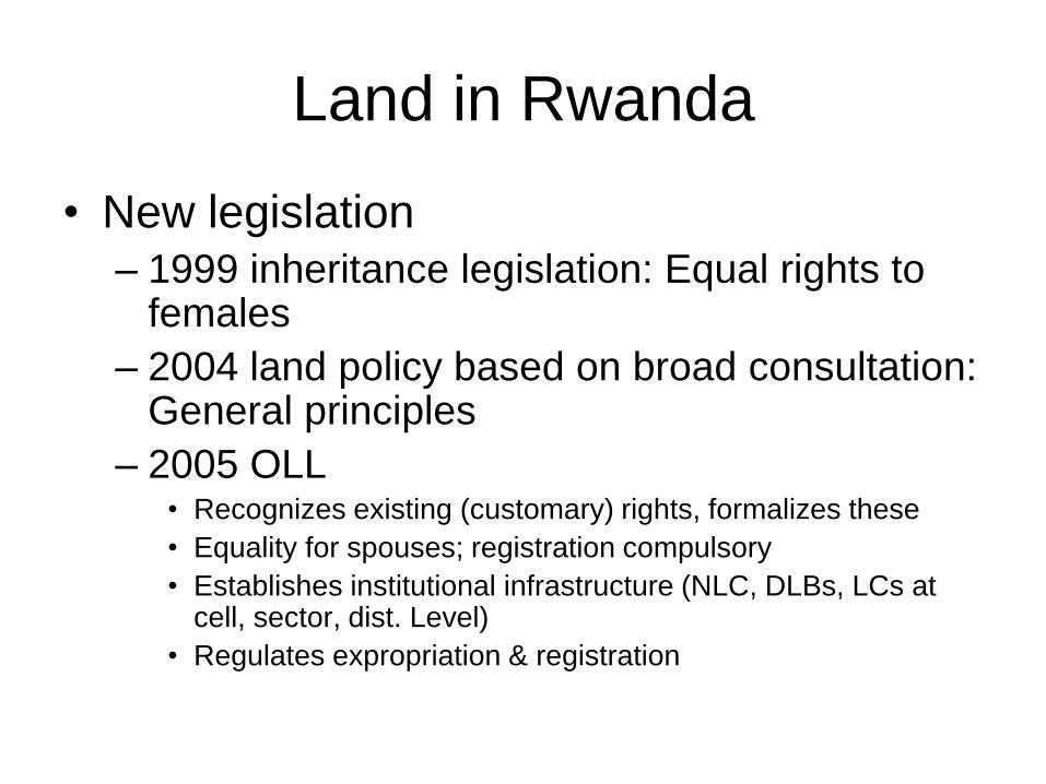
• New legislation
– 1999 inheritance legislation: Equal rights to females
– 2004 land policy based on broad consultation: General principles
– 2005 OLL • Recognizes existing (customary) rights, formalizes these
• Equality for spouses; registration compulsory
• Establishes institutional infrastructure (NLC, DLBs, LCs at cell, sector, dist. Level)
• Regulates expropriation & registration

Land in Rwanda
• Towards a national program
– Development of participatory, low-cost methodology
based on photomaps
– Fine-tuning of procedures in 4 trial cells reflecting
diversity of tenure situations 2006/7
– Launch of nation-wide program in 2009/10
– Currently 2.5 out of 11 mn. parcels registered
– Baseline IE survey is in the field

Outline
• Land tenure in Rwanda
• Program characteristics
• Sample & estimation strategy
• Data & descriptive statistics
• Econometric results
• Conclusions

Pilot registration: program basics
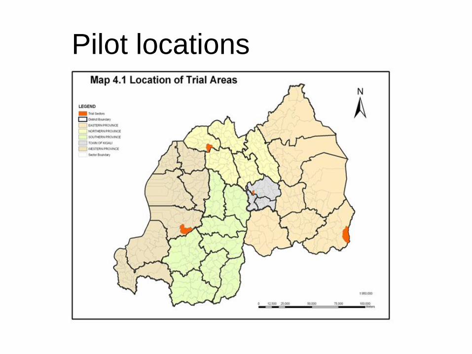
• Cells (4 of 2,146) were selected based on
differing tenure and land use situations
– Gatasta (Kigali, urban)
• High expropriation risk
• Interspersed with small agricultural plots
– Kabushenge (North, rural)
• Polygamy a major issue
– Biguhu (West, rural)
• Severely affected by genocide
– Mowga (East, rural)
• Past practice of land sharing leads to insecurity
• Boundaries well marked
Pilot registration: program basics
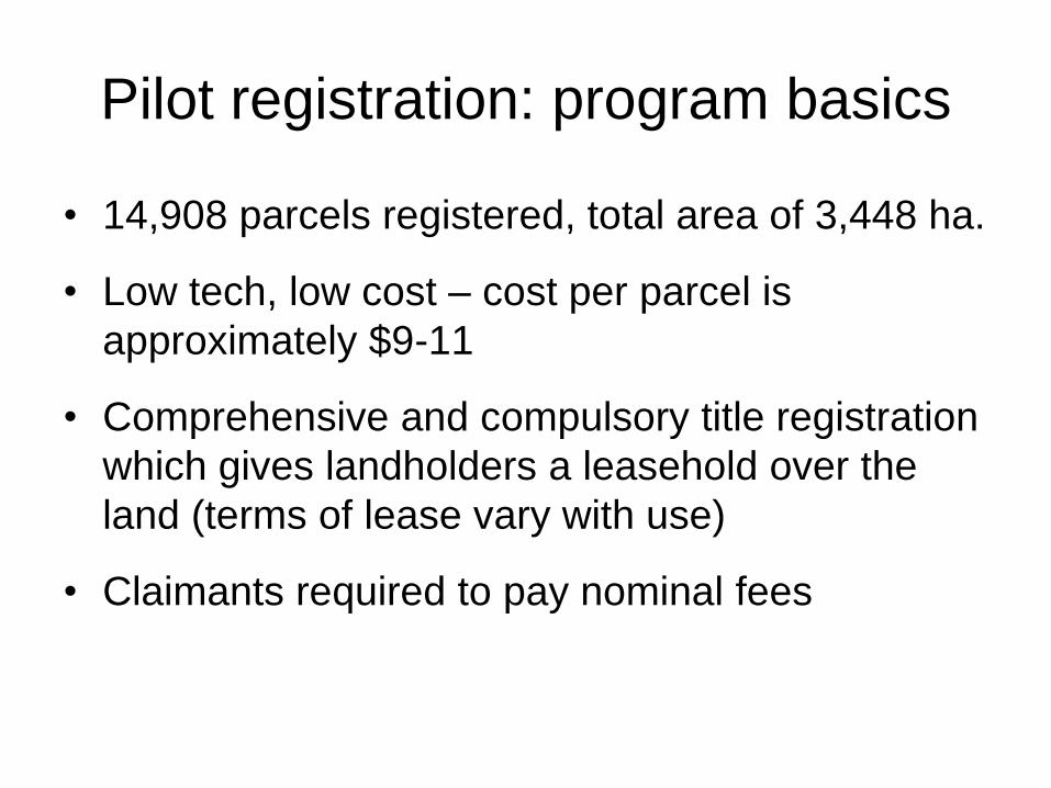
• 14,908 parcels registered, total area of 3,448 ha.
• Low tech, low cost – cost per parcel is
approximately $9-11
• Comprehensive and compulsory title registration
which gives landholders a leasehold over the
land (terms of lease vary with use)
• Claimants required to pay nominal fees
Pilot locations

Outline
• Land tenure in Rwanda
• Program characteristics
• Sample & estimation strategy
• Data & descriptive statistics
• Econometric results
• Conclusions

Estimation strategy
• We examine the effects of land
registration:
• Where Yph is the outcome of interest for parcel p
in household h, T is a title registration indicator,
X is a set of parcel characteristics, Z household
characteristics, and an error term.
phhphphph ZXTY 321

Endogenity
• If registration were voluntary, the
investment decisions, etc. would be
endogenous
• But here we have administrative units
(cells) in which registration is complete
and compulsory
• We will use the discontinuity provided by
the cell boundaries to identify effects

Sample Design

So our sample looks like this…

Estimation strategy
• Identification assumption: no other major policy or market conditions happen at the cell level to affect outcomes of interest
• Policies of interest happen at higher levels (soil = district, inheritance=national)
• In addition, we will use spatial fixed effects (Magruder 2010, G&U 2008, Conley & Udry 2008) to control for unobservable conditions (market and soil)
Outline
• Land tenure in Rwanda
• Program characteristics
• Sample & estimation strategy
• Data & descriptive statistics
• Econometric results
• Implications

Data• We undertook a quick, light survey during April-May
2010 (there was no usable baseline)
• 3560 households split across pilot cells and bordering cells
• Questions on hh included demographics, housing, assets, credit, registration participation and knowledge
• Questions on parcel included land characteristics, investment, inheritance, sales
• Took GPS readings of hh location
• The empirical results are based on the rural sample –not enough power in the urban sample
Outline
• Land tenure in Rwanda
• Program characteristics
• Sample & estimation strategy
• Data & descriptive statistics
• Econometric results
• Conclusions

Comparison of means Total Control Treatment
mean sd mean sd mean sd
Perceived risk of expropriation (1 if
yes) 0.72 0.45 0.74 0.44 0.68 0.47
***
Change in proportion of parcels receiving
soil conservation measures
Construction of new
conservation structures 0.07 0.43 0.04 0.42 0.10 0.44
***
Maintenance of existing
structures 0.09 0.37 0.07 0.35 0.11 0.38
***
New/maintenance of existing
Structures 0.14 0.51 0.10 0.50 0.19 0.52
***
Changed seed type from local to
improved variety since 2007 0.53 0.50 0.50 0.50 0.57 0.50
***
Female jointly or alone owns parcel 0.87 0.34 0.88 0.33 0.85 0.35 ***
Share of parcel owned by female (%) 42.55 27.40 42.14 27.12 43.11 27.77
Know who will inherit the parcel 0.64 0.48 0.60 0.49 0.69 0.46 ***
Sons will inherit parcel 0.74 0.44 0.72 0.45 0.77 0.42 ***
Daughters will inherit parcel 0.69 0.46 0.66 0.47 0.72 0.45 ***
Spouse will inherit parcel 0.32 0.47 0.34 0.47 0.29 0.45 ***
Children will inherit parcel 0.76 0.43 0.72 0.45 0.82 0.38 ***
Number of parcels 6312 3619 2693
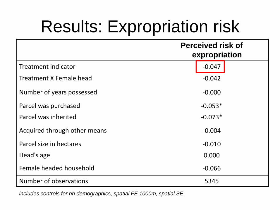
Results: Expropriation riskPerceived risk of
expropriation
Treatment indicator -0.047
Treatment X Female head -0.042
Number of years possessed -0.000
Parcel was purchased -0.053*
Parcel was inherited -0.073*
Acquired through other means -0.004
Parcel size in hectares -0.010
Head's age 0.000
Female headed household -0.066
Number of observations 5345
includes controls for hh demographics, spatial FE 1000m, spatial SE
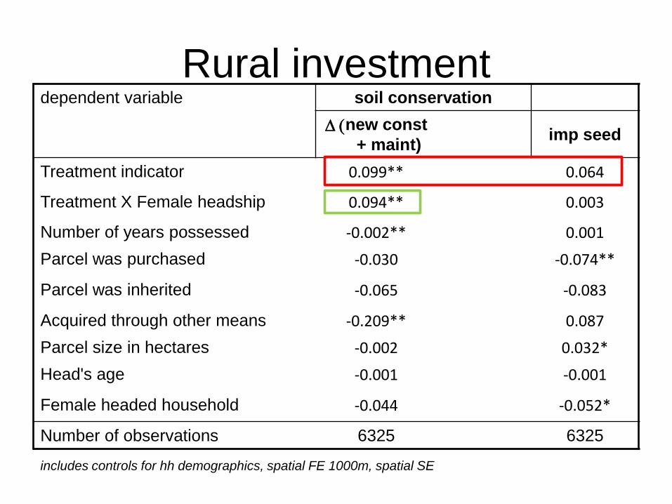
Rural investmentdependent variable soil conservation
D (new const
+ maint)imp seed
Treatment indicator 0.099** 0.064
Treatment X Female headship 0.094** 0.003
Number of years possessed -0.002** 0.001
Parcel was purchased -0.030 -0.074**
Parcel was inherited -0.065 -0.083
Acquired through other means -0.209** 0.087
Parcel size in hectares -0.002 0.032*
Head's age -0.001 -0.001
Female headed household -0.044 -0.052*
Number of observations 6325 6325
includes controls for hh demographics, spatial FE 1000m, spatial SE

Results: Women access to landFemale spouse/head owns
or co-owns plot
Treatment indicator -0.074**
Treatment X Marriage certificate 0.171***
Treatment X Female head with no spouse 0.143**
Has marriage certificate 0.075***
Female head with no spouse 0.094***
Male head with no spouse -0.837***
Number of observations 6209
includes controls for plot characteristics, hh demographics, spatial FE 1000m, spatial SE

Results: Inheritance
dependent variableknow
inherit
son
inherit
daughter
inherit
children
inherit
Treatment indicator 0.094** 0.102** 0.096** 0.133**
Treatment X Female head -0.044 -0.052 -0.158** -0.046
Number of years possessed 0.001 0.001 0.001 0.000
Parcel was purchased -0.008 0.043 0.008 -0.021
Parcel was inherited 0.026 0.072** 0.038 0.004
Acquired through other means -0.051 0.167* -0.030 0.025
Parcel size in hectares -0.023** 0.006 0.004 -0.012
Head's age 0.001 0.002 0.004** 0.003**
Female headed household 0.071* 0.210*** -0.003 0.094***
Number of observations 6325 4053 4053 6325
includes controls for hh demographics, spatial FE 1000m, spatial SE
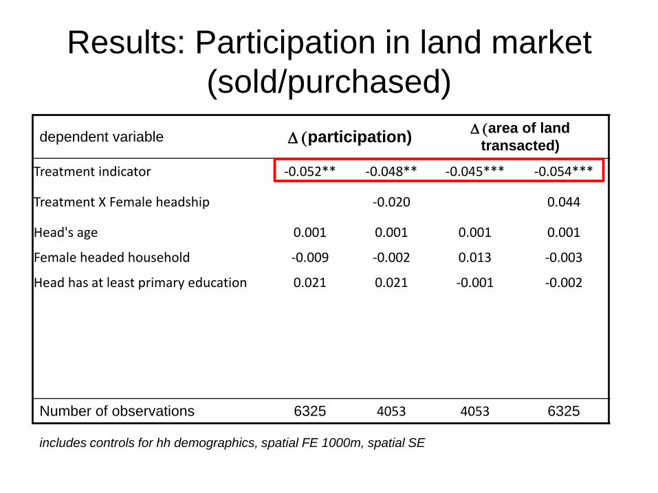
Results: Participation in land market
(sold/purchased)
dependent variable D (participation)D (area of land
transacted)
Treatment indicator -0.052** -0.048** -0.045*** -0.054***
Treatment X Female headship -0.020 0.044
Head's age 0.001 0.001 0.001 0.001
Female headed household -0.009 -0.002 0.013 -0.003
Head has at least primary education 0.021 0.021 -0.001 -0.002
Number of observations 6325 4053 4053 6325
includes controls for hh demographics, spatial FE 1000m, spatial SE
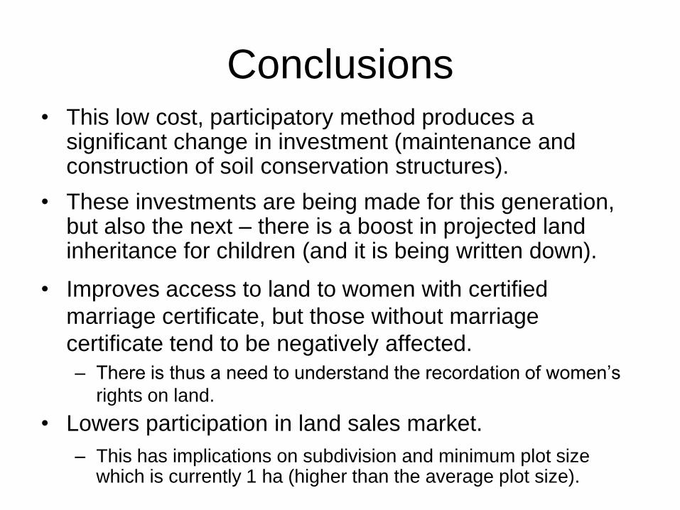
Conclusions• This low cost, participatory method produces a
significant change in investment (maintenance and construction of soil conservation structures).
• These investments are being made for this generation, but also the next – there is a boost in projected land inheritance for children (and it is being written down).
• Improves access to land to women with certified
marriage certificate, but those without marriage
certificate tend to be negatively affected.
– There is thus a need to understand the recordation of women’s
rights on land.
• Lowers participation in land sales market.
– This has implications on subdivision and minimum plot size which is currently 1 ha (higher than the average plot size).

Characteristics of pilot cells
• Gasabo (urban; pop 3,500/km2)– Thriving informal land market
– Great demand for legalization of existing informal land records
– Expropriation risk considerable
– Interspersed with small agric. plots
• Musanze (N; pop 769/km2)– Pressure on existing tenure system
– Polygamy a major issue & source of conflict
– Land allocation to refugees & soldiers causes additional conflict
– Highly fertile land
• Karongi (W; pop 337/km2)– Severely affected by genocide
– Some earlier efforts at land registration
• Kirehe (E; pop 274/km2)– Past practice of land sharing leads to insecurity
– Boundaries well marked; few conflicts; land quality marginal
– e

Explaining process and map

Field adjudication with neighbors

Locating parcels on the index map
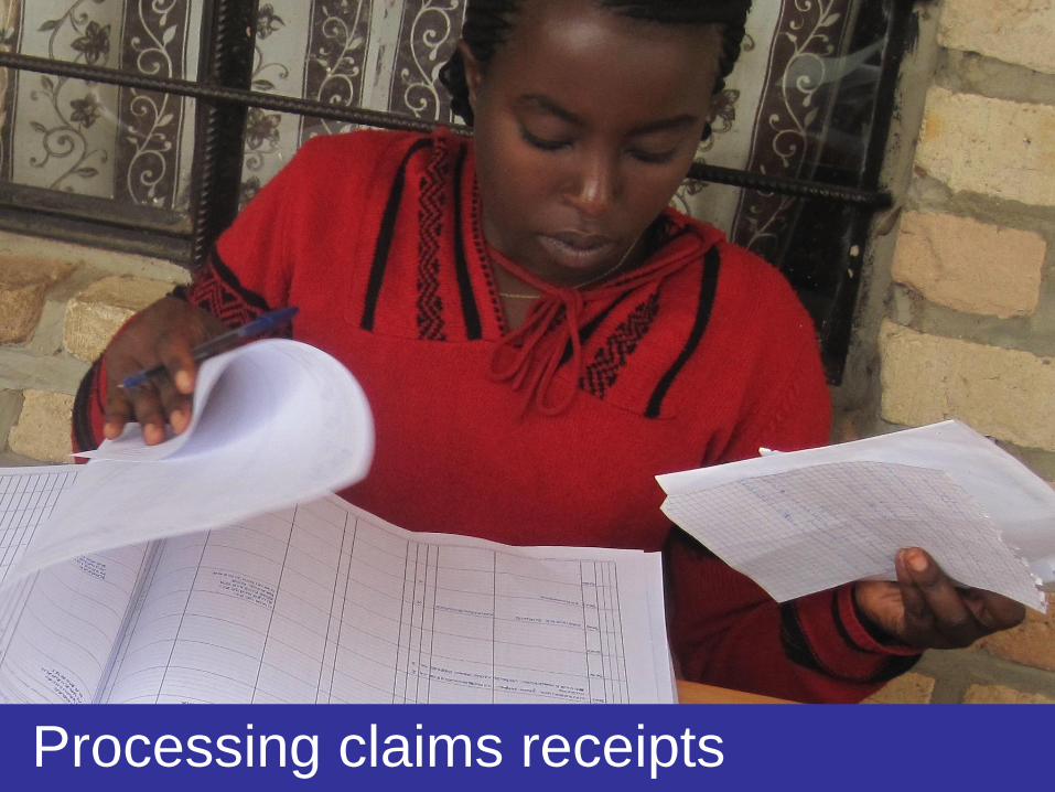
Processing claims receipts