the giyani gold project scoping report for a mining …
TRANSCRIPT

i
THE GIYANI GOLD PROJECT SCOPING REPORT FOR A
MINING RIGHT APPLICATION BY KUSILE INVEST 133
(PTY) LTD.
SUBMITTED FOR ENVIRONMENTAL AUTHORIZATIONS IN TERMS OF THE NATIONAL
ENVIRONMENTAL MANAGEMENT ACT, 1998 AND THE NATIONAL ENVIRONMENTAL
MANAGEMENT WASTE ACT, 2008 IN RESPECT OF LISTED ACTIVITIES THAT HAVE
BEEN TRIGGERED BY APPLICATIONS IN TERMS OF THE MINERAL AND PETROLEUM
RESOURCES DEVELOPMENT ACT, 2002 (MPRDA) (AS AMENDED).
Reference Number: LP 30/5/1/2/2 10188MR
Compiled By:
ARCHEAN RESOURCES PTY LTD
Date: 10 July 2020

ii
REPORT INFORMATION
Report Title:
Scoping Report for the Gold underground and surface mining right
application on Un-Surveyed State land of Greater Giyani 891 LT and a
portion of portion 0 of the farm 246 located in the Greater Giyani
Municipality, within Mopani District Municipality in Limpopo Province.
Report Reference: Scoping report for the proposed Giyani Gold Mine Project
Reference LP 30/5/1/2/2 10188MR
Report Status: Draft report for I&AP comments
REVISION DATE REASON FOR CHANGE
001 10 July 2020- 17 August 2020 Draft Scoping
002 18 August 2020
Final Scoping Report: Additional
Environmental information and
consolidation of I&AP comments
DETAILS OF APPLICANT AND EAP
Table 1: Applicant Details
NAME OF APPLICANT Kusile Invest 133 (Pty) Ltd
CONTACT PERSON Mzamani Mdaka
EMAIL: [email protected]
POSTAL ADDRESS: P O Box 4603, Weltevreden Park, 1715
PHYSICAL ADDRESS: 2 Wilhelmina Avenue, 698 Strubens Ridge Estate, Allens
Next Ext 21, Roodepoort, 1737
FILE REFERENCE NUMBER DMR: LP 30/5/1/2/2 10188MR
Contact Person and correspondence address
Table 2: EAP Details
Company: ARCHEAN RESOURCES (PTY) LTD
Contact Person (s) Yvonne Gutoona
Address 5 Villa Serring, Wapadrand Road, Wapadrand, Pretoria
Cell Phone 082 970 1513
Fax Number 0866955990

3
EXECUTIVE SUMMARY
Kusile Invest 133 (Pty) Ltd has appointed Archean Resources (Pty) Ltd, an independent consulting
company, to conduct an Environmental Impact Assessment (EIA) process to evaluate the potential
environmental and social impacts of the proposed project. The project is referred to as the Giyani Gold
Mine Project. The applicant Kusile Invest has lodged a mining right on Un-Surveyed State land of Greater
Giyani 891 LT and a portion of portion 0 of the farm 246 located within the town of Giyani, Limpopo
Province. and intends to establish an underground and open cast mine. The mine development activities
will commence by establishing and installing the required mining infrastructure such as pit establishment,
shaft headgear and winders, service water, compressed air and power supply, processing plant and
installation of surface ventilations fans. The type and size of the mining infrastructure to be installed will
be designed to support the proposed Life of Mine (LOM) production rate of 12 000 tons per month of Run
of Mine material (ROM) for 30 (thirty) years.
In terms of the National Environmental Management Act (NEMA), in addition to the mining right
application submitted to the DMR an Environmental Authorisation needs to be applied for. An integrated
scoping and environmental impact assessment process will be conducted for the Environmental
Authorisation application, and Water Use License application for the mining right application. The
applicant is doing an integrated application process for a Scoping and Environmental Impact Assessment
in terms of the National Environmental Management ACT (NEMA): EIA Regulations 2017. An application
for Environmental Authorisation (EA) in term of Section 16 of the NEMA EIA 2017 regulations was
submitted to the DMR. Kusile Invest 133 (Pty) Ltd holds the following prospecting right (PR) and mining
permit which form part of the mining application:
• (LP) 30/5/1/1//2/2724 PR on Un-Surveyed State land of Greater Giyani 891 LT and a portion
of portion 0 of the farm 246.
• (LP) 30/5/1/3/2/10708MP on Un-Surveyed State land of Greater Giyani 891 LT.
According to the EIA Regulations, Interested and Affected Parties (I&APs) must have the opportunity to
comment on the proposed project and verify that all the issues raised during the Scoping Phase have
been recorded. This is the main purpose of the Scoping Report (SR), which will be available for public
comment for the 30-day period. Comments received during this phase will be considered and addressed
in the Environmental Impact Assessment (EIA/EMPr) which will be submitted to the competent authority
Department of Minerals (DMR) for approval.
AN EIA CONSISTS OF THE FOLLOWING PHASES

4
Purpose of this Report
This report addresses the requirements for Scoping Phase and the Plan of Study (PoS) for the
Environmental Authorisation Process as outlined in the NEMA regulations and the MPRDA regulations.
The aim of this SR is to:
➢ Provide information to the authorities as well as interested and affected parties (I&APs) on the
proposed project;
➢ Provide information regarding alternatives that are being considered;
➢ Indicate how I&APs have been and are still being afforded the opportunity to contribute to the
project, verify that the issues raised during the scoping phase are incorporated in the impact
assessment phase of the environmental authorization process;
➢ Describe the baseline receiving environment;
➢ Define the Terms of Reference (ToR) for specialist studies to be undertaken in the Impact
Assessment Phase of the EIA; and
➢ Present the findings of the Scoping Phase in a manner that facilitates input by the I&AP’s and
decision-making by the relevant authorities.
The Process
As part of the project, the environmental authorizations and licenses required to start the mining need to
be obtained. In order to do so, a Scoping and Environmental Impact Assessment Process (S&EIR) is
being undertaken in line with the provisions of the National Environmental Management Act (EIA
regulations of April 2017). The S&EIR process and specialist studies to be undertaken will also support
the applications for the required licenses and environmental authorizations.
The EIA findings are used by the applicant and authorities to obtain an objective view of the potential
environmental, social and cultural impacts that could arise during the mining of the proposed area.
Measures for the avoidance or mitigation of negative impacts will be proposed and positive impacts will
be enhanced. The outcome of the first phase of the S&EIR is the Scoping Report, which provides the
basis for undertaking the Impact Assessment Phase of the project.

5
The process is summarized in the illustration below
Environmental Baseline and Potential Impacts
The mining right area has been identified in Giyani and this assessment is aimed at identifying the general
environmental sensitivities across the mining right area. This will involve desktop plus specialist studies
and draws extensively on information contained in these studies. To assess these potential impacts the
following baseline information will be assessed:
➢ Air quality impact assessment;
➢ Geo - Hydrological assessment (Underground and Surface water)
➢ Ecological Assessment;
➢ Soil and land Capability;
➢ Social Impact Assessment;
➢ Visual Impact Assessment;
➢ Noise & Air Quality Impact;
➢ Traffic Impact; and
➢ Heritage Impact Assessment
➢ Paleontological Assessment
The following key environmental issues – potential negative impacts and potential benefits – have been
identified:
• Ecology - Introduction of invader species; and the loss of freshwater resources, such as wetlands
and pans and riparian habitat (although, where feasible and ecologically viable, these areas will
not be mined);

6
• Botany - Potential loss of vegetation, habitat and endemic species;
• Soils, land use and land capability – Potential loss of agricultural potential;
• Terrestrial fauna – potential impact on faunal habitats;
• Surface and Ground water – Potential impact on surface water quality and flows;
• Visual and Sense of Place – Visual impacts associated with mining infrastructure, landscape
alteration and vegetation loss;
• Socio-economic – Job security, continued investment in local economy and negative impacts
associated with mine closure; and
• Heritage – Potential impacts on sites of archaeological or palaeontological significance.
Way Forward
The EIA process is being carried out in accordance with the NEMA 2017 EIA regulations and the public
participation will be in line with the GOVERNMENT GAZETTE No. 43412, published on the 5 JUNE 2020
by the Department of Environment, Forestry and Fisheries. Each of the specialist’s studies will undertake
a detailed EIA assessment. Included in this report is a detailed plan of study provided by each of the
appointed specialists to be implemented during the EIA phase. Potential impacts identified during the
Scoping and EIA will be assessed by the specialists for each feasible development alternative and for
each phase of the project. The EIA and specialist studies will provide input into the EMPR which will
provide the necessary action plans and management measures to mitigate the identified impacts.
This Scoping study has been undertaken with the aim of identifying potential positive and negative
impacts on the environment and gathering issues, concerns and queries from I&APs. The Scoping report
documents the process followed, the findings and recommendations of the Scoping Phase study, and
the proposed Plan of Study for the EIA Phase to follow.
The way forward recommended by this study is as follows:
➢ Make the Scoping Report available for public comment for a period of 30 calendar days;
➢ Submit the Scoping Report to the competent authority for permission to undertake the Impact
Assessment Phase of the project;
➢ Upon approval of the Scoping Report, all I&APs are to be notified of the conditions of the
Department of Mineral Resources for proceeding with the Impact Assessment Phase of the
project;
➢ Execute the Plan of Study for Impact Assessment during the Impact Assessment Phase of the
project.

7
TABLE OF CONTENTS
1 PROJECT INFORMATION --------------------------------------------------------------------------------- 15
1.1 Introduction --------------------------------------------------------------------------------------------------------------------------------------- 15
1.2 Purpose of the report --------------------------------------------------------------------------------------------------------------------------- 17
1.3 Assumptions and Limitations ---------------------------------------------------------------------------------------------------------------- 17
1.4 Description of the property and Locality ------------------------------------------------------------------------------------------------- 17
2 DESCRIPTION OF THE SCOPE OF THE PROPOSED OVERALL ACTIVITY ---------------------- 21
2.1 Description of the activities to be undertaken ------------------------------------------------------------------------------------------ 22
2.2 Mining Right: Description of Mining Method ------------------------------------------------------------------------------------------- 23
2.2.1 Mining – Mining Method ------------------------------------------------------------------------------------------------------------------- 24
2.3 High level description of the processing plant ------------------------------------------------------------------------------------------ 26
2.4 Summary of infrastructure such as roads, rail, electricity and water ------------------------------------------------------------ 29
2.4.1 Access roads ----------------------------------------------------------------------------------------------------------------------------------- 29
2.4.2 Rail Infrastructure ---------------------------------------------------------------------------------------------------------------------------- 29
2.4.3 Power Supply - Electricity------------------------------------------------------------------------------------------------------------------- 29
2.4.4 Water Supply----------------------------------------------------------------------------------------------------------------------------------- 30
2.4.5 Site Offices -------------------------------------------------------------------------------------------------------------------------------------- 30
2.4.6 Surface infrastructure ----------------------------------------------------------------------------------------------------------------------- 31
2.5 Minerals applied for: ---------------------------------------------------------------------------------------------------------------------------- 32
3 POLICY AND LEGISLATIVE CONTEXT ----------------------------------------------------------------- 33
3.1.1 The South African Constitution ----------------------------------------------------------------------------------------------------------- 33
3.1.2 National Environmental Management Act--------------------------------------------------------------------------------------------- 34
3.1.3 Mineral and Petroleum Resources Development Act ------------------------------------------------------------------------------- 36
3.1.4 National Environmental Management: Biodiversity Act, 2004 (Act 10 of 2004) -------------------------------------------- 37
3.1.5 National Forest Act, 1998 (Act 84 of 1998) -------------------------------------------------------------------------------------------- 38
3.1.6 National Environmental Management: Air Quality Act (Act No 39 of 2004) ------------------------------------------------- 38
3.1.7 Conservation of Agricultural Resources Act (Act 43 of 1983) --------------------------------------------------------------------- 39
3.1.8 National Environmental Management: Waste Act (Act 59 of 2008) ------------------------------------------------------------ 39
3.1.9 Occupational Health and Safety Act (Act 85 of 1993) ------------------------------------------------------------------------------- 40
3.1.10 National Heritage Resources Act ------------------------------------------------------------------------------------------------------ 42
3.1.11 National Water Act, 1998 (Act No.36 of 1998) ------------------------------------------------------------------------------------ 45
3.2 Provincial Legislative Framework ----------------------------------------------------------------------------------------------------------- 47
3.2.1 Applicable Legislation and Approvals Required -------------------------------------------------------------------------------------- 47

8
4 PROJECT ALTERNATIVES -------------------------------------------------------------------------------- 49
4.1 Feasible alternatives ---------------------------------------------------------------------------------------------------------------------------- 50
4.1.1 Location ----------------------------------------------------------------------------------------------------------------------------------------- 50
4.1.2 Activity ------------------------------------------------------------------------------------------------------------------------------------------- 50
4.1.3 Design -------------------------------------------------------------------------------------------------------------------------------------------- 50
4.1.4 Technological ---------------------------------------------------------------------------------------------------------------------------------- 50
4.1.5 Operational Aspects ------------------------------------------------------------------------------------------------------------------------- 50
4.1.6 No Project Alternative ----------------------------------------------------------------------------------------------------------------------- 51
4.1.7 Need and desirability of the proposed activities. ------------------------------------------------------------------------------------ 51
5 PUBLIC PARTICIPATION ( REFER TO APPENDIX 4 – 15 FOR PROOF OF PRELIMINARY
CONSULTATION) ------------------------------------------------------------------------------------------------ 53
5.1 Public Participation Process Followed to be followed -------------------------------------------------------------------------------- 53
5.1.1 Landowner Information and consultation --------------------------------------------------------------------------------------------- 53
5.2 I&AP and Stakeholder identification, registration and the creation of an electronic database -------------------------- 54
5.2.1 Formal notification of the application to key Interested and Affected Parties (adjacent landowners) and other
stakeholders ---------------------------------------------------------------------------------------------------------------------------------------------- 54
5.2.2 Consultation and correspondence with I&AP’s and Stakeholders and the addressing of their comments
(continuous). ---------------------------------------------------------------------------------------------------------------------------------------------- 55
5.2.3 Release of the revised and amended Scoping Report to I&AP’s and stakeholders for review and comment. ------ 55
5.3 Next Phases of the Public Participation Process ---------------------------------------------------------------------------------------- 56
5.4 Summary of issues raised by I&AP’s ------------------------------------------------------------------------------------------------------- 56
6 BASELINE RECEIVING ENVIRONMENT ---------------------------------------------------------------- 57
6.1 Regional Setting ---------------------------------------------------------------------------------------------------------------------------------- 57
6.2 Baseline Environmental attributes associated with the sites----------------------------------------------------------------------- 60
6.2.1 Site Assessment ------------------------------------------------------------------------------------------------------------------------------- 60
6.2.2 Climate ------------------------------------------------------------------------------------------------------------------------------------------ 60
6.2.3 Regional Geology ----------------------------------------------------------------------------------------------------------------------------- 61
6.2.4 Project Geological Setting ------------------------------------------------------------------------------------------------------------------ 63
6.2.5 Soils ----------------------------------------------------------------------------------------------------------------------------------------------- 67
6.2.6 Biodiversity ------------------------------------------------------------------------------------------------------------------------------------- 68
6.2.7 Topography ------------------------------------------------------------------------------------------------------------------------------------- 70
6.2.8 Surface Hydrology ---------------------------------------------------------------------------------------------------------------------------- 71
6.2.9 Heritage ----------------------------------------------------------------------------------------------------------------------------------------- 72
6.2.10 Socio economic ---------------------------------------------------------------------------------------------------------------------------- 72
7 ENVIRONMENTAL IMPACT ASSESSMENT ------------------------------------------------------------ 77
9
7.1 Assessment Criteria ----------------------------------------------------------------------------------------------------------------------------- 77
7.1.1 Extent -------------------------------------------------------------------------------------------------------------------------------------------- 77
7.1.2 Duration ----------------------------------------------------------------------------------------------------------------------------------------- 77
7.1.3 Intensity ----------------------------------------------------------------------------------------------------------------------------------------- 78
7.1.4 Probability -------------------------------------------------------------------------------------------------------------------------------------- 78
7.1.5 Mitigation --------------------------------------------------------------------------------------------------------------------------------------- 79
7.2 Determination of significance – Without Mitigation ---------------------------------------------------------------------------------- 79
7.3 Determination of significance – With Mitigation--------------------------------------------------------------------------------------- 80
7.3.1 Assessment weighting ----------------------------------------------------------------------------------------------------------------------- 81
7.3.2 Ranking, Weighting and Scaling ----------------------------------------------------------------------------------------------------------- 81
7.3.3 Identifying the Potential Impacts without Mitigation (WOM) -------------------------------------------------------------------- 81
7.3.4 Identifying the Potential Impacts with Measures (WM) --------------------------------------------------------------------------- 82
7.3.5 Impacts identified ---------------------------------------------------------------------------------------------------------------------------- 82
7.3.6 The positive and negative impacts that the proposed activity (in terms of the initial site layout) and alternatives
will have on the environment and the community that may be affected. --------------------------------------------------------------- 88
7.3.7 The possible mitigation measures that could be applied and the level of risk. ---------------------------------------------- 88
7.3.8 Draft Site Layout Plan ------------------------------------------------------------------------------------------------------------------------ 89
7.4 Plan of study for the Environmental Impact Assessment process ---------------------------------------------------------------- 89
7.4.1 Description of the aspects to be assessed as part of the environmental impact assessment process ---------------- 90
Specialist Studies --------------------------------------------------------------------------------------------------------------------------------------- 92
7.4.2 Description of aspects to be assessed by specialists -------------------------------------------------------------------------------- 92
7.4.3 Proposed method of assessing the environmental aspects including the proposed method of assessing
alternatives ------------------------------------------------------------------------------------------------------------------------------------------------ 94
7.4.4 The stages at which the competent authority will be consulted ---------------------------------------------------------------- 97
8 PUBLIC PARTICIPATION DURING THE EIA PHASE ------------------------------------------------ 98
8.1 Particulars of the public participation process with regard to the Impact Assessment process that will be
conducted ----------------------------------------------------------------------------------------------------------------------------------------------------- 98
8.2 Details of the engagement process to be followed ------------------------------------------------------------------------------------ 99
8.3 Description of the information to be provided to Interested and Affected Parties ---------------------------------------- 100
8.4 Description of the tasks that will be undertaken during the environmental impact assessment process ---------- 100
9 MITIGATION MEASURES ------------------------------------------------------------------------------- 103
9.1 Measures to avoid, reverse, mitigate, or manage identified impacts and to determine the extent of the residual
risks that need to be managed and monitored -------------------------------------------------------------------------------------------------- 103
9.2 Other Information required by the competent Authority ------------------------------------------------------------------------- 105

10
9.2.1 Impact on the socio-economic conditions of any directly affected person. ------------------------------------------------ 105
9.2.2 Impact on any national estate referred to in section 3(2) of the National Heritage Resources Act. ----------------- 105
9.2.3 Potential Cumulative impact and mitigation measures -------------------------------------------------------------------------- 105
10 RECOMMENDATIONS --------------------------------------------------------------------------------- 106
10.1 Undertaking Regarding Correctness of Information --------------------------------------------------------------------------------- 106 LIST OF FIGURES
FIGURE 1: REGULATION MAP ................................................................................................................................................................ 18
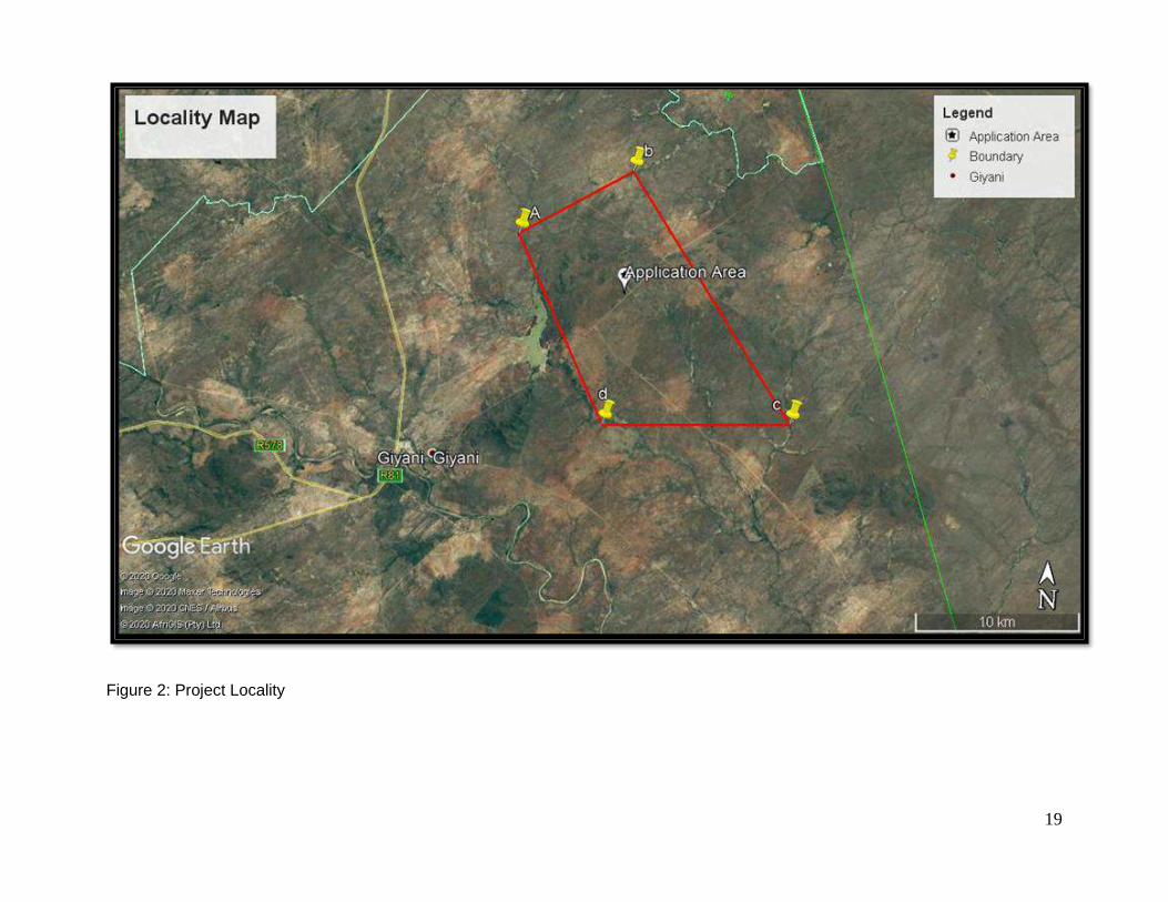
FIGURE 2: PROJECT LOCALITY ............................................................................................................................................................. 19
FIGURE 3: PROPOSED SITE LAYOUT .................................................................................................................................................. 20
FIGURE 4: SCHEMATIC DIAGRAM OF PROPOSED MINING METHODS (OPEN CAST AND UNDERGROUND) .................. 25
FIGURE 5: SCHEMATIC LAYOUT OF PROCESSING PLANT ........................................................................................................... 28
FIGURE 6: LOCATION OF THE LIMPOPO PROVINCE OF SOUTH AFRICA. ................................................................................. 58
FIGURE 7: LOCATION OF THE PROJECT IN THE GIYANI MUNICIPALITY. .................................................................................. 59
FIGURE 8: RAINFALL AVERAGE ............................................................................................................................................................ 61
FIGURE 9: THE REGIONAL GEOLOGICAL SETTING AND DEPOSITIONAL ENVIRONMENT ................................................... 62
FIGURE 10: REGIONAL STRUCTURE ALONG THE GIYANI GREENSTONE BELT ..................................................................... 63
FIGURE 11: LOCAL GEOLOGICAL SETTING AND DEPOSITIONAL ENVIRONMENT ................................................................. 64
FIGURE 12: GIYANI GOLD PROJECT LOCALITY PLAN .................................................................................................................... 64
FIGURE 13: GEOLOGICAL STRUCTURE OF THE GIYANI GREENSTONE BELT. ....................................................................... 65
FIGURE 14: DEPOSITIONAL ENVIRONMENTS WITHIN THE GIYANI GREENSTONE BELT ..................................................... 66
FIGURE 15: SOILS ...................................................................................................................................................................................... 67
FIGURE 16: LAND TYPE ........................................................................................................................................................................... 68
FIGURE 17: VEGETATION ........................................................................................................................................................................ 69
FIGURE 18: CONSERVATION STATUS ................................................................................................................................................. 70
FIGURE 19: SOTER LANDFORMS .......................................................................................................................................................... 71
FIGURE 20: POPULATION PER AGE AND GENDER .......................................................................................................................... 73
FIGURE 21: EDUCATIONAL INSTITUTIONS BEING ATTENDED ..................................................................................................... 74
FIGURE 22: LABOUR FORCE .................................................................................................................................................................. 75
FIGURE 23: LABOUR STATUS ................................................................................................................................................................ 75
FIGURE 24: POPULATION BY INDIVIDUAL MONTHLY INCOME, GREATER GIYANI, 2011 & 2016......................................... 76
FIGURE 25: DESCRIPTION OF BIOPHYSICAL ASSESSMENT PARAMETERS WITH ITS RESPECTIVE WEIGHTING........ 81
FIGURE 26: PROPOSED SITE LAYOUT ................................................................................................................................................ 89
LIST OF TABLES
TABLE 1: APPLICANT DETAILS ................................................................................................................................................................ II
TABLE 2: EAP DETAILS .............................................................................................................................................................................. II
TABLE 3: PROJECT DETAILS .................................................................................................................................................................. 17
TABLE 4: NEMA LISTED ACTIVITIES ..................................................................................................................................................... 21
TABLE 5: PLANNED MINE POWER USAGE ......................................................................................................................................... 29
TABLE 6: SUMMARY OF KEY WATER USES ....................................................................................................................................... 46
TABLE 7: PROVINCIAL LEGISLATION, POLICIES AND GUIDELINES CONSIDERED ................................................................. 47
TABLE 8: LIST OF POTENTIAL IMPACTS ............................................................................................................................................. 86
TABLE 9: MITIGATION MEASURES .................................................................................................................................................... 103
TABLE 10: CUMULATIVE IMPACTS AND MITIGATION MEASURES ............................................................................................ 105

11
LIST OF APPENDICES
Appendix 1 - Environmental Screening Report
Appendix 2 - NEMA EA Application
Appendix 3 -Tittle Deed
Appendix 4 – Regulation Plan
Appendix 5 - Background information and Notification document
Appendix 6 - Giyani MR Advert English
Appendix 7 - Giyani MR Advert Xitsonga
Appendix 8 - Giyani MR Site Notice Xitsonga
Appendix 9 - Giyani MR Site Notice English
Appendix 10 - Tribal Authority Proof of submission
Appendix 11 - Door to Door Confirmation of notification
Appendix 12 - Tribal Meeting Attendance Register
Appendix 13 - Tribal Council Notification Meeting Attendance Register
Appendix 14 - Comment form
Appendix 15 – List of Interested and affected Parties

12
LIST OF ABBREVIATIONS
AIA Archaeological Impact Assessment
ASAPA Association of Southern African Professional Archaeologists
BID Background Information Document
CA Competent Authority
CARA Conservation of Agricultural Resources Act (Act 43 of 1983)
CSA Constitution of South Africa (Act No. 108 of 1996)
DEA Department of Environmental Affairs
LEDET Limpopo Department of Economic Development, Environment and Tourism
DMR Department of Mineral Resources
DWS Department of Water and Sanitation
EA Environmental Authorisation
EAP Environmental Assessment Practitioner
ECA Environment Conservation Act (ECA), 1989 (Act No. 73 of 1989)
EIA Environmental Impact Assessment
EIAR Environmental Impact Assessment Report
GN Government Notice
HIA Heritage Impact Assessment
I&APs Interested and Affected Parties
IEM Integrated Environmental Management
IWULA Integrated Water Use License Application
IWWMP Integrated Water and Waste Management Plan
MPRDA Minerals and Petroleum Resources Development Act (Act No. 28 of 2002) (as amended)
NEMA National Environmental Management Act (EIA regulations of April 2017)
NEMAQA National Environmental Management: Air Quality Act (Act No. 39 of 2004)
NEMBA National Environmental Management: Biodiversity Act, 2004 (Act No. 10 of 2004)
NEMWA National Environmental Management: Waste Act (Act No. 59 of 2008)
NHRA National Heritage Resources Act, 1999 (Act No. 25 of 1999)
NWA National Water Act, 1998 (Act No. 36 of 1998)
OHSA Occupational Health and Safety Act (Act No. 85 of 1993)
PPP Public Participation Process
SAHRA South African Heritage Resources Agency
SANBI South African National Biodiversity Institute
SR Scoping Report

13
GLOSSARY OF TERMS
Anthropogenic: Change induced by human intervention.
Applicant: Any person who applies for an authorisation to undertake an activity or undertake an
Environmental Process in terms of the Environmental Impact Assessment (EIA) Regulations – National
Environmental Management Act (EIA regulations of April 2017) as contemplated in the scheduled
activities listed in Government Notice (GN) No 983, 984 and 985 (2014 listing number still apply).
Archaeological resources: This includes:
• material remains resulting from human activity which are in a state of disuse and are in or on land
and which are older than 100 years including artefacts, human and hominid remains and artificial
features and structures;
• rock art, being any form of painting, engraving or other graphic representation on a fixed rock surface
or loose rock or stone, which was executed by human agency and which is older than 100 years,
including any area within 10m of such representation;
• wrecks, being any vessel or aircraft, or any part thereof which was wrecked in South Africa, whether
on land, in the internal waters, the territorial waters or in the maritime culture zone of the republic as
defined in the Maritimes Zones Act, and any cargo, debris or artefacts found or associated therewith,
which is older than 60 years or which South African Heritage Resources Agency (SAHRA) considers
to be worthy of conservation; features, structures and artefacts associated with military history which
are older than 75 years and the site on which they are found.
Biodiversity: The variety of life in an area, including the number of different species, the genetic wealth
within each species, and the natural areas where they are found.
Cultural significance: This means aesthetic, architectural, historical, scientific, social, spiritual, linguistic
or technological value or significance.
Cumulative Impact: In relation to an activity, cumulative impact means the impact of an activity that in
itself may not be significant, but may become significant when added to the existing and potential impacts
eventuating from similar or diverse activities or undertakings in the area.
Environment: All physical, chemical and biological factors and conditions that influence an object.

14
Environmental Impact Assessment: In relation to an application, to which Scoping must be applied,
means the process of collecting, organising, analysing, interpreting and communicating information that
is relevant to the consideration of the application.
Environmental Impact Assessment Report: In-depth assessment of impacts associated with a
proposed development. This forms the second phase of an EIA and follows on the Scoping Report (SR).
Heritage resources: This means any place or object of cultural significance. See also archaeological
resources above.
Precipitation: Any form of water, such as rain, snow, sleet, or hail that falls to the earth's surface.
Red Data species: All those species included in the categories of endangered, vulnerable or rare, as
defined by the International Union for the Conservation of Nature and Natural Resources.
Riparian: The area of land adjacent to a stream or river that is influenced by stream induced or related
processes.

15
1 PROJECT INFORMATION
1.1 Introduction
Kusile Invest 133 (Pty) Ltd has appointed Archean Resources (Pty) Ltd, an independent consulting
company, to conduct an Environmental Impact Assessment (EIA) process to evaluate the potential
environmental and social impacts of the proposed project. The project is referred to as the Giyani Gold
Mine Project. The applicant Kusile Invest has lodged a mining right on Un-Surveyed State land of Greater
Giyani 891 LT and a portion of portion 0 of the farm 246 located within the town of Giyani, Limpopo
Province and intends to establish an underground and open cast mine.
The mine development activities will commence by establishing and installing the required mining
infrastructure such as pit establishment, shaft headgear and winders, service water, compressed air and
power supply, processing plant and installation of surface ventilations fans. The type and size of the
mining infrastructure to be installed will be designed to support the proposed Life of Mine (LOM)
production rate of 12 000 tons per month of Run of Mine material (ROM) for 30 (thirty) years.
Mining operations will commence from five open cast pits which will later be developed into underground
workings and expand into four working levels to reach the steady state production of 12 000 tons per
month. Additional working areas will be established for sustainability and to replace the depletion of ore
reserves being mined from the start-up working areas.
The open pit mine design shows the orebody being located centrally to the pit outer walls or pit shell.
The waste surrounding the orebody will be stripped, with topsoil stored separately from waste rock for
re-use during rehabilitation of the pit at closure of mining operations. The stripping will include the removal
of surrounding topsoil and waste rock to fully expose the orebody and have enough area for movement
of machinery inside the pit.
The sidewalls of the excavation, surrounding the orebody, referred to as Benches, will be excavated at
intervals to a maximum depth 12 metres and must be slanted to ensure slope stability as per
specifications determined by the project’s Rock Engineering expert. The pit development will include the
creation of Berms, representing the flat area or horizontal distance of approximately 5 metres in width,
when measured from the bottom of the preceding or top bench to the edge of the next bench as the pit
goes dipper. An access ramp and haul road will also be created from the top bench on the outer limits of
the pit, traversing the lower benches in order to have mining equipment and personnel accessing the pit
floor where excavating or blasting of the ore bearing rock will be conducted.

16
The pit will be excavated to an optimal operating final depth of 400 metres below surface level, thereafter,
the conversion of the mining operation from open pit to underground mining operation will be affected.
The timing for the development of the underground mining infrastructure will be scheduled to reach its
completion such that the commencement of underground operations will overlap with the final phase of
the open pit mining operation for a period of 6 months. The basic design or layout for the underground
mining operation, entails the conventional use of shafts and declines, with the development of footwall
haulages, cross-cuts and raise-lines to establish conventional steep stoping and cut and fill mining
panels.
In terms of the National Environmental Management Act (NEMA), in addition to the mining right
application submitted to the DMR an Environmental Authorisation needs to be applied for. An integrated
scoping and environmental impact assessment process will be conducted for the Environmental
Authorisation application, and Water Use License application for the mining right application. The
applicant is doing an integrated application process for a Scoping and Environmental Impact Assessment
in terms of the National Environmental Management ACT (NEMA): EIA Regulations 2017. An application
for Environmental Authorisation (EA) in term of Section 16 of the NEMA EIA 2017 regulations was
submitted to the DMR. Kusile Invest 133 (Pty) Ltd holds the following prospecting right (PR) and mining
permit which form part of the mining application:
• (LP) 30/5/1/1//2/2724 PR on Un-Surveyed State land of Greater Giyani 891 LT and a portion
of portion 0 of the farm 246.
• (LP) 30/5/1/3/2/10708MP on Un-Surveyed State land of Greater Giyani 891 LT.
The report has been designed to meet the requirements for conducting an Environmental Impact
Assessment (EIA) and Environmental Management Programme (EMPR) as stipulated in the Regulations
contained in both the Mineral and Petroleum Resources Development Act (Act No. 28 of 2002-MPRDA)
and National Environmental Management Act (EIA regulations of April 2017) respectively.
The National Water Act 36 of 1998 (NWA) specifies certain activities that require registration or licensing
from the Department of Water Affairs (DWA). Given the nature of the receiving environment and the
occurrence of certain drainage and water features the mine will require a Water Use Licence (WUL). The
EIA and a separate Technical Motivation Report are required to inform the decision to issue a Water Use
Licence. This application will be made concurrently with the current EIA process, including stakeholder
engagement.

17
1.2 Purpose of the report
In terms of relevant legislation, the applicant may not commence prior to a suite of authorisations. This
document is the Scoping Report, the purpose of which is to provide stakeholders with the preliminary
results of the Scoping Phase of the study and with an opportunity to verify that all issues have been
identified and, if not, provides an opportunity for stakeholders to raise them and for them to be captured
and considered in the EIA process.
1.3 Assumptions and Limitations
As is standard practice, this Scoping Report is based on a number of assumptions and is subject to
certain limitations. These are as follows:
• It is assumed that information provided by the applicant and the specialists once the reports are
compiled will be accurate.
• A more detailed project site layout will be presented in the Impact Assessment Phase; and
• Detailed assessment of the potential positive and negative environmental impacts of the proposed
development will only be undertaken during the Impact Assessment Phase.
Notwithstanding the above, Archean Resources is confident that these assumptions and limitations do
not compromise the overall findings of this report.
1.4 Description of the property and Locality
Table 3: Project Details
Farm Name: Un-Surveyed State land of Greater Giyani 891 LT and a portion of portion 0 of the
farm 246.
Application area
(Ha)
The project area covers a surface area of 13894.66 hectares
(Extent of surface area required for mining is 1000 Hectares and extent of the
area required for infrastructure, roads, servitudes etc. is 150 Hectares)
Magisterial district: Greater Giyani Municipality, within Mopani District Municipality in Limpopo Province
Distance and
direction from
nearest town
The application area is located approximately 10km North East town of Giyani
and approximately 140 km north-east of Polokwane, accessible along the R81
road from the N1 National Road in Polokwane.
21-digit Surveyor
General Code for
each farm portion
T0LT00000000089100000
T0LT00000000024600000

18
Figure 1: Regulation Map
19
Figure 2: Project Locality

20
Figure 3: Proposed Site Layout

21
2 DESCRIPTION OF THE SCOPE OF THE PROPOSED OVERALL ACTIVITY
i) Listed and specified activities
Table 4: NEMA Listed Activities
NAME OF ACTIVITY
(E.g. For prospecting - drill site, site camp, ablution facility, accommodation, equipment storage, sample storage, site office, access route etc…etc…etc E.g. for mining,- excavations, blasting, stockpiles, discard dumps or dams, Loading, hauling and transport, Water supply dams and boreholes, accommodation, offices, ablution, stores, workshops, processing plant, storm water control, berms, roads, pipelines, power lines, conveyors, etc…etc…etc.)
Aerial
extent of
the
Activity
Ha or m²
LISTED
ACTIVITY
(Mark with an X where applicable or affected).
APPLICABLE
LISTING
NOTICE
(GNR 983, 984, 985
WASTE
MANAGEMENT
AUTHORISATION
(Indicate whether an authorisation is required in terms of the Waste Management Act). (Mark with an X)
GNR 983 Listing Notice 1: Activities requiring an environmental authorisation subject to a Basic Assessment
The development of facilities or infrastructure for the transmission and distribution of electricity- (i) outside urban areas or industrial complexes with a capacity of more than 33 but less than 275 kilovolts; Relevance: A power distribution switch yard will be constructed (substation).
2ha X GNR 983 Listing Notice 1: Activity 11
N/A
The development of – (ii) channels exceeding 100 square metres in size (iv) dams where the dam including infrastructure and water surface area, exceeds 100 square meters in size (vi) bulk storm water outlet structures exceeding 100 square metres in size; (xii) Infrastructure or structures with a physical footprint of 100 square meters or more. Relevance: A pollution control dams will be constructed.
20 ha X GNR 983 Listing Notice 1: Activity 12
N/A
The development of a road where no reserve exists where the road is wider than 8 meters but excluding roads which are identified and included in activity 27 in listing Notice 2 of 2014. Relevance: Access roads will be upgraded, and mine haul roads constructed.
20km X GNR 983 Listing Notice 1: Activity 24
N/A
GNR 984Listing Notice 2: Activities requiring an environmental authorisation subject to a Scoping and Environmental Impact Assessment.
The development of facilities or infrastructure, for the storage, or storage and handling of a dangerous good, where such storage occurs in containers with a combined capacity of more than 500 cubic metres. Relevance: Hydrocarbon fuels and explosives
1000mᶟ X GNR 984 Listing 2: Activity 4
N/A

22
The development of facilities or infrastructure for any process or activity which requires a permit or licence or an amended permit or licence in terms of national or provincial legislation governing the generation or release of emissions, pollution, or effluent. Relevance: Processing of gold (smelting)
20ha X GNR 984 Listing 2: Activity 6
N/A
The clearance of an area of 20 hectares or more of indigenous vegetation Relevance: clearing of mining area
1200 Ha. X GNR 984 Listing 2: Activity 15
N/A
Any activity including the operation of that activity which requires a mining right as contemplated in section 22 of the Mineral and Petroleum Resources Development Act, 2002 (Act No. 28 of 2002), including associated infrastructure, structures and earthworks, directly related to the extraction of a mineral resource.. Relevance: Mining activity
13894.66 hectares
X GNR 984 Listing 2: Activity 17
N/A
Any activity including the operation of that activity associated with the primary processing of a mineral resource including winning, reduction, extraction, classifying, concentrating, crushing, screening, and washing
20 ha X GNR 984 Listing 2: Activity 21
N/A
GNR 983 Listing Notice 3: Activities requiring an environmental authorisation subject to a Basic Assessment
The development of-(xii) infrastructure or structures with a physical footprint of 10 square metres or more in Limpopo. (a) within a watercourse (c) if no development setback has been adopted, within 32 metres of a watercourse, measured from the edge of a watercourse. Relevance: Drainage and watercourses on site
1200ha X GNR 985 Listing Notice 3: Activity 14
N/A
The clearance of an area of 300 square metres or more of indigenous vegetation in Limpopo where: iv. On land, where, at the time of the coming into effect of this Notice or thereafter such land was zoned open space, conservation or had an equivalent zoning. Relevance: The application area is zoned open space.
1200ha X GNR 985 Listing Notice 3: Activity 12
N/A
2.1 Description of the activities to be undertaken
The planned mining methods will include both open cast/surface mining and conventional stoping
underground. Mining activities will be carried out on the reef horizon by means of excavating, drilling,
blasting, and cleaning of ore using heavy earth moving equipment and blasting using commercial
explosives scraper cleaning operations and truck loading or hoisting. The broken ore will be loaded on

23
to trucks and transported through the declines which will be developed below the reef horizon/stoping
area for transporting to surface by conveyor belts. For underground mining, the excavation that remains
after blasting and cleaning of ore on reef is supported by installing roof bolting to ensure a safe working
environment.
Exploitation of the gold bearing ore using the techniques above is associated with costs for procurement
of diesel; equipment maintenance; explosives; rock support material and transport costs, in addition to
labour costs. Other costs related to general stores and consumables, water, electricity, and compressed
air. During the build-up phase, it is expected that a high unit cost will be incurred for each ton of broken
ore produced due to initial high fixed and variable costs compared to low production rate when
establishing the working areas. The unit cost will gradually decrease and stabilize as production rate
increases to reach a steady state.
The planned conventional open cast mining and stope mining methods will utilize compressed air
powered rock-drills and electricity powered scraper winches. This equipment will increase electricity
consumption and inefficient use of equipment will negatively impact on the operating cost for the mine.
2.2 Mining Right: Description of Mining Method
Mining operations will commence from five open cast pits which will later be developed into
underground workings and expand into four working levels to reach the steady state production of 12
000 tons per month. Additional working areas will be established for sustainability and to replace the
depletion of ore reserves being mined from the start-up working areas.
The open pit mine design shows the orebody being located centrally to the pit outer walls or pit shell.
The waste surrounding the orebody will be stripped, with topsoil stored separately from waste rock for
re-use during rehabilitation of the pit at closure of mining operations. The stripping will include the
removal of surrounding topsoil and waste rock to fully expose the orebody and have enough area for
movement of machinery inside the pit.
The sidewalls of the excavation, surrounding the orebody, referred to as Benches, will be excavated
at intervals to a maximum depth 12 metres and must be slanted to ensure slope stability as per
specifications determined by the project’s Rock Engineering expert. The pit development will include
the creation of Berms, representing the flat area or horizontal distance of approximately 5 metres in
width, when measured from the bottom of the preceding or top bench to the edge of the next bench
as the pit goes dipper. An access ramp and haul road will also be created from the top bench on the

24
outer limits of the pit, traversing the lower benches in order to have mining equipment and personnel
accessing the pit floor where excavating or blasting of the ore bearing rock will be conducted.
The pit will be excavated to an optimal operating final depth of 400 metres below surface level,
thereafter, the conversion of the mining operation from open pit to underground mining operation will
be affected. The timing for the development of the underground mining infrastructure will be scheduled
to reach its completion such that the commencement of underground operations will overlap with the
final phase of the open pit mining operation for a period of 6 months. The basic design or layout for
the underground mining operation, entails the conventional use of shafts and declines, with the
development of footwall haulages, cross-cuts and raise-lines to establish conventional steep stoping
and cut and fill mining panels.
2.2.1 Mining – Mining Method
The basic mining methods to be utilised for the Giyani gold mining operation are both surface mining
using open pit and conventional stoping methods applied underground to excavate hard rock or ore
containing gold and associated minerals such as copper, zinc, nickel and lead and uranium. The existing
mine shafts in the area, which form part of the project, were generally mined by conventional breast
stoping mining until they were mothballed during the mid-1990’s.
Mining will commence using open pits on outcrops and later develop into underground workings.
Typically, underground working areas are accessed through a vertical shaft positioned a distance away
from the reef horizon to be mined. A mine shaft is vertical excavation sunk and equipped with
conveyances to transport men, material, and rock when mining operations are being conducted. A
number of horizontal haulages are developed from the shaft at equal vertical intervals of approximately
60m, to access and intersect the reef horizon by developing a tunnel referred to as a crosscut. A raise
development is then carried out from the cross-cut intersection on true dip or angle of inclination of the
reef plane to make a holing on the cross-cut developed on the haulage above. Instead of using the shaft
system, an option exists to utilize a decline system, where inclines are developed from the bottom of
surface pit limit to provide underground access to deeper lying orebodies.
Separate declines will be developed for men and material access and rock handling. Footwall haulages
will be developed from the declines to create crosscuts and raise lines similar to those used in a shaft
system.

25
Stoping or conventional breast mining commences from the raise line with mining panels laid out at 20 -
30m lengths. The rock breaking process or excavation entails drilling of blast holes and charging of
holes. Blasting of ore is done from both sides of the raise advancing on strike along the reef horizon.
The broken ore will be loaded by LHD’s on to trucks and transported through the declines which will be
developed below the reef horizon/stoping area for transporting to surface by conveyor belts. In a typical
SA gold mine, cleaning of broken ore is conducted by scraper winches to collect ore from the panel into
an ore-pass for loading onto a hoppers on the haulage below the stope. The development of the access
haulage and the on-reef development is carried out using hand-held rock-drills and pneumatic loaders
employed for cleaning of the broken rock into hoppers. The broken rock loaded onto the hoppers is
transported/trammed by a locomotive into an ore-pass or rock handling system for hoisting to surface.
One of the most important aspects of underground hard rock mining is ventilation. Ventilation is required
to clear toxic fumes from blasting. In deep hot mines ventilation is also required for cooling the workplace
for miners. Ventilation raises are excavated to provide ventilation for the workplaces and can be modified
to be used as escape routes in case of emergency. The main sources of heat in underground hard rock
mines are virgin rock temperature, machinery, auto compression, and fissure water although other small
factors contribute like people breathing, inefficiency of machinery, and blasting operations. Each mining
area will have a dedicated ventilation shaft to extract hot air and underground fumes to keep the working
places free of nauseous fumes and keep the temperature to within statutory requirements.
Figure 4: Schematic Diagram of Proposed Mining Methods (Open Cast and Underground)

26
2.3 High level description of the processing plant
Gold ore mined will be transported by Articulated Dump Truck (ADT) from open cast pits and hoist
skips or conveyor belts from underground to stockpiles and storage areas, where it will be transported
to the central processing plant by side tipper trucks for stockpiling onto a ROM pad in front of a crusher
unit. A ramp will be utilized to provide access for the loading and dumping of ore on the tipping station
for crusher feed. A conveyor belt will carry the ore from the tipping station and feed the load on top of
a grizzly above the feed bin of a crusher.
The key installations and stages of the processing plant for gold recovery are crushing, milling, gravity
concentration, flotation, leaching or cyanidation, concentration/elution and smelting. Summarized
below is a high-level description of the processing plant:
Crushing - ore extracted from the mine will be trucked and delivered to the ROM pad where it will be
stockpiled. It will then be fed through a two-stage crushing process. The Primary Crusher will be a
single toggle jaw crusher with the Secondary Crusher being a cone crusher.
Milling – the process is used to further agglomerate the crushed ore being fed into a semi autogenous
grinding (SAG) mill with lime, water and steel balls to liberate the gold contained in the rock. The larger
particles from this mill are returned to the SAG mill for more grinding. The finer particles receive more
grinding in a ball mill and are size classified to give a final product of 80% <70 microns. Crushed ore
will be ground using a 4.2m diameter, 5.3m long primary ball mill with 1650kw motor.
Gravity concentration – this stage of the process separates gold from the milling process using the
metal’s higher specific gravity to settle in a solution and separate from other metals and material. This
will be done in two centrifugal concentrators installed as part of the plant.
Flotation – a process for producing a mineral concentrate through the use of chemical conditioning
agents followed by intense agitation and air sparging of the agitated ore slurry to produce a mineral
rich foam concentrate. The installation comprises a bank of eight forced air, mechanically agitated cells
(8m³ each).
Cyanidation/leaching - this process involves the dissolution of gold containing ores in dilute cyanide
solution in the presence of lime and oxygen contained in acid resistant leach tank.
Concentration/elution – this process is called Carbon in Pulp (CIP) and is applied to control the gold

27
precipitation from the cyanide solution by use of activated charcoal (carbon). The final loaded carbon
then is removed and washed before undergoing "elution" desorption of gold cyanide at high
temperature and pH
Smelting - The rich eluate solution that emerges from the elution process is passed through electro-
winning cells where gold and other metals are precipitated onto the cathodes. After precipitation, the
product is treated with dilute sulfuric acid to dissolve residual zinc and most of the copper. The gold
precipitate is then filtered out of the solution, mixed with fluxes and smelted to form crude and impure
bars which are sent to a refinery to separate the copper; PGMs; silver and other associated base metal
minerals
Basic plant design. (supported by a process flow diagram, of the plant).
The basic plant design and anticipated process flow diagram (see diagram below) is based on the
proven metallurgical technology currently being used by mines in South Africa and represents a typical
free milling carbon-in-leach (CIL)/carbon-in-pulp (CIP) gold processing circuit comprising:
• Two stage crushing.
• Single stage milling designed for a grind size of 105 micron;
• Knelson Concentrator or Gravity recovery cyclone;
• Thickeners.
• CIL/CIP leaching and adsorption with a retention requirement of only 16 hours.
• Elution, gold smelting and carbon regeneration.
• Tailings disposal.
The modular nature of the proposed process plant layout will allow for modifications, including
increasing plant throughput, to be undertaken when required. The process flow diagram of the
processing plant showing the key components of the plant is as below:

28
Figure 5: Schematic layout of processing plant

29
2.4 Summary of infrastructure such as roads, rail, electricity and water
2.4.1 Access roads
The Giyani gold mine is located within the town of Giyani, approximately 140 km to the north- east of
the N1 National Road from Polokwane. A well maintained R81 road, from the N1 will provide as the
main access to the mine. The mining area will be accessed through existing tarred roads that will link
the mine to the various villages such as Thomo, Mninginisi, Mbatlo, Mavalani and Shikukwani.
The existing town roads will be utilized for trucking of ore to the processing plant which will be located
within a 20km radius from various mining pits and shafts. These roads will form part of the road
infrastructure to be utilized for the development of the mine. The initial capital costs to be incurred by
the company will be limited to re-establishment and maintenance costs for the access roads within the
pits and shaft areas and this will be provided for by the mine.
2.4.2 Rail Infrastructure
The Giyani mine is located approximately 80km to the east of the Soekmekaar-Polokwane railway
line, with the nearest station at Soekmekaar. The mine will not utilise any rail for the transport of ore
or delivery of mine material as these will be done by means of trucking to and fro the mine to the
central processing plant.
2.4.3 Power Supply - Electricity
There is an existing powerline located some 4km from the central processing area. A dedicated power
feeder will be obtained by establishing a connection to this existing powerline. A new sub-station
connection will installed at the central processing plant as a step-down transformer to reduce the
voltage from the high tension overhead power line to 6.6kV, where this will be reduced further to levels
suitable for use in the plant and nearby shafts and mine offices. The planned power usage at the mine
is as summarized below:
Table 5: Planned mine power usage
Area Usage Processing Plant 500kVA Mine Shafts/Winding Engine Room 500kVA Surface Compressors 300kVA Engineering Workshops 200kVA Mine Offices 100kVA Total 1600kVA

30
2.4.4 Water Supply
Water requirements on the mine will include the supply of water for drilling underground; dust
suppression on surface and underground; general office use; cleaning of equipment; workshops and
hauling roads. Potable water will also be needed for human consumption and change house facilities.
The mine will source its water supply from the Giyani water scheme which is under the management
of Greater Giyani Municipality. A pipe connection will be used to direct the water supply to the mine,
where it will be stored in a mounted tank, with enough capacity to hold at least 100m3 required for
mine services. There is an existing pipeline within a 10km distance, which supply water to Giyani town
and surrounding villages.
Other sources of water will include ground water seepage into the pits and underground mine working
and storm water in the event of heavy rains. Any excess water will be channeled into settling ponds
and used as make-up water in the event of losses associated with mining operations, discard streams
and evaporation.
2.4.5 Site Offices
To minimize the establishment cost and due to the relatively short life of mine plan for the envisaged
mine operation, pre-fabricated buildings will be erected to function as workshops and mine offices,
change houses, laboratories, first aid rooms, and warehousing..
2.4.5.1 Underground Infrastructure
➢ Decline lateral;
➢ Exhaust raises;
➢ Footwall drives;
➢ Ventilation lateral access;
➢ Cross cuts from decline;
➢ Sumps;
➢ Escapeway access;
➢ Escapeway raise;
➢ Decline rehandle bays;
➢ Production rehandle bays;
➢ Other lateral waste;
31
➢ Backfill tipping bay;
➢ Truck loop/loading access;
➢ Diamond drill chambers;
➢ Ore pass;
➢ Upper ventilation drive connection to surface;
➢ Intake Raise vertical;
➢ Main pump station;
➢ Longitudinal stope access;
➢ Transverse stope access lateral; and
➢ Exploration drive.
2.4.6 Surface infrastructure
The proposed project would comprise of the design and construction of all building structures, related
earthworks and building services, electrical and mechanical installations. This would include inter alia:
➢ Central Plant and Mobile Process plant
➢ Loading area
➢ Stockpile areas
➢ Site clearing and storm water berms and trenches;
➢ Administration building and first aid;
➢ Change house and laundry;
➢ Lamp room, self-rescuer and proto room;
➢ Access control and security centre;
➢ TMM Maintenance workshop, services, lubrication, bays;
➢ Wash bay and oil skimmer;
➢ Bulk fuel storage area;
➢ Refueling bay;
➢ Tyre storage, repair and pump area;
➢ LVD workshop;
➢ Fitting, electrical and boiler making workshop;
➢ Main stores and yard;
32
➢ Salvage yard;
➢ External parking, shade ports and walkways;
➢ Electrical, water and sewage reticulation;
➢ Terraces, pavements, access, internal and haul roads;
➢ Perimeter and internal fencing; and
➢ Explosives off-loading, storage and distribution.
➢ One Slimes Dam and PCD”s
2.5 Minerals applied for:
• Gold Ore/Bearing Minerals: Code: (Au),
• Copper Ore/Bearing minerals: Code: (Cu),
• Silver Ore/Bearing minerals: Code: (Ag),
• Nickel Ore/Bearing minerals: Code: (Ni),
• Platinum Group Minerals: Code: (PGM),
• Zinc Ore/Bearing Minerals: Code: (Zn),
• Lead Ore/Bearing Minerals: Code: (Pb),
• Uranium Ore/Bearing Minerals: Code: (U),
• Chrome Ore/Bearing Minerals: Code (Cr),
• Aggregate Material

33
3 POLICY AND LEGISLATIVE CONTEXT
3.1.1 The South African Constitution
This section provides an overview of the legislative requirements applicable to this project and it
includes the Acts, guidelines and policies considered in the compilation of this report. The legislative
motivation for this project is underpinned by the Constitution of South Africa, 1996 (Act No. 108 of
1996), which states that:
The State must, in compliance with Section 7(2) of the Constitution, respect, protect, promote and fulfil
the rights enshrined in the Bill of Rights, which is the cornerstone of democracy in South Africa. Section
24 of the Constitution:
24. Environment
-Everyone has the right-
(a) to an environment that is not harmful to their health or well-being; and
(b) to have the environment protected, for the benefit of present and future generations, through
reasonable legislative and other measures that-
(i) prevent pollution and ecological degradation;
(ii) promote conservation; and
(iii) secure ecologically sustainable development and use of natural resources while promoting
a justifiable economic and social development.
Section 24 of the Constitution of South Africa (Act No. 108 of 1996) requires that all activities that may
significantly affect the environment and require authorisation by law must be assessed prior to
approval. In addition, it provides for the Minister of Environmental Affairs or the relevant provincial
Ministers to identify:
• new activities that require approval;
• areas within which activities require approval; and
• existing activities that should be assessed and reported on.

34
Section 28(1) of the Constitution of South Africa (Act No. 108 of 1996) states that: “every person who
causes, has caused or may cause significant pollution or degradation of the environment must take
reasonable measures to prevent such pollution or degradation from occurring, continuing or recurring”.
If such pollution or degradation cannot be prevented then appropriate measures must be taken to
minimise or rectify such pollution or degradation. These measures may include:
• Assessing the impact on the environment;
• Informing and educating employees about the environmental risks of their work and ways of
minimising these risks;
• Ceasing, modifying or controlling actions which cause pollution/degradation;
• Containing pollutants or preventing movement of pollutants;
• Eliminating the source of pollution or degradation; and
• Remedying the effects of the pollution or degradation.
Applicability: Public participation process and consultation will be done at every stage of the
EIA phase. The public participation process to be followed and consultations to be done
regarding the proposed project. An EMP and awareness plan will be designed according to the
issues raised during this process
3.1.2 National Environmental Management Act
The NEMA Act under sections 24(2), 24(5), 24D and 44, read with section 47A (1) (b) of National
Environmental Management Act (107/1998): Environmental Impact Assessment Regulations, 2017
(as amended), is regarded as one of the important pieces of general environmental legislation as it
provides a framework for environmental law reform. The main objective of this act is to ensure that
ecosystem services and biodiversity are protected and maintained for sustainable development.
Furthermore, Section 28 (1) of the NEMA requires that “every person who causes has caused or may
cause significant pollution or degradation of the environment must take reasonable measures to
prevent such pollution or degradation from occurring, continuing or recurring”.
NEMA strives to regulate national environmental management policy and is focussed primarily on co-
operative governance, public participation and sustainable development. NEMA makes provisions for
co-operative environmental governance by establishing principles for decision making on matters
affecting the environment, institutions that will promote co-operative governance and procedures for
35
co-ordinating environmental functions exercised by Organs of State and to provide for matters
connected therewith.
A scoping report must contain the information that is necessary for a proper understanding of the
process, informing all preferred alternatives, including location alternatives, the scope of the
assessment, and the consultation process to be undertaken through the environmental impact
assessment process, and must include-
(a) details of-
I. the EAP who prepared the report; and
II. the expertise of the EAP, including a curriculum vitae; (See Annexure 1)
(b) the location of the activity, including-
I. the 21-digit Surveyor General code of each cadastral land parcel;
II. where available, the physical address and farm name;
III. where the required information in items (i) and (ii) is not available, the coordinates of the
boundary of the property or properties;
(c) a plan which locates the proposed activity or activities applied for at an appropriate scale, or, if it
is-
I. a linear activity, a description and coordinates of the corridor in which the proposed activity
or activities is to be undertaken; or
II. on land where the property has not been defined, the coordinates within which the activity
is to be undertaken;
(d) a description of the scope of the proposed activity, including-
I. all listed and specified activities triggered;
II. a description of the activities to be undertaken, including associated structures and
infrastructure;
(e) a description of the policy and legislative context within which the development is proposed
including an identification of all legislation, policies, plans, guidelines, spatial tools, municipal
development planning frameworks and instruments that are applicable to this activity and are to
be considered in the assessment process;
(f) a motivation for the need and desirability for the proposed development including the need and
desirability of the activity in the context of the preferred location;
(h) a full description of the process followed to reach the proposed preferred activity, site and location
within the site, including-
I. details of all the alternatives considered;

36
II. details of the public participation process undertaken in terms of regulation 41 of the
Regulations, including copies of the supporting documents and inputs;
III. a summary of the issues raised by interested and affected parties, and an indication of the
manner in which the issues were incorporated, or the reasons for not including them;
IV. the environmental attributes associated with the alternatives focusing on the geographical,
physical, biological, social, economic, heritage and cultural aspects;
V. the impacts and risks identified for each alternative, including the nature, significance,
consequence, extent, duration and probability of the impacts, including the degree to which
these impacts-
a) can be reversed;
b) may cause irreplaceable loss of resources; and
c) can be avoided, managed or mitigated;
VI. the methodology used in determining and ranking the nature, significance, consequences,
extent, duration and probability of potential environmental impacts and risks associated with
the alternatives;
VII. positive and negative impacts that the proposed activity and alternatives will have on the
environment and on the community, that may be affected focusing on the geographical,
physical, biological, social, economic, heritage and cultural aspects;
VIII. the possible mitigation measures that could be applied and level of residual risk;
IX. the outcome of the site selection matrix;
X. if no alternatives, including alternative locations for the activity were investigated, the
motivation for not considering such and
XI. a concluding statement indicating the preferred alternatives, including preferred location of the
activity;
Applicability: Baseline environmental information of the project area will be assessed.
Mitigation measures and recommendations where provided according to best practice
standards. This scoping report complies with the requirements of the NEMA act.
3.1.3 Mineral and Petroleum Resources Development Act
The MPRDA makes provision, for persons to apply for a mining right. A mining right granted in terms
of the MPRDA is a limited real right in respect of the type of resources and the land to which the right
relates. The holder of a mining right is entitled to the rights referred to in the MPRDA or any other law.
The applicant requires a mining right and environmental authorisation from the DMR. Acceptance of
the application by DMR only right the applicant to continue with the necessary process and does not
constitute authorisation. The acceptance details the outstanding requirements for the application,
which includes:
(a) the submission of an EMP; and

37
(b) notification and consultation with IAPs, including land owners or lawful occupiers of land, on
which the proposed mining is to be conducted;
(c) Details on how the applicant will substantially and meaningfully expand opportunities for
historically disadvantaged persons.
Applicability: A mining right was lodged with the DMR
3.1.4 National Environmental Management: Biodiversity Act, 2004 (Act 10 of 2004)
The overarching aim of the National Environmental Management: Biodiversity Act, 2004 (NEMBA),
within the framework of NEMA, is to provide for:
• The management and conservation of biological diversity within South Africa as well as for the
components of such biological diversity;
• The use of indigenous biological resources in a sustainable manner and
• The fair and equitable sharing among stakeholders of benefits arising from bio-prospecting
involving indigenous biological resources.
As part of its implementation strategy of NEMBA, the National Spatial Biodiversity Assessment was
developed. This assessment classifies areas as worthy of protection based on its biophysical
characteristics, which are ranked according to priority levels. The approach used for biodiversity
planning is systematic and entails the following three key principles:
• The need to conserve a representative sample of biodiversity pattern, such as species and
habitats (the principle of representation);
• The need to conserve the ecological and evolutionary processes that allow biodiversity to
persist over time (the principle of persistence); and
• The need to set quantitative biodiversity targets that quantifies the degree of conservation
required for each biodiversity feature in order to maintain functioning landscapes and
seascapes.
Furthermore, the South African National Biodiversity Institute (SANBI) was established by the NEMBA,
its purpose being (inter alia) to report on the status of the country’s biodiversity and the conservation

38
status of all listed threatened or protected species and ecosystems. NEMBA provides for a range of
measures to protect ecosystems and for the protection of species that are threatened or in need of
protection to ensure their survival in the wild, including a prohibition on carrying out a “restricted
activity” involving a specimen of a listed threatened or protected species without a permit issued in
terms of Chapter 8 of the Act. Lists of critically endangered, endangered, vulnerable and protected
species have been published and a permit system for listed species has been established.
The Applicant is therefore required to take appropriate reasonable measures to limit the impacts on
biodiversity, to obtain permits if required.
Applicability: An Ecological (Fauna and Flora) Impact Assessment is undertaken for
developments in an area that is considered ecologically sensitive and which requires
environmental authorisation in terms of NEMA, with such assessment taking place during the
Scoping or EIA phase.
3.1.5 National Forest Act, 1998 (Act 84 of 1998)
The purposes of National Forest Act, 1998 (act 84 of 1998) (NFA) includes inter alia:
(c) provide special measures for the protection of certain forests and trees:
(d) promote the sustainable use of forests for environmental, economic, educational,
recreational, cultural, health and spiritual purposes.
Applicability: A flora and fauna study will be conducted to determine the tree species in the
project area and specify if there are any endangered species. A permit for the removal /
destruction of protected trees will be applied for with the relevant Agriculture and F in terms of
Section 15 of the forestry department NFA.
3.1.6 National Environmental Management: Air Quality Act (Act No 39 of 2004)
Section 28 (1) of NEMA places a general duty of care on any person who causes pollution, to take
reasonable measures to prevent such pollution from occurring. The objective of the National
Environmental Management: Air Quality Act, 2004 (NEM:AQA) is to regulate air quality in order to
protect, restore and enhance the quality of air in the Republic, taking into account the need for

39
sustainable development. Furthermore, the provision of national norms and standards regulating air
quality monitoring, management and the control by all spheres of government determine that specific
air quality measures should be adhered to. Dust created during the construction and operational
phases of the proposed Kusile Invest 133 could influence air quality and thus make this legislation
relevant to this development. Air quality management and mitigation measures during the mining
phase will be considered to be a measure to exercise this duty of care, since it aims to minimise
volumes of dust emissions emanating from the operational activities.
Applicability: An air emission license will be required for the processing plant and air quality
monitoring will be implemented at the mine.
3.1.7 Conservation of Agricultural Resources Act (Act 43 of 1983)
The aim of the Conservation of Agricultural Resources Act,1983 (Act 43 of 1983) (CARA) is to provide
for control over the utilisation of the natural agricultural resources of the Republic in order to promote
the conservation of the soil, the water sources and the vegetation and the combating of weeds and
invader plants and for matters connected therewith. The EIA phase of the project will take into account
the requirements of CARA as well as determine the potential direct and indirect impacts on agricultural
resources as a result of the proposed mining development.
Applicability: A soil and land capability impact assessment will be undertaken.
3.1.8 National Environmental Management: Waste Act (Act 59 of 2008)
The National Environmental Management: Waste Act, 2008 (Act 59 of 2008) (NEM:WA) and Waste
Classification and Management Regulations, 2003 (GNR: 634 – 635): To reform the law regulating
waste management in order to protect health and the environment by providing reasonable measures
for the prevention of pollution and ecological degradation and for securing ecologically sustainable
development; to provide for institutional arrangements and planning matters; to provide for national
norms and standards for regulating the management of waste by all spheres of government; to provide
for specific waste management activities; to provide for the remediation of contaminated land; to provide
for the national waste information system; to provide for compliance and enforcement; and to provide
for matters connected therewith.

40
The operational activities associated with the proposed mining program shall be in accordance with
the requirements of National Environmental Management: Waste Act, 2008 (Act 59 of 2008)
(NEM:WA) and Waste Classification and Management Regulations, 2003 (GNR: 634 – 635).
The Key Waste Streams
According to the available information, the following waste streams might be generated at the
proposed Giyani Gold Mine:
• General domestic waste (e.g. food waste, papers, plastics, glass, cans, garden waste, etc.)
• Sewage and sullage from the office, change house and workshop
• Waste rock/overburden material
• Slime waste
• Spent oil and grease from mine workshops, as well as hydrocarbon containers
• Fluorescent tubes, old batteries, waste paints
• Scrap waste (scrap metals, empty chemical containers, and metal off-cuts)
• Wood waste (packaging material)
• Disused electronic equipment
The waste rock/overburden material and slimes dam are mine residues falling within the ambit of
hazardous waste requiring authorisation under the National Environmental Management: Waste Act,
2008.
Applicability: Kusile Invest 133 Mine will require a waste licence in terms of NEM:WA). The
mine will dispose of the waste offsite to disposal facilities until they apply for a waste
management licence and it is granted.
3.1.9 Occupational Health and Safety Act (Act 85 of 1993)
The aim of the Occupational Health and Safety Act, 1993 (act 85 of 1993) (OHSA) is to provide for the
health and safety of persons at work and for the health and safety of persons in connection with the
use of plant and machinery ; the protection of persons other than persons at work against hazards to
health and safety arising out of or in connection with the activities of persons at work; to establish an
advisory council for occupational health and safety as well as to provide for matters connected
therewith.

41
Section 8 which deals with the general duties of employers and their employees states that:
1) “Every employer shall provide and maintain, as far as is reasonably practicable, a working
environment that is safe and without risk to the health of the employees.”
2) ‘’Without derogating from the generality of an employer's duties under subsection (1), the matters
to which those duties refer include in particular:
a. The provision and maintenance of systems of work, plant and machinery that, as far as
reasonably practicable, are safe and without risk to health;
b. Taking such steps as may be reasonably practicable to eliminate or mitigate any hazard or
potential hazard to the safety and health of employees;
c. Making arrangement for ensuring as far as reasonably practicable, the safety and absence
of risks to health in connection with the production, processing, use, handling, storage and
transport of articles or substances;
d. Establishing, as far as reasonably practicable, what hazards to the health or safety of persons
are attached to any work which is performed, any article or substance which is produced,
processed, used, handled, stored or transported and any plant or machinery which is used in
his business, and he shall, as far as reasonably practicable, further establish what
precautionary measures should be taken with respect to such work, article, substance, plant
or machinery in order to protect the health and safety of persons, and he shall provide the
necessary means to apply such precautionary measures;
e. Providing such information, instruction, training and supervision as may be necessary to
ensure, as far as reasonably practicable, the health and safety of employees;
f. As far as reasonably practicable, not permitting any employee to do any work or to produce,
process, use, handle, store, or transport any article or substance or to operate any plant or
machinery, unless precautionary measures contemplated in paragraph (b) and (d), or any
precautionary measures which may be prescribed, have been taken;
g. Taking all necessary measures to ensure that the requirements of this act are complied with
by every person in his employment or on the premises under his control where plant and
machinery is used;
h. Enforcing such measures as may be necessary in the interest of health and safety;
42
i. Ensuring that work is performed and that plant and machinery is used under the general
supervision of a person trained to understand the hazards associated with it and who has the
authority to ensure that precautionary measures taken by the employer are implemented and
j. Causing any employees to be informed regarding the scope of their authority as contemplated
in section 37(1)(b).’’
3.1.10 National Heritage Resources Act
National Heritage Resource Act, 1999 (Act No. 25 of 1999)
The proposed Kusile Invest 133 project must comply with the requirements stipulated in the National
Heritage Resources Act, 1999 (Act 25 of 1998) (NHRA). The NHRA legislates the necessity for cultural
and Heritage Impact Assessment (HIA) in areas earmarked for development, which exceed 0.5 ha or
linear development exceeding 300 metres in length. The Act makes provision for the potential
destruction to existing sites, pending the archaeologist’s recommendations through permitting
procedures. Permits are administered by the South African Heritage Resources Agency (SAHRA).
Section 38(1) of NHRA, subject to the provisions of subsections (7), (8) and (9), requires that any
person who intends to undertake a development categorised as:
(a) The construction of a road, wall, power line, pipeline, canal or other similar form of linear
development or barrier exceeding 300m in length;
(b) The construction of a bridge or similar structure exceeding 50m in length;
(c) Any development or other activity which will change the character of a site-
(i)Exceeding 5 000 m2 in extent; or
(ii)Involving three or more existing erven or subdivisions thereof; or
(iii)Involving three or more erven or divisions thereof which have been consolidated within the
past five years; or
(iv)The costs of which will exceed a sum set in terms of regulations by SAHRA or a provincial
heritage resources authority;
(d) The re-zoning of a site exceeding 10 000 m2 in extent; or

43
(e) Any other category of development provided for in regulations by SAHRA or a provincial
heritage resources authority, must at the very earliest stages of initiating such a development,
notify the responsible heritage resources authority and furnish it with details regarding the
location, nature and extent of the proposed development.
Archaeological impact assessments (AIAs) are often commissioned as part of the heritage component
of an EIA and are required under Section 38(1) of the NHRA of 1999, Section 38(8) of the NEMA and
the MPRDA.
The process of archaeological assessment usually takes the form of:
1. A scoping or initial pre-assessment phase where the archaeologist and developer’s
representative establish the scope of the project and terms of reference for the project;
2. A Phase 1 AIA;
3. A Phase 2 archaeological mitigation proposal; and
4. A Phase 3 heritage site management plan.
Phase 1: Archaeological Impact Assessment
A Phase 1 AIA generally involves the identification and assessment of sites during a field survey of a
portion of land that is going to be affected by a potentially destructive or landscape altering activity.
The locations of the sites are recorded and the sites are described and characterised. The
archaeologist assesses the significance of the sites and the potential impact of the development on
the sites and makes recommendations. It is essential that the report supply the heritage authority with
sufficient information about the sites to assess, with confidence, whether or not it has any objection to
a development, indicate the conditions upon which such development might proceed and assess
which sites require permits for destruction, which sites require mitigation and what measures should
be put in place to protect sites that should be conserved.
Minimum standards for reports, site documentation and descriptions are clearly set out by the SAHRA
and supported by the Association of Southern African Professional Archaeologists (ASAPA). The
sustainable conservation of archaeological material (in situ) is always the best option for any sites that
are deemed to be of importance. The report needs to indicate which sites these are, explain why they

44
are significant and recommend management measures. In certain kinds of developments which
involve massive intervention (mining, dam construction, etc.), it is not possible to reach a conservation
solution other than to develop a programme of mitigation which is likely to involve the total or partial
“rescue” of archaeological material and its indefinite storage in a place of safety.
Phase 2: Archaeological Mitigation Proposal
If the Phase 1 report finds that certain archaeological sites in a development area are of low
significance, it is possible to seek permission from the heritage authority for their destruction. The final
decision is then taken by the heritage resources authority, which should give a permit or a formal letter
of permission, or in the case of an EIA issue a comment allowing destruction.
Phase 2 archaeological projects are primarily based on salvage or mitigation excavations preceding
development that will destroy or impact on a site. This may involve collecting of artefacts from the
surface, excavation of representative samples of the artefact material to allow characterisation of the
site and the collection of suitable materials for dating the sites. The purpose is to obtain a general
idea of the age, significance and meaning of the site that is to be lost and to store a sample that can
be consulted at a later date for research purposes. Phase 2 excavations should be done under a
permit issued by SAHRA, or other appropriate heritage agency, to the appointed archaeologist. Permit
conditions are prescribed by SAHRA, or other appropriate heritage agencies. Conditions may include
as minimum requirements reporting back strategies to SAHRA, or other appropriate heritage agencies
and/or deposition of excavated material at an accredited repository.
Should further material be discovered during the course of development, this must be reported to the
archaeologist or to the heritage resources authority and it may be necessary to give the archaeologist
time to rescue and document the findings. In situations where the area is considered archaeologically
sensitive the developer will be asked to have an archaeologist monitor earth-moving activities.
Phase 3: Management plan for conservation and planning, site museums and displays
On occasion Phase 2 may require a Phase 3 program involving one of the following:
• The modification of the site;
• The incorporation of the site into the development itself as a site museum;

45
• A special conservation area; or
• A display.
Alternatively, it is often possible to re-locate or plan the development in such a way as to conserve the
archaeological site or any other special heritage significance the area may have. For example in a
wilderness or open space areas where such sites are of public interest, the development of
interpretative material is recommended since it adds value to the development. Permission for the
development to proceed can be given only once the heritage resources authority is satisfied that
measures are in place to ensure that the archaeological sites will not be damaged by the impact of the
development or that they have been adequately recorded and sampled. Careful planning can
minimise the impact of archaeological surveys on development projects by selecting options that
cause the least amount of inconvenience and delay. The process as explained above allows the
rescue and preservation of information relating to our past heritage for future generations. It balances
the requirements of developers and the conservation and protection of our cultural heritage as required
of SAHRA and the provincial heritage resources authorities.
Applicability: A heritage and paleontological assessment will be undertaken
3.1.11 National Water Act, 1998 (Act No.36 of 1998)
The National Water Act, 1998 (Act 36 of 1998) (NWA) aims to provide management of the national
water resources to achieve sustainable use of water for the benefit of all water users. This requires
that the quality of water resources is protected as well as integrated management of water resources
with the delegation of powers to institutions at the regional or catchment level.
The purpose of the NWA is to ensure that the nation’s water resources are protected, used, developed,
conserved, managed and controlled in ways, which takes into account:
• Meeting the basic human needs of present and future generations;
• Promoting equitable access to water;
• Redressing the results of past racial discrimination;
• Promoting the efficient, sustainable and beneficial use of water in the public interest;
• Facilitating social and economic development;
• Providing for growing demand for water use;

46
• Protecting aquatic and associated ecosystems and their biological diversity;
• Reducing and preventing pollution and degradation of water resources;
• Meeting international obligations and
• Managing floods and droughts.
Section 21 of the National Water Act, 1998 (No. 36 of 1998) (NWA) lists water uses for which a Water
Use License (WUL) must be obtained. Uses with potential relevance to the proposed mining include:
Table 6: Summary of Key Water Uses
Section 21 Water Use Activity Description Operational Status
21(a) taking water from a water
resource
Groundwater abstraction boreholes Proposed
Use of water removed from underground mine
pit workings
Proposed
21 (b) Storing Water Raw water reservoir Proposed
Potable water storage tank Proposed
21(g) disposing of waste in a
manner which may detrimentally
impact on a water resource
Pollution control dam Proposed
Stormwater dam Proposed
Slimes dam Proposed
Waste rock dump/overburden material Proposed
Dust suppression Proposed
21(j) removing, discharging or
disposing of water found
underground if it is necessary for
the efficient continuation of an
activity or the safety of people
Dewatering of the underground mine workings Proposed
The Department of Water and Sanitation (DWS) has published various General Authorizations (GA)
in terms of Section39 of the NWA which, replace the need for a water user to apply for a license in
terms of the NWA for specific activities. The GAs have been revised and amended at different times.
The GAs set out specific conditions under which a water use may occur without a license and also
specify the conditions or thresholds at which a user must register the use with the DWA.
Other Applicable National legislations

47
➢ Hazardous Substances Act, 1973 (Act No. 15 of 1973);
➢ Roads Ordinance Amendment Act, 1998 (Act No. 17 of 1998);
➢ South African National Roads Agency Limited and National Roads Act, 1998 (Act No. 7 of
1998);
3.2 Provincial Legislative Framework
Table 7: Provincial legislation, policies and guidelines considered
TITLE OF LEGISLATION,
POLICY OR GUIDELINE
APPLICABILITY TO THIS PROJECT ADMINISTERING AUTHORITY
DATE
DEA&DP and DEA Guidelines
on Public Participation
Used as a guide to inform of the public
participation process.
Department of Environmental
Affairs and Development
Planning
Department of Environmental
Affairs
2012
2014
DEA&DP and DEA Guidelines
on Alternatives
Used as a guide to inform on the use and
presentation of alternatives in the EIA
process.
Department of Environmental
Affairs and Development
Planning
Department of Environmental
Affairs
2012
DEA&DP and DEA Guidelines
on Need and Desirability
Used as a guide to inform on the need and
desirability of the upgrade in conjunction
with the above mentioned SDF’s and IDP’s.
Department of Environmental
Affairs and Development
Planning
Department of Environmental
Affairs
The Vegetation of South Africa,
Lesotho and Swaziland.
Mucina & Rutherford (2006).
SANBI, Pretoria
Utilised as a reference guide for the
identification specific environmental
information
LEDET
3.2.1 Applicable Legislation and Approvals Required
The proposed Giyani Gold Mine Project requires the following approvals before the project may
commence:

48
➢ Mining right and Environmental authorization from the Department of Mineral Resources in
terms of the MPRDA (Act 28 of 2002) and National Environmental Management Act
(107/1998): Environmental Impact Assessment Regulations, 2017.
➢ Approval of an environmental management programme, in terms of the Mineral and
Petroleum Resources Development Act (No 28 of 2002) (MPRDA), by the Department of
Mineral Resources.
➢ A water use license in terms of section 21 of the National Water Act, 1998 (Act No. 36 of 1998)
In addition to the main legal approvals, the following approvals will be required:
➢ The South African Heritage Resources Agency needs to approve a heritage assessment, to
be conducted as part of the overall EIA process, in terms of the National Heritage Resources
Act (No 25 of 1999). Permits will be required for the destruction or removal of any heritage
resources affected by the development.
➢ Should protected species be affected, permits will have to be obtained for their removal,
relocation or destruction. This is in terms of the National Environmental Management:
Biodiversity Act (No 10 of 2004).
Other applicable legislation includes:
➢ Conservation of Agricultural Resources Act (No 43 of 1983).
➢ Environment Conservation Act (No 73 of 1989).
➢ National Forests Act (No 84 of 1998).
➢ National Veld and Forest Fire Act (No 10 1998).

49
4 PROJECT ALTERNATIVES
According to the EIA Guidelines feasible and reasonable alternatives have to be identified for a
development as required by the NEMA EIA Regulations and applicable to EIA. Each alternative is to
be accompanied by a description and comparative assessment of the advantages and disadvantages
that such development and activities will pose on the environment and socio-economy. When no
feasible and/or reasonable alternatives could be identified and investigated in terms of a comparative
assessment during the Scoping phase, the EIAR will then not contain a section with alternative.
Alternatives forms a vital part of the initial assessment process through the consideration of
modifications in order to prevent and/or mitigate environmental impacts associated with a particular
development. Alternatives are to be amended when the development’s scope of work is amended. It
is vital that original as well as amended alternative identification, investigation and assessment
together with the generation and consideration of modifications and changes to the development and
activities are documented.
The EIA Regulations (2017) defines alternatives as the different means of meeting the general purpose
and requirements of the activity, which may include alternatives to:
a) The property on which or location where it is proposed to undertake the activity;
b) The type of activity to be undertaken;
c) The design or layout of the activity;
d) The technology to be used in the activity
e) The operational aspects of the activity and
f) The option of not implementing the activity.
Although an array of alternatives could be investigated for each project, such alternatives will not
necessarily be applicable to each project and/or project phase. However there must always be strived
to seek alternatives that maximises efficient and sustainable resource utilisation and minimise
environmental impacts.

50
4.1 Feasible alternatives
4.1.1 Location
No alternatives have been investigated in terms of location due to the geological formation of the area
as well as the availability of the previously mined shafts, relevant studies have been done and show
of the availability of a deposit. Should the proposed mining site be relocated to another location the
applicant will not be able to utilise the resource potential.
4.1.2 Activity
The basic mining methods to be utilised for the Giyani gold mining operation are both surface mining
using open pit and conventional stoping methods applied underground to excavate hard rock or ore
containing gold and associated minerals such as copper, zinc, nickel and lead and uranium. The
existing mine shafts in the area, which form part of the project, were generally mined by conventional
breast stoping mining until they were mothballed during the mid-1990’s.
4.1.3 Design
There are other possible layout design possibilities, but the current design is the most efficient for this
type of mining activity.
4.1.4 Technological
Recycling:
The mining project will in its operational phase implement recycling policies and measures for optimal
utilisation of resources and minimisation of waste generation.
Water:
Water utilisation will be maximised through recycling of dirty water within the process operations.
Energy:
Fuel types will be investigated as well as energy conserving measures will be implemented. Where
solar energy can be utilised it will be implemented.
4.1.5 Operational Aspects
Kusile Invest 133 intend to make use of standard mining methods that enable safe mining which has
the having the lowest risk of causing health risks or environmental degradation

51
4.1.6 No Project Alternative
Not undertaking the mining activity in these shafts will lead to sterilisation of resources as well as the
potential socio-economic benefits that will arise with this opportunity.
4.1.7 Need and desirability of the proposed activities.
Mining is of great importance to the South African economy. There is a need that the environment is
left in a safe manner that is not harmful to the neighbouring community. The surface are to be disturbed
is minimal based on the total size of the application area, and specialist will confirm the apparent
aesthetic or conservation value, in terms of heritage aspects, fauna, and flora. The shaft already exist
which makes the project desirable. The project will stimulate the local and regional economy as it will
facilitate refining of gold at a cheaper and time efficient. The project will create jobs both skilled, semi-
skilled and unskilled. The aim of the strategic focus area is to create an economically enabling
environment in which investment can grow and jobs can be created. Various initiatives and
programmes are identified which will aid to stimulate economic growth and create more employment
opportunities.
4.1.7.1 Analysis of the ‘Need’ of the Project
The Project is in line with the relevant IDP, SDF, EMF and PDP. There is no reason why this
development should not be considered at this particular point in time considering the market parice for
gold.
4.1.7.2 Analysis of the ‘Desirability’ of the Project
Not only does it meed market demand but the economic contribution to the locan economy is
significant. Potential impact on the social, social, cultural and environmental aspects were identified.
These impacts were assessed for their effect on the social, cultural and environmental aspects. The
significance of the impacts was also detemined.
Mitigation measures are aimed at lessening negative consequences of the proposed mining operation.
The mitigation measures include designs and management practises that will be embarked on, to
prevent the identified impacts on the social, cultural and environmental aspects. For each significance

52
identified, mitigation measures were specified. These mitigation measures are described in more detail
in the environmental management programme.
Opportunities that exist within mining are as follows:
• Constant demand on the market for commodities;
• Establishment of a permanent working group between the Municipality and the mine managers
responsible from developing local economic development initiative;
• Encourage local SMME’s and entrepreneurs to take advantage of procurement;
• Develop a database of available labour and skills to encourage the employment of local people;
• Provide skills training and support programmes;
• Instigate mining procurement opportunities in consultation with the mines, develop a database
of such opportunities and ensure that this information is made available to local businesses
and communities.
For these to be achievable, investment and skills development, technology and infrastructure, as
well as broadening of the supplier base, will need to be addressed.
The proposed mining operation will employ approximately 400 permanent employees when
operating at a steady state. The majority of the workforce will be recruited from the local and
surrounding communities. The aggregate wages that will be paid to these employees will
contribute towards poverty alleviation and also improve the local economic activities. The mine will
also contribute towards the development of small business enterprises and support local suppliers
of capital goods and services, in so doing help create other jobs in the community.
Kusile Invest will also contribute in stimulating the economy in the area through local procurement.
The mine will implement a preferential procurement policy to ensure that the bulk of its
procurement spend is used for purchasing goods and services from companies that comply with
the BBBEE requirements. Preference will be given to local or regional suppliers which have a
broad-based empowerment shareholding.
Initiatives will be taken to promote entrepreneurship for HDSA from local communities and to
provide the group with business opportunities linked to the mining operations.

53
5 PUBLIC PARTICIPATION ( Refer to Appendix 4 – 15 for proof of preliminary consultation)
5.1 Public Participation Process Followed to be followed
This section of the report provides an overview of the tasks undertaken for the PPP to date. All PPP
undertaken is in accordance with the requirements of the EIA Regulations (2017). It further provides an
outline of the next steps in the PPP and makes recommendations for tasks to be undertaken during the
environmental assessment phase of the environmental authorisation process.
5.1.1 Landowner Information and consultation
Landowners have identified through a search conducted via online search engines accessing the Title
Deed office database. Due to the size of the area municipal ward councillors will be engaged to assist
with the notification and liaising with the legal occupiers of the application farms. In addition to land
owners (state land), other relevant organisations have been identified and will be notified of the
application. This includes municipal and State departments with jurisdiction in the area and Non-
governmental Organisations (NGOs) with an interest.
5.1.1.1 Community Meetings
Meetings with members of the community were held between the 12th and 20th of March 2020 in
accordance to the attendance registrar.
The land is owned by the government and the following communities are affected:
• Shiviti Tribal Community
• Thomo Tribal Community
• Makosha Tribal Community
• Xikukwani Tribal Community
• Mavalani Tribal Community
• Mninginisi Tribal Community
• Khakhala Tribal Community
An initial consult meeting with I&AP’s was held in March with the traditional council leaders to introduce
the project and identify more I&AP’s. Following the DEAFCOVID consultation protocols, continuous
engagement with the leaders to assist with the sharing of reports telephonically will be emphasised to
address issues regarding the published draft scoping report.
The PPP tasks include:

54
1. Identification of key Interested and Affected Parties (affected and adjacent landowners) and other
stakeholders (organs of state and other parties);
2. Formal notification of the application to key Interested and Affected Parties (all adjacent
landowners) and other stakeholders;
3. Consultation and correspondence with I&Aps and Stakeholders and the addressing of their
comments; and
4. Newspaper adverts.
5.2 I&AP and Stakeholder identification, registration and the creation of an electronic database
Public Participation is the involvement of all parties who are either potentially interested and or affected
by the proposed development. The principle objective of public participation is to inform and enrich
decision-making. This is also its key role in this Environmental Impact Assessment (EIA) process.
Interested and Affected parties (I&Aps) representing the following sectors of society has been identified:
• National, provincial and local government.
• Agriculture, including local landowners.
• Community Based Organisations.
• Non-Governmental Organisations.
• Water bodies.
• Tourism.
• Industry and mining.
• Commerce; and
• Other stakeholders.
5.2.1 Formal notification of the application to key Interested and Affected Parties (adjacent
landowners) and other stakeholders
The project was announced as follows:
5.2.1.1 Newspaper advertisement
Publication of media advertisement will be placed in the Giyani News announcing the project, the
availability of the scoping report and encourage I&AP’s to register and submit their comments to Archean.
The advert will be published on the 16th of July 2020 in English and Tsonga.

55
5.2.1.2 Site notice placement
In order to inform surrounding communities and adjacent landowners of the proposed development, site
notices were erected on site and at visible locations close to the site. Additional notices were placed at
local post office, shops, local library, Giyani Municipality, on the 10th of July 2020.
5.2.1.3 Written notification
I&AP’s and other key stakeholders where notified via email of the project and the scoping report on the
10th of July 2020. A background information document, draft scoping report and landowner notification
letters will be sent out to the identified I&AP’s. In addition, I&AP’s have been given extra time to comment
on the report so that during the EIA phase these issues can be addressed to avoid delays that may arise
during consultation.
5.2.1.4 Background Information Document
A Background Information Document (BID) will be distributed (by email, WhatsApp and SMS) to adjacent
landowners. The BID provides information concerning the proposed project and invites IAPs to register
and submit their concerns and comments during the 30-day consultation period. IAPs are free to distribute
the documents to other parties who may be interested or affected by the project. The BID will be
distributed on the 10th of July 2020.
5.2.1.5 Public Meeting
No public meeting will be held during the scoping phase. Virtual Meetings and telephone calls will be
emphasised. Preliminary consultation was done which the EAP will also utilise through the dispersion of
information to registered I&AP’s.
5.2.2 Consultation and correspondence with I&AP’s and Stakeholders and the addressing of
their comments (continuous).
Acknowledgements from I&APs, queries or registration requests are expected from stakeholders. A final
public meeting report with minutes will be compiled.
5.2.3 Release of the revised and amended Scoping Report to I&AP’s and stakeholders for review
and comment.
This serves to notify I&AP of the availability of the Scoping Report for public review for at least 30 days
for review by interested and affected parties. The reports are available from the 10th July 2020 to the
17th of August 2020 via email, we transfer link and as hardcopies at the following locations:
56
• Greater Giyani Library
• Shiviti Tribal Office
• Thomo Tribal Office
• Makosha Tribal Office
• Xikukwani Tribal Office
• Mavalani Tribal Office
• Mninginisi Tribal Office
• Khakhala Tribal Office
In order to ensure that you are identified as interested and/or affected party, please submit your name,
contact details and interest in the matter, in writing, to the consultant contact person provided below within
30 days of the publication of this notice ending on the 17th of August 2020.
Additional electronic and or hard copies will be made available to interested and affected parties and
stakeholders who request for them in accordance to the COVID19 safety requirements.
5.3 Next Phases of the Public Participation Process
All comments and responses received and sent throughout the entire process will be updated and
included in the comments and responses report which will be submitted to the Department of Mineral
Resources. Note that this PPP Report shall be updated at each phase as required.
The draft and final EIAR/EMPr will be released for public review for 30 days each excluding public and
school holidays. A final Consultation report with stakeholder comments from each phase will be
submitted.
5.4 Summary of issues raised by I&AP’s
Preliminary consultation meetings and site notice placement regarding the project notification and the
intention to conduct an EIA process was conducted from the 12th to the 20th of March 2020. I&AP’s
registered, no objections and no comments have been received. The directly affected communities will
be continuously engaged throughout the process.

57
6 BASELINE RECEIVING ENVIRONMENT
6.1 Regional Setting
Limpopo Province is South Africa’s northernmost province which shares borders with Mozambique,
Zimbabwe and Botswana, making it the ideal entrance to Africa. Named after the great Limpopo River
that flows along its northern border, this province is rich in wildlife, spectacular scenery and a wealth of
historical and cultural treasures. The province contains much of the Waterberg Biosphere, a
designated Biosphere Reserve. The Waterberg Biosphere, a massif of approximately
15,000 km² shaped by hundreds of millions of years of riverine erosion to yield diverse bluff
and butte landforms. The Waterberg ecosystem can be characterised as a dry deciduous
forest or Bushveld. Within the Waterberg, archaeological finds date to the Stone Age. Nearby are
early evolutionary finds related to the origin of humans.
Industry
Limpopo's rich mineral deposits include platinum group metals, iron ore, chromium high- and middle-
grade coking coal, diamonds, antimony, phosphate and copper, as well as mineral reserves such as gold,
emeralds, scheelite, magnetite, vermiculite, silicon and mica. Base commodities such as black granite,
corundum and feldspar are also found. Mining contributes to more than a fifth of the provincial economy.
The province is a typical developing area, exporting primary products and importing manufactured goods
and services. It has a high potential for development, with resources such as tourism, rain-fed agriculture,
minerals and abundant labour offering excellent investment opportunities.
Agriculture
The bushveld is cattle country, where extensive ranching operations are often supplemented by
controlled hunting. About 80% of South Africa's hunting industry is found in Limpopo. Sunflowers, cotton,
maize and peanuts are cultivated in the Bela-Bela and Modimolle areas. Modimolle is also known for its
table-grape crops. Tropical fruit, such as bananas, litchis, pineapples, mangoes and pawpaws, as well
as a variety of nuts, are grown in the Tzaneen and Makhado areas. Tzaneen is also at the centre of
extensive tea and coffee plantations. Limpopo, known as the "garden of South Africa" produces about
the majority of South Africa's mangoes, papayas, avocados and tomatoes. As well as thousands of tons
of potatoes, the province also produces tea, citrus, bananas, and litchis in abundance. Extensive forestry
plantations are also found in the region, including hardwood for furniture manufacture.
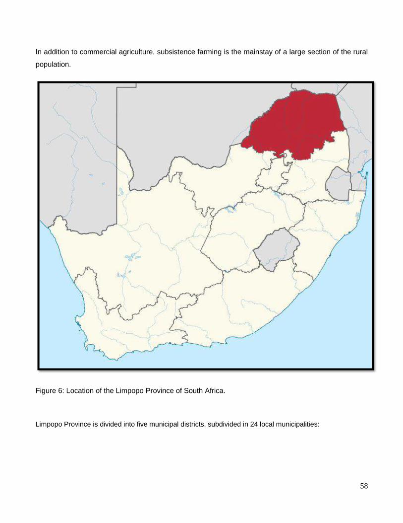
58
In addition to commercial agriculture, subsistence farming is the mainstay of a large section of the rural
population.
Figure 6: Location of the Limpopo Province of South Africa.
Limpopo Province is divided into five municipal districts, subdivided in 24 local municipalities:
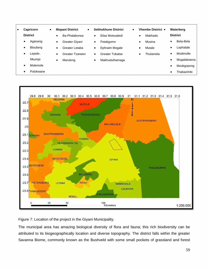
59
• Capricorn
District
• Aganang
• Blouberg
• Lepele-
Nkumpi
• Molemole
• Polokwane
• Mopani District
• Ba-Phalaborwa
• Greater Giyani
• Greater Letaba
• Greater Tzaneen
• Maruleng
• Sekhukhune District
• Elias Motsoaledi
• Fetakgomo
• Ephraim Mogale
• Greater Tubatse
• Makhuduthamaga
• Vhembe District
• Makhado
• Musina
• Mutale
• Thulamela
• Waterberg
District
• Bela-Bela
• Lephalale
• Modimolle
• Mogalakwena
• Mookgopong
• Thabazimbi
Figure 7: Location of the project in the Giyani Municipality.
The municipal area has amazing biological diversity of flora and fauna; this rich biodiversity can be
attributed to its biogeographically location and diverse topography. The district falls within the greater
Savanna Biome, commonly known as the Bushveld with some small pockets of grassland and forest

60
Biomes. These and other factors have produced a unique assortment of ecological niches which are in
turn occupied by a wide variety of plant and animal species. The area is comprised of Sacred Forests.
6.2 Baseline Environmental attributes associated with the sites
Key aspects of the baseline environment that are likely to impact on the scope of the impact assessment
and management measures that are implemented as well as project decisions regarding alternatives are
listed below.
6.2.1 Site Assessment
The mining permit is currently operational and the infrastructure setup as well as current surface
disturbances are shown below:
6.2.2 Climate
The climate of Giyani is characterized by low rainfalls with a very hot summer. This could be caused by
its position in the Lowveld. The municipal area received between 200 – 400ml of rain annually. The
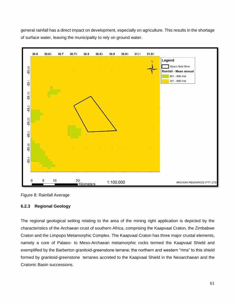
61
general rainfall has a direct impact on development, especially on agriculture. This results in the shortage
of surface water, leaving the municipality to rely on ground water.
Figure 8: Rainfall Average
6.2.3 Regional Geology
The regional geological setting relating to the area of the mining right application is depicted by the
characteristics of the Archaean crust of southern Africa, comprising the Kaapvaal Craton, the Zimbabwe
Craton and the Limpopo Metamorphic Complex. The Kaapvaal Craton has three major crustal elements,
namely a core of Palaeo- to Meso-Archaean metamorphic rocks termed the Kaapvaal Shield and
exemplified by the Barberton granitoid-greenstone terrane; the northern and western “rims” to this shield
formed by granitoid-greenstone terranes accreted to the Kaapvaal Shield in the Neoarchaean and the
Cratonic Basin successions.

62
The northern rim to the Kaapvaal Shield comprises the Murchison, Pietersburg and Giyani greenstone
belts. The Giyani Greenstone Belt (GGB) is the main focus in relation to the area of application. The rock
stratigraphy within the Giyani Greenstone Belt forms part of the Kaapvaal Craton sequence. The below
shows the geological setting and extent of the Kaapvaal Craton, and the northern rim in which the
application area is located.
Figure 9: The Regional Geological Setting and Depositional Environment
The Cratonic Basin successions were deposited on the Kaapvaal Shield during the Mesoarchaean and
are preserved as the Dominion Group and Witwatersrand Supergroup in the central part of the craton
and the Pongola Supergroup in the southeast.
6.2.3.1 Regional Geological Structure and Stratigraphy
The regional geology depicting the area of interest comprise the Murchison, Pietersburg, Giyani, and
Barberton greenstone belts. These belts are situated in the granite-gneiss terrain of the Kaapvaal Craton
which is located south of the Southern Marginal Zone (SMZ). The supracrustal rocks of the GGB are
classified as the Giyani Group and are dominated by mafic and ultramafic rocks with subordinate
metasedimentary units but due to structural complexity, with no reliable stratigraphy being recognized
within the sequence. Pillow-like structures in the tremolite schists near Klein Letaba Mine, and in
amphibolite schists east of Giyani town, is evidence that the greenstone were originally volcanic rocks.
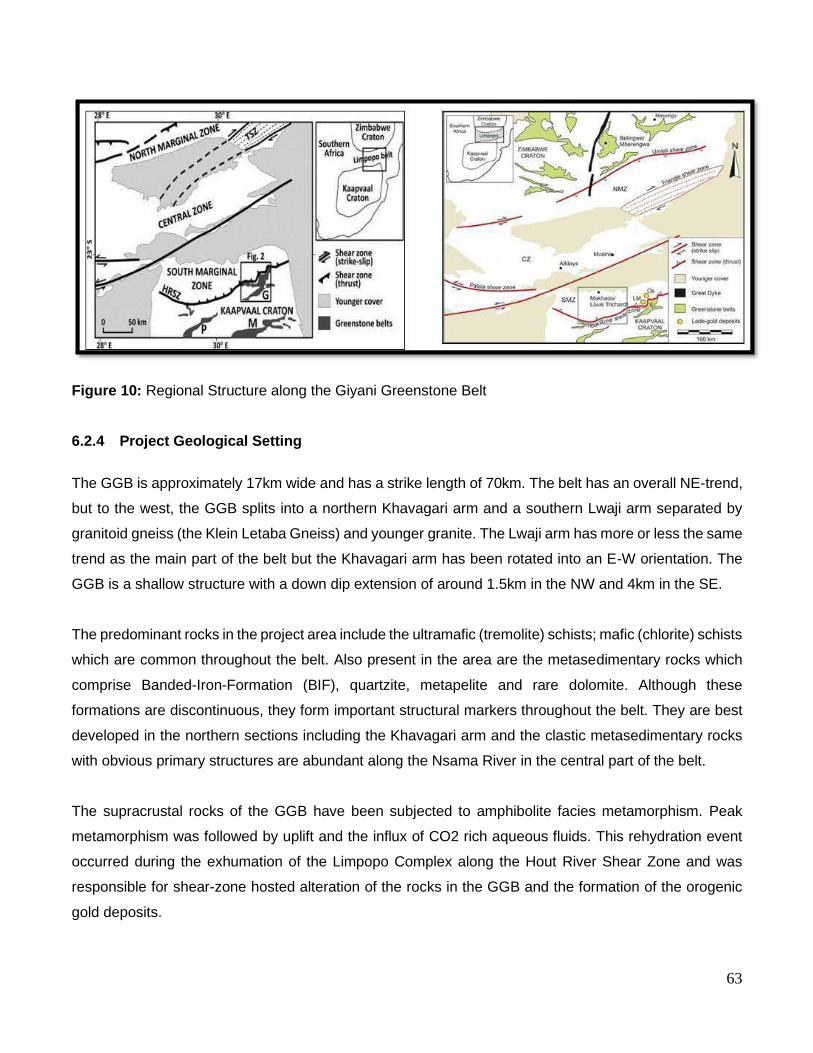
63
Figure 10: Regional Structure along the Giyani Greenstone Belt
6.2.4 Project Geological Setting
The GGB is approximately 17km wide and has a strike length of 70km. The belt has an overall NE-trend,
but to the west, the GGB splits into a northern Khavagari arm and a southern Lwaji arm separated by
granitoid gneiss (the Klein Letaba Gneiss) and younger granite. The Lwaji arm has more or less the same
trend as the main part of the belt but the Khavagari arm has been rotated into an E-W orientation. The
GGB is a shallow structure with a down dip extension of around 1.5km in the NW and 4km in the SE.
The predominant rocks in the project area include the ultramafic (tremolite) schists; mafic (chlorite) schists
which are common throughout the belt. Also present in the area are the metasedimentary rocks which
comprise Banded-Iron-Formation (BIF), quartzite, metapelite and rare dolomite. Although these
formations are discontinuous, they form important structural markers throughout the belt. They are best
developed in the northern sections including the Khavagari arm and the clastic metasedimentary rocks
with obvious primary structures are abundant along the Nsama River in the central part of the belt.
The supracrustal rocks of the GGB have been subjected to amphibolite facies metamorphism. Peak
metamorphism was followed by uplift and the influx of CO2 rich aqueous fluids. This rehydration event
occurred during the exhumation of the Limpopo Complex along the Hout River Shear Zone and was
responsible for shear-zone hosted alteration of the rocks in the GGB and the formation of the orogenic
gold deposits.
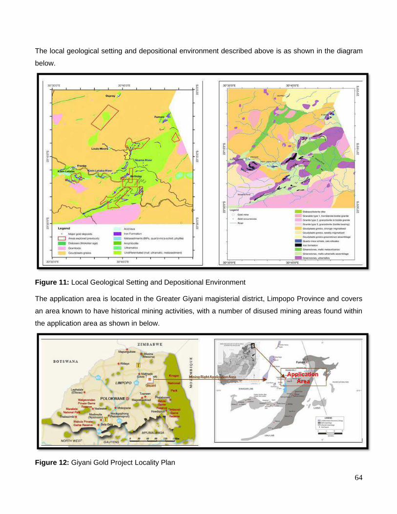
64
The local geological setting and depositional environment described above is as shown in the diagram
below.
Figure 11: Local Geological Setting and Depositional Environment The application area is located in the Greater Giyani magisterial district, Limpopo Province and covers
an area known to have historical mining activities, with a number of disused mining areas found within
the application area as shown in below.
Figure 12: Giyani Gold Project Locality Plan

65
6.2.4.1 Structural Geology in Project Area
The structural configuration of the GGB is one of a north-east trending syncline forming an apex in the
south-western corner of the Giyani Greenstone Belt. The established profile across the belt shows a 4km
down dip extension into the crust for Lwaji and 1km depth for Khavagari arms respectively. The central
portion of the belt is known to be shallow. The GGB is mainly made up of supra-crustal rocks of the
Giyani Group which consists mainly of mafic-ultramafic rocks as detailed in the diagram below.
Figure 13: Geological Structure of the Giyani Greenstone Belt.
6.2.4.2 Mineralisation in the area
The origin of gold in the Giyani Greenstone Belt (GGB) can be classified into the modified placer theory,
the syn-genetic theory, and the epigenetic theory. Gold mineralization in the GGB is orogenic in character
and origin and can be directly linked to the exhumation phase of the Neo-archaean Limpopo Orogeny.
Gold mineralization was late in the tectonic evolution of the GGB and related to the regional flow of CO2-
rich aqueous fluids along foliation parallel ductile shear zones in the schists of the GGB. These fluids
caused rehydration and hydrothermal alteration of suitable Fe-rich rocks in the GGB and the resultant
deposition of gold. The gold occurrence is associated with hydrothermally altered mafic and ultramafic
meta-volcanic schists and BIF, but is structurally controlled, due to being hosted in north-dipping
anastomosing shear zones in the immediate footwall of the Hout River Shear Zone (HRSZ).

66
Figure 14: Depositional Environments within the Giyani Greenstone Belt
There are several known gold occurrences in the GGB and related satellite bodies to the north of the belt.
A number of the occurrences were prospected and exploited in the past, evident in inactive mines which
are found in the area. Six of the inactive mines (Klein Letaba, Louis Moore, Osprey, Fumani, Franke
and Birthday) are known to have produced and recovered gold from the GGB. The distribution of the
mineralization is strongly asymmetric with most deposits, including the main ones, located along the
northern margin of the belt. Gold mineralization in the area is associated with mafic and ultramafic
metavolcanic schists and BIF but is hosted in north-dipping anastomosing shear zones in the immediate
footwall of the HRSZ. Gold is concentrated along the foliation in these shear zones and ore shoots plunge
with the elongation lineation implying a direct relationship between mineralization and deformation along
the shear zones.

67
6.2.5 Soils
The application area has Red, massive or weakly structured soils with high base status (association of
well drained Lixisols, Cambisols, Luvisols) and Soils with minimal development, usually shallow on hard
or weathering rock, with or without intermittent diverse soils with (association of Leptosols, Regosols,
Calcisols and Durisols. In addition one or more of Cambisols, Luvisols.
Figure 15: Soils

68
Figure 16: Land type
6.2.6 Biodiversity
6.2.6.1 Veld Description
Part of the area lies within the Granite Lowveld occurring on the uplands comprises tall shrubland with
few trees to moderately dense low woodland dominated by Terminalia sericea, Combretum zeyheri and
C. apiculatum and a ground layer consisting of Pogonarthria squarrosa, Tricholaena monachne and
Eragrostis rigidior. In the lowland areas dense thicket to open savanna with Acacia nigrescens,
Dichrostachys cinerea and Grewia bicolor dominate the woody layer. The dense herbaceous layer is
mainly comprised of Digitaria eriantha, Panicum maximum and Aristida congesta on fine-textured soils,
while brackish bottomland soils support Sporobolus mitens. A dense fringe of T. sericea and Eragrostis
gummiflua occurs in areas where the topography changes from convex to concave.

69
The majority of the application area is Mopaneveld characterised by medium to high shrub dominated
savannah, with scattered trees and a dense field layer. Tree and shrub species include A.nigrescens and
Sclerocarya birrea subsp. caffra (tall trees); C. mopane and C. apiculatum (small trees);
and C. hereroense, D. cinerea, Euclea divinorum and Grewia bicolor (tall shrubs), amongst others. The
field layer comprises of Clerodendrum ternatum and Indigofera schimperi (low shrubs); Bothriochloa
radicans, Digitaria eriantha subsp. pentzii, Heteropogon contortus and Panicum maximum (grasses); and
Blepharis integrifolia, Ceratotheca triloba and Chamaecrista absus (herbs), amongst others.
Figure 17: Vegetation
6.2.6.2 Conservation Status
The granite Lowveld bushveld in listed as vulnerable. A biodiversity assessment will be conducted to
assess to what extent the surface area will be disturbed as well as identify the flora and fauna species
on the project area.

70
Figure 18: Conservation Status
6.2.7 Topography
The application area lies within a low level plain with the topography ranging from 500masl to 580masl.

71
Figure 19: Soter Landforms
6.2.8 Surface Hydrology
There is one borehole on site that will be used only for the operation process at the gold mine. The
borehole is equipped with a submersible pump. Drinking water will be purchased in town and transported
to site.
A volume of 120m3/day will be abstracted from the borehole for the operation process and stored in a 60
000 liter jojo tank.
There are no streams located in 5km radius of the location of the gold mine. There is Nsami Dam which
is located approximately ±7km south of where the mine is located.
The proposed Giyani Gold Mine falls within the Letaba water management area.

72
The Letaba water management area is located in the north-eastern corner of South Africa, where it
borders on Zimbabwe in the north and on Mozambique along the eastern side. It falls entirely within the
Northern Province, and adjoins the Olifants and Limpopo water management areas to the south and west
respectively. The Luvuhu and Letaba water management area also forms part of the Limpopo River
Basin, which is an international river shared by South Africa, Botswana, Zimbabwe and Mozambique.
The Kruger National Park lies along the eastern boundary, and occupies approximately 35% of the land
area of the water management area.
6.2.9 Heritage
A number of archaeological sites / resource of significance are likely to be distributed across the study
area. These will most likely include graves, homesteads and other resources of the Late Stone Age (LSA).
Furthermore, it is important to note that since archaeological artefacts generally occur below surface, the
possibility exists that culturally significant material and skeletal remains may be exposed during the
development and construction phases, in which case all activities must be suspended pending further
archaeological investigations by a qualified archaeologist (See National Heritage and Resources Act, 25
of 1999 section 36 (6)).
A Heritage and Cultural Impact Assessment will be undertaken as part of the EIA. This assessment
determines the archaeological significances of all the identified resources as well as the possible impacts
that the proposed development might have.
6.2.10 Socio economic
Description: The Greater Giyani Municipality is one of five (5) local municipalities falling within Mopani
District Municipality in the Limpopo Province. The other four local municipalities are Greater Tzaneen (+/-
120km), Greater Letaba (+/-90km), Ba-Phalaborwa (+/-160km) and Maruleng (+/-195km). The town is
located +/- 185km from Polokwane, +/-100km from Thohoyandou and +/- 550km from Tshwane. The
municipality covers approximately 2967, 27km² areas with only one semi-urban area being Giyani.
The municipality is demarcated into 31 wards and has 62 councillors. It has 10 traditional authority
(however as per the new provincial gazette three more traditional authorities are in the process of being
recognized by office of the premier) areas comprising of +97 villages. Giyani town is the largest center of
population concentration, employment opportunities, shopping and recreational facilities.

73
6.2.10.1 Demography
The total population is 256, 300 with a total number of households of 70,537. The municipality has 31
wards grouped into 5 clusters. In most wards, the population exceeds 5000 people. In the past few years,
the population has shown a slight decline. In the 2011 census, the population was counted at 247 565
but according to the 2011 census, it has declined by almost 3000 people. The decline may be attributed
to migration to other urban centers, such as Polokwane, Gauteng and Tzaneen in which the migrants
search for better working conditions (2016 Census)
6.2.10.2 Population per Gender and Age
There are various factors contributing to the age group population patterns, such as mortality rate,
migration and death. The table below depicts that from the age group 0-4, 5-14 and 15-34. The population
patterns do not differ much. In the age groups 35-64 and over 65, there is a clear decrease in population
growth patterns, with females exceeding males.
Figure 20: Population per age and gender
Estimated Population for Greater Giyani, 2001& 2011by Gender and Age
Gender 2001 % 2011 % 2011
0-4 Male 15135 49.3 13559 49.7 16436
Female 15566 50.7 13725 50.3 12151
5 to 14 Male 34728 49.3 35850 49.5 16424
Female 35692 50.7 36509 50.5 17964
15 to 34 Male 32123 44.1 37640 44.4 18749
Female 40659 55.9 47117 55.6 18749
35 to 64 Male 11976 35.2 14966 35.1 4436
Female 22054 64.8 27633 64.9 7166
Over 65 Male 2732 32.4 3091 29.6 1845
Female 5712 67.6 7345 70.4 3473
Total Male 96694 44.7 105106 44.3 107094
Female 119683 55.3 132329 55.7 140473
Total
All
216377
100
244 217
100
256 300

74
6.2.10.3 Level of Education
The majority of people in the age groups 5 to 24 years, did attend school in 2007 (74.4%). It is indicated
that 22.6% of the population in this age bracket, does not attend any educational institution; possible
factors contributing to this may be accessibility of schools and affordability of higher learning institutions.
Figure 21: Educational Institutions being attended
The figure above statistics on the highest level of education attained by persons older than 20 years,
between 2001 and 2007. It indicates that the population with no schooling decreased from 47.6% to
42.1% in 2001. The percentage of the population with an educational level higher than Secondary school
increased from 4.7% in 1996 to 7.4% in 2001 with the actual number almost doubling during this period.
A factor that may contribute to the lower percentages on higher learning institution is the capacity and
the variety of qualification offered by our local institutions.
6.2.10.4 Employment Profile
The figure below indicates that the number of unemployed people has increased from 20 534 (50.7%) in
1996 to 31 636 (60.4%) in 2001. Unemployment has a negative impact on society which might eventually
result in an increase in crime, grant dependency, and non-payment of services.
Persons 2016 %
None 29217 22.6
Pre-school 2773 2.1
School 95970 74.4
College 635 0.5
Technikon 134 0.1
University 73 0.1
Adult Education Centre (ABET) 113 0.1
Other 106 0.1
Total 129021 100

75
Figure 22: Labour Force
Figure 23: Labour Status
The figure above indicates that most females are employed than males; this may be a result of job
opportunities within the municipality. This might also be due to the effort done to address gender equity
in labour intensive work opportunities such as construction and mining.
6.2.10.5 Household Income
The average income for all members of community within Greater Giyani can be categorized as
presented in Table 9. The percentage of people earning no income decreased from 82.34% in 2007 to
78.04% in 2011. The percentage of people earning less than R400 per month did increase tremendously
(the number of persons doubled from 5764 in 2007 to 18631 in 2011) and there was a decline in those
earning between R401 and R800 per month. The high statistic of low earning people may be in relation
to the employment industry. Agriculture in general, employs more people, but with the lower wages.
People that are earning higher incomes are professionals which are usually fewer in number.
Persons 2011 % 2016 %
Employed 19979 49.3 20759 39.6
Unemployed 20534 50.7 31636 60.4
Total Labour Force 40513 100 52395 100
Not economically active 75829
Male Female
Employed 16206 17360
Unemployed 10919 16178
Not economically active 31701 44720
Not applicable 2247 1833

76
Figure 24: Population by Individual Monthly Income, Greater Giyani, 2011 & 2016
A detailed socio- economic impact assessment will be conducted as part of the EIA to review the
opportunities that might arise due to the commencement of the project. A social and labour plan will also
be compiled detailing the company’s commitment to developing the community.

77
7 ENVIRONMENTAL IMPACT ASSESSMENT
7.1 Assessment Criteria
The assessment of the impacts will be conducted according to a synthesis of criteria required by the
integrated environmental management procedure.
7.1.1 Extent
The physical and spatial scale of the impact is classified as:
a) Footprint
The impacted area extends only as far as the activity, such as footprint occurring within the
total site area.
b) Site
The impact could affect the whole, or a significant portion of the site.
c) Regional
The impact could affect the area including the neighbouring properties, the transport routes
and the adjoining towns.
d) National
The impact could have an effect that expands throughout the country (South Africa).
e) International
Where the impact has international ramifications that extent beyond the boundaries of South
Africa.
7.1.2 Duration
The lifetime of the impact, that is measured in relation to the lifetime of the proposed development.
a) Short term
The impact would either disappear with mitigation or will be mitigated through natural
processes in a period shorter than that of the construction phase.
b) Short to Medium term
The impact will be relevant through to the end of the construction phase.
c) Medium term

78
The impact will last up to the end of the development phases, where after it will be entirely
negated.
d) Long term
The impact will continue or last for the entire operational lifetime of the development, but will
be mitigated by direct human action or by natural processes thereafter.
e) Permanent
This is the only class of impact, which will be non-transitory. Mitigation either by man or natural
process will not occur in such a way or in such a time span that the impact can be considered
transient,
7.1.3 Intensity
The intensity of the impact is considered by examining whether the impact is destructive or benign,
whether it destroys the impacted environment, alters its functioning, or slightly alters the environment
itself. The intensity is rated as:
a) Low
The impact alters the affected environment in such a way that the natural processes or
functions are not affected.
b) Medium
The affected environment is altered, but functions and processes continue, albeit in a modified
way.
c) High
Function or process of the affected environment is disturbed to the extent where it temporarily
or permanently ceases.
7.1.4 Probability
This describes the likelihood of the impacts actually occurring. The impact may occur for any length
during the life cycle of the activity, and not at any given time. The classes are rated as follows:
a) Impossible
The possibility of the impact occurring is none, due either to the circumstances, design or
experience. The chance of this impact occurring is zero (0%).

79
b) Possible
The possibility of the impact occurring is very low, due either to the circumstances, design or
experience. The chances of this impact occurring is defined as 25%.
c) Likely
There is a possibility that the impact will occur to the extent that provisions must therefore be
made. The chances of this impact occurring is defined as 50%.
d) Highly likely
It is most likely that the impacts will occur at some stage of the development. Plans must be
drawn up before carrying out the activity. The chances of this impact occurring is defined as
75%.
e) Definite
The impacts will take place regardless of any provisional plans, and or mitigation actions or
contingency plans to contain the effect can be relied on. The chance of this impact occurring
is defined as 100%.
7.1.5 Mitigation
The impacts that are generated by the development can be minimised if measures are implemented in
order to reduce the impacts. The mitigation measures ensure that the development considers the
environment and the predicted impacts in order to minimise impacts and achieve sustainable
development.
7.2 Determination of significance – Without Mitigation
Significance is determined through a synthesis of impacts as described in the above paragraphs. It
provides an indication of the importance of the impact in terms of both tangible and intangible
characteristics. The significance of the impact “without mitigation” is the prime determinant of the nature
and degree of mitigation required. Where the impact is positive, significance is noted as “positive”.
Significance is rated on the following scale:
a) No significance
The impact is not substantial and does not require any mitigation action.
b) Low
The impact is of little importance but may require limited mitigation.
c) Medium

80
The impact is of importance and is therefore considered to have a negative impact. Mitigation
is required to reduce the negative impacts to acceptable levels.
d) High
The impact is of major importance. Failure to mitigate, with the objective of reducing the impact
to acceptable levels, could render the entire development option or entire project proposal
unacceptable. Mitigation is therefore essential.
7.3 Determination of significance – With Mitigation
Determination of significance refers to the foreseeable significance of the impact after the successful
implementation of the necessary mitigation measures. Significance with mitigation is rated on the
following scale:
a) No significance
The impact will be mitigated to the point where it is regarded as insubstantial.
b) Low
The impact will be mitigated to the point where it is of limited importance.
c) Low to Medium
The impact is of importance however, through the implementation of the correct mitigation
measures such potential impacts can be reduced to acceptable levels.
d) Medium
Notwithstanding the successful implementation of the mitigation measures, to reduce the
negative impacts to acceptable levels, the negative impact will remain of significance.
However, taken within the overall context of the project, the persistent impact does not
constitute a fatal flaw.
e) Medium to High
The impact is of major importance but through the implementation of the correct mitigation
measures, the negative impacts will be reduced to acceptable levels.
f) High
The impact is of major importance. Mitigation of the impact is not possible on a cost-effective
basis. The impact is regarded as high importance and taken within the overall context of the
project, is regarded as a fatal flaw. An impact regarded as high significance, after mitigation
could render the entire development option or entire project proposal unacceptable.

81
7.3.1 Assessment weighting
Each aspect within the impact description was assigned a series of quantitative criteria. Such criteria are
likely to differ during the different stages of the project’s life cycle. In order to establish a defined base
upon which it becomes feasible to make an informed decision, it is necessary to weigh and rank all
criteria.
7.3.2 Ranking, Weighting and Scaling
For each impact under scrutiny, a scale weighting Factor is attached to each respective impact (refer to
Figure 25: Description of biophysical assessment parameters with its respective weighting), The purpose
of assigning such weight serve to highlight those aspects considered most critical to the various
stakeholders and ensure that each specialist’s element of bias is taken into account. The weighting factor
also provides a means whereby the impact assessor can successfully deal with the complexities that
exist between the different impacts and associated aspects criteria.
Simply, such a weighting factor is indicative of the importance of the impact in terms of the potential effect
that it could have on the surrounding environment. Therefore, the aspects considered to have a relatively
high value will score a relatively higher weighting than that which is of lower importance.
Figure 25: Description of biophysical assessment parameters with its respective weighting
7.3.3 Identifying the Potential Impacts without Mitigation (WOM)
Following the assignment of the necessary weights to the respective aspects, criteria are summed and
multiplied by their assigned weightings, resulting in a value for each impact (prior to the implementation
of mitigation measures).
Equation 1:
Significance Rating (WOM) = (Extent + Intensity + Duration + Probability) x Weighting Factor

82
7.3.4 Identifying the Potential Impacts with Measures (WM)
In order to gain a comprehensive understanding of the overall significance of the impact, after
implementation of the mitigation measures, it was necessary to re-evaluate the impact.
a) Mitigation Efficiency (ME)
The most effective means of deriving a quantitative value of mitigated impacts is to assign each
significance rating value (WOM) a mitigation effectiveness (ME) rating. The allocation of such a rating
is a measure of the efficiency and effectiveness, as identified through professional experience and
empirical evidence of how effectively the proposed mitigation measures will manage the impact.
Thus, the lower the assigned value the greater the effectiveness of the proposed mitigation measures
and subsequently, the lower the impacts with mitigation.
Equation 2:
Significance Rating (WM) = Significance Rating (WOM) x Mitigation Efficiency
Or WM = WOM x ME
b) Significance Following Mitigation (SFM)
The significance of the impact after the mitigation measures are taken into consideration. The
efficiency of the mitigation measure determines the significance of the impact. The level of impact is
therefore seen in its entirety with all considerations taken into account.
7.3.5 Impacts identified
A number of negative impacts on the bio-physical environment could result from disturbances during
mining. The significance of any potential impact is largely limited by the small physical size and short
duration of the mining, but also by the sensitivity of the receiving environment or receptor(s).
Potential impacts resulting from the proposed project were identified using input from the following:
• Views of I&APs;
• Existing information;
• Site visit with the project team and
• Legal and policy requirements that need to be fulfilled for the proposed project

83
The following potential impacts were identified:
• Ground and surface water contamination;
• Geology, soil and land capability;
• Underground blasting;
• Socio-economic issues;
• Waste products;
• Floral and faunal displacement;
• Dust and noise impacts;
• Traffic; and
• Identified heritage sites.
The primary environmental impacts associated with mining detailed in this report are related to these
main releases: dust emissions, produced water, ground water contamination and dewatering. Mining
poses risks to these resources through contamination, sediment loads, water consumption and
vegetation loss. The impact is largely mitigated by operational practices (drip trays, bunds, and container
water storage units) and responsive management (safe waste storage and disposal, spill response).
Restricting mining activities to further than 100 m from all watercourses largely eliminates the risk.
Vehicles should not enter or cross water courses except on established roads.
All produced water must be stored in impervious containers until its quality is determined by laboratory
analysis. In portions of the mining area where mining occurred testing the surface water and groundwater
during prior and during mining will set monitoring parameters of the activities. The best practicable
environmental option for the management of produced water can only be determined once its quality is
known. Production water may only be utilised for activities for which the quality is suitable (as defined by
the DWS Water Use Guidelines and SANS 241). If unsuited for use or release then the produced water
will need to be treated or disposed of. With these management measures in place no significant impacts
are anticipated. The volume of water produced and stored on surface must remain within the limits of the
DWS and a WUL must be obtained.
Localised compaction and soil erosion is highly likely due to heavy vehicle movement. Small scale and
isolated spillages of hydrocarbons or chemicals may occur but can generally be prevented or treated in-
situ with a suitable remediation product.

84
Wear and tear or accidental damage to private infrastructure could result. The use of any existing
infrastructure or placement of new infrastructure will be through an access agreement negotiated
between the mining right holder and the landowner/occupier (The land is state owned). Thus, the
landowner will have a direct say in which infrastructure is used. If there are any damages Kusile Invest
133 will be responsible for effecting satisfactory repairs for any damages
Sensitive sites will be identified by the National Protected Area Expansion Strategy (NPAES), Threatened
Ecosystems, Provincial Biodiversity Conservation Plan and Birdlife’s Important Bird Areas programme.
Land use transformation is one of the key risks to the grassland habitat and has significant influence on
the habitat quality, occurrence of species of conservation concern and ecosystem services provided.
Mining will result in the disturbances to vegetation and could affect habitat quality. The scale of physical
disturbances to the land surface is expected to be medium. Given that the location of the land is already
transformed. No mining may take place within protected areas as defined in terms of the NEMPAA and
in indigenous vegetation in areas of potential high biodiversity sensitivity.
The EMP defines the categories of biodiversity sensitivity in which mining may not be undertaken. Every
potential site must be subjected to an Environmental Site Assessment by an independent Environmental
Scientist.
Public access the mining area must be prevented and must be secure and provisioned with warning
signage in appropriate languages. Open excavations must be fenced. Livestock must not be allowed to
gain entry to the mine site or any of the mining equipment or materials. All gates on a property must be
kept in the status as agreed with the land owner and livestock must not be allowed to escape.
Safety and security on farms is an acknowledged concern. Additional access points to farms and
unfamiliar persons in the district could increase the risks. Access for mining must not be allowed to
compromise safety and security. Mining personnel may only access farms in terms of an access
agreement negotiated with the land owner/occupier (in this case the land is state owned). Where
appropriate the access points to a farm must be fitted with locks. Mining personnel must report unknown
persons to security and mine management.
Veld fires and resulting damages to assets are a high risk as the area has high fuel loads and experiences
windy conditions. With planning, risks assessments, site management and emergency procedures in
place the risk can be greatly reduced can be prevented. Specific measures may be required at each
mining block site and these must be set out in the EMP.

85
Mining activities will provide employment opportunities and some stimulation of the local economy
through the purchase of supplies and equipment. The applicant must, wherever possible, source the
materials and equipment needed to operate the mining equipment and sustain the personnel locally. The
employment and training of local persons, particularly HDIs, even for short-term jobs, should be prioritised
by Kusile Invest 133 and all of their sub-contractors.
Impact statement
The following key issues and potential impacts (direct and cumulative), was identified during the Scoping
phase, which will together with potential cumulative impacts, be assessed during the Environmental
Impact Assessment phase of the project and appropriate mitigation measures to reduce the identified
impacts will be proposed.
Potential Direct Impacts identified
IMPACT
SURFACE WATER
Alteration of the characteristics of a water resource
Hydrological modification on storm water flow and watercourses.
Deterioration of water quality
The impact on ground and surface water by migration of contaminated water
from the construction and operational phases.
Impacts on surface water during the construction and operational phases.
GROUNDWATER
Impact on dewatering of the groundwater aquifer due to mining activities- Mining
Impact on ground and surface water by migration of contaminated water from
the construction and operational phases.
Deterioration of water quality
AIR QUALITY Dust impacts on air quality during the mining phases.
SOIL, GEOLOGY AND
MINERAL RESOURCE
Impact of vegetation clearance on soil erosion and surface water runoff during
the mining phase
Soil pollution during the mining phase
Mining of resource underlying the site
TOPOGRAPHY Alteration of the surrounding topography
ECOLOGICAL
Destruction of sensitive habitat
Destruction of faunal habitat and faunal displacement
Reduction in natural migratory routes and faunal dispersal patterns
VISUAL Minimisation of aesthetics and/or sense of place of the surrounding areas.

86
IMPACT
SOCIO-ECONOMICAL Development and upliftment of the surrounding communities and infrastructure
Development of the economic environment
HERITAGE Alteration of archaeological, historical and paleonthologic features
Potential Cumulative Impacts identified
IMPACT
TRAFFIC Increased traffic volumes within the mine and surrounding communities. (low)
AIR QUALITY Decrease in air quality in the immediate surroundings of the mining site
HYDROLOGICAL
Cumulative loss of surface water functionality as a result of an increase in
pollutants.
Cumulative impact of hydrological modifications
ECOLOGICAL
Cumulative destruction of sensitive habitat.
Cumulative impact of faunal habitat and displacement.
Cumulative impact on natural migratory routes and faunal dispersal patterns.
VISUAL Cumulative impact of visual distrubances
NOISE, VIBRATION AND
SHOCK
Cumulative impact of construction and operational noise as well as noise due to
mining heavy vehicle movement
Cumulative impact of vibration and shocks.
SOCIO-ECONOMICAL
Postivie - Cumulative impact of development on the surrounding communities.
Positive - Cumulative impact of development on the economic environment.
Positive - Cumulative impact of the employment opportunities provided.
This section provides a list of potential impacts on environmental aspects separately in respect of each
of the main project actions / activities and processes. The potential impacts are presented for each of the
project phases in tabular format.
Table 8: List of Potential Impacts
Activity Phase Potential impacts (unmitigated)
Site preparation
Bush clearing, removal of infrastructure,
establishing construction area
Construction
Operation
Decommissioning
Physical destruction and disturbance of
biodiversity
Air pollution
Disturbing noise

87
Visual impacts
Underground and Open cast Mining
Operation Loss of soil resources and land capability
Physical destruction and disturbance of
biodiversity
Pollution of surface water resources
Contamination of groundwater
Dewatering impacts
Air pollution
Disturbing noise
Visual impact
Blasting and vibration impacts
Water supply and use
Delivery on site, storage
of clean water
Construction
Operation
Decommissioning
Hazardous excavations during mining phase
Loss of soil resources and land capability
Disturbance of biodiversity
Pollution of surface water resources
Alteration of natural drainage patterns
Contamination of groundwater
Air pollution
Visual impacts
Dirty water
management
Collection, storage of dirty water for re-use,
recycling
Construction
Operation
Decommissioning
Hazardous excavations
Loss of soil resources and land capability
Pollution of surface water resources
Contamination of groundwater
Disturbing noise
Transport systems
Use of access points, road transport to and from
site for employees and supplies, movement
within site boundary
Construction
Operation
Decommissioning
Loss of soil resources and land capability
Disturbance of biodiversity
Pollution of surface water resources
Alteration of natural drainage patterns
Contamination of groundwater
Disturbing noise
Traffic impacts
Visual impacts
Site / contract management
Appointment of workers/contractors, site
Management (monitoring, inspections,
maintenance, security, access control),
Construction
Operation
Decommissioning
Closure
Management of the site plays a significant role
in all
identified impacts

88
awareness training, emergency response,
implementing and maintaining programmes
Rehabilitation
Replacing soil, slope
stabilization,
landscaping, revegetation,
restoration
Construction
Operation
Decommissioning
Closure
Hazardous excavations
Loss of soil resources and land capability
Disturbance of biodiversity
Pollution of surface water resources
Alteration of natural drainage patterns
Contamination of groundwater
Air pollution
Disturbing noise
Visual impacts
Maintenance and aftercare
Inspection and maintenance of remaining
facilities and rehabilitated areas
Closure Loss of soil resources and land capability
Disturbance of biodiversity
Pollution of surface water resources
Air pollution
Visual impacts
7.3.6 The positive and negative impacts that the proposed activity (in terms of the initial site
layout) and alternatives will have on the environment and the community that may be
affected.
During the EIA phase all potential negative and potential impact will be identified, ranked and mitigation
measures will be prescribed.
7.3.7 The possible mitigation measures that could be applied and the level of risk.
During the EIA phase all possible impacts will be assessed and an EMP outlining the risk and mitigation
measures will be compiled.

89
7.3.8 Draft Site Layout Plan
Figure 26: Proposed Site Layout
The Final Layout Plan will be provided in the EIA/EMP after public consultation as well as specialist
recommendations excluding sensitive areas.
7.4 Plan of study for the Environmental Impact Assessment process
A plan of study for undertaking the environmental impact assessment process to be undertaken will
include-
• a description of the alternatives to be considered and assessed within the preferred site, including
the option of not proceeding with the activity;
• a description of the aspects to be assessed as part of the environmental impact assessment
process;
• aspects to be assessed by specialists;

90
• a description of the proposed method of assessing the environmental aspects, including a
description of the proposed method of assessing the environmental aspects including aspects to
be assessed by specialists;
• a description of the proposed method of assessing duration and significance;
• An indication of the stages at which the competent authority will be consulted;
• particulars of the public participation process that will be conducted during the environmental
impact assessment process; and
• a description of the tasks that will be undertaken as part of the environmental impact assessment
process;
• Identify suitable measures to avoid, reverse, mitigate or manage identified impacts and to
determine the extent of the residual risks that need to be managed and monitored.
The EIA phase will comprise of the following activities;
• Stakeholder Engagement;
• Assessing of Alternatives;
• Baseline and consideration of potential Specialist Studies;
• Identification of potential impacts
• Impact Assessment;
• Identification and Description of mitigation measures; and
• Reporting and decision-making.
7.4.1 Description of the aspects to be assessed as part of the environmental impact assessment
process
The authorization process to be followed has been designed to meet the requirements of the MPRDA
(Act 28 of 2002) and National Environmental Management Act (107/1998): Environmental Impact
Assessment Regulations, 2017.The authorization process will include:
• Scoping Phase:
• Stakeholder Notification;
• Authority Consultation;
• Capturing of Issues and Concerns;
• Compilation of a Stakeholder Database;
• Identification of Potentially Significant Impacts;
91
• Identification of Potentially Sensitive Environmental Aspects;
• Identification of Required Specialist Studies;
• Compilation of a Scoping Report (this document), including:
• Plan of Study for EIA/EMP Amendment.
• Issues Report; and
• Stakeholder Review of Documentation;
• Submission and approval of Scoping Report by relevant authorities.
• Impact Assessment Phase:
• Undertake necessary specialist studies;
• Assessment of environmental impacts;
• Compilation of management plans;
• Compilation of an EMP Report;
• Stakeholder document review and comment;
• Submission of final report for decision-making.
The EMP Report will include a description of the proposed project, a list of identified environmental
aspects that will potentially be impacted upon by the mining project, an Impact Assessment for these
aspects, and an Environmental Management Programme for the mitigation and management of the
identified impacts.
A plan of study for undertaking the environmental impact assessment process to be undertaken will
include-
• a description of the alternatives to be considered and assessed within the preferred site, including
the option of not proceeding with the activity;
• a description of the aspects to be assessed as part of the environmental impact assessment
process;
• aspects to be assessed by specialists;
• a description of the proposed method of assessing the environmental aspects, including a
description of the proposed method of assessing the environmental aspects including aspects to
be assessed by specialists;
• a description of the proposed method of assessing duration and significance;
• An indication of the stages at which the competent authority will be consulted;
• particulars of the public participation process that will be conducted during the environmental
impact assessment process; and

92
• a description of the tasks that will be undertaken as part of the environmental impact assessment
process;
• Identify suitable measures to avoid, reverse, mitigate or manage identified impacts and to
determine the extent of the residual risks that need to be managed and monitored.
Specialist Studies
To assess the environmental, social and cultural impacts of the proposed Giyani Gold Mine Project,
several specialist studies will be commissioned. The findings of these studies will be incorporated into
the Environmental Impact Assessment Report (EIR). The specialist studies consider the proposed
structure and activities of the operations, as well as the associated risks to the receiving physical and
socio-cultural environment.
The following aspects of the biophysical environment will be considered in the baseline studies:
• Surface Water and Groundwater;
• Noise;
• Air Quality;
• Vegetation and Fauna;
• Heritage and Archaeology;
• Traffic;
• Social Impact;
• Land Use;
• Visual Aspects
• Blast Assessment.
7.4.2 Description of aspects to be assessed by specialists
➢ Air quality impact assessment;
Identification of existing sources of emissions in the region and the characterisation of existing ambient
pollution concentrations is fundamental to the assessment of cumulative air impacts. A change in ambient
air quality can result in a range of impacts, which in turn, may cause a disturbance to nearby receptors.
➢ Geo - Hydrological assessment;

93
Identification of catchment area, water sources impacting the project area as well as the potential impact
of the mining activity on water quality.
➢ Ecological Assessment;
Identification of flora and fauna and possible invasive species as part of the areas have been previously
mined and agricultural activities were note on some of the farms.
➢ Social Impact Assessment;
The assessment of the possible socio- economic impact of the project area on the local and regional
locality both negative and positive impacts are to be outlined.
➢ Visual Impact Assessment;
Project-related activities have the potential to alter the landscape character of the site and surrounding
area through the establishment of both temporary and permanent infrastructure. As a baseline, this
section provides an understanding of the pre-mining visual character of the project area against which to
measure potential change because of project infrastructure and activities.
➢ Noise & Air Quality Impact;
Some of the noise generating activities associated with the project may cause an increase in ambient
noise levels in and around the site. This may cause a disturbance to nearby receptors. As a baseline,
this section provides a brief description of pre-mining conditions in the area from which to measure
changes because of project-related noise.
Traffic Impact;
An increase in traffic on the existing roads and possible risks associated with the increased activities as
well as the quality of the roads.
➢ Heritage Impact assessment
Identification and Protection of Heritage and historical and land marks and mitigation measures if such
artefacts are encountered during mining.
➢ Soil and Land capability
Identification of the current land uses, soils as well as land capability as surface disturbances will lead to
a loss in topsoil and fertility.

94
7.4.3 Proposed method of assessing the environmental aspects including the proposed method
of assessing alternatives
Methodology for Assessing Environmental Issues and Alternatives
According to National Environmental Management Act (107/1998): Environmental Impact Assessment
Regulations, 2017), the environment is described as the surrounding within which human exist and that
are made up of:
(i) the land, water and atmosphere of the earth;
(ii) micro-organisms, plant and animal life;
(iii) any part or combination of (i) and (ii) and the interrelationships among and between them; and
(iv) the physical, chemical, aesthetic and cultural properties and conditions of the foregoing that influence human health and well-being.
Impact Assessment Methodology
(a) Nature of the impact
The NATURE of an impact can be defined as: “a brief description of the impact being assessed, in terms
of the proposed activity or project, including the socio-economic or environmental aspect affected by this
impact”.
(b) Extent of the impact
The EXTENT of an impact can be defined as: “a brief description of the spatial influence of the impact or
the area that will be affected by the impact”.
EXTENT
Extent or spatial influence of impact
Footprint Only as far as the activity, such as footprint occurring within the total site area
Site Only the site and/or 500m radius from the site will be affected
Local Local area / district (neighbouring properties, transport routes and adjacent towns) is affected
Region Entire region / province is affected
National Country is affected
(a) Magnitude of the impact

95
The MAGNITUDE of an impact can be defined as: “a brief description of the intensity or amplitude of
the impact on socio-economic or environmental aspects”.
MAGNITUDE Magnitude / intensity of impact (at the specified scale)
Zero Natural and/or social functions and/or processes remain unaltered
Very low Natural and/or social functions and/or processes are negligibly altered
Low Natural and/or social functions and/or processes are slightly altered
Medium Natural and/or social functions and/or processes are notably altered
High Natural and/or social functions and/or processes severely altered
(b) Duration of the impact
The DURATION of an impact can be defined as: “a short description of the period of time the impact will
have an effect on aspects”.
DURATION
Duration of the impact
Short term Construction phase up to 3 years after construction
Medium term
Up to 6 years after construction
Long term More than 6 years after construction
(c) Probability of the impact occurring
The PROBABILITY of an impact can be defined as: “the estimated chance of the impact happening”.
PROBABILITY
Unlikely Unlikely to occur (0 – 25% probability of occurring)
Possible May occur (26 – 50% chance of occurring)
Probable Likely to occur (51 – 75% chance of occurring)
Definite Will certainly occur (76-100% chance of occurring)
(d) Degree to which impact can be reversed
The REVERSABILITY of an impact can be defined as: “the ability of an impact to be changed from a
state of affecting aspects to a state of not affecting aspects”.

96
REVERSABILITY
Reversible Impacts can be reversed through the implementation of
mitigation measures
Irreversible Impacts are permanent and can’t be reversed by the
implementation of mitigation measures
(e) Degree to which impact may cause irreplaceable loss of resources
The IRREPLACEABILITY of an impact can be defined as:” the amount of resources that can (not) be
replaced”.
IRREPLACEABILITY
Irreplaceable loss of
resources
No loss No loss of any resources
Low Marginal loss of resources
Medium Significant loss of resources
High Complete loss of resources
(f) Degree to which the impact can be mitigated
The degree to which an impact can be MITIGATED can be defined as: “the effect of mitigation measures
on the impact and its degree of effectiveness”.
MITIGATION
RATING
MITIGATED
Degree impact
can be
mitigated
High Impact 100% mitigated
Medium Impact >50% mitigated
Low Impact <50% mitigated
(g) Confidence rating
CONFIDENCE in the assessment of an impact can be defined as the:” level of certainty of the impact
occurring”.

97
CONFIDENCE
RATING CONFIDENCE
Unsure Amount of information on and/or understanding of
the environmental factors the potentially influence
the impact is limited.
Sure Amount of information on and/or understanding of
the environmental factors the potentially influence
the impact is reasonable and relatively sound.
Certain Amount of information on and/or understanding of
the environmental factors the potentially influence
the impact is unlimited and sound.
(h) Cumulative impacts
The effect of CUMULATIVE impacts can be described as:” the effect the combination of past, present
and “reasonably foreseeable” future actions have on aspects”.
CUMULATIVE RATING CUMULATIVE
EFFECTS
Low Minor cumulative effects
Medium Moderate cumulative effects
High Significant cumulative effects
7.4.4 The stages at which the competent authority will be consulted
The competent authority will be consulted during the
➢ Scoping phase
➢ Public Review of Documents
➢ EIA phase and release of the EMP
➢ Further Consultation after the EIA/EMP has been submitted if there are comments from I&AP’s
98
8 PUBLIC PARTICIPATION DURING THE EIA PHASE
8.1 Particulars of the public participation process with regard to the Impact Assessment
process that will be conducted
Public participation is an essential and regulatory requirement for an environmental authorization
process and is guided by Regulations promulgated under NEMA, specifically the EIA Regulations. NEMA
EIA Regulations defines the “Public Participation Process” as a process in which potential interested and
affected parties (I&APs) are given an opportunity to comment on, or raise issues relevant to, specific
matters”.
The public participation process is designed to provide sufficient and accessible information to I&APs in
an objective manner to assist them to:
During the Scoping Phase:
➢ Raise issues of concern and suggestions for enhanced benefits;
➢ Verify that their issues have been recorded;
➢ Assist in identifying reasonable alternatives; and
➢ Contribute relevant local information and traditional knowledge to the environmental assessment.
During the Impact Assessment Phase:
➢ Contribute relevant information and local and traditional knowledge to the environmental
assessment;
➢ Verify that their issues have been considered in the environmental studies; and
➢ Comment on the findings of the environmental assessments.
The identified Interested and Affected Parties during the scoping phase will be made aware of the
availability of the EIA report VIA
➢ A notification letter
➢ Emails and SMS
➢ Press advertisements
➢ Site Notices
➢ Public and Stakeholder Meetings

99
➢ The EIA will be made available for review to all IAPs for 30days. All registered IAPs will be
notified by email, fax, SMS, or post of the report’s availability. Hard copies of the draft report
will be placed at:
➢ Public Libraries, Municipal Offices and other accessible places.
8.2 Details of the engagement process to be followed
• In addition to land owners, other relevant organisations will be identified and notified of the
application. This includes municipal and State departments with jurisdiction in the area and Non-
Governmental Organisations (NGOs) with an interest.
• A notification letter with the details of the availability of the EIA will be distributed (by email, fax or
post) to all land owners. All IAPs will be asked to distribute the documents to anyone who may be
interested or affected by the project.
• Site Notices
• Public and Stakeholder Meetings
• Register of IAPs during the scoping report will be used to notify the availability of the EIA
• EIAR/EMPr will be released for public review for 30 days each excluding public and school
holidays.
• Hard copies of the draft report will be placed at: Public Libraries, Municipal Offices and other
accessible places.
• A final Consultation report with stakeholder comments from each phase will be submitted.
Framework of a Stakeholder Engagement Plan
Regulations and requirements;
➢ Summary of previous engagement;
➢ Project stakeholders inclusive of an analysis and categorisation of all project stakeholders;
➢ Stakeholder engagement process inclusive of the regulatory process and separate engagement
processes (i.e. with neighbouring facilities, or international NGOs);
➢ Timetable;
➢ Resources and responsibilities;
➢ Grievance mechanism;
➢ Key messages (code of conduct);
➢ Monitoring and reporting – i.e. comments and response tracking; and
➢ Management functions.

100
8.3 Description of the information to be provided to Interested and Affected Parties
Once the competent authority has approved the SR, the Impact Assessment Phase will commence.
Stakeholders will receive notification of the start of the Impact Assessment Phase and opportunities for
public review and comment.
Public participation during the Impact Assessment Phase revolves around a review of the findings of the
EIA, presented in the Draft EIA Report. This report will be made available for public comment for a period
of 30 days.
Stakeholders will be invited to comment on the Draft EIA Report and EMP in the following ways:
➢ By completing a comment sheet made available together with the report at the public
places, and by submitting additional written comments, by email or fax, or by telephone,
to Archean Resources the EAP’s; and
➢ The Draft EIA Report and EMP Report and its accompanying Specialist Studies will be
distributed for comment to public places in the project area, to everyone who requests a
copy email.
The documents will contain a project location, map as well as detailed legislations triggered by the project
and a project description as well as reference number of the project.
The scoping report will be made available to the public for review at public libraries. The scoping report
will entail potential impacts, mitigation measures as well as specialist reports to be undertaken to
supplement the background information of the proposed project.
8.4 Description of the tasks that will be undertaken during the environmental impact
assessment process
The Environmental Impact Assessment Phase will include the following activities:
1) Undertake necessary specialist studies;
2) Assessment of environmental impacts;
3) Compilation of management plans;
4) Compilation of an EMP Amendment Report;

101
5) Stakeholder document review and comment;
6) Submission of Scoping and EIA report for decision-making
The EIA report must contain:
➢ A description of the property on which the activity is to be undertaken and the location of the
activity on the property;
➢ A description of the environment that may be affected by the activity and the manner in which the
physical, biological, social, economic and cultural aspects of the environment may be affected by the
proposed activity;
➢ Details of the public participation process conducted including
• Steps undertaken in accordance with the plan of study;
• A list of persons, organisations and organs of state that were registered as interested
and affected parties;
• A summary of comments received from, and a summary of issues raised by registered
interested and affected parties, the date of receipt of these comments and the response
of the EAP to those comments; and
• Copies of any representations and comments received from registered interested and
affected parties;
➢ A description of the need and desirability of the proposed activity;
➢ A description of identified potential alternatives to the proposed activity, including advantages and
disadvantages that the proposed activity or alternatives may have on the environment and the
community that may be affected by the activity;
➢ An indication of the methodology used in determining the significance of potential environmental
impacts;
➢ A description and comparative assessment of all alternatives identified during the environmental
impact assessment process;
➢ A summary of the findings and recommendations of any specialist report or report on a specialized
process;
➢ A description of all environmental issues that were identified during the environmental impact
assessment process, an assessment of the significance of each issue and an indication of the extent to
which the issue could be addressed by the adoption of mitigation measures;

102
➢ An assessment of each identified potentially significant impact, including:
• Cumulative impacts;
• The nature of the impact;
• The extent and duration of the impact;
• The probability of the impact occurring;
• The degree to which the impact can be reversed;
• The degree to which the impact may cause irreplaceable loss of resources; and
• The degree to which the impact can be mitigated;
➢ A description of any assumptions, uncertainties and gaps in knowledge;
➢ A reasoned opinion as to whether the activity should or should not be authorised, and if the
opinion is that it should be authorised, any conditions that should be made in respect of that
authorisation;
➢ An environmental impact statement which contains:
• A summary of the key findings of the environmental impact assessment; and
• A comparative assessment of the positive and negative implications of the proposed activity
and identified alternatives;
A draft environmental management programme containing;
➢ Copies of any specialist reports and reports on specialised processes; and
➢ Any specific information that may be required by the competent authority
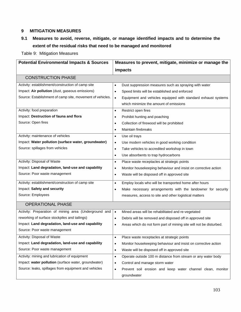
103
9 MITIGATION MEASURES
9.1 Measures to avoid, reverse, mitigate, or manage identified impacts and to determine the
extent of the residual risks that need to be managed and monitored
Table 9: Mitigation Measures
Potential Environmental Impacts & Sources Measures to prevent, mitigate, minimize or manage the
impacts
CONSTRUCTION PHASE
Activity: establishment/construction of camp site
Impact: Air pollution (dust, gaseous emissions)
Source: Establishment of camp site, movement of vehicles.
• Dust suppression measures such as spraying with water
• Speed limits will be established and enforced
• Equipment and vehicles equipped with standard exhaust systems
which minimize the amount of emissions
Activity: food preparation
Impact: Destruction of fauna and flora
Source: Open fires
• Restrict open fires
• Prohibit hunting and poaching
• Collection of firewood will be prohibited
• Maintain firebreaks
Activity: maintenance of vehicles
Impact: Water pollution (surface water, groundwater)
Source: spillages from vehicles
• Use oil trays
• Use modern vehicles in good working condition
• Take vehicles to accredited workshop in town
• Use absorbents to trap hydrocarbons
Activity: Disposal of Waste
Impact: Land degradation, land-use and capability
Source: Poor waste management
• Place waste receptacles at strategic points
• Monitor housekeeping behaviour and insist on corrective action
• Waste will be disposed off in approved site
Activity: establishment/construction of camp site
Impact: Safety and security
Source: Employees
• Employ locals who will be transported home after hours
• Make necessary arrangements with the landowner for security
measures, access to site and other logistical matters
OPERATIONAL PHASE
Activity: Preparation of mining area (Underground and
reworking of surface stockpiles and tailings)
Impact: Land degradation, land-use and capability
Source: Poor waste management
• Mined areas will be rehabilitated and re-vegetated
• Debris will be removed and disposed off in approved site
• Areas which do not form part of mining site will not be disturbed.
Activity: Disposal of Waste
Impact: Land degradation, land-use and capability
Source: Poor waste management
• Place waste receptacles at strategic points
• Monitor housekeeping behaviour and insist on corrective action
• Waste will be disposed off in approved site
Activity: mining and lubrication of equipment
Impact: water pollution (surface water, groundwater)
Source: leaks, spillages from equipment and vehicles
• Operate outside 100 m distance from stream or any water body
• Control and manage storm water
• Prevent soil erosion and keep water channel clean, monitor
groundwater

104
Activity: Vehicle movement during operational hours
Impact: Ecological degradation
Source: Uncontrolled vehicle movement and poor
rehabilitation
• Most of the biodiversity will be restored after closure
• Re-vegetation of the sites
• Movement of vehicles will be restricted to designated areas
Activity: Accidental spillages
Impact: Land pollution
Source: Lack of proper house keeping
• Trays used to trap hydrocarbons
• Absorbent agents to be used to trap hydrocarbons and grease
• Any spillage will be recorded and remedial action taken immediately
• Reporting of significant hazardous spillages
Activity: Mining (Underground and reworking of surface
stockpiles and tailings)
Impact: Noise
Source: Machine and Vehicle engines
• The operation will comply with the provisions of the Mine Health and
Safety Act, 1996 (Act 29 of 1996) and its regulations as well as other
applicable legislation regarding noise control
• Employees will be equipped with ear plugs and other protective gear.
All vehicles will be equipped with silencers and maintained in a
roadworthy condition
Activity: Mining (Underground and reworking of surface
stockpiles and tailings)
Impact: Aesthetic pollution
Source: visibility of site
• Site selection to prioritize areas not to exposed to the public or local
residences
• Visual impact will be temporary
Activity: Establishment of tailings
Impact: Land degradation
Source: visibility of site
• Backfilling in accordance with original soil profile
• Sloping and levelling of land
• Re-vegetation of the sites
Activity: Establishment of pads
Impact: Destruction of fauna and flora
Source: visibility of site
• Most of the biodiversity will be restored after closure
• Re-vegetation of the sites
• Re-introduction of local species where applicable
Activity: Bulk Excavation
Impact: Land degradation
Source: visibility of site
• Backfilling in accordance with original soil profile
• Sloping and levelling of land
• Re-vegetation of the sites
Activity: Bulk sample
Impact: Land degradation
Source: visibility of site
• Backfilling in accordance with original soil profile
• Sloping and levelling of land
• Re-vegetation of the sites
DECOMMISSIONING AND CLOSURE PHASE
Activity: establishment/construction of camp site
Impact: Air pollution (dust, gaseous emissions)
Source: movement of vehicles.
• Speed limits will be established and enforced
• Very temporary in nature
Activity: De-establishment / removal of infrastructure
Impact: Noise
Source: vehicle movement
• The operation will comply with the provisions of the Mine Health and
Safety Act, 1996 (Act 29 of 1996) and its regulations as well as other
applicable legislation regarding noise control
• Employees will be equipped with ear plugs and other protective gear.
All vehicles will be equipped with silencers and maintained in a
roadworthy condition

105
9.2 Other Information required by the competent Authority
Additional consultation and studies might be requested by the relevant authorities.
9.2.1 Impact on the socio-economic conditions of any directly affected person.
The socio-economic conditions will be identified and descried in the Social Impact Assessment report.
Preliminary it can be assumed that livelihoods of the adjacent landowners will be impacted by the infusion
of capital into the area.
9.2.2 Impact on any national estate referred to in section 3(2) of the National Heritage Resources
Act.
There are human settlements in the vicinity of the study area. Therefore it may be assumed that the
potential of existence of heritage resources is high. In terms of the National Heritage Resources Act,
1999 (Act no. 25 of 1999) an Archaeological Impact Assessment will undertaken in order to establish if
any localities of heritage significane are present on the property.
9.2.3 Potential Cumulative impact and mitigation measures
Table 10: Cumulative Impacts and Mitigation Measures
TRIGGERS POTENTIAL
CUMULATIVE
IMPACT
SIGNI-
FICANCE
MITIGATION AND MANAGEMENT
MEASURES
SIGNI-
FICANCE
(with
mitigation)
Blasting Cracks on
Instructure
High Scheduled properly planned
blasting
Moderate to
low
Use of hazardous
substances
(hydrocarbons), soil
erosion
Contamination of
water resources
Low Avoidance of hazardous substances
Prevention of spillages
Proper house keeping
Prevent soil erosion
Concurrent rehabilitation
Low

106
Soil erosion Reduction of land
capability
High Restriction on vehicular circulation
Immediate rehabilitation of disturbed
sites
Low
Loss of sense of
place and serenity
Reduction of land
land-use potential
High Reduction of noise and visual
aspects
Immediate rehabilitation of disturbed
sites
Low
Lack of supervision
and site surveys
Loss of vegetation
and land capability
Moderate Use of existing roads and tracks.
Limited vehicular movement
Prospect in one area at a time to
systematically open up access to
other areas for rotational grazing and
other land uses
Low
Improper use of
machinery and
vehicles
Generation of dust,
smog and noise
Moderate Maintenance of machinery and
vehicles
Operate within prescribed working
hours
Moderate
Perception of job
opportunities
Conflict between
project team and
the local
community
Moderate Employ local people, communicate
the right messages about the project
Negligible
10 RECOMMENDATIONS
It is recommended that the applicant conducts the recommended specialist studies to assess that the
risks that have been identified can be mitigated. The scoping report should be approved and
recommendations by commenting authorities will be considered in the EIA phase. The activity should be
granted with the conditions that the applicant implements the recommendations that have been provided
in the risk assessment report.
This conclusion assumes that Kusile Invest 133 undertakes the mining as described and that the
measures set out in the EMP are implemented in full.
10.1 Undertaking Regarding Correctness of Information
DECLARATION OF INDEPENDENCE

107
I, Yvonne Gutoona, on behalf of Archean Resources (Pty) Ltd in my capacity as an environmental consultant, hereby declare that I:-
Act as an independent consultant;
Do not have any financial interest in the undertaking of this project, other than remuneration for
the work performed in terms of the National Environmental Management Act EIA Regulations
Amendment of April 2017;
Have and will not have vested interest in the proposed activity nor will I engage myself in any
conflicting interest associated with this project
I undertake to disclose and provide to the competent authority any material or information at my
disposal regarding this project as required in terms of National Environmental Management Act
(EIA regulations of April 2017);
Based on the information provided to me by the client and in addition to information obtained
during the course of this study, I have presented the results and conclusion with regard to this
project to the best of my professional ability;
I Yvonne Gutoona herewith undertake that the information provided in the foregoing report
is correct, and that the comments and inputs from stakeholders and Interested and
Affected parties has been correctly recorded in the report.
__________________
Signature of the EAP
DATE:
10 July 2020
UNDERTAKING REGARDING LEVEL OF AGREEMENT
I Yvonne Gutoona herewith undertake that the information provided in the foregoing report
is correct, and that the level of agreement with interested and Affected Parties and
stakeholders has been correctly recorded and reported herein.
___________ Signature of the EAP
DATE:
10 July 2020