the geology of the blue mountains - cox's road dreaming · detailed, technical compendium on...
TRANSCRIPT

1
The Geology of the Blue Mountains -
with reference to Cox’s Road
The upper Grose Valley from Baltzer’s lookout
Col Bembrick
May, 2015

2
Contents:
Introduction 3
Geomorphology and Structure 5
Rock Units and their Origins 9
Igneous Rocks 22
Glaciation 23
Conclusion 24
Acknowledgements 24
References 25
Glossary 28
Figure 1 The Sydney Basin 3
Figure 2 The Geological Time Scale 5
Figure 3 The Lapstone ‘Monocline’ Structure 8
Figure 4 Rock Strata and their environments 9
Figure 5 Geological map of the Blue Mountains 12
Figure 6 Coal Measure deltas 15
Figure 7 Mt Banks cliff-face strata 16
Figure 8 Volcanic neck development 22

3
Introduction:
This article has been written as a contribution to Greening Bathurst’s Cox’s Road Dreaming
Project – part of the 2015 Bathurst Bicentenary celebrations. It is not intended to be a
detailed, technical compendium on the geology of the Blue Mountains, but rather a brief
summary of the current state of knowledge of the area’s geology. It is hoped that this will be
of interest to the tourist, students and other travellers who may require more in-depth
information without the need to consult the more detailed geological literature.
Wherever possible, reference is made to parts of the Cox’s Road (and other modern roads)
where some geological observations are relevant, even to some comments made by William
Cox himself. It is worth remembering however, that for the most part, Cox and his men
would have been totally ignorant of the geological significance of the unfamiliar terrain
through which they travelled and certainly would have been amazed at the ages of the rocks
that they traversed.
Although lacking the extensive spread of the coastal exposures, the dissected plateau of the
Blue Mountains gives some spectacular opportunities to observe the geological sequence (if
only from a distance at times) preserved along the western margin of the Sydney Basin. This
summary deals only with the Permian, Triassic and younger strata and concentrates on the
terrain between Lithgow/Hartley and the Nepean River. Another article in the Cox’s Road
Dreaming project covers the country between Bathurst and Mt York (Marshall, 2015) –
largely granite and sediments older than the Blue Mountains strata.
The early geological investigators in this region are
well summarised by Pickett & Alder (1997) in the
publication “Layers of Time”. A few of the more
famous ones will be mentioned in this article. It
appears that Sir Thomas Mitchell (1792-1855) was
the first to describe some rocks of Mt Tomah and Mt
Hay as “trap rock” – i.e. basalt. Others, such as
Count Strzelecki (1797-1873), had commented on
the basalt caps of the higher hills of the Blue
Mountains, and in 1845 he published a geological
map outlining what we now call the Sydney Basin
(Pickett & Alder, 1997).(fig 1)
Figure 1 – location and extent of the Sydney Basin.
4
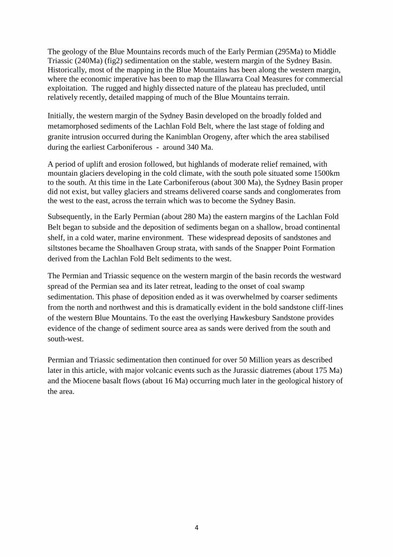
The geology of the Blue Mountains records much of the Early Permian (295Ma) to Middle
Triassic (240Ma) (fig2) sedimentation on the stable, western margin of the Sydney Basin.
Historically, most of the mapping in the Blue Mountains has been along the western margin,
where the economic imperative has been to map the Illawarra Coal Measures for commercial
exploitation. The rugged and highly dissected nature of the plateau has precluded, until
relatively recently, detailed mapping of much of the Blue Mountains terrain.
Initially, the western margin of the Sydney Basin developed on the broadly folded and
metamorphosed sediments of the Lachlan Fold Belt, where the last stage of folding and
granite intrusion occurred during the Kanimblan Orogeny, after which the area stabilised
during the earliest Carboniferous - around 340 Ma.
A period of uplift and erosion followed, but highlands of moderate relief remained, with
mountain glaciers developing in the cold climate, with the south pole situated some 1500km
to the south. At this time in the Late Carboniferous (about 300 Ma), the Sydney Basin proper
did not exist, but valley glaciers and streams delivered coarse sands and conglomerates from
the west to the east, across the terrain which was to become the Sydney Basin.
Subsequently, in the Early Permian (about 280 Ma) the eastern margins of the Lachlan Fold
Belt began to subside and the deposition of sediments began on a shallow, broad continental
shelf, in a cold water, marine environment. These widespread deposits of sandstones and
siltstones became the Shoalhaven Group strata, with sands of the Snapper Point Formation
derived from the Lachlan Fold Belt sediments to the west.
The Permian and Triassic sequence on the western margin of the basin records the westward
spread of the Permian sea and its later retreat, leading to the onset of coal swamp
sedimentation. This phase of deposition ended as it was overwhelmed by coarser sediments
from the north and northwest and this is dramatically evident in the bold sandstone cliff-lines
of the western Blue Mountains. To the east the overlying Hawkesbury Sandstone provides
evidence of the change of sediment source area as sands were derived from the south and
south-west.
Permian and Triassic sedimentation then continued for over 50 Million years as described
later in this article, with major volcanic events such as the Jurassic diatremes (about 175 Ma)
and the Miocene basalt flows (about 16 Ma) occurring much later in the geological history of
the area.
5
Figure 2 – Geological Time Scale – age of base of unit in millions of years (Ma).
Geomorphology and Structure:
Originally called mountains by the colonists, the Blue Mountains are in fact a dissected
uplifted plateau. Gentle uplift and warping together with some (relatively minor) faulting has
exposed the area to some millions of years of erosion by water and given the “mountains”
their spectacular gorges and cliffs we admire today.
Charles Darwin (1809-1882) crossed the area via Cox’s Road in 1836 and speculated on the
origin of the vast canyons and gorges as he viewed the scene southwards from near “The
Weatherboard” – present day Wentworth Falls. He invoked the ocean as the powerful erosive
force to carve out these valleys. However, it was Charles Wilkinson (1843-1891, the first
Director of the Geological Survey of NSW), who first put forward the correct explanation,
which is that the gorges have been eroded over geological time by the streams we see today
(Pickett & Alder, 1997).
As the Blue Mountains represent the stable western margin of the Sydney Basin (Branagan,
Herbert and Langford-Smith, 1976), obvious structures are rare, most being expressed by
gentle warps or monoclines, generally oriented north-south. The most obvious is the Lapstone
Monocline (fig3 - now Lapstone Structural Complex) which forms the eastern boundary of
6
the plateau. Other less obvious structures, to the west but parallel to the Lapstone structure,
include the Mt Tomah Monocline and (further west again) the Bodington Monocline
(Holland, 1974). It appears that these structures have been intermittently active since the time
of Permian sedimentation as borehole data indicate that the sediments thicken to the east
across the structural trend.
The Mt Tomah and Bodington Monoclines are responsible for the topographic division of the
plateau into what we term today the “lower Blue Mountains” and the “upper Blue
Mountains”. While these are simple monoclines, the Lapstone structure (fig 3) is a complex
of steeply west dipping reverse faults and monoclinal flexures (Herbert, 1989). There is still
considerable debate as to the age and timing of development of this structure. However, it
appears that much of the activity on this major structure took place in the early Tertiary
(Fergusson et al., 2011), and thus the uplift of the plateau appears to date from this period.
Recent palaeomagnetic studies (Schmidt et al., 1995) have suggested that most of the
movement is younger than 90Ma (mid-Cretaceous). An even earlier initiation of the Lapstone
Monocline is proposed by Pickett and Bishop (1992), who suggest a pre-Jurassic age for the
major movements on this structure. It appears the jury is still out on this one.
The Lapstone complex (fig 3) is believed to be controlled by re-activation of faults in the
basement rocks beneath the Sydney Basin. Evidence for movement on these old structures
can be seen close to the western margin of the basin.
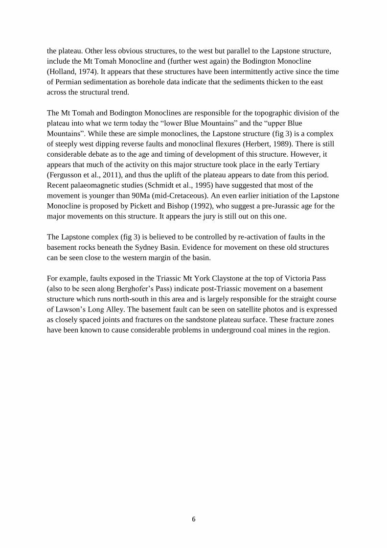
For example, faults exposed in the Triassic Mt York Claystone at the top of Victoria Pass
(also to be seen along Berghofer’s Pass) indicate post-Triassic movement on a basement
structure which runs north-south in this area and is largely responsible for the straight course
of Lawson’s Long Alley. The basement fault can be seen on satellite photos and is expressed
as closely spaced joints and fractures on the sandstone plateau surface. These fracture zones
have been known to cause considerable problems in underground coal mines in the region.
7
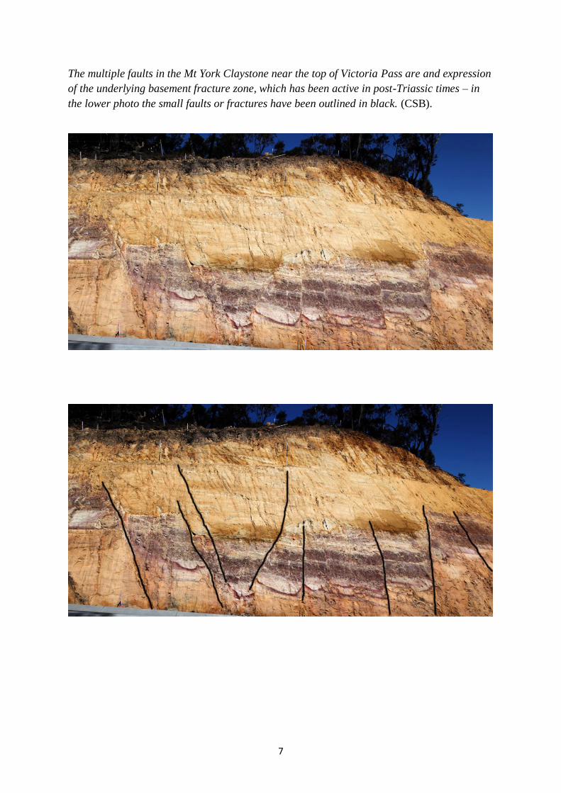
The multiple faults in the Mt York Claystone near the top of Victoria Pass are and expression
of the underlying basement fracture zone, which has been active in post-Triassic times – in
the lower photo the small faults or fractures have been outlined in black. (CSB).

8
Figure 3 – Lapstone ‘Monocline’ Structure, showing the Rickabys Creek high level gravels,
of probable Miocene age. (adapted from Branagan & Packham, 2000).
9
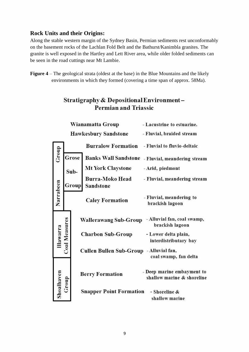
Rock Units and their Origins:
Along the stable western margin of the Sydney Basin, Permian sediments rest unconformably
on the basement rocks of the Lachlan Fold Belt and the Bathurst/Kanimbla granites. The
granite is well exposed in the Hartley and Lett River area, while older folded sediments can
be seen in the road cuttings near Mt Lambie.
Figure 4 – The geological strata (oldest at the base) in the Blue Mountains and the likely
environments in which they formed (covering a time span of approx. 58Ma).

10
Shoalhaven Group:
Marine sediments of the Shoalhaven Group (figs 4&5), comprising the Snapper Point
Formation and the overlying Berry Siltstone, form the gently rolling and dissected country
immediately west of the Triassic sandstone escarpments. Good exposures of these Permian
units can be seen in the road cuttings below Hassan’s Walls and in the highway cuttings east
of Mt Lambie.
As the Shoalhaven ‘sea’ advanced to the west it encountered some of the higher relief
topography of the older folded sediments, which in some cases formed islands and
promontories in this advancing sea. Examples of this can be seen today in the form of Mt
Cloudmaker (near Kanangra Walls) and Mt Lambie on the Great Western highway. At both
these locations the folded sediments rise far above the Snapper Point Formation sandstones
and Permian marine sediments can be found further west of these high residuals.
Poorly bedded pebbly sandstone of the Snapper Point Formation east of Mt Lambie – close
to the basement unconformity (CSB)
The sandstones of the Snapper Point Formation containing boulders and pebbles of a near-
shore high energy environment, give way to the overlying shallow marine siltstone of the
Berry Formation (fig 4). This unit contains abundant isolated pebbles and cobbles
(interpreted as “dropstones” - see glaciation section) and is noted for the abundant burrows
produced by bottom-dwelling organisms, which in most cases have completely destroyed the

11
original bedding. As the sea shallowed, shoreline sands and beach deposits came to dominate
the topmost portions of this unit. These often contain shelly fossil remains (commonly
brachiopods). The fossil assemblages indicate a cold water environment at this time, just
prior to coal measure deposition. Road cuttings on the highway just west of Victoria Pass (see
below) have good exposures of the topmost units of the Berry Formation.
Silty sandstones grading down to siltstones in the topmost Berry Formation – shoreline and
nearshore depositional environments. (CSB).

12
Figure 5 – Geological map of Blue Mountains – adapted from Sydney Basin1:500 000
geological sheet (Brunker & Rose, 1967).
Key: red – Carboniferous granite; purple – Lachlan Fold Belt; light grey – Permian
Shoalhaven Group; dark blue – Illawarra Coal Measures; light green – Narrabeen
group; mid-green – Hawkesbury Sandstone; darker green – Wianamatta Group; buff
and yellow – Tertiary and younger sediments.

13
Illawarra Coal Measures:
Following the retreat (regression) of the Shoalhaven ’sea’, widespread coal measure
sedimentation commenced. The change is marked by an abrupt transition to the deposition of
high energy, coarse sediments in the form of the Marrangaroo Conglomerate, the basal unit
(usually) of the Illawarra Coal Measures (figs 4&5) in the Western Coalfield. This dramatic
change in sedimentation is spectacularly exposed in the cuttings at the Marrangaroo overpass,
where the Mudgee Road diverges from the Great Western Highway. Here the silty sandstones
of the topmost Berry Formation (containing abundant “dropstones”) are overlain by the
cobble and pebble conglomerate beds of the Marrangaroo Conglomerate. The sharp basal
contact is most probably erosive on a regional scale.
The massive grey, pebble
and cobble conglomerate of
the Marrangaroo
Conglomerate overlying the
silty sandstones of the
topmost Berry Formation
(containing ice-rafted
material) – at the Mudgee
overpass cutting. (CSB).
Good exposures of the complete Illawarra Coal Measure sequence are rare in the district, but
some can be seen on the road over Brown’s Gap near Lithgow and also in the high wall of the
old brick quarry in Lithgow. The highway section at Victoria Pass contains poorly exposed
coal measures. Little coal is present, but the ‘barren shales’, inter-distributary bay sediments
of the lower part of the coal measure sequence, are well seen in the lower cuttings.
Given that all the above-mentioned sites are man-made openings, it is little wonder that Cox
and his men made no mention of coal in their road building efforts as they descended through
the coal measure strata below Mt York. However, one comment by Cox on this stretch of the
road shows he was a keen observer and we can today match his description with a known unit
in the Illawarra Coal Measures of the Western Coalfield. During the roadworks below Mt
York, Cox noted “an immense quantity of rock, which was very handsomely veined, very
like marble” (Cox, 2012). This can only be the finely banded and laminated Burragorang
Claystone, a unit high in the coal measure sequence and known throughout the Western
Coalfield. Its origin has been interpreted as a volcanic ash fall, deposited in extensive lakes in
a low energy environment which was starved of other coarser clastic input.

14
Many of the units of the Illawarra Coal Measures in the Western Coalfield (Yoo et al, 1995)
can be correlated with coal measure units in the Wollongong and Newcastle areas. This
interpretation is backed by detailed mapping along the basin margins plus well-documented
drill core data from the many coal bores now available (Bembrick, 1983). However, the
lower unit of the coal measures in the Western Coalfield – the Cullen Bullen Subgroup (fig 4)
– is peculiar to the western margin of the basin, being derived from the west via low angle
alluvial fans, braid plains and fan deltas. This unit contains the Marrangaroo and Blackmans
Flat Conglomerates, plus the Lithgow and Lidsdale Coals, which are commercially exploited.
This basal sequence passes upward into the Charbon Subgroup (fig 4&6), which is largely
made up of fine grained inter-distributary bay sediments and lower delta plain coals. Parts of
this sequence can be recognised across most of the Sydney Basin. Microfossils within these
fine grained sediments indicate a cold water marine to brackish environment (Bembrick,
1983). In turn this unit passes upwards into a higher energy environment including fluvial
sandstones, with upper delta plain coals. Here, in the Wallerawang Sub-Group (fig 4), we
find the prominently banded Wongawilli Coal (formerly Middle River Seam) and the
Burragorang Claystone (also called the Burragorang ‘Chert’). The upper coals in this part of
the sequence are often eroded by the lower sandstones of the overlying Narrabeen Group; in
rare cases this has removed all of the sediments above the Wongawilli Coal.
The coal measure sequence of the Wallerawang Sub-Group, Browns Gap near Lithgow – the
light grey claystone below the banded coal seam is most probably a ’seat earth’ or underclay
- i.e a fossil soil. (CSB).

15
Overall, the Sydney Basin coals have been formed in swamps thriving in a cool to cold
temperate environment (similar to that of south-west Tasmania), when Australia was part of
the ancient continent of Gondwana and lay at far southerly latitudes. Deposition of the
Illawarra Coal Measures was terminated by the extensive development of braid plains
extending southwards from the northern margins of the basin to form the basal part of the
Narrabeen Group sequence.
Figure 6 – Palaeogeography and depositional environments in Charbon Sub-Group (Late
Permian) time in the Western Coalfield – note the deltas advancing from the north and the
marine embayments. (after Johnson, 2004).

16
Narrabeen Group:
The sandstones of the Narrabeen Group are responsible for the dramatic cliffline scenery of
the upper Blue Mountains (fig 7). Older publications attributed all these cliffs to the
Hawkesbury Sandstone, which in fact does not crop out much further west than Hazelbrook
(Goodwin, 1969). On the western margin the Narrabeen Group is made up of the basal Caley
Formation, the Grose Sub-Group (formerly Grose Sandstone) and the uppermost Burralow
Formation (fig 4). The former Grose Sandstone is now subdivided into three formations – the
Burra-Moko Head Sandstone, the Mt York Claystone and the Banks Wall Sandstone
(Goldbery, 1972). It is these units which give the Blue Mountains their spectacular scenery,
such as The Three Sisters – Banks Wall Sandstone sitting above a Mt York Claystone bench.
A particularly informative and scenic exposure of these sandstone cliffs occurs at Mt Banks,
which can be viewed from Perrys Lookdown or Anvil Rock lookouts. (Charles Darwin
missed out on this superb view by sticking to the Cox’s Road route).
Figure 7 – The Triassic cliff strata of Mt Banks with thin basalt capping (CSB).
The lowermost unit of the Narrabeen Group in this cliff exposure – partly hidden in the tree
covered slope – is the Caley Formation (Goldbery, 1972). The name Caley comes from
explorer George Caley (1774-1829), who made valiant attempts to cross the Blue Mountains

17
near what we now know as Bells Line of Road in 1804. He reached and named Mt Banks
(Currey, 1966). On the western margin of the basin this formation consists of five alternating
claystone/shale and sandstone members. The basal fine grained unit (the Beauchamp Falls
Shale) in the Caley Formation is similar to the interseam sediments in the underlying coal
measures and plant remains are a common component here. Microfossils (acritarchs) have
been identified in this interval (Bembrick, 1980), which indicates a brief return to lower delta
plain and brackish water conditions of deposition.
The sandstones of the Caley formation are fine to coarse grained, quartz-lithic, with common
lithic pebbles. Cross-bedding is common and indicates a generally south easterly direction of
transport; the palaeodrainage patterns also indicate a south-easterly to easterly convergent
stream pattern (Bembrick, 1980). The fine grained units of this formation are typical of most
of the Narrabeen Group and consist of grey to grey-greenish claystone, with shale and
siltstone. Plant remains are present but not common. The formation varies in thickness from
around 15m in the western margins to over 45m in the Woodford area.
It is probable that the environment of deposition of the Caley Formation changed upward
from brackish or near marine at the base into fluvial, with meandering streams and overbank
shales and siltstones (Bembrick, 1980).
Overlying the Caley Formation is the lowermost massive, cliff-forming sandstone of the
Narrabeen Group – the Burra-Moko Head Sandstone (Goldbery, 1972). The unit is
commonly cross-bedded and displays prominent vertical joints, forming a blocky style of
cliffline. It consists of medium to coarse grained quartzose to quartz-lithic sandstone with
common green to grey claystone horizons. The latter may be locally prominent, but are not
regionally extensive. Large planar cross-beds are common, with a general south-east trend,
and the palaeodrainage data indicate a south-east convergent stream pattern (Bembrick,
1980). The unit thickens from 30m near the western margin to 110m at the eastern end of the
Grose Canyon. A fluvial, braided stream environment of deposition has been interpreted for
this interval (Ward, 1972).
The major, regionally widespread claystone unit in the Narrabeen Group of the Blue
Mountains is the Mt York Claystone (Goldbery, 1972). Previously generally known as the
‘red beds’ or chocolate shales’, these claystones – there are often two bands – are red-brown
siltstones and claystones which are a prominent feature of most Blue Mountains clifflines –
as is seen in the Mt Banks cliffs. Grey and green mottling is present in places and the
interbedded sandstone units are medium to coarse grained, with a quartz-lithic composition.
The whole unit is generally 9 to 12m in thickness. The small quarry near the top of Lawsons
Long Alley on the road to Mt York has a good exposure of these red claystones.
The mineralogy of these red beds has been extensively investigated (Goldbery and Holland,
1973; Loughnan et al (1974) and an arid, piedmont environment of deposition has generally
been attributed to these sediments. However, other evidence suggests that this may not be the
whole story. Evidence of burrowing organisms within the claystones and burrow structures in

18
the associated sandstones suggest that brackish or near marine conditions may have played a
part in the deposition of these red beds (Conolly, 1969 and Herbert, 1997). This is an ongoing
debate and the discussion of this complex issue will not be pursued here.
The Mt York Claystone – in the
small quarry along the Mt York
Road, near the top of Lawsons
Long Alley.
(CSB)
The uppermost cliffs of the Blue Mountains – as displayed at Mt Banks (fig 7) - are made up
of the Banks Wall Sandstone (Goldbery, 1972). This quartzose fluvial sandstone sequence
contains many lenticular grey-green claystone bands and one prominent, regionally extensive
red-brown claystone unit. The formation is around 115m thick in the western Blue Mountains
and reaches 244m thick in the Kurrajong area. It commonly weathers into ‘pagoda like’
outcrops which are prominent in the Gardens of Stone area north of Lithgow. Good
exposures of this unit can be seen in the road cuttings west of the truck stop at Mt Boyce.
About 90m above the base of the Banks Wall Sandstone is the Wentworth Falls Claystone
Member (WFC - the regionally extensive unit mentioned above). This unit marks a change in
the cross-bedding directions within the Banks Wall Sandstone. Below the WFC the
palaeocurrent directions are generally to the south-east, in conformity with the underlying
lower Narrabeen Group. However, above the WFC these palaeocurrent directions trend to the
north-east – more in conformity with the sediment transport directions for the Hawkesbury
Sandstone. Thus the WFC marks a major change in sediment source area for the western
parts of the Sydney Basin.
The unit is from 3m to 9m in thickness and may contain plant fossils in some localities. The
unit is associated with a conglomeratic sandstone, ‘flint’ clay and laminite. There appears to
be a distinct erosive break above this unit in the Blue Mountains sedimentary succession
(Bembrick & Holland, 1972).
Above the WFC, the upper parts of the Banks Wall Sandstone are equivalent to the Burralow
Formation (see section below) which occurs mostly in the lower Blue Mountains and
underlies the Hawkesbury Sandstone.

19
Cross-bedded channel sandstones of
the upper Banks Wall Sandstone,
near Mt Boyce. (CSB).
The Burralow Formation (Crook, 1957) lies above the Banks Wall Sandstone in the eastern
Blue Mountains and below the Hawkesbury Sandstone. In the west the interbedded
sandstones and shales of the Burralow have been largely replaced by the sandy facies of the
upper Banks Wall Sandstone (Bembrick, 1980). In general, the quartz and quartz-lithic
sandstones of the Burralow formation are interbedded with shale, claystone and siltstone.
Red-brown claystones occur more commonly towards the eastern areas. Some of the grey
shales may contain plant fossils and there is a persistent laminite near the top of the unit,
close to the boundary with the overlying Hawkesbury Sandstone. The unit thickens to the east
from about 6m near Mt Hay (Goldbery, 1972) to 138m in the area mapped by Crook (1957).
Hawkesbury Sandstone:
The Hawkesbury Sandstone is mainly confined to the lower Blue Mountains (fig 5) where it
is up to 240m in thickness. In the upper Blue Mountains it is restricted to thin outliers,
generally preserved under basalt caps – e.g. at Mt Banks (Bembrick, 1980). The unit is made
up of medium to coarse grained quartzose sandstone with thin lenticular grey shale beds
(Conaghan, 1980). Thin conglomeratic beds occur more frequently near the western limit of
outcrop where the unit thins to less than 50m. Large scale high angle (up to 300) cross-
bedding is a feature of this sandstone. The crossbeds dip generally northeast, indicating the
source rocks for these sands were to the south west of the Sydney Basin. This is in marked
contrast to the source for most of the underlying Narrabeen Group sandstones, which were
derived from the north and west.
Elsewhere in the basin, the shale lenses in the Hawkesbury Sandstone have yielded fish and
amphibian remains, plus common plant impressions. The Hawkesbury Sandstone is
considered to originate in a fluvial system on a coastal plain sloping gently northeast
(Conaghan, 1980). A mid-Triassic age is interpreted from these fossil assemblages.

20
Good exposures of the sandstone can be seen in Glenbrook Gorge and in the deep highway
road cuttings near Woodford station. One of the westernmost accessible outcrops of the unit
can be seen on the highway just east of Lawson, at ‘Sydney Rock’ (Stockton, 2014).
Cox and his men would have passed by this very spot, no doubt not realising they were about
to traverse from one sandstone unit to another (older) unit. Coincidentally, the base of the
Hawkesbury Sandstone and its transition with the underlying Narrabeen sandstones was
previously exposed in the old railway cutting (McNally, 2014) some 6m below Sydney Rock.
Unfortunately, this cutting has been backfilled for safety reasons and is no longer accessible.
Hawkesbury Sandstone in road
cutting near Woodford station,
where cross-bedding can be
observed in the weathered upper
cliff face.
(CSB).
Wianamatta Group:
In the Blue Mountains area the shales of the Wianamatta Group are confined to the lower
Blue Mountains and are almost entirely represented by the Ashfield Shale. They crop out
along the Bells Line of Road as far west as Mt Tomah (fig 5) - where they are 50m thick,
(Goldbery, 1972) - and are best developed in the Kurrajong area. On the Great Western
Highway they extend just west of Springwood. They are dark grey to black claystones and
siltstones, with fine sandstone/siltstone laminites (Clarke & Jones, 1991)
These sediments are responsible for good soil along the Bells Line of Road, which supports
the numerous orchards in that area. The major area of development of the Wianamatta Group
occurs east of the Lapstone Monocline towards the centre of the Sydney Basin. Elsewhere in
the basin a freshwater lake environment of deposition is indicated for the basal parts of the
Ashfield Shale (Herbert, 1980). Plant fossils are rare but spore and pollen evidence
(palynology) yield a mid-Triassic age for the sequence.
21
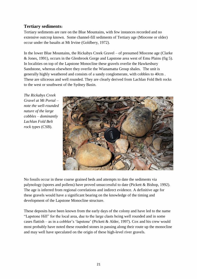
Tertiary sediments:
Tertiary sediments are rare on the Blue Mountains, with few instances recorded and no
extensive outcrop known. Some channel-fill sediments of Tertiary age (Miocene or older)
occur under the basalts at Mt Irvine (Goldbery, 1972).
In the lower Blue Mountains, the Rickabys Creek Gravel – of presumed Miocene age (Clarke
& Jones, 1991), occurs in the Glenbrook Gorge and Lapstone area west of Emu Plains (fig 5).
In localities on top of the Lapstone Monocline these gravels overlie the Hawkesbury
Sandstone, whereas elsewhere they overlie the Wianamatta Group shales. The unit is
generally highly weathered and consists of a sandy conglomerate, with cobbles to 40cm .
These are siliceous and well rounded. They are clearly derived from Lachlan Fold Belt rocks
to the west or southwest of the Sydney Basin.
The Rickabys Creek
Gravel at Mt Portal –
note the well-rounded
nature of the large
cobbles – dominantly
Lachlan Fold Belt
rock types (CSB).
No fossils occur in these coarse grained beds and attempts to date the sediments via
palynology (spores and pollens) have proved unsuccessful to date (Pickett & Bishop, 1992).
The age is inferred from regional correlations and indirect evidence. A definitive age for
these gravels would have a significant bearing on the knowledge of the timing and
development of the Lapstone Monocline structure.
These deposits have been known from the early days of the colony and have led to the name
“Lapstone Hill” for the local area, due to the large clasts being well rounded and in some
cases flattish – as in a cobbler’s ‘lapstone’ (Pickett & Alder, 1997). Cox and his crew would
most probably have noted these rounded stones in passing along their route up the monocline
and may well have speculated on the origin of these high-level river gravels.

22
Igneous rocks:
The Blue Mountains Plateau has a number of isolated basalt-capped residuals, such as Mt
Tomah, Mt Bell, Mt Banks, Mt Irvine, Mt Wilson and Mt Caley. All of these are to the north
of the Grose Canyon, while Mt Hay is the only one to lie to the south of the canyon.
These cappings are evidence for a once extensive basalt flow covering much of the plateau.
The source of this flow (or flows) is at present unknown. Columnar jointing – due to cooling
of the flow - is common in the outcrops and in some cases suggestions of a soil profile can be
seen which indicates several flow episodes. The basalt is up to 140m thick at Mt Tomah and
50m at Mt Banks.
In rare cases channel fill sediments occur beneath the basalts (Goldbery, 1972), which
indicate that at least in part the basalts filled topographic lows in the previous landscape.
Locally detailed mapping (eg Pickett, 1984) has indicated that the relief was at least 50m and
probably more. These basalt flows have now been dated by radiometric methods and have
been shown to be between 14 and 18 Ma old (Pickett & Alder, 1997) – i.e. formed in the
Miocene epoch.
Other notable occurrences of igneous rocks in the Blue Mountains are the volcanic necks,
which usually occur in hollows in the sandstone plateau surface, as they weather more
quickly than the hard sandstone plateau itself. These hollows may be quite large (hundreds of
metres) as is evident in the Euroka clearing and at Sun Valley and Toby’s Glen. These necks
or plugs contain not basalt but a mixture of rock fragments called breccia. This is a mixture of
volcanic fragments and material from the walls of the vent – showing the rock types through
which the intrusion passed on its way to the surface.
Such volcanic vents (fig 8) are called diatremes (Crawford et al, 1980) and were explosive at
the surface (as opposed to the Prospect intrusion, which did not reach the surface). Where
they have been dated by radiometric methods elsewhere in the basin they have been shown to
be about 200 Ma – i.e. earliest Jurassic in age. Because of their age and different composition
they are not considered to be the source for the extensive basalt caps mentioned previously.
Figure 8 – Probable development of an explosive volcanic neck (diatreme) – Pickett and
Alder, 1997.

23
Glaciation:
Evidence for local glaciation is preserved in the Permian sediments of the western margin of
the Sydney Basin. In late Carboniferous/early Permian times Australia (as part of Gondwana)
lay much closer to the pole – probably at more than 600 south latitude. The topographic relief
just to the west of the Sydney Basin margins has been estimated to be at least 600m and an
environment of alpine valley style glaciations is thought to have existed at that time (Herbert,
1980).
Large channels trending eastward for up to 50km have been identified along parts of the
basin margin – filled with conglomerates and other sediments typical of fluvio-glacial valley
fill (Herbert, 1980). In a few cases grooved or striated and facetted pebbles have been
recorded from drill cores, which indicate that these pebbles have been modified by ice action
and are probably part of a tillite-style glacial deposit. These channels occur beneath the
Permian Snapper Point Formation and include units referable to the Tallong Conglomerate,
Yadboro Conglomerate and (probably) the (former) Megalong Conglomerate.
As the basin developed and the Permian sea advanced (transgressed) further west, the
sediments of the Shoalhaven Group (mainly Berry Formation) included abundant isolated
clasts (pebbles, cobbles and boulders) within the fine silty matrix. The best explanation for
these is the mechanism of ice-rafting, whereby large rock fragments were transported down
the rivers and away from the shoreline by small icebergs or icerafts in seasonal thaw periods.
Melting of the floating ice then allowed the clasts to fall into the finer-grained, deeper-water
sedimentary deposits. During this time the local glacial conditions appear to be waning.
Evidence of such ice-rafted debris (or “dropstones”) can be seen throughout the full thickness
of the Berry Formation (e.g. in the road cuttings below Hassan’s Walls) and even up into the
fine grained inter-distributary bay sediments of the lower Illawarra Coal Measures, where a
cool to cold temperate climate still prevailed.
Large ice-
rafted quartzite
clast from the
Lachlan Fold
Belt in the
topmost Berry
Formation – in
road cutting at
Mudgee Road
overpass –
(scale bar is I
metre). (CSB).

24
Conclusion:
A study of the geology of the Blue Mountains allows us to unravel (at least partially) the
events of an immense period of time, from about 300 Ma to the present. Over this period,
seas have come and gone, coal swamps have thrived, massive stream systems have traversed
the landscape and volcanic outpourings covered the countryside.
Climates have changed from cold and glacial to arid and warm. Throughout all this time
weathering through the agent of running water has sought to destroy the evidence written in
the rocks. We are fortunate that, in these ’mountains’ at least, some of this story is preserved
and can be read and interpreted by an acute observer.
Little specific material accessible to the general public has been written on Blue Mountains
geology, but the “Layers of Time” publication (available at NPWS bookshops in the Blue
Mountains) is a good place to start. Some details – including maps - of specific localities can
be found in Branagan & Packham’s “Field Geology of New South Wales”. More detailed
(and technical) material is to be found in the volume, “A Guide to the Sydney Basin”,
published in 1980 by the Geological Survey of NSW (Herbert and Helby, 1980). More
general geological treatment of Australia as a whole is well covered in the book “The
Geology of Australia” by David Johnson. Also of general interest with several mentions of
the Blue Mountains is “The Geological Heritage of New South Wales” by Ian Percival.
The references which follow are not intended to be exhaustive, but sufficient to lead one to
most of the useful sources within the very extensive technical literature on the geology of the
Blue Mountains and the Sydney Basin.
Acknowledgements:
I would like to acknowledge my long-time friend and colleague, Ron Goldbery, who
introduced me to the details of Blue Mountains geology way back in 1967. Ron was
responsible for Bulletin 20 of the Geological Survey of NSW and the initial version (1969) of
the Katoomba 1:50 000 geological sheet – which finally saw the light of day in 1996! I’d also
like to pay tribute to my good friend and colleague (deceased), Garth Holmes, with whom I
did much of the geological mapping which resulted in the revised Katoomba 1:50 000 sheet.
My thanks also to David Goldney for his support and encouragement. David has acted as the
main driver and motivator for the Cox’s Road Dreaming Project.
Colleagues Colin Ward and Harry Bowman are thanked for their comments which improved
the readability and accuracy of the manuscript.
NB: (CSB) – denotes a photo by the author.

25
References
Bembrick, C.S. 1980. ‘Geology of the Blue Mountains, Western Sydney Basin’. In Herbert,
C. and Helby, R. (Eds.) A Guide to the Sydney Basin, Bull. Geol. Surv. NSW, 26, pp134-161.
Bembrick, C.S. 1983. ‘Stratigraphy and Sedimentation of the Late Permian Illawarra Coal
Measures in the Western Coalfield, Sydney Basin, New South Wales’. J. Proc. Roy. Soc.
NSW, 116, pp105-117.
Bembrick, C.S. & Holland, W.N. 1972. ‘Stratigraphy and structure of the Grose sandstone in
the Blue Mountains’, Q. Notes Geol. Surv. NSW, 7, pp11-18.
Branagan, D, Herbert, C and Langford-Smith, T. 1976. ‘An Outline of the Geology and
Geomorphology of The Sydney Basin’. Dept Geology and Geophysics, University of Sydney,
Science Press, Sydney.
Branagan, D. F. and Packham, G. H. 2000. ‘Field Geology of New South Wales – 2000’.
Department of Mineral Resources, NSW, Sydney.
Brunker, R.L. and Rose, G. 1967. Sydney Basin 1:500 000 geological sheet (special).
Geological Survey of NSW, Dept. of Mines, Sydney.
Clarke, N.R. and Jones, D.C. (Eds). 1991. Penrith 1:100 000 Geological Sheet 9030.
New South Wales Geological Survey, Sydney.
Conaghan, P. J. 1980. ‘The Hawkesbury Sandstone: Gross Characteristics and Depositional
Environment’. In Herbert, C. and Helby, R. (Eds.) A Guide to the Sydney Basin, Bull. Geol.
Surv. NSW, 26, pp188-253.
Conolly, J.R. 1969. ‘Models for Triassic Deposition in the Sydney Basin’. Spec. Publs. Geol.
Soc. Aust., 2, pp209-223.
Cox, R. 2012. ‘William Cox – Blue Mountains Road Builder and Pastoralist’.
Rosenberg Publishing Pty Ltd, Dural, Sydney. 312pp.
Crawford, E, Herbert, C, Taylor, G, Helby, R, Morgan, R and Ferguson, J. 1980. ‘Diatremes
of the Sydney Basin’ In Herbert, C. and Helby, R. (Eds.) A Guide to the Sydney Basin, Bull.
Geol. Surv. NSW, 26, pp294-323.
Crook, K.A.W. 1957. ‘The stratigraphy and petrology of the Narrabeen Group in the Grose
River district’. J. Proc. Roy. Soc. NSW, 90 (2), pp61-79.
Currey, J.E.B. (Ed.) 1966. ‘Reflections on the Colony of New South Wales – George Caley,
Explorer and Natural History Collector for Sir Joseph Banks’. Lansdowne Press, Melbourne.
239pp.

26
Fergusson, C.L., Bray, A. and Hatherly, P. 2011. ‘Cenozoic Development of the Lapstone
Structural Complex, Sydney Basin, New South Wales, Aust. Jour. Earth Sci., 58, pp49-59.
Goldbery, R. 1972. ‘Geology of the Western Blue Mountains’, Bull. Geol. Surv. NSW, 20,
172pp.
Goldbery, R. and Holland, W.N. 1973. ‘Stratigraphy and sedimentation of redbed facies in
the Narrabeen Group of the Sydney Basin, Australia’, Bull. Am. Assoc. Petrol. Geol., 57,
pp1314-1334.
Goodwin, R.H. 1969. ‘Triassic Stratigraphy – Blue Mountains, New South Wales’. J. Proc.
Roy. Soc. NSW, 102, (2), pp137-148.
Herbert, C. 1980. ‘Evidence for Glaciation in the Sydney Basin and Tamworth Synclinorial
Zone’. In Herbert, C. and Helby, R. (Eds.) A Guide to the Sydney Basin, Bull. Geol. Surv.
NSW, 26, pp274-293.
Herbert, C. 1989. ‘The Lapstone Monocline-Nepean Fault – a high angle reverse fault
system’. Advances in the Study of the Sydney Basin. Proc. 23rd
Symp. Uni Newcastle, Dept of
Geology, pp179-186.
Herbert, C. 1997. ‘Sequence statigraphic analysis of Early and Middle Triassic alluvial and
estuarine facies in the Sydney Basin’. Aust. Jour. Earth Sciences, 44, pp125-143.
Herbert, C. and Helby, R., 1980. (Eds.) ‘A Guide to the Sydney Basin’, Bull. Geol. Surv.
NSW, 26, 603pp.
Holland, W.N. 1974. ‘Origin and development of hanging valleys in the Blue Mountains,
New South Wales’. Ph.D. Thesis, University of Sydney.
Johnson, D. 2004. ‘The Geology of Australia’. Cambridge University Press, Melbourne.
276pp.
Loughnan, F.C., Goldbery, R. and Holland,W.N. 1974. ‘Kaolinite clayrocks in the Triassic
Banks Wall Sandstone of the western Blue Mountains, New South Wales’. J. Geol. Soc.
Aust., 21, pp393-402.
Marshall, C. 2015. ‘Understanding the Scenery – the geodiversity of Cox’s Rd from Mt York
to the flagstaff in Bathurst’. Web link??
McNally, G. 2014. ‘Geology’. In Stockton, Eugene (ed). Sydney Rock, pp11-17.
Percival, I. G. 1985. ‘The Geological Heritage of New South Wales’.
National Parkes and Wildlife Service, 189 Kent St, Sydney.
Pickett, J.W. 1984. ‘Pre-Basalt Topography on Mount Tomah, New South Wales’. Q. Notes
Geol Surv. NSW, 57, pp22-27.
27
Pickett, J.W. and Bishop, P. 1992. ‘Aspects of landscape evolution in the Lapstone
Monocline area, New South Wales’. Aust.Jour. Earth Sci., 39(1), pp21-28.
Pickett J.W. and Alder J.D. 1997. ‘Layers of time: the Blue Mountains and their Geology’.
New South Wales Department of Mineral Resources, Sydney 34pp.
Schmidt, P.W., Lackie, M.A. and Anderson, J.C. 1995. ‘Palaeomagnetic Evidence for the
Age of the Lapstone Monocline, NSW’. Australian Coal Geology, 10, pp14-19.
Stockton, E.(Ed). 2014. ‘Sydney Rock – on the Ways to the West’. Blue Mountains
Education and Research Trust.
Ward, C.R. 1972. ‘Sedimentation in the Narrabeen Group, southern Sydney Basin, New
south Wales’. J. Geol. Soc. Aust., 19(3), pp393-409.
Yoo, E.K., Norman, A. and McDonald, I. 1995. ‘Sydney Basin – Western Coalfield’. In
Ward, C.R., Harrington, H.J., Mallett, C.W. and Beeston, J.W. (Eds.) Geology of Australian
Coal Basins, pp231-245. Geol. Soc. Aust. Coal Geology Group, Special Publication 1.

28
Glossary
Acritarchs – remains of microscopic marine organisms which are found in marine sediments
along with plant spores and pollens.
Alluvial fan – a fan-shaped mass of sediments deposited by a stream where there is a marked
change of gradient, such as between a mountain range and the plains.
Brachiopods – marine bi-valved shell-fish that live on the sea floor.
Braid plain – a plain of low relief and low gradient where the river channels are intertwined.
Breccia – a rock composed of angular fragments, commonly of many rock types.
Chert – an extremely fine grained sedimentary rock composed largely of silica.
Columnar jointing – a polygonal system of joints perpendicular to the cooling surface
commonly found in basalt flows.
Crossbedding – or current bedding – small scale high angle beds between the main bedding
surfaces – an indication of current flow direction.
Delta – a fan-like or finger-like projection of sediments into a body of standing water – such
as where a river or stream discharges into the sea.
Diatreme – an explosive volcanic vent which is carrot-shaped in the subsurface, often
containing breccia.
Dip – the inclination of the rock strata from the horizontal.
Dropstone – a rock fragment, pebble or cobble which is deposited in fine grained sediments
by falling from small icebergs or ice sheets as they melt.
Facetted – having flat faces or sides produced by wind or ice erosion.
Fault – a planar fracture in the rock strata, usually with considerable displacement across the
fault plane
Flint clay – a hard, dense clay rock, with conchoidal (curved) fractures, generally composed
largely of kaolin.
Fluvial – relating to the deposition of sediments by running water.
Fluvio-deltaic – relating to the streams and channels of a delta system.
Gondwana – the former supercontinent of the southern hemisphere from which Australia,
India, South America and South Africa are derived.
Ice-rafting – the transport of rock fragments by icebergs floating down rivers and away from
the shoreline, to melt in deeper water.

29
Intrusion - a body of rock which has been inserted while molten into a pre-existing rock.
Kanimblan Orogeny – a period of folding and intrusion in the Lachlan Fold Belt – between
approx. 340 – 360 Ma.
Lachlan Fold Belt – a north-south trending zone in central western NSW comprising folded
sediments and granites ranging in age from Cambrian (500Ma) to Early Carboniferous
(340Ma).
Laminite – a fine grained and laminated sedimentary rock where the individual layers are less
than 1cm in thickness.
Metamorphosed – rocks which have been altered by heat and pressure
Monocline – a gentle flexure of the rock strata where the rocks on either side are horizontal
or nearly so.
Palaeocurrent – the ancient stream currents which deposited the sediments.
Palaeodrainage – the pattern of ancient stream system which deposited the rock strata.
Palaeogeography – the geomorphology of the ancient terrain which existed at the time of
deposition of the rocks.
Palaeomagnetic – relating to the remnant magnetism which can be measured in the minerals
within the rocks.
Piedmont – a low relief tract of country at the foot of a mountain range.
Quartzose – relating to a high quantity or dominance of quartz or silica in the sediment.
Quartz-lithic – describing a sedimentary rock which contains both quartz and rock fragments.
Radiometric – relating to the dating of rocks by the use of radioactive minerals which decay
at known rates.
Reverse fault – a fault where the uplifted side tends to ‘hang over’ the lower side.
Seat earth – or underclay – the fossil soil from which the coal-forming peat grew.
Tillite – the rock formed by material (till) deposited by a glacier
Tuff – the rock formed from a volcanic ash deposit, which may have been laid down by air-
fall or fluvial mechanism.
Unconformity – the contact surface between two rock layers where there is a major break in
sedimentation and thus a time gap in the geological record.