the geological evolution of bjørnøya, arctic norway...
TRANSCRIPT

Extended abstractThe small island of Bjørnøya ("Bear Island"), situated inthe Barents Sea almost midway between northern Nor-way and Spitsbergen, displays a Precambrian to Triassicsuccession in a continuous series of spectacular cliffexposures. These exposures provide a key not only to theevolution of the Stappen High (on which Bjørnøya rests)but also to the development of analogous structuresalong the major lineaments that subsequently contribu-ted to the formation of both the Norwegian-GreenlandSea and the Arctic Ocean.
Precambrian to Ordovician dolomites, limestones,quartzites and shales form the basement on which theUpper Palaeozoic succession of Bjørnøya was deposi-ted. In latest Devonian and early Carboniferous timesthe area subsided asymmetrically, probably in responseto NE-SW extension; a southwestwards downtiltedhalf-graben developed over the present-day island, withthe basinal axis dipping gently NNW. Some 600 m ofsandstones, coals and shales are preserved in twoupward coarsening sequences. These represent therepeated progradations of sandy fan systems over flo-odplains with lakes and northward meandering riverchannels. Mid-Carboniferous (Serpukhovian) upliftwas followed by renewed rifting and the same westernhinterland again shed debris over its faulted easternmargins. A shift from humid to a semi-arid climate isreflected by the predominantly red colouration of theresultant 200 m thick succession of conglomerates,sandstones and shales, with caliche horizons. Penecon-
temporaneous regional sea level rise resulted in the gra-dual replacement of the alluvial floodbasin deposits byshallow marine siliciclastics and carbonates of shore-line, tidal flat and shallow shelf origin. Continuedtransgression through the Moscovian, perhaps alsowith decreasing subsidence rates and only intermittenttectonism, is indicated by the gradual change to amarine carbonate-dominated succession, with chertybiomicrites reflecting the establishment of an open car-bonate shelf over the entire area.
A marked rejuvenation of tectonic activity in the lateMoscovian established a different depositional mosaic -faulting affected exposures on the present island alongN-S to NE-SW lineaments, with differential subsidencedown to the west. This produced erosion of earlierdeposits over the eastern part of Bjørnøya and deposi-tion of conglomerates, sandstones, shales and dolomitesin alluvial gully, coastal and shallow shelf environmentsto the west. A 200 m thick succession is preserved inwestern areas and eroded remnants are also preserved asoutliers elsewhere on the island. Conglomerate clastsindicate derivation by successive stripping and redepo-sition of mid-Carboniferous to uppermost Devonianand then basement strata. By the latest Carboniferousthe region had again stabilized and platform carbonatedeposition resumed, with the development of paleoa-plysinid carbonate build-ups. Early Permian flexuring,uplift and peneplanation followed, probably with sometranspressive movements. The highly condensed mid-to Upper Permian marine succession of mixed siliciclas-tics and carbonates oversteps all older strata. The Stap-
NORWEGIAN JOURNAL OF GEOLOGY The geological evolution of Bjørnøya 195
The geological evolution of Bjørnøya, Arctic Norway: implications for the Barents Shelf
David Worsley, Torleiv Agdestein, John G. Gjelberg, Knut Kirkemo, Atle Mørk, Inger Nilsson, Snorre Olaussen, Ron J. Steel & Lars Stemmerik
Worsley, D., Agdestein, T., Gjelberg, J.G., Kirkemo, K., Mørk, A., Nilsson, I., Olaussen, S., Steel, R.J. & Stemmerik, L.: The geological evolution ofBjørnøya, Arctic Norway: implications for the Barents Shelf. Norsk Geologisk Tidsskrift Vol. 81, pp.195–234. Trondheim 2001. ISSN 0029-196X.
D. Worsley, Norsk Hydro, 0246 Oslo, Norway (Email [email protected]); T. Agdestein, Norsk Chevron, Karenslyst Alle 2-4 Oslo, Norway,(Email [email protected]); J. Gjelberg, Norsk Hydro Forskningssenter, P.O. Box 7190, 5020 Bergen, Norway. (Email [email protected]); K. Kirkemo, Statoil, 4035 Stavanger, Norway (Email [email protected]); A. Mørk, SINTEF Petroleum Research, 7465 Trondheim, Norway ([email protected]); I. Nilsson, Norsk Hydro, P.O.Box 117, 4065 Stavanger, Norway (Email [email protected]); S. Olaussen, Norsk Hydro,present address: Norsk Agip, P.O.Box 101 Forus, 4064 Stavanger (Email [email protected]); R.J. Steel, University of Wyoming, Dept. ofGeology & Geophysics, Laramie, WY 82072-3355, U.S.A. (Email [email protected]); L. Stemmerik, GEUS, Thoravej 8, DK-2400 København NV,Denmark (Email [email protected]).

pen High then remained a positive feature through tothe late Triassic, the youngest beds preserved being ofCarnian age. The high subsequently subsided signifi-cantly during the Mesozoic, but it again became a posi-tive feature as a result of one or more phases of upliftduring the Cenozoic.
Much of the Carboniferous succession of Bjørnøya,with non-marine rifted sequences giving way in themid-Carboniferous to a marine carbonate shelf deve-lopment, mirrors time-equivalent successions throug-hout the Barents Shelf, northeastern Greenland and theSverdrup Basin. Late Carboniferous and early Permianfaulting, flexuring and uplift, and the development ofoverlying, condensed and stratigraphically incompleteUpper Permian/Lower Triassic platform sequences arehowever atypical features – only found on local struc-tural highs which together form elements of a majorcircum-Arctic fault complex along which Paleogenecontinental separation took place. A better understan-ding of the late Palaeozoic evolution of these highs maycontribute significantly to further hydrocarbon explo-ration in this frontier petroleum province.
IntroductionThe Barents Sea covers an extensive shelf area thatextends northwards from the Arctic coasts of Norwayand Russia to the margins of the Arctic Ocean (Fig. 1).It was long suspected that this area had a different geo-logical history from the Precambrian and CaledonideBaltic Shield to the south. Ongoing hydrocarbon explo-ration in the last 20 years has demonstrated a complexstructural development, with several major subprovin-ces containing varied Upper Palaeozoic to Cenozoicsedimentary successions (e.g. Rønnevik et al. 1982;Rønnevik & Jacobsen 1984; Faleide et al. 1984; Johan-sen et al. 1992, Nøttvedt et al. 1992, Gudlaugsson et al.1998). Exploration wells in the Norwegian sector (over50 to date) have rapidly increased our knowledge of thearea's stratigraphy. However, critical integration ofknowledge from onshore exposures with offshore welland seismic data is still crucial for a better understan-ding of the Barents Shelf ’s development.
The small island of Bjørnøya, only 178 km2 in area,is situated on the Stappen High, near the Barents shel-f ’s western margin and approximately midway bet-ween mainland Norway and Spitsbergen. (Fig.1). TheStappen High as defined by Gabrielsen et al. (1990) isan elongate structure trending N-S from 73º 30’ to 75º30’ N at 18 to 19º E latitude, with Bjørnøya forming itshighest point. This high was a positive Late Palaeozoicfeature; it then subsided in the Mesozoic and was againuplifted in the Cenozoic. Seismic data suggest thatexposures on Bjørnøya are representative of the Stap-
pen High as a whole. Prior to the drilling of offshorewells, exposures on this rugged, mist-shrouded andinhospitable island offered the only concrete informa-tion on the geological evolution of this significant sec-tor of the Arctic. The sedimentary succession exposedon the island ranges from the Upper Precambrian tothe Upper Triassic, with a composite thickness approa-ching 3 km (Fig. 2). Significant unconformities definethe boundaries between three main depositional com-plexes: viz. the Pre-Devonian economic basement, theLate Palaeozoic basin and the Permo-Triassic plat-form.
Bjørnøya itself comprises two topographically dis-tinct areas, each directly related to its underlying geo-logy (Fig. 3). The extensive northern plain generallyundulates between 20 and 50 m above sea level, with alabyrinth of rock fields, marshes and small lakes - all ofwhich make walking and reconnaissance difficult. Thefew poor inland exposures give little information onthe complexity of the underlying Upper Palaeozoicsequence and this succession is best studied in the coas-tal cliffs. The exposures there are excellent, but field-work is often hazardous. The south and southeasternpart of the island is a rugged mountainous terraindominated by basement exposures, and more than 400m high cliffs rise precipitously from the sea. Mountain-tops in this area show almost flat-lying exposures of thePermo-Triassic platform sequence unconformablyoverlying all older units; however Late Palaeozoic half-grabens are locally developed, cutting into the base-ment but predating the platform units (Fig. 4). Triassicstrata - the youngest pre-Quaternary deposits preser-ved on the island - are exposed in three conical peakson the Miseryfjellet massif, with youngest Carniandeposits preserved at 536 m above sea level.
Swedish expeditions in the latter half of the 19thcentury made the first general survey of the island, cul-minating in the major work of Andersson (1900).Upper Devonian and Lower Carboniferous coals werethen the main objects of geological and economic inte-rest, although other minerals were also investigated.Mining operations started in 1916, but were abando-ned as uneconomical in 1925 - a conclusion confirmedby the evaluation of Horn & Orvin (1928). This reportconcentrated on the coal-bearing strata, but it alsoreviewed other geological work and presented a 1:50000 bedrock map. Following the abandonment of eco-nomic exploitation, the island was largely bypassed bygeologists in the ensuing 50 years and only isolatedaspects of its palaeontology and geology were descri-bed. Biostratigraphically important contributions fromthis period include studies of Late Palaeozoic brachio-pods (Gobbett 1963), palynofloras (Kaiser 1970, 1971),and corals (Fedorowski 1975). Siedlecka (1972, 1975)and Folk & Siedlecka (1974) also presented significantpetrographical interpretations of selected Permian sec-tions.
196 D. Worsley et al. NORWEGIAN JOURNAL OF GEOLOGY
NORWEGIAN JOURNAL OF GEOLOGY The geological evolution of Bjørnøya 197
NO
VA
JAZ
E
MLJA
FinnmarkPlatform
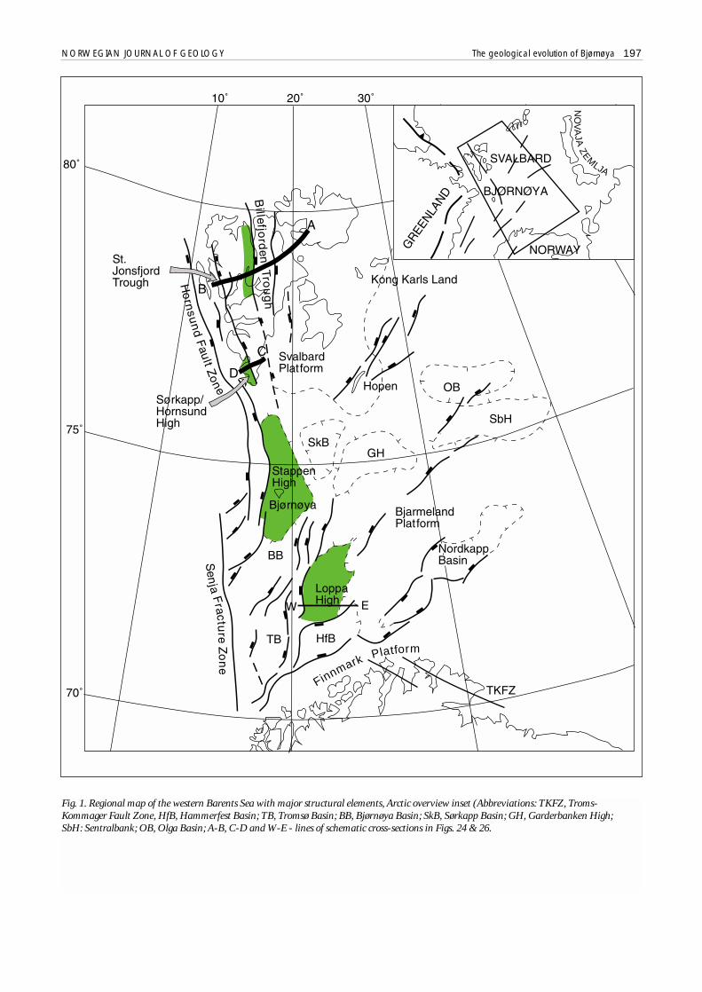
Fig. 1. Regional map of the western Barents Sea with major structural elements, Arctic overview inset (Abbreviations: TKFZ, Troms-Kommager Fault Zone, HfB, Hammerfest Basin; TB, Tromsø Basin; BB, Bjørnøya Basin; SkB, Sørkapp Basin; GH, Garderbanken High; SbH: Sentralbank; OB, Olga Basin; A-B, C-D and W-E - lines of schematic cross-sections in Figs. 24 & 26.

198 D. Worsley et al. NORWEGIAN JOURNAL OF GEOLOGY
BJA
RM
E-
LAN
D
Fig. 2. Composite stratigraphical column for Bjørnøya’s Upper Palaeozoic succession, comparing present and earlier nomenclatures.

NORWEGIAN JOURNAL OF GEOLOGY The geological evolution of Bjørnøya 199
Fig. 3. Simplified geological map of Bjørnøya.

General surveys by Soviet and Norwegian geologistsresulted in a description of the island's Triassic succes-sion by Pchelina (1972), a general tectonic synthesis byKrasilscikov & Livsic (1974) and a stratigraphical andpalaeoenvironmental review of the Upper Palaeozoicsuccession by Worsley & Edwards (1976). This newgeneration of activity sparked a series of detailed stu-dies on the entire Upper Palaeozoic and Triassic succes-sion, involving staff and research students at the Nor-wegian universities of Bergen and Oslo. Resultant the-ses (Gjelberg 1978a; Kirkemo 1979; Agdestein 1980)and publications (Gjelberg 1978b, 1981; Worsley &Gjelberg 1980; Gjelberg and Steel 1981, 1983; Bjorøy etal. 1983) were followed by detailed biostratigraphicalappraisals of both fusulinids (Simonsen 1988) andpalynomorphs (Vigran 1991) throughout the succes-sion. Other recent contributions include detailed stu-dies of parts of the succession (Lønøy 1988; Stemmerik& Larssen 1993; Stemmerik et al. 1994, 1998; Stemme-rik & Worsley 2000), a brief review of Late Palaeozoicstructural regimes (Lepvrier et al. 1989) and by evalua-tions of the area’s burial history (Ritter et al. 1996). Animportant contribution was the new 1:50 000 geologi-cal map of Dallmann and Krascilscikov (1996). Thegeneral review in Harland (1997) is mainly based onpre-existing literature and several of the conclusionspresented there will be supplemented and/or modifiedby the present contribution.
A synthesis of both published and unpublished recentwork is presented here. Following initial general reviewsof the palaeogeographical evolution of the entire Sval-bard archipelago (Steel & Worsley 1984; Worsley et al.1986) and more recent reviews of various aspects of theLate Palaeozoic regional development (Bruce & Toomey1992; Cecchi 1992; Gerhard & Buhrig 1990; Nilsen et al.1992; Stemmerik & Worsley 1989, 1995), it is now rele-vant to present such a synthesis and compare and con-trast the development of Bjørnøya with the remainder ofthe Barents Shelf. By combining this information withour present geophysical understanding of the area, it maybe possible to give more refined prognoses of the subsur-face development and economic potential of analogousstructures in this extensive and still little explored hydro-carbon province.
Pre-Devonian BasementIn common with the remainder of Svalbard, thissequence is often referred to as "Hecla Hoek"; it was des-cribed by Holtedahl (1920) and Krasilscikov & Livsic
200 D. Worsley et al. NORWEGIAN JOURNAL OF GEOLOGY
Fig. 4. The cliffs of Hambergfjellet from Hornvika with (Inset A) locality map and (Inset B) view of southern massif fromnorthern coast. Note the 80 m high stack of Sylen (“The needle”) for scale.
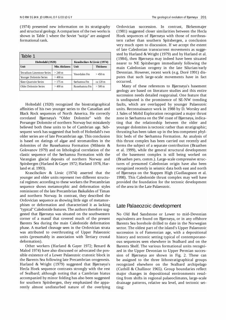
(1974) presented new information on its stratigraphyand structural geology. A comparison of the two works isshown in Table 1 where the Soviet "suitja" are assignedformational rank.
Holtedahl (1920) recognized the biostratigraphicalaffinities of his two younger series to the Canadian andBlack Rock sequences of North America. He correctlycorrelated Bjørnøya’s “Older Dolomite” with thePorsanger Dolomite of northern Norway but mistakenlybelieved both these units to be of Cambrian age. Sub-sequent work has suggested that both of Holtedahl's twoolder series are of late Precambrian age. This conclusionis based on datings of algae and stromatolites in thedolomites of the Russehamna Formation (Milstein &Golovanov 1979) and on lithological correlation of theclastic sequence of the Sørhamna Formation with theVarangian glacial deposits of northern Norway andSpitsbergen (Harland & Gayer 1972; Harland 1978, Har-land et al. 1993).
Krascilscikov & Livsic (1974) asserted that theyounger and older units represent two different structu-ral regimes: according to these workers the Precambriansequence shows metamorphic and deformation stylesreminiscent of the late Precambrian Baikalides of Timanand northern Norway. In contrast, they described theOrdovician sequence as showing little sign of metamor-phism or deformation and characterized it as lacking"typical" Caledonide features. The authors therefore sug-gested that Bjørnøya was situated on the southwesterncorner of a massif that covered much of the presentBarents Sea during the main Caledonide deformationphase. A marked cleavage seen in the Ordovician stratawas attributed to overthrusting of Upper Palaeozoicunits (presumably in association with Tertiary crustaldeformation).
Other workers (Harland & Gayer 1972; Renard &Malod 1974) have also discussed or advocated the pos-sible existence of a Lower Palaeozoic cratonic block inthe Barents Sea following late Precambrian orogenesis.Harland & Wright (1979) suggested that Bjørnøya'sHecla Hoek sequence contrasts strongly with the restof Svalbard; although noting that a Cambrian hiatusaccompanied by minor folding has also been suggestedfor southern Spitsbergen, they emphasized the appa-rently almost undisturbed nature of the overlying
Ordovician succession. In contrast, Birkenmajer(1981) suggested closer similarities between the HeclaHoek sequences of Bjørnøya with those of northeas-tern rather than southern Spitsbergen, a conclusionvery much open to discussion. If we accept the extentof late Caledonian transcurrent movements as sugge-sted by Harland & Wright (1979) and by Harland et al.(1984), then Bjørnøya may indeed have been situatednearer to NE Spitsbergen immediately following themain Caledonian orogeny in the late Silurian/earlyDevonian. However, recent work (e.g. Doré 1991) dis-putes that such large-scale movements have in factoccurred.
Many of these references to Bjørnøya's basementgeology are based on literature studies and this entiresuccession needs detailed reappraisal. One feature thatis undisputed is the prominence of SE-NW trendingfaults, which are overlapped by younger Palaeozoicunits. Reconnaissance work in 1988 by D. Worsley andJ. Sales of Mobil Exploration recognized a major thrustzone in Sørhamna on the SW coast of Bjørnøya, indica-ting that the relationship between the older andyounger dolomites is tectonic rather than stratigraphic;thrusting has been taken up in the less competent phyl-litic beds of the Sørhamna Formation. An analysis ofthis thrust complex has been carried out recently andforms the subject of a separate contribution (Braathenet al. 1999), while the general structural developmentof the basement complex is still being worked on(Braathen pers. comm.). Large-scale compressive struc-tures of presumed Caledonian origin have also beenrecognized recently in seismic data both east and northof Bjørnøya on the Stappen High (Gudlaugsson et al.1998). This Caledonide thrust complex may well haveprovided the foundation for the tectonic developmentof the area in the Late Palaeozoic.
Late Palaeozoic developmentNo Old Red Sandstone or Lower to mid-Devonianequivalents are found on Bjørnøya, or in any offshoreBarents Sea borehole drilled to date in the Norwegiansector. The oldest part of the island's Upper Palaeozoicsuccession is of Famennian age, with a depositionalhistory and tectonic setting typical of contemporane-ous sequences seen elsewhere in Svalbard and on theBarents Shelf. The various formational units recogni-zed in the Upper Devonian to Upper Permian succes-sion of Bjørnøya are shown in Fig. 2. These can be assigned to the three lithostratigraphical groupsrecognized elsewhere on the Svalbard archipelago(Cutbill & Challinor 1965). Group boundaries reflectmajor changes in depositional environments resul-ting from shifts in regional palaeoclimates, large-scaledrainage patterns, relative sea level, and tectonic set-ting:
NORWEGIAN JOURNAL OF GEOLOGY The geological evolution of Bjørnøya 201
Holtedahl (1920) Krasilscikov & Livsic (1974)
Unit Min. thickness Unit Thickness
Tetradium Limestone Series > 240 m Ymerdalen Fm > 450 mYounger Dolomite Series > 400 m
Slate-Quartzite Series > 175 m Sørhamna Fm ca 120 m
Older Dolomite Series > 400 m Russehamna Fm > 500 m
Table 1

• Billefjorden Group, (Famennian to Viséan)with coal-bearing non-marine siliciclastics,deposited in the humid alluvial fan and flood-plain environments represented by the Røed-vika and Nordkapp formations.
• Gipsdalen Group, (Serpukhovian/Bashkirianto Asselian) dominated on Spitsbergen byshallow marine carbonates and evaporites withsubordinate mixed carbonates and siliciclastics,all deposited in semi-arid to arid palaeo-climatic settings. The group is represented onBjørnøya by the Landørdingsvika, Kapp Kåre,Kapp Hanna and Kapp Dunér formations.
• Bjarmeland and Tempelfjorden groups(Artinskian to Upper Permian), with silica-rich mixed siliciclastics and carbonates of theHambergfjellet and Miseryfjellet formations,suggesting regional submergence and thedevelopment of more temperate climateswith deeper and cooler water hydrographicregimes. The Hambergfjellet Formation hasgenerally been assigned to the GipsdalenGroup; our reassignment will now be discus-sed in more detail.
These formational units were first described in gene-ral terms by Andersson (1900) and Horn & Orvin(1928). Presently accepted lithostratigraphical nomenc-lature as accepted by Dallmann (1999) is based on workby Cutbill & Challinor (1965), Krasilscikov & Livsic(1974) and Worsley & Edwards (1976).
The Famennian to mid-Moscovian succession ofBjørnøya displays a similar depositional history to con-temporaneous strata in central Spitsbergen, but theUpper Moscovian and younger rocks show striking dif-ferences to these better known areas. Whereas the lateCarboniferous to early Permian history of most of cen-tral Spitsbergen shows the establishment of a relativelystable carbonate and evaporite platform, Bjørnøya atthe same time suffered renewed and repeated tectonicactivity, producing extensive faulting (Fig. 4).
We will discuss the late Devonian to Permian his-tory of Bjørnøya in terms of six major evolutionaryphases. Palynological and faunal evidence for ourdatings of these phases are summarized in Fig. 5, basedon Simonsen (1988), Vigran (1991), Nilsson (1993,1994) and J.O. Vigran (pers. comm. 1999). Palaeogeo-graphical sketch maps showing our main conclusionsare displayed in Fig. 6. We will subsequently comparethis development with the contemporaneous evolutionof adjacent Arctic areas, and then discuss possibleimplications for hydrocarbon exploration in theregion.
The Famennian to Bashkirian West BjørnøyaBasin
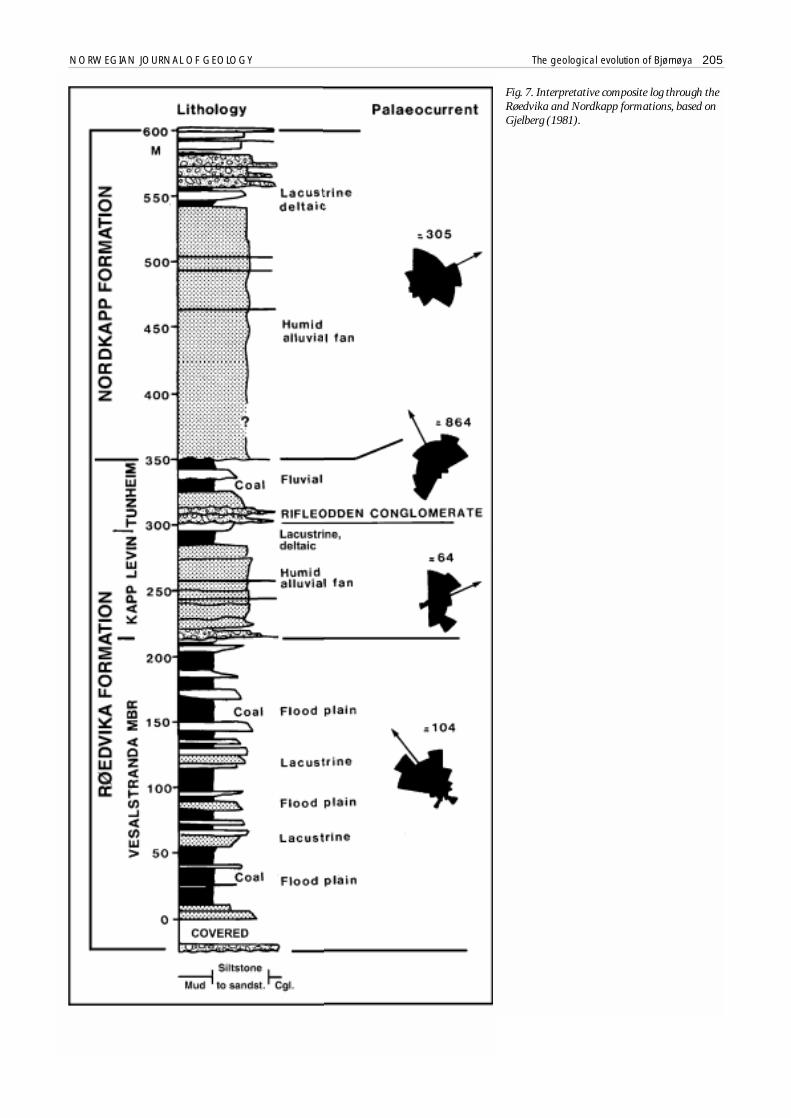
Bjørnøya in Famennian to Bashkirian times wassituated near the western margin of a NNW- trendingasymmetric rift basin, which Gjelberg & Steel (1983)considered to be bounded to the WSW by a major tecto-nic lineament - their “West Bjørnøya Fault”. The silici-clastic deposits of the Røedvika, Nordkapp and Land-nørdingsvika formations (Figs. 7, 8 & 9) show a maxi-mum composite thickness of up to 800 metres. This suc-cession consists of three coarsening upward sequences ofdiffering origin and development.
Røedvika and Nordkapp humid clastics -- The lower andmiddle parts of the Røedvika Formation form a singlecoarsening upward motif from the coal-bearing Vesal-stranda Member to the coarser Kapp Levin Member, bothdeposited during the Famennian. The base of the Vesal-stranda Member is marked by thin intermittent conglo-merates in a siliciclastic succession which onlaps theunderlying basement. The angular unconformity bet-ween these units is well displayed on the eastern cliffs ofMiseryfjellet where it is dissected by small normal faults,thus refuting the suggestion by Krasilscikov & Livsic(1974) of later modification by thrusting; the stronglydiscordant appearance of the contact seen in outcropresults from the marked onlap relationship combinedwith some deformation in the less competent basal bedsof the Røedvika Formation. The Vesalstranda Memberitself consists largely of fine-grained, dominantly greyflood-plain sediments, with fining upward sandstonebodies deposited in the channels of meandering streams.In addition, the lower and middle parts of the membercontain small coarsening upward sequences, which repre-sent the progradation of small lacustrine deltas (see Gjel-berg 1981 for details). Lacustrine and fluvial facies thusalternate in the lower parts of the succession, but fluvialdeposits become more common upwards and there is agradual transition to the more sandy and coarser grainedsediments of the overlying Kapp Levin Member. The lat-ter were deposited mainly by low sinuosity streams in themember's lower part; these pass upwards into more typi-cal braided river systems.
Palaeocurrents in the Vesalstranda Member suggestnorthwestwards flowing meandering streams, while flowdirections in the Kapp Levin Member were towards theeast and northeast. The overall change in depositionalenvironment and palaeocurrent distribution seenthrough this upward coarsening sequence is probablyrelated to the increasing dominance with time of alluvialfan systems that built out from the southwestern upliftedfootwall margin of the basin. These fans prograded east-wards over the older northwest-flowing axial fluvial sys-tems (Worsley & Edwards 1976; Gjelberg 1978a, b, 1981;Gjelberg & Steel 1981, Fig. 6 herein).
202 D. Worsley et al. NORWEGIAN JOURNAL OF GEOLOGY
NORWEGIAN JOURNAL OF GEOLOGY The geological evolution of Bjørnøya 203
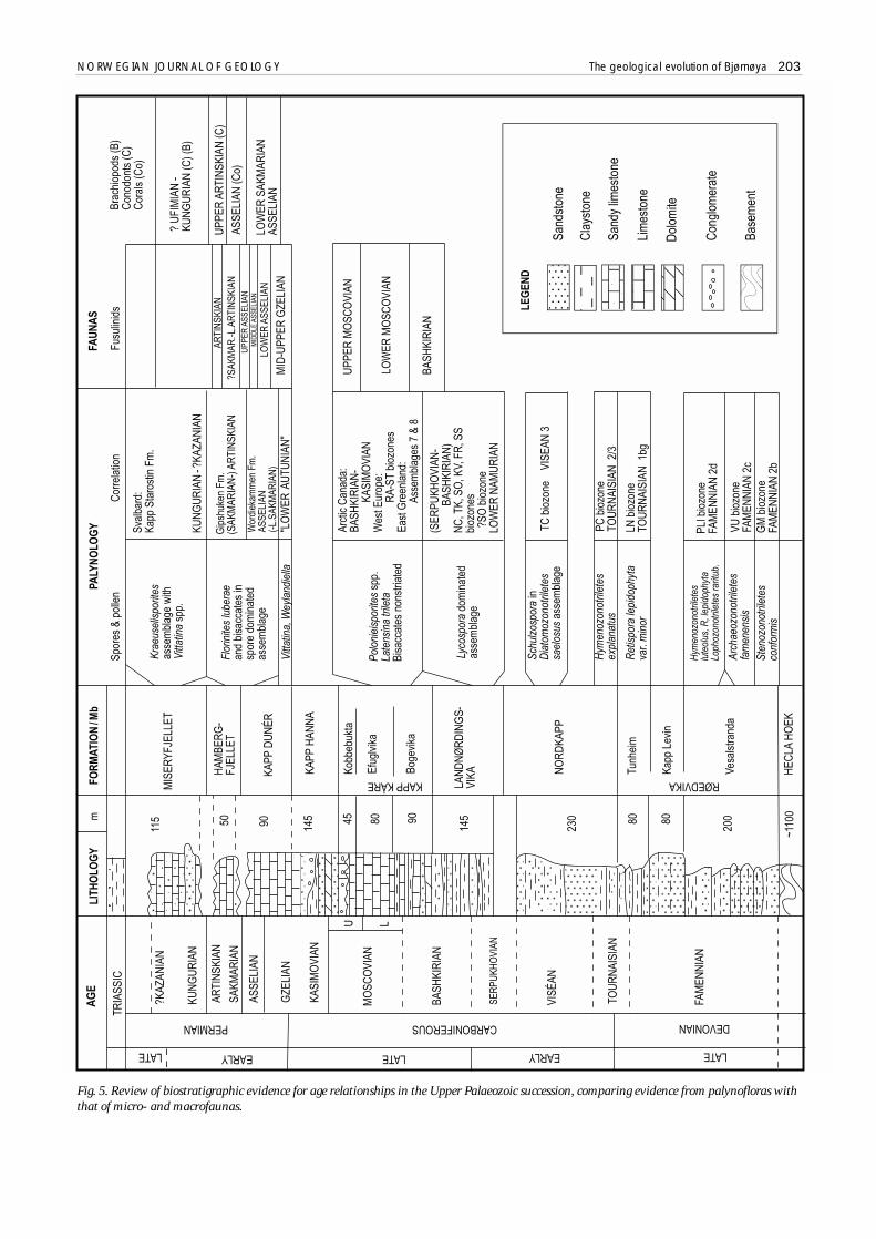
Fig. 5. Review of biostratigraphic evidence for age relationships in the Upper Palaeozoic succession, comparing evidence from palynofloras withthat of micro- and macrofaunas.
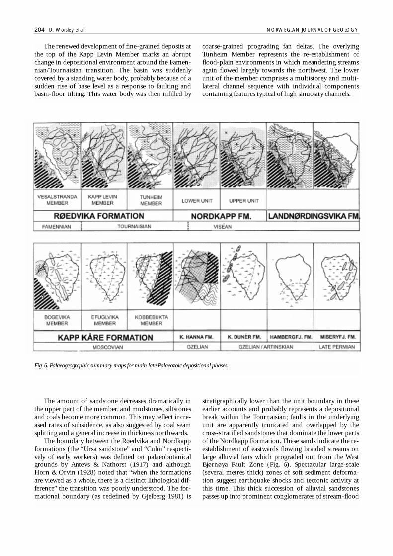
The renewed development of fine-grained deposits atthe top of the Kapp Levin Member marks an abruptchange in depositional environment around the Famen-nian/Tournaisian transition. The basin was suddenlycovered by a standing water body, probably because of asudden rise of base level as a response to faulting andbasin-floor tilting. This water body was then infilled by
coarse-grained prograding fan deltas. The overlyingTunheim Member represents the re-establishment offlood-plain environments in which meandering streamsagain flowed largely towards the northwest. The lowerunit of the member comprises a multistorey and multi-lateral channel sequence with individual componentscontaining features typical of high sinuosity channels.
204 D. Worsley et al. NORWEGIAN JOURNAL OF GEOLOGY
Fig. 6. Palaeogeographic summary maps for main late Palaeozoic depositional phases.
The amount of sandstone decreases dramatically inthe upper part of the member, and mudstones, siltstonesand coals become more common. This may reflect incre-ased rates of subsidence, as also suggested by coal seamsplitting and a general increase in thickness northwards.
The boundary between the Røedvika and Nordkappformations (the “Ursa sandstone” and “Culm” respecti-vely of early workers) was defined on palaeobotanicalgrounds by Antevs & Nathorst (1917) and althoughHorn & Orvin (1928) noted that “when the formationsare viewed as a whole, there is a distinct lithological dif-ference” the transition was poorly understood. The for-mational boundary (as redefined by Gjelberg 1981) is
stratigraphically lower than the unit boundary in theseearlier accounts and probably represents a depositionalbreak within the Tournaisian; faults in the underlyingunit are apparently truncated and overlapped by thecross-stratified sandstones that dominate the lower partsof the Nordkapp Formation. These sands indicate the re-establishment of eastwards flowing braided streams onlarge alluvial fans which prograded out from the WestBjørnøya Fault Zone (Fig. 6). Spectacular large-scale(several metres thick) zones of soft sediment deforma-tion suggest earthquake shocks and tectonic activity atthis time. This thick succession of alluvial sandstonespasses up into prominent conglomerates of stream-flood
NORWEGIAN JOURNAL OF GEOLOGY The geological evolution of Bjørnøya 205
Fig. 7. Interpretative composite log through theRøedvika and Nordkapp formations, based onGjelberg (1981).
206 D. Worsley et al. NORWEGIAN JOURNAL OF GEOLOGY
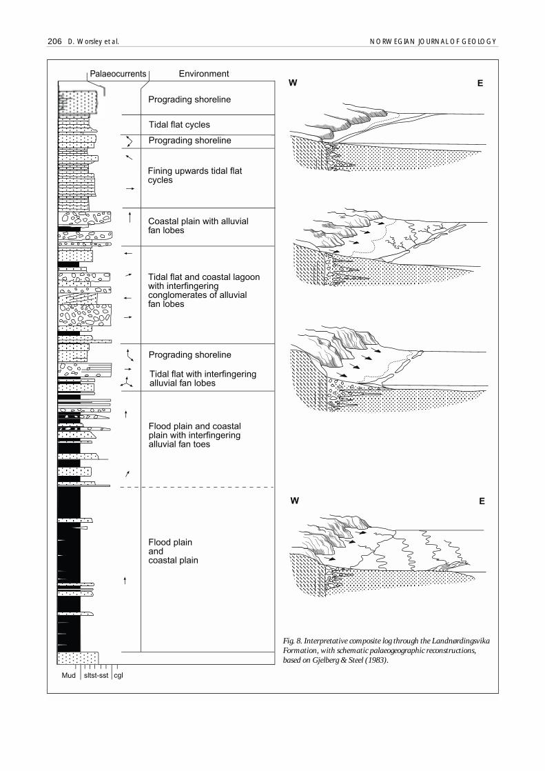
Fig. 8. Interpretative composite log through the LandnørdingsvikaFormation, with schematic palaeogeographic reconstructions,based on Gjelberg & Steel (1983).
NORWEGIAN JOURNAL OF GEOLOGY The geological evolution of Bjørnøya 207
and mass-flow origin, interbedded with black coaly sha-les. These contrast sharply with the underlying monoto-nous quartzitic sandstone succession and are thought torepresent renewed large-scale rifting.
Climatic shift to Landnørdingsvika redbeds -- The entiresuccession reviewed so far is typified by lithofacies sug-gesting deposition in moist climates on floodplainswith a high water table and a low substrate Eh. Thetransition between the Nordkapp and Landnørdings-vika formations marks a dramatic shift to semi-arid orarid climatic conditions. Worsley & Edwards (1976)noted a sharp break between the grey sandstones of theformer and the red mudstone of the latter in exposureson the southwest coast, although some secondary red-dening of the underlying unit has occurred. Recentpalynological studies (J.O. Vigran, pers. comm. 1995)indicate a Tournaisian to Viséan age for the NordkappFormation and a youngest Serpukhovian to Bashkirianage for the overlying red beds. The significant Serpuk-hovian depositional break above an upward coarseningfluvial succession has been recognized throughout theArctic and may represent a period of general upliftseparating early and mid-Carboniferous rifting phases.
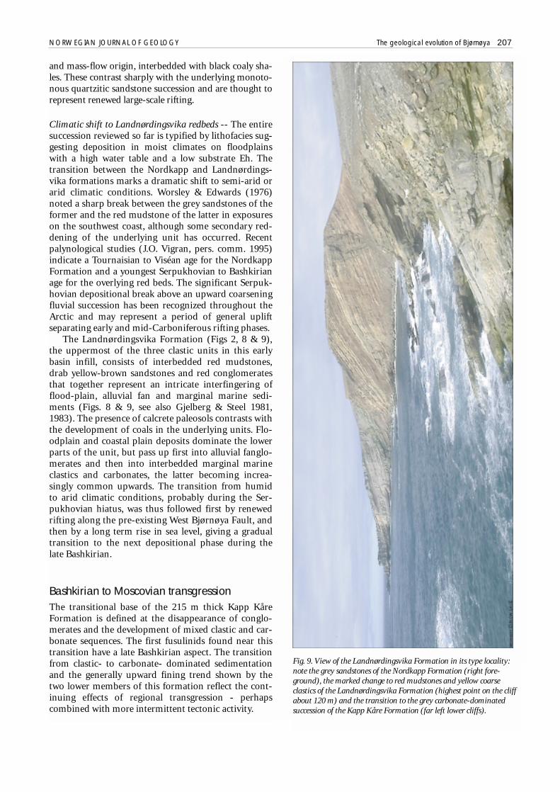
The Landnørdingsvika Formation (Figs 2, 8 & 9),the uppermost of the three clastic units in this earlybasin infill, consists of interbedded red mudstones,drab yellow-brown sandstones and red conglomeratesthat together represent an intricate interfingering offlood-plain, alluvial fan and marginal marine sedi-ments (Figs. 8 & 9, see also Gjelberg & Steel 1981,1983). The presence of calcrete paleosols contrasts withthe development of coals in the underlying units. Flo-odplain and coastal plain deposits dominate the lowerparts of the unit, but pass up first into alluvial fanglo-merates and then into interbedded marginal marineclastics and carbonates, the latter becoming increa-singly common upwards. The transition from humidto arid climatic conditions, probably during the Ser-pukhovian hiatus, was thus followed first by renewedrifting along the pre-existing West Bjørnøya Fault, andthen by a long term rise in sea level, giving a gradualtransition to the next depositional phase during thelate Bashkirian.
Bashkirian to Moscovian transgressionThe transitional base of the 215 m thick Kapp KåreFormation is defined at the disappearance of conglo-merates and the development of mixed clastic and car-bonate sequences. The first fusulinids found near thistransition have a late Bashkirian aspect. The transitionfrom clastic- to carbonate- dominated sedimentationand the generally upward fining trend shown by thetwo lower members of this formation reflect the cont-inuing effects of regional transgression - perhapscombined with more intermittent tectonic activity.
Fig. 9. View of the Landnørdingsvika Formation in its type locality:note the grey sandstones of the Nordkapp Formation (right fore-ground), the marked change to red mudstones and yellow coarseclastics of the Landnørdingsvika Formation (highest point on the cliffabout 120 m) and the transition to the grey carbonate-dominatedsuccession of the Kapp Kåre Formation (far left lower cliffs).
208 D. Worsley et al. NORWEGIAN JOURNAL OF GEOLOGY
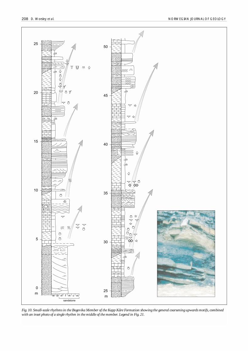
Fig. 10. Small-scale rhythms in the Bogevika Member of the Kapp Kåre Formation showing the general coarsening upwards motifs, combinedwith an inset photo of a single rhythm in the middle of the member. Legend in Fig. 21.
Bogevika Member rhythms -- The Bogevika Member(Fig. 10) consists of limestones, shales and sandstonesapparently organized in a series of small-scale (< 10 mthick) shoaling upward rhythms (Stemmerik et al. 1998;Stemmerik & Worsley 2000). Each rhythm typicallyshows an upward transition from oncolitic to coralgallimestones or marine shales (often organic rich) intosiltstones and sandstones with either brackish water fau-nas or plants and roots. Upper contacts are usually sharpand show desiccation cracks, calcrete horizons or an ero-sional surface under the basal limestone or shale of theoverlying rhythm. Marked discontinuities and karst sur-faces are also relatively common within and on tops ofindividual limestone units in these sequences. Red bedsand coarser clastics are more common in southern expo-sures, while grey shales and marine limestone incursionsare more characteristic of the northern coast. The entire
development reflects deposition in tidally influencedmarginal marine environments, with the upward coars-ening units representing repeated shoreline progradati-ons into both restricted and open marine depositionalsites (Stemmerik & Worsley 2000). The abundance ofkarst and other discontinuities suggests that the rhyth-mic development is not a purely autocyclic phenomenonbut may rather reflect an interplay of continued localtectonic activity, ongoing regional transgression andglacially influenced eustatic sea-level fluctuations (c.f.Stemmerik & Worsley 1989). Sporadic palaeocurrentindicators reflect both long-shore and bimodally direc-ted on/offshore current patterns in this complex regime.Sandstones become less common upwards, as decreasingclastic input accompanied submergence of the westernupland provenance areas. The gradual transition throughlimestone and shale intercalations to the overlying
NORWEGIAN JOURNAL OF GEOLOGY The geological evolution of Bjørnøya 209
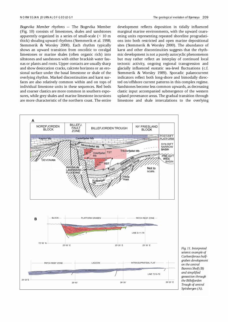
Fig. 11. Interpretedseismic example ofCarboniferous half-graben developmenton the centralBarents Shelf (B)and simplifiedgeosection throughthe BillefjordenTrough of centralSpitsbergen (A).

carbonate-dominated Efuglvika Member reflects theestablishment of carbonate shelf sedimentation throug-hout the entire area by the early Moscovian. Similartransitions in local troughs and transgression of largeplatform areas are typical of the whole Barents Shelf atthis time. The best-documented example is the Billefjor-den Trough in central Spitsbergen (Holliday & Cutbill1972; Johannessen & Steel 1992) but similar situationscan also be recognized locally in the western BarentsShelf ’s subsurface (Fig. 11).
Efuglvika platform carbonates -- The 80 m thick Efugl-vika Member is dominated by white to grey, thinly tomassively bedded and variably cherty limestones withtextures ranging from grainstone to wackestone. Bothmicrofacies and stenohaline faunas suggest depositionon an open marine shelf of moderate depth. Exposuresshow a series of shoaling-upwards rhythms passingfrom bioturbated chert-rich wackestones with Thalassi-noides burrows into chert-free grainstones, sometimeswith erosive or karstified tops (Stemmerik et al. 1998,Stemmerik & Worsley 2000). The cyclicity seen lower inthe succession thus continued, but clastic input decrea-sed as transgression covered available provenance areas.The rhythmic development, the karstic surfaces and thecherts themselves suggest some measure of continuedtectonic activity during sedimentation. The chert bothfills Thalassinoides burrows and occurs in various mor-photypes indicative of "diapiric" movement within theunconsolidated sediments. The resultant chert massesvary in form from bulbous to sheet-like "dykes" sub-perpendicular to the bedding. These elongate structu-res follow NE-SW and NW-SE trending zones of defor-mation. Large-scale fractures with penecontemporane-ous sediment infill also crosscut the bedding subverti-cally with a NE-SW trend. The fractures and the chertbodies are thought to be related to subaerial exposureand karstification: a few discontinuity surfaces showclear microkarstic features and bedding truncationsand angular unconformities are occasionally associatedwith these surfaces. These phenomena collectively sug-gest intermittent syn- and early post-sedimentationaltectonism, the chert deformation being precementationin age and the fractures postconsolidational; this tecto-nism is more clearly shown by the facies of the overly-ing units.
Late Moscovian to Gzelian tectonismWorsley & Edwards (1976) noted the existence of intra-formational conglomerates uppermost in the KappKåre Formation. Subsequent work has shown howthese beds mark a change of tectonic activity on Bjørn-øya in the Late Moscovian. We interpret the top surfaceof the Efuglvika Member as representing a pronouncederosional break with clear karstification. The overlyingKobbebukta Member (Kirkemo 1979), where present,consists of interbedded marine limestones, shales and
conglomerates (Figs. 12 & 13). The latter containmostly intraformational chert and limestone clasts - incontrast to the significant extrabasinal componentsthat characterize the coarse clastic units of the overly-ing Kapp Hanna Formation. The conglomerates of theKobbebukta Member were deposited by both subaerialand submarine debris flows triggered by renewed syn-depositional tectonism. However, these flows origina-ted from fault blocks over eastern parts of present-dayBjørnøya, producing apparent partial inversion of theearlier basin (Figs. 6 & 14), superimposed over the nor-therly trend of the underlying Caledonide thrust sys-tem. Two sets of brittle fracture systems with calciticslickensides observed in the Røedvika and Nordkappformations suggest post-early Carboniferous but pre-mid Permian movements characterized by predomi-nantly normal dip-slip extension followed by minorlateral movements. The late Moscovian basinal inver-sion appears to be represented by the normal extensio-nal fractures, which began to form penecontemporane-ously with the dykes and fractures described above inthe Efuglvika Member. Major block controls seem tohave been exerted by the dominantly N-S trendingfaults, while minor cross-cutting roughly ESE-WNWand ENE-WSW trending sets controlled flow of erodedmaterial from the uplifted flanks of the graben west-wards into accommodation areas on the hanging wallof the West Bjørnøya Fault.
A spectacular facies development seen on the north-ern coast within the Kobbebukta Member (mentionedbriefly by Worsley & Edwards 1976) is interpreted asmarking the site of repeated synsedimentary small-scalefault activity along such a WSW-ENE trending faultscarp (Fig. 12). Debris flows drape over the faulted mar-gin, but the main feature of the downthrown side is asequence of shales and turbidites, the latter deposited bycurrents flowing westwards and paralleling the micro-fault scarp (Stemmerik & Worsley 2000). The overlyingconglomerates show no lateral variation over the fault-line trace, implying cessation of movement on this parti-cular feature immediately below the boundary with theKapp Hanna Formation. Faulting obscures the boundaryitself; conglomerates, which apparently drape over thepoorly exposed critical fault separating the two forma-tions, may suggest ongoing synsedimentational tecto-nism. Southern outcrops show a highly varied develop-ment at this level (Fig. 13). Debris flows uppermost inthe formation just south of Efuglvika form thin veneers(less than 1 m thick) on the eroded top of the EfuglvikaMember whereas only 1.5 km further north along thecoast, extrabasinal Kapp Hanna conglomerates directlyinfill broad channels cutting at least 5 m down into theEfuglvika Member.
Additional evidence of tectonism -- Significant additionalinformation is given by several critical inland exposuresand by analysis of photomosaics of the generally inacces-sible southern cliffs:
210 D. Worsley et al. NORWEGIAN JOURNAL OF GEOLOGY

Fig. 12. Intraformational conglomerates in the Kobbebukta Member, uppermost Kapp Kåre Formation: combined section logs and photocollageshow a syndepositional fault – this reflects renewed tectonic activity producing small half-grabens which then channelled debris flows andturbidites from the newly emergent eastern high. Legend in Fig. 21.
NORWEGIAN JOURNAL OF GEOLOGY The geological evolution of Bjørnøya 211
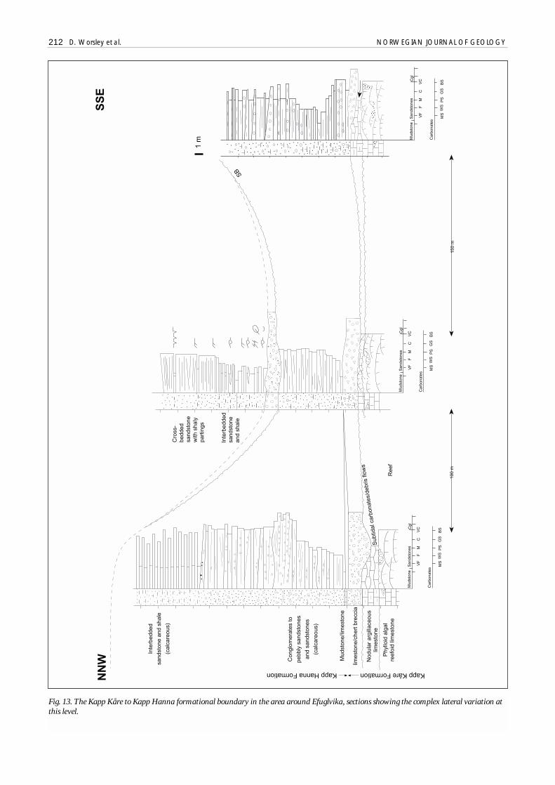
Fig. 13. The Kapp Kåre to Kapp Hanna formational boundary in the area around Efuglvika, sections showing the complex lateral variation atthis level.
212 D. Worsley et al. NORWEGIAN JOURNAL OF GEOLOGY
NORWEGIAN JOURNAL OF GEOLOGY The geological evolution of Bjørnøya 213
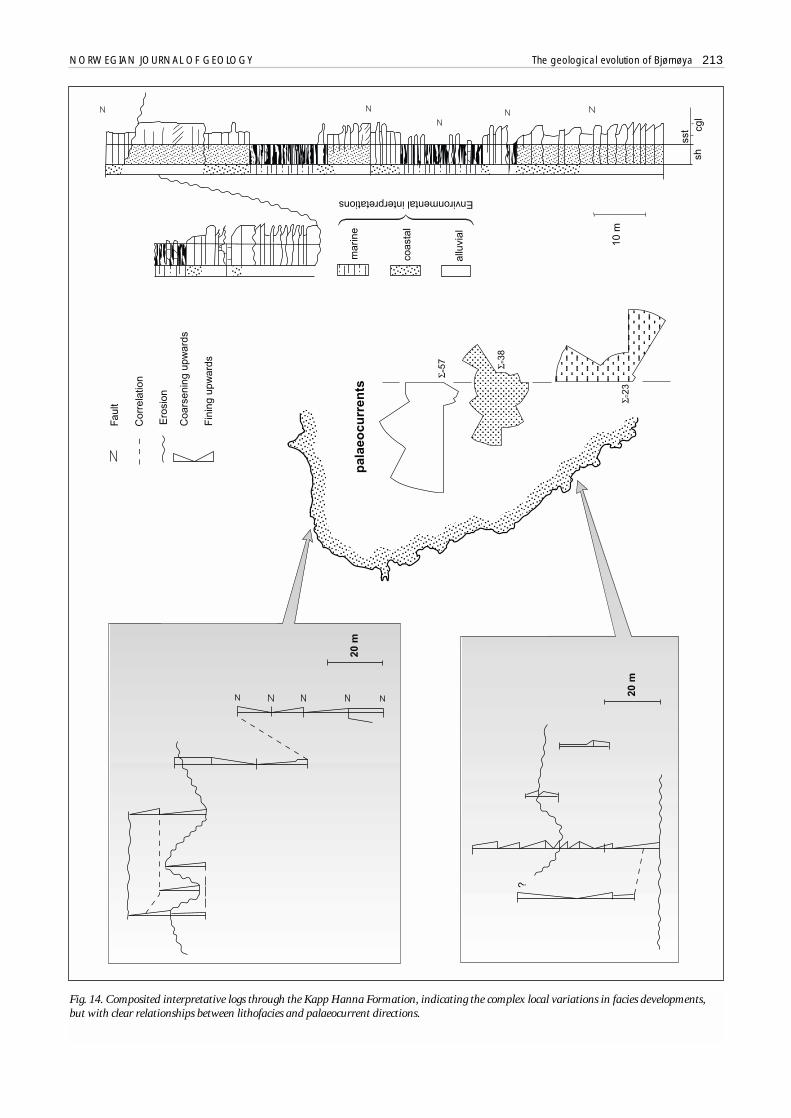
Fig. 14. Composited interpretative logs through the Kapp Hanna Formation, indicating the complex local variations in facies developments,but with clear relationships between lithofacies and palaeocurrent directions.
• Inland exposures on the hill of Raudnuten near thewest coast show complex relations: on eastern hill-sides almost flatlying Efuglvika carbonates are erosi-vely overlain by a cm-scale veneer of conglomerates,while western slopes show a monoclinal flexure inthe top of the Efuglvika Member before these dipsteeply to the west. ENE - WSW trending fracturesand minor faults dissect the N-S axis of the mono-cline and define an erosional relief infilled by up to10 m thick coarse conglomerates of the Kapp HannaFormation. The relief shown by the faulted and ero-ded top of the Efuglvika Member is clearly a lateMoscovian phenomenon - isolated thin outliers onthe hilltop contain limestones with fusulinids assig-nable to the overlying Kapp Dunér Formation oflate Asselian age (see also below) and these limesto-nes onlap the whole of the underlying irregularrelief,
• Earlier workers mapped inland exposures south ofMiseryfjellet near the southeastern coast as contain-ing basal Røedvika Formation conglomerates. Theseare now interpreted as Kapp Hanna conglomeratesdeposited directly on eroded basement; they pass upinto carbonates which have not yet been dated,
• Southernmost cliffs show almost 400 m sheer expo-sures of basement, generally with a thin onlappingmid- to Upper Permian overlying sequence; threelocal half-grabens which have been identified in thesecliffs show a presumed Kapp Hanna to Kapp Dunérwedge infill resting directly on an abutting basement;the uppermost Permian overlaps and is not involvedin the graben infill (Fig. 4).
• Coastal exposures of the Kapp Hanna Formation, oflatest Moscovian to Kasimovian age, display laterallyvariable alternations of conglomerates, sandstones,shales and dolomites. The complex development, innumerous small fault blocks on the western andnorthwestern coasts and in scattered poorly exposedoutliers inland, makes lateral correlation extremelydifficult but detailed studies suggest a compositemaximum thickness of around 145 m (Fig. 14). Mostof the coastal exposures display both fining and coar-sening upward packages in which alluvial, coastal andmarginal marine environments are represented.However, several localities show shallow marinedolomite and shale units cut by valley forms with upto 20 m observed relief; these valleys also trend gene-rally ESE-WNW and are controlled by minor synde-positional faults. These incised valleys are infilled bythinly interbedded sequences of conglomerates andsandstones of stream-flood origin. Abundant palaeo-current data in the alluvial sequences indicate a cleareastern source and flow directions along the valleyfloor to the WNW; similar directions are seen in the isolated inland exposures described above.
Desiccation cracks found in shaly laminae on bed-ding planes throughout the conglomerates indicaterepeated subaerial exposure between intermittentdepositional episodes. Other features indicative oflocal tectonic activity include fissures infilled withclastic material and intraformational angular uncon-formities of up to 5° overlain by conglomerates con-taining angular clasts of the underlying penecontem-poraneous sandstones.
Tectonic summary -- The total association of unusual fea-tures displayed by exposures of the Kobbebukta Memberand the Kapp Hanna Formation strongly suggest intra-basinal tilting which uplifted the eastern flanks of theearlier West Bjørnøya depositional graben. Older Carbo-niferous and Devonian deposits must have already beenwell consolidated so that the flanks were dissected into aseries of N-S trending fault blocks now exposed over eastern parts of present-day Bjørnøya (Figs. 15 & 16).Subaerial erosion of this newly created structural highcomplex produced the conglomeratic material infillingthe incised valleys in the Kapp Kåre and Kapp Hannaformations. Fault trends and paleocurrent directionsassociated with these events indicate main movementsalong N-S to NNE-SSW directed lineaments with a dif-ferent alignment from the NW-SE trending Early Carbo-niferous West Bjørnøya Fault. Conjugate sets of minorfaults controlled the general westerly trend of the incisedvalleys themselves.
Analyses of sandstone mineralogy and conglomerateclast composition in the Kapp Hanna Formation provideadditional evidence for basinal evolution at this time (Fig.15). The clasts were derived from older local units andboth clasts and matrix show a well-developed inverse stra-tigraphy, reflecting the progressive erosion of these unitson the newly uplifted graben flanks. The marked domi-nance of Hecla Hoek clasts in southwestern exposurescontrasts with the dominantly Lower Carboniferous clastcontent of the northwest exposures. This suggests thatunroofing and erosion of Hecla Hoek rocks in the southand southeast of the island happened largely during depo-sition of the Kapp Hanna Formation, so that this syntec-tonic depositional phase apparently involved tilting andcreation of most accommodation space in the north andnorthwest. This interpretation is supported by the inlandoutliers of coarse Kapp Hanna conglomerates and byseveral features in the Kapp Dunér Formation discussedbelow; this also suggests that much of the present expo-sure pattern on the island essentially reflects Late Carbo-niferous faulting, subsequently modified by early Permianuplift and peneplanation of the entire area (Fig. 16).
The incised valleys and the irregular relief producedby this tectonic phase were not completely infilledduring the Gzelian: uppermost fine clastic beds in valleyfills in Nordvestbukta (Fig. 17), for example, containfusulinids with a clear Asselian aspect; these beds appar-ently correlate with carbonates from the upper parts ofthe overlying Kapp Dunér Formation in westernmost
214 D. Worsley et al. NORWEGIAN JOURNAL OF GEOLOGY

exposures. Similar deposits occur above thin KappHanna lithologies on Raudnuten, possibly also in iso-lated localities south of Miseryfjellet and in at least oneof the half-grabens described from the southern cliffs
(Fig. 4), suggesting that the Kapp Hanna Formation wasonly locally deposited over most of the eastern andsouthern parts of the island - and then only in the fault-defined incised valleys.
NORWEGIAN JOURNAL OF GEOLOGY The geological evolution of Bjørnøya 215
Fig. 15. Clastcompositions inKapp HannaFormationconglomerates,showing varia-tions upwardsin the forma-tion, in mosaicwith othercritical expo-sures showingchannelling inthe formation.
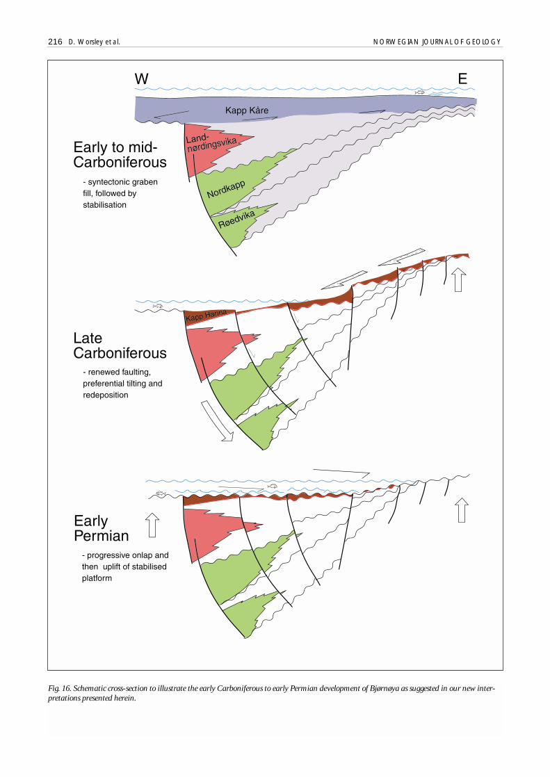
Fig. 16. Schematic cross-section to illustrate the early Carboniferous to early Permian development of Bjørnøya as suggested in our new inter-pretations presented herein.
216 D. Worsley et al. NORWEGIAN JOURNAL OF GEOLOGY

Fig. 17. Correlation of several partial sections through the Kapp Dunér Formation with (inset) an example of stacked palaeoaplysinid buildups.
NORWEGIAN JOURNAL OF GEOLOGY The geological evolution of Bjørnøya 217
218 D. Worsley et al. NORWEGIAN JOURNAL OF GEOLOGY
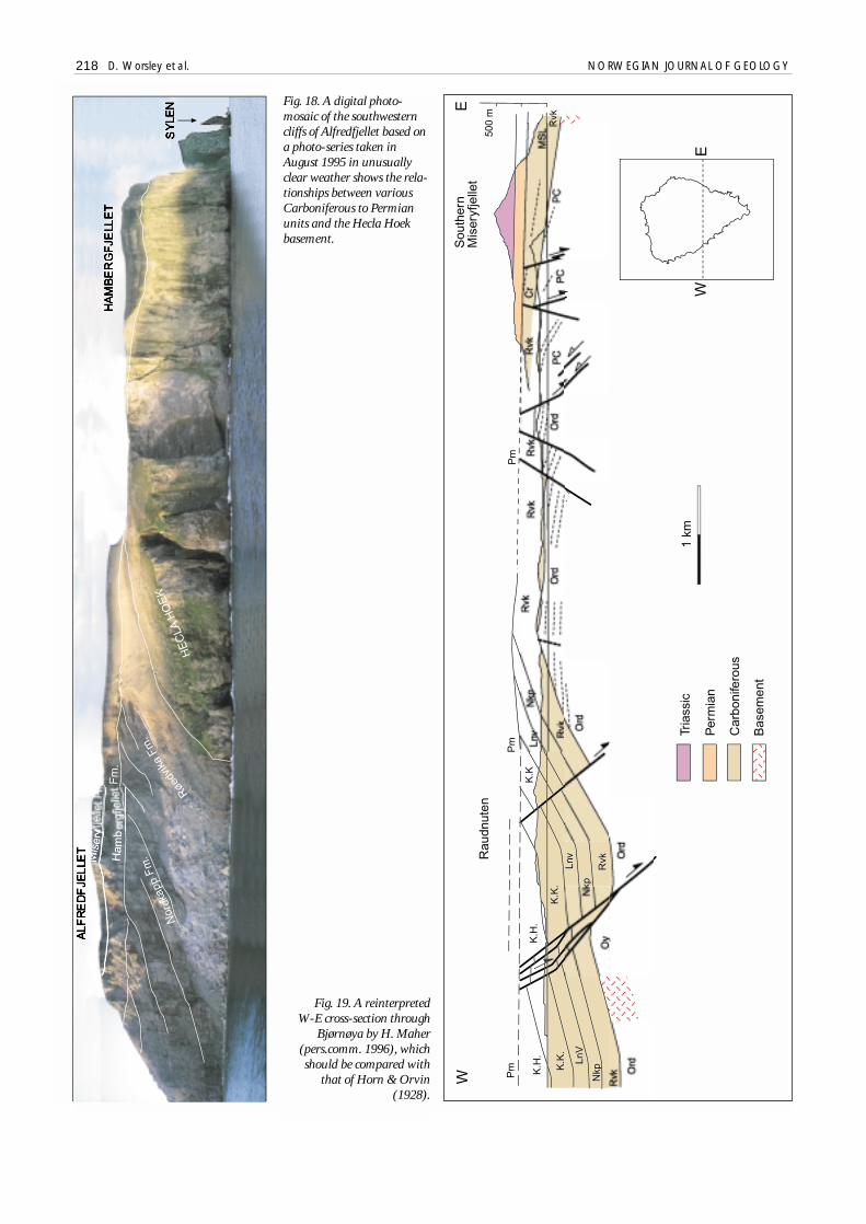
Fig. 18. A digital photo-mosaic of the southwesterncliffs of Alfredfjellet based ona photo-series taken inAugust 1995 in unusuallyclear weather shows the rela-tionships between variousCarboniferous to Permianunits and the Hecla Hoekbasement.
Fig. 19. A reinterpreted W-E cross-section through
Bjørnøya by H. Maher(pers.comm. 1996), whichshould be compared with
that of Horn & Orvin(1928).

Mid-Gzelian to Asselian stabilizationThe upper parts of the Kapp Hanna Formation show amarked fining trend into interbedded thin sandstonesand dolomitic mudstones, reflecting increasing local tec-tonic stability and a relative rise in sea level. The transi-tion to the carbonates of the Kapp Dunér Formation ismarked by the development of two thick beds of massivedolomite intercalated with thinly bedded dolomiticmudstones, wackestones and packstones (Fig. 17). Theformer are interpreted as highly dolomitized tabular bio-herms and biostromes; they show striking similarities tothe contemporaneous paleoaplysinid build-ups of cen-tral Spitsbergen described by Skaug et al. (1982).
Kapp Dunér mounds -- The two lowermost tabularmound sets are overlain by a karstic surface with 2 m reliefbefore deposition of more paleoaplysinid build-ups with alenticular cross-section. Pronounced long axes in theselenticular structures show a NNE-SSW trend (Fig. 6) andindividual 5-7 m thick build-ups are dominated by large-scale accretionary surfaces directed perpendicularly to thistrend both to the WNW and ESE. These represent a flankfacies formed by lateral migration of the structures follo-wing vertical growth to the surf zone. Talus washed fromthe build-ups' core was stabilized on the flanks by thebuilding activity of framework organisms such as corals,bryozoans and stromatoporoids; back-reef facies to theeast of the buildups are characterised by lagoonal wackes-tones and mudstones. Although binding organisms andother faunas are seen only as vague ghosts, some of thesestructures appear to show a marked ecological successionfrom base to top, frame-building organisms increasingfrom 20 % to 60 % upwards in each build-up. Bituminouslimestones and dolomites are common in the inter- andback-mound sequences; Siedlecka (1972, 1975) and Folk& Siedlecka (1984) have described the “schizohaline” envi-ronments represented by parts of these sequences: faunasand petrography suggest both restricted hypersaline andopen marine environments.
This total association, described in detail by Lønøy(1988), Stemmerik & Larssen (1993) and Stemmerik et al.(1994), is similar to that of the penecontemporaneousBrucebyen Bed of central Spitsbergen (Skaug et al. 1982),although the Bjørnøya sequence is more highly dolomiti-zed. In both areas build-ups developed in sites which hadbeen tectonically active in the Carboniferous. In centralSpitsbergen, build-ups developed parallel to the Bille-fjorden Lineament along the earlier Nordfjorden Block'seastern margins; they also extended some distance out intothe adjacent basin. We cannot establish the original lateralextent of the build-ups in the Bjørnøya area, but both axialand accretionary trends conform to the basinal patternsuggested by the underlying Kapp Hanna sequences.
Ongoing Asselian transgression -- Uppermost lenticularmound horizons are overlain by another pronouncedkarstic surface. The overlying 40 metres of the formation
consist of bedded dolomites without build-ups; thesebeds represent deposition in lagoonal to restricted shelfenvironments through the Late Asselian. Deposition inthe west was accompanied by onlap of the positive andstill emergent areas to the east and southeast; the entirehigh was probably transgressed before renewed tecto-nism and uplift in the Sakmarian. The present-day expo-sed top of the Kapp Dunér Formation on the westerncoast probably approximates to the eroded surface resul-ting from these Sakmarian movements; fractures and fis-sures up to about 10 m deep are filled with clasts andsediments of presumed mid- to Late Permian age.
The major erosional surface overlying the mounds inthe middle of the formation is correlated with a regionalrelative fall in sea level in the Late Gzelian now recogni-sed over large areas of the Barents Shelf (c.f. Cecchi1992). The subsequent Asselian transgression progressi-vely onlapped the entire Bjørnøya area, as shown by thecrucial exposures in Nordvestbukta, on Raudnuten andin the southern cliffs (Fig. 4). As mentioned previously,the incised valley observed in the Kapp Hanna Forma-tion in Nordvestbukta has an uppermost infill of Asse-lian age, directly overlying? Kasimovian coarse clastics.On Raudnuten (Simonsen 1988; Stemmerik et al. 1994),fusulinids in thin limestone beds that directly overlieboth Kapp Kåre and Kapp Hanna Formation lithologiesindicate late Asselian age. At least one of the previouslyunrecognized small graben structures in the southerncliffs contains bedded carbonates which we consider tobe lateral equivalents to the upper parts of the KappDunér Formation in its main exposure area (Figs. 4 &17), with fusulinids confirming the model presentedabove for onlap and evening of fault and erosional reliefduring the late Asselian. Smaller scale variations in theentire formation, with numerous karstic surfaces, proba-bly also reflect high-frequency local tectonic pulses(Stemmerik & Larssen 1993).
Present exposures of the Kapp Dunér Formation inthe western and northwestern cliffs of Bjørnøya are atleast 90 m thick, but uppermost beds exposed dip sea-wards and the unit appears to thicken in the same direc-tion on the limited seismic lines available so that theexposures onland may represent just the easternmostproximal part of a larger complex. The formation appa-rently outcrops on the seafloor up to 3 km off the wes-tern coast before passing up into presumed mid- toUpper Permian sequences further offshore.
Early to mid-Permian uplift and peneplanationRenewed uplift during the Sakmarian and/or earlyArtinskian resulted in the final sculpting of the entirearea, producing a broad, apparently gentle and slightlyasymmetric anticline which is cut by large numbers ofN-S trending largely normal faults. The axis of thisstructure corresponds roughly to the margins of the LateCarboniferous high, with the more steeply dipping west-ern limb containing the Upper Carboniferous to lower-
NORWEGIAN JOURNAL OF GEOLOGY The geological evolution of Bjørnøya 219
most Permian basinal sequences. Our new model sug-gests that most of the structuring of the area occurred inthe late Carboniferous rather than the early Permian.
Largely extensional faulting affects the Carboniferoussequence, with a N-S direction and dip-slip westerlydownthrow. The large-scale compressional featuresadvocated by Krasilscikov & Livsic (1974) as being Terti-ary in origin could equally well be reverse drag pheno-mena, produced by movements along listric normalfaults during the late Carboniferous (Fig. 16). Althoughsome lateral movement with a compressional elementmay be suggested by isolated faults, and by the small-scale horizontal slickensides cross-cutting the earlierphase of dip-slip movements, these are minor in compa-rison to the bulk of the faulting. The following salientpoints should be noted:
• No major faults affecting the Upper Devonian toLower Permian succession extend upwards into theUpper Permian strata,
• Horizontal slickensides post-date other indicators ofmovement, but again are not observed in UpperPermian strata,
• Fault frequency in outcrop decreases markedlyupwards stratigraphically and very few minor faultscan be demonstrated to affect the relatively largecoastal exposure line of the Kapp Dunér Formation,as compared to the high fault frequency observed inthe Kapp Hanna and Kapp Kåre formations.
Using this interpretation, early to mid-Permianuplift, peneplanation and erosion was probably minor,on the scale of up to 100 to 200 m in the eastern andsouthern parts of the island, rather than the 1 - 2 kmapparently suggested by cross sections of earlier workers(notably Horn & Orvin 1928), which did not recognizethe nature and extent of the Late Carboniferous tecto-nism. These eastern and southern areas were thus essen-tially sites of uplift and erosion from Late MoscovianKobbebukta Member time onwards, penecontempora-neous with deposition immediately further west; theseareas were only demonstrably transgressed during theLate Asselian immediately prior to regional uplift.
Stabilization of the Stappen HighMajor tectonic movements had ceased prior to the depo-sition of the carbonates of the Hambergfjellet Forma-tion, so that neither this nor younger units are affectedby any significant faulting or show large-scale angularunconformities.
The Hambergfjellet Formation forms an up to 60 mthick sedimentary wedge, which is preserved only on theisland's southwestern mountaintops (Fig. 18). The unitthins rapidly northwards and eastwards: it oversteps allolder sequences before itself being overstepped by the
mid- to upper Permian Miseryfjellet Formation. There is aminor angular unconformity between the two forma-tions, so that some additional rotation did occur betweenthese two depositional phases. Rotation was accompaniedby some local, probably slide-induced contortion of theHambergfjellet Formation; this is seen most clearly in thehalf-grabens noted earlier, where there was small-scalerenewed movement before deposition of the overlyingMiseryfjellet Formation. Only one of these structures (onAlfredfjellet) shows pronounced faulting affecting theHambergfjellet Formation and extending down into theunderlying Nordkapp Formation (Fig. 4).
The largely inaccessible cliff exposures of theHambergfjellet Formation have not yet been studied inany detail. Basal fossiliferous sandstones pass up intosandy packstones and grainstones with a rich and variedmarine fauna of bryozoans, crinoids and brachiopods.The fauna is similar to that found in the upper parts ofthe Gipshuken Formation of Spitsbergen, generallythought to be latest Sakmarian to Artinskian in age. Thiscorrelation suggests a regional transgression whichelsewhere resulted in deposition of open marine lime-stones over a thick sequence of platform dolomitesand/or sabkha evaporites. Even thicker equivalents inoffshore wells in the Barents Sea (Fig. 20) show a pack-stone/wackestone limestone development with no dolo-mites, contrasting to the underlying dolomites and eva-porites (Larssen et al. in press). Faunas are also markedlydifferent and offshore wells have penetrated prominentcarbonate build-ups containing bryozoans andTubiphytes, in contrast to the underlying paleoaplysinidand algal build-ups. These and other biota suggest atransition to the cooler water conditions of the LatePermian (Stemmerik 1997). Although no reefal facies areseen in the thin onlapping development of theHambergfjellet Formation on Bjørnøya, cooler waterbiotic elements are common and skeletal remains areoften partially silicified. Although lacking the pervasivesilicification of the overlying beds, all of these featuresprompt our allocation of the unit to the newly definedBjarmeland Group (Dallmann 1999) rather than theGipsdalen Group. A strikingly similar development isshown by the contemporaneous Great Bear Cape For-mation of the Sverdrup Basin (Beauchamp et al. 1989;Beauchamp & Henderson 1994) and the lowermost KimFjelde Formation of North Greenland (Håkansson &Stemmerik 1989; Stemmerik et al. 1996; Stemmerik1997).
The Hambergfjellet Formation may have primarilybeen deposited over the whole Bjørnøya area and thenpreferentially eroded in the north during tilting prior todeposition of the Miseryfjellet Formation. Equally, thepresent wedge may be a primary depositional feature,perhaps reflecting preferential subsidence of the sout-hern part of the newly formed Stappen High. Neitherremnants nor clasts of Hambergfjellet lithologies arefound at the unconformable contact between the Nord-kapp and Miseryfjellet formations in the northern parts
220 D. Worsley et al. NORWEGIAN JOURNAL OF GEOLOGY

NORWEGIAN JOURNAL OF GEOLOGY The geological evolution of Bjørnøya 221
Fig. 20. Correlation of the Late Palaeozoic succession of Bjørnøya to offshore wells on the southwestern Barents Shelf, including 7120/2-1in a near-crestal position on the Loppa High, passing eastwards into three wells drilled in more normal platform situations.
of the island. It may also be significant that conglomera-tes with clasts similar to those in the Miseryfjellet For-mation directly infill karstic fissures in the present-daytruncated top surface of the Kapp Dunér Formation onthe NW coast. These features together suggest that thenorthern parts of present-day Bjørnøya were not the siteof deposition of any significant Hambergfjellet equiva-lents.
The Miseryfjellet Formation consists of a 115 m thicksequence of silica-cemented sandstones and limestones(Fig. 21), which unconformably overlie all older unitsexposed on the island. Although clearly assignable to theTempelfjorden Group, the sequence lacks the typicaldevelopment of spiculitic shale seen in the more basinalsituations represented by the Kapp Starostin Formationof central Spitsbergen. Both litho- and biofacies suggestshallow, high energy depositional environments on thenewly stabilized and submerged - but still positive –structural high which had developed after the cessationof faulting activity earlier in the Permian.
As mentioned above, karstic features are seen inexposures of the uppermost Kapp Dunér Formation.These are up to 10 m deep and 1.5 m wide, and theypostdate both consolidation and tilting of the older unit.The structures are infilled with clasts typical of the basaldevelopment of the Miseryfjellet Formation seen elsew-here on the island. Occasional small hillocks of frost-shattered sandstone blocks are seen scattered on the nor-thern plain of Bjørnøya. We interpret these as erodedoutliers of the Miseryfjellet Formation’s basal sequencerather than primarily ice-moved material as previouslyassumed (c.f. Horn & Orvin 1928, Salvigsen & Slette-mark 1995). Thus the entire northern plain of the pre-sent-day island approximates to the peneplain uponwhich the basal sandstones of the Miseryfjellet Forma-tion were deposited.
The karst features show that the dolomites of theKapp Dunér Formation were well cemented by theonset of the Late Permian transgression. In contrast,basal sandstones of the Miseryfjellet Formation in nor-theastern exposures show vertical burrows of Skolithosextending down into the underlying sandstones of theNordkapp Formation. This indicates that at least thenear-surface of these sands was poorly consolidated inthe mid-Permian, although exposures only a fewmetres beneath the contact show faulting and fractu-ring with slickensides indicating, as discussed earlier,brittle deformation in at least two phases between theearly Carboniferous and mid-Permian. The poorly con-solidated sands must reflect early Permian subaerialerosion of exposed and previously cemented sandsto-nes rather than poor consolidation of the entire forma-tion at the time.
The Miseryfjellet Formation’s basal conglomeratesand sandstones pass up into irregularly bedded sandypackstones and grainstones with distinctive silicacement. These shallow shelf limestones contain a richshelly fauna, including unusually large individuals of
the same brachiopod taxa found elsewhere in theUpper Permian Kapp Starostin Formation of Svalbard.An up to 20 m thick sandstone developed in the middleof the formation contains both tabular and low-anglecross-bedding and Skolithos burrows (Fig. 21). Thisunit is interpreted as a shoal complex paralleling themargins of the earlier Gzelian high, suggesting contin-ued subtle tectonic controls on facies patterns in thearea (Fig. 6). These exposures represent a very conden-sed development of the Tempelfjorden Group, compa-rable to the even more highly attenuated few metrethick succession seen along the eastern margins of theSørkapp-Hornsund High in southern Spitsbergen(Hellem & Worsley 1978). The continued positivenature of the Bjørnøya area throughout the Late Per-mian is therefore clear.
Triassic sedimentsThe shale-dominated Triassic sequence, exposed on thehighest peaks in the SE of the island, is approximately200 m thick and rests discomformably on the uppermostresistant limestones of the Miseryfjellet Formation (Figs.21 & 22). The lowermost 65 m (the Urd Formation ofPchelina 1972; Mørk et al. 1982) is assigned to the Sas-sendalen Group - elsewhere in Svalbard assigned to theearly to mid-Triassic. Basal beds contain erosional pro-ducts of underlying Permian sediments, a similar basaldevelopment to that seen on Edgeøya. Palynological stu-dies indicate that the earliest Triassic is not represented -oldest datings suggest a Dienerian age (Mørk et al. 1990,1992). A poorly preserved ammonoid fauna of Smithianage occurs in the middle and upper parts of the forma-tion (Pchelina 1972). The lack of Spathian and Anisianpalynomorphs indicates sporadic deposition, with majorbreaks, through to the Late Ladinian.
The Urd Formation comprises silty marine shalescomparable in thickness and development to the con-densed Lower Triassic sequences seen on the Sørkapp-Hornsund High of southern Spitsbergen. A significantmarker at the top of the formation is the Verdande Bed -a 20 cm thick bed of remanié phosphorite concretions,some with the distinctive "petroliferous odour" noted byHoel & Orvin (1928). This bed is correlated with theorganic rich shales with phosphorites deposited elsew-here in Svalbard during the mid-Triassic. The remaniéclasts suggest that deposits initially formed during a regi-onally widespread Anisian transgression were subse-quently locally uplifted and eroded. However, no similarcondensed units are seen elsewhere at this horizon -indeed this was a time when there were fewer and smal-ler differences between basinal and block subsidence pat-terns than either earlier or later in the region's evolution.The remanié bed itself may represent the basal transgres-sive conglomerates of the Upper Triassic sequence, alt-hough its lithology has led it to be included in the UrdFormation by Pchelina (1972, 1983) and by Mørk et al.(1989, 1990, 1992).
222 D. Worsley et al. NORWEGIAN JOURNAL OF GEOLOGY

Fig. 21. A summary log through the Miseryfjellet Formation in its type area.
NORWEGIAN JOURNAL OF GEOLOGY The geological evolution of Bjørnøya 223
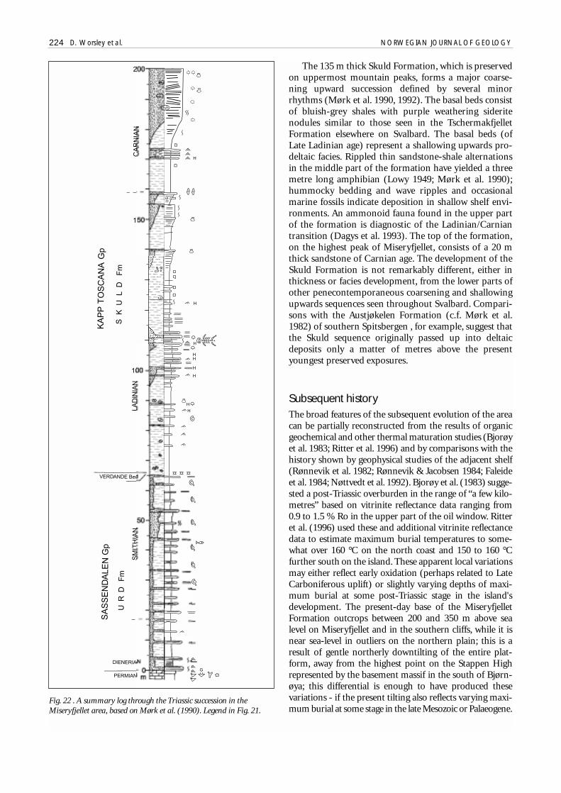
The 135 m thick Skuld Formation, which is preservedon uppermost mountain peaks, forms a major coarse-ning upward succession defined by several minorrhythms (Mørk et al. 1990, 1992). The basal beds consistof bluish-grey shales with purple weathering sideritenodules similar to those seen in the TschermakfjelletFormation elsewhere on Svalbard. The basal beds (ofLate Ladinian age) represent a shallowing upwards pro-deltaic facies. Rippled thin sandstone-shale alternationsin the middle part of the formation have yielded a threemetre long amphibian (Lowy 1949; Mørk et al. 1990);hummocky bedding and wave ripples and occasionalmarine fossils indicate deposition in shallow shelf envi-ronments. An ammonoid fauna found in the upper partof the formation is diagnostic of the Ladinian/Carniantransition (Dagys et al. 1993). The top of the formation,on the highest peak of Miseryfjellet, consists of a 20 mthick sandstone of Carnian age. The development of theSkuld Formation is not remarkably different, either inthickness or facies development, from the lower parts ofother penecontemporaneous coarsening and shallowingupwards sequences seen throughout Svalbard. Compari-sons with the Austjøkelen Formation (c.f. Mørk et al.1982) of southern Spitsbergen , for example, suggest thatthe Skuld sequence originally passed up into deltaicdeposits only a matter of metres above the presentyoungest preserved exposures.
Subsequent historyThe broad features of the subsequent evolution of the areacan be partially reconstructed from the results of organicgeochemical and other thermal maturation studies (Bjorøyet al. 1983; Ritter et al. 1996) and by comparisons with thehistory shown by geophysical studies of the adjacent shelf(Rønnevik et al. 1982; Rønnevik & Jacobsen 1984; Faleideet al. 1984; Nøttvedt et al. 1992). Bjorøy et al. (1983) sugge-sted a post-Triassic overburden in the range of “a few kilo-metres” based on vitrinite reflectance data ranging from0.9 to 1.5 % Ro in the upper part of the oil window. Ritteret al. (1996) used these and additional vitrinite reflectancedata to estimate maximum burial temperatures to some-what over 160 °C on the north coast and 150 to 160 °Cfurther south on the island. These apparent local variationsmay either reflect early oxidation (perhaps related to LateCarboniferous uplift) or slightly varying depths of maxi-mum burial at some post-Triassic stage in the island'sdevelopment. The present-day base of the MiseryfjelletFormation outcrops between 200 and 350 m above sealevel on Miseryfjellet and in the southern cliffs, while it isnear sea-level in outliers on the northern plain; this is aresult of gentle northerly downtilting of the entire plat-form, away from the highest point on the Stappen Highrepresented by the basement massif in the south of Bjørn-øya; this differential is enough to have produced thesevariations - if the present tilting also reflects varying maxi-mum burial at some stage in the late Mesozoic or Palaeogene.
224 D. Worsley et al. NORWEGIAN JOURNAL OF GEOLOGY
Fig. 22 . A summary log through the Triassic succession in theMiseryfjellet area, based on Mørk et al. (1990). Legend in Fig. 21.

Palaeogeothermal gradients estimated from the verticalvitrinite reflectance profile at Miseryfjellet range fromless than 10 °C/km to over 40 °C/km. A geothermal gra-dient of 30 °C/km (not unreasonable in view of nearbymeasurements of present-day heatflow by Sættem et al.1994) would indicate that 4 to 5 km of post-Permianoverburden has been eroded; extrapolations based onsonic velocities in the Triassic shales indicates about 3 to4 km of eroded section. Apatite fission track data indi-cate cooling below ~100 °C, beginning at some timeduring the late Cretaceous to early Tertiary (60 to 90Ma). Ritter et al. (1996) used all of the available data(including fluid inclusions in the Nordkapp Formation’ssandstones) to construct an “optimal” thermal history.However, their reconstructed burial curve for the baseRøedvika Formation takes no account of the complexblock development through the Late Carboniferous andindicates massive and - in our belief - unrealistic mid-Permian uplift. Figure 23 presents a reinterpreted burialcurve based on the tectonic models proposed here.
The total maximum post-Palaeozoic overburden sug-gested by these studies is thus in the range 3 to 5 km.Axial parts of the Tertiary Central Basin of Spitsbergenappear to have had a maximum total primary thicknessof about 3 km of Mesozoic sediments, while estimatessuggest thicknesses in the order of 10 km in the central
parts of the Bjørnøya Basin to the SE of the StappenHigh. In comparison, Triassic to lowermost Jurassicexposures in several northern areas of the Svalbardarchipelago show very low (< 0.3 % Ro) vitrinite reflec-tances, implying minimal later overburden. The estimatefor Bjørnøya is therefore "mid-range" and in no way sug-gests that the area remained a structural high throug-hout the Mesozoic. The present-day horst structure ofthe Stappen High therefore probably represents finalmoulding by the early to mid-Tertiary transpressivemovements that preceded the opening of the Norwe-gian-Greenland Sea. These movements rejuvenated theLate Palaeozoic high, leading to erosion of an appreci-able cover of Upper Triassic and younger Mesozoic sedi-ments.
We reiterate that the complex faulting and fracturingseen to affect the Carboniferous to Lower Permian suc-cession of Bjørnøya was a result of pre-Late Permian tec-tonism. There is no evidence of faults or extensive frac-turing affecting Upper Permian or younger units where-ver these overlie older rocks. The essential fault patternsdisplayed on Bjørnøya are therefore not a result of Terti-ary tectonism - as has been suggested in several regionalreviews: such Tertiary movements seem to have beenrestricted to the master faults along the Stappen High’spresent margins.
NORWEGIAN JOURNAL OF GEOLOGY The geological evolution of Bjørnøya 225
Fig. 23. Modelled post-Triassic depositional and thermal history based on all available data, modified from Ritter et al. (1996).

Comparisons with adjacent areasIn general terms, the Upper Palaeozoic and Triassicsuccession of Bjørnøya shows many of the same litho-facies seen elsewhere on the Barents Shelf and in theSvalbard archipelago - and indeed in the Wandel Sea(north Greenland) and Sverdrup (Arctic Canada) basins.However, Bjørnøya and some other specific areas showsignificant differences in their Late Palaeozoic tectonicand sedimentational evolution from the region as awhole.
Spitsbergen
The Billefjorden area of central Spitsbergen (Figs. 11 &24) was the site of active fault-controlled sedimentationin the early to mid-Carboniferous. Deposition commen-ced in local narrow basins along the eastern parts of theearlier Old Red Sandstone basin. Inversion in the Tour-naisian produced the uplifted Nordfjorden Block on thesite of the former Devonian basin, and this was a positivefeature throughout the remainder of the Carboniferous.Subsidence along the Billefjorden Fault on the block'seastern margins was at a maximum in the mid-Carboni-ferous, producing a tilted half-graben (Holliday & Cut-bill 1972; Harland et al. 1974; Gjelberg & Steel 1981;Johannessen & Steel 1992). Sediments range from coarsealluvial fans along the graben’s westerly faulted marginsto playa and sabkha deposits axially. This is a very similardevelopment to that shown by the LandnørdingsvikaFormation on Bjørnøya. However, lineamental activitydecreased in Billefjorden from the mid-Carboniferousonwards and Upper Carboniferous to Lower Permiancarbonate sequences show only small thickness variati-ons between the earlier block and trough, although late-ral facies changes suggest continued subtle tectonic con-trols on sedimentation. Bjørnøya’s history of inversionand renewed tectonism is not seen in this area.
Permo-Carboniferous exposures between St. Jons-fjorden and Hornsund on the western coast of Spitsber-gen show a different history. These exposures have beenpoorly understood until recently, partly because of theirinaccessibility, but also because Tertiary compressionand deformation have obscured primary lateral faciesrelationships in the area. Steel & Worsley (1984) sugge-sted the development of two or possibly more "en eche-lon" basins during the mid-Carboniferous. In commonwith Billefjorden, northwestern areas stabilized throughthe Carboniferous; however, Harmon Maher (pers.comm. 1995) has noted the existence of conglomeratesinterbedded with carbonates in the ?upper Carbonife-rous succession of St. Jonsfjorden. By the Permian thereseems to have been one continuous basin, also a west-wards tilted half-graben, flanking the eastern margins ofa presumed high off the western coast of present-daySpitsbergen; this most likely represented a northerlyextension of the Hornsund-Sørkapp High, which isinterpreted as actively controlling Late Palaeozoic sedi-mentation over southern Spitsbergen.
The evolution of the Sørkapp-Hornsund High itself(Figs. 1, 24 & 25) is directly relevant to Bjørnøya. Unfor-tunately, the few critical exposures in southernmostSpitsbergen are also difficult to interpret because of sig-nificant Tertiary deformation. A horst developed in theBashkirian by the inversion of a wide shallow basin thatapparently had covered southern Spitsbergen in the earlyCarboniferous. Fan deltas were deposited over the hor-st's eastern margins into the Inner Hornsund Basin inthe early Permian (Kleinspehn et al. 1984); these margi-nal basinal areas were subsequently uplifted before rene-wed Late Permian sedimentation produced a major pro-gradational wedge of marine siliciclastics, spilling outeastwards into the basin from the high. Thick Upper Per-mian sequences preserved off the western margins of thehigh are extensively tectonized and their original deposi-tional site is uncertain. Attenuated Upper Permiansequences are seen locally on the high's eastern margins,but the main part of the structure was not transgressedbefore the early Triassic. Dienerian basal conglomeratesoverlie Hecla Hoek, Devonian and Lower Carboniferoussequences in isolated localities on the high itself. Enig-matic exposures on islands and skerries south of thesouthernmost tip of Spitsbergen indicate that the highcontinues southwards so that Upper Permian or Triassicstrata may rest directly on Lower Carboniferous fluvialsthere. The highly schematic cross-section of Fig. 25 indi-cates the main stages in the high’s development follo-wing basinal inversion in the mid-Carboniferous.
A comparison of Figs. 18/19 and 24/25 highlights thestructural similarities between Sørkapp Land and Bjørn-øya. The late Palaeozoic fault zones in Sørkapp Land laterbecame the focus of Tertiary tectonism whereas the Stap-pen High remained a largely stable positive feature in theMesozoic and Cenozoic and, as noted earlier there is noevidence of major post-Palaeozoic faulting on Bjørnøya.This comparison may also shed some light on the struc-ture which we might expect in the shelf subsurface bet-ween southernmost Spitsbergen and Bjørnøya - in gene-ral terms the western margin of the Stappen High (the“West Bjørnøya Fault” of Gjelberg & Steel 1983) mayrepresent a strand of the Hornsund Fault Zone, while thehigh’s eastern margins roughly correspond with theexpected continuation of the Billefjorden Lineament.
Regional tectonic trends
The relationship between the Svalbard platform, the Stap-pen High and the southern areas of the Barents Shelf inthe Late Palaeozoic is still unclear. Immediately south ofBjørnøya, the Bjørnøya and Tromsø basins (Fig. 1) seemto mark a transition to yet another structural settingwhich was characterized by more northeasterly basinaltrends at the time (Rønnevik et al. 1982; Gudlaugsson etal. 1998). More work is needed to clarify the tectonic rela-tions between these basins and those of the Svalbard Plat-form. However, seismic studies in these other areas sug-gest the presence of strikingly similar features to those we
226 D. Worsley et al. NORWEGIAN JOURNAL OF GEOLOGY

have described from Bjørnøya. The Bjørnøya Basin isbounded to the east by the major Bjørnøya Fault Complexthat separates the basin from the Loppa High, a shalloweastwards tilting block. This high was tectonically activethroughout the Late Palaeozoic, with repeated movementinto the Late Permian (Faleide et al. 1984; Gudlaugsson etal. 1998) and was then progressively onlapped by a con-densed Lower to Middle Triassic sequence (Fig. 26). Maindepositional units and tectonic events displayed by wellsand seismic data on the Loppa High suggest a closely simi-lar but mirror image development to that of the StappenHigh: the mid-Permian to Triassic history of the Loppa
High, which can be better documented with the seismiccoverage available, is predominantly one of tilting ratherthan active faulting within the high itself, confirming thesimilarity to Bjørnøya. The Late Palaeozoic developmentof these areas may reflect uplift and tectonism over andalong the western and eastern flanks of the embryonicBjørnøya Basin, although major subsidence of the basinitself is a predominantly Mesozoic feature. Indeed someseismic lines in the shallow northern part of the BjørnøyaBasin may suggest that the entire area was uplifted prior tomid-Permian transgression and onset of the rifting whichproduced the basin itself.
NORWEGIAN JOURNAL OF GEOLOGY The geological evolution of Bjørnøya 227
Fig. 24. Comparison of Bjørnøya (right) with schematic cross-sections through central Spitsbergen (A to B), and the Hornsund area (C to D) sho-wing relationships of sediment thicknesses and sedimentation rates between highs and troughs: for positions of Spitsbergen cross-sections, see Fig. 1.
Fig. 25. Highly sche-matic cross-sectionindicating possiblelate Palaeozoic con-figuration of theSørkapp-HornsundHigh.
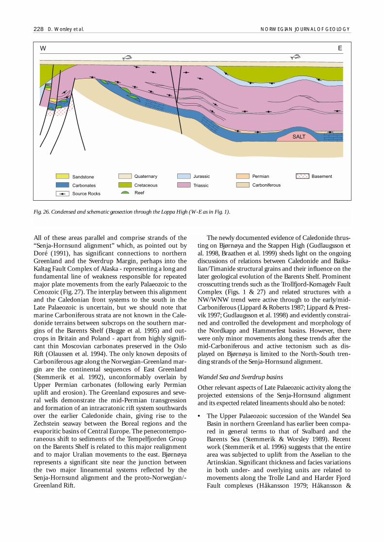
All of these areas parallel and comprise strands of the“Senja-Hornsund alignment” which, as pointed out byDoré (1991), has significant connections to northernGreenland and the Sverdrup Margin, perhaps into theKaltag Fault Complex of Alaska - representing a long andfundamental line of weakness responsible for repeatedmajor plate movements from the early Palaeozoic to theCenozoic (Fig. 27). The interplay between this alignmentand the Caledonian front systems to the south in theLate Palaeozoic is uncertain, but we should note thatmarine Carboniferous strata are not known in the Cale-donide terrains between subcrops on the southern mar-gins of the Barents Shelf (Bugge et al. 1995) and out-crops in Britain and Poland - apart from highly signifi-cant thin Moscovian carbonates preserved in the OsloRift (Olaussen et al. 1994). The only known deposits ofCarboniferous age along the Norwegian-Greenland mar-gin are the continental sequences of East Greenland(Stemmerik et al. 1992), unconformably overlain byUpper Permian carbonates (following early Permianuplift and erosion). The Greenland exposures and seve-ral wells demonstrate the mid-Permian transgressionand formation of an intracratonic rift system southwardsover the earlier Caledonide chain, giving rise to theZechstein seaway between the Boreal regions and theevaporitic basins of Central Europe. The penecontempo-raneous shift to sediments of the Tempelfjorden Groupon the Barents Shelf is related to this major realignmentand to major Uralian movements to the east. Bjørnøyarepresents a significant site near the junction betweenthe two major lineamental systems reflected by theSenja-Hornsund alignment and the proto-Norwegian/-Greenland Rift.
The newly documented evidence of Caledonide thrus-ting on Bjørnøya and the Stappen High (Gudlaugsson etal. 1998, Braathen et al. 1999) sheds light on the ongoingdiscussions of relations between Caledonide and Baika-lian/Timanide structural grains and their influence on thelater geological evolution of the Barents Shelf. Prominentcrosscutting trends such as the Trollfjord-Komagelv FaultComplex (Figs. 1 & 27) and related structures with aNW/WNW trend were active through to the early/mid-Carboniferous (Lippard & Roberts 1987; Lippard & Prest-vik 1997; Gudlaugsson et al. 1998) and evidently constrai-ned and controlled the development and morphology ofthe Nordkapp and Hammerfest basins. However, therewere only minor movements along these trends after themid-Carboniferous and active tectonism such as dis-played on Bjørnøya is limited to the North-South tren-ding strands of the Senja-Hornsund alignment.
Wandel Sea and Sverdrup basins
Other relevant aspects of Late Palaeozoic activity along theprojected extensions of the Senja-Hornsund alignmentand its expected related lineaments should also be noted:
• The Upper Palaeozoic succession of the Wandel SeaBasin in northern Greenland has earlier been compa-red in general terms to that of Svalbard and theBarents Sea (Stemmerik & Worsley 1989). Recentwork (Stemmerik et al. 1996) suggests that the entirearea was subjected to uplift from the Asselian to theArtinskian. Significant thickness and facies variationsin both under- and overlying units are related tomovements along the Trolle Land and Harder FjordFault complexes (Håkansson 1979; Håkansson &
228 D. Worsley et al. NORWEGIAN JOURNAL OF GEOLOGY
Fig. 26. Condensed and schematic geosection through the Loppa High (W-E as in Fig. 1).
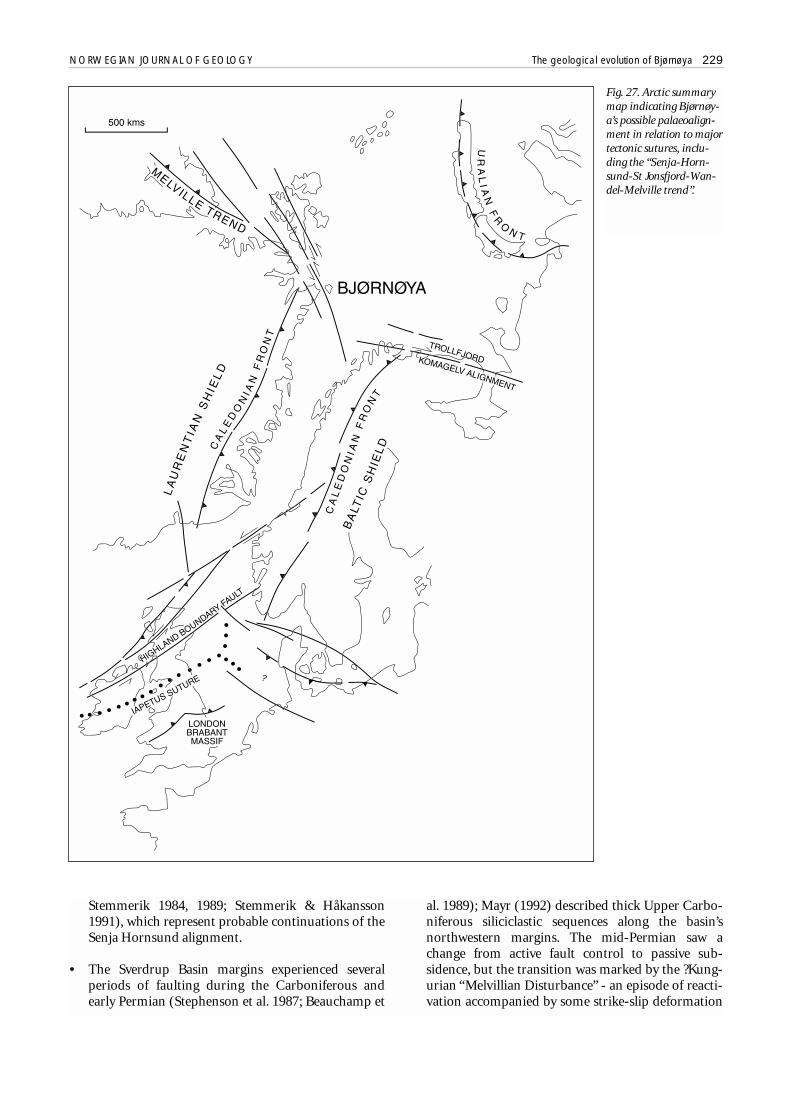
NORWEGIAN JOURNAL OF GEOLOGY The geological evolution of Bjørnøya 229
Fig. 27. Arctic summarymap indicating Bjørnøy-a’s possible palaeoalign-ment in relation to majortectonic sutures, inclu-ding the “Senja-Horn-sund-St Jonsfjord-Wan-del-Melville trend”.
Stemmerik 1984, 1989; Stemmerik & Håkansson1991), which represent probable continuations of theSenja Hornsund alignment.
• The Sverdrup Basin margins experienced severalperiods of faulting during the Carboniferous andearly Permian (Stephenson et al. 1987; Beauchamp et
al. 1989); Mayr (1992) described thick Upper Carbo-niferous siliciclastic sequences along the basin’snorthwestern margins. The mid-Permian saw achange from active fault control to passive sub-sidence, but the transition was marked by the ?Kung-urian “Melvillian Disturbance” - an episode of reacti-vation accompanied by some strike-slip deformation

- somewhat in the same style as the Sakmarian eventson Bjørnøya. The Tanquary Structural High in thenortheastern part of the Sverdrup Basin was appa-rently actively uplifted in the Late Permian to Triassic(Mayr 1992); this feature thus shows an interestinganalogy to the Loppa, Stappen and Sørkapp-Horn-sund highs.
Summary and ConclusionsIn summary:
• The Stappen High was the site of fluvial sedimenta-tion in a NNW trending half-graben from the lateDevonian to early Carboniferous,
• Mid-Carboniferous uplift was accompanied by a cli-matic shift to arid conditions and followed by rene-wed rifting along a master fault to the west of presentexposures on Bjørnøya,
• Bashkirian and Moscovian sea-level rise led to carbo-nate deposition over the entire area, in common withthe rest of the Barents Shelf,
• Renewed tectonism in the late Carboniferous produ-ced the faulted configuration seen today,
• The early Permian was characterized by onlap andthen uplift of the newly created high,
• Upper Permian and Triassic sequences progressivelyonlapped the high before the entire area subsidedfrom the late Triassic to late Mesozoic or Paleogene.
The complex development shown by the Upper Pala-eozoic succession of Bjørnøya is noteworthy in view of theimmense amount of information that can be derived fromthis small area. The structural development of the StappenHigh is in no way unique, but the spectacular exposuresoffer an impressive documentation of the ongoing tecto-nism that characterized the present-day western marginsof the Barents Shelf during the Late Palaeozoic. Bjørnøyais especially interesting in that the Late Palaeozoic tecto-nism can be differentiated from the Tertiary overprint,which usually obscures similar movements both in sout-hern and western Spitsbergen and in parts of the WandelSea and Sverdrup basins. This development also gives stri-king examples of the type of plays expected to have greatpotential for successful hydrocarbon exploration both onthe Barents Shelf and in adjacent areas.
Economic implicationsPresent knowledge suggests the extensive developmentof Upper Palaeozoic basinal and platform sequences tothe east and southeast of Bjørnøya over large areas of the
Barents Shelf, and the following features provide interes-ting - and as yet poorly explored - targets for hydrocar-bon exploration:
• Lower Carboniferous coal-bearing fluvial sequencesin local rift basins,
• Upper Carboniferous to Lower Permian platformcarbonates and interbedded evaporites, with localstructuring related to major lineaments,
• Carbonate build-ups and associated facies alongmajor lineaments and basinal margins,
• Intrabasinal thick evaporites with structuring resul-ting from halokinetic movements.
The Bjørnøya succession yields important informationfor the first three of these play types, whereas major basi-nal evaporites are restricted to the Nordkapp andTromsø basins.
Sandstones of the coal-bearing Røedvika and Nord-kapp formations may have an interesting trappingpotential, especially as they show some of the highestporosities of the entire Upper Palaeozoic succession onBjørnøya (c.f. Grønlie et al. 1980). These sandstonesoccur in local grabens where they may provide combina-tions of stratigraphical (pinch-out and truncation) andstructural traps, with structuring provided by mid-Car-boniferous rifting. Bjørnøya’s southwestern cliffs displaysections through possible truncation traps related tolater Carboniferous and Permian tectonism, with poten-tial seals provided by Permian carbonates; these providegood analogues for geographically restricted but similarstructures such as the Loppa High (Figs. 18 & 26). Thesepotential sandstone reservoirs would in general beexpected to be sourced by hydrocarbons derived fromthe adjacent coals and coal shales in the same sequences,but more oil-prone lacustrine units have also been des-cribed from comparable fluviatile sequences both in thepenecontemporaneous Emma Fjord Formation of theSverdrup Basin (Goodarzi et al. 1987; Davies & Nassi-chuk 1988) the Billefjorden Group of Spitsbergen (Nøtt-vedt et al. 1992) and the Upper Carboniferous of EastGreenland (Piasecki et al. 1990).
The overlying conglomerates, sandstones and limes-tones of the Landnørdingsvika, Kapp Kåre and KappHanna formations are generally tightly calcite cementedin exposures on Bjørnøya, reflecting the predominantlymarine diagenetic regimes in spite of repeated uplift anderosion. Similar units deposited in more restricted lag-oonal environments or which have been subjected tomore drastic uplift and subaerial exposure may showappreciable secondary porosity, either because of dolo-mitization or by leaching of early marine cements. Thebioherms and associated dolomites of the Kapp DunérFormation are much more porous bodies than the sur-rounding and overlying sequences, porosities resulting
230 D. Worsley et al. NORWEGIAN JOURNAL OF GEOLOGY

from early leaching and/or dolomitization linked torepeated subaerial exposure. These carbonate build-upsare furthermore associated with bituminous limestoneswith an interesting source potential.
The overlying limestones of the Hambergfjellet For-mation appear to have been formed in cooler watertransgressive regimes and are characterized by pervasivemarine calcite cementation leaving no effective reservoirpotential (Stemmerik et al. 1999). Indeed in subsurfacesituations analogous to those shown in Fig. 18, the Ham-bergfjellet Formation could have acted as an effectiveseal for hydrocarbons trapped in the underlying trunca-ted units. Large-scale carbonate build-ups associatedwith Hambergfjellet equivalents over large shelf areas aregenerally also tight, with no effective reservoir potential.Such build-ups are observed along the tilted flanks of theLoppa High where they were eroded and presumablykarstified as a result of repeated uplift in the Late Per-mian, probably giving good dissolution porosities; theywere subsequently directly overlain and sealed by onlap-ping Triassic shales with a probable source potential (Fig.26).
Uplift in the latest Permian was apparently accompa-nied by regional regression and at this time even thesilica-cemented sandstones and limestones of the Mis-eryfjellet Formation and its equivalents may have suffe-red dissolution and karstification over large areas, givingrise to an interesting mouldic secondary porosity deve-lopment; this play is especially interesting in areas suchas the Finnmark Platform or Loppa High where structu-ring may put these potential reservoirs in direct contactwith possible uppermost Permian or lowermost Triassicpotential source intervals which have been tentativelyidentified in several wells.
Based on these observations the search for significanthydrocarbons in the Upper Palaeozoic succession of theBarents Sea therefore will demand an integrated under-standing of the interactions of both local and regionaltectonics and sea-level variations together with a detailedunderstanding of the facies variations produced.
Acknowledgements.The authors gratefully acknowledge the contribu-tions given by research students and colleagues from the universitiesof Oslo and Bergen and from their present companies. Further,discussions in the field or sharing of field observations with John Sales(Mobil Exploration, Norway), Roy Gabrielsen (University of Bergen),Terje Hellem (Saga Petroleum), Harmon Maher (University ofNebraska), Alvar Braathen (Norges geologiske undersøkelse) and ToraHaabet (University of Tromsø) have greatly helped us to clarify someof the models presented herein. We gratefully acknowledge valuablecriticism and comments by referees A. Nøttvedt and S. Ehrenberg andby F.M. Broadhurst, all of which have greatly improved the presentcontribution. We however accept full responsibility for our final syn-thesis and its possible weaknesses.
We also thank the drafting staff of Saga Petroleum ASA –especially Liv Ravdal and Petter Lystad - for excellent work on the illu-strations and for support from that now defunct company’s manage-ment and research funds to the completion of this work. Thanks alsoto Berit Fossum of SINTEF Petroleumsforskning AS for her invaluableassistance in the final preparation of figures for publication.
ReferencesAgdestein, T. 1980: Stratigrafisk, sedimentologisk og diagenetisk
undersøkelse av karbon-perm sedimenter (Kapp Hanna og KappDunér formasjonene) på Bjørnøya, Svalbard. Unpublished thesis,University of Oslo, Norway (2 vols.).
Andersson, J.G. 1900: Über die Stratigraphie und Tektonik der BärenInsel. Bulletin of the Geological Institution of the University ofUppsala 7, 243–280.
Antevs, E. & Nathorst, A.G. 1917: Kohlenführende Kulm auf der BärenInsel. Geologiska Föreningens i Stockholm Förhandlingar 39,649–663.
Beauchamp, B., Harrison, J.C. & Henderson, C.M. 1989: UpperPaleozoic stratigraphy and basin analysis of the Sverdrup Basin,Canadian Arctic Archipelago: Part 1, time frame and tectonicevolution. Geological Survey of Canada, Paper 89–1G, 105–113.
Beauchamp, B. & Henderson, C.M. 1994: The Lower Permian Raanes,Great Bear Cape and Trappers Cove formations, Sverdrup Basin,Canadian Arctic: stratigraphy and conodont zonation. Bulletin ofCanadian Petroleum Geology 42, 562–597.
Birkenmajer, K. 1981: The Geology of Svalbard, the Western Part ofthe Barents Sea, and the Continental Margin of Scandinavia. InNairn, A.E.M., Churkin Jr., M. & Stehli, F.G. (eds.): The OceanBasins and Margins, v. 5, The Arctic Ocean, 265–329, PlenumPress, New York.
Bjorøy, M., Mørk, A. & Vigran, J.O. 1983: Organic GeochemicalStudies of the Devonian to Triassic succession on Bjørnøya andimplications for the Barents Shelf. In Bjorøy, M. (ed.): Advancesin Organic Geochemistry 1981, 49–59. John Wiley and Sons,London.
Braathen, A., Maher Jr., H.D., Haabet, T.E., Kristensen, S.E., Tørud-bakken, B.O. & Worsley, D. 1999: Caledonian thrusting onBjørnøya: implications for Paleozoic and Mesozoic tectonism ofthe western Barents Shelf. Norsk Geologisk Tidsskrift 79, 57–68.
Bruce, J.R. & Toomey, D.F. 1992: Late Paleozoic bioherm occurrencesof the Finnmark Shelf, Norwegian Barents Sea: analogues andregional significance. In Vorren, T.O, Bergsager, E., Dahl-Stamnes,Ø.A., Holter, E., Johansen, B., Lie, E. & Lund, T.B. (eds.): ArcticGeology and Petroleum Potential, 377–392. Norwegian PetroleumSociety Special Publication 2, Elsevier, Amsterdam.
Bugge, T., Mangerud, G., Elvebakk, G., Mørk, A., Nilsson, I., Fanavoll,S. & Vigran, J.O. 1995: The Upper Palaeozoic succession on theFinnmark Platform, Barents Sea. Norsk Geologisk Tidsskrift 75,3–30.
Cecchi, M. 1992: Carbonate sequence stratigraphy: application to thedetermination of play models in the Upper Palaeozoic of theBarents Sea, offshore northern Norway. In Vorren, T.O. Bergsager,E., Dahl-Stamnes, Ø.A., Holter, E., Johansen, B., Lie, E. & Lund,T.B. (eds.): Arctic Geology and Petroleum Potential, 419–438. Nor-wegian Petroleum Society Special Publication 2, Elsevier, Amster-dam.
Cutbill, J.L. & Challinor, A. 1965: Revision of the stratigraphicalscheme for the Carboniferous and Permian rocks of Spitsbergenand Bjørnøya. Geological Magazine 102, 418–439.
Dagys, A.S., Weitschat, W., Kontantinov, A.G., & Sobolev, E.S. 1993:Evolution of the boreal marine biota and stratigraphy at themiddle/upper Triassic boundary. Mitteilungen aus dem Geo-logisch- Paläonologischen Institut der Universität Hamburg 75,193–209
Dallmann, W.K. (ed.) 1999: Lithostratigraphic lexicon of Svalbard.Review and recommendations for nomenclature use. UpperPalaeozoic to Quaternary bedrock. Norsk Polarinstitutt, Tromsø,318 p.
Dallmann, W.K. & Krasilscikov, A.A. 1996: Geological Map ofSvalbard 1:50 000, sheet D20G. Bjørnøya. Temakart no. 27, NorskPolarinstitutt.
Davies, G.R. & Nassichuk, W.W. 1988: An Early Carboniferous(Viséan) lacustrine oil shale in Canadian Arctic Archipelago.American Association of Petroleum Geologists, Bulletin 72, 8–20.
NORWEGIAN JOURNAL OF GEOLOGY The geological evolution of Bjørnøya 231
Doré, A.G. 1991: The structural foundation and evolution ofMesozoic seaways between Europe and the Arctic Sea. Palaeogeo-graphy, Palaeclimatolpgy, Palaeoecology 87, 441–492.
Faleide, J.I., Gudlaugsson, S.T. & Jacquart, G. 1984: Evolution of thewestern Barents Sea. Marine and Petroleum Geology 1, 123–150.
Fedorowski, J. 1975: On some Upper Carboniferous Coelenteratafrom Bjørnøya and Spitsbergen. Acta Geologica Polonica 25,27–78.
Folk, R.L. & Siedlecka, A. 1974: The "schizohaline" environment: itssedimentary and diagenetic fabrics as exemplified by late Paleozoicrocks of Bear Island, Svalbard. Sedimentary Geology 11, 1–15.
Gabrielsen, R.H., Færseth, R.B., Jensen, L.N., Kalheim, J.E. & Riis, F.1990: Structural elements of the Norwegian Continental Shelf. PartI: The Barents Sea region. Norwegian Petroleum Directorate,Bulletin 6, 33 p.
Gerard, J. & Buhrig, C. 1990: Seismic facies of the Permian section ofthe Barents Sea: analysis and interpretation. Marine and PetroleumGeology 7, 234–252.
Gjelberg, J.G. 1978a: The Upper Devonian (Famennian) to MiddleCarboniferous (Moscovian) strata on Bjørnøya (Svalbard) – astudy in alluvial and coastal marine sedimentation. Unpublishedthesis, University of Bergen, Norway.
Gjelberg, J.G. 1978b: Facies analysis of the coal-bearing VesalstrandaMember (Upper Devonian) of Bjørnøya. Norsk PolarinsituttÅrbok 1977, 71–100.
Gjelberg, J.G. 1981: Upper Devonian (Famennian) – Middle Carbo-niferous succession of Bjørnøya, a study of ancient alluvial andcoastal marine sedimentation. Norsk Polarinsitutt Skifter 174,67 p.
Gjelberg, J.G. & Steel, R.J. 1981: An outline of Lower-Middle Carboni-ferous sedimentation on Svalbard. Effects of tectonic, climatic andsea level changes in rift basin sequences. In Kerr, J.W. (ed.): Geo-logy of the North Atlantic Borderlands, Canadian Society of Petro-leum Geologists, Memoir 7, 543–561.
Gjelberg, J.G. & Steel, R.J. 1983: Middle Carboniferous marine tran-gression, Bjørnøya, Svalbard: facies sequences from an interplay ofsea level changes and tectonics. Geological Journal 18, 1–19.
Gobbett, D.J. 1963: Carboniferous and Permian brachiopods ofSvalbard. Norsk Polarinstitutt Skrifter 127, 201 p.
Goodarzi, F., Davies, G.R., Nassichuk, W.W. & Snowdon, L.R. 1987:Organic petrology and Rock-Eval analysis of Lower CarboniferousEmma Fiord Formation in Sverdrup Basin, Canadian Arctic Archi-pelago. Marine and Petroleum Geology 4, 132–145.
Grønlie, G., Elverhøi, A. & Kristoffersen, Y. 1980: A seismic velocityinversion on Bjørnøya – the western Barents Shelf. Marine Geo-logy 35, M17–M26.
Gudlaugsson S.T, Faleide, J.I, Johansen, S.E. & Breivik, A.J. 1998: LatePalaeozoic structural development of the southwestern BarentsSea. Marine and Petroleum Geology 15, 73–102.
Harland, W.B. 1978: The Caledonides of Svalbard. Geological Surveyof Canada, Paper 78–13, 3–11.
Harland, W.B. 1997: The Geology of Svalbard. The Geological SocietyLondon, Memoir 17, 521 p.
Harland, W.B. & Gayer, R.A. 1972: The Arctic Caledonides and earlieroceans. Geological Magazine 109, 289–384.
Harland, W.B. & Wright, N.J.R. 1979: Alternative hypothesis for thepre-Carboniferous evolution of Spitsbergen. Norsk PolarinstituttSkrifter 167, 89–117.
Harland, W.B., Cutbill, J.L., Friend, P.F., Gobbett, D.J., Holliday, D.W.,Maton, P.I., Parker, J.R. & Wallis, R.H. 1974: The Billefjorden FaultZone, Spitsbergen. The long history of a major tectonic lineament.Norsk Polarinsitutt Skrifter 161, 72 p.
Harland, W.B., Gaskell, B.A., Heafford, A.P., Lind, E.K. & Perkins, P.S.1984: Outline of Arctic post-Silurian Continental Displacements.In Spencer A.M. et al. (eds.): Petroleum Geology of the NorthEuropean Margin, 137–148. Norwegian Petroleum Society,Graham and Trotman, London.
Harland, W.B., Hambrey, M.J. & Waddams, P. 1993: The Vendian geo-logy of Svalbard. Norsk Polarinstitutt Skrifter 193, 130 p.
Hellem, T. & Worsley, D. 1978: An outcrop of the Kapp StarostinFormation at Austjøkeltinden, Sørkapplandet. Norsk PolarinstituttÅrbok 1977, 340–343.
Holliday, D.W. & Cutbill, J.L. 1972: The Ebbadalen Formation (Carbo-niferous), Spitsbergen. Proceedings of the Yorkshire GeologicalSociety 39, 1–32.
Holtedahl, O. 1920: On the Palaeozoic Series of Bear Island, especiallyon the Hecla Hoek system. Norsk Geologisk Tidsskrift 5, 121–148.
Horn, G. & Orvin, A. 1928: Geology of Bear Island. Skrifter omSvalbard og Ishavet 15, 152 p.
Håkansson, E. 1979: Carboniferous to Tertiary development of theWandel Sea Basin, eastern North Greenland. Grønlands geologiskeUndersøgelse, Rapport 85, 11–15.
Håkansson, E. & Stemmerik, L. 1984: Wandel Sea Basin – the NorthGreenland equivalent to Svalbard and the Barents Shelf. InSpencer, A.M., Holter, E., Johnsen, S.O., Mørk, A., Nysæther, E.,Songstad, P. & Spinnangr, Å.. (eds.): Petroleum Geology of theNorth European Margin, 97–107. Norwegian Petroleum Society,Graham and Trotman, London.
Håkansson, E. & Stemmerik, L. 1989: Wandel Sea Basin – A new syn-thesis of the late Palaeozoic to Tertiary accumulation in NorthGreenland. Geology 17, 683–686.
Johannessen, E.P. & Steel, R.J. 1992: Mid-Carboniferous extension andrift-infill sequence in the Billefjorden Trough, Svalbard. NorskGeologisk Tidsskrift 72, 35–48.
Johansen, S.E., Ostisty, B.K., Birkeland, Ø., Fedorovski, Y.F., Martirosjan,V.N., Christensen, O.B., Cheredeev, S.I., Ignatenko, E.A. & Margulis,L.S. 1992: Hydrocarbon potential in the Barents Sea region: play dis-tribution and potential. In Vorren, T.O, Bergsager, E., Dahl-Stamnes,Ø.A., Holter, E., Johansen, B., Lie, E. & Lund, T.B. (eds.): Arctic Geo-logy and Petroleum Potential, 273–320. Norwegian Petroleum Soci-ety Special Publication 2, Elsevier, Amsterdam.
Kaiser, H. 1970: Die Oberdevon-Flora der Bäreninsel 3. Mikroflora deshöheren Oberdevons und des Unterkarbons. PalaeontographicaAbt. B 129, 71–24.
Kaiser, H. 1971: Die Oberdevon-Flora der Bäreninsel 4. Mikroflora derMisery-Serie und der flözleeren Sandstein-Serie. Palaeontograp-hica Abt. B 135, 127–164.
Kirkemo, K. 1979: En sedimentologisk undersøkelse av Kapp Kåre-formasjonen (moskov), Bjørnøya. Unpublished thesis, Universityof Oslo, Norway.
Kleinspehn, K., Steel, R.J., Johannessen, E.P. & Netland, A. 1984:Conglomerate fan-delta sequences, late Carboniferous – early Per-mian, western Spitsbergen. In Koster, E.H. & Steel, R.J. (eds.): Sedi-mentology of Gravels and Conglomerates, Canadian Society ofPetroleum Geologists Memoir 10, 279–294.
Krasilscikov, A.A. & Livsic, J.J. 1974: Tectonika ostrova Medvezij(Tectonics of Bjørnøya): Geotektonika 4, 39–51.
Larssen, G.B., Elvebakk, G., Henriksen, L.B., Kristensen, S.E., Nilsson,I., Samuelsberg, T.J., Svånå, T.A. & Stemmerik, L. (in press): UpperPalaeozoic lithostratigraphy of the southern Norwegian BarentsSea. Norwegian Petroleum Directorate, Bulletin.
Lepvrier, C., Leparmentier, R.F. & Seland, R. 1989: Upper Palaeozoicfaulting regimes in Bjørnøya (Svalbard, Norway). Bulletin de laSociete Géologique de France 5, 2, 411–416.
Lippard, S.T. & Prestvik, T. 1997: Carboniferous dolerite dykes onMagerøy: new age determination and tectonic significance. NorskGeologisk Tidsskrift 77, 159–163.
Lippard, S.T. & Roberts, D. 1987: Fault systems in the CaledonianFinnmark and southern Barents Sea. Norges geologiske under-søkelse, Bulletin 410, 55–64.
Lowy, L. 1949: A labyrinthodont from the Trias of Bear Island,Spitsbergen. Nature 163, 1002.
Lønøy, A. 1988: Environmental setting and diagenesis of lowerPermian palaeoaplysinid buildups and associated sediments fromBjørnøya: implications for exploration of the Barents Shelf.Journal of Petroleum Geology 11, 141–156.
Mayr, U. 1992: Reconnaissance and preliminary interpretation ofUpper Devonian to Permian stratigraphy of northeastern Elles-
232 D. Worsley et al. NORWEGIAN JOURNAL OF GEOLOGY

mere Island, Canadian Arctic Archipelago. Geological Survey ofCanada, Paper 91–08, 117 p.
Milstein, V.E. & Golovanov, N.P. 1979: Upper Precambrian micro-phytolites and stromatolites from Svalbard. Norsk PolarinsituttSkrifter 167, 219–224.
Mørk, A., Knarud, R. & Worsley, D. 1982: Depositional and diageneticenvironments of the Triassic and Lower Jurassic succession ofSvalbard. In Embry, A.F. & Balkwill, H.R. (eds.): Arctic Geologyand Geophysics, Canadian Society of Petroleum Geologists,Memoir 8, 371–398.
Mørk, A., Embry, A.F. & Weitschat, W. 1989: Triassic transgressive-regressive cycles in the Sverdrup Basin, Svalbard and the BarentsShelf. In Collinson, J.D. (ed.): Correlation in Hydrocarbon Explo-ration, 113–130. Norwegian Petroleum Society, Graham and Trot-man, London.
Mørk, A., Vigran, J.O. & Hochuli, P.A. 1990: Geology and palynologyof the Triassic succession of Bjørnøya. Polar Research 8, 141–163.
Mørk, A., Vigran, J.O., Korchinskaya, M.V., Pchelina, T.M., Fefilova,L.A., Vavilov, M.N. & Weitschat, W. 1992: Triassic rocks inSvalbard, the Arctic Soviet islands and the Barents Shelf: bearingon their correlations. In Vorren, T.O, Bergsager, E., Dahl-Stamnes,Ø.A., Holter, E., Johansen, B., Lie, E. & Lund, T.B. (eds.): ArcticGeology and Petroleum Potential, 457–479. Norwegian PetroleumSociety Special Publication 2, Elsevier, Amsterdam.
Nilsen, K.T, Henriksen, E. & Larsen, G.B. 1992: Exploration of the LatePalaeozoic carbonates in the southern Barents Sea – a seismicstratigraphic study. In Vorren, T.O, Bergsager, E., Dahl-Stamnes,Ø.A., Holter, E., Johansen, B., Lie, E. & Lund, T.B. (eds.): ArcticGeology and Petroleum Potential, 393–404. Norwegian PetroleumSociety Special Publication 2, Elsevier, Amsterdam.
Nilsson, I. 1993: Upper Paleozoic fusulinid stratigraphy of the BarentsSea and surrounding areas. Dr. Scient thesis, University of Tromsø,Norway, 538 p.
Nilsson, I. 1994: Review of fusulinids from Bjørnøya- a discussion.IKU-Report no.: 23.1438.00/24/94. 19 p. Trondheim.
Nøttvedt, A., Cecchi, M., Gjelberg, J.G., Kristensen, S.E., Lønøy, A., Ras-mussen, E., Skott, P.H. & Van Veen, P.M. 1992: Svalbard – BarentsSea correlation: a short review. In Vorren, T.O, Bergsager, E., Dahl-Stamnes, Ø.A., Holter, E., Johansen, B., Lie, E. & Lund, T.B. (eds.):Arctic Geology and Petroleum Potential, 363–375. NorwegianPetroleum Society Special Publication 2, Elsevier, Amsterdam.
Olaussen, S., Larsen, B.T. & Steel, R.J. 1994: The Upper Carboniferous-Permian Oslo Rift: basin fill in relation to tectonic development. InEmbry, A.F. et al. (eds.): Pangaea: Global environments and resour-ces, Canadian Society of Petroleum Geologists, Memoir 17,175–197.
Pchelina, T.M. 1972: Triassovye otlozenija ostrova Medvezego (Triassicdeposits of Bjørnøya). In Sokolov, V.N. & Vasilevskaja, N.D. (eds.):Mezozoiskie otlozenija Svalbarda, 5–20. NIIGA, Leningrad.
Pchelina, T.M. 1983: Novye dannye po stratigrafii mezozoja arkipelagaSpitsbergen (New evidence on Mesozoic stratigraphy of the Spits-bergen Archipelago). In Krasilscikov, A.A. & Basov, V.A. (eds.):Geologija Spicbergena, 121–141. PGO Sevmorgeologia, Leningrad.
Piasecki, S., Christiansen, F.G. & Stemmerik, L. 1990: Depositionalhistory of a Late Carboniferous organic-rich lacustrine shale fromEast Greenland. Canadian Petroleum Geology, Bulletin 38, -273–287.
Renard, V. & Malod, J. 1974: Structure of the Barents Sea from seismicrefraction. Earth and Planetary Science Letters 24, 33–47.
Ritter, U., Duddy, I., Mørk, A., Johansen, H. & Arne, D. 1996:Temperature and uplift history of Bjørnøya (Bear Island), BarentsSea. Petroleum Geoscience 2, 133–144.
Rønnevik, H.C., Beskow, B. & Jacobsen, H.P. 1982: Evolution of theBarents Sea. In Embry, A.F. & Balkwill, H.R. (eds.): Arctic Geologyand Geophysics, 432–440. Canadian Society of Petroleum Geo-logists, Memoir 8.
Rønnevik, H.C. & Jacobsen, H.P. 1984: Structural highs and basins inthe western Barents Sea. In Spencer, A.M., Holter, E., Johnsen, S.O.,Mørk, A., Nysæther, E., Songstad, P. & Spinnangr, Å. (eds.): Petro-
leum Geology of the North European Margin, 19–32. NorwegianPetroleum Society, Graham and Trotman, London.
Salvigsen, O. & Slettemark, Ø. 1995: Post-glaciation and sea levels onBjørnøya, Svalbard. Polar Research 14, 245–251.
Siedlecka, A. 1972: Length slow chalcedony and relicts of sulphates:evidences of evaporitic environments in the Upper Carboniferousand Permian beds of Bear Island, Svalbard. Journal of SedimentaryPetrology 42, 812–816.
Siedlecka, A. 1975: The petrology of some Carboniferous and Permianrocks from Bjørnøya, Svalbard. Norsk Polarinstitutt Årbok 1973,53–72.
Simonsen, B.T. 1988: Upper Palaeozoic fusulinids of Bjørnøya. IKUReport 23.1252.06/02/88, 90 p. Trondheim.
Skaug, M., Dons, C.E., Lauritzen, Ø. & Worsley, D. 1982: LowerPermian palaeoaplysinid bioherms and associated sediments fromcentral Spitsbergen. Polar Research 2, 57–75.
Steel, R.J. & Worsley, D. 1984: Svalbard's post-Caledonian strata – anatlas of sedimentational patterns and palaeogeographical evolu-tion. In Spencer, A.M., Holter, E., Johnsen, S.O., Mørk, A., Ny-sæther, E., Songstad, P. & Spinnangr, Å. (eds.): Petroleum Geologyof the North European Margin, 109–135. Norwegian PetroleumSociety, Graham and Trotman, London.
Stemmerik, L. 1997: Permian (Artinskian - Kazanian) cool-water car-bonates in North Greenland, Svalbard and the western Barents Sea.In James, N.P. & Clark, J. (eds.): Cool-water Carbonates. Socie-tyof Economic Paleontologists and Mineralogists, Special Publica-tion 56, 349–364.
Stemmerik, L. & Håkansson, E. 1991: Carboniferous and Permianhistory of the Wandel Sea Basin, Eastern North Greenland. Grøn-lands geologiske Undersøgelse, Rapport 143, 21–45.
Stemmerik, L. & Larssen, G.B. 1993: Diagenesis and porosity evolutionof Lower Permian Palaeoaplysina build-ups, Bjørnøya, Barents Sea:an example of diagenetic response to high frequency sea level fluc-tuations in an arid climate. In Horbury, A.D. & Robinson, A.G.(eds.): Diagenesis and Basin Development, American Associationof Petroleum Geologists Studies in Geology 36, 199–211.
Stemmerik, L. & Worsley, D. 1989: Late Palaeozoic sequence correla-tions, North Greenland, Svalbard and the Barents Shelf. In Collin-son, J.D. (ed.): Correlation in Hydrocarbon Exploration, 99–111.Norwegian Petroleum Society, Graham and Trotman, London.
Stemmerik, L. & Worsley, D. 1995: Permian history of the Barents Shelfarea. In Scholle, P.A., Peryt, T.M. & Ulmer-Scholle, D.S. (eds.): Per-mian of northern Pangaea, 81–97. Springer Verlag, Berlin.
Stemmerik, L. & Worsley, D. 2000: Upper Carboniferous cyclic shelfdeposits, Kapp Kåre Formation, Bjørnøya – response to high fre-quency, high amplitude sea level fluctuations and local tectonism.Polar Research 19, 227–249.
Stemmerik, L., Christiansen, F.G., Piasecki, S., Jordt, B., Marcussen, C.& Nøhr-Hansen, H. 1992: Depositional history and petroleumgeology of the Carboniferous to Cretaceous sediments in the nor-thern part of East Greenland. In Vorren, T.O, Bergsager, E., Dahl-Stamnes, Ø.A., Holter, E., Johansen, B., Lie, E. & Lund, T.B. (eds.):Arctic Geology and Petroleum Potential, 67–87. Norwegian Petro-leum Society Special Publication 2, Elsevier, Amsterdam.
Stemmerik, L., Håkansson, E., Madsen, L., Nilsson, I., Piasecki, S.,Pinard, S. & Rasmussen, J.A. 1996: Stratigraphy and depositionalevolution of the Upper Palaeozoic sedimentary succession in east-ern Peary Land, North Greenland. Grønlands geologiske Under-søgelse, Bulletin 171, 45–71.
Stemmerik, L., Larson, P., Larssen, G.B., Mørk, A. & Simonsen, B.T.1994: Depositional evolution of Lower Permian Palaeoaplysinabuild-ups, Kapp Dunér Formation, Bjørnøya, Arctic Norway. Sedi-mentary Geology 92, 161–174.
Stemmerik, L., Elvebakk, G. & Worsley, D. 1999: Potential Upper Palaeo-zoic carbonate reservoirs on the Norwegian Arctic Shelf - applicationto exploration of the Loppa High. Petroleum Geoscience 5, 173–187.
Stephenson, R.A., Embry, A.F., Nakiboglo, S.M. & Hastaoglu, M.A.1987: Rift-initiated Permian to Early Cretaceous subsidence of theSverdrup Basin. In Beaumont, C. & Tankard, A. (eds.): Sedimen-
NORWEGIAN JOURNAL OF GEOLOGY The geological evolution of Bjørnøya 233

tary basins and Basin-forming mechanisms, 213–231. CanadianSociety of Petroleum Geologists, Memoir 12.
Sættem, J., Bugge, T., Fanavoll, S., Goll, R.M., Mørk, A., Mørk, M.B.E.,Smelror, M. & Verdenius, J.G. 1994: Cenozoic margin developmentand erosion of the Barents Sea: Core evidence from southwest ofBjørnøya. Marine Geology 118, 257–281.
Vigran, J.O. 1991: Palynologiske dateringer av Bjørnøyas paleozoikum:Palynonytt 16, (abstr.), 191. Nordisk Palynologiske møte, Roskilde.
Worsley, D. & Edwards, M.B. 1976: The Upper Palaeozoic successionof Bjørnøya. Norsk Polarinstitutt Årbok 1974, 17–34.
Worsley, D. & Gjelberg, J.G. 1980: Excursion Guide to Bjørnøya,Svalbard. Palaeontological Contribution University of Oslo 258, 33 p.
Worsley, D., Aga, O.J., Dalland, A., Elverhøi, A. & Thon, A. 1986: Thegeological history of Svalbard, evolution of an arctic archipelago.Statoil, Aske Trykkeri, Stavanger, 121 p.
234 D. Worsley et al. NORWEGIAN JOURNAL OF GEOLOGY