the geography of new york state - educator...
TRANSCRIPT

Albers 1
The Geography of New York State
By Jamie Albers

Albers 2
Table of Contents for Unit
Information about the Unit/Task: I. Information Sheet for Curriculum Module… p. 3 II. About the Tasks… p. 4 III. Common Core State Standards Addressed... p. 5 IV. Task Rubric… p. 7 V. Necessary Skills for Task Completion… p. 9 VI. Outline of Instruction… p. 11 VII. Materials, References, and Supports… p. 14
Detailed Lesson Plans:
I. “Exploring the Physical Features of New York State”: First lesson in the segment… p. 15 a. Lesson Handouts/Activities… p. 18
II. “Cool Climates of New York State: Second lesson in the segment… p. 21 a. Lesson Handouts/Activities… p. 24
III. “The Politics of New York State”: Third lesson in the segment… p. 26 a. Lesson Handouts/Activities… p. 29
IV. “Learning How to Write About Places:” Sixth lesson in the segment… p. 31 a. Lesson Handouts/Activities… p. 34

Albers 3
Information Sheet for Curriculum Module Module title: The Geography of New York State
Module description (overview):
This module serves to engage students in learning about maps of New York State. Students will explore different types of maps, including physical, vegetation/climate, and political, to build an understanding of maps. They will use the information they learned, as well a knowledge of crafting informational texts, to create a Google Earth Literacy Trip (“Google Lit Trip”) that highlights different aspects of New York State on an interactive technological map.
Template task (include number, type, level):
RI7: 4. [Insert optional question] After reading or viewing _____ (informational text, or visual, oral, or quantitative information such as charts, graphs, diagrams, time lines, animations, or interactive elements on web pages), write _____ (product) in which you interpret the information and explain how the information contributes to an understanding of the text in which it appears.
Teaching task: 4. How do you describe important places and elements of New York State? After reading or viewing various informational texts and examples of Google Lit Trips, write informational pieces to use in a Google Lit Trip in which you interpret the information and explain how the information contributes to an understanding of the text in which it appears.
Grade(s)/Level: 4th grade
Discipline: (e.g., ELA, science, history, other)
History
Course: EPSY582L-256
Author(s): Jamie Albers
Contact information:
Email: [email protected]

Albers 4
About the Tasks Teaching Task
Background to share with students:
This module will provide an opportunity to learn about the different aspects of New York State through the use of maps, both interactive and physical. Students will be introduced to physical maps initially and eventually be able to express their learning through technology and interactive map studies.
Reading texts: • Map of New York State (Lesson #2) • Encyclopedia Britannica (Lesson #2) • Maps of the World (Lesson #2 & #3) • Political Map of New York State (Lesson #3) • “What is Information Text?” by The School Run (Lesson #4) • “Informational Text” by Kent District Library (Lesson #4) • “Kid Chefs at the White House” by Raphael Chambers (Lesson #4) • “Crafting Stories with Google Earth” by Joe Wood (Lesson #4) • “Arthur Meets the President” presentation by Erin Gotay (Lesson
#4)

Albers 5
Common Core State Standards
READING Standards for Informational or Explanatory
“Built In” Reading Standards “When Appropriate” Reading
1- Read closely to determine what the text says explicitly and to make logical inferences from it; cite specific textual evidence when writing or speaking to support conclusions drawn from the text.
5- Analyze the structure of texts, including how specific sentences, paragraphs, and larger portions of the text (e.g. a section, chapter, scene, or stanza) relate to each other and the whole.
2- Determine central ideas or themes of a text and analyze their development; summarize the key supporting details and ideas.
7- Integrate and evaluate content presented in diverse formats and media, including visually and quantitatively, as well as in words.
4- Interpret words and phrases as they are used in a text, including determining technical, connotative, and figurative meanings, and analyze how specific word choices shape meaning or tone.
9- Analyze how two or more texts address similar themes or topics in order to build knowledge or to compare the approaches the authors take.
10- Read and comprehend complex literary and informational texts independently and proficiently.
WRITING Standards for Informational or Explanatory
“Built In” Writing Standards “When Appropriate” Writing Standards
1 - Write informative/explanatory texts to examine and convey complex ideas and information clearly and accurately through the effective selection, organization, and analysis of content.
2 - Write informative/explanatory texts to examine and convey complex ideas and information clearly and accurately through the effective selection, organization, and analysis of content.
4- Produce clear and coherent writing in which the development, organization, and style are appropriate to task, purpose, and audience.
6 - Use technology, including the Internet, to produce and publish writing and to interact and collaborate with others.
5- Develop and strengthen writing as needed by planning, revising, editing, rewriting, or trying a new approach.
8- Gather relevant information from multiple print and digital sources, assess the credibility and accuracy of each source, and integrate the information while avoiding plagiarism.
9- Draw evidence from literary or informational texts to support analysis, reflection, and research.
10- Write routinely over extended time frames (time for research, reflection, and revision) and shorter time frames (a single sitting or a day or two) for a range of tasks, purposes, and audiences.
Albers 6
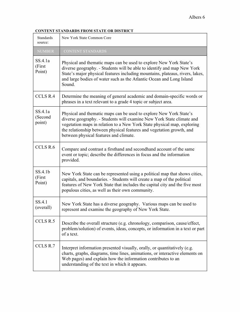
CONTENT STANDARDS FROM STATE OR DISTRICT
Standards source:
New York State Common Core
NUMBER CONTENT STANDARDS
SS.4.1a (First Point)
Physical and thematic maps can be used to explore New York State’s diverse geography. - Students will be able to identify and map New York State’s major physical features including mountains, plateaus, rivers, lakes, and large bodies of water such as the Atlantic Ocean and Long Island Sound.
CCLS R.4 Determine the meaning of general academic and domain-specific words or phrases in a text relevant to a grade 4 topic or subject area.
SS.4.1a (Second point)
Physical and thematic maps can be used to explore New York State’s diverse geography. - Students will examine New York State climate and vegetation maps in relation to a New York State physical map, exploring the relationship between physical features and vegetation growth, and between physical features and climate.
CCLS R.6 Compare and contrast a firsthand and secondhand account of the same event or topic; describe the differences in focus and the information provided.
SS.4.1b (First Point)
New York State can be represented using a political map that shows cities, capitals, and boundaries. - Students will create a map of the political features of New York State that includes the capital city and the five most populous cities, as well as their own community.
SS.4.1 (overall)
New York State has a diverse geography. Various maps can be used to represent and examine the geography of New York State.
CCLS R.5 Describe the overall structure (e.g. chronology, comparison, cause/effect, problem/solution) of events, ideas, concepts, or information in a text or part of a text.
CCLS R.7 Interpret information presented visually, orally, or quantitatively (e.g. charts, graphs, diagrams, time lines, animations, or interactive elements on Web pages) and explain how the information contributes to an understanding of the text in which it appears.

Albers 7
Task Rubric TEACHING TASK RUBRIC (INFORMATIONAL OR EXPLANATORY)
Scoring Elements
NOT YET 1
1.5
APPROACHES EXPECTATIONS
2
2.5
MEETS EXPECTATIONS
3
3.5
ADVANCED 4
Focus Attempts to
address prompt, but
lacks focus or is off-task.
Addresses prompt appropriately and
establishes a position, but focus
is uneven.
Addresses prompt appropriately and with an adequate
response; stays on task.
Addresses all aspects of
prompt appropriately
with a detailed response; stays
on task.
Controlling Idea
Lacks a clear controlling
idea to inform or explain.
Establishes a controlling idea to
inform or explain. Idea may
lack clarity or credibility.
Establishes a credible controlling
idea to inform or explain.
Accurately and effectively
presents important
information from reading materials to inform or explain.
Reading/ Research
Attempts to include reading
materials to develop
response, but lacks
connections or relevance to
the purpose of the prompt.
Utilizes some information from reading materials
relevant to the purpose of the
prompt with minor lapses in accuracy or completeness.
Accurately utilizes details from reading materials relevant to the purpose of the prompt to develop argument or claim.
Accurately and effectively
utilizes important details
from reading materials to inform or explain.
Development Attempts to inform or
explain but lacks details.
Informs or explains by presenting only
some details.
Informs or explains using appropriate
and sufficient details.
Informs or explains by providing
detailed and relevant
information.
Organization
Attempts to organize ideas,
but lacks control of structure, including opening,
development, and/or closure.
Demonstrates an attempt to organize information within
a structure to inform or explain, with minor lapses in structure and/or
coherence.
Maintains an appropriate
organizational structure to address
specific requirements of the prompt.
Structure adequately supports the ability
to inform or explain.
Maintains an organizational structure that
intentionally and effectively
enhances the presentation of information as required by the specific prompt.
Structure enhances
development of the ability to

Albers 8
inform or explain.
Conventions
Attempts to demonstrate
standard English
conventions, but lacks
cohesion and control of grammar, usage, and
mechanics at the appropriate
grade level. Does
not use citations when
needed.
Demonstrates an uneven command
of standard English conventions and
cohesion. Uses language and
tone with some inaccurate,
inappropriate, or uneven features.
Inconsistently cites sources.
Demonstrates a command of
standard English conventions and
cohesion, with few errors. Response
includes language and tone appropriate
to the audience, purpose, and specific requirements of the
prompt. Cites sources using
appropriate format with only minor
errors.
Demonstrates and maintains a well-developed
command of standard English conventions and cohesion, with
few errors. Response includes
language and tone consistently
appropriate to the audience, purpose, and
specific requirements of
the prompt. Consistently cites sources
using appropriate
format.
Content Understanding
Content is irrelevant,
inappropriate, or inaccurate.
Briefly notes disciplinary content
relevant to the prompt; shows basic or uneven understanding of content; minor
errors in explanation.
Accurately presents disciplinary content
relevant to the prompt with
sufficient explanations that
demonstrate understanding.
Integrates relevant and
accurate disciplinary content with
thorough explanations that demonstrate in-
depth understanding.

Albers 9
Necessary Skills for Task Completion Skills Cluster 1: Preparing for the Task
Skill Definition
1. Background information Ability to create a map of New York State that shows the major physical
features of New York State, identifying major physical features, including mountains, plateaus, rivers, lakes, and other large bodies of water on a map of New York State.
2. Background information Ability to create a physical map of New York State that shows the climate
and vegetation, placing and identifying physical features, vegetation growth, and climate on a map of New York State.
3. Background information Ability to create a map of New York State that shows the location of major
political features, placing and identifying the capital city, five most populous cities, and my own city on a map of New York State.
4. Task introduction and analysis
Ability to understand the task, as well as connect it to existing knowledge, skills, experiences, interests, and concerns.
Skills Cluster 2: Reading Process
Skill Definition
5. Task engagement
Ability to fluently work with technological tool used for final product (Google Earth); ability to explain concepts (what happened and why) in a technical text.
6. Active reading
Ability to identify central components of appropriate texts, including summarizing the text and extracting key details and main ideas.
6. Note taking Ability to select important facts and passages for use in one’s own writing. Skills Cluster 3: Transition to Writing- Organization
Skill Definition
7. Planning
Ability to use graphic organizers to map out ideas for final product using pieces from texts; ability to categorize ideas into sections of similar information and proper formatting.
Skills Cluster 4: Writing Process
Skill Definition
8. Development
Ability to write original informational/explanatory piece in an initial draft with an emerging line of thought and structure, including elements such as facts, definitions, concrete details, questions, and other relevant information about the topic.

Albers 10
9. Revision Ability to refine text, including line of thought, language usage, and tone as appropriate to audience and purpose.
9. Editing Ability to proofread and format a piece to make it more effective.
10. Completion
Ability to submit final piece that meets expectations.

Albers 11
Outline of Instruction
PACING SKILL AND DEFINITION
PRODUCT AND PROMPT
SCORING (product meets expectations if...)
INSTRUCTIONAL STRATEGIES
Skills Cluster 1: Preparing for the Task
Day 1
1. Background Information
Ability to create a map of New York State that shows the major physical features of New York State, identifying major physical features, including mountains, plateaus, rivers, lakes, and other large bodies of water on a map of New York State.
• New York State Map activity
• Map questions activity
• Map Activity: Full credit for their map if it both identifies the major physical features and is colored correctly; partial credit for the majority of the major physical features.
• Map questions: participation
Linked in “Procedures”
Day 2
2. Background Information Ability to create a physical map of New York State that shows the climate and vegetation, placing and identifying physical features, vegetation growth, and climate on a map of New York State.
• Climate/Vegetation Venn diagram
• Group discussion • Map completion
• Venn Diagram: 9 similarities/differences
• Group discussion: participation
• Map completion: participation
Linked in “Procedures”
Day 3
3. Background Information Ability to create a map of New York State that shows the location of major political features, placing and identifying the capital city, five most populous cities, and my own city on a map of New York State.
• New York State political map
• Cities graphic organizer
• Political map: Identifies all points
• Graphic organizer: fills out all categories
Linked in “Procedures”
Day 4
4. Task Introduction and Analysis Ability to understand the task, as well as connect it to existing knowledge, skills, experiences, interests,
• Group discussion: o How do you think
you could present this information?
o What do you want to include?
o How do you feel
• None • Introduce task.
• Discuss comments and concerns about task.

Albers 12
and concerns. about using this tool?
• Discuss student responses to questions.
Skills Cluster 2: Reading Process
Day 5
5. Task Engagement Ability to fluently work with technological tool used for final product (Google Earth); ability to explain concepts (what happened and why) in a technical text.
• Google Earth: o How do you feel
using this tool? o How do you think
you could incorporate your ideas using this tool?
o What are your concerns about the tool at this point?
• Exit ticket with questions
• Have students use Google Earth freely to understand how it works.
• Show students examples of Google Lit Trips.
• Students will fill out exit tickets to answer questions at the end of class.
Day 6
6. Active Reading Ability to identify central components of appropriate texts, including summarizing the text and extracting key details and main ideas.
• KWL chart • Informational Text
graphic organizer
• KWL chart: fills out all categories
• Graphic organizer: fills out all categories
Linked in “Procedures”
Day 6
6. Note Taking Ability to select important facts and passages for use in one’s own writing.
• Informational Text graphic organizer
• KWL chart: fills out all categories
Linked in “Procedures”
Skills Cluster 3: Transition to Writing
Day 7
7. Planning Ability to use graphic organizers to map out ideas for final product using pieces from texts; ability to categorize ideas into sections of similar information and proper formatting.
• Pre-planning graphic organizers
• List of ideas and sources
• Informal assessment - review of pre-planning charts
• Introduce graphic organizers for pre-planning of writing.
• Work in small groups/pairs to fill out graphic organizers.
• Meet with students individually to discuss ideas for writing.
Skills Cluster 4: Writing Process
Day 8
8. Development Ability to write original
• Initial draft
• Provides draft with all
• Students write

Albers 13
informational/explanatory piece in an initial draft with an emerging line of thought and structure, including elements such as facts, definitions, concrete details, questions, and other relevant information about the topic.
complete parts/evidence of outline
independently.
• Teacher circulates around the room to assist students.
Day 9
9. Revision Ability to refine text, including line of thought, language usage, and tone as appropriate to audience and purpose.
• Updated draft
• Provides draft with evidence of revisions.
• Review revision skills.
• Students work in pairs to read over and revise papers.
• Teacher circulates around the room to assist students.
Day 9
9. Editing Ability to proofread and format a piece to make it more effective.
• Updated draft
• Provides draft with evidence of editing.
• Review editing skills.
• Students work in pairs to edit each other’s papers.
• Teacher circulates around the room to assist students.
Day 10
10. Completion Ability to submit final piece that meets expectations.
• Completed final draft.
• Fits “Meet Expectations” criteria in each section of the rubric.
• Celebrate being finished!

Albers 14
Materials, References, and Supports
For Teachers
Full Lesson Plans: • Lesson Plan #1: Exploring the Physical Features of New York State (1st lesson in sequence) • Lesson Plan #2: Cool Climates of New York State (2nd lesson in sequence) • Lesson Plan #3: The Politics of New York State (3rd lesson in sequence) • Lesson Plan #4: Learning How to Write about Places (6th lesson in sequence)
Research Reviews:
• Research Review #1 • Research Review #2 • Research Review #3 • Research Review #4
Online Learning Tool:
• Online Learning Tool

Albers 15
Lesson 1: “Exploring the Physical Features of New York State”
Unit: The Geography of New York State
Title of Lesson #1: Exploring the Physical Features of New York State
Overview
Students will identify the major physical features of New York State (e.g. mountains, rivers, large bodies of water) and will map them out. Suggested time allowance: One 45 minute lesson. Standards (NYS Social Studies Standards, NYS Arts Standards, Common Core Learning Standards)
• SS.4.1a: Physical and thematic maps can be used to explore New York State’s diverse geography.
o Students will be able to identify and map New York State’s major physical features including mountains, plateaus, rivers, lakes, and large bodies of water such as the Atlantic Ocean and Long Island Sound.
• CCLS R.4: Determine the meaning of general academic and domain-specific words or phrases in a text relevant to a grade 4 topic or subject area.
Learning Targets
• I can create a map of New York State that shows the major physical features of New York State.
• I can place and identify major physical features, including mountains, plateaus, rivers, lakes, and other large bodies of water on a map of New York State.
• I can define the terms “compass rose,” “mountain,” “physical features,” “plateau,” and “river”.
Essential Unit Question
What are the major physical features of New York State?
Resources/Materials For This Lesson
• Large map of New York State with prominent land features • Post-it Notes • Teacher example map • Individual blank maps for students (attached at the end of this document) • Student map questions (attached at the end of this document) • Markers/colored pencils/crayons • Social studies textbook (with map of New York State and descriptions of major
physical features)

Albers 16
Activities/Procedures
1. Introduce the essential question and overview of the lesson to the students. 2. Have a large map of New York State in front of the classroom with Post-it Notes over the names of the different land features so that students cannot read them. Activate prior knowledge by showing the map to the students and asking them if they can identify any of the regions. Relate it to their lives by asking the class if anyone has been to these areas and can describe them. 3. Discuss the map and identify the major physical features of the state. At this point, introduce/review the new vocabulary for this lesson. Include a reference to the social studies text being used that includes this information. 4. After highlighting the important physical features of the state, explain the assignment to the students. They will have their own maps similar to the classroom example, but blank so the students can fill in the information themselves. The teacher will put the large map away and show the students an example of her own map that she created, using colored pencils and labeling the major physical features. The teacher will also review what a compass rose is, and discuss the different directions. 5. As a whole class, the teacher will encourage students to brainstorm what physical features are the most important. As students create their list, the teacher will write it on the board and add any points that the students did not include themselves. 6. The students will all be given blank maps. They will then fill out their maps using colors of their choice, being sure to label the major physical features and keep the colors organized (e.g. all the lakes are blue, all the mountains are brown). Students will be allowed to collaborate with a partner if they are having difficulty recalling all of the information. They can also use their textbooks as reference. 7. Once the students have finished their map, the teacher will check it for accuracy. She will then give them a sheet to complete that corresponds to the map to help develop further comprehension. This sheet can be completed during independent time if students need the entire period to finish their maps. 8. After all students have finished their maps, the teacher will bring the class together to discuss what they learned and clarify any misconceptions.
Evaluation/Assessment
• Completion of the New York State map
o Students will receive full credit for their map if it both identifies the major New York State physical features and is colored correctly. The student must have the majority of the major physical features that were listed on the board included on their map (if they have all features labeled except one they will still receive full credit). The other aspect to be included is if the student involved appropriate colors in their map (e.g. bodies of water are blue). Students will receive partial credit if some of these requirements are met.

Albers 17
o This map is the main assessment for this lesson. • Completion of map questions
o Students will complete the questions that accompany their map drawings, to be completed either during the class period with extra time or later in the day during an independent work period. This worksheet is not a requirement, and can be used as additional support for students who need further comprehension, as well as a challenge for higher level students. If completed, this question activity will be graded as a form of class participation.
Vocabulary
• Compass rose • Mountain • Physical features • Plateau • River

Albers 18
Name: _____________________________ Date: ____________________
New York State: Major Physical Features Map Directions: Fill out the map. Make sure to label all the names of the physical
features listed on the board in the correct locations. Also, color in each feature according to similarities (for example, all of the lakes should be the same
color). Do not forget to label the directions on the compass rose!
Retrieved from http://www.enchantedlearning.com/usa/label/states/newyork/ Bonus: Label any additional features that we did not list on the board that you find in your textbook or that you already know!

Albers 19
Name: _____________________________ Date: ____________________
New York State: Major Physical Features Comprehension Questions
Directions: Use your map as a reference to help answer the questions below.
1. How many major mountain ranges are in New York State? ________
2. Name two of these mountain ranges that are found in New York State. ________________________________________________________________
3. Which ocean does New York State connect to? __________________________
4. Circle the name of the longest river in New York State. Hudson River Mississippi River
5. What are the names of the two Great Lakes that border New York State? _______________________________________________________________
6. Which of these lakes does not border New York State? Circle the correct answer. Lake Ontario Lake Champlain Great Salt Lake
7. How many major lakes are in New York State? _______

Albers 20
8. Circle two states that are on the southern border of New York State. Pennsylvania Vermont New Jersey Delaware
9. What is the capital of New York State? A. Trenton B. Sacramento C. New York City D. Albany
10. What is the name of the tallest mountain peak in New York State? A. Mt. McKinley B. Mt. Marcy C. Mt. Everest D. Pikes Peak

Albers 21
Lesson 2: “Cool Climates of New York State”
Unit: The Geography of New York State
Title of Lesson #2: Cool Climates of New York State
Overview
Students will discuss to understand the various climates and vegetation of New York State. They will use a compare-and-contrast organizer to differentiate this information from the major physical features learned in the previous lesson. Suggested time allowance: One 45 minute lesson. Standards
• SS.4.1a: Physical and thematic maps can be used to explore New York State’s diverse geography.
o Students will examine New York State climate and vegetation maps in relation to a New York State physical map, exploring the relationship between physical features and vegetation growth, and between physical features and climate.
• CCLS R.6: Compare and contrast a firsthand and secondhand account of the same event or topic; describe the differences in focus and the information provided.
Learning Targets
• I can create a physical map of New York State that shows the climate and vegetation
• I can place and identify physical features, vegetation growth, and climate on a map of New York State.
• I can define the terms “climate” and “vegetation”.
Essential Unit Question
What are the different climates and vegetation of New York State, and how are they similar and different to the major physical features of New York State?
Resources/Materials For This Lesson
• Geographic map of New York State (such as this map) • Students’ completed major physical features map (from first lesson) • Climate Venn diagrams (attached at the end of this document) • Vegetation Venn diagrams (attached at the end of this document)
Activities/Procedures
1. With the students sitting together in a group (e.g. on the class rug or other large area), introduce the essential question and brief overview of the lesson.

Albers 22
2. Activate prior knowledge by asking the students what can be on a map, showing them an example such as this. Prompt the students by asking them questions such as:
a. “What do the different colors on the map mean?” b. “Why do you think some of the words are in different colors and sizes?” c. “How is this map similar to the map we made of the major physical features? How is it different?” d. “What do you think the different colored lines represent? Explain your reasoning.” 3. Correct any misconceptions and introduce the ideas of climate and vegetation to the
class. Write the terms on the board and collectively discuss what the two terms mean in relation to maps and New York State. Have the students predict by asking “Do you think the vegetation and climate have any relationship to the major physical features we discussed last class? Justify your answer” in order to make a connection between the two lessons.
4. Divide the class into groups of 4, and hand out the Climate and Vegetation Venn diagrams (each student will receive both worksheets). Assign half the class Climate and half the class Vegetation. Explain that the groups will be working together to complete only the Venn diagram that they have been assigned (the second one will be addressed later in the lesson). Include saying that every student will be responsible to explain at least one point on their Venn diagram to assure individual accountability. For students who have difficulties with writing, they may use bullet points instead of writing full sentences or use sentence starters (e.g. Climate/Vegetation is similar/different to the major physical features of New York State because...) on their Venn diagrams. Students may also decide to draw pictures to accompany their points if it is appropriate (e.g. draw trees to describe the forested areas of New York State).
5. Discuss with the groups appropriate resources. They can use their textbooks (whichever textbook is used within the specific district/school), as well as pre-approved Internet sources such as the Encyclopedia Britannica (information about the climate and vegetation of New York State) and Maps of the World (various maps that represent different geographical aspects of New York State).
6. Depending on the length of the discussion from Steps 1-3, allott the students about 25 minutes to research and collaborate to complete their Venn diagrams. The teacher will circulate around the room to answer any questions, correct misconceptions, and guide students if they need extra assistance.
7. If the students finish their Venn diagrams early, they may use their major physical features map (completed in the first lesson) and draw on the vegetation/climate over the major physical features to help create a visual.
8. After each group has completed their Venn diagram, the students will each share one point that they included in their comparisons. Students will use this opportunity to complete the Venn diagram they were not assigned to (i.e. if Group 1 is talking about Climate and Group 2 did Vegetation, they will write down what Group 1 discusses on their blank Climate sheet).
9. Bring the class back together as a whole group to discuss what they had learned. Go over the terms climate and vegetation again to reiterate and emphasize what they are

Albers 23
in the context of New York State. Have a few students share one new thing that they learned as a method of informal assessment.
Evaluation/Assessment
• Completion of the Climate/Vegetation Venn diagram o The Venn diagram will have at least 9 points (3 similarities, and three
differences for each category) in order for students to earn full credit for this assignment. Points do not have to be written in full sentences (i.e. can be written in bullets for students who have difficulties with writing). Partial credit will be given for 5-6 points.
• Participation in group discussion/explanation of Venn diagrams o Each student will be responsible for explaining one point on their Venn
diagram to the class. The student will explain where he or she got the information and what it means in the context of comparing it to the major physical features of New York State.
• Additional map completion o This optional assignment will take place if the students complete their
Venn diagrams early (see Procedure Step #7). Students will be assessed on the accuracy of their maps as well as the accuracy of the information. This activity will be graded as a form of participation if they choose to complete this non-required supplemental activity.
Vocabulary
• Climate • Vegetation

Albers 24
Name: _____________________________ Date: ____________________
New York State Climate Directions: Compare and contrast the climate and major physical features of New York State using this Venn diagram. Use your major physical features map, as
well as your textbook and pre-approved Internet sources to find as much valuable information as you can!

Albers 25
Name: _____________________________ Date: ____________________
New York State Vegetation Directions: Compare and contrast the vegetation and major physical features of
New York State using this Venn diagram. Use your major physical features map, as well as your textbook and pre-approved Internet sources to find as much
valuable information as you can!

Albers 26
Lesson 3: “The Politics of New York State” Unit: The Geography of New York State
Title of Lesson #3: The Politics of New York State
Overview
Students will identify the major political locations of New York State (e.g. five most populous cities, capital city, and own community) and will map them out. Suggested time allowance: One 45-minute lesson. Standards (NYS Social Studies Standards, NYS Arts Standards, Common Core Learning Standards)
• SS.4.1b: New York State can be represented using a political map that shows cities, capitals, and boundaries.
o Students will create a map of the political features of New York State that includes the capital city and the five most populous cities, as well as their own community.
• CCLS R.4: Determine the meaning of general academic and domain-specific words or phrases in a text relevant to a grade 4 topic or subject area.
Learning Targets
• I can create a map of New York State that shows the location of major political features.
• I can place and identify the capital city, five most populous cities, and my own city on a map of New York State.
• I can define the terms “political features,” “boundaries,” “city,” and “town”.
Essential Unit Question
What are the major political features of New York State and where are they?
Resources/Materials For This Lesson
• Political map of New York State
Activities/Procedures
1. Gather students to the rug or other communal area. Introduce the essential question and overview of the lesson to the whole class. 2. Have a large political map of New York State in front of the classroom, such as this. Activate prior knowledge by asking the students what they know about the map - if they know what any of the different colors or lines signify, as well as the varied sizes of the city names.

Albers 27
3. Introduce the idea that besides maps with physical features, climate, and vegetation (like in the last lessons), there are also political maps that show the locations of cities, counties, and towns. 4. Explain the assignment to the students: they will complete a political map of New York State, and then use it to complete a graphic organizer. The map will contain the identification of Albany (the capital), the five most populous cities in New York State (New York City, Buffalo, Rochester, Yonkers, and Syracuse), and their own home town/city. 5. Students will be given both the blank map and the graphic organizer. Students will work independently to find the names of the cities, but may ask their neighbor for help if needed. The students will work collaboratively at their table (4 students of heterogeneous abilities) to complete the graphic organizer. They will be able to use resources such as pre-approved Internet sources (like Maps of the World and other previously discussed websites), as well as their given social studies textbook. 6. Students will complete their maps independently and begin to work on the graphic organizer as other peers in their group finish their maps. During this time, the teacher will circulate around the room to answer any questions, correct misconceptions, and guide students if they need extra assistance. 7. After all the groups have completed both their maps and graphic organizers, the class will come back together as a whole. The teacher will assign each group a city from the graphic organizer, and that group will discuss the components of the graphic organizer that apply to their given city (population, location on the map, etc.). Students from other groups will use this opportunity to check to see if their information is correct. 8. All groups will have an opportunity to share their part of the graphic organizer. With the remaining time, the teacher will ask the students “Does anyone have any further questions?” and clear up any misconceptions.
Evaluation/Assessment
• Completion of the New York State political map
o Students will receive full credit for their map if it both identifies the capital city, the five most populous cities, and their hometown in the correct location. Students will receive partial credit if some of these requirements are met (only located 3/4 of the cities).
• Completion of cities graphic organizer o Students will complete the graphic organizer that accompanies their
political map, to be completed collaboratively with others in their group. Students will receive full credit for the full completion of all areas of the graphic organizer. Students will receive partial credit if they fill out 3/4 of the graphic organizer spaces.
o The teacher will use the sharing of the graphic organizer as an opportunity for informal assessment. While students are sharing what they learned about their cities, the teacher will be able to assess whether or not the

Albers 28
students were able to research the correct information and place it in the appropriate areas of the graphic organizer.
o The graphic organizer is the main assessment for this lesson.
Vocabulary
• Political features • Boundaries • City • Town

Albers 29
Name: _____________________________ Date: ____________________
New York State: Political Map Directions: Identify and locate the following cities. You may use your textbook as
well as pre-approved Internet sources to find as much valuable information as you can! Remember to work independently.
Cities: The capital city, the 5 most populous cities in New York State (with the most people), and the city where you live.

Albers 30
Name: _____________________________ Date: ____________________
New York State: Cities and Populations
Directions: Organize the cities you put on your map using this table. You may use your textbook as well as pre-approved Internet sources to find as much
valuable information as you can! You can work with the people in your cluster to help find all the information. When filling out the location of each city, use your map to see what else is around it and what direction it is in from other important
areas.
City Population Location

Albers 31
Lesson 6: “Learning How to Write About Places”
Unit: The Geography of New York State
Title of Lesson #6: Learning How to Write About Places
Overview
Students will examine several texts in order to understand how to write about places. This will contribute to their final unit product as this is their initial exposure to informational texts. They will use these texts eventually as models for writing their own informational pieces about places in New York State. Suggested time allowance: One 45 minute lesson. Standards (NYS Social Studies Standards, NYS Arts Standards, Common Core Learning Standards)
• SS.4.1: New York State has a diverse geography. Various maps can be used to represent and examine the geography of New York State.
• CCLS R.5: Describe the overall structure (e.g. chronology, comparison, cause/effect, problem/solution) of events, ideas, concepts, or information in a text or part of a text.
• CCLS R.7: Interpret information presented visually, orally, or quantitatively (e.g. charts, graphs, diagrams, time lines, animations, or interactive elements on Web pages) and explain how the information contributes to an understanding of the text in which it appears.
Learning Targets
• I can identify different characteristics of informational writing. • I can (begin to) describe the important qualities of a place. • I can define the term “informational text”.
Essential Unit Question
How can I write about a place?
Resources/Materials For This Lesson
• Informational texts about places
o “What is an information text?” & “Informational Text” - Explanation of informational text
o “Kid Chefs at the White House” - Informational article written by kids; Example of informational text
• Google Earth texts: o “Crafting Stories with Google Earth” - Explanation of Google Earth Lit
Trip

Albers 32
o Printed slides from student example of Google Earth - “Arthur Meets the President” presentation (link to Google Earth lit trip on the page as .kmz document); Example of Google Earth Lit Trip
• KWL chart (attached at the end of this document) • Informational texts graphic organizer (attached at the end of this document)
Activities/Procedures
1. Begin by reviewing the unit task (Google Earth literature trip about New York State). 2. Activate prior knowledge by asking the students what they already know about information texts. Ask: “Has anyone ever read an article or a story about a place? What was it like? What did it tell you?” to begin brainstorming ideas. 3. Have students complete the KWL Chart (included in this document) individually. When they are done, the students will share some of their answers with the class about what they already know and what they want to know. 4. Divide the class into four groups and introduce the lesson: the students will be rotating around stations, reading and discussing different informational texts. These texts will deal with different places as well as how to use informational text in Google Earth. Students will be given graphic organizers to take notes about the different texts, and can work together in their groups to analyze these texts. 5. Give each student the Informational Text Graphic Organizer. Assign each group a station with a text to begin. 6. Student groups will rotate until they have reached each station, reading each piece of informational text and completing their corresponding graphic organizer. The teacher will set a timer so the students know when to move to the next station, and circulate around the room while the students are reading in case they have any questions. There will be adapted versions of the text at teach station for any students with disabilities or low reading levels. 7. Once every group has moved through all the stations, the class will come back to their seats and regroup as a whole class. 8. The teacher will verbally assign each group an informational text to discuss for the class. 9. Each group will briefly discuss the informational text assigned to them and what they learned to the whole class. 10. After each group presents, the teacher will debrief by asking the students if they have any questions and clearing up any misconceptions. Evaluation/Assessment
• Completion of KWL chart o Students will complete the KWL by the end of the lesson. It will include
information about what they already know, what they want to learn, and what they learned during the lesson. The most important aspect of this

Albers 33
table for purposes of assessment is the “L” section, or what the students learned. Students will be graded on this section as evidence of participation in the lesson, receiving either a check (completed with at least one fact learned from the texts) or check minus (did not write anything learned/fact was inappropriate or irrelevant to the lesson).
• Completion of Informational Texts Graphic Organizer o Students will complete the graphic organizer that accompanies each
informational text, to be completed collaboratively with others in their group. Students will receive full credit for the full completion of all areas of the graphic organizer. Students will receive partial credit if they fill out 3/4 of the graphic organizer spaces, and no credit if less than half of the graphic organizer is completed.
o The teacher will use the sharing of the informational text (with notes from the graphic organizer) as an opportunity for informal assessment. While students are sharing what they learned about each text, the teacher will be able to assess whether or not the students were able to extract the correct information and record consequent notes in the graphic organizer.
o The graphic organizer is the main assessment for this lesson.
Vocabulary
• Informational text
Albers 34
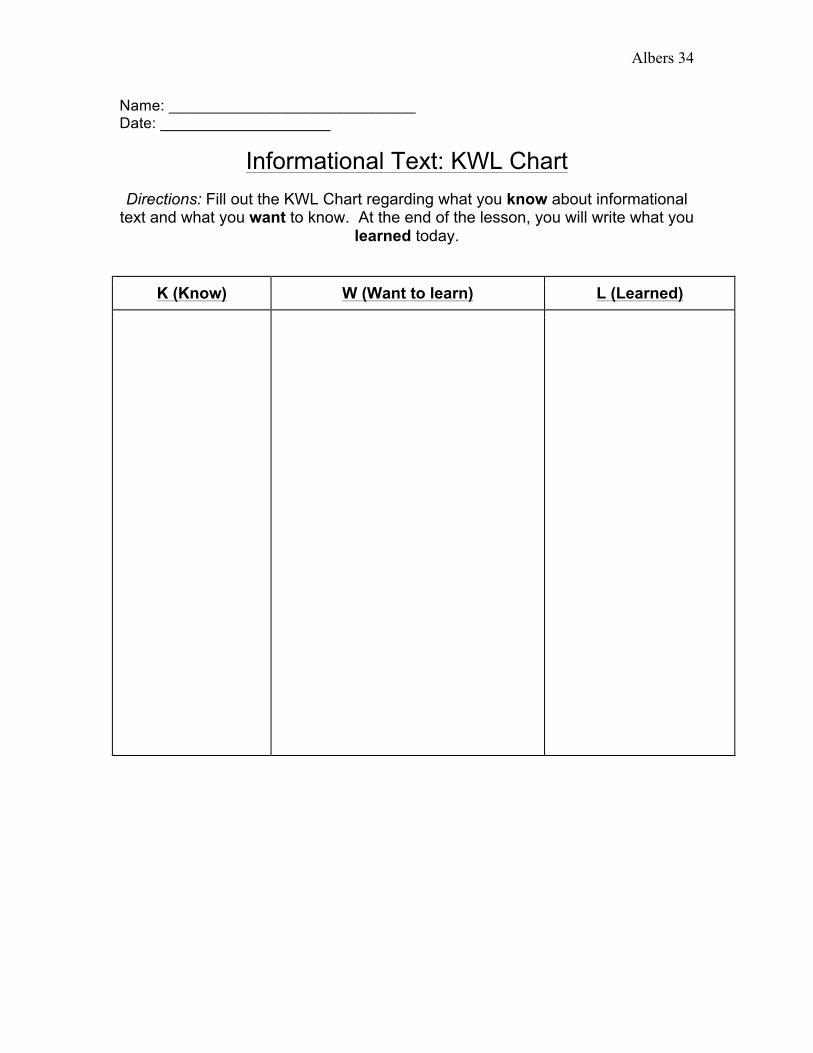
Name: _____________________________ Date: ____________________
Informational Text: KWL Chart Directions: Fill out the KWL Chart regarding what you know about informational
text and what you want to know. At the end of the lesson, you will write what you learned today.
K (Know) W (Want to learn) L (Learned)

Albers 35
Name: _____________________________ Date: ____________________
Informational Texts: Graphic Organizer
Directions: Take notes as you read each informational text, filling in what is important and what you learn at each station. You can work with the people in
your group to help find all the information.
Text What I Noticed How I Will Use This Information in My Writing
Other Notes
“What is an Information Text?” & “Informational Text”
“Kid Chefs at the White House”
“Crafting Stories with Google Earth”
“Arthur Meets the President”