the genevieve lykes duncan site
TRANSCRIPT

FF La Vistade la
Center for Big Bend Studies * Volume 22 * Summer 2011
The Genevieve Lykes Duncan SiteAn 11,000-Year-Old Paleoindian Site in the Big Bend
A longstanding archaeological research topic of archaeologists working in the Big Bend concerns the region’s earliest inhabitants. In fact, a lead article for La Vista de la Frontera written ten years ago indicated that
“The presence or absence of early Paleoindian cultures in the Big Bend proper has been, and continues to be, an important, long-standing research issue among archeologists” (Mallouf 2001:1). With the founding of the Trans-Pecos Archaeological Program (TAP) by the CBBS in 2004, research oriented toward discovery of early Paleoindian sites in the region was further energized. What’s more, one of seven guiding research domains of TAP—Paleoindians in the Trans-Pecos and Big Bend (9500–6500 B.C.)—specifically targeted this problematical time period for more intensive study.
CBBS archaeologists begin excavations at the Genevieve Lykes Duncan site on the 02 Ranch in Brewster County. Photo by David Keller.
� Center for Big Bend Studies
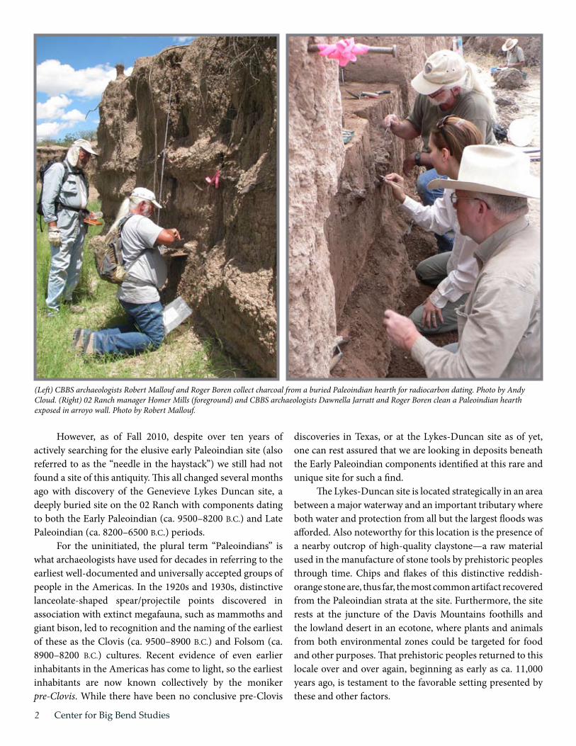
However, as of Fall 2010, despite over ten years of actively searching for the elusive early Paleoindian site (also referred to as the “needle in the haystack”) we still had not found a site of this antiquity. This all changed several months ago with discovery of the Genevieve Lykes Duncan site, a deeply buried site on the 02 Ranch with components dating to both the Early Paleoindian (ca. 9500–8200 B.C.) and Late Paleoindian (ca. 8200–6500 B.C.) periods.
For the uninitiated, the plural term “Paleoindians” is what archaeologists have used for decades in referring to the earliest well-documented and universally accepted groups of people in the Americas. In the 1920s and 1930s, distinctive lanceolate-shaped spear/projectile points discovered in association with extinct megafauna, such as mammoths and giant bison, led to recognition and the naming of the earliest of these as the Clovis (ca. 9500–8900 B.C.) and Folsom (ca. 8900–8200 B.C.) cultures. Recent evidence of even earlier inhabitants in the Americas has come to light, so the earliest inhabitants are now known collectively by the moniker pre-Clovis. While there have been no conclusive pre-Clovis
discoveries in Texas, or at the Lykes-Duncan site as of yet, one can rest assured that we are looking in deposits beneath the Early Paleoindian components identified at this rare and unique site for such a find.
The Lykes-Duncan site is located strategically in an area between a major waterway and an important tributary where both water and protection from all but the largest floods was afforded. Also noteworthy for this location is the presence of a nearby outcrop of high-quality claystone—a raw material used in the manufacture of stone tools by prehistoric peoples through time. Chips and flakes of this distinctive reddish-orange stone are, thus far, the most common artifact recovered from the Paleoindian strata at the site. Furthermore, the site rests at the juncture of the Davis Mountains foothills and the lowland desert in an ecotone, where plants and animals from both environmental zones could be targeted for food and other purposes. That prehistoric peoples returned to this locale over and over again, beginning as early as ca. 11,000 years ago, is testament to the favorable setting presented by these and other factors.
(Left) CBBS archaeologists Robert Mallouf and Roger Boren collect charcoal from a buried Paleoindian hearth for radiocarbon dating. Photo by Andy Cloud. (Right) 02 Ranch manager Homer Mills (foreground) and CBBS archaeologists Dawnella Jarratt and Roger Boren clean a Paleoindian hearth exposed in arroyo wall. Photo by Robert Mallouf.

�
Early Paleoindian remains at the site consist of a series of hearths in near proximity that are exposed by erosion of the arroyo walls and in backhoe cuts used by the CBBS in conducting initial testing of the site. Buried over two meters below the ground surface, these features are accompanied by debitage (the debris from stone tool manufacture), scattered charcoal, and bits of burned animal bone. The hearth features are unusual—even unique—for such an early time period, in that they were fashioned in shallowly-dug basins using stone for basin linings and/or for heating elements, a construction technique not found in either Clovis or Folsom sites from the same time period across North America. Further, preliminary analysis of hearth contents indicate that mesquite was used as a primary fuel for their fires—a surprising and significant finding with respect to our reconstruction of the ancient environment in which they lived.
As might be expected, a slew of questions accompany our discovery and preliminary findings at the Lykes-Duncan site. While it is too soon in the investigation to expound on probable cultural linkages, preliminary data do suggest that an unusually early human adaptation to a rapidly advancing aridity in the Early Holocene (10,000–8000 B.C.) of the Big Bend might account for the unique character of archaeological deposits thus far encountered there. Upcoming scientific excavations slated by the CBBS for the site should resolve this issue, as well as provide insights into many other questions posed by our initial investigations.
Ongoing CBBS investigations at this highly significant site are made possible by support from a number of individuals and foundations. Our warmest appreciation for fiscal support is extended to
CBBS archaeologists prepare arroyo wall surface for documentation. Photo by Andy Cloud.
Lance Jarratt volunteers his time and backhoe to cut essential exploratory trenches that enable CBBS archaeologists to interpret and document natural and cultural soil strata at the site. Photo by Andy Cloud. (Continued on page 11)
La Vista de la Frontera

� Center for Big Bend Studies
Perdiz Trail and Sun DogIn the summer of 2010, CBBS personnel discovered a
discrete, short-term campsite of Late Prehistoric peoples that promises major scientific returns. Termed the Perdiz Trail site, and radiocarbon dated to A.D. 1450–1530, this small, rather nondescript campsite was occupied by a group of hunters for only seven to ten days, and was buried quickly by eolian and alluvial processes upon abandonment. Its significance rests in the fact that it represents a sealed, uncontaminated moment in time where all artifactual material and constructed features can be assigned confidently to a single culture. Importantly, the site location had not proven attractive for occupation by earlier or later peoples. The principal tool form here is the Perdiz arrow point, a hallmark of the cultural group termed the Cielo complex
in the Big Bend. Limited excavations here have thus far yielded a series of hearths, ephemeral pits, middens, a cache-like concentration of debitage, and other features linked to short-term special activities that are not as apparent in large, complex base camps of the same culture.
Attendant to the Perdiz Trail find was the discovery in the same general area and setting of a much more extensive, but also short-lived site related to the same culture and time period—the Sun Dog site. Also a special activity site, but of a longer duration, the remains here include a large ring midden with well-preserved interior sub-features, areas of clustered small hearths, and multiple clustered rock features of as yet unknown function. In contrast with Perdiz Trail, the Sun
TAP founder and Senior Archaeologist, Robert Mallouf, displays a metate fragment coated with red pigment found within a hearth at the Perdiz Trail site. Photo by David Keller.
PROJECT UPDATES

�
(Left) CBBS crew recording rock-lined baking hearths within a ring midden (plant food baking feature) at the Sun Dog site on the 02 Ranch. Photo by David Keller. (Right) Aerial view of several baking hearths within the midden; one of these hearths was dated to A.D. 1450–1630. Photo by Mark Willis.
Dog site appears to be more oriented toward the collecting and processing of wild plant foods.
When combined with our existing data from much more complex villages of the Cielo complex, these two sites have the potential to expand our knowledge of the full range of subsistence activities and settlement
systems of this important Big Bend culture. Data gleaned from these sites promises to greatly enhance our understanding of hunter-gatherer adaptations to a desert environment that was essentially comparable to that of today.
—Robert J. Mallouf
Big Bend National Park SurveyFieldwork for the Big Bend National Park project—
what was likely the largest archaeological survey in the state’s history—was completed by the CBBS in the spring of 2010. During this final field season, two separate crews spent 40 days surveying over 3,800 acres, resulting in the discovery of 134 new sites and updates on 14 previously recorded sites. Over the course of the entire project, the CBBS surveyed over 65,000 acres and recorded 1,536 sites—representing the single largest contribution ever made to the Big Bend National Park site inventory. Data generated from the project will be used to create a model that will predict site occurrence in unsurveyed portions of the park. The final product, a comprehensive report detailing findings of the project, will be completed by the summer of 2012.
Rock Art ResearchCBBS Rock Art Coordinator Reeda Peel has been
very busy over the last year. She recorded some very interesting and significant rock art sites, worked with SRSU student Roddy Wilder in beginning digitization of the Miriam Lowrance Collection—a collection of slides, photos, and notes from a rock art documentation project conducted from the 1960s–1980s through the Fine Arts Department at Sul Ross—and made important strides in the development of a rock art database for the region. Reeda’s recording efforts were greatly assisted by a small cadre of volunteers: Curt Harrell, Roddy Wilder, Randy Ersch, and Benny and Gena Roberts. This work included
Roddy Wilder, Reeda Peel and Randy Ersch at the Agua Fria site.
(Continued on page 14)
La Vista de la Frontera

� Center for Big Bend Studies
In archaeology the term “cache” is applied to an object or group of objects—either provisions or tools—that
were hidden away, often with the intent of future recovery for use or trade. When recovery was the primary objective of caching, the term “utilitarian cache” is often applied. In contrast, if caching was done as part of a ritual or ceremony, retrieval typically was not intended. In this latter case, the objects are referred to archaeologically as a “ritual cache.”
Both utilitarian and ritual caches are known from the Big Bend. The remarkable Livermore Cache, a grouping of over 1,700 arrow points placed as an offering on the summit of Mt. Livermore in the Davis Mountains around A.D. 1250 and discovered by local ranchers in 1895, is easily the best known example of a ritual cache in the region. With respect to regional utilitarian caches, perhaps the best known is a grouping of two stone knives attached to sotol stalk handles (Carved Rockshelter Cache) that were hidden away in a rockshelter in Sunny Glen Canyon during late prehistory and recovered by Sul Ross archaeologists in the 1930s. A close-by
rockshelter yielded a cache of 11 bifacial preforms in 1933 (Meriwether Cache).
The significance of caches as storehouses of archaeological data cannot be overstated. Often hidden outside of campsites or other frequented areas, they typically are uncontaminated by the remains of earlier or later peoples, and normally represent a single event in time—time capsules if you will—that tell us about technology, social interaction, cultural boundaries, socio-religious beliefs, and many other aspects of prehistoric life.
Since caches were typically concealed by their makers to prevent chance discovery, they are only occasionally encountered today and, more often than not, only by accident. Some more recent and fortuitous cache discoveries made by local residents and/or CBBS archaeologists include a grouping of 6 bifacial knives found in the 1960s near Balmorhea (Toyah Creek Cache), a cluster of 17 dart point preforms and flakes found in 1996 at Elephant Mountain (McHam Cache), a spectacular find in 2002 of over 1,250
NEW DISCOVERIES
Homer Mills at Bandido Cache find spot. Photo by Robert Mallouf.
More Big Bend Caches Coming to Light

�La Vista de la Frontera
arrow points in the western Davis Mountains (John Z. and Exa Means Cache), and a grouping of 13 dart points and 2 bivalves found in 2006 in Big Bend National Park (Lizard Hill Cache).
Most recently, two new caches have come to light in the Terlingua Creek drainage system of Green Valley—in the heart of the Big Bend. They are small utilitarian caches found on the 02 Ranch during the recording of prehistoric campsites, and both discoveries were made by ranch manager Homer F. Mills in company with this writer. The first find—termed the Zodiac Cache—was made in fall 2010 and is a grouping of 8 stone artifacts, including 4 scraping tools, 2 bifacial knives, a flake, and a Middle Archaic (2500–1000 B.C.) dart point. The Zodiac Cache is one of only two Middle Archaic age caches known from the Big Bend and eastern Trans-Pecos region (the first being the ritual Lizard Hill Cache
mentioned above). Taken together, the Zodiac and Lizard Hill caches provide exceptional insights into the technology, subsistence, and ritual practices of Middle Archaic peoples.
The second of the two finds, termed the Bandido Cache, was discovered during winter 2011 at a campsite only a short distance from the Zodiac Cache site. It consists
of a compact clustering of 6 stone specimens, including 2 scraping tools, 2 flake blanks, and 2 bifacial preforms. One of the latter is an Archaic dart point preform having strong similarities with specimens in the McHam Cache mentioned above. The Bandido Cache is believed to have Late Archaic (1000 B.C.–A.D. 700) cultural linkages.
As additional caches are discovered in the field and in private artifact collections across the Big Bend, patterns in prehistoric caching behavior are being discerned that add significantly to our reconstructions of human lifeways through time.
— Robert J. Mallouf
Stone scraping tool from Zodiac Cache. Drawing by David Hart.
The Zodiac Cache. Photo by Robert Mallouf.

RESEARCH UPDATE
The CBBS has been conducting research on Pinto Canyon Ranch over the last ten years through a very productive
collaboration with the landowner John F. “Jeff ” Fort. While some of the findings have appeared in past CBBS newsletter articles or been published in the Trans-Pecos Archaeological Program (TAP) series—excavations and rock art/imagery recordings at the Cerro Chino site (Mallouf 2002); excavations at Tres Metates Rockshelter, Potsherd Rockshelter, and Boulder Rockshelter (Seebach 2006, 2007); analysis of the Vizcaino Collection (Bush 2006); and excavations at Two Room Rockshelter (Seebach 2008)—much of the work has quietly occurred as an impressive database of almost 700 prehistoric and historic sites has been assembled.
The property is located in the exceptionally rugged and picturesque landscape tucked between the Chinati Mountains and the Sierra Vieja, an area in Presidio County that roughly parallels the Rio Grande between the small, historic river communities of Ruidosa and Candalaria. The highly dissected terrain characterizing the ranch was created through a complex geological past combined with erosion
over the millennia. Together, these forces have conspired to create breathtaking vistas and a multitude of landforms, many of which were suitable for human occupation or use in another manner. That past Native Americans utilized these myriad settings over the last ca. 12,000 years is evidenced by both buried and exposed remnants of their lives. Remains of historic peoples’ presence across the landscape is also abundant, including extant dwellings and associated debris, ranch roads, culverts, dirt tanks, and fences.
Both clustered and widely scattered Native American sites represent the whole gamut of human occupation in the Big Bend, from Paleoindian to Historic times. A wide range of corresponding site types has been recorded on the ranch—open sites (n=400+), plant food processing sites (n=96), rockshelters and boulder shelters (n=139), rock imagery sites (n=45), cairns (n=28), and possible burials (n=25). Over 700 stone projectile points have been discovered on the surface and the overwhelming majority of these (ca. 95%) are Archaic-aged (i.e., ca. 6500 B.C.–A.D. 700) dart/spear points. Inexplicably, this pattern is reversed in data recovered from
Pinto Canyon Ranch ProjectCBBS archaeologists uncover a shallowly buried thermal feature and associated occupation zone at a site on Pinto Canyon Ranch. Photo by Sam Cason.
Center for Big Bend Studies�

�
rockshelters, where arrow points from more recent times are dominant. Understanding this dichotomy remains an important part of the Center’s research.
Rock imagery on the ranch is quite impressive, and is being systematically recorded by CBBS Rock Art Coordinator Reeda Peel. Consisting of both pictographs (painted designs) and petroglyphs (pecked, abraded, or scratched designs) of representational and abstract/non-representational figures, the imagery is very distinct both in its variability—the use of different methods and techniques—and in its content when compared to that found across the region and in adjacent regions. In fact, among the dozen or so rock imagery sites documented on the ranch are several techniques, styles, and motifs not previously reported in the eastern Trans-Pecos, such as the intentional use of both paint and pecking to illustrate individual motifs at one site (Tablecloth Rockshelter), and at another site, representational petroglyphs on small boulders that create a petroform (i.e., stones arranged into a design on the surface) (Mallouf 2005). Yet another site (Sphinx Rockshelter) contains several unusual pictographs, including a zoomorphic figure that is the most convincing representation of an elk found in the region to date and a probable Spaniard, complete with a hat and lance. Formal documentation with scaled drawings and photographs has occurred at seven sites and another four sites have been systematically photographed.
During the last year, CBBS efforts on the ranch have consisted of small-scale excavations at six campsites,
reconnaissance-level surveys in several areas, rock imagery recordings at three sites, and background research on the history of the ranch. Our recent excavations, under the direction of CBBS archaeologist Sam Cason, targeted a large ring midden (i.e., a specific type of earth oven used to slow-bake desert succulents), other types of thermal features, a boulder shelter, and deposits within a stone-based wickiup (i.e., a temporary hut or shelter). Interestingly, one of the excavated features revealed a previously undocumented construction sequence, where a large fire was initially built and, subsequently, a smaller stone-lined hearth was constructed on top of the coals.
Over the last several years the CBBS has been documenting all things related to the history of the ranch through site recordings, oral histories, and archival research. These threads of research are contributing to a forthcoming book by CBBS archaeologist David Keller on the history of the region between Pinto Canyon and Candelaria. Recently, the Prieto homestead and Chinati Hot Springs were both recorded in detail, and additional work was done at the historic village of Pueblo Nuevo—the latter of which resulted in a presentation at last year’s CBBS conference. Oral interviews were also conducted with a number of local residents, including Sergio Pena and Abel Tellez—both of whom were born and raised in Candelaria and have extensive knowledge of local history. Additional interviews and site recordings are planned for 2011. (Continued on page 14)
(Left) Features 3 (hearth) and 4 (stone clean out pile) at site PCR-69. Each square represents a 50 x 50 cm excavation unit—the darker shaded units reflect recovery of a higher number of artifacts (actual number in red), possibly indicative of discrete activity areas associated with the features. (Right) Elk pictograph at Sphinx Rockshelter. Photo by Andy Cloud.
La Vista de la Frontera

10 Center for Big Bend Studies
COMMUNITY OUTREACH
— April 2010 —CBBS Research Associate Jamie Hampson gave a presentation entitled “Rock Art and Ritual from the Pleistocene to the Present” at the University of Bristol Rock Art Symposium in Bristol, England.
Richard Walter presented “A Turtle Effigy Petroform in the Texas Big Bend” at the Southwestern Federation of Archeological Society’s 46th Annual Symposium in Hobbs, New Mexico.
— May 2010 — Jamie Hampson presented “Rock Art Regionalism: Case Studies from Big Bend Ranch State Park, Texas, and Kruger National Park, South Africa” at the British Rock Art Group Conference in Cambridge, England.
— July 2010 — Sam Cason presented “Collections in Archaeology” to a Sul Ross biology class.
— October 2010 — Reeda Peel provided a rock art display for Texas Archeology Month at the Bryan Wildenthal Memorial Library, Sul Ross State University, in Alpine.
Andy Cloud presented “Several Recent CBBS Investigations” at the Alpine Kiwanis Club meeting.
Bobby Gray presented “Following the Tracks of a Late Prehistoric Big Bend Culture” at the Alpine Kiwanis Club meeting.
Reeda Peel presented “Meyers Springs: Rock Art Images of Native American and Spanish Cultural Exchange” and discussed the presence of Buffalo Soldiers and their connection to rock art at a Jeff Davis County Historical Commission sponsored event.
Reeda Peel presented “Tracking Miniature Pictograph and Petroglyphic Zoomorphs Through the Eastern Trans-Pecos” at the Texas Archeological Society Annual Meeting in Corpus Christi.
— November 2010 — Andy Cloud presented “The Trans-Pecos Archaeological Program: Eight Hundred Generations of People in the Big Bend” to the Senior Circle group at Big Bend Regional Medical Center in Alpine.
Andy Cloud presented “Some Interesting Archaeological Finds in the Big Bend Region” to the Big Bend Retired Teachers group in Alpine.
— January 2011— Reeda Peel presented “Meyers Springs: Rock Art Images of Native American and Spanish Cultural Exchange” to the Senior Circle at Big Bend Regional Medical Center in Alpine.
— February 2011— Susan Chisholm was a judge at the Big Bend Regional History Fair in Alpine, at which high school students performed and presented posters. CBBS awarded $200.00 in prizes.
— March 2011— Reeda Peel gave a stone boiling dem-onstration (left) and discussed her display of “Useful Plants of the Chi-huahuan Desert” at the Chihuahuan Desert Research Institute Annual Cactus and Succulent Sale outside of Fort Davis.
— April 2011 —
Andy Cloud gave a tour of archaeological sites on the 02 Ranch (above) and presented “Archaeological Mapping: Traditional and New Innovative Approaches” for the Texas Map Society Spring Meeting in Alpine.
Sharing the work CBBS does with the public is an important part of our mission. Below is a selection of community events in which CBBS staff members have been involved.

The Brown Foundation, Inc. of Houston, The Summerlee Foundation, G. Cameron Duncan, Genevieve L. Duncan, Homer F. Mills, and George M. Canon. We are deeply grateful for site access and critical logistical support for the project by the Charles Lykes family and Homer F. Mills, owners and manager of the 02 Ranch, respectively. Donated backhoe services by Lance Jarratt of Jarratt Dirt Work & Paving, Inc., volunteer work by Benny and Gena Roberts, aerial mapping
by Mark Willis, and geoarchaeological evaluations by Dr. Charles Frederick have greatly facilitated our research here as well.
—William A. Cloud and Robert J. Mallouf
Reference CitedMallouf, Robert J.
2001 CBBS Continues Search for Early Paleoindians in the Big Bend. La Vista de la
Frontera 14:1.
The Genevieve Lykes Duncan Site(continued from page 3)
Discovery of the Genevieve Lykes Duncan site was made via the Trans-Pecos Archaeological Program (TAP), a research program initiated by the CBBS in 2004 and funded through the generous support of both foundations and individuals. Since TAP was founded, CBBS archaeologists have made significant strides in a host of research topics, including efforts to identify Paleoindian-aged deposits. These efforts ultimately facilitated discovery of the Lykes-Duncan site. Accordingly, we would like to sincerely thank each and every TAP donor for the programmatic seed money that led to the discovery.
The Brown Foundation, Inc. of Houston provided the leadership grant that jump-started the program. John F. “Jeff ” Fort has steadfastly shown his support through access to his ranch and significant financial contributions.
Other noteworthy TAP donors ($500 or more) recognized here, in alphabetical order, are Ann Schweppe Ashmun; Richard Bartlett; Jed Becker; Young Boozer Family Foundation; Ruth Bowers; J. P. and Mary Jon Bryan Foundation; Douglas Burns; George Canon; Clements Foundation; Coastal Bend Community Foundation; Harold Courson; Kirk Courson; Dick DeGuerin; William Foster; Charles Frederick; Gladys B. Foundation; Melanie Gray; Houston Harte; Linda Hoch; The Houston Endowment; Nancy Haywood; Sis Johnson; Michael L. Klein; Patricia Long; Ann Mendelsohn; Homer Mills; George Mitchell; Malone Mitchell, III; The Nature Conservancy; John Nau; Randall and Barbara Nemitz; Kathleen Olsen; James and Evelyn Olson; Orange County Community Foundation; John Poindexter; Herald Ritch; Benny and Gena Roberts; J. Travis Roberts, Jr.; San Antonio Area Foundation; Selz Foundation; Ron Sommers; Olive H. Spitzmiller; George and Lois Stark; Thad Steele; The Summerlee Foundation; The Texas Map Society; Ralph B. Thomas; Tom Ward; Jim and Teresa Weedin; Wendt Family Charitable Foundation of Sonoma County, California; Brenda Whorton; Cyvia and Melvyn Wolff Family Foundation; and William Wright.
Richard BartlettJed Becker
George CanonHarold Courson
Dick and Janie DeGuerinCarol Edwards
Earl Elam
Glen ElyJohn F. “Jeff ” Fort
William FosterClaude Hudspeth
Iris KorusBetty MacGuireRobert Mallouf
A. M. MicallefHomer Mills
R. Vic MorganKathleen Olsen
Bill SainBenny and Gena Roberts
J. Travis Roberts
Liz RogersHiram and Liz Sibley
J. TillapaughRon YokubaitisWilliam Wright
Thanks!
More Thanks!Pleas for financial assistance over the last two years in our CBBS membership renewal letters have led to an overwhelming response from the members. This has allowed us to continue to provide high-quality products and services during challenging economic times. Thank you!
A CBBS Lifetime Membership is another way to show your support. Thank you to our Lifetime Members:
La Vista de la Frontera 11

1� Center for Big Bend Studies
When archaeologists investigate the past, there can be a huge amount of information at their disposal.
In piecing together the behaviors represented at a series of archaeological sites (e.g., nearly 700 prehistoric sites in a single study area in Presidio County), archaeologists draw on many information resources, including cultural features, artifacts, vegetation communities, sediment types, and geologic strata, to name only a few. Synthesizing this seemingly overwhelming mass of data is made easier with an important tool called GIS—Geographic Information Systems. CBBS archaeologist Sam Cason frequently uses GIS computer applications to gather and analyze information collected during archaeological investigations. He relies on a suite of programs known collectively as ArcGIS (an ESRI product), as well as Google Earth. These tools combine a variety of information and organize it all within a geographic and spatial framework.
Before Cason and other CBBS staff explore for new archaeological sites or document features and artifacts in a new project area, Cason compiles geographic data that pertain to the study area—environmental conditions, previous archaeological investigations, and biological/geological studies. The information is arrayed atop topographic maps and satellite images of the landscape, where prominent geographic features are displayed including hills, valleys, water sources, and access roads. “This is the background information we need in order to be prepared for our fieldwork, and it sets the stage for our investigations,” Cason says.
Fieldwork, such as exploratory survey and excavation, generates new information that is added to the GIS database. Objects mapped in space (e.g., sites, artifacts, and cultural features) are documented with descriptive attributes, such as the kind or shape of a feature, the age of a site, and the kind of artifacts that were discovered. All of the GIS data,
STAFF PROFILES
GI SAll aboutAll AboutSam Cason taking a break from his GIS work. Photo by Avram Dumitrescu.
1�La Vista de la Frontera
including background information and archaeological documentation, is layered in a systematic fashion, and the data can be displayed according to the different attributes. “I can ask the program to show me all of the sites with middens (distinctive accumulations of rock generated by prehistoric cooking) . . . then I can refine the analysis to show me all of the middens at sites that date to the Late Prehistoric period (A.D. 700–1535).”
“Identifying relationships between diverse sets of information is a key component of archaeological investigations,” Cason explains. “There is a staggering array of variables to consider when archaeologists try to explain how and why the human experience changed through time.” Prehistoric people inhabited a variety of landforms over time, exploited different resources, and left vestiges of their diverse behavior in the archaeological record. Cason points out, “GIS tools help us organize the information and highlight patterns that might explain past behaviors . . . certain types of features and occupation time periods are often related to environmental variables such as plant communities and geologic substrates,” and these types of analyses would be much more difficult without GIS.
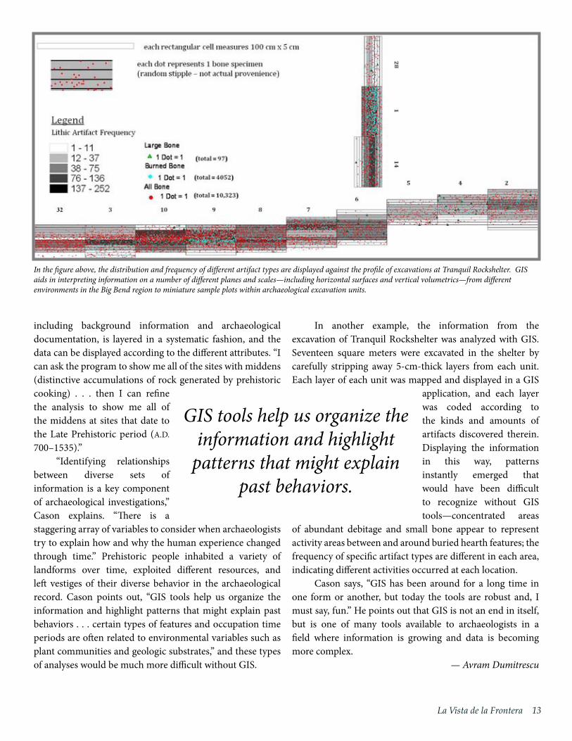
In another example, the information from the excavation of Tranquil Rockshelter was analyzed with GIS. Seventeen square meters were excavated in the shelter by carefully stripping away 5-cm-thick layers from each unit. Each layer of each unit was mapped and displayed in a GIS
application, and each layer was coded according to the kinds and amounts of artifacts discovered therein. Displaying the information in this way, patterns instantly emerged that would have been difficult to recognize without GIS tools—concentrated areas
of abundant debitage and small bone appear to represent activity areas between and around buried hearth features; the frequency of specific artifact types are different in each area, indicating different activities occurred at each location.
Cason says, “GIS has been around for a long time in one form or another, but today the tools are robust and, I must say, fun.” He points out that GIS is not an end in itself, but is one of many tools available to archaeologists in a field where information is growing and data is becoming more complex.
— Avram Dumitrescu
GIS tools help us organize the information and highlight
patterns that might explain past behaviors.
In the figure above, the distribution and frequency of different artifact types are displayed against the profile of excavations at Tranquil Rockshelter. GIS aids in interpreting information on a number of different planes and scales—including horizontal surfaces and vertical volumetrics—from different environments in the Big Bend region to miniature sample plots within archaeological excavation units.

1� Center for Big Bend Studies
La Vista de la Frontera is the annual newsletter of the Center for Big Bend Studies of Sul Ross State University. Address correspondence to the Editor, Center for Big Bend Studies, Box C-71, Alpine, TX 79832, or [email protected].
Editing by William A. Cloud and Susan Chisholm. Graphic design by Avram Dumitrescu.
MissionThe Center for Big Bend Studies fosters interdisciplin-ary scholarship of the diverse prehistoric, historic, and modern cultures of the borderlands region of the United States and Mexico, with emphasis on the area encompassed by Trans-Pecos Texas and north-central Mexico. The Center is committed to the recovery, pro-tection, and sharing of this region’s rich cultural legacy through dynamic programs involving research, educa-tion, public outreach, and publication.
Volume 22, Spring 2011www.sulross.edu/cbbs/
CBBS Advisory CouncilChairman: J. Tillapaugh, OdessaDirector: William A. Cloud, Alpine
J. TillapaughOdessa
William WrightAbilene
Honorary Member
Lonn TaylorFort Davis
Ex Officiofrom Sul Ross State University, Alpine
Ricardo MaestasDon CoersMelleta BellJim D. CaseJames W. Downing
Pete P. GallegoAlpine
Rick HendricksLas Cruces, NM
Claude HudspethSan Angelo
John KlingemannSan Angelo
Ben LoveMarathon
John L. Nau, IIIHouston
Rubén Osorio-ZuñigaChihuahua City, Mexico
J. Travis Roberts Jr.Marathon
Thomas AlexanderKerrville
Félix D. Almaráz Jr.San Antonio
Jed BeckerEl Paso
J.P. BryanHouston
Neil CaldwellAngleton
Paul CarlsonRansom Canyon
Tom CrumGranbury
David FanninMarfa
William C. FosterCuero
Texas State University SystemBoard of Regents, Effective May 2011Mr. Charlie AmatoChairmanSan Antonio
Ms. Donna N. WilliamsVice ChairmanArlington
Dr. Jaime R. GarzaSan Antonio
Mr. Kevin J. LillyHouston
Mr. Ron MitchellHorseshoe Bay
Mr. David MontagneBeaumont
Ms. Trisha S. PollardBellaire
Ms. Rossanna SalazarAustin
Mr. Michael TruncaleBeaumont
Mr. Christopher CovoStudent RegentSan Marcos
Dr. Brian McCallChancellor Austin
Through the work described above, the CBBS has been able to retrieve an enormous amount of archaeological and historical data from Pinto Canyon Ranch. The robust datasets generated thus far through this long-term project have allowed us to truly make meaningful inroads in unlocking the ranch’s past. And, the future promises many more exciting discoveries from this majestic landscape!
—William A. Cloud
documentation of imagery at the Agua Fria site, an important open site near Terlingua Creek that contains an array of imagery as well as extensive archaeological deposits. The site was originally recorded by Victor Smith in the early 1920s and, interestingly, served as a campsite during one of the camel expeditions that crossed the Big Bend in the mid 19th century.
Progress continued over the past year on a searchable database for rock art/imagery sites in the seven large counties that comprise the eastern Trans-Pecos region. The CBBS is now working with Robert Wall and Toni Dzubay, experts in database development from Odessa, who have volunteered their services to help restructure and complete the database project. Ultimately, the relational database will provide baseline data of site conditions, while facilitating the identification of patterns within the rock art. The latter is a crucial step in classifying and understanding the diverse images that seemingly defy categorization.
Rock Art Research(continued from page 5)
Pinto Canyon Ranch Project(continued from page 9)
References CitedBush, Jason
2006 Inside Pinto Canyon: The Vizcaino Collection. La Vista de la Frontera 17:11.
Mallouf, Robert J.
2002 Petroglyph Site Documented in Chinati Mountains. La Vista de la Frontera 15(1):8–9.
2005 The Dancing Rocks Petroglyphs: Horse Nomads of the Sierra Vieja Breaks of the Texas Big Bend.
Paper presented at the 12th Annual Conference of the Center for Big Bend Studies, November 12,
2005, Alpine, Texas.
Seebach, John D.
2006 Living and Leaving Behind: Research at Pinto Canyon Yields New Information on Prehistoric
Peoples. La Vista de la Frontera 17:8–10.
2007 Late Prehistory Along the Rimrock: Pinto Canyon Ranch. Papers of the Trans-Pecos Archaeological
Program 3, Center for Big Bend Studies, Sul Ross State University, Alpine, Texas.
2008 Excavating Two Room Rockshelter. La Vista de la Frontera 19:5.

1�La Vista de la Frontera
Index of the Journal of Big Bend Studies, Vol. 9–19
Compiled by Gerald G. RaunThe new Index of the Journal of Big Bend Studies is now out and covers Volumes 9–19. Members of the Center will receive their copies for free; non-members can buy a copy for $7. $7 (Free for CBBS members)Index of the JBBS, Vol. 1–8$5 (Free for CBBS members)
CBBS T-ShirtsFeaturing rock art from the Big Bend’s Tablecloth Rockshelter, the CBBS t-shirts were designed by our graphic illustrator, Avram Dumitrescu, and are produced in Alpine, Texas. Available in green or khaki, adult sizes S, M, L, XL, XXL and youth sizes S, M, and L. $15 each
CBBS STORE
A detail from Tablecloth Rockshelter, recorded by Reeda Peel, and a stunning photograph by Andy Cloud are now available on postcards and notecards. $1 per postcard ($8 for a pack of 10), $2 per notecard ($18 for a pack of 10). Contact Susan Chisholm at (432) 837-8179 to place an order.
Journal 22 now on saleVolume 22 of the Journal of Big Bend Stud-ies is now available. We also have some of our more popular journals listed below. The abstracts can be read on our website, www.sulross.edu/cbbs/ $15
JBBS 21 JBBS 20 JBBS 19 JBBS 18 JBBS 17
CBBS Notecards
front back
Sul Ross State University
TABLECLOTH ROCKSHELTER
CENTER FOR BIG BEND STUDIE
S
Sul Ross State University
TABLECLOTH ROCKSHELTER
CENTER FOR BIG BEND STUDIE
S
T-shirt #1 Size ________ ColorT-shirt #2 Size ________ ColorT-shirt #3 Size ________ ColorT-shirt #4 Size ________ Color
khaki greenkhaki
khakikhaki
Membership Levels Individual $35 Family $35 Institutional $50 Lifetime $1000Student $20
(�rst year is free)
In addition to my membership, I support the work of the Center for Big Bend Studies with mytax-deductible contribution to the FRIENDS OF THE CENTER FOR BIG BEND STUDIES.$100 $200 $500 $_________ �is is a comfortable level of support for me.
Donations
Books / T-shirts total
Name as it appears on cardCard NumberShipping AddressCityEmail
Exp. DateSecurity codePhoneZipState
Pay by Check Credit Visa/MasterCard Signature
Total
Merchandise
Mail orders toCBBSSRSUBox C-71Alpine, TX 79832
Order by Phone M—F, 8 to 5 (432) 837-8179
Or by email [email protected]
greengreengreen

Call for PapersThe CBBS Annual Conference is scheduled for November 11 and 12, 2011.
Presentation content should focus on prehistoric, historic and modern cultures of the Borderlands Region of the United States and Mexico, with emphasis on the area encompassed by Trans-Pecos Texas and North-Central Mexico.
Please prepare a Powerpoint slideshow to accompany your talk if visuals are needed. Presentations are allotted 30 minutes; we recommend that the presentation itself last between 20–25 minutes, leaving time for questions.
If you would like to present, please visit our website, www.sulross.edu/cbs/conference.php for more information and our Call for Papers form.
The deadline to submit title, abstract and short biography is October 3, 2011.
Sul Ross State UniversityA Member of the Texas State University System