the fluvial geochemistry of the rivers of eastern siberia: i. tributaries of the lena river draining...
TRANSCRIPT
PII S0016-7037(98)00107-0
The fluvial geochemistry of the rivers of Eastern Siberia: I. Tributaries of the Lena Riverdraining the sedimentary platform of the Siberian Craton
YOUNGSOOK HUH,1,* M AI-YIN TSOI,1 ALEXANDR ZAITSEV,2 and JOHN M. EDMONd1
1Department of Earth, Atmospheric and Planetary Sciences, Massachusetts Institute of Technology, Cambridge, Massachusetts 02139, USA2Laboratory of Erosion and Fluvial Processes, Department of Geography, Moscow State University, Moscow, Russia
(Received June11, 1997;accepted in revised form February12, 1998)
ABSTRACT—The response of continental weathering rates to changing climate and atmospheric PCO2 is ofconsiderable importance both to the interpretation of the geological sedimentary record and to predictions ofthe effects of future anthropogenic influences. While comprehensive work on the controlling mechanisms ofcontemporary chemical and mechanical weathering has been carried out in the tropics and, to a lesser extent,in the strongly perturbed northern temperate latitudes, very little is known about the peri-glacial environmentsin the subarctic and arctic. Thus, the effects of climate, essentially temperature and runoff, on the rates ofatmospheric CO2 consumption by weathering are not well quantified at this climatic extreme. To remedy thislack a comprehensive survey has been carried out of the geochemistry of the large rivers of Eastern Siberia,the Lena, Yana, Indigirka, Kolyma, Anadyr, and numerous lesser streams which drain a pristine, high-latituderegion that has not experienced the pervasive effects of glaciation and subsequent anthropogenic impactscommon to western Eurasia and North America.
The scale of the terrain sampled, in terms of area, is comparable to that of the continental United States orthe Amazon/Orinoco and includes a similarly diverse range of geologic and climatic environments. In thispaper the chemical fluxes from the western region, the very large, ancient, and geologically stable sedimentarybasin, Precambrian to Quaternary, of the Siberian Platform will be presented and compared to publishedresults from analogous terrains in the tropical basins of China. While the range in the chemical signatures ofthe various tributaries included here (;60 sampled) is large, this mainly reflects lithology rather than theweathering environment. The areal chemical fluxes are comparable to those of the Chinese rivers, beingdominated by the dissolution of carbonates and evaporites. The net consumption of atmospheric CO2 byaluminosilicate weathering is minor, as it is in the tropical basins. It is much smaller than in active orogenicbelts in similar latitudes, e.g., the Fraser and Yukon, but comparable to those of the Mackenzie tributaries thatdrain the eastern slope of the Rockies. Lithology exerts the dominant influence in determining the weatheringyield from sedimentary terrains, and for a largely carbonate/evaporite terrain climate does not have a directeffect. Copyright © 1998 Elsevier Science Ltd
1. INTRODUCTION
The fluvial flux of dissolved material to the oceans is a reflec-tion, by poorly understood mechanisms, of the environmentalconditions prevailing over the continental surface. Given thatchemical processes interior to the oceans, e.g., hydrothermalactivity, diagenesis, etc., are either relatively stable or theirvariations amenable to interpretation, then the chemical signalimprinted on marine sediments during their accumulationrecords the general evolution and secondary changes of thesurface environment of the Earth over geologic time. Theinversion of the sedimentary record to give this information isthe crux. However, the fluvial fluxes from individual drainagesare as diverse as the terrains themselves. Therefore, it is notlikely that a quantitative accounting is feasible. Rather, theproblem is one of determining relative responses to changerather than absolutes. Interpretation is complicated by the factthat the weathering of exposed aluminosilicates is a sink foratmospheric CO2 and hence is itself a potential determinant onclimate change. Climate and weathering environment may,therefore, be closely coupled.
Observations show that the fluvial chemistry of world rivers
in both stable and tectonically active regimes is dominated bythe rapid weathering of biogenic and inorganic carbonates andevaporites and the slower dissolution of sedimentary alumino-silicate rocks, shales and sandstones, with relatively minorcontributions from primary basement formations (Meybeck,1986; Berner and Berner, 1987). Approximately 80% of theland surface is covered by sediments (Ronov, 1982) in the formof platform cover and uplifted margins in continental foldbelts.The concentration of total dissolved solids in waters drainingsedimentary rocks is at least twice that in waters drainingigneous and metamorphic terrains (Holland, 1978). Extractionof the net CO2 sink term is, therefore, difficult. Systematicwork on the chemical manifestations of such geology in rea-sonably unperturbed river systems has been done mainly intropical and temperate regions, on platforms, e.g., China (Car-bon Cycle Research Unit, 1982; Hu et al., 1982; Gan et al.,1983; Gan, 1985; Zhang et al., 1990), southern India (Trivedi etal., 1995), central Africa (Ne´grel et al., 1993) and in thecontinental foldbelts of the Americas (Edmond et al., 1996).There is very little comparative data from high latitudes pre-dominantly due to the difficulty of access (Reeder et al., 1972).Additionally, the pervasive influence of glaciation in NorthAmerica and Baltica results in a cover of morainic debris ofheterogeneous origin and composition which complicates the
*MIT/WHOI Joint Program in Oceanography/Applied Ocean Sci-ence and Engineering.
Pergamon
Geochimica et Cosmochimica Acta, Vol. 62, No. 10, pp. 1657–1676, 1998Copyright © 1998 Elsevier Science LtdPrinted in the USA. All rights reserved
0016-7037/98 $19.001 .00
1657
interpretation of the fluvial data (Newton et al., 1987). Never-theless the response of these weathering regimes to regionaland global climate change at all time scales, in particular theeffect on atmospheric PCO2, is currently a question of someimportance since anthropogenic climatic impacts are expectedto be strongly enhanced at high northern latitudes as comparedto the global average (Hansen et al., 1983; Cuffey et al., 1995).
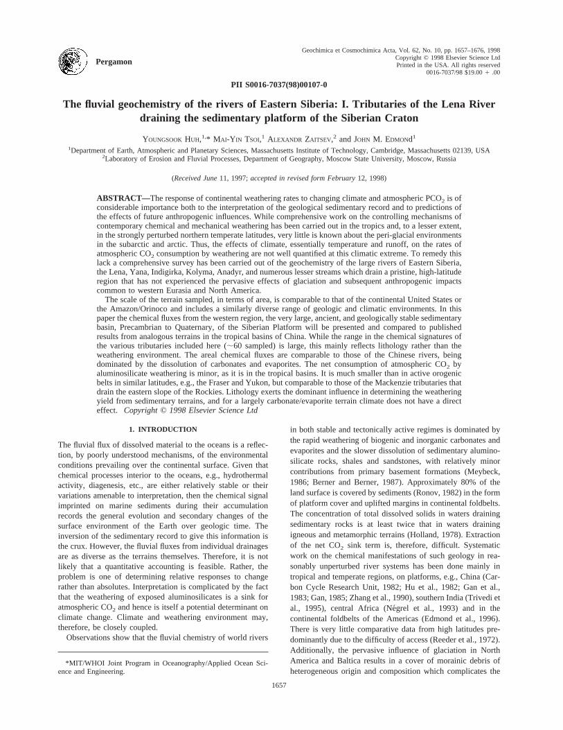
The rivers of Eastern Siberia (Fig. 1), east of Lake Baikal,are ideal for such studies in that the climate is extreme yet, dueto their aridity, the basins have never been glaciated except inthe highest alpine areas (Arkhipov et al., 1986; Velichko andFaustova, 1991). The region contains a very wide range ofgeologic and tectonic environments and the complete spectrumof climatic and vegetational zones characteristic of continentalinteriors at middle and high latitudes (Lydolph, 1977; Zonen-shain et al., 1990). The river basins are pristine, with popula-tions and economic activities at similar or much lesser scales ascompared to those of the Yukon and the Mackenzie in NorthAmerica. Previously reported data on the fluvial geochemistryhave been restricted to samples from the Lena delta outlet andthe estuarine plume (Gordeev and Sidorov, 1993; Gordeev etal., 1996; French-Russian SPASIBA Program: SeeMarineChemistry143, 1996, for major results; German Laptev SeaProgram: seeReports of Polar Research176,1996). As the firstin a series of studies of the major rivers that drain the subarcticand arctic terrains of Eastern Siberia, the Lena, Yana, Indigirka,Kolyma, Anadyr, presented here are the results of geochemicalanalyses of the streams of the Siberian Platform within thecatchment basins of the Lena and the Olenek (Fig. 1). Througha comparison with an equivalent tropical terrain, the Chinese
Platform, the influence of climate on weathering processes andfluxes in large sedimentary basins will be examined. The riversin sedimentary platforms in turn will be compared to those inactive orogenic zones, the Fraser and Mackenzie draining theRockies.
Information of all types concerning the remote areas ofSiberia discussed here is largely contained in the Russianliterature and is, therefore, inaccessible and unfamiliar to theWestern reader. An attempt will be made below to summarizewhat is available in order to establish the context of the chem-ical data.
2. LOCATION
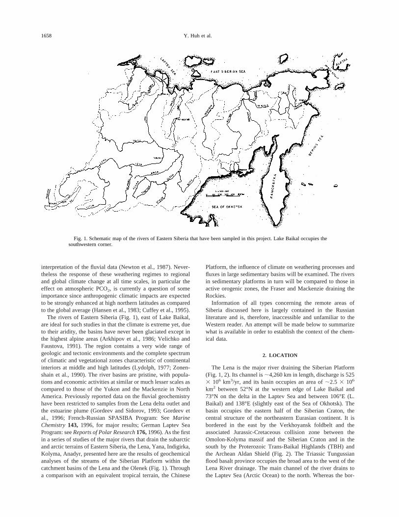
The Lena is the major river draining the Siberian Platform(Fig. 1, 2). Its channel is;4,260 km in length, discharge is 5253 106 km3/yr, and its basin occupies an area of;2.5 3 106
km2 between 52°N at the western edge of Lake Baikal and73°N on the delta in the Laptev Sea and between 106°E (L.Baikal) and 138°E (slightly east of the Sea of Okhotsk). Thebasin occupies the eastern half of the Siberian Craton, thecentral structure of the northeastern Eurasian continent. It isbordered in the east by the Verkhoyansk foldbelt and theassociated Jurassic-Cretaceous collision zone between theOmolon-Kolyma massif and the Siberian Craton and in thesouth by the Proterozoic Trans-Baikal Highlands (TBH) andthe Archean Aldan Shield (Fig. 2). The Triassic Tungussianflood basalt province occupies the broad area to the west of theLena River drainage. The main channel of the river drains tothe Laptev Sea (Arctic Ocean) to the north. Whereas the bor-
Fig. 1. Schematic map of the rivers of Eastern Siberia that have been sampled in this project. Lake Baikal occupies thesouthwestern corner.
1658 Y. Huh et al.
Fig. 2. Location of stations on the Lena, Olenek, and Anabar rivers. UL100, 200, 300, 400, 500, 600, 700, and 800 seriesrepresent expeditions in 1991 (Aldan), 1992 (Lena), 1993 (Olenek), 1994 (Upper Lena), 1994 (Olenek-Chara, Anabar),1995 (Lower Lena), 1996 (Upper Lena Reoccupation), and 1997 (Upper Aldan), respectively. Only rivers draining theSiberian Platform are discussed in this paper (Table 1). The stippled area denotes the continuous basement outcrop of theTrans-Baikal Highlands and Aldan Shield; the rest of the basin contains a sedimentary cover. Discharge measurements atKusur above the delta shown in the inset are from the Global Hydrological Archive and Analysis System. The locations ofthe gauging stations are marked with filled squares and their discharge hydrographs are shown in Fig. 3.
1659Siberian rivers draining the sedimentary platform
ders of the basin are composed of exposed igneous and meta-morphic rocks and uplifted detrital sediments, the interior is astable craton with a sedimentary cover several kilometers thick,Precambrian to Quaternary in age, composed of marine car-bonates and evaporites and continental deposits: sandstone,shale, red beds, and coal. This catchment geology, mountains inthe headwaters and massive, long-lived sedimentary basins inthe interior, is similar to that of the other Siberian rivers to thewest and to major world rivers such as the Mississippi and theYangtze.
The Lena rises on the northern slope of the uplifted moun-tains of the Baikal Rift at an altitude of;1,450 m. In its uppercourse, the river runs west to east parallel to the right-bankbasement outcrops of the TBH and the Aldan Shield (Fig. 2).The channel is deeply incised with bounding cliffs between;25 and 150 m high and transports gravel and coarse sand.Karst formation is pronounced in the limestones particularly onthe right bank;280 km above Yakutsk, the Lena Pillars. Thechannel then broadens considerably with numerous distribu-taries, islands and large sand bars; active dune fields occur onthe banks fed by these exposed bars at falling stage. At theconfluence with its largest tributary, the Aldan, below Yakutskthe river is several kilometers wide with bed material composedexclusively of sand. The Aldan is a high energy stream trans-porting coarse gravel. The bed and bank materials are stronglyasymmetrical across the Lena main channel for several hundredkilometers below the confluence. Below the Aldan confluencethe course of the river makes a sharp northwards turn andcontinues north against the flanks of the Verkhoyansk Range ina broad swampy valley dotted with numerous thermokarst lakesand ponds. The Lena is an ancient antecedent stream that hassupplied detrital sediment from the Aldan Shield to the easternSiberian margin since the Early Precambrian (Zonenshain etal., 1990). The diachronous collision with the Kolyma terrainthat produced the Verkhoyansk progressively diverted itscourse to the north. This is seen clearly at the Lena chute, thedeep, narrow defile north of Kusur above the delta, where theLena cuts through the northwestern limb of the Verkhoyanskrange in a single, narrow, very swift channel. Here the river isfunneled into a narrow gorge between bald, arid mountainsbefore debouching into the enormous delta.
The Olenek is a minor river (2193 103 km2; 35.8 km3/yr)to the west of the Lena also partly draining the platform. Itheads on the southern slope of the Anabar Shield, a domaluplift of the Early Precambrian basement to the northwest ofthe Lena basin. It then flows around this cratonic block to draininto the Laptev Sea. The Nizhnyaya Tunguska, also outside ofthe Lena basin, has its major course in the Tungussian Trapsand feeds the Yenisey to the west; however, the headwatersample is in the Platform. Appropriate data from both streamsare included in this discussion.
3. CLIMATE AND VEGETATION
The region experiences the most severe of continental cli-mates with cool, wet summers and very cold, dry winters.Precipitation occurs mostly in summer with the result that theregion is free from glaciers except in the highest alpine eleva-tions, despite the cold winter temperatures. In the Pleistocenewhen Western Siberia, Baltica, and North America all sup-
ported large ice caps (Denton and Hughes, 1981; Arkhipov etal., 1986; Velichko and Faustova, 1991), this region was freefrom glacial cover although underlain by a thick layer ofpermafrost.
In winter the Asiatic high develops just south of Lake Baikalwith its extension and secondary node in the Yana-Indigirka-Kolyma region to the east of the Lena basin. This high does notextend very far above the surface but the trough in the upperatmosphere is flooded by cold Arctic air reinforcing its stabil-ity. The combination of a stable, dry airmass and long periodsof darkness results in extreme cold and aridity. In summer, thetrough between the two high nodes is a convenient passway forcyclones generated in the northwest over the Arctic Ocean.These supply the precipitation in summer and track above theVilyui-Yakutsk region in the central part of the basin keepingthis area wetter than others in summer (Lydolph, 1977).
The vegetation patterns are broadly latitudinal and can bedivided into three zones (Atlas of Yakutia). In the narrow stripnear the Arctic coast, the mean temperature in July is 4–8°Cand the mean January value is232 ; 236°C. Annual precip-itation is below 300 mm. This tundra zone supports onlystunted shrubs, sparse grasses, moss, and lichen. In the subarc-tic the mean July temperature is 12–16°C though it can reachup to 35°C, and the January values are236 ; 248°C. Annualprecipitation is below 400 mm. Vegetation here is typical of theboreal taiga, open birch, and larch forest. In this extremelycontinental climate larch forests survive because of the addi-tional moisture available from summer melting of the upper-most layer of the permafrost. Small-needled species are dom-inant; they are light-demanding but lower in productivity and inbiomass and, therefore, suited better to the drier climates. In thesouthern part of the basin mean July temperatures are around16°C; in January228; 232°C. Annual precipitation averages500 mm. Here dense coniferous forest is the dominant vegeta-tion type (Monserud et al., 1993; Naidina, 1995). The totalbiomass of the boreal forests in the taiga that rings the arctic iscomparable to that in the tropical rain forests, although con-sisting of only a few species (Adams et al., 1990; Van Campoet al., 1993).
The whole region is underlain by continuous permafrostexcept in the headwater areas (Piguzova, 1965). In the south thepermafrost belt is discontinuous with thicknesses of;25–100m. Between;60°N and the Arctic Circle the permafrost iscontinuous with a thickness is;100–200 m but reaches 400–600 m in the Vilyui lowlands. Above the Arctic Circle, thick-ness is;200 to .500 m with large-scale development ofmassive ice wedges in the surficial layers. Along the arcticcoastal strip (several hundred kilometers wide), as much as75% of the exposed terrain is composed of this ground ice.
4. RUNOFF
In terms of water discharge, the Lena (525 km3/yr) rankseighth in the world after the Mississippi (530 km3/yr), andsecond after the Yenisey (620 km3/yr) among those draininginto the Arctic Ocean (Gordeev et al., 1996; Meade, 1996).
The discharge hydrograph is shown as an inset in Fig. 2 forthe Lena main channel above the delta (at Kusur) and in Fig. 3for some of its tributaries. The spring thaw begins in early Mayin the south and several weeks later in the north. Because the
1660 Y. Huh et al.
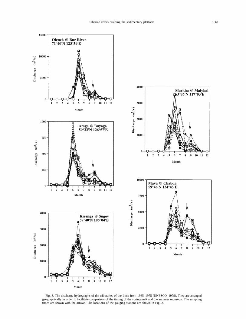
Fig. 3. The discharge hydrographs of the tributaries of the Lena from 1965–1975 (UNESCO, 1979). They are arrangedgeographically in order to facilitate comparison of the timing of the spring-melt and the summer monsoon. The samplingtimes are shown with the arrows. The locations of the gauging stations are shown in Fig. 2.
1661Siberian rivers draining the sedimentary platform
Lena main channel runs south-north in the lower reaches, icedams are frequent when spring thaw begins. Once a dambreaks, there is a flash flood containing large ice floes whichcan carry sizable boulders (drift rocks) plucked by the shore-fast ice. Scouring by ice and drift rocks on the rocky banks andthe islands is a common feature leading to extensive undercut-ting and slope failure and to large inputs of driftwood. Themaximum discharges occur in early June at the mouths of theLena and Olenek rivers in the north. The spring peak dischargecan reach 80,000 m3/s at Kusur, greater than 100 times thatduring the low water period and comparable to the maximumdischarge in the tropical Orinoco (Edmond et al., 1995, 1996).There is a smaller but highly variable discharge peak in Au-gust–September (20,000–40,000 m3/s) due to the summermonsoon bringing in precipitation from the northwest. In win-ter (November–April) the flow is almost nil for the headwatertributaries and,1,000 m3/s for the lower Lena (Kusur). All ofthe streams in the basin are frozen under;2 m of ice and areused as part of the ice road transportation network. Extremes inthe mean annual discharge of water flowing into the delta arefrom 10,600 to 20,200 m3/s. Individual tributaries by compar-ison show larger variations because of their smaller capacity ofmodulation. Despite the completely natural control of the Lenariver runoff (the only significant impoundment is on the upperVilyui), its long-term interannual variability is small, about12% at the mouth (UNESCO, 1971), indicating the overallhydrological stability of the basin. The summer rain is morevariable, and intermittent storm events can give rise to extremedischarges. Many of the other northern and arctic rivers havesimilar magnitudes of variation, but tropical rivers with unsta-ble precipitation conditions can show much greater instability(e.g., Godavari, 33%). The major tributaries to the Lena interms of annual average water discharge are the Aldan (5,000m3/s) draining the Aldan Shield, the southern parts of the platformand the associated Verkhoyansk fold belt, and the Vitim (2,200m3/s) and Olekma (1,700 m3/s) which drain the TBH (Fig. 2). Forcomparison, the Lena at Yakutsk above its confluence with theAldan transports 7,200 m3/s (Chalova et al., 1995).
5. GEOLOGY
The basement of the Siberian Craton is an Archean conti-nental nucleus exposed in the Aldan and Anabar shields. ThePlatform has been stable at least since the Mid-Precambrian. Ithas been encroached upon by marine transgressions and regres-sions caused by sea-level fluctuations in turn driven by globaland regional tectonics and eustasy; the major cycles are Arche-an-Early Cambrian, Early Cambrian-Late Silurian, Early De-vonian-Late Permian, and Mid Triassic-Quaternary (Zonen-shain, 1990; Ronov, 1994). The inundation was most extensivein the Cambrian and has since never quite recovered that stage.The classic shelly fossil assemblages of the Late Precambrian-Early Cambrian (Riphean) limestones and shales fringe thenorthern margin of the Aldan Shield. Ordovician oceanic se-quences are exposed from east of Lake Baikal to the Vilyui andalso to the south of the Anabar Shield. In these Cambrian andOrdovician deposits there are lagoonal facies with abundantevaporites abutting the highs of the TBH and Aldan Shield.This region was farthest away from the ocean and was sub-
merged only at the highest transgression in the Cambrian toOrdovician and not significantly affected by later inundations.
In addition to the sea-level fluctuations, there have beennumerous rifting events giving rise to deep sedimentary basinsaround the margins of the craton (Lobkovsky et al., 1996). InEarly to Middle Riphean (1.6–1.0 Ga.), and especially duringMiddle Riphean (1.35–1.0 Ga.), there was rifting in the Trans-Baikal area related to ocean basin opening, followed by post-rifting subsidence in the Vendian (0.8–0.57 Ga.). In the De-vonian to Permian (286–245 Ma), the main phase of thistectonic activity, there was an episode of multi-trough exten-sion which formed the Vilyui basin. Over the continental sed-iments of Middle Devonian age (hundreds of meters) a furtherLate Devonian rifting event led to extrusion of plateau basaltsand flank uplift and sediment accumulation of 2–7 km. Bore-holes and seismic surveys in the western part of the Vilyuibasin show sediment thicknesses of over 10 km in the Kem-pendyai depression. In Carboniferous-Middle Jurassic, therewas less than one km of post-rift subsidence. A foreland basincontaining a 4–5 km thickness of sediments formed in front ofthe Verkhoyansk orogen in Late Jurassic to Cretaceous. In theMesozoic (241–65.0 Ma) the Baikal rift system developed andin the Cenozoic (56.5 Ma), 6–8 km of sediment were depositedin this 1500 km long trough. To the north, the complex LaptevSea Rift (Cenozoic), a probable extension of the oceanicspreading system of the Eurasian Arctic Ocean, impinged onthe region of the present Lena delta and is still active (Lob-kovsky et al., 1996).
The Verkhoyansk foldbelt is composed of a sedimentarycomplex deposited on the slope and rise of the Siberian passivemargin by the proto-Lena during Late Paleozoic, Triassic, andJurassic times. This underwent intense deformation in the col-lision between the Kolyma cratonic complex and the Siberianmargin beginning in Middle and Late Jurassic and continuingthrough much of the Cretaceous. The clastics were derived solelyfrom the Siberian Platform and overlie older Paleozoic and UpperPrecambrian carbonate sequences. This passive margin probablyexisted for over half a billion years (Zonenshain et al., 1990).
The platform sediments deposited during the marine trans-gressions of the Middle Ordovician, Middle Devonian, and theLate Cretaceous are dominantly limestones and dolomites af-fected by diagenesis to varying degrees. At other times, tec-tonic events like the Devonian uplift of the TBH and the AldanShield supplied abundant detrital sandstones and shales to theplatform cover. The Siberian Platform is characterized by theremarkably widespread development of salt (marine halite andgypsum) and of coal-bearing sedimentary sequences (Ronov,1982). Lower Cambrian salt extends from the west of LakeBaikal along the whole length of the Lena to Kempendyai inthe Vilyui basin (Lefond, 1969). The most important exposedsalt deposits are at Peleduy (UL429) on the Lena and Kem-pendyai on the Vilyui. Other salt occurrences are at Ust-Kut(UL413) and Ust-Biryuk (UL436) on the Lena.
6. SAMPLING AND ANALYTICAL METHODS
In this study sampling was conducted during river transits on avariety of vessels; to date the cumulative distances covered amount to;8,000 km. A portable laboratory was installed on the ships so thatfiltration and sample preservation could be performed promptly under
1662 Y. Huh et al.
clean conditions. Given the constraints of time and logistics only pHwas measured in the field.
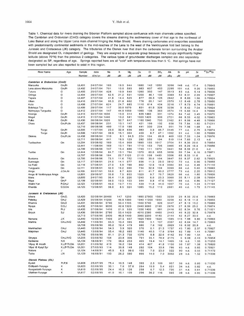
Field investigations were made in the Lena basin in July–August of1991, (Aldan, UL100 series), 1994 (Upper Lena, UL400), 1995 (LowerLena, UL600), and 1997 (Upper Aldan, UL800; Fig. 2). In addition,repeat samples were collected in 1992 and 1996 near Yakutsk. Allsignificant tributaries draining the platform (approximately sixty sta-tions) were sampled from small boats a few kilometers above theirconfluences with the main navigable channel for the major and traceelements and the suspended and bed material. The major element, pHand87Sr/86Sr data are reported in Table 1 along with an assignment ofthe geologic age of the rocks in the drainages. Aliquots for major ionswere filtered through 0.45mm Millipore filters and those for traceelements through 0.4mm Nuclepore filters. The latter were acidifiedwith 3x-vycor-distilled, 6N HCl or 16N HNO3 and stored in HDPEbottles within a few hours after collection. The pH was measuredimmediately at the sampling sites to ensure against CO2 loss. Inaddition, grab samples were collected on geologic expeditions by S.Pelechaty (MIT) in 1993 (Olenek, UL300) and 1994 (Chara-Olekma,UL500). These samples were unfiltered and pH was not measured. Allthe analyses of these samples occurred within 6 months of collection.Previous work showed that the sample integrity, in terms of major ionsand strontium isotopes, is maintained during the time of storage (Ed-mond et al., 1995). Upon return to the MIT laboratory, major cations(Na, K, Mg, Ca) were measured by flame atomic absorption spectros-copy, alkalinity by Gran titration, Cl and SO4 by ion chromatography,and silica by colorimetry (on field-acidified aliquots, save for the grabsamples). Strontium concentrations were determined by ICP-MS, theisotopic composition by TIMS.
7. RESULTS AND DISCUSSION
As the river water inherits its chemical load from diversesources, the dissolved composition is examined to isolate these.Comparisons are made to rivers with different lithologies:shield rivers, e.g., the Orinoco draining the Guayana Shield inthe tropics and orogenic rivers, e.g., Mackenzie, Fraser, andYukon draining the Rockies and Amazon and Orinoco drainingthe Andes. Then the composition and concentration ranges arecompared with those of Chinese rivers with similar lithologybut warmer and wetter climate. Finally the dissolved solids andCO2 uptake fluxes, which ultimately affect the global geo-chemical cycle, are computed. Following the geological distri-bution of the sedimentary deposits, as discussed above, samplesare separated into four groups to facilitate interpretation (seeTable 1). However, the headwaters of some tributaries lie ingeologic zones outside their group; the dominant terrain in thedrainage is used in the classification.
The only prospective atmospheric inputs to the fluvial dis-solved load are seasalt and eolian dust. Since the region ispristine and very remote from heavily populated areas, anthro-pogenic atmospheric contamination can safely be ignored.Given the size of the basin, the dust input must be overwhelm-ingly of local origin, i.e., redistribution of material rather thanits importation. The element most seriously affected by seasaltaerosol is Cl. The Cl values in most of the rivers discussed hereare high, ranging up to 30,000mM in the evaporite-dominatedtributaries of the Upper Lena left bank and to 50,000 in a spring(see Fig. 8a,b). Some tributaries of the Upper Aldan and Olenekare very dilute and low in Cl (,20 mM), but the high Naconcentrations associated with them indicate that other ions arenot severely influenced by marine aerosols. In this paper, thedata are not corrected for atmospheric input because it is anegligible fraction of the total concentration for most of the rivers.
7.1. Data Presentation
7.1.1. Total cations, anions
A large number of tributaries were sampled making it diffi-cult to include their often unfamiliar names in the location map(Fig. 2). Hence, samples will be referred to by number allowingreference to location and name to be made through Fig. 2 and Table1.
The total cationic charge (TZ1 5 Na1 1 K1 1 2Mg21 12Ca21 in mEq5 1026 equivalents per kg) and the total anioniccharge (TZ2 5 Cl2 1 2SO4
22 1 HCO32 in mEq) balance to
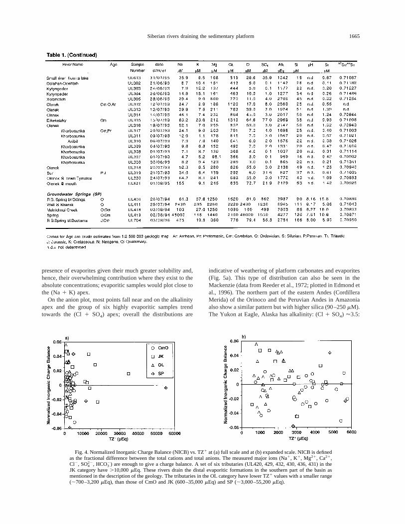
within experimental error (less than 6%, average 3%) (Fig. 4).The Normalized Inorganic Charge Balance, NICB, is defined as(TZ1 2 TZ2)/TZ1. This charge balance pertains to rivers in allthe different vegetation zones (taiga, UL400; tundra, UL600)and geologic terrains (detrital to evaporitic). This is as expectedfor most rivers in the world except in tropical black streams,e.g., in the Amazon, Orinoco, and Congo (Stallard and Ed-mond, 1983; Lewis et al., 1987; Ne´grel et al., 1993; Edmond etal., 1995) and indicates that unanalyzed anions derived fromorganic acids are not significant in the Siberian rivers. On theGuayana Shield, by comparison, the NICB ranges up to;1 invery dilute, acidic (,100mEq, pH, 5.5) black tributaries withnegative measured alkalinities (Edmond et al., 1995).
The TZ1 values (mostly,6,000mEq) range to over 2 ordersof magnitude higher than those of the Guayana Shield (,600mEq); however, the levels are comparable to those of otherplatform rivers such as the Yangtze and Huanghe (,8,000mEq; see Fig. 11d; Hu et al., 1982; Edmond et al., 1995).Overall, the rivers of the Siberian Platform have a large rangein TZ1, from ;560mEq (UL124) to 34,800 (UL420) to 55,200for one of the springs (UL419) and bracket the world averageriver water (TZ1 ;1,250mEq; Meybeck, 1979).
7.1.2. Major ion compositions
Anion and cation ternary diagrams together provide a way tovisualize the compositions and therefore the relative impor-tance of the different weathering regimes (Fig. 5; Hu et al.,1982; Stallard and Edmond, 1983; Edmond et al., 1995, 1996).On the anion diagram, purely carbonate weathering yields onlyalkalinity with no Si, and the data, therefore, fall on the alka-linity apex. Sodium-feldspar weathering to kaolinite, as anexample of silicate dissolution, produces both alkalinity and Siwith a ratio of 0.5, placing the data on the alkalinity-Si tie. Ingeneral the ratio depends on the degree of cation depletion inthe residual phase. Thus, extreme cases like kaolinite weather-ing to gibbsite yield silica but no alkalinity and data trendtowards the Si apex. Evaporites yield (Cl1 SO4) in highlyvariable proportions; however, due to their high solubility theydominate the ternary distributions where present. Oxidativeweathering of sulfidic black shales produces sulfuric acid, highsilica from subsequent acid reaction with the shales, and lowalkalinity; thus the water compositions fall in the center of thetriangle. On the cation diagram, the evaporitic tributaries fall atthe (Na1 K) apex and limestones on the Ca-Mg axis, the exactlocation varying with the Mg enrichment of the limestones withdolomites in the middle (Ca:Mg5 1:1). Silicate weathering isindicated by data extending from the Ca-Mg axis towards theNa 1 K apex. This trend cannot be contaminated by the
1663Siberian rivers draining the sedimentary platform
1664 Y. Huh et al.
presence of evaporites given their much greater solubility and,hence, their overwhelming contribution where they exist to theabsolute concentrations; evaporitic samples would plot close tothe (Na1 K) apex.
On the anion plot, most points fall near and on the alkalinityapex and the group of six highly evaporitic samples trendtowards the (Cl1 SO4) apex; overall the distributions are
indicative of weathering of platform carbonates and evaporites(Fig. 5a). This type of distribution can also be seen in theMackenzie (data from Reeder et al., 1972; plotted in Edmond etal., 1996). The northern part of the eastern Andes (CordilleraMerida) of the Orinoco and the Peruvian Andes in Amazoniaalso show a similar pattern but with higher silica (90–250mM).The Yukon at Eagle, Alaska has alkalinity: (Cl1 SO4) '3.5:
Fig. 4. Normalized Inorganic Charge Balance (NICB) vs. TZ1 at (a) full scale and at (b) expanded scale. NICB is definedas the fractional difference between the total cations and total anions. The measured major ions (Na1, K1, Mg21, Ca21,Cl2, SO4
22, HCO32) are enough to give a charge balance. A set of six tributaries (UL420, 429, 432, 430, 436, 431) in the
JK category have.10,000mEq. These rivers drain the distal evaporitic formations in the southern part of the basin asmentioned in the description of the geology. The tributaries in the OL category have lower TZ1 values with a smaller range(;700–3,200mEq), than those of CmO and JK (600–35,000mEq) and SP (;3,000–55,200mEq).
1665Siberian rivers draining the sedimentary platform
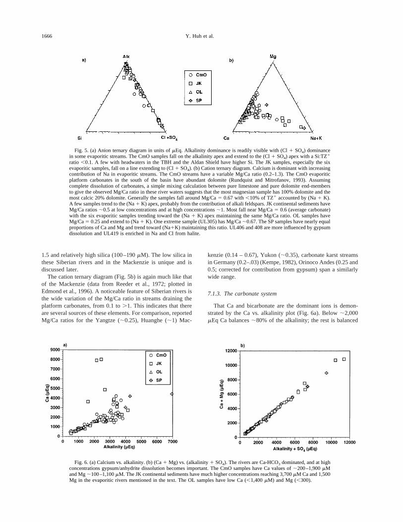
1.5 and relatively high silica (100–190mM). The low silica inthese Siberian rivers and in the Mackenzie is unique and isdiscussed later.
The cation ternary diagram (Fig. 5b) is again much like thatof the Mackenzie (data from Reeder et al., 1972; plotted inEdmond et al., 1996). A noticeable feature of Siberian rivers isthe wide variation of the Mg/Ca ratio in streams draining theplatform carbonates, from 0.1 to.1. This indicates that thereare several sources of these elements. For comparison, reportedMg/Ca ratios for the Yangtze (;0.25), Huanghe (;1) Mac-
kenzie (0.14 – 0.67), Yukon (;0.35), carbonate karst streamsin Germany (0.2–.03) (Kempe, 1982), Orinoco Andes (0.25 and0.5; corrected for contribution from gypsum) span a similarlywide range.
7.1.3. The carbonate system
That Ca and bicarbonate are the dominant ions is demon-strated by the Ca vs. alkalinity plot (Fig. 6a). Below;2,000mEq Ca balances;80% of the alkalinity; the rest is balanced
Fig. 5. (a) Anion ternary diagram in units ofmEq. Alkalinity dominance is readily visible with (Cl1 SO4) dominancein some evaporitic streams. The CmO samples fall on the alkalinity apex and extend to the (Cl1 SO4) apex with a Si:TZ1
ratio ,0.1. A few with headwaters in the TBH and the Aldan Shield have higher Si. The JK samples, especially the sixevaporitic samples, fall on a line extending to (Cl1 SO4). (b) Cation ternary diagram. Calcium is dominant with increasingcontribution of Na in evaporitic streams. The CmO streams have a variable Mg/Ca ratio (0.2–1.3). The CmO evaporiticplatform carbonates in the south of the basin have abundant dolomite (Rundquist and Mitrofanov, 1993). Assumingcomplete dissolution of carbonates, a simple mixing calculation between pure limestone and pure dolomite end-membersto give the observed Mg/Ca ratio in these river waters suggests that the most magnesian sample has 100% dolomite and themost calcic 20% dolomite. Generally the samples fall around Mg/Ca5 0.67 with,10% of TZ1 accounted by (Na1 K).A few samples trend to the (Na1 K) apex, probably from the contribution of alkali feldspars. JK continental sediments haveMg/Ca ratios;0.5 at low concentrations and at high concentrations;1. Most fall near Mg/Ca5 0.6 (average carbonate)with the six evaporitic samples trending toward the (Na1 K) apex maintaining the same Mg/Ca ratio. OL samples haveMg/Ca5 0.25 and extend to (Na1 K). One extreme sample (UL305) has Mg/Ca;0.67. The SP samples have nearly equalproportions of Ca and Mg and trend toward (Na1K) maintaining this ratio. UL406 and 408 are more influenced by gypsumdissolution and UL419 is enriched in Na and Cl from halite.
Fig. 6. (a) Calcium vs. alkalinity. (b) (Ca1 Mg) vs. (alkalinity1 SO4). The rivers are Ca-HCO3 dominated, and at highconcentrations gypsum/anhydrite dissolution becomes important. The CmO samples have Ca values of;200–1,900mMand Mg;100–1,100mM. The JK continental sediments have much higher concentrations reaching 3,700mM Ca and 1,500Mg in the evaporitic rivers mentioned in the text. The OL samples have low Ca (,1,400mM) and Mg (,300).
1666 Y. Huh et al.
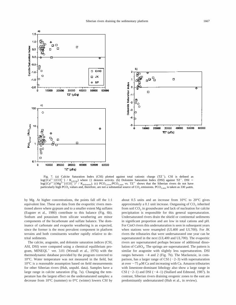
by Mg. At higher concentrations, the points fall off the 1:1equivalent line. These are data from the evaporitic rivers men-tioned above where gypsum and to a smaller extent Mg sulfates(Eugster et al., 1980) contribute to this balance (Fig. 6b).Sodium and potassium from silicate weathering are minorcomponents of the bicarbonate and sulfate balance. The dom-inance of carbonate and evaporite weathering is as expected,since the former is the most prevalent component in platformterrains and both constituents weather rapidly relative to de-trital sediments.
The calcite, aragonite, and dolomite saturation indices (CSI,ASI, DSI) were computed using a chemical equilibrium pro-gram, MINEQL1 ver. 3.01 (Westall et al., 1976) with thethermodynamic database provided by the program corrected to10°C. Water temperature was not measured in the field, but10°C is a reasonable assumption based on field measurementsfor other Siberian rivers (Huh, unpubl. data). Samples have alarge range in calcite saturation (Fig. 7a). Changing the tem-perature has the largest effect on the undersaturated samples: adecrease from 10°C (summer) to 0°C (winter) lowers CSI by
about 0.5 units and an increase from 10°C to 20°C givesapproximately a 0.1 unit increase. Outgassing of CO2 inheritedfrom soil CO2 in groundwater and lack of nucleation for calciteprecipitation is responsible for this general supersaturation.Undersaturated rivers drain the shield or continental sedimentsin significant proportion and are low in total cations and pH.For CmO rivers this undersaturation is seen in subsequent yearswhen stations were resampled (UL400 and UL700). For JKrivers the tributaries that were undersaturated one year can besupersaturated in the next (UL400 and UL700). The evaporiticrivers are supersaturated perhaps because of additional disso-lution of CaSO4. The springs are supersaturated. The pattern issimilar for aragonite with slightly less supersaturation. DSIranges between24 and 2 (Fig. 7b). The Mackenzie, in com-parison, has a larger range of CSI (22–3) with supersaturationat over;75mM Ca and increasing with Ca. Amazon tributarieswith limestone-dominant lithology also show a large range inCSI (22–1) and DSI (24–1) (Stallard and Edmond, 1987). Incontrast, Siberian rivers draining orogenic zones to the east arepredominantly undersaturated (Huh et al., in review).
Fig. 7. (a) Calcite Saturation Index (CSI) plotted against total cationic charge (TZ1). CSI is defined aslog({Ca21}{CO 3
22} / K calcite) where {} denotes activity. (b) Dolomite Saturation Index (DSI) against TZ1. DSI 5log({Ca21}{Mg 21}{CO 3
22} 2 / Kdolomite). (c) PCO2,river/PCO2,atm vs. TZ1 shows that the Siberian rivers do not haveparticularly high PCO2 values and, therefore, are not a substantial source of CO2 emissions. PCO2,atmis taken as 330matm.
1667Siberian rivers draining the sedimentary platform
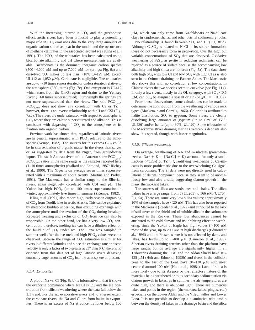
With the increasing interest in CO2 and the greenhouseeffect, arctic rivers have been proposed to play a potentiallymajor role in CO2 emissions due to the very large amounts oforganic carbon stored as peat in the tundra and the occurrenceof methane clathrates in the associated ground ice (Kling et al.,1991). The PCO2 of the tributaries has been calculated usingbicarbonate alkalinity and pH where measurements are avail-able. Bicarbonate is the dominant inorganic carbon species(500–4,000mM and up to 7,000mM for springs; Fig. 6a) anddissolved CO2 makes up less than;10% (3–129mM, exceptUL412 at 1,050mM). Carbonate is negligible. The tributariesare up to;10 times supersaturated or undersaturated relative tothe atmosphere (330matm) (Fig. 7c). One exception is UL412which starts from the CmO region and drains to the YeniseyRiver (;60 times supersaturated). Surprisingly the springs arenot more supersaturated than the rivers. The ratio PCO
2,river/
PCO2,atm does not show any correlation with Ca or TZ1;however, there is an inverse relationship with pH and CSI (Fig.7a,c). The rivers are undersaturated with respect to atmosphericCO2 where they are calcite supersaturated and alkaline. This isconsistent with degassing of CO2 to the atmosphere or itsfixation into organic carbon.
Previous work has shown that, regardless of latitude, riversare in general supersaturated with PCO2 relative to the atmo-sphere (Kempe, 1982). The sources for this excess CO2 couldbe in situ oxidation of organic matter in the rivers themselvesor, as suggested by data from the Niger, from groundwaterinputs. The swift Andean rivers of the Amazon show PCO
2,river/
PCO2,atmratios in the same range as the samples reported here(1–10 times atmospheric) (Stallard and Edmond, 1987; Richeyet al., 1990). The Niger is on average seven times supersatu-rated with a maximum of about twenty (Martins and Probst,1991). The Mackenzie has a similar range to the Siberianrivers, again negatively correlated with CSI and pH. TheYukon has high PCO2 (up to 100 times supersaturation inwinter; approximately five times in summer) (Kempe, 1982).
Kling et al. (1991) also report high, early-season outgassingof CO2 from Toolik lake in arctic Alaska. This can be explainedby metabolic buildup under ice, thus excluding exchange withthe atmosphere until the evasion of the CO2 during breakup.Repeated freezing and exclusion of CO2 from ice can also beresponsible. On the other hand, ice has a very low CO2 con-centration; therefore, melting ice can have a dilution effect onthe buildup of CO2 under ice. The Lena was sampled insummer well after the ice-melt and high PCO2 values were notobserved. Because the range of CO2 saturation is similar forrivers in different latitudes and since the exchange rate orpistonvelocity is only a factor of two greater at 25° than 0°C, there is noevidence from this data set of high latitude rivers degassingunusually large amounts of CO2 into the atmosphere at present.
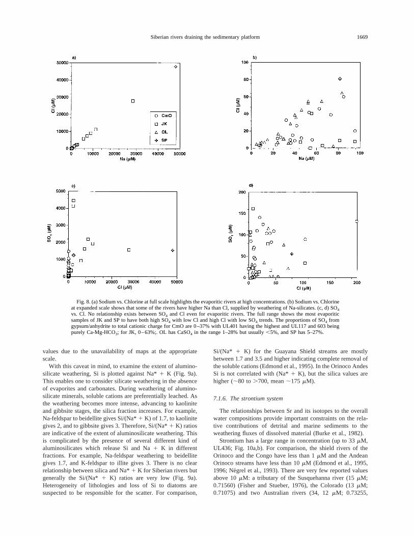
7.1.4. Evaporites
A plot of Na vs. Cl (Fig. 8a,b) is informative in that it showsthe evaporite dominance where Na:Cl is 1:1 and the Na con-tribution from silicate weathering where the data fall below the1:1 trend. For the six evaporative rivers and to a lesser extentthe carbonate rivers, the Na and Cl are from halite in evapor-ites. There is an excess of Na at concentrationes below 100
mM, which can only come from Na-feldspars or Na-silicateclays in sandstone, shales, and other detrital sedimentary rocks.
No relationship is found between SO4 and Cl (Fig. 8c,d).Although CaSO4 is related to NaCl in its source formation,these do not necessarily form in proportion, thus the high butvariable concentrations of SO4 that are observed. Oxidativeweathering of FeS2, as pyrite in reducing sediments, can berejected as a source of sulfate because the accompanying lowalkalinity and high silica are not seen (Fig. 5a). The data showboth high SO4 with low Cl and low SO4 with high Cl as is alsoseen in the Orinoco draining the Eastern Andes. The Mackenziealso shows this with no correlation at low concentrations. InChinese rivers the two species seem to coevolve (see Fig. 11g).In only a few rivers, mostly in the OL category, with SO4 ,0.5mM, can SO4 be assigned a seasalt origin (SO4/Cl 5 ;0.052).
From these observations, some calculations can be made todetermine the contribution from the weathering of various rocktypes (Mackenzie and Garrels, 1966). Chloride is attributed tohalite dissolution, SO4 to gypsum. Some rivers are clearlydissolving large amounts of gypsum (up to 63% of TZ1;UL436) and/or halite (up to 90%; UL420). Some tributaries ofthe Mackenzie River draining marine Cretaceous deposits alsoshow this spread, though with lesser magnitudes.
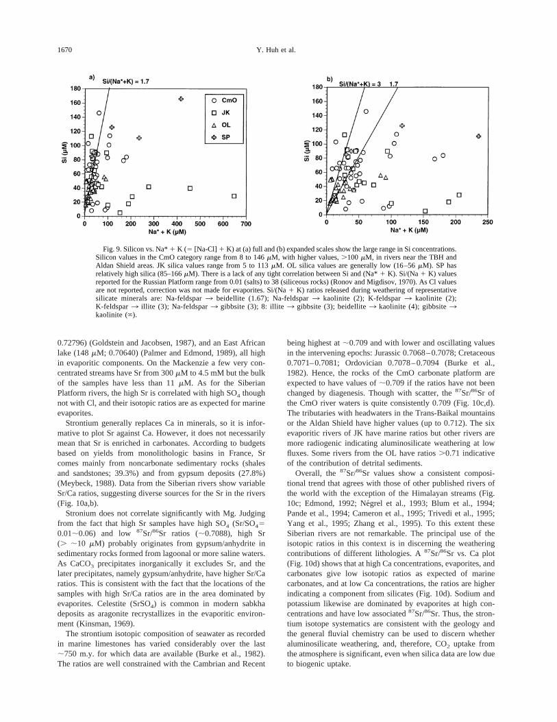
7.1.5. Silicate weathering
On average, weathering of Na- and K-silicates (parameter-ized as Na*1 K 5 [Na-Cl] 1 K) accounts for only a smallfraction (,12%) of TZ1. Quantifying weathering of Ca-sili-cates is more problematic due to the overwhelming Ca signalfrom carbonates. The Si data were not directly used in calcu-lations of detrital component because they seem to be anoma-lously low and also erratic, suggesting diatom growth in themany thermokarst lakes.
The sources of silica are sandstones and shales. The silicavalues have a large range, from 5 (UL205) to 166mM (UL704;Fig. 9a). There are some very low silica values; approximately10% of the samples have,20 mM. This has also been reportedin the Mackenzie (Reeder et al., 1972) and attributed to the lackof soil cover on the shield and of soluble silica in the carbonatesexposed in the Rockies. These low abundances cannot beattributed to the cold climate and its inhibiting effect on weath-ering, since the Yukon at Eagle has high values (.100 mMmost of the year, up to 200mM at high discharge) (Edmond etal., 1996) and the Fraser, where it is not affected by dams andlakes, has levels up to;400 mM (Cameron et al., 1995).Siberian rivers draining terrains other than the platform havelarge ranges but on average are significantly higher in Si.Tributaries draining the TBH and the Aldan Shield have 10–125 mM (Huh and Edmond, 1998b) and rivers in the collisionzone to the east of the Lena have 20–130mM with mostcentered around 100mM (Huh et al., 1998a). Lack of silica ismore likely due to its absence or the refractory nature of thematerials being weathered or to its secondary sedimentation viadiatom growth in lakes, as in summer the air temperatures arequite high, and there is abundant light. There are numerouslakes and ponds in the region (thermokarst lakes, pingos, etc.)especially on the Lower Aldan and the Vilyui valley and LowerLena. It is not possible to develop a quantitative relationshipbetween the density of lakes in the drainage basin and the silica
1668 Y. Huh et al.
values due to the unavailability of maps at the appropriatescale.
With this caveat in mind, to examine the extent of alumino-silicate weathering, Si is plotted against Na*1 K (Fig. 9a).This enables one to consider silicate weathering in the absenceof evaporites and carbonates. During weathering of alumino-silicate minerals, soluble cations are preferentially leached. Asthe weathering becomes more intense, advancing to kaoliniteand gibbsite stages, the silica fraction increases. For example,Na-feldspar to beidellite gives Si/(Na*1 K) of 1.7, to kaolinitegives 2, and to gibbsite gives 3. Therefore, Si/(Na*1 K) ratiosare indicative of the extent of aluminosilicate weathering. Thisis complicated by the presence of several different kind ofaluminosilicates which release Si and Na1 K in differentfractions. For example, Na-feldspar weathering to beidellitegives 1.7, and K-feldspar to illite gives 3. There is no clearrelationship between silica and Na*1 K for Siberian rivers butgenerally the Si/(Na*1 K) ratios are very low (Fig. 9a).Heterogeneity of lithologies and loss of Si to diatoms aresuspected to be responsible for the scatter. For comparison,
Si/(Na* 1 K) for the Guayana Shield streams are mostlybetween 1.7 and 3.5 and higher indicating complete removal ofthe soluble cations (Edmond et al., 1995). In the Orinoco AndesSi is not correlated with (Na*1 K), but the silica values arehigher (;80 to .700, mean;175 mM).
7.1.6. The strontium system
The relationships between Sr and its isotopes to the overallwater compositions provide important constraints on the rela-tive contributions of detrital and marine sediments to theweathering fluxes of dissolved material (Burke et al., 1982).
Strontium has a large range in concentration (up to 33mM,UL436; Fig. 10a,b). For comparison, the shield rivers of theOrinoco and the Congo have less than 1mM and the AndeanOrinoco streams have less than 10mM (Edmond et al., 1995,1996; Negrel et al., 1993). There are very few reported valuesabove 10mM: a tributary of the Susquehanna river (15mM;0.71560) (Fisher and Stueber, 1976), the Colorado (13mM;0.71075) and two Australian rivers (34, 12mM; 0.73255,
Fig. 8. (a) Sodium vs. Chlorine at full scale highlights the evaporitic rivers at high concentrations. (b) Sodium vs. Chlorineat expanded scale shows that some of the rivers have higher Na than Cl, supplied by weathering of Na-silicates. (c, d) SO4
vs. Cl. No relationship exists between SO4 and Cl even for evaporitic rivers. The full range shows the most evaporiticsamples of JK and SP to have both high SO4 with low Cl and high Cl with low SO4 trends. The proportions of SO4 fromgypsum/anhydrite to total cationic charge for CmO are 0–37% with UL401 having the highest and UL117 and 603 beingpurely Ca-Mg-HCO3; for JK, 0–63%;. OL has CaSO4 in the range 1–28% but usually,5%, and SP has 5–27%.
1669Siberian rivers draining the sedimentary platform
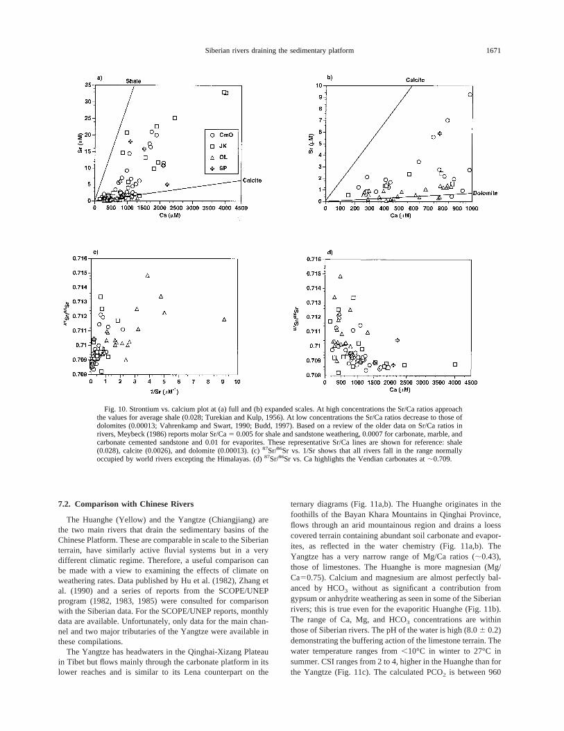
0.72796) (Goldstein and Jacobsen, 1987), and an East Africanlake (148mM; 0.70640) (Palmer and Edmond, 1989), all highin evaporitic components. On the Mackenzie a few very con-centrated streams have Sr from 300mM to 4.5 mM but the bulkof the samples have less than 11mM. As for the SiberianPlatform rivers, the high Sr is correlated with high SO4 thoughnot with Cl, and their isotopic ratios are as expected for marineevaporites.
Strontium generally replaces Ca in minerals, so it is infor-mative to plot Sr against Ca. However, it does not necessarilymean that Sr is enriched in carbonates. According to budgetsbased on yields from monolithologic basins in France, Srcomes mainly from noncarbonate sedimentary rocks (shalesand sandstones; 39.3%) and from gypsum deposits (27.8%)(Meybeck, 1988). Data from the Siberian rivers show variableSr/Ca ratios, suggesting diverse sources for the Sr in the rivers(Fig. 10a,b).
Stronium does not correlate significantly with Mg. Judgingfrom the fact that high Sr samples have high SO4 (Sr/SO450.01;0.06) and low 87Sr/86Sr ratios (;0.7088), high Sr(. ;10 mM) probably originates from gypsum/anhydrite insedimentary rocks formed from lagoonal or more saline waters.As CaCO3 precipitates inorganically it excludes Sr, and thelater precipitates, namely gypsum/anhydrite, have higher Sr/Caratios. This is consistent with the fact that the locations of thesamples with high Sr/Ca ratios are in the area dominated byevaporites. Celestite (SrSO4) is common in modern sabkhadeposits as aragonite recrystallizes in the evaporitic environ-ment (Kinsman, 1969).
The strontium isotopic composition of seawater as recordedin marine limestones has varied considerably over the last;750 m.y. for which data are available (Burke et al., 1982).The ratios are well constrained with the Cambrian and Recent
being highest at;0.709 and with lower and oscillating valuesin the intervening epochs: Jurassic 0.7068–0.7078; Cretaceous0.7071–0.7081; Ordovician 0.7078–0.7094 (Burke et al.,1982). Hence, the rocks of the CmO carbonate platform areexpected to have values of;0.709 if the ratios have not beenchanged by diagenesis. Though with scatter, the87Sr/86Sr ofthe CmO river waters is quite consistently 0.709 (Fig. 10c,d).The tributaries with headwaters in the Trans-Baikal mountainsor the Aldan Shield have higher values (up to 0.712). The sixevaporitic rivers of JK have marine ratios but other rivers aremore radiogenic indicating aluminosilicate weathering at lowfluxes. Some rivers from the OL have ratios.0.71 indicativeof the contribution of detrital sediments.
Overall, the 87Sr/86Sr values show a consistent composi-tional trend that agrees with those of other published rivers ofthe world with the exception of the Himalayan streams (Fig.10c; Edmond, 1992; Ne´grel et al., 1993; Blum et al., 1994;Pande et al., 1994; Cameron et al., 1995; Trivedi et al., 1995;Yang et al., 1995; Zhang et al., 1995). To this extent theseSiberian rivers are not remarkable. The principal use of theisotopic ratios in this context is in discerning the weatheringcontributions of different lithologies. A87Sr/86Sr vs. Ca plot(Fig. 10d) shows that at high Ca concentrations, evaporites, andcarbonates give low isotopic ratios as expected of marinecarbonates, and at low Ca concentrations, the ratios are higherindicating a component from silicates (Fig. 10d). Sodium andpotassium likewise are dominated by evaporites at high con-centrations and have low associated87Sr/86Sr. Thus, the stron-tium isotope systematics are consistent with the geology andthe general fluvial chemistry can be used to discern whetheraluminosilicate weathering, and, therefore, CO2 uptake fromthe atmosphere is significant, even when silica data are low dueto biogenic uptake.
Fig. 9. Silicon vs. Na*1 K (5 [Na-Cl] 1 K) at (a) full and (b) expanded scales show the large range in Si concentrations.Silicon values in the CmO category range from 8 to 146mM, with higher values,.100 mM, in rivers near the TBH andAldan Shield areas. JK silica values range from 5 to 113mM. OL silica values are generally low (16–56mM). SP hasrelatively high silica (85–166mM). There is a lack of any tight correlation between Si and (Na*1 K). Si/(Na1 K) valuesreported for the Russian Platform range from 0.01 (salts) to 38 (siliceous rocks) (Ronov and Migdisov, 1970). As Cl valuesare not reported, correction was not made for evaporites. Si/(Na1 K) ratios released during weathering of representativesilicate minerals are: Na-feldspar3 beidellite (1.67); Na-feldspar3 kaolinite (2); K-feldspar3 kaolinite (2);K-feldspar3 illite (3); Na-feldspar3 gibbsite (3); 8: illite3 gibbsite (3); beidellite3 kaolinite (4); gibbsite3kaolinite ( ).
1670 Y. Huh et al.
7.2. Comparison with Chinese Rivers
The Huanghe (Yellow) and the Yangtze (Chiangjiang) arethe two main rivers that drain the sedimentary basins of theChinese Platform. These are comparable in scale to the Siberianterrain, have similarly active fluvial systems but in a verydifferent climatic regime. Therefore, a useful comparison canbe made with a view to examining the effects of climate onweathering rates. Data published by Hu et al. (1982), Zhang etal. (1990) and a series of reports from the SCOPE/UNEPprogram (1982, 1983, 1985) were consulted for comparisonwith the Siberian data. For the SCOPE/UNEP reports, monthlydata are available. Unfortunately, only data for the main chan-nel and two major tributaries of the Yangtze were available inthese compilations.
The Yangtze has headwaters in the Qinghai-Xizang Plateauin Tibet but flows mainly through the carbonate platform in itslower reaches and is similar to its Lena counterpart on the
ternary diagrams (Fig. 11a,b). The Huanghe originates in thefoothills of the Bayan Khara Mountains in Qinghai Province,flows through an arid mountainous region and drains a loesscovered terrain containing abundant soil carbonate and evapor-ites, as reflected in the water chemistry (Fig. 11a,b). TheYangtze has a very narrow range of Mg/Ca ratios (;0.43),those of limestones. The Huanghe is more magnesian (Mg/Ca50.75). Calcium and magnesium are almost perfectly bal-anced by HCO3 without as significant a contribution fromgypsum or anhydrite weathering as seen in some of the Siberianrivers; this is true even for the evaporitic Huanghe (Fig. 11b).The range of Ca, Mg, and HCO3 concentrations are withinthose of Siberian rivers. The pH of the water is high (8.06 0.2)demonstrating the buffering action of the limestone terrain. Thewater temperature ranges from,10°C in winter to 27°C insummer. CSI ranges from 2 to 4, higher in the Huanghe than forthe Yangtze (Fig. 11c). The calculated PCO2 is between 960
Fig. 10. Strontium vs. calcium plot at (a) full and (b) expanded scales. At high concentrations the Sr/Ca ratios approachthe values for average shale (0.028; Turekian and Kulp, 1956). At low concentrations the Sr/Ca ratios decrease to those ofdolomites (0.00013; Vahrenkamp and Swart, 1990; Budd, 1997). Based on a review of the older data on Sr/Ca ratios inrivers, Meybeck (1986) reports molar Sr/Ca5 0.005 for shale and sandstone weathering, 0.0007 for carbonate, marble, andcarbonate cemented sandstone and 0.01 for evaporites. These representative Sr/Ca lines are shown for reference: shale(0.028), calcite (0.0026), and dolomite (0.00013). (c)87Sr/86Sr vs. 1/Sr shows that all rivers fall in the range normallyoccupied by world rivers excepting the Himalayas. (d)87Sr/86Sr vs. Ca highlights the Vendian carbonates at;0.709.
1671Siberian rivers draining the sedimentary platform
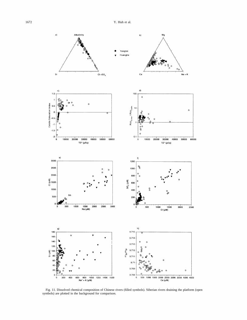
Fig. 11. Dissolved chemical composition of Chinese rivers (filled symbols). Siberian rivers draining the platform (opensymbols) are plotted in the background for comparison.
1672 Y. Huh et al.

and 1,900matm for the Yangtze and 900 – 1,650matm for theHuanghe, only slightly supersaturated with respect to the at-mosphere (Fig. 11d). Sodium vs. chloride generally follows the1:1 line; Na higher than Cl can be accounted for by Na-silicateweathering (Fig. 11e). The Huanghe is very much higher in(Na-Cl) than the Yangtze. Unlike in the Siberian rivers, Cl andSO4 show a good correlation (Fig. 11f) probably because datafrom diverse tributaries are not available for the Chinese rivers.The Si/(Na*1 K) ratio is higher for the Chinese rivers (Fig.11g), but no firm conclusions can be drawn from this becauseof lack of more comprehensive Si data for the Chinese rivers.There are only two strontium isotope values available and thoseare ;0.711, higher than the bulk of the Siberian Platformvalues but still within the expected range (Fig. 11h). Overall,the major ion geochemistry is similar to that of the Siberianrivers, both in property-property relationships and concentra-tion magnitudes.
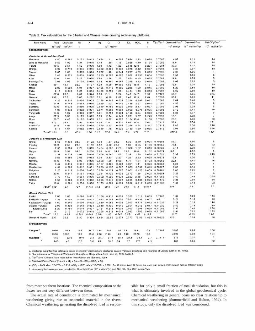
7.3. Flux Calculations
Fluxes of the major dissolved species and the total dissolvedload were calculated for each sampled tributary of the SiberianPlatform. The sums of fluxes of individual watersheds overeach of the three geological categories are also reported inTable 2. Discharge was estimated from the annual runoff (dis-charge per unit area) map of Asia (1:20,000,000 scale)(UNESCO, 1977) which is based on the interpolation andcontouring of the available measurements taken over manyyears. The annual runoff is highest to the north of Lake Baikal(300–800 mm) and lowest near Yakutsk (20 mm); the globalaverage is 30 cm. The drainage area of each tributary wasdetermined gravimetrically by tracing out the catchments froma 1:2,500,000 scale map. Concentrations determined from one-point sampling at falling stage and sometimes at the secondaryhigh stage of the summer rain combined with the mean annualdischarges are the best estimates of flux possible at present. Thecalculated flux at the mouth of the Lena, based on monthlychemical and discharge data (Gordeev and Sidorov, 1993),agrees to within 20% with that estimated here. Though suchagreement is not guaranteed at small tributary scales, fluxcalculations based on one point in time appear not to be too farfrom the truth especially as the data are from falling stage and,therefore, less prone to be sampling extreme conditions asduring snow melt or under-ice flow (Edmond et al., 1995,1996).
Fluxes for the Yangtze and Huanghe main channels werecalculated using the monthly chemical and discharge data setsreported by the SCOPE program (Table 2). Fluxes calculatedfrom one-point sampling and mean annual discharge by Hu etal. (1982) are also shown.
The total dissolved flux of the Chinese rivers and the Sibe-rian rivers are both dominated by Ca and in some cases Nafrom carbonate/evaporite weathering; the Si flux from silicateweathering accounts for only a small fraction (;10%; Table 2).The area-weighted average of the dissolved flux over eachgeological category of the Siberian rivers ranges from 0.53 to2.1 3 106 mol/km2/yr. This is comparable to that of theChinese rivers within the uncertainties even though they are indrastically different climatic regimes. There is more variabilitywithin each geological category of the Siberian rivers’ water-
sheds than between the two climatically different basins. Theflux from rivers draining sedimentary basins (0.53–2.13 106
mol/km2/yr Siberia; 0.37–2.43 106 mol/km2/yr China) (Table2) are comparable to that from orogenic zones (0.45 – 2.93 106 mol/km2/yr Rockies; 0.59–4.13 106 mol/km2/yrAndes; 0.04–0.383 106 mol/km2/yr Siberia) (Edmond andHuh, 1997). The fluxes are much higher than in the shieldregions, (0.05–0.753 106 mol/km2/yr in the tropical shields,0.08–0.813 106 mol/km2/yr in high latitude shields).
To explicitly calculate the uptake rate of CO2 (fCO2) byaluminosilicate weathering, the scheme of Edmond and Huh(1997) is adopted.fCO2 5 fTZ1* (TZ1* 5 TZ1 2 Cl2 22SO4
22) when87Sr/86Sr ratios are indicative of aluminosilicateweathering, i.e.,.0.710. fCO2 5 2fSi when carbonate/evaporites are dominant. This is the estimated ratio for alumi-nosilicate weathering in general, based on the global fluvialdataset (Garrels, 1967; Berner et al., 1983). Using the silica fluxgives an underestimate of the true uptake rate of CO2 becauseof the likely removal of Si by organisms. In Siberian rivers, thearea-weighted averagefCO2 over the geological categoriesrange from 16 to 1123 103 mol/km2/yr (Table 2). However, aswith the dissolved flux, individual tributaries show a largevariability, and overall thefCO2 values are not very differentfrom those of the Chinese rivers (7–1063 103 mol/km2/yr).Orogenic zones have higher uptake rates (143–1,0003 103
mol/km2/yr in the tropics; 19–1,7503 103 mol/km2/yr athigher latitudes).
There are two aspects to climate: temperature and runoff.Higher equilibrium solubility of carbonate minerals at lowertemperatures has been suggested to lead to higher concentra-tions in colder streams. Results to the contrary have been foundby Harmon et al. (1975) and attributed to the kinetic effects anddifference in discharge. This is important in consideringwhether carbonate weathering is saturation limited or kineti-cally limited at cold temperatures. Our results suggest that thesystem is saturation limited; however, the temperature effect onsaturation is only a factor of two between 10 and 25°C and theconcentrations of carbonate-generated Ca and alkalinity in theSiberian rivers are expected to be only slightly higher. It iswidely accepted that the chemical denudation rate for a givenlithology is roughly proportional to runoff (Amiotte-Suchet andProbst, 1993; Summerfield and Hulton, 1994). However, at aregional scale the present dataset does not show any relation-ship between chemical fluxes and runoff (Table 2). As runoff isgenerally lower for the Siberian rivers this reinforces theargument that they have comparable fluxes to those of theChinese streams even though the temperature and the runoffis lower.
In comparisons of different watersheds, the heterogeneity ofintra-basin climate and lithology has to be borne in mind.Whereas some of the Siberian river waters have headwaters inthe southern regions (52°N), the headwaters of the Yangtze areat the high altitudes of the Tibetan Plateau. Also the lithologyof a watershed is rarely homogeneous. In this study, sampleshave been collected at tributary scales; therefore, within eachtributary the climate and lithology are relatively homogeneous.Another reinforcing argument for lack of climatic effect onweathering is by comparing the OL samples, all of which lieabove the Arctic Circle, to the CmO or JK samples which come
1673Siberian rivers draining the sedimentary platform
from more southern locations. The chemical composition or thefluxes are not very different between them.
The actual rate of denudation is dominated by mechanicalweathering giving rise to suspended material in the rivers.Chemical weathering generating the dissolved load is respon-
sible for only a small fraction of total denudation, but this iswhat is ultimately involved in the global geochemical cycle.Chemical weathering in general bears no clear relationship tomechanical weathering (Summerfield and Hulton, 1994). Inthis study, only the dissolved load was considered.
1674 Y. Huh et al.
8. CONCLUSIONS
Weathering in two major sedimentary basins are comparedusing extensive new data from the Siberian Platform in thesubarctic/arctic zone and the existing information from theChinese Platform in tropical/temperate latitudes. The chemis-tries are largely similar in that the rivers are Ca-HCO3 domi-nated. The few values of the strontium isotope ratios for theYangtze that are available are comparable to those of the Lena.The concentration range and isotopic ratios are consistent withthe geology and with observations from other reported worldrivers. The Siberian rivers have been sampled in far more detailand so show more diverse compositions. Carbonate weatheringis saturation limited, and based on the temperature-saturationrelationship, the dissolution rates do not differ much. At re-gional scales, no direct relationship was found between runoffand chemical fluxes. The fluxes are about the same for thedissolved loads even though the basins are in very differentclimatic zones. Thus, it can be concluded that the cold climatein Siberia does not have a direct inhibiting effect on thechemical yields when the reactions are kinetically fast as forcarbonates and evaporites. Uptake of CO2 by aluminosilicateweathering as indicated by the Si concentrations and87Sr/86Srratios is similar for the two regimes but much smaller for theplatforms as compared to orogenic belts (Edmond and Huh,1996). Overall, weathering of sedimentary platforms is not adirect function of temperature but rather a result of the complexinterplay of regional climate and physical processes that deter-mine the chemical yields.
Acknowledgment—We owe our deepest gratitude to the personnel ofthe River Navigation Authorities of Yakutia for immense help andexertion in what were sometimes very trying situations. We thank thecaptains and crew of the various vessels for their enthusiasm andsupport, even running hard aground to get us the samples we needed.S. Pelechaty collected the UL300 and UL500 samples. The87Sr/86Srratios were measured in the lab of S. Bowring. H. Hemond providedaccess to an IC. The MIT component of this work was supported by theEarth Sciences Division of the NSF. We have benefited from thethoughtful comments of F. Albare`de and two anonymous reviewers.
REFERENCES
Adams J. M., Faure H., Faure-Denard L., McGlade J. M., and Wood-ward F. I. (1990) Increases in terrestrial carbon storage from the LastGlacial Maximum to the present.Nature348, 711–714.
Amiotte-Suchet P. and Probst J. L. (1993) Modeling of atmosphericCO2 consumption by chemical weathering of rocks: application tothe Garonne, Congo, and Amazon basins.Chem. Geol.107, 205–210.
Arkhipov S. A., Isayeva L. L., Bespaly V. G., and Glushkova O. (1986)Glaciation of Siberia and Northeast USSR.Quat. Sci. Rev.5, 463–474.
Atlas of Yakutia (1989) Atlas selskovo khozyaistva Yakutskoi ASSR(Agricultural Atlas of the Autonomous Soviet Socialist Republic ofYakuts). Moscow, Glavnoe upravlenie geodezyi i kartografyi prisovete ministrov SSSR.
Berner E. K. and Berner R. A. (1987)The Global Water Cycle:Geochemistry and Environment.Prentice-Hall.
Berner R. A., Lasaga A. C., and Garrells R. M. (1983) The carbonate-silicate geochemical cycle and its effect on atmospheric carbondioxide over the past 100 million years.Amer. J. Sci.283,641–683.
Blum J. D., Erel Y., and Brown K. (1994)87Sr/86Sr ratios of SierraNevada stream waters: implications for relative mineral weatheringrates.Geochim. Cosmochim. Acta58, 5019–5025.
Budd D. A. (1997) Cenozoic dolomites of carbonate islands: theirattributes and origin.Earth-Sci. Rev.42, 1–47.
Burke W. H., Denison R. E., Heatherington E. A., Koepnick R. B.,Nelson H. F., and Otto J. B. (1982) Variation of seawater87Sr/86Srthroughout Phanerozoic time.Geology10, 516–519.
Cameron E. M., Hall G. E. M., Veizer J., and Krouse H. R. (1995)Isotopic and elemental hydrogeochemistry of a major river system:Fraser River, British Columbia, Canada.Chem. Geol.122,149–169.
Carbon Cycle Research Unit (1982) The amount of carbon transportedto the sea by the Yangtze and Huanghe Rivers (People’s Republic ofChina) during the half-year July-December, 1981. InTransport ofCarbon and Minerals in Major World Rivers Part 1.(ed. E. T.Degens);SCOPE/UNEP Sonderband52, 437–448.
Chalova P. C., Panchenko B. M., and Zernova C. Y., ed. (1995)Waterways of the Lena Basin.(in Russian). Mikis, Moscow.
Cuffey K. M., Clow G. D., Alley R. B., Stuiver M., Waddington E. D.,and Saltus R. W. (1995) Large arctic temperature change at theWisconsin-Holocene glacial transition.Science270,455–458.
Denton G. H. and Hughes T. J., eds. (1981)The Last Great Icesheets.Wiley.
Edmond J. M. (1992) Himalayan tectonics, weathering processes, andthe strontium isotope record in marine limestones.Science258,1594–1597.
Edmond J. M. and Huh Y. (1997) Chemical weathering yields frombasement and orogenic terrains in hot and cold climates. InTectonicUplift and Climate Change(ed. W. F. Ruddiman), pp. 329–351.Plenum.
Edmond J. M., Palmer M. R., Measures C. I., Grant B., and StallardR. F. (1995) The fluvial geochemistry and denudation rate of theGuayana Shield in Venezuela, Colombia and Brazil.Geochim. Cos-mochim. Acta59, 3301–3325.
Edmond J. M., Palmer M. R., Measures C. I., Brown E. T., and Huh Y.(1996) Fluvial geochemistry of the eastern slope of the northeasternAndes and its foredeep in the drainage of the Orinoco in Colombiaand Venezuela.Geochim. Cosmochim. Acta60, 2949–2976.
Eugster H. P., Harvie C. E., and Weare J. H. (1980) Mineral equilibriain a six-component seawater system. Na-K-Mg-Ca-SO4-Cl-H2O, at25°C.Geochim. Cosmochim. Acta44, 1335–1347.
Fisher R. and Stueber A. M. (1976) Strontium isotopes in selectedstreams within the Susquehanna River basin.Water Resour. Res.12,1061–1068.
Gan W.-B. (1985) Hydrochemistry of the Yangtze River basin. InTransport of Carbon and Minerals in Major World Rivers. Part 3.(ed. E. T. Degens et al.);SCOPE/UNEP Sonderband58, 539–557.
Gan W.-B., Chen H.-M., and Han Y.-F. (1983) Carbon transport by theYangtze (at Nanjing) and Huanghe (at Jinan) Rivers, People’s Re-public of China. InTransport of Carbon and Minerals in MajorWorld Rivers. Part 2.(ed. E. T. Degens et al.);SCOPE/UNEPSonderband52, 459–470.
Garrels R. M. (1967) Genesis of some groundwaters from igneousrocks. In Researches in Geochemistry(ed. P. H. Ableson), pp.405–420. Wiley.
Goldstein S. J. and Jacobsen S. B. (1987) The neodymium and stron-tium isotopic systematics of river-water dissolved material: Impli-cations for the sources of neodymium and strontium in seawater.Chem. Geol. (Isot. Geosci. Sect.)66, 245–272.
Gordeev V. V. and Sidorov I. S. (1993) Concentrations of majorelements and their outflow into the Laptev Sea by the Lena River.Mar. Chem.43, 33–45.
Gordeev V. V., Martin J. M., Sidorov I. S., and Sidorova M. V. (1996)A reassessment of the Eurasian river input of water, sediment, majorelements and nutrients to the Arctic Ocean.Amer. J. Sci.296,664–691.
Hansen J. D., Johnson D., Lacis A., Lebedeff S., Lee P., Rind D., andRussell G. (1983) Climatic effects of atmospheric carbon dioxide.Science220,874–875.
Harmon R. S., White W. B., Drake J. J., and Hess J. W. (1975)Regional hydrochemistry of North American carbonate terrains.Water Resour. Res.11, 963–967.
Holland H. D. (1978)The Chemistry of the Atmosphere and Oceans.Wiley Interscience, New York.
Hu M.-H., Stallard R. F., and Edmond J. M. (1982) Major ion chem-istry of some large Chinese rivers.Nature298,550–553.
Huh Y., Babich D., Zaitsev A., and Edmond J. M. (in review) Thefluvial geochemistry of the rivers of Eastern Siberia II: tributaries of
1675Siberian rivers draining the sedimentary platform
the Lena, Yana, Indigirka, and Kolyma draining the accretionaryzone.Geochim. Cosmochim. Acta(in press).
Huh Y and Edmond J. M. (1998b) The fluvial geochemistry of therivers of Eastern Siberia: II. Tributaries of the Lena and Anbardraining the basement terrain of the Siberan Craton and the Trans-Baikal Highlands.Geochim. Cosmochim. Acta(submitted).
Kempe S. (1982) Long-term records of CO2 pressure fluctuations infresh waters. InTransport of Carbon and Minerals in Major WorldRivers Part 1.(ed. E. T. Degens);SCOPE/UNEP Sonderband52,91–332.
Kinsman D. J. J. (1969) Interpretation of Sr21 concentrations in car-bonate minerals and rocks.J. Sediment. Petrol.39, 486–508.
Kling G. W., Kipphut G. W., and Miller M. C. (1991) Arctic lakes andstreams as gas conduits to the atmosphere: implications for tundracarbon budget.Science251,298–301.
Kulp J. L., Turekian K., and Boyd D. W. (1952) Strontium content oflimestones and fossils.Bull. Geol. Soc. Amer.63, 70–716.
Lefond S. J. (1969)Handbook of World Salt Resources. Monographs inGeoscience.Plenum Press.
Lewis W. M., Hamilton S. K., Jones S. L., and Runnels D. D. (1987)Major element chemistry, weathering and element yields for theCaura River drainage, Venezuela.Biogeochem. 4, 159–181.
Lobkovsky L. I. et al. (1996) Extensional basins of the former SovietUnion: structure, basin formation mechanisms, and subsidence his-tory. Tectonophysics266,251–285.
Lydolph P. E. (1977)Climates of the Soviet Union. World Surv.Climatol. 7.
Mackenzie F. T. and Garrels R. M. (1966) Chemical mass balancebetween rivers and oceans.Amer. J. Sci.264,507–525.
Martins O. and Probst J.-L. (1991) Biogeochemistry of major Africanrivers: carbon and mineral transport. InBiogeochemistry of MajorWorld Rivers(ed. E. T. Degens et al.), pp. 127–155. Wiley.
Meade R. H. (1996) River-sediment inputs to major deltas. InSea-Level Rise and Coastal Subsidence: Causes, Consequences, andStrategies(ed. J. D. Milliman and B. U. Haq), pp. 63–85. Kluwer.
Meybeck M. (1979) Concentrations des eaux fluviales en e´lementsmajeurs et apports en solution aux oce´ans.Rev. Ge´ol. Dyn. Geogr.Phys. 21, 215–246.
Meybeck M. (1986) Composition chimique des ruisseaux non pollue´sde France.Sci. Geol. Bull. 39, 3–77.
Meybeck M. (1988) How to establish and use world budgets of riverinematerials. InPhysical and Chemical Weathering in GeochemicalCycles(ed. A. Lerman and M. Meybeck), pp. 247–272. Kluwer.
Monserud R. A., Denissenko O. V., and Tchebakova N. M. (1993)Comparison of Siberian paleovegetation to current and future vege-tation under climate change.Clim. Res.3, 143–159.
Naidina O. D. (1995) Holocene climatic, vegetation, and pollen data ofSiberia adjacent to the Laptev Sea.Rept. Polar Res.176,135–153.
Negrel P., Allegre C. J., Dupre´ B., and Lewin E. (1993) Erosionsources determined by inversion of major and trace element ratiosand strontium isotopic ratios in river water: the Congo Basin case.Earth Planet. Sci. Lett.120,59–76.
Newton R. M., Weintraub J., and April R. (1987) The relationshipbetween surface water chemistry and geology in the North Branch ofthe Moose River.Biogeochem. 3, 21–35.
Palmer M. R. and Edmond J. M. (1989) The strontium isotope budgetof the modern ocean.Earth Planet. Sci. Lett.92, 11–26.
Pande K., Sarin M. M., Trivedi J. R., Krishnaswami S., and SharmaK. K. (1994) The Indus river system (India-Pakistan): Major-ionchemistry, uranium, and strontium isotopes.Chem. Geol.116,245–259.
Piguzova V. M. (1965) Estimating underground flow into the rivers ofthe permafrost zone.Soviet Hydrol.,114–129.
Reeder S. W., Hitchon B., and Levinson A. A. (1972) Hydrogeochem-istry of the surface waters of the Mackenzie River drainage basin,Canada: I. Factors controlling inorganic composition.Geochim. Cos-mochim. Acta36, 825–865.
Richey J. E., Hedges J. I., Devol A. H., Quay P. D. and Victoria R.(1990) Biogeochemistry of carbon in the Amazon River.Limnol.Oceanogr.35, 352–371.
Ronov A. B. (1982) The Earth’s sedimentary shell (quantitative pat-terns of its structure, composition, and evolution).Intl. Geol. Rev.24,1313–1363.
Ronov A. B. (1994) Phanerozoic transgressions and regressions on thecontinents: a quantitative approach based on areas flooded by the seaand areas of marine and continental deposition.Amer. J. Sci.294,777–801.
Ronov A. B. and Migdisov A. A. (1970) Evolution of the chemicalcomposition of the rocks in the shields and sediment cover of theRussian and North American Platforms.Geochem. Intl.294–325.
Rundquist D. V. and Mitrofanov F. P., eds. (1993)PrecambrianGeology of the USSR. Developments in Precambrian Geology.Elsevier.
Stallard R. F. and Edmond J. M. (1983) Geochemistry of the Amazon2. The influence of geology and weathering environment on thedissolved load.J. Geophys. Res.88, 9671–9688.
Stallard R. F. and Edmond J. M. (1987) Geochemistry of the Amazon3. Weathering chemistry and limits to dissolved inputs.J. Geophys.Res.92, 8293–8302.
Summerfield M. A. and Hulton N. H. (1994) Natural controls of fluvialdenudation rates in major world drainage basins.J. Geophys. Res.99, 13,871–13,883.
Trivedi J. R., Pande K., Krishnaswami S., and Sarin M. M. (1995)Strontium isotopes in rivers of India and Pakistan: a reconnaissancestudy.Current Science69, 171–178.
Turekian K. K. (1964) The marine geochemistry of strontium.Geochim. Cosmochim. Acta28, 1479–1496.
Turekian K. K. and J. L. Kulp (1956) The geochemistry of strontium.Geochim. Cosmochim. Acta10, 245–296.
UNESCO (1977)Atlas of World Water Balance.UNESCO Press.UNESCO (1979)Discharge of Selected Rivers of the World. Studies
and Reports in Hydrology III.Gap.Vahrenkamp V. C. and Swart P. K. (1990) New distribution coefficient
for the incorporation of strontium to dolomite and its implications forthe formation of ancient dolomites.Geology18, 387–391.
Van Campo E., Guiot J., and Peng C. (1993) A data-based reappraisalof the terrestrial carbon budget.Global Planet. Change8, 189–201.
Velichko A. A. and Faustova M. A. (1991) Reconstruction of the lastpost-Pleistocene glaciation of the northern hemisphere (18–20 thou-sand years ago).Dokl. Akad. Nauk USSR223–225.
Westall J. C., Zachary J. L., and Morel F. M. M. (1976) MINEQL, AComputer Program for the Calculation of Chemical EquilibriumComposition of Aqueous Systems. Tech Note 18. MIT.
Yang C., Telmer K., and Veizer J. (1995) Chemical dynamics of the St.Lawrence riverine system:dDH2O, d18OH2O, d13CDIC, d34SSulfate, anddissolved87Sr/86Sr. Geochim. Cosmochim. Acta60, 851–866.
Zhang J., Huang W. W., Liu M. G., and Zhou Q. (1990) Drainage basinweathering and major element transport of two large Chinese rivers(Huanghe and Changjiang).J. Geophys. Res.95, 13277–13288.
Zhang J., Takahashi K., Wushiki H., Yabuki S., Xiong J., and MasudaA. (1995) Water geochemistry of the rivers around the TaklimakanDesert (NW China): Crustal weathering and evaporation processes inarid land.Chem. Geol.119,225–237.
Zonenshain L. P., Kuzmin M. I., and Natapov L. P. (1990) Geology ofthe USSR: A Plate-Tectonic Synthesis.Geodyn. Ser.21. AGU.
1676 Y. Huh et al.