the first national park of brasil - icmbio.gov.br · visitors center lago azul maromba pool três...
TRANSCRIPT
www.icmbio.gov.br/parnaitatiaiawww.facebook.com/parnaitatiaia
The firstNational Parkof Brasil
InstitutoChico Mendes
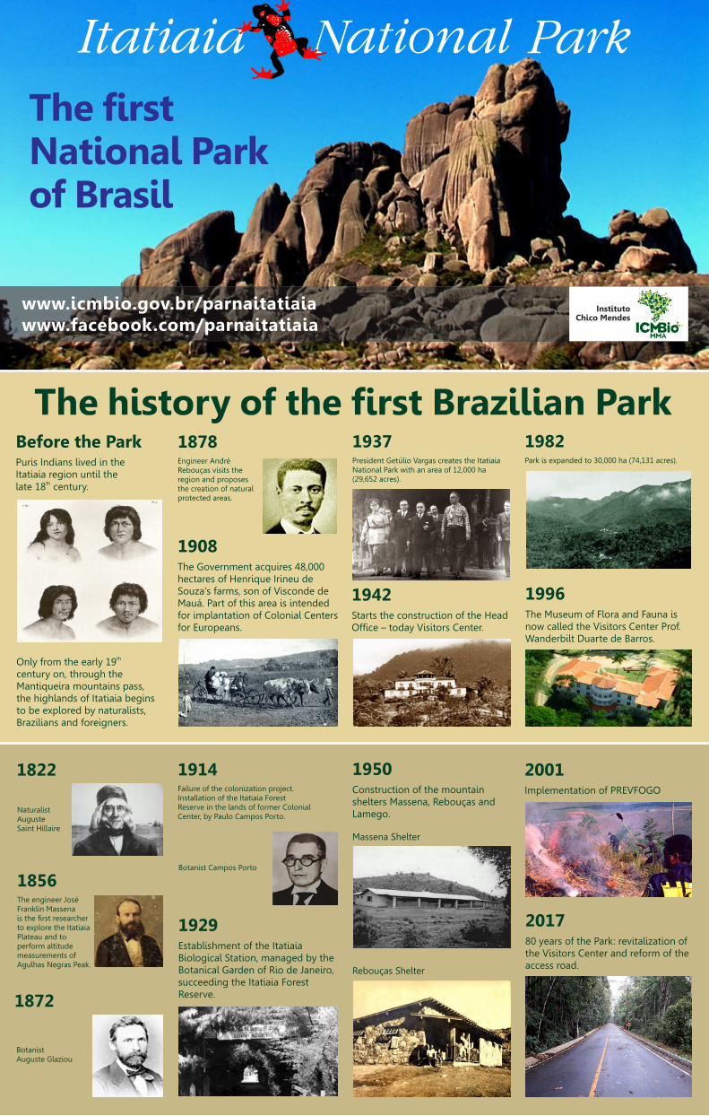
The history of the first Brazilian ParkBefore the Park
Itatiaia region until thethlate 18 century.
•
Puris Indians lived in the
thOnly from the early 19century on, through theMantiqueira mountains pass,the highlands of Itatiaia beginsto be explored by naturalists,Brazilians and foreigners.
1937National Park with an area of 12,000 ha(29,652 acres).
•
President Getúlio Vargas creates the Itatiaia
1878Rebouças visits theregion and proposesthe creation of naturalprotected areas.
1908The Government acquires 48,000hectares of Henrique Irineu deSouza's farms, son of Visconde deMauá. Part of this area is intendedfor implantation of Colonial Centersfor Europeans.
•
oooo
•
Engineer André
1982•
Park is expanded to 30,000 ha (74,131 acres).
1996
now called the Visitors Center Prof.Wanderbilt Duarte de Barros.
•
The Museum of Flora and Fauna is
1942
Office – today Visitors Center.
•
Starts the construction of the Head
Botanist Campos Porto
Massena Shelter
Rebouças Shelter
1822
NaturalistAugusteSaint Hillaire
1872
BotanistAuguste Glaziou
1856Franklin Massenais the first researcherto explore the ItatiaiaPlateau and toperform altitudemeasurements ofAgulhas Negras Peak.
•
The engineer José
1914Installation of the Itatiaia ForestReserve in the lands of former ColonialCenter, by Paulo Campos Porto.
•
Failure of the colonization project.
1929
Biological Station, managed by theBotanical Garden of Rio de Janeiro,succeeding the Itatiaia ForestReserve.
•
Establishment of the Itatiaia
1950Construction of the mountainshelters Massena, Rebouças andLamego.
•
2001•
Implementation of PREVFOGO
2017
the Visitors Center and reform of theaccess road.
•
80 years of the Park: revitalization of

Directions
Escorrega Waterfall Santa Clara Waterfall Aiuruoca Waterfall Flores WaterfallRebouças ShelterAgulhas NegrasPrateleirasMorro do Couto
N
S
NE
W E
SE
NW
SW
Visitors Center Lago Azul Poranga Waterfall Véu de Noiva Waterfall Itaporani Waterfall Último Adeus SightMaromba Pool Três Picos
km0 5 10
MarombaMaromba
FragáriaFragária
CampoRedondoCampo
Redondo
Gargantado Registro
Gargantado Registro
ItatiaiaItatiaia
Posto 1(Entrance)
Posto 1(Entrance)
Casade Pedra
Casade Pedra
CachoeirinhaCachoeirinha
Agulhas NegrasPeakAgulhas NegrasPeak
Furada StoneFurada Stone
Vale do PrataVale do Prata
Santa ClaraWaterfall
Santa ClaraWaterfall
Água BrancaShelter
Água BrancaShelter
Morro CavadoMorro Cavado
Lago AzulLago Azul
Cabeça deLeão StoneCabeça deLeão Stone
3 PicosGazebo3 PicosGazebo
ÚltimoAdeus Gazebo
ÚltimoAdeus Gazebo
Altodos Brejos
Altodos Brejos
Vale daSanta Clara
Vale daSanta Clara
Vale das CruzesVale das Cruzes
MaringáMaringá
Vale do PavãoVale do Pavão
AiuruocaWaterfallAiuruocaWaterfall
CameloStone
CameloStone
LamegoShelterLamegoShelter
CapivaraCapivara
k
Brejoda Lapa
Brejoda Lapa
Vargem GrandeVargem Grande
Dois IrmãosDois Irmãos
Resende
Rio de Janeiro
ItamonteSão Lourenço
Map Subtitles
MaçãStoneMaçãStone
Ovos daGalinhaOvos daGalinha
Rancho CaídoRancho Caído
TartarugaStone
TartarugaStone Assentada
StoneAssentada
Stone
Asa de HermesAsa de Hermes
Sino StoneSino Stone
k
MassenaShelter
MassenaShelter
Flores WaterfallFlores Waterfall
Serra NegraSerra Negra
Serra NegraCrossing
Serra NegraCrossing
Serra NegraCrossing
Serra NegraCrossing
Rancho CaídoCrossing
Rancho CaídoCrossing
TravessiaRuy Braga TravessiaRuy Braga
k
kk
Waterfall
Peak
Post
Shelter
Visitors Center
Stone
Gazebo
Locality
Park limits
Double lane highway
Single lane highway
Dirt road
Highway identification
Trail or crossing
PenedoPenedo
Base Viscondede Mauá
Base Viscondede Mauá
RJ/MG border
Monte BeloMonte Belo
From Rio or São Paulo, the access to the Park is via Presidente Dutra highway (BR 116).In Itatiaia (exit 318) the access is via BR-485, further 5.5 km to the entrance of theLower Part of the Park. For the Upper Part, the access is via Engenheiro Passos (exit330A of the Dutra Highway). After 26 km (16 miles) on the BR-354 highway you reachthe place called Garganta do Registro, that is the access to the Upper Part of the Park.Further 14 km through a dirt road, you reach the reception of the Upper Part of thePark (Posto Marcão) – that is the access to the main attractions of the highlands. FromBelo Horizonte, take the Fernão Dias highway and enter (BR-381), through Caxambuand follow the BR-354 route to Garganta do Registro to reach theUpper Part or take the Presidente Dutra highwayto access the Lower Part of the Park.
EscorregaWaterfallEscorregaWaterfall
Vale doAlcantilado
Vale doAlcantilado
Véu de NoivaWaterfall
Véu de NoivaWaterfall
ItaporaniWaterfallItaporaniWaterfall
PrateleirasPeak
PrateleirasPeak
AntenaHill
AntenaHill
Morro doCouto PeakMorro do
Couto Peak
Posto MarcãoPosto MarcãoAltarStoneAltarStone
k
Rio BonitoWaterfallRio BonitoWaterfall
PorangaWaterfallPorangaWaterfall
VisitorsCenterVisitorsCenter
MarombaPool
MarombaPool
Três PicosTrail
Três PicosTrail
Serrinhado Alambari
Serrinhado Alambari
Some attractions of the Park
BELO HORIZONTE
SÃOPAULO
RIO DEJANEIRO
Caxambu Juiz de Fora
Liberdade
SantaClara
Vale do PavãoVale dasCruzes
Santo Antônio
Mirantão
Itamonte
EngenheiroPassos
Visconde de Mauá
ITATIAIA
NATIONALPARK(Posto 1)
POSTOMARCÃOGARGANTA
DO REGISTRO
PENEDO
MARINGÁMAROMBA
BR116
BR354
BR040
BR38
15.
5 km
14 km
26 k
m
253 km
256
km
330
km
260 km
180 km
164 km10 km
MacieirasShelter
MacieirasShelter
Rebouças ShelterRebouças Shelter

Altar Stone
3 km (1.86 mi.) / 2.5 to 3.5 h 500 m (546 yd.) / 10 min
Just after the Rebouças Shelter,following the path to the Prateleiras,a trail to the left leads to this icywaterfall.
Difficulty level: Easy.
Morro do Couto PeakIt is located halfway to the AiuruocaWaterfall. Provides a great view ofthe Agulhas Negras Peak. A visitorsguide is recommended.
Difficulty level: Moderate.
This walk allows a privileged view ofthe Serra da Mantiqueira and the Valedo Paraíba. It starts at Posto Marcão.This trail is also the initial stretch ofthe Couto-Prateleiras circuit.
Difficulty level: Moderate.
Asa de Hermes Flores WaterfallRock formation curiously shapedbetween the Altar Stone and the Agulhas Negras Peak. We recommendcontracting the services of a localguide.
Difficulty level: Moderate, withfinal stretch of hard climbing.
Altar StoneAltar Stone
Agulhas NegrasPeak
Agulhas NegrasPeak
Rebouças ShelterRebouças Shelter
Posto Marcão(Entrance)
Posto Marcão(Entrance)
Cinco LagosCircuit
Cinco LagosCircuit
Morro do CoutoPeak
Morro do CoutoPeak
Posto Marcão(Entrance)
Posto Marcão(Entrance)
RebouçasShelter
RebouçasShelter
Couto-PrateleirasCircuit
Couto-PrateleirasCircuit
Rebouças ShelterRebouças Shelter
Posto Marcão(Entrance)
Posto Marcão(Entrance)
FloresWaterfall
FloresWaterfall
Rebouças ShelterRebouças Shelter
Posto Marcão(Entrance)Posto Marcão(Entrance)
Asa de HermesAsa de HermesAltarStoneAltarStone
Agulhas NegrasPeak
Agulhas NegrasPeak
3 km (1.86 mi.) / 1.5 h 3 km (1.86 mi.) / 2 h
1.2 km (0.74 mi.) / 40 min
Lago Azul Poranga Waterfall Três Picos TrailMaromba Site The walk should start at the VisitorsCenter. Initially, going by the accessroad to the Maromba Site by 800 mand another 400 m of trail to thewaterfall.
Difficulty level: Easy.
At 4 km by the road from the VisitorsCenter is the starting point for themain waterfalls of the Lower Part.Starting at Maromba Bridge by trail,Maromba Pool is 170 m away, Véu deNoiva Waterfall, 380 m and ItaporaniWaterfall, 640 m.
Difficulty level: Easy.
A nice walk starting in the VisitorCenter. Goes next to the snack bar,down a staircase of 124 steps (or theobservation trail with 460 m) and, atthe end, a beautiful natural pool ofthe Campo Belo river.
Difficulty level: Easy.
At first it seems to be easy, but laterbecomes hard and requires goodphysical conditioning. Requires thesigning of a disclaimer in the VisitorsCenter. Get out early and bring food,warm clothes and a flashlight. It mustbe started until 10 am.
Difficulty level: Hard.
Trails: beautiful walks through NatureObservation: All times (estimated) and distances are for the outward journey only.
Lago AzulLago Azul
BR 485BR 485
Visitors CenterVisitors Center
ObservationTrail
ObservationTrail
EntrancePosto 1EntrancePosto 1
Visitors CenterVisitors Center
PorangaWaterfallPorangaWaterfall
EntrancePosto 1EntrancePosto 1
Três PicosTrês Picos
Visitors CenterVisitors Center
EntrancePosto 1
EntrancePosto 1
7 km7 km
1.6 km
1.6 km
Maromba SiteMaromba Site
Visitors CenterVisitors Center EntrancePosto 1EntrancePosto 1
4 km4 km
Véu da NoivaWaterfall
Véu da NoivaWaterfall
MarombaPool
MarombaPool
ItaporaniWaterfallItaporaniWaterfall
Maromba SiteMaromba Site
Lower Part of the Park
7 km (4.35 mi.) / 4 h500 m (546 yd.) / 15 min 4 km (2.49 mi.)
Upper Part of the Park
Água Branca Shelter
Located on an extension of the RuyBraga crossing to 1,700 m altitude. Itoffers a very nice hosting andprivileged scenic beauty. Must bescheduled and previously authorizedby the Park Administration.0
Difficulty level: Hard.
Serra Negra Crossing
Long trail that connects the RebouçasShelter to Maromba and Maringávillages, passing by the Santa ClaraWaterfall. The night can be done inSerra Negra. It requires good physicalconditions and we recommendcontracting services of a local guide.Must be scheduled and previouslyauthorized by the Park Administration.0
Difficulty level: Hard.
4 h of Lower Part7 h of Upper Part
32 km (19.88 mi.) / 2 days
Ruy Braga Crossing
Trail that connects the Upper Part andthe Lower Part of the Park and can beperformed in both directions. It isessential to be in good physicalcondition, and together with localguide. The tour must be previouslyscheduled and authorized by the ParkAdministration.o
Difficulty level: Hard.
22 km (13.67 mi.) / 2 days
Connects Rebouças Shelter toVisconde de Mauá region, arriving inEscorrega Waterfall or Vale dasCruzes. The night can be done inwild camping at a site called RanchoCaído. It requires good physicalconditions and preferably a visitorsguide. Must be scheduled andpreviously authorized by the ParkAdministration.0
Difficulty level: Hard.
Rancho Caído Crossing
27 km (16.78 mi.) / 2 days
MarombaMaromba
PrateleirasPeak
PrateleirasPeak
Posto Marcão(Entrance)
Posto Marcão(Entrance)
Agulhas NegrasPeakAgulhas NegrasPeak
Rebouças ShelterRebouças Shelter
MarombaMaromba
PrateleirasPeak
PrateleirasPeak
Posto Marcão(Entrance)
Posto Marcão(Entrance)
Agulhas NegrasPeakAgulhas NegrasPeak
Rebouças ShelterRebouças Shelter
Macieiras ShelterMacieiras Shelter
Massena ShelterMassena Shelter
Lamego ShelterLamego ShelterÁgua Branca ShelterÁgua Branca Shelter
Agulhas NegrasPeakAgulhas NegrasPeak
EscorregaWaterfallEscorregaWaterfall MarombaMaromba
Rebouças ShelterRebouças Shelter
HO CAC ÍN DA ORHO CAC ÍN DA OR
Santa ClaraWaterfall
Santa ClaraWaterfall
EscorregaWaterfallEscorregaWaterfall
MaringáMaringá
Agulhas NegrasPeakAgulhas NegrasPeak
MarombaMaromba
Rebouças ShelterRebouças Shelter
Posto Marcão(Entrance)Posto Marcão(Entrance)
Serra NegraSerra Negra
Prateleiras Peak Aiuruoca Waterfall Assentada Stone
2.5 km (1.55 mi.) / 2.5 h 3 km (1.86 mi.) / 3.5 h
Departing from Rebouças Shelter tothe base, requires moderate walkingof 1.5 hours. For ascending to thepeak, it is necessary to have climbing equipments required by the Park.
Dificulty level: Moderate to the baseand final stretch of hard climbing.
Waterfall with a height of 20 m (66 ft.)and a large natural pool. Be preparedfor weather changes and start early.Long trail, beginning at the RebouçasShelter.
Difficulty level: Moderate.
Rocky massif east of the Prateleiras,through Maçã and Tartaruga stones.It is necessary a moderate hiking toreach the base of the rock and climbingto access the summit. The trail beginsat the Rebouças Shelter.
Difficulty level: Moderate to the baseand final stretch of hard climbing.
Recommendations: get off early, be accompanied by a licensed conductor of visitors and do not forget the basic safety equipment.
5.3 km (3.29 mi.) / 3.5 h2.5 km (1.55 mi.) / 2.5 h
Agulhas Negras Peak
Difficulty level : Hard and with astretch of climbing.
Highest point in the state of Rio deJaneiro, accessed by rock trail withacclivitous and, sometimes, slipperystretches. climbingRequires the use of equipment.
Rebouças ShelterRebouças Shelter
Prateleiras PeakPrateleiras Peak Maçã StoneMaçã Stone
Tartaruga StoneTartaruga Stone
AssentadaStone
AssentadaStone
Posto Marcão(Entrance)
Posto Marcão(Entrance)
Rebouças ShelterRebouças Shelter
AiuruocaWaterfallAiuruocaWaterfall
Posto Marcão(Entrance)
Posto Marcão(Entrance)
Rebouças ShelterRebouças Shelter
PrateleirasPeak
PrateleirasPeak
Posto Marcão(Entrance)
Posto Marcão(Entrance)
Rebouças ShelterRebouças Shelter
Agulhas NegrasPeak
Agulhas NegrasPeak
Posto Marcão(Entrance)
Posto Marcão(Entrance)
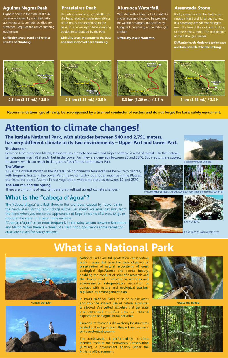
What is the “cabeça d’água”?
Flash flood at Campo Belo river.
The “cabeça d'água” is a flash flood in the river beds, caused by heavy rain inthe headwaters. Strong rapids drags all that lies ahead. You must get away fromthe rivers when you notice the appearance of large amounts of leaves, twigs ormood in the water or a water mass increase.“Cabeças d'água” occur more frequently in the rainy season between Decemberand March. When there is a threat of a flash flood occurrence some recreationareas are closed for safety reasons.
The SummerBetween December and March, temperatures are between mild and high and there is a lot of rainfall. On the Plateau,temperatures may fall sharply, but in the Lower Part they are generally between 20 and 28ºC. Both regions are subjectto storms, which can result in dangerous flash floods in the Lower Part.
The WinterJuly is the coldest month in the Plateau, being common temperatures below zero degree,with frequent frosts. In the Lower Part, the winter is dry, but not as much as in the Plateau,thanks to the dense Atlantic Forest vegetation, with temperatures between 10 and 25ºC.
The Autumn and the SpringThere are 6 months of mild temperatures, without abrupt climate changes.
Snow in 1985.
Sudden weather change.
Frost on Agulhas Negras (Black Needles), very frequent in the winter time.
Attention to climate changes!The Itatiaia National Park, with altitudes between 540 and 2,791 meters,has very different climate in its two environments – Upper Part and Lower Part.
What is a National Park
Respecting natureHuman behavior
National Parks are full protection conservation units – areas that have the basic objective of preservation of natural ecosystems of great ecological significance and scenic beauty, enabling the conduct of scientific research and the development of educational activities and environmental interpretation, recreation in contact with nature and ecological tourism, regulated by amanagement plan.
In Brazil National Parks must be public areas and only the indirect use of natural attributes is allowed. Are vetted activities that generate environmental modifications, as mineral exploration and agricultural activities.
Human interference is allowed only for structures related to the objectives of the park and recovery of it’s ecological systems.
The administration is performed by the Chico Mendes Institute for Biodiversity Conservation (ICMBio), a government agency under the Ministry of Environment.
..............................o
.....................o
...............................................o
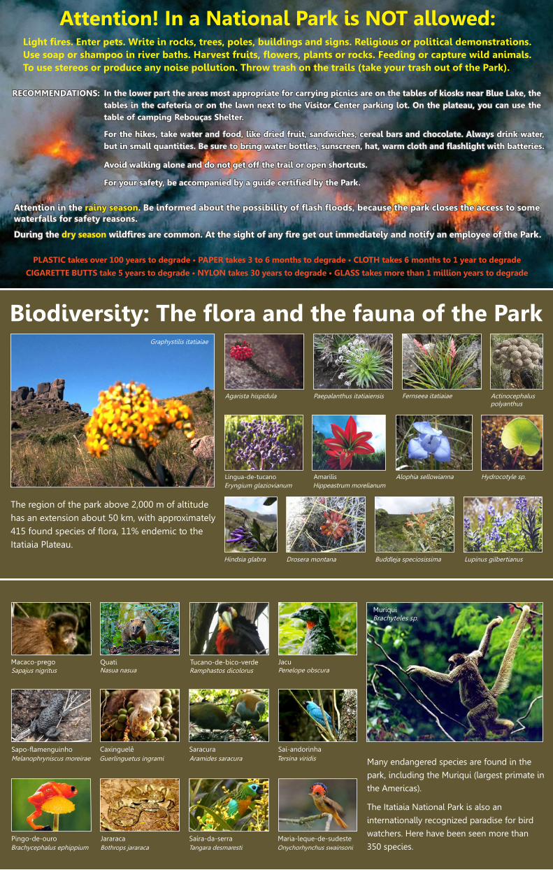
Light fires. Enter pets. Write in rocks, trees, poles, buildings and signs. Religious or political demonstrations.Use soap or shampoo in river baths. Harvest fruits, flowers, plants or rocks. Feeding or capture wild animals.To use stereos or produce any noise pollution. Throw trash on the trails (take your trash out of the Park).........
In the lower part the areas most appropriate for carrying picnics are on the tables of kiosks near Blue Lake, thetables in the cafeteria or on the lawn next to the Visitor Center parking lot. On the plateau, you can use thetable of camping Rebouças Shelter.
In the lower part the areas most appropriate for carrying picnics are on the tables of kiosks near Blue Lake, thetables in the cafeteria or on the lawn next to the Visitor Center parking lot. On the plateau, you can use thetable of camping Rebouças Shelter.
...................................................................................................................................
For the hikes, take water and food, like dried fruit, sandwiches, cereal bars and chocolate. Always drink water,but in small quantities. Be sure to bring water bottles, sunscreen, hat, warm cloth and flashlight with batteries.
Avoid walking alone and do not get off the trail or open shortcuts.o
For the hikes, take water and food, like dried fruit, sandwiches, cereal bars and chocolate. Always drink water,but in small quantities. Be sure to bring water bottles, sunscreen, hat, warm cloth and flashlight with batteries.
Avoid walking alone and do not get off the trail or open shortcuts.o
..............................................................................
For your safety, be accompanied by a guide certified by the Park.For your safety, be accompanied by a guide certified by the Park.
Attention in the rainy season. Be informed about the possibility of flash floods, because the park closes the access to somewaterfalls for safety reasons.Attention in the . Be informed about the possibility of flash floods, because the park closes the access to somewaterfalls for safety reasons.
rainy season
o
During the dry season wildfires are common. At the sight of any fire get out immediately and notify an employee of the Park. During the wildfires are common. At the sight of any fire get out immediately and notify an employee of the Park. dry season
PLASTIC takes over 100 years to degrade • PAPER takes 3 to 6 months to degrade • CLOTH takes 6 months to 1 year to degrade
CIGARETTE BUTTS take 5 years to degrade • NYLON takes 30 years to degrade • GLASS takes more than 1 million years to degrade
Attention! In a National Park is NOT allowed:
RECOMMENDATIONS:RECOMMENDATIONS:
Biodiversity: The flora and the fauna of the Park
The region of the park above 2,000 m of altitudehas an extension about 50 km, with approximately415 found species of flora, 11% endemic to theItatiaia Plateau.
Agarista hispidula Paepalanthus itatiaiensis Fernseea itatiaiae
Drosera montana
Língua-de-tucanoEryngium glaziovianum
Amarilis Hippeastrum morelianum
Actinocephalus polyanthus
Hydrocotyle sp. Alophia sellowianna
Hindsia glabra Buddleja speciosissima Lupinus gilbertianus
Graphystilis itatiaiae
Many endangered species are found in the
park, including the Muriqui (largest primate in
the Americas).
The Itatiaia National Park is also an
internationally recognized paradise for bird
watchers. Here have been seen more than
350 species.
0
Macaco-prego Sapajus nigritus
Quati Nasua nasua
Tucano-de-bico-verde JacuPenelope obscura Ramphastos dicolorus
Sapo-flamenguinho
Pingo-de-ouro
Caxinguelê Guerlinguetus ingrami
Saracura Aramides saracura
Saí-andorinha Tersina viridis Melanophryniscus moreirae
Brachycephalus ephippium
MuriquiBrachyteles sp.
JararacaBothrops jararaca
Saíra-da-serraTangara desmaresti
Maria-leque-de-sudesteOnychorhynchus swainsoni

Itatiaia: “pointed rocks”, in the Tupi-Guarani languageThis erosion of millions of years continues
today and can be seen in the groovesthat form the Agulhas Negras
(Black Needles).
The Itatiaia massif reveals deeperlayers of an ancient volcano.
The unusual shapes of the Itatiaia rocks.
The mountains of Itatiaia, an icon for Brazilian and foreign climbers.
Peaks, ropes and clouds
Mountaineering is the main activity in the Upper Part of the Itatiaia National Park. thSince the 19 century, climbers roam the ridges, valleys, chimneys, edges and ridges
of the massif. The main legacy of this essentially exploratory phase are the climbing
routes and trails, in which tourists and mountaineers repeat the footsteps of
pioneers with the same feeling of fullness and discovery. Although each rise is a
personal discovery, an internal challenge, risks can be minimized with proper use of
technical equipment. However, each climbing route or track has a different degree of
technical skills needed. Inquire about the equipment required to your route, so that
your adventure be enjoyed in a safe and healthy condition.
MantiqueiraMountain Range
ProtectedAreas Mosaic
E-mail: [email protected] • Phones: (55-24) 3352-1292 / 3352-2288 / 3352-6894
Mitra doBispo RPPN
Serrinha do AlambariCity Park
Serra doPapagaio State Park
Passa QuatroFLONA
LorenaFLONA
Camposdo JordãoState Park
Alto GamarraRPPN
Mário XavierFLONA
Floresta da Cicuta ARIE
São FranciscoXavier APA
Ibitipoca State Park
Cachoeirada FumaçaCity Park
Mananciais deCampos do Jordão
State Park
Camposdo Jordão
APASapucaí
Mirim APA
Ave Lavrinha RPPN
Serrinha doAlambari APA
Penedo Eco Tourism
City Park
Bananal ESEC