the factors that affect climate - ms. close's class...
TRANSCRIPT

The Factors that Affect Climate

• Weather – The daily condition of the atmosphere which includes temperature and precipitation.
• Precipitation – Moisture that falls from the sky. Precipitation has 4 forms: rain, snow, sleet, and hail.
• Climate – Weather conditions over time.
Review: Vocabulary

Climograph• A graph that indicates average
temperature and precipitation for an area.• These graphs can answer the following
types of questions:– How much rain is there in a particular
location?– When is it dry or wet?– Is it wet when it’s cool?– What vegetation (plants) can grow there?

How to Read a Climograph
The letters at the bottom show you the months of the year.
The numbers on the right show
you the temperature.
Make sure you check to see if
the temperature is measured in
degrees Fahrenheit of
Celsius.
The numbers on the left show you the amount of precipitation.
(This might be millimeters or inches)
Look at the title to see what location’s climate is being described by the graph.

How to Read a Climograph
The line graph shows you the
average temperature for
each month. The numbers
that measure it are on the right
side of the graph.
The bar graph measures the average precipitation for each month. The numbers that measure it are on the left side of the graph.

5 major factors that affect climate
• Latitude (how close to or far away you are from the equator)
• Ocean Currents & Wind (they move heat and cold around the earth; cold water off the coast means dry weather on land and warm water means humid conditions on land)
• Continentality (places further inland have harsher climates with larger variations in temperature throughout the year than locations close to the sea do)
• Elevation (the higher up a mountain you go, the colder it gets)
• Mountain barriers (mountains can block cold/heat or moisture; rain shadow effect)

Latitude
• This is the most important factor determining climate!
• The farther you are from the Equator – the colder and drier it becomes.
• Latitude determines how much direct and indirect sunlight a place receives.


I need a volunteer!
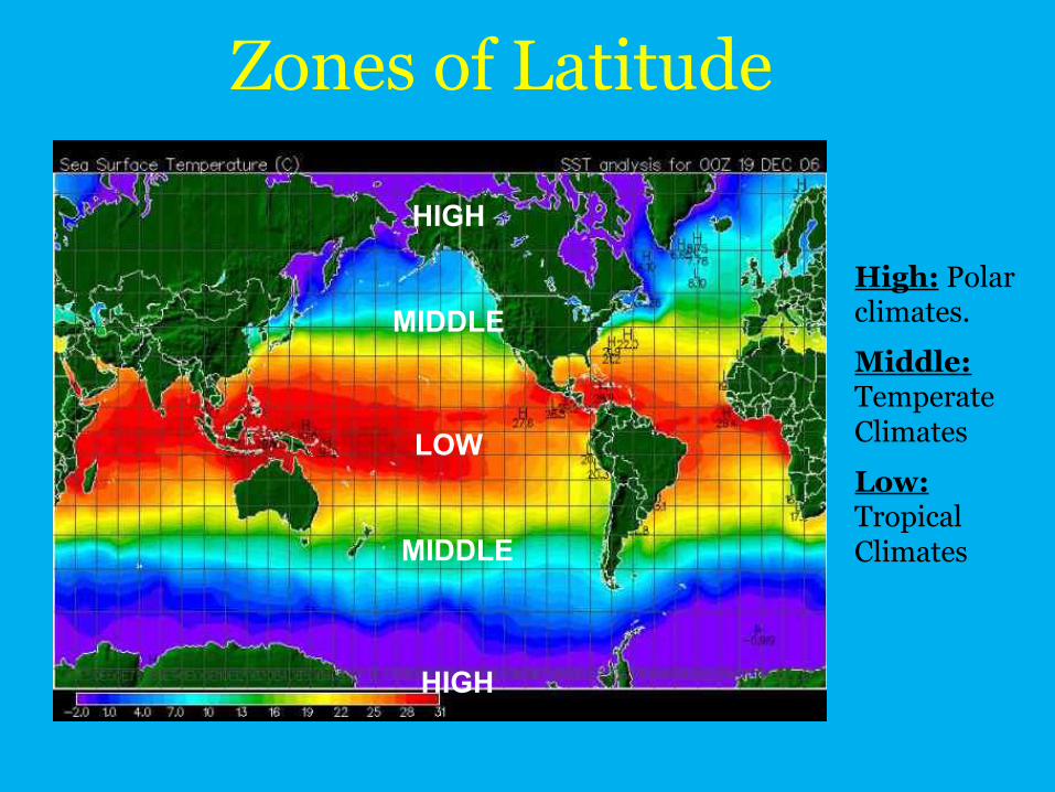
LOW
MIDDLE
HIGH
MIDDLE
HIGH
High: Polar climates.
Middle: Temperate Climates
Low: Tropical Climates
Zones of Latitude

In your notes, write 2-3 sentences explaining why
latitude affects climate.
Be sure to include the relationship between the
equator & sunlight.
Take out your Geography Alive! Textbooks. Turn to pg. 548
These books have several types of maps for every major region on earth. Two of the thematic maps are Climate & Vegetation.
Use the maps to look up 2 different countries for each type of zone. You will also need to use the Political Maps.

Continentality• Water moderates climate. To moderate means
to make milder: not as hot or cold.• Water takes a long time to heat and cool. So,
locations near water don’t heat up or cool down quickly. Therefore, the temperature doesn’t change as much during the year.
• Since land DOES heat up and cool quickly, areas inland from the coast will be hotter in the summer and colder in the winter.
• Areas on the coast stay more moderate.
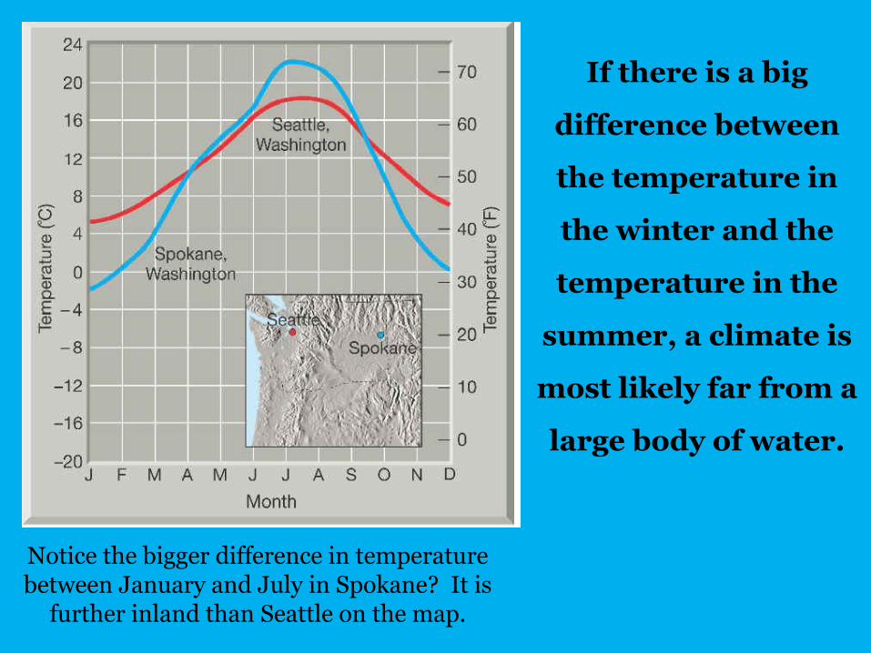
If there is a big
difference between
the temperature in
the winter and the
temperature in the
summer, a climate is
most likely far from a
large body of water.
Notice the bigger difference in temperature between January and July in Spokane? It is
further inland than Seattle on the map.

Continentality: How Does It Affect Climate?
The location on a continent affects the climate of a place. Inland locations typically have larger temperature ranges and
(possibly) drier conditions than locations near the ocean.
Compare these two locations. Which one is further inland? How can you tell?

Ocean Currents• Cold currents create dry conditions on the coast. • Warm currents create wet conditions on the coast.

Study the North Atlantic wind pattern map and the North Atlantic ocean current map. If
Western Europe is at roughly the same latitude as Canada, why is the climate of Western
Europe so much warmer?
Wind Patterns Ocean Currents

Elevation • It gets colder as you go up a mountain.
• The formula for vertical climate: the temperature decreases 3.5°F for every 1,000 ft of elevation.
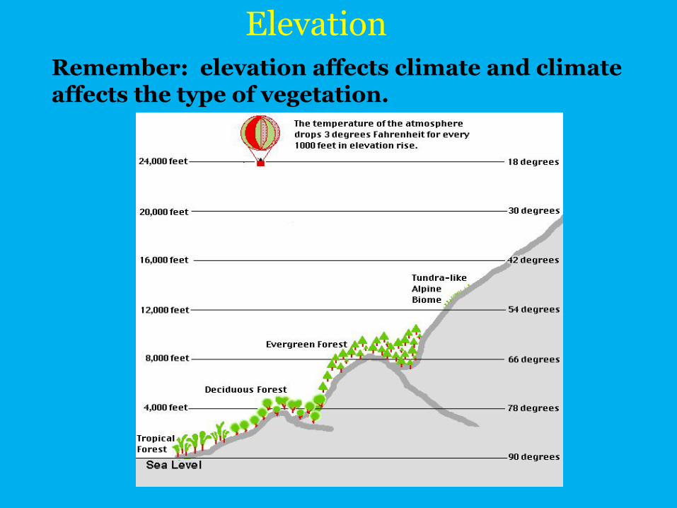
Remember: elevation affects climate and climate affects the type of vegetation.
Elevation

Not only does elevation affect the type of natural vegetation that will grow in a region,
it also affects what types of crops humans can grow.

In this photo, you can see the tree line-the highest point on a mountain that trees can
survive.

Mountain Barriers• Mountains can stop storms and air masses. • If you look at the physical map of southern Europe
below, you will see that there are mountains that block cold north winds from reaching the Iberian, Italian and Balkan Peninsulas.

Mountains are also responsible for the orographic effect.
•Wind containing moisture hits the windward side of a mountain (the side facing the wind).
•The moisture full clouds are too heavy to make it over the mountain so precipitation occurs.
Mountain Barriers (continued)
• After the precipitation, the clouds have no moisture and are able to rise over the mountain.
• The side facing away from the wind is called the leeward side.
• The leeward side of a mountain is arid.• The windward side has lush vegetation. • The leeward side of a mountain is in the rain
shadow and is usually a desert.

Mountain Barriers: Rain Shadow

Handy guide to remembering the connections between climate and
vegetation:• Trees grow naturally
in wet regions.• When rain supply
equals demand for rain grasses grow.
• Desert plants grow where there is a moisture deficit.

Let’s look at some photographic evidence!Take a look at each photo of the climate zone.
Compare this to your definition.

Ice Cap, Greenland

Tundra, Russia

Subarctic, Canada

Highlands, Ethiopia

Marine West Coast, Ireland

Humid Continental, Wisconsin

Humid Subtropical, South Carolina

Mediterranean, Sicily

Arid, Chad

Semiarid, Afghanistan

Tropical wet & dry, Bolivia

Tropical wet, Indonesia

Last page, your exit ticket:
With a partner, please complete the last page of questions. You will need to use the maps in the back of the Geo Alive book, as well as the knowledge you have gained about factors that affect climate.