the evolution of gis in the natural resources districts · the evolution of gis in the nebraska...
TRANSCRIPT

The Evolution of GIS in the Nebraska Natural Resources Districts
d b h ff dPresented by: Anna Verhoeff, IS AdministratorLower Platte South NRD

Topics to CoverTopics to Cover
1. GIS Time Line/Historyy2. NRD Statues 3. Tools and technologies 4. NRD Programs and Projects5. NRD Applications and uses of GIS6. Examples7. Other Entities/Partnerships8. Summary9. Contributors Information

VERY Early GISVERY Early GIS

Early GISEarly GIS
Lower Loup NRD Headquarters.
Tri Basin NRD HeadquartersMilt Moravek (Left) and Dan Clement (Right) Tri‐Basin NRD Headquarters.Milt Moravek (Left) and Dan Clement (Right)of CPNRD preparing to conduct water sampling.
Courtesy of Central Platte NRD

GIS Time Line/History – part APre ‐ 200 AD Eskimos of the Canadian Arctic to the Bedwin tribesmen of the Arabian desert had an almost inborn skill to produce
rough but quite accurate sketches on pieces of skin or in the sand, indicating the positions and distances of the localities known to them.
200 ‐ 1500 AD Mapping the maps
1500 ‐ 1600 AD Land surveying and map‐making, an integral part of any government, was pioneered in India by Todarmal who was employed in military operations in Akbar’s empire.
1600 1700 AD Maps began to use Greenwich as their prime meridian a fixed point from which longitude was measured In this1600 ‐ 1700 AD Maps began to use Greenwich as their prime meridian ‐ a fixed point from which longitude was measured. In this period of time, the gap between popular and scientific geography was narrowed. New surveys were made and new maps drawn by cartographers who were also accomplished astronomers
1700 ‐ 1800 AD The professional approach in Hydrography starts from the days of "Atlases of parts of India" and "Directory" based on systematic surveys using traditional methods by Rennell and Ritcher Dalymple Horsburg, Ross, Walker, Lloyd etc.on systematic surveys using traditional methods by Rennell and Ritcher Dalymple Horsburg, Ross, Walker, Lloyd etc.
1800 ‐ 1900 AD Gaspard Felix Tournachon (1859), also known as Nadar, was a famous French photographer and ballonist who carried big cameras aloft. His goal was to make land surveys from aerial photographs. Although not fully succesful in his attempt, he set the stage for the future of remote sensing.
1900 ‐ 1950 AD Wars and Maps
1914: During the First World War (1914‐1918), the value of complete aerial photographic reconnaissance is recognised by both sides.
1950 ‐ 1960 AD 1959: The US AMS series of maps covering the Himalaya Range from Bhutan to Pakistan on 1:250,000 scale is published.

GIS Time Line/History – part B1960 ‐ 1970 AD The Harvard Laboratory for Computer Graphics and Spatial Analysis laid its foundation with the development of general
purpose mapping software in the mid‐1960s by Howard Fisher. A GIS‐type course was taught in 1966 as a "collaborative regional‐scale studio and used SYMAP in a landscape‐planning study of the peninsula.
GPS, a space based positioning, navigation and timing system was developed by the U.S. Department of Defense (DoD) and emerged in late 60’s and early 70’s.
1969: Jack and Laura Dangermond founded ESRI as a privately held consulting group. The business began with $1100 from their personal savings and operated out of an historic home located in Redlands, California.
1970 ‐ 1980 AD 1974: The first Synchronous Meteorological Satellite, SMS‐1 operational prototype is launched. 1978: A Radar Imaging System ‐ the main sensor on Seasat, US is launched.
1980 ‐ 1990 AD 1985: Remote Sensing Instruments Pvt. Ltd., a GIS company is formed In Hyderabad 1986: MapInfo was founded by four students from the Renselaer Polytechnic Institute, the oldest engineering school in the United States.
1990 ‐ 1995 AD Radarsat is an advanced Earth Observation satellite project developed by Canada to monitor environmental change and to support resource sustainability. The Radarsat project was launched on November 4, 1995 by the Canadian Space Agency and then Canada Centre for Remote Sensing (CCRS).
1995 ‐ 2000 AD An active GIS market has resulted in lower costs and continual improvements in the hardware and software components f GISof GIS.
4D GIS (XYZ and time) is the next major frontier.
GIS's largest hurdle— educating the masses of potential users on what GIS is (and isn't) and developing spatial reasoning skills.
Much attention should go into geospatial application development and training as is given to hardware, software and database development.

12 NRD Statues Erosion prevention and control Erosion prevention and control Prevention of damages from flood water and sediment Flood prevention and control Soil conservation Water supply for any beneficial uses Development management utilization and Development, management, utilization, and
conservation of groundwater and surface water Pollution control Solid waste disposal and sanitary drainage Drainage improvement and channel rectification Development and management of fish and wildlife Development and management of fish and wildlife
habitat Development and management of recreational and park
facilities Forestry and range management

“A map is the greatest of all epic poems. Its lines and l h h li i f d ”colors show the realization of great dreams.”
Gilbert H. Grosvenor, Editor of National Geographic (1903‐ 1954)
“Knowing where things are, and why, is essential to rational decision making ”rational decision making.
Jack Dangermond, Environmental Systems Research Institute (ESRI)

Tools and TechnologiesTools and Technologies
GIS Software such as ArcGIS, ArcView, ArcPad, etc.G S So t a e suc as cG S, c e , c ad, etc
GPS Units
GPS Cameras
GPS Survey Grade Equipment
PDAs
iPads/iPods iPads/iPods

ArcPad Example
In an effort to improve data quality, efficiently collect large amounts of data in the field and havecollect large amounts of data in the field, and have a GPS navigation system that aides technicians in locating numerous monitoring wells and flow meters the North Platte NRD has turned to ESRI’smeters the North Platte NRD has turned to ESRI s ArcPad.
With ArcPad have set up paperless forms and checked out maps that allow:
• Required Fields and Domains to produce higher quality data
• Bluetooth GPS Technology to Navigate to remote locations
• PERFORM DATA ENRTY ONLY ONCE!
Courtesy of North Platte NRD

Sample Forms on ArcPad Form For Determining Crop Type and Irrigation
Flow Meter Form Monitoring Well FormMethod for Certified Ground Water Tracts
ArcPad’s customizable forms honor domain coded values allow for Read only fieldArcPad’s customizable forms honor domain coded values, allow for Read‐only field, allow you to pre‐populate fields, and allow you to set required fields.
Courtesy of North Platte NRD

Staff are given a field sheet based
Fi ld h ton the database and paper map to collect information in the field
Field sheets are given to someone in the office. The data is taken off
All data is stored on the server in a
in the field of the field sheet and typed into the database or spreadsheetserver in a
database or spreadsheet
spreadsheet
Old WorkflowOld Workflow
Courtesy of North Platte NRD

Data is checked out of the Geodatabase using ArcGIS Desktop and ppushed out to a PDA
Data on the PDA is edited i h fi ld
Field Data is checked in via workstation
All Data is stored on the
in the field workstation, quality checked and stored again on the severstored on the
server in a Geodatabase
New Workflow Using ArcPad
Courtesy of North Platte NRD

ArcPad Benefits
• Saves Time• Saves Time• Produces High Quality Data• Easy Customization• Deployed Quickly• ReliableE t U• Easy to Use
• Allows Real Time Navigation• Relatively Inexpensivey p
Courtesy of North Platte NRD

Courtesy of Lower Loup NRD

Courtesy of Lower Loup NRD

NRD Projects and ProgramsNRD Projects and Programs
PROJECTS: PROGRAMS:OJ C SBank StabilizationSalt Creek LevyFlood Control Watershed Dams
Environmental EducationCost SharingBuffer/Filter StripsFlood Control Watershed Dams
Flood Control non watershed damsAntelope Valley Flood control
Buffer/Filter StripsWild NebraskaGroundwater
i iStream InterventionsRecreation/TrailsAdvertisement
Community AssistanceStormwaterConservation Easements
Ortho/Aerial & LiDAR Acquisitions Conservation Forestry ProgramCertified Irrigated AcresWaterbankingWaterbankingLandtransfers

…for example:“Once we figured it out,we became more efficient andreduced the amount of mistakesmade in the field ”
…for example:
GPS
l
Water levels
Trees/Weedbarrier
made in the field.
Flowmeters Trees/WeedbarrierChemigation
Models Display Locations Measurements/Overlays on ImageryModelsand track activities
Courtesy of Central Platte NRD

Courtesy of Lower Platte South NRD

Courtesy of Lower Platte South NRD

Example of Report sent to Landowneri h l ifwith letter to certify acres
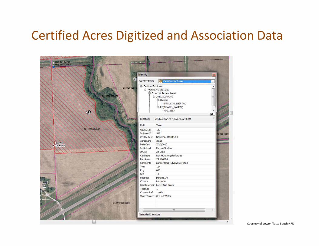
Certified Acres Digitized and Association Data
Courtesy of Lower Platte South NRD

Courtesy of Lower Platte South NRD

Google – ExampleVarying imagery available across LPS district
ArcMap–NIROC 2010 Aerials of same Area
Courtesy of Lower Platte South NRD

Courtesy of Central Platte NRD

Waterbanking in other DistrictsPlan A: Work with Surface Water Diversions
To Retire and Re‐Time Flow
Nearly the Same as Central PlatteCourtesy of Central Platte NRD

Courtesy of Central Platte NRD

Surface Water and Groundwater
Surface Irrigated 80 AcresDNR Appropriated 81 acresDNR Appropriated 81 acres
Courtesy of Central Platte NRD

Certified Historic (10 years) Irrigated Acres
A‐14588 12/13/1976 1A
IR Active / /
Platte River, Trib. To Sec: 23 T: 9 R:22 W
228 Acres3.26 70 1463
Larry & Rod Reynolds 75050 Road 43322 W
Pump Dawson
1463 433 Lexington NE 68850 Additional Names/POD
Courtesy of Central Platte NRD

Combining Capabilities
3D Data + Soils + Landuse3D Data + Soils + Landuse
3D Data + Imagery + GPS3D Data + Imagery + GPS
Courtesy of Central Platte NRD

Belden Wellhead Protection
Courtesy of Lower Elkhorn NRD

Courtesy of Lower Elkhorn NRD

Nitrate Sampling in Pierce County Phase II AreaPierce County Phase II Area
Courtesy of Lower Elkhorn NRD

Courtesy of Lower Elkhorn NRD
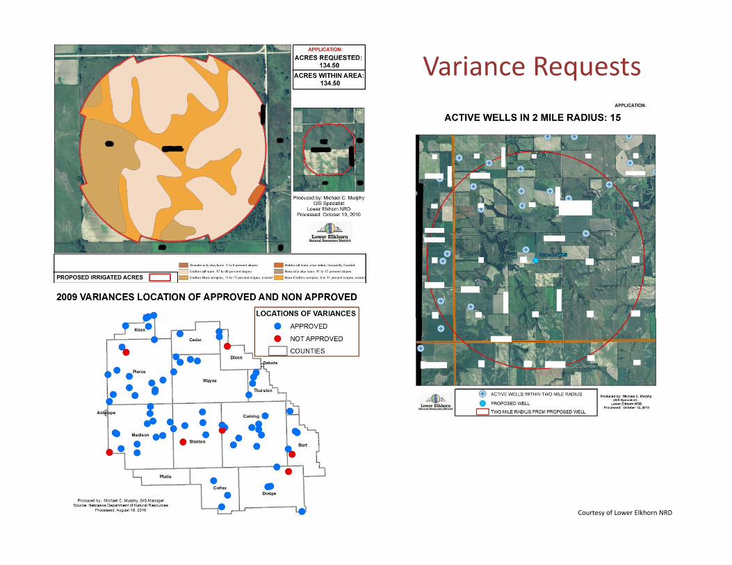
Variance Requests
Courtesy of Lower Elkhorn NRD

Streams that flow into Willow Creek and land use areas next to streamsand land use areas next to streams
Courtesy of Lower Elkhorn NRD

Ground Water Level Maps
Courtesy of North Platte NRD
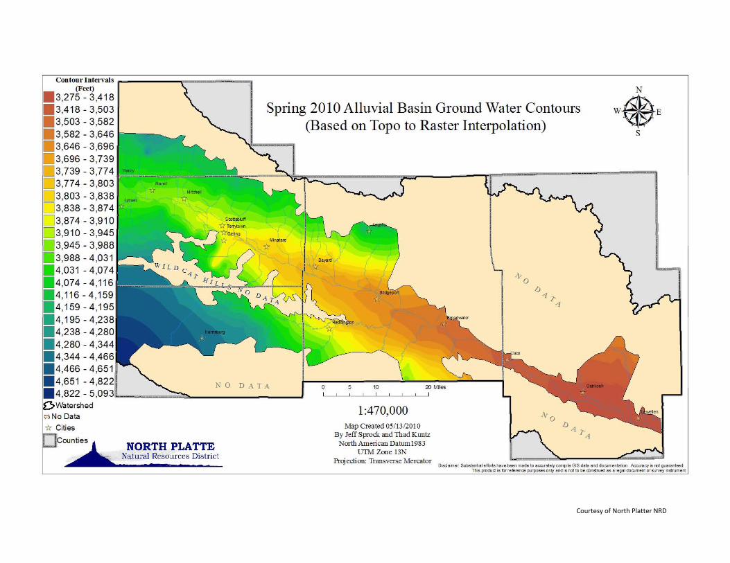
Courtesy of North Platter NRD

Other Entities/Partnerships L Pl tt Ri C id Alli (LPRCA) Lower Platte River Corridor Alliance (LPRCA) Saline Wetlands Conservation Partnership (w/NE Game and Parks) Eastern Nebraska Water Resources Assessment (ENWRA) Department of Natural Resources (DNR) Conservation and Survey Division, School of Natural Resources University of Nebraska Water Center Center for Advanced Land Management Information Technologies (CALMIT) University of Nebraska Institute of Agriculture and Natural Resources US Geological Survey (USGS) U.S. Department of Fish and Wildlife Nebraska Game and Parks Nebraska‐Iowa Regional Orthophotography Consortium (NIROC)eb as a o a eg o a O t op otog ap y Co so t u ( OC) City of Lincoln/Lancaster County/LES/LPSNRD GIS Interlocal Agreement Nebraska Environmental Trust Nebraska Department of Environmental Quality (DEQ) Nebraska Department of Environmental Quality (DEQ) Natural Resources Conservation Services (NRCS) Water for the West Foundation (WFTW)

NRD MapMaker
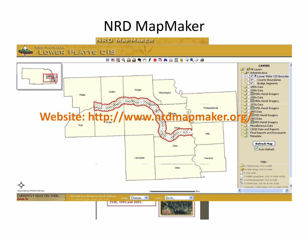
NRD MapMaker
Website: http://www.nrdmapmaker.org/

Wetland Management Areas
Created a Geodatabaseto combine data from several files– Wetland Management– Wetland Management Area boundaries
– GPS points ‐ Photo P i t ( ith h li k )Points (with hyperlinks), Phragmites locations, POIs
– Critical Habitat Areas
Courtesy of Lower Platte South NRD

Saline Wetland Example

Compliments from Lower Platte South NRD

ENWRAExample
Courtesy of Lower Platte South NRD

Courtesy of Lower Elkhorn NRD

LPRCA partnership with USGS for a Water Quality Monitoring Network

A GIS database has "topology," which defines the spatial relationships between features. The fundamental components of spatial data in a GIS are points linesJerry Maguire’s definition of Topology:components of spatial data in a GIS are points, lines (arcs), and polygons. When topological relationships exist, you can perform analyses, such as modeling the
y g p gy
“You complete me ”flow through connecting lines in a network, combining adjacent polygons that have similar characteristics, and overlaying geographic features.
You complete me.
y g g g p
Summary
• NRD GIS Staff have accomplished a lot over the years. Many GIS i li h “J k f ll T d ” i hare not GIS specialists, they are “Jack of all Trades” with many
other responsibilities.
• Increasing demand in the NRD’s for data coordination. (DNR, USGS, NARD, DEQ, HHS, City/County, other NRDs, NIROC and other collaborative projects etc)NIROC and other collaborative projects, etc)
• GIS is always changing bringing new upgrades, software, and h d Thi i GIS t i i dhardware. This requires more GIS training and some specialization!

QUESTIONS?QUESTIONS?

Contributors
Tylr NaprstekWater Modeling Coordinator
Matt BohnenkampGIS Program Director
Lower Loup NRD(308) 728‐[email protected]
Central Platte NRD(308)385‐[email protected]
Jeff SprockGIS CoordinatorNorth Platte NRD
Shaula RossGIS SpecialistLower Platte South NRD
(308) 632‐[email protected]
Mike Murphy
(402) 476‐[email protected]
Mike Murphy Water Resources TechnicianLower Elkhorn NRD(402) 371‐7313
h @l [email protected]