the eruptive chronology of the ampato-sabancaya...
TRANSCRIPT

The eruptive chronology of the Ampato–Sabancaya volcanic complex(Southern Peru)
Pablo Samaniego a,⁎, Marco Rivera b, Jersy Mariño b, Hervé Guillou c, Céline Liorzou d, Swann Zerathe e,Rosmery Delgado b, Patricio Valderrama a,b, Vincent Scao c
a Laboratoire Magmas et Volcans, Université Blaise Pascal - CNRS - IRD, 6 Avenue Blaise Pascal, TSA 60026 - CS 60026, 63178 Aubière, Franceb Observatorio Vulcanológico del INGEMMET, Dirección de Geología Ambiental y Riesgo Geológico, Urb. Magisterial B-16, Umacollo, Arequipa, Peruc Laboratoire des Sciences du Climat et de l'Environnement, LSCE/IPSL, CEA-CNRS-UVSQ, Université Paris-Saclay, F-91198 Gif-sur-Yvette, Franced Laboratoire Domaines Océaniques, Institut Universitaire Européen de la Mer, Université de Bretagne Occidentale, Rue Dumont d'Urville, 29280 Plouzané, Francee Institut des Sciences de la Terre, Université Grenoble Alpes – CNRS - IRD, 1381 rue de la piscine, 38400 Saint Martin d'Hères, France
a b s t r a c ta r t i c l e i n f o
Article history:
Received 14 January 2016
Received in revised form 1 April 2016
Accepted 29 April 2016
Available online 07 May 2016
Wehave reconstructed the eruptive chronology of the Ampato–Sabancaya volcanic complex (Southern Peru) on
the basis of extensive fieldwork, and a large dataset of geochronological (40K–40Ar, 14C and 3He) and geochemical
(major and trace element) data. This volcanic complex is composed of two successive edifices that have experi-
enced discontinuous volcanic activity from Middle Pleistocene to Holocene times. The Ampato compound
volcano consists of a basal edifice constructed over at least two cone-building stages dated at 450–400 ka and
230–200 ka. After a period of quiescence, the Ampato Upper edifice was constructed firstly during an effusive
stage (80–70 ka), and then by the formation of three successive peaks: the Northern, Southern (40–20 ka) and
Central cones (20–10 ka). The Southern peak, which is the biggest, experienced large explosive phases, resulting
in deposits such as the Corinta plinian fallout. During theHolocene, eruptive activitymigrated to the NE and con-
structed themostly effusive Sabancaya edifice. This cone comprisedmany andesitic and dacitic blocky lava flows
and a young terminal cone, mostly composed of pyroclasticmaterial. Most samples from the Ampato–Sabancaya
define a broad high-K magmatic trend composed of andesites and dacites with a mineral assemblage of plagio-
clase, amphibole, biotite, ortho- and clino-pyroxene, and Fe–Ti oxides. A secondary trend also exists, correspond-
ing to rare dacitic explosive eruptions (i.e. Corinta fallout and flow deposits). Both magmatic trends are derived
by fractional crystallisation involving an amphibole-rich cumulate with variable amounts of upper crustal
assimilation.
A marked change in the overall eruptive rate has been identified between Ampato (~0.1 km3/ka) and Sabancaya
(0.6–1.7 km3/ka). This abrupt change demonstrates that eruptive rates have not been homogeneous throughout
the volcano's history. Based on tephrochronologic studies, the Late Holocene Sabancaya activity is characterised
by strong vulcanian events, although its erupted volume remained low and only produced a local impact through
ash fallout. We have identified at least 6 eruptions during the last 4–5 ka, including the historical AD 1750–1784
and 1987–1998 events. On the basis of this recurrent low-to-moderate explosive activity, Sabancaya must be
considered active and a potentially threatening volcano.
© 2016 Elsevier B.V. All rights reserved.
Keywords:
Ampato
Sabancaya
Central Andes
Eruptive chronology
Eruptive rates
Volcanic hazards
1. Introduction
Reconstructing the eruptive chronology of active volcanic systems
represents a key step for any hazard assessment initiative. However,
the recent eruptions of Chaitén (2008, Major and Lara, 2013) and
Reventador volcanoes (2002, Hall et al., 2004) showed that the eruptive
chronology of many active volcanic complexes remains poorly known.
In the Andean cordillera, the Peruvian segment of the Central Volcanic
Zone (CVZ) results from the subduction of the oceanic Nazca plate
below the South American continental lithosphere. As a result, the
volcanic front includes at least twelve volcanic centres of Pleistocene
age (Fig. 1a) of which seven have experienced historical eruptive
activity (i.e. since the arrival of the Spanish conquistadors in the 16th
century). These volcanoes include El Misti (Thouret et al., 2001;
Harpel et al., 2011), which threatens the city of Arequipa, the active vol-
canoes of Ubinas (Thouret et al., 2005; Rivera et al., 2014) and
Sabancaya (Gerbe and Thouret, 2004), and Huaynaputina volcano
(Thouret et al., 1999; Adams et al., 2001), which has had the biggest
historical eruption in the Andes. However, little is still known about
the eruptive chronology of some of these volcanic centres, such as the
Journal of Volcanology and Geothermal Research 323 (2016) 110–128
⁎ Corresponding author.
E-mail address: [email protected] (P. Samaniego).
http://dx.doi.org/10.1016/j.jvolgeores.2016.04.038
0377-0273/© 2016 Elsevier B.V. All rights reserved.
Contents lists available at ScienceDirect
Journal of Volcanology and Geothermal Research
j ourna l homepage: www.e lsev ie r .com/ locate / jvo lgeores

180000 190000 200000 210000
180000 190000 200000 210000
82
40
000
82
50
000
82
60
000
82
70
000
AMPATO
SABANCAYA
HUALCA
HUALCA
RIO COLCA
CabanacondePinchollo
Madrigal
Lari
Maca
Río
Sep
ina
Achoma
Y
Colihuiri
Cajamarcana
Sallalli
Japo
Baylillas
Corinta
Collpa
c
Mucurca
lake
Río Parcomayo
Qda. H
uayura
y
70º
16º
15º
18º
CHILE
BOLIVIA
TACNA
TIT
ICACA L
AKE
JULIACA
PUNO
SOLIMANASARA SARA
COROPUNA
ANDAHUA
HUAYNAPUTINA
TUTUPACA
TICSANI
YUCAMANE
CASIRI
AMPATO-
SABANCAYA
0 50
74º
5-6 cm/y
18ºS
16º
72º100 km
MOLLENDO
ILO
CAMANA
CHACHANI
MISTI
MOQUEGUA
CHALA
70º74º 72º
AREQUIPA
UBINAS
Historically active
Potentially activePlio-Quaternary
volcanic fronta
72º
Ampato
Sabancaya
Hualca
Hualca
Normal fault
Strike slip
Lineaments
0 5 km
16º
Huambo
Chivay
Maca
CabanacondeRío Colca
Ichupamba
Huanca
Trigal
Sepina
b
Solarpampa
72º
Fig. 1. (a) The Peruvian volcanic arc. (b) Structural context of the Ampato–Sabancaya region, including the Colca river valley.Main structures fromMering et al. (1996) andGerbe and Thouret (2004)
Sabancaya and Hualca Hualca complexes and the nearby Colca canyon.

Sabancaya volcano, and its neighbouring Ampato edifice. Rare historical
accounts mention eruptive activity that occurred in AD 1750 and 1784
(Siebert et al., 2010; Travada y Córdova, 1752; Zamácola y Jaúregui,
1888). More recently, Sabancaya entered a new eruptive phase in
1988, which lasted until at least 1997 (Global Volcanism Program,
1988, 1997). During this period, Sabancaya experienced low to moder-
ate explosive eruptions (VEI 1–2) that were characterised by violent
vulcanian explosions accompanied by small (up to 5–7 km height)
eruption columns with a local ash fallout impact. The most significant
activity was observed between April–May 1990 and April 1991
(Global Volcanism Program, 1990, 1991). Since March–April 2013,
Sabancaya has shown increased fumarolic activity, accompanied by
frequent seismic swarms (Global Volcanism Program, 2013; Jay et al.,
2015).
Following its reactivation in 1988, several studies have been
carried out on Sabancaya. These works include an initial geological
reconnaissance, comprising a hazard assessment (Thouret et al.,
1994), a regional tephro-chronological survey (Juvigné et al., 1998,
2008) and a petrological description of the last eruption products
(Gerbe and Thouret, 2004). Based on detailed field work and
geochronological and petrological studies, we reconstruct the
structure and the volcanic and magmatic history of the Ampato–
Sabancaya volcanic complex from the Pleistocene to the present day.
2. Geological setting
The Ampato–Sabancaya Volcanic Complex (ASVC, 15° 49.3′S, 71°
52.7′W) is located 70–75 km NW of Arequipa (Fig. 1). It is construct-
ed upon the Western Cordillera of the Peruvian Andes, which is
composed of Mesozoic and Cenozoic volcanic and sedimentary for-
mations (Klinck et al., 1993; Sébrier and Soler, 1991). To the north,
the ASVC borders the older and highly eroded Hualca Hualca volcano
(6025 m above sea level – m asl), located at the southern margin of
Colca canyon. An 40Ar–39Ar age of 0.80 ± 0.04 Ma has been deter-
mined by Gerbe and Thouret (2004) for an andesitic lava flow from
this edifice, which represents the base of the Ampato–Sabancaya
volcanic complex. Southwards, the ASVC dominates a high plateau
with an overall southward slope, which is composed of Mio-
Pliocene volcanic formations comprising lava flows and large
ignimbritic deposits that overlie the Western Cordillera basement
(Klinck et al., 1993; Mamani et al., 2010). Thouret et al. (2007)
obtained a 40Ar–39Ar age of 2.20 ± 0.15 Ma for a dacitic ignimbrite
deposit on top of the Patapampa plateau, located to the east of the
volcanic complex.
Regional tectonic investigations have identified three main fault
systems in this part of the Andes (Fig. 1c; Sébrier and Soler, 1991;
Mering et al., 1996). The first one corresponds to NW-SE striking faults
that are oblique-slip extensional structures, with a minor left-lateral
component. These faults correspond to regional structures such as
the Huanca and Ichupampa faults (located to the SW and NE of the
ASVC, respectively). A second system is composed of E-W striking
faults with a southward normal, dip-slip component, notably the
Trigal and Solarpampa faults. These structures are almost parallel to
the Colca river valley, and located to the NW of the complex. A recent
Mw5.9 earthquakewas associatedwith these faults (Jay et al., 2015).
The third, NE-SW striking faults represent local extensional
structures, such as those crossing the Patapampa plateau, the most
prominent being the Sepina fault. This latter structure seems to
be the focus of several seismic events (Mw 4.5–5) that have
occurred during the last few decades (Antayhua et al., 2001; Jay
et al., 2015). The Ampato and Sabancaya vents, as well as several
glacial valleys in the western part of Ampato, are roughly aligned
in a NE-SW direction. This observation suggests that the NE-SW
Sepina fault probably controlled the structural development of the
ASVC.
3. Methodology
Fieldwork was carried out during several field campaigns between
2009 and 2012, which included geological mapping and sampling of
most volcanic units. At high altitude (above 5000 m asl), fieldwork
was complicated by the presence of a large icecap aswell as voluminous
glacial deposits. However, the presence of numerous deep glacial
valleys allowed sampling of almost all volcanic units, resulting in a
broad sample array for petrographic and geochemical studies (Fig. 2).
Major and trace element whole-rock analyses were obtained from
agate-crushed powders of 133 samples spanning the entire volcanic
complex, at the Institut Universitaire Européen de la Mer, Université
de Bretagne Occidentale (Brest, France), using an Inductive Coupled
Plasma-Atomic Emission Spectrometer (ICP-AES) and following the
analytical procedure described by Cotten et al. (1995). These data,
together with petrographic descriptions, have been used to characterise
and correlate the different volcanic units.
We constrained the Pleistocene eruptive chronology via the
unspiked 40K–40Ar dating method at the Laboratoire des Sciences du
Climat et de l'Environnement (LSCE/IPSL, Gif-sur-Yvette, France). We
obtained 10 ages covering the entire history of this volcanic complex
(Table 1). The Holocene chronology is based on 14 new radiocarbon
ages mainly obtained from peat and soil samples from several peatbogs
around the volcanic complex. Most samples (8) were analysed at the
Laboratoire de Mesure du Carbone 14 (LMC14, Gif-sur-Yvette, France)
and an additional group (6) were analysed at the Centre for Isotope
Research (CIO), Groningen University (Netherlands). Table 2 shows
the conventional 14C ages (±1σ), the 13δ values, and the calibrated
ages are given at 2σ confidence levels. Conversion from conventional14C ages to calendar ages was carried out using the Calib 7.1 code
(Stuiver and Reimer, 1993; Stuiver et al., 2005) and the recently
updated Southern Hemisphere calibration curve (SHcal13, Hogg et al.,
2013), which is available back to 50 ka cal BP. Finally, additional
constraints on the eruptive chronology of Sabancaya volcano were
obtained by cosmic ray exposure dating of lava flows using the couple3He/pyroxene. Three samples (Table 3) were collected from the tops
of undisturbed lava boulders and were processed at the CRPG noble
gas lab (Centre de Recherches Pétrographiques et Géochimiques,
Nancy, France). Additional information concerning the geochemical
and geochronological methods is included in the Supplementary
material.
4. Morphology and structure
The Ampato–Sabancaya volcanic complex has a roughly elliptical
basal outline (16–20 km NE–SW by 12–14 km NW-SE; Figs. 2, 3) and
is composed of twomain edifices: The older Ampato compound volcano
(6280masl) and the younger Sabancaya edifice (5967masl). The lower
flanks of the Ampato edifice have gentle slopes (5–10°), and are strong-
ly glacially eroded. As a result, the flanks are coated by a thick layer of
moraine deposits, especially on the southern and western sides. At
higher altitude, slopes are steeper (10–30°), locally up to 45°. The
upper part of the Ampato edifice is composed of three major cones
oriented NE-SW (Figs. 2 and 3), hereafter termed the Southern, Central,
and Northern cones, respectively located 1.2 and 2.5 km from the
summit (Southern cone). The Ampato edifice reaches an elevation of
~1800 m on the west and east sides, and slightly higher (~2250 m) on
the southern side. The summit area is characterised by these three
peaks and several unconformities that delimit the different cones. The
summit zone of the Southern cone displays a 1-km-long scar open to
the east testifying to an explosive phase associated with the upper
part of Ampato. It also marks the transition from the older Southern
cone to the younger Central cone.
The Sabancaya edifice is located 4–5 km to the NE of Ampato's
Southern peak. It is built on the remnants of Ampato and Hualca Hualca
(Figs. 2 and 3), and reaches 1300–1500 m in elevation on the west and
112 P. Samaniego et al. / Journal of Volcanology and Geothermal Research 323 (2016) 110–128

east sides. Its lower part is characterised by gentle slopes (10–15°), free
of glacial erosion. Two peaks compose the upper part of this edifice: A
dome-like structure characterised by steep slopes (30–45°) and a
younger main cone with moderate slopes (20–30°), located to the
northeast, which comprises an active crater (300–400 m in diameter)
with continuous fumarolic activity.
The morphology of the Ampato–Sabancaya volcanic complex was
shaped by the late Pleistocene glaciations. With the exception of the
north and north-eastern flanks, covered by younger Sabancaya lavas,
medium-sized glacial valleys have been carved all around the edifice.
Alcalá et al. (2011) identified at least two well-defined groups of
moraines radially oriented around the volcano. The oldest and biggest
moraines, which are morphologically well-defined, bear witness to the
Last Glacial Maximum (LGM) and extend down to 4250–4450 m asl.
In contrast, the younger moraines reach higher elevations, in the
range of 4400–4650 m asl, and are interpreted as resulting from late
glacier re-advances.
Based on cosmogenic 3He surface-exposure dating of Coropuna
volcano moraine deposits, Bromley et al. (2009) propose that the
LGM in this part of the Andean Cordillera was synchronous with
that at other latitudes (i.e. 17–25 ka). These authors also observe a
younger glacier re-advance in the range of 10–13 ka. These ages
agree with some 36Cl cosmogenic dates on samples from the
Huayuray valley on the northern flank of the Hualca Hualca edifice
that give ages of around 17–18 ka (Alcalá et al., 2011). These authors
also propose that a younger re-advance occurred at Hualca Hualca
around 11–12 ka. On the basis of these data, we consider that the
old moraines around the ASVC (M1 in Fig. 4) are associated with
the LGM period (i.e. 17–25 ka) whereas the younger moraines
(M2) are probably associated with a late glacier re-advance just
after the Holocene–Pleistocene boundary (10–13 ka). Other small
moraines (M3) observed at higher altitudes (above 4800 m asl) at
Ampato are clearly associated with younger Holocene fluctuations
(cf. Jomelli et al., 2011).
5. The eruptive chronology of the Ampato volcano
Our geomorphologic, stratigraphic, and geochronological data show
that Ampato is a compoundvolcano comprising (Fig. 4, Table 4): (1) The
Basal edifice, which is an old, highly eroded volcano; (2) the Upper
edifice, which started with the Yanajaja stage and continued with the
successive construction of the Northern, Southern, and Central peaks.
5.1. The Ampato Basal edifice
5.1.1. A former andesitic stage
The older remnants of the Ampato Basal edifice correspond to a 600-
m-thick volcanic pile that crops out on the south-western and western
flanks of Ampato. This sequence is composed of 40–60 m-thick lava
flows interlayered with proximal scoria-flow deposits and spatter ag-
glutinates (Figs. 3, 5a). Volcanic units corresponding to the subsequent
volcanic stages discordantly cover this unit. Another remnant of this
180000 190000 200000
180000 190000 200000
8240
00
08250
00
0
8240
00
08250
00
0
10 km
11-54
09-17
11-71A
09-30
11-28
11-15
11-37
11-38
11-03
11-64
11-68
11-20
10-18
10-13
10-1911-79
11-67
11-42
10-33
11-11
11-19
11-44
10-14/16/17
10-24
10-20
11-33
Japo
Sallalli
Qda. B
aylil
las
oy
am
arc
ah
C.
ad
Q
Cajamarcana
Collpa
Colihuiri
Corinta
Yanajaja
MoldepampaJatún
Pampa
Qda
. Hua
raya
Río
Par
com
ayo
Qda
. Sah
uanc
aya
Mucurca
Lake
Qda. Huaycumayo
To Taya
To Chivay
To Huambo
Qda
. Viz
cach
ane
Fig. 2. Digital elevation model of the Ampato–Sabancaya volcanic complex showing locations of rock samples (open circles) and dated rock samples and/or other studied sections (solid
circles).
113P. Samaniego et al. / Journal of Volcanology and Geothermal Research 323 (2016) 110–128
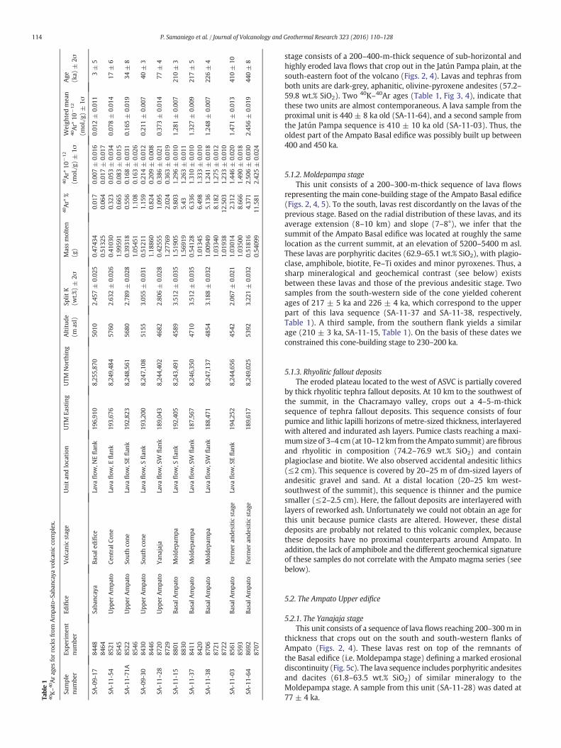
stage consists of a 200–400-m-thick sequence of sub-horizontal and
highly eroded lava flows that crop out in the Jatún Pampa plain, at the
south-eastern foot of the volcano (Figs. 2, 4). Lavas and tephras from
both units are dark-grey, aphanitic, olivine-pyroxene andesites (57.2–
59.8 wt.% SiO2). Two 40K–40Ar ages (Table 1, Fig 3, 4), indicate that
these two units are almost contemporaneous. A lava sample from the
proximal unit is 440 ± 8 ka old (SA-11-64), and a second sample from
the Jatún Pampa sequence is 410 ± 10 ka old (SA-11-03). Thus, the
oldest part of the Ampato Basal edifice was possibly built up between
400 and 450 ka.
5.1.2. Moldepampa stage
This unit consists of a 200–300-m-thick sequence of lava flows
representing the main cone-building stage of the Ampato Basal edifice
(Figs. 2, 4, 5). To the south, lavas rest discordantly on the lavas of the
previous stage. Based on the radial distribution of these lavas, and its
average extension (8–10 km) and slope (7–8°), we infer that the
summit of the Ampato Basal edifice was located at roughly the same
location as the current summit, at an elevation of 5200–5400 m asl.
These lavas are porphyritic dacites (62.9–65.1 wt.% SiO2), with plagio-
clase, amphibole, biotite, Fe–Ti oxides and minor pyroxenes. Thus, a
sharp mineralogical and geochemical contrast (see below) exists
between these lavas and those of the previous andesitic stage. Two
samples from the south-western side of the cone yielded coherent
ages of 217 ± 5 ka and 226 ± 4 ka, which correspond to the upper
part of this lava sequence (SA-11-37 and SA-11-38, respectively,
Table 1). A third sample, from the southern flank yields a similar
age (210 ± 3 ka, SA-11-15, Table 1). On the basis of these dates we
constrained this cone-building stage to 230–200 ka.
5.1.3. Rhyolitic fallout deposits
The eroded plateau located to the west of ASVC is partially covered
by thick rhyolitic tephra fallout deposits. At 10 km to the southwest of
the summit, in the Chacramayo valley, crops out a 4–5-m-thick
sequence of tephra fallout deposits. This sequence consists of four
pumice and lithic lapilli horizons of metre-sized thickness, interlayered
with altered and indurated ash layers. Pumice clasts reaching a maxi-
mumsize of 3–4 cm(at 10–12 km from theAmpato summit) are fibrous
and rhyolitic in composition (74.2–76.9 wt.% SiO2) and contain
plagioclase and biotite. We also observed accidental andesitic lithics
(≤2 cm). This sequence is covered by 20–25 m of dm-sized layers of
andesitic gravel and sand. At a distal location (20–25 km west-
southwest of the summit), this sequence is thinner and the pumice
smaller (≤2–2.5 cm). Here, the fallout deposits are interlayered with
layers of reworked ash. Unfortunately we could not obtain an age for
this unit because pumice clasts are altered. However, these distal
deposits are probably not related to this volcanic complex, because
these deposits have no proximal counterparts around Ampato. In
addition, the lack of amphibole and the different geochemical signature
of these samples do not correlate with the Ampato magma series (see
below).
5.2. The Ampato Upper edifice
5.2.1. The Yanajaja stage
This unit consists of a sequence of lava flows reaching 200–300m in
thickness that crops out on the south and south-western flanks of
Ampato (Figs. 2, 4). These lavas rest on top of the remnants of
the Basal edifice (i.e. Moldepampa stage) defining a marked erosional
discontinuity (Fig. 5c). The lava sequence includes porphyritic andesites
and dacites (61.8–63.5 wt.% SiO2) of similar mineralogy to the
Moldepampa stage. A sample from this unit (SA-11-28) was dated at
77 ± 4 ka.Table
140K–40Arag
esforrocksfrom
Ampato–Saban
cayavolcan
icco
mplex.
Sam
ple
number
Experiment
number
Edifice
Volcan
icstag
eUnitan
dlocation
UTM
Easting
UTM
Northing
Altitude
(masl)
SplitK
(wt.%)±
2σ
Massmolten
(g)
40Ar*
%40Ar*
10−
12
(mol./g)±
1σ
Weightedmean
40Ar*
10−
12
(mol./g)±
1σ
Age
(ka)
±2σ
SA-09-17
8448
Sab
ancaya
Basal
edifice
Lavaflow,N
Eflan
k196,910
8,255,870
5010
2.457±
0.025
0.47434
0.017
0.007±
0.016
0.012±
0.011
3±
5
8464
0.51325
0.064
0.017±
0.017
SA-11-54
8521
UpperAmpato
Central
Cone
Lavaflow,E
flan
k193,676
8,249,484
5760
2.632±
0.026
0.41030
0.323
0.053±
0.034
0.078±
0.014
17±
6
8545
1.99591
0.665
0.083±
0.015
SA-11-71A
8522
UpperAmpato
South
cone
Lavaflow,S
Eflan
k192,823
8,248,561
5680
2.789±
0.028
0.39318
0.556
0.168±
0.031
0.165±
0.019
34±
8
8546
1.05451
1.108
0.163±
0.026
SA-09-30
8430
UpperAmpato
South
cone
Lavaflow,S
flan
k193,200
8,247,108
5155
3.055±
0.031
0.51211
1.159
0.214±
0.012
0.211±
0.007
40±
3
8446
1.18860
0.824
0.209±
0.008
SA-11–28
8720
UpperAmpato
Yan
ajaja
Lavaflow,S
Wflan
k189,043
8,244,402
4682
2.806±
0.028
0.42555
1.095
0.386±
0.021
0.373±
0.014
77±
4
8729
1.27769
2.024
0.363±
0.019
SA-11-15
8801
Basal
Ampato
Moldepam
pa
Lavaflow,S
flan
k192,405
8,243,491
4589
3.512±
0.035
1.51905
9.803
1.296±
0.010
1.281±
0.007
210±
3
8830
1.56919
5.43
1.263±
0.011
SA-11-37
8411
Basal
Ampato
Moldepam
pa
Lavaflow,S
Wflan
k187,567
8,246,350
4710
3.512±
0.035
0.54128
6.336
1.310±
0.010
1.327±
0.009
217±
5
8420
1.01345
6.498
1.333±
0.010
SA-11-38
8706
Basal
Ampato
Moldepam
pa
Lavaflow,S
Wflan
k188,471
8,247,137
4854
3.188±
0.032
1.00949
5.136
1.241±
0.018
1.248±
0.007
226±
4
8721
1.03340
8.182
1.275±
0.012
8722
1.01938
12.503
1.233±
0.010
SA-11-03
8561
Basal
Ampato
Form
eran
desiticstag
eLavaflow,S
Eflan
k194,252
8,244,656
4542
2.067±
0.021
1.03014
2.312
1.446±
0.020
1.471±
0.013
410±
10
8593
1.03500
8.666
1.490±
0.018
SA-11-64
8692
Basal
Ampato
Form
eran
desiticstag
e189,617
8,249,025
5392
3.221±
0.032
0.51816
4.371
2.506±
0.030
2.456±
0.019
440±
8
8707
0.54099
11.581
2.425±
0.024
114 P. Samaniego et al. / Journal of Volcanology and Geothermal Research 323 (2016) 110–128

5.2.2. North cone
This small cone is constructed on the northern remnants of the Basal
edifice. It has an almost elliptical basal outline (1.5 × 3 km) located at
5200–5400 m asl, steep slopes (30–40°), and consists of viscous,
andesitic (61–62 wt.% SiO2) lava flows and breccias with plagioclase,
amphibole, pyroxene, biotite, and Fe–Ti oxides. Co-magmatic, cm-
sized aphanitic enclaves of andesitic composition (57–58 wt.% SiO2)
are common. Given the degree of erosion of these lavas, we consider
this cone to be the oldest of the three peaks comprising the Ampato
Upper edifice (Figs. 3, 5).
5.2.3. South cone
This edifice is constructed on the remnants of the Yanajaja
stage and the Basal edifice. It includes several volcanic units with a
maximum thickness of 800–1000 m. We identified several effusive,
dome-forming phases as well as explosive activity, represented by
frequent, albeit highly eroded, pyroclastic sequences. The presence
of angular unconformities between lava flows, allows to reconstruct
the structure of this cone. The western flank of Ampato, around
5600–6000 m asl, is marked by an unconformity separating
the older volcanic sequences of the Basal edifice from a 150–200-
m-thick subhorizontal sequence of lavas. This sequence corresponds
to the infilling of a depression, probably associated with major
explosive activity of the Basal edifice (Fig. 5).
5.2.3.1. First cone-building stage. Lavas overlying the previously
mentioned subhorizontal lavas form the bulk of the Southern cone.
They originate from the Ampato summit and descend to 5100 m asl
Table 2
New 14C data for Ampato–Sabancaya volcanic complex. We also include additional radiocarbon data from the literature.
Lab code Sample no. Locality UTM
Easting
UTM
Northing
Type of
sample
14C age (aBP) δ13C
(o/oo)
Calendar age range
(2σ)§Relative area
(%)
Lab⁎ Reference
GrA 57971 SA-11-68C Qda. Huaraya 186,942 8,251,723 Peat 85 ± 35 −26.39 1697–1725 cal AD 12 CIO This study
1807–1870 cal AD 35
1875–1954⁎ cal AD 53
SacA 27951 SA-11-68C (bis) Qda. Huaraya 186,942 8,251,723 Peat 265 ± 30 −25.20 1627–1680 cal AD 52 LMC14 This study
1731–1801 cal AD 47
GrA 50536 SA-10-13D Colihuiri 201,497 8,248,928 Peat 730 ± 35 −25.23 1269–1326 cal AD 58 CIO This study
1341–1390 cal AD 42
SacA 27943 SA-10-13B Colihuiri 201,497 8,248,928 Peat 810 ± 30 −24.40 1218–1286 cal AD 100 LMC14 This study
GrA 57885 SA-11-79C Sallalli (III) 202,341 8,246,831 Peat 2925 ± 45 – 2876–3159 cal BP 100 CIO this study
SacA 27952 SA-11-79C (bis) Sallalli (III) 202,341 8,246,831 Peat 3080 ± 30 −25.80 3144–3358 cal BP 99 LMC14 This study
GrA 50535 SA-10-13F Colihuiri 201,497 8,248,929 Peat 3105 ± 40 −23.80 3156–3380 cal BP 100 CIO This study
GrA 56327 SA-10-19C Sallalli (II) 201,980 8,246,726 Peat 3815 ± 35 −26.50 3986–4051 cal BP 13 CIO This study
4062–4258 cal BP 86
GrA 50533 SA-10-19F Sallalli (II) 201,980 8,246,726 Peat 4150 ± 40 −24.53 4450–4464 cal BP 2 CIO This study
4518–4821 cal BP 98
SacA 27946 SA-10-19C Sallalli (II) 201,980 8,246,726 Peat 5050 ± 30 −26.30 5651–5773 cal BP 63 LMC14 This study
5779–5795 cal BP 2
5804–5892 cal BP 35
SacA 27947 SA-10-19D Sallalli (II) 201,980 8,246,726 Peat 5830 ± 35 −22.20 6477–6676 cal BP 100 LMC14 This study
SacA 27948 SA-11-20A Japo 194,357 8,240,560 Soil 9480 ± 40 −26.90 10,553–10,786 cal BP 98 LMC14 This study
11,036–11,057 cal BP 1
SacA 27944 SA-10-18C Sallalli (I) 202,016 8,246,444 Soil 9705 ± 35 −26.60 10,792–10,964 cal BP 38 LMC14 This study
11,004–11,024 cal BP 2
11,065–11,201 cal BP 60
SacA 27945 SA-10-18G Sallalli (I) 202,016 8,246,444 Peat 11,165 ± 45 −24.90 12,831–13,089 cal BP 100 LMC14 This study
Beta-126965 – Sallalli – – Peat 300 ± 50 – 1485–1678 cal AD 83 Juvigné et al. (2008)
1733–1800 cal AD 17
Lv-2184 – Sallalli (S2) – – Peat 2050 ± 70 – 1813–2154 cal BP 99 Juvigné et al. (2008)
GrN-25586 – Sallalli (S2) – – Peat 2370 ± 90 – 2150–2710 cal BP 100 Juvigné et al. (2008)
Hv-24660 – Sallalli (S3) – – Peat 1790 ± 110 – 1409–1919 cal BP 100 Juvigné et al. (2008)
Hv-24662 – Sallalli (S3) – – Peat 2955 ± 80 – 2849–3258 cal BP 97 Juvigné et al. (2008)
3290–3333 cal BP 3
Hv-24661 – Sallalli (S3) – – Peat 4500 ± 125 – 4823–5469 cal BP 100 Juvigné et al. (2008)
– – Qda. Huaraya – – Peat 5440 ± 40 – 6014–6081 cal BP 12 Gerbe and Thouret
(2004)
6104–6158 cal BP 14
6171–6292 cal BP 74
Lv-2107 – Sallalli (A) – – Peat 8520 ± 80 – 9281–9597 cal BP 100 Juvigné et al. (1998)
Lv-2110 – Sallalli (A) – – Peat 9650 ± 170 – 10,420–11,358 cal BP 100 Juvigné et al. (1998)
§ Calendar ages were obtained using the updated SHcal13 calibration curve (Hogg et al., 2013) except for SA-11-68C (GrA57971) for which we used the former SHcal04 calibration
curve (McCormac et al., 2004).⁎ CIO, Centre for Isotope Research, Groningen University (Netherlands).LMC14, Laboratoire de Mesure du Carbone 14, Gif-sur-Yvette (France).
Table 3
Cosmogenic 3He data and exposure ages.
Sample Altitude
(m)
Latitude
(°S)
Longitude
(°W)
Sampling
thickness (cm)
Sampling thickness
correction
Topographic
shielding
Scaling
factor⁎Mass
(mg)
4He
(at/g)
3He
(106 at/g)
Li
(ppm)
Exposure
age (ka)
SA1 4905 15.8222 71.827667 3 0.954 0.997 11.89 43.2 b.d.l 9.37 ± 0.47 9.5 6.30 ± 0.31
SA4 4754 15.823417 71.820067 4 0.94 0.995 11.15 42 b.d.l 9.11 ± 0.44 15.1 6.65 ± 0.32
SA5 4740 15.82505 71.817383 3.5 0.947 0.999 11.05 31.6 b.d.l 17.0 ± 0.76 14.1 12.34 ± 0.55
b.d.l.: below detection limit, indistinguishable with the 4He blank at 1 sigma of uncertainty.⁎ Time-dependent scaling of Stone (2000) considering a specific Andes atmosphere model (Farber et al., 2005). Calculated using CosmoCalc (Vermeesch, 2007).
115P. Samaniego et al. / Journal of Volcanology and Geothermal Research 323 (2016) 110–128

on the southern flank, whereas they reach down to only 6000 m asl on
thewestern flank. Two lavas from the south and south-eastflanks of the
cone yielded ages of 40±3 and 34±8 ka (SA-09-30 and SA-11-71A re-
spectively, Table 1).
5.2.3.2. Block-and-ash flow deposits. A N20-m-thick sequence crops out
5–6 km from the present summit to the east and west of the volcano
(Fig. 4), and lies on lava flows from the Basal edifice. These deposits
are massive, indurated, and matrix-supported, with 20–40 vol.% of
Southerncone
Centralcone
Northerncone
AMPATO SABANCAYA
Terminal cone& active crater
Sallallipeatbog
Fig. 3. Panoramic viewof the Ampato–Sabancaya volcanic complex. View from the SE showing theAmpato and Sabancaya edifices. Note the discordances between the Northern, Southern
and Central cones. Sallalli peatbog is in the foreground.
AMI-1
AMI-1
AMI-1
AMI-2
AMI-2
AMI-3
AMI-3
AMI-3
AMI-3
M1
M1
M1
M1
M1
M1M1
M1
M1
M1
M2
M2
M2M2
M2
M2
M2
M2
M3
M3
M3
FGS
FGS
FGS
FGS
FGS
FGS
FGS
FGS
SA-1
SA-1
SA-1SA-2
SA-2
SA-2
SA-2
SA-4
SA-4
SA-4
SA-3
SA-3
AMII-1
AMII-1
AMII-2
AMII-3
HH
HH
HH
HH
AMII-6
184000 188000 192000 196000 200000 204000
184000 188000 192000 196000 200000 204000
8240
00
08244
00
08248
00
08252
00
08256
00
0
8240
00
08244
00
08248
00
08252
00
08256
00
0
C2
C1
77±4 ka
210±3 ka
217±5 ka
226±4 ka
440±8 ka
40±3 ka
410±10 ka
34±8 ka
17±6 ka
3±5 ka
2925±45aBP
5440±40aBP
6.30±0.31ka
6.65±0.32ka
12.34±0.55ka
vent
crater
caldera
South cone lavas (AMII-3)
Thick lavas (AMII-6)
Block-and-ash sequences (AMII-5)
Sub-horizontal lavas (AMII-4)
Pyroclastic deposits (AMII-7)
Lower cone lavas (AMII-1)
Northern cone lavas (AMII-2)
Central cone lavas (AMII-8)
Young dome (AMII-9)
Lower lavas (SA-1)
Upper lavas (SA-2)
Satellite vent lavas (SA-3)
Central cone
Terminal cone
Basal edifice
South cone
Yanajaja stage
Lower cone lavas (AMI-3)
Moldepampa stage
North cone
Distal lavas (AMI-2)
Proximal lavas and
pyroclastics (AMI-1)
Former andesitic cone
Hualca Hualca lavas (HH)
Undifferentiated volcanics
Older formations
BA
SA
L A
MP
AT
O
(AM
I)
UP
PE
R A
MP
AT
O
(AM
II)
SA
BA
NC
AY
A
(SA
)
Lavas and pyroclastics (SA-4)
GLA
CIA
L
DE
PO
SIT
S Younger moraines (M3)
Intermediate moraines (M2)
Older moraines (M1)Undifferentiated fluvio-glacial
sediments (FGS)
D
D
10 km
Fig. 4. Geological map of the Ampato–Sabancaya volcanic complex.
116 P. Samaniego et al. / Journal of Volcanology and Geothermal Research 323 (2016) 110–128

subangular blocks (Fig. 6a-d). The matrix is composed of pink
ash enriched in lithic material and free crystals. Two main lithologies
are present: The dominant group consists of dark-grey porphyritic
amphibole-rich andesites, whereas the second group consists of
porphyritic amphibole-biotite dacitic blocks. This pyroclastic sequence
testifies to a large dome-forming stage during the AmpatoUpper edifice
development.
The above sequence is overlain by thick lava flows related to the
upper part of the Southern cone. On the eastern flank, these lavas
consist of a 150–200-m-thick sequence of at least three to four
heterogeneous lava flows, with individual thicknesses of 30–50 m, and
that are characterised by the ubiquitous presence of two end-
members: A more abundant porphyritic, dark grey andesite (62.9–
63.6 wt.% SiO2), and a subordinate, highly porphyritic, light grey dacite
(66.9–67.3 wt.% SiO2). These two contrasting compositions, similar to
those observed in the previous block-and-ash flow deposits, are distrib-
uted as both dm-sized bands and magmatic inclusions. The amount of
these inclusions is variable, but it increases towards the base of the
lava sequence until it resembles a breccia in the lower part of the
sequence. On the western flank, a conspicuous lava sequence with a
similar stratigraphic position and degree of erosion is present. There,
the andesitic (61–63 wt.% SiO2) lava flows reach 4800 m asl at 5 km
from the present summit and have a thickness of 40–60 m. These
lavas spilled into an ancient glacial valley and overlie the older and
larger moraines, but they also show marked relief inversion that
suggests intense glacial erosion. Based on these field constraints, we
infer that this lava sequence was contemporaneous with the LGM (i.e.
17–25 ka).
5.2.3.3. Baylillas scoria fallout and flowdeposits.A5–10-m-thick sequence
of tephra fallout deposits crops out in the southern part of Ampato, near
the Quebrada Baylillas, at 10–12 km from the summit (Figs. 7a, 8).
Across this section, at least 6 scoria-lapilli fallout deposits are
interlayered with ash-rich horizons. Their thickness ranges from ~10–
20 cm, although a 50-cm-thick scoria fallout layer marks the middle
part of the sequence (Figs. 7a, 8). The 80-cm-thick pumice fallout depos-
it at the top is described below. This sequence crops out southwards,
along the road towards Taya village. Despite of the high magnitude of
the eruptions that originated these deposits (up to 50-cm-thick at 10–
15 km from the vent), outcrops are scarce and it is not possible to
trace their extension and dispersion axes, because these layers were
eroded probably during the Pleistocene glaciations.
Petrographic and chemical characteristics of the juvenile material
link these scoria fallout deposits to the scoria flow deposits that crop
out at the south and south-western foot of Ampato. For instance, at
Japo,we found at least four scoria-flowdeposits, each up to 3m in thick-
ness (Figs. 7d, 8). These deposits arematrix-supported (around 30 vol.%
bombs), with 10–40-cm-sized andesitic blocks and bombs (59–60 wt.%
SiO2) and a reddish-grey consolidated matrix. These andesitic deposits
testify to an intense explosive activity associated with this edifice.
Because these deposits are highly eroded, we infer that they pre-date
the LGM period roughly dated at 17–25 ka (Bromley et al., 2009;
Alcalá et al., 2011).
5.2.3.4. Corinta pumice fallout and flow deposits. A thick pumice-and-
lithics fallout deposit crops out in the south-western sector of
Ampato, from the Collpa and Quebrada Vizcachane in the north to the
Quebrada Baylillas in the south. In the Corinta area, 10–12 km from
the present volcano's summit (Figs. 7b, 8), the tephra deposit is 3–4-
m-thick and is composed of two layers separated by a distinctive
lithic-rich coarse ash horizon 3–4 cm in thickness. In this section, the
lower layer displays a minimum thickness of 2.5 m whereas the upper
layer is 0.8–1.0-m-thick. Pumice fragments, reaching a maximum size
of 7–8 cm, are white, dacitic in composition (65–68 wt.% SiO2) with
plagioclase, amphibole, biotite, and minor of pyroxene. These deposits
are covered by a 1–1.5 m ash-rich horizon with disseminated pumice
lapilli. Above an erosional contact, we observed a 1–2 m-thick, roughly
stratified, matrix-supported deposit, bearing subrounded lithic and
pumice fragments (b20 cm in diameter) in an indurated ash-rich
matrix. This deposit is interpreted as being associated with fluvio-
glacial activity. This suggests a major explosive eruption prior to or
during the LGM period (i.e. 17–25 ka).
Encircling the south and south-western base of Ampato we
identified the vestiges of a thick, reddish-orange pumice flow deposit.
In the Collpa and Quebrada Vizcachane zone, this deposit displays a
roughly metric stratification, with an overall thickness of N10 m. Other
outcrops occur along the Quebrada Chacramayo (south-western flank)
and around the Japo zone (south flank). In this latter location, this unit
rests subhorizontally on top of the pre-Ampato substratum and is
covered by a sequence of younger scoria-flow deposits (Fig. 8). Other
outcrops of this unit are scarce, probably because they have been eroded
by LGM glaciers. It is composed of pumice fragments (up to 50 cm in
diameter) in an ash-rich unconsolidated matrix. The deposit also
includes lithics and scoria fragments that suggest magma mixing
Table 4
Generalized chronostratigraphy showing the main eruptive stage at Ampato–Sabancaya volcanic complex.
Edifice Volcanic stage Units Structure Age Magma composition
Sabancaya
(SA)
Terminal cone Lavas and pyroclastics (SA-4) Explosive activity ~3 ka Amphibole-biotite, silicic andesites and
dacites (60–66 wt. SiO2)Satellite vent Lavas (SA-2) Lava flow emission - Cone building
- No glacial erosion
3–10 ka
Basal edifice Lavas (SA-1,3)
Upper Ampato
(AM-II)
Central cone Young dome (AMII-10) and Central
cone lavas (AMII-9)
Lava flows and dome growth 10–20 ka Amphibole-biotite, silicic andesites and
dacites (61–66 wt. SiO2)
South cone Upper lavas (AMII-6, 7, 8) Mainly lavas 20–40 ka Amphibole-biotite, siliceous andesites and
dacites (61–67 wt. SiO2)Block-and-ash flow deposits (AMII-5) Dome growth
Corinta pyroclastic deposits
(AMII-4) - Scoriaceous tephra
Explosive activity - caldera
formation (C2)
Amphibole-biotite dacites (65–69 wt. SiO2)
and andesitic scoria (57–59 wt. SiO2)
Lower lavas (AMII-3) Cone-building Amphibole-biotite dacites (63–64 wt. SiO2)
North cone Lavas (AMII-2) Cone-building ~50 ka (?) Amphibole-biotite silicic andesites (61–62
wt. SiO2)
Yanajaja Thick lava flows (AMII-1) Cone-building 70–80 ka Amphibole-biotite, siliceous andesites and
dacites (62–64 wt. SiO2)
Basal Ampato
(AM-I)
Terminal
explosive
activity (?)
Rhyolitic tephra (AMI-4) Explosive activity b200 ka (?) Biotite-bearing rhyolites (74–77 wt. SiO2)
Moldepampa Thick, viscous lava flows (AMI-3) Two main cone-building stages
separated by quiescence period
200–230 ka Amphibole-rich dacites (63–65 wt. SiO2)
Former andesitic
cone
Proximal lavas and pyroclastics
(AMI-1) and distal lavas (AMI-2)
400–450 ka Two-pyroxenes andesites (57–60 wt. SiO2)
117P. Samaniego et al. / Journal of Volcanology and Geothermal Research 323 (2016) 110–128

processes. The juvenile pumice fragments are fibrous and dacitic in
composition (67.1–69.3 wt.% SiO2), with plagioclase, amphibole, and
scarce biotite. These characteristics suggest a genetic relation with the
Corinta plinian fallout deposit. This explosive phase probably developed
a crater-like structure (C2 in Fig. 4) marking the transition between the
Southern and Central cones.
5.2.4. Central cone
This edifice was discordantly constructed over the remnants of
the Northern and Southern cones of the Ampato Upper edifice (Figs. 3,
5). It is composed of a sequence of andesitic and dacitic (61.3–
66.0 wt.% SiO2) lava flows and interlayered breccias (Fig. 4), with a
maximum thickness of 400–600 m. These lavas fill a depression
between the Southern and Northern peaks, forming a steep (25–30°)
cone that extends down to 5300 m on the eastern flank. This cone
shows evidence of glacial erosion, although to a lesser extent than the
others. A lava sample from this unit was dated at 17 ± 6 ka (SA-11-
54, Table 1). We also included a young dacitic lava dome (63–64 wt.%
SiO2) in this eruptive stage, which extruded on top of the Northern
cone, between 5700 and 6000 m asl. This structure has an oblate
morphology and shows no evidence of glacial erosion. This lava dome
represents the youngest volcanic structure of the Ampato compound
edifice.
6. The eruptive chronology of the Sabancaya volcano
Geomorphologic, stratigraphic, and geochronological data point
toward a two-stage development of Sabancaya edifice (Fig. 4,
Table 4): (1) A Basal edifice, and (2) a Young terminal cone.
Southern Cone
Basal
Edifice
a
440±8 ka
226±4 ka
CentralCone
SouthernCone
NorthernCone
b
34±8 ka
40±3 ka
17±6 ka
c
Basal Edifice
Basal edifice
Southern Cone
77±4 ka
40±3 ka
210±3 kaYanajaja
Upper Edifice
Fig. 5. Panoramic views of theAmpato–Sabancaya volcanic complex, showing some of themain structures. (a) View from theWshowing the former andesitic cone (Ampato Basal Edifice),
the Ampato Upper Edifice (subhorizontal sequence and the upper part of the South cone). (b) View from the SE showing the discordance between the South and Central cones of the
Ampato Upper Edifice. (c) View from the S showing the Ampato Basal Edifice with its former andesitic cone and the Upper edifice. Note the thick package of Pleistocene moraines in
the foreground.
118 P. Samaniego et al. / Journal of Volcanology and Geothermal Research 323 (2016) 110–128

6.1. The Basal edifice
This stage is represented by a sequence of blocky lava flows that
spilled out onto the older rocks of the Ampato and Hualca Hualca
edifices. These flows extend 6–8 km from the vent and have individual
thicknesses of 40–80m, forming a 300–400m thick lava pile (Fig. 4). On
the basis of satellite images, Bulmer et al. (1999) identified more than
42 distinct lava flows at Sabancaya. Here, using geomorphological data
and stratigraphic information, we group these lava flows into two
successive units (SA-1 and SA-2, Fig. 4). All lava flows show an uneven
surface morphology, often with flow structures and levees, and no
evidence of glacial erosion. A lava block, corresponding to SA-1 unit,
was sampled for 3He surface-exposure dating and yielded an age of
6.30± 0.31 ka.We include a 400-m-high lava dome in this unit, located
in the south-west part of Sabancaya, which is considered to be older
than most of the lava flows. These lavas are porphyritic andesites and
dacites (60.6–65.6 wt.% SiO2) with plagioclase, hornblende, biotite,
and minor ortho- and clinopyroxene and Fe–Ti oxides.
Associated with this unit, we identified a thick lava sequence
that crops out in the Sallalli plain (unit SA-2, Fig. 4). Following
Bulmer et al. (1999), we correlate this sequence to a satellite vent
located 4 km to the southwest of the current active crater (Fig. 4). This
sequence comprises at least 3 subhorizontal, andesitic (60.9–62.5 wt.%
SiO2) lava flows, with their respective lobes overlying the sedimentary
deposits and the Sallalli peatbog. Two lava blocks were sampled for3He surface-exposure dating and yielded ages of 6.65 ± 0.32 ka and
12.34 ± 0.55 ka. These age determinations are consistent, and suggest
that Sabancaya Basal edifice started its construction probably as early
as the Holocene–Pleistocene boundary. The ages at 6–7 ka are in agree-
mentwith a peat sample that underlies a distal lava flow (unit SA-1, Fig.
4) located at 7–8 km to the west of Sabancaya's crater that has been
radiocarbon dated at 5440 ± 40 aBP (Gerbe and Thouret, 2004). In
addition, a new 40K–40Ar age of a lava sample from the SA-3 unit yielded
a younger age of 3 ± 5 ka (SA-09-17, Table 1). Based on these
constraints and the lack of glacial erosion, we propose that the
Sabancaya Basal edifice has a lower to middle Holocene age (10–
6 Ma) and that units SA-1 to SA-2 are almost synchronous.
6.2. The Young cone
This cone is represented by a sequence of lava flows that lie discor-
dantly on the lavas of the previous stage. This unit also includes a
young cone, covered by pyroclastic material, with an active summit
crater (unit SA-4, Fig. 4). These lava flows reach 4–5 km from the vent,
have a thickness of 40–60 m and consist of porphyritic andesites and
dacites (61.7–65.7 wt.% SiO2) with a mineral assemblage similar to the
Basal Sabancaya lavas.
6.3. Holocene tephra deposits
In order to better constrain Sabancaya's Holocene eruptive activity
as first established by Juvigné et al. (1998, 2008), we carried out three
new excavations in the Sallalli peatbog, and further excavations in
other peatbogs on the south-eastern (Colihuiri), southern (Japo), and
western (Quebrada Huaraya) flanks. We also obtained 14 additional14C ages on peat and paleosoil samples. The oldest ages come from the
a b
c d
Fig. 6. (a) Sequence of indurated block-and-ash flow deposits associated with the Ampato Upper Edifice (site SA-10-17). (b) Block of the deposit in (a). (c) Consolidated block-and-ash
flow deposit (SA-10-14). (d) Fragments of blocks with mixing/mingling textures (SA-10-16).
119P. Samaniego et al. / Journal of Volcanology and Geothermal Research 323 (2016) 110–128

Sallalli - Section A (Juvigné et al., 1998) and Sallalli I and Japo sections
(this work). These sections are characterised by peat and/or soil
horizons interlayered with reworked gravel and sand layers (Fig. 9). In
these sections, we found medium-to-coarse ash layers ranging from 5
to 30 cm in thickness. On the basis of granulometry and microscope
examination, Juvigné et al. (1998) concluded that some of these
deposits represent pristine ash fallout layers. Thus, we consider that
there are at least 4–5 ash fallout layers in the period between 11 and
8 ka. Younger ages (b4.5 ka) have been obtained for the Sallalli S2
(not shown) and S3 (Juvigné et al., 1998), as well as the Sallalli II and
III, Colihuiri, and Quebrada Huaraya I and II sections (Fig. 9). The period
between 4.5 and 3 ka shows two well-preserved ash layers, whereas
stratigraphic correlations are difficult for the period younger than
3 ka, and reveal thick layers that represent either sequences of ash
fallout deposits or reworking of individual layers. At least 6 ash fallout
deposits were observed in the Sallalli II section. In the upper part of
the sequence, we found a 5–10-cm-thick, biotite-bearing, fine yellow
ash layer that represents a key marker horizon. We interpret this layer
as being associated with the 1600 AD Huaynaputina eruption
(Thouret et al., 1999). Above this layer, and only at the Quebrada
Huaraya section, we found a 10–30-cm-thick coarse ash layer, whose
underlying peat has been dated at 265 ± 30 aBP (Fig. 9). This age is in
agreement with the 300 ± 50 aBP date obtained by Juvigné et al.
(2008) and confirms the occurrence of explosive eruptions during the
17th or 18th century (Travada y Córdova, 1752; Zamácola y Jaúregui,
1888). Finally, in the upper part of most sections (and sometimes
mixed with the recent peat layer), we found a 4–8-cm-thick coarse
layer that corresponds to the AD 1987–1998 eruption.
7. Main petrological characteristics
The Ampato–Sabancaya samples display a high-K magmatic trend,
ranging from andesites to dacites (57 to 69 wt.% SiO2, Fig. 10, Table 5),
with rare rhyolitic compositions (74–77 wt.% SiO2). Four different
groups were identified:
(1) Thefirst group, composedmainly of andesites (57–60wt.% SiO2),
corresponds primarily to lavas from the Former andesitic stage
(Ampato Basal edifice), as well as to the scoriaceous tephra
fallout and pyroclastic flow deposits of Ampato Upper edifice.
These samples are porphyritic lavas and tephraswith plagioclase,
ortho- and clinopyroxene, and Fe–Ti oxides.
(2) The second group corresponds to andesitic and dacitic composi-
tions (60–67wt.% SiO2) from theMoldepamba stage, the Ampato
Upper edifice and the Sabancaya edifice. No significant differ-
ences have been observed between these successive volcanoes.
All these samples are porphyritic with phenocryst of plagioclase,
amphibole, biotite, ortho- and clinopyroxene, and Fe-Ti oxides.
(3) The third group corresponds to dacitic compositions (65–69wt.%
SiO2) associated with the Corinta plinian fallout and pyroclastic
flowdeposits of theAmpatoUpper edifice. These samples display
a similar mineral composition to the second group.
(4) Lastly, the fourth group displays rhyolitic compositions (74–
77 wt.% SiO2) and corresponds to tephra fallout deposits
cropping out in the western plateau.
In general themajor oxides (excepting K2O, Fig. 10) show a negative
correlation with silica content, although some scattering is observed for
Na2O (not shown). Light Ion Lithophile Elements (LILE, e.g. Rb, Ba, Th),
Light Rare Earth Elements (LREE, e.g. La, Ce), and some High Field
Strength Elements (HFSE, e.g. Nb) show broad positive correlations
(Fig. 10). In contrast, Sr and the transition elements (e.g. Cr, Ni, V) are
inversely correlated with silica. Lastly, Zr, Y and Heavy Rare Earth
Elements (HREE, e.g. Dy, Yb) display contrasting behaviour with silica
increase. Samples from groups 1 and 2 have an inverse correlation
with silica, while group 3 dacites display higher HREE concentrations,
as well as elevated values of Al2O3, K2O, and LILE (e.g. Rb, Th). In
addition, this latter group has lower concentrations of CaO, MgO, Sr,
and transition elements. Lastly, the rhyolites of group 4 plot as an
extension of the trend defined by groups 1 and 2, except for LREE and
MREE.
Trace element variations clearly indicate mineral fractionation, for
instance a decrease in Ni and Cr with increasing silica suggests olivine
and/or clinopyroxene fractionation, whereas Sr and Eu decrease and
depletions in MREE and HREE indicate plagioclase and amphibole
crystallisation. Trace elements ratios plotted against a differentiation
index place additional constraints on the differentiation process. In a
Rb versus Rb/Sr diagram (Fig. 11), groups 1 and 2 samples define a
single linear trend (the ASVC main trend), probably controlled by
fractional crystallization processes. In contrast, samples from group 3
show a different slope, and those of group 4 have a completely different
trend. These differences suggest a prominent role of assimilation of
the local upper crust (represented by the Charcani gneiss; Rivera,
2010) in the petrogenesis of these magmas. On the basis of these trace
element constraints, we tested some first-order geochemical models
based on major and trace element concentrations. Major element
mass-balance calculationswere carried out betweenmafic and siliceous
end-members in order to estimate the modal compositions of the
fractionating cumulate. These results were comparedwith the observed
mineralogy and subsequently used in trace element modelling,
using fractional crystallisation and assimilation models. As a result, a
a
b
Fig. 7. Pyroclastic deposits of the Ampato Upper edifice. (a) Scoriaceous tephra fallout
deposits at Quebrada Baylillas (SA-10-33). (b) Corinta plinian fallout deposit (SA-11-12).
120 P. Samaniego et al. / Journal of Volcanology and Geothermal Research 323 (2016) 110–128

fractional crystallisationmodel (FC in Fig. 11) can be used to explain the
evolution of the main ASVC trend by fractionation of a cumulate
composed by pl + amph + bio + cpx + mag ± ol. However, this
model does not explain the composition of the silica-rich magmas
(namely the dacites of group 3). In contrast, an assimilation-fractional
crystallisation model (AFC1 and 2 in Fig. 11) can account for the
chemical composition of these silicic magmas.
Thus, the differences in magma chemistry of the ASVC reflect
complex crustal process involving fractional crystallisation of an
amphibole-rich cumulate, together with variable amounts of upper
crustal assimilation. In addition, the frequent banding textures observed
at Ampato Upper edifice rocks as well as in the 1990–1998 eruptive
products of Sabancaya (Gerbe and Thouret, 2004) clearly indicate that
magma mixing and mingling must be taken into consideration in the
interpretation of the diverse Ampato–Sabancaya magmas. A detailed
reconstruction of the magmatic processes in operation during the life
of this magmatic system is beyond the scope of this work, and will be
developed elsewhere.
8. Edifice volumes and eruptive rates
Using a 40-m digital elevation model (obtained from 1:50,000
topographic maps), we obtained the volcano's morphometric parame-
ters (volcano basal area, height, and volume), following themethodolo-
gy of Grosse et al. (2014). This consists of computing the volcano basal
area (the edifice outline) and then fitting a 3D volcano basal surface
corresponding to the substratum topography. Using this surface, it is
possible to compute the volcano's maximum height and volume. Here,
0
20
40
60
80
100
[cm]
Qda. Baylillas
0190776 - 8237067
40
40-120
>200
[cm]
50
39
2
66
30-40
50
80
10
15
15
25
12
116
20
20
15
50
128
10-30
1010
20
10
10-205
SA-
10-33A
SA-
10-33B
SA-
10-33C
SA-
10-33D
SA-
10-33E
Route to Taya
0185941 - 8233726
SA-
11-33A
SA-
11-33B
50
[cm]
10
30
12
14
10
15
30
5
1313
110
40
40
15
50
>20
0
1
2
3
4
5
[m]
Taya-Sallalli road
0195619 - 8240453
>3
[m]
0.4
>1
0.50.30.6
3
1
2
1.5SA-
11-45
5
1.7
>2
SA-
10-30
SA-
10-31
Collpa
0184842 - 8245165
>3-5
[m]
1.3
2.7
>1.5
SA-
11-39A
SA-
11-39B
SA-
11-39C
Corinta
0184069 - 8240343
>2.5
0.8
0.8-1.5
1-2
[m]>1
fine ash
medium ash
coarse ash
pumice and lithics
lapilli fallout
scoria lapilli fallout
reworked material
pumice flow
scoria flow
[cm]
Fig. 8. Stratigraphic sections of the tephra fallout deposits associated with the Ampato Upper Edifice. UTM Easting and Northing are included below the section's name.
121P. Samaniego et al. / Journal of Volcanology and Geothermal Research 323 (2016) 110–128

0
10
20
30
40
50
100
[cm]
Sallali (S3)
Juvigne et al. (2008)
[cm]
300
14
15
46
25
10
6
15
7
50
Colihuiri
SA-10-13
0201497 - 8248928
5
4-6
13
[cm]
5
7
5
5
15
20
6
5
31
6
5233
6-8
12
5
5
8
5
6
5
20
20
5
6
6
>15
HP?
Sallalli III
SA-11-79
0202341 - 8246831
2
[cm]
4-6
24
3-422
5-6
14
1-23-41-2
13
8-9
3-4
25-26
> 30
Q. Huaraya II
SA-11-68
0186942 - 8251723[cm]
20
6-7
50
30
8
40
1987-
1998 AD
Sallali II
SA-10-19
0201980 - 8246726
5
[cm]
2-4
14
4
3-5
6
3
15
5
7
3
18
7
10
30
15
6-7
30
5
25
Q. Huaraya I
SA-11-67
0187021 - 8251578
5
[cm]
20
10
20
2
13
15
4
4
5-8
8
5
5
22
5-6
12-13
1
7
1
6
2
2-3
7
> 8-10 m
SA-10-13D
730 ± 35
aBP
SA-11-68C
265 ± 30
aBP
HP?
SA-10-13F
3105 ± 40
aBP
SA-10-19C
3815 ± 35
aBP
SA-10-19F
4150 ± 40
aBP
SA-11-79C
2925 ± 45
aBP
3080 ± 30
aBP
1790 ± 110
aBP
2955 ± 80
aBP
4500 ± 125
aBP
peat
soil
fine ash
medium ash
coarse ash reworked gravel and ash
block-and-ash flowdiatomite
Sallali ISA-10-18
202016 - 8246444
12
[cm]
23
1-332
3-42
25
2-32
32
30
6
2
20
1-3
20
5
40
35
35
SA-10-18C
9705 ± 35
aBP
SA-10-18G
11165 ± 45
aBP
Late
Holocene
activity
Sallali (Section
Fig. 9. Stratigraphic sections of the Holocene explosive activity of the Sabancaya edifice. UTM Easting and Northing are included below the section's

the edifice outline was obtained from the geological map (Fig. 4)
taking into account that the edifice's base is defined by a concave
break in slope (Grosse et al., 2014). Then, we applied different
interpolation techniques (linear, cubic, inverse distance weighting
method) to delimit the substratum topography. This procedure yielded
a basal area of 170–180 km2, amaximumheight of 1.6 km, and a volume
1
2
3
4
5
6
wt.%
K2O
wt.%
Al 2
O3
12
14
16
18
20
0
1
2
3
wt.%
MgO
0
100
200
Rb p
pm
0
100
200
300
Zr
ppm
0
400
800
Sr
ppm
0
20
40
60
La p
pm
55 60 65 70 75 80
wt.% SiO2
0
1
Yb p
pm
55 60 65 70 75 80
wt.% SiO2
Former andesitic cone
Moldepamba stage
Rhyolitic tephra
Yanajaja stage
North, South and Central cones
Corinta tephra and related
scoriaceous depositsUndifferentiated lavas
BASAL AMPATOUPPER AMPATOSABANCAYA
A D R
MK
HK
G1
G2
G3
G4
ba
c d
e f
g h
Fig. 10. Selectedmajor and trace elements for theAmpato–Sabancaya samples, plotted against silica. (a) SiO2 vs. K2O classification diagram. A andesites, D dacites, R rhyolites,MKmedium-
potassium, HK high-potassium (after Peccerillo and Taylor, 1976). (b–h) Variation diagrams for Al2O3, MgO, Rb, Sr, Zr, La, and Yb respectively. G1–4 in (b) correspond to the four groups
identified (see text for more details).
123P. Samaniego et al. / Journal of Volcanology and Geothermal Research 323 (2016) 110–128

Table 5
Geochemical analyses representative of main volcanic units of the Ampato–Sabancaya volcanic complex.
Edifice Ampato Basal edifice Ampato Upper edifice
Volcanic
stage
Former andesitic
cone
Moldepampa Riolitic
sequence
Yanajaja North
cone
South cone Central
cone
Sample no. SA-11-64 SA-11-03 SA-11-15 SA-11-38 SA-11-37 SA-11-84A SA-11-28 SA-11-75A SA-09-30 SA-11-71A SA-10-33C SA-11-27A SA-11-12A SA-11-54
UTM-North 8,249,025 8,244,656 8,243,491 8,247,137 8,246,350 8,234,467 8,244,402 8,251,299 8,247,108 8,248,561 8,237,095 8,242,318 8,243,120 8,249,484
UTM-East 189,617 195,706 192,405 188,471 187,567 809,521 189,043 193,121 193,200 192,823 190,769 183,658 184,012 193,676
Nature lava lava lava lava lava tephra lava lava lava lava fallout
tephra
fallout
tephra
PF bomb lava
SiO2 (wt.%) 60.28 57.37 64.22 62.78 61.90 70.62 61.06 60.27 61.79 62.82 56.71 63.23 65.82 60.79
TiO2 0.86 1.17 0.80 0.88 0.85 0.16 0.93 0.97 0.83 0.86 1.23 0.69 0.60 0.95
Al2O3 15.76 16.52 15.51 15.49 16.04 12.47 16.11 16.24 15.56 15.96 17.59 15.86 15.01 16.96
Fe2O3 * 5.46 7.16 4.54 4.95 4.83 0.98 5.42 5.61 4.98 5.26 7.44 3.83 3.24 5.22
MnO 0.07 0.09 0.05 0.06 0.06 0.08 0.07 0.07 0.07 0.07 0.10 0.05 0.04 0.07
MgO 2.20 3.59 1.83 1.99 2.00 0.21 2.66 2.60 2.21 2.25 2.83 1.01 0.82 2.49
CaO 4.57 6.08 3.72 3.91 3.84 0.89 4.81 5.08 4.41 4.61 5.87 2.51 2.30 5.14
Na2O 3.61 4.32 4.12 4.19 4.01 2.84 4.18 4.26 4.07 4.35 4.12 3.18 3.64 4.51
K2O 3.74 2.53 3.57 3.44 3.45 5.18 2.93 2.84 3.11 3.23 2.17 4.37 4.75 2.74
P2O5 0.28 0.44 0.28 0.32 0.30 0.03 0.32 0.33 0.26 0.33 0.34 0.17 0.16 0.33
LOI 1.81 0.00 0.64 0.26 0.74 4.71 1.22 0.31 1.23 −0.02 1.96 4.66 2.88 0.37
TOTAL 98.65 99.26 99.30 98.28 98.02 98.16 99.71 98.57 98.50 99.72 100.37 99.58 99.26 99.56
Sc (ppm) 9.8 13.5 7.5 7.5 7.8 2.6 10.6 10.1 9.2 9.1 13.0 6.1 5.3 9.0
V 124.2 169.0 97.9 109.1 103.4 5.6 124.6 128.6 113.2 115.0 181.1 69.6 58.6 117.3
Cr 19.0 104.9 34.3 39.8 39.7 1.7 46.1 49.3 34.2 42.3 7.5 1.3 0.0 37.7
Co 15.0 22.7 11.8 14.1 13.1 0.3 16.0 16.1 14.5 14.2 21.2 9.3 6.2 15.5
Ni 18.0 53.4 20.6 21.8 22.8 1.2 30.9 23.4 24.1 23.7 16.4 5.1 1.8 25.3
Rb 104 69 140 134 117 135 87 89 77 101 50 182 204 84
Sr 679 911 693 704 734 141 771 821 678 817 835 438 410 893
Y 16.5 15.1 13.1 13.1 13.2 12.0 12.8 12.6 12.5 12.3 16.8 18.2 17.3 12.4
Zr 214 238 146 143 152 91 133 129 134 148 207 342 333 120
Nb 9.6 9.2 9.3 9.3 9.4 12.8 7.8 8.2 8.0 9.7 7.2 12.6 12.4 7.4
Ba 1014 1168 1020 983 1065 1174 977 1036 1005 1154 949 1186 1137 1045
La 40.9 42.1 46.2 44.0 44.7 20.0 38.2 38.1 37.0 45.8 33.8 49.1 40.3 37.4
Ce 84.8 85.2 94.6 89.4 89.8 56.4 78.7 80.1 74.0 94.0 71.7 108.6 98.5 73.1
Nd 35.6 38.7 40.1 38.7 41.3 15.2 34.6 34.9 32.0 38.3 35.8 40.6 33.7 35.3
Sm 6.5 6.9 6.1 6.7 6.6 3.1 6.1 6.5 5.4 6.5 6.7 7.1 5.8 6.2
Eu 1.4 1.7 1.3 1.4 1.4 0.6 1.5 1.5 1.3 1.4 1.6 1.2 1.0 1.6
Gd 4.4 4.7 4.2 4.5 4.3 2.3 4.2 4.0 3.7 4.3 5.0 4.9 4.7 4.1
Dy 3.0 3.0 2.5 2.6 2.7 1.8 2.6 2.5 2.3 2.4 3.2 3.3 2.9 2.4
Er 1.7 1.0 0.7 1.2 1.0 0.8 1.0 1.2 1.0 0.9 1.5 1.5 0.9 0.9
Yb 1.4 1.2 1.0 1.0 1.1 1.2 1.0 1.0 1.0 0.9 1.3 1.6 1.6 0.9
Th 9.8 4.3 16.4 14.5 15.7 8.8 9.7 8.5 11.0 9.7 4.8 21.8 19.7 8.1

0.0
0.2
0.4
0.6
0.8
Rb/S
r
Rb0 100 200 300
10
30
50
70
La/Y
b
Rb0 100 200 300
0.0
0.2
0.4
0.6
0.8
Rb/S
r
Rb0 100 200 300
10
30
50
70
La/Y
b
Rb0 100 200 300
FC
FC
AFC2
AFC1
AFC1
AFC2
UC
UC
Rhyolithes:
Rb: 140-240 ppm
Rb/Sr: 0.6-2.9
ASVC
main trend
Corinta
dacites
a b
c d
Fig. 11. (a, c) Trace element ratios (Rb/Sr and La/Yb) plotted against Rb. Same symbols as Fig. 10. (b, d) Fields for Ampato–Sabancaya main trend (group 1 and 2, grey field) and Corinta
dacites (group 3, blue field). Note that rhyolites (group 4) display very high Rb/Sr values. FC: fractional crystallisation model from a parental composition (SA-11-62) and a amphibole-
bearing cumulate (62% pl + 30% amph +1% cpx + 7% mag). AFC: assimilation-fractional crystallisation models from the same parental composition and fractionating phases. AFC 1,
r = 0.5 and AFC2, r = 1.0, r = ratio between assimilated and fractionated mass. The assimilated upper crustal material (UC) is represented by the Charcani gneiss (Rivera, 2010).
Table 6
Magma eruptive rates at Ampato–Sabancaya Volcanic Complex, compared to eruptive rates from other dacitic volcanoes in active continental margins.
Volcano Compositional range Arc Volume
(km3)
Lifespan
(ka)
Average eruptive rate
(km3/ka)⁎Peak eruptive rates
(km3/ka)
Reference
Mt. Baker Andesitic to rhyolitic Cascades 161 1300 0.12 Hildreth et al. (2003)
Mt. Adams Basaltic to dacitic Cascades 230–400 940 0.24–0.42 1.5–2.5 Hildreth and Lanphere (1994)
Mt. Mazama Andesitic to dacitic Cascades 176 420 0.42 0.8–2.5 Bacon and Lanphere (2006)
Ceboruco Dacitic to rhyolitic Mexico 81 800 0.10 0.6 Frey et al. (2004)
Tancitaro Andesitic Mexico 97 556 0.17 Ownby et al. (2007)
Whole Pichincha Andesitic to dacitic Northern Andes 250 850 0.30 Robin et al. (2010)
Guagua Pichincha Andesitic to dacitic Northern Andes 30–32 50 0.60–0.64 0.7–2.2 Robin et al. (2010)
Chimborazo Andesitic to dacitic Northern Andes 63–100 120 0.53–0.84 1.2–1.6 Samaniego et al. (2012)
Parinacota Andesitic to rhyolitic Central Andes 46 163 0.25–0.31 0.5–1.2 Hora et al. (2007)
Ollague Dacitic Central Andes 85 ~1000 0.09 Feeley and Davidson (1994)
Lascar Dacitic Central Andes 35 ~400 0.08 Mathews et al. (1994)
Llullaillaco Dacitic Central Andes 50–60 ~1000 0.04–0.06 Richards and Villeneuve (2001)
Aucanquilcha Dacitic Central Andes 38 1000 0.04–0.16 Klemetti and Grunder (2008)
Ubinas Andesitic to rhyolitic Central Andes 56 235 0.17–0.22 Thouret et al. (2005)
El Misti Andesitic to rhyolitic Central Andes 70 112 0.63 2.1 Thouret et al. (2001)
Tatara - San Pedro Basaltic to rhyolitic Southern Andes 40 250 0.16 Singer et al. (1997)
Puyehue - Cordon Caulle Basaltic to rhyolitic Southern Andes 131 314 0.42 0.8–0.9 Singer et al. (2008)
Ampato–Sabancaya Volcanic complex
Sabancaya Andesitic to dacitic Central Andes 6–10 6–10 0.60–1.70 This work
Ampato Andesitic to dacitic Central Andes 38–42 440 0.08–0.09 This work
Whole complex Andesitic to dacitic Central Andes 44–54 450 0.10–0.12 This work
⁎ Deduced from estimated total volume and entire duration of the volcanic activity.
125P. Samaniego et al. / Journal of Volcanology and Geothermal Research 323 (2016) 110–128

of 44–54 km3 for the whole Ampato–Sabancaya volcanic complex. This
estimate is highly dependent on the substratum topography, and is
responsible for the uncertainty (10–20%) in the bulk volume assess-
ment. These bulk volumes take into account moraine deposits, whose
volume was estimated at 3–5 km3. Given that the older ages for the
volcanic complex are ~450 ka, we estimated an average eruptive rate
of ~0.10–0.12 km3/ka (Table 6). Using a similar approach, we also
estimated the volume for Ampato,which is 38–42km3. Given a duration
from ~450 ka until the end of the Pleistocene, its average eruptive rate
was calculated at 0.08–0.09 km3/ka (Table 6). The young Sabancaya
edifice has a smaller volume (6–10 km3). This large uncertainty is relat-
ed to imprecise constraints on the substratum topography because
Sabancaya is constructed on remnants of the older Ampato. Sabancaya's
construction lasted from 10 to 6 ka until ~3 ka, at an average eruptive
rate of around 0.6–1.7 km3/ka (Table 6), which is an order of magnitude
higher than for Ampato.
Estimating the volume of the main eruptive stages of the ASVC
is challenging given the uncertainties associated with the lateral extent
of the older units (Table 7, Fig. 12). We used a GIS-based procedure
to estimate the surface of each volcanic unit and its minimum and
maximum thickness and applied these parameters and simple
geometrical forms (cone, frustum, parallelepiped) to constrain the
bulk volume for these units. This highlights significant variations
between the long-term eruptive rates associatedwith thewhole edifice,
and the eruptive rates for individual eruptive stages. For instance, the
average eruptive rate for Ampato was estimated at (~0.1 km3/ka),
whereas we obtained higher eruptive rates for some volcanic
stages such as Moldepampa (0.38–0.45 km3/ka) or Yanajaja (0.35–
0.50 km3/ka, Table 7).
The bulk eruptive rates of the ASVC are comparable to those
from other silicic volcanic systems in continental arc settings (0.04–
0.2 km3/ka, Table 6), such as the Central Andes (i.e. Aucanquilcha;
Klemetti and Grunder, 2008), the Cascades (Mt Baker; Hildreth et al.,
2003) and the Trans-Mexican volcanic belt (i.e. Ceboruco, Tancítaro;
Frey et al., 2004; Ownby et al., 2007). In contrast, ASVC eruptive rates
are notably lower than those of other Andean volcanoes, particularly
the neighbouring El Misti volcano (0.63 km3/ka, Thouret et al., 2001)
and Parinacota (0.25–0.31 km3/ka, Hora et al., 2007) and others from
the Northern Andes, such as Guagua Pichincha (0.6 km3/ka, Robin
et al., 2010), Chimborazo (0.5–0.8 km3/ka, Samaniego et al., 2012),
and Puyehue-Cordón Caulle in the Southern Andes (0.42 km3/ka,
Singer et al., 2008).
We stress that these estimates suffer from an averaging effect, since
the long repose times are also taken into consideration. In fact, large
eruptive rate variations have been observed at several continental arc
volcanoes, such as Chimborazo (Samaniego et al., 2012), Puyehue-
Cordón Caule (Singer et al., 2008), Mt. Adams (Hildreth and Lanphere,
1994), and Mount Mazama (Bacon and Lanphere, 2006). Therefore,
we consider that the eruptive rate estimated for Sabancaya volcano
(0.6–1.7 km3/ka; Fig. 12) represents peak eruptive rates associated
with a main cone-building stage, and corroborates the hypothesis that
composite volcanoes grow in “spurts” with peak eruptive rates as high
as 1–2 km3/ka (Hildreth and Lanphere, 1994; Davidson and de Silva,
2000).
9. Late Holocene eruptive activity and hazards
Our new data confirms previous tephrochronological studies
(Juvigné et al., 1998, 2008) and enables better constraints to be placed
on the Holocene explosive activity of Sabancaya. Several ash layers
dated between 11 and 8 ka point to Early Holocene explosive activity
associated with this complex. Given that the younger ages of the
Ampato edifice fall in the range 20–15 ka and that the younger volcanic
unit of this edifice (the NE dome) lacks glacial erosion, the early
Holocene ash layers preserved in the peatbogs of the southern flank
could be related to the last eruptive phases of Ampato or the beginning
of volcanic activity at Sabancaya. In contrast, the Late Holocene
tephrochronology reveals recurrent explosive activity, with at least 6–
8 eruptions during the last 4000–5000 years, including the historic
eruptive phase of the 17th–18th century and the eruptive episode at
the end of the 20th century (AD 1987–1998).
An eruption of Sabancaya potentially threatens the Colca valley
(located 23–26 km to the north), which is an important tourist destina-
tion in Southern Peru. Based on the tephrochronological and historical
eruptive records, as well as the geological information for both the
Ampato and Sabancaya edifices, themost probable scenario for an erup-
tion of Sabancaya would be a low-to-moderate magnitude (VEI 1–2)
vulcanian or phreatomagmatic activity, accompanied by notable tephra
emissions that would produce a local impact. In addition, due to the
large icecap on Ampato and Sabancaya volcanoes, secondary lahars
might be triggered, as during the AD 1987–1998 eruption (Global
Volcanism Program, 1991). Moreover, given the major explosive activi-
ty (subplinian to plinian) of the Ampato volcano, higher magnitude
scenarios (VEI ≥ 3) have also been taken into account for the recently
published volcanic hazard map (Mariño et al., 2013; Global Volcanism
Program, 2013).
Table 7
Minimum–maximum volumes and eruptive rates for the main eruptive stages of ASVC.
Sabancaya Min–max
volume (km3)
Time
(ka)
Lifespan
(ka)
Min–max
eruptive rate
(km3/ka)
Terminal cone (SA4) 1.4–2.2 3–0 3 0.5–0.7
Satellite vent (SA3) 0.3–0.7
Basal edifice (SA1–2) 5.0–8.1 (10–6)-3 3–7 1.5–2.7
Whole Sabancaya 6–10 (10–6)-0 10–6 0.6–1.7
Ampato Upper edifice
Central 0.2–0.5 20–10 10 0.02–0.05
South 1.5–5.2 40–20 20 0.08–0.26
North 0.1–0.7
Yanajaja 3.5–5.0 70–80 (?) 10 0.35–0.50
Ampato Basal edifice
Moldepampa 19–22 250–200 50 0.38–0.45
Former andesitic cone 12–16 450–400 50 0.24–0.32
Whole Ampato 38–42 450–10 440 0.08–0.09
0
10
20
30
40
50
60
70
80
0100200300400500
~0.1 km3/ka
~1 km3/ka
Age (ka)
Cum
ula
tive v
olu
me (
km
3)
Ampato-Sabancaya
average
min-max
range
Parinacota
El Misti
Puyehue
Tatara-San Pedro
Mt. Mazama
Fig. 12. Cumulative volume versus age diagram for the Ampato–Sabancaya volcanic
complex.
126 P. Samaniego et al. / Journal of Volcanology and Geothermal Research 323 (2016) 110–128

10. Conclusions
The Ampato–Sabancaya volcanic complex (ASVC) comprises two
successive edifices. The oldest one, the Ampato Basal volcano, was
built during at least two cone-building stages: The Former andesitic
cone, and the Moldepampa stage dated at 450–400 ka and 230–
200 ka, respectively. After a period of quiescence, the Ampato Upper
edifice developed on the remnants of the Basal edifice about 80 to
70 ka ago with the lava sequence of the Yanajaja stage. This edifice
comprises several cone-building stages that successively shaped the
current peaks of Ampato: The Northern, Southern, and Central cones.
The Southern peak, which is the largest, was built over several effusive
episodes spanning the time period ka. The Baylillas tephra fallout se-
quence and the Corinta plinian fallout deposit testify to the intense ex-
plosive activity during this volcanic stage. The last cone-building stage
of Ampato constructed the Central cone from 20 to 10 ka, and probably
continued until Holocene times. During the Holocene, eruptive activity
migrated to the NE and built up the mostly effusive Sabancaya edifice,
between 6 and 3 ka. This cone comprises andesitic and dacitic blocky
lava flows which were emplaced during at least two eruptive stages.
During the Late Holocene (4.5–3 ka), Sabancaya's activity turnedmostly
explosive, although the erupted volume remained low.
Samples from the ASVC define a broad high-K magmatic trend
composed of andesites and dacites with a mineral assemblage of
plagioclase, amphibole, biotite, ortho- and clino-pyroxene, and Fe–
Ti oxides. A secondary trend is also identified, and corresponds to
rare dacitic explosive eruptions (Corinta fallout deposits). Both
magmatic trends are derived by fractional crystallisation involving
an amphibole-rich cumulate with variable amounts of upper crustal
assimilation.
The overall eruptive history of the Ampato–Sabancaya volcanic
complex reveals major changes in the bulk eruptive rates during the
volcano's development. Throughout Ampato's evolution, peak eruption
rates reached values of 0.2–0.5 km3/ka, although the greatest variation
has been identified between the overall eruptive rate for Ampato
(0.09 km3/ka) and that for Sabancaya (0.6–1.7 km3/ka). This abrupt
change highlights variable eruptive rates throughout the volcano's
history.
Based on tephrochronologic studies, the Late Holocene activity at
Sabancaya is characterised by vulcanian events with local ash fallout
impact. We identified at least 6 eruptions during the last 4–5 ka, includ-
ing the historical AD 1750–1784 and 1987–1998 events. On the basis of
this recurrent low-to-moderate explosive activity, Sabancaya must be
considered an active volcano, as corroborated by the frequent signs of
unrest since 2013.
Acknowledgements
This work is part of a Peruvian–French cooperation programme
carried out between the Instituto Geológico, Minero y Metalúrgico
(INGEMMET, Peru) and the Institut de Recherche pour le Développement
(IRD, France). It was partially founded by a “Jeunes Equipes Associées à
l'IRD” (JEAI) project that is an initiative designed to promote and
strengthen new research teams in developing countries. Several radiocar-
bon dates were obtained thanks to IRD support to Laboratoire de Mesure
du Carbone 14 (LMC14), UMS 2572 (CEA-CNRS-IRD-IRSN-MCC), Saclay,
France.We thank B. Jicha, C. Siebe and J.L. Le Pennec for their constructive
reviews of a previous version of thismanuscript, and F. vanWyk des Vries
for improving the English. This is Laboratory of Excellence ClerVolc
contribution no 200.
Appendix A. Supplementary data
Supplementary data to this article can be found online at http://dx.
doi.org/10.1016/j.jvolgeores.2016.04.038.
References
Adams, N.K., de Silva, S.L., Self, S., Salas, G., Schubring, S., Permenter, J.L., Arbesman, K.,2001. The physical volcanology of the 1600 eruption of Huaynaputina, southernPeru. Bull. Volcanol. 62, 493–518.
Alcalá, J., Palacios, D., Zamorano, J.J., Vázquez-Selem, L., 2011. Last Glacial Maximum anddeglaciation of Ampato volcanic complex, Southern Peru. Rev. CuaternarioGeomorfol. 25, 121–136.
Antayhua, Y., Tavera, H., Bernal, I., 2001. Análisis de la actividad sísmica en la región delvolcán Sabancaya (Arequipa). Bol. Soc. Geol. Peru 92, 79–88.
Bacon, C.R., Lanphere, M.A., 2006. Eruptive history and geochronology of Mount Mazamaand the Crater Lake region. Or. Geol. Soc. Am. Bull. 118, 1331–1359.
Bromley, G.R.M., Schaefer, J.M., Wincler, G., Hall, B.L., Todd, C.E., Rademaker, C.K.M., 2009.Relative timing of last glacial maximum and late-glacial events in the central tropicalAndes. Quat. Sci. Rev. 28, 2514–2526.
Bulmer, M., Johnston, A., Engle, F., 1999. Analysys of Sabancaya Volcano, Southern PeruUsing Radarsat and Lansat TM Data. Application Development and ResearchOpportunity (ADRO) (10 pp).
Cotten, J., Le Dez, A., Bau, M., Caroff, M., Maury, R.C., Dulski, P., Fourcade, S., Bohn, M.,Brousse, R., 1995. Origin of anomalous rare-earth element and yttrium enrichmentsin subaerial exposed basalts: evidence from French Polynesia. Chem. Geol. 119,115–138.
Davidson, J., de Silva, S., 2000. Composite Volcanoes. In: Sigurdsson, H., Houghton, B.,McNutt, S., Rymer, H., Stix, J. (Eds.), Encyclopedia of Volcanoes. Academic Press, SanDiego, pp. 663–681.
Farber, D.L., Hancock, G.S., Finkel, R.C., Rodbell, D.T., 2005. The age and extent of tropicalalpine glaciation in the Cordillera Blanca, Peru. J. Quat. Sci. 20, 759–776.
Feeley, T.C., Davidson, J.P., 1994. Petrology of calc-alkaline lavas at Volcán Ollagüe and theorigin of compositional diversity at Central Andean Stratovolcanoes. J. Petrol. 35,1295–1340.
Frey, H.M., Lange, R.A., Hall, C.M., Delgado-Granados, H., 2004. Magma eruption ratesconstrained by 40Ar/39Ar chronology and GIS for the Ceboruco–San Pedro volcanicfield, western Mexico. Geol. Soc. Am. Bull. 116, 259–276. http://dx.doi.org/10.1130/B25321.1.
Gerbe, M.C., Thouret, J.C., 2004. Role of magma mixing in the petrogenesis of lavaserupted through the 1990–98 explosive activity of Nevado Sabancaya in southPeru. Bull. Volcanol. 66, 541–561.
Global Volcanism Program, 1988. Report on Sabancaya (Peru). In: McClelland, L. (Ed.),Scientific Event Alert Network Bulletin, 13:6. Smithsonian Institution http://dx.doi.org/10.5479/si.GVP.SEAN198806-354006.
Global Volcanism Program, 1990. Report on Sabancaya (Peru). In: McClelland, L. (Ed.),Bulletin of the Global Volcanism Network, 15:5. Smithsonian Institution http://dx.doi.org/10.5479/si.GVP.BGVN199005-354006.
Global Volcanism Program, 1991. Report on Sabancaya (Peru). In: McClelland, L. (Ed.),Bulletin of the Global Volcanism Network, 16:5. Smithsonian Institution http://dx.doi.org/10.5479/si.GVP.BGVN199105-354006.
Global Volcanism Program, 1997. Report on Sabancaya (Peru). In: Wunderman, R. (Ed.),Bulletin of the Global Volcanism Network, 22:7. Smithsonian Institution http://dx.doi.org/10.5479/si.GVP.BGVN199707-354006.
Global Volcanism Program, 2013. Report on Sabancaya (Peru). In: Wunderman, R. (Ed.),Bulletin of the Global Volcanism Network, 38:2. Smithsonian Institution http://dx.doi.org/10.5479/si.GVP.BGVN201302-354006.
Grosse, P., Euillades, P.A., Euillades, L.D., van Wyk de Vries, B., 2014. A global database ofcomposite volcanomorphometry. Bull. Volcanol. 76, 784. http://dx.doi.org/10.1007/s00445-013-0784-4.
Hall, M.L., Ramón, P., Mothes, P., Le Pennec, J.-L., García, A., Samaniego, P., Yepes, H., 2004.Volcanic eruptions with little warning: the case of Volcán Reventador's surprise No-vember 3, 2002 eruption, Ecuador. Rev. Geol. Chile 31, 349–358.
Harpel, C.J., de Silva, S., Salas, G., 2011. The 2 ka eruption of Misti Volcano, southernPeru—the most recent Plinian eruption of Arequipa's iconic volcano. Geol. Soc. Am.Spec. Pap. 484, 1–72. http://dx.doi.org/10.1130/2011.2484.
Hildreth, W., Lanphere, M.A., 1994. Potassium-argon geochronology of a basalt-andesite-dacite arc system: the Mt. Adams volcanic field, Cascade Range of southernWashington. Geol. Soc. Am. Bull. 106, 1413–1429.
Hildreth, W., Fierstein, J., Lanphere, M., 2003. Eruptive history and geochronology of theMount Baker volcanic field, Washington. Geol. Soc. Am. Bull. 115, 729–764.
Hogg, A.G., Hua, Q., Blackwell, P.G., Niu, M., Buck, C.E., Guilderson, T.P., Heaton, T.J.,Palmer, J.G., Reimer, P.J., Reimer, R.W., Turney, C.S.M., Zimmerman, S.R.H.,2013. SHcal13 southern hemisphere calibration, 0–50,000 years cal BP. Radiocar-bon 55, 1889–1903.
Hora, J.M., Singer, B.S., Wörner, G., 2007. Volcano evolution and eruptive flux on the thickcrust of the Andean Central Volcanic Zone: 40Ar/39Ar constraints fromVolcan Parinacota,Chile. Geol. Soc. Am. Bull. 119, 343–362. http://dx.doi.org/10.1130/B25954.1.
Jay, J.A., Delgado, F.J., Torres, J.L., Pritchard,M.E., Macedo, O., Aguilar, V., 2015. Deformationand seismicity near Sabancaya volcano, southern Peru, from 2012 to 2015. Geophys.Res. Lett. http://dx.doi.org/10.1002/2015GL063589.
Jomelli, V., Khodri, M., Favier, V., Brunstein, D., Ledru, M.P., Wagnon, P., Blard, P.H., Sicart,J.E., Braucher, R., Grancher, D., Bourlès, D.L., Braconnot, P., Vuille, M., 2011. Irregulartropical glacier retreat over the Holocene epoch driven by progressive warming.Nature 474, 196–199. http://dx.doi.org/10.1038/nature10150.
Juvigné, E., Thouret, J.C., Gilot, E., Leclercq, L., Gourgaud, A., 1998. L'activité duvolcan Nevado Sabancaya (Pérou) au cours de l'Holocene. Quaternary 9,45–51.
Juvigné, E., Thouret, J.-C., Loutsch, I., Lamadon, S., Frechen, M., Fontugne, M., Rivera, M.,Marino, J., 2008. Téphrostratigraphie et chronologie dans la region des NevadosAmpato et Sabancaya, sud du Pérou. Quaternaire 19, 161–178.
127P. Samaniego et al. / Journal of Volcanology and Geothermal Research 323 (2016) 110–128

Klemetti, E.W., Grunder, A.L., 2008. Volcanic evolution of Volcán Aucanquilcha: a long-lived dacite volcano in the Central Andes of northern Chile. Bull. Volcanol. 70,633–650.
Klinck, B., Ellison, R., Hawkins, M., Palacios, O., de la Cruz, J., de la Cruz, N., 1993. Geologíade la Cordillera Occidental y Altiplano al Oeste del lago Titicaca- Sur del Perú. BoletínINGEMMET N° 42, Serie a (257 p).
Major, J.J., Lara, L.E., 2013. Overview of Chaitén volcano, Chile, and its 2008–2009eruption. Andean Geol. 40, 196–215. http://dx.doi.org/10.5027/andgeoV40n2-a01.
Mamani, M., Worner, G., Sempere, T., 2010. Geochemical variation in igneous rocks of theCentral Andean orocline (13 °S to 18 °S): tracing crustal thickening and magmasgeneration through time and space. Geol. Soc. Am. Bull. 97, 241–254.
Mariño, J., Samaniego, P., Rivera, M., Bellot, N., Manrique, N., Macedo, L., Delgado, R., 2013.Mapa de peligros del Complejo Volcánico Ampato-Sabancaya. Esc. 1:50.000. Edit.INGEMMET-IRD.
Mathews, S.J., Jones, A.P., Gardeweg, M.C., 1994. Lascar volcano, Northern Chile: evidencefor steady-state disequilibrium. J. Petrol. 35, 401–432.
McCormac, F.G., Hogg, A.G., Blackwell, P.G., Buck, C.E., Higham, T.F.G., Reimer, P.J., 2004.SHCal04 Southern Hemisphere Calibration 0-11.0 cal Kyr BP. Radiocarbon 46,1087–1092.
Mering, C., Huaman, D., Chorowicz, J., Deffontaines, B., Guillande, R., 1996. New data onthe geodynamics of southern Peru from computerized analysis of SPOT and SARERS-1 images. Tectonophysics 259, 153–169.
Ownby, S., Delgado Granados, H., Lange, R.A., Hall, C.M., 2007. Volcán Tancítaro, Michoacán,Mexico, 40Ar/39Ar constraints on its history of sector collapse. J. Volcanol. Geotherm. Res.161, 1–14.
Peccerillo, P., Taylor, S.R., 1976. Geochemistry of Eocene calc-alkaline volcanic rocks fromthe Kastamonu area, northern Turkey. Contrib. Mineral. Petrol. 58, 63–81.
Richards, J.P., Villeneuve, M., 2001. The Llullaillaco volcano, Northwest Argentina:construction by Pleistocene volcanism and destruction by sector collapse.J. Volcanol. Geotherm. Res. 105, 77–105.
Rivera, M., 2010. Genèse et évolution des magmas andésitiques à rhyodacitiques récentsdes volcansMisti et Ubinas (Sud du Pérou). Unpublished PhD thesis, Université BlaisePascal, Clermont-Ferrand II, France, 407 pp.
Rivera, M., Thouret, J.C., Samaniego, P., Le Pennec, J.L., 2014. The 2006–2009 activity ofUbinas volcano (Peru): petrology of the 2006 eruptive products and insights intogenesis of andesite magmas, magma recharge and plumbing system. J. Volcanol.Geotherm. Res. 270, 122–141. http://dx.doi.org/10.1016/j.jvolgeores.2013.11.010.
Robin, C., Samaniego, P., Le Pennec, J.L., Fornari, M., Mothes, P., van der Plicht, J., 2010.New radiometric and petrological constraints on the evolution of the Pichinchavolcanic complex (Ecuador). Bull. Volcanol. 72, 1109–1129. http://dx.doi.org/10.1007/s00445-010-0389-0.
Samaniego, P., Barba, D., Robin, C., Fornari, M., Bernard, B., 2012. Eruptive history ofChimborazo volcano (Ecuador): a large, ice-capped and hazardous compoundvolcano of the Northern Andes. J. Volcanol. Geotherm. Res. 221–222, 33–51. http://dx.doi.org/10.1016/j.jvolgeores.2012.01.014.
Sébrier, M., Soler, P., 1991. Tectonics and Magmatism in the Peruvian Andes from Late Ol-igocene Time to Present. In: Harmon, R.S., Rapela, C.W. (Eds.), Andean Magmatismand its Tectonic Setting. Geol. Soc. Am. Spec. Paper 265, pp. 259–278.
Siebert, L., Simkin, T., Kimberly, P., 2010. Volcanoes of the World. third ed. SmithsonianInstitution and University of California press (551 pp).
Singer, B.S., Thompson, R.A., Dungan, M.A., Feeley, T.C., Nelson, S.T., Pickens, J.C., Brown,L.L., Wulff, A.W., Davidson, J.P., Metzger, J., 1997. Volcanism and erosion during thepast 930 ky at the Tatara–San Pedro complex, Chilean Andes. Geol. Soc. Am. Bull.109, 127–142.
Singer, B.S., Jicha, B.R., Harper, M.A., Naranjo, J.A., Lara, L.E., Moreno-Roa, H., 2008. Eruptivehistory, geochronology, andmagmatic evolution of the Puyehue-Cordón Caulle volca-nic complex, Chile. Geol. Soc. Am. Bull. 120, 599–618. http://dx.doi.org/10.1130/B26276.1.
Stone, J.O., 2000. Air pressure and cosmogenic isotope production. J. Geophys. Res. 105,23753–23759.
Stuiver, M., Reimer, P.J., 1993. Extended 14C database and revised CALIB radiocarboncalibration program. Radiocarbon 35, 215–230.
Stuiver, M., Reimer, P.J., Reimer, R.W., 2005. CALIB 5.0. [WWW Program andDocumentation].
Thouret, J.C., Guillande, R., Huaman, D., Gourgaud, A., Salas, G., Chorowicz, J., 1994.L'activité actuelle du Nevado Sabancaya (Sud Pérou): reconnaissance géologique etsatellitaire, evaluation et cartographie des menaces volcaniques. Bull. Soc. Geol. Fr.165, 49–63.
Thouret, J.C., Dávila, J., Eissen, J.P., 1999. Largest historic explosive eruption in the Andes atHuaynaputina volcano, South Peru. Geology 27, 435–438.
Thouret, J.C., Finizola, A., Fornari, M., Suni, J., Legeley-Padovani, A., Frechen, M., 2001.Geology of El Misti volcano nearby the city of Arequipa, Peru. Geol. Soc. Am. Bull.113, 1593–1610.
Thouret, J.C., Rivera, M., Wörner, G., Gerbe, M.C., Finizola, A., Fornari, M., Gonzales, K.,2005. Ubinas: the evolution of the historically most active volcano in southernPeru. Bull. Volcanol. 67, 557–589.
Thouret, J.C., Wörner, G., Gunnell, Y., Singer, B., Zhang, X., Souriot, T., 2007. Geochronolog-ic and stratigraphic constraints on canyon incision and Miocene uplift of the CentralAndes in Peru. Earth Planet. Sci. Lett. 263, 151–166. http://dx.doi.org/10.1016/j.epsl.2007.07.023.
Travada y Córdova, V., 1752. El Suelo de Arequipa Convertido en Cielo. In: de Odriozola,M. 1877. Documentos Literarios del Perú. Tomo X. Imprenta del Estado, Lima, p. 415.
Vermeesch, P., 2007. CosmoCalc: an excel add-in for cosmogenic nuclide calculations.Geochem. Geophys. Geosyst. 8, 1525–2027.
Zamácola y Jaúregui, J.D., 1888. Apuntes Para la Historia de Arequipa, Año de 1804.Imprenta de la Bolsa, Arequipa, p. 96.
128 P. Samaniego et al. / Journal of Volcanology and Geothermal Research 323 (2016) 110–128