the economic framework is a statement of intent setting
TRANSCRIPT

0
The following documents are referenced as they have provided a strategic framework of background
evidence and information, which has helped inform
the direction for this transport strategy.
Wigan Council’s Corporate Strategy sets the vision
for the borough and enables the council and partners
to focus resources towards long-term outcomes through a value for money approach. The strategy
details the key priority projects that will contribute to
the delivery of the long term outcomes and vision, and
whilst it does not cover everything we do, it sets out the top level priorities and the values we should all
live up to.
Through the Confident Places Plan, the Council is
aspiring to provide an attractive, accessible and lively borough, with a prosperous economy as the location
of choice for investment. Transport improvements are
fundamental to achieving this and there is a strong
emphasis and importance placed on the improvement of our transport networks to ensure ‘the connectivity
and accessibility of Wigan is maximised through a
robust transport infrastructure”. Several transport
projects are listed within the Corporate Strategy as
they have been recognised as key priorities for the Council with strong political and corporate support (for
example - the Busway, Wigan Transport Hub and A49
link road).
The Economic Framework is a statement of intent setting
out the vision we have for the future economic prosperity of
our Borough and the actions that the Council and its partners
need to take to deliver this shared vision.
The Framework builds on the strengths of the borough, on the
characteristics that make Wigan unique and recognises that
the borough is located in the heart of the North West region,
providing a rich and attractive natural environment with access to high quality culture and leisure opportunities.
The approach was developed through strong partnership
between the Council and the Wigan Forward Board, a leading
collective of high profile businesses working together and playing an important role in rebalancing the local economy.
The connectivity of the borough plays an important role in
economic development and regeneration, building on its
connectivity with the motorway network, West Coast Main Line
and international airports.
The Framework identifies the significance of transport in
achieving future economic prosperity and sets out the
following objective: improve our infrastructure to provide
efficient connectivity to access job opportunities within the region, improve the quality of public transport provision and
facilities, and improve the transport network within the
borough to facilitate ease of movement.
The Transport Strategy for the Borough will provide the means of achieving this objective through identifying priorities
for action and in many cases the mechanism for achieving
improvement. The Strategy will also assist in providing an
understanding for partners of transport priorities and in this way should support investment decisions and enhance growth
opportunities.
The Council is at an advanced stage in preparing its Local
Plan, which, subject to approval, will replace the existing
Unitary Development Plan (UDP) and during its development was previously referenced as the Local Development
Framework (LDF).
The Core Strategy is the principal document within the Local
Plan. It sets out the planning strategy for the next 15 years
including how much housing and employment development is needed, where it should go and how development in the
borough will fit in with development in adjacent places. Other
documents in the Local Plan will establish more detailed
policies and land allocations in conformity with the Core Strategy.
The Local Plan has to both inform and respond to the Local
Transport Plan to make the best use of transport
infrastructure and support growth. The Transport Strategy has a critical role in linking the two plans together and in
providing a framework for lobbying decisions to ensure that
the necessary funding is secured to deliver transport
infrastructure improvements.
Building on the findings and recommendations of Manchester’s
Independent Economic Review (MIER), New Economy helped to
direct and coordinate The Greater Manchester Strategy (GMS). This landmark strategy, sets out a roadmap for a more
prosperous city region, with one of the key principles being: to
continue to grow into a fairer, healthier, safer and more
inclusive place to live, known for excellent, efficient, value for money services and transport choices.
Transport connectivity is one of the key determinants of the
ability of the city region to achieve the wider strategic priority
outcomes, stating that continued and sustained economic growth will be a function of: the relative ease by which people
are able to travel to work, education, retail or leisure; and, the
relative ease, or otherwise, of business to be able to access
markets and distribute goods and services.

Within GMS, there is recognition that public transport
suffers from a perceived, and sometimes a real, lack of quality which makes it a less attractive choice than the
car, and that the existing transport infrastructure does
not always facilitate, or provide sufficient incentives, for
walking and cycling. GMS outlines the requirements for measures to improve the current offer, recognising the
contribution towards health, quality of life, reducing
congestion and improving air quality, and the need to
deliver a step-change in both the quality and capacity of the transport system over the next 10-15 years.
As required by the Local Transport Act, 2008, the third
Greater Manchester Local Transport Plan (GM LTP3)
contains the policies of the Integrated Transport Authority (which from 1st April 2011, became Transport
for Greater Manchester, TfGM) for the provision of safe,
integrated, efficient and economic transport to, from
and within their area. In developing the key aims and
objectives for GM LTP3 within this sub-regional context, a number of key themes are consistent across national
and local strategic priorities, namely: economic growth,
environmental sustainability, health and wellbeing, and
value for money.
The Government believes that a modern transport
infrastructure is essential for a dynamic and entrepreneurial economy, as well as to improve well-
being and quality of life. It recognises the need to
make the transport sector greener and more
sustainable, with tougher emission standards and support for new transport technologies.
The National Planning Policy Framework (NPPF) sets out the
Government’s planning policies which emphasise the need
for promoting sustainable transport and recognise the role
that transport policies will play in:
• facilitating sustainable development;
• contributing to wider health objectives;
• the use of smarter technologies to help reduce the
need to travel; and, • balancing sustainable transport modes to provide
people with real choices about how they travel.
The NPPF also recognises that encouragement should be
given to solutions which support reductions in greenhouse gas emissions and reduce congestion, and therefore further
support is given to the use of sustainable modes of
transport, reinforcing the need for planning policies to aim
for a balance of land uses so that people can be
encouraged to minimise journey lengths for employment, education, health, shopping, leisure, and other activities.
The National Infrastructure Plan recognises that Britain will
not be able to compete in the modern world unless we
improve our transport infrastructure. At a national level, the inter-city rail and road networks need to connect
different conurbations of the UK together both quickly and
cost-effectively, while local transport systems must enable
suburban areas to grow.
The Plan recognises that congestion across the country’s
road network as a whole will increase from 2003 levels by
27 per cent by 2025 and 54 per cent by 2035. It also
reflects on the 83 per cent growth for passenger journeys since privatisation, and the expansion of rail freight by 60 per cent over the last decade.

Currently, the Department for Transport (DfT) makes
transport policy for the whole of the UK, however
national transport decision-making is increasingly taking place at a regional level, with regional priorities
influencing how the Government spends money on
transport.
For the borough, transport policy is determined within the Greater Manchester Combined Authority (GMCA)
and the Association of Greater Manchester Authorities
(AGMA). Transport for Greater Manchester (TfGM)
report to the GMCA / AGMA, providing the strategic lead for transportation across the conurbation, following the
development of The Greater Manchester Local Transport
Plan and other sub-regional transport policies.
Within the last twelve months, new governance arrangements have been developed in order to boost
economic performance and help deliver a prosperous
future for Greater Manchester and the North West.
Further developments are anticipated following central
Government’s consultation on devolution.
However, Wigan Council has a major role in improving
transport in the borough, directly or by influencing the
transport investment decisions of others. This Strategy is crucial in supporting and shaping that role.
We are thinking differently about transport and recognise
the importance it has in relation to connecting people to
the place they need to get to and how transport improvements can be fundamental to providing
opportunities for economic growth and regeneration. We
recognise that the challenge is a tough one, but this
strategic assessment has helped to outline the direction we need to go to help get Wigan Borough on the Move.

Wigan Borough is located at the heart of north-west
England, lying centrally between Manchester and
Liverpool, and at almost 200 square kilometres, it is the largest and most westerly of the ten Greater
Manchester (GM) districts. The borough shares its
boundaries with: Bolton and Salford (also within
GM); Warrington; St Helens (in Merseyside); and, West Lancashire and Chorley (in Lancashire). This
location presents many beneficial links to larger
centres, but there are challenges in improving
connectivity and dealing with transport issues across sub-regional administrative boundaries.
Our mining and industrial heritage has developed a
sporadic pattern of individual communities across
the borough. In addition, the industrial past has left a legacy of constrained road infrastructure, old
railways, canals, and bridges which can restrict and
limit movement across the borough.
However, the same historical infrastructure is also
able to offer opportunities for economic development such as rail and water freight, or for
creating new transport connections such as walking
and cycling routes along canal towpaths and disused
railway lines, which can connect people to where they need to go across the borough away from the
congestion on the road network.
This section will discuss more of the transport issues facing the borough, so that we can start to identify and prioritise
the actions and projects needed to get the borough moving!


Source: 2001 Census
The 2011 Census data showed that the borough had a
population of approximately 318,000, only second to
Manchester within Greater Manchester. The population has
grown by around 10,000 from 2001 with a noticeable increase
in the number of people over 65 years of age (1 in 6).
From the Office of National Statistics, we know that there are
145,100 residents currently in employment. However, the
borough currently offers 115,000 job opportunities, which
equates to a lower working density for the borough in comparison to the northwest or nationally, and highlights that
the borough is more for residential than employment.
From the 2001 Census, we understand that about 61% of
residents both live and work within the borough, creating a number of travel to work patterns that take place wholly within
the borough. This amount of people travelling within the
borough on a daily basis at peak times to get to work, creates
a complex and unique web of local travel patterns which in
turn generates significant challenges for our transport networks. Linked with additional trips created by people
travelling to school, college or training, localised congestion
especially in the morning peak continues to be a key issue
across the borough.
The complex web of commuter travel patterns is exacerbated
as the borough does not have one key centre for employment,
and the spread of residential development and the sporadic
locations of our employment areas are quite unlike those in any other district.
There are also 7 other smaller town centres (Ashton-in-
Makerfield, Atherton, Golborne, Hindley, Pemberton, Standish
and Tyldesley), and a further 25 smaller local centres which principally serve their surrounding communities.

The 2001 Census showed that over 52,000 borough residents travel
outside the borough for work, with the most popular external areas of employment being St Helens, Warrington, Salford, Manchester and
Bolton. In comparison, we only had 23,000 people travelling into the
borough for employment, with the majority of people coming from St
Helens, Warrington and Bolton.
The 2011 Census shows that car ownership continues to increase
across the borough with 75% of households owning at least one car. A
recent report, from the Campaign for Better Transport, identified
Wigan as being the most ‘car dependant’ area in the UK, with poor access to key services for those without a car. We need to work to
turn these statistics around to ensure people can access the places
they want to go to, and that they can get there by all modes of
transport.
The 2011 Census data also revealed that 44% of Wigan residents
travelled to work in a car. This has reduced significantly from 90% in
the 2001 Census, however it is still higher than the average for the
north west of England and reflects the dependency on cars for
commuting, as the data indicated that 1.5% of Wigan workers travel to work by train, 1% cycle to work, 4% catch the bus and 6% walk.
Detailed origin-destination data is not yet available, however Census
figures from 2001 showed that 48% of Wigan residents travelled less
than 5km to work, 35% travel 5-20km and the remaining 17% having either no fixed place of employment or travel over 20km. Once further
data from the 2011 Census is released, we will be able to analyse and
assess the implications of the updated travel information.
Travel plans are used by schools and businesses to help their staff and pupils make sustainable travel choices and reduce the congestion
created by conflicting commuter and school trips on weekday
mornings. Although every school in the borough has a Travel Plan,
School Census information from 2012 shows that while many children
walk or catch a dedicated bus services to school, there are still high numbers travelling by car which adds to the morning congestion
period.
There is more we can do to support schools, businesses and
developers with travel planning options, especially for key locations and sites near known congestion hotspots, so that pupils, employees and visitors can make informed decisions about how to travel about.
23,000
Live outside the borough and
travel in for work 83,000
Both Live and Work in the borough
52,000
Live in the borough and travel out
for work
Source: 2001 Census
We need to work more closely with our neighbouring districts, St Helens, Warrington, West Lancs, Chorley, Bolton and Salford together with MerseyTravel, Lancashire Country and Transport for Greater Manchester, bus and rail operators, and cycle groups to improve our transport connectivity and provide a more collaborative transport network. Partnership working is going to be of real importance as we strive to deliver common objectives and aspirations across the region during these times of financial uncertainty.
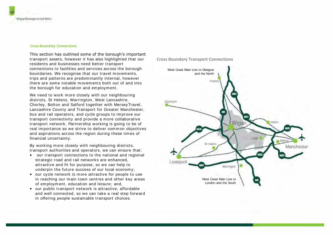
Cross Boundary Transport Connections This section has outlined some of the borough’s important
transport assets, however it has also highlighted that our residents and businesses need better transport
connections to facilities and services across the borough
boundaries. We recognise that our travel movements,
trips and patterns are predominantly internal, however there are some notable movements both out of and into
the borough for education and employment.
We need to work more closely with our neighbouring
districts, St Helens, Warrington, West Lancashire, Chorley, Bolton and Salford together with MerseyTravel,
Lancashire County and Transport for Greater Manchester,
bus and rail operators, and cycle groups to improve our
transport connectivity and provide a more collaborative transport network. Partnership working is going to be of
real importance as we strive to deliver common objectives
and aspirations across the region during these times of
financial uncertainty.
By working more closely with neighbouring districts, transport authorities and operators, we can ensure that:
• our transport connections to the national and regional
strategic road and rail networks are enhanced,
attractive and fit for purpose, so we can help to underpin the future success of our local economy;
• our cycle network is more attractive for people to use
in reaching our main town centres and other key areas
of employment, education and leisure; and, • our public transport network is attractive, affordable
and well connected, so we can take a real step forward in offering people sustainable transport choices.
West Coast Main Line to Glasgow
and the North
West Coast Main Line to London and the South

The Wigan Congestion Study 2010 identified the current
locations across the borough that experience the worst congestion levels, which were recognised as having
average speeds below 10mph for significant lengths of
time during the peak periods.
The congestion ‘hotspots’ are illustrated in the maps opposite for the morning and evening peak periods
respectively. Traffic survey data was collected as part of
the Wigan Congestion Study 2010 which took place on
key road routes within the western part of the borough. The results from the surveys showed a pattern in the
journeys, whereby are majority of them were local in
nature and were being undertaken predominantly by
single occupancy car trips.
The survey data also revealed that:
• During the morning peak period 58% of cars start and
finish their journeys within the borough. The evening
peak period has a similar figure of 57%; • 67% of all morning peak period trips are for
commuting to work. 76% of morning peak period and
66% of evening peak period car trips are made by
drivers with no passengers; • 57% of morning peak period car trips and 58% of
evening peak period car trips are less than 8
kilometres long;
• 12 of the 16 data survey points have more than 90% of the cars travelling through them finishing their
journeys within the borough during the morning peak
period, a similar pattern occurs in the evening;
• 62% of goods vehicles journeys taking place in the AM
peak originated within the borough. This percentage decreases to 59% in the Off peak and 56% in the PM
peak; and,
• 83% of all goods vehicles journeys in the AM peak
terminated within the district. This percentage increased to 87% in the Off peak and 92% in the PM
peak.

Aspull
Standish
Shevington
Wigan
Leigh
Golborne / Lowton
Aspull
Standish
Shevington
Wigan
Leigh
Golborne / Lowton
Tyldesley / Astley Tyldesley /
Astley Ashton
Ashton
Source: Wigan Congestion Study (2010)

The 2010 Congestion Study identified the following locations as
the worst congestion hotspots in the borough:
1. Hindley A577 Manchester Road, north-west bound direction
during the AM Peak
Traffic volumes comprised of 76% cars and 14% goods vehicles.
The study revealed that the majority of these car journeys originate in Hindley or Ince and where travelling towards Wigan
Town Centre.
Several interventions have already been installed to help relieve
this hotspot location including junction amendments at Hindley cross-roads and new signal technology. Further transport
infrastructure work, (such as the Amberswood Link Road) will be
needed in the longer term, linked with development opportunities
to help provide more substantial relief, while also providing opportunities for enhanced sustainable transport options to
connect people within these communities to the places they are
trying to get to.
2. A49 Pottery Road, west bound direction during the PM Peak
Traffic volumes comprised of 84% cars and 11% goods vehicles. The majority of car journeys on this corridor originated in central
Wigan and were heading for either the motorway or destinations
in Skelmersdale, Haydock, St. Helens or other parts of
Merseyside.
The Council has delivered a new Saddle Link Road, which was
completed in February 2013. This new road brings considerable
congestion relief benefits and provides an enhanced transport
corridor into the heart of Wigan Town Centre.
3. B5238 Poolstock, south-west bound during the PM Peak
Cars accounted for 88% of all vehicles on the road with goods
vehicles accounting for 10%. Most car journeys originated in
central Wigan and were heading for the motorway network, Winstanley, Ashton, Bryn, Haydock or St. Helens.
The Westwood Park development site will facilitate the delivery of
the A49 Link Road scheme, connecting the A49 from Warrington
Road through to Chapel Lane, providing a dual carriageway route from the M6 J25 through to the heart of Wigan Town Centre. This
scheme will also provide significant congestion relief benefits for
the residents along Poolstock, together with enhanced
sustainable transport, road safety and air quality improvements.