the drought crisis in the central highlands of vietnam
TRANSCRIPT

The drought crisis in the Central Highlands of Vietnam
Assessment Report
CGIAR Research Centers in Southeast Asia
18 - 22 April 2016 Kon Tum, Gia Lai, Dak Lak,
Vietnam

CGIAR Research Program on Climate Change, Agriculture and Food Security- Southeast Asia
(CCAFS-SEA) (2016). Assessment Report: The drought crisis in the Central Highlands of Vietnam.
Hanoi, Vietnam.
The CGIAR Research Program on Climate Change, Agriculture and Food Security (CCAFS) is a
strategic partnership of CGIAR and Future Earth, led by the International Center for Tropical
Agriculture (CIAT). The Program is carried out with funding by CGIAR Fund Donors, the Danish
International Development Agency (DANIDA), Australian Government (ACIAR), Irish Aid,
Environment Canada, Ministry of Foreign Affairs for the Netherlands, Swiss Agency for
Development and Cooperation (SDC), Instituto de Investigação Científica Tropical (IICT), UK Aid,
Government of Russia, the European Union (EU), New Zealand Ministry of Foreign Affairs and
Trade, with technical support from the International Fund for Agricultural Development (IFAD).
The CCAFS Southeast Asia Regional Program is led by the International Rice Research
Institute (IRRI) and is based in the IRRI Vietnam office in Hanoi, Vietnam.
ACKNOWLEDGEMENT
The assessment in the Central Highlands was successfully conducted with the support of the
Ministry of Agriculture and Rural Development (MARD), provincial DARDs and local authorities.
The Assessment Team would like to acknowledge the International Cooperation Department
(ICD) of MARD for facilitating the issuance of the travel permits to the Central Highlands
provinces. We also thank the People’s Committees(PC) and Department of Agriculture and Rural
Development (DARD) of Kon Tum, Gia Lai and Dak Lak provinces and the PC and DARD districts
offices for guiding the team and arranging the site visits. Special appreciation and thanks also
goes to CGIAR colleagues and local experts for their invaluable contributions during the site
visits and their constructive inputs that improved the report considerably. Many thanks to the
farmers and fisher folks in the sites visited for their openness in sharing with us their experiences
and insights.

2
Contents
Rationale ............................................................................................................................................................................................... 4
Objectives............................................................................................................................................................................................. 4
Expected Output................................................................................................................................................................................ 5
Background of the Central Highlands ....................................................................................................................................... 5
Methodology .................................................................................................................................................................................... 10
Key Observations and Findings ................................................................................................................................................. 12
Integrated Approaches for Addressing the Drought Crisis ............................................................................................. 15
Specific Recommendations ......................................................................................................................................................... 20
Summary and Conclusions .......................................................................................................................................................... 25
References.......................................................................................................................................................................................... 26
Appendix 1. Highlights of the On-Site Assessment ........................................................................................................... 27
Appendix 2. Field visit program ................................................................................................................................................. 34
Appendix 3. Members of the Assessment Team ................................................................................................................. 35

3
Acronyms
CC Climate change
CCAFS CGIAR Research Program on Climate Change, Agriculture and
Food Security
CIAT International Center for Tropical Agriculture
CSA Climate-smart agriculture
DARD Department of Agriculture and Rural Development
DoNRE Department of Natural Resources and Environment
ENSO El Niño Southern Oscillation
GIS Geographical Information System
ICRAF World Agroforestry Centre
ICT Information and communication technology
ILRI International Livestock Research Institute
IRRI International Rice Research Institute
IWMI International Water Management Institute
MARD Ministry of Agriculture and Rural Development
R4D Research for development
SDC Swiss Agency for Development and Cooperation
SEA Southeast Asia
UNDP United Nations Development Programme
UTFI Underground taming of floods for irrigation
WASI Western Highlands Agro-Forestry Scientific and Technical Institute

4
Rationale
As an impact of the ongoing El Niño Southern Oscillation (ENSO) phenomenon, serious drought
has been occurring in the Central Highlands of Vietnam and has caused varying degrees of
damage to agriculture and the livelihoods of people in the region. On 15 March 2016, the
Vietnamese government and the United Nations Development Programme (UNDP) organized a
meeting with donors, international organizations and other partners to discuss joint efforts for
drought response and recovery. Another meeting was presided by the Ministry of Agriculture
and Rural Development (MARD) Minister and the UN Resident Coordinator on 30 March 2016 to
report on the recent rapid assessment of current natural hazards and call for short-, medium-
and long-term support from the international community. MARD recognizes that this crisis and
its subsequent effects (e.g. inundation after the drought) will recur in the future, and that there is
a need to prepare and plan for necessary response measures.
In response to this urgent call, the CGIAR Centers operating in Vietnam, in collaboration with
MARD, organized a joint field assessment in the Central Highlands to have a first-hand
observation and assessment of the drought problem currently being experienced by the region.
The CGIAR interventions recommended based on the assessment may support the short-,
medium- and long-term planning in response to the impacts of climate change. The collective
strength that the CGIAR could contribute is in downscaling some of the global data and analyses
to Vietnam scenarios and forecasts for their planning, recommending climate-smart agriculture
(CSA) options for integration in current and future donor/development interventions, and
identifying opportunities in research for development (R4D) for future preparedness.
Objectives
This assessment and evaluation activity aimed to achieve the following objectives:
1. Conduct a first-hand observation and assessment of the drought crisis in the Central
Highlands;
2. Provide science-based recommendations to MARD and local authorities on future actions to
cope with drought crisis and prepare for future climate change impacts;
3. Identify potential CSA options that can be integrated in ongoing and future
development/donor interventions; and
4. Identify feasible R4D actions of CGIAR centers in the region.

5
Expected Output
An assessment report enumerating possible CGIAR contributions to the development of
integrated responses to the drought crisis (short-, medium-, to long-term), CSA options for
integration in ongoing and future interventions, and follow-up on joint actions of the CGIAR.
Background of the Central Highlands
General Information
The Central Highlands is one of eight agro-ecological
regions of Vietnam (Figure 1). The region consists of
various plateaus surrounded by mountain ranges. The
elevations of plateaus range from 500-1500 masl (meters
above sea level). The Central Highlands has a total land
area of 5,454,500 ha (17% of the national area), covering
five provinces: Kon Tum, Gia Lai, Dak Lak, Dak Nong and
Lam Dong.
Demography
The Central Highlands has a total population of 5,460,400
(GSP, 2013), with nearly 20 ethnic groups, of which the
three main groups are Kinh (3,310,000), Gia Rai (409,000),
and Ede (304,000). A large number of Kinh people migrated
to the region from the northern and central provinces of
Vietnam since the 1990s resulting in a remarkable
population growth of 485% in 1999.
Land Use
About 88% of the total land area in Central Highlands are
agricultural and forestry land. Gia Lai province has the
largest agricultural land area (1.3 million ha), followed by
Dak Lak (1.2 million ha) and Lam Dong (0.97 million ha)
(Table 1).
The aggregate area of annual crops in the region – about
856,000 ha – is planted mainly with rice, vegetables and
other cash crops. More than half of the cultivated lands are
Figure 1. Location of the Central Highlands in Vietnam.
Source: BCA et al. 2013

6
used for perennial crops, such as rubber, coffee, black pepper and cashew. About 50% of the
perennial crop areas are located in Dak Lak and Gia Lai. Of the total forest lands, which cover
about 2.8 million ha, 1.7 million ha are productive forest.
Agriculture
The Dak Lak, Dak Nong and Lam Dong provinces in the Central Highlands are Vietnam’s leading
coffee producers. Apart from coffee, the region also grows other perennial crops, including tea
(23,000 ha), rubber (257,000 ha), black pepper (33,490 ha), cashew (33,000 ha), cacao (3,750 ha)
and fruit trees (30,720 ha), for domestic and export markets.
The main annual crops in the region are rice, maize, sweet potato, vegetables, sugarcane,
groundnut and soybean. About one-third of the areas cultivated with annual crops (316,000 ha)
are in Dak Lak province. In 2013, 232,000 ha of land area were planted with rice over two
cropping seasons: winter-spring and summer. Most of the rice and other annual crop products
are for domestic use.
Livestock is also an important agricultural sector of the Central Highlands. In 2013, the region
raised nearly 755,000 heads cattle, 1,728,000 heads of pigs and 1,841,000 heads of poultry, while
the total meat production was 210,800 tons. The main meat product is pork, followed by beef
and poultry. Dairy cows are raised mainly in Lam Dong province, as they are not popular in other
provinces in the region. The region had 7,700 heads of dairy cattle, which produced 21,690 tons
of milk, in 2013.
Table 1. Land use of provinces in the Central Highlands in 2013.
Kon Tum Gia Lai Dak Lak Dak Nong Lam Dong Total
Total land area 968.96 1553.69 1312.54 651.56 977.35 5,464.10
1. Agriculture and forestry land 856.7 1343.86 1137.84 586.58 899.31 4,824.29
1.1. Cultivation 214.86 612.5 537.68 319.47 315.88 2,000.39
Annual crops 114.84 342.74 218.39 111.09 69.2 856.26
Rice-based 17.92 59.99 60.34 8.82 21.8 168.87
Pastures 0.35 0.24 0.97 0.02 0.69 2.27
Other annual crops 96.58 282.51 157.08 102.25 46.71 685.13
Perennial crops 100.01 269.75 319.29 208.38 246.67 1,144.10
1.2. Forest 641.06 730.15 597.35 265.43 581.15 2,815.14
Production forest 378.61 519.19 310.33 198.68 304.05 1,710.86
Protection forest 171.67 151.12 67.7 37.48 189.38 617.35
Special use forest 90.78 59.84 219.31 29.26 87.72 486.91
1.3. Fishery 0.7 1.1 2.78 1.69 2.13 8.40
1.4. Other agricultural land uses 0.09 0.12 0.03
0.15 0.39
2. Non-Agricultural land 43.84 116.05 103.18 43.95 54.71 361.73
3. Un-used lands 68.42 93.79 71.51 21.03 23.33 278.08
Source: DOP 2016

7
With 13,900 ha of water surface for aquaculture, total aquaculture production (mainly fish) was
29,156 tons, with capture fishery producing about 4,600 ton. Among the five Central Highlands
provinces, Dak Lak has the largest aquaculture area (7,800 ha) and produces 50% of the total
fish production in the region.
Water Resource Management
Irrigation systems in the Central Highlands in 2013 cover 137,000 ha, including areas for
cultivating rice and other crops. Tables 2 and 3 show the capacity of irrigation systems in the
region.
In the whole region, there are 214 dams with depths ranging from 3-10 m, of which 51 are
considered temporary. There are also 30 pumping stations for irrigation with capacities ranging
from 1,000 to 3,600 m3/ha.
Table 2. Capacity of reservoirs in the Central Highlands in 2013.
Total
volume (106
m3
)
Number of
reservoirs
Number of reservoir by size (106
m3
)
>10 3-10 1-3 0.5-1 0.05-0.5
1,388.7 1,069 22 29 102 106 756
Source: MARD 2015
Table 3. Irrigation canals in the Central Highlands in 2013
Type Total length (km) Concrete canals (km) Concreted ratio (%)
Main and level 1 canals 2,173.0 1,053.0 48.5
Level 2 canals 1,028.0 648.0 63.0
Level 3 and inter-field
canals
2,896.0 1,187.0 41.0
Total 6,097.0 2,888.0 47.4
Source: MARD 2015
Climate Conditions
The inter-annual variations of rainfall in the Central Highlands are mainly influenced by seasonal
winds. The annual rainfall ranges from 1500 to 2400 mm. Monthly rainfall is highest from May to
October, accounting for about 80% of the annual amount. The average monthly rainfall during
the rainy season exceeds 200 mm and reaches its peak in August and September. The air
temperature is rather low in comparison with other regions, ranging from 20oC to 25oC. The
highest temperatures are in April and May from 27oC to 31oC.
Impacts of El Niño
Studies show that the weather in Vietnam, as a part of the global weather system, is influenced
8
by large-scale climate circulation. There is a strong connection between climate conditions in
Vietnam and the global effects of El Niño and La Niña that occur normally every two to seven
years. The El Niño events in 1982-1983 and 1997-1998 were extremely strong and had severe
impacts on the environmental and socio-economic sectors of Vietnam. Nguyen and Rosbjerg
(2007) found that the effects of El Niño in the south are often stronger than in the north of
Vietnam. The Central Highlands is one of the regions most sensitive to El Niño effect, which
often leads to serious drought during the dry season.
The drought episode in 2003 reduced coffee production by about 25%. Domestic water supplies
were also threatened. Since 2014, the drought associated with the El Niño phenomenon has
been strongly affecting Vietnam again. A recent report shows at least one-third of Vietnam’s 63
provinces continue to be affected by El Niño-induced drought, which resulted in crop damage,
yield decline and serious water shortage. Eighteen provinces in the South Central, Central
Highlands and Mekong Delta regions are severely affected.
As a result of the current drought, the discharges of main rivers have been reduced by 20-90%
(NCHMF, 2016). For instance, the water level of Dak Bla River in Kon Tum province was lowest in
the series of observed data. By early April 2016, water volumes in most of the irrigation
reservoirs in the Central Highlands declined to 10-50% of their designed capacity. Hundreds of
small lakes in Kon Tum, Gia Lai and Dak Lak provinces have also been depleted.
About 70% of cultivation areas, which are rainfed or covered by small irrigation systems, have
experienced severe drought (MARD, 2016). Up to mid-April, nearly 170,000 ha of crops were
affected by the drought, of which 7,100 ha were left fallow and more than 95,000 ha were
deficient in irrigation. The latest reports showed that the total affected area in Kon Tum was
2,106 ha, including 1,226 ha of rice, 857 ha of industrial crops (mainly coffee and black pepper)
and 23 ha of cash crops. The damage was greater in Gia Lai with 21,998 ha of affected area of
rice (5,378 ha), cash crops (8,653 ha), coffee (6,317 ha) and black pepper (1,650 ha).
In Dak Lak, reduction of crop production was estimated for more than 42,400 ha and is
equivalent to nearly USD 60 million. Lack of feeds (grasses and forage) and water has also
affected the livestock production in the Central Highlands. According to the Department of
Agriculture and Rural Development (DARD) in Dak Lak, more than 100 heads of cattle have died
by mid-April due to the drought. Ea Rve and Ia Lop communes of Ea Sup district, particularly,
have lost 109 heads of cattle and hundreds of poultry.
Since last year, the Vietnamese government has provided 5,221 tons of food and allocated 1008
billion VND (45 million USD) worth of relief and disaster support services for people in the three
drought-affected regions. For 2016, it is estimated that about 2 million people lack freshwater
supply, 1.75 million people have compromised livelihoods and 1.1 million need food aid. About
27,500 children and 39,000 women have also been affected. Figure 2 shows the prediction of
drought-affected areas in the Central Highlands during the dry season of 2015-2016 (DMC,
2016). The levels of the actual effects have been proven and reported (DMC, 2016).

9
Figure 2. Warning maps to show expansion of drought affected areas in the Central Highlands during dry season 2015-2016. (Source: DMC 2016)
September 2015 October 2015 November 2015 December 2015
January 2016 February 2016 March 2016

10
Methodology
Site Selection
The sites visited by the assessment team were selected based on the scope and level of damage
on agricultural production as reported by MARD and the provinces in the Central Highlands.
Initially, the three provinces (Kon Tum, Gia Lai and Dak Lak) in the target region that were most
affected by drought were identified. Land use maps from 2010 were then used as reference to
identify the most affected areas and districts in each of the three provinces. The two districts
that had the largest area of affected agricultural products in each province were then selected
for on-site assessment. The itinerary program of the assessment team is listed in Appendix 2.
The Assessment Team
The CGIAR team was composed of experts in rice cultivation (International Rice Research
Institute, or IRRI), tree-integration/agroforestry in farming systems and landscapes (World
Agroforestry Centre, or ICRAF), livestock (International Livestock Research Institute, or ILRI),
tropical agriculture (International Center for Tropical Agriculture, or CIAT), water management
(International Water Management Institute, or IWMI) and local experts in industrial crop
production (Western Highlands Agro-Forestry Scientific and Technical Institute, or WASI). The
members of the team are listed in Appendix 3.
Information Collection Methods
Following a review of literature, the assessment team collected information from field
observations, key informant interviews with the officials of the provincial and district levels of the
DARD, the provincial level of the Department of Water Resources and its line offices, and face-
to-face interviews with affected households and the leaders of the Commune People’s
Committees.
Key guide questions asked during the field visits
1. Is drought a critical issue in your locality?
2. What are the most widely observed indicators of drought in your locality? How long
have these been observed?
3. What are the most widely observed impacts/outcomes of drought in your locality?
Which group/sectors are most deeply affected, most vulnerable?
4. What is the possible relation between intensity and incidence of drought and the bio-
physio characteristics of each sub-region?
5. Are there any existing techniques/practices being applied by farmers and/or local
organizations to cope with drought?

11
6. What has been the effect of the practice/technique?
7. What are the potential areas or entry points where drought could be effectively
addressed in your locality? What would be required to make this happen?
8. What plans do farmers/agencies intend to implement to cope with drought in the
future? What support/contribution will be needed from other stakeholders (government,
private sector, research community)?
Limitations of the assessment
The assessment team only visited the locations identified prior to the visit as most affected by
the drought, and relied on secondary data, the results of key informant discussions, and the
knowledge about the region of the participating experts. The assessment team did not conduct
a detailed collection of data (e.g. household survey questionnaire) that can be used for in-depth
analysis. The recommendations focused on the possible climate smart agricultural practices and
technologies that are suitable and feasible in the region.

12
Key Observations and Findings
The key observations of the assessment team listed below are the basis for the subsequent
recommendations. For a deeper understanding of these key observations, please refer to the
detailed daily highlights of the field assessment in Appendix 1.
1. Evidences of the effects of drought are clearly observable in the Central Highlands of
Vietnam. In this region, rice and coffee are most sensitive crops to drought. In terms of the
magnitude of drought effect, the province of Gia Lai appeared to have been most affected
by severe drought compared with the provinces of Kon Tum and Dak Lak.
2. The level of drought impacts experienced was found to be strongly related to local (i.e.
households, farm and village) conditions, such as the local climate, availability of surface and
groundwater, land use systems, capital capacity and social specificities. Effects of the
drought are more evident in sloping lands and remote areas than in low-land and peri-urban
areas. This could indicate that higher populations are usually located in areas with a
favorable climate, good water resources and fertile soils.
Water Management
1. The provincial government announced the occurrence of drought when the water levels in
the reservoirs and rivers were lower than the effective level for irrigation. Farmers reported
that they have been suffering from drought since late 2015. However the shortage of
irrigation water has become more serious since the beginning of 2016 as reflected in the dry
plots, cracking soil in some rice fields and dead coffee plants of some farms visited.
2. To cope with the water shortage, farmers pumped the remaining water from the nearest
storages or wells/boreholes. In some areas, local agencies recommended measures for
coping with drought, such as mulching or drip irrigation, but these recommendations lacked
detailed technical guidance, which may have limited the effectiveness of these practices.
3. In a normal year, the groundwater table is about 10 m deep, but the current drought
lowered it to as low as 70-80 m, resulting in water shortage for domestic use in some places.
Households thus often construct wells or boreholes to obtain water for domestic use, and
they need not apply for approval from DoNRE to build such.
4. Farmers have applied their own adaptation measures to address the lack of freshwater. For
instance, most of the farmers attempted to exploit the remaining surface water from nearby
reservoirs. Several pumps have constructed to fetch water from up to 10 km away from
coffee farms. Others depended on open wells or created boreholes of up to 120 m depth to
get water.

13
Diversification
1. As with the effects of other climate stresses, ethnic minorities and smallholders are the most
vulnerable to the effects of drought on food security and income. If they lose their crops
and/or animals to climate-related events, they are left with nothing to eat or little to no
income to purchase food for their family. This is exacerbated in isolated areas where
alternative economic activities are not easily available.
2. Farmers acknowledged the benefit of innovative techniques, such as using shade tree, drip
irrigation, intercropping and small-scale water storage, that alleviate the effects of drought.
However oftentimes, they do not adopt these techniques due to high technical requirement,
high operational cost, cash flow problems and reduction of output from main crops due to
larger areas allocated for intercropping or growing shade trees.
Watershed Management
1. Although forestland in the three provinces is sizeable, the actual area covered with forest is
very low. Many areas, especially dams and water reservoirs, have minimal tree cover in their
watershed areas.
2. Farmers have already developed effective adaptation practices with their accumulated
experience and knowledge against the effects of drought. For instance, a common practice
among farmers in the province of Dak Lak is integrating trees (e.g. fruit and timber trees)
with agriculture crops. However, no standard guidelines are in place for such practices since
intercropping designs vary from farm to farm.
3. The local people perceived that the severe drought experienced in the region is a
consequence of the significant change in land use with the expansion of coffee, rubber and
pepper plantations in the region in the recent decades. These plantations were expanded in
response to market opportunities that Vietnam was able to tap, particularly in the export
market. This led to large-scale deforestation in the provinces of the Central Highlands to
open up more land for cultivation.
Other Significant Observations
1. Local governments from provincial to commune levels have taken substantial short-term
actions in preparation for the extreme dry season and drought. Advice had also been
provided to communities, although these recommendations are still not efficient in dealing
with the severe drought. Strengthening of existing institutional systems is therefore still
needed.
2. The adaptive capacity of farmers toward the effects of drought differs among provinces,
districts, communes and even households. Some household adapt to drought better than
others.

14
3. The up-scaling of adaptation measures still faces challenges. Access to capital and
availability of savings influence the capacity to adapt and are heterogeneously distributed
across farmers.
4. The overall efficiency of the existing short-term options to cope with drought remains low.
Long-term adaptation plans need to be developed with the increasing impacts of climate
change.
Figure 3. Scenario images in the Central Highlands: (Top L-R) Dried-up rice fields and coffee plants (Bottom L-R) Members of the team interviewing Mr Le Thanh Ha, Kontum, and the critical water level in the reservoir.

15
Integrated Approaches for Addressing the Drought Crisis
The existing integrated and comprehensive plans in the Central Highlands need to be enhanced
for the region to cope with the expected recurrence of drought and El Niño. These plans have to
ensure that local communities and their leaders are well-prepared to appropriately respond to
changes in the climate. The plans should also ensure that the government and associated
agencies tasked with disaster risk management are well-equipped to do so under different
scenarios. Quick fixes that may not necessarily address the issues are to be avoided and instead,
long-term, holistic solutions should be sought. The following CSA options are recommended as
integral components of such plans.
Develop appropriate policies to encourage diversification of agricultural systems,
including innovative financing mechanisms to support smallholders Changing land use
patterns and landscape management are options for long-term adaptation. Typical
monocultures in the Central Highlands could be replaced with diversified cropping systems,
which vary agricultural products (both cultivation and livestock). These diversified systems
engender multiple sources of household income and promote resilience to climate change and
extreme weather events.
The main hindrances in promoting diversification are: (1) economic incentives which encourage
production of a select few crops; (2) the push for biotechnology strategies; and (3) the belief
that monocultures are more productive than diversified systems. However, crop diversification
can be implemented in a variety of forms and at a variety of scales, allowing farmers to choose a
strategy that both increases resilience and provides economic benefits.
Diversification can significantly reduce the vulnerability of production systems to greater climate
variability and extreme events, thus protecting rural farmers and agricultural production. At the
within-crop scale, diversification may refer to changes in crop structural diversity, such as using a
mixture of crop varieties that have different plant heights. Crop (plants and animals)
diversification can improve resilience in a variety of ways: (1) by improving ability to suppress
pest outbreaks and dampen pathogen transmission, which may worsen under future climate
scenarios; and (2) by buffering crop production from the effects of greater climate variability and
extreme events.
Under certain circumstances, diversification is needed to restore the degraded natural resource
base or to enhance the value of natural resources. For example, cropping systems have been
diversified or new cropping systems have been introduced in situations where it is deemed
critical to retain or enhance the value of natural resources, especially land and water. Other
potential benefits of crop diversification include food and nutrition security, income growth,
poverty alleviation, employment generation, judicious use of land and water resources,

16
sustainable agricultural development and environmental improvement. Crop diversification is
also an attractive strategy for improving incomes, providing gainful employment and stabilizing
the income flow.
Diversification at the within-field scale may be done by allocating areas between and around
fields where trap crops or natural enemy habitat may be planted. At the landscape scale,
diversification may be achieved by integrating multiple production systems, such as mixing
agroforestry management with cropping, livestock, and fallows, to create a highly diverse piece
of agricultural land. In addition, diversification can be created temporally as well as spatially,
adding even greater functional diversity and resilience to systems sensitive to temporal
fluctuations in climate.
In addition, as market opportunities develop and/or risks are reduced, the enterprise mix begins
to respond to market forces, thus creating stronger economic incentives for adoption and
scaling of this strategy.
What needs to be done to promote agricultural diversification?
To support diversification, a level playing field in terms of policy support like remunerative prices for
the crop, assured marketing for alternatives, value addition and processing is needed. Supportive
policies could also include removing of subsidies for the cultivation of selected crops, encouraging
land-use zoning and introducing differential land tax systems. Adoption of modern technologies (e.g.
biotechnology) needs to be strengthened to increase productivity.
A major challenge to the implementation of diversified agricultural systems for farmers is finding the
appropriate balance of diversification within the farm system to satisfy both production and protection
values. As climate variability increases, the value of resilience will also increase, especially in production
systems that are sensitive to climate change. A farmer’s decision to move toward diversified
agricultural systems will be highly influenced by the support a diversification strategy could give to the
economic resilience of farms. Finding win-win solutions that account for farmers’ various production
and protection goals is therefore necessary to develop long-term, viable strategies.
Developing tools that can help managers understand best practices on a farm, field or landscape scale
can also significantly enhance diversification. At the farm field level, techniques such as crop modelling
will be useful. Economic models that can predict threshold prices at which farmers begin to adopt
environmental land-use practices or payments for ecosystem services, can be highly effective in
encouraging farmer adoption of diversified agricultural systems. Development of larger-scale
diversified landscapes that support and improve ecological resilience in agricultural systems requires a
more in-depth analysis of farm business and landscape-level scenario modelling for potential on-farm
diversification schemes. In addition, stakeholder involvement and participatory research are useful
tools in developing adaptation options that will have higher likelihood of uptake by the local
community.

17
Plant the right trees in the right place to enhance watershed functions. For farmers,
drought is manifested by a lack of irrigation water. Their adaptive capacity therefore depends on
their ability to access water. A longer-term, but strategic solution is enhancing the capacity of
the landscape to discharge and recharge water. A diverse land use mosaic with trees helps
maintain the landscape’s water balance. Trees modify water balance in a watershed through
their morphology and phonological process, both aboveground and belowground.
Aboveground, tree canopy intercepts rainfalls and reduces its erosive power on the ground
surface. Canopy water evaporation and transpiration transfer water back to the atmosphere and
subsequently influence rainfall amount and pattern.
Trees with a deep root system improve soil structure and infiltration rate. Water input and
reduced surface runoff will be stored as groundwater through an improved water movement in
the soil. Groundwater stored will then be gradually released into the river during the dry season.
The improved capacity of the soil to store water induces a steady river flow characterized by low
peak flow and high base flow. Steadiness of river flow is the ultimate aim of every watershed
management strategy, which plays significant roles not only in enhancing water balance, but
also in ameliorating the climate conditions, improving soil infiltration, influencing rainfall
amount and pattern and protecting the watershed in general (Figure 4). In addition, good
watershed management prevents soil erosion and reduces sediment deposition in reservoirs.
-
-
-
- -
Figure 4. Vegetation/land use linkages with landscape hydrology (water balance) Source: ICRAF-Vietnam

18
Manage the scarce water resources (ground and surface) effectively and efficiently.
Construction of large irrigation systems with surface water will be costly in the Central Highlands
with its hilly and mountainous topography. This topography is more suitable for the
development of many small reservoirs as a cascade system managed by communities. These
reservoirs could also reuse the return flow of irrigation in higher elevations, as farmers in Sa
Thay district, Kon Tum province are practicing. The management of these reservoirs should be
assigned to communities or water user groups who are directly using the water. The concept of
water sharing should also be promoted to avoid conflicts in water use, in particular between the
reservoir manager and other members of the water user groups.
Groundwater is currently a main source of irrigation water during the dry season for both annual
and perennial crops, because of the limited coverage of surface water irrigation system in the
Central Highlands. Conjunctive water use, or the use of both surface and groundwater, is a
suitable alternative for communities. With such practices, users should understand the links
between surface water and groundwater. Systematic monitoring networks for observing
variations in groundwater levels of wells and surface water levels in streams could also be used
as input for surface and groundwater maps. Such tools and knowledge will be very useful for
planning and managing water resources and water use in the region.
The method of underground taming of floods for irrigation (UTFI- http://utfi.iwmi.org/)
proposed by IWMI could be an alternative for increasing the groundwater volume for irrigation
in the dry season and reducing the damage by floods during heavy rains. In this method,
groundwater aquifers are artificially recharged by simple and low cost measures rather than just
natural recharging. The first phase is the selection of suitable locations, such as the sand dunes
in the coastal provinces, as pilot sites for learning, before out-scaling to larger areas.
At the field and farm scale, drip irrigation (tưới nhỏ giọt) and water-saving irrigation (tưới tiết
kiệm) should be distinguished. Drip irrigation saves water and fertilizer by allowing water to drip
slowly to the roots of many different plants. Water either drips onto the soil surface or directly
onto the root zone through a network of valves, pipes, tubing and emitters. Narrow tubes
deliver water directly to the base of the plant. Water-saving irrigation is not necessarily drip
irrigation, but can be basin irrigation (e.g. pumping water every few minutes for each coffee tree,
as farmers are practicing) or gradual irrigation through water pipelines (as the system presented
by Dr. Bau of WASI for coffee).
Whether using drip or water-saving irrigation, the amount of water should be sufficient as
demanded by the plant. This means not always fully satisfying the growing biomass, but creating
the water stress in particular stages (such as at the initiation of the flower buds or acceleration
of the blossom) so that the plant can provide higher grain yield rather than higher biomass.
Field experiments (e.g. at WASI) and farmer sharing of experiences should be done to identify
suitable water saving irrigation techniques for each crop type (e.g. drip irrigation for annual
crops, and other water saving techniques for perennial crops) before developing demonstration

19
fields for out-scaling. The impacts of these water management options on farmers’ cash flows
(initial investment vs. maintenance costs) should also be analyzed before input programs and
policies promote their commercial adoption.
Enhance the early warning systems for farmers. Outputs of current early warning systems can
be scaled down using observed water availability in targeted areas. For example, data on the
availability of groundwater can be used together with existing inputs (i.e. vegetation cover,
climatic data and surface water level) to predict possibility of drought. Communities can also
engage in participatory prediction processes so that outputs can be revised using local
knowledge. Output resolutions of the improved system should be detailed enough (1 kmx1 km)
to be used at district or commune levels. At this resolution, heterogeneity of the target the areas
will be maintained.
Improved early warning systems should not only focus on providing warnings but also providing
guidance. Given the gap in existing systems (WRU, 2005; IMHEN, 2015), appropriate technical
guidance should be developed and released together with the warnings. For example, the
system can suggest delayed dates for rice transplanting, suitable varieties for planting and
associated techniques in case of drought. It is therefore necessary to establish an advisory group
in each province/district, which can analyze predictions and warnings and develop relevant
technical guidance for the local conditions. Training can improve the capacity of local staff in
interpreting outputs of the warning system.
Improvement of predictions and warnings can also be done through the use of information and
communication technologies (ICT). Modern communication platforms can now link mobile
phones to web applications. Information on drought effects and water availability sent from
mobile phones can be transferred to an analysis system, which will send back further
information. The system can then collect thousands of point data per day and provide location-
specific warnings.
An example of a regional weather forecasting network is the ThoiTiet
(http://thoitiet.hus.vnu.edu.vn/) developed by the Ha Noi University of Science. It currently
forecasts three-day rainfall, temperatures and wind speeds in the Central Highlands with lower
resolutions than the national weather forecasting network. This tool is developed with assistance
from the Swiss Agency for Development and Cooperation (SDC) and Nestle to support coffee
farmers in the Central Highlands.
Currently, IRRI is testing a system to predict and warn against saltwater intrusion for the Mekong
River Delta. A similar platform can be developed for drought in the Central Highlands. With an
open access system, local organizations and communities can easily test and revise outputs.
Such systems also help policymakers and local government develop better preventive plans and
responsive actions.

20
Specific Recommendations
CGIAR Centers can provide technical support utilizing their experiences and tested technologies
and practices. The CGIAR can systematically develop methodologies to evaluate the impacts of
technical and institutional interventions and identify appropriate recommendations for water
management, feasibility of CSA options, land use management and others.
Feasibility of CSA Options
Short- and Medium-Term Interventions
1. Conduct cost-benefit analyses of existing CSA options based on data from surveys and
expert knowledge. Data from surveys and expert knowledge could be used as inputs in
models for cost-benefit analyses. These would then simulate the effects of a range of
CSA options.
2. Develop high-resolution geographical information system (GIS) maps for analyzing
climate-related risks at multiple scales, from household to regional levels. The risk maps
developed in different levels can be used to develop detailed recommendations for
specific communities.
3. Develop information services to provide early warnings and recommendations during and
after disasters, especially drought. As mentioned above, an example could be the Thoi
Tiet developed by the Ha Noi University of Science that currently forecasts three-day
rainfall, temperatures and wind speeds in the Central Highlands with lower resolutions
than the national weather forecasting network.
4. Develop specific action plans of interventions for remote areas, targeting ethnic minorities
and smallholders, who are most vulnerable to natural hazards such as drought.
5. Promote practices that will not only address yield gaps from increased productivity but also
ensure system sustainability.
6. Deploy available drought-tolerant crop varieties during the dry season (winter-spring and
spring-summer cropping).
Finance mechanisms
Short- and Medium-Term Interventions
1. Identify innovative sources of funding for farmers. This would facilitate the adoption of
CSA practices and improve farmers’ resilience to the impacts of climate change.
21
2. Promote adaptation measures that provide mitigation benefits (for instance tree-
integration) and can be linked to international carbon markets or emerging national
initiative on emissions trading.
3. Strengthen further existing initiatives on payment for ecosystem services that can
contribute financing adaptation measures.
4. Promote and incentivize broader private sector involvement. For instance, supply chain
initiatives could be utilized as in-setting mechanisms where large buyers of agricultural
commodities support farmers in adapting to climate change and reducing their
emissions. This can create shared benefits by increasing the resilience of the supply chain
and generate sustainable financing for farmers.
5. Identify appropriate insurance mechanisms that could be piloted in trials and evaluate
these for their suitability, acceptability and potential scalability. These could include
weather-index based insurance schemes to protect smallholder farmers and agricultural
businesses from financial impacts of extreme weather events, like drought, typhoons and
floods. These schemes may address risks related to crop or livestock production, and
could possibly extend to other non-conventional sources of risk in these systems.
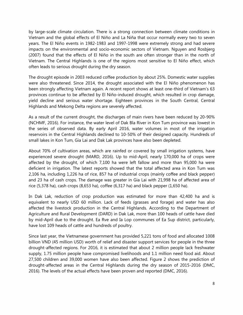
Water Management
Short- and Medium-Term Interventions
1. Develop community-based water availability maps based on the systematic recording of
groundwater levels in wells and surface water level by community observation networks.
These maps could be an alternative tool for detailed community maps of surface and
groundwater.
2. Formulate guidelines for harvesting rainwater during rainy season, particularly for creating
dams at the household scale in sloping areas. Government policies, technical and financial
advices and subsidies should be taken into account in establishing an effective
management mechanism. It might also be possible to adapt the ‘payment service’
model.
Long-Term Interventions
1. Study and apply the UTFI method proposed by IWMI in suitable locations to reduce the
damage of floods and increase groundwater volume for irrigation in the dry season.
2. Analyse community-based maps to identify spatial and temporal viability of groundwater
and surface water for greater efficiency of water management and exploitation.

22
Livestock
Short- and Medium-Term Interventions
1. Establish fodder banks in contour hedgerows. This practice could provide additional
biomass for livestock and at the same time help maintain soil quality through reducing
erosion and cushioning the impact of drought and other climate-related events from
mono-cropping in the short term. In the long term, it ensures system resilience.
2. Promote the inclusion of small stock (pigs and poultry), especially among smallholders who
have limited land. This could help buffer the shocks from extreme weather events by
providing immediate sources of income from the sale of these animals during crop
failure. It also provides access to food (eggs and meat) to supplement consumption
when farms cannot produce enough staples. These animal species could thrive under
limited feed conditions, as they could subsist on locally available feeds, including food
wastes that would otherwise be thrown away, on farms and within home gardens.
3. Promote practices that will not only address yield gaps from increased productivity but also
ensure system sustainability. These will be crucial for achieving food and nutrition
security with increasing climate variability.
4. Feed crop residues to livestock when feed resources are scarce and external inputs not
accessible. Two major opportunities to tap in mixed farming systems are: (1) potential to
improve both the quality and quantity of crop residues available to small-scale farmers
though appropriate selection of cultivars; and (2) intensification of livestock production
as a means to improve the energy use efficiency in these systems. Giving more attention
to the livestock feed characteristics of cereal crop residues could have major benefits in
facilitating intensification and limiting some of the negative environmental effects of
livestock production. Crop-livestock interactions are critical in increasing production
levels, especially the low levels of agricultural intensification commonly observed in
climate change-vulnerable areas.
5. Understand the demand for and uptake of crop-residue-based feeding practices. This is
important to agricultural development strategies that aim to meet food demand in an
environmentally-sound way.
Long-Term Interventions
1. Promote best practices for protecting animal assets from weather-related shocks. This
would help institutions improve their services for providing veterinary/animal health and
agricultural extension.
2. Explore comprehensive policies that will provide insurance for weather-related shocks.
Such policies will minimize production risks and protect production assets. This is

23
especially important in Vietnam where weather-related events are increasingly becoming
the new normal and which has still relatively young, developing markets and institutions
for asset protection products.
3. Develop crop-livestock–landscape simulation models that can demonstrate a range of
scenarios and conduct landscape modelling with farm profitability scenarios. This would
help farmers find optimal strategies for maintaining production and profits.
Forestry/Agroforestry
Short- and Medium-Term Interventions
1. Integrate appropriate (drought-tolerant and economically useful) tree species within
existing farming systems. At the farm level, these systems would: (1) provide shade for
crops and animals; (2) ameliorate micro-climate conditions; and (3) provide additional
biomass and income for farmers.
2. Identify possible sources of financing tree-integration in farming systems and link them
with the global carbon market.
Long-Term Interventions
1. Improve the tree cover of watershed areas with mixed multi-purpose species. Trees provide
buffering functions and maintain healthy watersheds. Water stored in watersheds is
essential for mitigating the impacts of drought.
2. Stabilize slopes with tree-based systems. Trees have soil-anchoring functions and thereby
control soil erosion and prevent landslides. Controlling soil erosion in cultivated sloping
lands prevents sedimentation in water courses, including dams and reservoirs, thus
extending the lifespans of these infrastructures.
Rice cultivation and industrial crop production
Long-Term Interventions
1. Change land use pattern and landscape management. The typical monoculture farming in
the Central Highlands could be replaced with diversified cropping systems (both
cultivation and livestock), which would diversify income sources of households and
increase their resilience to the effects of climate change, such as extreme weather events.
2. Explore carefully the root causes of the occurrence of drought for each sub-region. This is
because signs of drought problem and their corresponding impacts are found to be site-
specific. Thus, no single solution can solve the problem of the entire region.

24
3. Improve cultivation practices and land management by engaging agricultural extension
agencies and by introducing and demonstrating intercropping and replanting techniques in
connection with current government plans.
4. Incorporate drought-tolerant traits in all crops (e.g. rice) planted during the drought-prone
periods (winter-spring and spring-summer cropping).

25
Summary and Conclusions
Drought in the Central Highlands of Vietnam has resulted in water shortage for irrigation and
domestic use of the communities. Its effects are more apparent in sloping and remote areas of
the region. Rice and coffee are the most sensitive crops, while ethnic minorities and smallholders
are the most vulnerable groups in the region. Farmers acknowledge the benefits of innovative
techniques (e.g. intercropping). However they do not apply these because of reduced outputs
from their main crops (including long growing time for intercrop trees) and high technical
requirements and upfront investment needs. Limited short-term adaptation options are
currently in place.
Long-term, holistic adaptation plans need to be included in the existing strategies in the Central
Highlands for coping with the expected recurrence of drought and El Niño. These plans have to
ensure that local communities and their leaders are engaged and well-prepared for the
implementation of the adaptation strategies. We recommend the following CSA options to be
considered as integral components: (1) developing appropriate policies to encourage
diversification of agricultural systems, including innovative financing mechanisms to support
smallholders; (2) enhancing watershed functions with agroforestry; (3) improving ground and
surface water resources management; and (4) scaling down current early warning systems
providing guidance at commune and village level. We also recommend using the commune or
village as basic units in participatory planning and implementing collective actions. The CGIAR
centers can provide technical support utilizing experiences and tested technologies and
practices.
.
26
References
BCA, WWF and Stockholm University, 2013. Ecosystems classification mapping in Vietnam. Ha
Noi, Vietnam.
DMC. 2016. Drought in 5 provinces of the Central Highlands and provinces of the Southern
Coastal regions in 2016. URL: http://www.dmc.gov.vn/chi-tiet-thien-tai/han-han-tai-05-
tinh-tay-nguyen-va-cac-tinh-duyen-hai-nam-trung-bo-ninh-thuan-binh-thuan-va-
khanh-hoa-nam-2016-dis166.html?lang=vi-VN. Access date: 15 April 2016.
DOP. 2016. Agriculture baseline data for provinces. URL: http://dulieutichhop.mard.gov.vn/.
Access date: 15 April 2016.
Duy DT. 1998. El Niño and seasonal weathers in Vietnam. Hydro-meteorology Magazine, 2, 7-11
(in Vietnamese).
IMHEN. 2015. Developing the 3-month drought prediction and early warning system for
Vietnam. Project KC08.07/11-15. the Viet Nam Institute of Meteorology, Hydrology and
Climate Change (IMHEN). Ministry of National Resources and Environment.
MARD. 2015. Management, exploitation and usage of water resources. Decision 3511/QD-BNN-
TCTL.
MARD. 2016. Steering committee of the action plan on climate change adaptation in agriculture
and rural development. URL: http://occa.mard.gov.vn/. Accessed date: 15 April 2016.
NCHMF. 2016. The National Center for Hydro-Meteorological Forecasting. Long term
hydrological prediction of rivers in the Central coastal, Central Highlands and Mekong
River Delta. URL: http://www.nchmf.gov.vn/web/vi-VN/71/65/28315/Default.aspx.
Accessed date: 31 March 2016.
Nguyen, T. D. and Rosbjerg, D. 2007. Coping with drought in the central highlands - Vietnam.
PhD thesis. Institute of Environment and Resources, Technical University of Denmark.
WRU. 2005. Prediction of drought in the South Central Coast and the Central Highlandss and
development of preventive and responsive solutions. Project KC.08.22. Water Resources
University. Ministry of Science and Technology.

27
Appendix 1. Highlights of the On-Site Assessment
Day 01 - 18th April 2016 - Kon Tum province
According to Mr Le Thanh Ha of the Department of Irrigation and Disaster Prevention of Kon
Tum province, the drought is affecting about 30% of the area for rice and 10% of area the for
coffee, mainly in the districts of Dak Ha and Sa Thay, and in Kon Tum City. Signs of drought are
clearly seen in rice and coffee plantations, which have higher water demands than other crops.
Dak Ha, the largest coffee area (approximately 7000 ha), has reported experiencing the most
severe drought in Kon Tum province.
From along the main road leading to Dak Ha
district, signs of drought cannot be clearly
seen. The Dup La (Se San) River still has high
water flow and the vegetation cover remains
relatively green, except in rice fields and the
scattered coffee gardens. The main soil types
in this area are ferralsol and acrisol with high
soil depth and porosity. These physical
characteristics of the soil result in quick
infiltration and high water retention capacity.
Mr Le Thanh Ha showed the effects of
drought in the center of Dak Ha district, in a
coffee plantation managed by Vinacafe in Dak
Mar commune (Picture 1). Coffee in this area
is only slightly affected by drought due to
high soil moisture. During the assessment
team’s visit, the coffee trees in the area had
recently been irrigated. Withered leaves were
only seen in some trees. According to Dr Le Ngoc Bau, director of the Central Highland
Agriculture and Forestry Science Institute (WASI), a clear indicator of drought on coffee should
be the disappearance of young leaves and shoots, which did not really seem to be an issue, as
observed during the team’s visit.
According to Mr Le Thanh Ha, the provincial government announced the occurrence of drought
when the water level in reservoirs and rivers was lower than the effective level for irrigation.
Farmers reported that while they have been suffering from drought since late 2015, shortage of
irrigation water has become more serious since the beginning of 2016. In 2004-2005, Kon Tum
also suffered a slight drought, however the current drought is perceived as the most severe
event in the province. Upland, sloping and/or remote areas appeared to be more affected by
drought than areas in the lowlands or nearby towns.
Picture 1. Mr. Le Thanh Ha showed a coffee plantation in Dak Mar commune

28
In a normal year, the groundwater table is about 10 m deep, but the current drought event
lowered it to as low as 70-80 m, resulting in water shortage for domestic use especially in Kon
Tum City and Sa Thay district. The Chair of the People’s Committee of the province is
responsible for making decisions on prioritizing the areas or sectors that should be supplied
with water.
Local agencies recommended some measures, such as mulching or drip irrigation, for coping
with the drought but did not give detailed technical guidance. Farmers in Kon Tum are currently
pumping water from the nearest storages or wells/boreholes. The Department of Natural
Resources and Environment (DoNRE) manages and approves groundwater utilization. However,
making wells or boreholes for domestic use is often done by the households who need not
apply for approval to do so.
The key issue in mulching is selection of mulching material. In the coffee farms in Kon Tum,
using coffee residue is the most feasible option, given the low cost and labor requirement for
this, Dr Bau said. He also introduced shade trees, a measure widely adopted by farmers in some
provinces in Central Highlands but not popularly applied in Kon Tum. Shade trees that can be
used are Cassia siamea or fruit trees (e.g. durian and avocado).
An impressive farming model that uses fishpond as water storage was seen in Sa Nghia
commune (Sa Thay, Kon Tum) (Picture 2). Mr Pham Thanh Trung, the farm owner, reported that
he created this pond using his own capital, without any subsidy from the government. With this
small pond, he could share water with surrounding coffee farms during the dry season. In this
area, hierarchical ponds are also built along natural fallows to maximize storage and use of
water.
Picture 2. The multi-functional pond at the farm of Mr. Pham Thanh Trung, Sa Nghia, Sa Thay, Kon Tum.

29
Day 02 - 19th April 2016 - Gia Lai province
Before the dry season of 2016, Gia Lai province already provided support to lower administrative
units for repairing and improving irrigation infrastructures (i.e canal, pumping stations). Local
authorities have also recommended farmers to shift from intensive rice cropping systems to
cultivation of dry crops such as vegetables and cash crops. Since February 2016 the Gia Lai
province has been issuing drought announcements. Due to water scarcity, most of the rice
farmers skipped the winter-spring rice season to prevent losses.
The success of changing cropping systems can be seen from the vegetable farms in Pleiku City,
An Phu commune. Located within a large fallowed rice field, these green farms are impressive. A
farm owner reported that he draws water from a 60 m-deep borehole to irrigate his vegetables.
The borehole is able to provide enough irrigation water during the entire dry season (Picture
3a). He also applies sprinkler irrigation to reduce labor and water use.
The signs of severe drought are clearly seen in coffee farms in Dak Doa district. In Ia Bang
commune, most of the coffee areas are managed by ethnic minorities. The average farm size is
smaller than 1 ha. A total of 4.2 ha of coffee in this commune are strongly affected by drought.
A woman farmer in Ia Bang said that water from the open well was only enough to irrigate her
small coffee farm during the early part of the year. At present, groundwater is mostly depleted
so she has no other option but to leave her coffee trees to die from lack of water. In the nearby
farm, surprisingly, rubber trees are still green, which may indicate that rubber tree growth is not
affected that much by drought.
In Chu Puh, a district in the south of Gia Lai province, drought effects are more evident (Picture
3a). This district is reported to be the most severely affected by drought in the Central
Highlands. About 179 ha of coffee and 276 ha of rice areas in the district are damaged.
According to district officials, coffee trees in this area will not be able to recover from drought
and therefore need to be replaced. Groundwater volumes have been reduced by about 60% and
water depth has lowered farther down to 40 m. Some wells of 30-35 m depths were completely
empty and households have had to deepen their wells to find water.
The signs of drought effect are visible on coffee. On the other hand, black pepper, when visually
observed, is not really affected (Picture 3b). Dr Bau explained that although pepper has lower
root depth than coffee, the plant requires less water and its evapotranspiration is also lower. In
addition, pepper has much higher returns (in terms of market value) so farmers often give it
priority in irrigation when water is significantly scarce.
There are no rivers or reservoirs in this area so the main source for irrigation is groundwater. In
the Ia Le commune, a young farmer reported that the water table in his well was reduced to
about 10 m this year. The remaining water is not enough to save his coffee trees. According to
Mr Nguyen Minh Tu, vice-president of Chu Puh district, monoculture is mostly seen as rich
households’ farming systems. These households have large farms (more than 2 ha) and high
financial capacities to invest in high-value crops such as coffee and/or black pepper. Most of

30
their labor and capital availability are invested in these crops and they often do not produce
other agricultural products (e.g. annual crops or livestock). On the other hand, small households
have less land area but higher product diversification. Besides perennial crops, small households
produce cassava, sweet potato and vegetables, they also have 3-4 cattle per household.
Therefore, large households often suffer the impacts of natural hazards more severely than small
households.
Discussing with CGIAR scientists, the local staff members of Chu Puh district and Ia Le commune
said that farmers acknowledge the benefit of innovation techniques, such as using shade tree,
drip irrigation, intercropping and small scale water storage, which alleviate the effects of
drought. However, they often do not apply these techniques due to high technical requirement
and operational cost, and reduced crop yields due to larger areas allocated to intercropping or
growing shade trees. Local officials also expected to need long-term technical and financial
support (3-5 years) in strengthening the capacity of the local staff, introduce innovative practices
to farmers and change their traditional cultivation habits.
Access to credit is another issue as pledges are required for taking big loan packages. Since
2015, farmers have already been establishing loan groups to facilitate access of bank loans.
Regarding water management, especially groundwater management, Mr Nguyen Van Khanh,
head of district DARD, said official regulations for exploiting groundwater exist. For instance,
making deep borehole for business purposes requires approval from the local government and
agreement of the adjacent neighbors.
At present, Gia Lai province plans to subsidize seed costs for rice farmers who lost their harvests
during the crisis. Chu Puh district plans to build two reservoirs with a capacity of 2 million m3 (in
Ia Go) and 10 million m3 (in Plei Tho Ga). Apart from these, about 2000 ha of rice fields will be
shifted to vegetable and cash crops (soybean, sesame, forage maize, etc.)
Picture 3. The signs of drought effect in Ia Le commune, Chu Puh district, Gia Lai province

31
Day 03 - 20th April 2016 - Krong Pak district, Dak Lak province
Of the five provinces in the Central Highlands, Dak Lak has the largest area of perennial plants
(521,000 ha). The perennial plants are mainly coffee (203,560 ha), rubber (39,980 ha), cashew
(23,440 ha) and pepper (11,080 ha). Coffee plantations were first established in Buon Ma Thuot
in the 1930s and then expanded to the other provinces. A number of practices for growing
industrial crops have been tested and applied in Dak Lak province by either individual
households or organizations.
Some of the practices have high economic value and drought adaptation potential. For example,
the intercropping of coffee and durian in Ea Yong commune, Krong Pak district (Picture 4a)
brings multiple benefits to the households. With one hectare of durian (10-year-old trees) and
coffee (30-year-old plants), households earned around 600 million VND from durian (30
tons/ha) and nearly 50 million VND from coffee (2 tons/ha) in 2015. The total revenue from this
intercropping system is much higher than a coffee monoculture, which averages 100 million
VND.
This year, coffee monocultures (in the same commune, about 3.5 km from the visited site)
suffered an estimated yield loss of about 30-40% due to the drought. Coffee in intercropping
farm, on the other hand, grows very well. According to Dr Bau, durian is not only the main crop
but also it provides shade for the coffee. The, durian canopy reduces direct solar radiation to the
coffee, thus the temperature in the farm and evapotranspiration of the coffee are also reduced
significantly. Although durian competes with coffee for sunlight, which leads to reduction of
coffee yield, income from durian is much higher and outweighs the loss from coffee production.
In addition, the intercropping system also diversifies products and reduces market risks for
households.
Investment in irrigation systems in Krong Pak is well considered, as they have various water
storages for irrigation. Multi-hierarchical reservoirs were built and managed by the government
in the district. However, some reservoirs were made available for aquaculture under long-term
contracts with individual households. Temporary owners use their own strategies to protect their
benefits from using the reservoirs. This has led to conflicts in land use and access to waters. For
example, eight successive earth dams with different capacities were built along a small stream in
Ea Yong commune, with an upstream reservoir used for aquaculture. The owner maintains a
certain water level for saving fish, even though downstream reservoirs are already empty by the
peak of the drought period, and the farmers downstream lose access to the water. This therefore
needs more effective regulation for equitable water resource management.
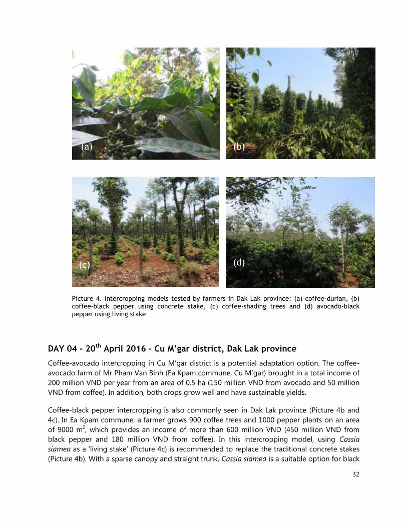
32
Picture 4. Intercropping models tested by farmers in Dak Lak province: (a) coffee-durian, (b) coffee-black pepper using concrete stake, (c) coffee-shading trees and (d) avocado-black pepper using living stake
DAY 04 - 20th April 2016 - Cu M’gar district, Dak Lak province
Coffee-avocado intercropping in Cu M’gar district is a potential adaptation option. The coffee-
avocado farm of Mr Pham Van Binh (Ea Kpam commune, Cu M’gar) brought in a total income of
200 million VND per year from an area of 0.5 ha (150 million VND from avocado and 50 million
VND from coffee). In addition, both crops grow well and have sustainable yields.
Coffee-black pepper intercropping is also commonly seen in Dak Lak province (Picture 4b and
4c). In Ea Kpam commune, a farmer grows 900 coffee trees and 1000 pepper plants on an area
of 9000 m2, which provides an income of more than 600 million VND (450 million VND from
black pepper and 180 million VND from coffee). In this intercropping model, using Cassia
siamea as a ‘living stake’ (Picture 4c) is recommended to replace the traditional concrete stakes
(Picture 4b). With a sparse canopy and straight trunk, Cassia siamea is a suitable option for black
(a) (b)
(c) (d)

33
pepper cultivation. Cassia siamea can also function as a windbreak and provide shade for other
crops.
In Cu M’gar, other intercropping trials, such as avocado-rubber-black pepper and coffee-fruit
tree-black pepper, are also being conducted by farmers. However, detailed information on these
trials could not be gathered for lack of time during the assessment visit.
About 8 km north of Ea Kpam commune, the coffee monocultures managed by the Ede minority
in Ea Tar commune are seriously affected by drought. In this commune, coffee is grown on a
small scale (1000-5000 m2), including separate fields in residential areas. The main water source
for irrigation is groundwater. This year, the severe drought resulted in a very low groundwater
table. A farmer in this commune reported that 30 m-deep wells are already depleted of water.
Freshwater supply is not even sufficient for domestic use.
Similar to what were observed in Kon Tum and Gia Lai province, the damage from drought in
Dak Lak can be clearly seen in coffee and rice, but effects are likely less apparent in other
perennial crops, such as cashew and avocado.
Picture 5. CGIAR team and coffee field in Ea Tar commune, Cu M’gar, Dak Lak

34
Appendix 2. Field visit program
18th
April, Monday
7:15- 8:50 Travel from Hanoi to Pleiku (Gia Lai province)
10:30 - 11:30 Travel to Kon Tum city by car (50km)
13:00 - 15:00 Site assessment in Kon Tum and Dac Ha district (25km)
15:00 - 17:00 Site assessment in Sa Thay district (Kon Tum) (20km)
17:00- 18:00 Travel from Sa Thay district to Pleiku (Gia Lai) (70km)
Stay overnight at Pleiku city
19th
April, Tuesday
8:00 - 12:00 Site assessment in sites in Dak Doa district and Pleiku city (20 km)
13:30 - 17:00 Travel from Dak Doa district to Chu Puh district via AH17 (50 km)
Stay overnight at Pleiku city
20th
April, Wednesday
7:30- 11:30 Travel from Pleiku (Gia Lai) to Buon Ma Thuot (Dak Lak) via AH17 (180km)
13:30-17:00 Site assessment in Krong Pak district (Dak Lak) (35km)
Stay overnight at Buon Ma Thuot
21st April, Thursday
8:30 - 11:30 Site assessment in Buon Don district (40 km)
13:30 - 16:00 Site assessment in Cu M’gar district (25 km)
16:00 – 17:00 Summarize findings and debrief the field report
Stay overnight at Buon Ma Thuot
22nd
April, Friday
9:55- 11:35 Travel back to Hanoi from Buon Ma Thuot (Dak Lak)

35
Appendix 3. Members of the Assessment Team
Name Position/Organization
1. Dr. Leocadio Sebastian
(Team leader) Regional program leader , CCAFS-SEA; Country
representative to Vietnam, International Rice Research
Institute (IRRI)
2. Dr. Bui Tan Yen Science officer, CCAFS-SEA, IRRI
3. Dr. Chu Thai Hoanh Principal scientist, International Water Management
Institute (IWMI)
4. Dr. Delia Catacutan Country representative of the World Agro-Forestry Center
(ICRAF)
5. Dr. Godefroy Grosjean Policy specialist, International Center for Tropical
Agriculture (CIAT)
6. Dr. Ma Lucila Lapar Senior Scientist, International Livestock Research Institute
(ILRI)
7. Dr. Le Ngoc Bau Director General, Western Highland Agriculture and
Forestry Science Institute (WASI)