the desert channels group natural resource management plan ... · desert channels group, what it...
TRANSCRIPT

The Desert Channels Group
Natural Resource Management Plan 2010-2015

The Desert Channels Natural Resource Management Plan 2010-2015 1
Contents
Contents ................................................................... 1
Glossary of terms ...................................................... 3
1: Executive summary ............................................... 4
2: Introduction to the natural resource management plan ..................................................... 8
2.1 Background ............................................................................ 8
2.2 Purpose and scope................................................................. 9
2.3 Our vision ............................................................................... 9
2.4 Plan review process ............................................................. 10
2.5 Legislative context ............................................................... 11
2.6 Regional planning framework .............................................. 12
3: The Desert Channels region ................................ 13
3.1 Overview .............................................................................. 13
3.2 A region with unique natural assets .................................... 14
3.2 Population ........................................................................... 15
3.3 Economy .............................................................................. 16
4: Planning principles .............................................. 17
4.1 Natural assets ...................................................................... 17
4.2 Land asset planning ............................................................. 18
4.3 Biodiversity asset planning .................................................. 20
4.3 Water asset planning ........................................................... 22
4.4 Community asset planning .................................................. 24
5: Risk assessment ................................................... 26
6: Monitoring, evaluation, reporting and improvement .......................................................... 29
6.1 Monitoring and evaluation .................................................. 29
6.2 Reporting ............................................................................. 33
6.3 Program and Plan Improvement ......................................... 34

The Desert Channels Natural Resource Management Plan 2010-2015 3
Glossary of terms
DCG The Desert Channels Group
MERI Monitoring, evaluation, reporting and improvement
NRM Natural resource management
WONS Weeds of national significance

The Desert Channels Natural Resource Management Plan 2010-2015 4
1: Executive summary
This is the second generation natural resource management plan prepared for the Desert Channels region (Queensland section of the Lake Eyre Basin). While this new planning framework has many common elements with the first plan, Protecting our Assets (2004), it also includes the program logic and monitoring, evaluation, reporting and improvement processes that have been adopted within the Australian Government’s natural resource management planning frameworks.
Over the past 6 years, Protecting our Assets guided the investment of $24.9 million that Desert Channels Group won for the region, from Australian and Queensland governments. Desert Channels Group has funded 480 projects on properties that cover almost half of the region’s 510,000 square kilometres. Weed control work across 800,000 hectares, improved management practices on 780,000 hectares of native vegetation, and protection of 99,000 hectares of significant ecological communities are among the highlights of the previous plan’s achievements.
As well as reviewing the outcomes of the previous plan’s 6 years, this plan plots a course for the next 5 years and beyond by outlining targets for 2015 and aspirational goals for 2050. It begins by recognising the current state of the region’s natural resources and articulating a set of goals, targets and actions that will guide community efforts. This provides a basis for strategic regional investment as well as establishing a framework for assessment and review of the plan, investment priorities and their outcomes.
This plan was developed through a series of community consultation meetings, as well as meetings with Government agencies, local government, the Remote Area Planning and Development Board and Agforce. Although this NRM plan is voluntary, with no statutory powers, it reflects and supports relevant Australian and Queensland government legislation that covers environmental protection, biodiversity conservation, land protection, cultural heritage and water, among others. It also links with, and assists in achieving, the NRM outcomes of the Central West Regional Plan which deals with sustainable growth of the region’s communities.
Agriculture remains the biggest employer in the region but the population is falling and aging. There is increasing pressure on sustainable natural resource management from resource exploration and mining, and a shrinking rural workforce. Relative to much of the rest of Australia, the landscape is largely unmodified and the unique natural assets in good condition. These assets, for the purposes of this plan, have been categorised as Land, Water, Biodiversity and Community.
As with any undertaking, there are a range of issues that can impact on the implementation of this plan and the successful achievement of its goals. These are identified, analysed and rated for their likely impact.
Desert Channels Group, what it does and how it operates and, by extension, this plan, is subject to a rolling process of monitoring, evaluation and reporting that drives continual improvement. The Desert Channels Natural Resource Management Plan 2010-2015 is a blueprint for the management of a unique part of Australia.
The Desert Channels Natural Resource Management Plan 2010-2015 5
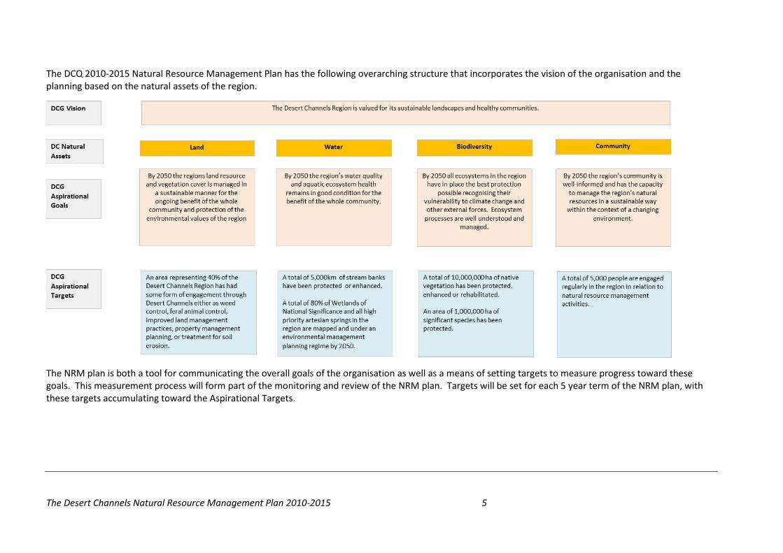
The DCQ 2010-2015 Natural Resource Management Plan has the following overarching structure that incorporates the vision of the organisation and the planning based on the natural assets of the region.
The NRM plan is both a tool for communicating the overall goals of the organisation as well as a means of setting targets to measure progress toward these goals. This measurement process will form part of the monitoring and review of the NRM plan. Targets will be set for each 5 year term of the NRM plan, with these targets accumulating toward the Aspirational Targets.

The Desert Channels Natural Resource Management Plan 2010-2015 6
The table below sets out the achievements toward the longer term aspirations recorded by DCG in the period of the previous NRM plan 2004 to 2010. Below the list of achievements are the targets to be achieved by 2015. This process sets S.M.A.R.T. (Strategic, Measurable, Achievable, Realistic and Timely) goals for DCG.

The Desert Channels Natural Resource Management Plan 2010-2015 7
A dashboard type of reporting framework will be used for annual updates on progress toward 2015 targets during the current 5 year NRM plan. The dashboard shows actual achievements in key measures (red) and the accumulated target for 2015.
- 1,000,000 2,000,000 3,000,000 4,000,000 5,000,000
2010
2015
Area of Land Engagement (ha)
Year
Land
0 500 1,000 1,500 2,000
2010
2015
Stream Banks Protected (km)
Year
Water
0 1,000,000 2,000,000 3,000,000 4,000,000
2010
2015
Ha of Natural vegetation protected, enhanced or rehabilitated
Year
Biodiversity - Native Vegetation
0 100,000 200,000 300,000 400,000
2010
2015
Area of significant species protected (ha)
Year
Biodiversity - Significant Species
0 500 1,000 1,500
2010
2015
Number of people engaged in natural resource management)
Year
Community
Actual achievement (2004- 2010)
DCG 2015 Targets

The Desert Channels Natural Resource Management Plan 2010-2015 8
2: Introduction to the natural resource management plan
2.1 Background
Desert Channels Queensland was formed in late 2002 as a largely government funded, community-based natural resource management organisation to deliver natural resource management outcomes for the Queensland section of the Lake Eyre Basin. The Desert Channels Group still retains this focus but has now broadened its business to include a natural resource management consulting business to further sustain and expand services to communities in the region. Since inception Desert Channels Queensland has been successful in winning $24.9 million in funding from the Australian and Queensland governments. This funding, along with the contribution from proponents, has achieved the following outcomes:
• 480 natural resource management projects on properties covering 40 percent of the region; • Control of weeds of national significance (WONS) and emerging pest plant species on approximately
800,000ha; • Feral animal control across 935,000ha; • Installation of 180 off-stream watering points protecting 398km of stream-bank vegetation; • Improved management practices enhancing 780,000ha of native vegetation; • Protection of 99,000ha of significant species and ecological communities; • Field days, training sessions, workshops and seminars to 3,787 people; and • Creation and circulation of more than 300 newsletters, posters, brochures and fact sheets.
The Desert Channels Group operates across one-third of the state and borders seven other regional bodies: four in Queensland and one in each of Northern Territory, South Australia and New South Wales. The region is a rich tapestry of landscapes and ecosystems, often in delicate balance within their ‘boom and bust’ cycles. Undoubtedly, its character has changed over the past 150 years, and it is facing new challenges as the 21st century rapidly unfolds. Ongoing work is needed to manage the region’s natural resources; this work includes weed and feral animal control, achieving best-practice groundcover management and conserving biodiversity.

The Desert Channels Natural Resource Management Plan 2010-2015 9
2.2 Purpose and scope
This plan provides a framework for the future management of the natural resources of the Desert Channels region. This is achieved by:
• Recognising the current state of natural resources in the region; • Establishing a structure of goals, targets and actions to focus all future effort on good NRM outcomes; • Providing a basis for strategic regional investment for a range of NRM outcomes; and • Establishing a framework for assessment and review of the
NRM plan, investment priorities and their outcomes.
The NRM plan integrates the natural assets of land, biodiversity, water and community within the all-encompassing vision to provide a holistic approach to managing natural resources in the Desert Channels region.
2.3 Our vision
”Sustainable landscapes, healthy communities”
The Desert Channels Natural Resource Management Plan 2010-2015 10
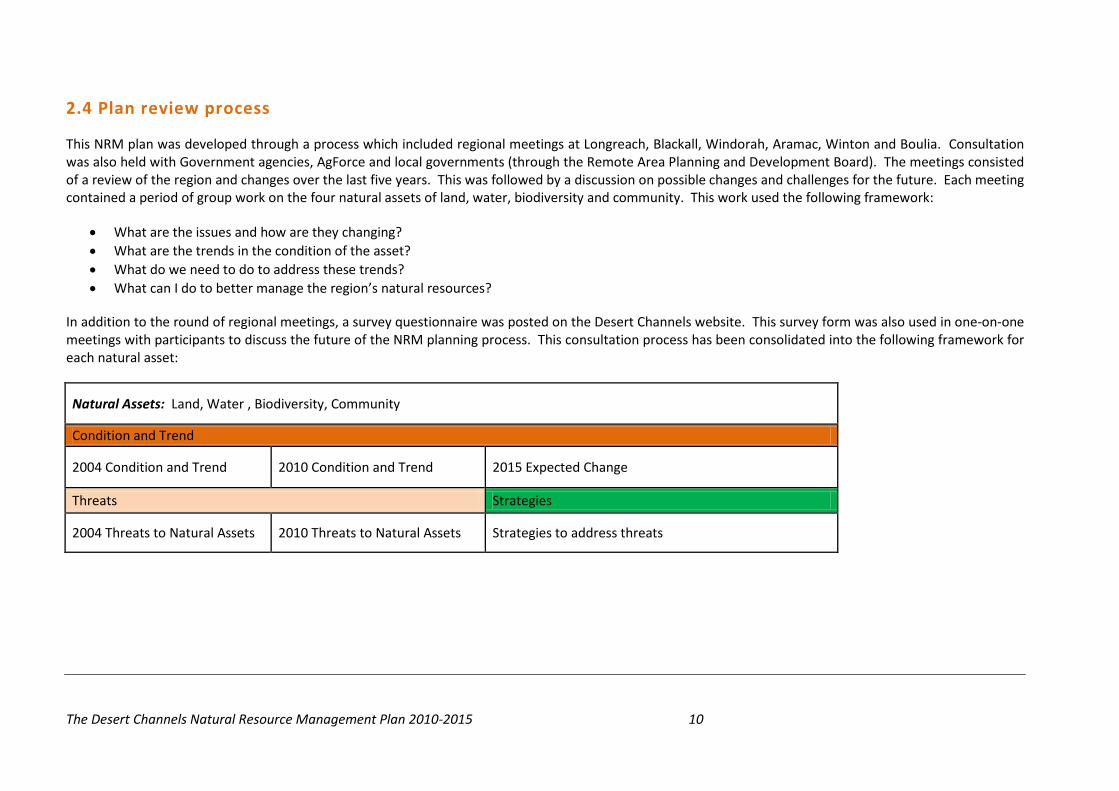
2.4 Plan review process
This NRM plan was developed through a process which included regional meetings at Longreach, Blackall, Windorah, Aramac, Winton and Boulia. Consultation was also held with Government agencies, AgForce and local governments (through the Remote Area Planning and Development Board). The meetings consisted of a review of the region and changes over the last five years. This was followed by a discussion on possible changes and challenges for the future. Each meeting contained a period of group work on the four natural assets of land, water, biodiversity and community. This work used the following framework:
• What are the issues and how are they changing? • What are the trends in the condition of the asset? • What do we need to do to address these trends? • What can I do to better manage the region’s natural resources?
In addition to the round of regional meetings, a survey questionnaire was posted on the Desert Channels website. This survey form was also used in one-on-one meetings with participants to discuss the future of the NRM planning process. This consultation process has been consolidated into the following framework for each natural asset:
Natural Assets: Land, Water , Biodiversity, Community
Condition and Trend
2004 Condition and Trend 2010 Condition and Trend 2015 Expected Change
Threats Strategies
2004 Threats to Natural Assets 2010 Threats to Natural Assets Strategies to address threats

The Desert Channels Natural Resource Management Plan 2010-2015 11
The NRM plan review process has been integrated with the Australian Government’s natural resource management planning framework incorporating a program logic that links the Desert Channels Group’s NRM goals and targets as follows:
• 2050 goals • 2050 targets • 2015 targets • Strategic management actions • Monitoring, evaluation, reporting and improvement processes
2.5 Legislative context
This plan has been developed to align with relevant Australian and Queensland Government legislation and assumes that statutory obligations are being addressed by those implementing targets and management actions contained in the plan. Although this NRM plan is voluntary and has no statutory powers, it reflects and supports the following relevant legislative instruments:
• Queensland Nature Conservation Act 1992 • Queensland Environmental Protection Act 1994 • Queensland Vegetation Management Act 1999 • Queensland Water Act 2000 • Queensland Land Protection (Pest and Stock Route Management) Act 2002 • Sustainable Planning Act (Qld) 2009 • Queensland Aboriginal Cultural Heritage Act 2003 • Commonwealth Environment Protection and Biodiversity Conservation Act 1999 • Commonwealth Water Act 2007

The Desert Channels Natural Resource Management Plan 2010-2015 12
2.6 Regional planning framework
The other guiding document for the community of the region is the Central West Queensland Regional Plan, which has been prepared by the Queensland Department of Infrastructure and Planning in consultation with local governments, community and industries of the seven Central Western Queensland local government areas: Barcaldine, Barcoo, Blackall-Tambo, Boulia, Diamantina, Longreach and Winton.
This plan, which has statutory powers consistent with the Sustainable Planning Act 2009 (Qld), deals with key issues for the sustainable growth of the communities of the region, including physical and social infrastructure and planning, as part of a wider process to ensure that a consistent and contemporary regional planning framework is operating for the whole of Queensland.
The Desert Channels NRM plan is linked to the Central West Queensland regional plan in that it will provide support, and assist in achieving the outcomes of the Central West Queensland Regional Plan in relation to natural resource management of the Desert Channels region.

The Desert Channels Natural Resource Management Plan 2010-2015 13
3: The Desert Channels region
3.1 Overview
The Desert Channels region is the Queensland section of the Lake Eyre Basin. Its 509,900 square kilometres consist of the Georgina, Diamantina and Cooper Creek catchments. The region’s unique biodiversity is reflected in the seven bioregions represented – Mount Isa Inlier, Mitchell Grass Downs, Desert Uplands, Simpson Strzelecki Dunefields, Channel Country, Mulga Lands and Brigalow Belt South.
The region supports many unique plants, animals and ecosystems, as well as a productive pastoral industry. This, coupled with the remoteness and vast area, poses many challenges for natural resource management.
Figure 1: Bioregions
Table 2: Regional snapshot
* Central West statistical division 2009
Desert Channels Regional Snapshot
Area 509,900 square kilometres
Population 11,302*
Unemployment 2.8%*
Value of agricultural production $325 million*
From an economic perspective, the major industries in the region are primary production (mostly rangeland grazing), tourism, government services and minerals and energy resources. From a socio-economic perspective, the significant trend over the past thirty years has been one of declining regional population. Town communities increasingly rely on tourism, government services and other service industries.

The Desert Channels Natural Resource Management Plan 2010-2015 14
3.2 A region with unique natural assets
Worth seeing, worth protecting ...
The Desert Channels region is that part of Queensland where the rivers run inland to Lake Eyre. Its ancient landscapes range from the western watershed of the Great Dividing Range, through open Mitchell grass plains, to the floodplains of the Channel Country and the sand dunes of the Simpson Desert. This region, with its seven bioregions, is the most diverse region in the State.
These mighty rivers of the inland rise in the north and east of Queensland’s outback and feed the wetlands and waterholes of the Channel Country, as well as the RAMSAR listed Coongie Lakes and Lake Eyre itself. With the demise of wetlands in the Murray-Darling Basin, those of the Lake Eyre Basin are critical breeding bastions for many of Australia’s water birds, and for a host of international migratory birds. The Diamantina and the Cooper are the most variable major rivers on the planet. These unique, largely unmodified rivers are also among the world’s last unregulated dry-land river systems.
The Desert Channels region supports many unique plants, animals and ecosystems. The Red-finned blue-eye is a fish found nowhere else in the world apart from a few shallow artesian springs north of Aramac. The ancient waddi
tree is restricted to three locations on the fringes of the Simpson Desert – two of them in the Desert Channels region. This area is the last Queensland stronghold of the once-abundant bilby, and the elusive night parrot, one of Australia’s rarest birds, last seen alive in the early 1900s, still clings to an enigmatic existence, while giving up an occasional body to confound.
This unique landscape and biodiversity is shared with the pastoral industry in a way that demonstrates how well-managed agriculture can co-exist with natural values. The region includes one of the largest areas of organic beef production in the world, driven principally by the natural irrigation of vast areas of highly productive Channels Country. The native pastures of the region are in remarkably good condition and our land managers are embracing sustainability and looking towards the future.

The Desert Channels Natural Resource Management Plan 2010-2015 15
3.2 Population
The population of the region has been both declining and aging. With the recent advent of resource exploration and development, there may be a halt to this decline and, in some areas, even a reverse. The following charts show the decline in population over time as well as the change in proportions of population in different age groups, with a general increase in the proportion of people over the age of 45 and a general decrease in the proportion of people under the age of 45 between 1999 and 2009. The data below relates to the Central West statistical division of Queensland, which is considered a best fit, as no statistical area, or grouping, aligns with the Desert Channels regional boundary. However, it is still only approximate. For instance, in 2003, the detailed analysis of ABS 2001 figures in relation to the Desert Channels regional boundary indicated a population of approximately 14,500, while that for the Central West statistical division of Queensland was 12,500. Regardless, subsequent trends would align with the graphs below.
Figure 2: Population trends
Source: QRSIS database (Central West Statistical Division)
10,600
10,800
11,000
11,200
11,400
11,600
11,800
12,000
12,200
12,400
12,600
1999 2000 2001 2002 2003 2004 2005 2006 2007 2008 2009Year
Central West QLD total population 1996 to 2009

The Desert Channels Natural Resource Management Plan 2010-2015 16
3.3 Economy
The major employer in the region is agriculture. In the 2005/06 financial year the gross value of agricultural production in the Central West Statistical Division was $325 million, which represents approximately 4 percent of the agricultural production in Queensland (QRSIS Database). The following charts show the employment by industry sector for the region.
Figure 3: Regional employment by industry Unemployment rates in the region have typically been lower than the state average as shown in the table below
Table 3: Unemployment rates
Source: ABS Census Data (Central West Statistical Division regional community profile)
Unemployment 2005 2006 2007 2008 2009 Central West SD 2.1% 1.7% 1.6% 1.9% 2.8% Queensland 4.9% 5.0% 4.0% 3.7% 4.4%

The Desert Channels Natural Resource Management Plan 2010-2015 17
4: Planning principles
4.1 Natural assets
The natural assets of the Desert Channels region have been divided into four main categories: land, water, biodiversity and community. Table 4 gives a brief description of each of these natural assets and the Aspirational Goal set by the DCG.
Table 4: The natural assets of the Desert Channels region Natural Asset
Asset Description Aspirational Goal
Land The rangelands pastures of the region produce in the vicinity of $325 million per annum as beef, sheep and wool. This wealth is generated by the healthy soils and vegetation cover of the land; for this to continue, sustainable management is critical.
By 2050 the regions land resource and vegetation cover is managed in a sustainable manner for the ongoing benefit of the whole community and protection of the environmental values of the region
Water Water in the region consists of surface water found in the streams and waterholes, along with ground water from shallow aquifers and the Great Artesian Basin. Good quality water is essential for stock and domestic consumption, ecosystem health, and recreation and mining. A prerequisite for good water quality is a healthy landscape and careful management of the resource.
By 2050 the region’s water quality and aquatic ecosystem health remains in good condition for the benefit of the whole community.
Biodiversity Biodiversity is all the life forms within a given ecosystem; it underpins the healthy environment on which all life depends. A characteristic of the region is its unique and diverse range of species and ecosystems.
By 2050 all ecosystems in the region have in place the best protection possible recognising their vulnerability to climate change and other external forces. Ecosystem processes are well understood and managed.
Community Our community is the social fabric and natural resource management capacity of the region. Protecting the region’s natural resources enhances the viability of the community and its ability to participate in NRM activities.
By 2050 the region's community is well-informed and has the capacity to manage the region's natural resources in a sustainable way within the context of a changing environment.

The Desert Channels Natural Resource Management Plan 2010-2015 18
4.2 Land asset planning
Condition and trends 2004 2010 Expected change – 2015
1. Recent drought conditions have caused a decline in land condition, pastures and vegetation.
2. Response of perennial pasture to recent rain has been sporadic in parts of the Mitchell Grass Downs and Desert Uplands.
3. Vegetation thickening and/or encroachment are having an adverse impact on the structure (changing biodiversity) and pasture (reduced grazing potential) in a number of gidgee, mulga and eucalypt communities.
4. Use of fire to manage vegetation is not common practice in many parts of the region (e.g. the Mitchell Grass Downs).
5. Recent assessment of land degradation is available in the Desert Uplands (condition generally good or better apart from some impacted sites) but information for the remainder of the region is dated and conflicting.
6. There is a need to assess the current extent of degradation (soil condition, ground cover, and vegetation condition) and identify susceptible land types.
1. Response of perennial pastures continues to be sporadic across the Mitchell Grass Downs.
2. Land condition continues to be vulnerable to drought.
3. Although the impact of some WONS species in parts of the region has been reduced through control efforts, in other parts of the region, weeds are spreading.
4. Emerging non-WONS species continue to be a threat (e.g. cactus and florestina).
5. Delbessie Agreement is emerging as a significant driver of land management outcomes on some of the leasehold land in the region.
6. There is more respect now for Indigenous knowledge of land management as well as recognition of cultural heritage.
7. Better seasons through much of the region and improved terms of trade have resulted in some of the best prospects for the grazing industries of the region.
8. Land values remain at historical highs through much of the region.
9. Alternative land uses (e.g. conservation holdings) are emerging as a force in the region.
1. Shared land use between resource companies (mining and energy) and landowners has potential to create conflict similar to that being experienced in other resource regions in Queensland.
2. Potential for organic industry to grow further.
3. Community will struggle to cope with new and emerging weeds.
4. Economic pressure on grazing enterprises is subject to changes in land values, which can make it difficult to access capital. When compounded by changing terms of trade, rising energy costs and declining labour availability could mean that expenditure on NRM will decline and pressure to use land unsustainably will increase.
5. More families living in town and more remote management of properties.
6. Potential for marginal land to be vacated and possibly returned to the crown leading to significant weed management issues.
7. Conversely, some potential for further expansion in alternative land holdings (e.g. conservation or carbon capture).
8. Potential for some loss of productive land as mining activities extend from the east. Mining may also bring increased spread of weeds.

The Desert Channels Natural Resource Management Plan 2010-2015 19
Land asset planning continued …
Threats to the asset Strategies 2004 2010 Strategies to address threats
1. Lack of baseline information and monitoring at the regional scale.
2. Climate variability (getting warmer and drier). 3. Vegetation thickening. 4. Exotic weed impacts. 5. Total grazing pressure (includes macropod impact). 6. Unsustainable grazing practices (not always
recognised due to incremental change and masking by climate variability).
7. High and rising land prices (relationship between land productivity/profitability and land price is poor). Increase in short-term landholding.
8. Declining number of people working the land and increasing economic pressures may result in short-term decision making.
9. Lack of regeneration of desirable pastures (caused by drought or grazing pressure).
10. Lack of appropriate fire management techniques. 11. Accelerated erosion (wind, water) caused by
overgrazing, poor road/track construction practices and visitor pressures.
12. Salinity (not immediate; will need to monitor; identify areas of risk).
13. Lack of rehabilitation after small-scale mining and road building activities.
14. Pollution (mining activity; chemical spills). 15. Lack of community knowledge to manage land
change impacts. 16. Limited ability to engage landholders positively in
current uncertain climate of vegetation management.
1. There is currently inadequate information on land degradation to enable identification of susceptible land types.
2. The potential impact of climate change on natural resource management is a concern.
3. Management of total grazing pressure in the region continues to be a problem.
4. There is better recognition of sustainable grazing management techniques in the region.
5. Land prices have plateaued, and have decreased in some cases. One of the drivers of this change is tighter access to finance for rural properties.
6. Properties bought for feed. 7. Absentee landowners. 8. Climate change. 9. Bushfire management. 10. Kangaroo management (total grazing pressure). 11. Mining and gas developments. 12. Energy and resources (cost of fuel). 13. Carbon trading.
1. Work with land managers and custodians through: • Incentives, • Training, • Sharing knowledge and information,
and • Reporting on outcomes
2. Influence natural resource management
outcomes in the region toward the 2050 aspirational goal of:
That by 2050 the region’s land resource and vegetation cover is managed in a sustainable manner for the ongoing benefit of the whole community and protection of the environmental values of the region.
3. Have a positive engagement with 40% of the
land area and 40 %of the land managers of the region by 2050, to create the momentum for change across the region.
4. Deliver of targeted incentives to
demonstrate effective change to mitigate the threats. These incentives would include: • Strategic weed control • Sustainable grazing management

The Desert Channels Natural Resource Management Plan 2010-2015 20
4.3 Biodiversity asset planning
Condition and trend 2004 2010 Expected change – 2015
1. Unique and diverse range of ecosystems (some are tolerant of high aridity; some rely on flooding of the vast floodplains).
2. Integrity of most ecosystems is good. 3. Desert Uplands bioregion is a declared ‘biodiversity
hotspot’. 4. The limited information that exists on biodiversity
values indicates that a significant part of the region’s biodiversity is still intact.
5. There are a number of species in the region that are endangered or vulnerable.
6. In some ecosystems, there are trends showing decline.
7. The greatest impacts on the biodiversity of the region are total grazing pressure and weed invasion.
8. Macropod numbers inflated in parts of the region due to increased artificial watering points and removal of wild dogs. Impacts of this are most evident during drought.
9. Key species and ‘of concern’ ecosystems still need to be identified and quantified.
10. Broader community doesn’t understand value of preserving ‘on property’ biodiversity, and the accompanying benefits to land and production.
1. Integrity of most ecosystems is good in a region noted for its diverse range of ecosystems.
2. The greatest impacts on the biodiversity of the region are total grazing pressure, weed invasion and inappropriate fire management.
3. Macropod numbers inflated in parts of the region due to increased artificial watering points and removal of wild dogs. Impacts of this are most evident during drought.
4. Knowledge of the biodiversity of the region and the factors impacting upon it are still relatively poor.
5. There is an improvement in the recognition of the role of biodiversity in overall land management.
6. There is an increase in the number of landowners seeking biodiversity or vegetation off-sets.
7. Regional biodiversity planning has improved and will continue to be refined.
8. Incentives exist to adopt best environmental practice and to encourage conservation agreements.
1. Impact of weeds will continue. 2. Economic pressure may have an adverse
impact on biodiversity through grazing pressure.
3. Increased private nature conservation. Increased use of biodiversity off-sets.
4. More opportunity to react to real or perceived threats to biodiversity. (e.g. night parrots or high value Regional Ecosystems)

The Desert Channels Natural Resource Management Plan 2010-2015 21
Biodiversity asset planning continued …
Threats to the asset Strategies 2004 2010 Strategies to address threats
1. Weeds and feral animals. 2. Inappropriate land clearing. 3. Unsustainable grazing practices. 4. Declining numbers of people working the land and
increasing economic pressures may result in short-term decision making.
5. Increased area of the region subjected to grazing pressure due to improvements in water infrastructure (may impact on areas that are refuges for biodiversity).
6. Lack of incentives to adopt best environmental practice and to encourage conservation agreements.
7. Visitor impacts are not being adequately managed in some areas.
8. Mining practices in sectors such as opal and gypsum where environmental compliance is low.
9. Poor information base (need for complete surveys of ecosystems / flora / fauna).
10. Refugia for some species are not well understood. 11. Lack of understanding by community of the role of
biodiversity an ecosystem functions. 12. Ecosystems/species are most vulnerable during
drought, which may be worsened by climate change. 13. Climate change may reduce rainfall in the region and
increase stress on ecosystems. Resilience of ecosystems to these threats is not well understood.
14. Limited ability to engage landholders positively in current, uncertain climate of vegetation management.
1. Tourism activity has potential for detrimental environmental and biodiversity impacts.
2. Low levels of environmental compliance in some mining sectors are causing concern.
3. Macropods are a big issue in parts of the region. 4. Domestic companion animal management (wild
dogs) 5. Threatened species recovery plans are limited. 6. Mining and gas developments have potential to
impact on the biodiversity in the region. 7. National Parks management in the region is
improving; however, still needs more resources. 8. Increase in the area of land owned for conservation
and nature refuges in the region creating increased management issues in relation to weed and feral animal control.
9. The value of wildlife corridors is not fully recognised in the region.
Work with land managers and custodians of the land through;
• Incentives • Training • Sharing knowledge and information • Reporting on outcomes • Record and use Indigenous knowledge
to better manage biodiversity • Increased understanding of carbon
capture in the rangelands
Influence natural resource management outcomes in the region toward the 2050 aspirational goal of: By 2050 all ecosystems in the region have in place the best protection possible recognising their vulnerability to climate change and other external forces. Ecosystem processes are well understood and managed.
Positively engage with 40% of the land area and 40% of the land managers of the region by 2050, to create the momentum for change across the region.
Engage with 20% of the region to have in place some form of protection in relation to native vegetation by 2050.
Engage with 2% of the region (1,000,000ha) to have in place some form of protection in relation to significant species by 2050.

The Desert Channels Natural Resource Management Plan 2010-2015 22
4.3 Water asset planning
Condition and trend 2004 2010 Expected change – 2015
1. No recent systematic survey available of wetland areas or riparian condition assessment.
2. Many riparian areas adversely impacted by weeds and feral animals.
3. Excessive stock pressure is impacting on some waterholes and riparian areas.
4. Water quality is generally good but is threatened by point impacts such as town sewage, stock watering, groundwater discharges and visitor pressures.
5. Artesian springs are inadequately protected and managed. Threats include loss of flows due to declining GAB pressure, feral animals and stock pressure.
6. There are a limited number of in-stream storages (weirs) but most do not have structures to allow fish movement during low flows.
7. Impact from noxious fish species is low at present (need for constant monitoring).
8. No major water extractions, but urban and stock water demands in drought times can impact significantly on waterholes.
9. Small scale irrigation at present (some sections of the community keen to pursue it).
10. Lack of knowledge on true impacts of removing water, and a need for more research on aquatic ecosystem processes.
1. Wetlands mapping now available for most of the region.
2. Limited systematic information on riparian condition.
3. Some riparian areas continue to be affected by weeds and feral animals.
4. Protection of artesian springs has improved with the GAB bore capping program and establishment of both private and public conservation reserves.
1. Wild Rivers Declarations are in place and associated management activities are appropriately resourced.
2. The current GAB program will be completed in 2014 and artesian water pressure will be at a sustainable use level.
3. Monitoring of mining impacts on the re-charge areas of the GAB is under way.
4. Increasing mining activities will increase the risk of contamination of surface water.
5. Coal Seam Gas projects will increase the risk of cross aquifer contamination.

The Desert Channels Natural Resource Management Plan 2010-2015 23
Water asset planning continued …
Threats to the asset Strategies 2004 2010 Strategies to address threats
1. Pollution (chemical, sewage discharge from towns, groundwater discharge).
2. Inefficient water use (urban, stock and irrigation). 3. Declining numbers of people working the land and
increasing economic pressures may result in short-term decision making.
4. Unsustainable grazing practices, especially in riparian areas (leading to stream-line siltation, nutrient accumulation, loss of vegetation and soil).
5. Invasive species (e.g. fish/aquatic plants, feral animal and weed).
6. Barriers to fish movement during low flows. 7. Lack of understanding in the community of aquatic
ecosystem processes. 8. Excessive water extraction during drought (pressure
on refuges for biodiversity). 9. Spread, via bore drains, of weeds, ferals and potential
noxious fish (e.g. Gambusia). 10. Loss of pressure in Great Artesian Basin. 11. Poor management of mound springs (loss of
biodiversity). 12. Cumulative impact of water storage developments.
1. Potential increased threats to the ecosystems in the region as a result of mine waste spills.
2. Water use efficiency is improving; however, it still has room for improvement.
3. Increased awareness of the impact of grazing on riparian areas.
4. Threats from invasive species (e.g. fish/aquatic plants, feral animal and weed) continues to be a problem in managing riparian areas.
5. Reduction in the spread of weeds through open bore drains.
6. Improvement in pressure in GAB due to bore capping program.
7. Uncertainty over the impact of the Wild Rivers Declaration in some areas in the region.
8. Improved management of mound springs through establishment of conservation reserves (Elizabeth Springs – DERM, and Edgbaston – Bush Heritage).
9. Potential impact on ground water from mining and gas developments in the region.
10. Climate change may have an impact on the duration of 'no-flow' periods.
11. Climate change may already be impacting on surface water availability.
Work with managers and custodians of the land through:
• Incentives • Mapping • Protection of stream banks • Protection of wetland areas • Reduced erosion • Improving understanding of the role of
water in ecosystem processes Influence natural resource management outcomes in the region toward the 2050 aspirational goal for the region’s water natural asset:
By 2050 the region’s water quality and aquatic ecosystem health remains in good condition for the benefit of the whole community.
Undertake to have 5,000 km of stream banks protected or enhanced by 2050. Undertake to have 80% of Wetlands of National Significance and all high priority artesian springs in the region mapped and under an environmental management planning regimes by 2050.

The Desert Channels Natural Resource Management Plan 2010-2015 24
4.4 Community asset planning
Condition and trend 2004 2010 Expected change – 2015
1. Declining population across the region. Significant impact on some communities with declining employment opportunities because of the shift from sheep to cattle.
2. Lack of information (education/awareness is critical to engaging broader community).
3. Reduction in Landcare group activity across the region due to drought and lack of funding opportunities.
4. Regional NRM process is not widely known or understood. 5. Concern that regional NRM groups are ‘big brother’ and
will regulate/legislate. 6. Local government becoming more active in NRM (pest
control, stock routes, planning, water and waste management).
7. Community of the region continues to rely on effective partnerships with government to deliver technical support and project management.
8. Non-Indigenous heritage of the region is well understood and promoted through the establishment of dedicated facilities (e.g. Australian Stockman’s Hall of Fame, Waltzing Matilda Centre).
9. Indigenous community is fragmented in much of the region and is poorly engaged in NRM.
10. There is inadequate information and understanding of Indigenous Cultural Heritage.
11. A common fear amongst landholders is that Indigenous Cultural Heritage assets are a liability; may result in loss of control or interference with their land management.
12. Partnerships in the community to manage cultural heritage are inadequately developed.
1. Population decline may have stabilised and may increase with resource developments in and near the region.
2. Resource development in the region will increase competition for limited labour resources; land managers have a much more limited ability to attract skilled staff.
3. Landcare groups have re-activated in some parts of the region.
4. There is increased activity and engagement with the Indigenous community on natural resource management and other issues in the region.
5. Increased use of carbon trading, biodiversity offsets.
6. The Indigenous community of the region has come together to discuss NRM issues and develop projects through the Georgina, Diamantina, Cooper Aboriginal Group. There has been an improvement in the information and understanding in relation to Indigenous Cultural Heritage.
7. There are a number of joint cultural heritage protection projects in partnership with landholders in the region.
8. Partnerships in the community to manage cultural heritage are being developed.
1. Some urban communities in the region may grow with resource developments and 'tree change' in habitants.
2. More tourism visitors to the region subject to the cost of energy (fuel).
3. By 2015 the regional road network will have improved significantly, making travel in the region more accessible to standard vehicles.
4. Increased energy cost due to shortage in global energy supply.
5. Increased internet speed could reduce the need for travel for specialist medical services, increase collaboration and innovation by providing means for sharing data in real time and increase technological monitoring of properties by managers and remote managers. Some small communities may continue to contract as goods and services can be more readily sourced from outside the area.

The Desert Channels Natural Resource Management Plan 2010-2015 25
Community asset planning continued …
Threats to the asset Strategies 2004 2010 Strategies to address threats
1. Lack of engagement. 2. Misconceptions about NRM and regional bodies. 3. Lack of funding opportunities. 4. Lack of economic and social opportunities. 5. Enterprise viability. 6. Drought management policies and practices. 7. Population drift from the region. 8. Ageing population (especially among land managers). 9. Reductions in government services. 10. Questionable capacity of local government to deal with
issues previously seen as State Government business. 11. Lack of understanding of Indigenous heritage. 12. Lack of understanding and confidence by the Indigenous
community in the area of natural resource management. This is matched by a lack of understanding in the broader community of the potential benefits of Indigenous involvement in NRM.
13. Lack of appreciation, or inadequate recording, of heritage assets may result in loss or damage.
14. The size of the region, small population and the vast number of heritage sites (both Indigenous and non-Indigenous) means that resources available for recording sites and managing them are limited.
15. Difficulty in preventing unauthorised access to sites by tourists/visitors in such a vast landscape.
1. Succession management is a significant problem for landowners transitioning to the next generation.
2. Low generational renewal leading to reduced energy, innovation and capacity for NRM activities.
3. No regional strategy for recycling. 4. With return of wetter seasons there has been
a decline in infrastructure conditions (rail and road).
5. Increase in absentee landowners in the region, less people running more country, which has an impact on the whole community.
6. Potential for mining and gas development to change the nature of regional communities.
7. Energy and resources (cost of fuel), increased electricity costs and increased interest in renewable energy in the region including solar and geothermal.
Promote engagement in natural resource management in the communities of the region through:
• Dissemination of information • Research and development • Workshops and field days • Support of Research and Development
in the region promoting increased knowledge about NRM issues
Influence natural resource management outcomes in the region toward the 2050 aspirational goal for the region’s community natural asset:
By 2050 the region's community is well-informed and has the capacity to manage the region's natural resources in a sustainable way within the context of a changing environment.
Positively engage with 5,000 people (representing approximately 40% of the population) in the region on an ongoing basis by 2050 to create the momentum for change.

The Desert Channels Natural Resource Management Plan 2010-2015 26
5: Risk assessment
Every activity or undertaking has a degree of risk to it. Sometimes, these risks are so outweighed by the benefits, that they aren’t even recognised; at other times, the risks are so great that an activity should not be pursued. An assessment of the risks associated with implementing this NRM plan has been undertaken by DCG. This risk analysis involved examining non-measurables like, ‘why landholders participate in NRM activities’, or ‘why they trust DCG’ (qualitative analysis), and working through the comparative risks. Both the ‘likelihood of occurrence’ and the ‘severity of the consequences’ were expressed using descriptions. These likelihoods and consequences were then assigned ratings in decreasing ‘order of likelihood’ and ‘severity of consequence’. The following tables illustrate the risk rating and description scheme for likelihood and consequences.
Table 5: Measures of likelihood Rating Category Description 1 Very Likely Is expected to occur in most circumstances 2 Likely Will probably occur in most circumstances 3 Unlikely Could occur sometime 4 Very Unlikely May occur, but only in exceptional circumstances
Table 6: Measures of consequences Rating Category Description
1 Catastrophic Causes serious environmental damage; huge financial loss; catastrophic effect on community and industry
2 Critical Causes detrimental environmental impacts on the region; major financial loss; major detrimental effect on community and industry
3 Marginal Causes marginal detrimental environmental impact on the region; moderate financial loss; moderate detrimental effects on community and industry
4 Negligible Causes no significant environmental impact on the region; low financial loss; no detrimental effect to community and industry

The Desert Channels Natural Resource Management Plan 2010-2015 27
The following table illustrates the risk assessment matrix.
Table 7: Risk assessment matrix
Consequences
Catastrophic Critical Marginal Negligible
Like
lihoo
d Very Likely 1 2 3 4 Likely 2 4 6 8 Unlikely 3 6 9 12 Very Unlikely 4 8 12 16
The ratings from the risk assessment matrix above have been categorised as follows:
• 1-2 Extreme risk: detailed research and management planning required at senior levels • 3-4 High risk: senior management attention – substantial and site-specific controls required • 6-12 Moderate risk: management responsibility must be specified • 12 -16 Low risk: manage by routine procedures
Table 8: Results from risk assessment Issue Impact Likelihood Consequence Risk Rating Risk Mitigation actions
Changes in government legislation and/or policies for funding community NRM activities
Reduced funding available for NRM community groups such as DCG and Landcare (e.g. core costs may be no longer covered by State or Commonwealth Governments)
Likely Critical 4 1. Continually monitor and seek out opportunities across all relevant State and Commonwealth Departments
2. Develop and implement an appropriate lobbying strategy with like-minded organisations.
3. Diversify income sources with the development of commercial consulting services.

The Desert Channels Natural Resource Management Plan 2010-2015 28
Table 8 continued …
Issue Impact Likelihood Consequence Risk Rating Risk Mitigation actions Industry cooperation Unable to gain sufficient
industry cooperation to meet participation rates required in targets
Unlikely Marginal 9 Maintain regular communication with industry groups. Offer assistance for lobbying NRM support at commonwealth, state and local levels. Develop tools that offer direct benefit to industry participants, as well as providing activity-based NRM education and learning opportunities.
Community cooperation Unable to gain sufficient community cooperation to meet participation rates required in targets
Unlikely Marginal 9 Maintain regular community communication across the region. Create opportunities for engagement in NRM activities. Develop activity-based NRM education and learning tools that promote individual and community engagement. Develop partnerships and joint ventures with community organisations to delivery NRM benefits.
Climate change Changed landscape function in response to long-term climate change
Unlikely Critical 4 Develop adaptive management processes that provide early warning signals of stress within the ecosystems of the region.
Mining and gas development
Potential impacts are: underground water quality; surface disturbance of the landscape; availability of workforce participants; and changes in community structure.
Likely Critical 4 Ensure that DCG is engaged in the NRM related aspects of the mining and gas developments so that impacts can be understood and plans adapted. Develop services that can support land managers in relation to NRM issues in the face of mining and gas developments.
The Desert Channels Natural Resource Management Plan 2010-2015 29
6: Monitoring, evaluation, reporting and improvement
6.1 Monitoring and evaluation
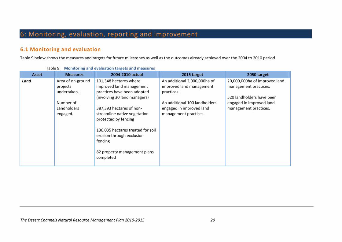
Table 9 below shows the measures and targets for future milestones as well as the outcomes already achieved over the 2004 to 2010 period.
Table 9: Monitoring and evaluation targets and measures Asset Measures 2004-2010 actual 2015 target 2050 target
Land Area of on-ground projects undertaken. Number of Landholders engaged.
101,348 hectares where improved land management practices have been adopted (involving 30 land managers) 387,393 hectares of non-streamline native vegetation protected by fencing 136,035 hectares treated for soil erosion through exclusion fencing 82 property management plans completed
An additional 2,000,000ha of improved land management practices. An additional 100 landholders engaged in improved land management practices.
20,000,000ha of improved land management practices. 520 landholders have been engaged in improved land management practices.
The Desert Channels Natural Resource Management Plan 2010-2015 30
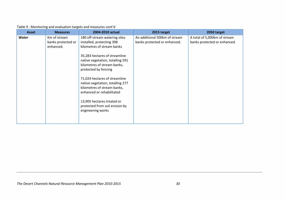
Table 9 : Monitoring and evaluation targets and measures cont’d Asset Measures 2004-2010 actual 2015 target 2050 target
Water Km of stream banks protected or enhanced.
180 off-stream watering sites installed, protecting 398 kilometres of stream banks 35,283 hectares of streamline native vegetation, totalling 591 kilometres of stream-banks, protected by fencing 71,024 hectares of streamline native vegetation, totalling 277 kilometres of stream-banks, enhanced or rehabilitated 13,905 hectares treated or protected from soil erosion by engineering works
An additional 500km of stream banks protected or enhanced.
A total of 5,000km of stream banks protected or enhanced.

The Desert Channels Natural Resource Management Plan 2010-2015 31
Table 9 : Monitoring and evaluation targets and measures cont’d Asset Measures 2004-2010 actual 2015 target 2050 target
Community Number of community members regularly engaged in NRM activities. Number of people regularly receiving newsletters. Number of workshops, seminars, training sessions, demonstrations and field days. Attendees at workshops, seminars and training sessions.
125 demonstrations and field days attended by 1,457 people 260 workshops, seminars and training sessions attended by 2,330 people 310 newsletters, posters, brochures and fact sheets developed and disseminated to 43,927 people 47 research and development studies completed
An additional 500 community members regularly engaged in NRM activities.
5,000 community members are regularly engaged in NRM activities.

The Desert Channels Natural Resource Management Plan 2010-2015 32
Table 9 : Monitoring and evaluation targets and measures cont’d Asset Measures 2004-2010 actual 2015 target 2050 target
Biodiversity Area of native vegetation protected or enhanced.
803,389 hectares covered by weed control measures 935,090 hectares covered by feral animal control measures 180 off-stream watering sites installed, protecting 398 kilometres of stream banks 35,283 hectares of streamline native vegetation, totalling 591 kilometres of stream-banks, protected by fencing 71,024 hectares of streamline native vegetation, totalling 277 kilometres of stream-banks, enhanced or rehabilitated 752,804 hectares of non-streamline native vegetation enhanced or rehabilitated 98,702 hectares protected by fencing, specifically for significant species or ecological communities
An additional 1,000,000ha of native vegetation has been protected or enhanced. An additional 100,000ha of significant species have been protected.
10,000,000ha of native vegetation has been protected or enhanced. 1,000,000ha of significant species have been protected.
The Desert Channels Natural Resource Management Plan 2010-2015 33
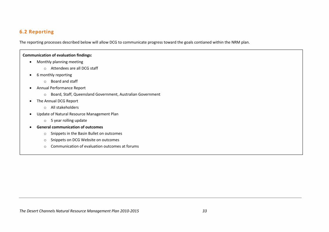
6.2 Reporting
The reporting processes described below will allow DCG to communicate progress toward the goals contianed within the NRM plan.
Communication of evaluation findings:
• Monthly planning meeting
o Attendees are all DCG staff
• 6 monthly reporting
o Board and staff
• Annual Performance Report
o Board, Staff, Queensland Government, Australian Government
• The Annual DCG Report
o All stakeholders
• Update of Natural Resource Management Plan
o 5 year rolling update
• General communication of outcomes
o Snippets in the Basin Bullet on outcomes
o Snippets on DCG Website on outcomes
o Communication of evaluation outcomes at forums

The Desert Channels Natural Resource Management Plan 2010-2015 34
6.3 Program and Plan Improvement
6.3.1 Program Improvement Each program undertaken by DCG will contain a Monitoring, Evaluation, Reporting and Improvement plan as part of the management of that
program. This process will identify key learnings and outcomes from each program and enable this information to inform future programs for improvement management and delivery of outcomes.
6.3.2 Plan Improvement Reporting on the NRM plan will form part of the DCG 6 monthly and annual reporting framework. The NRM Planning process is based on a
5 year rolling plan with the next plan due to be developed in 2015. At this time the existing plan will be reviewed with the learnings from that plan incorporated into the new plan.