the cosna-nowitna. region, alaska - u.s ... cosna-nowitna region, alaska. by henry m. eakin. field...
TRANSCRIPT

DEPARTMENT OF THE INTERIORFRANKLIN K. LANE, Secretary
UNITED STATES GEOLOGICAL SURVEYGEORGE OTIS SMITH, Director
Bulletin 667
THE COSNA-NOWITNA. REGION, ALASKA
BY
HENRY M. EAKIN
%A;
WASHINGTONGOVERNMENT PRINTING OFFICE
1918

ADDITIONAL COPIESOF THIS PUBLICATION MA\ BE PROCURED FROM
THE SUPERINTENDENT OF DOCUMENTSGOVERNMENT PRINTING OFFICE
WASHINGTON, D. C.
AT
25 CENTS PER COPY

CONTENTS.
Page.Preface, by Alfred H. Brooks................................................ 5Field work.I............................................................... 7Previous explorations....................................................... 8Geography. ......................................................."......... 9
Topography ......................................................... 9Location and extent of the area.................................... 9Relief............................................................ 10Drainage......................................................... 11
, Climate........................................................... 14Forests and vegetation....'.............:...............'................. 16Fish and game.......................................................... 17Soils and agriculture.................................................... 17Inhabitants................... r ....................................... 18Routes of travel......................................................... 18
Geology.................................................................. 19General features....................................................... 19Stratigraphy....:..................................................... 20
Groups and sequence............................................... 20Pre-Ordovician limestones and greenstones..... 1..................... 20Pre-Ordovician schists and quartzites................................ 21Ordovician limestones ............................................. 23
' Devonian limestones and slates.................................... 25Diabases and basalts .............................................. 27Quartzites and phyllites............................................. 28Grits and sandstones............................................... 29Cherts and slates. ...................'............................. 30Younger volcanic rocks............................................. 33Granitic intrusives................................................ 34Unconsolidated sedimentary deposits............................... 35
Structure................'............................................. 36Geologic history............................................................ 38
Principal events ..................................................... 38Pre-Ordovician sedimentation........................................... 39Pre-Ordovician diastrophism and erosion................................. 39Ordovician or earlier sedimentation.................................... 39Pre-Devonian uplift and erosion.......................................... 40Devonian sedimentation................................................ 40Carboniferous time..................................................... 40Early Mesozoic sedimentation............................:............. 40Later Mesozoic diastrophism....'......................................... 41Late Mesozoic or early Tertiary diastrophism and volcanism............... 41Tertiary erosion....................................................... 41Early Quaternary inundation and sedimentation......................... 42Recent erosion......................................................... 42
3.

4 CONTENTS.
Page.Geomorphology........................................................... 42
Outline........................... ; ...............:................... 42Tertiary erosion......................................................... 42Early Quaternary sedimentation......................'......'........... 43Recent erosion........................................................... 48
Economic geology.......................................................... 50Veins and mineralization................................................ 50Prospecting. .............................................I............ 51
Index..................................,.......:......................... 53
ILLUSTRATIONS.
PLATE I. Topographic reconnaissance map of the Cosna-Nowitna region,Alaska........................................:...........In pocket.
; II. Geologic reconnaissance map of the Cosna-Nowitna region,Alaska....................................................In pocket.
III. A, Open birch forest on high, well-drained slopes near camp 27;B, North Pork-of Kuskokwim River near camp 15............... 14
IV. A, Cherty pre-Ordovician limestone, 2 miles northeast of camp 41; B, Thin-bedded slate and limestone member of schist-quartzite group 2 miles southeast of camp 32.............................. 20
V. A, Characteristic topography of Ordovician limestones where steeply tilted, looking north from a point half a mile southeast of camp 37; B, Massive Ordovician limestones 1,500 feet below fossil horizon, 3*miles north of camp 36........................................ 24
VI. A, Thin-bedded Ordovician limestones underlying fossiliferous member, looking northeast from fossil locality 1 mile northwest of camp 36; B, Hogback ridge supported by upper limb of recumbent synclinal fold. ............................................... 26
VII. A, Plat summit and terraces due to altiplanation on granite mountain2 miles southwest of camp 24; B, View looking down on terraced spur from the flat-topped mountain at the south end of the diabase- basalt area..................................................... 48
VIII. A, View looking down the course of a recent landslide in the uplands between camps 12 and 13; B, Folds in turf where part of the slide came to rest................................................... 50 . *
FIGURE 1. Index map showing relation of the Cosna-Nowitna region to otherdistricts of interior Alaska...................................... 7
2. Sketch map of an area of silt plains 15 miles southeast of Cbsna,showing scarp line crossed by modern intrenched drainage...... 11
3. Geologic cross section along line A-B on Plate II, near camp 33, showing unconformity and faulting between schist-quartzite group and Ordovician limestone.............................. 23

PREFACE.
By ALFRED H. BROOKS.
The completion id 1911 of the geologic and topographic recon naissance surveys of the Yukon-Tanana region, which includes most of the older inland-placer districts, has made funds available to extend surveys into other regions. Therefore, during the last five years extensive surveys have been made in the Yukon basin below Tanana River and in the Kuskokwim basin. There are still enormous unsurveyed areas in this part of Alaska, yet the surveys of districts in which the greatest mining development has taken place, including the Ruby, Innoko, and Iditarod placer camps, have now been com pleted. There remained unexplored, however, a large area between the Ruby district and the Yukon-Tanana region. Much of this area was known to be a great lowland that affords little promise of mineral wealth. South of this lowland, however, there are highlands that promise both to furnish a feasible route of travel for pack trains and to yield information on the character of the bedrock terranes. An exploration of this -field was therefore decided upon, and the task was assigned to Mr. Eakin. As Mr. Eakin had no technical assistant he not only studied the geology of the area he traversed but also made his own topographic base map.
The results of these studies, which are here set forth, show that the geology presents much variety and that many of the rock terranes recognized in this field can not yet be definitely correlated with the formations in other parts of the Yukon basin. Yet by this survey the age of at least two formations the Ordovician and Devonian limestones have been pretty definitely established, and these deter minations will help to solve some of the stratigraphic problems of central Alaska. In the writer's opinion the correlation of the pre- Ordovician metamorphic sediments of the Cosna-Nowitna region with the Birch Creek schists of the Yukon-Tanana region also seems justi fied. Mr. Eakin'has not definitely determined the age of the younger sedimentary rocks that are provisionally assigned by him to the upper Paleozoic and Mesozoic. He points out the difficulty of correlating them either with the rocks of the Yukon-Tanana region to the north or with those of the Alaska Range to the southeast. In the Alaska Range profound thrust faulting has much complicated the structure
5

6 PREFACE.
and has made the determination of the sequence difficult, and' the writer would suggest that similar complication may exist in the adjacent parts of the Cosna-Nowitna region. Here, in consequence of the dearth of good exposures, displacements might easily be over looked during a rapid exploration. Additional information will be obtained on some of these problems by geologic studies of the Kan- tishna. district and adjacent portions of the Minchumma Lake region which are now under way.
The region described in this bulletin has produced no mineral wealth, and, though auriferous gravels have been found at a few localities, no placers have been discovered that would justify exploi tation. Mr. Eakin points out that gold placers are most likely to be found on streams where the overburden is probably very deep. It is therefore not a field that will be attractive to the prospector. On the other hand, some of the geologic formations are similar to those which are gold-bearing in districts on the northeast and on the northwest. Moreover, at a few localities Mr. Eakin discovered some evidence of slight mineralization, and placers may therefore possibly be found in the Cosna-Nowitna region. As he states, search for gold in streams that cross the granite contacts is most likely to be successful.
The region as a whole is fairly accessible, because many of the streams are navigable for small boats. It is well timbered and includes much fertile land similar to that near Fairbanks.

THE COSNA-NOWITNA REGION, ALASKA.
By HENRY M. EAKIN.
FIELD WOKK.
The term "Cosna-Nowitna region" is used to designate the general Tukon-Kuskokwim drainage area from the longitude of Cosna west ward to Nowitna River. (See fig. 1.) Prior to 1915 the topography and geology of this region were practically unknown. Only a few prospectors had visited it, and it had no particular known economic importance. However, problems that had arisen in the course of
146°
FIQURE 1. Index map showing relation of the Cosna-Nowitna region to other districts of interior Alaska.
geologic investigations in adjacent regions made its exploration desirable, and the work was undertaken during the summer of 1915 by a small Geological Survey party in charge of the writer. A brief summary of the results of the work has already been published.1
» Eakin, H. M., An exploration in the Cosna-Nowitna region: U. S. Geol. Survey Bull. 642, pp. 211-221,r 1916.
7

8 COSNA-NOWITNA REGION, ALASKA.
The party included, besides the writer, four camp men for the first two weeks and two for the remainder of the season. A pack train of seven horses was used for transportation. Field work was begun on June 12, 1915, on the south bank of Tanana River about 2 miles above the native village of Cosna, at a point where a special landing was kindly made by the officers of the Alaska Yukon Transportation Co.'s steamboat Alaska. From this point a pace traverse was carried southward across a broad alluvial plain east of Cosna River for about 30 miles, to the first bedrock hills of the main upland. Here a base line was measured, and plane-table work was begun. "The traverse was extended, first, southward to the vicinity of Lake Minchumina, then northwestward to the headwaters of Chitanana (Redlands), River, and then in a general southwesterly direction to Nowitna River at the mouth of the Sulukna. The work was then expanded, first southward to the head of the Sulukna and then northward to the Nowitna at the head of the canyon, a little above the mouth of Titna River. Here the four remaining horses were abandoned, a raft was built, and observations were continued along Nowitna River to its mouth, which was reached September 3. About 300 linear miles was covered by the pack train. Traverses made by the writer amounted to considerably more. About 2,600 miles was mapped topographically on a scale of 1:180,000. Areal geology was mapped on the same scale over most of the area covered by the topographic work.
During the same season a Survey party in charge of C. E. Giffin, working in the Ruby district, extended topographic surveys eastward to the Nowitna, ran a traverse of that river from the canyon to its mouth, and mapped the topography of the country near the river. (See PI. I, in pocket.) The two surveys touched at many points, and the elevations and positions determined independently for these points were found to be in practical agreement.
PREVIOUS EXPLORATIONS.
Before the exploration of 1915 much of the Cosna-Nowitna region was little known except to the natives and to a few prospectors, but its eastern part had been frequently traversed by white men. A long-established native route of travel leads from the North Fork of the Kuskokwim across the divide to Cosna River and down that stream to the Tanana. An alternative route, used especially in summer, follows Kantishna River from its head in Lake Minchumina to its junction with the Tanana. No Russians reached this part of Alaska, but this route has been followed by many prospectors and trappers. So far as known, Frank Densmore, one of the pioneers of the Yukon, was the first white man to cross the Tanana-Kuskokwim

GEOGRAPHY. 9
divide, probably about 1889. 1 Ten years later Lieut. J. S. Herron, United States Army, made the first map of this part of Alaska. In the summer of 1899 Herron 2 led an expedition from Cook Inlet through the Alaska Range to the Kuskokwim lowland, which he reached late in the fall, when it was no longer possible to use horses. Herron, therefore, spent some time on Lake Minchumina and after the snow came continued his journey with dog sleds procured from natives and reached the Tanana by the Cosna River route. His report contains a general account of the topography, vegetation, animals, and natives of the region.
The only other official investigation of any part of the Cosna- Nowitna region was that made in the winter of 1911-12 by Christofers and Dice, of the Bureau of Fisheries, who crossed from the Tanana to the Kuskokwim. Their mission was to investigate the fur-bearing animals, to which their report 3 is chiefly devoted, though it contains some account of the vegetation and topography.
An expedition sent out by the University of Pennsylvania in 1907, in charge of G. B. Gordon, reached Kuskokwim River by way of the Kantishna and Lake Minchumina. Its work was primarily the study of the Kuskokwim natives, but its report contained some notes on the geography of the region.4
GEOGRAPHY.
LOCATION AND EXTENT OF THE AREA.
The general position of the area surveyed in 1915 may be inferred from its designation. (See fig. 1.) It includes the territory that could be studied along the most available route between Cosna, on Tanana River, and the headwater's of Nowitna River. In general the route led through the principal uplands between Yukon and Tanana rivers on the north and the headwaters of Kantishna and Kuskokwim rivers on the south, but it was far from being direct, as broad deviations were made so as to include as great a breadth of territory as possible. As a result, the area mapped covers by far the greater part of the upland belt between the lowlands of the Yukon basin on the north and the Kuskokwim basin on the south. It all lies between longitude 151° and 155° west and latitude 63° 30' and 65° north.
1 Brooks, A. H., The Mount McKinley region: U. S. Geol. Survey Prof. Paper 70, p. 25,1911.8 Herron, J. S., An exploration in Alaska in 1899, U. S. War Dept., Adjutant General's Office, 1901.8 Christofers, H. J., and Bice, L. R.., Minor fur industries: U. S. Dept. Commerce Bur. Fisheries Doc.
780, pp. 99-123,1913. '4 Gordon, G. B., Ethnological researches in Alaska: British Assoc. Adv. Sci., Kept. 79th Meeting, p. 623,
1910; Theexpedition to Alaska: Old Penn, vol. 6, No. 10, p. 1,1907.

I'O COSNA-NOWITNA REGION, ALASKA.
TOPOGRAPHY.
RELIEF.
The topography of the region is about equally divided areally between two contrasting types that of the plains and that of the uplands.
The plains are developed on unconsolidated deposits at several elevations up to about 1,200 feet above sea level. Their relief is generally low, being comprised in minor surface irregularities, such as dunes, hollows, terraces, and canyonlike valleys of locally in trenched drainage lines. The plains border the uplands on the north, east., and south, extend broadly into the principal valleys of the upland areas, and in places continue through low passes from one drainage basin to another, dividing the uplands into several more or less distinct areas.
The uplands are bedrock features. They range in contour from strongly rolling hills and ridges to fairly rugged mountains. The highest summits reach elevations of 3,000 feet or more above sea level. Their relief is generally strong, at many places being as much as 1,000 to 2,000 feet in short distances. They are higher and more continuous over broader areas in the western part of 'the region than in the eastern. Still farther east, beyond the area of the actual survey, several small isolated ranges and hills rise above the plains like islands from the sea.
The differences in the topographic aspect of the alluvial and bedrock areas of the region constitute a notable topographic .uncon formity. The primary development of the upland features is related to an earlier cycle of erosion, during which the bedrock depressions, now partly filled with alluvium, were, formed. The relief of the alluvial areas is a product of the present cycle, whicli is essentially in a very .youthful stage. The plains are in some places practically flat and featureless but elsewhere are marked by low dunelike hillocks and ridges that inclose undrained depressions. The perfect dune form, even height, and arrangement of these minor features of relief seem to show conclusively that they were developed by the action of the wind. At some places the descent from a higher to a lower plain forms a distinct scarp (fig. 2). The scarps follow broadly curved lines that are unrelated to the present lines of drainage and that apparently must be interpreted as the cut banks of a large river or, more probably, as cliffs on the shore of a body of standing water, °an interpretation favored by the absence of foreign wash ancl the uniformity of the material in both plains.
The principal drainage lines across the plains are deeply intrenched and in places have, cut through the alluvial deposits, uncovering and cutting canyons in the bedrock. Some of these canyons are

GEOGRAPHY. 11
far from the present uplands; others are well within them and were formed by, the diversion of streams across low passes of the original topography.
Throughout the region there is abundant evidence of stream diver sion and superposition at elevations up to 1,200 feet above sea level. Indeed, in alluvial areas that lie below 1,200 feet there is probably but little correspondence between the present streams and those of preceding cycles.
FIGURE 2. Sketch map of an area of silt plains 15 miles southeast of Cosna, showing scarp lino crossed by modern intrenched drainage. Note dunes along scarp on upper plains. ^L .
DRAINAGE.
The region is drained by streams of the Yukon and Kuskokwim river systems. The main divide in the central and western parts of the region has a general northeasterly trend and lies very close to the course of the North Fork of the Kuskokwim. This northeasterly trend continues to a point about 40 miles north by northeast of Lake

12 COSNA-NOWITNA REGION", ALASKA.
Minchumina, where it turns abruptly around the head of North Fork and runs south by southwest past the west end of the lake and then in general southward to the Alaska Range.
The drainage of the upland area northeast of Lake Minchumina is divided among an extraordinarily large number of distinct streams. The south, east, and north slopes of this area drain into Kantishna, Zitziana, Cosna, and Chitanana rivers, tributaries of the Tanana; and the west slopes into a branch of Titna River, tributary to the Nowitna, and into the North Fork of the Kuskokwim. Thus, six streams, all of considerable size, head within a few miles of the same point.
Most of the upland in the western part of the region drains north ward into the Nowitna through Titna and Sulukna rivers. In this part of the region the North Fork of Kuskokwim River receives only short northern tributaries.
The Kantishna River basin is represented by only a small area in the southeastern part of the region. Several small streams that drain southward from the upland run out upon the alluvial plains and flow either into Lake Minchumina or into the Kantishna a short distance below its outlet. The Kantishna flows northeastward from Lake Minchumina to Tanana River, a direct distance of about 80 miles. The distance along the course of the stream is probably more than twice as great. . The Kantishna receives most of its water from a number of large southerly tributaries that head in the Alaska Range. It is said to be navigable for launches or small steamboats from its mouth to Lake Minchumina.
Zitziana River has not yet been shown on maps of this part of Alaska and has been known only to the natives and to a very few hunters and prospectors. Its basin lies east of that of Cosna River and north of that of the Kantishna. A few of its southwestern headwater tributaries head against the North Fork of Kuskokwim River. The basin lies almost entirely in the alluvial plains, only the extreme southwesterly headwater streams draining any part of the uplands. The main stream flows northeastward to Tanana River in the vicinity of Hot Springs, a direct distance of about 40 miles. Its valley, which is deeply intrenched in the silt plains, is one-fourth to one-half mile wide. The stream is extremely meandering, so that its«lctual length is several times as great as the distance directly from its source to its mouth. It is navigable for canoes or poling boats well up to its head. The gradient is very slight and the current is correspondingly slow.
Cosna River is of about the same size as the Zitziana. Its tribu taries head against those of the Zitziana on the east, of the North Fork of Kuskokwim River on the south, and of the Chitanana on the west. The western and southern tributaries head in uplands

GEOGRAPHY. 13
and flow out upon the silt plains, which embrace a broad area in the basin. In its lower course the stream has a low grade and is sluggish and meandering. Toward the uplands the grades steepen and the courses of its tributaries are more direct. It is navigable only for canoes or poling boats.
Chitanana (Redlands) River drains an area which lies west of'the Cosna River basin and is about twice as large. Its southern tributaries head against those of the Titria and its western tributaries against those of the Nowitna below the Titna. The greater part of its drain age basin is in the silt plains. Uplands border parts of the basin on the east and south only. The distance in a direct line from the mouth of the Chitanana to the rim of its basin is probably less than 50 miles, yet the distance along its very devious course is probably at least three times as great. The main stream is deeply intrenched in the silt plains, the cut exposing at some places sheer bluffs of silt 400 to 500 feet high. The stream is said to be easily navigable by canoes or poling boats far up its course.
Nowitna River drains considerably more than half the central and western parts of the region, through Sulukna, Titna, and Big Mud rivers, its chief eastern tributaries named in order downstream. The Sulukna has its source in the highest uplands of the region, the lime stone mountain'range about 50 miles southwest of Lake Minchumina, near the course of North Fork of Kuskokwim River. It flows in general northward for an air-line distance of about 45 miles to its junction with the mam river, 10 iniles above the head of the canyon. Its eastern tributaries head against two large southern tributaries of the Titna; its western tributaries head against those of the upper Nowitna. All its tributaries head in prominent uplands, 'but in the lower part of its course the main stream runs through a broad silt- filled basin, which marks the western limit of the present survey. Poling boats have been taken up the Sulukna to points well back in the mountains, 30 to 35 miles in a direct line from its mouth, though these trips involved many portages around beaver dams.
Titna River drains a broad spatulate area bounded on the west by the Sulukna basin, on the south by North Fork of the Kuskokwim, on the east by the Cosna and the Chitanana, and on the north by the Big Mud River basin. Its extreme eastern headwaters, which head against the Cosna, flow in general westward for an air-line dis tance of about 45 miles to the Nowitna, which it joins at a point 20 miles below the .mouth of Sulukna River. In this distance it receives three large and several small southern tributaries. The upper southern tributary is called the main head of the Titna, although it is smaller than the eastern branch or the other two southern branches, all of which have headwaters farther from the mouth of the Titna. The next southern tributary below this stream is the Sethkokna, a large

14 COSNA-NOWITNA REGION, ALASKA.
clear-water stream that heads against North Fork of the Kuskokwim and Sulukna River 40 miles southwest of its mouth. The other southern tributary, the Telsitna, joins the Titna 15 miles downstream from the Sethkokna and heads 25 miles to the southwest', against an eastern tributary of the Sulukna. Thus there are four large branches of the Titna, all of which are navigable for poling boats well up toward then' heads. All flow in meandering courses through rather broad valleys. The Sethkokna and Telsitna have relatively steep grades and flow swiftly over numerous riffles. There are said to be rapids on theTelsitna near its mouth and also on the Titna below theTelsitna. The Titna rapids are said to be rather hard going for boats when the stream is at low stages but are easily traversed by skillful boatmen when it is at medium or high stages.
Big Mud River is an eastern tributary of the Nowitna, which it joins about 8£ miles below the Titna. Its eastern tributaries head against the Chitanana and its southern tributaries against the Titna. It is somewhat smaller than the Titna but is navigable by poling boats for a considerable distance. The Big Mud drains a large area of the silt plains and derives its name from the great amount of silt which it carries during high stages.
The main upper branches of Nowitna River head against Nixon Fork of Kuskokwim River. The mouth of the Nowitna is about 14 miles above Kokrines village, on the Yukon. The direct distance between its mouth and the divide at its extreme head is about 125 miles, but the actual length of the stream between these points is about 360 miles. Below the Sulukna the river flows for 166 miles to cover an air-line distance of 57 miles. In its lower course its grade is very low and its current is sluggish from one-half mile to 2 miles an hour at ordinary stages. For a long distance above its mouth the depth of its water at mean stages is 20 to 40 feet. It is navigable for launches, scows, and shallow-draft steamboats for at least 100 miles. '
North Fork of Kuskokwim River (see PI. Ill, B] heads against Cosna, Zitziana, and Kantishna rivers in the uplands of the eastern part of the region. It flows in general southwestward beyond the area of the present survey without receiving-any large tributaries. The northern limit of its drainage basin is near the southern margin of the principal upland area, which is drained mainly by the several tributaries of the Nowitna, already described. Its southern tribu taries head against streams of the Kantishna system. It is navigable by canoes or poling boats to a point within a few miles of its head.
CLIMATE.
The Cosna-Nowitna region, in common with the greater part of central Alaska, has a subarctic climate, marked by great seasonal

U. S. GEOLOGICAL SURVEY BULLETIN 667 PLATE III
A. OPEN BIRCH FOREST ON HIGH, WELL-DRAINED SLOPES NEAR CAMP 27.
B. NORTH FORK OF KUSKOKWIM RIVER NEAR CAMP 15.

GEOGRAPHY. 15
variations in temperature, a rather scant rainfall, and infrequent storms. Winter weather may be experienced from October to April. During the other months the weather is usually mild. The larger streams generally thaw early in May and freeze late in October. The growing season for the hardier forms of vegetation extends from early in May to early in September.
The annual precipitation may be as little as 10 inches and is probably always less than 20 inches. Usually it comes mostly as rain, in the months of July and August. The short midsummer thunderstorms may be accompanied by considerable precipitation. The later rains are general, and although they are not usually violent 'hey may continue for days or even weeks, so they contribute the greater part of the year's precipitation.
The mean annual temperature is so low that the ground below a slight depth is permanently frozen except where special conditionsprevail. Extremely permeable gravel deposits are usually thawed by the circulation of ground waters.
The following table gives the recorded' precipitation at Rampart from 1906 to 1910, inclusive, and indicates the precipitation in the Cosna-Nowitna region:
Monthly precipitation, in inches, at Rampart, I906-I910.a [Rainfall or melted snow is given in the first line, snowfall in the second line.]
Year.
1906. ......... ..'....|
. !7. ...............
1908................
1909................
1910................
Jan.
0.637 9
1.17 12.01.08
11.5.09
.84 11.1 '
Feb.
0.082 A
.44 a K..52
6 9.10
.08
Mar.
0.171 Q
1.1719 Q
.81 81
.37
.36 4.7
Apr.
0.04 .5.02
2 C
.58
.51
.07 1.0
May.
0.40
.44
.82
i.04
.20
June.
0.15
1.64
1.38
.85
.98
July.
1.86
2.29
1.13
2.01
.71
Aug.
2.40
3.38
.46
1.41
.62
Sept.
0.59
2.52
1.56
.36 1.5.43
Oct.
0.61
.65
.39 5.11.14
14.4.45
6 n
Nov.
0.95W 9
.55 6.3.73
.35
.263 i
Dec.
0.333 C
1.26
1.14
1.99
.32 5.0
An nual.
8.21OK 9
15.53
10.60CO ft
10.22
5.32 to i
a Excerpt from table by C. E. Ellsworth. Water supply of the Yukon-Tanana region: U. S. Qeol. Survey Bull. No. 480, pp. 176-177, 1911.
The length of the growing season is indicated by the following records made at the United States Agricultural Experiment Stationat Rampart: <
Length of growing season at Rampart.«
Year.
1906. ................................................1907 .................................................1908. ................................................1909.................................................1910 .................................................
Last spring frost.
Date.
May 20 May 21 May 19 May 29 .May 28
Tempera- tureCF.).
23 25 30 30 28
First autumn frost.
Date.
N
Aug. 25 Sept. 6 Aug. 31 Aug. 24 Aug. 21
Tcmpera- ture(°F.).
25 24 29 27 27
Days be tween frosts.
96 107 103 86 84
a Gasser, G. W., Alaska Agr. Exper. Sta. Ann. Kept, for 1910, p. 43,1911.

16 COSNA-NOWITNA REGION, ALASKA.
FORESTS AND VEGETATION.
The Cosna-Nowitna region is almost entirely forested, owing to its general low altitude. Only a few small areas lie above timber line, which is about 2,000 feet above sea level. Below timber line there are untimbered areas in places where the soil is apparently unfavorable to forest growth, but such areas are small, so that the entire region, so far as ordinary uses are concerned, may be regarded as forested.
Spruce and birch are generally the dominant species, but in some places cottonwood and tamarack are the more abundant. The largest specimens of spruce grow along streams (PL III, B) and at the heads of valleys, where trees 2 feet or more in diameter may be found within any considerable area of the region. Along the main rivers there are large areas of heavy spruce timber. Stunted spruce trees grow generally over poorly drained areas and are the chief form of forest growth over the swampy areas of the alluvial plains. Birch, on the other hand, does better on well-drained slopes (PL III, A). It finds a favorable habitat on the scarp faces and dunelike hillocks of the alluvial plains, where it vies with the cottonwood. Tamarack grows sparingly in all parts of the region but reaches perfection only in areas underlain by limestone, especially oh northern slopes, where, in places, it forms the forest growth exclusively and grows to a diameter of a foot or more.
Willow and alder are the most abundant of the smaller species found in the region. They thrive along watercourses and at timber line. Alder is valuable for fuel for high camps and is to be had in all parts of the region. Willow is -less valuable for fuel but supplies agreeable forage for horses and browsing animals. In some places the pack horses subsisted on willow for days at a time and showed a preference for it even where grass was available. The growth of willow along some of the low-lying streams is remarkably heavy and many of the trees are large, some attaining heights of 40 feet, Old trees that were \y% feet in diameter were seen on a branch of the Sulukna.
The vegetation of the region, besides trees, consists of mosses, grasses, shrubs, and plants of many other species. The sphagnum mosses are prevailingly abundant; they grow in company with bunch grass, bmeberry bushes, and trailing birch and give a soft, laborious footing over the whole region except in the limestone areas. Grass is not plentiful in the. region, but outside of the areas underlain by limestone it canVbe found in quantities sufficient for the needs of pack animals, provided camp is held only a day or two at any one place. The scarcity of grass in parts of the region was a source of considerable inconvenience to the Survey party, and had it not been

GEOGRAPHY. 17
for the willow used as forage in the limestone belts the horses would have fared worse than they did.
The edible berries in the region are blueberry, currant, raspberry, and cranberry. The blueberry and cranberry are to be had in un limited amount, but the others are rather scarce.
FISH AND GAME.
Food fish are fairly abundant in the streams and in some of the lakes of the region. Salmon were seen in the North Fork of Kus- kokwim River near its head and in the Sulukna where it was crossed near the middle of its course. Grayling are plentiful in both large and small streams. Trout were taken only in the clear-water streams that drain the limestone mountains. Pickerel and other species are said to be found in the larger lakes that have outlets.
Large game is very abundant in parts of the region. Moose and bear were seen almost daily in the area between Lake Minchumina and Sulukna River, and well-marked game trails show that this is an unusually good game country. No brown bear were seen, but the black bear is so numerous in most of the region as to be more or less of a nuisance. Caribou were not so plentiful, a single specimen having been shot on a tributary of North Fork, but well-worn caribou trails in the eastern part of the region and old Indian fences, now in disrepair, show that this animal frequents the region, at least during its migrations.
Water fowl, including ducks, geese, cranes, and swan, were seen on the lakes and streams. Land fowl were almost entirely missing, but perhaps only temporarily, for these species are said to disappear and grow numerous again more or less periodically. They were formerly plentiful and undoubtedly will be plentiful again in a few years.
Fur animals, including fox, lynx, marten, mink, and beaver, were seen in different parts of the region, and trappers report good catches during the last few years. Beaver are very numerous on the tribu taries of the North Fork and of Nowitna River. Their dams so greatly obstructed some of the valleys that travel through them with the pack train was difficult.
SOILS AND AGRICULTURE.
The soil and the climatic conditions that affect agriculture in the region are similar to those in the Fairbanks, Tanana, and Rampart districts, where a large variety of products have been successfully grown. The silt loams are relatively of much greater extent than in those districts, being practically coextensive with the silt plains already described. These lands are mostly undulating and well
3167° 18 Bull. 667 2

18 COSNA-NOWITNA REGION, ALASKA.
drained and on the whole would seem to afford as favorable condi tions for agriculture as any part of interior Alaska. The soils are exceedingly friable, however, and might be drifted by the wind if the vegetation was generally removed. The dune topography of large areas indicates the action of wind prior to the growth of the presentvegetal covering.
INHABITANTS.
The region is practically uninhabited during the summer, but in winter half a dozen white prospectors and trappers and a few natives sojourn within it for a longer or shorter period. The nearest native settlement is Cosna, on Tanana River, which consists of but a few families. Formerly there was a considerable native population in the region of North Fork and Lake Minchumina, but it has been so depleted by measles and other diseases that there are now said to be scarcely 50 persons left. Parts of the region serve as hunting grounds for the natives of both Tanana and Kuskokwim tribes, but large areas are apparently seldom, if ever, visited by either natives or whites.
ROUTES OF TRAVEL.
The most available routes of travel in summer are those furnished by the principal streams of the region. See (pp. 11-14.)
Winter travel from the vicinity of Lake Minchumina to settlements on Yukon and Tanana rivers follows mainly two principal routes, marked by more or less definite trails, which appear to be very old. At present, however, they are somewhat overgrown and in disrepair.
The route from Cosna to Lake Minchumina leads up Cosna River for about 25 miles, thence eastward across a low divide to the head waters of the Zitziana, and thence around the east margin of the up lands through another low pass into the valley of a stream flowingsouth westward into the lake. The other winter route from the lake to the Yukon leads northwestward across the upper basin of North Fork of Kuskokwim River, across a low divide to the Titna, down the Titna to a point below the mouth of the Sethkokna, and thence northward across the low country to the Yukon above Ruby.
A number of other trails, chiefly those made by trappers for short distances along their trap lines, follow the crests of many of the timbered ridges in the eastern part of the region. Farther west, where the upland ridges and divides are more uneven and without timber, the trails lead chiefly along the streams in the valley bottoms.
The trappers and prospectors who frequent the region generally outfit at Tanana or Ruby and get their supplies to their base camps during the open season by poling boat up Nowitna River. They bring out their furs in the spring by the same means after the break-up ,of ice on the navigable streams,
COSNA-ISTOWITNA REGION, ALASKA. 19
GEOLOGY.
GENERAL FEATURES.
The region is stratigraphically and structurally very complex. If classified according to their lithologic and structural affinities its rocks fall into eleven separate groups (PL II, in pocket), whose character and relations illuminate many phases of a long and complex geologic history. The age of the rocks of some of these groups is definitely known from the fossils they contain; the relative age of those of other groups may be inferred from their structural relations; but even the general position in the geologic column of those of still other groups can not yet be positively determined.
Fossils were collected from limestone beds at three localities. Two of the collections represent a Middle Devonian and one an Ordovician horizon. The Ordovician fossils were taken from a single bed in a thick limestone series that occupies a large area in the southwestern part of the region. One of the Devonian collections was made on the headwaters of Chitanana Kiver and the other near the North Fork of the Kuskokwim due west of Lake Mmchumina. The Devonian rocks include, besides the fossiliferous limestones, calcareous and carbonaceous slates, which outcrop at intervals in a zone lying between the two fossil localities.
The Ordovician' limestones are underlain unconformably by a metamorphic series, which is separable into two groups an upper group composed chiefly of schists and quartzites and a lower group composed chiefly of limestones and greenstones. These metamorphic rocks extend northward from the Ordovician limestone area to the margin of the silt plains.
The eastern part of the region is occupied mainly by a thick series of sedimentary rocks that are separable into three groups a lower group composed dominantly of banded quartzites and phyllites; a middle group of grits, sheared sandstones, and slates; and an upper group of cherts and slates.
Two groups of volcanic rocks are distinguished on the map. The older consists of more or less altered diabase and basalt flows, which form the highest part of the Cosna-Chitanana divide, east of the locality where Devonian fossils were found. The younger includes an assemblage of lavas, tuffs, and breccias, which occupy large areas in the same general belt that includes the Devonian rocks. Two other small areas of rocks of this group occur near the head of Telsitna Kiver, where they cover part of the fault contact be tween the Ordovician limestones and the schists and quartzites.
Intrusive igneous rocks occur in large masses at several localities indicated on the map (PI. II) and also in the form of dikes that are too small to be shown on a map of this scale. The larger masses
20 COSNA-NOWITNA REGION, ALASKA.
are batholithic in form, and the typical rock has the composition of monzonite. The dike rocks are mainly rhyolite or rhyolite por phyry, although more basic rocks were found that probably form dikes.
STRATIGRAPHY.
GROUPS AND SEQUENCE.
In this report no formation names are given to the rocks in the region. To give such names would be to affirm that the classifica tion here adopted is final, or that the tentative correlation between the rocks of this region and those of others is exact, and neither of these affirmations is justified by the data at hand. The rocks are designated by terms that accord with their prune lithologic characters and, so far as possible, their definite or relative age. Thus, the rocks of the western part of the region are divided into the pre-Ordovician limestones and greenstones, the pre-Ordovician schists and quartzites, and the Ordovician limestones; those of the central part into the Devonian limestones and slates, the diabases and basalts, and the younger volcanic rocks; those of the eastern part into the banded quartzites and phyllites, the grits and sand stones, and the cherts and slates; and those of more general distri bution into the granitic intrusives and the unconsolidated sedi mentary deposits.
The rocks noted in the foregoing outline constitute ten separate groups and include all the igneous and consolidated sedimentary terranes noted in the region. Their masses form the upland features of the region, which occupy about half its area. The other half of the region is covered by unconsolidated sedimentary deposits, chiefly silt, which form broad terraces and plains at several elevations, the highest about 1,200 feet above sea level. These deposits extend broadly up the principal valleys and spread over large areas to the north, east, and south of the region here described.
PRE-ORDOVICIAN LIMESTONES AND GREENSTONES.
Distribution and character. The pre-Ordovician limestones and greenstones occupy a considerable area in the western part of the region, about the upper end of the canyon of Nowitna River. Only the southern boundary of this area is shown on the map (PL II), at the point where the contact line between this group and the overlying schists and quartzites crosses the Nowitna-Telsitna divide in a northeasterly direction. These rocks probably continue at the surface for some distance north and east of the area shown.
The limestones of this group are mostly nonmagnesian but are in places dolomitic. They generally contain much silica, which is in part disseminated in small particles through the rock and in part segregated in thin cryptocrystalline lenses or laminae that vary in

U. S. GEOLOGICAL SURVEY
A. CHERTY PRE-ORDOVICIAN LIMESTONE 2 MILES NORTH
EAST OF CAMP 41.
BULLETIN Rfi7 PLATE IV
S. THIN-BEDDED SLATE AND LIMESTONE MEMBER OF SCHIST-QUARTZITE GROUP 2 MILES SOUTHEAST OF
CAMP 32.

GEOLOGY. 21
abundance in different beds and in some places form the greater part of the rock. (See PL IV, A)
The limestones are generally dark gray on fresh fracture but weather buff or cream color or even white. Some massive beds are of even color throughout, but others exhibit an intricate banding of different shades. The dolomites are distinguished by a brownish- yellow color that changes but little on weathering.
The greenstones are highly altered basic igneous rocks. They form thick beds and probably represent lava flows interbedded with the calcareous sediments. Their original character is largely obscured by intense shearing and recrystallization. Apparently they were for the most part coarsely granular and of dioritic composition. Most outcrops present a banded or gneissoid appearance, due to a partial segregation of light and dark minerals. Some specimens, however, have a fine, even texture and a uniform dark-green color. The mostaltered types are schistose and have an even texture and a light-green color.
The group as mapped includes, besides limestones and greenstones, relatively small amounts of schist arid slate. The schists are light- colored quartz-mica varieties and may represent altered persilicic dike rocks. The slates are dark, and some are notably graphitic. The schists and slates were seen at only a few places, and none of the outcrops could be traced for more than a few hundred feet.
The thickness of these rocks could not be measured, but it must be several thousand feet. The different classes of rocks are not evenly distributed in the group; in one area the limestones pre dominate and in another the greenstones, and at some places either type may occur exclusively over a considerable area. At other places, however, the two are clearly interbedded, and this relation is presumably characteristic of the whole group.
Structure. The structure of the group is very complex. The beds are intricately folded and in places are-faulted. The more massive beds show little of the detail of the structure, but the thin- bedded members, especially those that contain chert laminae, exhibit minute folds and crenulations, which indicate rock flowage and are due to deformation under heavy cover.
Age. In the absence of direct paleontologic evidence the age of . the group can be determined only relatively. It is apparently older than the schists and quartzites, which, as will be shown, underlie unconformably a series of limestones that have yielded Upper Ordo- vician fossils.
PRE-ORDOVICIAN SCHISTS AND QUARTZITES.
Distribution and character. The schists and quartzites occupy most of the drainage basin of Telsitna River and outcrop in adjacent

22 ' COSNA-NOWITNA REGION, ALASKA.
areas at places where the overlying Ordovician limestones and the younger volcanic rocks have been removed. They probably extend for some distance northeastward from the area shown on the map.
Quartzites and schists are the most abundant rocks of the group, but rocks of many othor classes are associated with them. Lime stones and slates accompany some of the schists; and conglomerate, grit, arkose, graywacke, and phyllite are in places associated with the quartzites and are apparently related to them stratigraphically. (See PI. IV, B.}
The schists are generally quartzose, containing more or less mica. Some are dark, straight-cleaving quartz-biotite schists, true meta- morphic rocks that are entirely recrystallized and that afford no indication of their original character; others are sericitic and appar ently grade through less altered phases into clearly granitic intrusive rocks. A gradation is also found from quartz-mica schist to calca reous mica schist and sheared or banded limestone. At some places schists and phyllites are found together, apparently developed from different rocks of the same series of fine-grained sediments. The quartzites are typically compact, purely siliceous rocks of pale, trans lucent shades.of red or green. At many places they exhibit sheared zones, in some of which white or green mica has formed, producing schists. The grits and arkoses also, have schistose phases. One phyllite member contains numerous quartz pebbles, an inch or less in diameter, which show a marked flattening due to pressure. Some of the schists exhibit more than one set of cleavage planes and con tain granules of secondary minerals, so that they resemble the so-called knotenschiefer.
Structure. The structure of the group is complex and is generally obscure. Rocks of different classes succeed one another areally in an erratic and bewildering manner. The group apparently repre sents a thick series of sedimentary rocks that have a wide range of composition and that have undergone repeated and intense defor mation and metamorphism. Rocks of different classes were differ ently affected, and rocks of the same kind behaved differently under different conditions of association and of transmission of stresses. The beds generally appear to stand nearly vertical and strike in general a little west of south. The lines of secondary structure are dominantly horizontal or but slightly, inclined. Local variations to any degree in the attitude of both primary and secondary structural features may be found.
Age. The schists and quartzites are clearly of pre-Ordovician age, for they are overlain unconformably by limestones that have fur nished Ordovician fossils. (See fig. 3.) Their much greater com plexity of structure and metamorphism probably indicate the lapse of considerable time between their deposition and that of the Ordo vician rocks.

GEOLOGY. %&
ORDOVICIAN LIMESTONES.
Distribution and character. The Ordovician limestones occupy a large area on the headwaters of Sulukna River and are expressed topographically in the range of mountains that forms the Sulukna- Sethkokna divide and extends southwestward beyond the limits of the present survey.
So far as could be noted the group is made up entirely of carbonate rocks without admixture of other sediments. The rocks include pure limestones and dolomites and intermediate types, but the purer limestones are greatly in excess. Dolomite occurs more extensively near the base of the series, where it was seen in unconformable contact with the underlying metamorphic rocks, but thin beds of dolomite are also inters!ratified with thick beds of limestone that evidently lie several thousand feet above the base
NW.
0 SMifes
FIQTTRE 3. Geologic cross section along line A-B on Plate II, near camp 33, showing unconformity and faulting between schist-quartzite group and Ordovician limestone. Lavas occur along the fault. Is, Ordovician limestone; sc, schist and quartzite; p, andesite porphyry; a,alluvium.
Few of the limestones are very siliceous, but most of them carry finely disseminated particles of silica that stand out and roughen the surface on weathering. They are dominantly very pure .and apparently are unusually soluble in carbonized waters. Solution by soil waters was strikingly evident on blocks of talus taken from beneath the soil, and solution by rain water was frequently noted. In places the exposed surfaces of blocks of limestone are entirely covered by flutings and even-sized corrugations that run up the slope on the sides of the blocks and meet at the tops in sharp scal loped crests. These flutings are evidently due to the solvent action of rain water. The extent of such solution is shown by its modifi cation of the shapes of talus blocks, and its rapidity is indicated by the fact that talus blocks that lie in unstable situations and that are subject to frequent movement bear well-developed sets of flutings of diverse trend.
The limestones are mostly dark gray on fresh fracture and show a bluish translucence on surfaces subjected to solution by soil waters. They generally weather to a uniform light gray from the develop ment of a calcareous incrustation, in places iron oxide stains are formed on weathered surfaces. The dolomites are generally brown ish yellow and weather somewhat lighter. Rocks of intermediate

24 COSNA-NOWITNA REGION, ALASKA.
composition have colors intermediate between those of the purer rocks on both freshly fractured and weathered surfaces.
The weathering of the limestones produces a scant dark-gray sandy soil. That of the dolomitic members in places produces abun dant brown and yellow clayey soils.
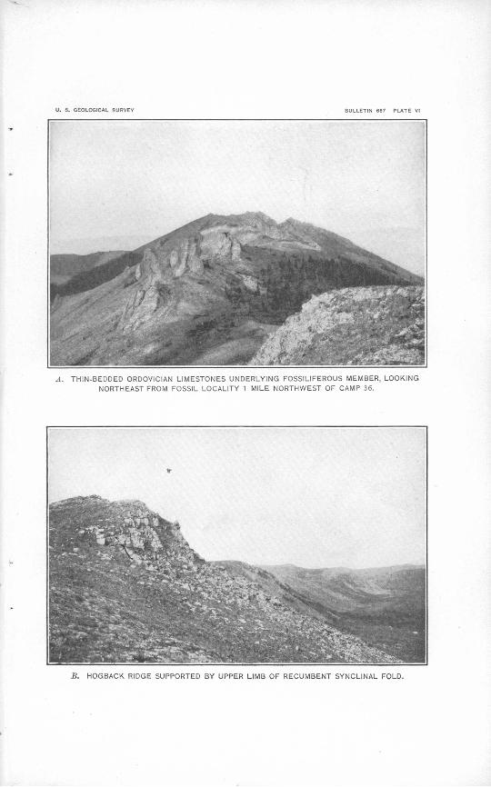
The stratigraphy of the limestones was not entirely worked out, but certain general features of it are rather conspicuous. The base of the series, which rests on the .schists, is made up of rather massive beds. (See PI. V, A.) These are apparently overlain by a thinner-bedded series, upon which lie the thickest beds of the group. These thick beds are of the purer type of limestone and have an aggregate thick ness of 300 to 400 feet, including apparently homogeneous strata 30 to 90 feet thick. These thick beds are overlain by other thinner- bedded rocks (PL V, .B), among which, about 1,500 feet higher stratigraphically, there is a fossiliferous horizon. (See PL VI, A.)
The total thickness of the limestones could not be measured directly, but several exposed sections were roughly measured, and these, when assembled in accordance with the apparent stratigraphic sequence, indicate that the aggregate thickness is not less than 6,000 and probably as much as 8,000 feet. So many uncertain factors affect the measurement, however, that these figures should be regarded as only tentative.
Structure. The structure of the group is relatively simple. The beds he generally in broad, open /olds; sharp, closely appressed or overturned folds were nowhere seen. At a few places, however, the strata stand almost vertical. There is evidence of pronounced faulting at many places, and minor faulting is common throughout the area. The faults generally cut across the beds and conform in trend with the dominant strike. In places there is evidence of movement between beds, and thin dolomitic beds that lie between massive limestones have been made schistose or slaty by such move ments. The folds are generally long, so that strikes and dips may be uniform for great distances. The dominant trend of the folds in most of the region is 10° to 20° east of north. In the southern part of the region the structure is complicated by another set of folds', which trend nearly at right angles to the set noted elsewhere.
These limestones are at few places much altered. Near the base of the group they have been locally silicified and dolomitized, and in places they are more or less crystalline, but no coarsely crystalline limestone or true marble was noted.
Secondary structure is not generally developed in the group, but shearing was observed in some members, such as .the thin beds of dolomite that have taken up the movements between adjacent thick beds of limestone.

U. 8. GEOLOGICAL SURVEY BULLETIN 687 PLATE V
A. CHARACTERISTIC TOPOGRAPHY OF ORDOVICIAN LIMESTONES WHERE STEEPLY TILTED, LOOKING NORTH FROM A POINT HALF A MILE SOUTHEAST OF CAMP 37.
S. MASSIVE ORDOVICIAN LIMESTONES 1,500 FEET BELOW FOSSIL HORIZON, 3 MILES NORTH OF
CAMP 36. ,

GEOLOGY. 25
Age. The age of the group is indicated in a general way by the occurrence of Upper Ordovician fossils at a single horizon that is probably several thousand feet above its base. The collection made at this horizon was examined by Edwin Kirk, of the United States Geological Survey, who reports as follows:
Lot 15AE5. One-fourth mile north of Station 0; P. T. Sheet 5 (east rim Little Solatna (Sulukna) Valley, 25 miles above month):
Columnaria alneolata Goldfuss var.Halysites gracilis Hall.Crinoid cokunnals.
These fossils are of Upper Ordovician (Richmond) age.
Although this horizon is thus definitely determined to be Upper Ordovician, it by no means follows that the entire group is of this age. Along the Yukon-Alaska international boundary Cairnes 1 found an apparently conformable series of limestones and dolomites that ranges in age through the Silurian, Ordovician, and Cambrian. In the White Mountains of the Yukon-Tanana region limestones have furnished Devonian, possibly Silurian, Ordovician, and Cambrian fossils. About 100 miles to the south, in the Alaska Range, Brooks found a series of rocks that he describes as "dominantly calcareous but including considerable argillaceous and some arenaceous material," which furnished Middle and Upper Ordovician forms. In the light of these occurrences it is apparent that the rocks including the bed from which Upper Ordovician fossils were collected in the Cosna- Nowitna region anay represent a considerable range in geologic age possibly from Cambrian to Silurian. They are all probably older than Devonian, for Middle Devonian fossils were collected from a probably distinct series of rooks that occur to the east, in the central part of the region.
DEVONIAN LIMESTONES AND SLATES.
Distribution and character. The Devonian limestones and slates outcrop at intervals along a rather narrow belt that trends northeast ward across the central part of the region and that probably con tinues both to the northeast and southwest beyond the area surveyed. A group of hills 20 miles southwest of the southernmost outcrop of Devonian rocks shown on the map, southeast of the North Fork of the Kuskokwim, consists largely of limestone and has topographic forms that are characteristic of the Devonian rocks in other parts of the field.
The Devonian rocks are represented in their northeastern outcrops by several limestone members, 50 to 300 feet thick, which are separ ated by much thicker members composed of more or less schistose or
1 Cairnes, D. D., The Yukon-Alaska international boundary line between Porcupine and Yukon rivers: Canada Geol. Survey Mem. 67, p. 60,1914.

26 COSNA-NOWITNA REGION, ALASKA.
slaty calcareous and carbonaceous shales. Some of these shales are very siliceous and in places are cherty. One conspicuous phase is a dark siliceous schistose rock containing rounded, probably concre tionary bodies about an inch in diameter. Rock of this type crops out southeast and northwest of the principal exposures of limestone and probably underlies the limestone.
The outcrops mapped as Devonian in the center of the field are of limestone. The correlation is made on lithologic and structural grounds, as no fossils were found at this locality.
The Devonian rocks 30 miles west of Lake Minchumina, at the southwest end of the belt, are chiefly limestones but include some dark slates. The limestone members are much thicker here than in the northeastern section, and the relatively small amount of slate gives the series a very different aspect, although the paleontologio evidence indicates that the two lie at the same general horizon.
Structure. The Devonian rooks are strongly folded, and the axes of the folds trend in general northeastward, a fact shown in detail in individual beds and in the alignment of outcrops across the region. The beds at the northeastern locality strike N. 35° E. and dip south eastward, and those at the southwestern locality strike N. 40°-65° E. and dip from vertical to 52° NW. and 74° SE. The structure is complicated by faulting as well as by folding, and beds other than Devonian may occur at this locality. The lower part of the mountain, which furnishes the chief outcrops, is made up of massively bedded limestones that resemble and may be equivalent 'to parts of the Ordovician limestone group.
Age. The age of these rocks is indicated by fossils found at two widely separated localities, one at the southeastern headwaters of Chitanana River and one on the highest mountain in the Devonian area shown on the map, 30 miles west of Lake Minchumina. These fossils were examined by Mr. Kirk, who reports as follows:
Two lots collected from the northeast locality at the head of Chitanana -River con tained Diphyphyllum sp. and Cyathophyllum sp.
The collection from the southwestern locality comprised a single lot in which the following species were determined:
Diphyphyllum sp.Cladopora sp.Favosites cf. F. limitaris Rominger.
Alneolites sp.Atrypa reticularis (Linne').Martinia cf. M. maia Billings.
The fossils in these three lots are of Middle Devonian age. The formation is to be correlated with the Salmon Trout limestone of the upper Yukon.
These rocks are to be correlated also with Spurr's "Tachatna series," 1 found on the middle Kuskokwim, and with the Middle
1 Spurr, J. E., A reconnaissance, in southwestern Alaska in 1898: U. S. Geol. Survey Twentieth Ann. Kept., pt. 7, pp. 157-159, 1900.
U. 6. GEOLOGICAL SURVEY BULLETIN 667 PLATE VI
A. THIN-BEDDED ORDOVICIAN LIMESTONES UNDERLYING FOSSILIFEROUS MEMBER, LOOKINQ
NORTHEAST FROM FOSSIL LOCALITY 1 MILE NORTHWEST OF CAMP 36.
B. HOGBACK RIDGE SUPPORTED BY UPPER LIMB OF RECUMBENT SYNCLINAL FOLD.

GEOLOGY. 27
Devonian limestones found by Brooks 1 in the Alaska Range. De vonian rooks that are less definitely determined have been noted also in the adjacent Ruby, Rampart, and Fairbanks districts.
The entire vertical range in the geologic column of the Devonian rocks of central Alaska has nowhere been determined, so that it is unsafe to assign the whole group under discussion to the Middle Devonian. The relation of the Devonian rocks to other terranes is also generally an open question. In the Ruby district the Devonian
limestones apparently overlie metamorphic rocks comparable to those of the recognized pre-Ordovician terranes already described, no such series as the Ordovician limestones intervening. The relation of the Devonian to the metamorphic rocks Of the Ruby district is therefore presumably unconformable. The apparent absence of the Ordo vician in the Chitanana area is presumptive evidence that in this region also there is a stratigraphic break at the base of the Devonian.
DIABASES AND BASALTS.
Distribution and character. The diabases and basalts occupy an area about 2 miles wide and 10 miles long near the southern limit of the Cosna-Chitanana divide. They are expressed topographically in two parallel linear ranges of hills, about a mile apart, that trend N. 35° E. throughout the length of the area. The eastern range is the higher and forms the highest part of the main divide. The western range is less prominent and is broken by several streams that drain the trough between the ranges.
The western range is made up of coarse-grained diabasic flows that have an aggregate thickness of several hundred feet. The eastern range is basalt and must include a series of strata that aggregate well over 1,000 feet in thickness. The intervening strata underlying the depression between the ranges do not outcrop along the traverse made across the area, so that their characteristics were not definitely deter mined. However, as only diabasic and basaltic detritus was found in the area the group is presumably made up entirely of such igneous rocks. All the rocks show more or less alteration. Some might be properly termed greenstones; but others are but little changed from their original condition.
Structure. The structure of the group is not fully apparent but does not appear to be very complex. The conspicuous folds trend consistently N. 35° E. At the western margin of the region the dips are steep probably almost vertical but elsewhere there is little to indicate the attitude of the strata. It is impossible to estimate the total thickness of the group closely, but it is probably 2,000 feet or more.
i Brooks, A. H., The Mount McKinlcy region, Alaska: U. S. Geol. Survey Prof. Paper 70, pp. 77-78,1911.

28 COSNA-NOWITNA REGION, ALASKA.
Age. The age and stratigraphic relations of the group are only vaguely suggested. The rocks have the same general strike as the Devonian rocks on the west and like them lie unconformably beneath younger volcanic rocks. In view of these conditions and of the fact that similar igneous rocks are associated with EJevonian limestones in the Rampart district, to the northeast, and in the Ruby district, to the west, the group is tentatively assigned to the Devonian or post- Devonian.
QUARTZITES AND PHYLLITES.
Distribution and character. The quartzites and phyllites are known to occur only in the upland area that lies between the main headwater forks of Cosna River, where they are expressed topographically in the most prominent mountains of the eastern part of the region. Their extent beyond this small mountain area is unknown.
The rocks are mostly banded quartziticrocks and phyllites of several types and massive quartzites, limestones, slates, and cherts. The apparent thickness of the entire group, roughly measured, is about 4,500 feet. The real thickness may be considerably less, however, for the structure7 is complex and may involve duplication of beds in the apparent column.
The lower part of the exposed section for a thickness of about 2,000 feet is made up of quartzites of the banded or laminated type and phyllitic rocks that in places are true slates. The group is made up of rather thick members, beds of apparently homogeneous composition 100 to 300 feet thick being recognizable. The phyllitic rocks are the more abundant in the lower part of the group and the quartzites in the upper part.
The banded quartzites are made up of alternating layers of pure and impure quartzose material. The layers of pure quartz are white and the layers of impure quartzose rock, which contains carbonaceous and shaly material, are dark gray to black. The banding is in places even and fine, involving twenty or more layers to the inch, but a some what coarser and less distinct banding is more generally characteristic of these rocks. They are nearly everywhere intensely deformed, and the banding is intricately contorted or confused by minute faulting or brecciation. The rocks are cut by thick veins of quartz, and the pure quartz laminae are, in part at least, of secondary origin. The phyllites and slates are all dark, ranging from bluish to dark gray and black. Some are notably graphitic and contain thin streaks of material that resembles anthracite coal; others are massive and break with irregular cleavage; and still others are true slates and break with a strong regular cleavage. For the most part, however, schistose secondary structures are characteristic of these rocks, and they are classed as phyllites.

GEOLOGY. 29
Next above the banded quartzites and phyllites there is a set of dark-gray slates, argillites, and gray sandstone, about 800 feet thick. For several hundred feet above these beds the rocks are covered, but the topography suggests that they are of the same general charac ter as those immediately below. Above the covered part of the section is an entirely different set of rocks, about 500 feet thick, which comprises the upper members of the group. Their lithologic character and sequence are as follows:
Feet. Quartzite, massive, white........................................ 50Limestone and chert, interbedded................................ 20Quartzite, massive1 , yellow to gray................................ 40Quartzite and chert, interbedded................................ 20Limestone, white, coarsely crystalline............................. 15Slate, black..................................................... 50Limestone and slate, interbedded................................. 200Slate and phyllite, carbonaceous................................. 90
The massive white quartzite is overlain, apparently conformably, by a heavy bed of grit which belongs to the group next to be described.
Structure. The structure of these rocks is very complex in detail, but the general attitude of the beds is clearly apparent. The strike is in general to the northeast and the dip is to the southeast. The pronounced lithologic differences between different parts of the group show that there is no large duplication of beds in the measured section, though exaggeration of thickness, due to minor duplication is probable.
The rocks of the group have been in places considerably metamor phosed. The banded quartzites appear to show secondary silicifica- tion. The recrystallization of the chief limestone member also indicates strong metamorphism, and chiastolite has been formed in some .of the black phyllites. The rocks are in places impregnated with pyrite and show iron and copper staining on weathered surfaces. The bedded rocks are cut by dikes of rhyolite, some of which carry sulphide minerals, and by thick veins of quartz. The alteration of the rocks and the development in them of secondary minerals are due mainly to local igneous action rather than to regional metamorphism.
The age of this group is discussed on pages 31-33.
GRITS AND SANDSTONES.
The grits and sandstones occupy a large area in the upper basin of the North Fork of Kuskokwim River and extend in a relatively narrow belt northeastward across the divide to Cosna River. They were not observed elsewhere in the region.
The group is made up chiefly of heavy-bedded grits and sand stones but in places comprises varicolored slates and igneous rocks. The slates occur in strata that are relatively thin but that are well

30 COSNA-NOWITNA REGION, ALASKA.
distributed through the series. The igneous rocks are rhyolitic and probably form dikes like those that cut the quartzites and phyllites on the north.
The grits and sandstones differ chiefly in texture. Both are dominantly quartzose rocks containing more or less feldspar, mica, and femic minerals. The feldspar content varies in both the grits and the sandstones, and at some places the rocks have nearly the composition of a typical arkose. At other places, however, the femic minerals are more abundant, especially in the sandstones, and the rocks should probably be classed as graywacke. These detrital rocks have been more or less sheared and in places are fairly schistose. The sandstones are normally dark to light gray, but owing to alteration and the development of secondary minerals some phases have a greenish cast.
The slates are typically fine-cleaving argillaceous rocks of remark ably fine and delicate colors, generally red and green but in places dove-colored or lavender, the same shade holding throughout a bed several feet thick.
The apparent structure and the relative positions of outcrops indi cate that the group comprises about 800 feet of beds, which appear to overlie the quartzites and phyllites and to underlie the cherts and slates, both conformably.
CHERTS AND SLATES.
Distribution and character. The cherts and slates form all the upland features from the area of the grits and sandstones southeast ward to the border of the alluvial, plains in the basin of Kantishna River. They also comprise the only outcrops in the low ridges that rise above the silt plains at intervals northeastward from the principal upland area almost to Tanana River above Cosna. Presumably the group underlies the silts throughout the large area in which these scattered outcrops occur.
The group is made up almost entirely of cherts and slates. In places, apparently near the base of the series, chert conglomerates occur, and at one locality a thick chert conglomerate unconformably underlies slates and sandstones, which appear to form an independent series. However, this relation could not be fully established, and the area occupied by the apparently younger rocks was not distin guished from that of the main group in the mapping. The lower part of the group is made up almost exclusively of chert and chert con glomerate. Higher in the series slates appear and increase in abund ance upward until they equal or slightly exceed the chert in amount.
The cherts occur in strata ranging in thickness from a few inches to about 10 feet between partings. (See. PI. VI, B.} They are of
GEOLOGY. 31
various colors, including black, gray, green, red, and intermediate shades. Similar characteristics are found in many places through a considerable thickness of strata, so that the group, even where it is made up exclusively of chert, may be divided into distinct members that may be recognized in widely separated outcrops. Some such, members were as much as 150 feet thick and were apparently homo geneous and unbroken throughout except for the planes of incoherence between strata.
When viewed, microscopically the cherts appear to be composed entirely of cryptocrystaUine silica. The fineness of crystallization differs somewhat in different specimens and in different parts of the same specimen. The coarser phases are probably the result of partial recrystallization under the stresses of deformation. Indistinct rounded bodies seen in some' specimens suggest an organic origin, but for the most part the rocks have a fine even texture suggestive of chemical precipitation.. Although the microscope shows that the chert is composed of silica it undoubtedly contains other minerals. Weathered surfaces are generally more or less covered with an earthy incrustation, and meta- morphic phases contain secondary mica, probably developed from the original constituents of the chert. The presence of iron in considerable amounts is suggested in the red chert, which produces red clayey soils on weathering and which contains brecciated zones that are commonly recemented with ferruginous material.
The slates are compact, even-grained argillaceous rocks that break with a very regular cleavage. Beds 10 feet to over 100 feet thick ap parently occur, but their characteristics are generally obscured by the products of weathering. The cherts form the prominent topographic features, and the slates generally occupy depressions. In the few outcrops of slate actually seen and in the talus accumulated over the outcrops the slates resemble very closely those associated with the grits and sandstones of the underlying group, generally showing the same variety of coloring and fine texture and cleavage.
Structure. The group shows close folding and faulting. At one locality a close fold overturned to the northwest was noted. The structure is not generally evident, and the determinable outcrops show considerable irregularity, so that it was impossible to estimate very closely the total thickness of the group, but it is believed to be 2,000 feet or more.
Age. As already indicated the quartzites and phyllites, grits and sandstones, and cherts and slates appear to belong to the same unbroken group of sedimentary strata. The age of this group is not definitely indicated within the region, and the inferences that may be drawn from apparent relations of the rocks to those of other regions

32 COSNA-NOWIT'NA REGION, ALASKA.
are fraught with uncertainty. The most characteristic part of the group would appear to be the thick series of cherts and slates, and this series chiefly has afforded grounds for the following deductions: The cherts and slates have their counterpart in the Kuby district, where there are cherts that appear to be younger than certain Devo nian rocks. Similar cherts ° occur also farther southwest, in the Innoko and Iditarod districts and on the lower Kuskokwim. At these localities the cherts manifestly underlie the Upper Cretaceous rocks. At the Kuskokwim locality the cherts evidently overlie a volcanic series that lies upon limestones of uppermost Mississippian age.1 It should be noted, however, that the group represented in the quartzites and phyllites, grits and sandstones, and cherts and slates of the Cosna-Nowitna region corresponds remarkably with Brooks's Tonzona group,2 as it occurs along the inland front of the Alaska Range. Similar rocks that outcrop north of the Tanana between the Tolovana Flats and the Baker Creek valley and in the Eampart district were also assigned to the Tonzona group by Brooks. These occurrences may represent a northeastward extension of the rocks of the Cosna-Nowitna region, for they are in line with the dominant structural trends observed south of the Tanana. Concerning the age of the Tonzona group Brooks 3 says:
No fossils of any description have been found in the Tonzona group * * *. It will be shown that they are overlain, probably unconformably, by a limestone of Middle Devonian age. Their delation to the older Tatina group is not definitely established, as most of the contacts between the two groups have become'lines of movement. In any event they are without doubt younger than the Tatina, which is, in part at least, Ordovician.. These facts have led the writer ,to assign these rocks provisionally to the Lower Devonian or to the Silurian.
Prindle 4 extends the use of the term Tonzona group to certain rocks of the Fairbanks quadrangle. Concerning these rocks he says:
A series of red, green, and black argillites, conglomerate, and sandstone, including some chert, is here correlated with the Tonzona group. Locally some limestones are included in the Tonzona as mapped. The information gained in regard to these rocks is far from being conclusive in regard to their stratigraphic position. * * * It [the series] is believed to be younger than the Ordovician and Silurian limestones of the region, and the rocks along the western boundary, which have here been mapped with the Tonzona, have yielded Devonian fossils. It will therefore here be pro visionally assigned to the Devonian, with the warning that it may be in part Silurian.
Within the area mapped as Tonzona in the western part of the Fairbanks quadrangle the writer, in 1911, collected a few fossils, on which T. W. Stanton reports as follows:
1 Maddren,A. G., personal information.2 Brooks, A. H., The Mount McKinley region, Alaska: U. S. Geol. Survey Prof. Paper 70, pp. 73-76,1911.3 Idem, p. 76.4 Prindle, L. M., A geologic reconnaissance of the Fairbanks quadrangle, Alaska: U. S. Geol. Survey
Bull. 525, pp. 44-45,1913-

GEOLOGY. 33
7241, No. 11AE5. Little Minook-Quail Creek divide, half a mile below trail cross ing, Rampart (Fairbanks) quadrangle, Alaska:
Aucella? ep., apparently belonging to the group of A. crassiqollis Keyserling. Many fragments of pelecypods, probably Lower Cretaceous or Jurassic.
The collection is far from satisfactory and the determination is given only provis ionally. If it is correct the horizon is either Lower Cretaceous or uppermost Jurassic.
The Tonzona group as it is shown on the published maps seems to include rocks of widely different ages. The series in the Cosna- Nowitna region are very like parts of the Tonzona group and their tentative correlation with part of that group is further justified by similarities in structure. The pre-Devonian age of these series seems to be precluded in the Cosna-Nowitna region, for they appa rently do not lie between rocks of the Devonian and Ordovician systems. In fact, their structural relations suggest that they overlie Middle Devonian rocks.
On the whole, a much later age is indicated for these rocks and possibly for parts of the Tonzona group of the adjacent regions than has generally been postulated for the Tonzona group. It would appear that they are of very late Paleozoic or early Mesozoic age. The tentative correlation of the cherts and slates with the known Upper Triassic cherts 1 of southern and southwestern Alaska would therefore seem justified. The grits and sandstones and the quartzites and phyl- lites and probably similar rocks that are now mapped with the Ton zona group should then be assigned to the earlier Triassic or perhaps to latest Paleozoic tune.
YOUNGER VOLCANIC ROCKS.
Distribution and character. The younger volcanic rocks occur with the Devonian rocks in a belt that runs northeastward across the central part of the region from the North Fork of the Kuskokwim west of Lake Minchumina to the Cosna-Chitanana divide. Similar rocks occur in the two small areas near the headwaters of Telsitna River, along the fault contact between the Ordovician limestones and the older metamorphic rocks.
The group includes lavas, tuffs, breccias, and some sedimentary beds. The sedimentary rocks were noted at only a few places, and as they occur in relatively small areas and are intimately associated with the volcanic rocks they are not distinguished on the map.
The lavas are predominantly rhyolitic and andesitic porphyries. A bed of olivine basalt was noted at one place, and the other lavas are cut by basic dikes. The most widespread type of lava is a rhyolite porphyry that has a light-colored aphanitie groundmass and that contains phenocrysts of quartz, which is black in the hand
i Martin, G. C., A geologic reconnaissance of the Hlamna region, Alaska: U. S. Geol. Survey Bull. 485, pp. 47-50,1912.
3167° 1& Bull. 667 3

34 COSNA-NOWITNA REGION, ALASKA.
specimen but transparent in thin section. Another common type has a cryptocrystalline matrix and abundant large orthoclase phen o- crysts. In considerable masses of this lava the phenocrysts are so abundant as to constitute more than half the rock.
The tuffs are locally interbedded with the lavas. They are com monly fine-grained compact rocks composed of angular fragments of varicolored lavas. In places they are coarser grained and grade into breccias that contain fragments of rock a foot or more in diameter.
The associated sedimentary rocks are thin-bedded shales and sandstones. They are apparently interbedded with the volcanic rocks and form a relatively small part of the group.
Structure. The structure of the group appears to be very simple. Direct observation of individual strata was possible at some places, and at none of them were steep dips found. The persistence of the same type of lava over wide areas also indicates low dips, so that over much of the area the beds probably lie almost flat.
Age. The age of these rocks is not definitely established, but the character of the associated sedimentary beds and the generally simple structure indicate that they were ejected in late Mesozbic or early Tertiary time. Several granitic masses intrude the lavas or the rocks of adjacent areas, and the volcanic group may represent an effusive phase of the same magma, ejected at the same time. The intrusive rocks are probably to be correlated with the monzonites of the Iditarod, Innoko, and Hot Springs districts, which are believed to be of very late Mesozoic or early Tertiary age. Rocks somewhat like certain members of this group are intrusive in Upper Cretaceous rocks of the Innoko district and adjacent territory. These facts also indicate that the lavas of the younger volcanic group were ejected in very late Mesozoic or early Tertiary time.
GRANITIC INTRUSIVES^
Granitic intrusives occur at several places hi the Cosna-Nowitna region. (See PI. II.) The two largest areas, each covering several square miles, lie 20 to 25 miles northwest of Lake Mmchumina and are expressed topographically in two prominent mountain groups. Two smaller areas lie 30 to 35 miles farther northeast, on the head waters of Cosna and Chitanana rivers, respectively. Another small area was noted in the hills a few miles east of the mouth of Sulukna River. The topography of the country between Sethkokna and Titna rivers suggests another occurrence of rock of this type, and it is reported that granitic rocks make up a large part of the upland southwest of the Ordovician limestone area.
The rocks of this class vary somewhat in texture and composition but probably correspond closely in age and mode of occurrence. All are composed dominantly of orthoclase, plagioclase, quartz, and

GEOLOGY. 35
biotite. Hornblende and microperthite are also abundant con stituents of some specimens. The relative amounts of the essential minerals vary, so that some specimens may be classed as granite and some as monzonite. The monzonite, the more basic phase, is apparently more abundant than the granite, the more siliceous phase.
The granitic rocks occur as intrusive stocks and masses that cut rocks of different ages, including the pre-Ordovician metamorphic and the younger volcanic rocks. They should probably be correlated with the monzonites of the Iditarod, Innoko, and Hot Springs dis tricts, which are younger than certain Upper Cretaceous beds and are believed to be of early Tertiary age.
UNCONSOLIDATED SEDIMENTARY DEPOSITS.
Distribution and character. Unconsolidated sedimentary deposits occur throughout the region and form broad plains that border the uplands on all sides except the southwest. The valleys that head in the uplands are generally wide and contain thick deposits of uncon- solidated material. At many places such deposits extend across low divides from one drainage basin to another, separating upland areas that are underlain by solid rock.
The most widely distributed unconsolidated material in the region is a fine, powdery light-colored silt composed of fragmental quartz, mica, and some femic minerals. This material forms terraces and plains at different elevations, the highest about 1,200 feet above sea level, and occurs at somewhat higher elevations in passes between broad valleys. In places the silt res'ts directly on bedrock, but elsewhere it is underlain by deposits of washed gravels.
The main streams are generally deeply intrenched in the . silt. Most of those that head in silt areas are narrow and without bottom lands of reworked material. Those that head in the uplands cany sands and gravels and meander over flood plains made up of material brought down from their upper tributaries and deposited more recently than the silt. The absence of stream gravel on most of the streams and the small areas in which it does occur made it impracti cable to distinguish between silt and stream gravel in the mapping.
The character of the silt and its topographic expression suggests that it was laid down in comparatively quiet water. Its distribu tion points to a general inundation of the region to a level now about 1,200 feet above the sea.
Since its original deposition the silt has been subjected to the action of wind, which at many places has formed on its surface characteristic dunes and hollows. The deposits that lie above the level of the uppermost broad silt plains are believed to be wind blown.

36 COSNA-NOWITNA REGION, ALASKA.
Structure. The original structure of the silt deposits is not gen erally evident owing to the lack of good sections and to the second ary structure produced by the wind. Exposures along Yukon and Tanana rivers show horizontal stratification, which is said to be very apparent also in the bluffs along the lower Chitanana, where sections 500 feet or more thick are exposed. The structure observed in sections exposed along the smaller streams and about lakes on the plains is probably secondary, being characteristic of wind depo sition.
Age. The silt contains fossil shells of species that are still living and is doubtless of early Quaternary age. The material resembles the finer glacial detritus and may have been deposited in the earlier part of the Quaternary period, at the time of the earlier and more extensive glaciation of the Alaska Range and other mountain groups of interior Alaska.
STRUCTURE.
The structural features of the rocks of the region have already been noted in the discussion of the general geology. It remains to summarize these features and, so far as possible, to determine the character and sequence of the principal events in the tectonic his tory of the region.
The dominant trend of the structural features throughout the region in rocks of all kinds and ages is northeasterly, and any section across the strike shows a remarkable parallelism in trend. In the direction of the dominant trend the strike changes rather system atically; in the southwestern part of the field it is N. 10°-20° E.; in the central part N. 35°-45° E., and in the southeastern part N. 45°-65° E. Both to the north and the east the strike becomes more easterly. Local more or less abrupt variations from the domi nant trend are few, and such variations probably represent local deflections of the stresses that formed the major features and not another set of general stresses.
Diastrophism has affected the region during several different periods far apart in geologic time. The earliest of these was in pre-Ordovician tune, for it is recorded only in the metamorphic rocks of the northwestern part of the region, which are folded, faulted, and sheared much more intricately than the succeeding Paleozoic and later rocks.
The Ordovician, Devonian, and probably early Mesozoic rocks show deformation of the same general type, but apparently the action was more intense in the southeastern part of the region, for the younger rocks show progressively more pronounced and intricate structure toward the southeast. The Ordovician rocks lie generally in broad, open folds and show little shearing. The Devo nian rocks are more sharply folded and include sheared or schistose

GEOLOGY. 37
phases. The cherts and associated rocks are generally unsheared but are more intricately folded and brecciated than either the Ordo- vician or the Devonian rocks; in places they show closely appressed folds overturned to the northwest.
Faults of different magnitude were noted in all these rocks, but the effects of faulting are more conspicuous in the Ordovician areas than elsewhere, for there the exposures are better and the other structural features are more regular. Like the other dominant features of the structure the major faults trend northeastward. The irregularities in the northern boundary of the Ordovician area are due to faults of large vertical movement. At the head of Telsitna River the Ordovician rocks are in contact with the older metamor- phic rocks on a fault plane along which igneous rocks are locally extruded. The straight, scarplike east wall of Telsitna Valley is probably due to the continuation of the same fault to the northeast. The extrusion of lavas along this fault plane and the relation and structure of the adjacent rocks indicate that this fault is of great magnitude and that it includes horizontal as well as vertical displace ment. The beds of limestone east of the fault are thrown into trans verse folds, the bottoms of which must lie a thousand feet or more below the present surface of the schists west of the fault plane. The transverse folds indicate a relative northerly movement of the rocks west of the fault.
The principal folding of the Ordovician and younger rocks was completed prior to the extrusion of the younger volcanic rocks, presumably in late Cretaceous or early Tertiary time. These vol canic rocks are only gently tilted, except near the larger intrusive masses, where they show considerable local displacement.
The remarkable agreement in the structural trend throughout the region and in all the stratified rocks in the geologic column is probably due to the influence of earlier structure on the transmission of later stresses. The earliest stresses produced structural features folds, cleavage, and planes of weakness and incoherence that trend northeastward. Later stresses, if they differed in direction from the earlier, tended to be resolved into two components, one consisting of forces acting normal to and the other of forces acting parallel with the lines of the earlier structure. The first named produced the major folds of the younger rocks, and the other was
> expressed in horizontal displacement and the development of minor transverse folds. The operation of such forces during the later periods of diastrophism is clearly indicated by the relations of the folds and faults in the Ordovician and younger rocks.
The extrusion of lavas along the great fault at the head of Telsitna River and the northeasterly trend of the main volcanic belt suggest that volcanic activity accompanied this crustal deformation. If it
38 COSNA-NOWITNA BEGION, ALASKA.
did so the major faults were developed later than the principal folding of the Ordovician and younger rocks.
The general events in the tectonic history of the region seem to include extensive crustal deformation in pre-Ordovician, post-Ordo- vician, post-Devonian, and probably late Mesozoic or early Tertiary time. The stresses causing such deformation probably recurred after numerous intervals, but the results of the diastrophism of the different periods are confused in the general parallelism of the later structural features with the earlier. Close chronologic distinc tions between periods of diastrophism are therefore impossible, but it appears that in post-Ordovician time the earlier deformation was expressed in folding and the later in faulting. It also appears that the later diastrophism affected the southeastern part of the region more strongly than the northwestern part.
GEOLOGIC HISTORY.
Principal events. The character and relations of the rocks now exposed at the surface in the region reveal clearly the principal events that marked certain periods of geologic time, but the records of long intervening periods are either obscure or wholly lacking. The data that form the basis of the following geologic history have already been presented under the heading "Geology." In order to avoid a repeti tion of the discussion of problems of chronology the ages there sug gested are assumed to be true, so that the classification of rocks there given will apply also to the historical events related.
The salient events hi the history of the region may be summarized as follows:
1. Pre-Ordovician sedimentation and volcanism. Deposition of the limestone- greenstone and schist-quartzite groups.
2. Pre-Ordovician diastrophism and erosion. Deformation of pre-Ordovician rocks and erosion of surface upon which Ordovician limestones were afterward deposited.
3. Ordovician (possibly including more or less Cambrian and Silurian) sedimenta tion. Deposition of thick limestone and dolomite series; marine conditions.
4. Pre-Devonian uplift and erosion? Probable development of erosional uncon formity between Ordovician and Devonian rocks.
5. Devonian sedimentation. Deposition of limestones and clastic beds (in part Middle Devonian) and local extrusion of diabases and basalts.
6. Carboniferous time. Uncertain. Possibly uplift and erosion.7. Early Mesozoic sedimentation. Deposition of quartzites and phyllites, grits
and sandstones, and cherts and slates. o8. Later Mesozoic diastrophism. Folding and uplift of early Mesozoic rocks followed
by erosion.9. Late Mesozoic or early Tertiary diastrophism and volcanism. . Development of
major faults of the Paleozoic rocks accompanied by the extrusion of lavas and followed by the intrusion of the granitic rocks.
10. Tertiary erosion. Development of topography of the bedrock underlying the silt.

GEOLOGIC HISTORY. 39
11. Early Quaternary inundation and sedimentation. Deposition of lacustrine and fluvialile silt and gravel.
12. Recent erosion. Development of present topography through erosion by water and wind.
Pre-Ordovician sedimentation. The pre-Ordovician sediments are of two types and may represent two distinct epochs. The older sediments are dominantly calcareous and are interbedded with extrusive igneous rocks. The conditions of sedimentation were marine, and presumably the volcanic rocks were laid down as sub marine flows, but as the details of the original structure of the series are generally obscure the evidence on this point is not conclusive. These dominantly calcareous rocks are overlain by dominantly clastic rocks, some of which are coarse grained and may be fluviatile deposits, Marine conditions recurred at intervals, however, for sev eral limestone members are interbedded with the clastic rocks. The only fact definitely established regarding the time of the deposition of these rocks is that it antedated that of the deposition of the thick series of limestones from which Upper Ordovician fossils were obtained. The great thickness of limestone beneath the horizon at which the fossils were collected must represent a long time, possibly all of earlier Ordovician and some of Cambrian time. Therefore the older rocks were probably laid down in Cambrian if not in pre- Cambrian time.
Pre-Ordovician diastrophism and erosion. Before the rocks of the Ordovician limestone group were laid down the older rocks were 'deformed and uplifted .and exposed to subaerial erosion. The deformation was intense, for the beds were thrown into closely appressed folds, and secondary schistosity was generally developed. Faulting probably occurred at this time as well as during later periods of diastrophism, but there are no definite criteria for determining the relative age of the different faults. Subsequent erosion of the folded beds apparently developed a rather even surface over broad areas, which accounts for their pronounced angular unconformity with the overlying limestone series. Both the period of deposition of the pre- Ordovician rocks and the period of their deformation and erosion are uncertain, but these events probably occurred in Cambrian or pre-Cambrian time.
Ordovician or earlier sedimentation. After the older rocks were folded and eroded the sea again extended over the region, and in it was deposited a thick series of limestones and dolomites, which now underlie the fossiliferous Upper Ordovician rocks. These limestones and dolomites probably represent all of earlier Ordovician and pos sibly more or less of Cambrian time. The rocks at the Upper Ordo vician fossiliferous horizon are also overlain by a great thickness of

40 COSNA-NOWITNA REGION, ALA&KA.
limestones which may represent Silurian as well as later Ordovician time.
The marine inundation during this period was general over the northwestern part of the continent, and the rocks laid down are now exposed at widely separated localities. The inundation was appar ently progressive, for the fossil remains of forms that must have lived in comparatively shallow water are now found beneath thousands of feet of marine sediments. Apparently the region suffered no notable diastrophic disturbance during the deposition of the limestone series.
Pre-Devonian uplift and erosion. As already pointed out, there is general indirect evidence of an unconformity between the limestone series and the Devonian group. Presumably the region was uplifted and exposed to considerable denudation before the earliest of the beds associated with the Middle Devonian f ossiliferous limestones was laid down. But, although the probability of a period of diastrophism and erosion at this time is strongly indicated, the details of such activ ities are obscure, and the type and degree of deformation of the Ordo vician rocks in pre-Devonian time can not be clearly determined from the data at hand. However, a general comparison of the present structure of the Devonian and Ordovician rocks seems to preclude the possibility of very extensive folding during this time.9
Devonian sedimentation. Marine conditions recurred in the region in Devonian time, when a thick series of fine clastic beds and lime stones was deposited. Fossils in the limestone beds indicate areas of shallow water, and the thickness of the series shows that the inun dation was progressive, involving the depression of the area several thousand feet below sea level. Probably late in the Devonian period, after the deposition of most of the sedimentary series, volcanic activ ity came into play, locally at least and thick series of basaltic and diabasic lavas were poured out.
Carboniferous time. The record of Carboniferous time is not found in the rocks of the region, according to the classification adopted. The apparent absence of Carboniferous rocks is perhaps evidence that the region became a land surface after the end of Devonian sedimen tation. However, until the classification of the rocks of the region by age can be made more certain the conditions that existed at the end of the Paleozoic are too uncertain to justify further discussion.
Early Mesozoic sedimentation. If the quartzites and phyllites, grits and sandstones, and cherts and slates are all of early Mesozoic age, the beginning of this era was marked by a general and pronounced submergence. The earlier deposits consist of fine clastic material, some of which was laid down as very thin, even strata, presumably in deep water. Higher in the series there are several wen-marked cal careous members which are overlain by another clastic member, some beds of which are evidently of fluviatile origin. Fluviatile deposi-
GEOLOGIC HISTORY. * 41
tion was only temporary, however, for the upper group of the cherts and slates indicates the recurrence of marine conditions. This general sedimentation was apparently brought about by intermittent subsidence. There is no positive evidence as to the time of its begin ning or its end, and the general age of the deposits is assumed on only probable correlation.
Later Mesozoic diastrophism. During the interval between the deposition of the early Mesozoic series a"nd the extrusion of the younger volcanic rocks the rocks of the region were deformed, uplifted, and exposed to erosion. This diastrophism was in effect the most pro nounced that occurred in post-Ordovician time. The early Mesozoic rocks were closely folded, and locally the folds were overturned to the northwest. The same degree of movement must have occurred also in the underlying Paleozoic rocks, but as these generally show lesscomplicated structure than the early Mesozoic rocks they must have been deformed chiefly during this period. The intensity of the defor mation evidently differed in different areas and was more pronounced to the southeast, toward the Alaska Range.
The amount of the erosion that followed the uplift of the region in this period is indicated by the relations of the younger volcanic rocks to the underlying sedimentary series. Apparently it involved the complete removal of the cherts and slates and part of the grits and sandstones over considerable areas.
Late Mesozoic or early Tertiary diastrophism and volcanism. Late Mesozoic or early Tertiary diastrophism is postulated on the apparent relation of the younger volcanic rocks to faulting. At some places it is clear that these lavas were extruded along fault planes, and the general distribution of other areas of volcanic rocks indicates similar relations. The lavas are presumably of late Mesozoic or early Ter tiary age. If their extrusion was incidental to the faulting, this also must have occurred in late Mesozoic or early Tertiary time. The dynamic relations of the faulting and the folding in the tectonic history of the region have already been discussed. (See p. 37.)
A somewhat later phase of volcanic activity in the region was the intrusion of the granitic rocks.
Tertiary erosion. No Tertiary sedimentary rocks were found hi the region, and probably none were deposited. The region was a land surface exposed to erosion at least during later Tertiary time, when the major features of the present topography and the topo graphic detail of the bedrock surface that now lies beneath the silt were formed. The base-level of erosion was lower than now, so that the bottoms of the major erosional depressions are far below the level of the present streams. The arrangement of drainage lines was also different from the present. These subjects are treated more fully under the heading "Geomorphology." (See p. 42.)

42 COSNA-NOWITN*A REGlOtf, ALASKA.
Early Quaternary inundation and sedimentation. The denudation of the low-lying parts of the region was interrupted in early Quater nary time by agencies that caused a general aggradation of the region to a height now about 1,200 feet above sea level. The deposits, of this time are chiefly fine light-colored incoherent silt, probably the finer product of glacial erosion in adjacent mountainous regions. Evidence of several kinds points to a general inundation of the region to the level indicated and to the lacustrine deposition of the silt. Throughout this period the areas lying above the level of maximum inundation were, of course, exposed to subaerial erosion.
Recent erosion. After the silts were deposited subaerial erosion again extended over the entire region. New drainage lines, dis cordant with the old, were established across the silt plains, and the present cycle of erosion was begun. The subsequent history of the region included a record of the development of the present topography by subaerial aqueous erosion and other agencies. (See pp. 48-50.)
GEOMORPHOLOGY.. OUTLINE.
The geomorphology of the regi'on, or the development of its present topography, has been influenced by events that occurred far back in geologic time, so that the entire geologic history of the region is in some measure pertinent to the subject. The earlier geologic history has already been discussed as completely as the data warrant. It remains to treat more fully the later history, covering the time after the deposition of the youngest solid rocks, during which both erosion and sedimentation operated to produce the present topog raphy. The history of their operation comprises three principal phases Tertiary erosion, early Quaternary sedimentation, and recent erosion. These phases will be discussed separately, and so far as possible the agencies that operated and the results that were produced during each period will be described.
TERTIARY EROSION. ,
After the extrusion of the younger volcanic rocks and the intrusion of the granitic rocks the region was long subject to normal subaerial erosion. The condition of the land surface at the beginning of the period of erosion is uncertain. Evidence of peneplanation either before or during this period is apparently entirely lacking. The drainage lines may have been inherited from an earlier cycle of erosion but may have been modified by the latest volcanic and dias- trophic action. Whatever may have been their origin, the drainage lines apparently persisted in the same general courses throughout late Tertiary time, and the topography of the entire region was shaped in conformity with them.

GEOMOBPHOLOGY. 43
The base-level of erosion during late Tertiary time was considerably lower than it is now, and the main valleys were excavated to a depth far below the level of the present streams. As the uplands of the region have since been continuously exposed to erosion, the divides during and at the end of the Tertiary period were doubtless con siderably higher than th,ey are now. The cycle of erosion embraced by this period had progressed well past maturity at its close, and the relief was much stronger and more rugged than that of to-day. Most of the main divides coincided with those now existing, which, how ever, differ from them in some particulars because of changes in drainage. The mam valleys of that time are now deeply filled with alluvium, and the distribution of these deposits, coupled with the topography above the level of the silts, gives a rough indication of the courses followed by the principal streams. The Sulukna basin drainedto the northwest, past the upper end of the Nowitna Canyon, into the Sulatna basin. The Telsitna basin continued northward across the present courses of Titna and Big Mud rivers into the great depres sion that extends northward to the Yukon. Parts of the present Cosna, Chitanana, and Titna basins and possibly of the Sethkokna basin apparently drained southward into the area now drained by the North Fork of the Kuskokwim. The direction taken by the drainage ines in the extensive basin between the uplands and the Yukon is more problematic. Perhaps a divide lay across the present course of the Yukon at Ruby and the basin drained eastward through the silt plains south of Cosna. This suggestion is countenanced by the exist ence of a great depression that extends southwestward with apparent continuity through the. areas drained by Kantishna, Kuskokwim, and Nushagak rivers to Bristol Bay. At least, the drainage lines when Tertiary erosion ceased were notably different from the present lines, and the arrangement suggested is not only in keeping with the distribution of alluvium but in accord with the probable subsequent events.
EARLY QUATERNARY SEDIMENTATION.
Distribution and character. Erosion was interrupted in early Quaternary time by agencies that caused a general aggradation of the region to the present 1,200-foot level. The resultant deposits are chiefly silt but include gravel and boulders locally about the mar gins of the filled depressions. The determination of the origin of these materials and the conditions attending their deposition forms a rather complex problem, whose solution involves studies of the distribution, character, and structure of the deposits, their topo graphic expression, and the form of the bedrock surface beneath them.
The silt is typically fine, light-colored, incoherent, slightly worn detrital material, chiefly quartz but including considerable mica

44 COSNA-NOWITHA REGION, ALASKA.
and f emic minerals. Three samples of the silt from different parts of the region were submitted to E. W. Shaw, of the United States Geological Survey, for mechanical analysis to determine whether the ratios of different-sized particles would throw any light on their origin. In his report Mr. Shaw says:
The material resembles loess to a certain extent but is different from any loess of the United States or Europe so far examined. * * * It averages a little coarser; it is not quite so well assorted; and it does not contain nearly so much of the finest constituents. The amount of material of the size next larger than the most abundant size is considerably greater than that of the size next smaller, whereas the reverse is true of all the loess so far examined. * * * Of the material that I have studied the one most like the Alaska material is some washed loess taken from the lower end of a little gully cut in loess. * * * In general fineness a composite and hence unsorted sample of the Mississippi Delta taken at the mouths of the river is next in similarity.
The mechanical analysis of the silt seems to indicate more strongly an aqueous rather than an eolian origin. The surficial part of the deposits, from which the samples were taken, has been drifted to some extent by wind, which probably in some degree re-sorted the material, so that the undisturbed silt would differ from loess even more greatly than the samples examined and be more evidently a product of aqueous deposition. The silts show two kinds of bedding. The low-lying deposits are nearly everywhere horizontally bedded; the higher surficial deposits are generally cross-bedded. The hori zontal bedding indicates deposition in .still and probably deep water; the cross-bedding is evidently due to the action of wind. The rela tion of the flat-lying and cross-bedded deposits suggests that the horizontal bedding is an original feature of the entire deposit and that the cross-bedding is a later feature, superficially developed.
Some of the gravel and boulder deposits about the borders of the basins, especially a series of gravel terraces along the hills north of the Yukon, near the mouth of Nowitna River, have forms which suggest that they are deltas built out into standing water. These delta-like terraces lie in front of the larger upland valleys, and their materials are apparently derived from local bedrock. Erosion by the Yukon has carried a large part of them into the river bed, which, opposite the largest terraces, is made up of coarse bouldery deposits, so that the characteristic delta form is not so apparent in the lower most terrace as in the higher ones. At several places below the mouth of the Big Mud Nowitna River has cut across huge tongues of gravel that extend out into the silts. The valley from which each deposit came is evident, and the relation of the gravel to the silt bears out the interpretation just given.
The. unconsohdated deposits have a fairly uniform maximum ele vation of 1,200 feet throughout the Cosna-Nowitna region and in the adjacent Ruby district on the west and the Hot Springs district

GEOMOEPHOLOGY. 45
on the northeast. No agency besides that of level standing water seems capable of producing such a result.
The surface of the unconsolidated deposits is level and practically unbroken over considerable areas, forming plains that stand at dif ferent elevations, and the line of descent from one plain to another is in places marked by rather steep scarps. One of these scarps, about 15 miles southeast of Cosna, runs in a gently sinuous line for several miles. (See fig. 2, p. 11.) Such plains and scarps could be produced only by aqueous erosion. They are unrelated to the pres ent drainage in fact, they include considerable areas that have no drainage 1 lines connected with present streams. The absence from them of foreign wash, or indeed of any material other than the char acteristic silt, indicates that they were produced by large bodies of standing water, but whether they were produced by standing or byrunning water, they indicate a base-level of erosion nearly 1,000 feet above the present base-level.
Higher base-levels of erosion than the present are also indicated by numerous examples of superposed drainage throughout the region and by the occurrence along many of the streams of smaller silt terraces than those just described. Terraces are especially well pre served in places along the Nowitna and its larger tributaries. The last of the large upland features touched by the Nowitna bears a series of five distinct silt terraces, the highest of which stands about 400 feet above the river, or 1,000 feet above sea level.
Rock-cut terraces and horizontally truncated hills and ridges have been noted in places about the border of the great depression in which'the unoonsolidated materials lie and have been revealed in some detail in the placer workings of the Hot Springs district. Their form and topographic position indicates that they were produced by waves, as has been already noted by the writer.1
Change of base-level. The most salient fact that is unmistakably indicated in the features described above is that the drainage level during the deposition of the uppermost silt beds was nearly 1,000 feet above the present level of the Yukon at Ruby and still higher above the base-level that controlled the erosion of the preceding cycle. Transportation of detritus by wind is obviously incapable of pro ducing such a result. Likewise the idea that such a change in the drainage level could be the result of overloading streams with ma terial as fine as the silts is untenable. Through some agency apart from erosion itself the old base-level of erosion was eliminated and a new base-level was established at a much greater elevation.
The change of base-level apparently involved extensive inunda tion of the old land surface, a fact indicated by the character, struc-
1 Eakin, H. M., A geologic reconnaissance of a part of the Rampart quadrangle, Alaska: U. S. Geol. Survey Bull. 635, pp. 26-27,1913.

46 OOSNA-JfOWITNA EEGIOF, ALASKA.
ture, distribution, and topographic expression of the unconsolidated deposits and the bedrock beneath them. Some of these features can hardly be accounted for in any other way, and the aggregate evidence is in conformity with this interpretation. The rock-cut terraces are explained as the result of beach action; the gravel and boulder deposits may represent beach or marginal phases of deposi tion; and the silts may represent offshore conditions more or less like those that exist off the mouths of the Mississippi. The uni formity in maximum elevation of the unconsolidated deposits at widely separated localities points to the control of a body of standing water.
The coarser deposits were derived from local sources. The silt, on the other hand, is far too great in amount to have been derived from the uplands of the region. It was perhaps a product of the earlier and more extensive glaciation of the Alaska Range and other mountainous areas that were tributary to the aggraded basins. The fineness of the silt adapted it to transportation on low grades, so that fairly remote districts as well as those nearer at hand may have contributed material to it.
There are but few possible causes of so pronounced a change in base-level of erosion as that which took place in the Cosna-Nowitna and adjacent regions in early Quaternary tune. It might be brought about by a general subsidence of the land, so that sea level would furnish the new base-level, or it might be caused more locally by the blocking of drainage courses by diastrophism or by ice, glacial out- wash, or outwash from rejuvenated mountain valleys.
There seem to be no adequate grounds for postulating a marine invasion of interior Alaska in early Quaternary time. The aggrada tion to the 1,200-foot level is limited to the basin adjacent to Yukonand Tanana rivers east of Ruby, whereas under marine conditions it must have extended westward into the region tributary to the Yukon below Ruby. It also seems that such an incursion of the sea would have left other unmistakable evidence of its occurrence in the western coastal provinces. As this evidence seems to be lack ing the conclusion that the change in base-level in the Cosna-Nowitna region was due to causes more local than a general subsidence seems justified.
As the base-levels of erosion of the basins now tributary to the Yukon above and below Ruby differed by many hundreds of feet in elevation during the period of aggradation of the upper basin, the Yukon could not have had its present adjustment in the reach near Ruby at that time. The distance between the two basins was short, so that the descent from the higher to the lower level must have been very abrupt. This condition would have been possible only if a bedrock barrier across the present course of the Yukon at

GEOMORPHOLOGY. 47
Ruby connected the uplands on the north with those on the south. A barrier at this point high enough to permit the sedimentation that is evident in the basin above Ruby must have been, in the earlier cycle of erosion, a part of the divide between the great depression that drained into Bristol Bay and that now drained by the Yukon below Ruby. The arrangement of drainage lines in the vicinity of Ruby accords nicely with this view and supplies the strongest evi dence that the adjusted course of the Yukon past Ruby has been developed since the deposition of the silts. It follows 'that the streams above Ruby formerly flowed eastward into the great de pression that leads southwestward from the lower Tanana to Bristol Bay and that the change in base-level of erosion was incident to the blocking of this depression and the diversion of waters across the divide at the Ruby locality. The establishment of a new outlet tothe basin at a higher elevation necessarily involved the accumulationof a body of standing water of equal elevation back of the barrier.
The blocking of the old outlet toward Bristol Bay must have been caused by the formation of a barrier across its course. Such a bar rier might be produced by local warping, by local accumulation of detrital deposits, or by a glacier.
A barrier formed by local upwarp of bedrock across the old channel must have been higher than that crossed by the new outlet. This alone would have required an uplift of probably more than 1,000 feet. Furthermore, during the progress of the uplift, as long as the old outlet was still in use, erosion would be very active, and the depth of the trench made across the growing barrier must be added to the amount of uplift. The rate and extent of crustal warping required to divert so large a stream from its course and the fact that no remnant of such a bedrock barrier is now to be found seems to render such a hypothesis untenable.
It seems equally futile to postulate the formation of a barrier by the local accumulation of detrital rock materials. Streams have been dammed by outwash from rejuvenated tributaries, but this agency seems entirely inadequate to construct a dam 1,000 feet or more high across the valley of a large and active river. Further more, there is no apparent remnant of such a barrier at any point in the old depression and no topographic conditions that suggest the possibility of such a barrier.
On the other hand, ice damming in glaciated regions is a commonly recognized phenomenon and has diverted streams fully as large as that which must have drained the old Kuskokwim-Nushagak depres sion. Moreover, the evidence of a considerable extension of glaciers from the Alaska Range westward into the old depression is conclusive. From the southern part of the Alaska Range glaciers extended west ward from the divide toward Kuskokwim River at the mouth of the

48 COSNA-NOWITNA REGION,,ALASKA.
Stoney. Smith 1 finds here unmistakable evidence of glaciation within 30 miles of the western margin of the old depression and also some low gravel ridges, possibly of morainic origin, within 6 miles of the uplands west of the Kuskokwim. A glacier that could have made these deposits must have had a length of certainly 100 miles and possibly 125 miles. Toward the south the Alaska Range falls off in elevation but approaches nearer the seaboard. The lower ele vation near the sea would tend to decrease the accumulation of ice; the marine influences would tend to increase it. The great magni tude of glacial action in the adjacent coastal provinces and the con siderable altitude of even the lowest parts of the range indicate that glaciers much more than 100 miles in length must have extended from the divide westward into the Nushagak lowlands. Glaciers also extended out into this lowland from the mountainous and strongly glaciated area west of Nushagak River. Beyond the mountain val leys on either hand the ice streams must have coalesced in the pied mont region in. a form resembling continental glaciers in bulk and force. As the Nushagak area lies within the coastal province of most pronounced glaciation, as all the known evidence points to ice accumulation on a gigantic? scale, and as no other adequate expla nation of the diversion of the old drainage is available, it is difficult to avoid the conclusion that in the course of earlier glaciation of the region piedmont glaciers extended out far enough from the east and west to meet and form an effective ice barrier across the old depression.
RECENT EROSION.
The history of the region subsequent to the deposition of the silts and associated deposits includes a record of the establishment of the present drainage lines and the progress of the present cycle of erosion.The main differences in the drainage systems of the two cycles have been mentioned, and numerous examples of superposed drainage have also been pointed out. The new drainage lines have apparently been superposed upon the older topography in regular topographic rela tions, indicating a common cause or control.
Practically every stream that has been shifted from its old course has been shifted toward the more prominent of the older upland fea tures. Thus, Nowitna and Titna rivers both leave broad alluvial depressions and enter the highest part of the northerly upland area, where they join. Both have recently cut within the uplands canyons in which the streams are still in process of adjustment. The Chita- nana flows for a long way across the alluvial plains out of a direct course to its mouth to pass through a small, isolated group of hills, where it has recently cut a canyon in the bedrock. Many other
jSmith, P. S., oral information.
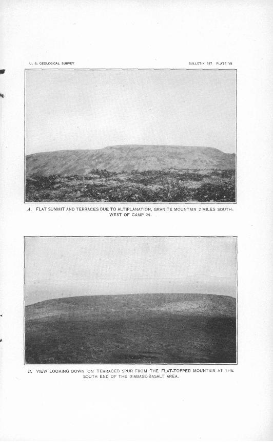
U. S. GEOLOGICAL SURVEY BULLETIN 667 PLATE VII
A. FLAT SUMMIT AND TERRACES DUE TO ALTIPLANATION, GRANITE MOUNTAIN 2 MILES SOUTH
WEST OF CAMP 24.
S. VIEW LOOKING DOWN ON TERRACED SPUR FROM THE FLAT-TOPPED MOUNTAIN AT THE
SOUTH END OF THE DIABASE-BASALT AREA.
GEOMOEPHOLOGY. 49
aberrant stream courses of similar significance but of smaller magni tude are found in this region and in other parts of the Yukon basin.
When the streams first adopted their present courses the region was apparently rather evenly aggraded to an elevation of about 1,200 feet. The waters from the upland areas tended to gather at the base of the slopes at.the margins of the alluvial plains. The highest and broadest upland areas gave rise to the largest streams, whose direc tions of flow determined the first courses of the new drainage lines.. The new courses therefore tended systematically to differ from the old, and many of them led from one basin to another across silt- filled divides. As the streams cut downward in such situations they encountered the solid rock and cut the canyons which they now occupy.
The recent erosion of the region as a whole was first controlled by the level of the outlet across the old Ruby barrier. As this levelwas lowered the erosion of the unconsolidated deposits was stimu lated, so that by the time the Yukon reached a fair adjustment in this reach a mature topography had been developed over large areas. The local barriers crossed by the superposed streams determined local base-levels of erosion, so that the rate of erosion differed in different parts of the region. The reduction of the bedrock barriers has pro gressed up to the present time, and the drainage as a whole is now fairly adjusted to the trunk streams. The removal of the unconsolidated deposits likewise has progressed in adjustment to the different base- levels. Their removal is further advanced where erosion was con trolled by lower base-levels and where, adjacent to the uplands, the gathering of waters facilitated the early establishment of drainage lines. The silts are especially well preserved in the area extending from the Chitanana basin eastward to the Zitziana and Kantishna basins. The bedrock barrier on Chitanana River apparently was cut down slowly, and the valley in the silt plains above it is very deep and narrow. The persistence of the silts in the eastern part of the region is probably due to the absence of upland features and the con sequent slowness in the development of drainage courses. Much of this area still drains into lakes that have no outlets.
The same principles apply to the erosion of the silts in all parts of the region and probably account for the major differences in their topographic aspect from place to place.
At many places the wind has formed irregularities in the surface of the silt, and it doubtless transported fine, dry silt for considerable distances. It may have aided in removing the silt from some areas, and it probably laid down the local siltlike deposits that are found in some of the higher passes.
Most of the major features of the present topography and some of its minor features are, then, the combined result of the work of
3107° !&-BuU, 607 4

50 COSNA-NOWITm REGION, ALASKA.
streams, standing water, and winds, agencies whose action was com plicated by the glaciation of adjacent regions and whose results con form in a measure to structural and lithologic conditions imposed by agencies that were effective earlier in the geologic history of the region. Neither of these sets of agencies, however, was instru mental in producing certain locally conspicuous topographic details, such as the characteristic flat summits, passes, and terraces in the areas occupied by hills formed of granite, quartzite, and the old diabases and basalts (PL VII, A, B), for these are due to a form of solifluction which the writer has called altiplanation.1 Frost action causes movements in accumulating detrital deposits, and under cer tain climatic conditions, when the proportion of coarse and fine prod ucts of weathering fall within certain limits, the process of alti planation is favored and produces flat-topped features. At several places in the region these features have been developed in extraordi nary perfection. The process of altiplanation is extremely slow and has probably been in operation here since well back in Tertiary time.
More recently landslides have in places developed striking features of the landscape. A general view along the course of a landslide within a year of its occurrence is shown in Plate VIII, A; and the folded turf where a part of the same slide came to a stop is shown in Plate VIII, B. This slide started on a 10° slope and stopped on an 8° slope. It affected only a thin stratum of material, representing the depth to which the talus mantle thawed after part of its moss covering had been burned. The burning evidently took place in the spring and the slide in the fall of the same year. These features are fairly numerous in the uplands of the region wherever burning has occurred and serve to emphasize the importance of ground frost in controlling the accumulation and migration of the residual mantle in interior Alaska.
ECONOMIC GEOLOGY.
VEINS AND MINERALIZATION.
Quartz veins or other signs of mineralization are not generally abundant in the region. Veins were noted only locally, about the granitic intrusives, in the area of the quartzites and phyllites between the forks of Cosna River and in the pre-Ordovician metamorphic rocks. At none of these places, however, so far as could be noted in the field examination, were they very abundant or highly mineralized.
Sulphide mineralization has affected the quartzites and phyllites to some extent, but not in a manner that suggests any economic possibilities. These rocks hi places carry finely disseminated gran ules of pyrite and are cut by rhyolite dikes that are similarly miner-
i Eakin, H. M., The Yukon-Koyukuk region, Alaska: U. S. Geol. Survey Bull. 631, pp. 78-H2,1916.
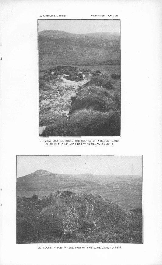
U. S. GEOLOGICAL SURVEY BULLETIN 667 PLATE VIII
A. VIEW LOOKING DOWN THE COURSE OF A RECENT LAND SLIDE IN THE UPLANDS BETWEEN CAMPS 12 AND 13.
B. FOLDS IN TURF WHERE PART OF THE SLIDE CAME TO REST.

ECONOMIC GEOLOGY. * 51
alized. Weathered surfaces of these rocks in places show iron and copper stains.
Auriferous mineralization is nowhere evident from the study of rocks in place, but placer gold occurs at two localities in the region on Baker Creek, a western tributary of Sethkokna River near its mouth, and on American Creek, a western tributary of the Telsitna about the middle of its course. Placer gold has been reported also from the head of Our Creek, a tributary of the Nowitna next above the Sulukna, and from a tributary of the Sulukna that heads againstOur Creek.
PROSPECTING.
A few prospectors have spent a great deal of time in a search for placer gold on the tributaries of Nowitna River, and the occurrences just named have long been known. Exaggerated reports of gold placers in the region have been circulated among the river settlements at different times and have caused several so-called stampedes of large numbers of people to this or that locality, but the occurrence of commercial placers in the region has not yet been demonstrated, and during the summer of 1915 the creeks were entirely deserted. It should be noted, however, that new discoveries on the tributary of the Sulukna heading against Our Creek were reported during the summer and that a number of prospectors were on their way to that locality.
Except in the locality near Our Creek, where the alluvial deposits are comparatively shallow, the region holds out little promise to the prospector, and his work would be very difficult, owing to the great depth and breadth of the alluvial filling of the larger valleys, a con dition that has limited prospectors to small streams that lie relatively high in the uplands. Such streams naturally have narrow valleys and steep grades and, as they have performed only a small amount of erosion, large concentrations of placer gold in their gravels are not to be expected. The concentrations that might have been made by the larger streams can be looked for only in the broad depressions that are now floored with deep alluvial deposits. The distribution of these deposits is shown on the map (PL II). They extend up all the larger valleys well toward their heads. Wherever these valleys were occupied, prior to their alluviation, .by streams of size sufficient to form large placers, the alluvial deposits probably measure scores if not hundreds of feet in thickness. Furthermore, the present streams generally do not follow exactly the courses of the original
' streams, and there is no definite indication as to the position of the earlier deposits. Under these conditions it seems that erratic pros pecting in the broad, deeply filled valleys is not justified.
As gold occurs on some of the small and relatively shallow streams of the region, prospectors will no doubt continue the search for

52 COStfA-NOWITETA REGION, ALASKA.
profitable placers. The most intelligent plan to follow in such prospecting would appear to be that of tracing the known auriferous deposits down the smaller streams and out into the broader valleys by means of a succession of crosscuts. When the trend of the auriferous gravels has been discovered the hazard of succeeding operations will be reduced to a minimum. Whether a systematic plan of prospecting, such as this, is justified will depend on the showings in the smaller streams where work might be begun, and on this point the writer was unable to obtain any information. The occurrence of large placers in the major valleys is, of course, an unsettled question.
In this connection mention should be made of the relation of auriferous mineralization to igneous intrusives that is evident in the Innoko and Iditarod districts, southwest of this region. It seems clearly proved that the introduction of gold into the rocks of these districts was a phase of the same igneous activities that produced the granitic intrusives, and deposits near such intrusives have con tained the most valuable placers. The monzonites and granites of the Cosna-Nowitna region are probably closely related to the intrusives of the Innoko and Iditarod districts in age and character, and it would not be surprising to find that auriferous mineralization is associated with them also. It is equally possible, however, that such mineralization may not have occurred, for the granites and monzonites at many places in the interior of Alaska apparently have no such association. On, the whole, however, the vicinity of igneous intrusives would seem to be a more likely place for successful pros pecting than the areas more distant from them.

INDEX.
Page. Agriculture, conditions affecting............. 17-18Altiplanation, effect of....................... 50
flat'summit and terraces due to, plateshowing......................... 48
American Creek, gold on..................... 51Animals of the region........................ 17
Baker Creek, gold on........................ 51Barrier near Ruby, formation of.............. 47-48Basalts. See Diabases and Basalts.Base-level, changeof............. v .......... 4&-47Big Mud River, drainage by.................. 14Birch forest on well-drained slopes, plate
showing......................... 14Brooks, Alfred H., cited...................... 32
preface by............................... 5-6
Carboniferous rocks, absence of............... 40Cherts and slates, age of...................... 31-33
distribution and character of............. 30-31structure of.............................. 31
Chitanana River, drainage by............... 13Christbfcrs, H. J., and Dice, L. R., explo
ration by ....................... 9Climate of the region........................ 14-15Copper stains, occurrence of................. 50-51Cosna River, drainage by .................... 12-13
Densmore, Frank, exploration by............ 8-9Devonian limestones and slates, age of........ 26-27
distribution and character of............. 25-26structure of.............................. 26
Devonian sedimentation, features of......... 40Diabases and basalts, age of.................. 28
distribution and character of............. 27structure of.............................. 27
Drainage of the region........................ 10-14
Economic geology of the region............... 50-52Explorations, earlier......................... 8-9Extent of the region......................... 9
Faults, occurrence of........................ 37Field work, record of........................ 8Fish of the region............................ 17Folds in turf where landslide came to rest,
plateshowing................... 50Fossils, occurrence of.................. 19,25,26,32Frost, action of, on detrital deposits.......... 50
Game of the region........................... 17Geologic history of the region................. 38-42Geologic reconnaissance map of the region,
............................ In pocket.Geology, economic........................... 50-52
general features of....................... 19-20Geomorphology of the region................. 42-50Giffln,C.E., survey by...................... 8Glaciers, damming of rivers by............... 47-48
Gold, occurrence of.......................... 51Gordon, G. B., exploration by................ 9Granitic rocks, distribution and character of.. 34-35Grits and sandstones, age of.................. 31-33
distribution and character of............. 29-30
Herron, Lieut. J. S., exploration and map ping by......................... 9
History, geologic, of the region................ 38-42Hogback ridge supported by recumbent syn
clinal fold, plate showing........ 26
Inhabitants of theregion..................... 18Intrusive rocks, distribution and character of 34-35 Iron stains, occurrence of.....................' 50-51
Kantishna River, drainage by............... 12Kirk, Edwin, fossils determined by.......... 25,26Kuskokwim River, North Fork of, drainage
by............................... 12,14North Fork of, plate showing............ 14
Landslide, recent, view down course of, plateshowing......................... 50
Landslides, effects of........................ 50Lavas. See Volcanic rocks.Location of the region........................ 9
Mesozoic, early, sedimentation, features of.. 40-41 later, diastrophism, intensity of.......... 41
Names used for formations...............'.... 20Nowitna River, drainage by.............. 12,13,14
Ordovician limestones, age of................ 25characteristic topography of, where steeply
tilted, plate showing............ 24distribution and character of............. 23-24massive, plate showing.................. 24structure of.............................. 24thin bedded, underlying fossiliferous
member, plate showing......... 26Ordovician sedimentatipn, events of......... 39-40Our Creek, gold on.......................... 51
Phyllites. See Quartzites and Phyllites; Precipitation, record of, at Rampart......... 15Pro-Devonian uplift and erosion, features of. 40 Pre-Ordovician diastrophism and erosion,
features of....................... 39Pre-Ordovician limestone, plate showing.... 20Pre-Ordovician limestones and greenstones,
age of........................... 21distribution and character of............. 20-21structure of.............................. 21
Pre-Ordovician schists and quartzites, age of 22 distribution and character of............. 21-22structure of.............................. 22
Pre-Ordovician sedimentation, features of... 39 Prindle, L. M., cited........................ 32
53
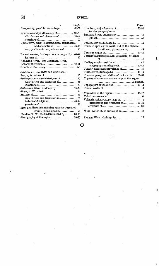
54 INDEX.
Prospecting, possible results from............ 51-52
Quartzites and phyllites, age of.............. 31-33distribution and character of............. 28-29structure of................................ 29
Quaternary, early, sedimentation, distributionand character of................. 43-48
early, sedimentation, evidence of.......... 42
Recent erosion, drainage lines arranged by. 48-49 features of................................. 42
Redlands River. See Chitanana River.Relief of the region.......................... 10-11Results of the survey.......................... 5-6
Sandstones. See Grits and sandstones.Scarps, formation of........................... 10Sediments, unconsolidated, age of............. 36
distribution and character of.............. 35structure of................................ 36
Sethkokna River, drainage by............... 13-14Shaw, E. W., cited............................. 44Siltj age of..................................... 36
distribution and character of............... 35nature and origin of..................... 43-44structure of................................ 36
Slate and limestone member of schist-quartzitegroup, plate showing.............. 20
Stanton, T. W., fossils determined by....... 32-33Stratigraphy of the region................... 20-36
Structure, major features of.................. 36-38See also groups of rocks.
Sulukna River, drainage by................... 13gold on.................................... 51
Telsitna River, drainage by................... 14Terraced spur at the south end of the diabase-
basalt area, plate showing......... 48Terraces, origin of........................... 44-45Tertiary diastrophism and volcanism, evidence
of.................................. 41Tertiary erosion, outline of.................... 41
topography resulting from............... 42-43Timber, kinds and prevalence of............... 16Titna River, drainage by.................... 13-14Tonzona group, correlation of rocks with.... 32-33Topographic reconnaissance map of the region
.............................In pocket.Topography of the region.................... 10-14Travel, routes of............................... 18
Vegetation of the region..................... 16-17Veins, occurrence of........................... 50Volcanic rocks, younger, age of................ 34
distribution and character of............ 33-34structure of................................. 34
Wind, action of, on surface of silt.............. 49
Zitziana River, drainage by................. 12
o