the conterminous united states mineral assessment program: background information … · ·...
TRANSCRIPT
U.S. GEOLOGICAL SURVEY CIRCULAR 975
The Conterminous United States Mineral Assessment Program:
Background Information to
Accompany Folio of Geologic
and Mineral Resource Maps of the Silver City 1 ° X 2° Quadrangle,
New Mexico and Arizona


The Conterminous United States
Mineral Assessment Program:
Background Information to
Accompany Folio of Geologic
and Mineral Resource Maps of the
Silver City l 0 X2° Quadrangle,
New Mexico and Arizona
By D. H. Richter, B. B. Houser, K. C. Watts, D. P. Klein, W. N. Sharp, Harald Drewes, D. C. Hedlund, G. L. Raines, and J. R. Hassemer
U.S. GEOLOGICAL SURVEY CIRCULAR 975
1987

Department of the Interior DONALD PAUL HODEL, Secretary
U.S. Geological Survey Dallas L. Peck, Director
Free on application to the Books and Open-File Reports Section, U.S. Geological Survey Federal Center, Box 25425, Denver, CO 80225

CONTENTS
Abstract
Introduction ----------------------------------------------------------------~ose and scope -------------------------------------------------------Geography and physiography ---------------------------------------------History of mining activity ------------------------------------------------
Description of component maps of the Silver City quadrangle folio ----------------Geology (Map I -1310-C) -------------------------------------------------Mineral deposits (Map I-1310-B) -----------------------------------------Geochemistry (Maps I-1310-E and MF-1183-A through L) --------------------
Introduction and methods ---------------------------------------------Results -------------------------------------------------------------
Geophysics (Maps I-1310-A, D, and G) -------------------------------------Petrochemistry of igneous rocks (Map I-1310-H) ----------------------------Remote sensing (Map MF -1183-Q) ----------------------------------------Resource assessment (Map 1310-F) -----------------------------------------
References cited -------------------------------------------------------------Selected bibliography for the Silver City quadrangle ------------------------------
ILLUSTRATIONS
Page
1 1 1 1 2 4 4 7 7 7 9
11 12 12 13 14 15
Page
FIGURE 1. Index map of Arizona and New Mexico showing location of the Silver City 1 °X2° quadrangle------- 3 2. Map of the Silver City 1 oX 2 o quadrangle, New Mexico and Arizona, showing principal mining areas a..,.d
year of discovery------------------------------------------------------------------------ 4 3. Generalized geologic map of the Silver City 1 °X2° quadrangle, New Mexico and Arizona------------ 5 4. Map of the Silver City 1 °X2° quadrangle, New Mexico and Arizona, showing locations of stream-sediment
samples ------------------------------------------------------------------------------- 8 5. Map of the Silver City 1 °X2 o quadrangle, New Mexico and Arizona, showing locations of ground-water sampl~ 9 6. Map of the Silver City 1 °X2° quadrangle, New Mexico and Arizona, showing relationship of the ra~io
(Ag+Mn+Ba+Zn+Pb)/(Au+Cu+Mo+Bi+W) to middle Tertiary eruptive centers---------------- 11
TABLES
Page
TABLE 1. Component maps of the Silver City 1 °X2° quadrangle folio, New Mexico and Arizona-------------- 2 2. Summary of estimated production, reserves, and resources of the principal commodities in the Silver c~~y
1 °X2° quadrangle, New Mexico and Arizona------------------------------------------------ 14
Ill

.I

The Conterminous United States Mineral Assessment Progr~m: Background Information to Accompany Folio of Geologic crnd
Mineral Resource Maps of the Silver City 1 °X2 ° Quadrangle,New Mexico and Arizona
By D. H. Richter, B. B. Houser, K. C. Watts, D. P. Klein, W. N. Sharp, Harald Drewes, D. C. Hedlund, G. L. Raines, and J. R. Hassemer
ABSTRACT
The Silver City 1 oX 2 o quadrangle, consisting of about 20,650 km2 in southwestern New Mexico and southeastern Arizona, has been investigated by a multidisciplinary research team for the purpose of assessing its mineral resource potential. The results of this investigation are in a folio of 21 maps that contain detailed information on the geology, geochemistry, geophysics, mineral deposits, and potential mineral resources of the quadrangle. This Circular provides background information on the various studies and integrates the component maps. It contains an extensive selected bibliography pertinent to the geology and mineral deposits of the quadrangle. The quadrangle has produced more than $3.5 billion in mineral products since about 1850 and contains significant resources of gold, silver, copper, molybdenum, lead, zinc, iron, manganese-iron, zeolite minerals, and possibly tin and tungsten.
INTRODUCTION
PURPOSE AND SCOPE
This Circular, together with a separately available group of related maps of the Silver City 1 °X2 o
quadrangle, New Mexico and Arizona, is one of a series of U.S. Geological Survey folios that focuses on the mineral resource potential of the conterminous United States. This folio, prepared under the auspices of the Conterminous United States Mineral Assessment Program (CUSMAP), is intended to ( 1) provide information for national minerals policy, (2) aid in Federal, State, and local landuse planning, (3) provide data and guidance for minerals exploration, and (4) increase our geologic knowledge of the quadrangle.
1
Much of the basic data for this folio was collected prior to 1977 in several U.S. Geological St~:rvey and U.S. Bureau of Mines projects, university thesis studies, and investigations by the mineral industry. Since then an interdisciplinary team of Geological Survey scientists has carried on field, laboratory, and library studies necessary to provide the additional data for a mineral resource assessrnent. The folio consists of 21 maps on the geology, geochemistry, geophysics, and mineral deposits of the quadrangle (table 1). This circular provides a very brief description of the folio elements and an extensive bibliography of the geologic literature pertinent to the Silver City 1 °X2° quadrangle.
GEOGRAPHY AND PHYSIOGRAP~~y
The Silver City 1 °X2 o quadrangle cover~ approximately 20,650 km2 in southwestern Ne~r Mexico and southeastern Arizona between lat 32 ° and 33° N. and between long 108° and 110° l~Z (fig. 1). It includes parts of Grant, Hidalgo, and Luna Counties in New Mexico, and Cochise, Graham, and Greenlee Counties in Arizona. The principal population centers are Silver City and Lordsburg in New Mexico, and Safford and V\~illcox in Arizona. Interstate 10, U.S. Highways 70, 80, 180, and 666, and numerous state and county roads provide access to most of the quadrangle.
The quadrangle lies almost entirely within the southern Basin and Range province, an area of north- to northwest-trending mountain rPnges and

TABLE I.-Component maps of the Silver City JOX2° quadrangle foliq New Mexico and Arizona
U.S. Geological Survey Miscellaneous Investigations Series (I) Maps
1-1310-A (Wynn 1981) B (Richter and Lawrence, 1983) C (Drewes and others, 1985) D (Klein, 1986) E (Watts and Hassemer, 1986) F (Richter and others, 1986) G (Klein, 1986) H (Sharp, 1986)
U.S. Geological Survey Miscellaneous Field Studies (MF) Map
MF-1183-A (Watts and others, 1986a) B (Watts and others, 1986b) C (Watts and Hassemer, 1980) D (Watts and others, 1986c) E (Watts and others, 1986d) F (Watts and others, 1986e) G (Watts and others, 1986f) H (Watts and others, 1986g) I (Watts and others, 1986h) J (Watts and others, 1986i) K (Watts and others, 1986j) L (Hassemer and others, 1986) Q (Raines, 1984)
basins. A small area in the northeast part of the quadrangle, characterized by broad volcanic uplands, is in the transition zone between the Basin and Range and the Colorado Plateau provinces. The westerly flowing Gila River and its tributaries form the principal drainage system in the quadrangle; two large playa basins and other smaller central basin areas are drained internally. Elevations range from a low of 820 m, where the Gila River leaves the northwest corner of the quadrangle, to a high of 3,257 m, 35 km south on M t. Graham in the Pinaleno Mountains.
HISTORY OF MINING ACTIVITY
The first known mineral development in the Silver City quadrangle was at Santa Rita and Tyrone in New Mexico where prehistoric Indians mined native copper and turquoise prior to Spanish conquest. From about 1801 to 1848, when the area became part of the United States, copper was mined in the Santa Rita area and shipped to Mexico for coinage.
2
Gravity Mineral deposits Geology Magnetics
Subject
Interpretive geochemist11· Mineral resource assessm~nt Interpretive geophysics Petrochemistry of igneou ~ rocks
Subject
Geochemistry of lead Geochemistry of copper Geochemistry of fluorite Geochemistry of zinc Geochemistry of molybdE'num Geochemistry of silver Geochemistry of tungsten Geochemistry of bismuth and beryllium Geochemistry of tin Geochemistry of mangan,.~se Geochemistry of barium Hydrogeochemistry of ururium Limonitic alteration
During and immediately following t]'~ Civil War, prospecting activity was extreme!:? vigorous, especially in the northeast corner c--= the quadrangle. By the late 1860's, the rich secc~dary silver deposits at Georgetown and Silver e::.ty, the gold lodes at Pinos Altos and in the Dos Ca':lezas Mountains, and the replacement and vein deposits at Fierro-Hanover and Bayard had beeiJ discovered, and many were being mined. Prospectors rapidly moved south and west across the quadrangle and, despite hostile Indian activity, th~ next two decades saw most of the principal mining areas established (fig. 2). By the early 1890's, many of the shallow, high-grade enriched prE:~ious metal ores were depleted, and the drop in the price of silver in 1893 closed most of the rema~.ning mines. Attention shifted to the base-metal ores in the early 1900's, when copper, lead, and zinc were produced from many of the vein and replacement deposits such as those at Lordsburg, FierroHanover, Santa Rita, Bayard, Steeph Rock, Safford, and Tyrone.
Low-grade, disseminated porphyry copper deposits were first recognized in the quadrangle

~7--.-----,-----.----,---~-----.---?\so:eRJ------j
r-. ); : ~""// ) ROCKY I ~ 360 r "" ! I ~~~~~ /MoUNTAINs\ \
\ ~ COLORADO
1 vo~ './f~ / PROVINCE /\ I
\"- I / \ /\ I
1 \ '--- PLATEAU 1 ( 1r- 4 ---""'( PLAINS 1 L \ ........_ ........._ . ~ • Albuquerque 1 \ '""-- \ PRoVJrNcerN E vi, ,._ j M E I x c c I
l" A R 1"-.~ 'Q_ N A I \ I ~ I \ f " ----.. I J J .:::. ) \ J34o
I \ 7". \ I ( .........: lz I I ' }?..ql\l.s. \ ~,....-.::::-;::::- I tr \ PROVINCE \
/ .Phoenrx'-,-~o,_, '---1 )1 \ ~ \ \\ 1 ! e G110 -.., I ZONE Y ~ \ i I Als 'I (!) \ \
,- IJ\1 SUver g \1\tlC~ \ 1 ~ ANo City \ ~~0 \ I
,~ RANGE j 114~..._ _...lL--..1.-----
..... " ~ . ,---'-;- 104~ '..... I \ r.:---'--' 106 ~ I . 11oao
112o ' ...... ~-----..l. __ _jL.._L, 110°
0 100 200 KILOMETERS
0 50 100 MILES
FIGURE 1. Index map of Arizona and New Mexico showing location of the Silver City 1 °X2° quadrangle and some major geographic and physiographic features.
at Santa Rita in 1906, and in 1911large-scale openpit mining was started. The porphyry copper deposit at Tyrone was developed as a large openpit mine in 1969, although high-grade copper ore had been produced from a number of underground mines in, and peripheral to, the deposit between 1880 and 1921. The large, buried porphyry copper deposits of the Safford area were not discovered until the 1950's and are now under consideration for development for underground mining.
Magnetite iron ore was mined from the limestone replacement deposits peripheral to the Fierro-Hanover stock between 1916 and 1931. Production of manganiferous iron ore also began in 1916 from the Silver City area and has continued intermittently up to the present time.
World Wars I and II spurred the search for strategic minerals throughout the quadrangle. During these periods of national emergency, especially during and following World War II, many generally small vein deposits of manganese
3
(Ash Peak, Cap Rock, and Lone Mountain areas) and fluorite (Duncan, Steeple Rock, Redrock, and Tyrone areas) were discovered and mined; except for the mining of fluorite at Redrock, neith~r commodity has been extensively produced sir~e the late 1950's. Very small tungsten ore bodies from skarn-type deposits were mined following World War II.
The radium boom of the 1920's led to the redevelopment of gold- and silver-bearing veins in the White Signal area for their secondary uranium minerals. Following World War II, these deposits and others throughout the quadrangl~ were examined as potential sources of uranium, but total production for nuclear energy purposes has been negligible.
In 1950, zeolite minerals were recognized in late Cenozoic ash-fall beds within the lac~~strine
deposits of the San Simon basin near Bowie. The deposits have produced significant amounts of inqustrial zeolite minerals since 1960.

~ v .960
0 26
0 10 20
60
30 40
76 KILOMETERS
MILES
<;:)
VICTORIO :-1880
FIGURE 2. Map of the Silver City 1 °X2° quadrangle, New Mexico and Arizona, showing principal mining areas and year of discovery. Second date indicates rediscovery or other important milestone in the mining area. Bedrock a-~as are stippled.
DESCRIPTION OF COMPONENT MAPS OF THE SILVER CITY
1 °X2° QUADRANGLE FOLIO
GEOLOGY (MAP 1-1310-C)
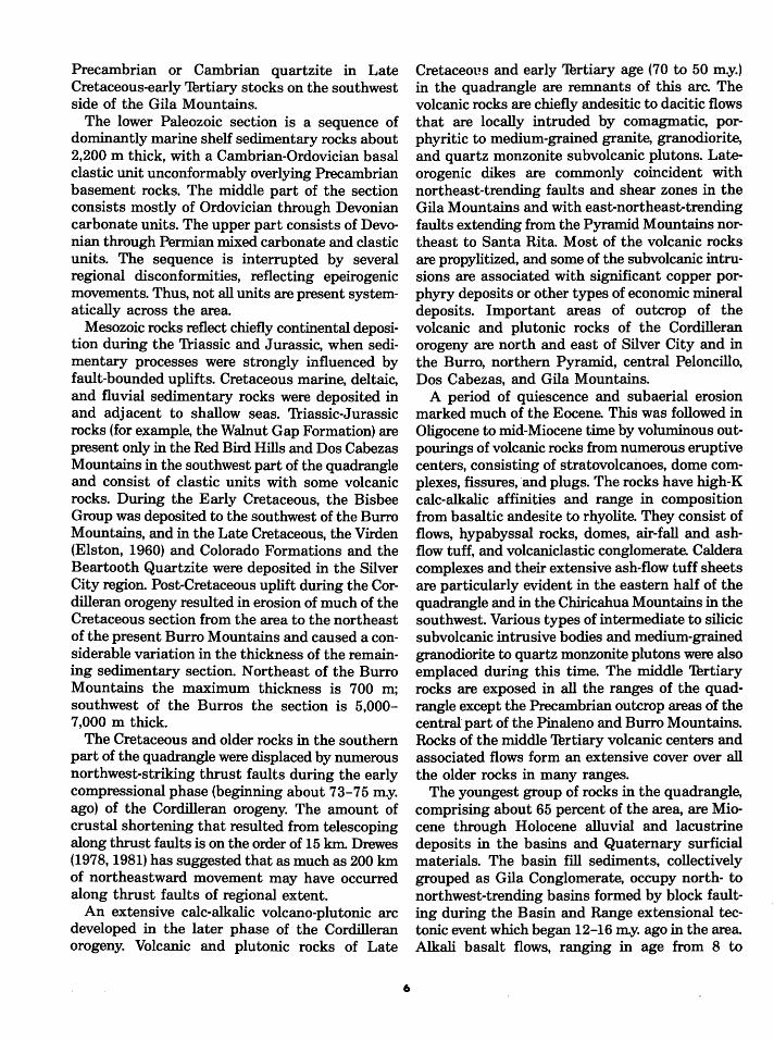
The Silver City 1 oX 2 o quadrangle is composed of north- to west-northwest-trending block-faulted mountain ranges consisting of diverse rocks ranging in age from Precambrian through Cenozoic. The mountain ranges are separated by structural and topographic basins filled with late Cenozoic continental sedimentary rocks (fig. 3). Four main groups of rocks exposed in the ranges are, from oldest to youngest, (1) Precambrian metamorphic and plutonic rocks, (2) Paleozoic and Mesozoic sedimentary rocks, (3) Cretaceous and early Tertiary volcanic and plutonic rocks, and (4) midTertiary volcanic and plutonic rocks.
4
The principal outcrop areas of Prer.ambrian rocks are the Pinaleno and Dos Cabezas Mountains in the southwest and the Burro Mo",.ntains in the east. In both areas, thick sequer~es of chiefly pelitic sediments with lesser amounts of intermediate volcanic rocks (Pinal Schirt. in the southwest and Bullard Peak "Series" of Jl"ewitt, 1959 in the east) were regionally metamorphosed to amphibolite facies during the Mazatzal revolution (Wilson, 1939; Anderson, 1951), which was between 1,550 and 1,680 m.y. ago. The rr.~tamorphosed rocks were intruded by large lat~-orogenic but chiefly postorogenic granite to granodiorite plutons about 1,450 m.y. ago. Near the close of the Mazatzal revolution, the region was cut by northwest-trending faults with significant offsetboth strike-slip and dip-slip. Dial:·'lse dikes and other small igneous bodies, probably 1,200 m.y. old, cut both the metamorphic and plutonic rocks. The area was marked by a period of relative tectonic
1os•oo· 1os•oo·
~ Ti})
0 10 20 30 40 50KILOMETERS r---L--.~--~-.~--~
0 10 20 JOMILES
EXPLANATION
OTs Quaternary to upper Tertiary sedimentary rocks and surficial materials
Middle Tertiary volcanic and plutonic rocks
Lower Tertiary to Upper Cretaceous volcanic and plutonic rocks
Mesozoic to Paleo zoic sedimentary rocks
Precambrian metamorphic and plutonic rocks
-..--- ,.-- Tectonic boundary- numerous thrust faults on sawtooth side
FIGURE 3. Generalized geologic map of the Silver City 1 •x2 • quadrangle, New Mexico and Arizona.
quiescence and erosion between about 1,200 m.y. and the beginning of Paleozoic sedimentation. The maximum thickness of Precambrian rocks in the quadrangle is unknown, but is certainly greater than several thousand meters.
Sedimentary rocks of Paleozoic and Mesozoic age are exposed mostly in the northeast part of
the quadrangle in the Pinos Altos Range along the Santa Rita horst and in the ranges in the southern one-third of the quadrangle. Part of the PaleozoicMesozoic section may also be present at depth beneath the volcanic rocks of the Gila Mountains in the northwest part of the quadrangle. This is suggested by the presence of large xenoliths of
5
Precambrian or Cambrian quartzite in Late Cretaceous-early Thrtiary stocks on the southwest side of the Gila Mountains.
The lower Paleozoic section is a sequence of dominantly marine shelf sedimentary rocks about 2,200 m thick, with a Cambrian-Ordovician basal clastic unit unconformably overlying Precambrian basement rocks. The middle part of the section consists mostly of Ordovician through Devonian carbonate units. The upper part consists of Devonian through Permian mixed carbonate and clastic units. The sequence is interrupted by several regional disconformities, reflecting epeirogenic movements. Thus, not all units are present systematically across the area.
Mesozoic rocks reflect chiefly continental deposition during the 'IHassic and Jurassic, when sedimentary processes were strongly influenced by fault-bounded uplifts. Cretaceous marine, deltaic, and fluvial sedimentary rocks were deposited in and adjacent to shallow seas. 'friassic-Jurassic rocks (for e;xample, the Walnut Gap Formation) are present only in the Red Bird Hills and Dos Cabezas Mountains in the southwest part of the quadrangle and consist of clastic units with some volcanic rocks. During the Early Cretaceous, the Bisbee Group was deposited to the southwest of the Burro Mountains, and in the Late Cretaceous, the Virden (Elston, 1960) and Colorado Formations and the Beartooth Quartzite were deposited in the Silver City region. Post-Cretaceous uplift during the Cordilleran orogeny resulted in erosion of much of the Cretaceous section from the area to the northeast of the present Burro Mountains and caused a considerable variation in the thickness of the remaining sedimentary section. Northeast of the Burro Mountains the maximum thickness is 700 m; southwest of the Burros the section is 5,000-7,000 m thick.
The Cretaceous and older rocks in the southern part of the quadrangle were displaced by numerous northwest-striking thrust faults during the early compressional phase (beginning about 73-75 m.y. ago) of the Cordilleran orogeny. The amount of crustal shortening that resulted from telescoping along thrust faults is on the order of 15 km. Drewes (1978, 1981) has suggested that as much as 200 km of northeastward movement may have occurred along thrust faults of regional extent.
An extensive calc-alkalic volcano-plutonic arc developed in the later phase of the Cordilleran orogeny. Volcanic and plutonic rocks of Late
6
Cretaceous and early Thrtiary age (70 to 50 m.y.) in the quadrangle are remnants of this arc. The volcanic rocks are chiefly andesitic to dacitic flows that are locally intruded by comagmatic, porphyritic to medium-grained granite, granodiorite, and quartz monzonite subvolcanic plutons. Lateorogenic dikes are commonly coincident with northeast-trending faults and shear zones in the Gila Mountains and with east-northeast-trending faults extending from the Pyramid Mountains northeast to Santa Rita. Most of the volcanic rocks are propylitized, and some of the subvolcanic intrusions are associated with significant copper porphyry deposits or other types of economic mineral deposits. Important areas of outcrop of the volcanic and plutonic rocks of the Cordilleran orogeny are north and east of Silver City and in the Burro, northern Pyramid, central Peloncillo, Dos Cabezas, and Gila Mountains.
A period of quiescence and subaerial erosion marked much of the Eocene. This was followed in Oligocene to mid-Miocene time by voluminous outpourings of volcanic rocks from numerous eruptive centers, consisting of stratovolcanoes, dome complexes, fissures, 'and plugs. The rocks have high-K calc-alkalic affinities and range in composition from basaltic andesite to rhyolite. They consist of flows, hypabyssal rocks, domes, air-fall and ashflow tuff, and volcaniclastic conglomerate. Caldera complexes and their extensive ash-flow tuff sheets are particularly evident in the eastern half of the quadrangle and in the Chiricahua Mountains in the southwest. Various types of intermediate to silicic subvolcanic intrusive bodies and medium-grained granodiorite to quartz monzonite plutons were also emplaced during this time. The middle Thrtiary rocks are exposed in all the ranges of the quadrangle except the Precambrian outcrop areas of the central part of the Pinaleno and Burro Mountains. Rocks of the middle Thrtiary volcanic centers and associated flows form an extensive cover over all the older rocks in many ranges.
The youngest group of rocks in the quadrangle, comprising about 65 percent of the area, are Miocene through Holocene alluvial and lacustrine deposits in the basins and Quaternary surficial materials. The basin fill sediments, collectively grouped as Gila Conglomerate, occupy north- to northwest-trending basins formed by block faulting during the Basin and Range extensional tectonic event which began 12-16 m.y. ago in the area Alkali basalt flows, ranging in age from 8 to
0.14 m.y., are locally interlayered with the sediments in some basins and are also locally present in some of the ranges. The maximum thickness of the Gila Conglomerate in the quadrangle is not known; however, it is as much as 2,590 m thick east of the Pinalenos, 27 km south of Safford, and it is probably more than 1,000 min the deeper parts of most basins. The upper 300 m of the Gila Conglomerate is well exposed in basins in the northern part of the quadrangle where it has been dissected by the Gila River. Details of the development of the Gila River system are not known, but the presence of Lava Creek Bash (lzett and Wilcox, 1982) in gravel in the Gila River near Canador Peak suggests that the river became a through-flowing system prior to 600,000 yr ago. Much of the southern half of the quadrangle still has interior drainage and the basins are veneered with surficial materials.
MINERAL DEPOSITS (Map 1-1310-B)
The Silver City quadrangle contains a variety of mineral deposits that have produced about $3.5 billion worth of mineral products, chiefly base and precious metals, since 1850. Map 1-1310-B and its accompanying pamphlet are a descriptive compilation of more than 600 mineral deposits at 440 localities. The deposits described range from large operating mines to minor occurrences and are restricted generally to those that have been referred to in the literature. The compilation includes both metallic and nonmetallic deposits, but excludes such commodities as sand and gravel, rock, and most other construction materials that have a low cost per unit volume.
The mineral deposit data are grouped into 11 regional areas, each with a relatively distinct geologic terrane and to some degree a characteristic suite of deposit types. These areas include all the formal and informal mining districts in the quadrangle.
Forty-two specific mineral deposit types are recognized in the quadrangle. The deposits are classified in a broad genetic sense (hydrothermal, magmatic, and so forth) and then further subdivided into more specific types on the basis of physical form or process and metal or mineral content, such as porphyry Cu (Mo), Zn replacement, and fluorite vein. The pamphlet briefly describes the individual deposits in terms of ore minerals,
7
geologic features, and mining activity and includes a comprehensive economic geology bibliopl"aphy.
The mineral deposits in the quadrangle range in age from Precambrian to late 'Thrtiary. The: major hydrothermal ore-forming systems in thE: quadrangle developed as a result of subduction-related events during two distinct orogenic periods in the formation of the western continental marg~n: (1) a mediumK calc-alkalic volcanic arc system in Late Cretaceous-early 'Thrtiary time (the Cordilleran orogeny 80 to 50 m.y. ago) and (2) a high-K calcalkalic volcano-plutonic arc system in middle 'Thrtiary time (30 to 15 m.y. ago): The hydrot]'~rmalmagmatic vein- and pegmatite-type deporits are probably Precambrian, and the syngenetic sedimentary and volcanic deposits range in age from Cambrian to late 'Thrtiary or youngE' ....
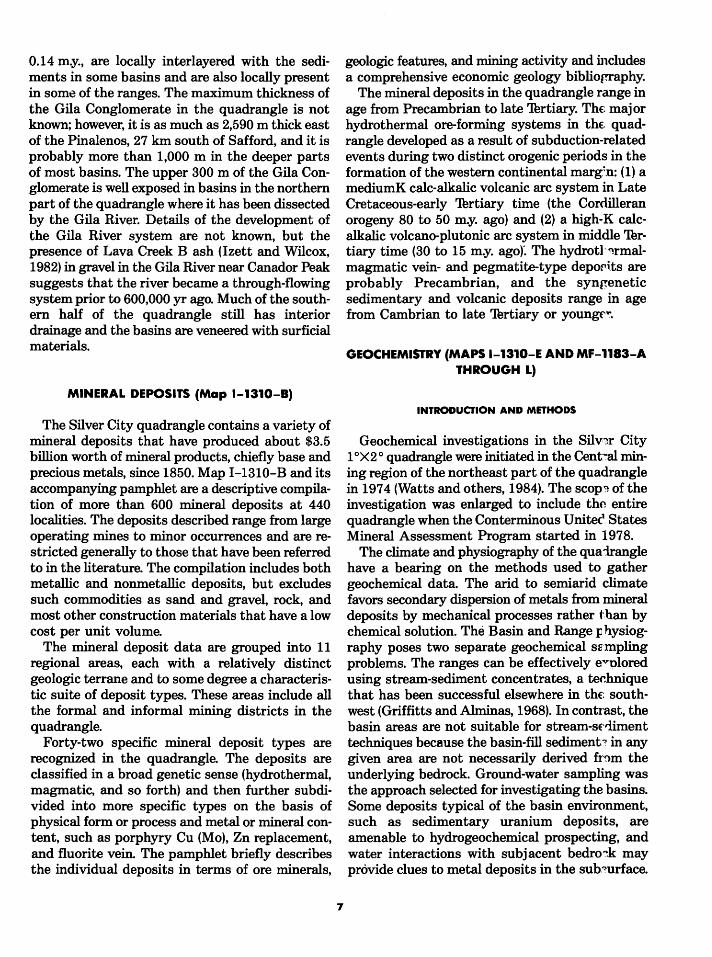
GEOCHEMISTRY (MAPS 1-1310-E AND MF-1183-A THROUGH L)
INTRODUCTION AND METHODS
Geochemical investigations in the Silv~r City 1 °X2 o quadrangle were initiated in the Cent':"al mining region of the northeast part of the quadrangle in 1974 (Watts and others, 1984). The scop~ of the investigation was enlarged to include th~ entire quadrangle when the Conterminous Unitec, States Mineral Assessment Program started in 1978.
The climate and physiography of the quairangle have a bearing on the methods used to gather geochemical data. The arid to semiarid climate favors secondary dispersion of metals from mineral deposits by mechanical processes rather than by chemical solution. The Basin and Range IJ hysiography poses two separate geochemical szmpling problems. The ranges can be effectively e.vl)lored using stream-sediment concentrates, a technique that has been successful elsewhere in the: southwest (Griffitts and Alminas, 1968). In contrast, the basin areas are not suitable for stream-sE'..fiment techniques because the basin-fill sediment:~ in any given area are not necessarily derived fr~m the underlying bedrock. Ground-water sampling was the approach selected for investigating the basins. Some deposits typical of the basin environment, such as sedimentary uranium deposits, are amenable to hydrogeochemical prospecting, and water interactions with subjacent bedro~k may provide clues to metal deposits in the sub'?urface.

,,
x \ x'
:
'' ' xx
X X ~X Jt X
'' X X ll II
X X
' ' •'
X X X
0
X X X
10 20 30 40 50KILOMETERS
10 20 30MILES
'xx •x,
X X
xx
FIGURE 4. Map of the Silver City 1 °X2° quadrangle, New Mexico and Arizona, showing locations of stream-sed~~ent samples.
During the geochemical program 2,345 streamsediment samples (fig. 4), 328 ground-water samples (fig. 5), and 1,273 samples of both mineralized and nonmineralized rocks were collected. The 12 geochemical maps (MF-1183-A through L) of the folio are based chiefly on analyses of the heavy-mineral concentrates of the streamsediment samples and analyses of the groundwater samples. The maps show element data by symbols representing ranges of analytical values for Ph, Cu, Zn, Mo, Ag, W, Bi, Sn, Mn, and Ba, and whether fluorite was identified in the concentrates. The concentrations of U, U/HC03, and Rn in ground-water samples are similarly shown. Map I-1310-E summarizes these data and presents interpretations relating to patterns of primary mineralization on a regional scale and the effects of erosion and weathering on these patterns.
The stream-sediment samples were collected from the active channels of first- and second-order streams along range fronts within 30 m of the contact between bedrock and basin fill, and on side
8
and headward tributaries of large canyons. Two types of stream-sediment samples were collected at each sample site: (1) a small (about 0.5 kg) screened sample of fine-grained matE:~al, and (2) a large (4-5 kg) bulk sample includir~ sand and gravel. The small samples were sievt"Q to< 0.18 mm but not further separated. The. large bulk samples, however, were treated in a series of steps to concentrate the heavy minerals.
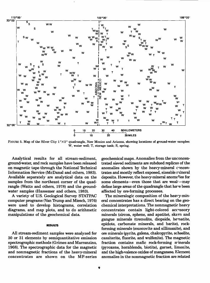
Ground-water samples, chiefly frmn the basins of the quadrangle, were collected frmn 248 wells, 15 springs and seeps, and 51 storage tanks that were fed either by wells or springs at the site. Two samples of water were collected at each site: ( 1) an untreated sample used for the determination of the major chemical constituents and (2) a filtered sample (0.45/l) acidified to pH<2 with ultrapure nitric acid for the determination of trace metals. The majority of analyses were by atomic: absorption spectrophotometry (14 elements) and inductively coupled plasma emission spectroscopy (17 elements).
110°00' 109°00' 108°00' 33°00'~--~5~----------------------------~1~1 ------------------------------------.
S WW IW W T. I Tr. W W wwl w w T w
w s w W W T W
WWw WTW Ww S
w w sw w
T w W s 1 WT W T W IW WT
w w w w
Wwww w w w w
w lw T w s Www w w s w w T
I I W
ww w w
w ,;'w ww
ww wr w
w w
s s W T S
w w
T lww rw
WI T W w w wW T w
wW s w w ww w, w T w wV.VV w
wl w w
w w w s w T W T T
w w w w
w ww Ww
ww w T
10 w Ww <'~ w ww zl>< w w
w w
w w w
w w T 2 ~ w o:,~w w w w
T
ww w w w w w w
w <ILJJ W T w T lz w w w
T w w
w ww w w w w w
w s w w~ w ww w w w w .. Tw w T --ww
w w w w W T w
T WW wT w w T W T T
w w w w ww
w w ww w w w Ww w
w w
WT Wr
Tr W W W W W vf W WW W T 32ooo·~T--~w~ __ w=-________ w __ r~ ________ w ____ w~!~, ___ T ___ T ____________________ ~r_w_T~wL-_T __ ~
T w
30 40 50KILOMETERS
20 30MILES
FIGURE 5. Map of the Silver City 1 °X2° quadrangle, New Mexico and Arizona, showing locations of ground-water samples: W, water well; T, storage tank; S, spring.
Analytical results for all stream-sediment, ground-water, and rock samples have been released on magnetic tape through the National 'Thchnical Information Service (McDanal and others, 1983). Available separately are analytical data on the samples from the northeast corner of the quadrangle (Watts and others, 1978) and the groundwater samples (Hassemer and others, 1983).
A variety of U.S. Geological Survey STATPAC computer programs (Van 1\-ump and Miesch, 1976) were used to develop histograms, correlation diagrams, and map plots, and to do arithmetic manipulations of the geochemical data.
RESULTS
All stream-sediment samples were analyzed for 30 or 31 elements by semiquantitative emission spectrographic methods (Grimes and Marranzino, 1968). The spectrographic data for the magnetic and nonmagnetic fractions of the heavy-mineral concentrates are shown on the MF-series
9
geochemical maps. Anomalies from the unconcentrated sieved sediments are subdued replicas of the anomalies shown by the heavy-mineral C">ncentrates and mostly reflect exposed, sizeable nineral deposits. However, the heavy-mineral anomz lies for some elements-even those that are weal~-may define large areas of the quadrangle that ha,.,e been affected by ore-forming processes.
The mineralogic composition of the heavy-mineral concentrates has a direct bearing on the geochemical interpretations. The nonmagnetic heavy concentrates contain light-colored acc~ssory minerals (zircon, sphene, and apatite), ska m and gangue minerals (tremolite, diopside, he~atite, epidote, carbonate minerals, and barite), rockforming minerals (muscovite and sillimanite), and ore minerals (pyrite, galena, chalcopyrite, scheelite, cassiterite, fluorite, and wulfenite). The magnetic fraction contains mafic rock-forming Irinerals (pyroxene, hornblende, biotite), garnet, limonite, and the high-valence oxides of manganese. Element anomalies in the nonmagnetic fraction are related

to (1) primary and secondary ore minerals, (2) heavy gangue minerals, and (3) accessory minerals of unusual composition, such as sphene containing tin. Anomalies in the magnetic mineral fraction have diverse sources from (1) limonite derived from ore minerals and associated gossan in zones of intense chemical weathering, (2) metal-rich (Ph, Zn, Ba, W) oxyhydroxides of manganese and iron introduced by heated meteoric water, (3) oxides of iron and manganese in spring deposits, and (4) relatively magnetic ore minerals or ore minerals intergrown with ferromagnesian minerals from mineralized outcrops.
Anomaly patterns indicate that metals are enriched along regional linear trends and locally are zoned around centers of known or postulated mineralization. The suites of elements and mineral phases involved are, in part, a function of geologic setting and level of erosion. Three types of anomalies are recognized in the quadrangle:
1. Nonmagnetic fractions show anomalies of high contrast characterized by the elements Au, Cu, Bi, Mo, and W. In mining areas high contrast anomalies of Pb, Ag, Zn, Sb, As, and Cd show up as well.
2. Magnetic fractions show anomalies of low to moderate contrast characterized by the elements Ph, Zn, Ba, Mn, and Ag (sometimes with As and Au); these anomalies are associated with oxyhydroxides of manganese and iron, and form broad patterns that parallel the basins and ranges.
3. Anomalies of moderate to high contrast, characterized by the elements Pb, Sn, Be, Ag, Mn, Nb, Th, and U, and fluorite occur in certain nonmagnetic fractions, usually those associated with the middle-'Thrtiary eruptive centers and generally in combination with magnetic-fraction anomalies of type 2. Some samples taken from subvolcanic intrusions that are more deeply exposed also include anomalous amounts of Mo and Bi, and rarely Cu and Zn.
Two suites of elements from the nonmagnetic fraction at each sample site were used to interpret metal zonation around apparent hydrothermal systems: (1) the inner-zone suite of relatively immobile elements, including Au, Cu, Mo, Bi, and W, that are related to deposits in contact metasomatic and plutonic and subvolcanic environments; and (2) the peripheral-zone suite of relatively mobile elements, including A.g, Mn, Ba, Zn, and Ph, that
10
are commonly laterally and (or) vertic~ 1ly dispersed from centers of mineralization.
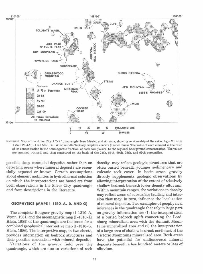
For each sample, the previously defined geochemical contrasts were determined; these values were then grouped according to suite and summed. Finally the sum for the inner-zone suite was divided into the sum for the peripherrl-zone suite. The resulting ratio (Ag+Mn+Ba+Zn+Pb)/(Au +Cu + Mo+ Bi + W) was posted by san1ple location; the map of ratio data was then contoured by cell averaging on the basis of the cumulrtive percent values on the statistical distribution c~lrve (percentiles). The contour map (fig. 6) thus ob~ained shows patterns that we interpret to be indicrtive of zonation around discrete mineralized centE-rs, including some centers that may lie well below the present ground surface. Linear portions of the contour patterns may indicate directional trends of mineralizing solutions.
Figure 6 shows that at least 10 of th ~ middle 'Thrtiary eruptive centers recognized in th~ quadrangle are dominated by dispersions of elements related to the peripheral-zone suite of ele1nents. Some volcanic centers show anomaly pattE'¥ns on their peripheries (for example, Ash Peak center); such patterns may be the result of distal hypogene leakage along ring fractures or other permeable zones. However, other eruptive cente:""s (for example, Greasewood Mountain center) sh'lw centrally located, somewhat more subdued ano:'llalies of the peripheral-zone suite. These centrally located anomalies, of moderate contrast, ma~T be characteristic of dispersion zones above a she llow ye.t concealed mineralized mass, related to a partially exposed igneous cupola. In areas with these characteristics, portions of the inner-zone metal dispersions occur at the surface.
Most of the known mineral districts in the quadrangle (see fig. 2) occur in deeply eroded terrane that is depleted in the peripheral-znne suite of elements and therefore shows no patte':'lls on figure 6. Where patterns do occur on figure 6 within an area of known mineral deposits (for example, in the northeast corner of the quadrangle), they may reflect either concealed, mineralized igneous cupolas or solution conduits peripl'~ral to the center of mineralization.
The interpretive method used in figure 6 is experimental and is subject to confirmation through detailed studies. The emphasis of the approach is on detecting the outer fringe of ve•tically and laterally zoned mineralization in orde· to identify
DRY
POWER LINE
!-iORSECAMP
/
! I
A v
x
' ---1
Contours: ORANGE BUTTE ~-"/)
:/ I, 14·75th Percentile MCKENZIE/" 1
28·85
4.9·90
68·95
238·99
AD values normalized to threshold
PEAK \
COCHISE ,~ ,/HEAD
' ' \
\
'o <Is.! zx OIUJ t:li:E
=I~ <u.~ z I I
@
0 10 20 30 40 50KILOMETERS ~--L--,L_ __ J_-,J_ __ _L,
0 10 20 30MILES
F IGURE 6. Map of the Silver City 1 ° X2° quadrangle, New Mexico and Arizona, showing relationship of the ratio (Ag+Mn+Ba +Zn+Pb)/(Au+Cu+Mo+Bi+W) to middle Tertiary eruptive centers (dashed lines). The value of each element is the ratio of its concentration in the nonmagnetic fraction, at each sample site, to the regional background concentration. The values are summed, ratioed, and then contoured on the basis of the 75th, 85th, 90th, 95th, and 99th percentiles.
possible deep, concealed deposits, rather than on detecting areas where mineral deposits are essentially exposed or known. Certain assumptions about element mobilities in hydrothermal solution on which the interpretations are based are from both observations in the Silver City quadrangle and from descriptions in the literature.
GEOPHYSICS (MAPS 1-1310-A, D, AND G)
The complete Bouguer gravity map (1-1310-A, Wynn, 1981) and the aeromagnetic map (1-1310-D, Klein, 1985) of the quadrangle are the bases for a combined geophysical interpretive map (1-1310-G, Klein, 1986). The interpretive map, in two sheets, provides information on bedrock structures and their possible correlation with mineral deposits.
Variations of the gravity field over the quadrangle, which are due to variations of rock
11
density, may reflect geologic structures that are often buried beneath younger sedimentary and volcanic rock cover. In basin areas, gravity directly supplements geologic observations by allowing interpretation of the extent of relatively shallow bedrock beneath lower density alluvium. Within mountain ranges, the variations in density may reflect zones of subsurface faulting and intrusion that may, in turn, influence the localization of mineral deposits. Two examples of geophysical inferences in the quadrangle that rely in large part on gravity information are (1) the interpretation of a buried bedrock uplift connecting the Lordsburg mineralized area with the Summit Mountains mineralized area and (2) the interpretation of a large area of shallow bedrock northeast of the Victoria Mountains mineralized area. Both areas have the potential for undiscovered mineral deposits beneath a few hundred meters or less of alluvium.

Aeromagnetic data show lateral variations in the total intensity of the Earth's magnetic field, which is related to the vertical and horizontal distribution of magnetic minerals, mainly magnetite, in the crust. The data reflect the magnetic structure of the crust that is produced when different rock types are brought into contact by intrusion or faulting. The magnetization information, to a great extent, reflects geologic conditions hidden beneath alluvium or other cover, and like gravity, allows inferences on structures and rock variations that are not exposed at the surface. Although gravity and magnetic data may be complementary, density and magnetization properties are independent variables that do not necessarily parallel each other. An example, based mostly on magnetic but partly on gravity data, is a zone 10-20 km wide of geophysical features along the southern edge of the quadrangle in which the trend is noticeably more due west than similarly prominent northwesttrending geophysical features found to the north. This zone is interpreted as related partly to thrustfaulted contacts of nonmagnetic carbonate rocks against variable but more magnetic igneous, metamorphic, and volcanic rocks. Areas with similar trends mapped in the Dos Cabezas and Chiricahua Mountains are known to be locally favorable for vein- and replacement-type mineral deposits.
PETROCHEMISTRY OF IGNEOUS ROCKS (MAP 1-1310-H)
The mineral content and major-, minor-, and trace-element chemistry of most of the Mesozoic and Cenozoic granitic intrusive rocks and rhyolitic eruptive centers are compiled and discussed in the two map sheets of Map I-1310-H. The investigation was aimed at determining the chemical and mineralogical characteristics of ore-producing magmas, especially those that may be the host for porphyry copper and molybdenum deposits, stockwork molybdenum deposits, and tin-tungsten deposits. In addition accessory minerals of the intrusive rocks and near-vent extrusive rocks were analyzed by microprobe in an attempt to establish specific residences of metals in the mineral assemblages. The multiple and complex black oxide accessories are particularly significant, as they are an indicator of the metal abundances in the magmas and may have rare metal (Nb, Ta, U, Sn) byproduct potential.
12
Post-Precambrian magmatic activity began in the Late Cretaceous (about 80 m.y. ago) with the advent of the Cordilleran orogeny. This period of volcano-plutonic activity, related in current tectonic models to subduction of an oceanic plate along the western margin of North America (Coney and Reynolds, 1977; Damon and others, 1981), continued through the early Thrtiary (about 50 m.y. ago) with the intrusion of an array of calc-alkalic granites and granodiorites. During this volcanoplutonic activity, the porphyry copper deposits and a variety of base- and precious-metal vein andreplacement deposits in the quadrangle were formed. Following a period of magmatic quiescence between 50 and 40 m.y. ago, intrusive activity resumed in the Oligocene with the emplacement of both high-K and normal calc-alkalic granites and intrusive rocks. The appearance of high-K rocks may reflect the beginning of a change from compressional to extensional tectonism along the eastern side of the orogenic belt. By the beginning of the Miocene (about 26 m.y. ago), the shift from calc-alkalic magmatism to high-K calc-alkalic magmatism was complete as evidenced by the composition of extrusive rocks and assuming that the nature of the buried intrusive rocks is similar.
Many of the Miocene eruptive systems show characteristics that suggest chemically zoned magma chambers-a maturing process that has produced high-silica, high-K rhyolites and anomalous rare metal concentrations elsewhere. Some of these rocks are fayalite rhyolites; they are high in Rb, low in Sr and Zr, and contain fluorite, F-apatite, ilmenite ± Nb, cassiterite, and uraninite as accessory minerals. Locally they are accompanied by small veins or segregations of gas-phase minerals containing Sn, W, Be, U, Mo, and F.
Minor-element plots of rhyolites from some of these middle Thrtiary silicic eruptive centers, as well as plots for the granitic intrusive rocks, combined with criteria developed by Hildreth (1980) and Mutschler and others (1981) for assessing the degree of magma fractionation, enable selection of some eruptive centers as deserving further study and perhaps exploration for deposits.
REMOTE SENSING (MAP MF-1183-Q)
Laboratory remote-sensing studies, consisting of digital image processing and interpretation of Landsat imagery, were used to produce a map of

limonitically altered rocks or areas in the quadrangle. Numerous limonite anomalies in bedrock areas and two limonite anomalies in the late Cenozoic basins were mapped. Most of the bedrock anomalies and one of the basin anomalies are related to areas of known hydrothermally altered rock. The other basin anomaly, on Lordsburg Mesa, may be related to a mineralization process similar to that which produced the calcrete uranium deposits of western Australia.
RESOURCE ASSESSMENT (MAP 1-1310-F)
Geologic, geochemical, and geophysical data from other investigations of the program have been used to assess the quadrangle's mineral resources. The resources evaluated include both metallic and nonmetallic commodities but exclude the organic fuels and most sand, gravel, and rock products. The 42 deposit types recognized in the mineral deposit component (Richter and Lawrence, 1983) of the folio have been adopted as the basic unit in this assessment. In addition to the known deposit types of the quadrangle, the resource potential of several other deposit types for which the geologic environment appears favorable is also discussed.
The assessment is based on identifying geologic terranes favorable for the occurrence of both known and possible deposit types and focuses chiefly on the mineral potential of the mountain ranges. Although favorable geologic terranes for mineralization undoubtedly underlie the late Cenozoic basin areas, their areal extent and the relatively great thickness of fill preclude an appraisal of the underlying bedrock. Locally, known geology of the mountain ranges can be extrapolated into areas of shallow basin fill, and in some places geophysical studies have resulted in a better understanding of regional subbasin geology, but delineation of favorable terranes on the basis of such results is not feasible. Likewise, the extensive areas of middle Thrtiary volcanic rocks may cover favorable terranes and possibly significant ore deposits of Late Cretaceous-early Thrtiary and older age. Some attempt has been made to peer under the volcanic cover by geophysical means, but again the data are not sufficient to warrant an appraisal.
The approach relies heavily on detailed information that facilitates inferences about the processes that have shaped the geology of the quadrangle and on developing physical-genetic models of the mineral deposit types likely to occur. In general,
13
the delineation of areas of favorability fe· the deposit types examined are based on three broad criteria: (1) known deposits, which imply a favorable geologic environment; (2) necE:~sary geologic conditions, such as favorable host rocks, eruptive systems, structures, and source rocks, that indicate the presence of a favorable en"•ironment; and (3) suggestive conditions, such as associated deposit types and geochemica 1 and geophysical anomalies, that suggest the pn:~ence of a favorable environment. Ranking areas in terms of favorability is largely avoided, although the type criteria used in delineating an area are an iniirect guide to its favorableness. However, many ar~as of favorability based on suggestive criteria may, in fact, become increasingly significant in the future as ore-forming processes become better under~tood and as more sophisticated exploration techr.iques are developed. No estimation of the numb~rs of deposits that may occur in areas of favorability has been attempted, nor has there been any concerted effort to quantify the undiscovered res<',uces (either hypothetical or speculative) of these areas by statistical methods.
In the pamphlet accompanying the map. each commodity, or group of related commodit::~s, is discussed separately. Following a brief intJ"'>ductory statement, the deposit types in which the commodity is a significant constituent are modeled. For a few deposit types, especially so'lle of the precious-metal vein-type deposits mined long ago, data are inadequate to allow more than suggestions about the geology of the deposits. From the models, the criteria used in delineating areas of favorability for each deposit type are tabulated, and the areas are shown on small-scale conm10dity maps. A summary statement at the end o~ each commodity section discusses the resource potential and, where possible, quantitative estimates of production, reserves, and identified resourc~s are given. In a few cases the undiscovered resorrce is estimated, but usually this part of the total resource is discussed in less quantitative fashion.
The production and total resource of the r-incipal commodities in the quadrangle are summwed in table 2. Production of copper, molybdenurr.. zinc, lead, gold, silver, iron, manganese-iron, fluorite, and zeolite with small amounts of manganese, tungsten, vanadium, bismuth, and uranium since 1850 is valued at about $3.5 billion. Reserves and identified resources, chiefly of base and precious n1etals, are valued at more than $30 billion at current
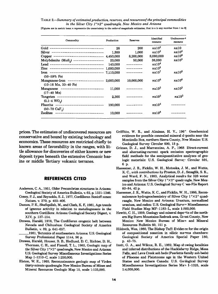
TABLE 2.-Summary of estimated production, reserves, and resourcesof the principal commodities in the Silver City JOX2° quadrangle, New Mexico and Arizona
[Figures are in metric tons; n represents the uncertainty in the order-of magnitude estimates, that is n is any number from 1 to 9]
Commodity Production Reserves Identified Undiscovere" resource resource
Gold ------------------------------ 26 200 nx102 nx10 Silver ----------------------------- 1,300 1,000 nx103 nx103
Copper ---------------------------- 4,450,000 8,200,000 8,000,000 nx106
Molybdenite (MoS2
) ----------------- 23,000 50,000 38,000 nx105
Lead ------------------------------ 140,000 --------- nx104
Zinc ------------------------------ 1,000,000 --------- nx105
Iron ------------------------------ 7,110,000 --------- nx107 nx108
(50-59% Fe) Manganese-Iron -------------------- 2,000,000 10,000,000 nx106 nx106
(10-16 Mn, 30-40 Fe) Manganese ------------------------ 11,000 --------- nx103 nx103
(17-40 Mn) Thngsten -------------------------- 2,300 --------- nx103 nx103
(0.1-4 W03)
Fluorite --------------------------- 190,000 --------- nx104 --------(50-70 CaF 2)
Zeolites --------------------------- 10,000 --------- nx108 --------
prices. The estimates of undiscovered resources are conservative and bound by existing technology and economics. These resources are restricted chiefly to known areas of favorability in the ranges, with little allowance for discoveries of either known or new deposit types beneath the extensive Cenozoic basins or middle 'Thrtiary volcanic terranes.
REFERENCES CITED
Anderson, C. A., 1951, Older Precambrian structures in Arizona: Geological Society of America Bulletin, v. 62, p. 1331-1346.
Coney, P. J., and Reynolds, S. J., 1977, Cordilleran Benioff zones: Nature, v. 270, p. 403-406.
Damon, P. E., Shafiqullah, M., and Clark, K. F., 1981, Age trends of igneous activity in relation to metallogenesis in the southern Cordillera: Arizona Geological Society Digest, v. XIV, p. 137-154.
Drewes, Harald, 1978, The Cordilleran orogenic belt between Nevada and Chihuahua: Geological Society of America Bulletin, v. 89, p. 641-657.
__ 1981, 'Thctonics of southeastern Arizona: U.S. Geological Survey Professional Paper 1144, 96 p.
Drewes, Harald, Houser, B. B., Hedlund, D. C., Richter, D. H., Thorman, C. H., and Finnell, T. L., 1985, Geologic map of the Silver City 1 °X2° quadrangle, New Mexico and Arizona: U.S. Geological Survey Miscellaneous Investigations Series Map I-1310-C, scale 1:250,000.
Elston, W. E., 1960, Reconnaissance geologic map of Virden thirty-minute quadrangle: New Mexico Bureau of Mines and Mineral Resources Geologic Map 15, scale 1:125,000.
14
Griffitts, W. R., and Alminas, H. V., 196<>. Geochemical evidence for possible concealed mineral d 1posits near the Monticello Box, northern Sierra County, New Mexico: U.S. Geological Survey Circular 600, 13 p.
Grimes, D. J., and Marranzino, A. P., 1968 Direct-current and alternating-current spark emission spectrographic field methods for the semiquantitative analyses of geologic materials: U.S. Geological Surve;r Circular 591, 6 p.
Hassemer, J. R., Ficklin, W. H., Motooka, J. M., and Watts, K. C., with contributions by Preston, D. J., Smaglik, S. K., and Ward, F. N., 1983, Analytical result's for 328 water samples from the Silver City 1 °X2° quadrangle, New Mexico and Arizona: U.S. Geological Survey C '"len-File Report 83-84, 42 p.
Hassemer, J. R., Watts, K. C., and Ficklin, W. H., 1986, Reconnaissance hydrogeochemistry of Silver City 1 oX 2 o quadrangle, New Mexico and Arizona: Uranium, normalized uranium, and radon: U.S. Geological SurvE'v Miscellaneous Field Studies Map MF-1183-L, scale 1:500,000.
Hewitt, C. H., 1959, Geology and mineral depo,its of the northern Big Burro Mountains-Redrock area, Grant County, New Mexico: New Mexico Bureau of Mincq and Mineral Resources Bulletin 60, 151 p.
Hildreth, Wes, 1980, The Bishop Tuff: Evidence for the origin of compositional zonation in silicic ma~a chambers: Geological Society of America Special Paper 180, p. 43-75.
Izett, G. A., and Wilcox, R. E., 1982, Map si:'owing localities and inferred distributions of the Hucklebe"ry Ridge, Mesa Falls, and Lava Creek ash beds (Pearlette family ash beds) of Pliocene and Pleistocene age in the Western United States and southern Canada: U.S. Geological Survey Miscellaneous Investigations Series Ma.., I-1325, scale 1:4,000,000.
Klein, D. P., 1985, Aeromagnetic map of the Silver City 1 °X2 o quadrangle, New Mexico and Arizona: U.S. Geological Survey Miscellaneous Investigations Series Map 1-1310-D, scale 1:250,000.
__ 1986, Implications of gravity and magnetic data for the structure and mineralization in the Silver City 1 oX 2 o quadrangle, New Mexico and Arizona: U.S. Geological Survey Miscellaneous Investigations Series Map 1-1310-G, scale 1:250,000.
McDanal, S. K., Fom, C. L., Hassemer, J. R., and Watts, K. C., 1983, Analytical results for stream-sediment concentrates, sieved stream sediment, rock, and water samples from the Silver City 1 oX 2 o quadrangle, New Mexico and Arizona: Tape available only from National Technical Information Service (NTIS), Springfield, Va. 22161 as report number.
Mutschler, F. E., Wright, E. G., Ludington, S.D., and Abbott, J. T., 1981, Granite molybdenite systems: Economic Geology, v. 76, p. 874-897.
Raines, G. L., 1984, Limonite alteration map of the Silver City 1 °X2° quadrangle, New Mexico and Arizona: U.S. Geological Survey Miscellaneous Field Studies.Map MF-1183-Q, scale 1:250,000.
Richter, D. H., and Lawrence, V. A., 1983, Mineral deposit map of the Silver City 1 °X2° quadrangle, New Mexico and Arizona: U.S. Geological Survey Miscellaneous Investigations Series Map 1-1310-B, scale 1:250,000.
Richter, D. H., Sharp, W. N., Watts, K. C., Raines, G. L., Houser, B. B., and Klein, D. P., 1985, Mineral resource assessment of the Silver City 1 °X2 o quadrangle, New Mexico and Arizona: U.S. Geological Survey Miscellaneous Investigations Series Map 1-1310-F.
Sharp, W. N., 1986, Petrochemistry of the igneous rocks, Silver City 1 °X2° quadrangle, New Mexico and Arizona: U.S. Geological Survey Miscellaneous Investigations Series Map 1-1310-H, scale 1:250,000.
Van 'frump, G: R., and Miesch, A. T., 1976, The U.S. Geological Survey RASS-STATPAC System for management and statistical reduction of geochemical data, in Computers and Geoscience, v. 3, 1977: Oxford, Pergamon Press, p. 475-488.
Watts, K. C., and Hassemer, J. R., 1980, Distribution and abundance of fluorite in stream-sediment concentrates, Silver City 1 °X2° quadrangle, New Mexico and Arizona: U.S. Geological Survey Miscellaneous Field Studies Map MF-1183-C, scale 1:250,000.
__ 1986, Geochemical interpretive and summary maps, Silver City 1 °X2° quadrangle, New Mexico and Arizona: U.S. Geological Survey Miscellaneous Investigations Series Map 1-1310-E, scale 1:250,000.
Watts, K. C., Hassemer, J. R., Fom, C. L., and Siems, D. F., 1986a, Geochemistry of lead in stream-sediment concentrates, Silver City 1 °X2° quadrangle, New Mexico and Arizona: U.S. Geological Survey Miscellaneous Field Studies Map MF-1183-A, scale 1:500,000.
__ 1986b, Geochemistry of copper in stream-sediment concentrates, Silver City 1 °X2° quadrangle, New Mexico and Arizona: U.S. Geological Survey Miscellaneous Field Studies Map MF-1183-B, scale 1:500,000.
__ 1986c, Geochemistry of zinc in stream-sediment concentrates, Silver City 1 oX 2 o quadrangle, New Mexico and Arizona: U.S. Geological Survey Miscellaneous Field Studies Map MF-1183-D, scale 1:500,000.
15
__ 1986d, Geochemistry of molybdenum in stream·sediment concentrates, Silver City 1 °X2° quadrangle, Ne, Mexico and Arizona: U.S. Geological Survey Miscellane"~us Field Studies Map MF-1183-E, scale 1:500,000.
__ 1986e, Geochemistry of silver in stream-secli.r'-ent concentrates, Silver City 1 oX 2 o quadrangle, New M c;~xico and Arizona: U.S. Geological Survey Miscellaneous Field Studies Map MF-1183-F, scale 1:500,000.
__ 1986f, Geochemistry of tungsten in stream-sedi""lent concentrates, Silver City 1 °X2° quadrangle, New Ma.xico and Arizona: U.S. Geological Survey Miscellaneous Field Studies Map MF-1183-G, scale 1:500,000.
__ 1986g, Geochemistry of bismuth and beryllium in streamsediment concentrates, Silver City 1 °X2° quadra..,.~le, New Mexico and Arizona: U.S. Geological Survey Misc.ellaneous Field Studies Map MF-1183-H, scale 1:500,00'l.
__ 1986h, Geochemistry of tin in stream-sedimer~ concentrates, Silver City 1 °X2° quadrangle, New Mexico and Arizona: U.S. Geological Survey Miscellaneous Field Studies Map MF-1183-I, scale 1:500,000.
__ 1986i, Geochemistry of manganese in stream .. sediment concentrates, Silver City 1 °X2° quadrangle, New Mexico and Arizona: U.S. Geological Survey Miscellaneous Field Studies Map MF-1183-J, scale 1:500,000.
__ 1986j, Geochemistry of barium in stream-sedi'1'lent concentrates, Silver City 1 °X2° quadrangle, New Mexico and Arizona: U.S. Geological Survey Miscellaneous Field Studies Map MF-1183-K, scale 1:500,000.
Watts, K. C., Hassemer, J. R., and Siems, D. F., 1984, Geochemical halos in the Silver City mining region and adjacent areas, Grant County, New Mexico: U.S. Geological Survey Bulletin 1534, 85 p.
Watts, K. C., Hassemer, J. R., Siems, D. F., and Nishi, J. M., 1978, A statistical summary and listing of the spectrographic analyses of heavy-mineral concentrat?. and conventional, sieved stream-sediment samples, s:'ver City area, New Mexico: U.S. Geological Survey OpenF~l~ Report 78-801, 247 p.
Wilson, E. D., 1939, Pre-Cambrian Mazatzal Revolut~fln in central Arizona: Geological Society of America Bullfltin, v. !)0, p. 1113-1164.
Wynn, J. C., 1981, Complete Bouguer anomaly map of the Silver City 1 °X2° quadrangle, New Mexico and Ari.mna: U.S. Geological Survey Miscellaneous Investigations f·---ies Map 1-1310-A, scale 1:250,000.
SELECTED BIBLIOGRAPHY FOR THE SILVER CITY QUADRAI~GLE
(Does not include references cited in Circula·)
Aiken, C. L. V., 1978, Gravity and aeromagnetic an,1malies of southeastern Arizona, in Land of Cochise: New Mexico Geological Society, 29th Field Conference, G·.•idebook, p. 301-313.
Aldrich, M. J., 1974, Structural development of the HanoverFierro pluton, southwestern New Mexico: Geological Society of America Bulletin, v. 85, p. 963-968.
Anderson, C. A., 1969, Copper, in Mineral and water resources of Arizona: U.S. 90th Congress, 2d Session, Se:"l'ate Committee on Interior and Insular Affairs, p. 117-156.

Anderson, E. C., 1955, Occurrences of uranium ores in New Mexico: New Mexico Bureau of Mines and Mineral Resources Circular 29, 27 p.
__ 1957, The metal resources of New Mexico and their economic features through 1954: New Mexico Bureau of Mines and Mineral Resources Bulletin 39, 183 p.
Armstrong, A. K., Silberman, M. L., 'Ibd.d, V. R., Hoggatt, W. C., and Carten, R. B., 1978, Geology of central Peloncillo Mountains, Hidalgo County, New Mexico: New Mexico Bureau of Mines and Mineral Resources, Circular 158, 19 p.
Ballman, D. L., 1960, Geology of the Knight Peak area, Grant County, New Mexico: New Mexico Institute of Mining 'Thchnology, State Bureau of Mines and Mineral Resources Bulletin 70, 39 p.
Belt, C. B., Jr., 1960, Intrusion and ore deposition in New Mexico: Economic Geology, v. 55, p. 1244-1271.
Biggerstaff, B. P., 197 4, Geology and ore deposits of the Steeple Rock-'IWin Peaks area, Grant County, New Mexico: El Paso, University of 'Thxas, unpublished M.S. thesis, 102 p.
Blake, D. W., 1971, Geology, alteration, and mineralization of the San Juan mine area, Graham County, Arizona: 'fucson, University of Arizona, M.S. thesis, 85 p.
Bornhorst, T. J., Erb, E. E., and Elston, W. E., 1976, Reconnaissance geologic map of the Mogollon-Datil volcanic province and preliminary tectonic map of Mogollon-Datil volcanic province: New Mexico Geological Society Special Publication No. 5, scale 1:350,000.
Boyd, F. S., Jr., and Wolfe, H. D., 1953, Recent investigations of radioactive occurrences in Sierra, Dona Ana, and Hidalgo Counties, New Mexico: New Mexico Geological Survey Guidebook, 4th Field Conference, p. 141-142.
Brant, A. A., 1966, Geophysics in the exploration for Arizona porphyry copper, in 'Iitley, S. R., and Hicks, C. L., eds., Geology of the porphyry copper deposits, southwestern North America: 'fucson, University of Arizona Press, p. 87-110.
Bromfield, C. S., and Wrucke, C. T., 1961, Reconnaissance geologic map of the Cedar Mountains, Grant and Luna Counties, New Mexico: U.S. Geological Survey Mineral Investigations Field Studies Map MF-159, scale 1:62,500.
Burchard, E. F., 1914, Stone-Arizona, in Part 2 of Mineral Resources of the United States [1913]: U.S. Geological Survey, p. 1338-1346.
Burnham, C. W., 1959, Metallogenic provinces of the southwestern United States and northern Mexico: New Mexico Bureau of Mines and Mineral Resources Bulletin 65, 76 p.
Bush, F. V., 1915, Meerschaum deposits of New Mexico: Engineering and Mining Journal, v. 99, p. 941-943.
Butler, A. P., Jr., Finch, W. I., and 1\venhofel, W. S., 1962, Epigenetic uranium deposits in the United States, exclusive of Alaska and Hawaii: U.S. Geological Survey Mineral Investigations Resource Map MR-21, scale 1:3,168,000.
Clark, K. F., 1970, Zoning, paragenesis, and temperature formation in the Lordsburg district: New Mexico Geological Society Guidebook, 21st Field Conference, p. 107-113.
Cook, Annan, and Robinson, R. F., 1962, Geology of Kennecott Copper Corporation's Safford copper deposit: New Mexico Geological Society Guidebook, 13th Field Conference, p. 143-148.
Cooper, J. R., 1960, Reconnaissance map of the Willcox, Fisher Hills, Cochise and Dos Cabezas quadrangles, Cochise and Graham Counties, Arizona: U.S. Geological Survey Mineral Investigations Field Studies Map MF-231, scale 1:62,500.
16
Corbitt, L. L., Nials, F. L., and Varnell, R. J., 1977, Structure of Brockman Hills, southwestern New Mexico: American Association of Petroleum Geologists Bulletin 61, no. 4, p. 601-615.
Cunningham, J. E., 197 4, Geologic map and sections of Silver City quadrangle, New Mexico: New Mexioo Bureau of Mines and Mineral Resources Geologic Map 30, scale 1:24,000.
Dale, V. B., and McKinney, W. A., 1959, 'fungsten deposits of New Mexico: U.S. Bureau of Mines Report of Investigations 5517, 72 p.
Dale, V. B., Stewart, L.A., and McKinney, W. A., 1960, 'fungsten deposits of Cochise, Pima, and Santa Cruz Counties, Arizona: U.S. Bureau of Mines Report of Investigations RI-5650, 132 p.
Dane, C. H., and Bachman, G. 0., 1961, Prer'llinary geologic map of the southwestern part of New Me~~i.co: U.S. Geological Survey Miscellaneous Investigations f'·~ries Map I -344.
Darton, N.H., 1916, Geology and underground water of Luna County, New Mexico: U.S. Geological Survey Bulletin 618, 188 p.
Dempsey, W. J., Fackler, W. D., and others, 19f-~. Aeromagnetic map of the Dragoon quadrangle, Cochise County, Arizona: U.S. Geological Survey Geophysical Investigations Map GP-412, scale 1:62,500.
__ 1963, Aeromagnetic map of the Coc"-ise quadrangle, Cochise County, Arizona: U.S. Geological Survey Geophysical Investigations Map GP-413, scale 1:62,500.
Dorr, J. V. N., 1965, Manganese, in Mineral an~ water resources of New Mexico: U.S. 89th Congress, 1st Session, Senate Committee on Interior and Insular Affzirs, p. 183-195.
__ 1969, Manganese, in Mineral and water resources of Arizona: U.S. 90th Congress, 2d Session, Senate Committee on Interior and Insular Affairs, p. 211-225.
Drewes, Harald, 1980, 'Thctonic map of south "astern Arizona: U.S. Geological Survey Miscellaneous Invnstigations Series Map I-1109, scale 1:125,000.
__ 1981, 'Thctonics of southeastern Arizona: U.S. Geological Survey Professional Paper 1144, 96 p.
__ 1981, Geologic map and sections of the Bowie Mountain South quadrangle, Cochise County, Arizonq; U.S. Geological Survey Miscellaneous Investigations Se:-ies Map I-1363, scale 1:24,000.
__ 1982, Geologic map and sections of t'l-e Cochise Head quadrangle and adjacent areas, Cochise County, Arizona: U.S. Geological Survey Miscellaneous Invr~tigations Series Map I-1312, scale 1:24,000.
__ 1983, Geologic map and sections of the Bowie Mountain North quadrangle, Cochise County, Arizonl\: U.S. Geological Survey Miscellaneous Inv~stigations Se:-ies Map I-1492, scale 1:24,000.
Drewes, Harald, and Thorman, C. H, 1978, Ge':llogic map of the Gary and.Lordsburg quadrangles, Hida1~ County, New Mexico: U.S. Geological Survey Miscellzneous Investigations Series Map I-1151, scale 1:24,000.
__ 1978, Major geologic structures between Lordsburg, New Mexico, and Douglas and 'fucson, Arizrna: New Mexico Geological Society Guidebook, 29th Field Conference, p. 291-296.
__ 1980, Geologic map of the Steins, New Mexico, and Vanar, Arizona and New Mexico, quadrangles: U.S. Geological Survey Miscellaneous Investigations Se:-ies Map I-1220, scale 1:24,000.

__ 1980, Geologic map of the Cotton City, New Mexico, and Vanar, Arizona and New Mexico, quadrangles: U.S. Geological Survey Miscellaneous Investigations Series Map I-1221, scale 1:24,000.
Dunn, P. G., 1978, Geologic structure of the Safford District, Arizona: Arizona Geologic Society Digest, v. 11, p. 9-16.
Duriez, L. H., and Newman, J. V., Jr., 1948, Geology and mining practice at the Bayard, New Mexico, property: Mining and Metallurgical Society of America Bulletin, v. 29, no. 502, p. 559-561.
Dutton, C. E., and Carr, M.S., 1947, Iron ore deposits of the Western United States: U.S. Geological Survey Mineral Investigations Preliminary Report 3-212.
Eaton, G. P., 1970, Altered (pyritized) rocks in San Simon Valley, southeastern Arizona, in Geological Survey Research 1970: U.S. Geological Survey Professional Paper 700-A, p. A37.
Ellis, R. W., 1929, New Mexico mineral deposits except fuels: New Mexico University Bulletin 167, Geological Series, v. 4, no. 2, 148 p.
Elsing, M. J., and Heineman, R. E. S., 1936, Arizona metal production: Arizona Bureau of Mines Economic Series 19, Bulletin 140, 112 p.
Elston, W. E., 1957, Geology and mineral resources of the Dwyer quadrangle, Grant, Luna, and Sierra Counties, New Mexico: New Mexico Bureau of Mines and Mineral Resources Bulletin 38, 86 p.
__ 1960, Reconnaissance geologic map of Virden thirtyminute quadrangle: New Mexico Bureau of Mines and Mineral Resources Geologic Map 15, scale 1:125,000.
__ 1963, Geology and mineral resources of Hidalgo County, New Mexico: New Mexico Bureau of Mines and Mineral Resources Open-File Report, 781 p.
__ 1965, Mining districts of Hidalgo County, New Mexico: New Mexico Geological Society Guidebook, 16th Field Conference, p. 210-214.
__ 1965, Volcanic rocks of the Mimbres and upper Gila drainages, New Mexico: New Mexico Geological Society Guidebook, 16th Field Conference, p. 167-174.
Elston, W. E., Damon, P. E., Coney, P. J., Rhodes, R. C., and Bikerman, Michael, 1973, Tertiary volcanic rocks, Mogollon-Datil province, New Mexico, and surrounding region-K-Ar dates, patterns of eruption, and periods of mineralization: Geological Society of America Bulletin, v. 84, no. 7, p. 2259-2274.
Elston, W. E., Erb, E. E., and Deal, E. G., 1979, Tertiary geology of Hidalgo County, New Mexico: New Mexico Geology, v. 1, no. 1, p. 1.
Elston, W. E., Rhodes, R. C., and Erb, E. E., 1976, Control of mineralization by mid-Tertiary volcanic centers, southwestern New Mexico, in Elston, W. E., and Northrup, S. A., eds., Cenozoic volcanism in southwestern New Mexico: New Mexico Geological Society, Special Publication No. 5, p. 125-130.
Enders, M.S., 1981, The geology, mineralization, and exploration characteristics of the Beck Mine and vicinity, Kimball mining district, Hidalgo County, New Mexico, and Cochise County, Arizona: Tucson, University of Arizona, M.S. thesis, 109 p.
Entwistle, L. P., 1944, Manganiferous iron ore deposits near Silver City, New Mexico: New Mexico Bureau of Mines and Mineral Resources Bulletin 19, 70 p.
17
__ 1975, Geology and mineralization at the Grcund Hog mine, New Mexico, in Base metal and preci<Jus metal districts of New Mexico and Arizona: New Mexico and Arizona Geological Society Symposium, May 21-24, 1975.
Erickson, R. C., 1968, Geology and geochronology o.c: the Dos Cabezas Mountains, Cochise County, Arizona; Arizona Geological Society Guidebook III, p. 192-198.
Eyde, T. H., 1978, Bowie zeolite, an Arizona industria 1 mineral, in Field notes: Arizona Bureau of Geology anrl Mineral Technology: v. 8, no. 4, p. 1-5.
__ 1982, Zeolite deposits in the Gila and San Simcn Valleys of Arizona and New Mexico, in Austin, G. S., compiler, Industrial rocks and minerals of the Southwest: I Tew Mexico Bureau of Mines and Mineral Resources Circular 182, p. 65-71.
Farnham, L. L., 1961, Manganese deposits of New Mexico: U.S. Bureau of Mines Information Circular 8030, 17'1 p.
Farnham, L. L., Stewart, L. A., and DeLong, C. W., 1961, Manganese deposits of eastern Arizona: U.S. n~'lreau of Mines Information Circular 7990, 178 p.
Finnell, T. L., 1976, Geologic map of the Twin Sisters quadrangle, Grant County, New Mexico: U.S. Geological Survey Miscellaneous Field Studies Map MF -779, scale 1:24,000.
__ 1976, Geologic map of the Reading Mountain qnidrangle, Grant County, New Mexico: U.S. Geological Survey Miscellaneous Field Studies Map MF-800, scale 1:24,000.
__ 1982, Geologic map of the Dorsey Ranch quq_drangle, Grant County, New Mexico: U.S. Geological Survey Miscellaneous Field Studies Map MF-1431, scale:1:24,000.
Flege, R. F., 1959, Geology of Lordsburg quadrangle:, Hidalgo County, New Mexico: New Mexico Bureau of Mines and Mineral Resources Bulletin 62, 36 p.
Gillerman, Elliot, 1952, Fluorspar deposits of Burro Mountains and vicinity, New Mexico: U.S. Geological Surve:r Bulletin 973-F, p. 261-289.
__ 1953, Search for and geology of uranium in s1ndstonetype deposits, White Signal-Black Hawk distr~~ts, New Mexico, in Search for and geology of radioactive deposits, semiannual progress report: U.S. Geological Survey TEI-330, p. 111-113, issued by U.S. Atomic Energy Commission Technical Information Service, Oav Ridge, Tennessee.
__ 1953, Fluorite deposits of Burro Mountains ann vicinity: New Mexico Geological Society Guidebook, 4th Field Conference, p. 137-138.
__ 1953, White Signal uranium deposits: NeF Mexico Geological Society Guidebook, 4th Field Conference, p. 133-137.
__ 1958, Geology of the central Peloncillo Mountains, Hidalgo County, New Mexico, and Cochise County, Arizona: New Mexico Bureau of Mines ancl Mineral Resources Bulletin 57, 152 p.
__ 1964, Mineral deposits of western Grant County, New Mexico: New Mexico Bureau of Mines and Mineral Resources Bulletin 83, 213 p.
__ 1967, Structural framework and character of n'ineralization, Burro Mountains, New Mexico: Economic Geology, v. 62, no. 3,p. 370-375.
__ 1970, Mineral deposits and structural pattern of the Big Burro Mountains, New Mexico: New Mexico Geological Society Guidebook, 21st Field Conference, p. 115-121.
Gillerman, Elliot, and Whitebread, D. H., 1956, Uraniumbearing nickel, cobalt, native silver deposits, Black Hawk district, Grant County, New Mexico: U.S. Geological Survey Bulletin 1009-K, p. 283-313.
Graf, D. L., and Kerr, P. F., 1950, Trace-element studies, Santa Rita, New Mexico: Geological Society of America Bulletin, v. 61, p. 1023-1052.
Granger, H. C., and Bauer, H. L., Jr., 1951, Results of diamond drilling, Merry Widow claim, White Signal district, Grant County, New Mexico: U.S. Geological Survey TEM-146A, 11 p., issued by U.S. Atomic Energy Commission Technical Information Service, Oak Ridge, Tenn.
__ 1952, Uranium occurrences on Merry Widow claim, White Signal district, Grant County, New Mexico: U.S. Geological Survey Circular 189, 16 p.
Griggs, R. L., and Wagner, H. C., 1966, Geology and ore deposits of the Steeple Rock mining district, Grant County, New Mexico: U.S. Geological Survey Bulletin 1222-E, 29 p.
Griswold, G. B., 1961, Mineral deposits of Luna County, New Mexico: New Mexico Bureau of Mines and Mineral Resources Bulletin 72, 157 p.
Hall, R. B., 1978, World nonbauxite aluminum resourcesAlunite: U.S. Geological Survey Professional Paper 1076-A, 35 p.
Harrer, C. M., and Kelly, F. J., 1963, Reconnaissance of iron resources in New Mexico: U.S. Bureau of Mines Information Circular 8190, 112 p.
Hedlund, D. C., 1978, Geologic map of the Wind Mountain quadrangle, Grant County, New Mexico: U.S. Geological Survey Miscellaneous Field Studies Map MF-1031, scale 1:24,000.
__ 1978, Geologic map of the Soldiers Farewell Hill quadrangle, Grant County, New Mexico: U.S. Geological Survey Miscellaneous Field Studies Map MF-1033, scale 1:24,000.
__ 1978, Geologic map of the Ninety-six Ranch quadrangle, Grant County, New Mexico: U.S. Geological Survey Miscellaneous Field Studies Map MF-1034, scale 1:24,000.
__ 1978, Geologic map of the Gold Hill quadrangle, Grant County, New Mexico: U.S. Geological Survey Miscellaneous Field Studies Map MF-1035, scale 1:24,000.
__ 1978, Geologic map of the Tyrone quadrangle, Grant County, New Mexico: U.S. Geological Survey Miscellaneous Field Studies Map MF-1037, scale 1:24,000.
__ 1978, Geologic map of the Werney Hill quadrangle, Grant County, New Mexico: U.S. Geological Survey Miscellaneous Field Studies Map MF-1038, scale 1:24,000.
__ 1978, Geologic map of the C-Bar Ranch quadrangle, Grant County, New Mexico: U.S. Geological Survey Miscellaneous Field Studies Map MF-1039, scale 1:24,000.
__ 1978, Geologic map of the Burro Peak quadrangle, Grant County, New Mexico: U.S. Geological Survey Miscellaneous Field Studies Map MF-1040, scale 1:24,000.
__ 1978, Geologic map of the White Signal quadrangle, Grant County, New Mexico: U.S. Geological Survey Miscellaneous Field Studies Map MF-1041, scale 1:24,000.
__ 1980, Geologic map of the Redrock NW quadrangle, Grant County, New Mexico: U.S. Geological Survey Miscellaneous Field Studies Map MF-1263, scale 1:24,000.
__ 1980, Geologic map of the Redrock NE quadrangle, Grant County, New Mexico: U.S. Geological Survey Miscellaneous Field Studies Map MF-1264, scale 1:24,000.
18
__ 1980, Geologic map of the Redrock SE q'1adrangle, Grant County, New Mexico: U.S. Geological Surv~y Miscellaneous Field Studies Map MF-1265, scale 1:24,000.
Hernon, R. M., compiler, 1949, Geology and ore deposits of Silver City region, New Mexico: West 'Thxas Geolo'rical Society and Southwestern New Mexico Section, AIME Guidebook, Field 'frip 3, 45 p.
__ 1953, Summary of smaller mining distri~ts in Silver City region: New Mexico Geological Society Guidebook, 4th Conference, p. 138-142.
Hernon, R. M., and Jones, W. R., 1968, Ore der11sits of the Central mining district, Grant County, New ] fexico, in Ridge, J.D., ed., Ore deposits of the United States 1933-1967: The Graton-Sales Volume, v. II, New York, An-~rican Institute of Mining, Metallurgical, and Petroleum Engineers, p. 1212-1237.
Hernon, R. M., Jones, W. R., and Moore, S. L., 1953, Some geological features of the Santa Rita quadrangle, New Mexico: New Mexico Geological Society Guid~book, 4th Field Conference, p. 117-130.
__ 1964, Geologic map of the Santa Rita quadrangle, Grant County, New Mexico: U.S. Geological ~·u-vey Geologic Quadrangle Map GQ-306, scale 1:24,000.
Hewett, D. F., and Fleischer, Michael, 1960, De:posits of manganese oxides: Economic Geology, v. 55, nc'. 1, p. 1-55.
Hewitt, C. H., 1959, Geology and mineral dep<Jsits of the northem Big Burro Mountains-Redrock area, Grant County, New Mexico: New Mexico Bureau of Mines and Mineral Resources Bulletin 60, 151 p.
Heyl, A. V., and Bozion, C. N., 1962, Oxidized zinc deposits of the United States: U.S. Geological Surve:r Bulletin 1135-A, 49 p.
Holser, W. T., 1953, Beryllium minerals in th~ Victorio Mountains, Luna County, New Mexico: Americ"'n Mineralogist, v. 38, p. 599-611.
Hook, S. C., and Cobban, W. A., 1981, Late Greenhorn (midCretaceous) disconformity surfaces, sout~west New Mexico, in Contributions to mid-Cretaceous rf:l.leontology and stratigraphy of New Mexico: New Mexico Bureau of Mines and Mineral Resources Circular 180, p. 5-21.
Houser, B. B., Richter, D. H., and Shafiqullah, M., 1985, Geologic map of the Safford quadrangle, Graham County, Arizona: U.S. Geological Survey Miscellaneous Inve:qtigations Series Map 1-1617, scale 1:48,000.
Huntington, M. G., 1947, Atwood copper g-oup, Lordsburg district, Hidalgo County, New Mexico: U.S. Bureau of Mines Report of Investigations 4029, 9 p.
Jahns, R. H., Kottlowski, F. E., and Kuelli..,er, F. J., 1955, Volcanic rocks of sout.h-central New Mex~r!o: New Mexico Geological Society, 6th Field Confere~ce Guidebook, p. 92-95.
Jaster, M. C., 1956, Perlite resources of the Ur;ted States: U.S. Geological Survey Bulletin 1027-1, p. 375-404.
Johnston, W. D., Jr., 1928, Fluorspar in New Mexico: New Mexico Bureau of Mines and Mineral Resources Bulletin 4, 128 p.
Jones, E. L., Jr., 1919, Deposits of manganese ore in New Mexico: U.S. Geological Survey Bulletin 710, p. 37-60.
Jones, E. L., Jr., and Ransome, F. L., 19:-'0, Deposits of manganese ore in Arizona: U.S. Geological Survey Bulletin 710-D, p. 93-184.
Jones, F. A., 1904, New Mexico mines and mi~erals: Santa Fe, New Mexico Printing Company, 349 p.
Jones, W. R., Case, J. E., and Pratt, W. P., 1964, Aeromagnetic and geoJogic map of part of the Silver City mining region, Grant County, New Mexico: U.S. Geological Survey Geophysical Investigations Map G P-424, scale 1:63,360.
Jones, W. R., and Hernon, R. M., 1973, Ore deposits and rock alteration of the Santa Rita quadrangle, Grant County, New Mexico: U.S. Department of Commerce, National Thchnical Information Service PB 214, 371, 102 p.
Jones, W. R., Hernon, R. M., and Moore, S. L., 1967, General geology of the Santa Rita quadrangle, Grant County, New Mexico: U.S. Geological Survey Professional Paper 555, 144p.
Jones, W. R., Hernon, R. M., and Pratt, W. P., 1961, Geologic events culminating in primary metallization in the Central mining district, Grant County, New Mexico: U.S. Geological Survey Professional Paper 424-C, p. C11-C16.
Jones, W. R., Moore, S. L., and Pratt, W. P., 1970, Geologic map of the Fort Bayard quadrangle, Grant County, New Mexico: U.S. Geological Survey Geologic Quadrangle Map GQ-865, scale 1:24,000.
Keith, S. B., 1973, Index of mining properties in Cochise County, Arizona: Arizona Bureau of Mines Bulletin 187, 98 p.
Keith, S. B., and Wilt, J. C., 1978, Supplemental road log no. 3, Thcson to Lordsburg via Interstate 10, in Land of Cochise: New Mexico Geological Society, 29th Field Conference, Guidebook, p. 112-114.
Kelley, V. C., 1949, Geology and economics of New Mexico ironore deposits: New Mexico University Publications in
- Geology Series, no. 2, 246 p. __ 1951, Oolitic iron deposits of New Mexico: American
Association of Petroleum Geologists Bulletin, v. 35, no. 10, p. 2199-2228.
Kelley, V. C., and Branson, 0. T., 1947, Shallow high-temperature pegmatites, Grant County, New Mexico: Economic Geology, v. 42, p. 699-712.
Kerr, P. F., Kulp, J. L., Patterson, C. M., and Wright, R. J., 1950, Hydrothermal alteration at Santa Rita, New Mexico: Geological Society of America Bulletin, v. 61, no. 4, p. 275-347.
King, R. U., 1969, Molybdenum and rhenium, in Mineral and water resources of Arizona: U.S. 90th Congress, 2d Session, Senate Committee on Interior and Insular Affairs, p. 230-238.
Knechtel, M. M., 1938, Geology and groundwater resources of the valley of the Gila River and San Simon Creek, Graham County, Arizona: U.S. Geological Survey Water-Supply Paper 796-F, p. 181-222.
Kolessar, Joseph, 1970, Geology and copper deposits of the 'JYrone district: New Mexico Geological Society Guidebook, 21st Field Conference, p. 127-132.
Krohn, D. H., 1976, Gravity survey of the Mogollon Plateau volcanic province, southwestern New Mexico, in Cenozoic volcanism in southwestern New Mexico: New Mexico Geological Society Special Publication 5, p. 113-116.
Langton, J. M., and Williams, S. A., 1982, Structural, petrologic, and mineralogic controls for the Dos Pobres ore body, Safford Valley, Graham County, Arizona, in Titley, S. R., ed., Advances in geology of the porphyry copper deposits, southwestern North America: Thcson, University of Arizona Press, p. 335-352.
Larsh, P. A., 1913, Lucky Bill lead-vanadium mine: Engineering and Mining Journal, v.. 96, p. 1105.
Lasky, S. G., 1930, Geology and ore deposits of the Grou"ldhog mine, Central district, Grant County, New Mexico: New Mexico Bureau of Mines and Mineral Resources Ci-:-cular 2, 14 p.
__ 1935, The Lordsburg district, New Mexico, in Copper resources of the world: International Geological Con ~ess, 16th, Washington, D.C., 1933, p. 337-341.
__ 1936, Geology and ore deposits of the Bayard arer. Central mining district, New Mexico: U.S. Geological Survey Bulletin 870, 144 p.
__ 1938, Geology and ore deposits of the Lordsburg mining district, Hidalgo County, New Mexico: U.S. Geological Survey Bulletin 885, 62 p.
__ 1942, Groundhog mine, Central district, New Mexico, in Newhouse, W. H., ed., Ore deposits as related to structural features: Princeton, N.J., Princeton University Prf~ss, p. 244.
__ 194 7, Geology and ore deposits of the Little Hatchet Mountains, Hidalgo and Grant Counties, New Mexico: U.S. Geological Survey Professional Paper 208, 101 p.
Lasky, S. G., and Hoagland, A. D., 1948, Central nining district, New Mexico, in Symposium on ge·'llogy, paragenesis, and reserves of ores of lead and zinc: London, International Geological Congress, 18th, 1948, p. 86-97.
Lasky, S. G., and Wootton, T. P., 1933, The metal resources of New Mexico and their economic features: New Mexico Bureau of Mines and Mineral Resources Bulletin 7, 178 p.
Leopoldt, W., 1981, Neogene geology of the central Mangas graben, Cliff-Gila area, Grant County, New Mexico: Albuquerque, University of New Mexico, M.S. thesis, 160 p.
Leroy, P. G., 1954, Correlation of copper mineralizatio:'l with hydrothermal alteration in the Santa Rita porphyry copper deposit, New Mexico: Geological Society of America Bulletin, v. 65, p. 739-767.
19
Lindgren, Waldemar, Graton, L. C., and Gordon, C. H., 1910, The ore deposits of New Mexico: U.S. Geological f!·~rvey Professional Paper 68, 361 p.
Lines, H. L., 1940, Mining and milling methods and costs at the Ash Peak mine of the Veta Mines Incorporated, Duncan, Arizona: U.S. Bureau of Mines Information c~reular IC-7119, 26 p.
Lovering, T. G., 1956, Radioactive deposits in New Mexico: U.S. Geological Survey Bulletin 1009-L, p. 315-390.
McAnulty, W. N., 1978, Fluorspar in New Mexico: New ]fexico Bureau of Mines and Mineral Resources Memoir 34,64 p.
McKnight, J. F., and Fellows, M. L., 1978, Silicate mineral assemblages and their relationship to sulfide mine:ralization, Pinos Altos mineral deposit: Arizona Geo1ngical Society Digest, v. 11, p. 1-8.
Meeves, H. C., 1966, Nonpegmatitic beryllium occurrences in Arizona, Colorado, New Mexico, Utah, and four adjacent states: U.S. Bureau of Mines Report of Investigatio:"l's RI-6828, 68 p.
Meeves, H. C., Harrer, C. M., Salsbury, M. H., Kons·1lman, A. S., and Shannon, S. S., Jr., 1966, Reconnaiss~nce of beryllium-bearing pegmatite deposits in six western states, Arizona, Colorado, New Mexico, South Dakota, Utah, Wyoming: U.S. Bureau of Mines Information Circula- 8298, 34 p.
Moore, R. T., 1969, Beryllium, in Mineral and Water RefQurces of Arizona: U.S. 90th Congress, 2d Session, SenatH Committee on Interior and Insular Affairs, p. 102-113.

__ 1969, Gold, in Mineral and Water Resources of Arizona: U.S. 90th Congress, 2d Session, Senate Committee on Interior and Insular Affairs, p. 156-167.
__ 1969, Lead and zinc, in Mineral and Water Resources of Arizona: U.S. 90th Congress, 2d Session, Senate Committee on Interior and Insular Affairs, p. 182-205.
Moore, R. T., and Roseveare, G. H., 1969, Silver, in Mineral and Water Resources of Arizona: U.S. 90th Congress, 2d Session, Senate Committee on Interior and Insular Affairs, p. 251-270.
Moore, S. L., 1970, Geologic map of the Allie Canyon quadrangle, Grant County, New Mexico: U.S. Geological Survey Open-File Map 70-230, scale 1:24,000.
Morrison, R. B., 1965, Geologic map of the Duncan and Canador Peak quadrangles, Arizona and New Mexico: U.S. Geological Survey Miscellaneous Investigations Series Map I -442, scale 1:62,500.
Mullen, D. H., and Storms, W. R., 1948, Copper Flat zinc deposits, Central mining district, Grant County, New Mexico: U.S. Bureau of Mines Report of Investigations 4228, 8 p.
Neilsen, R. L., 1968, Hypogene texture and mineral zoning in a copper-bearing granodiorite porphyry stock, Santa Rita, New Mexico: Economic Geology, v. 63, p. 37-50.
__ 1970, Mineralization and alteration in calcareous rocks near the Santa Rita stock, New Mexico: New Mexico Geological Society Guidebook, 21st Field Conference, p. 133-139.
Ordonez, Georges, Baltosser, W. W., and Martin, Keith, 1955, Geologic structures surrounding the Santa Rita intrusive, New Mexico: Economic Geology, v. 50, no. 1, p. 9-21.
Paige, Sidney, 1908, The Hanover iron-ore deposits, New Mexico, in Iron and manganese: U.S. Geological Survey Bulletin 380-E, p. 199-214.
__ 1909, Marble prospects in the Chiricahua Mountains, Arizona, in Building stones: U.S. Geological Survey Bulletin 380-I, p. 299-311.
__ 1911, Metalliferous ore deposits near the Burro Mountains, Grant County, New Mexico, in Copper: U.S. Geological Survey Bulletin 470-C, p. 131-150.
__ 1911, The ore deposits near Pinos Altos, New Mexico, in Gold and silver: U.S. Geological Survey Bulletin 470-B, p. 109-125.
__ 1912, The geologic and structural relations at Santa Rita (Chinol, New Mexico: Economic Geology, v. 7, p. 547-559.
__ 1912, The origin of turquoise in the Burro Mountains, New Mexico: Economic Geology, v. 7, p. 383-392.
__ 1916, Description of the Silver City quadrangle, New Mexico: U.S. Geological Survey Geologic Atlas, Silver City Folio 199, 19 p.
__ 1922, Copper deposits of the Tyrone district, New Mexico: U.S. Geological Survey Professional Paper 122, 53 p.
__ 1932, The region around Santa Rita and Hanover, New Mexico: 16th International Geological Congress U.S., 1933, Guidebook 14, Excursion C-1, p. 23-40.
__ 1935, Santa Rita and Tyrone, New Mexico, in Copper resources of the world: Washington, D.C., 16th International Congress, p. 327-335.
Peirce, H. W., 1969, Diatomite, in Mineral and Water Resources of Arizona: U.S. 90th Congress, 2d Session, Senate Committee on Interior and Insular Affairs, p. 337-342.
20
__ 1969, Salines, in Mineral and V' ater Resources of Arizona: U.S. 90th Congress, 2d Sess:~on, Senate Committee on Interior and Insular"Affairs, p. 417-424.
Peirce, H. W., Keith, S. B., and Wilt, J. C., 1970, Coal, oil, natural gas, helium and uranium i"l Arizona: Arizona Bureau of Mines Bulletin 182, p. 103-146.
Powers, R. S., 1976, Geology of the Summit Mountains and vicinity, Grant County, New Mexico, and Greenlee County, Arizona: Houston, Tex., University of Houston, M.S. thesis, 107 p.
Pratt, W. P., 1967, Geology of the Hurley WE:"'t quadrangle, Grant County, New Mexico: U.S. Geological S'rvey Bulletin 1241-E, 91 p.
Richter, D. H., Houser, B. B., and Damon, P. E., 1983, Geologic map of the Guthrie quadrangle, Graham. and Greenlee Counties, .Arizona: U.S. Geological Survey Miscellaneous Investigations Series Map I-1455, scale 1:48,000.
Richter, D. H., Shafiqullah, M., and Lar<rrence, V. A., 1981, Geologic map of the Whitlock Mountains and vicinity, Graham County, Arizona: U.S. Geolotrlcal Survey Miscellaneous Investigations Series Map I-1302, scale 1:48,000.
Robinson, R. F., and Cook, Annan, 1966, The Safford copper deposit, Lone Star mining district, Graham County, Arizona, in Titley, S. R., and Hicks, G L., eds., Geology of the porphyry copper deposits, southwePt.ern North America: 'fucson, University of Arizona Press, p. 251-266.
Rose, A. W., and Baltosser, W. W., 1966, T~e porphyry copper deposit at Santa Rita, New Mexico, in Titley, S. R., and Hicks, C. L., eds., Geology of the porpl~rry copper deposits, southwestern North America: 'fucson, University of Arizona Press, p. 205-221.
Roseveare, G. H., 1969, Antimony and ot:'J.er minor metals, in Minerals and water resources of Arizona: U.S. 90th Congress, 2d Session, Senate Committee on Interior and Insular Affairs, p. 93-102.
Rothrock, H. E., Johnson, C. H., and Hahn, A. D., 1946, Fluorspar resources of New Mexico: New Mexico Bureau of Mines and Mineral Resources Bulletin 21, 245 p.
Russell, P. L., 1946, Exploration of Contact manganese mine, Grant County, New Mexico: U.S. Burnau of Mines Report of Investigations 3969, 5 p.
__ 1947, Gila fluorspar district, Gran~ County, New Mexico: U.S. Bureau of Mines Report of Inv'?Stigations 4020, 5 p.
__ 194 7, Exploration of Fluorite Ridf'P, fluorspar district, Luna County, New Mexico: U.S. BUl'('au of Mines Report of Investigations 3987, 7 p.
Schilling, J. H., 1964, Molybdenum resou~s of New Mexico: New Mexico Bureau of Mines Bullet:~n 76, 74 p.
Schmitt, H. A., 1935, The Central mininr district, New Mexico: American Institute of Mining and Metallurgical Engineers 'fransactions, v. 115, p. 187-20<').
__ 1939, Outcrops of ore shoots: Econ'lmic Geology, v. 34, p. 654-673.
__ 1939, The Pewabic mine: Geologica1 Society of America Bulletin 50, p. 777-818.
__ 1942, Certain ore deposits in the Southwest, central mining district, New Mexico, in Newho·1se, W. H., ed., Ore deposits as related to structural featnres: Princeton, N.J., Princeton University Press, p. 73-79.
Sheppard, R. A., 1969, Zeolites, in Mineral and water resources of Arizona: U.S. 90th Congress, 2d Session, Senate Committee on Interior and Insular Affairs, f. 464-467.
Sheppard, R. A., Gude, A. J., 3d, and Edson, G. M., 1978, Bowie zeolite deposit, Cochise and Graham Counties, Arizona, in Sand, L. B., and Mumpton, F. A., eds., Natural zeolitesOccurrence, properties, and use: Oxford and New York, Pergamon Press, p. 319-328.
Smith, C., 1978, Geophysics, geology, and geothermal leasing status of the Lightning Dock KGRA, Animas Valley, New Mexico, in Land of Cochise: New Mexico Geological Society, 29th Field Conference, Guidebook, p. 343-348.
Soule, J. H., 1947, Peerless lead-zinc mine, Grant County, New Mexico: U.S. Bureau of Mines Report of Investigations 4044, 8 p.
__ 1948, Silver Spot manganese-iron-zinc deposits, Grant County, New Mexico: U.S. Bureau of Mines Report of Investigations 4217, 5 p.
__ 1948, West Pinos Altos Zn-Pb deposits, Grant County, New Mexico: U.S. Bureau of Mines Report of Investigations 4237, 8 p.
Spencer, A. C., and Paige, Sidney, 1935, Geology of the Santa Rita mining area, New Mexico: U.S. Geological Survey Bulletin 859, 78 p.
Sterrett, D. B., 1907, Meerschaum in New Mexico, in Hayes, C. W., and Lindgren, Waldemar, eds., Contributions to Economic Geology: U.S. Geological Survey Bulletin 340, p. 466- 473.
Storms, W. R., and Faust, J. W., 1949, Mining methods and costs at the Kearney zinc-lead mine: U.S. Bureau of Mines Information Circular 7507, 11 p.
Strangway, D. W., 1970, Geophysical exploration through geologic cover: Geothermics, v. 2, pt. 2, p. 1231-1243.
Strangway, D. W., Simpson, J., and York, D., 1976, Paleomagnetic studies of volcanic rocks from the Mogollon Plateau area of Arizona and New Mexico, in Elston, W. E., and Northrup, S. A., eds., Cenozoic volcanism in southwestern New Mexico: New Mexico Geological Society, Special Publication No. 5, p. 119-124.
Strangway, D. W., Swift, C. M., and Holmer, R. C., 1973, The application of audio-frequency magnetotellurics (AMT) to mineral exploration: Geophysics, v. 38, no. 6, p. 1159-1175.
Talmage, S. B., and Wootton, T. P., 1937, The non-metallic mineral resources of New Mexico and their economic features (exclusive of fuels): New Mexico Bureau of Mines and Mineral Resources Bulletin 12, 159 p.
Thorman, C. H., 1978, Geologic map of the Coyote Peak and Brockman quadrangles, Grant and Hidalgo Counties, ·New Mexico: U.S. Geological Survey Miscellaneous Field Studies Map MF-924, scale 1:24,000.
__ 1981, Geology of the Pinaleno Mountains: A preliminary report: Arizona Geological Society Digest, no. 13, p. 5-13.
Thorman, C. H., and Drewes, Harald, 1978, Geologic map of the Gary and Lordsburg quadrangles, Hidalgo County, New Mexico: U.S. Geological Survey Miscellaneous Investigations Series Map I-1151, scale 1:24,000.
__ 1978, Cretaceous-Early Tertiary history of the northern Pyramid Mountains, southwestern New Mexico: New Mexico Geological Society, Guidebook, 29th Field Conference, p. 215-218.
__ 1979, Geologic map of parts of the Grandmother Mountain East and Grandmother Mountain West quadrangles, Luna County, New Mexico: U.S. Geological Survey Miscellaneous Field Studies Map MF-1088, scale 1:24,000
21
__ 1979, Geologic map of the Saltys quadrangle, Grant County, New Mexico: U.S. Geological Survey Miscellaneous Field Studies Map MF-1137, scale 1:24,001.
__ 1980, Geologic map of the Victorio Mountains, Luna County, New Mexico: U.S. Geological Survey Miscellaneous Investigations Series Map I-1175, scale 1:24,000.
__ 1981, Geologic map of the Gage SW quadrangle, Grant and Luna Counties, New Mexico: U.S. Geological Survey Miscellaneous Investigations Series Map I-1231, scale 1:24,000.
Tourtelot, E. B., and Meier, A. L., 1976, Lithium in thf' Gila conglomerate, southwestern New Mexico, in Vine, J.D., ed., Lithium resources and requirements by the year 2000: U.S. Geological Survey Professional Paper 1005, p. 123-127.
Trauger, F. D., 1972, Water resources and general geok'n' of Grant County, New Mexico: New Mexico Bureau of I ·•ines and Mineral Resources Hydrologic Report 2, 211 r
Turner, D. L., 1978, Geology and economic geology of the Juniper Hill-Sycamore Creek area, Reading Mountain quadrangle, Grant County, New Mexico: Golden, Col "rado School of Mines, M.S. thesis, 152 p.
U.S. Geological Survey, 1974, Aeromagnetic map of pa·ts of the Silver City and Las Cruces 1 oX 2 o quadrAngle, southwestern New Mexico: U.S. Geological Survey OpenFile Map 74-1107, scale 1:250,000.
__ 1979, Aeromagnetic map of the north and west parts of the Silver City 1 oX 2 o quadrangle, New Mexico and Arizona: U.S. Geological Survey Open-File Report 79-·1452, scale 1:62,500, 5 sheets.
__ 1980, Aeromagnetic map of the southern part of the Silver City 1 °X2° quadrangle, Arizona and New M~xico: U.S. Geological Survey Open-File Report 80-1128, scale 1:62,500, 4 sheets.
VanAlstine, R. E., and Moore, R. T., 1969, Fluorspar, in M~"'\eral and Water Resources of Arizona: U.S. 90th Congre~!:l, 2d Session, Senate Committee on Interior and Insular Affairs, p. 348-357.
Wahl, D. E., 1980, Mid-Tertiary volcanic geology in parts of Greenlee County, Arizona, Grant and Hidalgo Counties, New Mexico: Tempe, Arizona State University, Fl.. D. dissertation, 14 7 p.
Wargo, J. G., 1959, The geology of the Schoolhouse Mor'ltain quadrangle, Grant County, New Mexico: Tucson, U""iversity of Arizona, Ph.D. dissertation, 187 p.
Warner, L.A., Holser, W. T., Wilmarth, V. R., and Cameron, E. N., 1959, Occurrence of nonpegmatite beryllium in the United States: U.S. Geological Survey Professional Paper 318, 198 p.
Weber, R. H., and Kottlowski, F. E., 1960, Gypsum resources of New Mexico: New Mexico Institute of Mining Technology, State Bureau of Mines and Mineral Resources Bulletin 68, 68 p.
Wells, E. H., 1918, Manganese in New Mexico: Socorro. New Mexico School of Mines Bulletin 2, 85 p.
Wells, E. H., and Wootton, T. P., 1940, Gold mining and gold deposits in New Mexico (revised ed.): New Mexico E ·.·~eau of Mines and Mineral Resources Circular 5, 25 p.
White, N. D., 1963, Analyses and evaluation of avrllable hydrologic data for San Simon Basin, Cochise and Graham Counties, Arizona: U.S. Geological Survey Water-Supply Paper 1619-DD, 33 p.

Williams, F. E., 1966, Fluorspar deposits of New Mexico: U.S. Bureau of Mines Information Circular 8307, 143 p.
Wilson, E. D., 1951, Dragoon Mountains, in part 2 of Arizona zinc and lead deposits: Arizona Bureau of Mines Bulletin 158, p. 10-29.
__ 1961, Arizona gold placers, in part 1 of Gold placers and placering in Arizona: Arizona Bureau of Mines Bulletin 168, p. 1-86.
__ 1962, A resume of the geology of Arizona: Arizona Bureau of Mines Bulletin 171, 140 p.
Wilson, E. D., and Butler, G. M., 1930, Manganese ore deposits in Arizona: 'fucson, University of Arizona Bulletin 127, 104 p.
Wilson, E. D., Cunningham, J. B., and Butler, G. M., 1934, Arizona lode gold mines and gold mining: Arizona Bureau of Mines Bulletin 137, 261 p.
22
*U.S. GOVERNMENT PRINTING OFFICE: 1987-0-773-047/46043
Wilson, E. D., and Roseveare, G. H, 1949, Arfzona nonmetallics: A summary of past production and pres"lnt operations (2d ed., revised): Arizona Bureau of Mines Mineral Technology Series 42, Bulletin no. 155, 60 p.
Wynn, J. C., and Zonge, K. L., 1975, EM coupling, its intrinsic value, its removal, and the cultural coupling problem: Geophysics, v. 40, no. 5, p. 831-850.
Young, T. H., 1982, Geological and exploration characteristics of precious-metal mineralization at the Volcano Mine and vicinity, Peloncillo Mountains, Hidalgo County, New Mexico: Tucson, University of Arizona, M.S. thesis, 188 p.
Zalinski, E. R., 1907, Turquoise in the Burr,, Mountains, New Mexico: Economic Geology, v. 2, no. 5, p. 464-492.