the chocó-darién conservation corridor - amazon s3conservation... · a project design note for...
TRANSCRIPT
A Project Design Note for Validation to Climate, Community, and Biodiversity (CCB) Standards (2nd Edition).
The Chocó-Darién Conservation Corridor
July 4, 2011

CCB Project Design Document – July 4, 2011
2
Executive Summary Colombia is home to over 10% of the world’s plant and animal species despite covering just 0.7% of the planet’s surface, and has more registered species of birds and amphibians than any other country in the world. Along Colombia’s northwest border with Panama lies the Darién region, one of the most diverse ecosystems of the American tropics, a recognized biodiversity hotspot, and home to two UNESCO Natural World Heritage sites. The spectacular rainforests of the Darien shelter populations of endangered species such as the jaguar, spider monkey, wild dog, and peregrine falcon, as well as numerous rare species that exist nowhere else on the planet. The Darién is also home to a diverse group of Afro-Colombian, indigenous, and mestizo communities who depend on these natural resources. On August 1, 2005, the Council of Afro-Colombian Communities of the Tolo River Basin (COCOMASUR) was awarded collective land title to over 13,465 hectares of rainforest in the Serranía del Darién in the municipality of Acandí, Chocó in recognition of their traditional lifestyles and longstanding presence in the region. If they are to preserve the forests and their traditional way of life, these communities must overcome considerable challenges. During 2001-2010 alone, over 10% of the natural forest cover of the surrounding region was converted to pasture for cattle ranching or cleared to support unsustainable agricultural practices. This project helps to prevents global climate change and safeguard the ecosystems and wildlife of the Darién by strengthening the territorial identity and governance capacity of COCOMASUR. It is among the first in the world to use to new methodologies under the Verified Carbon Standard (VCS) and Climate, Community, and Biodiversity (CCB) Standards. Under the guidance of Anthrotect and the Fund for Environmental Action, COCOMASUR is carrying out activities designed to address the main drivers of deforestation and ecosystem degradation in the region, and communities receive 50% of net profits from the project. State of the art monitoring via remote sensing and community surveillance will be carried out in collaboration with the Carnegie Institution for Science, and will provide timely and accurate assessments of project impacts. Project monitoring will be managed in an open source mapping platform to inform and engage policymakers, the scientific community, and the general public. Project activities include 1) building governance capacity, by raising awareness of collective identity and rights, demarcating title boundaries, resolving land disputes, instilling best practices for administration and accountability, and constructing collective visions and strategic plans for land use; 2) reducing carbon emissions, through community surveillance to conserve existing forest, restoring degraded lands, and improving forest management by extending harvest rotations and minimizing logging impacts; and, 3) investing in green commodity production, by improving technologies and agricultural practices, applying proven new models for sustainable ranching (e.g., Aliança da Terra) and artisanal gold mining (e.g., Oro Verde), and securing enduring markets for other community products. Over its 30-year lifespan, the project will prevent the emission of 1.4 million tons of CO2 into the atmosphere, demonstrating how forest-dependent communities can generate income from markets for ecosystem services while preserving their traditional ways of life.

CCB Project Design Document – July 4, 2011
3
Project Location Country: Colombia Department: Chocó Municipality: Acandí
Contact Information
Project Design and Carbon Finance Implementing Organization
Anthrotect, Ltd. COCOMASUR
Dr. Brodie Ferguson Ms. Everildys Córdoba
Founder, Managing Director Project Coordinator
Calle 7D #43C -23 Barrio Zarabanda
Medellín, Colombia Acandí, Colombia
+57 (4) 266-1250 +57 (310) 369-1631
www.anthrotect.com
www.cocomasur.org.co
Implementing Partner Technical Partner
Fund for Environmental Action Carnegie Institution for Science
Mr. José Luis Gómez Dr. Greg Asner
Executive Secretary Professor, Dept. of Global Ecology
Carrera 7 No. 32 - 33 Piso 27 260 Panama St.
Bogotá, Colombia Stanford, CA 94305
+57 (1) 285-3862 +1 (650) 223-6902
http://www.accionambiental.org
http://dge.stanford.edu/
Legal Adviser
Strategic Environmental Management
Ms. María del Pilar Pardo
Managing Partner
Carrera 11 No. 81-26 Piso 5
Bogotá, Colombia
+57 (1) 621-3280
www.gestionambientalestrategica.com
CCB Project Design Document – July 4, 2011
4
Anthrotect Founded in 2007, Anthrotect is a private environmental services partnership with offices in Palo Alto, California and Medellin, Colombia. Anthrotect supports community landholders in the design and implementation of payment for ecosystem services (PES) programs that engage emerging international markets for carbon and biodiversity credits. Anthrotect leverages strategic partnerships with leading universities, non-profits, government, and private industry to channel the technical and financial resources necessary to achieve superior stewardship of vital ecosystems. Anthrotect helps communities living in areas of global ecological importance to produce measurable conservation outcomes through best practices for conservation and sustainable resource use.
Fund for Environmental Action The Fund for Environmental Action was established in August 2000 as a not-for-profit organization, with origins in the bilateral agreement signed in 1993 between the governments of Colombia and the United States. The Fund administers the Enterprise for the Americas initiative in Colombia, a fund capitalized by a debt-swap yielding US$52 million to finance projects of environmental conservation and child welfare, implemented by non-governmental and community-based organizations. The Fund for Environmental Action strengthens the management capacities of communities represented in Boards of Community Action, NGOs, the local councils of indigenous communities, and Afro-Colombian communities, among others, so that these groups can effectively manage natural resources and benefit from them.
Carnegie Institution for Science Founded in 2002, the Department of Global Ecology of the Carnegie Institution for Science conducts basic research on the complex interactions among the earth's land, atmosphere, and oceans. Using powerful tools ranging from satellites and remote sensing (LIDAR) to the instruments of molecular biology, the group’s scientists explore the global carbon cycle, the role of land and oceanic ecosystems in regulating climate, and the interaction of biological diversity with ecosystem function. Through a partnership with Google, Department of Global Ecology is working to develop the Google Earth Engine, a free platform that provides real-time monitoring of global land use change.
Strategic Environmental Management Founded by Maria del Pilar Pardo, Gestión Ambiental Estratégica is among the most prominent environmental services law firms in Colombia and has played a key role in the development of Colombia’s carbon market infrastructure beginning with CDM and extending to voluntary forest carbon, and bio-commerce, among others. Maria del Pilar’s singular environmental services markets experience has led her group to facilitate the requisite collaboration between sectors to enhance confidence and attract investment in Colombia as a stable supply of environmental services products.

CCB Project Design Document – July 4, 2011
5
Table of Contents
General Section
G.1 Original Conditions in the Project Area ............................................................................................. 11 G.1.1 Location and Basic Physical Parameters ....................................................................................... 11 G.1.2 Types and Condition of Vegetation within the Project Area ........................................................ 16 G.1.3 Boundaries of the Project Area and the Project Zone .................................................................. 23 G.1.4 Current Carbon Stocks in the Project Area ................................................................................... 25 G.1.5 Communities Located in the Project Area .................................................................................... 35 G.1.6 Current Land Use and Property Rights .......................................................................................... 39 G.1.7 Current Biodiversity and Threats to Biodiversity .......................................................................... 41 G.1.8 Areas and Species of High Conservation Value ............................................................................. 53
G.2 Baseline Projections ........................................................................................................................... 55 G.2.1 Most Likely Land Use Scenario in Absence of Project ................................................................... 55 G.2.2 Additionality of Project Benefits ................................................................................................... 60 G.2.3 Estimated Carbon Stock Changes in Absence of Project .............................................................. 61 G.2.4 Impact of the Baseline Scenario on Communities ........................................................................ 63 G.2.5 Impact of the Baseline Scenario on Biodiversity ........................................................................... 64
G.3 Project Design and Goals ................................................................................................................... 66 G.3.1 Summary of Project’s Major Objectives........................................................................................ 66 G.3.2 Description of Project Activities .................................................................................................... 67 G.3.3 Location of Project Areas and Leakage Areas ............................................................................... 69 G.3.4 Project Lifetime and GHG Accounting Period ............................................................................... 69 G.3.5 Natural and Human-Induced Risks and Mitigation Strategies ...................................................... 70 G.3.6 Ensuring the Maintenance and Enhancement of High Conservation Values ............................... 74 G.3.7 Measures to Maintain and Enhance Benefits Beyond the Project Lifetime ................................. 76 G.3.8 Community Involvement and Stakeholder Consultation .............................................................. 76 G.3.9 Procedure to Publicize CCB Public Comment Period .................................................................... 79 G.3.10 Process for Handling Unresolved Conflicts ................................................................................. 79 G.3.11 Adequacy of Financial Mechanisms for Project Implementation ............................................... 80
G.4 Management Capacity and Best Practices ......................................................................................... 81 G.4.1 Identification and Roles of Project Proponents ............................................................................ 81 G.4.2 Key Skills and Experience of Project Management Team ............................................................. 83 G.4.3 Orientation and Training of Project Employees ............................................................................ 83 G.4.4 Opportunities for Community Employment ................................................................................. 84 G.4.5 Communicating and Complying with Regulations on Worker Rights ........................................... 85 G.4.6 Communicating and Minimizing Risks to Worker Safety .............................................................. 85 G.4.7 Financial Health of Implementing Organization ........................................................................... 85
G.5 Legal Status and Property Rights ....................................................................................................... 86 G.5.1 Relevant Laws and Assurance of Compliance ............................................................................... 86 G.5.2 Approval from Relevant Authorities ............................................................................................. 90

CCB Project Design Document – July 4, 2011
6
G.5.3 Guarantees Regarding Property Encroachment ........................................................................... 91 G.5.4 Guarantees Regarding Involuntary Resettlement ........................................................................ 91 G.5.5 Identification and Mitigation of Illegal Activities .......................................................................... 91 G.5.6 Land Tenure Status and Carbon Rights ......................................................................................... 92
Climate Section
CL.1 Net Positive Climate Impacts ............................................................................................................ 93 CL.1.1 Net Change in Carbon Stocks due to Project Activities ............................................................... 93 CL.1.2 Net Change in Emissions of Non-CO2 Gases ................................................................................ 94 CL.1.3 Other GHG Emissions from Project Activities .............................................................................. 94 CL.1.4 Net Climate Impact of the Project ............................................................................................... 94 CL.1.5 Avoiding Double Counting ........................................................................................................... 94
CL.2 Offsite Climate Impacts .................................................................................................................... 95 CL.2.1 Determination of Types and Extent of Leakage ........................................................................... 95 CL.2.2 Documentation and Quantification of Leakage Mitigation ......................................................... 96 CL.2.3 Subtracting Project-Related Leakage from Carbon Benefits ....................................................... 96 CL.2.4 Inclusion of Non-CO2 Gases in Calculations ................................................................................. 96
CL.3 Climate Impact Monitoring .............................................................................................................. 97 CL.3.1 Plan for Selecting and Monitoring Carbon Pools ......................................................................... 97 CL.3.2 Development of a Full Monitoring Plan ....................................................................................... 97
Community Section
CM.1 Net Positive Community Impacts ................................................................................................... 98 CM.1.1 Methodologies for Assessing Community Impacts .................................................................... 98 CM.1.2 Demonstration of Neutral or Positive Impact on HCV Areas ..................................................... 99
CM.2 Offsite Stakeholder Impacts ......................................................................................................... 101 CM.2.1 Identification of Negative Offsite Stakeholder Community Impacts ....................................... 101 CM.2.2 Offsite Impact Mitigation Strategies ........................................................................................ 101 CM.2.3 Demonstration of Neutral or Positive Impact on Other Stakeholder Groups ......................... 102
CM.3 Community Impact Monitoring .................................................................................................... 103 CM.3.1 Selecting Community Indicators for Monitoring...................................................................... 103 CM.3.2 Assessing Effectiveness of High Conservation Value Monitoring ............................................ 103 CM.3.3 Community Impact Monitoring Timeline ................................................................................. 103
Biodiversity Section
B.1 Net Positive Biodiversity Impacts ..................................................................................................... 104 B.1.1 Methodologies Used to Estimate Changes in Biodiversity .......................................................... 104 B.1.2 Demonstration of Neutral or Positive Effect on HCVs................................................................. 104 B.1.3 Identification of Tree Species to be Planted by the Project ........................................................ 105

CCB Project Design Document – July 4, 2011
7
B.1.4 Adverse Effects of Non-Native Species in the Project Area ........................................................ 105 B.1.5 Guarantee to Use No Genetically Modified Organisms .............................................................. 105
B.2 Offsite Biodiversity Impacts ............................................................................................................. 106 B.2.1 Identification of Potential Negative Offsite Project Impacts ...................................................... 106 B.2.2 Mitigation Strategies for Potential Negative Offsite Biodiversity Impacts ................................. 106 B.2.3 Unmitigated Negative Offsite Biodiversity Impacts .................................................................... 106
B.3 Biodiversity Impact Monitoring ....................................................................................................... 107 B.3.1 Biodiversity Monitoring Plan ....................................................................................................... 107 B.3.2 Assessment of Monitoring Plan Effectiveness ............................................................................ 112 B.3.3 Commitment to Biodiversity Monitoring Plan Timeline ............................................................. 112
Gold Level Section
GL.1 Climate Change Adaptation Benefits ............................................................................................. 113 GL.1.1 Likely Regional Climate Change Variability ............................................................................... 113 GL.1.2 Identification of Risks to the Project and Mitigation Strategies ............................................... 113 GL.1.3 Demonstration that Climate Change Impacts Communities and Biodiversity .......................... 113 GL.1.4 Demonstration that Project Activities Assist in Climate Change Adaptation ............................ 113
GL.2 Exceptional Community Benefits ................................................................................................... 115 GL.2.1 Demonstration that the Project is in a Low Human Development Area ................................... 115 GL.2.2 Demonstration of Project Benefits to Poorest Communities .................................................... 115 GL.2.3 Demonstration of Neutral or Positive Impact on Vulnerable Households ................................ 115 GL.2.4 Demonstration of Neutral or Positive Impact on Disadvantaged Groups................................. 116 GL.2.5 Community Monitoring of Disadvantaged Groups ................................................................... 116
GL.3 Exceptional Biodiversity Benefits ................................................................................................... 117 GL.3.1 Demonstration of High Biodiversity Conservation Priority ....................................................... 117

CCB Project Design Document – July 4, 2011
8
List of Figures Figure 1: Important Morphological and Topographic Characteristics of Acandí. ....................................... 12 Figure 2: Profiles of the Nine Topographical Transects in the Project Zone. ............................................. 15 Figure 3: Vegetative Cover in the Project Zone (Acandí, Chocó) in 2010. .................................................. 21 Figure 4: Boundaries of the Project Area within the Project Zone (Acandí, Chocó). .................................. 24 Figure 5: Histogram Analysis of Satellite Information for the Project Zone. .............................................. 27 Figure 6: Anthropogenic Intervention in the Project Zone (1990-2010). ................................................... 28 Figure 7: Structure of the Fuzzy Logic Model for Land Cover Classification (from Arellano 2011). ........... 31 Figure 8: Inputs Used in the Membership Functions for Land Classification via Fuzzy Logic. .................... 32 Figure 9: Records of Flora and Fauna in the Project Zone (from Rangel-Ch. 2004). .................................. 52 Figure 10: Model Structures for Estimating Biomass Loss (from Arellano-P. 2011). .................................. 57 Figure 11: Actual and Expected Change in Land Cover in the Baseline Scenario. ...................................... 59 Figure 12: COCOMASUR Governance Structure. ........................................................................................ 90

CCB Project Design Document – July 4, 2011
9
List of Tables Table 1: Summary of Nine Topographical Profiles in the Project Zone, Acandí, Chocó. ............................ 13 Table 2: Principal Rivers in the Project Zone .............................................................................................. 14 Table 3: Tree Species in the Project Area, Acandí, Chocó. ......................................................................... 18 Table 4: Classes of Land Cover in the Project Zone (Acandí, Chocó). ......................................................... 20 Table 5: Carbon Stocks in the Project Area by Class of Land Cover (2010). ............................................... 22 Table 6: Boundaries of the Project Area Collectively Managed by COCOMASUR. ..................................... 23 Table 7: LANDSAT Scenes Used in the Image Reconstruction Process. ...................................................... 26 Table 8: Signal Classes Used in the Classification of Land Cover. ............................................................... 29 Table 9: Pools of Carbon Included in the Estimation of Carbon Stocks. ..................................................... 33 Table 10: Average Biomass by Class of Vegetation for the Project Area. ................................................... 34 Table 11: Carbon Stocks in the Project Area by Class of Land Cover (2010). ............................................. 34 Table 12: Administrative Subunits of Acandí (Townships, Settlements, and Sectors). .............................. 36 Table 13: Flora and Fauna of the Darién by Biogeographic Districts (from INVIAS 1999). ......................... 42 Table 14: Mammal Species in the Project Zone by Category of Risk. ......................................................... 44 Table 15: Amphibian Species in the Project Zone by Category of Risk. ...................................................... 47 Table 16: Reptile Species in the Project Zone by Category of Risk. ............................................................ 49 Table 17: Plant Families with the Most Number of Species in the Chocó and in the Darién. .................... 51 Table 18: Areas of High Conservation Value within the Project Zone ........................................................ 54 Table 19: Historical Land Use Conversion Matrix for the Project Zone (2001-2010). ................................ 58 Table 20: Estimated Carbon Stock Changes in the Reference Zone Without Project (2010-2040). ........... 61 Table 21: Net Change in Carbon Stocks from Activities in the Project Area (2010-2040). ......................... 62 Table 22: Drivers of Deforestation and Major Project Activities. ............................................................... 68 Table 23: Expected Benefits to HCVs in the Project Area. .......................................................................... 75 Table 24: Role of Participating Organizations in the Project. ..................................................................... 82 Table 25: Key Skills Required for Project Implementation and Source of Expertise. ................................. 84 Table 26: Articles of the Colombian Constitution Relevant to Environmental Services. ............................ 87 Table 27: Net Changes in Carbon Stocks Due to Project Activities (2010-2040). ....................................... 93 Table 28: Activities Designed to Mitigate Leakage. .................................................................................... 96 Table 29: Framework for Monitoring “Ecosystem Integrity”. .................................................................. 108 Table 30: Framework for Monitoring “Sustainable Environmental Supply”. ........................................... 109 Table 31: Framework for Monitoring “Sustainable Environmental Demand”. ........................................ 110 Table 32: Framework for Monitoring “Political and Institutional Capacity”. ........................................... 111 Table 33: Framework for Monitoring “Cultural Visions, Uses, and Practices”. ........................................ 112

CCB Project Design Document – July 4, 2011
10
List of Appendices
Appendix 1. Amendments and Adjustments to the Labor Code ........................................................ 123 Appendix 2. Applicable Legal Framework ........................................................................................... 132 Appendix 3. Bird Species in the Project Area by Category of Risk ...................................................... 138 Appendix 4. Mammal Species in the Project Area .............................................................................. 152

CCB Project Design Document – July 4, 2011
11
G.1 Original Conditions in the Project Area
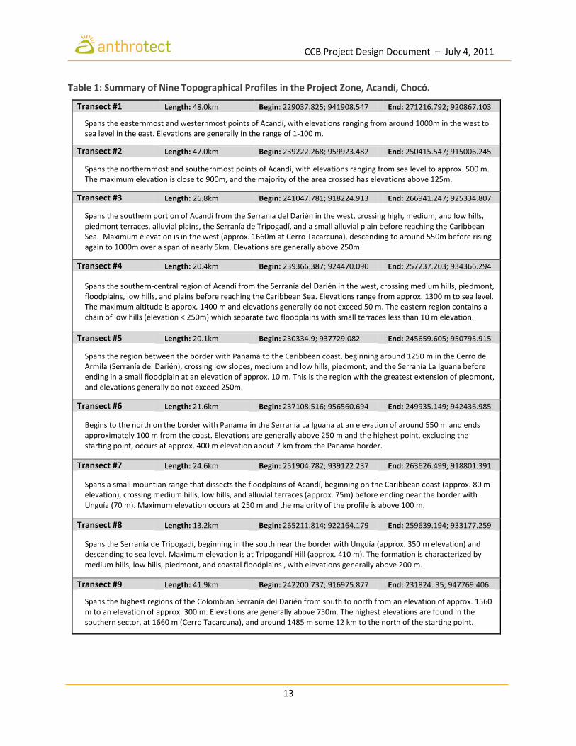
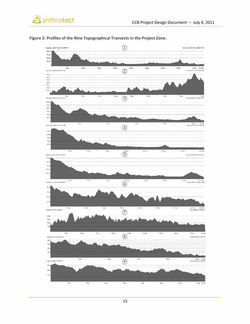
G.1.1 Location and Basic Physical Parameters The Choco-Darien Conservation Corridor is located in the Darién region of northwest Colombia within the administrative jurisdictions of the Department of Chocó and the Municipality of Acandí. The Colombian Darién is part of the Chocó biogeographic region, recognized as one of the most biodiverse regions in the world for its strategic geographic location and high levels of species endemism. Much of this biological richness owes to the relatively recent formation of the Isthmus of Panama some 5 million years ago, an extraordinary geological event which separated the Atlantic and Pacific Oceans and formed a land bridge between North and South America. Geology and Soils The most pronounced geomorphological regions of the Colombian Darien are the Baudó and Darién mountain ranges, which originated in a volcanic island arc that emerged in the Middle Eocene epoch, and the Atrato River basin, which emerged in the late Pliocene through tectonic activity. The Serranía del Baudó and the Caribbean slopes of the Serranía del Darién are largely of volcanic origin, while the inland slope of the Serranía del Darién is of Cenozoic sediments. The mountains and hills of the Pacific platform are formed largely by igneous rocks with basalts, diabases, andesites, and sedimentary clays, as well as siltstones, chert and limestone (Martínez 1993). A second, less extensive lithostratigraphic formation contains diorite, quartz diorite, and different types of granite, while a third formation consists of gravel, sand, limestone, and river, lake, and marine deposits (Coates, et al. 2004; Cossio 1994; Govea and Aguilera 1985). The soils of the Darién exhibit both marine and alluvial characteristics, and evidence suggests that sea level has fluctuated from 100 m below to 50 m above present levels, most recently during the early Pleistocene. The recent alluvial plains are formed by deposits from rivers such as the Atrato, which courses northward through a flat, marshy floodplain flanked by the Andes to the east and the Darién and Baudó ranges to the west, before emptying into the Gulf of Urabá (Lobo-Guerrero 1993). While the lowland plains are dominated by alluvial deposits, the more hilly areas resulted from the dissection of Tertiary sediments (González and Marín 1989). Where not alluvial, the lowland clay soils are lateritic, generally derived from late Miocene shale with layers of dolomite and calcareous sandstone. Where sloping, soils tend to be leached of nutrients by high rainfall (Golley, et al. 1975). Topography The municipality of Acandí is located in northwest Colombia in the department of Chocó and has a territorial extension of 1,551 km2. It is bordered to the north and west by the Republic of Panama, to the east by the Caribbean Sea, and to the south by the municipality of Unguía. Figure 1 summarizes the most important morphological and topographic characteristics of Acandí. The red lines depict nine distinct topographical profiles based on cartographic information generated using Universal Transverse Mercator (UTM) coordinates WGS 84 zone 18 N (78-72W). Table 1 provides an overview of each of the nine topographical profiles.

CCB Project Design Document – July 4, 2011
12
Figure 1: Important Morphological and Topographic Characteristics of Acandí.
CCB Project Design Document – July 4, 2011
13
Table 1: Summary of Nine Topographical Profiles in the Project Zone, Acandí, Chocó.
Transect #1 Length: 48.0km Begin: 229037.825; 941908.547 End: 271216.792; 920867.103
Spans the easternmost and westernmost points of Acandí, with elevations ranging from around 1000m in the west to sea level in the east. Elevations are generally in the range of 1-100 m.
Transect #2 Length: 47.0km Begin: 239222.268; 959923.482 End: 250415.547; 915006.245
Spans the northernmost and southernmost points of Acandí, with elevations ranging from sea level to approx. 500 m. The maximum elevation is close to 900m, and the majority of the area crossed has elevations above 125m.
Transect #3 Length: 26.8km Begin: 241047.781; 918224.913 End: 266941.247; 925334.807
Spans the southern portion of Acandí from the Serranía del Darién in the west, crossing high, medium, and low hills, piedmont terraces, alluvial plains, the Serranía de Tripogadí, and a small alluvial plain before reaching the Caribbean Sea. Maximum elevation is in the west (approx. 1660m at Cerro Tacarcuna), descending to around 550m before rising again to 1000m over a span of nearly 5km. Elevations are generally above 250m.
Transect #4 Length: 20.4km Begin: 239366.387; 924470.090 End: 257237.203; 934366.294
Spans the southern-central region of Acandí from the Serranía del Darién in the west, crossing medium hills, piedmont, floodplains, low hills, and plains before reaching the Caribbean Sea. Elevations range from approx. 1300 m to sea level. The maximum altitude is approx. 1400 m and elevations generally do not exceed 50 m. The eastern region contains a chain of low hills (elevation < 250m) which separate two floodplains with small terraces less than 10 m elevation.
Transect #5 Length: 20.1km Begin: 230334.9; 937729.082 End: 245659.605; 950795.915
Spans the region between the border with Panama to the Caribbean coast, beginning around 1250 m in the Cerro de Armila (Serranía del Darién), crossing low slopes, medium and low hills, piedmont, and the Serranía La Iguana before ending in a small floodplain at an elevation of approx. 10 m. This is the region with the greatest extension of piedmont, and elevations generally do not exceed 250m.
Transect #6 Length: 21.6km Begin: 237108.516; 956560.694 End: 249935.149; 942436.985
Begins to the north on the border with Panama in the Serranía La Iguana at an elevation of around 550 m and ends approximately 100 m from the coast. Elevations are generally above 250 m and the highest point, excluding the starting point, occurs at approx. 400 m elevation about 7 km from the Panama border.
Transect #7 Length: 24.6km Begin: 251904.782; 939122.237 End: 263626.499; 918801.391
Spans a small mountian range that dissects the floodplains of Acandí, beginning on the Caribbean coast (approx. 80 m elevation), crossing medium hills, low hills, and alluvial terraces (approx. 75m) before ending near the border with Unguía (70 m). Maximum elevation occurs at 250 m and the majority of the profile is above 100 m.
Transect #8 Length: 13.2km Begin: 265211.814; 922164.179 End: 259639.194; 933177.259
Spans the Serranía de Tripogadí, beginning in the south near the border with Unguía (approx. 350 m elevation) and descending to sea level. Maximum elevation is at Tripogandí Hill (approx. 410 m). The formation is characterized by medium hills, low hills, piedmont, and coastal floodplains , with elevations generally above 200 m.
Transect #9 Length: 41.9km Begin: 242200.737; 916975.877 End: 231824. 35; 947769.406
Spans the highest regions of the Colombian Serranía del Darién from south to north from an elevation of approx. 1560 m to an elevation of approx. 300 m. Elevations are generally above 750m. The highest elevations are found in the southern sector, at 1660 m (Cerro Tacarcuna), and around 1485 m some 12 km to the north of the starting point.
CCB Project Design Document – July 4, 2011
14
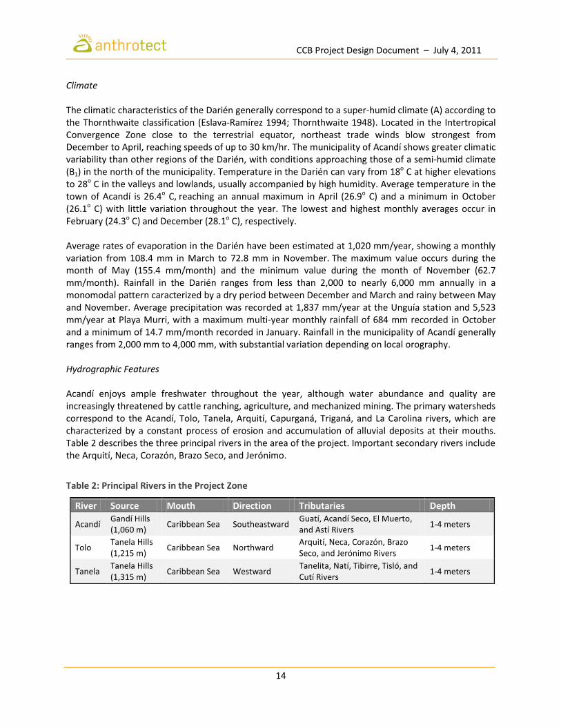
Climate The climatic characteristics of the Darién generally correspond to a super-humid climate (A) according to the Thornthwaite classification (Eslava-Ramírez 1994; Thornthwaite 1948). Located in the Intertropical Convergence Zone close to the terrestrial equator, northeast trade winds blow strongest from December to April, reaching speeds of up to 30 km/hr. The municipality of Acandí shows greater climatic variability than other regions of the Darién, with conditions approaching those of a semi-humid climate (B1) in the north of the municipality. Temperature in the Darién can vary from 18o C at higher elevations to 28o C in the valleys and lowlands, usually accompanied by high humidity. Average temperature in the town of Acandí is 26.4o C, reaching an annual maximum in April (26.9o C) and a minimum in October (26.1o C) with little variation throughout the year. The lowest and highest monthly averages occur in February (24.3o C) and December (28.1o C), respectively. Average rates of evaporation in the Darién have been estimated at 1,020 mm/year, showing a monthly variation from 108.4 mm in March to 72.8 mm in November. The maximum value occurs during the month of May (155.4 mm/month) and the minimum value during the month of November (62.7 mm/month). Rainfall in the Darién ranges from less than 2,000 to nearly 6,000 mm annually in a monomodal pattern caracterized by a dry period between December and March and rainy between May and November. Average precipitation was recorded at 1,837 mm/year at the Unguía station and 5,523 mm/year at Playa Murri, with a maximum multi-year monthly rainfall of 684 mm recorded in October and a minimum of 14.7 mm/month recorded in January. Rainfall in the municipality of Acandí generally ranges from 2,000 mm to 4,000 mm, with substantial variation depending on local orography. Hydrographic Features Acandí enjoys ample freshwater throughout the year, although water abundance and quality are increasingly threatened by cattle ranching, agriculture, and mechanized mining. The primary watersheds correspond to the Acandí, Tolo, Tanela, Arquití, Capurganá, Triganá, and La Carolina rivers, which are characterized by a constant process of erosion and accumulation of alluvial deposits at their mouths. Table 2 describes the three principal rivers in the area of the project. Important secondary rivers include the Arquití, Neca, Corazón, Brazo Seco, and Jerónimo.
Table 2: Principal Rivers in the Project Zone
River Source Mouth Direction Tributaries Depth
Acandí Gandí Hills (1,060 m)
Caribbean Sea Southeastward Guatí, Acandí Seco, El Muerto, and Astí Rivers
1-4 meters
Tolo Tanela Hills (1,215 m)
Caribbean Sea Northward Arquití, Neca, Corazón, Brazo Seco, and Jerónimo Rivers
1-4 meters
Tanela Tanela Hills (1,315 m)
Caribbean Sea Westward Tanelita, Natí, Tibirre, Tisló, and Cutí Rivers
1-4 meters
CCB Project Design Document – July 4, 2011
15
Figure 2: Profiles of the Nine Topographical Transects in the Project Zone.

CCB Project Design Document – July 4, 2011
16
G.1.2 Types and Condition of Vegetation within the Project Area The vegetation of the Chocó biogeographic region has received considerable research attention, including taxonomic studies (Acosta-S. 1970; Cuatrecasas 1958; Forero and Gentry 1989) as well as research on composition (Cuatrecasas 1946; Rangel-Ch. and Lowy 1993; Zuluaga-R. 1987). In particular, the Serranía del Darién exhibits a number of botanically interesting ecosystems, especially above 200 m where large pockets of primary forest are still intact (Prieto-C., et al. 2004). Dense low premontane rainforest occurs to 500 m, where Brosimum and Dipteryx species abound in the canopy, with lianas, ferns, and palms in the subcanopy and Cephaelis elata a dominant shrub. At 500-600 m there is seasonal yet evergreen tropical wet forest. Anacardium excelsum is dominant in the canopy with an abundance of Bombacopsis quinata (VU), B. sessilis, Brosimum guianense, Ceiba pentandra, Cochlospermum williamsii, Dipteryx panamensis and Myroxylon balsamum. In this range, the main subcanopy tree is Oenocarpus panamanus. The dominant understorey shrub is Mabea occidentalis and frequent shrubs include Clidemia spp., Conostegia spp. and Miconia spp. Cloud forest represented by species such as Oenocarpus panamanus, Anacardium excelsum, Brosimum utile and Pseudolmedia laevigata commences at around 750 m elevation, and elfin forest with Clusia spp. is found on the highest peaks and ridges (Gentry 1977; Golley, et al. 1975; Porter 1973). A distinctive montane oak forest of Quercus humboldtii (VU) is present at the highest elevations of the project area (above 1500 m) on the border with Panama, in the direction of Mt. Tacarcuna. Mt. Tacarcuna is a sacred site in Kuna cosmology and the highest point in the Serranía el Darién, where many endemics occur (Gentry 1985; Lewis 1971). The limited collections (90% identified) from high on Mt. Tacarcuna show 23% endemism and some 25% new species, including the new genus Tacarcuna (Euphorbiaceae) and three specimens only of the tree Freziera forerorum (CR) recently dscovered on the summit. Other similar areas are presumed to have high angiosperm endemism, especially in the isolated cloud forests (Herrera-MacBryde 1997). In order to assess vegetation and prepare a more precise tree species inventory, field data was collected at two forest plots within the project area. This work was carried out by forest engineers Fernando Quejada Olivo, Robert Roa Mosquera, Wiston Antonio Renteria Escobar, and Jean Javier Urrutia under contract with COCOMASUR at the following locations:
Lot 1: Located at the village of Peñaloza toward Balboa, reference point Jerónimo Creek, UTM coordinates (WGS 84 - Area 18N) defining Polygon 1 (247543.546875; 924394.1875), 2 (244,132; 923606.8125 ), 3 (243683.109375; 925,557) and 4 (247092.828125; 926374.3125), which corresponds to 706 hectares along an altitudinal gradient of 659.58 meters. The minimum elevation is approx. 179m and the maximum is 839m, with an average of 445m and a median of 401m.
Dipteryx oleifera in the project area, Acandí, Chocó. Photo by Henry Arellano Peña.

CCB Project Design Document – July 4, 2011
17
Lot 2: Located at the confluence of the Chugandí River and Pescao Creek with coordinates 5 (254040.578125; 916893.125), 6 (252611.8125; 918945.375), 7 (253596.78125, 919631.4375) and 8 (255025.53125, 917579.25) corresponding to an area of 300 hectares over an altitudinal gradient of 377m. The minimum and maximum elevations recorded were 169m and 545m, respectively, with a mean elevation of 320m and a median of 307m.
In Lot 1, a total of fourteen (14) linear transects were laid with an area of one hectare each, within which ten (10) subtransects were defined, each with an area of 1000 m2. In Lot 2, six (6) linear transects were laid, each with an area of one hectare, within which ten (10) subtransects were defined, each with an area of 1000 m2. Of the total number of sampling subunits, information was collected from 194 subunits. This information on floristic composition was used to prepare a floristic inventory with scientific species names based on information from the Colombia Biodiversity Project Colombia (Rangel-Ch. 2004a). Table 3 presents an abbreviated list of the tree species identified at the two sites sampled. The structural characterictics of tree species identified in the two forest plots were used to define 21 classes of land cover or land use (Table 4) for the project zone using the TWINSPAN software program (McCune and Mefford 1999) and comparing with other important work on vegetation in Colombia (Arellano-P. and Rangel-Ch. 2008; Arellano-P. and Rangel-Ch. 2009). Figure 3 shows land cover in the municipality of Acandí in the year 2010, where the color red represents Classes 5 and 6 from Table 4, and where the color green represents Classes 11 and 12 (forests). Table 5 shows the area of each class of land cover in the project area in the year 2010.
Undergrowth palms in the project zone, Acandí, Chocó. Photo by Brodie Ferguson.

CCB Project Design Document – July 4, 2011
18
Table 3: Tree Species in the Project Area, Acandí, Chocó.
Species Vernacular Name
Widely distributed species:
Brosimum utile Sande + Arbol Vaca
Elaegia sp. Brasilete
Carapa guianensis Guino + Cedro Guino
Hymenaea oblongifolia Algarrobo
Phitecellobium dinizzi Costillo
Tapirira guianensis Fresmo + Cedro Macho
Pterocarpues rohric Sangre de Gallo
Oneocarpus bataua Milpesos
Maclura tinctoria Mora
Cecropia hispidisima Guarumo
Chrysophyllum sp. Níspero
Forests characterized by Terminalia amazonia, Apeiba membranacea and Aspidosperma dugandii:
Terminalia ef. amazonia Escobo + Parasiempre
Apeiba membranacea Corcho
Aspidosperma dugandii Carreto
Astronium graveolens Santacruz
Micropholis guianensis Caimito
Jacaranda copaia Canalete + Chingale
Aniba pichurim Caidita
Licaria canella Canelon
Vitex columbienses Truntago
Anacardium excelsum Caracolí
Dialum guianense Tamarindo + Culo de Hierro
Oxandra xylopioides Yaya
Couratari guianensis Cabuyo
Tabebuia rosea Roble
Caryocar amygdalifera Cavi (Cawi)
Pseudolmedia laevigata Leche perra
Clarisia biflora Caucho + Cauchillo
Unidentified "Humo sp." Humo
Lecythis tuyrana Oyeto
Arecaceae sp1 Canillona (palma)
Poulsenia armata Damagua + Majagua
Peltogyne pubescens Nazareno
Toxicodendron striatum Manzanillo
Spondias mombin Hobo
Schizolobium parahiba Tambolero
Gustavia superba Membrillo
Callophylum brasiliense Aceite maria
Cassipourea elliptica Pantano
Conostegia cuatrecasasii Aji Mora
cedrela odorata Cedro
Hirtella latifolia Carbonero
Roupala obovata Azufre

CCB Project Design Document – July 4, 2011
19
Macrolobium colombianum Guamillo
Ficus cf. tonduzzi Higueron
Cordia aff. panamensis Laurel
Macrolobium stenosiphon Dormilon
Nectandra acutifolia Amarillo
Protium veneralense Anime
Vitex masoniana Aceituno
Other species present:
Inga sp. Guamo
Cyrtostachys renda Pintalabios
Copaifera canime Harms Canime
Vismia baccifera Carate
Eschweilera sclerophylla Guasca
Trichilia martiana Vara de Piedra
Aniba guianensis Comino
Ceiba pentandra Bonga
Unidentified "Copa seca" Indeterminado "Copa seca"
Couroupita dananensis Cocuelo
Dystovomita clusifolia Zanca de Araña
Eschweilera coriacea Cazuelo
Huberodendron patiñoi Carra
Ochroma lagopus Balso
Sterculia apetala Camajon
Myroxylon balsamum Balsamo
Osteophleum platyspermun Palo de Agua
Vitex sp. Polvo de Arroz
Mauria sp. Palo Amargo
Ammandra decesperima Tagua
Arecaceae sp3 Tres Patas
Ficus aff. palida Lechudo
Catostemma digitata Arenillo
Eschweilera pittieri Coco Cristal
Zanthoxylum sp. Tachuelo
Myristicaceae Sangre de Pescao
Arecaceae sp2 Patona (palma)
Inga edulis Churimo
Unidentified 1 Caobillo
Unidentified 2 Llovisna
Phyllanthus sp. Balsilla
Platymiscium darienensis Ebano

CCB Project Design Document – July 4, 2011
20
Table 4: Classes of Land Cover in the Project Zone (Acandí, Chocó).
Class Symbol Type Description Dominant Species
1 Bhal/Par-Vco Humid tropical forest
Humid alluvial plain formation
Poulsenia armata and Vitex columbienses
2 Hb/Pac Grasslands Flat alluvial marshes (wetland, swamp) formation
Polygonum acuminatum
3 Hb/Mar Grasslands Alluvial plains or floodplains Montrichardia arborescens
4 Pm/Rta Palms Mainland in dikes and basines
Raphia taedigera
5 A-Pd/PnsUre (a) Grazinglands Areas subject to anthropic action
Pennisetum purpureum and Urera laciniata
6 A Intervened Completely intervened areas
7 Mm-Ma/Efu-Cic Shrublands Alluvial plains and piedmont Erythrina fusca and Chrysobalanus icaco
8 Bhal/Toc-Mba-Cpa Humid tropical forest
Vegetation in floodplains or flat regions near rivers
Tabebuia ochracea, Myroxylon balsamum and Cordia aff. panamensis
9 Bhri/Efu-Isp Humid tropical forest
Formations associated with watercourses and alluvial plains
Erythrina fusca and Inga sp.
10 Bhal-tf/Sgl-Hob-Tma Humid tropical forest
Alluvial plains and terraces formation
Symphonia globulifera, Hyeronima oblonga and Terminalia amazonia
11 A-Ma/Trm Shrublands Areas subject to anthropic action
Trema micrantha
12 A-Ps/Hru-Abi Pastures Areas with anthropic disturbance
Hyparrhenia rufa and Andropogon bicornis
13 Bhtf/Tam-Ame-Adu Humid tropical forest
Vegetation in non-alluvial plains
Terminalia amazonia, Apeiba membranacea and Aspidosperma dugandii
14 Bhtf/Toc-Mba-Tam Humid tropical forest
Terrace vegetation Tabebuia ochracea, Myroxylon balsamum and Terminalia amazonia
15 Bshtf/Dol-Par Very humid tropical forest
Mainland and slope formations
Dipteryx oleifera and Poulsenia armata
16 Bshtf/Dol-Jco-Toc Very humid tropical forest
Mainland and slope formations
Dipteryx oleifera, Jacaranda copaia, and Tabebuia ochracea
17 Bshtf/Dol-Esc-Tam Very humid tropical forest
Mainland and slope formations
Dipteryx oleifera, Eschweilera sclerophylla, and Terminalia cf. amazonia
18 Bhtf/Cod-Agr-Cbr Humid tropical forest
Formations over humid terraces
Cedrela odorata, Astronium graveolens, and Callophylum brasiliense
19 Bhtf/Cpl Humid tropical forest
Monostratified canopy on high hills
Cavanillesia platanifolia
20 Bhtf/Aex Humid tropical forest
Northward high hill formations
Anacardium excelsum
21 Bhtf/Qhu Humid tropical forest
Northward high hill formations
Quercus humboldtii (oak)

CCB Project Design Document – July 4, 2011
21
Figure 3: Vegetative Cover in the Project Zone (Acandí, Chocó) in 2010.

CCB Project Design Document – July 4, 2011
22
Table 5: Carbon Stocks in the Project Area by Class of Land Cover (2010).
Class Code Condition Type Area (ha)
3 Hb/Mar Natural Grasslands 1.7
4 Pm/Rta Natural Palms 0.3
5 A-Pd/Pns-Ure Intervened Grazinglands 2.0 6 A Intervened Completely transformed areas 1.1 7 Mm-Ma/Efu-Cic Natural Shrublands 146.3 8 Bhal/Toc-Mba-Cpa Natural Humid tropical forest 214.7 9 Bhri/Efu-Isp Natural Humid tropical forest 266.1
10 Bhal-tf/Sgl-Hob-Tma Natural Humid tropical forest 148.6 11 A-Ma/Trm Intervened Shrublands 1,273.9 12 A-Ps/Hru-Abi Intervened Pastures 313.5 13 Bhtf/Tam-Ame-Adu Natural Humid tropical forest 325.1 14 Bhtf/Toc-Mba-Tam Natural Humid tropical forest 407.6 15 Bshtf/Dol-Par Natural Very humid tropical forest 916.7 16 Bshtf/Dol-Jco-Toc Natural Very humid tropical forest 5,451.9 17 Bshtf/Dol-Esc-Tam Natural Very humid tropical forest 957.4 18 Bhtf/Cod-Agr-Cbr Natural Humid tropical forest 144.7 19 Bhtf/Cpl Natural Humid tropical forest 648.6 20 Bhtf/Aex Natural Humid tropical forest 2,175.4 21 Bhtf/Qhu Natural Humid tropical forest 152.8
Total 13,548.5
Largely undisturbed humid and very humid tropical forests make up approximately 11,807 hectares, or 88% of the total project area. The most abundant class of forest in the project area is Class 16: Very humid tropical forest – mainland and slope formations (Bshtf/Dol-Jco-Toc) characterized by Dipteryx oleifera, Jacaranda copaia, and Tabebuia ochracea and comprising an estimated 5,452 ha, or nearly 40% of the project area. The second most abundant class of forest is Class 20: Very humid tropical forest - northward high hill formations (Bhtf/Aex) dominated by Anacardium excelsum and comprising approximately 2,175 hectares, or 16% of the project area. Grazingland, pasture, and intervened shrubland combined comprise 1,590 ha, or almost 12% of the total project area.

CCB Project Design Document – July 4, 2011
23
G.1.3 Boundaries of the Project Area and the Project Zone The project area is located in northwest Colombia in the municipality of Acandí (Department of Chocó) within the territory constituting the collective land title of the Tolo River Basin Community Council (COCOMASUR). Table 6 shows the UTM points corresponding to the property boundaries of the COCOMASUR title, and Figure 4 indicates the area and location of the territory in red. The territory encompasses a total of 13,465 hectares distributed in two non-contiguous blocks, both of which are adjacent to Darién National Park in Panama.
Table 6: Boundaries of the Project Area Collectively Managed by COCOMASUR.
Boundaries (Block 1): 10,366 ha. + 3,239 m2
Point 1 X = 1.424.414 m.N Y = 965.970 m.E
Borders the Republic of Panama and a neighboring collective land title (COCOMASECO). From Point 1, proceed northeast, downstream, along the right bank of Batatilla River for 6,529 m until arriving at Point 2.
Point 2 X = 1.428.518 m.N Y = 969.947 m.E
Borders COCOMASECO (separated by the Batatilla River). From Point 2, proceed eastward, then southward for 13,686 m until arriving at Point 3.
Point 3 X = 1.421.862 m.N Y = 976.622 m.E
Borders private property. From Point 3, proceed, southward for 3,684 m until arriving at Point 4.
Point 4 X = 1.418.594.53 m.N, Y = 975.743.76 m.E
Located on the Brazo Seco River and bordering private property. Proceed southward for 2,334 m until arriving at Point 5.
Point 5 X = 1.417.290 m.N Y = 977.631 m.E
Located on the Jerónimo River and bordering private property. Proceed from Point 5 southward for 781 m until arriving at Point 6.
Point 6 X = 1.416.649 m.N. Y = 978.038 m.E
Borders private property. From Point 6 proceed westward for 9,006 m until arriving at Point 7.
Point 7 X = 1.414.105 mN Y = 969.969
Borders the Chidima indigenous reserve. From Point 7 proceed northward along the border with Panama for 12,583.87 m until arriving back at Point 1.
Boundaries (Block 2): 3,517 ha + 3,846 m2
Point 8 X = 1.407.565 m.N Y = 971.492 m.E
Located on the border with Panama. From Point 8, proceed eastward for 13,811 m along the border with the Chidima indigenous reserve before arriving at Point 9.
Point 9 X = 1.412.406 m.N Y = 983.484 m.E
Borders the Chidima indigenous reserve. From Point 9 proceed eastward for 4,883 m before arriving at Point 10.
Point 10 X = 1.408.646 m.N Y = 985.654
Located on the Tanela River and bordering private property. From Point 10 proceed westward, upstream following left bank of the the Tanela River for 17,601 m until arriving at Point 11.
Point 11 X = 1.406.510 m.N Y = 971.420 m.E
Located on the border with Panama. From Point 11 proceed northward for 1,078 m along the border with Panama until arriving back at Point 8.

CCB Project Design Document – July 4, 2011
24
Figure 4: Boundaries of the Project Area within the Project Zone (Acandí, Chocó).

CCB Project Design Document – July 4, 2011
25
G.1.4 Current Carbon Stocks in the Project Area Remote sensing analysis Carbon stocks in the project area were estimated by reconstructing satellite imagery scenes (1:25,000) from different groups of remote sensors from distinct points in time over the period 1990-2010 (Arellano-P. 2011). Extensive cloud cover throughout the year makes it nearly impossible to carry out satellite imagery analysis using a single multispectral scene. For this reason, in addition to the costs associated with acquiring medium to high-resolution imagery for the project area and the drawbacks of using radar imagery, land cover was classified by comparing similar scenes in the region. Such an analysis of land cover and land use change should strive to include the following:
1. a series of satellite images or aerial photos (raster series) spaced at different points in time that allow evaluation pixel by pixel;
2. a series of vectoral, multitemporal thematic maps that are sufficiently spaced in time; 3. evidence of types of land cover and vegetation in the project zone based on primary and
secondary information; 4. attaining the largest comparison area possible for the same spatial resolution.
Table 7 shows the three groups of LANDSAT images pertaining to three decades that were selected for the project zone: LANDSAT Group 5 for the 1980’s, LANDSAT Group 7 for the 1990’s, and LANDSAT Group 7 for the 2000’s (GloVis 2011). It was necessary to address two issues in the image series. First, in the 1980’s, the sensor lacked the panchromatic band which makes it impossible to compare with remote multispectral data from the 1990’s and later. This issue was solved by combining with the oldest panchromatic image available, which is from 1999. Second, although LANDSAT 7 provides uninterrupted information since July of 1999, a fault in the image capture instrument since May 31, 2003 makes it impossible to obtain images without bands. Conventional methods for addressing this issue include the use of Fourier transformations; however, given that the sensor damage results in large amounts of information loss, this technique does not recover sufficient information. Some research groups, such as the U.S. Geological Survey, have designed algorithms like the SLC-Gap-Fill Algorithm (Scaramuzza, et al. 2004) which attempt to correct the signal defects using similar information (Howard and Lacasse 2004). However, applying these algorithms requires specific information on the scene as well as a complete series of the scene, which was not available for the project area. A group of techniques were used to process the images from the LANDSAT 7 group for the project zone (representing anthropogenic disturbance during 2000-2010). The process sacrifices the information distributed in bands, although the spectral result is similar to the combination of the bands separately (in this case bands 4, 5, and 3). The process, known as “histogram matching”, is used to combine the color intensities as well as the distribution of the color palate associated with the best image selected among all dates over the three decade period. In general, the process consists of homogenizing the color information in the raw data and homologizing them in the rest of the images. This process was carried out using the MATLAB, Grass, and R statistical software packages (GRASS Development Team 2010; Mathworks 2007; R Development Core Team 2011).

CCB Project Design Document – July 4, 2011
26
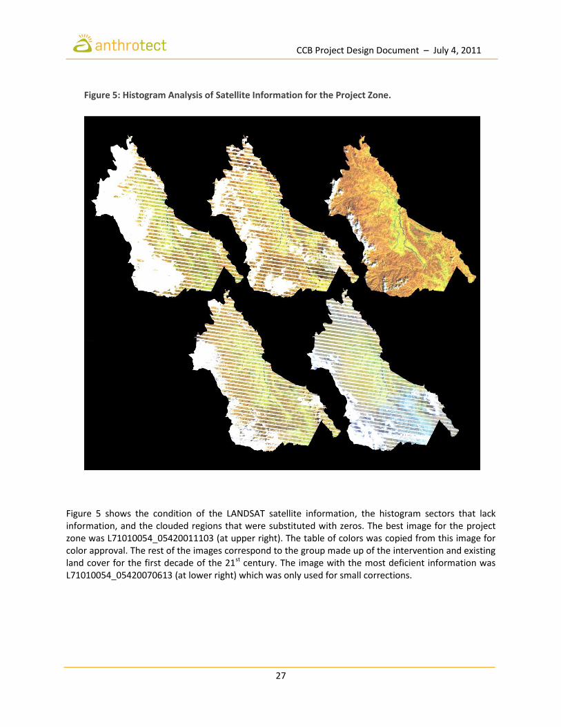
Next, images with banding and information loss were decomposed using Fourier analysis to eliminate small periodic interferences. Even though these processes substantially improve the visual information of the images, image processing software (especially histogram curve adjustment) is useful for the intuitive correction of subtle changes in brightness and color. Regions lacking information (i.e. areas affected by banding, dense clouds, atmospheric interference, or bodies of water) were modified by incorporating values of zero (0) in their histograms in order to reduce classification error and homogenize the number of resulting classes. This process yielded information on patterns of land cover in the project zone without interference. The information was incorporated into an image mosaic which, in the case of LANDSAT Group 7 (2000-2009), recuperated over 80% of the information lost as a result of the defective sensor. The remaining 20% was reconstructed by comparing land cover with the LANDSAT Group 7 (1990-1999) through the process illustrated in Figure 5.
Table 7: LANDSAT Scenes Used in the Image Reconstruction Process.
LANDSAT Scene Year Decade Equivalent Bands Used Panchromatic band
L5010054_05419830512 1983
Land Cover 1980's
4,5,3
Unavailable, Band 8 from 1999 was used.
L5010054_05419860219
1986 L5010054_05419860510
L5010054_05419860713
L5010054_05419861102
L5010054_05419891228 1989
L71010054_05420010527
2001 Land Cover 1990's
8
L71010054_05420011103
L71010055_05420011103
L71010054_05420070613
2007
Land Cover 2000's
L71010054_05420071019
L71010054_05420071104
L71010054_05420081106 2008
L7G010054_05420100621 2010
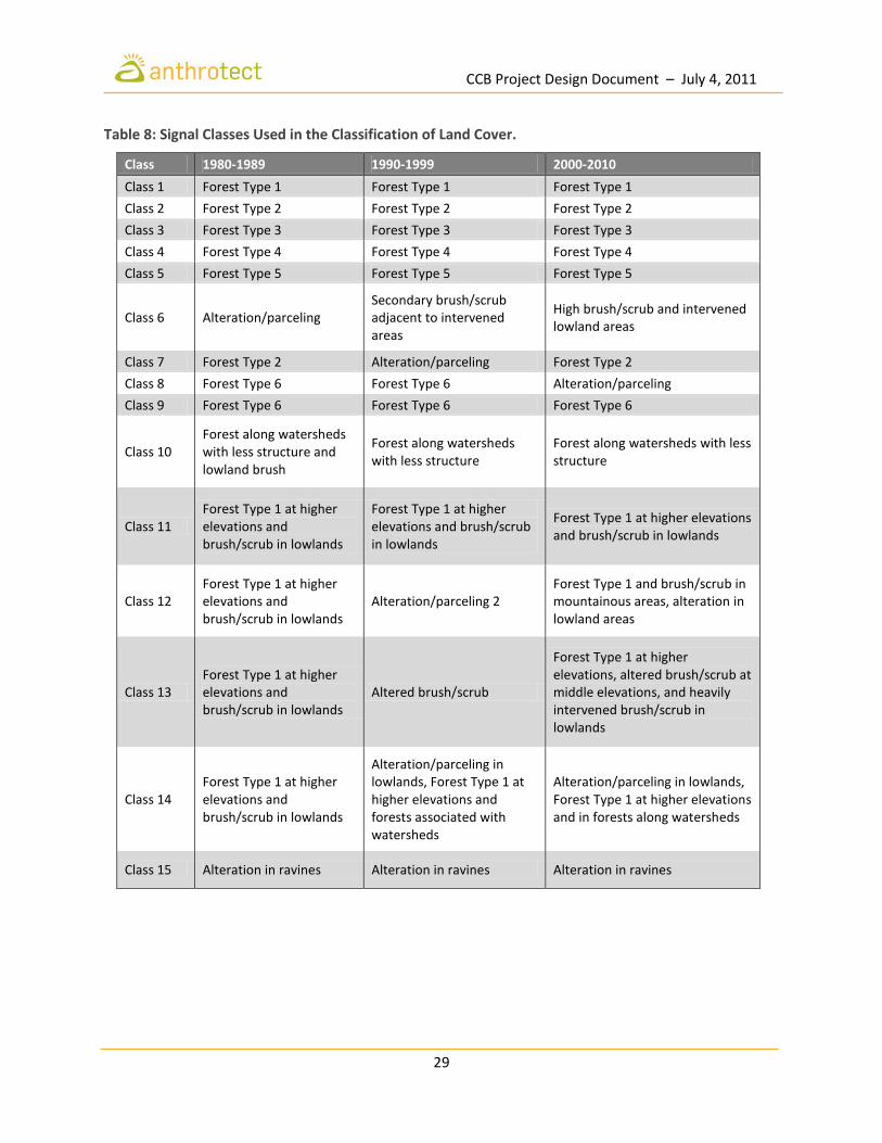
Land cover classification In order to classify land cover, supervised (visual) classification was combined with classification using fuzzy logic (Arellano-P. 2011; Arellano-P. and Rangel-Ch. 2010). For the supervised classification of images, training surfaces were generated in order to reclassify those pixels that shared similar characteristics. LANDSAT-SPOT images can include specific types of land cover within each signal, for example, anthropogenic disturbance in lowlands can generate a signal that may be misinterpreted as areas of highly illuminated forest. This requires the revision of classification with visual methods in the vectorized product. For raster inputs, this type of pixel correction can be time-consuming when all of the signals are assessed, hence fuzzy logic can be a useful tool in the classification and separation of data. For the project zone, fifteen (15) spectral signatures were generated in order to separate the principal land cover classes. Table 7 shows the signal classes used in the classification of land cover in the project zone and the signal(s) they include. Figure 6 shows the results of the classification, where land cover classes dominated by anthropogenic intervention have been grouped into at least three classes (shown in red).
CCB Project Design Document – July 4, 2011
27
Figure 5 shows the condition of the LANDSAT satellite information, the histogram sectors that lack information, and the clouded regions that were substituted with zeros. The best image for the project zone was L71010054_05420011103 (at upper right). The table of colors was copied from this image for color approval. The rest of the images correspond to the group made up of the intervention and existing land cover for the first decade of the 21st century. The image with the most deficient information was L71010054_05420070613 (at lower right) which was only used for small corrections.
Figure 5: Histogram Analysis of Satellite Information for the Project Zone.
CCB Project Design Document – July 4, 2011
28
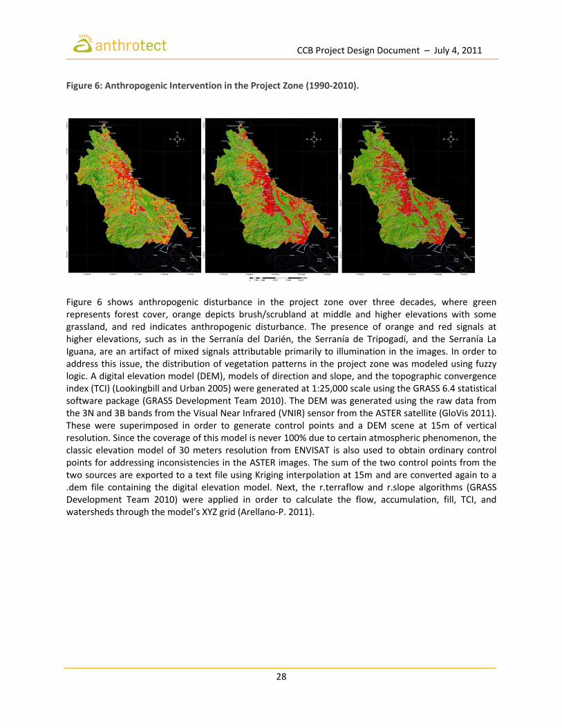
Figure 6: Anthropogenic Intervention in the Project Zone (1990-2010).
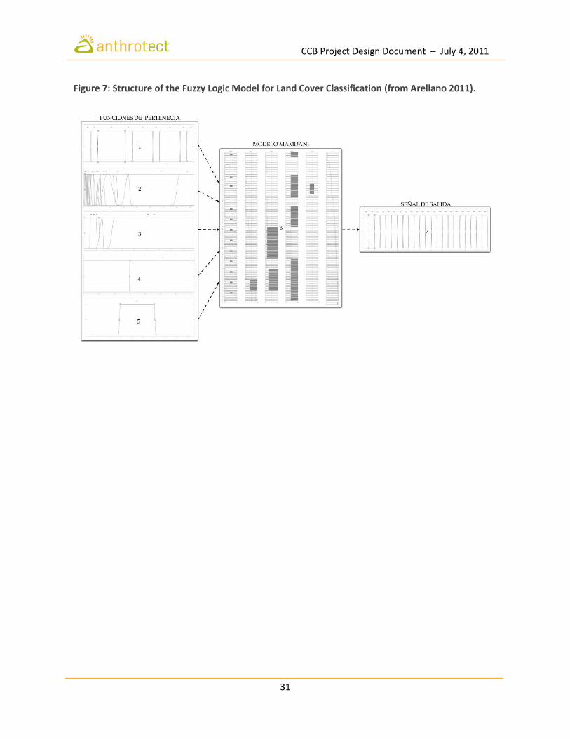
Figure 6 shows anthropogenic disturbance in the project zone over three decades, where green represents forest cover, orange depicts brush/scrubland at middle and higher elevations with some grassland, and red indicates anthropogenic disturbance. The presence of orange and red signals at higher elevations, such as in the Serranía del Darién, the Serranía de Tripogadí, and the Serranía La Iguana, are an artifact of mixed signals attributable primarily to illumination in the images. In order to address this issue, the distribution of vegetation patterns in the project zone was modeled using fuzzy logic. A digital elevation model (DEM), models of direction and slope, and the topographic convergence index (TCI) (Lookingbill and Urban 2005) were generated at 1:25,000 scale using the GRASS 6.4 statistical software package (GRASS Development Team 2010). The DEM was generated using the raw data from the 3N and 3B bands from the Visual Near Infrared (VNIR) sensor from the ASTER satellite (GloVis 2011). These were superimposed in order to generate control points and a DEM scene at 15m of vertical resolution. Since the coverage of this model is never 100% due to certain atmospheric phenomenon, the classic elevation model of 30 meters resolution from ENVISAT is also used to obtain ordinary control points for addressing inconsistencies in the ASTER images. The sum of the two control points from the two sources are exported to a text file using Kriging interpolation at 15m and are converted again to a .dem file containing the digital elevation model. Next, the r.terraflow and r.slope algorithms (GRASS Development Team 2010) were applied in order to calculate the flow, accumulation, fill, TCI, and watersheds through the model’s XYZ grid (Arellano-P. 2011).
CCB Project Design Document – July 4, 2011
29
Table 8: Signal Classes Used in the Classification of Land Cover.
Class 1980-1989 1990-1999 2000-2010
Class 1 Forest Type 1 Forest Type 1 Forest Type 1
Class 2 Forest Type 2 Forest Type 2 Forest Type 2
Class 3 Forest Type 3 Forest Type 3 Forest Type 3
Class 4 Forest Type 4 Forest Type 4 Forest Type 4
Class 5 Forest Type 5 Forest Type 5 Forest Type 5
Class 6 Alteration/parceling Secondary brush/scrub adjacent to intervened areas
High brush/scrub and intervened lowland areas
Class 7 Forest Type 2 Alteration/parceling Forest Type 2
Class 8 Forest Type 6 Forest Type 6 Alteration/parceling
Class 9 Forest Type 6 Forest Type 6 Forest Type 6
Class 10 Forest along watersheds with less structure and lowland brush
Forest along watersheds with less structure
Forest along watersheds with less structure
Class 11 Forest Type 1 at higher elevations and brush/scrub in lowlands
Forest Type 1 at higher elevations and brush/scrub in lowlands
Forest Type 1 at higher elevations and brush/scrub in lowlands
Class 12 Forest Type 1 at higher elevations and brush/scrub in lowlands
Alteration/parceling 2 Forest Type 1 and brush/scrub in mountainous areas, alteration in lowland areas
Class 13 Forest Type 1 at higher elevations and brush/scrub in lowlands
Altered brush/scrub
Forest Type 1 at higher elevations, altered brush/scrub at middle elevations, and heavily intervened brush/scrub in lowlands
Class 14 Forest Type 1 at higher elevations and brush/scrub in lowlands
Alteration/parceling in lowlands, Forest Type 1 at higher elevations and forests associated with watersheds
Alteration/parceling in lowlands, Forest Type 1 at higher elevations and in forests along watersheds
Class 15 Alteration in ravines Alteration in ravines Alteration in ravines
CCB Project Design Document – July 4, 2011
30
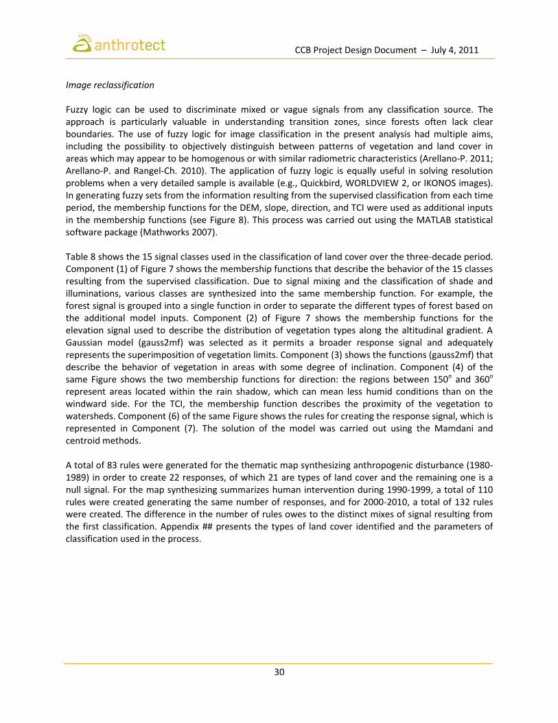
Image reclassification Fuzzy logic can be used to discriminate mixed or vague signals from any classification source. The approach is particularly valuable in understanding transition zones, since forests often lack clear boundaries. The use of fuzzy logic for image classification in the present analysis had multiple aims, including the possibility to objectively distinguish between patterns of vegetation and land cover in areas which may appear to be homogenous or with similar radiometric characteristics (Arellano-P. 2011; Arellano-P. and Rangel-Ch. 2010). The application of fuzzy logic is equally useful in solving resolution problems when a very detailed sample is available (e.g., Quickbird, WORLDVIEW 2, or IKONOS images). In generating fuzzy sets from the information resulting from the supervised classification from each time period, the membership functions for the DEM, slope, direction, and TCI were used as additional inputs in the membership functions (see Figure 8). This process was carried out using the MATLAB statistical software package (Mathworks 2007). Table 8 shows the 15 signal classes used in the classification of land cover over the three-decade period. Component (1) of Figure 7 shows the membership functions that describe the behavior of the 15 classes resulting from the supervised classification. Due to signal mixing and the classification of shade and illuminations, various classes are synthesized into the same membership function. For example, the forest signal is grouped into a single function in order to separate the different types of forest based on the additional model inputs. Component (2) of Figure 7 shows the membership functions for the elevation signal used to describe the distribution of vegetation types along the altitudinal gradient. A Gaussian model (gauss2mf) was selected as it permits a broader response signal and adequately represents the superimposition of vegetation limits. Component (3) shows the functions (gauss2mf) that describe the behavior of vegetation in areas with some degree of inclination. Component (4) of the same Figure shows the two membership functions for direction: the regions between 150o and 360o represent areas located within the rain shadow, which can mean less humid conditions than on the windward side. For the TCI, the membership function describes the proximity of the vegetation to watersheds. Component (6) of the same Figure shows the rules for creating the response signal, which is represented in Component (7). The solution of the model was carried out using the Mamdani and centroid methods. A total of 83 rules were generated for the thematic map synthesizing anthropogenic disturbance (1980-1989) in order to create 22 responses, of which 21 are types of land cover and the remaining one is a null signal. For the map synthesizing summarizes human intervention during 1990-1999, a total of 110 rules were created generating the same number of responses, and for 2000-2010, a total of 132 rules were created. The difference in the number of rules owes to the distinct mixes of signal resulting from the first classification. Appendix ## presents the types of land cover identified and the parameters of classification used in the process.
CCB Project Design Document – July 4, 2011
31
Figure 7: Structure of the Fuzzy Logic Model for Land Cover Classification (from Arellano 2011).
CCB Project Design Document – July 4, 2011
32
Figure 8: Inputs Used in the Membership Functions for Land Classification via Fuzzy Logic.

CCB Project Design Document – July 4, 2011
33
Table 9 shows the pools of carbon included in the estimation of carbon stocks. Further studies are required on vegetation structure in order to properly estimate carbon stocks in other pools. Biomass was estimated using the IPCC (2003) formula proposed by Brown (1997) for estimating above-ground biomass (kg dry weight) in moist tropical hardwood zones.
Y = exp[–2,289 + 2,649 • ln (DBH) – 0,021 • (ln(DBH))2]
R2/size of sample: 0.98/226 DBH range = 5-148 cm Where:
Y = above ground dry biomass, Kg (tree)-1 DBH = Diameter at breast height, cm. ln = natural logarithm exp = e to the x power
Table 10 shows the average biomass by class of vegetation used to estimate carbon stocks in the project zone. Since detailed data on root structure in the project area is not yet available, below-ground biomass has been estimated using the root to shoot ratio for tropical forests in Table 4.4 of the IPCC GL AFOLUC. Table 11 shows carbon stocks in the project area by class of land cover for the year 2010.
Table 9: Pools of Carbon Included in the Estimation of Carbon Stocks.
Type Inclusion Observations
Above-ground tree biomass
Included Local allometric defined for estimation of above ground tree biomass from diameter at breast height.
Above-ground non-tree biomass
Excluded Local allometric to be defined.
Below-ground tree biomass
Included Estimated based on IPCC 2006 root:shoot ratio.
Below-ground non-tree biomass
Excluded Local root:shoot ratio for below-ground non-tree biomass to be defined.
Deadwood Excluded Likely to remain constant under the project scenario.
Leaf litter Excluded Expected to represent only a small proportion of total biomass (<1%).
Soil Excluded To be determined.

CCB Project Design Document – July 4, 2011
34
Table 10: Average Biomass by Class of Vegetation for the Project Area.
Average Biomass (tC/ha)
Vegetation Class
Above-ground tree
Above-ground non-tree
Below-ground tree
Below-ground tree Deadwood
Leaf litter Soil
Bhal/Par-Vco 274.1 Excluded 54.8 Excluded Excluded Excluded Excluded
Bhal/Toc-Mba-Cpa 298.6 Excluded 59.7 Excluded Excluded Excluded Excluded
Bhri/Efu-Isp 322.6 Excluded 64.5 Excluded Excluded Excluded Excluded
Bhal-tf/Sgl-Hob-Tma 322.6 Excluded 64.5 Excluded Excluded Excluded Excluded
Bhtf/Tam-Ame-Adu 291.7 Excluded 58.3 Excluded Excluded Excluded Excluded
Bhtf/Toc-Mba-Tam 393.6 Excluded 78.7 Excluded Excluded Excluded Excluded
Bshtf/Dol-Par 312.9 Excluded 62.6 Excluded Excluded Excluded Excluded
Bshtf/Dol-Jco-Toc 376.0 Excluded 75.2 Excluded Excluded Excluded Excluded
Bshtf/Dol-Esc-Tam 276.2 Excluded 55.2 Excluded Excluded Excluded Excluded
Bhtf/Cod-Agr-Cbr 309.5 Excluded 61.9 Excluded Excluded Excluded Excluded
Bhtf/Cpl 322.6 Excluded 64.5 Excluded Excluded Excluded Excluded
Bhtf/Aex 322.6 Excluded 64.5 Excluded Excluded Excluded Excluded
Bhtf/Qhu 322.6 Excluded 64.5 Excluded Excluded Excluded Excluded
Table 11: Carbon Stocks in the Project Area by Class of Land Cover (2010).
Class Code Condition Type Area (ha) C (ha-1
) C Stocks
3 Hb/Mar Natural Grasslands 1.7 - -
4 Pm/Rta Natural Palms 0.3 - -
5 A-Pd/Pns-Ure Intervened Grazinglands 2.0 - - 6 A Intervened Completely transformed areas 1.1 - - 7 Mm-Ma/Efu-Cic Natural Shrublands 146.3 - - 8 Bhal/Toc-Mba-Cpa Natural Humid tropical forest 214.7 298.6 32,060 9 Bhri/Efu-Isp Natural Humid tropical forest 266.1 322.6 42,932
10 Bhal-tf/Sgl-Hob-Tma Natural Humid tropical forest 148.6 322.6 23,977 11 A-Ma/Trm Intervened Shrublands 1,273.9 - 12 A-Ps/Hru-Abi Intervened Pastures 313.5 - 13 Bhtf/Tam-Ame-Adu Natural Humid tropical forest 325.1 291.7 32,060 14 Bhtf/Toc-Mba-Tam Natural Humid tropical forest 407.6 393.6 80,204 15 Bshtf/Dol-Par Natural Very humid tropical forest 916.7 312.9 143,415 16 Bshtf/Dol-Jco-Toc Natural Very humid tropical forest 5,451.9 376.0 1,025,008 17 Bshtf/Dol-Esc-Tam Natural Very humid tropical forest 957.4 276.2 132,236 18 Bhtf/Cod-Agr-Cbr Natural Humid tropical forest 144.7 309.5 22,397 19 Bhtf/Cpl Natural Humid tropical forest 648.6 322.6 104,636 20 Bhtf/Aex Natural Humid tropical forest 2,175.4 322.6 350,933 21 Bhtf/Qhu Natural Humid tropical forest 152.8 322.6 24,652
Total 13,548.5 2,014,507

CCB Project Design Document – July 4, 2011
35
G.1.5 Communities Located in the Project Area Precolonial history A variety of indigenous groups have inhabited the Daríen for several millennia including the Tule (Kuna), Cueva and Embera. Lithic artifacts in the area date back to around 10,000 B.C.. Paleobotanical evidence of tools used for grinding and processing vegetables suggest that there was cultivation of maize and squash by around 7,000 B.C., while ceramics, weaving, goldsmithing, and the cultivation of yuca appeared shortly thereafter around 6,000 – 2,000 B.C. During the 16th and 17th centuries, Kuna and Embera groups that inhabited the region managed to exercise a high degree of independence from the Spanish, who were unable to establish a permanent presence in the Darien until a peace was signed with the Kuna in 1677 (Santos Vecino 1989; Torres de Araúz 1975). Pirates frequently attacked Spanish settlements and mining operations throughout the 17th century with the tacit support of the Kuna, who maintained good relations with the English and French as well as the Embera during the early colonial period (Torres de Arraúz 1975). Black settlements in the Chocó In the 17th century, slave companies began to bring Africans to the Chocó as the search for gold in the region intensified. Between 1724 and 1728, approximately 53% of slaves arriving to Cartagena were destined for the more important mining regions of the Chocó (Tovar 1980). Africans and indigenous were spatially segregated and subject to strict controls, which included a division of labor in which Africans worked mines in and around rivers while indigenous groups were displaced to other regions for the cultivation of crops. Often, escaped African slaves (libres) would flee into the sparsely populated forests, such as those of the Darién, to join maroon communities (palenques) along the lower banks of rivers, usually in peaceful coexistence with indigenous groups (Pardo 1996). Meanwhile, mining in the Pacific was the impetus for the establishment of large estates (haciendas), such that slaves increasingly worked not just in mining but also in the fields. By the end of the 17th century, the distribution of the slave population had experienced a fundamental shift: nearly 60% were working in agricultural zones, while only 40% were dedicated to mining (Tovar Pinzón 1980). With the official abolition of slavery in 1851 and the decline of the gold mining economy in the Chocó, black settlement patterns spread significantly along the river banks (Aprile 1993; Romero 1995). Settlements in the Darién arose longitudinally along the region’s key rivers: the Atrato, Salaquí, Baudó, Cacarica, Tanela, Perancho, Truando, Brazo Viejo, León, Tumaradó, Jimarandó, and Riosucio, which together comprised the regional transportation network, connecting the communities with each other and with regional commercial centers such as Quibdó, Turbo, and Cartagena. By the early 20th century, the Chocó remained physically and economically marginalized with respect to the rest of the country. Since the mid-19th century, the region experienced what was essentially a series of boom-and-bust cycles in which natural products were exploited intensively in response to external demands before declining demand led to a rapid decrease and economic collapse (Oslender 2004). Both the “ivory nut” (tagua) and the rubber exploitation on the Pacific coast in the first half of the 20th century are typical of these cycles, while local people continued to practice a subsistence economy of fishing, agriculture and gathering for their everyday needs (Whitten 1986).
CCB Project Design Document – July 4, 2011
36
Acandí The project area is located within the municipality of Acandí, which was formed by settlers arriving from the Atlantic coast and Sinú region (e.g., the departments of Bolívar and Córdoba) looking for products such as rubber, tagua, raicilla, and tortoiseshell. While the name “Acandí” comes from the Kuna (or Tule) language, meaning “river of stone”, there are currently no Kuna settlements in the municipality. Acandí was officially created in 1880 within the jurisdiction of the District of Turbo (Cauca). In 1908, it was incorporated into the newly-created District of San Nicolás de Titumate (Department of Quibdó). Shortly thereafter, in 1909, the National Congress created the Department of Chocó from what was previously the Department of Quibdó. In 1971, Acandí was divided into two regions in order to create the municipality of Unguía, which was separated from Acandí along its present southern border. The 2005 Census registered a population of 10,455 for the municipality, of which over 85% identify themselves as Afro-descendants (DANE 2005). Approximately 80% of the population older than 5 years of age is able to read and write. Table 12 shows the townships, settlements, and sectors that currently comprise the municipality of Acandí.
Table 12: Administrative Subunits of Acandí (Townships, Settlements, and Sectors).
Township Sectors and Settlements
Sapzurro Township Seat: Sapzurro Sectors: Cabo Tiburón, La Diana
Capurganá Township Seat: Capurganá Sectors: El Cielo, El Aguacate Settlements: La Mora
Rufino Township Seat: Rufino Settlements: Borbúa, Pinorroa
Capitán
Township Seat: Capitán Settlements: Cogollo, El Brillante, Astí, Capitancito, Los Girasoles, El Cedro, Juancho, Acandí Seco (Medio), Acandí Seco (Bajo), El Brazo, Dos Bocas, La Diabla, La Hoya Sectors: Río Muerto, Quebrada Arena
Caleta Township Seat: Caleta Settlements: Playona, Goleta, Playeta, Furutungo
San Miguel Township Seat: San Miguel Settlements: El Perdido
Peñalosa
Township Seat: Peñalosa Settlements: Barrancón, Brazo Seco, Campo Difícil, Ñeca, Nequita, Ñeca Arriba, Reinaldo Indigenous reserve (Embera Katío): Pescadito Indigenous reserve (Embera): Chidima
Santa Cruz de Chugandí Township Seat: Chugandí Settlements: Chugandicito, La Joaquina, Tibirrí (Alto), Tibirrí (Medio), Tibirrí (Bajo), Aguas Blancas
Titiza Township Seat: Titiza Settlements: Titiza (Alto), Titiza (Bajo), Los Morales, El Besote, Quebrada Loma
Villa Claret Township Seat: San Francisco Settlements: Triganá, Coquital, San Nicolás, Napú, Loma del Cielo, Río Ciego, Sasardí

CCB Project Design Document – July 4, 2011
37
Livelihoods River systems are the organizing force of Chocó life, connecting communities to each other and to the main commercial centers along the coast. Concepts of “up” and “down” are understood in terms of the flow of rivers, and not as north or south. The rivers have traditionally shaped the formation of villages such that they are completely integrated into the daily life and activities of the inhabitants. Houses in riparian communities are typically constructed of locally harvested materials, with a family garden located behind the dwelling or on higher ground in close proximity to the village. Dwellings and community buildings such as schools, kiosks, and social spaces are often connected by elevated wooden planks that run parallel to the river. The majority of Chocoanos depend on subsistence resources including agricultural products as well as hunting and fishing. In 2005, more than 57% of the population of the Chocó lived in rural settings working in small‐scale units of production (DANE 2005). Agriculture and gathering are important elements in household subsistence strategies, though lacking in advanced techniques. Residents of the region cultivate rice, cassava, plantain, yam, coconut, peach palm (chontaduro) and borojó at subsistence volumes. Riverine communities trade small volumes of fish, such as bocachico, to passing boats heading to larger cities on the coast. While surplus yields were once exported to neighboring regions, production has declined in recent years and most no longer reach sufficient volumes for export, and some staples, such as coconut and corn, are now imported (Marín Marín, et al. 2004). While families traditionally cultivate their own gardens, many families were forced to abandon their parcels, particularly during the peak in violence in the region during 1997‐1998. Subsistence fishing is as important as agriculture and also involves a substantial portion of the population. The practice is artisanal and greatly disadvantaged by industrial fishermen who negatively impact the integrity of coastal and marine ecosystems. Fishing is done in a variety of large and small boats, mainly dugout canoes of different widths and lengths, such as the long, narrow piragua and the wider canoe (canoa), often used with outboard motors. Quality woods, such as cedar, ceiba, chibuga, caracolí, and cativo, are prized for their durability in the construction of these boats. Fishermen prefer the dry season (verano), when fish are more concentrated in diminished water than in the the rainy season (invierno).
Line fishing in Sapzurro Bay, Acandí, Chocó. Photo by Nicolas Arms.
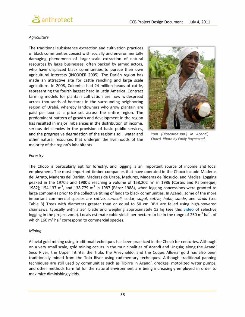
CCB Project Design Document – July 4, 2011
38
Agriculture The traditional subsistence extraction and cultivation practices of black communities coexist with socially and environmentally damaging phenomena of larger-scale extraction of natural resources by large businesses, often backed by armed actors, who have displaced black communities to pursue their own agricultural interests (INCODER 2005). The Darién region has made an attractive site for cattle ranching and large scale agriculture. In 2008, Colombia had 24 million heads of cattle, representing the fourth largest herd in Latin America. Contract farming models for plantain cultivation are now widespread across thousands of hectares in the surrounding neighboring region of Urabá, whereby landowners who grow plantain are paid per box at a price set across the entire region. The predominant pattern of growth and development in the region has resulted in major imbalances in the distribution of income, serious deficiencies in the provision of basic public services, and the progressive degradation of the region’s soil, water and other natural resources that underpin the livelihoods of the majority of the region’s inhabitants. Forestry The Chocó is particularly apt for forestry, and logging is an important source of income and local employment. The most important timber companies that have operated in the Chocó include Maderas del Atrato, Maderas del Darién, Maderas de Urabá, Madurex, Maderas de Riosucio, and Madisa. Logging peaked in the 1970's and 1980's reaching a volume of 158,202 m3 in 1986 (Cortés and Palomeque, 1982); 154,137 m3, and 138,779 m3 in 1987 (Pérez 1988), when logging concessions were granted to large companies prior to the collective titling of lands to black communities. In Acandí, some of the more important commercial species are cativo, caracolí, cedar, sagal, cativo, hobo, sande, and virola (see Table 3). Trees with diameters greater than or equal to 50 cm DBH are felled using high-powered chainsaws, typically with a 36" blade and weighing approximately 13 kg (see this video of selective logging in the project zone). Locals estimate cubic yields per hectare to be in the range of 250 m3 ha-1, of which 160 m3 ha-1 correspond to commercial species. Mining Alluvial gold mining using traditional techniques has been practiced in the Chocó for centuries. Although on a very small scale, gold mining occurs in the municipalities of Acandí and Unguia; along the Acandí Seco River, the Upper Titirita, the Titila, the Arreynaldo, and the Cuque. Alluvial gold has also been traditionally mined from the Tolo River using rudimentary techniques. Although traditional panning techniques are still used by communities such as Tibirre in Acandí, dredges, motorized water pumps, and other methods harmful for the natural environment are being increasingly employed in order to maximize diminishing yields.
Yam (Dioscorea spp.) in Acandí, Chocó. Photo by Emily Roynestad.

CCB Project Design Document – July 4, 2011
39
Marginalization With improving security in the Chocó and the Darién, Afro-descendant and indigenous familes displaced by the conflict have begun to return home. Nonetheless, the department of Chocó still lags far behind the rest of the country in all measures of human and economic development. Palacio (2009) observes that, despite Colombia’s impressive economic growth in recent decades, the Chocó may still be characterized as a pre‐modern society compared with the rest of the country according to the criteria of Gosling & Taylor (2005). The Chocó region has one of the lowest shares of industrial production in the country, contributing only 0.38% of GDP in 2005 and with a declining annual growth rate since 1990. Despite democratic elections, political accountability is poor in the region and institutions fail to provide the minimum basic public goods such as health, education and utilities (Bonet 2007). Indicators of health and wellbeing in the Chocó are among the worst in the country. In 2005, some 79% of the inhabitants of the Chocó had “basic unmet needs”, the highest percentage of any department in Colombia and roughly four times the national average (DANE 2009). Male infant mortality rates are roughly double the national average according to DANE (2007) figures at 86 per 1000 births. The rate of illiteracy among Afro-Colombians is 32% compared to 15% among other ethnic groups. Only 38% of Afro-Colombian teenagers attend high school, compared to 66% of non-black Colombian teenagers. Only 2% of all Afro-Colombian youth attend university. In the year 2000, the Chocó experienced an internal displacement rate of 3,440 per 100,000 habitants, the highest of any department in Colombia in that year (CODHES 2008; Ferguson 2010).
G.1.6 Current Land Use and Property Rights Despite their marginalization, black communities have played a central role in democratic reforms in Colombia beginning with the election of a constituent assembly and the adoption of a new constitution in 1991 that redefined the country as multiethnic and pluricultural. The new constitution’s Transitory Article 55 (AT‐55) required Congress to pass a law granting Pacific black communities (comunidades negras) collective property titles to the rural and riparian areas that they occupy “in conformity with their traditional systems of production” (Cepeda Espinosa 2009; Offen 2003). Two years later, as a result of AT‐55, Congress passed Law 70 guaranteeing the “territorial rights” of black communities in the Pacific. Subsequently, Decree 1745 required the collaboration of governmental institutions and agencies in the demarcation and titling of black territories to locally‐elected community councils (consejos comunitarios). These councils were newly created ethno‐territorial and political entities that served to solicit and administer the new territories. To date, the Colombian government has demarcated and titled 150 black territories totalling over 5 million hectares and representing over 300,000 people in one of the most ambitious and radical territorial reforms ever undertaken in Latin America.
A fisherman dries his catch in the sun along a river in the Darién. Photo by Emily Roynestad.

CCB Project Design Document – July 4, 2011
40
On August 1st, 2005, the Instituto Colombiano para el Desarrollo Rural (INCODER) awarded Collective Title No. 1502 to the Council of Black Afro-Colombian Communities of the Tolo River Basin and Southern Coastal Zone (COCOMASUR) in recognition of their longstanding inhabitance of the riverine, rural and forestlands of Acandí. This 13,465 ha project area is managed by the nine Local Councils that constitute COCOMASUR, who in turn represent a mix of Afro-descendant and mestizo families spread amongst 31 villages (see Figure 12). The most recent territorial census accounts for 826 families and 5,782 individuals. Notwithstanding the recognition and demarcation of collective titles in the Chocó, many communities are still uncertain as to their territorial boundaries and rights. Inadequate resources have been allocated to guarantee implementation of these progressive new property laws and enable territorial governance building. A key law mandated by the new constitution regarding territorial ordering, for example, has yet to be passed. There is widespread ignorance of the Law 70, and many communities have yet to develop the internal governance structures and regulations necessary for effective common resource management.
Children bathing in the Tolo River, Acandí, Chocó. Photo by Emily Roynestad.

CCB Project Design Document – July 4, 2011
41
G.1.7 Current Biodiversity and Threats to Biodiversity Colombia is home to over 10% of the world’s plant and animal species despite covering just 0.7% of the planet’s surface, and has more registered species of birds and amphibians than any other country in the world. Around one third of its plant species and 12% of its terrestrial vertebrates exist nowhere else on earth. Even by Colombian standards, the lowland rainforests of Colombia’s Pacific coast are outstanding. This region, known as the Chocó, is characterized by moist tropical forest, seasonally flooded forests, and mangroves with average annual rainfall ranging from 1,500-5,000 mm in the Darién region to as much as 12,700 mm further south. The Darién in particular has been prioritized by global conservation organizations for its high degree of biodiversity and endemism. The region boasts over 500 species of birds, over 25% of the total reported for Colombia, in an area less than 1% of the country’s size. Although detailed biological inventories for Colombia are still incomplete, Colombia is considered to rank 4th globally in total species diversity, 2nd in both plant and amphibian diversity, 1st in bird diversity, and 3rd and 5th in mammals and reptiles respectively (Rangel-Ch. 2004a). Much of this extraordinary biological diversity owes to the Great American Interchange, an important paleozoogeographic event in which land and freshwater fauna migrated from North America via Central America to South America and vice versa, as the volcanic Isthmus of Panama rose up from the sea floor bridging the formerly separated continents (Wallace 1876). The migration peaked around three million years ago (during the Piacenzian and upper Pliocene), and resulted in the joining of the Neotropic (roughly South America) and Neartic (roughly North America) ecozones to form the Americas. While the most dramatic effect of the interchange was on the zoogeography of mammals, it also provided migration opportunities for weak-flying (or flightless) birds, reptiles, amphibians, arthropods, and even freshwater fish. For this reason, the Chocó biogeographic is one of the most important reservoirs of biodiversity on the planet (Rangel-Ch. 2004a). The northern region of the Chocó (the Darién) is particularly important because of the confluence of environmental factors such as the Caribbean Sea and the presence of large areas of forest both on the Colombian side as well as in Darién National Park in Panama. This is one of the most species-rich expanses of lowland and highland rainforest in the world, possessing endemism over a broad range of taxa. The biotic composition of the Darién has been estimated at 5% of the total worldwide. The northern region of Chocó is considered one of the least studied in Colombia (Lynch and Suárez- Mayorga 2004). Analysis of biodiversity in the project zone, and specifically around the towns of Acandí and Unguía, indicates the presence of 167 species of terrestrial mammals, 35 species of aquatic mammals, 598 species of birds, 58 species of amphibians, and 45 species of reptiles. Unfortunately, an estimated 44 species of mammals are considered under threat, as well as 153 birds, 25 reptiles, 217 amphibians, 63 fish and 28 invertebrates, 523 species of higher plants and 96 species of lower plants (Roguiguez-Mahecha, et al. 2008). Table 13 presents an overview of the biogeographical districts of the Darién from INVIAS (1999), while the following sections explore the project zone in further detail.
The near-threatened jaguar (Panthera onca) is the largest feline in the Western Hemisphere. Photo by Emily Roynestad.

CCB Project Design Document – July 4, 2011
42
Table 13: Flora and Fauna of the Darién by Biogeographic Districts (from INVIAS 1999).
District Ha Percent Location Characteristics
San Blas-Acandí-Tanela
128,866 8.9%
Coastal corridor from the Panamanian province of San Blas to the valleys of the rivers Tolo, Acandí, Tanela y Arquía
Sub rainforest vegetation, area of Cana turtle nesting on the beaches of Acandí and Playona (wildlife sanctuaries) with 82 identified species of reptiles, 845 plants, 110 fish, 177 mammals, 328 birds and 14 amphibians; a bird migration corridor.
Tacarcuna 34,842 2.4%
Foothills of the Serrania del Darien above 400 meters, from the province of San Blas, towards the south to the river Pipirre
Rainforest vegetatation, center of endemism, a wildlife sanctuary, the existence of 50 endemic woody species 507 plants, 130 mammals, 247 birds, 74 reptiles and 19 amphibians.
Serranía del Limón Pirre-Serranía de los Saltos
274,554 18.9%
Mountain range that includes the highlands of Cerro Pirre Limón in Panama, and the hills of Aspavé of the Serrania de los Saltos in Colombia
Rainforest vegetation, 131 identified species of mammals including endemic species including rodents, 31 species of reptiles, 237 birds and 19 amphibians. Hardly any study in detail as to plants and amphibians.
Juradó-Cupica
99,182 6.8%
Coastal plain of the Pacific littoral, from the Gulf of San Miguel, flanking the west, the former district until Cupica Bay
806 plant species, 172 mammals, 301 birds, 25 reptiles and 26 amphibians.
Curvaradó-Río León
264,800 18.2%
Floodplain on the right bank of the Atrato River from its delta and offshore in the Gulf of Uraba to Curvaradó River basin south
Rainforest vegetation, 512 species of plants, 181 species of mammals, 312 birds, 105 reptiles and 98 species of fish. Presence of white-headed marmoset, an endemic species.
Katíos 275,813 19.0% Hilly portion of the foothills of the Serranía del Darién closer to the banks of the Atrato River
National Park; 933 species of plants, 182 mammals, 428 birds, 96 reptiles and 113 fish have been identified.
Murri 151,161 10.4% Right side of the Atrato river
Rainforest vegetation, 158 species of plants, 170 mammals, 293 birds, 77 reptiles, 27 amphibians and 74 fish, a little-studied region.
Domingodó-Upurdú-Bojayá
223,944 15.4% Truandó river valleys, Nercua, Upurdú, Opogadó and Napipí to the left bank of the River Bojayá
224 plant species, 63 reptiles, 100 fish, 167 mammals, 369 birds and 11 amphibians have been identified.

CCB Project Design Document – July 4, 2011
43
Mammals A total 13 orders, 39 families, 106 genera and 167 species (Table 14) have been observed in the project zone. In addition, there are aquatic mammals, which include some species of very wide distribution or migration patterns. The most representative mammals are the order Chiroptera (bats) with a total of 89 species (53.2%), followed by the order Rodentia with 31 species (18.5%), the order Carnivora with fifteen species, the order Didelphimorphia with eight species; and the order Primates with seven species. Mammals in the project zone include the three-striped night monkey Aotus trivirgatus, howler monkey Alouatta villosa, brown-headed spider monkey Ateles fuscipens, three-toed sloth Bradypus variegatus, giant anteater Myrmecophaga tridactyla (VU), capybara Hydrochaerus hydrochaeris, agouti Dasyprocta punctata, and paca Aguti paca. The giant pocket gopher Orthogeomys dariensis, Mt. Pirre climbing mouse Rhipidomys scandens (VU), and Panama slender opossum Marmosops invictus are endemic. There are also bush dog Speothos venaticus (VU), spectacled bear Tremarctos ornatus, jaguar Panthera onca, ocelot Felis pardalis, margay F. wiedii, jaguarondi F. yagouaroundi, oncilla F. tigrinis, whitelipped peccary Tayassu pecari, long-tailed weasel Mustela frenata, and Baird's tapir Tapirus bairdii (EN) (Mello and Zuercher 2005; Reid and Helgen 2008; Zuercher, et al. 2008). There are 22 species of mammal categorized as experiencing some degree of threat according to the Red Book of Colombian Mammals (Rodríguez-Mahecha, et al. 2006). Table 14 presents those species classified as conservation priorities by the IUCN (2010). In the case of bats, researchers have noted that some 65% of species in the Chocó region lie further than 30 km from conservation areas such as national parks, and are therefore vulnerable to a host of conservation threats. This group includes endemic species and those that have only recently been described for which there is no further information available (Mantilla-Meluk and Jiménez-Ortega 2006; Pineda and Rodriguez 2008). Mammals in the project zone are at particular risk of being killed by commercial or subsistence hunters, or simply because they are considered dangerous to humans or their livelihoods. The giant anteater (Myrmecophaga tridactyla), for example, is often killed upon discovery as it is perceived to threaten domesticated animals. Table 14 indicates the level of risk for mammal species in the project zone by category of risk, where EN = “Endangered”, VU = “Vulnerable”, CR = “Critically Endangered”, NT = “Near Threatened”, and DD = insufficient data.
The endangered cotton-top tamarin (Saguinus oedipus) is found only in northwestern Colombia. Photo by Miroslav Petrasko.
Baird’s tapir (Tapirus bairdii) is the largest land mammal found in the wild in South America.
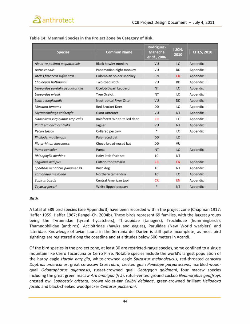
CCB Project Design Document – July 4, 2011
44
Table 14: Mammal Species in the Project Zone by Category of Risk.
Species Common Name Rodríguez-Mahecha
et al., 2006
IUCN, 2010
CITES, 2010
Alouatta palliata aequatorialis Black howler monkey VU LC Appendix I
Aotus zonalis Panamanian night monkey VU DD Appendix II
Ateles fusciceps rufiventris Colombian Spider Monkey EN CR Appendix II
Choloepus hoffmannii Two-toed sloth VU DD Appendix III
Leopardus pardalis aequatorialis Ocelot/Dwarf Leopard NT LC Appendix I
Leopardus wiedii Tree Ocelot NT LC Appendix I
Lontra longicaudis Neotropical River Otter VU DD Appendix I
Mazama temama Red Brocket Deer DD LC Appendix III
Myrmecophaga tridactyla Giant Anteater VU NT Appendix II
Odocoileus virginianus tropicalis Rainforest White-tailed deer CR LC Appendix III
Panthera onca centralis Jaguar VU NT Appendix I
Pecari tajacu Collared peccary * LC Appendix II
Phylloderma stenops Pale-faced bat DD LC
Platyrrhinus chocoensis Choco broad-nosed bat DD VU
Puma concolor Puma NT LC Appendix I
Rhinophylla alethina Hairy little fruit bat LC NT
Saguinus oedipus Cotton-top tamarin CR EN Appendix I
Speothos venaticus panamensis Bush dog LC NT Appendix I
Tamandua mexicana Northern tamandua LC LC Appendix III
Tapirus bairdii Central American tapir CR EN Appendix I
Tayassy pecari White-lipped peccary * NT Appendix II
Birds A total of 589 bird species (see Appendix 3) have been recorded within the project zone (Chapman 1917; Haffer 1959; Haffer 1967; Rangel-Ch. 2004b). These birds represent 69 families, with the largest groups being the Tyrannidae (tyrant flycatchers), Thraupidae (tanagers), Trochilidae (hummingbirds), Thamnophilidae (antbirds), Accipitridae (hawks and eagles), Parulidae (New World warblers) and Icteridae. Knowledge of avian fauna in the Serranía del Darién is still quite incomplete, as most bird sightings are registered along the coastline and at altitudes below 500 meters in Acandí. Of the bird species in the project zone, at least 30 are restricted-range species, some confined to a single mountain like Cerro Tacarcuna or Cerro Pirre. Notable species include the world’s largest population of the harpy eagle Harpia harpyjia, white-crowned eagle Spizastur melanoleucus, red-throated caracara Daptrius americanus, great curassow Crax rubra, crested guan Penelope purpurascens, marbled wood-quail Odontophorus gujanensis, russet-crowned quail Geotrygon goldmani, four macaw species including the great green macaw Ara ambigua (VU), rufus-vented ground cuckoo Neomorphus geoffroyi, crested owl Lophostrix cristata, brown violet-ear Colibri delpinae, green-crowned brilliant Heliodoxa jacula and black-cheeked woodpecker Centurus pucherani.

CCB Project Design Document – July 4, 2011
45
Six of the bird species registered in the project zone are endemic to Colombia, and 39 are near-endemic (Stiles 1998). Some 29 species belong to an IUCN threat category: Critically Endangered (0), Endangered (2), Vulnerable (11), and Near Threatened (16) (Renjifo 1998; Renjifo, et al. 2002). Threatened lowland species include the Baudó oropendula Psaracolius cassini (EN), the Chocó tinamou Crypturellis kerriae (VU), and the speckled ant-shrike Xenornis setifrons (VU). Most mountain species are not threatened at present, but their very small range sizes leave them vulnerable to disturbance (Stattersfield, et al. 1998). Nearly one-quarter of species found on the Serranía del Tacarcuna are endemic, such as the Tacarcuna woodquail Odontophorus dialeucos (VU), Tacarcuna bush-tanager Chlorospingus tacarcunae, Tacarcuna tapaculo Scytalopus panamensi and violet-capped hummingbird Goldmania violiceps. The Serranía de Pirre has the Pirre bush-tanager Chlorospingus inornatus, green-naped tanager Tangara fucosa, Pirre hummingbird Geothalsia bella, violet-capped hummingbird Goldmania violiceps, beautiful tree-runner Margarornis bellulus and Pirre warbler Basileuterus ignotus (VU). A total of 13 endemic bird species have been identified in the project zone (2% of the total recorded), among which the Chocó tinamou Crypturellis kerriae and the Tacarcuna Wood-quail Odontophorus dialeucos are most notable. The distribution of endemic birds occurs along two corridors in particular: the first is located towards the Serranía de los Saltos along the coast between Juradó and Cupica, while the second includes the Serranía del Darién, Cerro Tacarcuna, Los Katíos National Park, and the foothills of the Serranía del Darien. At least 47 species belong to the genus of songbirds, which have a significant presence in the Gulf of Urabá since they adapt easily to intervened habitats. There are seven species of endangered birds (two species of eagles, three parrots, and two herons) that have virtually disappeared from the project zone. There are a total of 88 migratory species, of which almost all (86) nest in North America and winter in South America, while two species nest in southern South America and spend their winter further north. Most records are based on insufficient samples, hence further fieldwork is needed in order to more accurately estimate species richness (Rangel-Ch. 2004b). Amphibians and Reptiles Colombia currently ranks 2nd in global diversity of amphibians, with 735 species in 13 families (Rueda-Almonacid, et al. 2004). The country also ranks 4th globally in reptiles, with about 500 species reported to date (Castaño-M., et al. 2004). Amphibians A total of 58 amphibian species have been recorded in the project zone. These are distributed among two orders, 11 families and 21 genera (see Table 15). Among the species identified by the IUCN as of Least Concern (LC) are Savage's Thin-toed Frog Leptodactylus savagei, the Tungara Frog Engystomops pustulosu, and the Cane Toad Rhinella marina, the latter of which is considered to be a growing
The three-toed sloth (Bradypus variegatus) sleeps 15-18 hours per day. Photo by Brodie Ferguson.

CCB Project Design Document – July 4, 2011
46
population, since it can occupy a variety of habitats and adapts well to anthropogenic changes. The aforementioned species comprise the group of frogs found in lowlands and transformed areas of the project zone (Lynch 2006). The presence of these species is supported by landscape heterogeneity, particularly transition zones between open areas, secondary forests, and areas dominated by human intervention that offer plenty of open habitat, such as grasslands and crops. Heterogeneity in habitat structure due to increased human intervention may result in favorable characteristics for the establishment of certain amphibian species (Yahner 1988). Water bodies, shrubs and grasses have been found to be suitable for anuran species with certain reproductive characteristics. Species such as the Gladiator Tree Frog Hypsiboas boans (LC) require slow-flowing bodies of water whereupon to lay their eggs for tadpoles to develop, as do the Glass Frog Hyalinobatrachium sp. and Phyllomedusa venusta (LC), which are found in areas with tree cover and also associated with bodies of water (Duellman and Trueb 1994). The presence of R. marina and E. pustulosus in open areas may be due to the fact that they have several reproductive events throughout the year. Of the species found in the project zone, Phyllomedusa venusta is most vulnerable to deforestation and pollution by agrochemicals and herbicides (Renjifo, et al. 2004). Further studies are required to better understand the behavior of Hyalinobatrachium as well as the potential negative impacts caused by human intervention. Reptiles There are approximately 8000 registered species of reptiles in the world (Uetz 2002), and Colombia counts among the richest in reptile species with more than 500 described species and numerous more yet to be described, especially in the group of snakes and lizards. Colombia has the most turtle species in South America (the same number as Brazil) as well as the most crocodiles (the same number as Venezuela) (Castaño-Mora 2002). The 42 species of reptiles present in the project zone span three orders and 13 families (see Table 16). Of all the species identified for the region, eight are considered endangered, particularly from pressures exerted by hunting (for the pet trade) and habitat destruction. An additional seven species are considered threatened, largely due to their low tolerance to changes in habitat. Among the reptiles present in the project zone are the Central American bushmaster Lachesis stenophys, Central American coral snake Micrurus nigrocinctus, the deadly fer-de-lance Bothrops asper, cayman Caiman crocodilus, and American crocodile Crocodylus acutus (VU).
The Glass Frog (Hypsiboas boans) requires slow-flowing bodies of water to reproduce. Photo by Brian Gratwicke.

CCB Project Design Document – July 4, 2011
47
Table 15: Amphibian Species in the Project Zone by Category of Risk.
Order Family Scientific Name Common Name
Threat Category
Global IUCN 2010*
Population Trend
ANURA
Dendrobatidae
Allobates talamancae LC Stable Colostethus panamansis LC Declining Colostethus pratti Rana flecha LC Stable
Dendrobates auratus Dardo, flecha verde, cocoi, cocoy
LC Unknown
Phyllobates bicolor Rana Bicolor NT Declining Silverstoneia flotator LC Stable Silverstoneia nubicola NT Declining Ranitomeya fulgurita LC Unknown Ranitomeya minuta LC Unknown
Bufonidae
Atelopus varius Sapito arlequín CR A2ace Declining Incilius coniferus LC Stable Rhaebo haematiticus LC Declining Rhinella acrolopha DD Unknown Rhinella marina Sapo común LC Increasing Rhinella margaritifera LC Stable
Centrolenidae
Cochranella euknemos LC Declining Espadarana prosoblepon LC Stable Hyalinobatrachium chirripoi
Ranita de cristal LC Stable
Hyalinobatrachium colymbiphyllum
LC Stable
Hyalinobatrachium fleischmanni
LC Unknown
Sachatamia albomaculata LC Stable Sachatamia ilex LC Declining Teratohyla pulverata LC Unknown Teratohyla spinosa LC Stable
Hylidae
Dendropsophus ebraccatus
LC Stable
Dendropsophus phlebodes LC Stable Dendropsophus subocularis
LC Stable
Hyloscirtus colymba CR Declining Hyloscirtus palmeri LC Unknown Hypsiboas boans LC Stable
Hypsiboas crepitans LC Stable Hypsiboas pugnax Rana platanera LC Stable Hypsiboas rosenbergi LC Declining Scinax boulengeri LC Stable Scinax rostratus LC Stable Scinax ruber LC Stable Smilisca phaeota LC Stable Smilisca sila LC Declining Agalychnis callidryas LC Declining Agalychnis lemur CR Declining
Cruziohyla calcarifer LC Declining
Phyllomedusa venusta Rana arborícola de ojos rojos
LC Declining
Strabomantidae
Strabomantis bufoniformis LC Stable Pristimantis achatinus LC Stable Pristimantis cruentus LC Stable Pristimantis gaigeae LC Stable
Pristimantis ridens LC Stable
Pristimantis taeniatus LC Stable
Leptodactylidae Diasporus gularis LC Stable
Diasporus tinker LC Stable
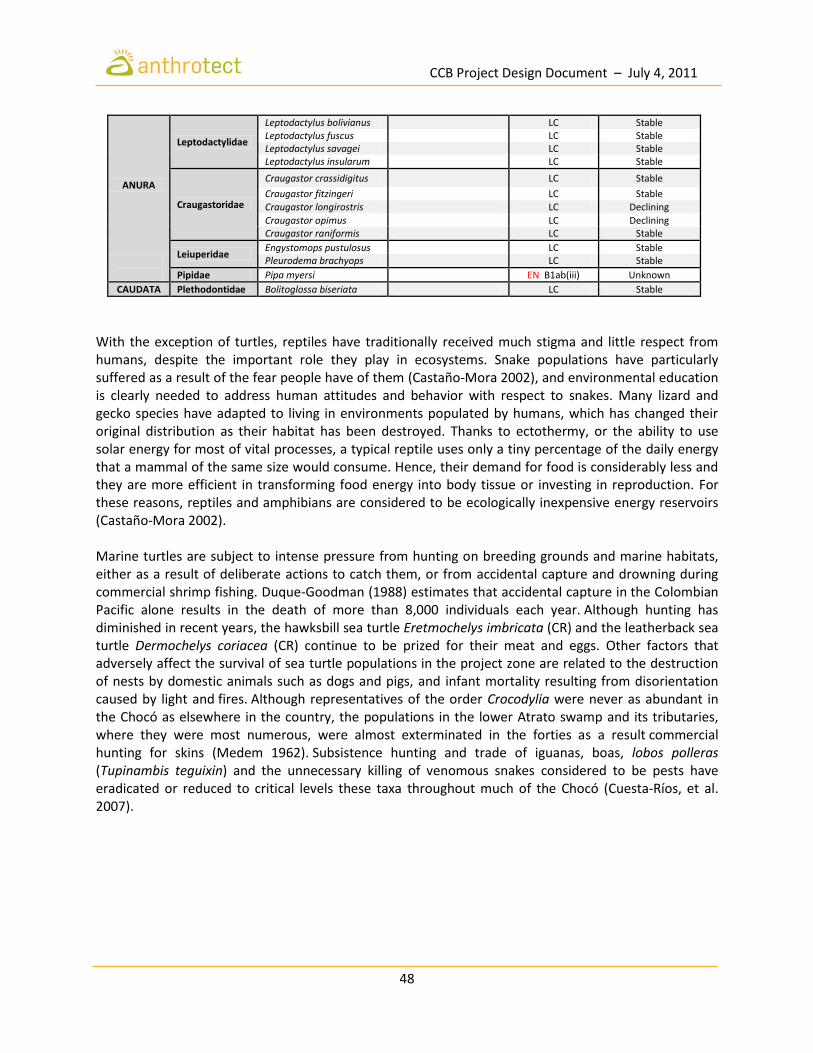
CCB Project Design Document – July 4, 2011
48
ANURA
Leptodactylidae
Leptodactylus bolivianus LC Stable Leptodactylus fuscus LC Stable Leptodactylus savagei LC Stable Leptodactylus insularum LC Stable
Craugastoridae
Craugastor crassidigitus LC Stable
Craugastor fitzingeri LC Stable Craugastor longirostris LC Declining
Craugastor opimus LC Declining Craugastor raniformis LC Stable
Leiuperidae Engystomops pustulosus LC Stable
Pleurodema brachyops LC Stable
Pipidae Pipa myersi EN B1ab(iii) Unknown
CAUDATA Plethodontidae Bolitoglossa biseriata LC Stable
With the exception of turtles, reptiles have traditionally received much stigma and little respect from humans, despite the important role they play in ecosystems. Snake populations have particularly suffered as a result of the fear people have of them (Castaño-Mora 2002), and environmental education is clearly needed to address human attitudes and behavior with respect to snakes. Many lizard and gecko species have adapted to living in environments populated by humans, which has changed their original distribution as their habitat has been destroyed. Thanks to ectothermy, or the ability to use solar energy for most of vital processes, a typical reptile uses only a tiny percentage of the daily energy that a mammal of the same size would consume. Hence, their demand for food is considerably less and they are more efficient in transforming food energy into body tissue or investing in reproduction. For these reasons, reptiles and amphibians are considered to be ecologically inexpensive energy reservoirs (Castaño-Mora 2002). Marine turtles are subject to intense pressure from hunting on breeding grounds and marine habitats, either as a result of deliberate actions to catch them, or from accidental capture and drowning during commercial shrimp fishing. Duque-Goodman (1988) estimates that accidental capture in the Colombian Pacific alone results in the death of more than 8,000 individuals each year. Although hunting has diminished in recent years, the hawksbill sea turtle Eretmochelys imbricata (CR) and the leatherback sea turtle Dermochelys coriacea (CR) continue to be prized for their meat and eggs. Other factors that adversely affect the survival of sea turtle populations in the project zone are related to the destruction of nests by domestic animals such as dogs and pigs, and infant mortality resulting from disorientation caused by light and fires. Although representatives of the order Crocodylia were never as abundant in the Chocó as elsewhere in the country, the populations in the lower Atrato swamp and its tributaries, where they were most numerous, were almost exterminated in the forties as a result commercial hunting for skins (Medem 1962). Subsistence hunting and trade of iguanas, boas, lobos polleras (Tupinambis teguixin) and the unnecessary killing of venomous snakes considered to be pests have eradicated or reduced to critical levels these taxa throughout much of the Chocó (Cuesta-Ríos, et al. 2007).

CCB Project Design Document – July 4, 2011
49
Table 16: Reptile Species in the Project Zone by Category of Risk.
Order Family Scientific Name Common Name
IUCN Threat Category 2010*
SQUAMATA
Boidae Boa constrictor Boa LC Corallus annulatus LC Corallus ruschenbergerii LC
Colubridae
Clelia clelia Cazadora negra LC Chironius munticola Verde juetiadora, guache LC Dendrophidron bivitta Guardacaminos LC Imantoides cenchoa Bejuquillo LC Leptodeira annulata LC Phimophis guianenis LC Spilotes pullatus cf. Soche LC
Viperidae Bothrops atrox asper Mapaná LC
Gekkonidae
Lepidoblepharis peraccae
LC
Sphaerodactylus lineolatus
LC
Gymnophtalmidae Echinosaura horrida LC
Iguanidae
Anolis auratus LC
Anolis chocorum LC
Anolis frenatus LC
Anolis granuliceps LC Anolis maculiventris LC Anolis tropidogaster LC Basiliscus basiliscus LC Basiliscus galeritus LC
Scincidae Mabuya mabuya LC
Teiidae
Ameiva ameiva LC Ameiva anomala LC Cnemidophorus lemniscatus
LC
TESTUDINATA
Cheloniidae
Eretmochelys imbricata Tortuga Carey, Kurira, Hawksbill Sea Turtle
CR
Lepidochelys kempii Tortuga Golfina, Kemp’s Ridley Sea Turtle
CR
Caretta caretta Tortuga Caguama, Loggerhead Sea Turtle
EN
Chelonia mydas mydas Tortuga Blanca, Green Sea Turtle EN Chelonia mydas agassizii
Tortuga Verde, Pacific Green Sea Turtle
EN
Lepidochelys olivacea Tortuga Lora, Olive Ridley Sea Turtle VU
Dermochelyidae Dermochelys coriacea Cardón, Cardona, Tortuga Caná, Leatherback Sea Turtle CR
Testudinidae Geochelone carbonaria Morrocoy, Morrocoyo, Motelo, Red-footed tortoise
EN
CROCODYLIA
Alligatoridae Caiman crocodilus Caimán común, caimán de anteojos, babilla, Spectacled caiman
LC
Crocodylidae Crocodylus acutus Cocodrilo Americano, Caimán del
Magdalena, American Crocodile CR

CCB Project Design Document – July 4, 2011
50
Fish Fish diversity in the project zone is low relative to elsewhere in the country with 274 species making up some 9% of the national total. The taxon exhibits a pattern of steady decline of species diversity moving from south to north. Of the species recorded, most are primary (165) and secondary (26) freshwater species from the Atrato, San Juan and Baudó rivers; nonetheless, it is unknown what the tributaries of these rivers contribute in terms of species richness, such as the Juradó and other rivers that descend from Serranía de Los Saltos and Serranía del Baudó. A total of 83 species registered are marine species found in the Golf of Urabá. Despite their under-representation at the national level, fish populations in the Darién produce significant amounts of fish that vary according to season, constituting an important source of income and employment for residents in the project zone. The highest fish diversity recorded is in the Acandí-Tanela area, partly due to the importance of the Acandí River basin and its higher likelihood of being included in biological surveys. Next in importance are the Arquía River and the Truandó and Salaquí Rivers, tributaries of the Atrato just south of the project zone. A total of 19 endemic species have been registered in the Darién (INVIAS 1999). Plants Colombia ranks 3rd worldwide in endemic plant species, with a total of 15,000 to 17,000 species (a high percentage of these species are found in the Darién) corresponding to roughly 6.0-6.8% of the global total of plants endemic to each country, a figure close to that held by the kings of plant endemism (Brazil and Indonesia), which are at the top to 6.6-7.4% and 5.9-7.4% respectively, with larger land areas. A total of 3,493 plant species from 1,380 families have been reported in the Darién, representing approximately 10% of the national total (Rangel-Ch. 2004a). Of these 1,380 families, Rubiaceae, Euphorbiaceae, Melastomataceae and Poaceae are the most represented (See Table 17). Levels of plant endemism in the Chocó region are among the highest in the world; almost a quarter of plants recorded at Cerro Tacarcuna are endemic. Limited information on plant distributions prevents a more accurate comparison of plant endemism at the local, regional, and national levels. Nonetheless, the phenomenon of exclusivity in vegetation is closely related to the trend that occurs in animal groups. Hence, levels are higher as altitude increases in the project zone and most of the endemic species occur in epiphytes, shrubs and grasses in these areas. In summary, a total of 86 species of endemic plants have been recorded in the project zone, in addition to unique populations of oak (Quercus humboldtii).
Bocachico (Prochilodus reticulatus), once abundant in the project area, Acandí, Chocó. Photo by Brodie Ferguson.

CCB Project Design Document – July 4, 2011
51
Table 17: Plant Families with the Most Number of Species in the Chocó and in the Darién.
Family Chocó Darién Rubiaceae 350 62 Euphorbiaceae 103 38 Melastomataceae 229 29 Poaceae 112 29 Solanaceae 81 25 Orchidaceae 251 23 Asteraceae 127 20 Bromeliaceae 127 20 Arecaceae 93 20 Gesneriaceae 109 19 Piperaceae 185 16 Total 4525 1380
Source: (Prieto-C., et al. 2004)
Endemism The Colombian Pacific shares many elements of its flora and fauna with other biogeographical units. The lowland forests of Central America are the most closely related to those of the Chocó, both in terms of fauna and history. Until the middle of last century, the forests of Central America, the equatorial Pacific and the Middle Magdalena River Valley converged in the Chocó. However, of the 5,823,469 ha of forest that once existed in the Middle Magdalena region of Colombia, only 2,170,000 ha remain, representing an annual rate of forest conversion of over 80,000 ha/year (Cardenas-Torres 2006). Of course, at the north end of the Colombian Chocó, there are still remnants of a connection to the Magdalena Valley, as discussed by Hernández-Camacho et al. (1992). Nonetheless, the Chocó region is much richer in species than the northern (Caribbean) coasts of Colombia and Venezuela, and shows a greater number of endemic species registered for most taxa. Species in groups that are less capable of dispersal, such as amphibians, reptiles and rodents, tend to show higher endemism. In more mobile groups, such as birds and bats, the degree of endemism is lower and a higher percentage of species is shared with other areas (Alberico 1993). The most likely explanation for the restriction of the distribution of these species in Colombia is the geography of the Colombian Pacific, specifically its enclosure by the Western Andes to the east and the Pacific Ocean to the west, a weather barrier to the south, and the Serranía del Darién to the North. These geographical barriers have likely been responsible for preventing the dispersal of many species, particularly of small animals, such as the armored rat Hoplomys (Echimyidae), the isthmus rat Isthmomys (Cricetidae) and the pocket gopher Orthogeomys (Geomyidae), even though their distributions may continue into Central America. Confinement of these genera to the Colombian Pacific and the strong distribution of the Central American tapir Tapirus bairdii undoubtedly strengthen the notion of the Chocó as a bioregion, as do other phenomena of the biota, such as the fact that the Colombian Chocó has probably the greatest diversity of flora found in the Neotropics (Rangel-Ch. 2004a).

CCB Project Design Document – July 4, 2011
52
Figure 9: Records of Flora and Fauna in the Project Zone (from Rangel-Ch. 2004).
CCB Project Design Document – July 4, 2011
53
G.1.8 Areas and Species of High Conservation Value The High Conservation Value (HCV) concept is a globally applicable framework for identifying and managing areas of particular importance in terms of biodiversity, social values, or ecosystem services (ProForest 2008; Stewart, et al. 2010). Areas of particular conservation importance were assessed on the basis of expert review of the scientific literature in conjunction with mapping exercises and other consultations held with participating communities. Table 18 summarizes the findings of the HCV assessment in the project zone. The Darién is part of the Chocó bioregion which is one of the world's most rich and diverse plant and animal species, many of them still unidentified or analyzed by science. This project addresses multiple globally, regionally, and nationally significant concentrations of biodiversity values in the project zone. Protected areas (8.1.a) in the project zone include Darién National Park in Panama, recognized as a UNESCO Natural World Heritage Site and Biosphere Reserve for its extraordinary biodiversity. A second UNESCO Natural World Heritage Site, Los Katíos National Park, is located some 50 km south of the project area. Threatened species in the project zone (8.1.b) include 57 vulnerable, endangered, and critically endangered species included on the IUCN Red List. Endemic species (8.1.c) include 6 species of birds and 86 species of plants, in addition to 39 bird and 2 rodent species considered to be near-endemic. Important migratory species seasonally present in the project zone (8.1.d) include 88 species of birds (of which 86 nest in North America) as well as 7 species of marine turtles listed as critically-endangered by the IUCN. Furthermore, the project zone is part of a globally and regionally significant large landscape-level area where viable populations of most if not all naturally ocurring species exist in natural patterns of distribution and abundance (8.2). The Darién lies within the Tumbes-Choco-Magdalena Biodiversity Hotspot (Myers 1988), highlighting the importance to be taken in handling regional and local development in the Darién. Threatened or rare ecosystems within this range (8.3) include the area around Cerro Tacarcuna, highest point in the Darién (1874 m) with high endemism and a rare montane oak forest of Quercus humboldtii (VU). The project zone also includes a numbe of areas of particular importance to local communities. 8.4 Among the areas providing critical ecosystem services (8.4) are the riparian zones of the Arquití, Neca, Corazón, Brazo Seco, and Jerónimo Rivers (tributaries of the Tolo River) and the Tanelita, Natí, Tibirre, Tisló, and Cutí Rivers (tributaries of the Tanela River), which support livestock and gaurantee clean drinking water for communities in the watersheds. 8.5 Areas have been identified within the project area and project zone for hunting, collection of medicines, extraction of palm and timber products for building materials and household income, as well as collection of dead trees and branches for fuelwood.An area of particular cultural importance to communities in the project zone (8.6) is the Cerro Tacarcuna, the highest point in the Darién (1874 m) and a sacred site in Kuna traditional cosmology.

CCB Project Design Document – July 4, 2011
54
Table 18: Areas of High Conservation Value within the Project Zone
HCV Description Presence in the Project Zone
8.1
Globally, regionally or nationally significant concentrations of biodiversity values: Los Katíos National Park (UNESCO Natural World
Heritage Site) and Darién National Park (UNESCO World Heritage Site and Biosphere Reserve); endemic species (6 birds and 86 plants); near-endemic species (39 birds and 2 rodents); IUCN-threatened (57 species); migratory species (88 birds); breeding grounds (7 IUCN-listed marine turtles).
a. Protected areas
b. Threatened species
c. Endemic species
d. Areas that support significant concentrations of a species during any time in their lifecycle (e.g. migrations, feeding grounds, breeding areas)
8.2
Globally, regionally or nationally significant large landscape-level areas where viable populations of most if not all naturally occurring species exist in natural patterns of distribution and abundance
Project zone is within the Tumbes-Choco-Magdalena Biodiversity Hotspot, formerly the Chocó-Darién Western Ecuador Hotspot, of the Critical Ecosystem Partnership Fund (CEPF) and Conservation International.
8.3 Threatened or rare ecosystems Area around Cerro Tacarcuna, highest point in the Darién (1874 m) with high endemism and a rare montane oak forest of Quercus humboldtii (VU).
8.4 Areas that provide critical ecosystem services (e.g., hydrological services, erosion control, fire control)
Riparian zones of the Arquití, Neca, Corazón, Brazo Seco, and Jerónimo Rivers (tributaries of the Tolo River) and the Tanelita, Natí, Tibirre, Tisló, and Cutí Rivers (tributaries of the Tanela River).
8.5
Areas that are fundamental for meeting the basic needs of local communities (e.g., for essential food, fuel, fodder, medicines or building materials without readily available alternatives)
Areas identified within the project area and project zone for hunting, collection of medicines, palm and timber extraction for building materials and household income, and firewood collection of dead trees and branches.
8.6
Areas that are critical for the traditional cultural identity of communities (e.g., areas of cultural, ecological, economic or religious significance identified in collaboration with the communities)
Cerro Tacarcuna, sacred site in Kuna cosmology.
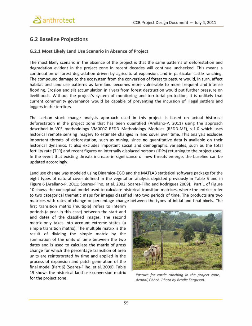
CCB Project Design Document – July 4, 2011
55
G.2 Baseline Projections
G.2.1 Most Likely Land Use Scenario in Absence of Project The most likely scenario in the absence of the project is that the same patterns of deforestation and degradation evident in the project zone in recent decades will continue unchecked. This means a continuation of forest degradation driven by agricultural expansion, and in particular cattle ranching. The compound damage to the ecosystem from the conversion of forest to pasture would, in turn, affect habitat and land use patterns as farmland becomes more vulnerable to more frequent and intense flooding. Erosion and silt accumulation in rivers from forest destruction would put further pressure on livelihoods. Without the project’s system of monitoring and territorial protection, it is unlikely that current community governance would be capable of preventing the incursion of illegal settlers and loggers in the territory. The carbon stock change analysis approach used in this project is based on actual historical deforestation in the project zone that has been quantified (Arellano-P. 2011) using the approach described in VCS methodology VM0007 REDD Methodology Modules (REDD-MF), v.1.0 which uses historical remote sensing imagery to estimate changes in land cover over time. This analysis excludes important threats of deforestation, such as mining, since no quantitative data is available on their historical dynamics. It also excludes important social and demographic variables, such as the total fertility rate (TFR) and recent figures on internally displaced persons (IDPs) returning to the project zone. In the event that existing threats increase in significance or new threats emerge, the baseline can be updated accordingly. Land use change was modeled using Dinamica-EGO and the MATLAB statistical software package for the eight types of natural cover defined in the vegetation analysis depicted previously in Table 5 and in Figure 6 (Arellano-P. 2011; Soares-Filho, et al. 2002; Soares-Filho and Rodrigues 2009). Part 1 of Figure 10 shows the conceptual model used to calculate historical transition matrices, where the entries refer to two categorical thematic maps for images classified into two periods of time. The products are two matrices with rates of change or percentage change between the types of initial and final pixels. The first transition matrix (multiple) refers to interim periods (a year in this case) between the start and end dates of the classified images. The second matrix only takes into account extreme states (a simple transition matrix). The multiple matrix is the result of dividing the simple matrix by the summation of the units of time between the two dates and is used to calculate the matrix of gross change for which the percentage transition of area units are reinterpreted by time and applied in the process of expansion and patch generation of the final model (Part 6) (Soares-Filho, et al. 2009). Table 19 shows the historical land use conversion matrix for the project zone.
Pasture for cattle ranching in the project zone, Acandí, Chocó. Photo by Brodie Ferguson.

CCB Project Design Document – July 4, 2011
56
Part 2 of the diagram shows the conceptual model for raster cube creation. The aim is to compile different kinds of regional information into a single file for later consultation in the itieration processes of the models. Part 3 shows the model for categorizing continuous variables (e.g., DEM and slope) as well as distances of up to 1000 meters for zones of agricultural influence in order to determine their relationship to deforestation and agricultural expansion. The raster cube generated in Part 2 works as a static form because it does not change in value during the consultations between the years 1987 and 2010, while the calculation of distance from zones influenced by agricultural are dynamically recalculated because their values do change over the period. Weighted values for categorical variables (continuous variables made discrete) were used to generate coefficients of evidence similar to the previous model (Part 4) for later use in the Bayesian probability calculation employed in the final model. Before building the final deforestation model (Part 6), the correlation of variables (Part 5) was evaluated to eliminate poor and redundant explanatory variables. In the case of Acandí, the variable type of coverage was removed because no single type of coverage was satisfactorily related or could serve to explain the historical trend of deforestation. After the calibration process (processes of one to five), a model similar to the final model (Part 6), but with inputs from historical entries and exits is validated by the decay function. Finally, Part 6 of Figure 10 shows the estimated changes most likely to occur in future scenarios of greatest probability. This structure was used to calculate the loss of biomass and carbon due to human intervention through deforestation. Figure 11 shows the expected transformation where light colors represent Classes 5 and 6 from Table 4, and dark colors represent Classes 11 and 12. The maps for 2001 and 2010 represent historical data, while 2020, 2030, and 2040 are projections.

CCB Project Design Document – July 4, 2011
57
Figure 10: Model Structures for Estimating Biomass Loss (from Arellano-P. 2011).

CCB Project Design Document – July 4, 2011
58
Table 19: Historical Land Use Conversion Matrix for the Project Zone (2001-2010).
Class Symbol 2001 Area (ha)
A A-
Pd/Ppu-Ula
A-Ma/Trm
A-Ps/Hru-
Abi Subtotal
Converted Grassland
Converted Palms
Converted Shrubland
Converted Forest
Total %
Change
7 A 9,066 - 1,394 38 59 1,491 115 108 908 401 3,022 33.3
6 A-Pd/Ppu-Ula 2,512 502 - 22 61 584 236 81 140 242 1,283 51.1
12 A-Ma/Trm 3,530 20 17 - 115 153 5 10 88 1,429 1,685 47.7
13 A-Ps/Hru-Abi 3,835 49 50 199 - 298 16 6 330 1,278 1,927 50.3
3 Hb/Pac 5 1 1 0 0 2
2 40.5
4 Hb/Mar 1,182 351 198 24 81 654 654 55.3
5 Pm/Rta 358 107 62 6 19 194 194 54.1
8 Mm-Ma/Efu-Cic 5,436 675 289 212 353 1,530 1,530 28.1
2 Bhal/Par-Vco 2 0 0 0 0 10.2
9 Bhal/Toc-Mba-Cpa 4,137 55 54 280 165 554 554 13.4
10 Bhri/Efu-Isp 3,582 50 37 215 216 518 518 14.5
11 Bhal-tf/Sgl-Hob-Tma
1,896 21 15 204 120 360 360 19.0
14 Bhtf/Tam-Ame-Adu 1,034 7 13 88 40 148 148 14.3
15 Bhtf/Toc-Mba-Tam 1,424 2 5 133 48 188 188 13.2
16 Bshtf/Dol-Par 3,831 2 6 330 78 416 416 10.9
17 Bshtf/Dol-Jco-Toc 21,412 116 293 1,616 449 2,474 2,474 11.6
18 Bshtf/Dol-Esc-Tam 3,959 1 1 388 53 444 444 11.2
19 Bhtf/Cod-Agr-Cbr 610 1 0 51 8 60 60 9.9
20 Bhtf/Cpl 4,388 18 7 304 41 370 370 8.4
21 Bhtf/Aex 6,818 442 29 471 471 6.9
22 Bhtf/Qhu 344 16 0 16 16 4.8
Forests 53,437
6,021
6,021 11.3
Grassland 1,186 656 656 55.3
Shrubland 5,436 1,530 1,530 28.1
Palms 358 194 194 54.1
Natural Vegetation 60,417 8,401 8,401 13.9

CCB Project Design Document – July 4, 2011
59
Figure 11: Actual and Expected Change in Land Cover in the Baseline Scenario.
1990 2001
2010 2020
2030 2040

CCB Project Design Document – July 4, 2011
60
G.2.2 Additionality of Project Benefits There are several barriers to conservation and sustainable natural resource management that make these outcomes and benefits unlikely without the project. These include: Financial barriers - The principal factor preventing the uptake of a conservation and sustainable natural resource management project in COCOMASUR is financial. The development of the project, including the strengthening of the territorial governance capacity and the financing of the project activities to conserve, monitor, and enhance the forest rely on project revenues from the sale of carbon credits. The members of the territory do not have access to capital to invest in improved forest management, agro-forestry or higher yield agriculture. Nor does the territory have the resources to map, demarcate, and organize a system for protection and sustainable management of the territory. Without carbon revenues, it would be impossible to create effective incentives for alternative, forest-friendly sustainable land-use activities. Governance capacity – A secondary factor is that without the project, the COCOMASUR would not have the resources to invest in strengthening its own capacity to govern. The project has already invested in increasing community understanding of Law 70 and the nature of their collective territory and its protection. The project has enabled the High Council and Local Councils to increase their degree of organization and hence their capacity to implement a forest carbon project, which did not exist prior to the project. In addition, the project will enable COCOMASUR to continue to clarify land tenure arrangements within the territory (usufruct rights), to dedicate previously non-existent resources to resolving land disputes, and to prevent new disputes by demarcating and protecting collective holdings. By reinforcing its management and governance capacity, the project will also strengthen the territories’ ability to attract further investment from donors or other sources. Productive capacity - Without the project, the loggers and farmers of COCOMASUR would have inadequate access to information, inputs, and technology to effectively manage their forests and improve their agricultural productivity. Agro-forestry, improved forest management, reforestation and improved yield agriculture practices require the investment of project resources. Shifting cultivation and uncontrolled selective logging would continue without the project.

CCB Project Design Document – July 4, 2011
61
G.2.3 Estimated Carbon Stock Changes in Absence of Project Analysis of alternative land use in Section G2.1 indicates that conversion of forest to pasture and grazingland for cattle ranching is the most likely land use scenario without the project. Under this scenario, low intensity cattle ranching already prevalent in the project zone would continue to expand in the absence of carbon revenue. Conversion of natural ecosystems under the without project scenario would result in the loss of an estimated 1,610,520 tons of carbon over the thirty year period. Of a total of 16,530 hectares lost, an estimated 6,906 ha would be converted to shrublands (A-Ma/Trm), 3,645 to pastures (A-Ps/Hru-Abi), 3,035 to grazinglands (A-Pd/Pns-Ure), and an additional 2,944 hectares would end up completely intervened (A).
Table 20: Estimated Carbon Stock Changes in the Reference Zone Without Project (2010-2040).
Area (ha) Carbon (mt)
# Symbol A-
Pd/Pns-Ure
A A-
Ma/Trm
A-Ps/Hru
-Abi
A-Pd/Pns
Ure A
A-Ma/Tr
m
A-Ps/Hru-
Abi Total
2 Bhal/Par-Vco 0 0 0 0 9 25 0 0 34
3 Hb/Pac 12 1 0 0 - - - - 0
4 Hb/Mar 180 397 2 62 - - - - 0
5 Pm/Rta 141 164 2 12 - - - - 0
6 A-Pd/Pns-Ure 0 693 0 72 - - - - 0
7 A 1,623 0 1 24 - - - - 0
8 Mm-Ma/Efu-Cic
78 255 29 848 - - - - 0
9 Bhal/Toc-Mba-Cpa
66 26 374 331 9,918 3,933 55,767 49,351 118,969
10 Bhri/Efu-Isp 44 39 252 426 - - - - 0
11 Bhal-tf/Sgl-Hob-Tma
14 32 327 270 - - - - 0
12 A-Ma/Trm 126 417 0 183 - - - - 0
13 A-Ps/Hru-Abi 118 12 251 0 - - - - 0
14 Bhtf/Tam-Ame-Adu
50 8 338 344 7,349 1,130 49,240 50,217 107,936
15 Bhtf/Toc-Mba-Tam
5 1 353 117 975 174 69,462 22,953 93,565
16 Bshtf/Dol-Par 2 11 600 111 390 1,786 93,932 17,299 113,408
17 Bshtf/Dol-Jco-Toc
565 417 2,652 716 106,145 78,328 498,525 134,599 817,597
18 Bshtf/Dol-Esc-Tam
1 3 663 62 172 470 91,607 8,570 100,819
19 Bhtf/Cod-Agr-Cbr
0 2 96 7 19 347 14,785 1,105 16,256
20 Bhtf/Cpl 0 0 626 34 1 47 100,926 5,504 106,478
21 Bhtf/Aex 8 452 324 26 1,348 72,915 52,324 4,152 130,740
22 Bhtf/Qhu 0 13 16 0 81 2,102 2,545 0 4,728
1,610,530
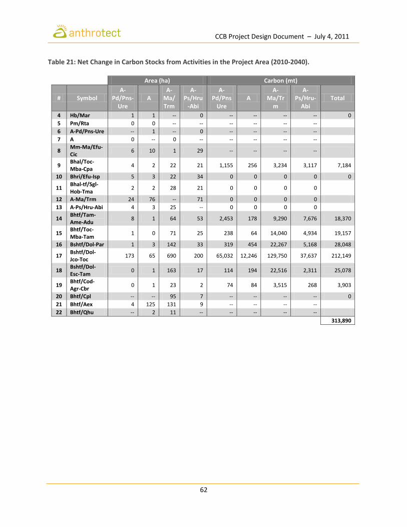
CCB Project Design Document – July 4, 2011
62
Table 21: Net Change in Carbon Stocks from Activities in the Project Area (2010-2040).
Area (ha) Carbon (mt)
# Symbol A-
Pd/Pns-Ure
A A-
Ma/Trm
A-Ps/Hru
-Abi
A-Pd/Pns
Ure A
A-Ma/Tr
m
A-Ps/Hru-
Abi Total
4 Hb/Mar 1 1 -- 0 -- -- -- -- 0
5 Pm/Rta 0 0 -- -- -- -- -- --
6 A-Pd/Pns-Ure -- 1 -- 0 -- -- -- --
7 A 0 -- 0 -- -- -- -- --
8 Mm-Ma/Efu-Cic
6 10 1 29 -- -- -- --
9 Bhal/Toc-Mba-Cpa
4 2 22 21 1,155 256 3,234 3,117 7,184
10 Bhri/Efu-Isp 5 3 22 34 0 0 0 0 0
11 Bhal-tf/Sgl-Hob-Tma
2 2 28 21 0 0 0 0
12 A-Ma/Trm 24 76 -- 71 0 0 0 0
13 A-Ps/Hru-Abi 4 3 25 -- 0 0 0 0
14 Bhtf/Tam-Ame-Adu
8 1 64 53 2,453 178 9,290 7,676 18,370
15 Bhtf/Toc-Mba-Tam
1 0 71 25 238 64 14,040 4,934 19,157
16 Bshtf/Dol-Par 1 3 142 33 319 454 22,267 5,168 28,048
17 Bshtf/Dol-Jco-Toc
173 65 690 200 65,032 12,246 129,750 37,637 212,149
18 Bshtf/Dol-Esc-Tam
0 1 163 17 114 194 22,516 2,311 25,078
19 Bhtf/Cod-Agr-Cbr
0 1 23 2 74 84 3,515 268 3,903
20 Bhtf/Cpl -- -- 95 7 -- -- -- -- 0
21 Bhtf/Aex 4 125 131 9 -- -- -- --
22 Bhtf/Qhu -- 2 11 -- -- -- -- --
313,890
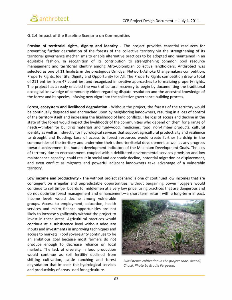
CCB Project Design Document – July 4, 2011
63
G.2.4 Impact of the Baseline Scenario on Communities Erosion of territorial rights, dignity and identity - The project provides essential resources for preventing further degradation of the forests of the collective territory via the strengthening of its territorial governance mechanisms to enable alternative practices to be adopted and maintained in an equitable fashion. In recognition of its contribution to strengthening common pool resource management and territorial identify among Afro-Colombian collective landholders, Anthrotect was selected as one of 11 finalists in the prestigious Omidyar Network-Ashoka Changemakers competition, Property Rights: Identity, Dignity and Opportunity for All. The Property Rights competition drew a total of 211 entries from 47 countries, and recognized innovative approaches to formalizing property rights. The project has already enabled the work of cultural recovery to begin by documenting the traditional ecological knowledge of community elders regarding dispute resolution and the ancestral knowledge of the forest and its species, infusing new vigor into the collective governance building process. Forest, ecosystem and livelihood degradation - Without the project, the forests of the territory would be continually degraded and encroached upon by neighboring landowners, resulting in a loss of control of the territory itself and increasing the likelihood of land conflicts. The loss of access and decline in the state of the forest would impact the livelihoods of the communities who depend on them for a range of needs—timber for building materials and fuel-wood, medicines, food, non-timber products, cultural identity as well as indirectly for hydrological services that support agricultural productivity and resilience to drought and flooding. Loss of access to forest resources would create further hardship in the communities of the territory and undermine their ethno-territorial development as well as any progress toward achievement the human development indicators of the Millenium Development Goals. The loss of territory due to encroachment, coupled with a debilitated environmental services provision and low maintenance capacity, could result in social and economic decline, potential migration or displacement, and even conflict as migrants and powerful adjacent landowners take advantage of a vulnerable territory. Low income and productivity - The without project scenario is one of continued low incomes that are contingent on irregular and unpredictable opportunities, without bargaining power. Loggers would continue to sell timber boards to middlemen at a very low price, using practices that are dangerous and do not optimize forest management and enhancement—a short term return with a long-term impact. Income levels would decline among vulnerable groups. Access to employment, education, health services and micro finance opportunities are not likely to increase significantly without the project to invest in these areas. Agricultural practices would continue at a subsistence level without adequate inputs and investments in improving techniques and access to markets. Food sovereignty continues to be an ambitious goal because most farmers do not produce enough to decrease reliance on local markets. The lack of diversity in food production would continue as soil fertility declined from shifting cultivation, cattle ranching and forest degradation that impacts the hydrological services and productivity of areas used for agriculture.
Subsistence cultivation in the project zone, Acandí, Chocó. Photo by Brodie Ferguson.

CCB Project Design Document – July 4, 2011
64
G.2.5 Impact of the Baseline Scenario on Biodiversity In the absence of the project, degradation and destruction of this moist forest ecoregion that is considered one of the most species rich lowlands in the world in the world continue on an incremental scale. The area is already recognized as one with insufficient conservation, multiple threats and high biocultural value (Dinerstein et al. 1995, Davis et al. 1997). The completion of the Inter-American highway would increase pressures on habitat in this distinctive biological region from logging, clearing and encroachment of ranches, degrading the density and composition of the forest understory, disrupting the age distribution of trees due to uncontrolled logging and resulting in a significant conversion of habitat of the abundant and endemic taxons that include plants birds, mammals, amphibians and butterflies. Severe erosion and disruption in the hydrological services provided by the forest is already being experienced in the territory due to removal of forest cover. The already torrential wet invierno season is worse each year, with this past year being a prime example of the costs of conversion and degradation. Forest conservation is a key element of any strategy to preserve the region’s hydrological systems and avoid further loss of soil and further impact the capacity of river systems to provide species habitat. Continuing deforestation and a likely increase due to population growth and the need to clear agricultural areas would reduce species abundance as habitat is reduced and fragmented. The vulnerable and declining jaguar population is affected by habitat fragmentation and loss, and would be further endangered without conservation efforts by the project. Increased poaching and hunting of at risk mammals with slow reproductive cycles, such as the tapir, owing to increasing human populations, is likely.Hunting and poaching of the already vulnerable Central American tapir is likely to increase without intervention due to population growth. The abundant amphibean population is of concern because frogs are very sensitive to local temperature and humidity, and the clearing of small amount of trees is enough to disturb them. The conversion of forests threatens the 58 species found in the project area. Without the project, the conversion of habitat supporting the ecoregion’s highly diverse and endemic flora and fauna would place additional pressure on already threatened, vulnerable, endangered and near-endangered species. There are 22 species categorized as experiencing some degree of threat according to the Red Book of Colombian mammals (Rodríguez-Maher et al., 2006) including the critically endangered Colombian Spider Monkey, Cotton-top tamarin and Central American tapir. Efforts by the community to control poaching of eggs from the critically endangered leatherback sea turtles, for example, which nest on beaches of Playona near Acandí, one of 2 nesting sites in the country, would not be able to be resourced effectively. These conservation efforts currently suffer from limited resources that need additional support from the carbon project to be effective. Undertaking additional efforts to control hunting and poaching of other species would not be implemented without project funds.
Selective logging, an important livelihood in the project zone. Photo by Nicolas Arms.

CCB Project Design Document – July 4, 2011
65
Of the birds in the project zone, six are endemic species to Colombia and 40 are near-endemic species. Some 29 species are placed in a category of threat according to IUCN (Renjifo 1998, Renjifo et al. 2002); 88 species are migratory: almost all (86) nest in North America and winter in South America, two species nest in southern South America and spend their winter further north. This represents the last opportunity to conserve relatively large areas of intact lowland and medium elevation forests that allow the natural altitudinal migration of many species of birds, mammals and invertebrates. In the case of bats, some authors claim that 66.3% of the species in the Chocó region are outside a radius of 30 km from conservation areas such as the parks system and are exposed to pressures threatening its conservation. This group includes endemic species and those that have only recently been described for which there is no further information available (Mantilla-Meluk and Jiménez-Ortega 2006). The project provides the last opportunity to conserve relatively large areas of intact lowland and medium elevation forests that allow the natural altitudinal migration of many species of birds, mammals and invertebrates that would otherwise be destroyed with increase access by road and commercial pressures. In addition, the region has great potential for ecotourism and scientific research. Its forests are of great interest because some of them may be secondary forests that are nearly 500 years old, which would clearly allow for studies on the subject of the regeneration of tropical forests (Davis, et al. 1997).

CCB Project Design Document – July 4, 2011
66
G.3 Project Design and Goals
G.3.1 Summary of Project’s Major Objectives The project leverages carbon finance to reduce greenhouse gas emissions while maintaining the biodiversity values of the collective territory and enhancing economic and social development with sustainable livelihoods and governance capacity of collective landholders. Climate Objectives The Chocó Darien Conservation Corridor project is designed to mobilize 31 local communities organized among 8 local councils to avoid further deforestation and degradation as well as facilitate the natural regeneration of 13,458 hectares of project area. This will lead to mitigation of about 1.4 million MTCO2 over the project’s 30-year lifetime. Community Objectives With clear land titles and improved security conditions, Afro-Colombian communities have returned to the project area to pursue their own visions of territorial development. This project will provide a stream of income to reinvest in reinforcing the dignity and territorial autonomy of Afro-descendent communities, so that neither the forests nor the residents’ traditional ways of life are lost. The impacts of armed conflict and displacement on traditional patterns of agriculture and resource use resulted in disorderly exploitation to meet basic needs. The project will strengthen organizational and financial capacities, provide training and technical support for improving agricultural practices, support micro-finance groups and educate communities in improved forest management and biodiversity conservation and sustainable use. In other cases, weakly-governed communities unaware of their collective land rights have come under the influence of outside ranching and agricultural interests. Most project effort will focus on developing and strengthening territorial policies, practices and skills for the collective management by communities, including internal regulations for land-use planning, benefit sharing, procedures for handling violations and alternative dispute resolutions mechanisms. Moreover, the project aims to demonstrate the importance of respecting and encouraging collectively-managed forest conservation projects as they are the most effective model for mitigating climate change. Biodiversity Objectives This project will contribute to the protection and conservation of one of the most biodiverse places in Colombia, and on earth. Assisted natural forest regeneration with endangered species will increase the quantity and quality habitat. Project staff will facilitate community education on effective practices for conserving flora and fauna and combating myths about certain species that have been traditionally vilified, resulting in their decline. Monitoring of key species by members of the communities will occur with support from project staff and the National University. The project zone will be positively affected by project implementation.
CCB Project Design Document – July 4, 2011
67
G.3.2 Description of Project Activities The project will use carbon financing to avoid the threat of conversion to pasture, agriculture, gold mining or selective logging by undertaking 11 different activities to achieve reduced degradation and deforestation. Table 22 shows how each of these activities targets one or more of the above identified deforestation drivers. The project will be implemented incrementally as per a strategic plan with corresponding annual action plans developed by COCOMASUR with technical guidance from Anthrotect. Foundational activities such as territorial demarcation, land use planning and strengthening local governance will be prioritized in the first year. As additional activities commence, additional project benefits will accrue. Specifically, the project enables landholders to generate a revenue stream linked to the carbon value of conservation and reforestation activities by 1) solidifying nascent governance structures, 2) consolidating existing land titles, 3) resolving and preventing land disputes, and 4) implementing sustainable livelihood alternatives. The local ownership model of the project will reduce risk and ensure long-term performance in project activities around three themes:
1. building governance capacity, by raising awareness of collective identity and rights, demarcating title boundaries, resolving land disputes, instilling best practices for administration and accountability, and constructing collective visions and strategic plans for land use;
2. reducing carbon emissions, through community surveillance to conserve existing forest,
restoring degraded lands, and improving forest management by extending harvest rotations and minimizing logging impacts; and,
3. investing in green commodity production, by improving technologies and agricultural practices,
applying proven new models for sustainable ranching (e.g., Aliança da Terra) and artisanal gold mining (e.g., Oro Verde), and securing enduring markets for other community products.
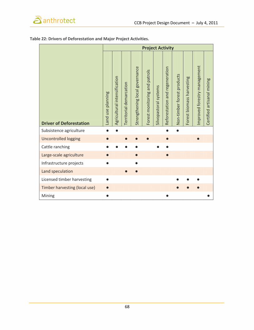
CCB Project Design Document – July 4, 2011
68
Table 22: Drivers of Deforestation and Major Project Activities.
Driver of Deforestation
Project Activity
Lan
d u
se p
lan
nin
g
Agr
icu
ltu
ral i
nte
nsi
fica
tio
n
Te
rrit
ori
al d
emar
cati
on
Str
engt
hen
ing
loca
l go
vern
ance
Fo
rest
mo
nit
ori
ng
and
pat
rols
Silv
op
asto
ral s
yste
ms
Ref
ore
stat
ion
an
d r
ege
ner
atio
n
No
n-t
imb
er f
ore
st p
rod
uct
s
Fo
rest
bio
mas
s h
arve
stin
g
Imp
rove
d f
ore
stry
man
agem
ent
Cer
tifi
ed a
rtis
anal
min
ing
Subsistence agriculture • • • •
Uncontrolled logging • • • • • •
Cattle ranching • • • • • •
Large-scale agriculture • • •
Infrastructure projects • •
Land speculation • •
Licensed timber harvesting • • • •
Timber harvesting (local use) • • • •
Mining • • •

CCB Project Design Document – July 4, 2011
69
G.3.3 Location of Project Areas and Leakage Areas The project will monitor leakage by tracking deforestation and forest degradation in the surrounding project zone which corresponds to the municipality of Acandí.
G.3.4 Project Lifetime and GHG Accounting Period The project lifetime and the GHG accounting period are 30 years. The project started on January 1, 2011 and will end on December 31, 2040. The project lifetime was preceeded by a 6 month project preparation period that involved community training, stakeholder consultations, participatory mapping, and negotiations. During the first 5 years (i.e. Years 1-5), the project is focusing on:
1. strengthening internal governance structures; 2. developing community capacity in administration and finance; 3. clarifying project boundaries; 4. controling drivers of deforestation and degradation; 5. regenerating degraded forest lands and riparian zones; 6. building community capacity for monitoring social and environmental impacts; 7. identifying viable opportunities for livelihood generation.
During Years 6-30, the project activities and management will be gradually transitioned to COCOMASUR. Net revenues from carbon payments during this period will be used to benefit local communities by enhancing livelihoods and improving the quality of the forest.
CCB Project Design Document – July 4, 2011
70
G.3.5 Natural and Human-Induced Risks and Mitigation Strategies Flooding The annual rainy invierno (winter) season poses serious threats to local communities who live alongside rivers, endangering homes, crops and household gardens, and damaging infrastructure. Rains affect livelihoods and mobility as well as the land. Heavy rains and flooding can cause landslides and wash away significant amounts of topsoil, causing sedimentation down stream in the deltas of the rivers as they empty into the sea. Sedimentation is a serious problem in Acandí municipality, affecting the livelihoods of fisherman who can no longer make a living on the river due to its decreased productivity. Communities alongside rivers are vulnerable to the destruction they can cause when they rise and carve out new courses where houses once stood. Degradation of forests along river banks and at the heads of rivers and tops of watersheds are a major cause of the annual destruction, though the inordinate scale of damage incurred this year is clearly also attributable to global climate patterns like the 2010-2011 La Niña cycle that has affected the majority of Colombian Departments this year. Reforestation alongside riverbanks and at the top of watersheds with appropriate species has been identified as a priority in COCOMASUR to prevent tragedy and reinforce vulnerable ecosystems that are rapidly degrading as a result. Such measures will also sustain the integrity of ecosystem’s flora and fauna. Investing in retaining walls and other infrastructure measures to protect vulnerable communities are also planned. Seismic risk From a seismological point of view, western Colombia has traditionally been viewed as an area of high activity, and the department of Chocó, in particular, has been classified as high seismic risk (Meyer and Velásquez 1993; Sarria 1985). However, although this could be true in the south of the study area, in the Darién the case seems to be different, as is shown by the location of epicenters of considerable magnitude (c), which indicate a clear distinction between high concentration of seismic epicenters south of the Darién and the frequency of moderate earthquakes of considerable magnitude in the area of interest. Recent research conducted by the National Seismological Network project in the Colombian portion, and the University of Panama in the eastern part of Panama, show a different picture. Between June 1993 and August 1997, the network recorded 280 earthquakes in the area of interest (Ingeominas, 1993-1996 and 1997) and in eastern Panama 142 earthquakes were recorded between October 1992 and August 1996 (Camacho-A and Benito 2008). The Darién should thus be considered as an area of seismic risk; that is, the coefficient that represents the expected peak acceleration is in the range of 0.20 to 0.45 (Colombian Association of Earthquake Engineering, 1996). The region does not experience risks from wildfires or volcanic activity.

CCB Project Design Document – July 4, 2011
71
Post-conflict/security The project’s community-based approach creates attractive local employment opportunities that are critical for resilience to armed groups and durability of peace. Vulnerability to armed actors who aim to monopolize trade and intimidate those who assert their legal and territorial rights is best mitigated via strengthened community organizational structures and improving livelihoods—which carbon based income alternatives will contribute towards. A further advantage to carbon-based revenues in this context is their intangibility. The enhanced social organization required to implement a REDD+ project includes a process of education about territorial rights not undertaken in such depth or at such a scale until now. There will be continued efforts to reinforce this knowledge among members of the collective territory and the enhancement of economic opportunities that results from the income generated by the project will contribute to community resistance to these actors. With more economic prospects and a more organized and resourced territorial governance, there will be less vulnerability to the pressures or tactics of these actors, and it is likely to act as a deterrent to the entry of armed groups to the project region. Community capacity An emphasis on participatory design and transfer of skills & technology for a progressive community management role is central to the project. The first five years of the project will emphasize building institutional capacity to oversee implementation of project activities and management of its resources. Local people and organizations will be given preference in hiring decisions as a matter of policy. When external support is required, the external organization or consultant must work with at least one local counterpart. Skills sharing and community learning objectives and outputs will be built into their work plans. The community-based model is built on the legal autonomy of Cocomasur as an Afro-Colombian collective landholder. This local ownership model is critical to long term performance in project-activities and acts as a strong incentive for meeting capacity development and project implementation milestones. Preventing corruption Project funds in Colombia will be administered by Acción Ambiental with a 10 year track record as an ETF in Colombia until Cocomasur meets internationally recognized and audited standards for administering its project resources.
Community member at a General Assembly in Peñaloza, Acandí, Chocó. Photo by Emily Roynestad.

CCB Project Design Document – July 4, 2011
72
Opportunity costs of REDD To effectively reduce carbon emissions, this project must understand the near-term opportunity costs of conservation and sustainable livelihood activities while reinforcing the dignity and territorial autonomy of indigenous communities, so that neither the forests nor residents’ traditional ways of life are lost. There is every indication that benefits from REDD/FSC-certification will provide sufficient economic incentives for a successful project. Time preference exercises carried out among project participants revealed very high individual discount rates (a mean of 0.38), where the average respondent preferred to receive a lump sum payment of $800 USD versus a payment of $25 USD each month for the next 30 years (Ferguson 2010). Measures to ensure tangible short-term benefits such as employment in project activities, and prioritization of project activities with high conservation impact that generate additional livelihoods value such as green ranching and mining, and forest products will be a priority. Artisanal mining Many families in the project zone practice several sustainable artisanal mining techniques (such as those employed in this video). The project will explore implementation of the Oro Verde model, which assists traditional gold and platinum mining communities to comply with social and environmental criteria and access international markets for fairly mined and traded metals. Oro Verde addresses irresponsible mining practices in the region by rescuing local communities’ ancestral knowledge, integrating it with technical and scientific know how, and enabling families to generate sustainable incomes. Artisanal techniques do not use chemicals such as cyanide and mercury, and often include:
Panning (mazamorreo) - involving getting gravel from riverbeds and riverbanks in the dry season; Zambullidero - a summer season technique where the mine is located at the end of a river. After successive immersions the minerals are extracted from the gravel. Hoyadero (hole technique) - manually excavated holes of varying sizes until bedrock is reached. Flow water method - a technique used in the rainy season that uses the force of pressurized water to extract sediments, circulating it through narrow artificial channels and man made dams where the sediments containing gold are washed.
Artisanal mining is an important livelihood in Tibirre, Acandí, Chocó. Photo by Nicolas Arms.

CCB Project Design Document – July 4, 2011
73
Illegal logging Current logging practices produce collateral damage to the forest and jeopardize worker safety. A focus on improved practices and training to minimize risk and damage to surrounding forest is a priority for investing in IFM and value-adding processing of wood products. Domestic timber consumption in Colombia represents the largest proportion of the total trade in timber and is organized in informal ways. Improving forest management to achieve certifiable, sustainable timber production is key for the success of the project but requires access to markets for sustainable products. Without policy incentives to stimulate demand for better forest management from national and international markets (such as the U.S., in the even of the approval of the bilateral Free Trade Agreement), efforts to bring domestic producers into a formal framework will fall short of providing the social and economic benefits promised from improved forest governance from the fair distribution of forest benefits. Currently, this is not the case. Loggers sell bundles to middlemen who sell on to larger buyers up the chain, retaining very little value at the bottom of the chain. A value chain development approach for certified timber products will mitigate these risks, by adding value and investing in skills and diversified income opportunities with loggers, such as forest guards and monitors and agroforestry production.
CCB Project Design Document – July 4, 2011
74
G.3.6 Ensuring the Maintenance and Enhancement of High Conservation Values Owing to the unique composition of its ecosystems, its rich genetic resources its status as the ancestral land and present day basis of the COCOMASUR territory, the project area exceeds the qualifications of a High Conservation Value (HCV) forest by demonstrating all of the 6 HCVs summarized in Table 18. No negative impacts are forseen as a result of the project. To the contrary, HCVs are expected to benefit from the project. The six previously described HCVs stand to be positively affected by the project are summarized in Table 23.
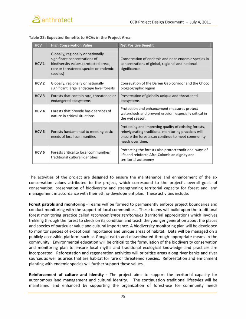
CCB Project Design Document – July 4, 2011
75
Table 23: Expected Benefits to HCVs in the Project Area.
HCV High Conservation Value Net Positive Benefit
HCV 1
Globally, regionally or nationally significant concentrations of biodiversity values (protected areas, rare or threatened species or endemic species)
Conservation of endemic and near-endemic species in concentrations of global, regional and national significance.
HCV 2
Globally, regionally or nationally significant large landscape level forests
Consevation of the Darien Gap corridor and the Choco biogeographic region
HCV 3
Forests that contain rare, threatened or endangered ecosystems
Preservation of globally unique and threatened ecosystems
HCV 4
Forests that provide basic services of nature in critical situations
Protection and enhancement measures protect watersheds and prevent erosion, especially critical in the wet season.
HCV 5
Forests fundamental to meeting basic needs of local communities
Protecting and improving quality of existing forests, reinvigorating traditional monitoring practices will ensure the forests can continue to meet community needs over time.
HCV 6
Forests critical to local communities’ traditional cultural identities
Protecting the forests also protect traditional ways of life and reinforce Afro-Colombian dignity and territorial autonomy
The activities of the project are designed to ensure the maintenance and enhancement of the six conservation values attributed to the project, which correspond to the project’s overall goals of conservation, preservation of biodiversity and strengthening territorial capacity for forest and land management in accordance with their ethno-development plan. These activities include: Forest patrols and monitoring - Teams will be formed to permanently enforce project boundaries and conduct monitoring with the support of local communities. These teams will build upon the traditional forest monitoring practice called reconocimientos territoriales (territorial appreciation) which involves trekking through the forest to check on its condition and teach the younger generation about the places and species of particular value and cultural importance. A biodiversity monitoring plan will be developed to monitor species of exceptional importance and unique areas of habitat. Data will be managed on a publicly accessible platform such as Google earth and disseminated through appropriate means in the community. Environmental education will be critical to the formulation of the biodiversity conservation and monitoring plan to ensure local myths and traditional ecological knowledge and practices are incorporated. Reforestation and regeneration activities will prioritize areas along river banks and river sources as well as areas that are habitat for rare or threatened species. Reforestation and enrichment planting with endemic species will further support these values. Reinforcement of culture and identity - The project aims to support the territorial capacity for autonomous land management and cultural identity. The continuation traditional lifestyles will be maintained and enhanced by supporting the organization of forest-use for community needs

CCB Project Design Document – July 4, 2011
76
(construction, medicine, NTFP collection) in a sustainable way in dedicated areas accessible to all communities. These activities include: 1) territorial demarcation and organization of land use, 2) clarification of usufruct rights and demarcation of these areas, 3) support to community livelihoods through investments financed by carbon credits, and 4) strengthening territorial institutions of governance.
G.3.7 Measures to Maintain and Enhance Benefits Beyond the Project Lifetime The project’s value chain development approach is designed to develop and support sustainable enterprises, cooperatives and associations within the territory to create permanent and sustainable income streams using kick-start finance from the carbon project. These businesses include FSC-certified wood products from sustainably managed forests, sustainable collection, cultivation and processing of non-timber forest products including bamboo, tagua and resin, medicinal and aromatic plants (MAPs) such as acai, sacha inchi, tumeric, and agro-forestry commodities (borojó, cacao, mango, vanilla, camu camu). This also includes improved agricultural production including traded in local, and national and international markets, and micro-enterprises. Investments in communications infrastructure will bring internet and mobile phone coverage to many areas for the first time, and boost the capacity in other areas that already have minimal, but insufficient coverage. These investments will increase access to services and information for the members of the territory, opening up new possibilities for livelihoods and education. The education, training, and development of territorial capacity to manage the project is an investment in the long-term viability of not only the project but also in the territories’ future well beyond the lifetime of the project.
G.3.8 Community Involvement and Stakeholder Consultation Anthrotect’s relationship with the communities of COCOMASUR began over 3 years ago, during a trip to the Darien region in 2008 when Anthrotect Founder and Director Dr. Brodie Ferguson first met with community leaders to explore the opportunities and challenges associated with the recent recognition of collective property rights over their traditional lands. Discussions began to explore how a partnership could bring together the community’s determination to conserve remaining forest and restore degraded lands, and Anthrotect’s interest in developing innovative finance mechanisms for conservation and sustainable development could be combined in a forest carbon project that would infuse dignity and vigor into these new collective entities while providing an invaluable service to the rest of the world. Law 70 grants collective territorial rights and autonomous governance powers to Afro-Colombian landholders. As a community-driven project, the input of members of the territory is the foundation of the project’s design, such as what activities are being undertaken, which are needed, and what kinds of support will be required to prepare communities to undertake project activities. Direct project stakeholders are the governing entities of the territory itself, its community members, and participating communities organized into 9 Local Councils. This mechanism of project participation also act as a distribution mechanism for project benefits, such as direct employment created by project activities and special project funds to invest in community priorities.
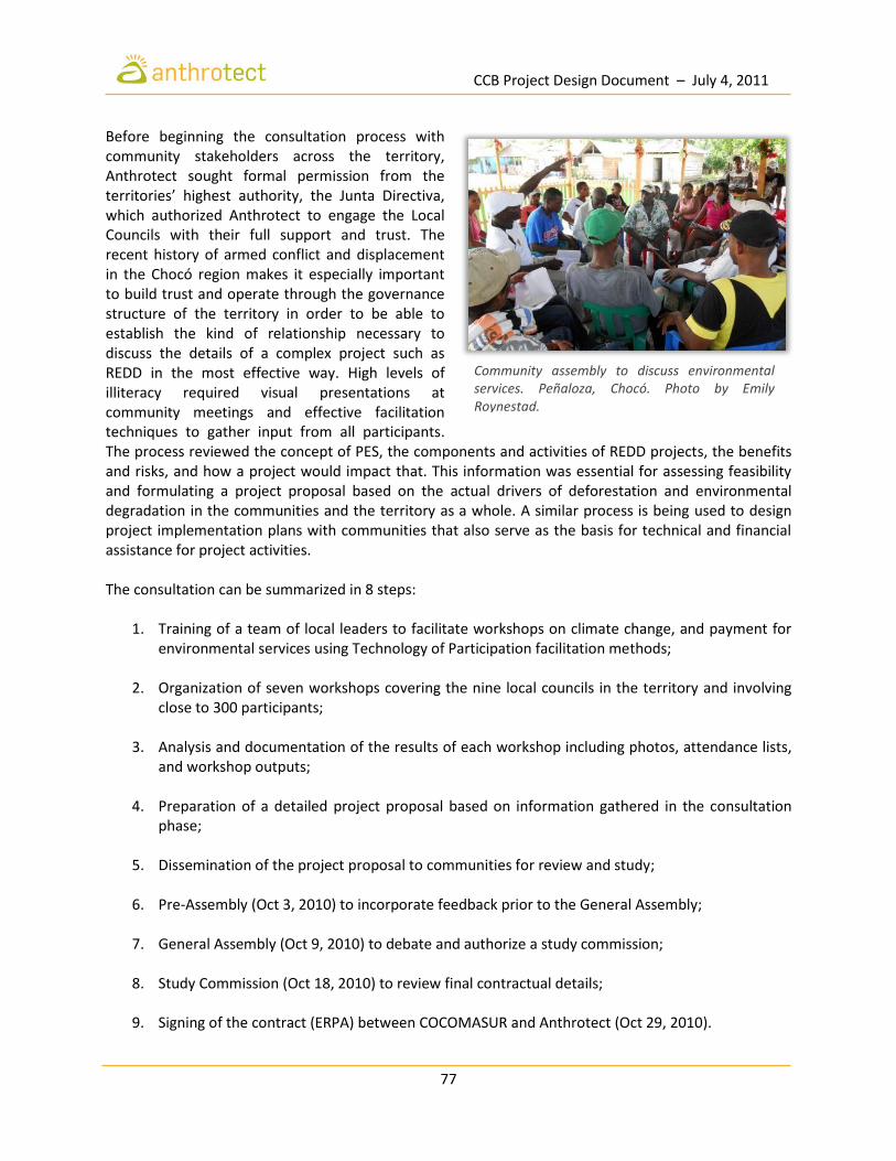
CCB Project Design Document – July 4, 2011
77
Before beginning the consultation process with community stakeholders across the territory, Anthrotect sought formal permission from the territories’ highest authority, the Junta Directiva, which authorized Anthrotect to engage the Local Councils with their full support and trust. The recent history of armed conflict and displacement in the Chocó region makes it especially important to build trust and operate through the governance structure of the territory in order to be able to establish the kind of relationship necessary to discuss the details of a complex project such as REDD in the most effective way. High levels of illiteracy required visual presentations at community meetings and effective facilitation techniques to gather input from all participants. The process reviewed the concept of PES, the components and activities of REDD projects, the benefits and risks, and how a project would impact that. This information was essential for assessing feasibility and formulating a project proposal based on the actual drivers of deforestation and environmental degradation in the communities and the territory as a whole. A similar process is being used to design project implementation plans with communities that also serve as the basis for technical and financial assistance for project activities. The consultation can be summarized in 8 steps:
1. Training of a team of local leaders to facilitate workshops on climate change, and payment for environmental services using Technology of Participation facilitation methods;
2. Organization of seven workshops covering the nine local councils in the territory and involving
close to 300 participants;
3. Analysis and documentation of the results of each workshop including photos, attendance lists, and workshop outputs;
4. Preparation of a detailed project proposal based on information gathered in the consultation
phase;
5. Dissemination of the project proposal to communities for review and study;
6. Pre-Assembly (Oct 3, 2010) to incorporate feedback prior to the General Assembly;
7. General Assembly (Oct 9, 2010) to debate and authorize a study commission;
8. Study Commission (Oct 18, 2010) to review final contractual details;
9. Signing of the contract (ERPA) between COCOMASUR and Anthrotect (Oct 29, 2010).
Community assembly to discuss environmental services. Peñaloza, Chocó. Photo by Emily Roynestad.
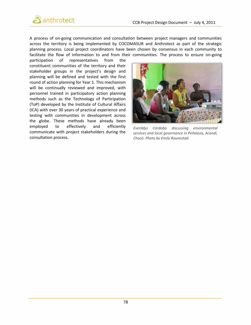
CCB Project Design Document – July 4, 2011
78
A process of on-going communication and consultation between project managers and communities across the territory is being implemented by COCOMASUR and Anthrotect as part of the strategic planning process. Local project coordinators have been chosen by consensus in each community to facilitate the flow of information to and from their communities. The process to ensure on-going participation of representatives from the constituent communities of the territory and their stakeholder groups in the project’s design and planning will be defined and tested with the first round of action planning for Year 1. This mechanism will be continually reviewed and improved, with personnel trained in participatory action planning methods such as the Technology of Participation (ToP) developed by the Institute of Cultural Affairs (ICA) with over 30 years of practical experience and testing with communities in development across the globe. These methods have already been employed to effectively and efficiently communicate with project stakeholders during the consultation process.
Everildys Córdoba discussing environmental services and local governance in Peñaloza, Acandí, Chocó. Photo by Emily Roynestad.

CCB Project Design Document – July 4, 2011
79
G.3.9 Procedure to Publicize CCB Public Comment Period In addition to posting the project design document on the CCBA website for public commenting, the document is available in Spanish and will be disseminated through the Local Councils to provide members of the territory and stakeholders the opportunity to provide comments. The Spanish version will be available in the project office in Acandí and has additionally being distributed to local government officials and local NGOs. Comments collected during the public commenting period will be collected by COCOMASUR, sent to Anthrotect, translated into English and submitted to CCB. The public commenting period was announced to the communities of the territory during a 10-day territory-wide campaign to present the PDD in each local council during workshops facilitated by COCOMASUR and Anthrotect. Comments will be collected during the visits and afterwards via the local council members and above-mentioned anonymous mechanism. All project documents including this design document will be disseminated in Spanish to communities in the collective territory. Focal points and local council members will ensure wide publicity of these and future documents through informational feedback meetings. The project proposal was prepared in Spanish and disseminated in this manner and successfully enabled an orderly and productive general assembly meeting in October 2010, when the project was approved. COCOMASUR has consistently demonstrated their commitment to the wide dissemination of information to its constituents with regards to this project and this is evidenced by the overwhelming support for the project despite the difficulties in reaching communities located in remote areas that are difficult to reach during many months of the year when rains cause rivers to become impassable. The lack of telecommunications infrastructure has proven to be the major barrier to a more regular flow of information and means of communication between the project proponents, COCOMASUR, and the communities in the territory out of signal range. As a result, investing in telecommunications infrastructure is a first level priority of the project and will commence in July. Alternatives are currently being assessed for cost and power consumption.
G.3.10 Process for Handling Unresolved Conflicts Questions, complaints, and grievances will be handled by an independent, third-party office housed in the Municipal government. Complaints will be registered, processed, and referred to the relevant party according to a Project Complaints Mechanism designed to ensure an effective and transparent response within 30 days (see Annex). Conflicts within the territory may be resolved using traditional territorial dispute mechanisms based on dialogue faciliated by the Local Councils.
CCB Project Design Document – July 4, 2011
80
G.3.11 Adequacy of Financial Mechanisms for Project Implementation Estimates of project costs are based on extensive socio-economic analyses of livelihoods in the Darien region and reflect an appropriate degree of risk and uncertainty in opportunity costs. Estimated net carbon revenues from the project, totaling approximately US$9 million over 30 years, are expected to exceed all inflation-adjusted implementation and monitoring costs for the project. Detailed 30-year financial projections have been developed for the project, and will be made available to the Validator upon request. While the project would be financially viable in the absence of additional funding, a distinguishing feature of this project is that rather than receive direct payments, participating families will leverage revenues from emissions reductions for other profitable and sustainable land use strategies, for which start-up capital would not otherwise be available. This encourages the development of community-owned enterprises and decreases dependence on conventional timber extraction and agricultural models that predominate in the region. At the same time, an innovative partnership with the Fund for Environmental Action, a Bogota-based environmental trust fund, will facilitate matching contributions from donors and philanthropists. The Fund administers the Enterprise for the Americas initiative in Colombia, capitalized by a debt-swap yielding over US$50 million to finance projects of environmental conservation and child welfare. The Fund for Environmental Action works by strengthening the management capacities of non-governmental and community-based organizations in order to achieve superior stewardship of natural resources. The Fund’s stringent administrative and accounting standards combined with its exceptional track record in strengthening management capacity of community organizations will encourage additional opportunities and benefits through an array of complementary funding sources. Independent, third-party audits will regularly measure progress towards these capacity milestones.

CCB Project Design Document – July 4, 2011
81
G.4 Management Capacity and Best Practices
G.4.1 Identification and Roles of Project Proponents Project implementation will be overseen by a Steering Committee responsible for approving the annual disbursement of funding conditional on project milestones being achieved. The specific roles of each of the project partners are outlined in Table 24. Each year, the implementing partners and Technical Committee will prepare a joint annual report on progress, achievements, and needs to present to the Project Steering Committee as well as the Executive Board of COCOMASUR. Action plans are developed through a bottom-up process organized by the Technical Committee and reviewed quarterly by project managers and members of the Steering Committee. At the field level, COCOMASUR oversees the daily administration and monitoring of REDD activities in cooperation with the implementing partners, the fiduciary partner, and Anthrotect, in coordination with local government and technical agencies.
CCB Project Design Document – July 4, 2011
82
Table 24: Role of Participating Organizations in the Project.
Organization Role
Anthrotect
Project design and planning (with COCOMASUR)
Oversight of project implementation, monitoring, and verification
Capacity building for local communities, stakeholder consultation and conducting forest inventories
Carbon calculations, development of Project Design Documents, creation of management system to gather monitoring data, technical assistance
Monetization and marketing of project carbon credits. Support with training of local communities, stakeholder consultation and integration
COCOMASUR (Executive Board)
Highest territorial governance body overseeing project governance and the legally constituted entity for territorial administration
Appoints representative to the project Steering Committee, Assists with coordination of project actions. Support forest protection and enforcement
Participation in project design
Facilitation between various stakeholders, and government agencies, ensuring accountability, transparency in use of revenues, and good governance
Activities to monitor community, ecosystem, and climate impacts
COCOMASUR (Communities)
Protect and manage forest resources
Assist in planning and implementing activities to improve livelihoods and forest quality
Participate in project design, action planning and implementation
Fund for Environmental Action
Administration of operational resources based on the Action Plan approved by the Steering Committee
Supports COCOMASUR in building the capacity and systems necessary to independently manage project resources and profits
Supports the implementation of field-based activities related to financial management, administration and oversight
Supports the training of local community entities in administration, financial and project management
Project Steering Committee
Comprised with equal representation from from: COCOMASUR, Anthrotect, and the Fund for Environmental Action (voice no vote)
Project review and control, approval of action plans and budgets for project activities submitted by technical committees in line with the Strategic Plan
Oversees project implementation and monitoring processes
COCOMASUR (Local Councils)
Participate in project design and implementation as indicated in action plans and governance arrangements
Ensure widespread participation in project planning and design, implementation, enforcement, data collection and impact monitoring
Carnegie Institution
Technical support in estimation of carbon stocks, analysis and modeling of land use change, as well as monitoring of climate and biodiversity impacts
Gestion Ambiental Estratégica
Legal advice on emissions reduction purchase agreements
Due diligence on land title and ecosystem services rights
Mayor’s Office Maintenance and oversight of the project complaints mechanism as well as
additional conflict resolution and mediation services.
CCB Project Design Document – July 4, 2011
83
G.4.2 Key Skills and Experience of Project Management Team At present, COCOMASUR does not have the requisite financial or administrative experience to independently manage the project’s resources. One of the core objectives of the project is to develop administrative autonomy at the local level so that the collective landholders themselves may manage project funds over the medium- to long-term. Therefore, a transitional arrangement is necessary to guarantee the immediate financial oversight and the administration of project resources while reaching progressively sophisticated capacity milestones. This will be achieved through a partnership with Fondo Acción, a non-profit, non‐governmental organization responsible for administering the Enterprise for the Americas Initiative in Colombia. As the fiduciary partner for the project, Fondo Acción will serve as the transitional institutional arrangement for the receipt and disbursement of project operational resources according to the jointly-established Action Plan approved by the project Steering Committee. It will also manage competitive bidding processes for other implementing partners according to the project’s needs. Fondo Acción was established in 2000 with the sole purpose of supervising and managing funds from a debt for nature swap program between the United States and Colombian governments under the Enterprise for the Americas Initiative, and has quickly become one of the most important sources of funding for conservation and sustainable development initiatives in Colombia. It invests in conservation projects in threatened ecosystems, focusing on habitat protection and restoration, sustainable development, local participation, and capacity building of nongovernmental and community-based organizations. The Fund is a member of the USAID-sponsored Network of Latin American and Caribbean Environmental Funds, RedLAC, and will host the network’s Presidency and Executive Secretariat in 2012. In 2004, the Fund’s bylaws were modified in order to allow the organization to manage new accounts set up by third parties, provided these accounts were in line with the Fund’s mission (to generate significant and sustainable changes in Colombian society with respect to: (a) the conservation, sustainable and equitable use of biological diversity, and (b) the protection and development of children. These bylaws preclude it from acting in a manner similar to a for profit entity. The Fund’s assets and earnings may only be used for its designated purpose and, accordingly, may not inure to the benefit of any private shareholder or individual. G.4.3 Orientation and Training of Project Employees Employees of the project will receive orientation and training from COCOMASUR and Anthrotect as appropriate. On-going identification of training and capacity building needs will be built into the project, and trainings organized to meet specific needs of the various project components by a qualified organization. Trainings constitute a core part of project implementation in order to develop local capacity and skills to perform the necessary activities to implement and manage the project from monitoring, reduced impact logging, to new livelihoods alternatives such as finishing wood products, reforestation with native species and project cycle management. In addition, efforts to reach a wide range of people in the community to share methods and results of activities and projects underway will be built into the Terms of Reference of project staff and cooperating consultants to increase local participation in the process of project implementation.

CCB Project Design Document – July 4, 2011
84
Table 25: Key Skills Required for Project Implementation and Source of Expertise.
Key Technical Skills Source of Expertise
Community engagement
COCOMASUR Project Coordinator, Everildys Cordoba is a recognized leader with substantial experience working with communities from her work as a trained mediator for the Mercy Corps Peaceful Conflict Resolution Project. She has excellent social communication and facilitation experience, and natural leadership abilities. In addition, she has substantial commercial experience, serving as a Sales Director for a cosmetics company.
Biodiversity assessment and monitoring
Community traditional ecological knowledge, cooperation with scientists at the Institute of National Sciences, National University of Colombia and the University College of London on a consulting and studentship basis.
Carbon measurement and monitoring
Anthrotect will ensure a bottom-up top-down CMRV system that meets the highest international standards. Community forest patrol teams will collaborate with a national expert in GIS, satellite imagery and 3D mapping and the Asner Lab at the Carnegie Institute for Science, Stanford University.
Project management and administration
Ms. Everildys Córdoba will coordinate field level project activities in the territory, reporting to the tri-partite Steering Committee and Executive Board of COCOMASUR. The Fund for Environmental Action will provide technical support and oversight for management of project resources against action plans. Further training and technical support will be provided through a competitive bidding process managed by the Fund for areas of specific need.
G.4.4 Opportunities for Community Employment As a matter of policy, local community members will be prioritized in hiring decisions. Where there is a lack of local talent that meets the job requirements, the project will recruit from the region, nationally or internationally, as appropriate. When local talent is not available, at least one local counterpart will be assigned to accompany and assist the person recruited to carry out the work—building in a capacity building component to each Terms of Reference. The hiring process will adhere to policy and procedures agreed upon by the Steering Committee to ensure fairness, equal opportunity and representation. Efforts will be made to focus on developing local human resources for all project roles, including apprenticeships and other practices to transfer skills and knowledge between those employed in roles now with those who will carry out the responsibilities in the future. This intergenerational component also reinforces territorial identity. Strategies to attract and prepare women to various project employment roles will be developed and monitored. Women who are already involved in leadership roles in the project will play a key role in recognizing women’s contributions and aptitude for taking on a wide range of project-related roles, with the support of male territorial leaders.
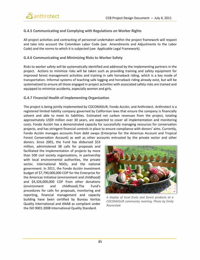
CCB Project Design Document – July 4, 2011
85
G.4.5 Communicating and Complying with Regulations on Worker Rights All project activities and contracting of personnel undertaken within the project framework will respect and take into account the Colombian Labor Code (see Amendments and Adjustments to the Labor Code) and the norms to which it is subjected (see Applicable Legal Framework).
G.4.6 Communicating and Minimizing Risks to Worker Safety Risks to worker safety will be systematically identified and addressd by the implementing partners in the project. Actions to minimize risks will be taken such as providing training and safety equipment for improved forest management activities and training in safe horseback riding, which is a key mode of transportation. Informal systems of teaching safe logging and horseback riding already exist, but will be systematized to ensure all those engaged in project activities with associated safety risks are trained and equipped to minimize accidents, especially women and girls.
G.4.7 Financial Health of Implementing Organization The project is being jointly implemented by COCOMASUR, Fondo Acción, and Anthrotect. Anthrotect is a registered limited liability company governed by Californian laws that ensure the company is financially solvent and able to meet its liabilities. Estimated net carbon revenues from the project, totaling approximately US$9 million over 30 years, are expected to cover all implementation and monitoring costs. Fondo Acción has a demonstrated capacity for successfully managing resources for conservation projects, and has stringent financial controls in place to ensure compliance with donors’ aims. Currently, Fondo Acción manages accounts from debt swaps (Enterprise for the Americas Account and Tropical Forest Conservation Account) as well as other accounts entrusted by the private sector and other donors. Since 2001, the Fund has disbursed $53 million, administered 38 calls for proposals and facilitated the implementation of projects by more than 500 civil society organizations, in partnership with local environmental authorities, the private sector, international NGOs, and the national government. In 2011, the Fondo Acción investment budget of $7,790,000,000 COP for the Enterprise for the Americas Initiative (environment and childhood) and $4,326,000,000 COP from other donations (environment and childhood).The Fund’s procedures for calls for proposals, monitoring and reporting, financial management and capacity building have been certified by Bureau Veritas Quality International and ANAB as compliant under the ISO 9001:2008 International Quality Standard.
A display of local fruits and forest products at a COCOMASUR community meeting. Photo by Emily Roynestad.

CCB Project Design Document – July 4, 2011
86
G.5 Legal Status and Property Rights
G.5.1 Relevant Laws and Assurance of Compliance In many parts of the world, local forest communities lack formal rights and title to their traditional territories. Resource tenure is considered essential condition for indigenous and local communities to benefit from REDD (Cotula and Mayers 2009). Law 70 empowers Afro-Colombian collective landholders both bio-culturally and legally, creating an extraordinary legal niche for the development of community-based REDD projects in the Colombian Pacific. Article 6 “In Recognition of the Right of Black Colombians to Collectively Own and Occupy their Ancestral Lands” specifically states that:
“the soils and forests included in the collective titling, ownership will be exercised as a social function with an inherent ecological function… and that the exploitation of the forest for commercial purposes should guarantee the continuity of resources… Land grantees will develop conservation and handling practices that are compatible with ecological conditions. To this end, appropriate models of production should be developed, such as agrosilvopasture, agroforestry, and the like, designing suitable mechanisms to stimulate them and to discourage unsustainable environmental practices.”
Working directly with the collective landholders within the framework established for sustainable resource management by Law 70 has the advantage of clarifying several important stakeholder considerations including:
Who benefits: Community membership in the territory is clear;
What is the traditional authority in the territory? Territorial governance structures are defined in the Law.
What are the customary laws relating to sustainable forest use and management?
What are the rights of the community under international and national law?
What is required to provide FPIC? As legally empowered entities, Afro-Colombian collective territories take decisions about how they will grant rights over their forests through its local governance structures and accordingly to their own protocols of consultation with its constituent members.

CCB Project Design Document – July 4, 2011
87
Table 26: Articles of the Colombian Constitution Relevant to Environmental Services.
Article Scope Implications
Article 8 Protection of cultural and national wealth
Natural and cultural heritage of the Darién region deserve the attention of the state and its citizens.
Article 49 Right to health and a clean environment
The Darién region, due to its marginalization, is characterized by the lowest indicators of health and availability of basic services.
Article 58 The social and ecological function of property
Conservation and protection of natural resources of the region is a task fro all citizens and supercedes individual interests.
Article 63 Inalienable character of the land of ethnic groups and their archaeological heritage
Safeguarding and protection of lands once and currently occupied by indigenous and black communities is a priority in the region
Article 80
Obligation to plan the territory, control and sanction any environmental damage incurred
Legal basis for giving priority to land use planning in the region and to take effective measures to control and repair environmental damage.
Article 80 International cooperatio for ecosystem protection
A region such as the Darién requires policies and efforts to protect it that are transnational in character.
Article 81 Protection of genetic resources The high biodiversity of the region requires regulating commercial activities related to genetic resources.
Law 52 of 1994 Law 52 of 1994 regulates article 342 of the 1991 Constitution and defines the procedures for the elaboration, preparation, approval, and implementation of development plans. It represents the law which most affects the structuring and implementation of sustainable development in the Colombian Darién. In this sense, and although the program stems from a national initiative, departmental and municipal authorities are called on to harmonize their programs, plans and projects for local investment, to be established as part of this proposal. Law 388 of 1997 By this standard, the national government established the mechanisms for municipalities to advance the management of their territories, guiding actions to rational and equitable use of land, the preservation and protection of ecological and cultural heritage, and disaster prevention. The law constitutes a basic tool for planning and managing the physical development of land in each of the municipalities in the country, specifically in regard to land use.

CCB Project Design Document – July 4, 2011
88
In developing their skills, departments will coordinate their policies, guidelines and strategies for physical and territorial management at the departmental level with the programs, projects and actions of the regional and local levels by adopting management plans for all or specific portions of its territory. The municipalities and districts must develop and adopt territorial management plans that regulate land use in urban areas, promote rural development in accordance with the law, optimize use of available land, and coordinate sectoral plans in line with national and departmental policies and plans. Agrarian Reform The Agrarian Reform Act (Law 160 of 1994) for example, partially regulated by Decree 1031 of 1994 defines procedures for voluntary negotiation between farmers and land owners so as to facilitate negotiations and diminish conflict. For events that can not be voluntary negotiation, there is Decree 2666 of 1994 which establishes procedures for rural land acquisitions by INCORA (INCODER). Moreover, to stabilize the situation with respect to the demarcation and delimitation of Los Katíos National Park, indigenous reserves and lands of black communities, areas that now have serious conflicts of possession and territorial dominance, may apply the provisions of Decree 2663 of 1994, which establishes procedures for the acquisition of rural land with these characteristics. Since there are also untitled lands in the region which traditionally do not belong to black or indigenous communities, Decree 00982 of 1996 can be applied in the awarding of these vacant lands, which is also regulated by INCORA (INCODER). Regional Development The environmental planning functions of local authorities are defined in Law 99/93, Articles 64, 65, 66 and 67. They emphasize the need to harmonize regional plans with the national level. In practice, the municipalities use the environmental guidelines outlined in national policies such as the National Development Plan by the Ministry of Environment or other regional environmental authorities, in order to submit projects for local councils. National Parks Resolution 1426 of December, 1996 contains important legislation with respect to regional planning and development of the region given that Los Katíos National Park is included within the Darién Special Management Area. This legislation is an important legal instrument for the reorganization and restriction of activities to prevent colonization as well as monitor forestry activities. However, the development and implementation of these instruments first requires strengthening of regional environmental corporations (Corpourabá and Codechocó) and secondly, from a prior process of consultation and public participation, through which, on the basis of a clear understanding of the possibilities and constraints that characterize the region, defined by consensus strategies for the preservation and protection of natural and cultural heritage, and options for social and economic development to enable communities to achieve a decent standard of living.

CCB Project Design Document – July 4, 2011
89
Additional, more specific rules with respect to legal status and protection categories include: Law 002/59, which regulates aspects of the nation's forest economy and conservation of natural resources, and is the basis of the creation of the Pacific Forest Reserve; Decree 2811/74, particularly Articles 47, 48 and 49 pertaining to the creation of reserves and Decree 0622/77 of Decree 2811/74, which defines different classes of reserves, delimits and defines management criteria, and establishes systems for granting of concessions, rights and obligations of users, prohibitions, penalties, surveillance and control. Frontier Zones The Congress of the Republic passed Law 191 of 1995 which enacts provisions on "Border Zones", seeking primarily to protect human rights and improve the living conditions of communities living in these areas. In the case of the Sustainable Development Programme of the Colombian Darién, this law provides the tools necessary to strengthen integration and cooperation with Panama, with the prior consent of the Chocó Department Assembly and Council of the four municipalities. Part of this Law is dedicated to the preservation and sustainable exploitation of natural resources, which means it can be an additional policy tool to advance environmental conservation and restoration. Article 4, for example, defines the municipalities of Unguía, Acandí, Juradó, Turbo, and Riosucio as border municipalites eligible for the benefits provided by the Act. Article 8 in particular protects the traditional knowledge associated with genetic resources that indigenous communities have developed in the frontier areas. Thus, this rule enables the protection of botanical and zoological knowledge and promotes patenting with the Ministry of Development thereby potentially opening new sources of funds for indigenous communities. Also relevant is Article 9, regarding "areas of parks and nature reserves and other special forest located in the border areas” and Article 20, which mandates special protection of the cultural manifestations of indigenous and local communities.

CCB Project Design Document – July 4, 2011
90
G.5.2 Approval from Relevant Authorities Black collective and indigenous territories have the authority to develop and implement forest conservation plans, programs and projects. This territorial autonomy allows for issuing regulations to control deforestation and for conservation in line with the strategies of the Ministry of the Environment and regional environmental authorities (WWF 2009). Act 99 of 1993 assigns Indigenous entities the same roles and duties regarding environemental issues as municipalities, which were empowered by the 1991 constitution to regulate land use within their jurisdictions. The existing national legal framework determines the obligation of the communities in the project area, and their compliance with the procedures established for the collective title of "Land of Black Communities, " according to Law 70 of 1993, Decree 1745 of 1995 and Decree 1300 of 2003 before the Colombian Institute for Rural Development - INCODER. The Special Prosecutor for Ethnic Affairs of the Attorney General's Office, the legal representative of the applying Community Council and the legal representatives of the adjacent Community Councils are also involved in the titling process. Once the collective title is granted to the community, the newly established territory must prepare and approve its plan of ethnic development through the bodies established internally by the community (See Figure 12 below). The highest authority in a community council is the General Assembly which represents all the interests of its members and Board of the Council who is responsible for conducting and executing the instructions issued by the General Assembly.
Figure 12: COCOMASUR Governance Structure.
CCB Project Design Document – July 4, 2011
91
G.5.3 Guarantees Regarding Property Encroachment The project will not encroach uninvited on private property, community property, or any other government property. The project will only undertake activities on areas previously defined through an internal territorial ordering ordenamiento territorial process approved by the local community authorities through official acts. This exercise will determine the exact geographic coordinates of all project activities within the territory and the resulting plan and activities will be the subject of a new and specific legal agreement that determines where project activities are permitted. This agreement will be signed by the legal representative of the territory after approval of the plan and the agreement by the high council.
G.5.4 Guarantees Regarding Involuntary Resettlement The project activities will not involve the resettlement of any communities or households. The project activities will not involve the resettlement of any communities or households. The collective territory where project activities are undertaken is not located in the populated areas corresponding to the 9 local councils and their respective 31 villages where the members of the territory live. Since there is a clear separation of individual from collective land, there is no threat of resettlement due to project activities because individual land is outside of the collective territory. The project will not exclude members of the territory from the project area nor impede the continuation of cultural and livelihood activities from continuing. It is the aim of the project, in fact, to encourage increased visits to the territory and a recovery of these practices to sustain territorial identity and protect the forest resources.
G.5.5 Identification and Mitigation of Illegal Activities The territory will undertake to identify and mitigate any illegal activities that occur within the project area with pre-defined protocols as per the approved territorial land use plan and subsequent Specific Agreement referred to in G5.3. that outlines project activities, their locations and sanctions. Protocols for responding to illegal activities will be devised in the planning process and approved by the high council in coordination with relevant local authorities. Illegal activities such as illicit crop production are not an anticipated threat. The presence of the project and the level of community organization that accompanies it will create a strong disincentive for the incursion of paramilitaries or other armed groups involved in illicit crop cultivation. Collective territories found to be growing illicit crops stand to have their land titles revoked. The adaptive management approach will allow for ongoing adjustments to the management plan in the event of new types of illegal activities or actions required to prevent and address them. Yearly action planning processes designed in communities with assistance from technical committees will allow for improved strategies and more efficient management as the project evolves.

CCB Project Design Document – July 4, 2011
92
G.5.6 Land Tenure Status and Carbon Rights The environmental services (soils and forests) generated on the lands of black communities that have been granted collective titles as Afro-Colombian collective territories are the property of the community landholders, according to Article 6 of Law 70 of 1993. The activities that are developed within the framework of this project are captured in the Framework Collaboration Agreement previously cited and its protocol agreements, such as the Specific Agreements that serve to define the areas of intervention and the actions within the territory that are generated within the project.
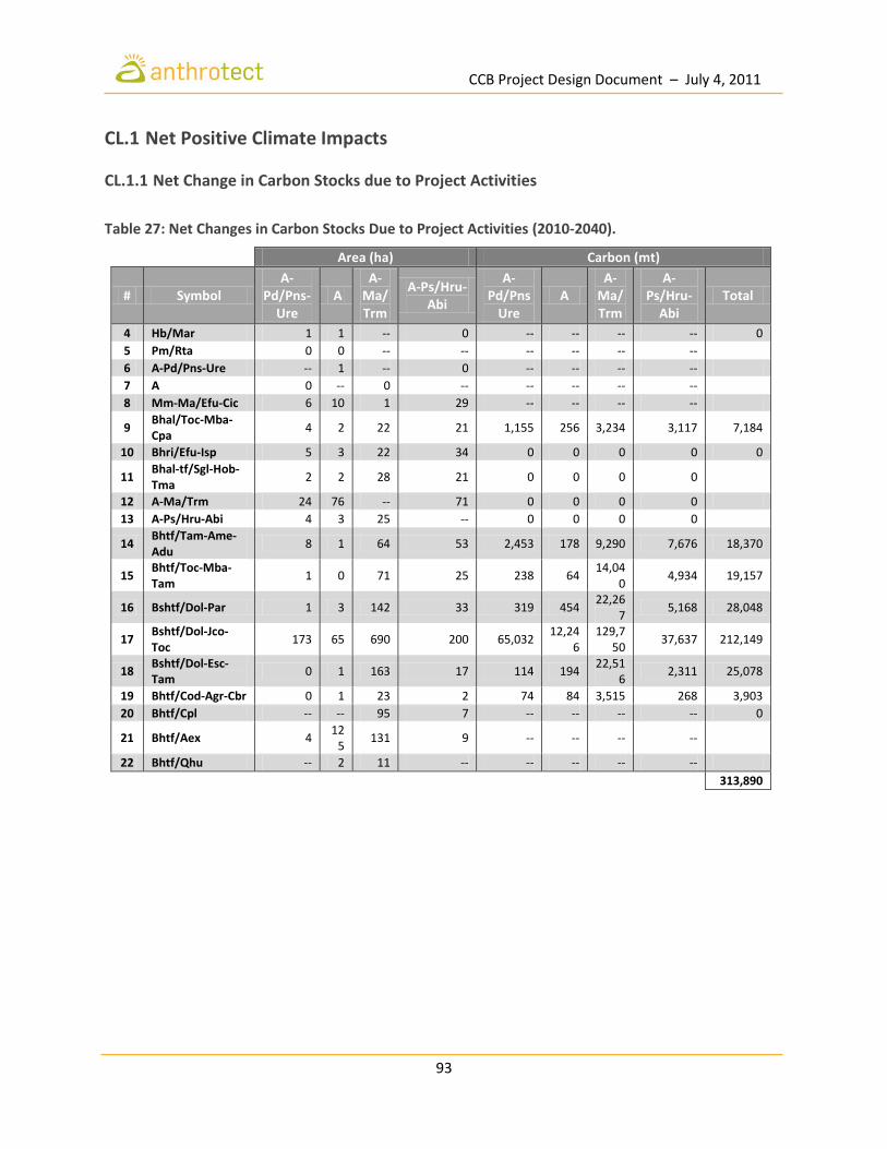
CCB Project Design Document – July 4, 2011
93
CL.1 Net Positive Climate Impacts
CL.1.1 Net Change in Carbon Stocks due to Project Activities
Table 27: Net Changes in Carbon Stocks Due to Project Activities (2010-2040).
Area (ha) Carbon (mt)
# Symbol A-
Pd/Pns-Ure
A A-
Ma/Trm
A-Ps/Hru-Abi
A-Pd/Pns
Ure A
A-Ma/Trm
A-Ps/Hru-
Abi Total
4 Hb/Mar 1 1 -- 0 -- -- -- -- 0
5 Pm/Rta 0 0 -- -- -- -- -- --
6 A-Pd/Pns-Ure -- 1 -- 0 -- -- -- --
7 A 0 -- 0 -- -- -- -- --
8 Mm-Ma/Efu-Cic 6 10 1 29 -- -- -- --
9 Bhal/Toc-Mba-Cpa
4 2 22 21 1,155 256 3,234 3,117 7,184
10 Bhri/Efu-Isp 5 3 22 34 0 0 0 0 0
11 Bhal-tf/Sgl-Hob-Tma
2 2 28 21 0 0 0 0
12 A-Ma/Trm 24 76 -- 71 0 0 0 0
13 A-Ps/Hru-Abi 4 3 25 -- 0 0 0 0
14 Bhtf/Tam-Ame-Adu
8 1 64 53 2,453 178 9,290 7,676 18,370
15 Bhtf/Toc-Mba-Tam
1 0 71 25 238 64 14,04
0 4,934 19,157
16 Bshtf/Dol-Par 1 3 142 33 319 454 22,26
7 5,168 28,048
17 Bshtf/Dol-Jco-Toc
173 65 690 200 65,032 12,24
6 129,7
50 37,637 212,149
18 Bshtf/Dol-Esc-Tam
0 1 163 17 114 194 22,51
6 2,311 25,078
19 Bhtf/Cod-Agr-Cbr 0 1 23 2 74 84 3,515 268 3,903
20 Bhtf/Cpl -- -- 95 7 -- -- -- -- 0
21 Bhtf/Aex 4 12
5 131 9 -- -- -- --
22 Bhtf/Qhu -- 2 11 -- -- -- -- --
313,890

CCB Project Design Document – July 4, 2011
94
CL.1.2 Net Change in Emissions of Non-CO2 Gases No net change in emissions in Non-Co2 gases is forseen as a result of the project. Deforestation and degradation are not significant sources of non-CO2 gases such as CH4 and N2O. For this reason they have not been included in calculations for the with project scenario because they amount to less than 5%. The adoption of forest patrol and monitoring, agroforestry, and forest management activities will not produce an increase of these gases. Forest patrol, monitoring and management activities will entail increased travel within the territory, but by horse or mule, which are the most common form of transport used as they are the most effective and safest for the terrain. Furthermore, their natural diet of grass and forage maintains their digestive health, unlike cattle ranching that is often associated with increased CH4 emissions from grain-based diets. There is no cattle ranching occurring or allowed within the project area, though future research on CH4 emissions in the project zone will be considered given the extensive conversion of forests for this purpose.
CL.1.3 Other GHG Emissions from Project Activities No burning is planned as part of project activities, since there is no need for construction of fire breaks, for example, in such a wet region. The largest predicted source of project emissions from the project activities are those generated from electricity, vehicles and flights by Anthrotect staff outside of the project area. These emissions are still estimated to be well below 1% of the total project carbon benefits. Agricultural activities are not planned within the project area, therefore no significant sources of N2O emissions are forseen as a result of the project’s activities.
CL.1.4 Net Climate Impact of the Project Without considering leakage, the project is expected to prevent the emission of an estimated 1,460,000 mtCO2e over the 30 year project lifespan, representing a clear positive climate impact.
CL.1.5 Avoiding Double Counting The carbon credits generated from the project will be registered under the Voluntary Carbon Standard and sold under that mechanism. Credits from the project will not be registered or sold under any current regulatory scheme, as these schemes currently only allow for Afforestation or Reforestation credits to be sold. If and when the credits become eligible under a regulatory scheme, the proper procedures will be taken to ensure that credits are not sold twice. In addition, Anthrotect (as the Seller and aggregator of credits) maintains an agreement with community landholders to ensure that credits are only sold by Anthrotect so that duplicate sales of the same credits cannot occur.

CCB Project Design Document – July 4, 2011
95
CL.2 Offsite Climate Impacts
CL.2.1 Determination of Types and Extent of Leakage Due to the nature of the project being implemented within a collective territory in which participatory land use planning determines areas for project and other activities that serve to mitigate leakage such as agricultural intensification, agroforestry, IFM, and green mining. This overarching strategy of investing in forest-friendly livelihoods that decrease reliance on deforestation and degradation-causing activities serves to prevent a substantial amount of leakage from occurring due to activity shifting to an area outside of the project. Furthermore, the territory and its members are not likely to shift activities to an area outside of their collective title which they do not own and is most often owned by private landholders who are encroaching onto land within the collective territory to expand cattle ranching. It is more likely that the expansion of neighboring large cattle ranches will be halted because of the project’s patrolling activities and the disincentive created by more organized territorial entities. The territorial management plan will define all land and forest management activities, and address the potential sources of leakage by building in targeted preventative measures into the project design. As a result, leakage is expected to be negligible. Types of leakage may include:
1. Shifting cultivation - Traditional practices of shifting cultivation and clearing or felling to open up new areas for subsistence farming are probable causes of leakage that have been identified and will be addressed in the project’s territorial planning and organization processes. The project explicitly aims to organize agricultural land use within the territory to improve yields, and preserve forest.
2. Displacement of cattle ranching - The expansion of cattle ranching in the project zone is a
significant cause of deforestation. Large and powerful private landholders have converted forest into pasture at alarming rates, including illegally encroaching onto the territory. Large-scale ranching is not a desired activity within the project area, so the most likely type of leakage caused by the project would be the displacement of ranching expansion by private landholders into areas outside of the leakage belt and perhaps to other regions where communities are less organized and vulnerable to illegal encroachment and purchases.
3. Displacement of selective logging - There is significant reliance on selective logging by members of the territory for their own livelihoods. A lack of other viable alternatives is the main cause, making it a priority to create other opportunities for these members of the community in project activities such as forest protection and monitoring, improved forest management and FSC certified wood products, and reforestation and regeneration. It is not likely that because of the project the logging will be undertaken outside the project area due to the arduous conditions that have kept current logging to a relative minimum compared to other regions where there is greater access to rivers and roads.

CCB Project Design Document – July 4, 2011
96
4. Displacement of selective logging by migrants - The project could result in migrant loggers moving to other regions where they can log illegally, however this is not a common occurrence in the project area.
5. Selective logging for local use –Selective logging will not decrease as a result of the project, but will occur within a designated managed forest with reduced impacts and will be better organized in the territory’s land use plan.
CL.2.2 Documentation and Quantification of Leakage Mitigation The risk of leakage will be minimized through design of specific project activities that improve livelihoods alternatives and reduce the need for clearing new land areas for cultivation. These include forest patrols, forest and biodiversity monitoring, reforestation, regeneration and enrichment planting, and agroforestry and agricultural activities, including improving the efficiency of existing farm and pasture land (Table 28).
Table 28: Activities Designed to Mitigate Leakage.
CL.2.3 Subtracting Project-Related Leakage from Carbon Benefits We are confident in or expection that the mitigation measures outlined above will result in positive and additional climate benefits in the territory and will not result in a shifting or displacement of activities within or outside of the territory, but rather will lead a transition into new occupations in support of the project.
CL.2.4 Inclusion of Non-CO2 Gases in Calculations Non-CO2 gases account for far less than 5% of emissions, and are easily offset by mitigation activities described in CL1.1.
Leakage Risks Mitigation Actions
Shifting cultivation
Development of a territorial sustainable land management plan will demarcate areas for community agriculture activities using improved techniques and inputs that decrease pressure for expansion within the territory.
Displacement of cattle ranching
Designated areas for community grazing and enrichment planting to improve soil quality and fodder on existing community pasturelands. Territorial boundary demarcation and patrols to prevent encroachment by neighboring ranchers.
Displacement of selective logging
Direct employment in project activities such as protection and IFM activities or in community businesses started by the project such as agro-forestry, certified wood products, or independent micro-businesses.

CCB Project Design Document – July 4, 2011
97
CL.3 Climate Impact Monitoring
CL.3.1 Plan for Selecting and Monitoring Carbon Pools Estimates of carbon stocks and changes in the project area thus far include only above-ground tree biomass (estimated on the basis of local allometric equations using fixed plot sampling) and below-ground tree biomass (estimated using the IPCC 2006 root to shoot ratio for tropical forests). In order to ensure that activities planned for the project area do not result in unanticipated GHG emissions and in order to minimize leakage, the project partners are developing a comprehensive plan for monitoring a broader range of carbon pools (most importantly above-ground non-tree biomass, but also including soil, leaf-litter, and below ground non-tree biomass). These pools will be sampled on an annual basis using standard statistical sampling methodologies that gaurantee a sufficient degree of certainty. At the same time, the project will estimate carbon stocks and changes for natural and intervened land cover classes that were not included in the present analysis, such as shrublands, grasslands, and pasture.
CL.3.2 Development of a Full Monitoring Plan Project emissions reductions and their associated social and environmental benefits will be monitored through a transparent platform integrating state of the art remote sensing with community participation on the ground. Community forest patrols will be trained and employed to collect monitoring data on the forest and its biodiversity and submit regular reports, building on traditional practices such as the territorial discovery excursions (reconocimiento del territorio) carried out every few weeks by COCOMASUR. On-the-ground field monitoring will be complemented with space-based high-resolution satellite imagery (ASTER 1:25,000 and Quickbird 1:10,000) and remote sensing using light detection and ranging (LIDAR) and RADAR methods developed by Dr. Greg Asner at the Carnegie Institute for Science. Novel methods for integrated space and terrain-based monitoring developed at the the National University of Colombia, and the Colombian Institute for Hydrology, Meteorology, and Environmental Studies (IDEAM) will enable state-of-the-art measurements and mapping in this notoriously cloudy region. Anthrotect and its partners commit to developing a full plan for monitoring carbon pools in the project area within 6 months of validation against the CCB standards. An open monitoring platform through a partnership with Carnegie Institution and Google Earth for the storage and display of forest biodiversity and carbon data will enable external donors, policymakers and the global public to understand the ecosystem services being provided by the communities, as well as ensure transparency and wide distribution of the data to the scientific community and greater public.
CLAS images of deforestation. Asner Lab, Department of Global Ecology, Carnegie Institution.

CCB Project Design Document – July 4, 2011
98
CM.1 Net Positive Community Impacts
CM.1.1 Methodologies for Assessing Community Impacts The stakeholder engagement process initiated in the community workshops in 2010 initiated a mechanism for defining the vision of each community, identifying the barriers to achieving these aspirations, and formulating strategies for addressing underlying obstacles. The results from these workshops indicate preliminary priorities for development and perceived opportunities for alternative livelihoods investments and actions to arrest deforestation. This initial information will serve to shape the strategic plan and action planning processes within the territory commencing in June. The results of these workshops are described in more detail in Section G3.8 on Stakeholder Consultation. Positive Community Impacts The socio-economic impacts from this project that enables landholders to generate a revenue stream linked to the carbon value of conservation and reforestation activities are expected to be transformational for the communities of the COCOMASUR territory. The project will finance a range of activities that will yield socio-economic and cultural development dividends including:
Strengthened territorial governance structures;
Improved capacity for collective land management;
Improved access to basic health and education services;
Expanded opportunities for vocational training and secondary education;
Expansion of internet and mobile phone coverage;
Resolution and prevention of land disputes;
Investments in green commodity production (agro-forestry, NTFP, medicinal and aromatic plants, artisanal gold mining, sustainable ranching);
Improved access to markets for green products and for existing stable crops;
Improved agricultural yields and food security;
Reinforced dignity, territorial autonomy and traditional ways of life; The project will directly benefit members of the territory by:
Continuing to engage with local communities as co-creators of the project in the design and development of its strategies and activities;
Investing in local councils, community associations and enterprises to undertake sustainable forest management, monitoring and administration activities;
Strengthening land tenure of Afro-Colombian collective territories and raising the profile of collective landholder models for REDD in the Colombian Pacific.
Generating a revenue stream from the carbon values of conservation and reforestation activities that the territory will reinvest in forest protection and restoration employment, health facilitities and schools, improved agricultural systems, establishment of small enterprises for agro-forestry, non-timber forest products and medicinal and aromatic plants;
CCB Project Design Document – July 4, 2011
99
It is clear from the stakeholder engagement process that without a project, several outcomes are likely, including:
increasing conflict with migrants, other members of the territory (usufruct rights) and potentially with large agricultural interests backed by armed actors;
conversion of forest into pasture, agriculture land and increasingly uncontrolled logging resulting in deterioration of environmental services and livelihoods;
accelerated logging of forests enabled by the completion of the Pan-American highway;
growing poverty and social marginalization and further weakened capacity of local governance institutions in the territory to respond;
loss of a globally-unique forest and its biodiversity. The project will work in alliance with municipal and regional environmental agencies as well as with other local stakeholders. Beyond enhancing tenure security within the territory including definition of usufruct rights, the project will create direct and indirect employment opportunities, funds for community enterprises and infrastructure initiatives, and resources for building territorial governance over the project’s 30-year life time.
CM.1.2 Demonstration of Neutral or Positive Impact on HCV Areas The principal assumption underlying the project is that other outside investments would not approach a scale that would allow for major development, and those that did arrive, would be a continuation of a predatory political-economic resource model that is incomparable with the Chocó-Darien Conservation Corridor project in terms of socio-economic impact, environmental destruction and conflict risk. The expansion of a predatory economic model seen in other parts of the Chocó that converts forest to banana plantation or cattle ranches, such as has been observed in Urabá, would bring enormous ecological cost and devastating socio-economic impact as well as preventing any real chance to empower the collective territory to develop according to its ethno-development plan and carry out its governance responsibilities established by the Law 70. The expansion of large cattle ranches that occupy neighboring regions in the project zone, would increase forest and biodiversity loss, further compact soils and change the water table—effects which are already being seen as a result of ranches established within the last 10 years. Similarly grim is the scenario where accelerated deforestation along the planned Pan-American Highway occurs. All of these potential “investment” models would not actually serve to further the vision of the COCOMASUR territory for its own development, and would neither engage with the territory as an equal partner in the co-creation of the project nor in the sharing of its proceeds. We are confident that this ‘global’ project will raise the profile of Afro-Colombian collective landholders at the national level, bringing attention to the long-neglected and poorest region in the country, and will serve to attract resources from donor agencies and NGOs to collaboratively facilitate climate compatible ethno-development in the Pacific.

CCB Project Design Document – July 4, 2011
100
Increased adaptive capacity and mitigation of disasters from flooding Another major assumption is that without the project, deforestation along river banks and at the source of watersheds would continue to pose risks for downstream residents. Communities have identified reforestation activities along riverbanks and upstream sources as a first level priority because of the recognized urgency of reducing vulnerability to flooding that threatens the homes of communities along their banks.

CCB Project Design Document – July 4, 2011
101
CM.2 Offsite Stakeholder Impacts
CM.2.1 Identification of Negative Offsite Stakeholder Community Impacts We do not forsee any major negative offsite stakeholder impacts as a result of the REDD project because the areas outside the territory are mostly owned by private landowners, mostly large ones, who came to the region and speculated land to clear for cattle ranches. These operations have no legal basis on which to occupy or ‘lease’ land belonging to the territory. Whereas 10 years ago during the period of most intense conflict and displacement, abandoned or ‘empty’ lands were opportunistically inhabited or ‘purchased’ for agriculture by such buyers, the return process and subsequent consolidation of territorial land claims deters further illegal incursions. As for the migrants who live in the vicinity of the project area, there are no forseen negative impacts as there lands are not affected. In some community workshops, they have participated and it is likely they will take part in implementation of some project activities as they have shown enthusiasm for the model and many consider themselves and are considered to part of the Afro-Colombian community having lived in the community for many years, adopted a similar lifestyle and in many cases have Afro-Colombian partners and families. These dynamics of defining who belongs to the territory and how migrants will be integrated into the project will continued to be defined as part of the territorial governance strengthening process. The most likely scenario is that since deforestation and degradation occurs by the activities of members of the territory, the provision of alternative, forest-friendly sources of income to local community members (including ‘naturalized’ migrants) will result in a transition out of those activities and not their displacement.
CM.2.2 Offsite Impact Mitigation Strategies As mentioned in CM 2.1, migrants have already been welcomed into the project planning and consultation process as members of the community and will continue to participate on a voluntary basis. Their participation is welcomed, and the governing bodies of the territory see this as a very positive dynamic, and will further define and formalize territorial membership processes and mechanisms for the participation of non-Afro-Colombian residents who desire to participate in the project’s activities. The project team will continue to dialogue with migrant families to inform them of management areas and rules as they develop as part of a broader communication strategy in the region to raise awareness about the project’s activities, boundaries and encourage the interest in neighboring territories. Radio, signage, meetings and education campaigns will be used to communicate the initiatives underway. Anthrotect hopes that the project will generate sufficient interest among neighboring cattle ranchers in the carbon revenue model to be able to develop pilot initiatives for a sustainable ranching model as a second phase of the project. Such agricultural intensification projects are critical for relieving pressure on the region’s forests and to meet growing demand for meat and leather products in the national and international markets.
CCB Project Design Document – July 4, 2011
102
CM.2.3 Demonstration of Neutral or Positive Impact on Other Stakeholder Groups As outlined above, there are no offsite negative impacts forseen as a result of this project on other stakeholders, which by design aims to shift the economic base of the collective territory to a forest-friendly, climate-compatible model. The policy and disposition towards migrants living alongside members of the territory is one of inclusion and good will, as they are seen as part of the community.

CCB Project Design Document – July 4, 2011
103
CM.3 Community Impact Monitoring
CM.3.1 Selecting Community Indicators for Monitoring The project partners have identified preliminary variables to be monitored on a regular basis and will integrate these indicators into the territorial census survey in the next 2 months. The months as the strategic plan and project action plans are developed. The overall project monitoring plan will be managed as a separate activity, but will integrate the indicators from community action plans to reflect local impact measuring priorities and facilitate a streamlined data collection process. The project objectives to monitor include:
Social impacts (participation in the project, project knowledge, attitudes and practices (KAPs), health, gender, identity);
Economic (employment, income from forest-related activities, new livelihoods);
Institutional/governance (natural and financial resource management capacity, conflict resolution);
Biodiversity (rare and endangered species, habitat and forest types, HCVs);
Carbon stocks and forest condition. The territory will also develop its statistical database and data collection plan for territorial governance in general. The project will continually aim to adjust its monitoring plans to emerging REDD++ guidelines.
CM.3.2 Assessing Effectiveness of High Conservation Value Monitoring Data collection on HCV areas will be given special attention in the biodiversity monitoring plan to assess if there are any negative impacts from the project in HCVs of high value in terms of community needs and tradition, and rare, endangered and threatened species and forest types. The monitoring will conducted by forest patrols and through the traditional activity, “reconocimientos territoriales” (territorial appreciation treks) to visit and survey locations within the territory. Species monitoring techniques will be integrated into these treks, to enable data collection and monitoring of key species and habitat status. The practice of reconocimientos territoriales themselves will also be documented and assessed as an indicator of HCV6 regarding maintenance of forest-related culture. To measure the ability of HCVs to meet basic community needs, such as providing timber and non-timber forest products, medicines, and drinking water, focus groups, interviews and field surveys will be used.
CM.3.3 Community Impact Monitoring Timeline Within six months of validation against the Standards a full and detailed monitoring plan will be developed based on the initial community impact monitoring plan. Anthrotect and COCOMASUR will conduct the necessary trainings with all project communities on the plan as well as with the monitoring teams. The development of the monitoring framework and plan will be initiated in July after the Strategic Planning process. The monitoring plan will be disseminated to the communities in the territory and the results will be made public on the project website. Project investments in telecommunications infrastructure will enable the use of SMS communication systems using software such as Frontline® that enables immediate reporting on project activities with a GIS layer for mapping.

CCB Project Design Document – July 4, 2011
104
B.1 Net Positive Biodiversity Impacts Forest cover and biodiversity are expected to decline progressively as a result of degradation and conversion in the without-project scenario. The loss of species and erosion of the quality of the forest ecosystems will be systematically addressed by the project to result in a net-positive gain for biodiversity in the project area. The areas of forest are refuges for the many species of mammals, amphibeans, and birds found in the area, many of which are migratory species which will have a positive-spill-over effect into the project zone as migratory habitat is protected and enhanced.
B.1.1 Methodologies Used to Estimate Changes in Biodiversity Methodologies will be developed for monitoring biodiversity that bridge traditional ecological knowledge and practices with cost-effective, field-based monitoring systems that meet international standards. The development of the system will involve biologists with expertise in the region’s flora and fauna from the national university and community development practitioners undertaking participatory action research and planning methods to design a system that is locally owned and builds on already-existing practices and knowledge. Gaps will be identified and integrated into the community monitoring, reporting and verification protocol. Technical support will be provided to ensure that biodiversity assessments and monitoring methodologies meet both local and international objectives. The biodiversity monitoring program will include routine observation and data collection of key indicator species for which there is a baseline, as well as species that are traditionally hunted or poached. Other methods such as photographic evidence, field surveys and qualitative interview methods will be employed.
B.1.2 Demonstration of Neutral or Positive Effect on HCVs The objective of the project is the conservation of existing forests and their spectacular biodiversity through the strengthening of formal territorial governance and protection measures, and restoration of degraded areas. As such, areas of High Conservation Value will be enhanced, and not negatively affected. Many IUCN listed species previously cited will be positively affected as a result of preservation of habitat and its regeneration. Biodiversity inventories and community-based monitoring protocols are being developed to fuse traditional values and practices with the requirements of global forest monitoring and biodiversity standards. Local ownership of the project further guarantees the flourishing of HCVs, as indigenous forest management is much broader than reducing degradation and conversion. In addition, it provides other valuable environmental services, and importantly as people go back into their territory, they are reconnecting with their ancestry, their family, and passing on traditional ecological knowledge and fulfilling deep-rooted obligations.
COCOMASUR consultation in the community of Peñaloza, Acandí. Photo by Emily Roynestad.
CCB Project Design Document – July 4, 2011
105
B.1.3 Identification of Tree Species to be Planted by the Project Trees planted in the project area will be indigenous species wherever possible, with an emphasis on those required for forest regeneration and those known for their multiple values by the community. Enrichment planting will be carried out in areas that are identified as priority due to logging or degradation during the coming months as part of planned forest and biodiversity baseline planning and territorial ordering activities. The territory is eager to determine these priorities and devise concrete plans to assist the regeneration of degraded areas and indigenous tree species. Species that have become rare such as níspera, may be planted within the collective territory as well as on family use lots to support household income.
B.1.4 Adverse Effects of Non-Native Species in the Project Area The conservation of existing forests through the establishment of formal governance and protection measures, flood management and restoration of degraded areas will prioritize native species endemic to the biogeographic region. Fruit trees such as mango are commonly planted in the project area and provide livelihoods benefits that reduce dependence on agriculture. These trees do not carry diseases that threaten native species in the project region. The project will focus primarily on increasing production of the more than 40 endemic and near-endemic fruit tree species in the Chocó but the suggestion for non-native species that already occur in the project area such as mango will be incorporated to reduce consumption of threatened native species and support subsistence crops and local livelihoods.
B.1.5 Guarantee to Use No Genetically Modified Organisms In accordance with its commitment to protecting anfd enhacing the unique biological diversity of the Darién region, this project will neither use nor introduce genetically-modified organisms (GMOs). Agricultural components of the project such as agro-forestry initiatives within the project area will adhere to this policy as well.

CCB Project Design Document – July 4, 2011
106
B.2 Offsite Biodiversity Impacts
B.2.1 Identification of Potential Negative Offsite Project Impacts The project will have overwhelmingly positive impacts on biodiversity both within and outside of the project area due to the increased amount of secure habitat available. Migratory birds and aquatic mammals, such as the leatherback turtles, for example, will benefit from the security of their part-time habitat, implying increases in turtle populations, for example, who nest on beaches in the project area.
B.2.2 Mitigation Strategies for Potential Negative Offsite Biodiversity Impacts Local ownership of the project will ensure that any potential negative offsite impacts to communities in regards to use and access to biodiversity and forest resources will be mitigated, if not positively affected. Ownership in this project refers not simply to job creation but rather towards the extension of responsibility towards the care of the forest that members of COCOMASUR feel. This distinction recognizes the existence of territorial governance and customary mechanisms that already serve to protect local values and culture and will be integrated into biodiversity management plans. Sustainable harvesting methods for NTFPs will form part of capacity building, and value medicinal species will similarly be protected from over-harvest and cultivation in home gardens encouraged as part of the education efforts to maintain knowledge of their use, propogation and potential trade. Any species that are found to be scarce or endangered will be regulated accordingly. Wood products for home and community use will similarly be managed collectively according to the territorial ordering plan, and will not cause displacement of demand. In-demand species for these uses may be planted in anticipation of future demand.
B.2.3 Unmitigated Negative Offsite Biodiversity Impacts As previously described, there are no expected unmitigated negative biodiversity impacts given the community-driven nature of the project and the exceptional benefits expected from forest conservation on the great wealth of flora and fauna in the project zone.

CCB Project Design Document – July 4, 2011
107
B.3 Biodiversity Impact Monitoring
B.3.1 Biodiversity Monitoring Plan The provisional biodiversity monitoring framework is an integrated ecosystem approach framework developed by Orlando J. Rangel based on criteria and indicators applied in the study, “An Integrated Evaluation of the Colombian Darién” by Fundación Natura (Fundación Natura, et al. 2000; Rangel-Ch., et al. 2004). The system is a holistic framework that integrates ecological, social and political analyses to propose strategies for conservation and development that are viable from both social and environmental perspectives, and permits the development of territorial planning that respect cultural autonomy and the values of the distinct groups who live there. The ecosystem approach is an integrated strategy to manage land, water and living resources and that promotes conservation and sustainable use in a equitable manner (UNESCO 2000). The strategy seeks balance between the three principles that underpin the Convention on Biological Diversity: conservation, sustainable use and equitable benefit-sharing. The monitoring scheme developed will adhere to this commitment and the implementation of Colombian accord 052-013/01 between the Ministry of the Environment, Development and Housing (SECAB), and the Institute of Natural Sciences at the National University of Colombia to implement the ecosystem approach in Colombia. The application of an ecosystem approach to biodiversity monitoring and management in Colombia is described in the following tables, which comprise the parameters of the projects’ integrated monitoring plan.

CCB Project Design Document – July 4, 2011
108
Table 29: Framework for Monitoring “Ecosystem Integrity”.
Criteria Indicator
Structure and composition of the ecosystem
Climatic units
Geomorphological units
Hydrological units
Aquatic ecosystem units
Flora species
Fauna species
Endemic flora and fauna
Vegetation communities
Dominant species
Associated species
Distribution of populations
Threatened species
Landscape patterns
Diversity and structure of habitat
Ecosystems (richness and diversity)
Structure of plant skeletons
Population structure
Fragmentation
Ecosystem Functioning
Type of land use
Ecological processes on the landscape scale
Disturbances
Inter-species interactions
Changes in demographic processes
Life histories
Changes in ecological processes and the ecosystem and community scales
Source: (Rangel-Ch., et al. 2004)

CCB Project Design Document – July 4, 2011
109
Table 30: Framework for Monitoring “Sustainable Environmental Supply”.
Criteria Indicator
Ecosystem Health
Invasive species
Presence of contaminants
Changes in the conservation/state of soil
Changes in watercourses
Changes in number of waterfalls and streams
Goods and services provided by the ecosystem
Biomass
Basal area
Cover (of forest and vegetation)
Population density
Changes in population functions (reproduction, growth, survival)
Changes in species dominance
Changes in species density
Changes in carrying capacity
Source: (Rangel-Ch., et al. 2004)
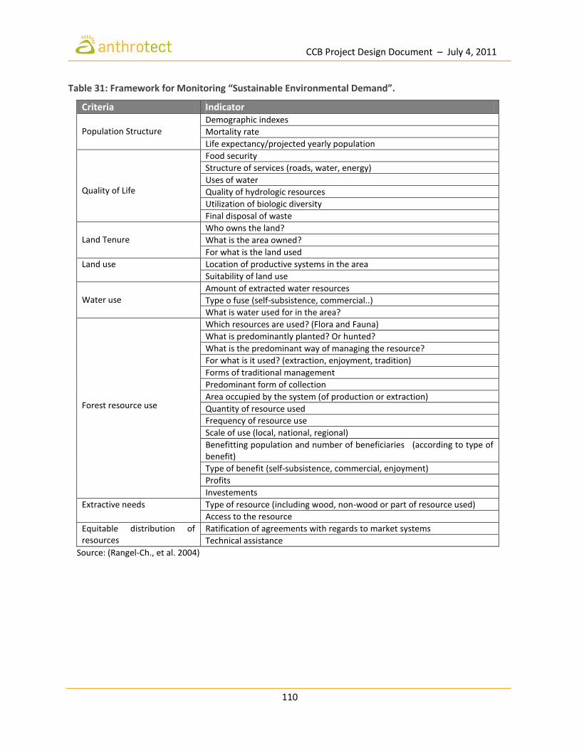
CCB Project Design Document – July 4, 2011
110
Table 31: Framework for Monitoring “Sustainable Environmental Demand”.
Criteria Indicator Population Structure
Demographic indexes
Mortality rate
Life expectancy/projected yearly population
Quality of Life
Food security
Structure of services (roads, water, energy)
Uses of water
Quality of hydrologic resources
Utilization of biologic diversity
Final disposal of waste
Land Tenure
Who owns the land?
What is the area owned?
For what is the land used
Land use Location of productive systems in the area
Suitability of land use
Water use
Amount of extracted water resources
Type o fuse (self-subsistence, commercial..)
What is water used for in the area?
Forest resource use
Which resources are used? (Flora and Fauna)
What is predominantly planted? Or hunted?
What is the predominant way of managing the resource?
For what is it used? (extraction, enjoyment, tradition)
Forms of traditional management
Predominant form of collection
Area occupied by the system (of production or extraction)
Quantity of resource used
Frequency of resource use
Scale of use (local, national, regional)
Benefitting population and number of beneficiaries (according to type of benefit)
Type of benefit (self-subsistence, commercial, enjoyment)
Profits
Investements
Extractive needs Type of resource (including wood, non-wood or part of resource used)
Access to the resource
Equitable distribution of resources
Ratification of agreements with regards to market systems
Technical assistance
Source: (Rangel-Ch., et al. 2004)

CCB Project Design Document – July 4, 2011
111
Table 32: Framework for Monitoring “Political and Institutional Capacity”.
Criteria Indicator Geopolitical structure of the territory Municipalities, towns, and villages
Decision-making capacity
Inter-institutional links with resources an population
Jurisdiction of environmental authorities (governmental and non-governmental)
Established community groups
Other groups with power (guerilla, paramilitary)
Possession of territorial areas
Technical and professional capacity of local institutions
Interinstitutional coordination
Local capacity to develop proposals
Management policies
Efficiency and efficacy of resource management
Normative framework in relation to renewable natural resources
Norms for resource management
Conservation policies
Existence of territorial ordering plans
Land distribution
Land tenure
Operationality and application of norms
Situations of conflict generated by use of natural resources
Incentives and/or regulations
Organizational capacity and participation of local communities
Forms of association
Number of community organizations
Forms of distribution of benefits derived from the use of natural resources.
Source: (Rangel-Ch., et al. 2004).

CCB Project Design Document – July 4, 2011
112
Table 33: Framework for Monitoring “Cultural Visions, Uses, and Practices”.
Criteria Indicator Ethnic and cultural diversity
Population and settlements in the area over time
Cultural patrimony
Areas of environmental importance
Popular celebrations
Maintenance of cultural and ancenstral practices
Myths and customs around resource use
Natural resource management practices
Continuity of vegetative cover
Mosaic patterns of use
Protection of cultural and natural patrimony
Prevention of illicit sale of cultural or natural goods
Source: (Rangel-Ch., et al. 2004)
B.3.2 Assessment of Monitoring Plan Effectiveness The project will collaborate with a range of scientists from institutions such as the National University of Colombia (Universidad Nacional de Colombia), the University of Antioquia (Universidad de Antioquia), the Technological University of the Chocó (Universidad Tecnológica del Chocó), Stanford University, the Institute for Environmental Studies of the Pacific (IIAP), and the Humboldt Institute to continually adapt and evaluate the status of biodiversity and the protocols used to measure its changes.
B.3.3 Commitment to Biodiversity Monitoring Plan Timeline The project commits to finalizing the community-based biodiversity monitoring plan within six months of project certification.

CCB Project Design Document – July 4, 2011
113
GL.1 Climate Change Adaptation Benefits
GL.1.1 Likely Regional Climate Change Variability Heavy and extended rains triggered by La Niña phenomenon have affected 900,000 hectares of land to be affected in 28 of 32 departments, 200,000 people affected this year. Since the beginning of the rainy season in April 2010 almost 3 million people have been affected nationwide. In the Chocó department, the poorest in the country, and which experiences seasonal flooding, is sixth in order of magnitude of affected persons (OCHA 2011). This is a region with some of the highest rainfall rates in the world, but the intensified rains this year have taken a toll on communities who are familiar with flooding. The increasing frequency of the rains and flooding and the longer duration amount to worsening weather patterns and a more extreme La Niña phenomenon. Without forest cover to act as a buffer to catastrophic destruction from these weather events, which will in turn affect biodiversity and habitat. Project activities such as reforestation along degraded areas critical for watershed maintenance, flood protection and erosion control will assist communities to adapt to worsening weather patterns such as this years’ rainy season which has yet to end—and rather has begun again.
GL.1.2 Identification of Risks to the Project and Mitigation Strategies Conservation of biodiversity in this globally significant and unique biogeographic region relies on maintaining and enhancing the diverse types of forest that are found here despite a changing climate. The high level of endemism will require research and actions to better understand patterns of species occurrence as well as the effects of shifting climatic conditions on the 15 different types of forest—some of which are already threatened and found no where else in the world. Conserving and enhancing forest cover is a strategy to safeguard species adaptation, especially at higher elevations where temperatures are cooler.
GL.1.3 Demonstration that Climate Change Impacts Communities and Biodiversity Soil damaging erosion is expected to increase with heavy season rains and will severely affect communities who depend on farming to meet their basic needs. Farmers are already affected by floods that have caused increasing loss of livelihood this year as crops of banana and yucca were submerged and fields waterlogged. Without the project, deforestation would exacerbate the annual rainy season and cause even greater loss of life and livelihoods, further degrading the unique ecosystems.
GL.1.4 Demonstration that Project Activities Assist in Climate Change Adaptation The implications of the REDD+ project for Cocomasur will be cross-cutting, increasing resilience of the forests themelves, and of its people and institutions. The mitigation activities of REDD+ activities will enable adaptation in several ways: Cost-effective investment in hydrological functioning that reduces vulnerability By protecting its forests and enhancing their resilience through improved forest management and assisted regeneration and reforestation, the project will provide synergies that reduce the current and vulnerability to climate change faced by the local population and species that rely on the forests for
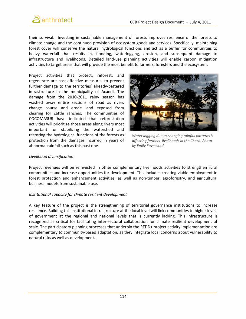
CCB Project Design Document – July 4, 2011
114
their survival. Investing in sustainable management of forests improves resilience of the forests to climate change and the continued provision of ecosystem goods and services. Specifically, maintaining forest cover will conserve the natural hydrological functions and act as a buffer for communities to heavy waterfall that results in, flooding, waterlogging, erosion, and subsequent damage to infrastructure and livelihoods. Detailed land-use planning activities will enable carbon mitigation activities to target areas that will provide the most benefit to farmers, foresters and the ecosystem. Project activities that protect, reforest, and regenerate are cost-effective measures to prevent further damage to the territories’ already-battered infrastructure in the municipality of Acandí. The damage from the 2010-2011 rainy season has washed away entire sections of road as rivers change course and erode land exposed from clearing for cattle ranches. The communities of COCOMASUR have indicated that reforestation activities will prioritize those areas along rivers most important for stabilizing the watershed and restoring the hydrological functions of the forests as protection from the damages incurred in years of abnormal rainfall such as this past one. Livelihood diversification Project revenues will be reinvested in other complementary livelihoods activities to strengthen rural communities and increase opportunities for development. This includes creating viable employment in forest protection and enhancement activities, as well as non-timber, agroforestry, and agricultural business models from sustainable use. Institutional capacity for climate resilient development A key feature of the project is the strengthening of territorial governance institutions to increase resilience. Building this institutional infrastructure at the local level will link communities to higher levels of government at the regional and national levels that is currently lacking. This infrastructure is recognized as critical for facilitating inter-sectoral collaboration for climate resilient development at scale. The participatory planning processes that underpin the REDD+ project activity implementation are complementary to community-based adaptation, as they integrate local concerns about vulnerability to natural risks as well as development.
Water logging due to changing rainfall patterns is affecting farmers’ livelihoods in the Chocó. Photo by Emily Roynestad.

CCB Project Design Document – July 4, 2011
115
GL.2 Exceptional Community Benefits
GL.2.1 Demonstration that the Project is in a Low Human Development Area Afro-Colombian communities in the Chocó are among the most politically and economically marginalized in Colombia, making them extremely vulnerable to industrial natural resource extraction and agricultural pressures that have degraded forests. Palacio (2009) observes that, despite Colombia’s impressive economic growth in recent decades, the Chocó may still be characterized as a pre-modern society compared with the rest of the country according to the criteria of Gosling & Taylor (2005). First, in 2005, more than 57% of the population still lived in rural settings as peasants working in small-scale units of production. Second, the Chocó region exhibits one of the lowest shares of industrial production in the country, contributing only 0.38% of GDP in 2005 and with a declining annual growth rate since 1990. Third, despite democratic elections, political lords remain in power and fail to provide the minimum basic public goods such as health, education and utilities (Bonet 2007). Indeed, indicators of health and wellbeing in the Chocó are among the worst in the country. DANE (2007) figures indicate that infant mortality among males declined from 104 per 1000 in 1985 to 86 per 1000 in 2005, but still remains roughly double the national average. In 2005, some 76% of the inhabitants of the Chocó had “basic unmet needs”, the highest percentage of any department in the country and roughly four times the national average (DANE 2009).
GL.2.2 Demonstration of Project Benefits to Poorest Communities Bio-cultural community protocols There is a desperate need for development funding in the region and there are great hopes that REDD can deliver such benefit. The community-led model is designed to deliver much-needed income and development opportunities without exclusion of communities from the project area. In fact, it endeavors the opposite—to mobilize communities to undertake a host of activities--both traditional and newly designed—that support and complement the project. Through these actions, the linkages between communities and their forests are sustained and the community’s bio-cultural way of life can continue for future generations. Reinforcing Afro-Colombian identity and practices is essential for the long-term success of the project and for the scalability of the model. These traditional systems of forest maintenance have come under threat after decades of conflict and displacement and are now being recuperated, bolstered by the collective property rights granted to the territory by the Law 70. While these formal proprietary rights are certainly a critical element in the ability of REDD to succeed and deliver benefits, they must be coupled with strengthened community autonomy to determine how best to protect forests while enabling them to live according to their bio-cultural values.
GL.2.3 Demonstration of Neutral or Positive Impact on Vulnerable Households The project model enables communities to pick and choose the suite of land-use systems that best fits their vision, and complement the terrain, culture and lifestyle of the individual community. This will guarantee a net positive impact for the households in the project, and those who are vulnerable, as

CCB Project Design Document – July 4, 2011
116
participation channels are designed to serve the needs of the community as a whole and specific groups such as youth, women, elders, returnees, etc.
GL.2.4 Demonstration of Neutral or Positive Impact on Disadvantaged Groups The initial visioning process undertaken in all communities determines what land-use systems fit within a community‘s vision and lifestyle, and ensure that project activities do not compromise community goals—including on those most vulnerable. The strong emphasis on participatory planning takes into account groups that may be negatively affected. This planning process safeguards long-term economic and social sustainability of the project, emphasizing progressive diversification of revenue streams and governance capabilities of the territory, its high councils, and its local councils. Disadvantaged groups, such as women, are integrated into the planning process with a specific effort to integrate, or mainstream, their needs into the plans and monitor the projects’ impacts. Efforts will be made to promote and prepare women to take on leadership roles in territorial and project governance and implementation, as well as in the formulation of gender-specific initiatives and interventions. The impact of the project on these groups is expected to be positive, if not transformative.
GL.2.5 Community Monitoring of Disadvantaged Groups A distinguished feature of this project is the strengthening of territorial governance that will enable equitable benefit distribution and important advances in the economic, social and cultural situation of its residents. One of the key features anticipated by the community is resources to conduct a socioeconomic survey in the form of a census. In a region considered on par with the poorest countries in the world, such as Haiti and Burundi, in terms of satisfaction of basic necessities, these revenues from carbon sequestration will provide the ability identify the most disadvantaged households and ensure project benefits not only reach them, but that the mechanisms for participation in the project are easily accessible (Antón-S. 2004). Without the project, Afro-Colombian territories like COCOMASUR face uncertain futures since their institutions are underfunded and weak, unable to cope with the multiple and complex demands of its constituents who live in a state of poverty affected by recent conflict and violent displacement. Community leaders are eager to have resources available to construct a monitoring system to measure advances in social, economic, and cultural development among all the groups in the territory, including those determined to be most vulnerable and disadvantaged.
Members of the Rio Tolo Community Council (COCOMASUR), Acandí, Chocó. Photo by Emily Roynestad.

CCB Project Design Document – July 4, 2011
117
GL.3 Exceptional Biodiversity Benefits
GL.3.1 Demonstration of High Biodiversity Conservation Priority The project will directly contribute to protecting and potentially enhancing populations of IUCN Red List Critically endangered (CR), and Endangered (EN) species that are present in the project zone. Critically Endangered (CR) species include the Colombian Spider Monkey (Ateles fusciceps rufiventris), Cotton-top tamarin (Saguinus oedipus), Central American tapir (Tapirus bairdii), Kemp’s Ridley Sea Turtle (Lepidochelys kempii), Hawksbill Sea Turtle (Eretmochelys imbricata), Harlequin Frog (Atelopus varius), La Loma Tree Frog (Hyloscirtus colymba), Lemur Leaf Frog (Agalychnis lemur), and Leatherback Sea Turtle (Dermochelys coriacea). Endangered (EN) species found in the project zone include the Darien small-eared shrew (Cryptotis mera), Myers’ Surinam toad (Pipa myersi), Loggerhead Sea Turtle (Caretta caretta), Green Turtle (Chelonia mydas).

CCB Project Design Document – July 4, 2011
118
References Acosta-S. M. 1970. La selva del noroccidente ecuatoriano. Revista de la Academia Colombiana de
Ciencias Exactas, Físicas y Naturales 13(52):499-533. Alberico M, editor. 1993. La zoogeografía terrestre. Bogotá, D.C.: Instituto Nacional de los Recursos
Naturales Renovables y del Ambiente (INDERENA), Departamento Nacional de Planeación (DNP), Global Environment Facility (GEF), Programa de las Naciones Unidad para el Desarrollo en Colombia (PNUD- COL)
Fondo para la Protección del Medio Ambiente "José Celestino Mutis" (FEN). 232-239 p. Antón-S. J. 2004. Dinámicas sociales del Chocó Biogeográfico. In: Rangel-Ch. JO, editor. El Chocó
Biogeográfico. Bogotá: Instituto de Ciencias Naturales. p 887-910. Aprile J. 1993. Poblamiento, Hábitats y Pueblos del Pacífico. Cali: Universidad del Valle. Arellano-P. H. 2011. Estudio de deforestación evitada en áreas del Caribe Colombiano, una guía
metodológica para comprender el impacto de la intervención antrópica y su efecto sobre las coberturas naturales. (en preparación).
Arellano-P. H, Rangel-Ch. JO. 2008. Patrones en la distribución de la vegetación en áreas de páramo de Colombia: Heterogeneidad y dependencia espacial. Caldasia 30(2):355-411.
Arellano-P. H, Rangel-Ch. JO. 2009. Patrones de distribución de las especies dominantes en la vegetación de la Serranía de Perijá, sectores norte y centro. In: Rangel-Ch. JO, editor. Media y baja montaña de la serranía de Perijá. Bogotá. D. C.: Universidad Nacional de Colombia. p 323-364.
Arellano-P. H, Rangel-Ch. JO. 2010. Fragmentación y estado de conservación en páramos de Colombia. In: Rangel-Ch. JO, editor. Cambio global (natural) y climático (antrópico) en el páramo Colombiano. Bogotá, D. C.: Universidad Nacional de Colombia.
Bonet J. 2007. ¿Por qué es pobre el Chocó? Cartagena: Banco de la República - Centro de Estudios Económicos Regionales (CEER). 68 p.
Brown S. 1997. Estimating Biomass and Biomass Change of Tropical Forests: A Primer. Rome: FAO. 55 p. Camacho-A E, Benito B. 2008. Evaluación de la amenaza sísmica en Panamá. Ciudad de Panamá:
Universidad de Panamá. Cardenas-Torres M. 2006. Estimación de la deforestación por cultivos ilícitos en la zona de la Reserva
Forestal del Río Magdalena. Revista Colombia Forestal 9(19):136-154. Castaño-M. OV, Cárdenas-A. G, Hernández-R. E, Castro-H. F. 2004. Reptiles en el Chocó Biogeográfico.
In: Rangel-Ch. JO, editor. El Chocó Biogeográfico / Costa Pacífica. Bogotá, D. C.: Universidad Nacional de Colombia-UNIBIBLOS, Conservación Internacional. p 597-631.
Castaño-Mora OV, editor. 2002. Libro rojo de reptiles de Colombia. Bogotá, D.C.: Instituto de Ciencias Naturales - Universidad Nacional de Colombia / Ministerio del Medio Ambiente.
Cepeda Espinosa MJ. 2009. Protección de los derechos fundamentales de la población afrodescendiente víctima del desplazamiento forzado, en el marco del estado de cosas inconstitucional declarado en la sentencia T-025 de 2004. In: Colombia CCd, editor. Auto 005. Bogotá.
Chapman FM. 1917. The distribution of bird-life in Colombia. Bulletin of the American Museum of Natural History 48:1-1169
Coates AG, Collins LS, Aubry MP, Berggren WA. 2004. The Geology of the Darien, Panama, and the late Miocene-Pliocene collision of the Panama arc with northwestern South America. Bulletin of the Geological Society of America 116(11/12):1327-1344.
CODHES. 2008. Cifras de Desplazamiento Forzado: Tasa por cada 100 mil habitantes por departamentos de llegada (1999-2005). Bogotá: Consultoría para los Derechos Humanos y el Desplazamiento.
CCB Project Design Document – July 4, 2011
119
Cossio U. 1994. Memoria Explicativa del Mapa Geológico Generalizado del Departamento del Chocó, Escala 1:600.000. Santa Fe de Bogotá. 46 p.
Cotula L, Mayers J. 2009. Tenure in REDD: startpoint or afterthought? London: International Institute for Environment and Development.
Cuatrecasas J. 1946. Vistazo a la vegetación natural del bajo Calima. Revista de la Academia Colombiana de Ciencias Exactas, Físicas y Naturales 7:306-312.
Cuatrecasas J. 1958. Aspectos de la vegetación natural de Colombia. Revista de la Academia Colombiana de Ciencias Exactas, Fisicas y Naturales 10:221-668.
Cuesta-Ríos E, Valencia-Mazo J, Jiménez-Ortega A. 2007. Aprovechamiento de los vertebrados terrestres por una comunidad humana en los bosques tropicales (Tutuendó, Chocó, Colombia). Revista Institucional Universidad Tecnológica del Chocó 26(3):37-43.
DANE. 2005. Colombia: Censo General 2005. Bogotá: Departamento Administrativo Nacional de Estadística, Dirección de Censos y Demografía.
DANE. 2007. Conciliación Censal 1985-2005. Bogotá: Departamento Administrativo Nacional de Estadística.
DANE. 2009. Resultados Fase 1: Empalme de las Series de Mercado Laboral, Pobreza y Desigualdad. Bogotá: Departamento Administrativo Nacional de Estadistica.
Davis SD, Heywood VH, Herrera-MacBryde O, Villa-Lobos J, Hamilton AC. 1997. Centres of plant diversity: A guide and strategy for their conservation. Cambridge: WWF & IUCN Publications Unit.
Duellman WE, Trueb YL. 1994. Biology of amphibians. Baltimore: The Johns Hopkins University Press. Duque-Goodman F. 1988. Observaciones sobre la captura de tortugas marinas por un buque arrastrero
camaronero en aguas someras del Pacífico colombiano. Trianea 2:351–372. Eslava-Ramírez JA. 1994. Climatología del Pacífico colombiano. Nueva EG, editor. Bogotá: Academia
Colombiana de Ciencias Geográficas. Ferguson BD. 2010. Life History and Livelihood Strategies in the Colombian Chocó. Stanford, CA:
Stanford University. 142 p. Forero E, Gentry AH. 1989. Lista anotada de las plantas del departamento del Chocó, Colombia. Bogotá:
Universidad Nacional de Colombia. 138 p. Fundación Natura, Universidad Nacional de Colombia, Universidad de Antioquia. 2000. Evaluación
Integrada del Darién Colombiano. Bogotá: Fundación Natura. CD-ROM p. Gentry A. 1977. Endangered Plant Species and Habitats of Ecuador and Amazonian Peru. In: Prance G,
Elias T, editors. Extinction is Forever. Bronx: New York Botanical Garden. p 136-149. Gentry A. 1985. Contrasting phytogeographic patterns of upland and lowland Panamanian plants. In:
D'Arcy W, Correa-A. M, editors. The Botany and Natural History of Panama. St. Louis: Missouri Botanical Garden. p 147-160.
GloVis. 2011. U.S.G.S Global Visualization Viewer. EROS, U.S. Geological Survey Golley F, McGinnis J, Clements R, Child G, Duever M. 1975. Mineral Cycling in a Tropical Moist Forest
Ecosystem. Athens: Univ. Georgia Press. González J, Marín L. 1989. Problemas geológicos asociados a la línea de costa del Departamento del
Chocó: geomorfología y riesgos geológicos. Bogotá. Gosling R, Taylor S. 2005. Principles of Sociology. London: London School of Economics. Govea C, Aguilera H. Cuencas Sedimentarias de Colombia; 1985. p 1-93. GRASS Development Team. 2010. Geographic Resources Analysis Support System (GRASS) Software.
Version 6.4.0: Open Source Geospatial Foundation. Haffer J. 1959. Notas sobre la Avifauna de la región de Urabá. Lozania 12:1-49.

CCB Project Design Document – July 4, 2011
120
Haffer J. 1967. Hornero Zoogeographical notes on the “nonforest” lowland bird fauna of northwestern South America 10:315-333.
Hernández-Camacho J, Adriana Hurtado G, Rosario Ortiz Q, Walschburger T. 1992. Unidades biogeográficas de Colombia. In: Halffter IG, editor. La Diversidad Biológica de Iberoamérica. México, D.F.: Instituto de Ecología, A.C. p 105-151.
Herrera-MacBryde O. 1997. Darien Province and Darien National Park. In: Davis S, Heywood V, Herrera-MacBryde O, Villa-Lobos J, Hamilton A, editors. Centres of Plant Diversity: A Guide and Strategy for Their Conservation. Cambridge: IUCN.
Howard SM, Lacasse JM. 2004. An evaluation of gap-filled Landsat SLC-off imagery for wildland burn severity mapping. Photogrammetric Engineering and Remote Sensing 70:877–880.
INCODER. 2005. Los Cultivos de Palma de Aceite en los Territorios Colectivos de las Comunidades Negras de los Ríos Curvaradó y Jiguamiandó, en el Departamento del Chocó. Bogotá: Instituto Colombiano de Desarrollo Rural, Ministerio de Agricultura y Desarrollo Rural.
INVIAS. 1999. Dimensionamiento Técnico y Operativo del Desarrollo Sostenible del Darién Colombiano. Bogotá: Instituto Nacional de Vías. 95 p.
IPCC, editor. 2003. Good Practice Guidance for Land Use, Land-Use Change and Forestry. Lewis WH. 1971. High floristic endemism in low cloud forests of Panama. Biotropica 3:78-80. Lobo-Guerrero A. 1993. Hidrología e Hidrogeología. In: Leyva P, editor. Colombia Pacifíco. Bogotá: Fondo
para la Protección del Medio Ambiente A José Celestino Mutis - FEN. p 120-134. Lookingbill TR, Urban DL. 2005. Gradient analysis, the next generation: towards more plant-relevant
explanatory variables. Canadian Journal of Forest Research 35:1744-1753. Lynch JD. 2006. The amphibian fauna in the Villavicencio región of Eastern Colombia. Caldasia 28(1):135-
155. Lynch JD, Suárez- Mayorga A. 2004. Anfibios en el Chocó biogeográfico. In: Rangel-Ch. JO, editor. Costa
Pacífica - El Chocó Biogeográfico. Bogotá, D.C.: Instituto de Ciencias Naturales. p 633- 667. Mantilla-Meluk H, Jiménez-Ortega A. 2006. Estado de Conservación y Algunas Consideraciones
Biogeográficas sobre la Quirópterofauna del Chocó Biogeográfico Colombiano. Revista Institucional de la Universidad Tecnológica del Chocó 25:10-17.
Marín Marín GA, Álvarez de Uribe MC, Rosique Gracia J. 2004. Cultura alimentaria en el municipio de Acandí. Boletín de Antropología 18(035):61-72.
Martínez JO. 1993. Geomorfología. In: Leyva P, editor. Colombia Pacífico. Santafé de Bogotá: Fondo para la Protección del Medio Ambiente A José Celestino Mutis - FEN. p 110-119.
Mathworks. 2007. MATLAB Statistical Software Package. Version R2007a. Natick, MA. McCune B, Mefford MJ. 1999. PC ORD, Multivariate Analysis of Ecological Data. Version 3.05.
Gledeneden Beach: MJM Software. Medem F. 1962. La distribución geográfica y ecología de los Crocodylia y Testudinata en el
Departamento del Choco. Revista de la Academia Colombiana de Ciencias Exactas, Físicas y Naturales 2(14):279-303.
Mello B, Zuercher GL. 2005. Speothos venaticus. Mammalian Species 783:1-6. Meyer H, Velásquez A. 1993. Costa Pacífica, amenaza y riesgo sísmico. Bogotá: Red de Estudios Sociales
en Prevención de Desastres en América Latina. Myers N. 1988. Threatened biotas: hotspots in tropical forests. The Environmentalist 8(178-208). OCHA. 2011. Inundaciones 2010-2011. Bogotá: United Nations Office for the Coordination of
Humanitarian Affairs (OCHA). Offen KH. 2003. The Territorial Turn: Making Black Territories in Pacific Colombia. Journal of Latin
American Geography 2(1):43-73.

CCB Project Design Document – July 4, 2011
121
Oslender U. 2004. Fleshing out the geographies of social movements: Colombia's Pacific coast black communities and the [`]aquatic space'. Political Geography 23(8):957-985.
Palacio A. 2009. Living Standards in between 1975 and 2005 in Chocó, Colombia: A demographic approach using four (4) waves of DHS surveys. Lund, Sweden: Lund University.
Pardo M. 1996. Movimientos Sociales y Relaciones Interétnicas en el Pacífico. In: Escobar A, Pedrosa A, editors. El Pacífico Colombiano: Desarrollo o Diversidad. Bogotá: CEREC. p 299-315.
Pineda J, Rodriguez B. 2008. Eumops hansae. Red List of Threatened Species: International Union for Conservation of Nature.
Porter D. 1973. The vegetation of Panama: A Review. In: Graham A, editor. Vegetation and Vegetational History of Northern Latin America. New York: Elsevier. p 167-201.
Prieto-C. A, Rangel-Ch. JO, Rudas-L. A, Gonima-G. L, Serrano H. 2004. La vegetación del Darién colombiano: una aproximación histórica aplicada a la interpretación satelital y videográfica. In: Rangel-Ch. JO, editor. El Chocó biogeográfico / Costa Pacífica. Bogotá: Instituto de Ciencias Naturales. p 1024.
ProForest. 2008. Good practice guidelines for High Conservation Value assessments. Oxford: ProForest. 48 p.
R Development Core Team. 2011. R: A Language and Environment for Statistical Computing. Vienna: R Foundation for Statistical Computing.
Rangel-Ch. JO, editor. 2004a. El Chocó biogeográfico / Costa Pacífica. Bogotá: Instituto de Ciencias Naturales.
Rangel-Ch. JO. 2004b. Notas sobre la riqueza avifaunística en el Chocó Biográfico. In: Rangel-Ch. JO, editor. El Chocó Biográfico / Costa Pacífica. Bogotá, D.C.: Universidad Nacional de Colombia. p 669-677.
Rangel-Ch. JO, Lowy P, editors. 1993. Tipos de vegetación y rasgos fitogeográficos el la Región Pacífica de Colombia. Bogotá: Fondo Protección del Medio Ambiente José Celestino Mutis. 182-198 p.
Rangel-Ch. JO, Orjuela-R. MA, Zambrano H, Andrade-C. MG. 2004. El enfoque ecosistémico aplicado en un estudio de caso: evaluación integrada del Darién colombiano. In: Rangel-Ch. JO, editor. El Chocó Biogeográfico / Costa Pacífica. Bogotá: Instituto de Ciencias Naturales. p 867-885.
Reid F, Helgen K. 2008. Mustela frenata. Red List of Threatened Species: International Union for Conservation of Nature.
Renjifo JM, Solís F, Ibáñez R, Jaramillo C, Fuenmayor Q. 2004. Phyllomedusa venusta. Red List of Threatened Species: International Union for the Conservation of Nature.
Renjifo LM. 1998. Aves amenazadas y casi amenazadas de extinción en Colombia. Informe Nacional sobre el Estado de la Biodiversidad 1997. Bogotá, D.C. : Instituto de Investigación de Recursos Biológicos Alexander Von Humboldt. p 416-426.
Renjifo LM, Franco-Maya AM, Amaya-Espinel JD, Kattan GH, López-Lanús B. 2002. Libro Rojo de aves de Colombia. Bogotá, D.C.: Instituto de Investigación de Recursos Biológicos Alexander von Humboldt / Ministerio del Medio Ambiente.
Rodríguez-Mahecha J, Alberico M, Trujillo F, Jorgenson J, editors. 2006. Libro Rojo de los Mamíferos de Colombia. Bogotá, D.C.: Panamericcana Formas e Impresos, S.A. 433 p.
Roguiguez-Mahecha JV, Rueda-Almonacid JV, Gutierrez TD, editors. 2008. Guia ilustrada de fauna del Santuario de Vida Silvestre Los Besotes: Valledupar, Cesar, Colombia. Bogotá, D.C.: Editorial Panamericana. 574 p.
Romero MD. 1995. Poblamiento y Sociedad en el Pacífico Colombiano: Siglos XVI al XVIII. Cali: Universidad del Valle.
Rueda-Almonacid JV, Lynch JD, Amézquita A, editors. 2004. Libro Rojo de Anfibios de Colombia. Bogotá, D.C.: Panamericana Formas e Impresos S. A. 384 p.
CCB Project Design Document – July 4, 2011
122
Santos Vecino G. 1989. Las étnias indígenas prehispánicas y de la Conquista en la región del golfo de Urabá. Boletín de Antropología 6(22).
Sarria A. 1985. Sismos y riesgo sísmico en Colombia. Lima: CERESIS. 330-371 p. Scaramuzza P, Micijevic E, Chander G. 2004. SLC gap-filled products: Phase one methodology.: U.S.
Geological Survey. Soares-Filho BS, Pennachin CL, Cerqueira G. 2002. DINAMICA – a stochastic cellular automata model
designed to simulate the landscape dynamics in an Amazonian colonization frontier. Ecological Modelling 154:217-235.
Soares-Filho BS, Rodrigues OHC, W. L. 2009. Modelamiento de dinámica ambiental con DINAMICA-EGO. Belo Horizonte: Centro de Sensoriamento Remoto/Universidade Federal de Minas Gerais (CSR/UFMG). 119 p.
Stattersfield AJ, Crosby MJ, Long AJ, Wege DC. 1998. Endemic Bird Areas of the World: Priorities for their Conservation. Cambridge: BirdLife International.
Stewart C, Lindhe A, Cura A. 2010. ProForest REDD + co-benefits and the HCV concept. Oxford: ProForest. 47 p.
Stiles FG. 1998. Las Aves Endémicas de Colombia. Informe Nacional sobre el Estado de la Biodiversidad 1997. Bogotá, D.C.: Instituto de Investigación de Recursos Biológicos Alexander Von Humboldt. p 378-389.
Thornthwaite CW. 1948. An Approach toward a Rational Classification of Climate. Geographical Review 38(1):55-94.
Torres de Araúz R. 1975. Darien: Etnoecología de una región histórica. Ciudad de Panamá: Dirección Nacional del Patrimonio Histórico, Instituto Nacional de Cultura.
Tovar Pinzón H. 1980. Grandes empresas agrícolas y ganaderas del siglo XVIII. Bogotá: Cooperativa de Profesores de la Universidad Nacional.
Uetz P. 2002. The EMBL Reptile Database. Hamburg. UNESCO. 2000. Solving the Puzzle of the Ecosystem Approach and Biosphere Reserves. Paris: UNESCO. Wallace AR. 1876. The Geographical Distribution of Animals, With a Study of the Relations of Living and
Extinct Faunas As Elucidating the Past Changes of the Earth's Surface. New York: Harper and Brothers.
Whitten N. 1986. Black Frontiersmen: Afro-Hispanic Culture of Ecuador and Colombia. Prospect Heights, Illinois: Waveland Press.
WWF. 2009. National Institutional Arrangements for REDD Case Study: Colombia. Bogotá: WWF. Yahner RH. 1988. Changes in wildlife communities near edges. Conservation Biology 2(4):333-339. Zuercher GL, Swarner M, Silveira L, Carrillo O. 2008. Speothos venaticus. Red List of Threatened Species:
International Union for Conservation of Nature. Zuluaga-R. S. 1987. Observaciones fitoecológicas en el Darién colombiano. Pérez-Arbelaezia 1(85-145).

CCB Project Design Document – July 4, 2011
123
Appendix 1. Amendments and Adjustments to the Labor Code Labor Code (adopted by Decree Law 2663 of August 5, 1950 "On the Labour Code,” published in Diario Oficial No. 27,407 of September 9, 1950, by virtue of the State, issued by the Extraordinary Decree No 3518 of 1949). The following amendments and adjustments have since been made to the Labor Code:
1. Law 57 of November 15, 1915, 'Reparations for accidents," published in the Official Gazette No
15646 of 17 November 1915. 2. Legislative Act 1st. September 19, 1940, "amending the Constitution. (Labour Court),” published
in the Diario Oficial No. 24,468 of September 19, 1940. 3. Legislative Act 1st. February 16, 1945, 'reformatory of the Constitution', published in the Diario
Oficial No. 25,769, February 17, 1945. 4. Amended by Law 90 of December 26, 1946, 'which is set by compulsory social insurance and
creating the Colombian Institute of Social Security," published in the Diario Oficial No. 26322 of January 7, 1947.
5. Article 153 of Decree Law 2158 of June 24, 1948, "about proceedings in trials of labor ',
ordered:" To authorize the government to organize a committee to prepare a codification of the substantive provisions of the work or to make a draft Code on the matter, 'published in the Diario Oficial No. 26,754 of June 26, 1948.
6. Legislative Decree 2215 of June 12, 1948, 'which was postponed for the duration of the Decree-
Law No. 2158 of June 24, 1948.', published in Official Gazette No. 26,761 of June 12, 1948. 7. Legislative Decree 2283 of July 6, 1948, 'by issuing rules on collective agreements on working
conditions, "published in the Diario Oficial No. 26,774 of June 22, 1948, was suspended for the Articles 495 and 508 Decree 2663 of 1950.
8. Amended by Law 90 of December 16, 1948, 'which is set by the monetary unit and currency of
national conferred extraordinary powers to the President and other provisions," published in the Diario Oficial 32 467, 29 March 1968.
9. Legislative Decree 4133 of December 16, 1948, 'by which laws are adopted as a provision
"contained in special decrees, issued under Article 121 of the Constitution, published in the Official Journal No 26 896 16 December 1948.
10. Special Decree No 3518 of November 9, 1949, 'which is declared by the disturbance of public
order and under siege throughout the national territory'published in the Diario Oficial No. 27,163 of November 10, 1949.

CCB Project Design Document – July 4, 2011
124
11. Special Decree No 693 of February 28, 1950, 'which is organized by the Commission to formulate the draft Labor Code'published in the Diario Oficial No. 27,273 of 1950.
12. The current Labor Code was adopted by Decree Law No. 2663 of August 5, 1950 "On the Labour
Code, published in the Diario Oficial No. 27,407 of September 9, 1950, under the rule promulgated by Site Extraordinary Decree No 3518 of 1949. Fulfilling the provisions of Article 153 of Decree Law 2158, 1948, 'Labor Code. Authorizes the government to organize a committee to draw up a code of substantive work over the provisions or to make a draft Code on materia'Se gave permanent effect by Law 141 of December 16, 1961.
13. Amended by Decree Law 3743 of December 20, 1950, 'by which amends Decree 2663 of 1950
on the Labour Code, published in the Diario Oficial No. 27,504 of January 11, 1951. In particular Article 46, which states: 'The Ministry of Labor shall make an official edition of the Labor Code."
14. Amended by Decree 904 of April 20, 1951, 'which is issued by a provision on collective
bargaining agreements." published in the Diario Oficial No. 27,601 of May 12, 1951. 15. Amended by Decree Law 905 of April 20, 1951, "Whereby amending Articles 254 and 256 of the
Labour Code, published in the Diario Oficial No. 27,601 of May 12, 1951. 16. The Official Edition of the Labour Code, as amended, required by Article 46 of Decree Law 3743
of 1950, was published in the Diario Oficial No. 27,622 of June 7, 1951, 2663 and compiling Decrees 3743 of 1950 905 of 1951.
17. Amended by Decree 2027 of September 28, 1951, 'which is added by Decree No. 0030 of
January 9, 1951." published in the Official Journal No. 27 730 1951. 18. Amended by Decree 426 of February 21, 1952, 'On which amends Article 3rd. Decree number
2058 of 1951." published in the Diario Oficial No. 27,882 of 1952. 19. Amended by Decree 2017 of August 20, 1952, 'On which dictates certain provisions on the
constitution and jurisdiction of the courts or commissions of conciliation and arbitration and employment procedures." published in the Diario Oficial No. 28,005, 18 September 1952.
20. Amended by Decree 3153 of November 30, 1953, 'By which regulates labor regulations that
apply to certain public employees." published in the Diario Oficial No. 28,367 of December 10, 1953.
21. Amended by Decree 616 of February 26, 1954, 'For that modifies the Substantive and
Procedural Labour', published in the Diario Oficial No. 28,424, of March 5, 1954. 22. Amended by Decree 617 of February 26, 1954, 'On which amends the Labour Code, published in
the Diario Oficial No. 28,424, of March 5, 1954. 23. Amended by Decree 456 of March 2, 1956, 'By which authorizes the collection of fees and other
compensation of a private nature, published in the Diario Oficial No. 28,987 of March 14, 1956.
CCB Project Design Document – July 4, 2011
125
24. Amended by Decree 525 of March 10, 1956, 'On which amends Article 453 of the Labour Code,
published in the Diario Oficial No. 28,991 of March 20, 1956. 25. Amended by Decree 753 of April 5, 1956, “which is replaced by Article 430 of the Labour Code,”
published in the Diario Oficial No. 29,019 of April 25, 1956. 26. Amended by Decree 931 of April 20, 1956, 'By which authoritatively interprets the special
Decree number 456 of 1956." published in the Diario Oficial No. 29,027 of May 7, 1956. 27. Amended by Decree 1761 of July 26, 1956, 'For that modifies the Substantive and Procedural
Labour', published in the Diario Oficial No. 29,110 of August 22, 1956. 28. Amended by Decree Law No. 3129 of December 20, 1956, 'for which are added certain
provisions of the Labor Code." published in the Diario Oficial No. 29,272 of February 2, 1957.34. Amended by Decree 2164 of August 10, 1959, 'which are regulated by Articles 450 and 451 of the Labor Code." published in the Diario Oficial No. 30,038 of September 3, 1959.
29. Amended by Decree No 59 of March 22, 1957, 'by which they join the Notaries and Registrars to
the National Provident Fund and other provisions." published in the Diario Oficial No. 29,330 April 1 1957.
30. Amended by Decree 204 of September 6, 1957, 'By establishing rules relating to trade union,
published in the Diario Oficial No. 29,516 of October 19, 1957. 31. Amended by Decree No 231 of September 25, 1957, 'by which gives a measure of working
hours," published in the Diario Oficial No. 29,517 of October 21, 1957. 32. Amended by Decree No 284 of November 7, 1957 “by issuing rules on wages and benefits for
workers on fixed-price contractors in oil companies," published in the Official Journal No 29 552 4 December 1957.
33. Amended by Decree No 18 of February 6, 1958 “by which dictates a labor provisions," published
in the Diario Oficial No. 29,598 of February 18, 1958. 34. Amended by Decree 2164 of August 10, 1959, 'which are regulated by Articles 450 and 451 of
the Labor Code," published in the Diario Oficial No. 30,038 of September 3 of 1959. 35. Amended by Law 156 of December 21, 1959, “which is returned by the governors of the
departments the power to appoint notaries and registrars,” published in the Diario Oficial No. 30,138 of January 22, 1960.
36. Amended by Law 188 of December 30, 1959, 'for which regulates the apprenticeship contract,"
published in the Diario Oficial No. 30,140 of January 25, 1960. 37. Amended by article 1. Law 141 of December 16, 1961, "which is adopted by the emergency
legislation and enacting other provisions" which adopted as permanent legilación all the
CCB Project Design Document – July 4, 2011
126
legislative decrees issued in reliance on Article 121 of the Constitution, from 9 November 1949 until July 20, 1958, published in the Official Gazette 30694 of 23 December 1961.
38. Amended by Law No. 171 of December 14, 1961, 'By which amends Law 77 of 1959 and other
provisions on pensions," published in the Official Journal No 30 709 1961. 39. Amended by Law No. 1a of January 19, 1962, “which is set for notary fees and other provisions,"
published in the Diario Oficial No. 31,064 of January 25, 1962. 40. Amended by Law 9a April 4, 1963, 'On which issues an exceptional standard for workers affected
by TB," published in the Diario Oficial No. 31,064 of April 22, 1963. 41. Amended by Decree No 99 of January 22, 1965, 'By which measures are taken to ensure the
provision of public services in government and private companies, published in the Diario Oficial No. 31,754 of September 17, 1965.
42. Amended by Decree Law No. 2351 of September 4, 1965, "Whereby are reforms to the Labour
Code, published in the Diario Oficial No. 31,754 of September 17, 1965. 43. Amended by Decree Law No. 2469 of September 17, 1965, 'On which amends Article 35 of
Decree 2351 of 1965 and gives a provision related to employment. "Published in the Diario Oficial No. 31,763 of September 28 1965.50. Amended by Decree No 2076 of November 10, 1967, 'On which regulates Article 18 of the Special Decree 2351 of 1965 and section 30 of the Labor Code. "Published in the Official Journal No 32 377 23 November 1967.
44. Amended by Decree No 1373 of May 26, 1966, 'which are regulated by Article 4, 7th. Sections 9,
14, 15, 9th, 10, 14 paragraph 2, 17, 20, 25, 26, 39 and 40 of the Special Decree 2351 of 1965." published in the Diario Oficial No. 31970 of July 2, 1966.
45. Amended by Decree No 3041 of December 15, 1966, “By approving the rules of the invalidity,
old age and death that takes the ICSS.”, Published in the Official Journal No 32 126 1966. 46. Amended by Law 73 of December 13, 1966, “by which introduced some changes to the Labour
Act, in development of international conventions,” published in the Official Journal of 30 694 December 23, 1961.
47. Extraordinary amended by Decree No 13 of January 4, 1967, 'for which are incorporated into the
Labour Code provisions of Law 73 of 1966, published in the Diario Oficial No. 32,131 of January 25, 1967.
48. Amended by Act 21 of June 14, 1967, 'which was approved by the International Labour
Convention on paid leave in agriculture adopted by the Thirty-Fifth Session of the General Conference of the International Labour Organization (Geneva, 1952),” published in the Official Journal of 26 June 32 253 1967.
49. Amended by Act 22 of June 14, 1967, “which was approved by the International Labour
Convention concerning discrimination in employment and occupation, adopted by the Forty-
CCB Project Design Document – July 4, 2011
127
Second Session of the General Conference of the International (Geneva, 1958),” published in the Official Journal of 26 June 32 253 1967.
50. Amended by Decree No 2076 of November 10, 1967, 'On which regulates Article 18 of the
Special Decree 2351 of 1965 and section 30 of the Labor Code. "Published in the Official Journal No 32 377 23 November 1967.
51. Amended by Law 48 of December 16, 1968, 'why are adopted as permanent legislation some
legislative decrees are granted powers to the President and the Assemblies, introduces reforms to the Labour Code and other provisions , 'published in the Diario Oficial No. 32,679 of December 26, 1968.
52. Amended by Law 3a of October 13, 1969, "by ordering the delivery workers, shoes and clothing
of work, and clarifies the 7th Act of 1967," published in the Diario Oficial No. 32,916 of October 24, 1968.
53. Amended by Law 5 of October 13, 1969, “which is clarified by Article 12 of Law 171 of 1961 and
Article 5 of Law 4 of 1966 and other provisions,” published in the Diario Oficial No. 32,916 of October 24, 1968.
54. Amended by Decree No 1393 of August 6, 1970, 'which is issued by the National Land Transport
Regulations automotive, published in the Diario Oficial No. 33,131 of August 25, 1970. 55. Amended by Law 29 of December 28, 1973, 'By creating the National Notary Fund and other
provisions ", published in the Diario Oficial No. 34,007 of January 25, 1974. 56. Amended by Law 33 of December 12, 1973, “By which they become lifetime pensions of
widows," Published in the Diario Oficial No. 34,007 of January 25, 1974. 57. Amended by Law 27 of December 20, 1974, 'By establishing rules on the establishment and
maintenance of comprehensive care centers for pre-school for children of employees and workers of public and private', published in Diario Oficial No. 34,244 of January 28, 1975.
58. Amended by Law 4 of 1976, "On enacting rules concerning the benefits of public, official, semi-
private and other provisions", published in Official Gazette No. 34,500 of 1976 and is effective as the 1st. January 1976.
59. Amended by the Law on the 6th of 1981, “By which amends Article 161 of the Labor Code,”
published in the Diario Oficial No. 35,687 of January 26, 1981. 60. Amended by Law 20 of January 22, 1982, “On which created the General Directorate of Child
Workers under the Ministry of Labour and Social Security and adopted the Statute of the Child Workers,” published in the Diario Oficial No. 35,937 February 3, 1982.
61. Amended by Law 51 of December 22, 1983, "by which he moved the rest paid for some
holidays." Published in the Diario Oficial No. 36,428 of December 30, 1983.

CCB Project Design Document – July 4, 2011
128
62. Amended by Law 11 of February 24, 1984, 'by which some rules are reformed Substantive and Procedural Codes of Labour," published in the Diario Oficial No. 36,517 of March 5, 1984.
63. Amended by Law 39 of February 5, 1985, 'by which amends the terms for the collective
bargaining process work. "Published in the Diario Oficial No. 36,867 of February 21, 1985. 64. Amended by Article 1. Act 24 of 1986, 'By which is added to Article 236 of Chapter V of the
Labour Code', published in Official Gazette No. 37320 of January 28, 1986. 65. Amended by Act 75 of 1986, 'On which issue tax rules surveying, building and democratization
of capital markets, are granted some special powers and other provisions ", published in the Diario Oficial No. 37,742 of December 24, 1986.
66. Amended by Decree No 776 of April 30, 1987, 'by which amends the table of the evaluation of
disabilities resulting from accidents, contained in Article 209 of the Labour Code, published in the Diario Oficial No. 37,868 5 May 1987.
67. Amended by Decree No 778 of April 30, 1987, 'by which amends the table of occupational
diseases contained in Article 201 of the Labour Code, published in the Diario Oficial No. 37,868 of May 5, 1987.
68. Amended by Law 54 of December 18, 1987, 'by which the National Labor Council', published in
the Diario Oficial No. 38,157 of December 18, 1987. 69. Amended by Decree No 778 of April 30, 1987, 'by which amends the table of occupational
diseases contained in Article 201 of the Labour Code, published in the Diario Oficial No. 37,868 of May 5, 1987.
70. Amended by Law 71 of December 19, 1988, 'why are issued rules on pensions and other
provisions," published in the Diario Oficial No. 38,624 of 22 December 1988. 71. Amended by Decree Law 2737 of November 27, 1989, “which is issued by the Juvenile Code,"
published in the Diario Oficial No. 39,080 of November 27, 1989. 72. Amended by Act 50 of 1990, 'On which introduced reforms to the Labor Code and other
provisions," published in Official Gazette No. 39,618 of the 1st. January 1991. 73. Amended by Law 23 of March 21, 1991, 'By which create mechanisms to decongest Juduciales
Offices and other provisions ", published in Official Gazette No. 39,752 of March 21, 1991. 74. The term 'employer' means replaced by the term 'employer', brackets in accordance with Article
107 of Act 50 of 1990, published in Official Gazette No. 39,618 of the 1st. January 1991. 75. Modificado por la Ley 100 del 23 de diciembre de 1993, 'por la cual se crea el sistema de
seguridad social integral y se dictan otras disposiciones', publicada en el Diario Oficial No. 41.148 del 23 de diciembre de 1993.
CCB Project Design Document – July 4, 2011
129
76. Modificado por la Ley 119 del 9 de febrero de 1994, 'Por la cual se reestructura el Servicio Nacional de Aprendizaje, SENA, se deroga el Decreto 2149 de 1992 y se dictan otras disposiciones.', publicada en el Diario Oficial No. 41.216 del February 9, 1994.
77. Amended by Decree 691 of March 29, 1994, "which are incorporated by public servants, the
General System of Pensions and other provisions," published in the Diario Oficial No. 41,289 of March 30, 1994.
78. Amended by Decree 692 of March 29, 1994, 'By which partially regulates Law 100 of 1993,"
published in the Diario Oficial No. 41,289 of March 30, 1994. 79. Amended by Decree 813 of April 21, 1994, 'On which regulates Article 36 of Law 100 of 1993,"
published in the Official Journal No 41 328 1994. 80. Amended by Decree 1160 of June 3, 1994, “which is complemented by Decree 813 of 1994 and
enacted provisions," published in the Diario Oficial No. 41,385 of June 9, 1994. 81. Amended by Decree 1295 of June 22, 1994, “which is determined by the organization and
administration of the General System of Occupational Hazards," published in the Official Journal no 41405 of June 24, 1994.
82. Amended by Decree 1832 of August 3, 1994, “on which adopts Table of Occupational Diseases,"
published in the Official Journal No 41,473 of 1994. 83. Amended by Decree 1836 of August 4, 1994, 'On which adopts the single table valuation manual
disabilities single disability rating," published in the Official Journal No 41,473 of 1994. 84. Amended by Decree 2709 of December 15, 1994, 'On Regulating the article 7. Law No. 71 of
1988,” published in the Official Journal No 41,635 of 1994. 85. Judgement modified by C-051-95 of February 16, 1995, issued by the Constitutional Court
handed down a ruling of unconstitutionality on Article 252. 86. Judgement modified by C-051-95 of February 28, 1995, issued by the Constitutional Court
handed down a ruling of unconstitutionality on Article 338.90. Amended by Law 278 of April 30, 1996, by which it creates permanent la'Comisión affecting labor and employment created by Article 56 of the Constitution," published in the Official Journal No. 42 783 10 May 1996.
87. Judgement modified by C-450-95 of October 4, 1995, issued by the Constitutional Court handed
down a ruling on the constitutionality of Article 452. 88. Amended by Decree 692 of April 26, 1995, 'On which adopts the Single Manual for the Disability
Rating," published in the Diario Oficial No. 41,826 of April 28, 1995. 89. Judgement modified by C-483 No-95 of October 30, 1995, issued by the Constitutional Court, a
ruling of unconstitutionality. Uttered regarding Article 101.

CCB Project Design Document – July 4, 2011
130
90. Amended by Law 278 of April 30, 1996, by which it creates permanent la'Comisión affecting labor and employment created by Article 56 of the Constitution," published in the Official Journal No. 42 783 10 May 1996.
91. Amended by Law 311 of August 12, 1996, by creating the National Family Protection Registry
and other provisions," published in the Official Journal No. 42855 of August 14, 1996. 92. Articles 452, 453, 454, 455, 456, 457, 458, 459, 460 and 461 of the Code were incorporated into
the Decree 1818 of 1998, 'through which issues the Statute of alternative mechanisms for conflict resolution,” published in Official Gazette No. 43,380 of September 7, 1998.
93. Amended by Act 550 of 1999, 'By which establishes a system which promotes and facilitates
business recovery and restructuring of local authorities to ensure the social role of business and achieve harmonious development of regions and enacted provisions to harmonize the existing law regime with the provisions of this Act”, published in Official Gazette No. 43,836 of December 30, 1999.
94. Amended by Act 584 of 2000, published in Diario Oficial No. 44,043 of June 14, 2000, 'By which
repealing and amending certain provisions of the Labor Code. 95. Amended by Act 755 of 2002, published in Official Gazette No. 44878 of July 25, 2002, 'On which
modifies the paragraph of Article 236 of the Labor Code - Law Mary'. 96. Amended by Act 789 of 2002, published in Diario Oficial No. 45,046 of December 27, 2002, 'by
issuing rules to support employment and expanding social protection and amending some articles of the Labour Code."
97. In the opinion editor for the interpretation of Article 236 Paragraph of this Act must take into
account the provisions of Article 51 of Law 812 of 2003, "On approving the National Development Plan 2003-2006, to an EU state ', published in Official Gazette No. 45,231 of June 27, 2003.
98. Amended by Act 962 of 2005, published in Official Gazette No. 45963 of July 8, 2005, 'By
enacting provisions on streamlining administrative requirements and procedures of state agencies and entities and individuals engaged public functions or providing public services."
99. Amended by Act 995 of 2005, published in Official Gazette No. 46,089 of November 11, 2005,
'By which recognizes the cash payment of rental to private sector workers and employees and workers public administration in different orders and levels”.
100. Amended by Act 1098 of 2006, published in Official Gazette No. 46,446 of November 8, 2006, “issued by the Code for Children and Adolescents.”
101. Amended by Act 1210 of 2008, published in Official Gazette No. 47050 of July 14, 2008, 'By which partially amending articles 448 and 451 section 4 of the Labour Code and 2 of the Labor Code and Social Security and creating Article 129A of the Code of Labour and Social Security and other provisions'.

CCB Project Design Document – July 4, 2011
131
102. Amended by Act 1280 of 2009, published in Official Gazette No. 47223 of January 5, 2009,
“added by paragraph 10 of Article 57 of the Labor Code and set the License for Grief.”
103. Amended by Decree 2566 of 2009, published in Official Gazette No. 47404 of July 8, 2009, “On which adopts Table of Occupational Diseases.”
104. Amended by Law 1429, 2010, published in Official Gazette No. 47,937 of December 29, 2010, “On which issues the Law for the Formalization and Employment Generation.”

CCB Project Design Document – July 4, 2011
132
Appendix 2. Applicable Legal Framework
Number Year Type of Norm Theme Responsible
Agency Description
1991 Constitution
1991 Political Constitution
All Congress Recognized Colombian society as pluralistic and multicultural.
345 1993 Andean Decision
International The Andean Community
Recognize and guarantee the protection of the rights of breeders of new plant varieties by granting a certificate of the breeder, promote research areas and technology transfer.
391 1996 Andean Decision
International The Andean Community
Common regime on access to genetic resources.
486 2000 Andean Decision
Propiedad intelectual
THE ANDEAN COMMUNITY
Common regime on intellectual property.
523 2002 Andean Decision
International THE ANDEAN COMMUNITY
Regional strategy on biodiversity for tropical Andean countries.
684 2008 Andean Decision
Pesticides THE ANDEAN COMMUNITY
Repeal 436 approves the decision on registration and control of agricultural pesticides.
699 2008 Andean Decision
International THE ANDEAN COMMUNITY
environmental indicators in the Andean Community.
622 1977 Decree Ecotourism Congress
By which partially regulates Chapter V, Title II, Part XIII, Book II of Decree-Law number 2811 of 1974 on "National Park System", Law 23 of 1973 and Act 2 of 1959.
1541 1978 Decree
Agriculture, Fisheries, and Ecotourism
MAVDT
Which is regulated by Part III of Book II of Decree - Law 2811 of 1974: "From sea waters" and part of the Law 23 of 1973.
533 1994 Decree Plants Congress On Regulating the Common Regime of Rights of Breeders of New Plant Varieties.
1768 1994 Decree Institutional MAVDT
Which is developed by partially literal h) of Article 116 in relation to the establishment, organization or reform of the Regional Autonomous Corporations special regime created by processing by Act 99 of 1993.

CCB Project Design Document – July 4, 2011
133
1840 1994 Decree General MADR Which is regulated by Article 65 of Law 101 of 1993.
1791 1996 Decree Plants MAVDT Whereby establishing the forestry regime.
900 1997 Decree Plants MAVDT By regulating the Forestry Incentive Certificates conservation.
1401 1997 Decree CITES MAVDT
Which is designated by the Management Authority of Colombia to the Convention on International Trade in Endangered Species of Wild Animals and Plants, CITES, and define its functions.
1420 1997 Decree General MAVDT
Which are designated by the scientific authorities of Colombia to the Convention on International Trade in Endangered Species of Wild Animals and Plants, CITES, "and define its functions.
2967 1997 Decree ALL MAVDT
Whereby the ports are designated as authorized for the international trade in specimens of wild fauna and plants.
3075 1997 Decree Health MPS By which partially regulates Law 09 of 1979 and other provisions.
1320 1998 Decree Prior consultation
MIJ
Through which regulations prior consultation with indigenous and black communities for the exploitation of natural resources within its territory.
125 2000 Decree General MAVDT By which amends Decree 1420 of 1997.
309 2000 Decree Scientific Research
MAVDT On Regulating scientific research on biological diversity.
2687 2002 Decree Plants MADR Whereby amending Article 7 of Decree 533 of 1994.
3199 2002 Decree Institutional Presidency
By which regulates the provision of Mandatory Public Service Direct Rural Technical Assistance under the Act 607 of 2000.
216 2003 Decree Institutional MAVDT
By which the objectives are determined, the structure of the Ministry of Environment, Housing and Territorial Development and other provisions.

CCB Project Design Document – July 4, 2011
134
302 2003 Decree Institutional MAVDT
Which is modified by paragraph 1 of Article 309, second Decree 2000, which regulates scientific research on biodiversity.
132 2004 Decree Biosafety MRE
Which enacts the "Cartagena Protocol on Biosafety to the Convention on Biological Diversity, done at Montreal on January 29, 2000.
3553 2004 Decree Plants MPS Which amends Decree 2266 of 2004 and other provisions.
4525 2005 Decree Biosafety MADR Regulated by Law 740 of 2002.
1498 2008 Decree General MADR Which is regulated by paragraph 3 of Article 5 of Law 99 of 1993 and Article 2 of Law 139 of 1994.
3257 2008 Decree General MAVDT Which partially amends Decree 2269 of 1993 and other provisions.
2811 1974 Decree Law RNR Presidency
Which is issued by the National Code of Renewable Natural Resources and Environmental Protection.
74 1978 Law International Congress Approved the Amazon Cooperation Treaty, signed in Brasilia on July 3, 1978.
17 1981 Law CITES Congress Approved the Convention on International Trade in Endangered Species of Wild Animals and Plants.
29 1990 Law Scientific Research
Congress
Enacted provisions to promote scientific research and technological development and are granted extraordinary powers.
21 1991 Law Indigenous Communities
Congress
Approval of Convention No. 169 concerning indigenous and tribal peoples in independent countries, adopted by the 76th. All reunion of the Conference of the ILO, Geneva 1989.
70 1993 Law Black Communities
Congress Developed by transitory article 55 of the Constitution.
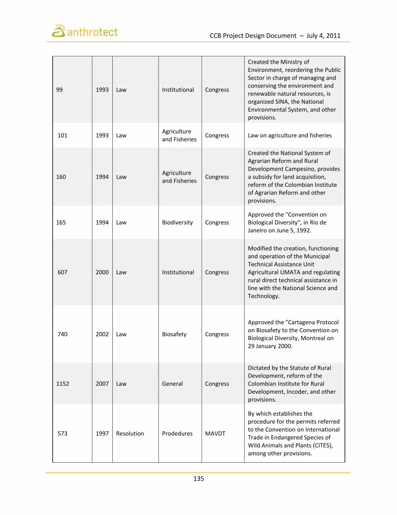
CCB Project Design Document – July 4, 2011
135
99 1993 Law Institutional Congress
Created the Ministry of Environment, reordering the Public Sector in charge of managing and conserving the environment and renewable natural resources, is organized SINA, the National Environmental System, and other provisions.
101 1993 Law Agriculture and Fisheries
Congress Law on agriculture and fisheries
160 1994 Law Agriculture and Fisheries
Congress
Created the National System of Agrarian Reform and Rural Development Campesino, provides a subsidy for land acquisition, reform of the Colombian Institute of Agrarian Reform and other provisions.
165 1994 Law Biodiversity Congress Approved the "Convention on Biological Diversity", in Rio de Janeiro on June 5, 1992.
607 2000 Law Institutional Congress
Modified the creation, functioning and operation of the Municipal Technical Assistance Unit Agricultural UMATA and regulating rural direct technical assistance in line with the National Science and Technology.
740 2002 Law Biosafety Congress
Approved the "Cartagena Protocol on Biosafety to the Convention on Biological Diversity, Montreal on 29 January 2000.
1152 2007 Law General Congress
Dictated by the Statute of Rural Development, reform of the Colombian Institute for Rural Development, Incoder, and other provisions.
573 1997 Resolution Prodedures MAVDT
By which establishes the procedure for the permits referred to the Convention on International Trade in Endangered Species of Wild Animals and Plants (CITES), among other provisions.

CCB Project Design Document – July 4, 2011
136
1367 2000 Resolution Non CITES MAVDT
Establishes the procedure for authorization of import and export of specimens of biological diversity that are not listed in the appendices of the CITES Convention.
438 2001 Resolution Safeguards MAVDT
Establishes safeguards for the national mobilization of specimens of biological diversity.
454 2001 Resolution Plants MAVDT
Which regulates the certification referred to by the first paragraph Article 7th. of Resolution number 1367 of 2000 of the Ministry of Environment.
1029 2001 Resolution Safeguards MAVDT
Assigns the value of evaluation and monitoring services for the issue of safe conduct national mobilization only specimen of biological diversity and other provisions.
3742 2001 Resolution General MAVDT Criteria and conditions for the issuance of Technical Regulations.
584 2002 Resolution Fauna MAVDT Declares which wildlife species are threatened in the country and adopts other provisions.
619 2002 Resolution Safeguards MAVDT
Establishes the National Travel Document for mobilization of primary products from forest plantations, Andean Community modifiThe Resolutions 0438 and 1029 numbers 2001 from the Ministry of Environment, and adoptes other regulations.
562 2003 Resolution General MAVDT
Amends Resolution number 0438 of May 23, 2001 the Ministry of Environment, and adopting other regulations.
572 2005 Resolution General MAVDT Amends Resolution number 0584 of June 26, 2002 and adopts other regulations.

CCB Project Design Document – July 4, 2011
137
1263 2006 Resolution CITES MAVDT
Establishes the procedure and the values to issue the permits referred to in the Convention on International Trade in Endangered Species of Wild Animals and Plants, CITES, and other provisions.
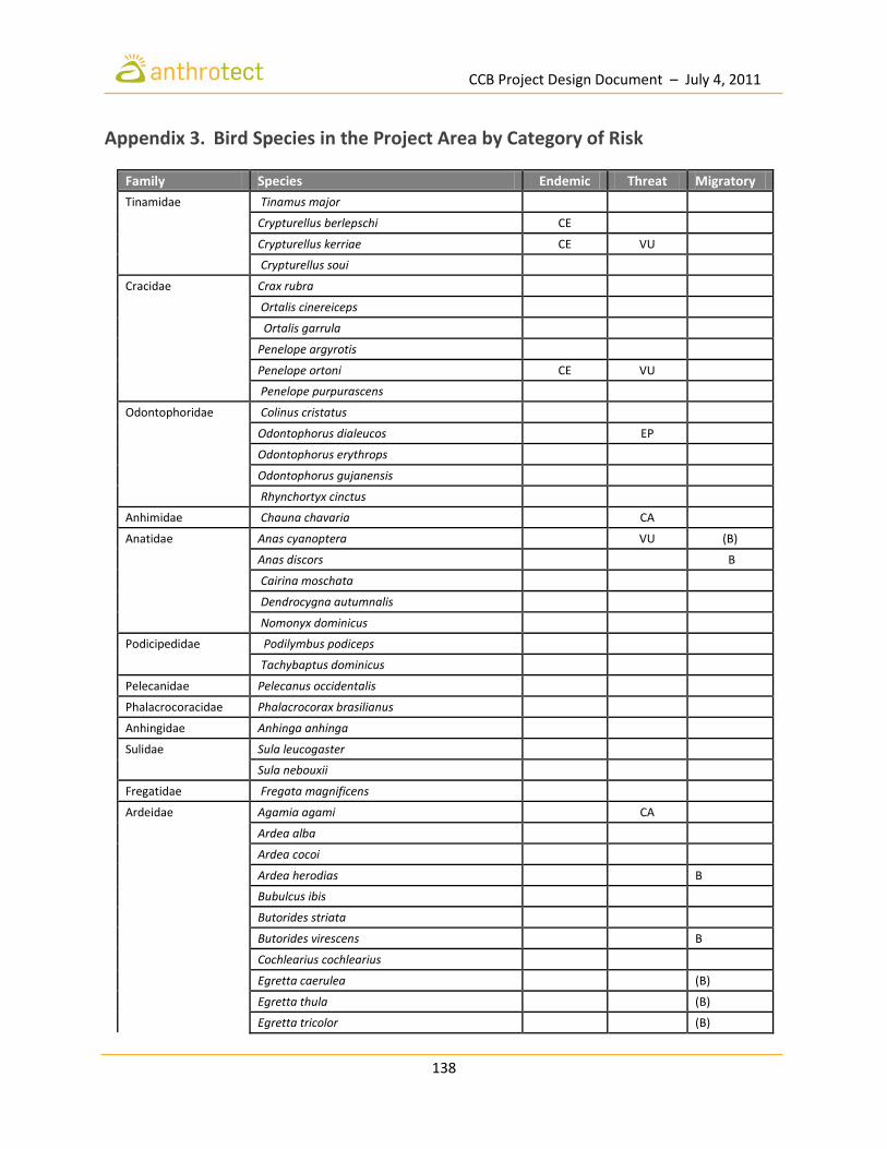
CCB Project Design Document – July 4, 2011
138
Appendix 3. Bird Species in the Project Area by Category of Risk
Family Species Endemic Threat Migratory
Tinamidae Tinamus major
Crypturellus berlepschi CE
Crypturellus kerriae CE VU
Crypturellus soui
Cracidae Crax rubra
Ortalis cinereiceps
Ortalis garrula
Penelope argyrotis
Penelope ortoni CE VU
Penelope purpurascens
Odontophoridae Colinus cristatus
Odontophorus dialeucos EP
Odontophorus erythrops
Odontophorus gujanensis
Rhynchortyx cinctus
Anhimidae Chauna chavaria CA
Anatidae Anas cyanoptera VU (B)
Anas discors
B
Cairina moschata
Dendrocygna autumnalis
Nomonyx dominicus
Podicipedidae Podilymbus podiceps
Tachybaptus dominicus
Pelecanidae Pelecanus occidentalis
Phalacrocoracidae Phalacrocorax brasilianus
Anhingidae Anhinga anhinga
Sulidae Sula leucogaster
Sula nebouxii
Fregatidae Fregata magnificens
Ardeidae Agamia agami CA
Ardea alba
Ardea cocoi
Ardea herodias
B
Bubulcus ibis
Butorides striata
Butorides virescens
B
Cochlearius cochlearius
Egretta caerulea
(B)
Egretta thula
(B)
Egretta tricolor
(B)

CCB Project Design Document – July 4, 2011
139
Nyctanassa violacea
Nycticorax nycticorax
Pilherodius pileatus
Tigrisoma fasciatum CA
Tigrisoma lineatum
Tigrisoma mexicanum
Threskiornithidae Eudocimus albus
Mesembrinibis cayennensis
Cathartidae Cathartes aura
(B)
Cathartes burrovianus
Coragyps atratus
Sarcoramphus papa
Accipitridaeae Accipiter bicolor
Accipiter ventralis
Accipiter superciliosus
Busarellus nigricollis
Buteo albicaudatus
Buteo magnirostris
Buteo nitidus
Buteo platypterus
B
Buteogallus anthracinus
Buteogallus urubitinga
Circus cyaneus
B
Elanoides forficatus
Gampsonyx swainsonii
Geranospiza caerulescens
Harpagus bidentatus
Harpia harpyja CA
Helicolestes hamatus
Ictinia plumbea
Leptodon cayanensis
Leucopternis albicollis
Leucopternis plumbea CA
Leucopternis semiplumbea CA
Morphnus guianensis CA
Rostrhamus sociabilis
Spizaetus ornatus
Spizaetus tyrannus
Pandionidae Pandion haliaetus
B
Falconidae Falco rufigularis
Falco sparverius
Herpetotheres cachinnans
Ibycter americanus
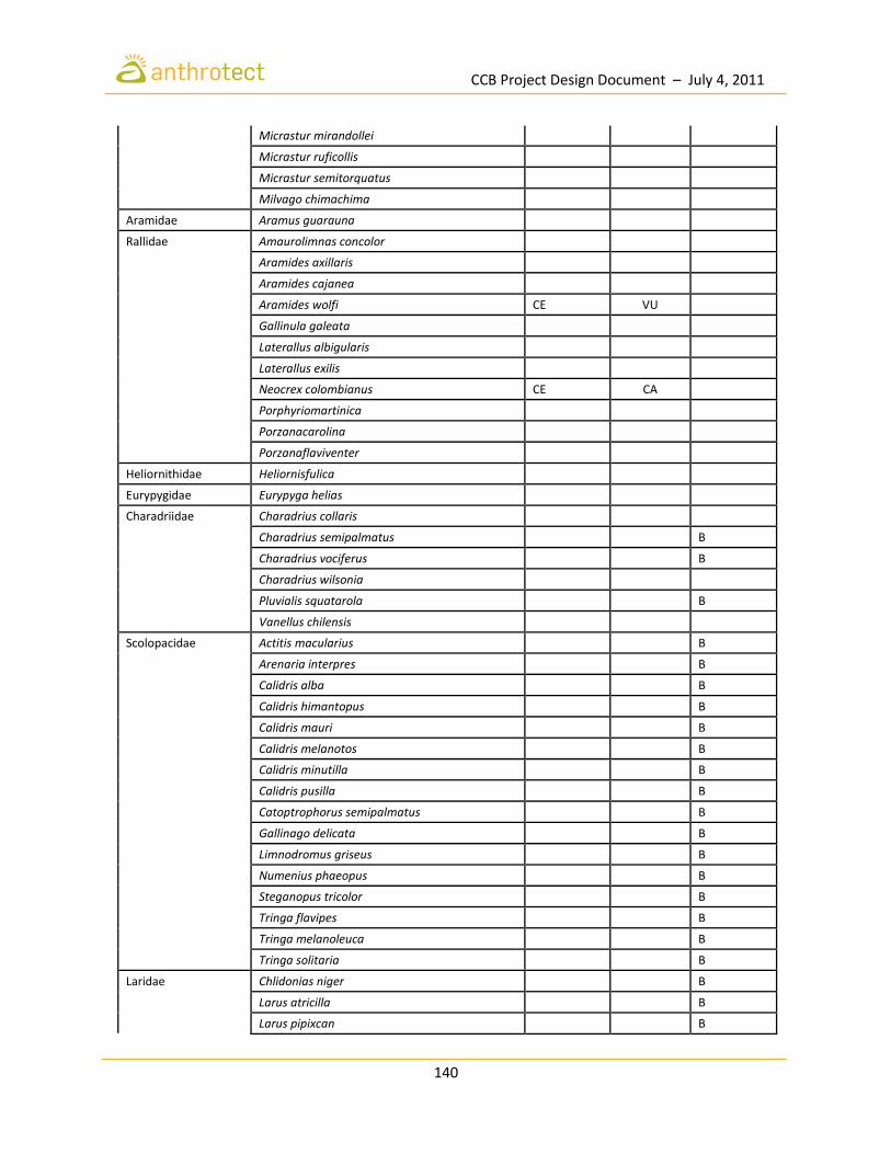
CCB Project Design Document – July 4, 2011
140
Micrastur mirandollei
Micrastur ruficollis
Micrastur semitorquatus
Milvago chimachima
Aramidae Aramus guarauna
Rallidae Amaurolimnas concolor
Aramides axillaris
Aramides cajanea
Aramides wolfi CE VU
Gallinula galeata
Laterallus albigularis
Laterallus exilis
Neocrex colombianus CE CA
Porphyriomartinica
Porzanacarolina
Porzanaflaviventer
Heliornithidae Heliornisfulica
Eurypygidae Eurypyga helias
Charadriidae Charadrius collaris
Charadrius semipalmatus
B
Charadrius vociferus
B
Charadrius wilsonia
Pluvialis squatarola
B
Vanellus chilensis
Scolopacidae Actitis macularius
B
Arenaria interpres
B
Calidris alba
B
Calidris himantopus
B
Calidris mauri
B
Calidris melanotos
B
Calidris minutilla
B
Calidris pusilla
B
Catoptrophorus semipalmatus
B
Gallinago delicata
B
Limnodromus griseus
B
Numenius phaeopus
B
Steganopus tricolor
B
Tringa flavipes
B
Tringa melanoleuca
B
Tringa solitaria
B
Laridae Chlidonias niger
B
Larus atricilla
B
Larus pipixcan
B

CCB Project Design Document – July 4, 2011
141
Rynchops niger
A?
Sterna hirundo
B
Thalasseus maximus
B
Thalasseus sandvicensis
B
Columbidae Claravis pretiosa
Columbina minuta
Columbina talpacoti
Geotrygon frenata
Geotrygon goldmani CA
Geotrygon montana
Geotrygon saphirina
Geotrygon veraguensis
Leptotila cassini
Leptotila pallida CE
Leptotila verreauxi
Patagioenas cayennensis
Patagioenas goodsoni CE
Patagioenas nigrirostris
Patagioenas plumbea
Patagioenas speciosa
Patagioenas subvinacea
Psittacidae Amazona autumnalis
Amazona farinosa
Amazona ochrocephala
Ara ambiguus VU
Ara ararauna
Ara chloropterus
Ara militaris VU
Ara severus
Brotogeris jugularis
Pionopsitta haematotis
Pionopsitta pulchra CE
Pionopsitta pyrilia CE VU
Pionus menstrus
Touit dilectissimus
Cuculidae Coccycua minuta
Coccyzus americanus
B
Coccyzus erythropthalmus
B
Coccyzus melacoryphus
A
Crotophaga ani
Crotophaga major
Neomorphus geoffroyi
Piaya cayana

CCB Project Design Document – July 4, 2011
142
Tapera naevia
Tytonidae Tyto alba
Strigidae Ciccaba virgata
Glaucidium griseiceps
Lophostrix cristata
Megascops choliba
Megascops guatemalae
Pulsatrix perspicillata
Rhinoptynx clamator
Strix albitarsis
Strix nigrolineata
Steatornithidae Steatornis caripensis
Nyctibiidae Nyctibius aethereus
Nyctibius grandis
Nyctibius griseus
Caprimulgidae Caprimulgus maculicaudus
Chordeiles acutipennis
(B)
Chordeiles minor
B
Lurocalis semitorquatus
Nyctidromus albicollis
Nyctiphrynus rosenbergi CE
Apodidae Chaetura brachyura
Chaetura cinereiventris
Chaetura spinicaudus
Streptoprocne zonaris
Trochilidae Aglaiocercus coelestis
Amazilia amabilis
Amazilia rosenbergi CE
Amazilia tzacatl
Androdon aequatorialis
Anthracothorax nigricollis
Boissonneaua jardini CE
Chalybura urochrysia
Chrysolampis mosquitus
Coeligena wilsoni CE
Damophila julie
Discosura conversii
Doryfera ludovicae
Eutoxeres aquila
Florisuga mellivora
Glaucis aeneus
Glaucis hirsutus
Goldmania violiceps

CCB Project Design Document – July 4, 2011
143
Haplophaedia aureliae
Heliomaster longirostris
Heliothryx barroti
Hylocharis eliciae
Hylocharis grayi CE
Hylocharis humboldtii CE
Klais guimeti
Lepidopyga coeruleogularis
Phaethornis anthophilus
Phaethornis guy
Phaethornis longirostris
Phaethornis striigularis
Phaethornis yaruqui CE
Schistes geoffroyi
Thalurania fannyi
Threnetes ruckeri
Trogonidae Trogon collaris
Trogon comptus CE
Trogon massena
Trogon melanurus
Trogon rufus
Trogon violaceus
Trogon viridis
Alcedinidae Chloroceryle aenea
Chloroceryle amazona
Chloroceryle americana
Chloroceryle inda
Megaceryle torquata
Momotidae Baryphthengus martii
Electron platyrhynchum
Hylomanes momotula
Momotus aequatorialis
Momotus subrufescens
Galbulidae Brachygalba salmoni CE
Galbula ruficauda
Jacamerops aureus
Bucconidae Bucco noanamae E CA
Malacoptila mystacalis
Malacoptila panamensis
Monasa morphoeus
Nonnula frontalis
Notharchus hyperrhynchus
Notharchus pectoralis

CCB Project Design Document – July 4, 2011
144
Notharchus tectus
Nystalus radiatus
Ramphastidae Capito maculicoronatus
Capito quinticolor E VU
Pteroglossus torquatus
Ramphastos brevis CE
Ramphastos sulfuratus
Ramphastos swainsonii
Selenidera spectabilis
Semnornis ramphastinus
Picidae Campephilus haematogaster
Campephilus melanoleucos
Celeus elegans
Celeus loricatus
Colaptes punctigula
Dryocopus lineatus
Melanerpes pucherani
Melanerpes rubricapillus
Piculus leucolaemus
Picumnus olivaceus
Veniliornis chocoensis CE CA
Veniliornis dignus
Veniliornis kirkii
Furnariidae Campylorhamphus pusillus
Campylorhamphus trochilirostris
Dendrocincla fuliginosa
Dendrocincla homochroa
Dendrocolaptes sanctithomae
Dendroplex picus
Glyphorynchus spirurus
Lepidocolaptes souleyetii
Xiphorhynchus erythropygius
Xiphorhynchus lachrymosus
Xiphorhynchus susurrans
Xiphorhynchus triangularis
Anabacerthia variegaticeps
Automolus ochrolaemus
Automolus rubiginosus
Certhiaxis cinnamomeus
Hyloctistes subulatus
Lochmias nematura
Margarornis stellatus
Philydor fuscipenne

CCB Project Design Document – July 4, 2011
145
Premnornis guttuligera CE
Sclerurus guatemalensis
Sclerurus mexicanus
Synallaxis albescens
Synallaxis brachyura
Synallaxis cinnamomea
Xenops minutus
Xenops rutilans
Thamnophilidae Cercomacra nigricans
Cercomacra tyrannina
Cymbilaimus lineatus
Dysithamnus mentalis
Dysithamnus puncticeps
Gymnocichla nudiceps
Gymnopithys leucaspis
Hylophylax naevioides
Microrhopias quixensis
Myrmeciza berlepschi CE
Myrmeciza exsul
Myrmeciza immaculata
Myrmeciza laemosticta
Myrmornis torquata
Myrmotherula axillaris
Myrmotherula brachyura
Myrmotherula fulviventris
Myrmotherula ignota
Myrmotherula pacifica
Myrmotherula schisticolor
Phaenostictus mcleannani
Sakesphorus canadensis
Taraba major
Terenura callinota
Thamnistes anabatinus
Thamnophilus atrinucha
Thamnophilus multistriatus CE
Thamnophilus nigriceps
Thamnophilus unicolor
Xenornis setifrons VU
Formicariidae Formicarius analis
Formicarius nigricapillus
Grallariidae Grallaria guatimalensis
Grallaricula flavirostris
Hylopezus dives
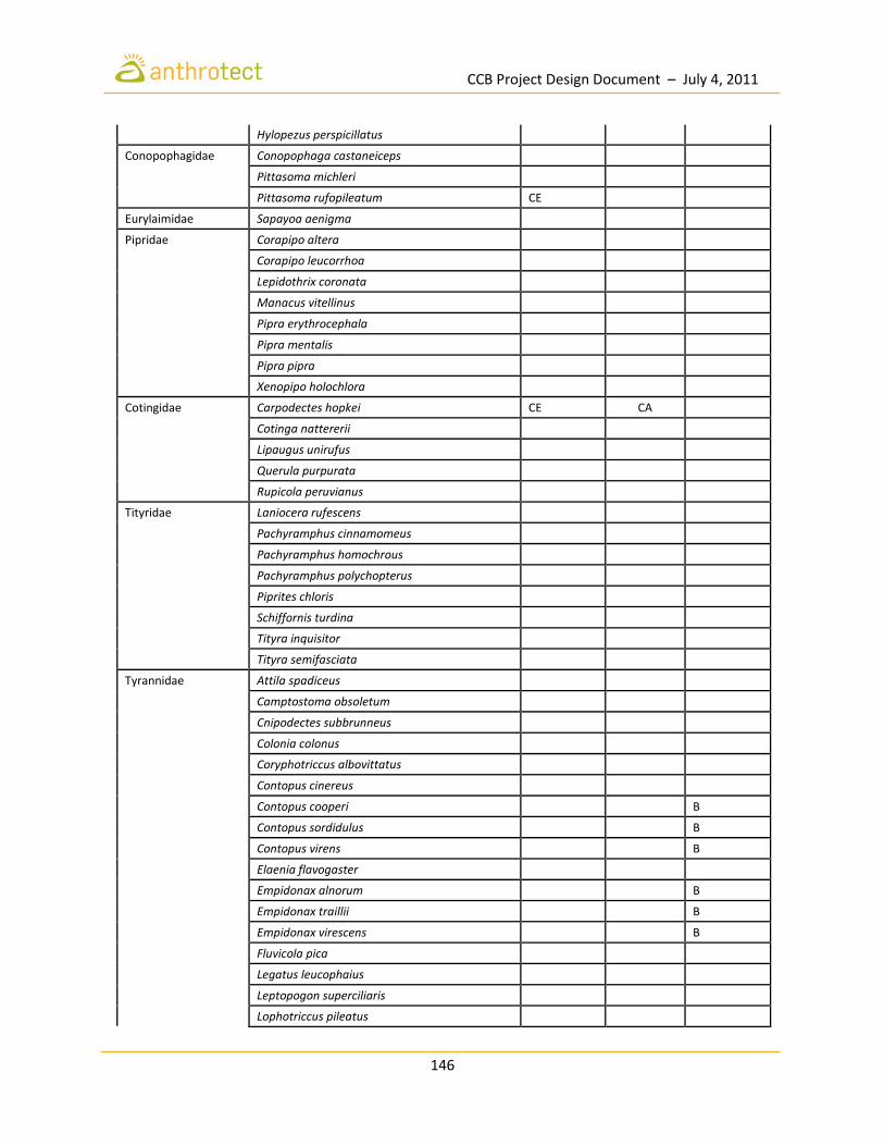
CCB Project Design Document – July 4, 2011
146
Hylopezus perspicillatus
Conopophagidae Conopophaga castaneiceps
Pittasoma michleri
Pittasoma rufopileatum CE
Eurylaimidae Sapayoa aenigma
Pipridae Corapipo altera
Corapipo leucorrhoa
Lepidothrix coronata
Manacus vitellinus
Pipra erythrocephala
Pipra mentalis
Pipra pipra
Xenopipo holochlora
Cotingidae Carpodectes hopkei CE CA
Cotinga nattererii
Lipaugus unirufus
Querula purpurata
Rupicola peruvianus
Tityridae Laniocera rufescens
Pachyramphus cinnamomeus
Pachyramphus homochrous
Pachyramphus polychopterus
Piprites chloris
Schiffornis turdina
Tityra inquisitor
Tityra semifasciata
Tyrannidae Attila spadiceus
Camptostoma obsoletum
Cnipodectes subbrunneus
Colonia colonus
Coryphotriccus albovittatus
Contopus cinereus
Contopus cooperi
B
Contopus sordidulus
B
Contopus virens
B
Elaenia flavogaster
Empidonax alnorum
B
Empidonax traillii
B
Empidonax virescens
B
Fluvicola pica
Legatus leucophaius
Leptopogon superciliaris
Lophotriccus pileatus

CCB Project Design Document – July 4, 2011
147
Machetornis rixosa
Megarynchus pitangua
Mionectes oleagineus
Mionectes olivaceus
Mitrephanes phaeocercus
Myiarchus crinitus
B
Myiarchus panamensis
Myiarchus tuberculifer
Myiobius atricaudus
Myiobius sulphureipygius
Myiobius villosus
Myiodynastes luteiventris
B
Myiodynastes maculatus
Myiopagis gaimardii
Myiophobus fasciatus
Myiophobus pulcher
Myiornis atricapillus
Myiotriccus ornatus
Myiozetetes cayanensis
Myiozetetes granadensis
Ochthoeca cinnamomeiventris
Ochthoeca diadema
Oncostoma cinereigulare
Oncostoma olivaceum
Onychorhynchus coronatus
Ornithion brunneicapillum
Phyllomyias griseiceps
Phylloscartes superciliaris
Philohydor lictor
Pitangus sulphuratus
Platyrinchus coronatus
Pyrocephalus rubinus
Rhynchocyclus olivaceus
Rhynchocyclus pacificus
Rhytipterna holerythra
Sayornis nigricans
Sirystes sibilator
Terenotriccus erythrurus
Todirostrum cinereum
Todirostrum nigriceps
Tolmomyias assimilis
Tolmomyias flaviventris
Tolmomyias sulphurescens

CCB Project Design Document – July 4, 2011
148
Tyrannulus elatus
Tyrannus dominicensis
Tyrannus melancholicus
Tyrannus savana
Tyrannus tyrannus
Zimmerius chrysops
Zimmerius vilissimus
Hirundinidae Hirundo rustica
B
Neochelidon tibialis
Petrochelidon pyrrhonota
B
Progne chalybea
Stelgidopteryx ruficollis
Corvidae Cyanocorax affinis
Vireonidae Hylophilus decurtatus
Hylophilus flavipes
Hylophilus ochraceiceps
Vireo flavifrons
B
Vireo flavoviridis
B
Vireo leucophrys
Vireo olivaceus
B
Vireo philadelphicus
B
Cinclidae Cinclus leucocephalus
Troglodytidae Campylorhynchus albobrunneus
Cyphorhinus phaeocephalus
Henicorhina leucophrys
Henicorhina leucosticta
Microcerculus marginatus
Thryothorus fasciatoventris
Thryothorus leucopogon
Thryothorus leucotis
Thryothorus nigricapillus
Troglodytes aedon
Polioptilidae Microbates cinereiventris
Polioptila plumbea
Ramphocaenus melanurus
Polioptila schistaceigula
Donacobiidae Donacobius atricapilla
Mimidae Dumetella carolinensis
B
Mimus gilvus
Turdidae Catharus fuscater
Catharus fuscescens
B
Catharus minimus
B
Catharus ustulatus
B

CCB Project Design Document – July 4, 2011
149
Myadestes coloratus
Turdus assimilis
Turdus grayi
Turdus obsoletus
Turdus serranus
Bombycillidae Bombycilla cedrorum
B
Icteridae Amblycercus holosericeus
Cacicus cela
Cacicus microrhynchus
Cacicus uropygialis VU
Chrysomus icterocephalus
Dolichonyx oryzivorus
B
Hypopyrrhus pyrohypogaster E
Icterus auricapillus
Icterus chrysater
Icterus galbula
B
Icterus mesomelas
Icterus spurius
B
Molothrus bonariensis
Molothrus oryzivorus
Psarocolius angustifrons
Psarocolius decumanus
Psarocolius guatimozinus
Psarocolius cassinii E EP
Psarocolius wagleri
Quiscalus mexicanus
Sturnella militaris
Parulidae Basileuterus culicivorus
Basileuterus tristriatus
Dendroica castanea
B
Dendroica cerulea
B
Dendroica fusca
B
Dendroica magnolia
B
Dendroica pensylvanica
B
Dendroica petechia
(B)
Dendroica striata
B
Geothlypis aequinoctialis
Geothlypis semiflava
Geothlypis trichas
B
Mniotilta varia
B
Myioborus miniatus
B
Oporornis formosus
B
Oporornis philadelphia
B
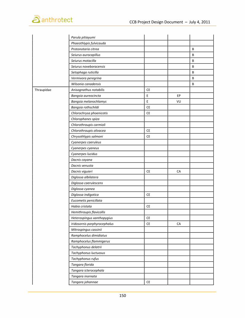
CCB Project Design Document – July 4, 2011
150
Parula pitiayumi
Phaeothlypis fulvicauda
Protonotaria citrea
B
Seiurus aurocapillus
B
Seiurus motacilla
B
Seiurus noveboracensis
B
Setophaga ruticilla
B
Vermivora peregrina
B
Wilsonia canadensis
B
Thraupidae Anisognathus notabilis CE
Bangsia aureocincta E EP
Bangsia melanochlamys E VU
Bangsia rothschildi CE
Chlorochrysa phoenicotis CE
Chlorophanes spiza
Chlorothraupis carmioli
Chlorothraupis olivacea CE
Chrysothlypis salmoni CE
Cyanerpes caeruleus
Cyanerpes cyaneus
Cyanerpes lucidus
Dacnis cayana
Dacnis venusta
Dacnis viguieri CE CA
Diglossa albilatera
Diglossa caerulescens
Diglossa cyanea
Diglossa indigotica CE
Eucometis penicillata
Habia cristata CE
Hemithraupis flavicollis
Heterospingus xanthopygius CE
Iridosornis porphyrocephalus CE CA
Mitrospingus cassinii
Ramphocelus dimidiatus
Ramphocelus flammigerus
Tachyphonus delatrii
Tachyphonus luctuosus
Tachyphonus rufus
Tangara florida
Tangara icterocephala
Tangara inornata
Tangara johannae CE
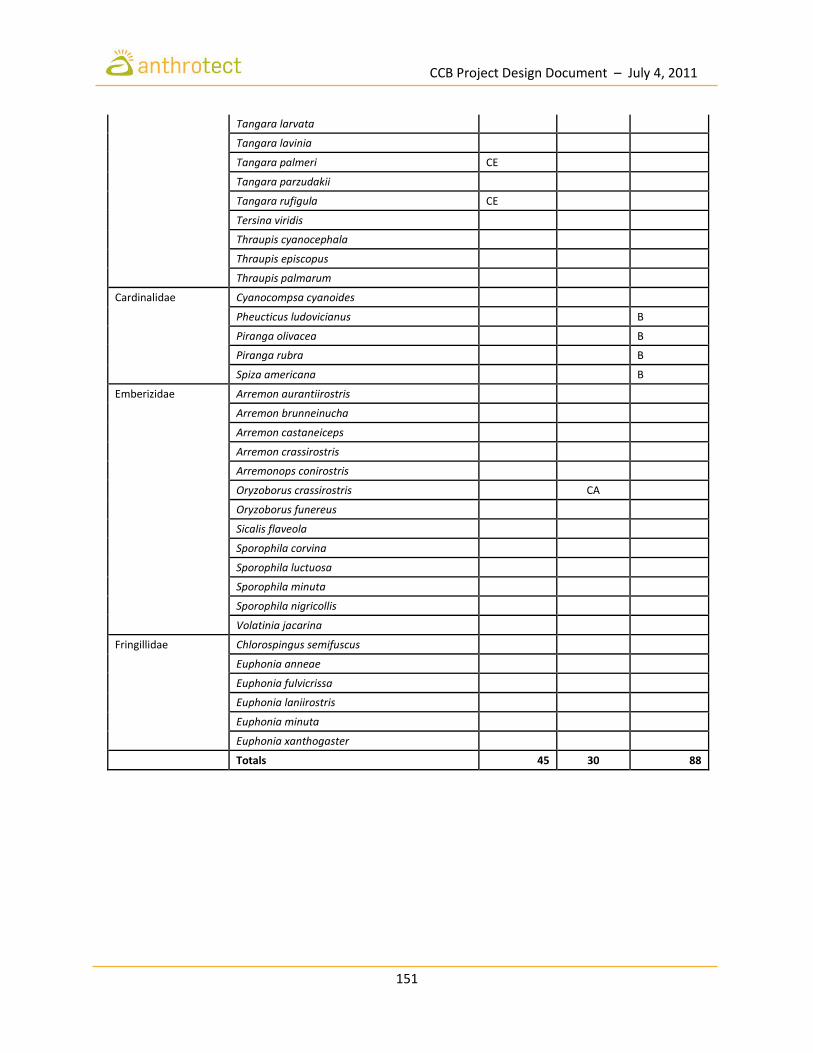
CCB Project Design Document – July 4, 2011
151
Tangara larvata
Tangara lavinia
Tangara palmeri CE
Tangara parzudakii
Tangara rufigula CE
Tersina viridis
Thraupis cyanocephala
Thraupis episcopus
Thraupis palmarum
Cardinalidae Cyanocompsa cyanoides
Pheucticus ludovicianus
B
Piranga olivacea
B
Piranga rubra
B
Spiza americana
B
Emberizidae Arremon aurantiirostris
Arremon brunneinucha
Arremon castaneiceps
Arremon crassirostris
Arremonops conirostris
Oryzoborus crassirostris CA
Oryzoborus funereus
Sicalis flaveola
Sporophila corvina
Sporophila luctuosa
Sporophila minuta
Sporophila nigricollis
Volatinia jacarina
Fringillidae Chlorospingus semifuscus
Euphonia anneae
Euphonia fulvicrissa
Euphonia laniirostris
Euphonia minuta
Euphonia xanthogaster
Totals 45 30 88
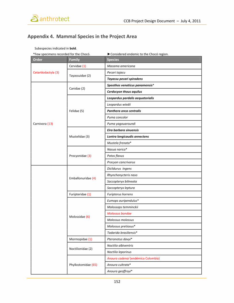
CCB Project Design Document – July 4, 2011
152
Appendix 4. Mammal Species in the Project Area
Subespecies indicated in bold. *Few specimens recorded for the Chocó. ►Considered endemic to the Chocó region.
Order Family Species
Cetartiodactyla (3)
Cervidae (1) Mazama americana
Tayassuidae (2) Pecari tajacu
Tayassu pecari spiradens
Carnivora (13)
Canidae (2) Speothos venaticus panamensis*
Cerdocyon thous aquilus
Felidae (5)
Leopardus pardalis aequatorialis
Leopardus wiedii
Panthera onca centralis
Puma concolor
Puma yagouaroundi
Mustelidae (3)
Eira barbara sinuensis
Lontra longicaudis annectens
Mustela frenata*
Procyonidae (3)
Nasua narica*
Potos flavus
Procyon cancrivorus
Emballonuridae (4)
Diclidurus ingens
Rhynchonycteris naso
Saccopteryx bilineata
Saccopteryx leptura
Furipteridae (1) Furipterus horrens
Molossidae (6)
Eumops auripendulus*
Molossops temminckii
Molossus bondae
Molossus molossus
Molossus pretiosus*
Tadarida brasiliensis*
Mormopidae (1) Pteronotus davyi*
Noctilionidae (2) Noctilio albiventris
Noctilio leporinus
Phyllostomidae (65)
Anoura cadenai (endémica Colombia)
Anoura cultrata*
Anoura geoffroyi*

CCB Project Design Document – July 4, 2011
153
Artibeus aequatorialis
Artibeus jamaicensis
Artibeus lituratus
Carollia brevicauda
Carollia castanea
Carollia monohernandezi*
Carollia perspicillata
Chiroderma trinitatum
Chiroderma villosum
Chiroderma salvini
Choeroniscus minor*
Choeroniscus periosus►
Dermanura phaeotis
Dermanura rava
Dermanura rosenbergi
Desmodus rotundus
Diaemus youngi
Diphylla ecaudata*
Enchisthenes hartii
Glossophaga commissarisi
Glossophaga soricina
Glyphonycteris sylvestris
Lampronycteris brachyotis
Lichonycteris obscura►
Lionycteris spurrelli*
Lonchophylla cadenai►
Lonchophylla chocoana*►
Lonchophylla concava
Lonchophylla robusta
Lonchophylla thomasi*
Lophostoma brasiliense
Lophostoma silvicolum
Macrophyllum macrophyllum*
Mesophylla macconnelli
Micronycteris hirsuta*
Micronycteris megalotis*
Micronycteris minuta

CCB Project Design Document – July 4, 2011
154
Micronycteris schmidtorum*
Mimon crenulatum*
Phylloderma stenops*
Phyllostomus discolor
Phyllostomus hastatus
Phyllostomus latifolius
Platyrrhinus chocoensis►
Platyrrhinus dorsalis
Platyrrhinus helleri
Platyrrhinus matapalensis
Platyrrhinus nitelinea►
Platyrrhinus umbratus
Platyrrhinus vittatus*
Rhinophylla alethina►
Sturnira koopmanhilli ►
Sturnira lilium
Sturnira luisi*►
Trachops cirrhosus*
Trinycteris nicefori*
Uroderma bilobatum
Uroderma magnirostrum
Vampyressa thyone
Vampyriscus nymphaea
Vampyrodes caraccioli
Vampyrum spectrum*
Thyropteridae (1) Thyroptera tricolor*
Vespertilionidae (4)
Eptesicus brasiliensis*
Myotis nigricans
Myotis riparius
Rhogeessa io*
Cingulata (2) Dasypodidae (2) Cabassous centralis*
Dasypus novemcinctus
Didelphimorphia (9) Didelphidae (9)
Caluromys derbianus
Chironectes minimus
Didelphis marsupialis
Didelphis pernigra*

CCB Project Design Document – July 4, 2011
155
Marmosa isthmica
Metachirus nudicaudatus
Micoureus phaeus
Philander opossum
Lagomorpha (1) Leporidae Sylvilagus brasiliensis
Perissodactyla (1) Tapiridae Tapirus bairdii►
Pilosa (6)
Bradypodidae Bradypus variegatus
Cyclopedidae Cyclopes didactylus
Megalonychidae (1) Choloepus hoffmanni
Myrmecophagidae (2) Myrmecophaga tridactyla
Tamandua mexicana
Primates (7)
Aotidae Aotus zonalis
Atelidae (3)
Alouatta palliata aequatorialis►
Alouatta seniculus seniculus
Ateles fusciceps rufiventris►
Cebidae (1) Cebus capucinus capucinus
Rodentia (31)
Caviidae (2) Hydrochoerus hydrochaeris
Hydrochoerus isthmius*
Cricetidae (13)
Handleyomys alfaroi
Isthmomys pirrensis►
Melanomys caliginosus
Neacomys tenuipes
Nephelomys pectoralis
Oryzomys couesi*
Oryzomys gorgasi*
Sigmodontomys alfari*►
Transandinomys bolivaris*►
Transandinomys talamancae*
Zygodontomys cherriei
Cuniculidae Cuniculus paca
Dasyproctidae Dasyprocta punctata
Dinomyidae Dinomys branickii*
Echimyidae (3)
Diplomys labilis*►
Hoplomys gymnurus►
Proechimys semispinosus
Erethizontidae (1) Coendou rothschildi*►
Geomyidae (2) Orthogeomys dariensis*►

CCB Project Design Document – July 4, 2011
156
Orthogeomys thaeleri*►
Heteromyidae (2) Heteromys australis
Heteromys desmarestianus►
Sciuridae (3)
Microsciurus alfari
Microsciurus mimulus*►
Sciurus granatensis
Sirenia (1) Trichechidae Trichechus manatus