the chalgrave heritage trailmediafiles.thedms.co.uk/publication/bh-go/cms/pdf... · most of...
TRANSCRIPT
About Chalgrave Most of Chalgrave Parish sits on a low ridge of the Gault Clay. In the Cretaceous period, over 100 million years ago, rising sea levels were flooding south Bedfordshire. Sands deposited on the shallow sea floor became the Greensand Ridge, north of Chalgrave; as the sea grew deeper and dry land was further away, finer particles washed out to sea drifted down through the water to become a muddy sea floor that is now the Gault Clay. Eventually this area was so far from land that little or no mud reached it: the Chalk escarpment to the south is made of the skeletons of microscopic algae. Then, 20 million years ago, the same force that raised the Alps created a gentle ridge across southern England. The Chalk, the Greensand and the Gault were exposed and eroded by glaciers, wind and rain to create the landscape we live in. The glaciers brought with them clay, sand and rock from the landscape they flowed across to reach this area. When the ice melted these became the layer of glacial till that caps the Gault ridge.
The landscape shaped settlement of this area: the prehistoric track known to the Anglo-Saxons as Theedway runs down from the Chalk to follow high ground through Chalgrave until at last it reaches the low clay vale west of the parish. The earliest settlement remains known in Chalgrave are on the warmer, south-facing slope of the ridge.
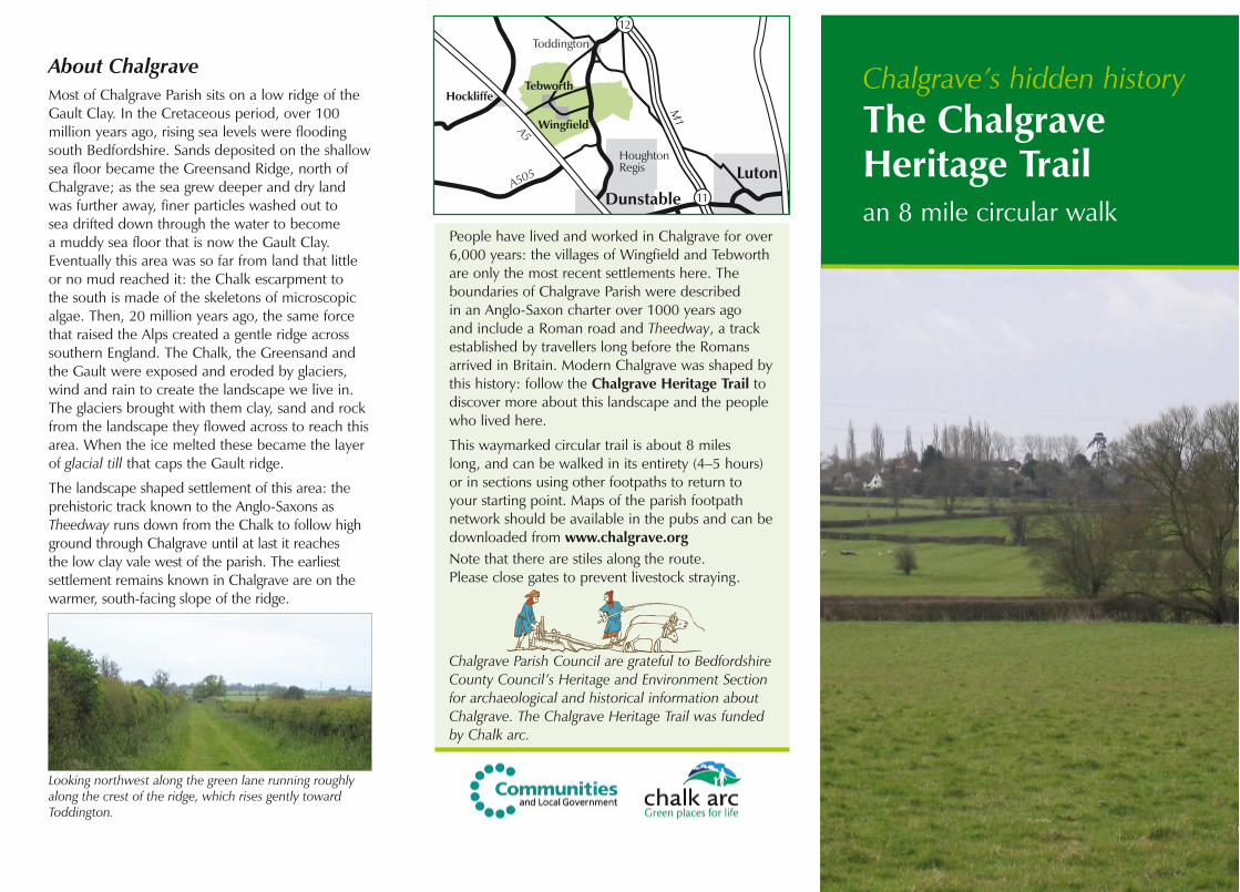
Chalgrave’s hidden history The Chalgrave Heritage Trail an 8 mile circular walk
People have lived and worked in Chalgrave for over 6,000 years: the villages of Wingfield and Tebworth are only the most recent settlements here. The boundaries of Chalgrave Parish were described in an Anglo-Saxon charter over 1000 years ago and include a Roman road and Theedway, a track established by travellers long before the Romans arrived in Britain. Modern Chalgrave was shaped by this history: follow the Chalgrave Heritage Trail to discover more about this landscape and the people who lived here.
This waymarked circular trail is about 8 miles long, and can be walked in its entirety (4–5 hours) or in sections using other footpaths to return to your starting point. Maps of the parish footpath network should be available in the pubs and can be downloaded from www.chalgrave.orgNote that there are stiles along the route. Please close gates to prevent livestock straying.
Chalgrave Parish Council are grateful to Bedfordshire County Council’s Heritage and Environment Section for archaeological and historical information about Chalgrave. The Chalgrave Heritage Trail was funded by Chalk arc.
Wingfield
Hockliffe
HoughtonRegis
Dunstable
Luton
12
11
Toddington
Tebworth
M1
A5
A505
The Chalgrave Heritage Trail, beginning at information board 4 in Tebworth. Where known, dates and old names are in italics.
As you stand at the board behind you, to the right of the Queen’s Head [The Three Horseshoes, 1822] is 2 The Lane [17th century]; the village pump was to the left of the pub. Across The Lane is Blacksmith House [site of the blacksmith’s shop, 1755], then Forge Cottage [The Cock beerhouse, 1867]. Further right is Buttercup Farm [late 17th century] and straight ahead, down Hockliffe Road, is Park Farm, much as it appeared in the 19th century; to its left is The Maltings [malt house 1693; the Butcher’s Arms, 1690]. Tithe Farm [17th century] is further left, across the road. The village stocks [1757] and a cattle pound [1755] where stray livestock could be reclaimed after payment of a fine were in this area. In 1277 the triangle of ground where Forge Cottage and Blacksmith House stand today was part of the green, and villagers worshipped at St Martin’s Chapel on its western side. If you walk up Wingfield Road you can see St Mary’s Chapel [1889], the National School [1855], and The Shoulder of Mutton [17th century] in Parkview Lane, all of which are now private houses.
Walk east along Toddington Road, past the Wesleyan Methodist Chapel [1842, now a house] to the Pond. Information board 5 is here, and a bench with a back designed by the children of Chalgrave in 2008.
Follow the footpath sign through the gate and past the pond. Continue straight ahead across some fine examples of the ridge-and-furrow created by medieval ploughing to a green lane. Turn right into the lane to walk through Boggy Meadow (a County Wildlife Site) and across the brook. Go through the gate, then turn right through the field gate with the CHT waymark, following the footpath arrow to angle up across the field along part of what was once Frenchman’s Way, the pre-enclosure road to Toddington. Cross one stile and continue on the same angle to another stile in the corner of the field.
Carefully cross the busy Toddington road, then follow the waymarkers. Please stay on the permissive path through recently planted trees to the corner of the field, then turn right. Continue ahead, over a stile and kissing gate to walk to the Glebe in Toddington. Follow the waymarked footpath sign south along the fence and turn right through another kissing gate. The path runs through a nature reserve and across a bridge into Chalgrave parish. Continue to Chalgrave Road (once known as Church Way) at College Farm. Turn left and walk to All Saints Church. There has been a church here since before 1185; information board 2 tells you more about its history (including the famous wall paintings) and the Manor that once stood beside it.
Follow the waymarks and the Icknield Way path around the churchyard and continue east, beside the golf course. Where the Icknield Way turns left the CHT turns right across the field to Chalgrave Manor Farm. Follow signs around the farmyard to the road on which the footpath runs south to Featherbed Lane, once part of a prehistoric track the Anglo-Saxons called Theedway.
At board 1 turn left onto Theedway, then take the first footpath right. Follow the signs through Grove Farm, turn right onto a bridleway beside the A1520, then left, carefully crossing this busy road. You are now walking the Chalgrave parish boundary on the Boundway [The Dyke 926]. Take the first footpath on the right, cross a bridge and follow the signs across the fields once known as Grove Grass Croft to The Plough [1822] and information board 3 about medieval Wingfield.
Take Tebworth Road (another section of Theedway) toward the centre of Wingfield, but turn left onto the next footpath, part of the Icknield Way as well as the CHT, and walk around the cricket field to Hill Close. Walk past Hill Farm to take the first path on the right. Walk through a dell, over a bridge and across what was once Stockwell Furlong. Cross three stiles and take the concrete track right, back toward Tebworth Road. Turn left onto the footpath that follows the route of Theedway and Chasewell Way. Take the first path on the right,
which was Millway (nothing now remains of the Mill) across the fields that were West Close Furlong to Hockliffe Road.
When Chalgrave was enclosed in 1800 the old route across the open fields to Hockliffe, Coxstead Way, was replaced by Hockliffe Road. Cross this road and take the footpath, angling through a modern copse and across the ditch. These fields were part of Coxted Furlong. Cross the next ditch into part of Hockliffe Parish that was once in Chalgrave and continue through the recreation ground, skirting the football pitch. Walk down Kilby Road, turn right and follow Birches Close to the A5.
The A5 [Watling Street] has been a major road since Roman times; Hockliffe thrived on passing trade after the road was turnpiked. Turn right and walk to the Woburn Road crossroads past what were once inns: The Red Lion [Three Blackbirds, 1720] closed in 2003 and the site is now a housing estate; The White Horse Inn [1712–c. 1924]; The Shoulder of Mutton [1822–c. 1914] and The Star Inn [1636-c. 1850], Turn right toward Woburn, across Clipstone Brook, and take the first footpath on the right, down the track. The path runs parallel to the brook across Washingpool Furlong to a stile. Follow the CHT signs into Chalgrave Parish, turning right over a small bridge, left along the field edge, then right to follow the field edge. Cross the small bridge, climb the stile, walk straight across the field to a second stile and then left and right along the field edge on the path known as the ‘slipe’. The first path on the left takes you across Pullins Close to The Lane at 30 The Lane (includes 16th century Emerton’s Cottage, the oldest building in Tebworth). Turn right and walk into Tebworth where The Queen’s Head awaits.
Looking northwest along the green lane running roughly along the crest of the ridge, which rises gently toward Toddington.

About Chalgrave Most of Chalgrave Parish sits on a low ridge of the Gault Clay. In the Cretaceous period, over 100 million years ago, rising sea levels were flooding south Bedfordshire. Sands deposited on the shallow sea floor became the Greensand Ridge, north of Chalgrave; as the sea grew deeper and dry land was further away, finer particles washed out to sea drifted down through the water to become a muddy sea floor that is now the Gault Clay. Eventually this area was so far from land that little or no mud reached it: the Chalk escarpment to the south is made of the skeletons of microscopic algae. Then, 20 million years ago, the same force that raised the Alps created a gentle ridge across southern England. The Chalk, the Greensand and the Gault were exposed and eroded by glaciers, wind and rain to create the landscape we live in. The glaciers brought with them clay, sand and rock from the landscape they flowed across to reach this area. When the ice melted these became the layer of glacial till that caps the Gault ridge.
The landscape shaped settlement of this area: the prehistoric track known to the Anglo-Saxons as Theedway runs down from the Chalk to follow high ground through Chalgrave until at last it reaches the low clay vale west of the parish. The earliest settlement remains known in Chalgrave are on the warmer, south-facing slope of the ridge.
Chalgrave’s hidden history The Chalgrave Heritage Trail an 8 mile circular walk
People have lived and worked in Chalgrave for over 6,000 years: the villages of Wingfield and Tebworth are only the most recent settlements here. The boundaries of Chalgrave Parish were described in an Anglo-Saxon charter over 1000 years ago and include a Roman road and Theedway, a track established by travellers long before the Romans arrived in Britain. Modern Chalgrave was shaped by this history: follow the Chalgrave Heritage Trail to discover more about this landscape and the people who lived here.
This waymarked circular trail is about 8 miles long, and can be walked in its entirety (4–5 hours) or in sections using other footpaths to return to your starting point. Maps of the parish footpath network should be available in the pubs and can be downloaded from www.chalgrave.orgNote that there are stiles along the route. Please close gates to prevent livestock straying.
Chalgrave Parish Council are grateful to Bedfordshire County Council’s Heritage and Environment Section for archaeological and historical information about Chalgrave. The Chalgrave Heritage Trail was funded by Chalk arc.
Wingfield
Hockliffe
HoughtonRegis
Dunstable
Luton
12
11
Toddington
Tebworth
M1
A5
A505
The Chalgrave Heritage Trail, beginning at information board 4 in Tebworth. Where known, dates and old names are in italics.
As you stand at the board behind you, to the right of the Queen’s Head [The Three Horseshoes, 1822] is 2 The Lane [17th century]; the village pump was to the left of the pub. Across The Lane is Blacksmith House [site of the blacksmith’s shop, 1755], then Forge Cottage [The Cock beerhouse, 1867]. Further right is Buttercup Farm [late 17th century] and straight ahead, down Hockliffe Road, is Park Farm, much as it appeared in the 19th century; to its left is The Maltings [malt house 1693; the Butcher’s Arms, 1690]. Tithe Farm [17th century] is further left, across the road. The village stocks [1757] and a cattle pound [1755] where stray livestock could be reclaimed after payment of a fine were in this area. In 1277 the triangle of ground where Forge Cottage and Blacksmith House stand today was part of the green, and villagers worshipped at St Martin’s Chapel on its western side. If you walk up Wingfield Road you can see St Mary’s Chapel [1889], the National School [1855], and The Shoulder of Mutton [17th century] in Parkview Lane, all of which are now private houses.
Walk east along Toddington Road, past the Wesleyan Methodist Chapel [1842, now a house] to the Pond. Information board 5 is here, and a bench with a back designed by the children of Chalgrave in 2008.
Follow the footpath sign through the gate and past the pond. Continue straight ahead across some fine examples of the ridge-and-furrow created by medieval ploughing to a green lane. Turn right into the lane to walk through Boggy Meadow (a County Wildlife Site) and across the brook. Go through the gate, then turn right through the field gate with the CHT waymark, following the footpath arrow to angle up across the field along part of what was once Frenchman’s Way, the pre-enclosure road to Toddington. Cross one stile and continue on the same angle to another stile in the corner of the field.
Carefully cross the busy Toddington road, then follow the waymarkers. Please stay on the permissive path through recently planted trees to the corner of the field, then turn right. Continue ahead, over a stile and kissing gate to walk to the Glebe in Toddington. Follow the waymarked footpath sign south along the fence and turn right through another kissing gate. The path runs through a nature reserve and across a bridge into Chalgrave parish. Continue to Chalgrave Road (once known as Church Way) at College Farm. Turn left and walk to All Saints Church. There has been a church here since before 1185; information board 2 tells you more about its history (including the famous wall paintings) and the Manor that once stood beside it.
Follow the waymarks and the Icknield Way path around the churchyard and continue east, beside the golf course. Where the Icknield Way turns left the CHT turns right across the field to Chalgrave Manor Farm. Follow signs around the farmyard to the road on which the footpath runs south to Featherbed Lane, once part of a prehistoric track the Anglo-Saxons called Theedway.
At board 1 turn left onto Theedway, then take the first footpath right. Follow the signs through Grove Farm, turn right onto a bridleway beside the A1520, then left, carefully crossing this busy road. You are now walking the Chalgrave parish boundary on the Boundway [The Dyke 926]. Take the first footpath on the right, cross a bridge and follow the signs across the fields once known as Grove Grass Croft to The Plough [1822] and information board 3 about medieval Wingfield.
Take Tebworth Road (another section of Theedway) toward the centre of Wingfield, but turn left onto the next footpath, part of the Icknield Way as well as the CHT, and walk around the cricket field to Hill Close. Walk past Hill Farm to take the first path on the right. Walk through a dell, over a bridge and across what was once Stockwell Furlong. Cross three stiles and take the concrete track right, back toward Tebworth Road. Turn left onto the footpath that follows the route of Theedway and Chasewell Way. Take the first path on the right,
which was Millway (nothing now remains of the Mill) across the fields that were West Close Furlong to Hockliffe Road.
When Chalgrave was enclosed in 1800 the old route across the open fields to Hockliffe, Coxstead Way, was replaced by Hockliffe Road. Cross this road and take the footpath, angling through a modern copse and across the ditch. These fields were part of Coxted Furlong. Cross the next ditch into part of Hockliffe Parish that was once in Chalgrave and continue through the recreation ground, skirting the football pitch. Walk down Kilby Road, turn right and follow Birches Close to the A5.
The A5 [Watling Street] has been a major road since Roman times; Hockliffe thrived on passing trade after the road was turnpiked. Turn right and walk to the Woburn Road crossroads past what were once inns: The Red Lion [Three Blackbirds, 1720] closed in 2003 and the site is now a housing estate; The White Horse Inn [1712–c. 1924]; The Shoulder of Mutton [1822–c. 1914] and The Star Inn [1636-c. 1850], Turn right toward Woburn, across Clipstone Brook, and take the first footpath on the right, down the track. The path runs parallel to the brook across Washingpool Furlong to a stile. Follow the CHT signs into Chalgrave Parish, turning right over a small bridge, left along the field edge, then right to follow the field edge. Cross the small bridge, climb the stile, walk straight across the field to a second stile and then left and right along the field edge on the path known as the ‘slipe’. The first path on the left takes you across Pullins Close to The Lane at 30 The Lane (includes 16th century Emerton’s Cottage, the oldest building in Tebworth). Turn right and walk into Tebworth where The Queen’s Head awaits.
Looking northwest along the green lane running roughly along the crest of the ridge, which rises gently toward Toddington.

Clipst
one B
rook
was
Lec
k B
rook
0 1 mile
0 1 km
A5
Chasewell Way
Coxstead W
ay
Frenchman’s
Way
Church Way
Blan
stea
d W
ay
Brach Riddy
A5120
Millw
ay
Todd
ingt
on R
oad
Hockliffe
Road
Chalgrave Road
The Lane was ‘Tatterhill’
Featherbed LaneTebworth Road
1. Windmills. The location of a windmill mentioned in 1216 is unknown, but the windmill in Mill Field southwest of Wingfield had been there for some time before 1596. This mill was gone by 1765, replaced by one west of Tebworth that disappeared by 1815.
2. Hill Cottage was the parish ‘Pest House’, built in the late 18th or early 19th century to house people suffering from smallpox and other infectious diseases.
3. Gravel pits and brickworks. The ploughed-down pits in these fields are reminders of local industry. In the 17th century the area near Hockliffe Road was Tebworth’s ‘Gravel Pitt Furlong’ in the ‘Gravel Pit Field’; in 1800 the pits (possibly medieval in origin) supplied road materials. In the late 19th century a clay pit and brick kiln near Hockliffe Road supplied local builders, but by 1901 it was out of use. The brickworks in the south of the parish was disused by 1880.
4. A Roman ring was found near the brook in 1860. The intaglio (carved stone) shows Achilles with his spear and helmet.
0 1 mile
0 1 km
The remains of what may be an earlier Wingfield were visible as lumps and hollows in these fields until they were ploughed in the late 1970s.
The Chalgrave Heritage TrailOld names for some features on the map are shown in italics.
4
31
5
Chalgrave Manor Golf Course
ToddingTon was Tuddington in 1399
Wingfield was Wynefeld in 1334
All Saints Church
TebWorTh was Teobbanwyrthe, ‘Toebba’s Farm’ in 1334
Heritage Trail route
Stream
Parish boundary
Public house
Line of Theedway, the Anglo-Saxon name for this prehistoric track.
Modern field boundaries some boundaries change; follow the footpath signs!
Ridge & furrow of medieval arable fields, mapped in the 1970s.
Pre-enclosure roads and tracks
In 1929 part of Chalgrave east of the A5 (usually known as ‘Hockliffe in the parish of Chalgrave’) was transferred to Hockliffe Parish.
In the 12th and 13th centuries there were few buildings along Watling Street. Traffic increased through the medieval period, spurring development along the road. It was frequently in poor condition. In Britannia (1607) William Camden wrote of “Hockley in the Hole, so named of the miry way in winter time, very troublesome to Travellers”. The road was turnpiked in 1706; in 1724 Daniel Defoe wrote of it “We now see the most dismal Piece of Ground for Traveling that ever was in England handsomely repaired”.
Prehistoric, Roman and Saxon Chalgrave
The Church and the Manor
Wingfield and the open fields
Historic Tebworth
Tebworth ‘Great Pond’
3
1
45
Information panels
a
a
b
c
d
Chalgrave takes its name from a manor or estate created before AD976. In the 14th century a moated manor house and its fishponds stood at modern Chalgrave Manor Farm.
Grove FarmHill Farm
d
c
b
a
A branch of the Woburn Road cut the corner through a coach arch here, at The Star Inn.
c
2Chalgrave was East Coten in 926
TheGlebe