the calipso spacebornelidar - superlidar...
TRANSCRIPT

The CALIPSO Spaceborne LidarThe CALIPSO Spaceborne Lidar
Carl [email protected]
December 1, 2014
Carl [email protected]
December 1, 2014
Page 2
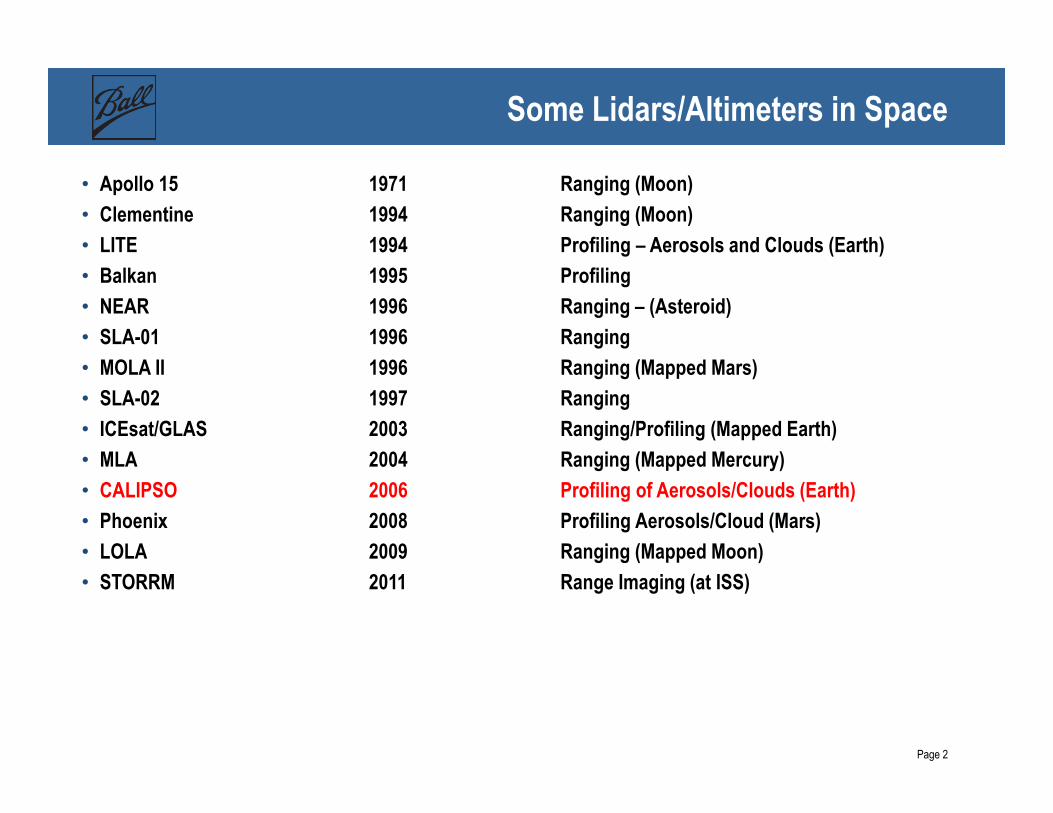
Some Lidars/Altimeters in Space
• Apollo 15 1971 Ranging (Moon)
• Clementine 1994 Ranging (Moon)
• LITE 1994 Profiling – Aerosols and Clouds (Earth)
• Balkan 1995 Profiling
• NEAR 1996 Ranging – (Asteroid)
• SLA-01 1996 Ranging
• MOLA II 1996 Ranging (Mapped Mars)
• SLA-02 1997 Ranging
• ICEsat/GLAS 2003 Ranging/Profiling (Mapped Earth)
• MLA 2004 Ranging (Mapped Mercury)
• CALIPSO 2006 Profiling of Aerosols/Clouds (Earth)
• Phoenix 2008 Profiling Aerosols/Cloud (Mars)
• LOLA 2009 Ranging (Mapped Moon)
• STORRM 2011 Range Imaging (at ISS)
Page 3
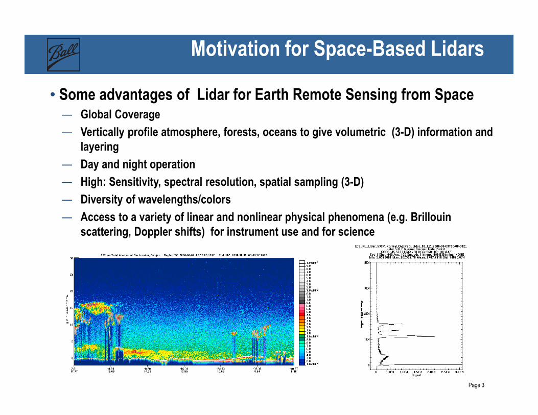
Motivation for Space-Based Lidars
• Some advantages of Lidar for Earth Remote Sensing from Space— Global Coverage
— Vertically profile atmosphere, forests, oceans to give volumetric (3-D) information and layering
— Day and night operation
— High: Sensitivity, spectral resolution, spatial sampling (3-D)
— Diversity of wavelengths/colors
— Access to a variety of linear and nonlinear physical phenomena (e.g. Brillouinscattering, Doppler shifts) for instrument use and for science

Page 4
CALIPSO and the A-Train: Earth Remote Sensing

Page 5
CALIPSO Payload and Spacecraft
CALIPSO includes the CALIOP Lidar –two-wavelength (532/1064nm), polarization sensitive, profiling lidar. It uses elastic scattering from aerosols, clouds, and air
Earth System Science Pathfinder(ESSP) mission
NASA - Ball
Payload
CNES – Alcatel
Proteus
Spacecraft
Principal Investigator – David Winker – NASA LaRC
Co-PIs – Patrick McCormick (Hampton University)
and Jacque Pelon (IPSL)
Launched April 2006
Page 6
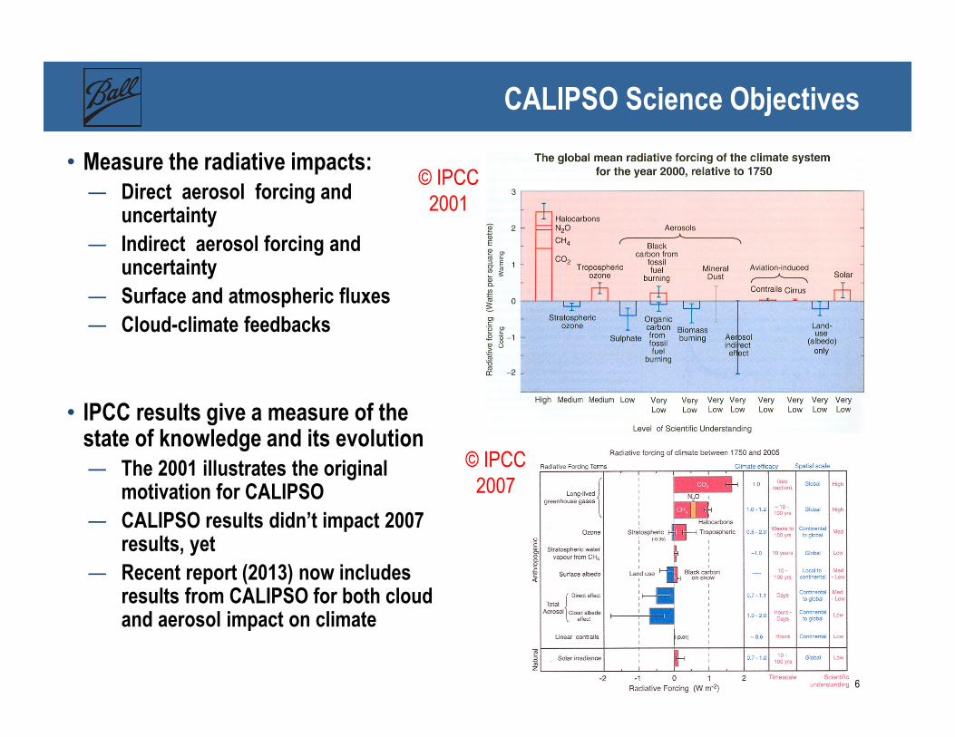
CALIPSO Science Objectives
• Measure the radiative impacts:— Direct aerosol forcing and
uncertainty
— Indirect aerosol forcing and uncertainty
— Surface and atmospheric fluxes
— Cloud-climate feedbacks
• IPCC results give a measure of the state of knowledge and its evolution — The 2001 illustrates the original
motivation for CALIPSO
— CALIPSO results didn’t impact 2007 results, yet
— Recent report (2013) now includes results from CALIPSO for both cloud and aerosol impact on climate
© IPCC
2001
© IPCC
2007

Page 7
Latest IPCC Report Results
© IPCC
2013
CALIPSO is just one of
many satellites used to
support the model
validations that create these
summaries

Page 8
Lidar Core –Technologies of the Transmitter and Receiver
ILT (Integrated
Lidar Transmitter)
ILR (Integrated
Lidar Receiver)
Beam Expander
Optics
Adjustable Boresight
Mechanism
Laser Optics
Modules
Laser Radiator
PMTs
Telescope – 1 meter Beryllium
Optical Bench
APD
Etalon Filter
Page 9
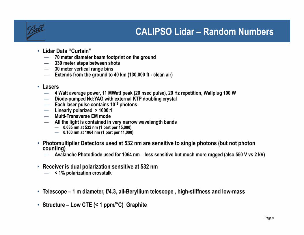
CALIPSO Lidar – Random Numbers
• Lidar Data “Curtain” — 70 meter diameter beam footprint on the ground— 330 meter steps between shots— 30 meter vertical range bins— Extends from the ground to 40 km (130,000 ft - clean air)
• Lasers— 4 Watt average power, 11 MWatt peak (20 nsec pulse), 20 Hz repetition, Wallplug 100 W— Diode-pumped Nd:YAG with external KTP doubling crystal — Each laser pulse contains 1018 photons — Linearly polarized > 1000:1— Multi-Transverse EM mode— All the light is contained in very narrow wavelength bands
— 0.035 nm at 532 nm (1 part per 15,000)— 0.100 nm at 1064 nm (1 part per 11,000)
• Photomultiplier Detectors used at 532 nm are sensitive to single photons (but not photon counting)— Avalanche Photodiode used for 1064 nm – less sensitive but much more rugged (also 550 V vs 2 kV)
• Receiver is dual polarization sensitive at 532 nm — < 1% polarization crosstalk
• Telescope – 1 m diameter, f/4.3, all-Beryllium telescope , high-stiffness and low-mass
• Structure – Low CTE (< 1 ppm/°C) Graphite
Page 10
What is different doing Lidar from Space?
• Long distance from atmosphere – 400- 800 km Low Earth Orbit (LEO) –
— Low Signal-to-Noise because of 1/R2 term in lidar equation
— Looking down through atmosphere- strongest scatter from furthest distance
— Ground/Ocean scatter sets far boundary condition
— Satellite motion, typical LEO velocity 7000 m/s – limits averaging time, can cause dopplershift if laser has a component along-motion
— Strong Solar background light signal – Solar spectrum reflected from clouds or ice is the most demanding
— Attitude control critical to pointing where you want— Well-developed techniques
— Severe vibration during launch
• Space Environment
— Radiation (Galactic, Solar, Van-Allen Belts)
— Vacuum – Outgassing and Contamination concerns
— Microgravity – Optical alignments shift after launch
— Atomic Oxygen – Erosion and reaction with surfaces
— Micrometeroids and space junk (recent collision was 80 km higher in orbit)
— Charging of Surfaces – Corona plus Arc Discharge
— Thermal environment – Controlled through careful design using radiators and heaters
Page 11
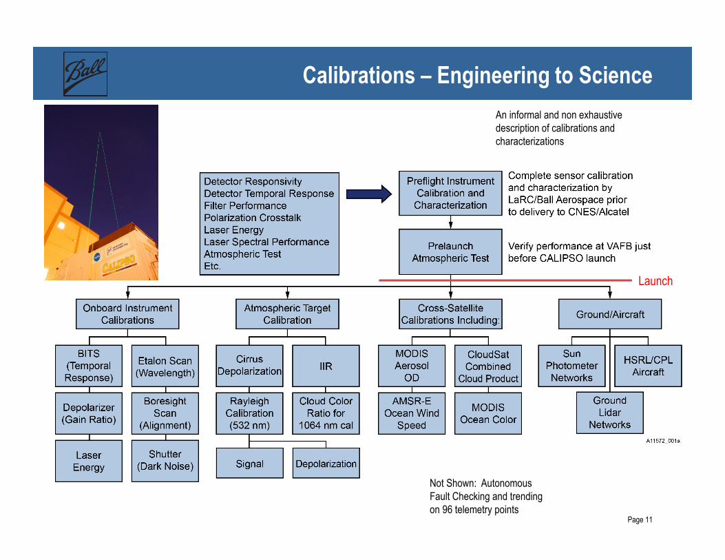
Calibrations – Engineering to Science
Not Shown: Autonomous
Fault Checking and trending
on 96 telemetry points
Launch
An informal and non exhaustive
description of calibrations and
characterizations

Page 12
Examples On-board and Atmospheric Calibrations
Courtesy of Ron Verhappen and Bill Hunt, NASA LaRC
Page 13
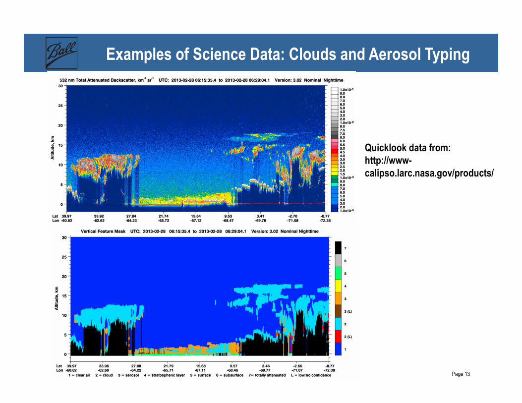
Examples of Science Data: Clouds and Aerosol Typing
Quicklook data from: http://www-calipso.larc.nasa.gov/products/

Page 14
Example: Aircraft Calibration of Aerosols
August 10, 2006
Coincidence
532 nm Attenuated Backscatter (km-1 sr-1)
1064 nm Attenuated Backscatter (km-1 sr-1)
Coincidence
CALIPSO
HSRL
CALIPSO
HSRL
CALIPSO
LaRC HSRL
NASA LaRC High Spectral Resolution Lidar is being flown on
Aircraft to support validating CALIPSO Data Graphics courtesy of Dave
Winker (LaRC)
Page 15
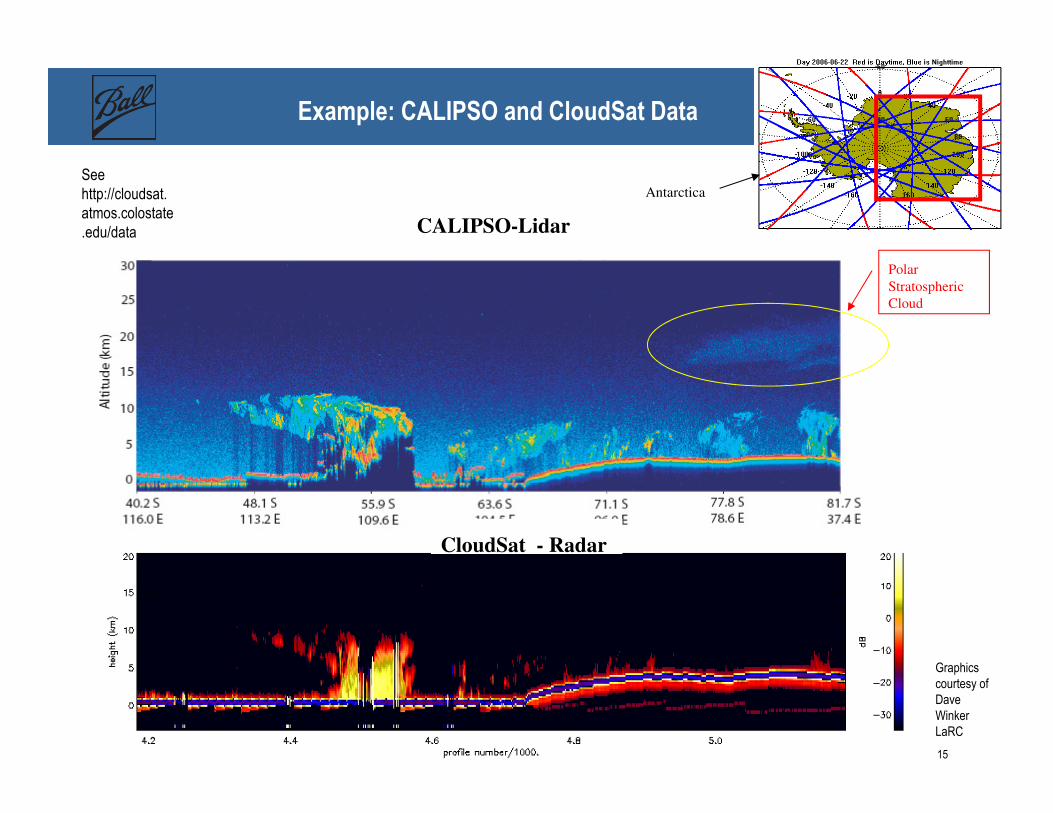
Example: CALIPSO and CloudSat Data
Polar
Stratospheric
Cloud
Antarctica
CALIPSO-Lidar
CloudSat - Radar
Graphics
courtesy of
Dave
Winker
LaRC
See
http://cloudsat.
atmos.colostate
.edu/data

Page 16
CALIPSO as a Pathfinder – Ocean Windspeed
• Wind over the ocean changes the surface roughness
• Change in roughness causes the reflectivity to change per Cox Munk relationship
• This works at all wavelengths – allows cross-comparison between microwave system (AMSR-E on AQUA) and CALIPSO
• Agreement to < 1.4 m/s rms when averaged over large microwave footprint dimensions
• CALIPSO allows accurate measurements over small (70 m) footprint
Courtesy of Yong Hu NASA LaRC
Page 17
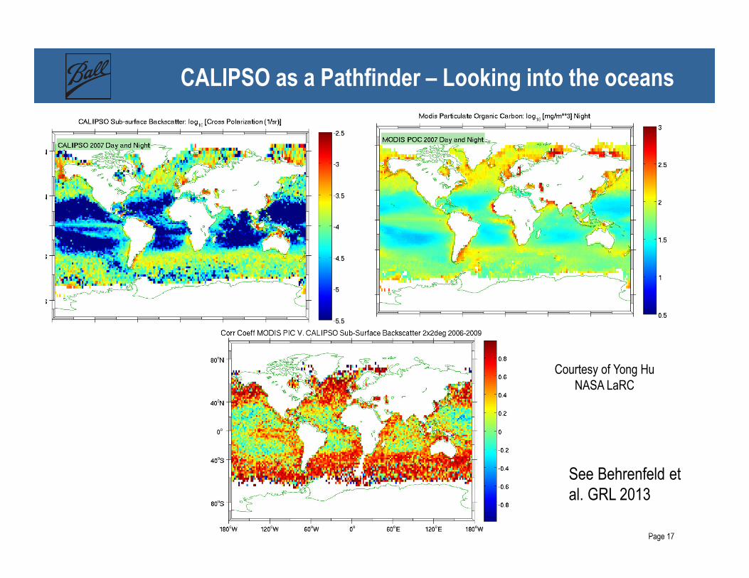
CALIPSO as a Pathfinder – Looking into the oceans
Courtesy of Yong Hu
NASA LaRC
See Behrenfeld et
al. GRL 2013

Page 18
Some Metrics for Success
Eight Years into a Three Year Mission • Requirements still being met after >8 years— Senior review process renews for 2 year periods
— Consumables will last to > 2017 – but Single String Payload means risk are growing
— New ground laser testing to try and extend laser life
• Total Laser Shots On-Orbit: 5 Billion— 1 GJoule of optical energy delivered (around 200 mJ per
laser pulse, split between 1064 nm/532 nm)
— 100 seconds total laser “on-time” (20 nanosecond pulse length)
• Data Downlink: — 12.5 TeraBytes of Science Data delivered to NASA LaRC
— 98.8% Capture Efficiency (one Downlink per day)
— Added in “Expedited Data” delivery mode that delivers with < 4 hours latency for science mission planning purposes
• Published Peer-Reviewed Papers to date – 1191— http://www-calipso.larc.nasa.gov/
Page 19
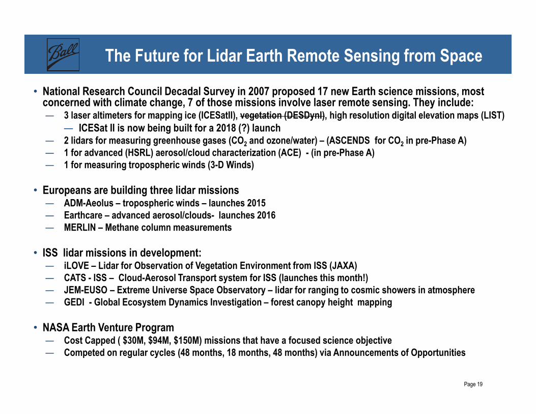
The Future for Lidar Earth Remote Sensing from Space
• National Research Council Decadal Survey in 2007 proposed 17 new Earth science missions, most concerned with climate change, 7 of those missions involve laser remote sensing. They include: — 3 laser altimeters for mapping ice (ICESatII), vegetation (DESDynI), high resolution digital elevation maps (LIST)
— ICESat II is now being built for a 2018 (?) launch— 2 lidars for measuring greenhouse gases (CO2 and ozone/water) – (ASCENDS for CO2 in pre-Phase A)— 1 for advanced (HSRL) aerosol/cloud characterization (ACE) - (in pre-Phase A)— 1 for measuring tropospheric winds (3-D Winds)
• Europeans are building three lidar missions— ADM-Aeolus – tropospheric winds – launches 2015— Earthcare – advanced aerosol/clouds- launches 2016— MERLIN – Methane column measurements
• ISS lidar missions in development: — iLOVE – Lidar for Observation of Vegetation Environment from ISS (JAXA) — CATS - ISS – Cloud-Aerosol Transport system for ISS (launches this month!) — JEM-EUSO – Extreme Universe Space Observatory – lidar for ranging to cosmic showers in atmosphere — GEDI - Global Ecosystem Dynamics Investigation – forest canopy height mapping
• NASA Earth Venture Program — Cost Capped ( $30M, $94M, $150M) missions that have a focused science objective— Competed on regular cycles (48 months, 18 months, 48 months) via Announcements of Opportunities

Page 20
New Mission Concept for Earth Venture – ATHENA-OAWL
• Proposed in 2013 by University of Maryland (PI –Lars Peter Riishojgaard; Deputy PI -Mike Hardesty of CIRES)
• Troposheric Winds from ground to stratosphere via Doppler shifts measured from aerosol backscatter
• Direct ingestion of data into Numerical Weather Models for testing forecast improvements
• 532 nm only for space version to minimize cost/risk
• OSSE’s of different configurations completed
• Expanded version – HAWC-OAWL in development for HSRL and Winds at 532 nm and 355 nm (PI-Tucker at Ball)
Page 21
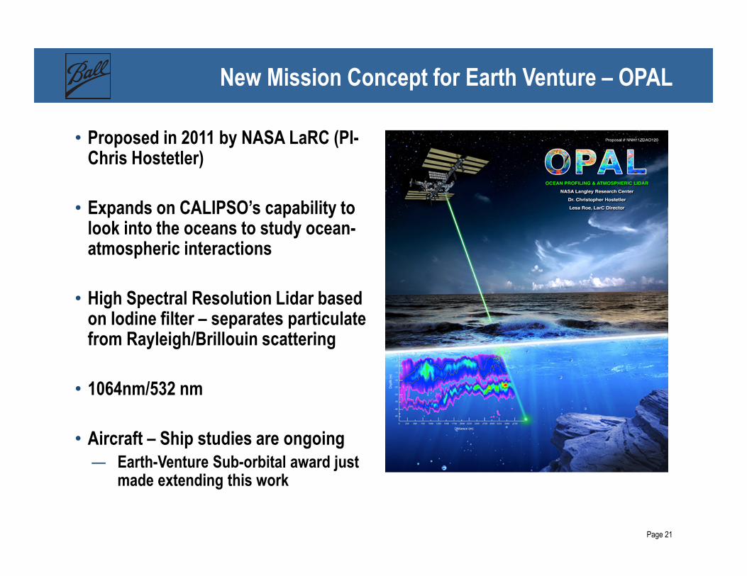
New Mission Concept for Earth Venture – OPAL
• Proposed in 2011 by NASA LaRC (PI-Chris Hostetler)
• Expands on CALIPSO’s capability to look into the oceans to study ocean-atmospheric interactions
• High Spectral Resolution Lidar based on Iodine filter – separates particulate from Rayleigh/Brillouin scattering
• 1064nm/532 nm
• Aircraft – Ship studies are ongoing— Earth-Venture Sub-orbital award just
made extending this work

Page 22
Images of CALIPSO Laser
Check-out UFO database at: http://www.nuforc.org/webreports/055/S55212.html
Images Courtesy
of Greg Hendry
Thank You! Questions?