the bush club inc., greater blue mountains national … blue mountains national park – wollemi...
TRANSCRIPT
1
The Bush Club Inc.,
Greater Blue Mountains National Park – Wollemi National
Park– Minotaur Point and Minotaur Lair- Friday 7th
October 2016- Part EXPLORATORY- Track Notes
Short title Minotaur Point and Minotaur Lair
Date Friday 7th October 2016
Leader Yuri Bolotin
Maps, etc. Department of Lands: Ben Bullen, 8931 – 4S topographic map, 1:25000, second edition GPS setting WGS 84.
Walk description and route
Park at GR 431 232 on Wolgan Rd and ascend towards Minotaur Watch. Explore around it, then climb further to visit the amazing Minotaur Point. Continue into the Minotaur Lair Gully, then climb up to the tops. Explore the dissected pagoda and slot country above. Descend into Minotaur Lair; along the way, recce for an exit midstream for a planned future walk; return via the gully. About 8k. Scrambling and exposure.
Rating 5, M.
Gear issues 2 litres of water, GPS, PLB, appropriate head and footwear, electrolytes, maps, compass, tape (leader only). Change of gear for afterwards.
Numbers 8
Meeting point
Pymble 0545, McDonalds Richmond 0640 (collect only), Salud Lithgow 0800, Wolgan Road, 0820.
Transport Club cars.
Comments Scrambling and exposure, Part exploratory.
Close of Bookings
ASAP
Enquiries Yuri Bolotin [email protected] tel. 014 3715 943 or Michael Keats [email protected] or tel. 9144 2096
The Party
Yuri Bolotin, leader, Brian Fox, Michael Keats, John Fox, Dave Dash, John Anderson, Emanuel Conomos, Harold Thompson, Anna Ossig-Bonanno, Karen Cody, Jafar Caley, members, Evgenia Obriadina, John Murray, guests, 13. The Weather
A fine somewhat cloudy day with rising humidity in the afternoon. Occasional light breeze was welcome. Temperature range 11 to 26. Background Notes
The essential elements of this walk were explored by Yuri Bolotin leading a small party on 10th September 2016. Extracts from Yuri’s notes are included to set the scene,
“The packs were left here, and we went exploring. Minotaur Watch is a
great pinnacle some 40m high that has separated from the main cliff line.
One part of the split pinnacle has become a separate monolith that ends

2
up with a giant pyramid shaped top. That structure is strangely
reminiscent of the famous Chrysler Building in New York. The other part
has a flat square top. Within the first, larger part, is a double slot, divided
by a rubble of broken sandstone and a thin wall. Both sides of the slot can
be climbed, but the left hand side is easier and perhaps more spectacular.
The left crack, just enough to squeeze your shoulder through, rises sharply
through some loose rocks, and the journey along its 50m length is an
exhilarating one. Care needs to be exercised in order not to displace any
boulders onto other members of the group below you; for that reason, we
climbed through the slot one at a time.” … “…When we reached a spot that looked promising, it was morning tea
time, at 1017, GR 4259 2297, 759m. I was so curious about what was over
there around the corner that I swallowed my banana in about 15 seconds
and went investigating. I first walked some 50m in a north westerly
direction back towards where we had come from, but at a much higher
level, until I could see a big window in the rock face. I approached the
window and peered through it. Wow! In front and underneath me was the
Chrysler Building-like pinnacle part of Minotaur Watch. From my
commanding position, I could see its sharp, red lichen clad spire, standing
out menacingly in front of the green mass of tree tops in the distant
background and framed by the honey coloured second part of Minotaur
Watch on one side and the dark main cliff line on another. What a sight!
But there was more! Before proceeding, I went back and called the rest of
the team to follow me. I then continued from the window at about the same
level for a few more metres, until I saw a deep drop that indicated there
was nowhere else to move at that elevation; however, right in front of me,
I saw a small ledge that was easy to get to. The ledge ends in a crack less
than a metre wide; I jumped over it; from the other side, I was able to see
that the crack was pretty shallow and one could even climb through it. I
was now on the edge looking down at Minotaur Watch! No longer did I
feel like a tiny helpless creature lost in a forest; I now thought I was a
mighty giant peering above these towers of stone.
But there was still even more! The thin spur I was walking along, with
sheer 40-50m drops on both sides, continues for about 100m to its end,
which is very narrow and crowned with a small rock, about 1m in
diameter. There is a cairn on top of that rock, which looked to me rather
old. Standing there, I was suspended above the Wolgan Valley and the
Minotaur Lair Gully gorge below me. Across on the other side of the
gorge, I could see slots and great caves of pale yellow sandstone framed
by green bush; looking back, the towering eroded face of the first of the
two pagodas at the end of the cliff line that we had seen from the Wolgan
Road was about 100m away from me. I named this spectacular location
Minotaur Point, GR 4264 2306, 770m, 10401045…”

3
The view of the ‘Chrysler Building’ from the window. Photo: Mark Bolotin
Minotaur Lair is a canyon located in an unnamed creek system that flows generally east into the western side of the Wolgan River, 1.7km south, south west of junction of Zobels Gully and Wolgan River. Access via Wolgan Road, 3km south of Newnes. In Greek mythology, the Minotaur was a creature with the head of a bull on the body of a man. He dwelt at the centre of the Cretan Labyrinth, which was an elaborate maze like construction. Named by Michael Keats on a Bush Club walk, 21st July 2010. Described by Michael as, "It is labyrinthine, it is mysterious, it is serpentine, it is long and it is varied; it is a special place." Previously known
4
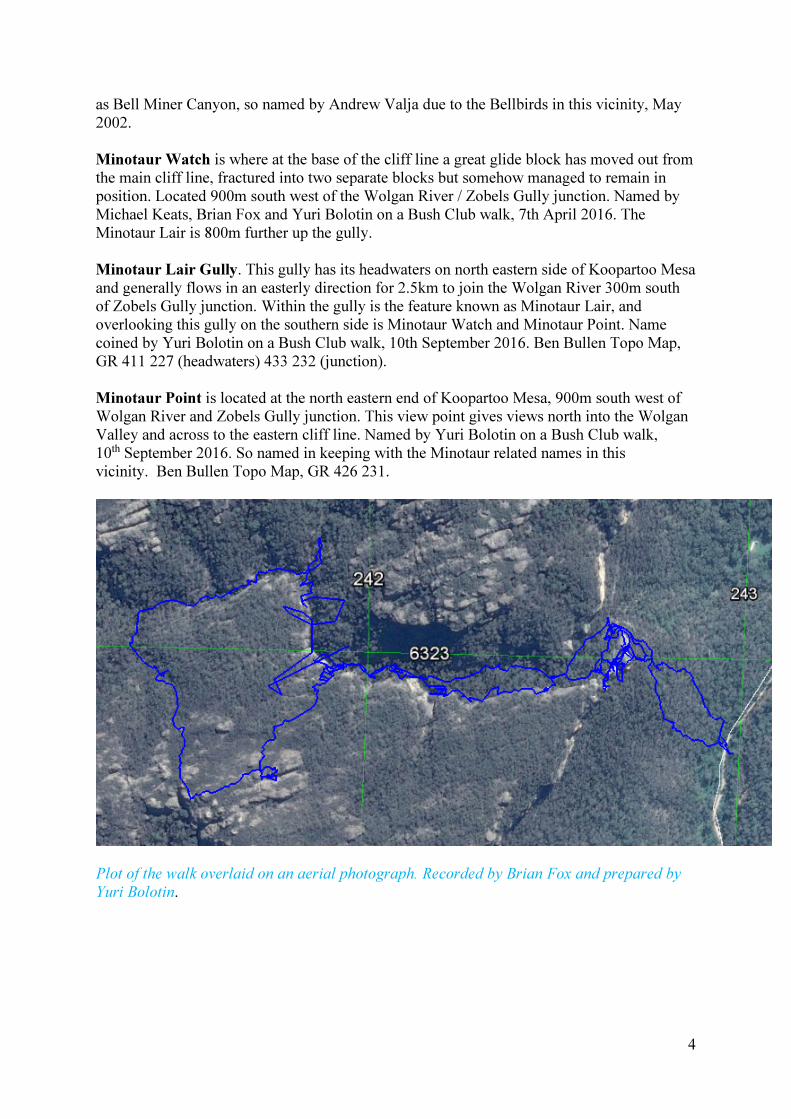
as Bell Miner Canyon, so named by Andrew Valja due to the Bellbirds in this vicinity, May 2002. Minotaur Watch is where at the base of the cliff line a great glide block has moved out from the main cliff line, fractured into two separate blocks but somehow managed to remain in position. Located 900m south west of the Wolgan River / Zobels Gully junction. Named by Michael Keats, Brian Fox and Yuri Bolotin on a Bush Club walk, 7th April 2016. The Minotaur Lair is 800m further up the gully. Minotaur Lair Gully. This gully has its headwaters on north eastern side of Koopartoo Mesa and generally flows in an easterly direction for 2.5km to join the Wolgan River 300m south of Zobels Gully junction. Within the gully is the feature known as Minotaur Lair, and overlooking this gully on the southern side is Minotaur Watch and Minotaur Point. Name coined by Yuri Bolotin on a Bush Club walk, 10th September 2016. Ben Bullen Topo Map, GR 411 227 (headwaters) 433 232 (junction). Minotaur Point is located at the north eastern end of Koopartoo Mesa, 900m south west of Wolgan River and Zobels Gully junction. This view point gives views north into the Wolgan Valley and across to the eastern cliff line. Named by Yuri Bolotin on a Bush Club walk, 10th September 2016. So named in keeping with the Minotaur related names in this vicinity. Ben Bullen Topo Map, GR 426 231.
Plot of the walk overlaid on an aerial photograph. Recorded by Brian Fox and prepared by
Yuri Bolotin.

5
Plot of the walk overlaid on a topographic map. Recorded by Brian Fox and prepared by
Yuri Bolotin.
Yuri points out the location of Minotaur Watch and Minotaur Point. Photo: Brian Fox.

6
The ‘Chrysler Building’ amongst other skyscrapers. Photo: John Anderson.
Track Notes
It has been a while since a walk started by walking in the opposite direction to the main objective. There was method in Yuri’s madness as we walked towards the Wolgan River, for from a clearing we had a view of the great stone towers that include the Minotaur Watch, and Minotaur Point. Even the briefing session impressed. These rock towers are more than sentinel guardians, they are the gateway to a unique world that exists on the Koopartoo mesa.

7
Only Brian could climb this shard within Chrysler Lane on the south side of the Chrysler
building. Photo: Yuri Bolotin.
8
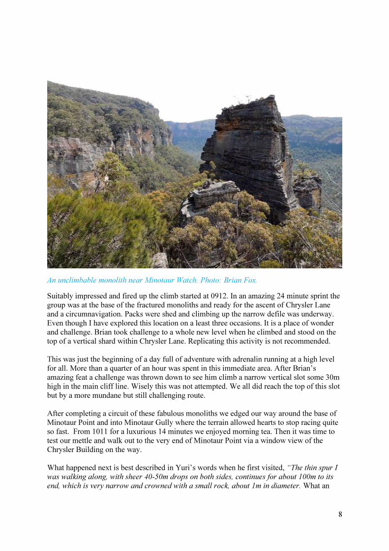
An unclimbable monolith near Minotaur Watch. Photo: Brian Fox.
Suitably impressed and fired up the climb started at 0912. In an amazing 24 minute sprint the group was at the base of the fractured monoliths and ready for the ascent of Chrysler Lane and a circumnavigation. Packs were shed and climbing up the narrow defile was underway. Even though I have explored this location on a least three occasions. It is a place of wonder and challenge. Brian took challenge to a whole new level when he climbed and stood on the top of a vertical shard within Chrysler Lane. Replicating this activity is not recommended. This was just the beginning of a day full of adventure with adrenalin running at a high level for all. More than a quarter of an hour was spent in this immediate area. After Brian’s amazing feat a challenge was thrown down to see him climb a narrow vertical slot some 30m high in the main cliff line. Wisely this was not attempted. We all did reach the top of this slot but by a more mundane but still challenging route. After completing a circuit of these fabulous monoliths we edged our way around the base of Minotaur Point and into Minotaur Gully where the terrain allowed hearts to stop racing quite so fast. From 1011 for a luxurious 14 minutes we enjoyed morning tea. Then it was time to test our mettle and walk out to the very end of Minotaur Point via a window view of the Chrysler Building on the way. What happened next is best described in Yuri’s words when he first visited, “The thin spur I was walking along, with sheer 40-50m drops on both sides, continues for about 100m to its
end, which is very narrow and crowned with a small rock, about 1m in diameter. What an

9
experience! The picture on page 10 shows the Yuri, Brian and I perched in a very special place. We were not the first there as the rock cairn will testify.
Yuri in Minotaur Lair. Photo: Brian Fox.
Following Yuri’s exploration on 10th September, Brian Fox undertook some research and his findings were that “The area above the cliff line in which you walked was covered by a mineral lease application by George Anderson and applied for 3rd July

10
1905. For Shale. Ref: Plan of Portion MP 13, Parish of Gindantherie, County of Cook. S1782. Surveyed 19th July 1906.” Again my admiration for the early surveyors rose. Anyone who had to lug survey equipment to a location as challenging as this would have to be exceptionally fit and very determined.
The precarious road to Minotaur Point. Yuri can be seen as a diminutive figure at the point
terminus Photo: Jafar Caley.
Past the viewing point where you can look down on the roof spire of the ‘Chrysler Building’, progress is a bit tricky and the drops vertiginous; a narrowing way forward is punctuated with drops to cross over and bushes that want to sweep you off the edge. Arrival at the terminus is an amazing experience. Looking southwards the cliffs some 150m away are yet another 30m higher. I remember the euphoria shared, 21st July 2010 when we first began exploring this place. In the June prior to that I recall being on the western edge of Constance Point and looking across the void of the Wolgan Valley and seeing what we now know as Minotaur Watch and Minotaur Point for the first time as several discrete monoliths and even then planning a visit. Returning from Minotaur Point we then tracked south climbing as we went to a ledge that projected out into the Wolgan Valley from the cliff line. The very edge of this projection also sported a cairn, possibly of similar vintage to the one on Minotaur Point. A study of the relevant mineral lease would confirm the relationship. It was 1104 before we all returned to the site where we had morning tea.

11
Yuri, Michael and Brian on Minotaur Point. The stick between Michael and Brian marks the
centre of a rock cairn. Photo: Evgenia Obriadina.
After such a serving of wonders it felt a bit mundane to be walking along the base of the southern cliff line of Minotaur Gully. In itself this is a magical location with alternating beautiful overhangs with sandy floors studded with animal and bird footprints, wind and natural erosion sculpted forms, hidden water falls, a side canyon which would be marvellous to abseil down and trees of a size and diversity that makes this high level valley one of the most delightful locations to visit. At one stage the waterway is hard against the southern wall and within a small but soaring amphitheatre there are two very different and distinct big trees. The first of these is a Sassafras, Doryphora sassafras. It can grow to a height of 25–35 m (80–110 ft.) It is a normally a straight-trunked tree generally with a small crown, its grey-brown trunk reaching a diameter of 1.2 m (4 ft.). Oppositely arranged on the stem, the green leaves are elliptic to lanceolate or ovate, usually 7–10 cm (3–4 in) long, 2–4 cm wide, margins are shallowly to deeply toothed, glabrous and glossy, with a pleasant 'sassafras' scent when crushed. I have now checked. They have a prominent midrib and veins on the paler underside. The small white flowers occur in groups of three on short axillary stalks from May to July, and are followed by dark brown hairy fruit which are ripe from February to August. The flowering display can be showy with flowers massed on branches, contrasting against the darker foliage. The unusual shape of the trunk of this specimen has been determined by local factors. The other tree of note is a huge eucalypt of venerable age. Because of its extreme height the diagnostic features are inaccessible. From what can be observed I believe it to be a Blackbutt,

12
Brian ascending Minotaur Pass. Photo: Jafar Caley.
Some members of the party celebrate a pagoda at our lunch site. Photo: Emanuel Conomos.

13
Eucalyptus pilularis. Blackbutt can grow to 50 metres in height, and a trunk diameter of 4.1 metres. Though is mostly seen between 20 and 45 metres tall. Like many large eucalyptus species, the maximum height in the past is difficult to determine. Maximum heights of the blackbutt may have reached greater sizes than the largest trees still standing today. Blackbutt is a potential giant, of immense size.
Harold and Karen in Minotaur Gully. Photo: Yuri Bolotin.
The group at the base of a giant Blackbutt in Minotaur Gully. Photo: Emanuel Conomos.

14
Dave, John A and John M in the Minotaur Lair canyon. Photo: Harold Thompson.

15
Michael in Minotaur Lair
canyon. Photo: Emanuel
Conomos.
Aerial photo studies by Yuri showed a possible slot pass exit from Minotaur Gully to the top of the Koopartoo Mesa at GR 419 239. On 10th September 2016, Yuri proved that this slot followed by a succession of alternating ramps was negotiable. On the day it was also proved that a scramble up a ledge adjoining to the immediate west was also negotiable to the mid- section of the slot. A short exposed leap is involved to reach the top section. Dave positioned himself as a brace for those using this option. This pass has been named Minotaur Pass. The appealing aspect of using this pass is that a circuit walk is possible so the Minotaur Lair canyon can be enjoyed travelling downstream. The five ramps that follow are all easy grade and lead to a relatively scrappy section of the plateau top that is heavily peppered with great pagodas. It is not easy country to move through with many multi stemmed
Whipstick Mallee Ash (Eucalyptus multicaulis) enforcing a slow pace. At 1227 we were in fine pagoda country. A towering collection of pagodas generally at GR 418 237 was chosen for lunch. Extensive views over the Minotaur Gully catchment are stunning. Brilliant golden yellow Pagoda Daisies, Leucochrysum graminifolium dotted the pagoda surfaces. This amazing daisy grows nowhere else but on high pagodas. Over lunch I reflected on the spring colours and scents we had encountered. High in number of specimens sighted, and exquisite in their beauty, were the ubiquitous Rock Orchids, Dendrobium
speciosum. Next were the Prosthanteras in varying shades of purple. Colourful also were the pink shades of Zimeria species.

16
Evgenia high above Chrysler Lane. Photo: Emanuel Conomos.

17
Some of the group in a lush section of Minotaur Gully. Photo: Emanuel Conomos.
Walking south after lunch we entered another pagoda rich area, a very familiar area for this was the location in July 2010, GR 416 226 where we had lunch and were gobsmacked by the view over the Wolgan Valley. Nothing has changed. It is still a remarkable location and the dissection of the terrain adds to the sensational feeling of being on top of the world. It is a place close to heaven in every sense. When the senses were sated we set off walking northwest down into the catchment of Minotaur Gully. It is a rigorous descent with some small drops. During the descent we had a reminder of the importance of safety when walking above other walkers. A football size rock was dislodged. Due to quick thinking and even quicker response an incident was averted. It was a very circumspect group that descended to the creek junction at GR 417 231. We now commenced a beautiful progress down Minotaur Gully that morphs seamlessly into Minotaur Lair and the canyon. Recent rains had pushed a lot of debris into the waterway and several sections required limbo rock type movements to proceed. Before entering the Minotaur Lair proper, Yuri and Brian went to check a tributary creek at GR 418 232 to verify
18
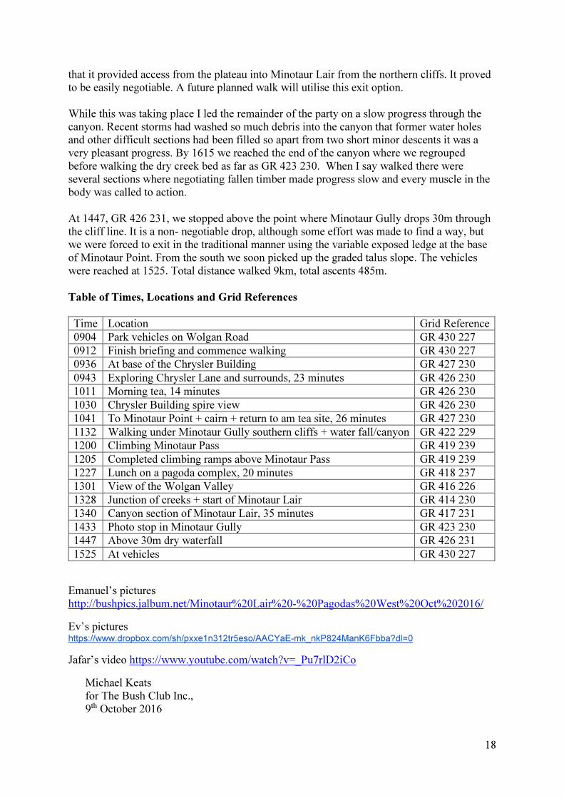
that it provided access from the plateau into Minotaur Lair from the northern cliffs. It proved to be easily negotiable. A future planned walk will utilise this exit option. While this was taking place I led the remainder of the party on a slow progress through the canyon. Recent storms had washed so much debris into the canyon that former water holes and other difficult sections had been filled so apart from two short minor descents it was a very pleasant progress. By 1615 we reached the end of the canyon where we regrouped before walking the dry creek bed as far as GR 423 230. When I say walked there were several sections where negotiating fallen timber made progress slow and every muscle in the body was called to action. At 1447, GR 426 231, we stopped above the point where Minotaur Gully drops 30m through the cliff line. It is a non- negotiable drop, although some effort was made to find a way, but we were forced to exit in the traditional manner using the variable exposed ledge at the base of Minotaur Point. From the south we soon picked up the graded talus slope. The vehicles were reached at 1525. Total distance walked 9km, total ascents 485m. Table of Times, Locations and Grid References
Time Location Grid Reference
0904 Park vehicles on Wolgan Road GR 430 227
0912 Finish briefing and commence walking GR 430 227
0936 At base of the Chrysler Building GR 427 230
0943 Exploring Chrysler Lane and surrounds, 23 minutes GR 426 230
1011 Morning tea, 14 minutes GR 426 230
1030 Chrysler Building spire view GR 426 230
1041 To Minotaur Point + cairn + return to am tea site, 26 minutes GR 427 230
1132 Walking under Minotaur Gully southern cliffs + water fall/canyon GR 422 229
1200 Climbing Minotaur Pass GR 419 239
1205 Completed climbing ramps above Minotaur Pass GR 419 239
1227 Lunch on a pagoda complex, 20 minutes GR 418 237
1301 View of the Wolgan Valley GR 416 226
1328 Junction of creeks + start of Minotaur Lair GR 414 230
1340 Canyon section of Minotaur Lair, 35 minutes GR 417 231
1433 Photo stop in Minotaur Gully GR 423 230
1447 Above 30m dry waterfall GR 426 231
1525 At vehicles GR 430 227
Emanuel’s pictures http://bushpics.jalbum.net/Minotaur%20Lair%20-%20Pagodas%20West%20Oct%202016/
Ev’s pictures https://www.dropbox.com/sh/pxxe1n312tr5eso/AACYaE-mk_nkP824ManK6Fbba?dl=0
Jafar’s video https://www.youtube.com/watch?v=_Pu7rlD2iCo
Michael Keats for The Bush Club Inc., 9th October 2016