the bulletin number 69 march 1977 - new york archaeology
TRANSCRIPT

THE BULLETIN
Number 69 March 1977
CONTENTS
Archaeology of the New York Metropolis Robert L. Schuyler 1 Archeological Investigations in the Vicinity of "Fort Crailo" During Sewer Line Construction Under Riverside Avenue in Rensselaer, New York Paul R. Huey, Lois M. Feister and Joseph E. McEvoy 19 Archaeology, Education and the Indian Castle Church Wayne Lenig 42 New York State Archaeological Association-Minutes of the 60th Annual Meeting 52


No. 69, March 1977 1
ARCHAEOLOGY OF THE NEW YORK METROPOLIS Robert L. Schuyler City College, CUNY
Introduction
Almost ten thousand years of human prehistory are buried in the shores, peninsulas, and islands on which New York City and its satellite communities stand today.1 Between 14,000 B. C. and 10, 000 B. C. the final retreat of the Wisconsin ice sheet modified and opened the harbor area. Human population was then able to enter the estuary and lower valley of the Hudson by following two natural migration corridors. Movement east and west was possible along the coastal plain, while access to the interior followed the river and its valley that ran over 200 miles to the north. Once Man entered the region he settled in. Bands of Paleo-Indian hunter-gatherers and their archaic descendants found an area rich in natural resources. A complex interfacing of salt and fresh water provided marine, estuarine, and riparian sources of food. On land an even broader transition between three major physiographic provinces-New England Upland (Manhattan and Westchester County), New Jersey Lowland, and Atlantic Coastal Plain (Staten Island and Long Island)-greatly enriched the range and variety of available fauna and flora. Exploitation of these resources allowed the evolution of a succession of prehistoric cultures. Hunter-gatherers held sway for several millennia but were replaced by agriculturalists living in scattered hamlets and perhaps larger, sedentary villages during the Late Woodland (ca. A.D. 1000-1600). This indigenous record of cultural development was complete except for one major stage of evolution. Urban civilization was external, being introduced only in the 17th century by Europeans.
Although urban society has a local history of barely three and a half centuries, compared to a hundred centuries for prehistory, it has left a more varied and impressive archaeological record. Unfortunately the existence and significance of these remains have only recently drawn the attention of professional archaeologists. This paper will summarize this research and then, using two projects as examples, discuss the potential contribution of urban historical archaeology to anthropology.
Survey of New York Urban Archaeology Settlement and Formation (1609-1720)
Regional prehistory and history are not completely discontinuous. Native cultural development continued for over a half century after the arrival of Europeans and the same factors that drew the American India n to the mouth of the Hudson also attracted the Dutch.2
Except for occasional 16th century visitations by European explorers (the earliest recorded being the 1524 timid probing of the Narrows by Giovanni da Verrazano), it was not until September 11, 1609, that the harbor became an area of continuous European activity. Henry Hudson, like unnamed Indian explorers some 10,000 years earlier, was drawn by the river that now bears his name and the fur bearing animals that inhabited its watershed. At its height the fur trade, which intimately tied European and Indian together, was producing 85,000 skins a year. This flow was important enough after 1624 to merit a permanent settlement on Manhattan but it was a "trifling" trade within the total global Dutch system. After 1629 a "patroon" system of landed estates initiated a different economic base for the colony-agriculture. Most of the patroon grant manors were situated farther up the Hudson but a number were located around Figure 1: Cover illustration. Key to Archaeological Sites. (1) Remains of Dutch ship, Tijger (1613). (2) Stadthuis (City Hall) Site (1653-1699). (3) Melyn Site (ca. 1630-1660). (4) Pieter Claesen Wyckoff House (1650-present). (5) Fort Washington Site (1776-1783). (6) Dyckman Farm/Soldier Encampment Site (1776-1783). (7) "Old Fort" Remains (1776). (8) Weeksville (1839-1890). (9) Sandy Ground (1850-present). (10) Paterson (1793-present). (11) Brooklyn Heights Site (ca. 1840-present). Projects that are just outside of the metropolitan area, such as the work of Budd Wilson in southern New Jersey and Edward J. Lenik in northern New Jersey, are not reviewed in this paper. (1) Notes at end of paper, p. 17.

2 THE BULLETIN
New Amsterdam. By 1664, when the English captured the original Dutch colony, the patroonships had failed but they did create an economic revolution that in the 1680's saw the beaver skin give way to the wheat barrel. Since New Amsterdam was the center for the bolting of flour it became more than a village-trading post. Steady growth increased the population to 7, 000 by 1720, placing the town on the verge of future economic, social, and demographic changes that would transform it into a true city. Archaeological remains from this opening phase in New York's history represent the two themes of fur and flour (see Figure 1). Following Hudson's pioneering voyage a number of ships were drawn to the Hudson by the abundance of fur-bearing animals. In 1613 two ships of the Van Tweenhuysen Company reached the harbor. One of these vessels, the Tijger under Adriaen Block, landed on southern Manhattan and spent several months collecting furs from the local Indians. The Tijger was small, perhaps 80 ft. long, which would give it a weight of some 130 tons. It was, however, well armed, carrying six to eight cannons weighing between 1500 and 1600 pounds. In January 1614 Block was ready to sail when a fire burned the ship to water line (Hallowell 1974). Block and his crew built a smaller vessel, perhaps from parts salvaged from the Tijger, and returned to Europe. During the next 300 years, during which the topography of southern Manhattan was greatly altered by land fill, the wreck remained buried, but in 1916 the excavation of the Interborough Rapid Transit subway exposed the burned shell of a ship under some 11 feet of river silt and 9 ft. of fill. The location of the remains, associated artifacts (including a Dutch broad-headed axe, glass trade beads, clay pipes, a small cannon ball, and European ceramics), a C-14 date from the timbers (Broecker and Kulp 1957), and a metallurgical analysis all strongly indicated that the remains were those of the Tijger (Solecki 1974). Although the ship could not then be totally excavated, and more recent attempts have failed to relocate it, an 8 ft. section of keelson and ribs were preserved. One of the original cannons, lost when the Tijger sunk, has also been discovered on the site (Hallowell 1976).
Importance of the fur trade and the possibility of English encroachment from New England or Maryland prompted the Dutch to reinforce their claim to the Hudson by placing a permanent settlement on Manhattan in 1624. This colony was tightly clustered below what today is Wall Street. Archaeological evidence of this first New York has frequently been unearthed in southern Manhattan. Over 30 ft. of stratified cultural deposits have built up in the area (Salwen 1973) although most of these layers have been destroyed by later urbanization. Sections of the foundations and roof tiles of a structure that may have been the first Stadthuis, or City Hall (1653-1699), have been located in one test excavation (Shelley 1971).
Paralleling the growth of the trading village-fort on Manhattan was an expansion of secondary agricultural settlements. These farms initially helped only to support New Amsterdam, but eventually they transformed its economy. The Dutch West India Company issued patroon ships in 1630 that included Staten Island and parts of New Jersey. The Staten Island "fief" ex changed hands and was violently destroyed at least three times. As the fur-bearing animals were depleted in the region around the harbor and lower valley the focus of the trade shifted to Fort Orange (Albany). Open conflict between the local harbor Indians and the Dutch, who no longer shared common interests, broke out.
Cornelis Melyn established one of these farming communities in 1642 on Staten Island near the Narrows. It was abandoned in 1643, reestablished, and finally completely burned in 1655 during the "War of the Peach. " Trash pits, which probably date from the first or second plantations, have been discovered (Anderson and Sainz 1965). A Flemish two-handled jar, sections of a Bellarmine jug of German origin, ceramics (English slipware and Dutch and English delftware), a brass "Latten" spoon, and a brass pipe tamper bearing an effigy of Charles I (1625-1649), all point to a temporal span of ca. 1630 to 1660. The location of the settlement was designated as "maize lands" in the documents, and a heavy scatter of Indian artifacts show that its agricultural potential was recognized prehistorically as well as historically.
Other Staten Island sites, including a possible 17th century house-general store that served the farmers on the North shore (Anonymous 1974), have been archaeologically explored but no published reports have been issued. Farms were not limited, however, to Manhattan or Staten Island. In the 1640's or early 1650's a farm-the Pieter Claesen Wyckoff House-was built in East Flatbush, Brooklyn. Test excavations around the house, the oldes t structure in Kings County, exposed strata and materials from the 20th, 19th, and 18th centuries (Salwen, Bridges,

No. 69, March 1977 3 and Klein 1974). The original 17th century occupation surface and late 17th-early 18th century Dutch ceramics and clay pipe fragments were also found. The dearth of early materials might be explained by the failure to encounter primary trash pits and the limited extent of the excavations.
New Holland was seized by the Duke of York in 1664, recaptured by the Dutch in 1673, and retaken permanently by the English the following year. These political vacillations were not as basic as the economic and social expansion that, in the early 18th century, began to transform a town into the City of New York.
Urban Evolution (1720-1815)
New Amsterdam was founded as a small, specialized trading link between the Hudson Valley and Europe. The success of local agriculture and the establishment of a populous hinterland allowed its successor to expand this trade into a commercial base. Export of flour to West Indian slave plantations and southern Europe was soon supplemented by a carrying trade involving the importation of English manufactured goods. Population grew with the economy. In 1720 there were 7, 000 inhabitants in New York City, while a century later there were 124, 000. Such phenomenal growth led to the rapid urbanization of New York but since the city was artificially confined to the tip of southern Manhattan, all the problems seen in contemporary modernization soon appeared. Crowding, inadequate housing, crime, ethnic succession and conflict (in 1720 there were 1600 Negroes in the city), fire control, special cultural activities, land fill projects, and disarticulation of political and social institutions from an evolving technological base are not 20th century developments. All of these aspects of urban life were familiar to 18th century New Yorkers.
The rise of an urban society on the shores of North America undermined the colonial mother country relationship. The American Revolution, during which New York was continuously occupied by the British (1776-1783), and its aftermath disrupted the process of urbanization. In 1775 New York's population stood at 25, 000, in 1776 it had fallen to 5, 000 and the city was economically and militarily isolated. Disruption was temporary; indeed, independence put the city on the start of a meteoric rise that would see it emerge as the largest and most vital city in the New World.
Archaeologically only one phase of this period of urban evolution has been studied-its disruption. Artifacts of the Revolution have been recovered from almost all parts of the city but extensive excavations have been undertaken only along its outer limits. After the Battle of Long Island the English occupied the city. Their effective control did not extend beyond the harbor region, which necessitated the stationing of permanent garrisons in areas like northern Manhattan and Staten Island. On the latter island the "Old Fort" has been explored (Calver and Bolton 1950:30-36). But extensive excavations have concentrated on Washington Heights. After Fort Washington in northern Manhattan was lost by the Americans in 1776 the British fortified the Heights. An archaeological survey of the fort site, now Fort Tyron Park, exposed remains left by both the American defenders and later occupation troops (Calver and Bolton 1950:45-54). North of the fort, very rich deposits were also exposed of a large British encampment established in 1776 on the Dyckman Farm. Two regiments (1200 men) were housed there in 120 huts. These crude dwellings were dugouts usually 12 to 15 ft. deep with dirt floors about 12 ft. wide. Fifty of them were excavated (Calver and Bolton 1950; 11-26) producing one of the finest collections of 18th century British military accoutrements in North America. As there is extensive documentation on the succession of regiments on the site (e. g. the Seventeenth left the site in 1779 and did not return because it was captured at Stoney Point), the buttons, badges, belt-plates, and personal items recovered are tightly dated. Of equal importance is the picture that domestic remains give of 18th century military life in the field. Recent excavations outside of New York State have shown that 18th century officers were surprisingly well supplied with ceramics and other in-vogue amenities from England. This pattern appeared at the Dyckman site but its proximity to an urban center complicates interpretation. Much of these materials may have been looted rather than shipped in for the officers from Europe. Status differentiation between officers and privates and some ethnic variation between English, Hessian, and local Loyalist troops were noted as was the presence of toys (e. g. locally manufactured "buzzers"). Toys confirm indications in the written sources that many of the soldiers had brought their families to America.

4 THE BULLETIN On November 25, 1783, all British forces, along with 12,000 Loyalist refugees, evacuated New York.
Urban recovery, however, was not complete until the end of the global Napoleonic Wars. Urban Florescence and Industrialization (1815-1920)
After 1815 New York entered a new growth cycle that, by 1860, elevated it to the position of leading seaport in North America and, by 1920, brought it world primacy as a city. The motive force behind this cycle was again commerce but commerce that was grounded on the qualitatively new factor of industrialization.
Both the Industrial Revolution and its impact on New York passed through two phases; the first external, the second internal. Before 1860 New York was still a pre-industrial city but its economy was structured by the emergent industrialization of England and sections of New England and the Middle Atlantic region. The expansion of global trade networks under the stimulus of mass production was advantageously tapped. In 1860 New York's wharves handled two-thirds of all foreign imports into America. The city was equally successful in appending an enormous hinterland to itself through a system of canals and railroads.
Population leaped from 123,000 in 1820 to 813,000 in 1860 and urban life was no longer limited to Manhattan. Brooklyn was a city in its own right by the latter date. Its 182,000 citizens made it larger than New York had been in 1820. After the Civil War massive immigration kept the spiral moving upward. Movement from Ireland, which became a flood in the 1840's, was replaced by other streams that constantly altered the ethnic composition of the city. Jews, for example, who had only reached a level of 40,000 in 1860 numbered over a half million by 1900.
Between 1860 and 1920 the context of urban growth also altered as industrialization became internal and underwent its own evolution. Steam made dependence on waterpower obsolete, allowing factories to move closer to or into the metropolitan zone. However, even this basic energy source was soon secondary. By the 1920's the use of new fossil fuels, electricity, and internal combustion laid the foundation for a modern metropolis of over 5,000,000 inhabitants.
Investigations of this phase of New York urban archaeology have predictively focused on ethnic diversity and industrialization. Two of the three major projects dealing with sites dating between 1815 and 1920 will not be reviewed here. Excavations at Sandy Ground, a 19th-20th century oystering community, and Paterson, New Jersey, a 19th century industrial satellite of New York, will be covered in the second part of this paper.
In 1838, James Weeks, a free black man, purchased a lot and house in the Bedford-Stuyvesant section of Brooklyn. Within ten years enough black families had joined him to form a distinct settlement and establish the Bethel African Methodist Episcopal Church (Salwen and Bridges 1974). Weeksville, as the community came to be called, grew in size and was able to support several black institutions. Children were enrolled in Colored School No. 2, and some lived in the Howard Colored Orphans Asylum. At the opposite end of the age spectrum elderly persons could enter the Zion Home for Colored Aged. Cultural and social groups, such as the African Civilization Society and the Abyssinian Benevolent Daughters of Esther Association (Anonymous 1971; Mims 1971), also existed. As the century progressed, however, urban expansion, particularly land speculation, destroyed the community. It ceased to exist by the 1890's and today only four of the original houses are still standing.
Recent urban redevelopment had badly disturbed the area before professional archaeological research could be initiated. A number of items were recovered from houses prior to demolition, including a fine set of photographs and postcards dating between 1870 and 1905 (Hurley 1969:18). Some archaeological features (e. g. a well abandoned in the 19th century) were also located, but analysis has concentrated on the 2, 852 recovered ceramic specimens (Salwen and Bridges 1974). Treated as a unit, this "assemblage" has a time span of ca. 1790 to 1969, thus completely bracketing the history of Weeksville. Evidence of socio-economic changes in the area is seen in the archaeological record. The use of greater quantities of pottery as the 19th century progresses parallels the growth of population and the increase in house building activity. Decline in the variety and status of ceramics is seen in the third and fourth decades of the 19th century. In the 1870's expensive imports give way to crude, domestic wares. This pattern correlates with Weekville's economic and ethnic disintegration.

No. 69, March 1977 5 Ironically, although this black settlement died out before the 20th century, the area was eventually to revert
to black occupancy as a part of Bedford- Stuyvesant.
Recapitulation
The projects just reviewed (see Table 1) follow national patterns for work on urban sites. Some of the characteristics, such as the issuance of preliminary but not final reports, are common to both prehistoric and urban archaeology. The disturbed nature of deposits, limited extent of excavations, and lack of research designs are, at the same time, unique. Etiology of these characteristics is complex. Both the inherent nature of the urban environment and questions of archaeological method and theory are involved.
Several historical archaeologists have discussed the distinctive character on urban site excavations in America. One result is a debate concerning the question of archaeology in the city versus archaeology of the city (Foley 1967; Ingersoll 1971; Foley in Ingersoll 1971; 71-72; Salwen 1973). It is true that problem of disturbance, looting, and legal perplexities will be encountered whether a city site is Paleo-Indian or industrial (see Powell 1962; Landberg 1967), but a definition of "urban archaeology" cannot be based on methodology. Urban archaeology is archaeology of the city. A survey of projects on the national level (see Table 2) that excludes prehistoric sites reveals a second question in differentiating urban from non-urban. Archaeologists for several years have been excavating in cities that have one or several pre-urban phases in their history. St. Augustine, San Diego, and New Orleans, for example, have seen excavations that have concentrated on these settlements when they were towns or specialized mission/fort/trading post communities. In fact, it is debatable if Hispanic St. Augustine or San Diego were ever cities.The eleven odd projects in New York City also divide along the same line. Pre-18th and early 18th century sites in New York are not urban. Excavation of the Pieter Claesen Wyckoff House as the base for
. . a long-range archaeological project designed to expose and study large horizontal sections of the early surfaces. Such a project could be expected to provide unique information about the operation of a Dutch colonial farm . . . (Salwen, Bridges, Klein 1974:30).
would be more successful in an extra urban context. Investigation of some typical Dutch farms in the Hudson Valley, where isolation would have more likely preserved them from urban disturbances, would produce in situ assemblages that could then serve as an interpretative-backdrop for sites like the Wyckoff house.
Of course earlier phases could be important for an understanding of the evolution of the city but work at sites like the San Diego Presidio was not predicated on such a research goal. Projects that are consciously urban in orientation have focused on "new" cities (i. e. settlements created rapidly in the 19th century with fully urban aspects) including Lowell, Denver, Patterson, and Sacramento, or on cities that witnessed only minor activity before their emergence as urban centers. San Francisco, Detroit, and Portsmouth N. H. are examples.
If a definition of urban archaeology excludes non-urban and pre-urban periods and sites then a number of significant problems intrinsic to the urban setting are highlighted. A persistent complaint of archaeologists working in urban areas concerns the fragmented nature of sites and deposits. Disturbance is certainly a common occurrence but what is overlooked is that settlement patterns in true urban zones are in themselves fragmented when compared to prehistoric or early historic villages and towns. Viewed evolutionarily this pattern ranges from the complete-preserved village showing a brief occupation to a greater and overlapping concentration of peoples and structures as complexity increases. Ultimately the emergence of the modern city creates tenements and block-neighborhoods that break individual human activities into smaller and more specialized units. Preservation of the remains of human activities is also hierarchically arranged-from almost total preservation of primary deposits representing primitive cultures, to secondary deposits (actual "dumps") in more complex societies, ending with no deposits at all in some modern cities. Garbage collection, which has reached an absolute level only in the 20th century, and massive, mixed land-fill or sea dumping only leaves a temporary architectural shell for the archaeologist to explore

6 THE BULLETIN

No. 69, March 1977 7
Such a radical change in the nature of settlement patterns and trash deposition requires new approaches and field methods. One might do ethnoarchaeology or "archaeology-on-the-hoof." A number of researchers have undertaken such studies in grocery stores and apartment buildings (Salwen 1973) in New York and other cities. Another possibility is to chase after the data before they are carted away. William Rathje, the "Guru of Garbage," is doing just that in Tucson, Arizona.
Living garbage-archaeology and soup cans are innovative if somewhat unorthodox subjects. It is also necessary, at the same time, to reconsider traditional methodology and sources of data. Salwen and Bridges, for example, were forced to lump ceramics from Weeksville that spanned a hundred years and thousands of lives. Their problem is instructive. Broad, even gross approaches involving sampling based on the repetitive patterns of modern material culture may be part of the answer, even if such techniques violate the field and laboratory canons developed on simple, prehistoric sites. This change of focus is the equivalent of the problem facing the traditional ethnographer who enters the city. Not one culture limited to an isolated island, but hundreds of interacting "cultures" in totally new institutional contexts are encountered. Many social anthropologists respond either by doing traditional research (street corner and block ethnography), which seems rather micro productive, or by ignoring the fact that their subjects live in a city.
For the archaeologist the need for new methodologies will only become apparent if research designs based on the evolution and nature of cities, traditional and industrial, are developed. If 19th century immigration is being studied, as Edward Rutsch and Mary Jane Rutsch

8 THE BULLETIN are doing in Paterson, the problem of fragmentation may not be a problem. There are potentially thousands of backyards to excavate. The complex ("disturbed") stratigraphy found in such time capsules is actually the detailed record of the constantly changing residents and their lives. Careful excavations of such micro-strata will be very revealing. In contrast areas of impending redevelopment might be more productively approached using salvage techniques. Excavations of dozens of such enclaves would produce a general picture within which such careful "digs" would take on a fuller meaning. Urban archaeological remains are fragmented because, in part, urban life was and is dissected in new and unique ways when compared to life in traditional society.
Two examples of projects in metropolitan New York will indicate the potential ranges of data from sites that are approached with research designs based on the city.
Two Studies in the Urban Archaeology of Greater New York
Paterson, New Jersey: a Study in Industrial Urbanism Notwithstanding the 18th century invention of the steam engine early American industry was based on
waterpower. Pioneer factories could not be situated within major cities, like New York, because these stood on the flat coastal plans. What was required was a location that combined a natural fall line, the basis of waterpower, with proximity to a city, which supplied markets and established transportation systems. In the late 18th century Alexander Hamilton and his New York associates initiated a search of the metropolitan area for such a site for the establishment of the first planned industrial community in America. The Great Falls on the Passaic River located less than 20 miles from Manhattan and offering tremendous waterpower, was selected. In 1792 the Society for the Establishment of Useful Manufactures purchased land at the Falls around which the city of Paterson was to grow.
The advantages which Paterson possesses for a manufacturing town are obvious. An abundant and steady supply of water-a healthy, pleasant and fruitful country supplying its markets fully with excellent meats and vegetables-its proximity to New York, where it obtains the raw materials and sale for manufactured goods . . . (Archdeacon 1853, quoted in Cotz 1975:46).
During the 18th century a power canal system, factories, and some housing were constructed but
economically the experiment was a failure. It was only during the 19th century that textiles (including silk), locomotive building, and labor migration from Europe established the settlement as an industrial-urban center.
Archaeological work, which is still in progress, has explored both the technical and human sides of Paterson's history. Excavations in the Rogers Locomotive Machine Company have recovered a wide range of architectural features, including the original erecting shop bays in which the locomotives were constructed, and associated 19th century tools and machine parts (Rutsch 1975). A blacksmith shop and sections of the Paterson hydraulic system were also located. Salvage archaeology in other parts of the city exposed the only preserved remains of a canal barge (Wilson 1975:39-44) from the Morris Canal, which ran through Paterson, and outhouse pits in the "Little Dublin" residential area. When these features were abandoned in the late 19th century they were, in some cases, filled with cultural material. These domestic and personal items can be associated with ten individual houses and the predominantly Irish families that occupied them. Clay pipes bearing "House Rule" slogans foreshadow the wealth of data such an assemblage contains. Research in federal and state census tracts (Cotz 1975: 44-52) has already outlined the history of the ten-house block. Newly arrived rural Irish immigrants settled in the block in the 1850's and slowly adapted to a doubly novel environment of American culture and industrial society. Comparisons, based on archival and archaeological sources, of the life styles of this laboring class with the wealthier segments of Patersonian society are being developed. Analysis has only begun and the eventual research goal is the reconstruction of a complete cultural image of a typical late 19th century manufacturing community.
Migration is still the basis for the evolution of Paterson's population. It is interesting that Paterson, as a part of metropolitan New York, is drawing people from the Caribbean and
No. 69, March 1977 9 the American South who are continuing earlier patterns. Like their Irish and Italian predecessors, Puerto Ricans and Southern Blacks are from rural backgrounds and are now faced with adjusting both to urbanism and continuing industrialization. Sandy Ground: A Study in the Evolution of Metropolitan Relationships
As the Irish were arriving in Paterson in the late 1840's a different ethnic group was founding another specialized settlement in the metropolitan area. During the 17th and 18th centuries New York harbor was rich in native shellf ish, but by the 19th century overexploitation forced a reestablishment of the shell beds by the transplantation of seed oysters from the Chesapeake Bay. Free Blacks, an important segment of the oystering community in Maryland and Virginia, also traveled on the schooners and sloops that carried seed oysters to New York. By 1850 a number of black families, primarily from Snowhill, Maryland, joined with other Blacks to establish the Zion African Methodist Episcopal Church, which became the core for a small settlement.
Sandy Ground, as this community came to be informally called, was situated on a high, sandy section of Staten Island that was within easy reach of the estuary of Lemon Creek at Princes Bay (see Figure 2). This bay was an important center for oyster boats. Although the community experienced some early hard years, it soon became a prosperous little oystering village (Wilkins 1943a, b). By 18803 there were about 140 Blacks in Sandy Ground clustered into 38 residential units, intermixed with white families, that ranged from single old men or widows to large extended families. Twenty-two of these families had one or more members working on the oyster boats, and some men owned their own sloops. The Landin brothers, for example, owned the Fannie Fern and employed a crew of 10. Other occupations such as blacksmithing also provided income and Sandy Ground was well known for its backyard horticulture, especially strawberries. Families built and owned their own houses and, although they were not wealthy like some of the leading white oystermen who built mansions on the north end of the island, the village was economically stable and successful.
Sandy Ground's history, including the era of prosperity that lasted until after the turn of the century, is part of the history of New York City.Staten Island was and to some degree still is an isolated, rural section of the metropolitan zone. Nevertheless, Sandy Ground was always intimately tied to Manhattan. Its formation depended on the city and its history is one of a gradual intensification of this relationship. Initially the village was a specialized settlement that was rural in some aspects and urban-oriented in others. As the second half of the 19th century progressed an ironic dual relationship between Sandy Ground and New York emerged. The city established and strengthened the economic base of the community but simultaneously eroded that base. Industrial and human pollution began to affect the oyster beds in the late 19th century. Abruptly in 1916 the entire economic structure of Sandy Ground was broken when, following a series of typhoid cases, the Department of Health outlawed all oystering in the harbor. Sandy Ground went into decline and its residents were forced into the general labormarket. Urbanization continued; air pollution from New Jersey industry eventually destroyed the possibility of local horticulture. In 1896 Staten Island was formally annexed by New York City and this suburbanization was greatly accelerated after 1964 when the Verrazano-Narrows Bridge opened the southern end of the island for development. The Westside Highway, constructed on Staten Island in the early 1970's, destroyed some of the remaining houses in Sandy Ground and recent housing projects have advanced so close that they are within view on the other side of Lemon Creek. Sandy Ground, however, is still a vital if small community centered around the AME Church.
Since Redfield's work in Yucatan, the study of urban-suburban-rural continua has been an important subject for urban anthropologists. Sandy Ground offers a varied range of data on this theme. It is unique as an oystering community of Blacks in the harbor area; in fact, it is one of the oldest extant free black communities in the state of New York. Its story is not only preserved in documentary and oral history but also in archaeological remains. In 1963 a major fire on Staten Island destroyed several Sandy Ground houses, adding foundation ruins to those already created by gradual abandonment. Between 1971 and 1973 excavations of such house sites and local, primarily late 19th century, dumps produced a series of assemblages that are being analyzed at CCNY (Schuyler 1974). The Staten Island Institute of Arts and Sciences, under the

10 THE BULLETIN supervision of Gail Schneider, is also continuing oral history and documentary research on the community.
Eventually a longitudinal study of Sandy Ground (ca. 1850-1970) is planned that will draw on archaeology, oral history, and archival sources. Problems involving planned migrations, gradual economic and social growth, and the effects of sudden economic collapse are some of the potential areas of investigation. Since much of the data are still unanalyzed discussion in this paper will concentrate on one point in time and on one source of information. This example, nevertheless, will highlight the wealth of information available for the study of modern, urban society from properly recovered archaeological materials.4
At the turn of the century Sandy Ground was still successfully adapted to the oyster industry. Economic collapse was a few years in the future. Two dumps (Features 4 and 120), which were excavated in 1972 and 1973, present a replicated image of the place Sandy Ground occupied in metropolitan, regional, national, and international trade networks. Both dumps are domestic, being composed of discarded bottles and other glass containers, ceramics, some metal objects, and faunal remains including oyster shells. Chronologically they are roughly contemporary (ca. 1890-1905 or 1910) but are from separate areas of the site and thus represent different families. Whether these families were White or Black is not completely clear. Feature 4 was deposited in a natural depression opposite from two houses occupied by Blacks, while Feature 120 could have come from a number of houses. A specific item from Feature 4 might also indicate an association with Blacks. A small, clear glass bottle (Cat. No. 4. 15. 33) bears the inscription "F. A. SHIPLEY CENTRAL PHARMACY SEAFORD, DEL. ". The Shipley Pharmacy was in operation between 1891 and 1909 and Seaford is not far from Snowhill, Maryland. In fact, Seaford was itself deeply involved in the Chesapeake oystering industry at the turn of the century.
Glass containers, such as this medicine bottle, are an important source of economic and behavioral information as they frequently have embossed inscriptions and logos (see Figure 3). Contents, the company name (sometimes of both the maker and user of the bottle), and the geographical source are frequently given. The 4.14.33 specimen, for example, contained medicine, was from Delaware, and the bottle itself was made by the Whitall Tatum Company whose initials (W. T. & Co.) appear on its base. This company was a major bottle producer located in Millville, New Jersey.
When a tabulation of contents and provenience data, which is almost identical for both dumps, is compiled an image of trade networks operating in the metropolitan area at the turn of the century is created. The major categories represented are beverages (especially soda pop and beer), food, medicine, and more exotic items such as perfumes and imported liquors. Soda pop even derives its name from this era when the Hutchinson stopper (ca. 1879-1915), consisting of a rubber gasket on a heavy wire loop, was opened by being forced down into the bottle. Escape of carbonation caused a distinctive "pop." It was only in the 20th century that the "crown top" replaced such cumbersome devices. Medicines for humans-"BUMSTEAD'S WORM SYRUP ONE BOTTLE HAS KILLED 100 WORMS/CHILDREN CRY FOR MORE/JUST TRY IT/PHILADA. "-and animals represent, in turn, the great patent medicine hoax that was not to fall until the Pure Food and Drug Act of 1906.
Distributional patterns disclose a tight clustering around the metropolitan area for each feature (see Figure 4). One bottle - "DALLEY'S CALVANIC HORSE SALVE/THE GREAT HOOF OINTMENT"--symbolizes that these deposits date just before the opening of the second phase of the Industrial Revolution when internal combustion and electronics were to revolutionize transportation, communication, and most aspects of modern society. Staten Island, indeed, was somewhat archaic in that it was totally dependent on water transportation. The first direct link to New Jersey or New York was not completed until the Outerbridge Crossing and the Goethals Bridge was opened in 1928. All goods and people moved in and out of the island by Figure 2: The boundary for Sandy Ground (dotted line) is approximate because the changing settlement patterns between 1850 and 1970 are still being researched. However, the community was always clearly set off by breaks between it and adjacent settlements at Rossville, Pleasant Plains-Princes Bay, and houses to the east and west. The roads and house symbols are not to scale.

No. 69, March 1977 11

12 THE BULLETIN ferry or sloop. Almost every origin point external to the island is on a branch of a complex water transportation system. The scatter of New Jersey origin points are all, with one exception, on secondary bays or rivers that flow into the harbor.
Elizabeth - Newark Bay Hackensack - Hackensack River Hoboken - Hudson River Jersey City - Hudson River New Brunswick - Raritan River Paterson - Passaic River Perth Amboy - Arthur Kill and Raritan River Rahway - Rahway River
Millville, the exception, is located in southern New Jersey but it sits on the Maurice River that flows into Delaware Bay, giving it access to the coastal-sloop trade.
In New York State the same pattern appears but the water network is the Hudson River Erie Canal systems. Buffalo and Dunkirk sit at one extremity on Lake Erie with easy access to the canal's western terminus. Rochester and Oswego are on Lake Ontario but the former is on the Erie and the latter is connected to it by feeder canals. The towns of Hudson and Dobbs Ferry are located above New York on the Hudson.
Regionally, although the sample is small (29 examples), the correlation with water is repeated. Boston, Philadelphia, and Seaford, Delaware (which is situated on the Nanticoke River that flows southwest into Chesapeake Bay) were deeply involved in the coastal trade that was a secondary but important factor in New York City's commercial rise. Lowell was originally connected to Boston by the Middlesex Canal (1803-1853) and after 1835 by the Boston and Lowell Railroad. Whether "FATHER JOHN'S MEDICINE" or "AYER'S CHERRY PECTORAL", both of which originated in Lowell, one of the greatest patent medicine centers in America, passed directly to New York or first to Boston and then via boat to New York is not clear. After 1850 railroad systems paralleled many of the earlier water routes. Paterson, for example, was connected to the harbor by the Morris Canal, the Paterson and Hudson River Railroad, a Plank Road, and sloop navigation on the Passaic River. Some of the bottles from Features 4 and 120 may have moved in part or wholly by rail but the almost absolute association with riverine-canal coastal systems is striking.
A more detailed tabulation of the two assemblages produces another, equally well defined pattern (Table 3). Out of a total of 191 specimens5 only five bottles come from outside of the Middle Atlantic -Northeastern region. Of the 186 bottles that fall within this region nearly 78% cluster within a tight 20 to 25 mi. radius from Sandy Ground. A potential circle extending out from the site is not complete as only one side of New York harbor is involved, with Long Island (particularly Brooklyn) having no representation. Actually the pattern is half an ellipse with Figure 3: Examples of Logos on Bottles from Features 4 and 120.
(a) Several bottles from the George Bechtel Brewing Company of Stapleton were found in both Features 4 and 120. This brewery, one of several on Staten Island, was founded in 1853 by John Bechtel and passed on to his son, George Bechtel. It had gained such fame by the late 19th century that the Japanese ambassador, who visited New York in 1879, ordered 100, 000 bottles for his homeland.
(b) Frank Hadkins moved this soft drink company from Perth Amboy, where his father had originally established it, to Tottenville where he ran it until 1872. In that year his son, Robert H. Hadkins took it over, being joined by his brother, Frank, in 1887 ("R. H. HA DKINS & BRO."). In 1889 the name was again changed, on the death of Robert, to the Hadkins Bottling Company. Several Hadkins bottles, bearing different logos, were recovered from Features 4 and 120.
(c) The eagle logo is of the "GEO. SPREITZER & CO. 1886 PATERSON, NEW JERSEY" (Cat. No. 4.18.6). On its base appears the initials GS&Co., an unidentified bottle producer. (d) Anchor Brewing Company located at Dobbs Ferry, New York. This bottle (Cat. No.4. 4.4) is of clear glass and may be one of the more recent specimens. Unfortunately its top is broken off making it impossible to ascertain if it had an applied lip or a crown top (post-1903).

No. 69, March 1977 13

14 THE BULLETIN
Figure 4: Flow of items into Sandy Ground at the turn of the century based on the glass containers from Features 4 and 120. Thickness of line is proportional to the number of items (see Table 3). Key: (1) New York City; Staten Island: (2) Concord, (3) Eltingville, (4) Pleasant Plains, (5) Prince Bay, (6) Princes Bay, (7) Stapleton, (8) Tottenville, (9) West New Brighton; New Jersey: (10) Elizabeth, (11) Hackensack, (12) Hoboken, (13) Jersey City, (14) New Brunswick (15) Paterson, (16) Perth Amboy, (17) Rahway, (18) Millville; New York State: (19) Buffalo, (20) Dobbs Ferry, (21) Dunkirk, (22) Hudson, (23) Oswego, (24) Rochester; Northeast - Middle Atlantic Regions: (25) Boston, (26) Lowell, (27) Philadelphia, (28) Seaford, Delaware; Non-Regional: (29) San Francisco, California (30) Europe.

No. 69, March 1977 15

16 THE BULLETIN one node being Staten Island itself (68 specimens), the other New York (56 specimens from southern Manhattan). A thin scatter of 20 specimens connects these two areas of concentration by an arc along the New Jersey shore. The fact that this tight pattern is, with some variation, the same for both Features 4 and 120 demonstrates that the two major orientations of Sandy Ground at the turn of the century were equally local and metropolitan. Another dump (Feature 5), which, unlike Features 4 and 120 which are surface deposits, is stratified, is clearly associated with a white Sandy Ground family and is in part contemporary (ca. 1890-1920) with Features 4 and 120. Analysis of its contents is in a preliminary stage. It will be significant if distribution patterns repeat or contrast with those outlined above. Perhaps the unique relationship of Black Sandy Grounders to Manhattan, via the oyster trade, is a factor behind the two-node pattern. Feature 5 may well reveal fewer bottles from New York City and a more local orientation in all its contents.
Hopefully enough data can be derived from the 100 excavated surface dumps-most of which unfortunately are different from Features 4 and 120 in that they have been badly disturbed by bottle collectors-to bracket the major transformation from economic stability to economic collapse (1880-1920). A series of hypotheses on rapid economic change in an industrial setting has been discussed elsewhere (Schuyler 1974). Would the variety and quantity of goods decrease, remain the same, or increase? Would trade networks retrench, expand, or remain stable? It must be remembered that economic collapse, though it would reduce the standard of living, would force people into the general labor market. It is known that after 1916 many Sandy Grounders were forced to look outside Staten Island for employment. Such movement might in turn make it possible for people to purchase a greater variety and range of goods.
Changes arising from economic perturbations would also alter demography, marriage and residence patterns and, eventually, all other aspects of culture. Sandy Ground, although unique in some of its characteristics, is an example of the paradox of specialized satellite communities created by the city and then devoured by their creator. This process is familiar to both historians of Europe and America and to anthropologists working in the contemporary Third World.
Urban Archaeology and Urban Anthropology
In the first volume of the new journal Urban Anthropology Richard G. Fox (1972) offers an insightful
critique of the anthropology of cities. Fox points out that much of urban anthropology is an attempt to carry out traditional ethnographic fieldwork whose subjects happen to be city dwellers. Urban anthropology is anthropology undertaken in a city rather than anthropology of the city. He advocates a reformulation of research toward comprehensive questions of urbanism, especially the ideology of urban life, and proposes that the city be approached holistically as one segment of total society. It is interesting that his own example, involving a comparison of Newport, Rhode Island and Charleston, South Carolina, is strongly diachronic in orientation.
Fox and other anthropologists, such as Anthony Leeds (1968), are correct in calling for a reorientation of urban anthropology. Nevertheless such an expansion of horizons must not only include the redefining of problems to cover the evolution, ecology and societal setting of the city but this research expansion, unless urban anthropology is simply to be a variety of urban sociology, must also incorporate the findings and methodologies of all the traditional sub fields of anthropology. Social anthropologists must be joined in cooperative projects by linguists (even now sociolinguistics is primarily being done by anthropologists) and physical anthropologists studying metropolitan breeding patterns, disease, and the impact of the urban environment on physiology and genetics.
Archaeology is another potential source of data and interpretations. In cooperation with architects and urban planners archaeologists can recreate images of urban life that traditional historians are incapable of reconstructing. The diet of Irish immigrants in Paterson, gradual changes in traditional material cultures, repercussions of the city on its hinterland, as seen in Sandy Ground and Weeksville, and the evolution of new, industrial cities such as Paterson and Lowell, Massachusetts (Schuyler 1976) are all subjects for the shovel and trowel as well as the archive and tape recorder. Anthropology is the study of humanity in its totality. Urban anthropology should be the study of the city in its totality using all sources of data.

No. 69, March 1977 17
Notes
(1) Many of the excavations of prehistoric sites in and around New York City were carried out in the 19th and the early 20th centuries. Published sources are scattered but summaries are available in William A. Ritchie (1969) The Archaeology of New York State (Natural History Press) and Herbert C. Kraft (1974) "Indian Prehistory of New Jersey," pp. 1-56, in A Delaware Indian Symposium (Pennsylvania Historical and Museum Commission).
(2) Ellis L. Raesly's (1945) Portrait of New Netherland (Columbia University Press) is a basic source for the Dutch period while Carl Bridenbaugh's Cities in the Wilderness (1938) and Cities in Revolt (1955) (Capricorn Books) offer an excellent comparative study of New York up to 1776. Robert Greenhalgh Albion's (1939) The Rise of New York Port 1815-1860 (Charles Scribner's Sons) and David T. Gilchrist's (ed. 1967) The Growth of the Seaport Cities (University Press of Virginia) concentrate on the 19th century. The modern period is covered in the excellent nine volume series in the New York Metropolitan Region Study (under Raymond Vernon) issued between 1956 and 1961 by Harvard University.
(3) There are pertinent data on Sandy Ground in all Federal Censuses after 1850 but it is only in the 1880 Census that Sandy Ground (Woodrow) is differentiated from other communities in southwestern Staten Island. In the earlier censuses all communities are lumped under Westfield, one of the original four townships for Richmond County. (Schuyler, in press).
(4) Of the approximate 100 surface deposits excavated at Sandy Ground only two were undisturbed. Most had been severely damaged by the activity of "bottle hunters." Although the current interest in Americana is understandable and commendable, collectors of bottles and other artifacts do not realize that an archaeological site is a site whether it is 50 or 50,000 years old. Once artifacts are removed from their original context they lose almost all their scientif ic and historical value unless they were excavated under controlled conditions. The map in Figure 4 is a good example of the type of data such collecting disturbs. Much of the national heritage of the United States is being destroyed by such activity.
(5) All glass containers are included in the 191 specimens with the exception of canning jars, which occur in both features. Reconstruction of glass items from Feature 120 is not complete so its count may prove to be slightly inflated or deflated.
Acknowledgments
Several people on Staten Island and many students at CCNY and the other CUNY colleges participated in the research at Sandy Ground. I would particularly like to thank Minna Wilkins, whose study of the village in the 1940's preserved its oral history for posterity, and Gail Schneider of the Staten Island Institute of Arts and Sciences. Messrs. William Askins, Jed Levin, and Edward Staski (CCNY) helped with laboratory analysis specifically for this article. Mr. Askins drew Figures 1, 2, 3 and 4.
References Anonymous
1971 Weeksville Now Haven for History. New York Post. Tuesday, October 5, P. 7 . 1974 Amateur Archaeologists Dig Into S. I's Past. The New York Times. Sunday, November 24.
Anderson, Albert J. and Donald R. Sainz 1965 Excavations at Oude Dorp. The New Bulletin, Staten Island Institute of Arts and Sciences, Vol. 14, No. 9:83-
95. Broecker, W. S. and J. S. Kulp
1957 Lamont Natural Radiocarbon Measurements . Science, Vol. 126 (3287):1324-1334. Calver, William Louis and Reginald Pelham Bolton
1950 History Written With Pick and Shovel. New York Historical Society. Cotz, Jo Ann
1975 A Study of Ten Houses in Paterson's Dublin Area. Northeast Historical Archaeology, Vol. 4, Nos. 1-2:44-52.

18 THE BULLETIN Foley, Vincent P.
1967 Pre-1800 Historic Sites-Urban. Historical Archaeology, Vol. 1; 43-44. Fox, Richard G.
1972 Rational and Romance in Urban Anthropology. Urban Anthropology, Vol. 1, No. 2:205-233. Hallowell, Christopher L.
1974 Disappearance of the Historic Ship Tijger. Natural History, Vol. 83, No. 7:12-29. 1976 Journey of a Seventeenth-Century Cannon. Natural History, Vol. 85, No. 4:76-79.
Hurley, James 1969 "Weeksville." Unpublished ms. paper.
Ingersoll, Daniel W. 1971 Problems of Urban Historical Archaeology. Man In The Northeast, No. 2: 66-74.
Landberg, Leif C. W. 1967 Problems of Post-1800 Urban Sites Archaeology at Old Sacramento, California. Historical Archaeology,
Vol. 1:71-77. Leeds, Anthony
1968 The Anthropology of Cities: Some Methodological Issues. Southern Anthropology Society Proceedings, No. 2:31-47.
Mims, Doris 1971 Weeksville Rediscovered. The Paper (Student Newspaper, CCNY), Vol. 34, No. 4:1-3 (Wednesday,
November 3rd). Powell, B. Bruce
1962 Problems of Urban Archaeology. American Antiquity, Vol. 27, No. 4:580-683. Rutsch, Edward S.
1975 Salvage Archaeology in Paterson, N. J., 1973-75. Northeast Historical Archaeology, Vol. 4, Nos. 1-2:1-16. Salwen, Bert
1973 Archeology in Megalopolis. In Charles L. Redman (ed.), Research and Theory in Current Archaeology. Pp. 151-168. John Wiley & Sons.
Salwen, Bert and Sarah Bridges 1974 The Ceramics from the Weeksville Excavations, Brooklyn, New York, Northeast Historical Archaeology,
Vol. 3, No. 1: 4-29. Salwen, Bert, Sarah Bridges, and Joel Klein
1974 An Archaeological Reconnaissance at the Pieter Claesen Wyckoff House, Kings County, New York. Bulletin of the New York State Archeological Association, No. 61: 26-38. Schuyler, Robert L.
1974 Sandy Ground: Archaeological Sampling in a Black Community in Metropolitan New York. Papers of the Conference on Historic Sites Archaeology, Vol. 7, Pt. 2:12-52. University of South Carolina.
1976 Merrimack Valley Project: Second Year. Newsletter of the Society for Industrial Archeology, Supplementary Issue No. 8:7-8.
N. d. The Spoken Word, the Written Word, Observed Behavior, and Preserved (in press) Behavior: the Contexts Available to the Archaeologist. Papers of the Conference on Historic Sites Archaeology, Vol. 10. Shelley, Joseph
1971 Dutch City Hall. The City College Report (A Newsletter for the Faculty and Staff of CCNY), Vol. 10, No. 2:3.
Solecki, Ralph S. 1974 The "Tiger," an Early Dutch 17th Century Ship, And an Abortive Salvage Attempt. Journal of Field
Archaeology, Vol. 1, Nos. 1-2:109-116. Wilkins, Minna C.
1943a Sandy Ground: A Tiny Racial Island. The Staten Island Historian, Vol. 6, No. 1:1-3, 7.

No. 69, March 1977 19
1943B Sandy Ground: A Tiny Racial Island: Part Two. The Staten Island Historian, Vol. 6, No. 4:25-26; 31-32.
Wilson, Budd 1975 The Nature and Scope of Archaeological Observation. Northeast Historical Archaeology, Vol. 4,
Nos. 1-2:39-43.
ARCHEOLOGICAL INVESTIGATIONS IN THE VICINITY OF "FORT CRAILO" DURING SEWER LINE CONSTRUCTION UNDER RIVERSIDE AVENUE IN RENSSELAER, NEW YORK
Paul R. Huey Van Epps-Hartley Chapter Lois M. Feister Van Epps-Hartley Chapter Joseph E. McEvoy Van Epps-Hartley Chapter
Introduction
In its ongoing program of archeological research to define and study significant historical culture patterns in New York State, the Historical Archeology Bureau of the Division for Historic Preservation, New York State Office of Parks and Recreation, has regularly assisted in the review of projects in the State that could adversely affect archeological resources. Whenever prior testing to identify archeological remains is impossible or whenever it becomes impossible for construction to avoid destroying an archeological site of significant interpretive potential, the data must either be salvaged or lost forever.
As part of this review procedure, the Bureau learned in September, 1972, of plans by the Rensselaer County Sewer District #1 to acquire property less than 150 ft. north of Fort Crailo State Historic Site for the erection of a pumping station to collect and transmit waste water from a proposed Rensselaer Interceptor Sewer line to a treatment facility. In October the Division for Historic Preservation, after considering the location and design of the pumping station, decided that it would not have an unsatisfactory direct impact on Fort Crailo. However, because the area to be disturbed by the sewer line project was located in the vicinity of other colonial archeological sites previously sampled by the Division for Historic Preservation, and close to Fort Crailo, a State-owned historic site reputedly occupied since 1642 and a center of activity east of the Hudson River in the 18th century, the Bureau requested to be notified when construction began in order to monitor the digging because of the likelihood that other related archeological remains existed in deep fill and under road pavement.
The sewer project included construction of the new pumping station on the east bank of the Hudson River adjacent to Riverside Ave. across from Aiken Ave. and northwest of Fort Crailo. The Rensselaer Interceptor Sewer was to consist of a 30 in. pipeline laid in a 20 to 30 ft. deep trench following Riverside Ave., the modern street in the City of Rensselaer that runs north and south along the riverbank past Fort Crailo, curving inland at one point around a modern lumberyard. Archeologists from the Historical Archeology Bureau checked the digging for the pumping station in the fall of 1973 and spring of 1974. No sign of the original riverbank line appeared, and the entire area was discovered to be relatively recent fill. Therefore, one of the purposes for monitoring the digging under the street was to test for and provide additional information on the location of the original east bank line of the Hudson River in front of Fort Crailo and in the construction areas to the northward and southward.
The first few weeks of digging and laying pipe in the block north of Fort Crailo behind the early 19th century Aiken House and westward down Aiken Ave. produced no evidence of significant cultural material. The pipeline then swung down Riverside Ave. and proceeded south to Belmore Pl. after which work was resumed from Aiken Ave. northward up Riverside Ave. (Fig. 1).
During the 1950's Riverside Ave. had been graded to subsoil and widened along its west side removing much cultural material; however, numerous features remained undisturbed under the east portion of the street. The Archeological salvage part of the project, then, consisted of excavation of these features.

20 THE BULLETIN
Figure 1: Map of the Rensselaer Interceptor Sewer and archeological features near "Fort Crailo."

No. 69, March 1977 21
Figure 2: Detailed plan of archeological salvage excavations.

22 THE BULLETIN
Historical Background
The southern part of the City of Rensselaer is located on a river flat on the east side of the Hudson River opposite Albany. This flat, consisting of coarse gravel and interspersed with backwater swamps, extends north from Paepscanee Island to Mill Creek. In 1630, Kiliaen van Rensselaer, a Dutch patroon, chose this area for some of his early settlements, calling it "Greenbush" or "Pine Woods." Under Van Rensselaer's direction, a tenant farmer, Teunis Dircksen van Vechten, established and developed a large productive farm there in 1638. In 1687, Kiliaen Van Rensselaer, the fourth patroon, sold to Melgert Abrahamsen van Deusen at least a part of this old farm and in June, 1704, Kiliaen van Rensselaer gave to his only brother Hendrick all that remained of the farm (called Greenbush) extending inland for 1 mi. and along the river for nearly 3 mi. More land south along the river was added to Hendrick's tract in 1715. Sometime before 1712, Hendrick evidently brought his family to the old Van Vechten property which his son John van Rensselaer later inherited.
During the French and Indian War troops were stationed at the Greenbush farm. From the 1740's through the 1760's, John van Rensselaer's farm became a large military camp during almost every British campaign against Canada.The appearance of ragged provincials there after long marches through New England is said to have inspired one British officer to write the lines of "Yankee Doodle." By the early 1800's John J. van Rensselaer, grandson of John, was heavily in debt and was forced to sell sections of his property.
In 1810, the New England partnership of Aiken, Goodman, and Dickinson purchased remaining sections of the Greenbush farm and began laying out the new town, which became the City of Rensselaer. The old mansion house remained in the Van Rensselaer family until the 1870's when it was conveyed to William N. Callendar and David M. and Thomas Stuart Callendar. Although the Calendars appreciated the historic house, even publishing a booklet about it, subsequent owners did not, and it fell into disrepair.
Finally, in the 1890's, Susan de Lancey van Rensselaer Strong of Philadelphia launched a successful campaign to save the house. In 1924, Mrs. Strong presented it to the State of New York, and it was heavily restored in the late 1920's and 1930's to the concepts of that period (Huey, 1974; Stambach, 1974).
Recovery and Analysis of Data
On May 10, 1974, after the digging had begun on Riverside Ave. , a crew from the Historic Preservation
Office was assigned full time to monitor the trench. Human bone was found during the first full day of trench digging. Unfortunately, all pieces were lifted out
by machine in one bucketful before the grave outlines were detected. Work was halted, while a careful search was made for further remains. When nothing more was found the bones in the backhoe were removed and the dirt piles were searched for others. All of the bones, however, were evidently in the bucket load, an indication of a single burial. The pit, 4 ft. in diameter, was located 39 ft. , 6 in. west of the northwest corner of Fort Crailo, in yellow subsoil gravel at a depth of approximately 3 ft. (Fig. 2). The burial was under the street exactly in line with the north wall of Fort Crailo. No artifacts were found with the burial.
The bones were subsequently inspected by Charles Gillette of the New York State Museum and Science Service.They consisted of a left humerus, left femur, the ball of the right femur, both tibias, both innominates, and the right fibula. Gillette felt the remains were that of a young male between the ages of 20 and 40, probably not an Indian. There was no evidence of disease. Because of the number of soldiers camped near Fort Crailo during the 18th century, the bones may have been the remains of one of those men. Without any further evidence, however, this is mere speculation. This was the only burial encountered during the project. Pit #I
One feature was found along the present west curb of Riverside Ave. The southern edge of this feature was on the datum line, which is in line with the north wall of Fort Crailo, at a distance of 46 ft. west from the northwest corner of Fort Crailo, and the feature extended northward 12 ft. along the curb. Thus it was opposite the burial pit (Figure 2).

No. 69, March 1977 23
Figure 3: Top: The west profile of Pit #1. Bottom: Plan-view of the rubble layer in Pit #1.
Only the exposed portion of this large feature was excavated. Below the paving (asphalt over cement slab) was dark brown sandy gravel approximately 9 in. thick. There were only 6 artifacts in this layer, which was probably fill dating from the laying of the concrete pavement. Below the fill was a thin packed black layer about 1/4 in. thick. The gravel from above was pressed into it. Below the packed black layer was a lens of mortar, brick, plaster, and charcoal that varied considerably in thickness, from 1/4 to 20 in. Fig. 3 shows the packed black layer removed, revealing the rubble -filled feature with the evidence of an intrusion into its northern end containing dark, organic fill. This rectangular intrusion (Fig. 3) was board-lined and contained additional packed black soil and clay fill, including several large pieces of concrete. There were round nails in the horizontally placed pieces of wood board lining.
Below the rubble fill of the feature was a sloping layer, generally about 2 in. thick, of brown loam above the yellow gravel subsoil. The yellow gravel subsoil, conta ining cobblestones of various sizes, extended about 3 ft. down to a stratum of yellow-green clay.
Brown Loam: The brown loam above subsoil could have been the original topsoil layer. It was continuous beneath the feature, following the shape of the pit. The few artifacts in the layer were extremely small or very corroded, making positive dating of the layer difficult. The fragments of delft and of yellow earthenware, the soft orange brick, and the green-tinted glass fragments may indicate an early 18th century date. However, this layer also yielded machine cut nail fragments and a pipestem with a very small bore (4/64 in.). One interesting artifact was a piece of worked bone, 1 5/16 in. in length, sharpened but with a broken point. This was similar to awl-like bones found in other pits in association with both Indian and colonial 17th century remains. The loam evidently represents continuous occupation of the area until the filling of this pit or depression occurred after 1790.

24 THE BULLETIN Rubble Fill: Several beef and pork bones, along with clam shells, were found in the rubble fill of the feature above the brown loam.Fragments of wine bottle glass and one section of a lighter green hexagonal blown glass bottle, the panels of which were 1 3/4 in. wide, accompanied the evidence of food consumption. Unfortunately, all of the bottle fragments were body pieces, making dating impossible in the absence of mouth and basal pieces.
A knife fragment 3-1/8 in. long was also found in the rubble filled pit. A small section of blade, the bolster, and the handle attachment remained. Noel-Hume identifies this type as a late 17th century artifact (1970:182).
Several types of ceramics were found in the same pit. 8 thick, coarse, unglazed red earthenware fragments, including one large rim sherd, were probably from a utilitarian storage vessel such as a large olive jar. Also of utility wares were 4 sherds of coarse gray salt-glazed stoneware. Representing three grades of reddish-gray body colors and greenish-gray salt-glazed exteriors, they probably were from crocks and jars also used for food storage.
37 sherds of various types of tableware were also found. 16 of the pieces were creamware fragments, a type of ceramic in use after 1763. 2 fragments of creamware plate rims were of the Royal pattern. 3 other rim sherds were plain. 1 fragment of a creamware teacup was also present as well as 4 body sherds of plates or saucers. 8 fragments were Pearlware sherds, a type of English ceramic popular after 1785. 6 of the body sherds were plain; one small body sherd had a decorative blue line and a single dot design. The single tiny rim sherd was of the blue-edged type, the line painted carefully over indentations rather than the narrow incising usually associated with shell-edged pearlware. A single sherd of mocha ware, a type of ceramic manufactured between 1795 and 1890, was found (Plate 1). Bearing a dark brown fern-like ornament positioned over horizontal bands of pale blue, the piece probably is part of a pitcher or jug. Many of the finer ceramic sherds were porcelain, mostly of the Chinese export type popular after 1790 through the first 30 years or so of the 19th century (Plate 2). 2 large rim sections are probably from the cover of a soup tureen. Other sherds of hard-paste porcelain, probably of Chinese origin, were parts of tea cups, some with over-glaze red design. 1 piece of hard-paste porcelain had a distinctive pierced design in its rim and traces of over glaze decoration on the interior. It was probably once part of a bowl used as a basket for arranging flowers and other displays. A similar Chinese porcelain plate with a pierced flat rim was made for the Russian Empress about 1775 or 1780 and is similar to the pierced rim of Wedgwood's dinner service made for Catherine between 1773 and 1775 (Le Corbeiller, 1974:70).
2 brass pins, 1 with a wire-wound head, a type manufactured before 1825 when a machine for making solid headed pins was patented (Huey, 1969:49), and 3 pipestem fragments, all 4/64 in. bore size, completed the assemblage of artifacts of non-structural origin.
The rubble-filled pit contained considerable evidence of structural repair work. All of the 21 brick fragments saved as a representative sample were of a red-orange color, and of different sizes. The dimensions on heads varied from 4-1/2 in. by 2 in. to 3-1/4 in. by 1-1/2 in. 1 piece appeared to be part of a water table brick with a curved edge while the rest were regular structural bricks. A sample of 28 mortar fragments out of hundreds present were saved. All were mixed with lime. The nails were all hand-wrought and badly deteriorated; 18 of them were saved. One coal sample and a piece of heavy slate completed the inventory of structural evidence.
Analysis of the artifacts indicates Pit #1 was filled after 1790 or shortly after 1800, probably all at one time, since the deposit was uniform. It may have been filled during repairs to Van Rensselaer's house. Although John J. van Rensselaer had paid off one mortgage by 1795, by 1805 he had accumulated an additional $18,000 in debts (Huey, 1974), perhaps some of which were to pay for extensive repairs to the house he had inherited in 1783. Packed Black Layer: The packed black layer above the rubble pit contained a mixture of materials ranging from 18th century yellow earthenware and creamware to milk glass, and including a flat headed straight pin and other early to mid-19th century artifacts. The layer also contained a mixture of hand-wrought and machine-cut nails. This thin layer, which contained a large number of artifacts, evidently represents a road surface dating from the 19th century, since it was quite hard-packed.
As part of the analysis of the ceramic contents of Pit #1, a graph was prepared showing percentage distribution of ceramic types from the rubble fill and the packed black layer above

No. 69, March 1977 25
Plate 1. Pit #1; Sherd from a mocha ware pitcher or jug, ca. 1795-1890. it (Figure 4). The similarity between the two graphs further indicates that the two layers are in a continuous sequence. It is probable that a road was laid over the pit soon after it was filled. The upper layer, however, seems to contain a greater proportion of wares for everyday dining service, such as creamware and pearlware. Also, pearlware had replaced porcelain as the second-most common ceramic to creamware. Brown Sandy Gravel: The brown gravel above the packed black layer and below the concrete contained only 5 artifacts, all dating from after the mid-19th century. The body sherds of white earthenware and porcelain were small, and, along with fragments of pork bone, bottle glass, and window glass, were probably intrusive from other sources when the brown sand was laid as a bed for concrete. Board-Lined Pit: Intrusive into the rubble pit from the brown sandy gravel layer was a board-lined pit containing black mixed fill and many artifacts. The artifacts, covering an entire range of culture periods, varied from a piece of Indian pottery to colonial ceramics to modern wire nails and pieces of cement. Since the pit itself was lined with boards containing round nails, it was perhaps a drain or a privy dug down to the clay during road work or the restoration of Fort Crailo in the 1920's.

26 THE BULLETIN
Plate 2. Pit #1: Chinese export porcelain sherds, circa 1780-1830.

No. 69, March 1977 27
Figure 4. Pit #1: Distribution graph of ceramic sherds in the rubble fill layer and the packed black layer.

28 THE BULLETIN Pit #2
Pit #2 was exposed in the process of removing concrete road pavement and was entirely within the trench excavation area. 18 in. in diameter and 18 in. deep, the pit was round bottomed and contained charcoal and round cobbles but no artifacts. It was located 55 ft. south of the extended north wall line of Fort Crailo (Fig. 2). Pit #3
This large pit, 3 ft. , 7 in. in diameter, was also located entirely within the path of the sewer trench excavation. It was 19 ft. , 2 in. from the east curb of Riverside Ave. and 12 ft. , 6 in. from the west curb, 73 ft. south of the datum established previously (Figure 2). The pit was basin shaped, 3 ft. deep, and almost circular, with large cobble stones at the bottom. Although it contained some hardwood charcoal, there were only a few fragments of fire-cracked rock and no other evidence of a hearth. 1 land snail shell fragment and 3 whole snail shells were found in the pit; the snails were probably not eaten for food but more likely had been living in the pit on garbage thrown in by man (Pl. 3). 10 fragments of deer bone, including 2 phalanges, were found scattered through the pit fill.
About 2 ft. below the surface of the pit were 2 stone projectile points. A Normanskill point (Ritchie and Funk, 1971:37-38) was found near the edge of the pit close to the subsoil gravel, while a Greene point (Ritchie and Funk, 1971:122) was nearer the center of the feature. Both point types predominantly occur in eastern New York in the middle Hudson Valley, but their ages differ widely. Normanskill points are from Late Archaic times, while the Greene point is from the Late Middle Woodland dating circa 400 to 800 A. D. The tip of a stone knife was located about 2 in. from the Normanskill point toward the outer edge of the pit. Also in the pit were 35 flint chips of which two had been utilized (11 black, 2 chalcedony, 1 granite, 4 green flint, 16 gray flint, and 1 quartzite), one unidentifiable projectile point tip, possibly a Meadowood, 1 chopper, 1 blade, and 1 large flat notched sandstone slab, possible a net-sinker (Pl. 4).
Located 9 in. below the surface of the pit and at its center were 7 fragments of delft, all of which fit together to form a corner of a delft tile (Pl. 3). The tile had a red paste body covered with a thick white-gray tin glaze with a blue corner design under the glaze. The design is the "oxhead" pattern most typical of the middle and second half of the 17th century (Korf, 1964:41; figs. 189, 207, 215, 268, 301, 305, 319, 321, 324, 337). Many similar examples were found at the site of Fort Orange in Albany (1624-1676), excavated in 1970 and 1971.
Nearly in line with Pit #3, 14 ft., 2 in. from the east curb of Riverside Ave., was a post hole 8 in. in diameter and 2 ft. in depth, with a deeply pointed bottom (Fig. 2). The dark humus which filled the post hole contained no artifacts. Pit #4
Pit #4, a small basin-shaped pit located 16 ft., 6 in. from the east curb of Riverside Ave. (Fig. 2), was exposed in the eastern wall of the sewer line trench. 1 ft., 9 in. in diameter and 1 ft., 4 in. deep, the pit contained fire-cracked rock and charcoal along with 8 flint chips (four gray, two black, two chalcedony), and a clamshell fragment. 5 of the flint chips bore evidence of utilization. Pit #5
Within 2 ft. of Pit #4 was another large basin-shaped pit, also located on the eastern wall of the sewer line trench, 19 ft., 8 in. from the west curb of Riverside Ave. and between 143 and 147 ft. south of the north wall of Fort Crailo (43 to 47 ft. south of New York Telephone Pole 140/Power Pole No. 153, used as the 100 ft. mark for measurements south of datum (Fig. 2). Dug into gravel subsoil and covered by a tan sand layer, the pit was about 4 ft. in diameter and nearly 2 ft. deep, and contained pebbles, aboriginal ceramics, a flint core and a bone implement fragment.
The contents of this pit, exposed in the east wall of the sewer trench excavation, were clearly stratified (Fig. 5). An upper, shallow, basin-shaped section, about 5 in. deep at its center, was filled with yellow sand containing small pebbles and flecks of charcoal. This zone was separated from the lower part of the pit fill by a thin layer composed, in the north part of the profile, of fresh water mussel shell fragments (Elliptio cornplanatus Dillwyn) mixed with sand

No. 69, March 1977 29
Plate 2. Pit #3, left to right and top to bottom: Greene point, portion of delft tile, Normanskill point, snail shells, tip of a stone knife.

30 THE BULLETIN
Plate 4.Pit #3: Possible net-sinker
and charcoal which merged, toward the south, into an equally thin layer of dark greasy soil containing much charcoal, but little or no shell. This layer yielded 1 flint chip and 4 mammal bone fragments. Below this, the main section of the pit was filled with tan sand containing fragments of charcoal and burned mammal bone. Towards the bottom were a large number of fire-cracked and reddened cobbles. A large amount of wood charcoal occurred at the very base of the feature, just above the coarse gravel subsoil, probably indicating that this had been a bark-lined pit.
Over 50 small mammal bone fragments were in the pit including one bone piece sharpened to a point, the tip of which was damaged. Of the 3 gray flint chips collected, one was utilized. 7 sherds of Indian pottery were found in the main pit fill. 1, unfortunately lost at the site, was a rim fragment with interrupted cordwrapped stamp marking.
The other 6 sherds fit together to form 2 large pieces of a notched and incised collared rim. In addition, another notched and incised collared rim sherd fell from the pit during excavation, probably from the main pit fill. All of these proved to be Iroquois type Late Woodland pottery of the Caroga phase, probably Cayadutta Incised (Ritchie, 1969:308), and would date from circa 1450 A. D. into the 17th century. A small net-sinker completed the artifact inventory (Pl. 5).
Flotation analysis of two samples from the shell layer of Pit #5, performed by students at New York University under the direction of Dr. Bert Salwen, revealed the presence of rock, bone, shell, wood charcoal, and pottery sherds. Samples A and B were weighed and put through a 1 millimeter screen. Sample A weighed 500 grams (420 milliliters), and Sample B weighed 200 grams (310 milliliters). Rock material was mostly small water-worn pebbles. The bone material proved revealing. Although most appeared to be small mammal bone, about 1 gram of Sample A and .35 gram of Sample B was fish bone. Fish bone of a size easily discernible to the field crew had not appeared except in Pit #6. The flotation analysis would suggest that greater amounts of fish bone were present in these pits than previously believed, thus answering a question about the puzzling lack of such remains in a riverbank site. Kinsey, in experiments with Elliptio complanatus fresh water shell found, in streams in the upper Delaware Valley (Kinsey, 1972:250), the ratio of pounds of edible meat to be very similar to that of Mytilus edulis, a common blue mussel found along the Atlantic coast, i.e. 5:1. Sample A with 40 grams of shell weight converted to pounds would thus represent .018 pound of edible meat; Sample B (20 grams) would represent .010 pound of edible meat. Pit #6
Located near the center of the sewer line trench (Fig. 2), Pit #6 was bowl shaped, with scattered fire-cracked rock partially lining its bottom. The fill, about 1 ft. deep, was yellow sand and gravel mixed with large charcoal flecks. A tiny sliver of calcined fish bone and a small fragment of a kaolin pipe stem were the only other materials found in the pit fill. A 3-in. layer of sterile brown sand and gravel sealed the pit across the top; there was a 4-in. thick layer of heavy gravel above that. 2 pieces of red-bodied delft tile decorated in underglaze blue with a painted dog motif were found in this gravel deposit. The 2 pieces of tile fit together and probably date from the 17th century (Korf, 1964:34).
Pit #7
Pit #7 was small and saucer shaped and contained some fire-cracked rock. It was located along the east wall of the sewer line trench 161 ft., 5 in. south from the datum line (Fig. 2). There were no artifacts in the pit.

No. 69, March 1977 31
Figure 5. The east profile of Pit #5.

32 THE BULLETIN

No. 69, March 1977 33 Pit #8 This feature was also completely within the sewer line trench. Filled with sooty black city dirt and lined with rotten wood, the pit was rectangular in shape and approximately 4 ft. across. Other than 2 small bone fragments, there were no artifacts in the pit and no nails left in the wood by which to date it, but because of the type of fill and condition of the wood it appeared to be relatively recent. Pit #8A Pit #8A was 16 in. in diameter, 12 in. deep and bowl shaped; it contained fire-cracked rock, charcoal and 1 gray flint chip (not utilized). It was located in the east wall of the sewer line trench 165 ft. south from datum and 17 ft. short of New York Telephone Pole #140 1/2 (Power Pole No. 152) (Fig. 2). Pit #9 Pit #9 was located 4 ft. south of Pit #8A and extended 3 ft., 8 in. into subsoil. A layer of hard-packed gray clay mixed with charcoal, cobbles, and broken red and yellow bricks, perhaps an old road surface, extended north of Pit #9 and around it. Several artifacts were found in the pit fill, which was of dark, pebbly loam and charcoal. Together with 4 deer bone fragments (2 heavily charred), 10 small flint chips (7 gray and 3 green), and 1 fire-cracked rock were 10 green glass bottle fragments, 1 piece of European flint, and 4 fragments of Indian pottery. The 10 fragments of glass bottle fit together to form the base of a case bottle with a square, nearly flat base of the type common to the first half of the 17th century (Noel Hume, 1969-33). (Pl. 6). Similar examples have been found at Fort Orange, across the river, and these bottles represent the type most widely used in the Netherlands in this period (McNulty, 1971:102, 103). 2 fragments of Indian pottery were body sherds decorated with interrupted linear dentate impressions, resembling Vinette Dentate, a
Plate 6. Pit #9: Base of a square green glass case bottle from the early 17th century.
type common to the early to middle Point Peninsula tradition of the Middle Woodland period (Ritchie, 1969: 206, 227, 229, 230). The other 2 sherds were body sherds, undecorated, thin and hard, with a sandy texture, which could easily have come from Iroquoian type vessels (Plate 7). Pit #10
Also on the east side of the sewer line trench, and partially intersecting Pit #9, Pit #10 was quickly excavated because of extremely adverse conditions, with heavy machinery working rapidly in the immediate vicinity. It was 2 ft. in diameter and contained 1 black flint cobble and 4 flint chips (1 black and 3 gray). Because of the intrusion of Pit #9 into this pit, it is possible the earlier Point Peninsula pottery could have originally come from Pit #10. Pit #11
A charcoal lens located to the south of Pit #11 was not excavated due to lack of time. Pit #11, however, was 2 ft. , 3 in, in diameter, and contained 1 shell fragment and 2 flint chips (1 black and 1 green), 1 of which was utilized. A possible hearth south of Pit #9 was also noted on the east side of

34 THE BULLETIN
Plate 7. Pit #9: Indian pottery, including sherds of Vinette Dentate type. the sewer line trench. Consisting of a thick lens of scorched orange clay with flecks of charcoal, it rested on subsoil gravel. 3 fire-cracked rocks and 9 gray flint chips were saved from this feature. 1 projectile point tip was also found here. Pit #12 A pit 3 ft. , 7 in. in diameter was found in the east bank of the sewer line trench 4 ft. past New York Telephone Pole 140 1/2 (Power Pole No. 152) (Fig. 2); it contained fire-cracked rocks, charcoal and pebbles, and many artifacts. Subsistence activities were represented by deer bones, fish spines, and fresh water clamshells. One 3-1/8-in. deer bone fragment had been worked to a point. A sliver of beaver incisor was also present.
2 small wine bottle fragments accompanied a raspberry style glass prunt, a type of applied glass decoration found on 17th century Dutch roemer glasses dated from as early as 1625 or 1630 (Pl. 8). Numerous prunts similar to this specimen were found at the site of Fort Orange during excavations in 1970 and 1971. 2 red earthenware fragments with clear glazes and 1 buff earthenware fragment which had lost its glaze were perhaps from utility vessels. 1 of these red earthenware fragments had horizontal turning marks of the type commonly found on the bodies of glazed red earthenware three-legged pots with handles, dating from the 17th century and also excavated at Fort Orange.

No. 69, March 1977 35
13 sherds were delftware fragments. 6 of these had reddish-paste bodies, all with various blue and white designs. 1 large piece with clear glazed exterior and blue design on the interior represented a large plate of the decorative type probably hung on walls of rooms in the 17th century. 7 of the sherds had buff yellow bodies, some with blue decoration and some plain white glazed. 1 rim piece with blue crosshatching was probably from a shallow dish or bowl with a diameter of about 6 in. This, and the largest delft sherd, also decorated in dark blue, were probably parts of dishes copied from Dutch-imported porcelain ("kraak-porselein") decorated with a "Wan Li" type pattern evidently dating circa 1645 to 1650 (Antiques, 1971:15; Antiques, 1973:11; Scheurleer, 1966: pl. 18; Valenstein, 1970:23; Volker, 1971:23, 59-61, 128, No. 26). Another piece of small delft bowl with flaring lip had blue stripes on the exterior with polychrome yellow, blue, and orange interior (Plate 9).
6 specimens represented common 17th century artifacts. 1 rolled 1 in. brass fragment was cone shaped and was probably a leather thong tip. Leather thongs with brass tips were common generally on European peasant costume and as trade items in America during the 16th and early 17th centuries. Beginning about 1625, however, Dutch paintings began to show fashionable male dress ornamented with fancy ribbons having these metal tips (Halls, 1970:6). 3 thin strips of copper also from this feature had been sheared or clipped. 1 had a piece of iron through its rolled end, probably the rim of a copper kettle. A burned glass bead 1-1/8 in. in length and probably once redwood in color had 3 thin white stripes in its body and a center core of green or black glass. It may originally have been similar to type IIIbbl in Kidd, 1970. An iron Jews harp had a rounded head with broken tongs. Part of a steel reed was still attached (Pl. 8).
28 kaolin pipe fragments were found in Pit #12. Several of the pipe bowl and stem fragments fit together to form some of the bowl, all of the heel, and part of the stem of one pipe. This bulbous type pipe had a flat heel impressed with a flower similar to the Tudor rose, a mark used on Dutch pipes in the 17th century. Another bulbous pipe bowl fragment had rouletting marks around the rim, a decoration common to 17th and 18th century Dutch pipes. One long pipe stem fragment with a bore size of 8/64 in. had alternating pinched sides, a style also found at Fort Orange in 17th century layers. Another pipe stem had 2 impressed fleur-de-lis marks with rouletting and the initials PG in one fleur-de-lis (Pl. 8). This type of pipe stem is evidently common to the middle 17th century and was also found at Fort Orange. 7 of the measurable pipe stems had a bore size of 8/64 in. and three were 7/64 in., both sizes common to 17th century pipe stems.
12 yellow brick fragments and parts of 9 soft red bricks containing admixtures of yellow clay were found with 7 hand-wrought nails. The red bricks might have been locally made by combining local clay, which burns red with ground-up yellow European 17th century brick.
14 flint pieces (3 green, 8 black, and 3 gray) included 2 medium-sized cores. 7 of the chips had been utilized. 12 pieces of Indian pottery, some of which fit together, could all have come from vessels, of Iroquoian types. Several thin, hard body sherds of similar color and texture probably represent parts of a single pot. A large incised and notched collar sherd of Cayadutta Incised type (Ritchie 1969:308) was also present (Pl. 10).
2 postholes were found beyond Pit #12 in the east side of the trench. The first had a top diameter of 1 ft., 9 in. and was 1 ft., 7 in. deep. The second had a 9-in. -diameter top and was 1 ft., 5 in. deep. Both were sharply pointed and filled with rich humus. No artifacts were found in either. Pit #I3
59 ft. , 5 in. south of New York Telephone Pole 142 (Power Pole No. 150) (Fig. 2) in the east edge of the sewer line trench was a basin-shaped pit filled with stone and gravel, with a blue and tan clay bottom. 2 ft. , 10 in. in diameter, the pit contained a sherd of 19th century coarse salt-glazed gray stoneware crock and a curved fragment of red roofing tile probably dating from the 17th or 18th centuries.
Final Discoveries 22 ft. south of New York Telephone Pole 142 (Power Pole No. 150), at the west curb of Riverside Ave. , a large disturbance was first discovered, dug to clay and filled with dark brown

36 THE BULLETIN
Plate 8. Pit #12, Top to Bottom: Iron Jews harp, raspberry prunt, kaolin pipe stem fragments (one with fleur-de-lis mark and P. G. initials, one with pinched sides, one with rouletting around bowl rim and flat heel with Tudor Rose mark), pieces of copper, glass bead, brass thong tip.
Plate 9. Pit #12: Fragments of delftware, blue and white decorated.

No. 69, March 1977 37
Plate 10. Pit #12: Iroquoian-type pottery, including Cayadutta Incised sherd.

38 THE BULLETIN gravel, fresh water clamshells and red brick fragments. This thick deposit continued to be exposed as the sewer line trench was extended southward until, at 87 ft. , 10 in. past New York Telephone Pole 142 (Power Pole No. 150), a line of wood piling was discovered (Fig. 2). These pilings were posts 8 to 9 in. in diameter with a 2-in. space between adjacent posts. Every 9th piling was doubled. Although interrupted by a modern pipe trench opposite the intersection of Belmore Place and Riverside Avenue, the line continued southward as more pilings were found. At 130 ft. , 9 in. south of New York Telephone Pole 142 (Power Pole No. 150), the pilings began to curve southeastward until they stoppe12 ft. beyond the last piling, 3 posts appeared, in a line, curving back toward the west curb.
Later sewer line excavation disclosed more pilings still farther south, swinging in an easterly direction. Associated with the pilings was the dark fill, described above which, perhaps, represented dredgings from the river heaped behind the pilings to create more river bank. Hence the pilings represented the shape of a newly created riverbank, which has since been farther extended and even more radically changed. It is surmised, therefore, that the east bank of the Hudson River, at this point, was once much farther east than it is now, and lay under present-day Riverside Ave. From there the old riverbank line probably curved north west closer to its modern line, but still east of the new sewer line station near Aiken Ave. Fort Crailo would thus have once stood considerably closer to the river than it does now, perhaps originally on a point around which Riverside Ave. today continues to curve (Fig. 1).
Artifacts in the dark fill may represent those dredged from the bottom along the old riverbank line and thus were included in the fill used to help create the new bank line. Four kaolin pipe stems were 17th century types with 8/64 in. bore diameters. One had a 17th century fleur-de-lis mark similar to that in Pl. 9. Although 1 plain pottery sherd was of an Iroquoian type, the 16 others were printed pearlware, probably dating from after 1820. The porcelain sherds were also of the mid-19th century, as were three bluish-tint bottle fragments with molded letters. The words were not discernible. There were no white earthenware or ironstone fragments, both types of ceramics popular in the latter part of the 19th century. In all, the artifacts in the fill were manufactured before 1860 and represent a complete span of cultural activity along the river in Greenbush from as early as the 17th century.
As the sewer line excavation continued southward, and then from Aiken Ave. northward, the exposed areas became obviously more and more disturbed by recent pipelines. A large coal ash-filled feature 22 ft. south of New York Telephone Pole 149 (Power Pole No. 143) intrusive into the dark river fill yielded artifacts completely within the early to late 19th century period. The coal ash, molded bottle fragments, milk glass, several types of transfer-printed pearlware, and white earthenware fragments all indicated the feature was filled after 1860. A ceramic distribution graph prepared for this feature is presented in Fig. 6.
CONCLUSIONS
Sewer line trenching has become increasingly necessary in recent years, partly due to the increased efforts
to improve the purity of our water. It is inevitable that such extens ive digging also has an effect on the material remains left buried in the ground by past cultures, both pre historic and historic. It is difficult to assess how much scientific data is being lost daily as construction of sewer lines, highways, housing developments, and other necessary modern growth continues.
The area along the riverbank in Rensselaer would perhaps not seem particularly promising in terms of the usual kinds of archeological research. Nevertheless, by following the progress of the trenching through an area known to be of historical importance and by working closely with the sewer line crews and engineers, a cluster of deep pits representing 17th century and prehistoric cultural activities were salvaged. The positioning of the pits on the site map makes it obvious that a certain area south of Fort Crailo was once an area of intense early historic and prehistoric occupation. Although some of the site was possibly graded away between Pits #3 and #4, and some undoubtedly was destroyed during the widening of the street in the 1950's, it appears that more of this site still lies under the eastern portion of Riverside Ave. Associated with the most heavily occupied site area was a 3 ft. sand lens that, it is hypothesized, once ran to the river and was perhaps an old stream bed. Since the rest of the riverbank was

No. 69, March 1977 39
Figure 6: Ceramic sherd distribution by percentages from the Coal Ash Feature.
gravel, this particular area may have been a point, which furnished a good landing place for canoes and small sloops. Because of the nature of the fill in the pits, it appears that Indians, possibly Iroquois, but just as possibly Mahican, camped or settled near the Van Vechten farm established by Van Resselaer for the purpose of trading some of the European goods represented in the pits. Historically, these excavations prove 17th century occupation of an area close to Fort Crailo.
11 out of 14 pits excavated under this section of Riverside Ave. contained evidence of Indian occupation. 4 out of these 11 pits were definitely of 17th century date and contained Dutch materials associated with evidence of Indian occupation. 7 other pits (#2, 4, 5, 7, 8A, 10, 11) cannot be dated either as historic or prehistoric but appear to represent Indian occupation, most likely associated with the historic period. The material from these pits, as part of a significant 17th century contact site, helps define the characteristics of Dutch-Indian interaction at the early Greenbush settlement in this period. This data provides a basis for comparison with material culture from other areas, representing other contact situations, and should help explain significant differences and similarities known through documentation.

40 THE BULLETIN
Figure 7: Distribution of ceramic sherds from the 17th century features.
The pits contain Indian artifacts dating from the Middle Archaic, Early and Middle Woodland, and the Caroga Phase of the Late Woodland. There is a noticeable hiatus between the Greene Point of the Late Middle Woodland, circa 400 to 800 A. D., to the Cayadutta Incised pottery which appeared about 1450 and continued into the 17th century. Dateable prehistoric artifacts, however, appeared in every instance associated with 17th century Dutch material. The ratio of total Indian to Dutch artifacts in the 17th century pits is 54% aboriginal material and 46% Dutch material.
The dateable Dutch material is consistent with an occupation period extending from about 1625 to about 1650 A. D. The evidence reveals a noteworthy amount of Dutch domestic material in relation to trade goods and Indian artifacts. The material evidence of food preparation and consumption and structural remains seems especially significant as indicative of Dutch influence. Of the total pottery utensil sherds, 58% are of Indian manufacture as compared to 42% of European origin. Of the European ceramics, delft is clearly the predominant type. Distinctively, however, there appears to be a total absence of Rhenish salt-glazed stoneware, a ceramic type commonly found on other 17th century Dutch sites in association with delft and red earthenware of the period.

No. 69, March 1977 41
In addition to the delft pottery, the amount of yellow brick, red brick, and decorative tile fragments found in pits associated with fire-cracked rock, flint chips, and trade goods seems also distinctive. Delft tiles were frequently used by the Dutch not only around fireplaces but also at the base of walls at floor level. The yellow bricks were imported from the Netherlands, but the red bricks could have been made locally in the Hudson Valley Archeological evidence of the use by Indians of European materials other than typical trade goods is a problem which deserves more study. Van den Bogaert reported that in his trip in 1634 through the Mohawk Valley, he saw iron hinged doors on longhouses, as well as "iron work, iron chains, harrow irons, iron hoops, nails. . . " (Jameson, 1909:141). By 1637, the Patroon was urging his representative in Rensselaerwyck to find means to build for the Indians "houses and huts which they can shut with doors and windows, to which end . . . the smith . . . may furnish nails, hinges, bolts and other necessaries . . . " (Van Laer, 1908:351).
In addition, the pits containing material probably associated with Fort Crailo in the late 18th or 19th centuries provide useful comparative evidence for analyzing and interpreting the Van Rensselaers at Fort Crailo as a significant Anglo-Dutch landholding family in this area of New York State. The high percentage of porcelain sherds is outstanding and may indeed be an indicator of wealth and status. Other pits contain material from the 19th century and include Probable River dredging to change the shoreline. Fig. 6 summarizes the ceramic content of one of these later features, and a comparison with 19th century material from other cities on waterways in New York State at this same time period would be significant. The amount of riverbank change proved surprising and revealing, and this additional evidence, which has been recorded, will help explain and interpret the historic environment around Fort Crailo.
Although layers of occupation associated with the 18th century had evidently been graded off, cultural remains from the 17th century and earlier still remained. Such results demonstrate that, with documentary research, persistance, and care, scientific data that would otherwise be lost can be found and retrieved, even in the face of rapid modern development. Extensive, significant archeological remains can be found under street levels as urban conservation archeological work in Philadelphia (Cotter, 1960), Kingston (Bridges, 1974), and Albany (Huey, 1973) has consistently proved. Fragile, finite archeological resources must be considered as subject to the impact of modern development upon the environment, and professionals have a real responsibility to assist in mitigating this adverse impact by identifying, protecting, and, if necessary, rescuing such data before so much is lost that an already incomplete picture becomes impossibly fragmented.
References Antiques
1971 Advertisement, p. 15. November 1973 Advertisement, p. 11. July.
Bridges, Sarah 1974 Clinton Avenue s ite, Kingston, New York. Mss. Thesis, New York University, New York.
Cotter, John 1960 “Digging an Historic Shrine: Philadelphia Independence Square." Expedition: The Bulletin of the University
Museum of the University of Pennsylvania , Volume VII, pp. 28-32. Halls, Zillah
1970 Men's Costume: 1580-I750. Her Majesty's Stationery Office, London. Huey, Paul R.
1971 Handbook of Historical Artifacts. Heldeberg Workshop, Inc., Voorheesville. 1973 Archeological work under State, Broadway and Pearl Streets, Albany, New York. Mss., Division for Historic
Preservation, Albany. 1974 Some notes on the history of Fort Crailo. On file, Division for Historic Preservation, Albany.
Jameson, J. Franklin (ed.). 1909 Narratives of New Netherland: 1600-1664. Barnes and Noble, Inc., New York.

42 THE BULLETIN Kidd, Kenneth E., and Martha Ann Kidd
1970 "A Classification System for Glass Beads for the Use of Field Archeologists. " Canadian Historic Sites: Occasional Papers in Archeology and History No, l, pp. 46-89. National Historic Site Service, Ottawa.
Kinsey, W. Fred, III 1972 Archeology in the Upper Delaware Valley. The Pennsylvania Historical and Museum Commission,
Harrisburg. Korf, Dingeman
1963 Dutch Tiles. Universe Books, Inc., New York. Le Corbeiller, Clare
1974 China Trade Porcelain: A Study in Double Reflections. China Institute in America, New York. McNulty, Robert H.
1971 "Common Beverage Bottles: Their Production, Use, and Forms in Seventeenth and Eighteenth Century Netherlands. " Part I. Journal of Glass Studies, Volume XIII, pp. 91-119. The Corning Museum of Glass, Corning Glass Center, Corning, New York.
Noel-Hume, Ivor 1969 Glass in Colonial Williamsburg's Archeological Collections. Colonial Williamsburg,
Williamsburg, Virginia. 1970 A Guide to Artifacts of Colonial America. Alfred A. Knopf, New York.
Ritchie, William A. 1969 The Archeology of New York State. The Natural History Press, Garden City, New York.
Ritchie, William A., and Robert E. Funk 1971 A Typology and Nomenclature for New York Projectile Points. New York State Museum and
Science Service Bulletin #384, The University of the State of New York, Albany. Scheurleer, D. F. Lunsingh
1966 Chine de Cornmande. W. De Haan, Hilversum. Stambach, Paul
1974 Memorandum to Lois Feister. August 28. Valenstein, Suzanne G.
1970 Ming Porcelains: A Retrospective. China Institute in America, New York. Van Laer, A. J. F. (ed.).
1908 Van Rensselaer Bowier Manuscripts. The University of the State of New York, Albany. Volker, T.
1971 Porcelain and the Dutch East India Company. E. J. Brill, Lei den.
ARCHAEOLOGY, EDUCATION AND THE INDIAN CASTLE CHURCH Wayne Lenig Van Epps-Hartley Chapter
Preface
Increasingly, in recent years, important archaeological sites have been destroyed by the indiscriminate activity of relic collectors. Although few attempts have been made to inform the public of the consequences of "pot hunting," many professional archaeologists are already convinced that the situation is hopeless. Some would support legislation prohibiting nonprofessionals from digging without a permit from some proposed state board of antiquities, but such a drastic measure could make the situation even more critical. Competent amateur archaeologists would undoubtedly be offended by the inherent elitism of this proposition, in which case the net result would be a loss of important information which is presently available via

No. 69, March 1977 43 amateur-professional communication channels such as the New York State Archaeological Association. Besides, prohibitions are not usually very effective, and the physical isolation of many sites would make it impossible to prevent clandestine digging.
The project, which is the subject of this report, was conceived on the assumption that the present "crisis" is the result of a failure on the part of professional archaeologists, not the general public. When people are bombarded through the media with accounts of "priceless treasures" unearthed during archaeological excavations, it is not surprising that they rush out to buy a metal detector and try their luck. What is surprising is that in most cases professional archaeologists tend to discourage any legitimate interest by laymen. As long as spectacular finds continue to attract the attention of the press, it is not realistic to assume that the public will loose interest. If they cannot learn about archaeology from the "experts," they will blunder along on their own. The only logical way to avoid an escalation of the present crisis is to redirect our energy and to some extent our financial resources to educate the public. Now is the time to bring the real meaning of archaeology to the people, and on a modest scale that is what the following report is all about.
During the first two weeks in July 1972, the Herkimer County Board of Cooperative Educational Services sponsored limited archaeological excavations at the Indian Castle Church, near Little Falls, New York. The primary objective of the program was to educate high school teachers and "gifted" high school students in the legitimate aims of archaeology (i.e. reconstruction of cultural history and the investigation of cultural processes). The research problem involved gathering data, which could test the validity of historical sources that indicated the church, had been moved a short distance from its original site in the mid-19th century. The exact location of the original building was also of interest to the Indian Castle Church Restoration and Preservation Society, and they kindly granted permission for the excavation. The Fort Plain Museum cooperated by offering their facilities for the treatment and eventual safekeeping of any artifacts recovered. Donald Tuttle, director of the Herkimer County BOCES summer program, acted as project coordinator, and BOCES secretary Kathleen Flansburg provided onsite clerical assistance. The field crew included three secondary school teachers: Walter Lallier, JoAnne Ventura and Rodney Ventura; four high school students: Michael Hart, Deborah Kohn, Pamela Kuchman and Linda Whiteman; and two volunteer college students: Rosemary Lallier and Richard La Vallo. I would like to take this opportunity to express my gratitude to all of these people and to countless others who contributed to the success of the project.
Historical Background:
An association between the Mohawk Indians and the Anglican Church was formed in the first decade of the
18th century, when Society for the Prorogation of the Gospel missionaries would occasionally brave the wilderness to preach at the lower Mohawk castle. (Lydecker, 1938:17) In 1711 the bond was further strengthened by Queen Anne, who ordered a substantial church built at the Mohawks' easternmost village. Anglican ministers continued to supply the pulpit of this church until the American Revolution. (Sheehan, 1937:9-10) By the 1760's, Christianity had become very fashionable among the eastern Iroquois; so much so that the Mohawks at the Canajoharie or Upper Castle began to "tease" the Indian superintendent for a missionary and church of their own.
Sir William Johnson, the Superintendent of Indians, was an Anglican and an honorary member of the Society for the Prorogation of the Gospel, but it was more than loyalty to the Church which prompted his decision to build an Anglican chapel at the Upper Castle in 1769. Anglicanism was the State Religion, and its liturgy contained statements of loyalty to the English monarch. In the turbulent decade which proceeded the American Revolution, Johnson wanted to insure that the Mohawks, at least, were socialized with values which would support and preserve the established order. Already New England missionaries such as Samuel Kirkland and Aaron Crosby were at work among the Oneidas, Tuscaroras and Oquagos, and according to one Anglican cleric "the principles inculcated by them . . . [were] . . . by no means favorable to Government." (Lydecker, 1938:126)

44 THE BULLETIN
Construction was started on the new church at the Upper Mohawk Castle (now called the Indian Castle Church) in the fall of 1769, and it was completed in the late spring of the following year. (Sullivan et al., 1921-1962:7:666) All of the building expenses came out of Johnson's personal pocket. (O'Callaghan, 1849-1850:4:426) The only contemporary description of the building indicates that it was "a Wooden Church . . . 50 feet long, by 32 wide." (Sullivan et al., 1921-1962: 6:639)
Dedication services were held on June 17, 1770, and the Rev. Harry Munro of St. Peter's Church in Albany preached the sermon. (Lydecker, 1938:128) Although Johnson was never successful in finding a permanent missionary for the Upper Castle, John Stuart, the missionary at the Lower Castle, held frequent services in the new church. (Lydecker, 1938:131)
Many Mohawk warriors left the Upper Castle and moved to Canada in the beginning of the American Revolution, largely due to the influence of the loyalist Joseph Brant. Those who did not leave in 1776 were forced to flee the following year when the Whigs ransacked their homes in an act of retribution for the patriot losses at the battle of Oriskany. (Graymont, 1972:146-147) Little is known about the Indian Castle Church during the Revolution. In all probability it stood vacant, but it may have served as a neighborhood refuge for homeless Whigs. An 1845 newspaper account lends some credibility to this contention, for it mentions loopholes in the walls of the building, but subsequent structural modifications have made it impossible to verify this statement. (Draper Papers: Brant Manuscripts: 2:13).
After the Revolution the church served a number of Protestant congregations. The Reformed Dutch seem to have been the first whites to claim the structure. A congregation was formed in 1800 under the Reverend Christopher Pick who also served the Dutch Reformed Church of Canajoharie, located at present-day Fort Plain. (Montgomery County Clerk's Office, Deeds Book 7:191) In 1820 a "Union Congregation" was formed, but little is known of their activities. (Herkimer County Clerk's Office, Corporations Book A: 35) Presbyterians used the building from 1833 until at least 1835, and the Lutherans were active there in 1838. (Record of the Presbyterian Church in Danube; Records of Lutheran Churches in Fordsbush, Danube and Newville)
In 1848, historian Benson Lossing visited the area and sketched the earliest known view of the church. According to Lossing, except for replacing the steeple, few modifications had been made at that time. (Fig. 1)
On February 1, 1855, a meeting of the inhabitants living near the church was called "for taking into consideration the propriety of repairing or rebuilding a new house [of worship] upon the site of the old." Another Union Church Society was formed, and Methodists, Presbyterians, Calvinists, Lutherans and Universalists cooperated in the organization. The church was almost 90 years old at this time and badly in need of repair. It had been built upon a Georgian plan, with the main entrance in one of the long walls, and like most 18th century churches in the Mohawk valley, its longitudinal axis was east and west. The people decided unanimously to rebuild the church, probably at least in part because the building was out of style. The new specifications called for Greek Revival form: the structure was to be turned about ninety degrees so that one of the shorter walls faced north; a new facade was to be constructed in this wall, and the arched Georgian windows were to be replaced by rectangular frames. Essentially the building was completely changed, except for the super-structure and one small window, which was retained in the south wall. The rebuilt exterior conformed quite closely to the classic Greek Revival meeting house style, but the roof retained its steep 18th century pitch. (Records of the Indian Castle Church: 1:1-9) (Plate 1)
The Union Church Society continued to care for the structure until 1925, when regular services were discontinued.
The church is presently open to the public as an historic site, and it is maintained by the Indian Castle Church Restoration and Preservation Society, a non-profit, Board of Regents chartered organization.

No. 69, March 1977 45
Figure 1: Indian Castle Church as it appeared in 1838 to historian Benson Lossing.
Methods and Procedures:
Before any archaeological work was begun, a base line was established parallel to the present east wall of the church. A transit and ranging pole were then utilized to construct a 60 by 100 ft. grid, which was subdivided into 5 ft. squares. The northern extremity of the base line was arbitrarily picked as the datum, and this point was triangulated with a cement flagpole footing and the northeast corner of the church foundation. The orientation of our base line was found to be 5° west of magnetic north.
Excavation was begun in the 3 ft. wide trench immediately east of the standing structure. This area was chosen because specifications for the 1855 rebuilding project indicated that the original wall probably intersected the existing wall in this area. Three 5 ft. squares were excavated and the 1855 wall trench was located, but efforts to find any traces of the earlier structure proved fruitless. Since there is no basement under the structure we were also able to work beneath the church. It was in this area that the east wall of the 1769 structure was eventually encountered. Using steel probe rods we then located the west wall and opened 5 ft. squares in the areas that we thought the southwest and northwest corners might be located. In both cases our speculations proved correct, and the resultant data enabled us to plot the exact location of the original church. (Pl. 2)
Near the northwest corner of the 1769 structure portions of a midden and the footings of a limestone pier were discovered. (Pl. 3 & 4)
An additional 5 ft. square was excavated for stratigraphic information in the center of the present driveway, and two limestone slabs near the southeast corner of the present church were investigated. (Fig. 2)

46 THE BULLETIN
Plate #1: Indian Castle Church c. 1900, showing location of east and west carriage houses.
Plate #2: The southwest corner of the 1769 foundation, looking west.
Plate #3: The northwest corner of the 1769 foundation, looking west. The arrow points to the northeast corner pier of the west carriage house. Note that the tree roots run under the pier, but over the 1769 foundation.
Plate #4: 19th century trash deposit in square # 520, W60, adjacent to the northwest corner of the 1769 foundation. Arrow points to fragments of an ironstone plate.

No. 69, March 1977 47
Figure 2: Plan of Site showing areas excavated, topography and position of structures.

48 THE BULLETIN
Floor plans were recorded at the contacts of strata, and profiles were drawn of each exposed vertical wall. All of this information was also recorded on black-and-white film and color transparencies.
Results and Conclusions
Although the specifications for the 1855 construction make no mention of grading or filling, the excavated
profile clearly indicates that a large quantity of gravel was used to level the east yard. Since the same gravel fill, mixed with bits of plaster from the demolition of the original structure, is also present in the area, which would have been beneath the 1769 church, the filling and leveling must date to the 1855 construction period. The original surface is delineated by 4 in. of organic forest duff and a narrow leach zone. The east wall of the early structure apparently stood at the edge of a small knoll. (Fig. 3)
A comparison of the 1769 and 1855 foundations has yielded some information, which may be indicative of the changes in stone masonry techniques during that period. While the earlier walls ranged from 2.5 to 3 ft. wide at the base, the 1855 walls measured a fairly constant 2 ft. Unrobbed portions of the 1769 foundations suggest that the walls were probably 2 or 3 stones wide all the way up to the sill, but the present walls are only 2 stones wide for the first 2 or 3 courses, and the sill rests on a portion of the wall which is only 1 stone wide. Small chips of limestone which are present in the builder's trench suggest that the earlier walls were "dressed" in place with a cold chisel, but the complete absence of these chips in the 1855 trench and the irregular appearance of the present foundation walls seem to indicate that such niceties were not bothered with when the church was rebuilt. (Fig. 3)
Local tradition has long maintained that a number of limestone slabs in the east yard of the church were actually gravestones from a cemetery which was associated with the early structure. The fact that this area had been filled and graded in 1855 seemed to make this assertion doubtful. Nevertheless we investigated two of these slabs near the southeast corner of the standing church. They proved to be rough limestone boulders, which had been sunk in holes just large enough to receive them. There was no disturbance beneath the stones. From this information we deduced that they were probably foundation piers, and their location corresponds to that of a carriage house, which shows in an early 20th century, photograph of the church. Near the southernmost pier we located an iron fence post that appears to have been part of a barbed-wire property fence which also shows in the aforementioned photograph. (Fig. 2)
A third limestone pier was discovered near the northwest corner of the original church foundation. This location corresponds to the northeast corner of a second carriage house, which shows in the early 20th century photograph. An area resident informed us that he remembered the building, and that it had been torn down about 1942. (Pl. 1), (Fig. 2)
A secondary objective of the excavation was the location of any 18th century domestic refuse which might tend to support the theory that the church had served as a refuge during the Revolution. Only 2 artifacts were recovered which have possible 18th century associations. A George II halfpence, minted in 1744 or 1757, was recovered from the present driveway fill. (Adjacent to it and in the same stratum was a 1954 Jefferson nickel.) The second artifact could not be considered as domestic refuse and is not even clearly of 18th century manufacture. It is a set of carpenter's dividers, and they were found in the layer of plaster directly above the east wall of the 1769 foundation. Unfortunately, there are no diagnostic features that separate 18th and 19th century dividers, and the stratum was clearly deposited in 1855. (Fig. 4c & f)
A mid-19th century midden, which seems to have been associated with the 1855-rebuilding project, was discovered near the northwest corner of the 1769 foundation. Fragments of at least 3 tin-plated paint pails, a portion of an ironstone plate, incomplete mid-19th century clay pipe and a broken bone collar button were recovered from the small portion of the midden which was excavated. (Fig. 4a, d & e)
The limited excavations not only proved conclusively that the church had been relocated; they provided information, which aid a cultural interpretation of the site. While the rebuilding specifications mentioned that the church was to be turned approximately 90°, excavations indicate that it was actually turned 85°. This fine distinction may indicate an important difference; for while the early church was aligned with the points of the compass, the rebuilt church
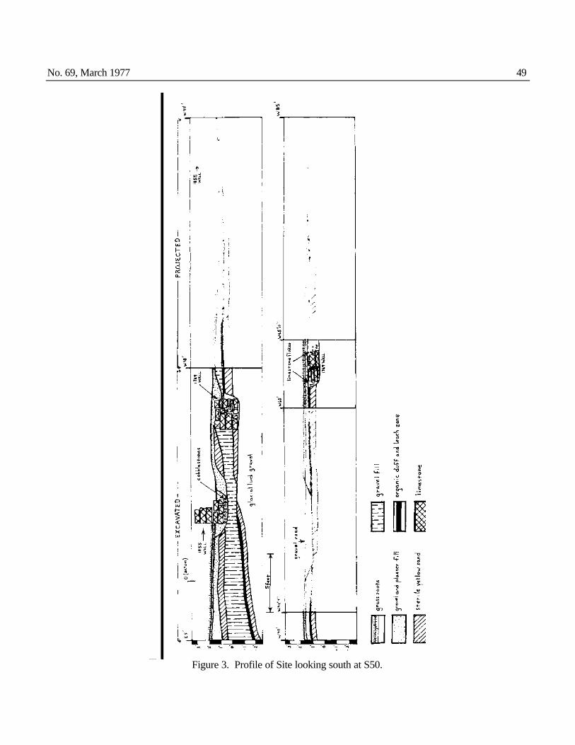
No. 69, March 1977 49
Figure 3. Profile of Site looking south at S50.

50 THE BULLETIN
Figure 4: Selected Artifacts from Indian Castle Church. a. mid-19th century white ironstone plate. b. Makers mark on back of plate "Royal Iro[nstone]". c. George II halfpence. d. Bone collar button. e. White clay pipe, 19th century. f. Carpenter's dividers, steel.

No. 69, March 1977 51 seems to have been oriented with the main road. Since all of the other existing 18th century Mohawk valley churches also appear to be aligned with the compass, it seems reasonable to hypothesize that this practice was an early tradition. By 1855, however, the residents of Indian Castle seem to have been more concerned that their church fit well with the man-made environment. The construction differences which were previously noted concerning the two foundation walls also seem to have some interesting cultural implications. It has often been asserted that the introduction of the factory system and mass-production resulted in a degeneration of traditional skills and a loss of pride in one's work. The earlier walls were more massive and more neatly finished than the rebuilt foundations; and this difference seems to signal a shift in cultural ideals. Neatness and permanence were valued in the 18th century, but it was speed which paid a premium in 19th century America. In fact, the entire 1855 rebuilding project reflects an important cultural change in the Mohawk valley, and it was not just time that effected this change. It is no coincidence that Anglo-Saxon names such as Green, Holmes and Hyde played a prominent part in rebuilding the old structure. After the American Revolution, large numbers of New Englanders migrated to the Mohawk valley, and their lifestyle was somewhat different from the Dutch and German pioneers of that region. Greek Revival meeting houses were a common sight on most New England village greens, and it seems quite probable that this cultural concept of what a church should look like had something to do with the renovation of the Indian Castle Church.
References Draper, Lyman n. d. Papers. Microfilm published by Wisconsin Historical Society. Graymont, Barbara 1972 The Iroquois in the American Revolution. Syracuse University Press, Syracuse, Syracuse, N.Y. Lydecker, John Wolfe 1938 The Faithful Mohawks. Cambridge University Press, Cambridge, England. O'Callaghan, Edmund B. (ed.) 1849- Documentary History of New York. 4v. State of New York, Albany, N.Y. 1850 Records of the Indian Castle Church n. d. Manuscripts, Margaret Reaney Memorial Library, St. Johnsville, N.Y. Records of the Lutheran Churches in Danube. . . n. d. Typed copy. Montgomery County Archives, Fonda, New York. Sheehan, Edward 1937 Old Fort Hunter and Queen Anne Chapel. Press of the Enterprise and News, St. Johnsville, N.Y. Sullivan, James et al. (eds.) 1921- The Papers of Sir William Johnson. 13v. University of the State of New York, Albany, N.Y. 1962

52 THE BULLETIN
NEW YORK STATE ARCHEOLOGICAL ASSOCIATION Minutes of the 60th Annual Meeting
April 23-25, 1976 Gideon Putnam Hotel, Saratoga Springs, New York
Executive Committee Meeting President Elizabeth M. Dumont called the meeting to order at 8:20 pm on April 23rd, 1976. Chapters were represented and the following members and alternates were in attendance. President Elizabeth Dumont, Inc. Orange Co. Vice President Charles Gillette, Van Epps-Hartley Secretary William F, Ehlers, Inc. Orange Co. Treasurer J. Thomson Fuller, Inc. Orange Co. James P, Walsh, Auringer-Seelye Beverly Roach, Auringer-Seelye Victor Lockwood, Chenango Monte Bennett, Chenango Neal Trubowitz, Frederick M. Houghton *William Engelbrecht, Frederick M. Houghton *Robert Hawkins, Inc. Long Island *Margaret Sebinowski, Inc. Long Island *Lewis Dumont, Inc. Orange Co. *Helen Tolosky, Inc. Orange Co.
George Hamell, Lewis Henry Morgan Kathleen Hamell, Lewis Henry Morgan *Roberta Wingerson, Metropolitan Kathryn Browning, Metropolitan Alvin Wanzer. Mid-Hudson Richard Jackson, Triple Cities Dolores Elliott, Triple Cities Pamela Augustine, Upper Susquehanna, Inc. Helen Gutierrez, Upper Susquehanna, Inc. *Gwen Gillette, Van Epps-Hartley Kingston Larner, MD, Van Epps-Hartley Barbara Harris, William M. Beauchamp *James Bradley, William M, Beauchamp Louis A. Brennan, Editor and ESAF Representative, Metropolitan
Committee Chairmen present: Carolyn Weatherwax-Chapters and Memberships Henry Wemple-Constitution Kingston Larner, MD-Nominating Elizabeth Dumont-Program, NYSAA James P. Walsh-Program, Annual Meeting Roberta Wingerson-Publications Charles Gillette-Liaison Officer NYSAA/NYAC Also: Dr. William A. Ritchie, Past President, Earl Casler, Past President 1. The meeting was called to order at 8:20 pm. 2. Roll call was taken. 3. Motion was made to accept the minutes of the last meeting as printed. Motion by Neal Trubowitz, seconded by Henry Wemple. Motion carried. 4. Reports of the Officers: a. Presidents Report-President Dumont expressed appreciation to the officers and members who had helped during her term of office. She said: the membership drive is judged a success and Carolyn Weatherwax is thanked for all her hard work. Henry Wemple will be taking over as president in an era of great change for archeology and archeologists, changes that NYSAA must become increasingly sensitive and responsive to if we are to fulfill our objectives as set forth in the constitution. We are living through the birth of a field in archeology -namely, public archeology. This is a time which the archeologist finally has a say as to whether or how much our cultural resources are to be destroyed by increasing urbanization. To insure that NYSAA does not remain indifferent to public archeology, its problems and its purposes, I will propose the establishment of a new standing committee to concern itself with these problems. We are also living in an age in which the archeologist himself or herself has to come to the realization that if purely research excavation continues to be carried out at its present rate, we ourselves will be doing what the bulldozer has done in the past-destroyed our heritage and left no sites to be investigated with superior techniques of succeeding generations of archeologists. NYSAA should become aware of and encourage the value of above ground archeology, of site survey, of site recording, should be the leader in the drive to develop a complete, state-wide inventory of archeological sites. We are also in an age in which historic archeology is coming into its own. I do not think that we can remain prehistoric elitists any more-whether that stance is conscious or unconscious. Therefore, I would urge that NYSAA take an active role in encouraging historic archeologists to participate in the Association and to make a genuine place for them. I will suggest that a committee for historic archeology be formed to suggest ways of implementing this. b. Vice President's Report-Charles E. Gillette. "Due to the vigor and good health of the President, the Vice President has been required to assume that office only once. He has attended all meetings required of him by the Constitution, e.g., the Mid-year Executive committee meeting at Binghamton where he assumed the gavel while Dr. Dumont stepped down to give a report as the Program Committee Chairman. The NYSAA is nearly triple the size it was when I last held the office of Association Treasurer. In these past *Alternates.

No. 69, March 1977 53 two years its affairs have been capably guided by the hand of our retiring President and it has been a pleasure to have served with her. On several occasions in the past two years I have used the office to respond with membership information to inquiries which have come addressed to the State Archeologist's Office Attendance at the November meeting of the Auringer-Seelye Chapter was much enjoyed by Mrs. Gillette and myself and we wish to thank Mrs. Rice, the Secretary, for sending the meeting notice to us. We would have liked to have responded to similar notices from the Inc. Long Island and Inc. Orange Co. Chapters but in each instance other commitments prevented our attendance." c. Report of the Secretary-William F. Ehlers. The secretary reported the largest paid membership (953 members) in the history of the NYSAA to be paid by Annual meeting time. 1975 memberships totaled 879 with 1093 paid members. 55 letters were received and 56 written; 893 ballots, meeting notices and reservation cards were mailed, 353-(1975) and 909-(1976) membership cards were completed and mailed. 1170 newsletters written assembled and mailed, 295 letters concerning Exec, meeting, membership correspondence to chapters and Rochester and 41 letters written concerning membership inquiry, 101 packages mailed. 60 copies of the Annual and Exec. meeting minutes written assembled and mailed. Distribution to the chapters consisted of: 125 copies of the Informational Handbook, Vol. 8; 1000 ESAF meeting notices, 1100 ESAF AENA circulars, 1100 announcements of new books, 1055 ESAF Bulletin #34 and periodical minutes of NYAC meetings. The Newsletter: 6 issues of Vol. #6 containing 17 pages and 3 issues of Vol. #7 containing 7 pages were printed during the fiscal year. In conclusion, I wish to thank the many Chapter secretaries that have worked so hard during the five years I have been secretary. I also wish to thank Tom Fuller for his faithful and devoted service as Treasurer. Through his efforts the NYSAA is again financially sound and due to prompt payment of bills our credit rating is back on top. d. Report of the Treasurer-J. Thomson Fuller. General Fund Publication Fund Total March 31, 1975 $ 567.13 $7142,29* $ 7709.42 Receipts +5394.96 Disbursements -4534.93 Balance on Hand April 1, 1976 $ 8569.45 Savings Accounts - 48-707 $4182.38 47-753 1000.00* 47-930 3085.91 Checking Account - 461-1646 301.16 $ 8569.45* General Fund Publication Fund Total Receipts $1314.56 $4080.40 $ 5394.96 Disbursements 1509.65 3025.28 4534.93 Balance $ 372.04 $8197.41* $ 8569.45 *Includes $1000.00 set aside for Life Membership. Note: A complete report of all receipts and disbursements is on file with the 1975 annual reports. 5. Report of Committees: a. Awards and Fellowships Committee - Charles F. Hayes, III, Chairman, Due to the absence of Mr. Hayes, this committee met on Friday night, Theodore Whitney presiding. The results were approved and presentations were made at the Saturday night banquet as follows: Fellowship Awards were presented to Paul Huey (Van Epps-Hartley) and to Franklin J. Hesse (Upper Susquehanna, Inc.). Certificate of Merit: Gordon DeAngelo (Beauchamp), George Hamell (Morgan), Neal Trubowitz (Houghton), James P, Walsh (Auringer-Seelye), Meritorious Service: Marilyn Sternitzke, Harold Jonas, Helen Tolosky of the Inc. Orange Co.; Jacqueline Hesse and Clark Rogers of the Upper Susquehanna, Inc.; Beulah Rice, Auringer-Seelye. Special Awards: A letter of recognition and appreciation of the service of the late Charles Merritt was presented to his widow, Carolyn Merritt. Honorary Life Membership and recognition of service was presented to William F. Ehlers. b. Chapters and Memberships - Carolyn Weatherwax, Chairman. Questionnaires were distributed at the October Executive Committee meeting, and of the 12 chapters, 4 responded. The leaflets, bumper stickers and news releases were used most and with good results. Although the membership drive was late in getting started, 61 new members joined. In 1974 our members totaled 1032, at the end of 1975 we had climbed to 1093 and by annual meeting time, 1976, our paid members have reached 953, 3 out of 4 chapters reported that their members would not oppose a dues increase. Reports from questionnaire state that new members are looking for digs, interesting programs, workshops and fellowships. Membership this year is climbing steadily, , ,let us continue to climb to a new record in 1976. c. Constitution Committee - Henry Wemple, Chairman. The Constitution of the NYSAA, revised 4/20/74, requires all Chapters to revise their Chapter Constitutions to conform with the State Constitution changes. The committee has received, approved and returned to the Chapters for adoption, the revised Constitutions of Auringer-Seelye, William M. Beauchamp, Chenango, Mid-Hudson, Triple Cities Chapters. The remaining Chapters are urged to revise and forward their constitutions in order to fulfill their obligations as required by the NYSAA Constitution.

54 THE BULLETIN d. Education Committee-Carolyn Schrier, Chairman. (No report received). e. Finance-Dolores Lalock, Chairman, Expenditures for the calendar year of 1975 exceeded income by $79.65. With the increases in postage rates, as well as general inflation, we can anticipate a larger deficit in 1976. The approval of the dues increase is a must. It was also reported that the records of the treasurer have been audited and found to be in order. f. Fiscal and Budget-Edwin S. Phillips, Chairman. A 3 page report was submitted by Mr. Phillips and has been distributed. Estimated receipts was compiled from information received from the Chapters and totals $4232.00. Estimated expenditures of $4155.00 was compiled from Officers and Committee Chairmen information. The estimated excess is $77.00. g. Grants-Vicky B, Jayne, Chairman. (No report received). h. Legislative-Vacant. i. Librarian-Archivist-Vacant. j. New York Indian-Vacant. k. Nominating Committee-Kingston Larner MD, Chairman. The committee's work began following the October executive meeting. Of all the officers only the Vice President, Mr. Gillette chose to run for another term. Letters were written to all Chapter Secretaries on Nov. 14, asking for nominations for the various positions. Up until Jan. 16 only two responses were received, follow-up letters were mailed on that date which produced a series of telephone calls and several letters from committee members. AuringerSeelye Chapter was particularly helpful and I feel the team of Richard LaBrake and James P. Walsh will be an excellent combination, Henry Wemple, our long-time chairman of the Constitution Committee had indicated an interest in the presidency some time ago. In fact, he had been nominated on two previous occasions. His nomination for presidency by the Chenango Chapter was reinforced by the Van Epps-Hartley Chapter of which he is also a member. I do regret the failure to develop a contest in any of the offices. I think that those of you who have held this position in the past realize the difficulty entailed in enticing and ensnaring candidates likely to carry out their duties with distinction. l. NYSAA Program-Elizabeth M, Dumont, Chairman. Two slide and tape lectures are currently in preparation: the first one concerning itself with public archeology and being produced by Dolores Elliott and SUNY Binghamton; the second dealing with techniques in historic archeology being prepared by Edward Lenick of the Inc. Orange Co. Chapter, I have not received a progress report on his lecture but Ed predicts his opus should be completed in early summer. Until these two programs become part of our traveling library. I feel that we should not inaugurate new ones. With respect to the future, now that my responsibilities as president are completed, I would like to return to two projects I had initiated earlier, namely developing a Speaker's list for use of Chapter Program Chairman, and trying to organize inter-Chapter meetings. m. Publications Committee-Roberta Wingerson, Chairman, Membership in the committee represent each chapter and remains the same as last reported, The BULLETIN. In 1975 three issues of The Bulletin#63, 64, 65 were published. A total of 120 pages was printed. Thanks are again extended to the editor, Louis Brennan, for his excellent job and to the Rochester Museum where distribution is handled, RESEARCHES & TRANSACTIONS: There are not sufficient funds to consider publication at this time, FESTSCHRIFT: It is expected that the Festschrift will be published this year. A separate report will be made by the co-editors, Bob Funk and Charles Hayes. NEWSLETTER AWARD: At the suggestion of Bill Ehlers, the Executive Committee voted an award, to be given for the best newsletter published by a chapter based on its output for the year and an award for the best single newsletter. Appointed to the Awards Committee was President Dumont, Editor Brennan and Publications Chairman Wingerson, The award will be made at the annual meeting. n. Public Relations-Vicky B. Jayne, Chairman. (No report received). o. NYSAA/NYAC Liaison-Charles E. Gillette, NYAC is presently recovering from two great shocks. First, the death of their first president, Dr. Marian White. Second, the resignation of the council's first administrator, Thomas King. Mr. King's position has been filled by Dr. Earl J. Prahl. NYAC is still interested in contract archeology and the proposition that all archeological resources must be mitigated in all construction projects. Much time was spent at meetings in discussion of the lawsuit brought by the Council against the NY State Historical Preservation Officer and the Federal EPA. At last notice the case was still in litigation and might be settled out of court. In response to a plea for a co-plaintiff the NYSAA Executive Committee voted support in principle but this has had no effect on mitigating the expenses of the suit. Note: Many of the preceding reports have been condensed to save printing space. All reports that were received are on file with the NYSAA minutes 4/23/76 of the Executive Committee Meeting.
Discussions during Committee Reports Certification Committee- Mr. Gillette reported that he was collecting material for this committee but that the President was to have appointed a committee ". , to study in depth and propose criteria and standards for developing a roster of para-professional archeologists," As per 25 Oct. 75 Executive Committee meeting resolution. Budget-The 1976-77 proposed budget was passed unanimously.

No. 69, March 1977 55 Program, Annual Meeting-James P. Walsh, Chairman, presented a fine program for the Annual Meeting. Mr. Walsh showed concern that a number of members had registered at the motels as opposed to the Gideon Putnam accommodations, Neal Trubowitz noted that a number of students were using motels due to finances. 6. Old Business First order of old business was the Membership Drive, Mrs. Weatherwax discussed her report and urged the Chapter Drive Chairmen to continue with the good work. President Dumont noted that the Drive had been a tremendous success and thanked Mrs. Weatherwax for all her efforts, Dr. Dumont suggested that we push for more Sustaining Memberships, The subject then arose concerning Husband & Wife Sustaining Memberships as one Membership. A motion was made by Mr. Brennan: To reject the suggestion that a Husband & Wife Sustaining Membership category be instituted. The motion was carried 12 to 8 to reject the suggestion. A recommendation was made that cards be printed by the Ass'n, noting to new members that donations would be accepted over and above the yearly dues, The Orange Co. Chapter volunteered to print the material and have it ready by the next meeting, Incorporation-Inc. Orange Co. member and Lawyer Alfred Cavalari volunteered to research the subject of NYSAA. Incorporation, Dr. Dumont stated that Mr. Cavalari's research found that we had Incorporated in 1927. Dues Increase-It was noted that if the dues increase was passed by the membership at the April 24 Business Meeting that this did not mean that chapters had to increase their dues to their members. $1.00 more per membership would be expected as the State's share. NYSAA/NYAC Weekend-Questionnaires sent to the chapters were not returned. One chapter returned the questionnaire. Suggestion was made to hold this project in abeyance due to lack of interest. 7. New Business a. Public Archeology: President Dumont brought forth the suggestion that a committee be established to examine the problems of Public Archeology, Motion: That the NYSAA establish a new ad hoc committee to investigate the problems and establish norms for Public Archeology, Motion made by Dr. Larner and seconded by Lewis Dumont, Motion was carried and Dolores Elliott was appointed by the President to chair this committee. b. The 1977 Annual Meeting: NYSAA Annual Meeting will be hosted by the Inc. Long Island Chapter and held at Southold, Long Island on April 22-24, 1977. c. Non-Profit Mailing: This type of mailing for the larger chapters was found to be very successful and a money saver. The permit costs $25.00 and an annual fee of $10.00 is charged. The service is somewhat slower but a great saver for the chapter treasury. Contact your local Post Office for details. d. Oral Chapter Reports: President Dumont requested that each chapter give an oral report of their chapter's activities for the past year at the Saturday a.m. business session. e. Marion White Scholarship Fund; Mr. Brennan stated that Dr. Marian White should be honored and made the motion: that the NYSAA establish a scholarship fund to send a student to each annual meeting of the Association. Motion was seconded by Henry Wemple and carried. Further discussion noted that the President would appoint a committee. Nominations for this award would come from the chapters and the committee would choose the candidate. A maximum amount of $50.00 per year was agreed upon to be raised by donation. f. Festschrift: Mrs. Wingerson noted that the manuscript should be ready for print by August, and wished to know how many copies should be printed. Mr. Fuller commented that $3000.00 had been set aside and as many copies as the amount would buy should be printed. The Chenango Chapter stated that an extra $400.00 was available from the Bennett Memorial Fund. A discussion followed as to distribution and sale of the Festschrift and a motion was made and carried: Move that the Festschrift be treated as a Research and Transaction paper and that members receive the publication free of charge and that the extra copies be sold. g. Historic Archeology: The subject of Historic Archeology was brought up, and after discussion, everyone agreed that this field had been long ignored by the Association. A motion was made: that the NYSAA establish a committee on Historic Archeology . Motion by James Bradley and seconded by Alvin Wanzer. The motion was carried and President Dumont appointed Bert Salwen to chair the committee. h. Annual Meeting Program: Mr. Brennan stated that drastic changes should be made in the convention program. A committee should be established instead of a chairman. At present we have twenty minute papers unrelated to each other. We have an obligation to provide time for site reports and archeological problems should be discussed. Symposiums of three to four experts, a number of related papers with time for discussion from the floor should constitute one session. The committee should seek out papers by contacting the chapters and the membership to set up at least one session of this type. A motion was made by Mr. Brennan and seconded by Edward Johnanmann to: Appoint a committee to conduct the business necessary to produce the 1977 annual meeting program. Committee to be appointed by the President. Motion carried, i. Neal Trubowitz stated that the Frederick M. Houghton Chapter is in the process of printing a Memorial Volume in memory of Dr. Marion White. j. Motion for adjournment was made and carried at 10:40 p.m. Respectfully submitted: William F, Ehlers, Secretary NYSAA.

56 THE BULLETIN
Minutes of the General Business Meeting Saturday, April 24, 1976
1. President Dumont called the meeting to order at 8:25 a.m. 2. Motion to accept the minutes of the last meeting, as printed, was made and carried. 3. Reading of the President's Vice President's, and Secretary's reports were waived. 4. Mr. Fuller reported on the finances of the Association. (See Treasurer's Report-Executive Committee Meeting). 5. President Dumont appointed Richard McCarthy and Henry Wczeski as election tellers. 6. Each Chapter gave an oral report of their past years activities. This has not been done for quite some time but I think all members present will agree that this practice should be continued. Copies of each Chapter's activities are in the hands of your Chapter delegates. 7. Old Business President Dumont discussed the NYSAA/NYAC Weekend. Due to lack of interest this project will be held in abeyance. 8. New Business President Dumont reported on the highlights of the Executive Committee Meeting, noting that committees on Public Archeology (Dolores Elliott, Chairman) and Historical Archeology (Bert Salwen, Chairman), had been established. President Dumont discussed the newly established Marian White Scholar ship Fund and asked the membership for contributions. The announcement that the 1977 Annual Meeting will be hosted by the Incorporated Long Island Chapter, of Southold, to be held on April 22-24, 1977, was noted by the President. Bert Salwen spoke briefly concerning Federal Funding. Last year, $22,000,000.00 of which New York State received $900,000.00 but this year funds have been cut by 50%. Suggestions were made that individuals write their Senators and Congressmen concerning the cuts in funding. Note: Letters cannot be written by the Association or Chapters thereof due to our non-profit status. . . . The following Resolution was made by Lewis Dumont and seconded by Helen Tolosky. The Motion was carried.... RESOLVED:
that the New York State Archeological Association hereby express its appreciation to Carolyn Weatherwax, Local Arrangements Chairman, and the Committee for their meritorious efforts in the preparations for the 60th Annual Meeting at Saratoga Springs, New York.
RESOLVED:
that the New York State Archeological Association hereby express its appreciation to James P. Walsh, Program Chairman, and the Committee for their exceptional preparations and execution of the program for the 60th Annual Meeting at Saratoga Springs, New York.
Motion made by Barbara Harris and seconded by Richard McCarthy, Motion carried. Report of Tellers: 893 Ballots were mailed to members. The tellers reported 166 votes were counted. The new NYSAA Officers for 1976-77 are as follows: PRESIDENT-Henry Wemple VICE PRESIDENT-Charles E. Gillette SECRETARY-James P. Walsh TREASURER-Richard F. LaBrake The Referendum: Dues payable to the New York State Archeological Association for all classes of membership except Life Membership, shall be increased by $1,00 effective with payment of 1977 dues. Tellers reported 130 votes for the Referendum and 35 against. The Referendum has been passed, President Dumont presented the new Officers to the members and a call for adjournment followed at 9:05 a. m.
Respectfully, Submitted, William F. Ehlers Secretary NYSAA