the boundaries of borno in the nineteenth century: the...
TRANSCRIPT

The Boundaries of Borno in the Nineteenth Century:
The Perception of Travellers*
Vincent Hiribarren
University of Leeds
Abstract
This article deals with the boundaries of Borno as perceived by nineteenth century travellers.
Indeed, numerous European travellers such as Denham, Barth or Nachtigal tried to reach the
central African kingdom for three main reasons: commerce, diplomacy and science. In addition,
the Bornuese perception of the boundaries is also studied through the testimony of Aden
Mahamma, a pilgrim from Borno. Using published narratives, reports, articles and maps, this
article argues that conceptions of boundaries existed in the travellers‟ narratives as well as in the
Bornuese mentalities. Admittedly, the different travellers had a Eurocentric perception of Bornu
and conceived Bornuese boundaries as a mixture between lines and undefined zones; however,
the Bornuese seem to have conceived their own territory clearly and had a sense of belonging to
a specific territory demarcated by boundaries.
Keywords: Borno, Bornu, nineteenth century, boundaries, territory, travellers, explorers,
Denham, Barth, Nachtigal, Adem Mahamma.
Introduction
In the nineteenth century, many European expeditions aimed at discovering Bornu for three main
reasons. Firstly, the Europeans wanted to visit the kingdom of Borno to establish diplomatic and
commercial ties with its ruler, the Shehu. Secondly, the Lake Chad area was arousing interest
among geographers and explorers willing to reach and “discover” the lake‟s shores. Finally, the
Europeans intended to obtain scientific information about the fauna, flora and mineral resources
of the region.
This interest in the kingdom of Borno comes from the Arabic oral and written sources which
depict the kingdom of Kanem-Borno as a rich and influential central African kingdom. Indeed,
since its conversion to Islam in the eleventh century, the kingdom of Kanem-Borno has been
linked to the Islamic world through trade, pilgrimage and diplomatic correspondence as stressed
by Palmer (1936). In 1850, the British explorer, James Richardson rejoiced when he reached
Borno:
When we reached the camping-ground a pleasant announcement was
made. We were at length upon Bornou soil! I could hardly believe my ears.
Oh, marvel, after all our dangers and misgivings! Thanks to Almighty God
for deliverance from the hands of lawless tribes! I shall never forget the
sensation with which I learned that I was at length really in Bornou, and
that the robber Tuarick was in very truth definitively left behind.
(Richardson, 1853, p.153)
Thus, Bornu was in the main objective of a consequent number of expeditions which were
funded by the European governments and in particular by the British government. One of the
objectives of these expeditions was the publication of a narrative, usually, in the form of a diary.
Hiribarren, Boundaries of Bornu
Thus, from 1798-1799, a German explorer, Hornemann probably journeyed to Borno. When
explorers visited the country during the nineteenth century, they discovered a new dynasty ruling
over a diminished kingdom of Borno. Indeed, Denham, Clapperton, Oudney, Tyrwhitt and Toole
travelled to Borno in 1822-1824, Overweg and Richardson in 1850-1851, Barth in 1850-1855, da
Segni in 1850, Vogel in 1854-1855, Beurmann in 1862-1863, Rohlfs in 1865-1867, Nachtigal in
1870-1871, Matteucci and Massari in 1880, Monteil in 1890 and finally Macintosh in 1891.
Among them, only Hornemann, Denham, Clapperton, Richardson, Barth, da Segni, Rohlfs,
Nachtigal and Massari left narratives whereas Vogel only wrote letters to the Times‟s editor.
Exploring the Sahara and the “Sudan” was dangerous as only half of the explorers survived
(Denham, Barth, da Segni, Nachtigal and Monteil). However, the remaining narratives contain
precious information about the state of Bornu during the nineteenth century as they precisely
describe its political and economic situation. Thus, their interest is threefold. Firstly, it is possible
to grasp in these narratives, the explorers‟ conception of the Bornuese boundaries. Secondly, this
conception, even if Eurocentric, reveals the Bornuese perception of their own boundaries.
Finally, this conception of limits leads to the idea of a Bornuese territory.
The most important authors for the nineteenth century are Denham, Barth and Nachtigal. Indeed,
these three explorers visited Bornu respectively in 1822-24, 1850-1855 and 1870-1871 as the
kingdom was one of the main aims of their expedition. Wilhelm II, the Prussian king even sent
Nachtigal to offer presents to the Sultan of Bornu. Thus, their observations cover a span of fifty
years in the nineteenth century. Their own perception of the boundaries was that of a traveller.
As they were journeying through these regions with caravans, they conceptualised the
boundaries in terms of barriers and checkpoints:
On the 10th we reached the komadugu; and after some lively negotiation
with the governor or shitima, who resides in the town of Yo, I and my
companion were allowed to cross the river the same afternoon; for it has
become the custom with the rulers of Bornu to use the river as a sort of
political quarantine, a proceeding which- of course they can only adopt as
long as the river is full. During the greater part of the year everybody can
pass at pleasure. Even after we had crossed, we were not allowed to
continue our journey to the capital, before the messenger, who had been
sent there to announce our arrival, had returned with the express
permission that we might go on. (Barth, 1960, p.542)
It is important to notice the fact that this “quarantine” barrier was not permanent throughout the
year, which means that the boundary was totally porous when the streambed is dry. The river,
whether it be dry or not, represents Bornuese authority, therefore Barth acknowledges the
existence of boundaries-lines for Bornu and the need to “knock” on Bornu‟s door.
The European explorers made enquiries about their itineraries as to which would be the rapidest
and safest way to reach their destination. Thus, their own knowledge was limited to their guides‟
experience but also to their predecessors‟ narratives. Indeed, Barth frequently referred to
Denham‟s narrative, whereas Nachtigal referred to both Denham‟s and Barth‟s narratives. The
empirical knowledge of the Bornuese territory and its limits is built by every explorer who
provides in his narrative and map his own perception of the Bornuese territory.
African Nebula, Issue 2, September 2010
59
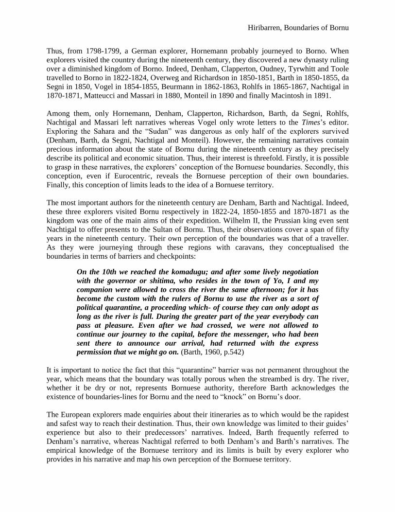
Figure 1: Extract from Clapperton's map of Bornu (Denham et al., 1828, end of volume)
Denham in his map, among other topographic and ethnographic information, reveals the
existence in Bornu of two boundaries. The eastern border of the kingdom of Bornu goes from the
shores of Lake Chad to the river Chari, spelt as „Shary‟ on the map. The western border is
supposed to separate Bornu from the Bedde, “accounted non-Muslims”. This first attempt to
localise Bornu kingdom gives an approximate idea of the position of Bornu on the African map.
The European explorers made enquiries about their itineraries as to which would be the rapidest
and safest way to reach their destination. Thus, their own knowledge was limited to their guides‟
experience but also to their predecessors‟ narratives. Indeed, Barth frequently referred to
Denham‟s narrative whereas Nachtigal referred to both Denham‟s and Barth‟s narratives. The
empirical knowledge of the Bornuese territory and its limits is built by every explorer who
provides in his narrative and map his own perception of the Bornuese territory.
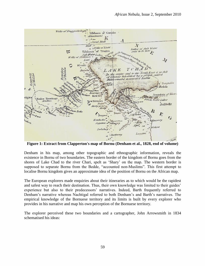
The explorer perceived these two boundaries and a cartographer, John Arrowsmith in 1834
schematised his ideas:
Hiribarren, Boundaries of Bornu
Figure 2: Africa (Arrowsmith,1834)
Source: http://www.davidrumsey.com/luna/servlet/detail/RUMSEY~8~1~33870~1170022:Africa,-by-J--
Arrowsmith--London,-p?trs=65&mi=1&qvq=q%3Aafrica+1834%3Blc%3ARUMSEY%7E8%7E1, David Rumsey
maps, Creative Commons Licence (accessed 13 January 2010)
The main idea present in both maps is that the Bornuese territory is located between these two
lines. However, this conception of the boundaries by Denham and Clapperton reveals his
Eurocentric perception of the Lake Chad area. Looking for boundaries as lines, he mapped the
kingdom of Bornu as any other European kingdom. Moreover, the cartographer, John
Arrowsmith used different colours to emphasise this aspect in his map published in a world atlas.
In addition, the passage from the explorers‟ map to the commercial map published in London
illustrates how the geographical knowledge is transmitted from the field to the map in Europe. It
only takes a few years to publish the result of their exploration. To what extent is it possible to
say that such maps could influence the following explorers‟ representation of Borno?
Moreover, are these truncated boundaries a consequence of the travellers‟ ignorance? This
question is relevant as Denham could not explore the whole region and therefore reveals his
extrapolation of the Bornuese boundaries. The following explorers “filled” the map and were
able to determine more precisely the localisation of different Bornuese boundaries. One of the
main aims of the explorers was to establish ties with African rulers and to produce a geopolitical
map of the visited territories. For example, Denham gathered geographical information about
Bornu in his “Supplemental chapter about Bornou”.
African Nebula, Issue 2, September 2010
61
“BORNOU, a kingdom of Central Africa, is comprehended, in its present
state, between the 15th and 10th parallel northern latitude, and the 12th
and 18th of east longitude. It is bounded on the north by part of Kanem and
the desert; on the east by the Lake Tchad, which covers several thousand
miles of country, and contains many inhabited islands ; on the south-east
by the kingdom of Loggun and the river Shary, which divides Bornou from
the kingdom of Begharmi, and loses itself in the waters of the Tchad ; on
the south by Mandara, an independent kingdom, situated at the foot of an
extensive range of primitive mountains; and on the west by Soudan”.
(Denham et al., 1828, p.155)
This description of Borno reveals the names of the neighbouring states. Thus, Denham provides
his reader with a geographical description of an area in a style typical of the nineteenth century.
Indeed, this geographic introduction to his chapter reveals as much about Borno as about
Denham‟s perception of this African territory. His vision of Africa divided into neatly bounded
kingdoms reveals his European perception of the continent. Thus, as there are clear boundaries in
Europe, there are clear boundaries in Africa. As there are kingdoms in Europe, there are
kingdoms in Africa.
It also reveals the progress of geography as a science in the nineteenth century (Surun, 1998).
Denham as an educated officer tries to introduce the results of his discoveries in a suitable
scientific way. Thus, Borno is presented as any other European kingdom would be portrayed.
Although the boundaries are described in a European manner, Denham unveils geographical data
unknown in Europe until then. Richardson also added:
“I have obtained a list of the names of the principal sultans in this part of
Africa:
Bornou—The Sheikh Omer, the son of the sheikh who reigned in the time
of the first expedition. He has now reigned fourteen years. He has a good
character.
Sakkatou—Sultan of the Fellatahs, Ali. He is not so great as his father
Bello, celebrated in the time of the first expedition.
Asben, or Aheer—Abd-el-Kader.
Maradee—Binono.
Gouber—Aliou (Ali)... (Richardson, 1853, p.189)”
This is the reason for which they wanted to discover the different routes possible for their
journey. For example, Richardson in his diary took notes of the route from Kuka, then capital of
Bornu to Mandara.
“TERRITORY OF BORNOU.
From Kuka, south-east, to
Gornu, half a-day; a walled town, larger than Zinder.
Gulum, three hours; small village. Here is a river.
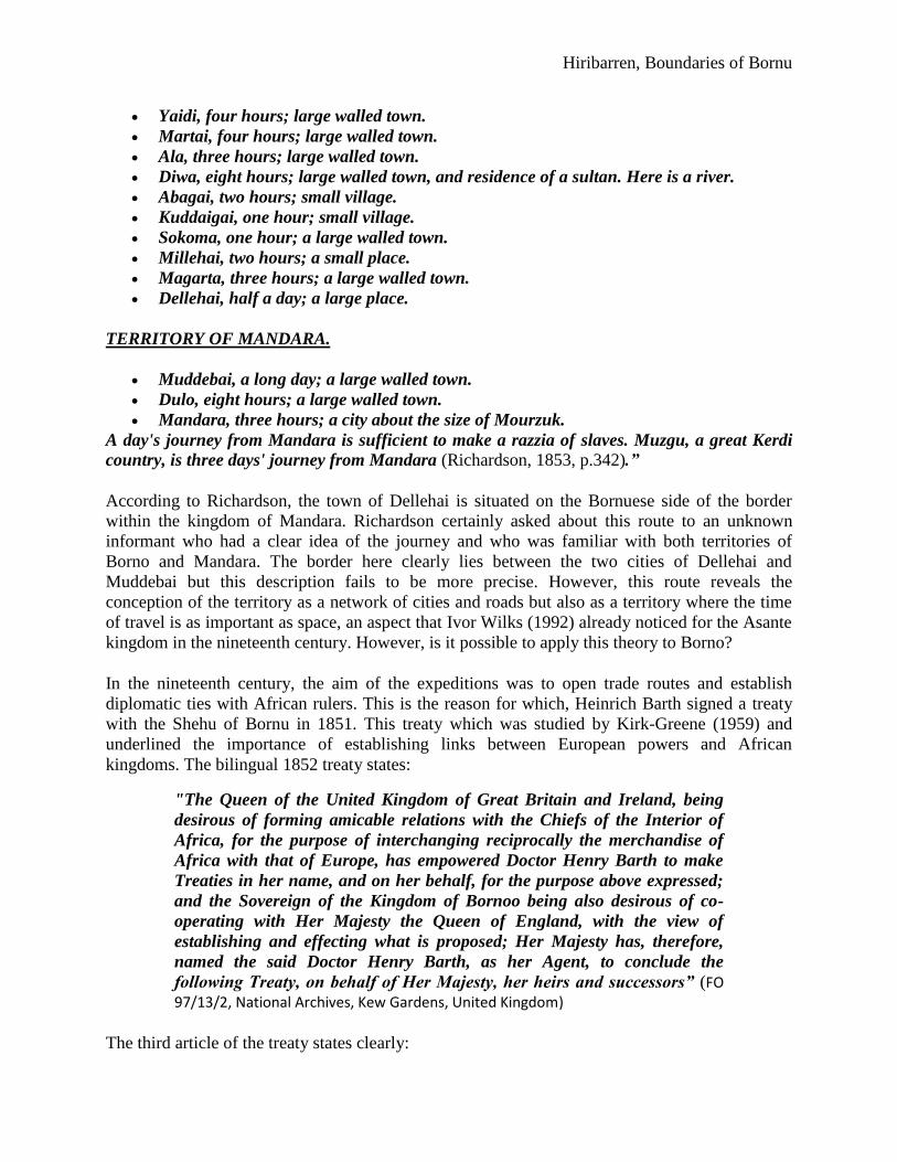
Hiribarren, Boundaries of Bornu
Yaidi, four hours; large walled town.
Martai, four hours; large walled town.
Ala, three hours; large walled town.
Diwa, eight hours; large walled town, and residence of a sultan. Here is a river.
Abagai, two hours; small village.
Kuddaigai, one hour; small village.
Sokoma, one hour; a large walled town.
Millehai, two hours; a small place.
Magarta, three hours; a large walled town.
Dellehai, half a day; a large place.
TERRITORY OF MANDARA.
Muddebai, a long day; a large walled town.
Dulo, eight hours; a large walled town.
Mandara, three hours; a city about the size of Mourzuk.
A day's journey from Mandara is sufficient to make a razzia of slaves. Muzgu, a great Kerdi
country, is three days' journey from Mandara (Richardson, 1853, p.342).”
According to Richardson, the town of Dellehai is situated on the Bornuese side of the border
within the kingdom of Mandara. Richardson certainly asked about this route to an unknown
informant who had a clear idea of the journey and who was familiar with both territories of
Borno and Mandara. The border here clearly lies between the two cities of Dellehai and
Muddebai but this description fails to be more precise. However, this route reveals the
conception of the territory as a network of cities and roads but also as a territory where the time
of travel is as important as space, an aspect that Ivor Wilks (1992) already noticed for the Asante
kingdom in the nineteenth century. However, is it possible to apply this theory to Borno?
In the nineteenth century, the aim of the expeditions was to open trade routes and establish
diplomatic ties with African rulers. This is the reason for which, Heinrich Barth signed a treaty
with the Shehu of Bornu in 1851. This treaty which was studied by Kirk-Greene (1959) and
underlined the importance of establishing links between European powers and African
kingdoms. The bilingual 1852 treaty states:
"The Queen of the United Kingdom of Great Britain and Ireland, being
desirous of forming amicable relations with the Chiefs of the Interior of
Africa, for the purpose of interchanging reciprocally the merchandise of
Africa with that of Europe, has empowered Doctor Henry Barth to make
Treaties in her name, and on her behalf, for the purpose above expressed;
and the Sovereign of the Kingdom of Bornoo being also desirous of co-
operating with Her Majesty the Queen of England, with the view of
establishing and effecting what is proposed; Her Majesty has, therefore,
named the said Doctor Henry Barth, as her Agent, to conclude the
following Treaty, on behalf of Her Majesty, her heirs and successors” (FO 97/13/2, National Archives, Kew Gardens, United Kingdom)
The third article of the treaty states clearly:
African Nebula, Issue 2, September 2010
63
“The communications between the country of Bornoo and other places
shall be safe, so that English merchants may, without obstacle, import their
merchandise of lawful commerce, of whatever kind, and bring them for
sale in Bornoo and elsewhere; and it shall be equally free for them to
export from Bornoo such merchandise of lawful commerce” (FO 97/13/2, National Archives, Kew Gardens, United Kingdom)
Thus, commercial interests between the United Kingdom and Borno were in the centre of the
travellers‟ interests as both treaties were signed between “sovereign” rulers of their own
kingdom. The 1851 Borno treaty underlines the fact that Bornu is an “empire”, a “country”, a
“State” which possesses its own “territory”. Would it be possible to understand Borno as a
clearly bounded territory according to this document? Au contraire, the translator only over-
translated the same Arabic word bilâd for “empire”, “country”, “State” and “territory”. Thus,
European conceptions of statehood were applied to Borno even though most explorers were
aware of its political situation.
Furthermore, the boundary can also be considered as a buffer zone as in the case of the Bedites,
an ethnic group living on the borderland between Kano and Bornu. When the ruler of Sokoto,
Bello and the ruler of Bornu, El Kanemi signed a peace treaty in 1820, they recognised this
territory as being an open source of slaves, and money. Bello writes in one of his letters
“We profess the same religion, and it is not fitting that our subjects should
make war on each other. Between our kingdoms are the pagan Bedde
tribes, on whom it is permissible to levy contribution: let us respect this
limit: what lies to the east of their country shall be ours: what lies to the
west shall be yours. As for Muniyo, Damagaram and Daura, they will
continue to be vassals of the Sultan of Bornu, who in return will surrender
to you all his claims to Gobir and Katsina” (Palmer, 1936, p.269)
A few years later, Denham describes this area:
“As before observed, the Bedites have never received the doctrines of
Mahomet; and, although speaking the language of Bornou, and
acknowledging a kind of nominal sovereignty of the Bornouese sultan, they
are everywhere regarded as a race of outlaws, whom it is incumbent on
every good Mussulman, Bornouese, or Felatah, to enslave or murder [...]
Their country is of small extent, defended by impenetrable morasses and
forests, by which alone they preserve a precarious and dangerous
independence. (Denham et al., 1828, pp.229-230)”
Thus, this natural region constitutes, according to Clapperton, the borderland between Kano and
Bornu. For him, even nature separates it from the Hausa/Fulani and the Kanuri. It is possible to
recognise the theory of the natural boundaries supposed to neatly enclose the Bedites‟ territory.
In addition, the image of the wild and barbarian Bedites is omnipresent in every traveller‟s
description. Sokoto‟s or Bornu‟s influence in their vision must be preponderant. Indeed,
according to the different explorers, the Bedites‟ territory is Bornu‟s “wild west”. This case
corresponds to the boundaries of Asante described by Wilks (1992). Indeed, the further from the
Hiribarren, Boundaries of Bornu
capital the territory was, the less authority the king of Asante had. Thus, distant regions were not
as integrated to the kingdom as the core provinces were. The Bedites‟ territory could be an
example of this kind of territory where the central authority has faded.
Moreover, from the Bornuese viewpoint, as this territory is not Muslim, it becomes a religious
frontier. This conception relates to the Islamic perception of the world as separated between the
ummah and the unbelievers. Thus, the western boundary is a military boundary between Sokoto
and Bornu but is also a religious boundary between Dar Al-Islam and Dar-Al-Garb. The
description of the world in religious terms is a common practice among Muslim scholars since
the spread of Islam in Africa. This common view in the Muslim world (Brauer, 1992) leads Bello
and El Kanemi to the recognition of the Bedites‟ territory as a march between their two
countries. Therefore, this boundary is a cultural and religious one.
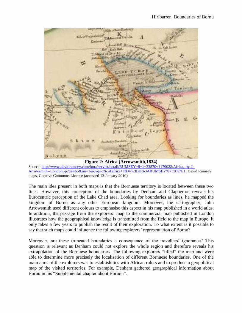
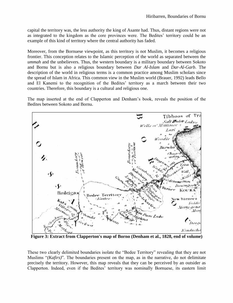
The map inserted at the end of Clapperton and Denham‟s book, reveals the position of the
Bedites between Sokoto and Bornu.
Figure 3: Extract from Clapperton's map of Borno (Denham et al., 1828, end of volume)
These two clearly delimited boundaries isolate the “Bedee Territory” revealing that they are not
Muslims “(Kafirs)”. The boundaries present on the map, as in the narrative, do not delimitate
precisely the territory. However, this map reveals that they can be perceived by an outsider as
Clapperton. Indeed, even if the Bedites‟ territory was nominally Bornuese, its eastern limit
African Nebula, Issue 2, September 2010
65
became on this map the Bornuese western boundary. The perception of the limits between these
territories is typically European as these limits are only lines drawn around the towns belonging
to the Bedites. As Clapperton and Oudney travel to Kano, they have to cross this territory and
determine which town belongs to Bornu. Thus, the map is a simple topographic map trying to
represent the different political powers. However, without totally dismissing the representation
of the boundaries, Clapperton tries to give an account of the regional political stage.
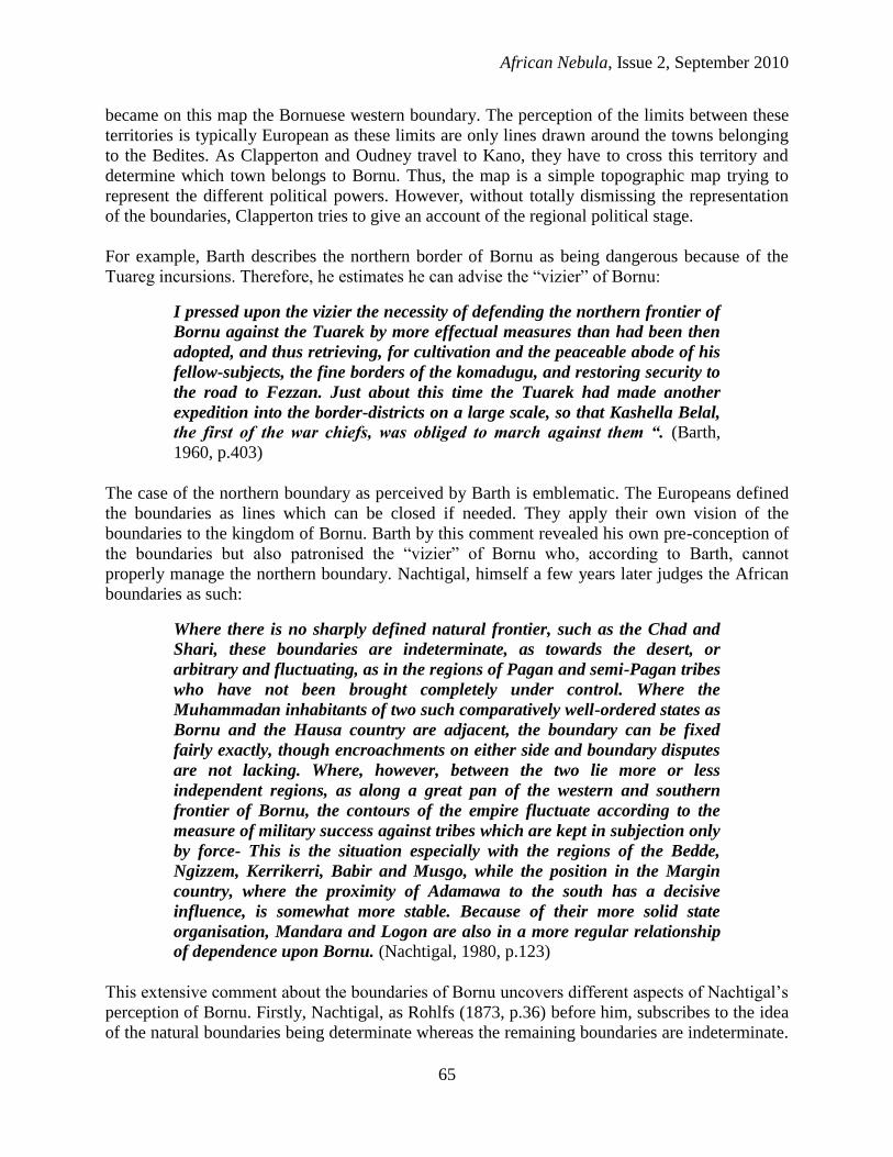
For example, Barth describes the northern border of Bornu as being dangerous because of the
Tuareg incursions. Therefore, he estimates he can advise the “vizier” of Bornu:
I pressed upon the vizier the necessity of defending the northern frontier of
Bornu against the Tuarek by more effectual measures than had been then
adopted, and thus retrieving, for cultivation and the peaceable abode of his
fellow-subjects, the fine borders of the komadugu, and restoring security to
the road to Fezzan. Just about this time the Tuarek had made another
expedition into the border-districts on a large scale, so that Kashella Belal,
the first of the war chiefs, was obliged to march against them “. (Barth,
1960, p.403)
The case of the northern boundary as perceived by Barth is emblematic. The Europeans defined
the boundaries as lines which can be closed if needed. They apply their own vision of the
boundaries to the kingdom of Bornu. Barth by this comment revealed his own pre-conception of
the boundaries but also patronised the “vizier” of Bornu who, according to Barth, cannot
properly manage the northern boundary. Nachtigal, himself a few years later judges the African
boundaries as such:
Where there is no sharply defined natural frontier, such as the Chad and
Shari, these boundaries are indeterminate, as towards the desert, or
arbitrary and fluctuating, as in the regions of Pagan and semi-Pagan tribes
who have not been brought completely under control. Where the
Muhammadan inhabitants of two such comparatively well-ordered states as
Bornu and the Hausa country are adjacent, the boundary can be fixed
fairly exactly, though encroachments on either side and boundary disputes
are not lacking. Where, however, between the two lie more or less
independent regions, as along a great pan of the western and southern
frontier of Bornu, the contours of the empire fluctuate according to the
measure of military success against tribes which are kept in subjection only
by force- This is the situation especially with the regions of the Bedde,
Ngizzem, Kerrikerri, Babir and Musgo, while the position in the Margin
country, where the proximity of Adamawa to the south has a decisive
influence, is somewhat more stable. Because of their more solid state
organisation, Mandara and Logon are also in a more regular relationship
of dependence upon Bornu. (Nachtigal, 1980, p.123)
This extensive comment about the boundaries of Bornu uncovers different aspects of Nachtigal‟s
perception of Bornu. Firstly, Nachtigal, as Rohlfs (1873, p.36) before him, subscribes to the idea
of the natural boundaries being determinate whereas the remaining boundaries are indeterminate.
Hiribarren, Boundaries of Bornu
The theory of the natural boundaries which emerged mainly in France at the end of the
seventeenth century was widely spread throughout the nineteenth century:
The limits of empires are controlled by two causes: the physical geography
of the soil and the power of man. The first is durable; the last is variable
and thus in examining history we find that the first produces the most
permanent effect (Finch, 1844, p.2)
The explorers are eager to find which boundaries are natural, in other words “durable”. The
others only depend on the “power of man”. This is the reason for which Nachtigal underlines the
fluctuation of the other boundaries which are not permanent. As a German from Saxony, he may
have been aware of the efforts of Emperor Wilhelm II to expand the Prussian boundaries in the
1860s and 1870s. The boundaries made by the “power of man” are more recent and have a less
permanent effect according to him. However, Nachtigal neglects the fact that the so-called
“natural boundaries” are only the result of a choice by the different political powers. For
example, in the case of the kingdom of Bornu, the Chari river boundary is the result of the
competition between Bornu and its neighbour Berghami. Far from being only natural, the
boundary is as much the result of man‟s actions. This deterministic view of the boundaries
prevents Nachtigal and the other explorers from giving a detailed account of the Bornuese
boundaries.
In addition, Nachtigal stresses the fact that the boundaries between Muslim states can be “fixed
fairly exactly”. For every explorer, the Muslim states are “comparatively well-ordered states”
whereas pagan states are disorganised. Most of them subscribe to the theory of the Nilo-Hamitic
origin of the State in Africa. In other words, concepts of “State” and “boundaries” do not origin
from sub-Saharan Africa but from Northern Africa (Lange, 1984). Black countries can be “well-
ordered” only if they adopt Islam.
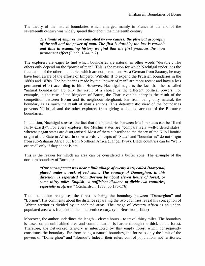
This is the reason for which an area can be considered a buffer zone. The example of the
northern boundary of Bornu is:
“Our encampment was near a little village of twenty huts, called Daazzenai,
placed under a rock of red stone. The country of Damerghou, in this
direction, is separated from Bornou by about eleven hours of forest, or
some thirty miles English—a sufficient distance to divide two countries,
especially in Africa.” (Richardson, 1853, pp.175-176)
Thus the author recognises the forest as being the boundary between “Damerghou” and
“Bornou”. His comments about the distance separating the two countries reveal his conception of
African territories divided by uninhabited areas. The image of Western Africa as an under-
populated area was frequent in the nineteenth century. (van Beusekom, 1999)
Moreover, the author underlines the length – eleven hours – to travel thirty miles. The boundary
is based on an uninhabited area and communication is harder through the thick of the forest.
Therefore, the networked territory is interrupted by this empty forest which consequently
constitutes the boundary. Far from being a natural boundary, the forest is only the limit of the
powers of “Damerghou” and “Bornou”. Indeed, their rulers control populations not territories.
African Nebula, Issue 2, September 2010
67
As the populations of Damerghou are not submitted to the Shehu of Bornu, the boundary lies in
the space before the first cities of Damerghou.
Thus, the power of Borno does not seem to fade around its borderland with Damerghou.
Wilks‟ theory (1992) does not apply to this part of the Bornuese boundary. Rohlfs evokes the
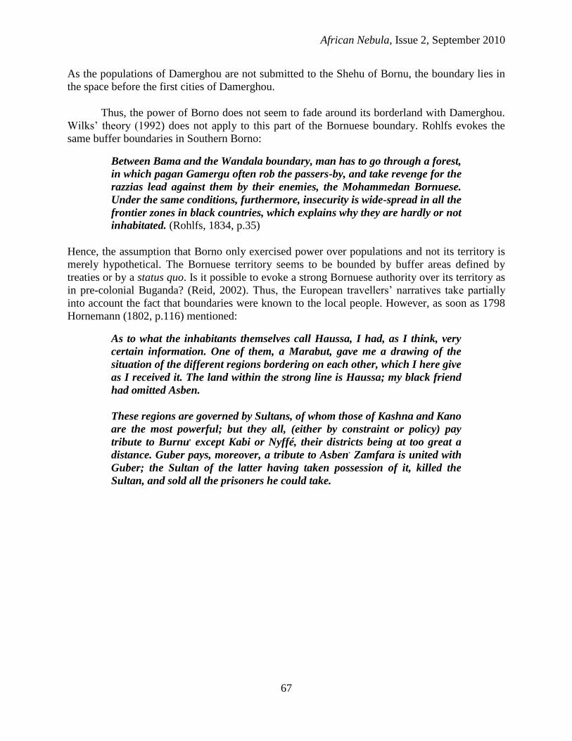
same buffer boundaries in Southern Borno:
Between Bama and the Wandala boundary, man has to go through a forest,
in which pagan Gamergu often rob the passers-by, and take revenge for the
razzias lead against them by their enemies, the Mohammedan Bornuese.
Under the same conditions, furthermore, insecurity is wide-spread in all the
frontier zones in black countries, which explains why they are hardly or not
inhabitated. (Rohlfs, 1834, p.35)
Hence, the assumption that Borno only exercised power over populations and not its territory is
merely hypothetical. The Bornuese territory seems to be bounded by buffer areas defined by
treaties or by a status quo. Is it possible to evoke a strong Bornuese authority over its territory as
in pre-colonial Buganda? (Reid, 2002). Thus, the European travellers‟ narratives take partially
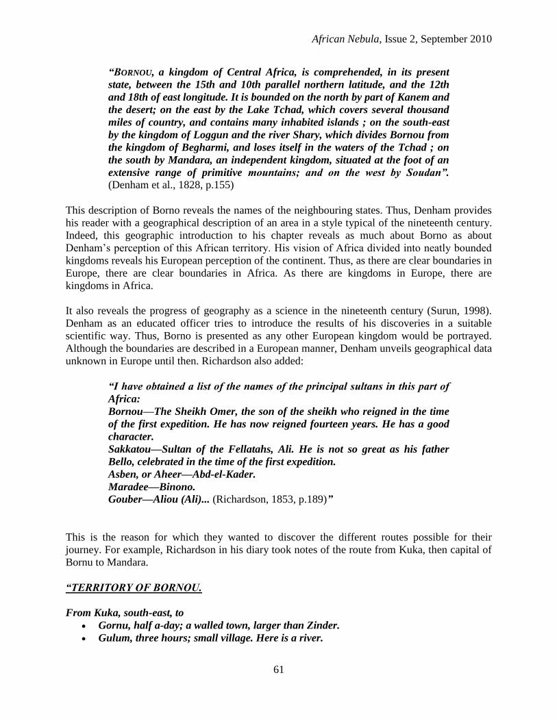
into account the fact that boundaries were known to the local people. However, as soon as 1798
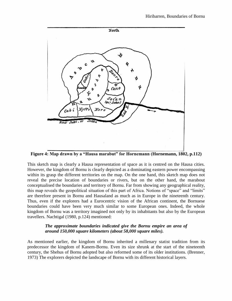
Hornemann (1802, p.116) mentioned:
As to what the inhabitants themselves call Haussa, I had, as I think, very
certain information. One of them, a Marabut, gave me a drawing of the
situation of the different regions bordering on each other, which I here give
as I received it. The land within the strong line is Haussa; my black friend
had omitted Asben.
These regions are governed by Sultans, of whom those of Kashna and Kano
are the most powerful; but they all, (either by constraint or policy) pay
tribute to Burnu, except Kabi or Nyffé, their districts being at too great a
distance. Guber pays, moreover, a tribute to Asben. Zamfara is united with
Guber; the Sultan of the latter having taken possession of it, killed the
Sultan, and sold all the prisoners he could take.
Hiribarren, Boundaries of Bornu
Figure 4: Map drawn by a “Hausa marabut” for Hornemann (Hornemann, 1802, p.112)
This sketch map is clearly a Hausa representation of space as it is centred on the Hausa cities.
However, the kingdom of Bornu is clearly depicted as a dominating eastern power encompassing
within its grasp the different territories on the map. On the one hand, this sketch map does not
reveal the precise location of boundaries or rivers, but on the other hand, the marabout
conceptualised the boundaries and territory of Bornu. Far from showing any geographical reality,
this map reveals the geopolitical situation of this part of Africa. Notions of “space” and “limits”
are therefore present in Bornu and Hausaland as much as in Europe in the nineteenth century.
Thus, even if the explorers had a Eurocentric vision of the African continent, the Bornuese
boundaries could have been very much similar to some European ones. Indeed, the whole
kingdom of Bornu was a territory imagined not only by its inhabitants but also by the European
travellers. Nachtigal (1980, p.124) mentioned:
The approximate boundaries indicated give the Bornu empire an area of
around 150,000 square kilometers (about 58,000 square miles).
As mentioned earlier, the kingdom of Bornu inherited a millenary statist tradition from its
predecessor the kingdom of Kanem-Bornu. Even its size shrunk at the start of the nineteenth
century, the Shehus of Bornu adopted but also reformed some of its older institutions. (Brenner,
1973) The explorers depicted the landscape of Bornu with its different historical layers.
African Nebula, Issue 2, September 2010
69
But at present all this district, the finest land of Bornu in the proper sense
of the word, which once resounded with the voices and bustle of hundreds
of towns and villages, has become one impenetrable jungle, the domain of
the elephant and the lion, and with no human inhabitants except a few
scattered herdsmen or cattle-breeders, who are exposed every moment to
the predatory inroads of the Tuarek. (Barth, 1960, p.345)
This nostalgic tone reminds the readers the splendour of ancient Bornu which is comparable, in
this era of literary romanticism, to the splendour of classical European civilisations. Indeed, most
explorers tried to give a historical perspective to their “discoveries”. Thus, Barth himself brought
back to Europe the Girgam, a list of kings who reigned in Kanem-Bornu from the eleventh
century on. The nineteenth century territory of Bornu is perceived as a historical space.
Therefore, it is possible to speak of an existence of a Bornuese territory at this time. For
example, Barth and Nachtigal refer to the tombs of the ancient kings that they have visited. In a
sense, these explorers consider Bornu as a nation under construction. The core province of the
kingdom known as “Bornu proper” reinforces this idea.
I had now entered Bornu proper, the nucleus of that great Central African
empire in its second stage, after Kanem had been given up. It is bordered
towards the east by the great sea-like komadugu the Tsad or Tsade, and
towards the west and north-west by the little komadugu which by the
members of the last expedition had been called Yeou, from the town of that
name, or rather Yo, near which they first made its acquaintance on their
way from Fezzan. I had now left behind me those loosely attached
principalities which still preserve some sort of independence, and
henceforth had only to do with Bornu officers. (Barth, 1960, p.360)
Thus, Borno proper would be the heart of this “empire”. This last statement shows the
conception of Borno as a territory and not as a collection of different ethnic groups. The territory
itself is compared to medieval European kingdoms which would have vassals (Chrétien, 1980
quoted by Lefebvre, 2008, p.131). Principalities had therefore to pay tribute to the Sultan of
Bornu. The question of tributes is an important question as it may be misleading. Some regions
had to pay a tribute because Bornu dominated them economically or militarily, such as Zinder.
Some other regions paid tribute to obtain a certain kind of autonomy from Bornu such as the
Hausa cities at the start of the nineteenth century (Hornemann, 1802).
This last point leads to the reflection of the meaning of tributary states. Little is known about the
true nature of the relationship between different buffer-states and Borno. It seems that the states
situated at the periphery of Borno could be divided into two different categories: the satellite-
states only orbiting around “Borno proper” and the other states oscillating between Borno and its
powerful neighbours. The first category of satellite-states depending only on Borno could
include Logone or Manga whereas the second category could include Matsina or Baghirmi.
Indeed, depending on the geopolitical situation, the presence of states as Wadai or Sokoto would
prevent Borno from exerting its influence over its tributaries. Therefore, the notion of “tributary”
can be considered as double-edged because it could entail a concept of dependence but also of
autonomy according to the evolving political situation. Without more precise documentation on a
certain buffer-state, no generalisation would be feasible in the nineteenth century. Cohen
Hiribarren, Boundaries of Bornu
illustrates this last point while describing the fate of Matsina in the nineteenth century. Formerly
a Borno tributary state, Matsina came under the influence of Sokoto because of internal rivalries
while eventually reverting to Borno. (Cohen, 1970, p.158)
Indeed, according to Barth, a constellation of states orbits around Borno. Therefore, it is possible
to suggest that the buffer-states were coherently organised by Borno. On the one hand, they
would furnish tribute and taxes; on the other hand, they would be a military frontier. This
constitutes only a generalisation of the status of the buffer-states as Baghirmi and Logone
differently depended on Borno. For instance, the map quotes “Marghi (claimed both by Bornu
and Adamaua)”, “Loggene (tributary to Bornu)”, Daura across the border with Katsina
(“Katshna”) “consisting of about 1000 towns & villages, 400 of which belong to the Fulahs and
600 to Bornu”.
Moreover, galadimas (literally “gate-keepers”) were in charge of the territories on the fringe of
the Bornu kingdom (Bala and Alkali, 1983). These officers administered these provinces from
the capital, Kuka, and were responsible for levying taxes and for ensuring that the border
province would stay loyal to the Shehu. Their presence in the capital was the guarantee that they
would not develop a form of autonomy whilst in charge. These galadimas are the proof of the
importance of these border provinces to the central power. In addition, kachellas, military leaders
of servile origin, were posted along the boundaries to assure the security of Borno. For instance,
in 1835, El-Kanemi posted three kachellas to the western provinces to Gujba, Biriri and Borsari
(Brenner, 1973, p.72). Hence, the Shehu of Borno managed his boundaries through galadimas
and kachellas from the capital.
Thus, the capital played a very important role in the rather centralised kingdom of Bornu. Kuka
or Kukawa was the place where the Shehu was living and where the galadimas were working.
The state of Borno was exerting power from Kuka. Taxes were levied in different provinces
under modalities defined by the Shari‟a. In addition, Rohlfs mentions import taxes levied upon
goods when he crosses the boundary between Borno and Gongola:
“At the same time, a small caravan under our armed protection had crossed
the boundary because they needed to sell salt and cattle. They were staying
close to us so that people could believe they belonged to my followers in
order not to pay import taxes for their goods. Usually imported Bornuese
products were taxed, 20 cowries for a horse or a piece of cattle, 10 cowries
for a sheep or a goat, a certain amount of salt for each sold measure”
(Rohlfs, 1874, p.126)
These import taxes were highly regulated as the precise figures given by Rohlfs reveal. Even if
they were not decided by Borno but by Gongola, the import taxes reveal the conception of a
recognised commercial Borno territory by the borderland dwellers. If Borno exports goods, it
means that is possible to conceive the existence of a Bornuese territory. In consequence, this
article argues that Bornuese administration exerted its power over a territory as much as people.
Indeed, the explorers revealed the importance of the Bornuese space during the nineteenth
century. Borno was territorially organised in the nineteenth century and boundaries were
recognised at a local level but also by the Ottoman Empire, the Sokoto Caliphate and other states
of the Chad basin (Barkindo, 1999). This last point differs from the traditional viewpoint of

African Nebula, Issue 2, September 2010
71
African polities being ill-defined and being only constructed on personal relations. In the case of
Borno, Urvoy (1949), Cohen (1967), Brenner (1973) have underlined the importance of the
personal relations in the territorial organisation of the kingdom. According to Brenner (1973,
p.19), territory was only
“one basis for administrative relationship; very often ethnic and personal
relationships were more important.”
The different sources allege the fact that ethnic and personal relationships were fundamental.
However, were they more important than the Bornuese territory? Palmer, a former Borno
resident, even if criticised for his Eurocentric perception of Borno, already evoked the division of
Borno in quadrants at the cardinal points. (Brenner, 1973, p.10) This article argues that the
Bornuese territory played a very important role in the organisation of the kingdom. Indeed as
mentioned above, the representation of a Bornuese space, especially in the inter-statist relations,
was largely influenced by Islam as Nachtigal put it. Furthermore, Borno in the nineteenth century
inherited from the kingdom of Kanem-Borno a strong administrative and territorial organisation
which recognised a Bornuese territory and acknowledged the existence of Bornuese boundaries.
Thus, far from being vague, Borno‟s boundaries were known to its inhabitants with all their
fluctuations during the nineteenth century.
In addition, the British, French and Ottomans were interested in the political situation in Central
Sudan and were gathering reports from travellers and pilgrims in order to assess the geopolitical
status of the region. These reports obtained through Bornuese travellers are invaluable sources
for the history of the boundaries of Borno from 1890 to 1900. In 1997, Kanya-Forstner and
Lovejoy published French intelligence reports which dealt with Sokoto and Borno (Kanya-
Forstner and Lovejoy, 1997). Indeed, in 1892, the French interrogated in Tunis, Adem Mahanna
a Bornuese travelling back to Kukawa after his pilgrimage to Mecca. On his way to Mecca, he
had already been interrogated by the British in Suakin. His interrogation in Tunis lasted twelve
hours and revealed two conceptions of Borno in the nineteenth century. Firstly, according to
Adem Mahamma, Borno proper is the core province of the kingdom “immediately to the west of
the lake”.
“The name of Borno was extended to the whole Empire of the Dunama
which consisted for the rest, in separated states, governed by vassal
dynasties; the vassality link becoming looser when these states were
situated far from the centre of the Empire.” (Kanya-Forstner and Lovejoy,
1997, p.102)
Thus, it is possible to argue that the Bornuese, such as Adem Mahanna, had a territorial
conception of Borno as a province and as an Empire. In addition, the Bornuese pilgrim evokes
the boundary of Borno with the Mahdist state founded by Hayatu ibn Sa‟id in Adamawa (Kanya-
Forstner and Lovejoy, 1997, p.111 and Warburg, 2003). Thus, Adem Mahamma may have had a
concept of a neat boundary between Borno and its neighbours.
However, Adem Mahamma‟s report was translated from Arabic and written down by a French
officer, Major Francis Rebillet. His own perception of Borno is deeply influenced by his own
education. For example, Major Rebillet constantly uses European medieval concepts to refer to
Hiribarren, Boundaries of Bornu
Borno. Borno is the core-province which gave its name to the whole “Empire of Borno”. The
same phenomenon happened in France as the region around Paris was called France because it
constituted the personal domains of the Frankish king. Subsequently, the name France was
extended to the whole kingdom. Major Rebillet mentioned as well Borno vassals and its
suzerainty over them and compared the last kings of the Sayfawa dynasty to the last kings of the
Merovingian dynasty. Indeed, Major Rebillet evoked their role as “do-nothing kings” a phrase
used by nineteenth and early twentieth century French historians to describe the late
Merovingian kings (Kanya-Forstner and Lovejoy, 1997, p.102). He even compares the Kanemi
dynasty to the Carolingian dynasty when he qualifies El-Kanemi as “mayor of the palace”. Thus,
Major Rebillet‟s historical reminiscences give a European biased account of the boundaries and
territory of Borno and it can be argued that Adem Mahamma‟s account of Borno is perceived
along European concepts.
This illustrates the French perception of Borno as being in a medieval stage of development. The
description of Borno provided by Adem Mahamma through Major Rebillet is a blatant example
of social Darwinism applied to Borno. Triaud (2000) showed how this perception was common
among French colonial agents when considering Muslim societies in the nineteenth century.
Chrétien (1980) stressed the same perception of colonial Eastern Africa as medieval Europe as
well. Thus, how to apprehend Borno‟s relationship with its satellite-states? Were they vassals or
simple tributaries? To what extent does this tribute mean that the tributary state is autonomous or
even independent? The French authorities had a map traced according to the different
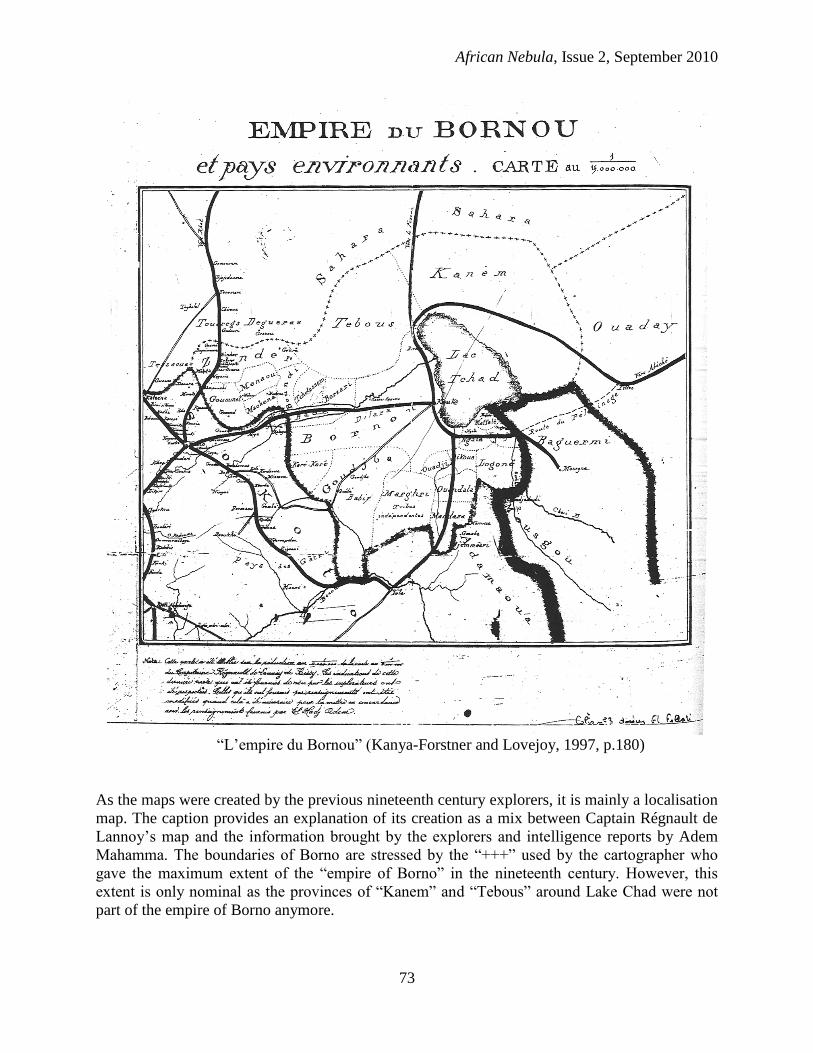
testimonies in order to obtain a better understanding of the geopolitical status of the region.
African Nebula, Issue 2, September 2010
73
“L‟empire du Bornou” (Kanya-Forstner and Lovejoy, 1997, p.180)
As the maps were created by the previous nineteenth century explorers, it is mainly a localisation
map. The caption provides an explanation of its creation as a mix between Captain Régnault de
Lannoy‟s map and the information brought by the explorers and intelligence reports by Adem
Mahamma. The boundaries of Borno are stressed by the “+++” used by the cartographer who
gave the maximum extent of the “empire of Borno” in the nineteenth century. However, this
extent is only nominal as the provinces of “Kanem” and “Tebous” around Lake Chad were not
part of the empire of Borno anymore.
Hiribarren, Boundaries of Bornu
Does this exaggeration come from the image of Borno conveyed by the European explorers? Or
does it come from the information provided by Adem Mahamma? The boundaries of Borno
traced on this map are an idealised image of Borno in the nineteenth century. This representation
is the result of the cartographic representation of Borno in the nineteenth century and does not
take into account the evolution of the boundaries after the Fulani jihad. Adem Mahamma,
coming from Borno himself, furnishes a biased image of his own country and shows its supposed
strength to his interrogators. Thus, this cartographic representation of the boundaries of Borno is
the melange of two biased representations of Central Sudan. However, the most striking
elements of the maps are the bold lines representing the communication axis between the
different cities of Borno and Kano, the entrepot of Central Sudan and through the Sahara. In
addition, the route to Mecca at the east of Lake Chad shows the importance of the east-west axis.
This emphasis on the travelling conditions of the region is understandable as the sources for this
map are the explorers and travellers whether they be Europeans or Bornuese
Conclusion
This representation of space and territoriality in nineteenth century Bornu is a hypothesis.
Indeed, this article argued that conceptions of boundaries existed in the travellers‟ narratives as
well as in the Bornuese mentalities. Admittedly, the different travellers had a Eurocentric
perception of Bornu and conceived Bornuese boundaries as a mixture between lines and
undefined zones; however, the Bornuese seem to have conceived their own territory clearly and
had a sense of belonging to a specific territory demarcated by boundaries. The territorial
organisation of Borno proper and its satellites states on the one hand, and the management of the
borders through agents as the galadimas and the kachellas on the other hand, clearly indicate that
Borno can be defined as a territory. Ronald Cohen himself described nineteenth century Borno as
“not only a sovereign state, but an imperial expansionist one as well”. (Cohen, 1970, p.154)
Thus, in the nineteenth century, is it possible to argue that the European conception of
boundaries is not far from the Bornuese conception?This last argument leads to the debate
between time and distance in pre-colonial Africa. Did Africans have a representation of their
own political space according to time as in Wilks‟s Asante (1992) or according to their territory
as in Reid‟s Buganda (2002)? As an ancient state, Borno seems to be highly structured and could
be seen as a model of State in central and western Africa. However, in the absence of more
Bornuese sources, Borno as a territory entirely defined by boundaries remains a hypothesis.

African Nebula, Issue 2, September 2010
75
* I would like to thank Dr. Shane Doyle, Dr. Chris Prior and Prof. Ian Wood for their comments on an earlier draft
of this paper. I also want to thank Robin Seignobos for the piece of information on Bilâd which is difficult to
translate into English for it has different meanings.
References
Bala, U., and Alkali N. (1983). Studies in the history of pre-colonial Borno. Zaria: Northern
Nigerian Publishing.
Barkindo, B. (1999). Kanem-Borno: its relations with the Mediterranean Sea, Bagirmi and other
states in the Chad basin. In Bethwell A. (Ed.), UNESCO general history of Africa: Africa
from the sixteenth to the eighteenth century, pp. 248-258. Oxford: J. Currey.
Barth, H. (1857). Travels and discoveries in north and central Africa: being a journal of an
expedition undertaken under the auspices of H.B.M.'s Government in the years 1849-
1855. London: Longman.
Barth, H. (1890). Travels and discoveries in North and Central Africa : including accounts of
Tripoli, the Sahara, the remarkable kingdom of Bornu, and the countries around Lake
Chad. London: Ward, Lock.
Beusekom, M. M. v. (1999). From Underpopulation to Overpopulation: French Perceptions of
Population, Environment, and Agricultural Development in French Soudan (Mali), 1900-
1960. Environmental History, 4(2), 198-219.
Bovill, E. W. (1966). Missions to the Niger. Cambridge: Published for the Hakluyt Society at the
University Press.
Brauer, R. W. (1995). Boundaries and Frontiers in Medieval Muslim Geography. Transactions of
the American Philosophical Society, 85(6), 1-73.
Brenner, L. (1973). The Shehus of Kukawa : a history of the al-Kanemi dynasty of Bornu:
Oxford, Clarendon Press.
Brenner, L., & Cohen, R. (1984). Bornu in the nineteenth century History of West Africa (pp. 93-
128). Harlow: Longman.
Chrétien, J.-P. (1980). Vocabulaires et concepts tirés de la féodalité occidentale et administration
indirecte en Afrique orientale In D. N. a. J.-P. Raison (Ed.), Science de l’homme et
conquête coloniale. Constitution et usages des sciences humaines en Afrique (pp. 47-64).
Paris: Presses de l'École Normale Superieure.
Clapperton, C., & Bruce-Lockhart, J. (1996). Clapperton in Borno : journals of the travels in
Borno of Lieutenant Hugh Clapperton, RN, from January 1823 to September 1824. Köln:
Rudiger Koppe.
Da Segni, F. P. (1870). Viaggio del Padre Filippo da Segni da Tripoli di Barberia al Bornou nel
1850. Bolletino della societa geografica italiana, Fasciocolo 4, 137-150.
Denham, D., Clapperton, H., Oudney, W., Murray, J., Davison, T., & Finden, E. F. (1828).
Narrative of travels and discoveries in northern and central Africa, in the years 1822,
1823, and 1824 (Third edition.. ed.). London: John Murray.
Diawara, M., Farias, P. F. d. M., & Spittler, G. (2006). Heinrich Barth et l'Afrique. K ln:
R diger K ppe.
Finch, J. (1844). The natural boundaries of empires : and a new view of colonization. London:
Longman, Brown, Green and Longmans.
Hornemann, F. C. (1802). The journal of Frederick Horneman's travels, from Cairo to
Mourzouk, the capital of the Kingdom of Fezzan, in Africa. In the years 1797-8. London:
Hiribarren, Boundaries of Bornu
printed by W. Bulmer and Co. Cleveland-Row, St. James's; for G. and W. Nicol,
Booksellers to His Majesty.
Kanya-Forstner, A. S., Lovejoy, P. E., & University of Wisconsin--Madison. African Studies, P.
(1997). Pilgrims, interpreters, and agents : French reconnaissance reports on the Sokoto
Caliphate and Borno, 1891-1895: Madison: African Studies Program, University of
Wisconsin--Madison.
Kirk-Greene, A. N. M. (1959). The British Consulate at Lake Chad: a Forgotten Treaty with the
Sheikh of Bornu. Afr Aff (Lond), 58(233), 334-339.
Lange, D. (1984). The kingdoms and peoples of Chad. In D. T. Niane (Ed.), General history of
Africa (Vol. IV, pp. 238-265). London: Unesco, Heinemann.
Leo Africanus, J., Brown, R., & Pory, J. (1965). The history and description of Africa and the
notable things therein contained. New York: Burt Franklin.
Lockhart, J. B., & Clapperton, H. (1999). In the Raw: Some Reflections on Transcribing and
Editing Lieutenant Hugh Clapperton's Writings on the Borno Mission of 1822-25.
History in Africa, 26, 157-195.
Monteil, P. L. (1895). De Saint-Louis à Tripoli par le lac Tchad voyage au travers du Soudan et
du Sahara, accompli pendant les années 1890-19-92. Paris: Germer Baillière.
Nachtigal, D. (1876). Journey to Lake Chand and Neighbouring Regions. Journal of the Royal
Geographical Society of London, 46, 396-411.
Nachtigal, G. (1980). Sahara and Sudan. London: C Hurst and Co.
Palmer, H. R. (1936). The Bornu Sahara and Sudan. London: John Murray.
Reid, R. (2002). Political power in pre-colonial Buganda : economy, society and warfare in the
19th century. Chicago, IL: Ohio University Press.
Richardson, J., & St. John, B. (1853). Narrative of a mission to central Africa : performed in the
years 1850-1851 under the orders and at the expense of Her Majesty's government.
London: Chapman and Hall.
Rodd, F., & Bovill, E. W. (1936). A Fezzani Military Expedition to Kanem and Bagirmi in 1821.
Journal of the Royal African Society, 35(139), 153-168.
Rohlfs, F. G. (1868). ohlf ’ ei e d ch o d- f i om mittell ndi chen ee e i m
Busen von Guinea 1865 bis 1867. Mit Karten: Gotha.
Rohlfs, G. (1874). Quer durch Afrika : Reise vom Mittelmeer nach dem Tschad-See und zum
Golf von Guinea. Leipzig: F.A. Brockhaus.
Surun, I. (1998). L‟exploration scientifique de l‟Afrique au 19e siècle est-elle une entreprise
géographique ? Finisterra, XXXIII (65), pp.31-38.
Triaud, J.-L. (2000). Islam in Africa under French colonial rule. In Levtzion, N. & Pouwels, R.
(Ed.), The history of Islam in Africa (pp. 169-188). Oxford: James Currey.
Urvoy, Y. F. (1949). Histoire de l'empire du Bornou. Paris: Larose.
Urvoy, Y. (1968). Bornu conquest and empire. In P. J. M. McEwan (Ed.), Africa from early
times to 1800 (pp. 48-59). London: O.U.P.
Vogel, E. (1855). Mission to Central Africa. Journal of the Royal Geographical Society of
London, 25, 237-245.
Warburg, G. R. (2003). Islam, sectarianism and politics in Sudan since the Mahdiyya. London:
Hurst & Company.
Wright, J. (2007). The trans-Saharan slave trade. London: Routledge.
Unpublished thesis

African Nebula, Issue 2, September 2010
77
Lefebvre, C. (2008). Territoires et frontieres du Soudan Central a la Republique du Niger: 1800-
1964. Unpublished Unpublished Doctorate thesis, Paris I Pantheon-Sorbonne, Paris.