the atlantic geoscience society (ags) la société...
TRANSCRIPT

The Atlantic Geoscience Society (AGS)
La Société Géoscientifique de l’Atlantique
32nd Colloquium and Annual Meeting
Special Sessions: Structure and Sedimentology of Hydrocarbon-prospective Basins
Environmental Geosciences Polar GeoScience
Mineral Deposits Geology Education Outreach
Sediment Dynamics of the Greater Bay of Fundy General Sessions:
Current Research in the Atlantic Provinces
3-4 February, 2006 The Old Orchard Inn,
Greenwich, Nova Scotia
PROGRAM WITH ABSTRACTS

2
Welcome to the 32nd Colloquium and Annual Meeting of the Atlantic Geoscience Society in the Old Orchard Inn. We have compiled a diverse and very full program, which we trust you will find stimulating, broadening, and the source of much discussion. With three parallel sessions and over 40 posters you are bound to be kept busy! Since we last met in The Old Orchard Inn in 1998, the facility has expanded and provides a superb meeting space and comfortable lounge – don’t miss the after-banquet jam and open mike on Saturday night. We hope you will be able to use the weekend to renew old acquaintances, make new ones, and further our study of geology. The organizers, Liz Kosters, Rob Raeside, Ian Spooner We gratefully acknowledge sponsorship from the following companies and organizations:
Acadia Gold Corporation
Corridor Resources
Falconbridge
Potash Company of Saskatchewan
Nova Scotia Department of Natural
Resources, Mines and Energy Branch

3
ATLANTIC GEOSCIENCE SOCIETY 32ND COLLOQUIUM AND ANNUAL GENERAL MEETING
3-4th February, 2006 The Old Orchard Inn, Greenwich, Nova Scotia
PROGRAM SUMMARY Locations: see plan, inside back cover Friday, 3rd February, 2006 1.00 – 5.00 p.m. Cathodoluminescence Workshop, Huggins Science Hall 336, Acadia University 3.00 – 9.00 p.m. Registration, Orchard Hall foyer, The Old Orchard Inn 3.00 – 5.30 p.m. Poster set-up, Fireside Room and hall 4.00 – 5.00 p.m. Atlantic Geology editors meeting, Board Room 303 5.00 – 6.30 p.m. AGS executive council meeting, Salon 304 5.30 – 7.00 p.m. Poster Session 7.00 – 10.00 p.m. Current Research in Atlantic Canada, Salon ABC 7.00 – 10.00 p.m. Mineral Deposits Geology, sponsored by the SEG Chapters, Dalhousie, Memorial, St.
Mary’s and UNB, Salon D 7.00 – 10.00 p.m. Structure and Sedimentology of Hydrocarbon-prospective basins, Salon E 10.00 – 11.30 p.m. Poster session and cash bar Saturday, 4th February, 2006 8.00 – 10.00 a.m. Polar Geoscience: Current Research from above the Tree Line, Salon ABC 8.00 – 10.00 a.m. Current Research in Atlantic Canada, Salon D 8.00 – 10.00 a.m. Environmental Geosciences, Salon E 10.00 – 10.20 a.m. Refreshment break (courtesy of Potash Company of Saskatchewan) 10.20 – 12 noon Polar Geoscience: Current Research from above the Tree Line, Salon ABC 10.20 – 12 noon Education Outreach: A Required Element of the Geoscience Community, Salon D 10.20 – 12 noon Environmental Geosciences, Salon E 12 noon – 2.00 p.m. Luncheon and Annual General Meeting, Blomidon Room 2.00 – 3.00 p.m. Polar Geoscience: Current Research from above the Tree Line, Salon ABC 2.00 – 3.00 p.m. Sediment Dynamics of the Greater Bay of Fundy, Salon E 2.00 – 5.00 p.m. Education Outreach: A Required Element of the Geoscience Community, Salon D 3.20 – 5.00 p.m. Polar Geoscience: Current Research from above the Tree Line, Salon ABC 3.20 – 5.00 p.m. Sediment Dynamics of the Greater Bay of Fundy, Salon E 5.30 – 6.30 p.m. APICS (Geology Committee), Board Room 201 6.00 – 7.00 p.m. Cash Bar, Fireside Room 7.00 p.m. – midnight Awards banquet and social. Guest speaker, David Mosher, Geological Survey of
Canada (Atlantic) - To the Heart of the Tsunami: the Sumatra Earthquake and Tsunami Offshore Survey (SEATOS)
after dinner – midnight: Open mike, showcasing instrumental and voice in the Fireside Room. Sunday, 5th February, 2006 9.00-11.00 a.m. Education Outreach Committee, Board Room 303

4
TECHNICAL PROGRAM Posters: Sessions: Friday, 3rd February, 5.30 – 7.00 p.m., 9.40 p.m. to 11.30 p.m. Saturday, 4th February: posters will be up all day and available for viewing until 5 p.m. Posters should be set up between 3.00 and 5.30 p.m. on Friday afternoon, and taken down promptly at 5
p.m. on Saturday. *Student presentations (all student presenters are eligible for the Graham Williams Award for Best
Student Poster) Environmental Geosciences
*Amanda L. Blackmore, Ian S. Spooner, Timothy Webster and Christine Rivard Modeling groundwater vulnerability in the Annapolis Valley, Nova Scotia, using DRASTIC in a GIS
*Heather Campbell, Bruce E. Broster and Roger Paulen The formation of a glacial meltwater channel in Northern Alberta during the Late Wisconsinan and the potential for aggregate resources in the area
*Ryan Cook and Peter Wallace Authigenic carbonate mounds and hydrocarbon seeps of offshore Cape Breton Island
Fenton M. Isenor, Ian S. Spooner, Kim Wahl, David Liverman and Jeanette Smith Landslides and avalanches in Cape Breton Island, Nova Scotia, Canada
*Brent T. Lennox and Ian S. Spooner Post-glacial climate change and its effect on the thermal structure and habitat in a shallow dimictic lake, Nova Scotia, Canada
Ann A.L. Miller, C.F. Michael Lewis, Joyce B. Macpherson, Elisabeth Levac and Ian S. Spooner The post-glacial history of the Labrador Current (dynamics and composition): micropaleontological evidence of outburst floods and Atlantic Canada climate changes
Anne-Marie O'Beirne-Ryan and Marcos Zentilli Weathered granites as potential chemical sieves: impacts of ancient pre-glaciation weathering on the granitoids of south-western Nova Scotia and the environment
Michael B. Parsons, Paul K. Smith, Terry A. Goodwin, Gwendy E.M. Hall, and Jeanne B. Percival Environmental legacy of historical gold mining activities in Nova Scotia
Timothy Webster The application of high-resolution DEMs derived from LIDAR for geoscience
Sediment Dynamics of the Greater Bay of Fundy
*Jillian Bambrick and Danika van Proosdij Comparison of the spatial and temporal patterns of change in salt marshes of the Avon and Cornwallis River estuaries
Current Research in the Atlantic Provinces
Sandra M. Barr, James K. Mortensen and Heather E. Wolczanski Machias Seal Island quartz monzodiorite: the southernmost rocks in New Brunswick
*Lori A. Cook, Sandra M. Barr and Sonya A. Dehler Evaluating the source of the East Point Magnetic Anomaly, southern Gulf of St. Lawrence, based on magnetic, gravity, and seismic data
Sonya A. Dehler, D. Patrick Potter, John F. Cassidy and Isa Asudeh The Atlantic Region teleseismic experiment: a new study of regional structure and seismicity

5
*John Evangelatos and Karl E. Butler Tracking the Ministers Island dyke using marine magnetics, St. Andrews, New Brunswick
Robert A. Fensome, Jason Crux, Gunilla Gard, Graham L. Williams, R. Andrew MacRae, Frank C. Thomas, Flavia Fiorini and Grant Wach Late Cretaceous-Cenozoic biostratigraphic control on the Scotian Margin: an eventful story
Daniel J. Kontak A geological map of the Jurassic North Mountain Basalt, southern Nova Scotia: a 200 km transect from Cape Split to Brier Island
*Brent LaPierre and Andrew MacRae Upper Cretaceous-Cenozoic salt movement in the Abenaki Subbasin, offshore Nova Scotia
Randall F. Miller, Nadine J. Wood and Christopher J. G. Baker Preserving geoscience heritage in Saint John, New Brunswick
Michael A. Parkhill, Marc Desrosiers, Toon Pronk and Rex Boldon Applications of Quaternary geology and till geochemistry projects in northeastern New Brunswick
Erin A. Smith Bedrock geology of 21G and 21B, New Brunswick geological compilation project
*Ryan M. Toole, Sandra M. Barr, and Chris E. White Petrographic and chemical variations through the Goldenville and Halifax formations, Bear River, High Head, and Broad River sections, southwestern Nova Scotia
Aaron Vaughan, J.Victor Owen, Jaroslav Dostal & Brad Redden Coeval granulites and granites in a metamorphic core complex: the Liscomb complex, Nova Scotia
Chris E. White, Sandra M. Barr and Ryan M. Toole New constraints on deciphering the origin of the Meguma Group in southwestern Nova Scotia
Reg Wilson and M.P. Rennick New 1:250 000 geological map for northern New Brunswick
Y.A. Kettanah, D.B. Scott, G.D. Wach and P. Stoffyn-Egli The first submarine occurrence of baricite: a rare hydrated Fe-Mg phosphate mineral, Mackenzie Bay, Beaufort Sea, Canada
Structure and Sedimentology of Hydrocarbon-prospective Basins
Dave Keighley and Devin Mohan Lithofacies and spectral gamma-ray analysis of a potential outcrop analogue for a secondary reservoir in the McCully Gas Field, Sussex, NB.
*Sara Mason, Victoria Arbour, David Scott, Grant Wach and Chloe Younger Nannofossil biostratigraphy of Sauk A-57 and Shubenacadie H-100, offshore Nova Scotia
John W. F. Waldron and Michael C. Rygel Structure of the western Cumberland Basin: implications for coalbed-methane exploration
Marie-Claude Williamson, Samantha .F. Jones, Denis. Lavoie and Peter Giles First steps in the production of a geographic information system for Iles-de-la-Madeleine, Québec

6
Polar GeoScience: Current research from above the treeline…Land and Sea, and all the Places in between
K. Förster, A. Reuther, M. Fiebig, H. Strunk & K. Heine Dating of raised beach deposits in Gipsdalen, coastal west Svalbard, using surface exposure dating (10Be, 36Cl) and radiocarbon ages
INVITED PAPER Vogt, P.R., Jung, W-Y., Jakobsson, M., Mayer, L. and Williamson, M-C. The Alpha-Mendeelev Magmatic Province, Arctic Ocean: A new synthesis
Mineral Deposits Geology, co-sponsored by SEG student chapters DAL-SMU-UNB-MUN
*Tony Barresi, JoAnne Nelson, Dani Alldrick and Jarda Dostal The upper Hazelton Group in northwest British Columbia: an example of an ore-forming arc to rift transition
*Patrick G. Collins and Derek H.C. Wilton Evaluation and characterization of the nickel-copper-PGE potential of the Red Cross Lake intrusive suite, central Newfoundland
O. Gerel, S. Dandar, S. Myagmarsuren and B. Soyolmaa Cu-Mo porphyry deposit of the Erdenetiin Ovoo: an environmental study
O. Gerel, B. Batkhyshig and S. Myagmarsuren Mongolian women in geosciences: the appearance and reality of changing gender roles
*Jonathan Lafontaine, David R. Lentz and Kathleen G. Thorne The relationship between mafic intrusive units and the Devil Pike Brook orogenic lode gold deposit, south-central New Brunswick
*Mohammad Maanijou, David Lentz, Iraj Rasa and Babak Aletaha Geology, mineralogy and alteration of Chehelkureh Polymetallic Ore Deposit, southeast Iran
Y. Majigsuren and Antonio Alberti Petrology and geochemistry of granitoids, Mandalgobi area, central Mongolia
S. Myagmarsuren, O. Gerel, S. Oyungerel and B. Soyolmaa Granitoids of Mongolia and metallogeny: GIS database
*A.J. Orozco-Garza, J. Dostal and P. H. Reynolds Temporal-Spatial association between Tertiary lamprophyre dykes and epithermal Au-Ag mineralization in Sonora, northwestern Mexico
*Sabine Vetter, Jim Walker and David R. Lentz The Guitard Brook shear-zone hosted As–Au–Ag–Cu occurrence, northern New Brunswick
7
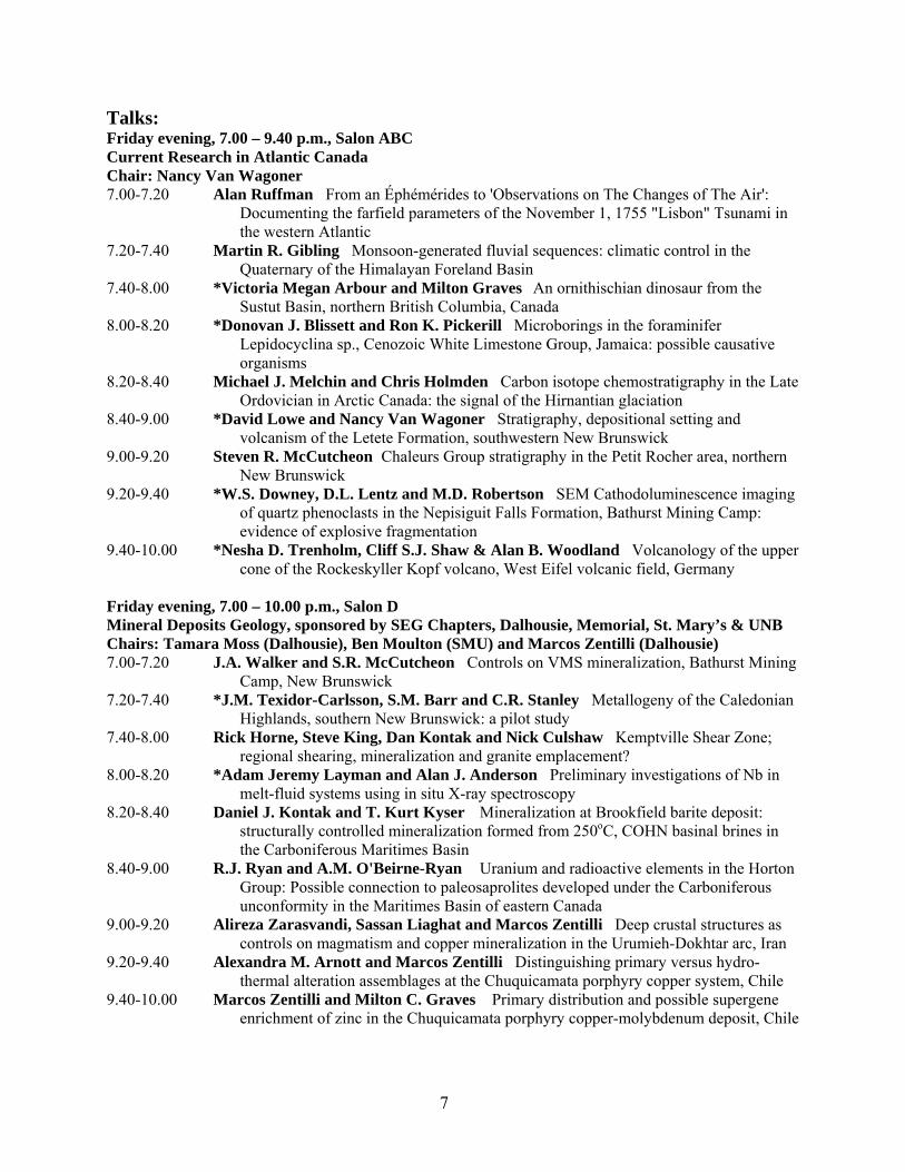
Talks: Friday evening, 7.00 – 9.40 p.m., Salon ABC Current Research in Atlantic Canada Chair: Nancy Van Wagoner 7.00-7.20 Alan Ruffman From an Éphémérides to 'Observations on The Changes of The Air':
Documenting the farfield parameters of the November 1, 1755 "Lisbon" Tsunami in the western Atlantic
7.20-7.40 Martin R. Gibling Monsoon-generated fluvial sequences: climatic control in the Quaternary of the Himalayan Foreland Basin
7.40-8.00 *Victoria Megan Arbour and Milton Graves An ornithischian dinosaur from the Sustut Basin, northern British Columbia, Canada
8.00-8.20 *Donovan J. Blissett and Ron K. Pickerill Microborings in the foraminifer Lepidocyclina sp., Cenozoic White Limestone Group, Jamaica: possible causative organisms
8.20-8.40 Michael J. Melchin and Chris Holmden Carbon isotope chemostratigraphy in the Late Ordovician in Arctic Canada: the signal of the Hirnantian glaciation
8.40-9.00 *David Lowe and Nancy Van Wagoner Stratigraphy, depositional setting and volcanism of the Letete Formation, southwestern New Brunswick
9.00-9.20 Steven R. McCutcheon Chaleurs Group stratigraphy in the Petit Rocher area, northern New Brunswick
9.20-9.40 *W.S. Downey, D.L. Lentz and M.D. Robertson SEM Cathodoluminescence imaging of quartz phenoclasts in the Nepisiguit Falls Formation, Bathurst Mining Camp: evidence of explosive fragmentation
9.40-10.00 *Nesha D. Trenholm, Cliff S.J. Shaw & Alan B. Woodland Volcanology of the upper cone of the Rockeskyller Kopf volcano, West Eifel volcanic field, Germany
Friday evening, 7.00 – 10.00 p.m., Salon D Mineral Deposits Geology, sponsored by SEG Chapters, Dalhousie, Memorial, St. Mary’s & UNB Chairs: Tamara Moss (Dalhousie), Ben Moulton (SMU) and Marcos Zentilli (Dalhousie) 7.00-7.20 J.A. Walker and S.R. McCutcheon Controls on VMS mineralization, Bathurst Mining
Camp, New Brunswick 7.20-7.40 *J.M. Texidor-Carlsson, S.M. Barr and C.R. Stanley Metallogeny of the Caledonian
Highlands, southern New Brunswick: a pilot study 7.40-8.00 Rick Horne, Steve King, Dan Kontak and Nick Culshaw Kemptville Shear Zone;
regional shearing, mineralization and granite emplacement? 8.00-8.20 *Adam Jeremy Layman and Alan J. Anderson Preliminary investigations of Nb in
melt-fluid systems using in situ X-ray spectroscopy 8.20-8.40 Daniel J. Kontak and T. Kurt Kyser Mineralization at Brookfield barite deposit:
structurally controlled mineralization formed from 250oC, COHN basinal brines in the Carboniferous Maritimes Basin
8.40-9.00 R.J. Ryan and A.M. O'Beirne-Ryan Uranium and radioactive elements in the Horton Group: Possible connection to paleosaprolites developed under the Carboniferous unconformity in the Maritimes Basin of eastern Canada
9.00-9.20 Alireza Zarasvandi, Sassan Liaghat and Marcos Zentilli Deep crustal structures as controls on magmatism and copper mineralization in the Urumieh-Dokhtar arc, Iran
9.20-9.40 Alexandra M. Arnott and Marcos Zentilli Distinguishing primary versus hydro-thermal alteration assemblages at the Chuquicamata porphyry copper system, Chile
9.40-10.00 Marcos Zentilli and Milton C. Graves Primary distribution and possible supergene enrichment of zinc in the Chuquicamata porphyry copper-molybdenum deposit, Chile

8
Friday evening, 7.00 – 10.00 p.m., Salon E Structure and Sedimentology of Hydrocarbon-prospective basins Chairs: Dave Keighley, Adrian Park 7.00-7.20 Peter S. Giles and John Utting Stratigraphic revision of the Codroy and Barachois
groups (Carboniferous) of western Newfoundland 7.20-7.40 Pierre Jutras Carboniferous plays in the eastern Gaspé and Chaleur Bay areas: a
synopsis 7.40-8.00 Denis Lavoie Hydrothermal dolomites in Paleozoic rocks of eastern Canada: A story
from identification to recent hydrocarbon production record 8.00-8.20 Adrian F. Park, Clint St. Peter and David Keighley Lower Carboniferous history of
the Indian Mountain deformed zone, Westmorland County, SE New Brunswick 8.20-8.40 John W. F. Waldron and Michael C. Rygel Carboniferous tectonics, sedimentation
and evaporite mobility in the Cumberland and Kennetcook basins 8.40-9.00 Georgia Pe-Piper and David J.W. Piper Interplay of tectonics, volcanism and
diagenetic processes in Lower Cretaceous sediments of the Chaswood Formation and Scotian Basin
9.00-9.20 *Mehdi Reza Poursoltani and Martin R. Gibling The Kashafrud Formation of Iran: Jurassic turbidites in the Neotethys Ocean, and their reservoir evaluation
9.20-9.40 Juergen Adam, John Shimeld, Csaba Krezsek, Steve King, Sheila Ballantyne and Djordje Grujic Integrating analogue experiments and seismic interpretation for improved understanding of sedimentation and salt dynamics in Mesozoic Sub-Basins and their deepwater extensions, offshore Nova Scotia
9.40-10.00 *Sheila Ballantyne, Juergen Adam, Steve King, Csaba Krezsek and Djordje Grujic Analogue models of salt dynamics and sedimentary basin evolution on passive margins: implications for offshore Nova Scotia hydrocarbon exploration
Saturday morning, 8.00 a.m. – 10.00 a.m., Salon ABC Polar GeoScience: Current research from above the treeline ... Land and Sea and all the Places in
between Chair: Trecia Schell 8.00-8.20 INVITED SPEAKER André Rochon The Northwest Passage: Future Dream
Getaway? 8.20-8.40 *Karissa Belliveau, Norm Catto, Evan Edinge and Donald Forbes The effects of
climate change on the coastal geomorphology of southwestern Banks Island, NWT 8.40-9.00 R. Bennett, S. Blasco, J. Hughes-Clarke, J. Beaudoin, J. Bartlett, A. Rochon and T.
Schell Seabed morphology, geologic framework, and paleoceanography of the NW Passage
9.00-9.20 *Tamara Moss Comparison of Late Holocene and Pleistocene sedimentologic and oceanographic records in the Amundsen Gulf, Northwest Territories, Canada
9.20-9.40 David B. Scott, Trecia Schell and André Rochon Foraminifera and associated organisms on the present Mackenzie Shelf/Amundsen Basin, Canadian Arctic and comparison to the Antarctic faunas
9.40-10.00 Robert Taylor, Dave Frobel and Don Forbes Monitoring coastal change in the eastern Canadian Arctic

9
Saturday morning, 8.00 a.m. – 10.00 a.m., Salon D Current Research in Atlantic Canada Chair: Sandra Barr 8.00-8.20 *Heather E. Wolczanski and Sandra M. Barr The Wolves - a missing link in
southern New Brunswick geology 8.20-8.40 *James C.P. Sykes Schlieren structures in the South Mountain Batholith, Nova Scotia 8.40-9.00 *Glenn Hart, Rebecca Jamieson, Neil Tobey, and Jared Butler Andalusite in the
South Mountain Batholith contact aureole, Halifax NS: a tale of two isograds 9.00-9.20 *Virginia Brake Filling in the gap: Ccorrelation of onshore and offshore geology,
southwestern Nova Scotia using geophysical data 9.20-9.40 David J.W. Piper, Georgia Pe-Piper and L.F. Jansa Origin and tectonic significance
of the Early Cretaceous Fogo Seamounts 9.40-10.00 Cliff Shaw, Florian Heidelbach and Don Dingwell The origin of reaction textures in
mantle peridotite xenoliths from Sal Island, Cape Verde: the case for “metasomatism” by the host lava
Saturday morning, 8.00 a.m. – 10.00 a.m., Salon E Environmental Geosciences Chair: Grant Ferguson and Ian Spooner 8.00-8.20 André Robichaud and Colin P. Laroque A study of buried forests from two bogs in
northern New Brunswick 8.20-8.40 *Lanna J. Campbell and Colin P. Laroque Chronology development from decayed
tree-ring samples in Atlantic Canada 8.40-9.00 *Nigel Selig, André Robichaud and Colin P. Laroque Tree-ring chronology
development from house structures in Dorchester, New Brunswick 9.00-9.20 *Ben Phillips and Colin P. Laroque Historical and dendrochronological assessment of
the Bay of Fundy forests for dendroclimatological modeling, New Brunswick 9.20-9.40 Colin P. Laroque Climate reconstructions from five conifer species in southwestern
Nova Scotia 9.40-10.00 *Christine Robichaud and Colin P. Laroque Future treeline migration based on past
radial tree growth, Jasper National Park, Alberta Saturday morning, 10.20 a.m. – 12.00 noon, Salon ABC Polar GeoScience: Current research from above the treeline…Land and Sea and all the Places in
between Chair: Marie-Claude Williamson 10.20-10.40 INVITED SPEAKER Gordon Neil Oakey Cenozoic tectonic framework of the Baffin
Bay – Nares Strait region of Arctic Canada and Greenland 10.40-11.00 *Samantha Jones, Hans Wielens, Marie-Claude Williamson and Marcos Zentilli
Impact of magmatism on the petroleum system of the Sverdrup Basin, Canadian Arctic Islands, Nunavut; a numerical modeling experiment
11.00-11.20 M. Zentilli, A.M.Grist, M-C.Williamson, D.T.Andersen and W.Pollard Thermal effects of warm fluid circulation associated with the rise of evaporite diapirs in the east-central Sverdrup Basin, Canadian Arctic Archipelago
11.20-11.40 R. Andrew MacRae and Len Hills Biostratigraphic constraints on the Cretaceous Strand Fiord Formation flood basalts, central Sverdrup Basin, Canadian Arctic Islands
11.40-12.00 John Shimeld, Ruth Jackson and Jacob Verhoef Furthering understanding of Arctic marine geology through the United Nations Convention on the Law of the Sea

10
Saturday morning, 10.20 a.m. – 12.00 noon, Salon D Education Outreach: A Required Element of the Geoscience Community Chair: Jennifer Bates and Heather Johnson 10.20-10.40 Jennifer Bates How a committee earns its keep: current activities of the Atlantic
Geoscience Society Education Committee 10.40-11.20 Heather Johnson Earth science at the junior high level: a teachers perspective 11.20-11.40 Lucette Barber and Trecia Schell “Schools on Board!” bridging Arctic sciences and
education 11.40-12.00 Sonya A. Dehler Putting it in motion: plate tectonics as a classroom activity Saturday morning, 10.20 a.m. – 12.00 noon, Salon E Environmental Geosciences Chairs: Grant Ferguson and Ian Spooner 10.20-10.40 *Lori Wrye Suspended sediment concentrations in the Shubenacadie Canal,
Dartmouth, Nova Scotia 10.40-11.00 *Megan E. Little, Michael B. Parsons and Ann-Marie Ryan Distribution of arsenic
and mercury in marine sediments impacted by gold mine tailings, Wine Harbour, NS 11.00-11.20 Philip Giles Analysis of hierarchical unsupervised clustering of IKONOS data for
Pointe de l’Est, Iles de la Madeleine, Quebec 11.20-11.40 Brent Ward, Marten Geertsema, Alice Tekla and Rolf Mathewes A
paleoecological record of climatic deterioration from middle to late Wisconsinan time on the Interior Plateau of British Columbia, Canada
11.40-12.00 C.F. Michael Lewis, Ann A.L. Miller, Gary V. Sonnichsen and David J. W. Piper Marine evidence on the northeast Newfoundland Shelf of outburst floods from glacial Lake Agassiz and the 8.2 cold event
Saturday afternoon, 2.00 p.m. – 5.00 p.m., Salon ABC Polar GeoScience: Current research from above the treeline…Land and Sea and all the Places in
between Chair: Robbie Bennett, Gavin Manson 2.00-2.20 Gavin K. Manson, Donald L. Forbes, Norman R. Catto, Karissa Belliveau, Kathleen
Parewick, Steven M. Solomon, Evan N. Edinger and Tanya Brown Coastal processes, hazards impacts, and resilience in Canadian Arctic communities
2.20-2.40 *Frederick B. Walsh The Kopanoar mud volcano on the Mackenzie Shelf, Beaufort Sea: Implications for methane release on Arctic shelves
2.40-3.00 S.M. Blasco, K.A. Blasco, J.M. Shearer, D. Poley and B.R. Pelletier Mud Volcanoes, Diapirs, pingos and relict topographic features on the Canadian Beaufort Shelf
3.00-3.20 refreshments 3.20-3.40 Erin J. Oickle, Steve M. Blasco and Jim M. Shearer Extreme ice-scouring processes
on the Canadian Beaufort Shelf caused by sea-ice pressure ridge keels 3.40-4.00 André Rochon, Steve Blasco, David Scott, Trecia Schell, Robbie Bennett and
Kimberly Jenner Holocene paleoceanography of the MacKenzie Trough, Beaufort Sea, Canada: preliminary results
4.00-4.20 Trecia M. Schell, David B. Scott, André Rochon, Steve Blasco, Robbier Bennett and Kimberly Jenner Recent paleoceanography of the MacKenzie Trough (Beaufort Sea) with comparisons to Lancaster Sound (Baffin Bay) using foraminifera as proxies.
4.20-5.00 KEYNOTE SPEAKER Jean H. Bédard, Tom Fleming, Taber Hersum, B. Marsh, H. Richard Naslund and Samuel B. Mukasa Differentiation mechanisms in the Basement Sill, Ferrar Province, Antarctica

11
Saturday afternoon, 2.00 p.m. – 5.00 p.m., Salon D Education Outreach: A Required Element of the Geoscience Community Chair: Jennifer Bates and Heather Johnson 2.00-2.20 Rob Fensome, Judi Pennanen, Tim Fedak, Andrew MacRae, Paul Olsen, John
Wade, Graham Williams, Ken Adams, Jennifer Bates, Dave Brown, Howard Falcon-Lang, Kathy Goodwin, Randy Miller, Georgia Pe-Piper and Deborah Skilliter Dinosaurs, deserts and volcanoes: the creation of a series of paintings depicting scenes from the Mesozoic Fundy Basin of Nova Scotia and New Brunswick
2.20-2.40 John Calder, Hans Samuelson and Jenna Boon Learning how to tell the story of a prospective geological World Heritage Site: rejoining art and science at Joggins
2.40-3.00 Brad Tucker Rules of engagement 3.00-4.00 Gordon B.J. Fader, Charles Doucet and George Jordan The making of an AGS
educational film: from design to production 4.00-4.20 D. Patrick Potter, John W. Shimeld, Peter Wallace River in a box: sedimentary
geology with modified Hele-Shaw cells 4.20-4.40 Howard V. Donohoe Jr. and Ken Adams On the rocks with geoscience outreach 4.40-5.00 Tracy Webb Canadian Geology 12 - The inspiration point for many future geologists! Saturday afternoon, 2.00 p.m. – 5.00 p.m., Salon E Sediment Dynamics of the Greater Bay of Fundy Chairs: Elisabeth Kosters and Anna Redden 2.00-2.20 Gordon B.J. Fader The past, present and future geoscience research in understanding
the Bay of Fundy 2.20-2.40 Danika van Proosdij Ecomorphodynamics of salt marsh and mudflat systems in the
upper Bay of Fundy 2.40-3.00 Kee Muschenheim Suspended sediment cycles in the mid and outer Bay of Fundy 3.00-3.20 refreshments 3.20-3.40 T.G. Milligan, G. Bugden and B.A. Law Mud breeds mud: the non-linear effect of
high sediment concentrations on channel infill downstream of causeways 3.40-4.00 Karl E. Butler, E. Jane Simmons, Murray K. Gingras, Gary Bugden and Peter G.
Simpkin Trends in sedimentation and erosion at the mouth of the Petitcodiac River, Bay of Fundy, as inferred from sub-bottom profiles
4.00-4.20 Russell Parrott, Michael Parsons, Michael Li, Vladimir Kostylev, John Hughes Clarke and Kok-Leng Tay Multidisciplinary approach to assess sediment transport and environmental impacts at an offshore disposal site near Saint John, NB
4.20-4.40 discussion

12
ABSTRACTS
(*Student Presenter)
Integrating analogue experiments and seismic interpretation for improved understanding of sedimentation and salt dynamics in Mesozoic sub-basins and their deepwater extensions, offshore Nova Scotia
JUERGEN ADAM1, JOHN SHIMELD2, CSABA KREZSEK1, STEVE KING1, SHEILA BALLANTYNE1 AND DJORDJE GRUJIC1 1Salt Dynamics Group, Department of Earth Sciences, Dalhousie University, Life Sciences Centre, Halifax, Nova
Scotia, B3H 4J1, <[email protected]> 2Geological Survey of Canada (Atlantic), Bedford Institute of Oceanography, P.O. Box 1006, Dartmouth, Nova
Scotia, B2Y 4A2, <[email protected]> Salt-deformation features beneath the shelf and slope of the Scotian Margin manifest complex tectono-stratigraphic relationships with high rates of sedimentation and progradation during the Jurassic and Early Cretaceous. Exploration and seismic interpretation concepts developed in other salt basins (e.g., Gulf of Mexico and South Atlantic basins) are not directly transferable to the Scotian Margin due to differences in paleographic setting, sediment supply, and primary salt-basin geometry. We have begun an integrated geoscience study with innovative 4D physical simulations using scaled analogue models and 2D/3D seismic interpretation. Our objective is to investigate the complex interplay between sedimentation and salt deformation in different sub-basins and their deepwater extensions that are characterized by contrasting salt deformation styles ranging from major extension and roho-style detachment to minor extension and vertical salt movement. Public domain seismic data provide the boundary conditions for the experiments including tectonic setting, geometry of salt basins, and sedimentation pattern and rates. The evolution of the sedimentary basins and the dynamic salt system is simulated in physical experiments that consist of scaled granular-viscous models with syntectonic sedimentation. Model deformation is analysed by time-series of images and 3D displacement data obtained with high-resolution optical image correlation techniques (2D/3D PIV - Particle Imaging Velocimetry). Structural 3D models are built from model sections with commercial seismic interpretation software to provide insights in the architecture of the linked salt-controlled basins and fault structures. The integration of structural interpretation with time-series of fault strain data allows the reliable 3D fault correlation and the mechanical analysis of complex fault systems. For the first time, this new modelling approach allows us to quantitatively assess: 1) the timing and mechanisms of faulting, folding and salt migration, 2) the role of variable sedimentation patterns and rates, and 3) the coupling between extensional, translational and compressional regimes. In this experiment series we have investigated the role of basin floor dip, sedimentation pattern and rates on the basin evolution at regional scale. The experiment results show that gravitational collapse and salt mobilization generate complex 3D structures similar to those observed along the Scotian Margin, including crestal grabens, landward and seaward dipping roller structures, triangular-shaped reactive and active diapirs, turtle structures, canopies, and allochthonous salt detachments. The tectonic evolution is strongly controlled by sedimentation. Individual sub-basins and their deep-water compressional belts are coupled spatially and temporally and are characterized by lateral and temporal migration and highly variable and localized subsidence patterns. Our results show that a strong relation exists between sedimentation, rate of extension and dominant structural styles. Integration of 4D physical simulations with 2D/3D structural modelling and seismic interpretation will lead to a new generation of improved interpretation templates for salt-related structures and basins offshore Atlantic Canada. The project will significantly improve our understanding of the interaction of dynamic salt systems with sedimentation and erosion processes and will aid interpretation of complex structures beneath the Scotian Margin.

13
An ornithischian dinosaur from the Sustut Basin, northern British Columbia, Canada
*VICTORIA MEGAN ARBOUR AND MILTON GRAVES Dalhousie University, Halifax, Nova Scotia, Canada, B3H 4R2 <[email protected], [email protected]>
In 1971, dinosaur bones were discovered during uranium exploration in the Sustut Basin in northern British Columbia, Canada, and were donated to Dalhousie University in Nova Scotia in 2004. Although dinosaur bones have been reported from British Columbia previously, this specimen is the earliest recorded discovery of dinosaur bones from the province. The specimen also represents one of the westernmost discoveries of dinosaur bones in Canada. The bones were collected from loose blocks in a talus slope, near the intersection of Birdflat Creek and Sustut River. The fossils are encased in a hard siltstone that shares characteristics with both the Early Albian to Late Cenomanian Tango Creek Formation and the Late Campanian to late Early Maastrichtian Brothers Peak Formation, making a more precise age estimate for this specimen difficult. Bones collected include the right humerus, a radius, the distal portion of the right tibia and fibula, several pedal phalanges including two unguals, and several unidentifiable fragments. A small block of matrix removed from the tibia contains additional small bones, but further preparation is not possible at this time. Comparison of the material with specimens at the Royal Ontario Museum and descriptions in the scientific literature indicates that a relatively small (less than five metres in length), bipedal ornithischian is represented. General features of the tibia and phalanges are consistent with the ornithopod Thescelosaurus, but a low deltopectoral crest on the humerus matches closely with Stegoceras and other pachycephalosaurs.
Distinguishing primary versus hydrothermal alteration assemblages at the Chuquicamata porphyry copper system, Chile
ALEXANDRA M. ARNOTT AND MARCOS ZENTILLI
Dalhousie University, Halifax, B3H 4J1, Canada, [email protected], [email protected]
One of the major problems facing a new geologist at a mine is learning how to distinguish in the workings and in drillcore the various fresh, generally unmineralized rock units, their hydrothermally altered equivalents, and those altered by weathering, which are often intermingled due to complex structural deformation. It is also tricky to distinguish between magmatic biotite and K-feldspar from that formed by potassic alteration. Previous review of previous work is essential, and classical mineralogy and petrographic techniques, such as slabbing and staining of feldspars can help, but often thin section microscopy, x-ray diffraction and other modern mineralogical tools (e.g. electron microprobe) are necessary to unravel the alteration record. At the Chuquicamata porphyry copper deposit, Chile, mineralogical and geochemical evidence suggests a multiphase history of intrusion and alteration/mineralization complicated due to structural complexity. A strike-slip structure, the West Fault, truncates the Chuquicamata Intrusive Complex (CIC), which consists of the calcalkaline granodioritic Este, Oeste, and Banco porphyries. The CIC is overprinted by multiple phases of alteration (e.g. potassic, quartz-sericite, argillic) and mineralization. Inside the open pit and juxtaposed across the West Fault is the relatively unaltered and unmineralized Fortuna Intrusive Complex (FIC). Macroscopically, the fresh and the potassically-altered Este Porphyry are nearly identical, making pit and core mapping very difficult. However, a closer examination of the potassically altered rocks reveals a lack of Ca-bearing silicate minerals. The potassic alteration affecting the Este Porphyry is the result of a late hydrous phase of the same magma with high halogen contents that preferentially partitioned Ca into the melt and the escaping fluid phase. The Banco Porphyry is unaffected by the potassic Ca-leaching event giving a firm relative age of intrusion, but altered by the phyllic event which obliterated feldspars and biotite, but introduced sericite and anhydrite. The upper levels of the mine and structurally shattered zones are deeply weathered and dominated by low temperature clay minerals, sulphates and other secondary minerals that make the rocks textures unrecognizable.

14
Analogue models of salt dynamics and sedimentary basin evolution on passive margins: implications for offshore Nova Scotia hydrocarbon exploration
*SHEILA BALLANTYNE, JUERGEN ADAM, STEVE KING, CSABA KREZSEK AND DJORDJE GRUJIC
Salt Dynamics Group, Department of Earth Sciences, Dalhousie University, Halifax, Nova Scotia, B3H 4J1<[email protected]>
The high economic risk in hydrocarbon exploration on the Scotian Slope, offshore Nova Scotia, is caused by the complex salt structures, which developed from the Triassic to Cretaceous period. This study applies physical experiments with optical strain monitoring to develop new concepts for the interpretation of geological and geophysical data, and provide information for the hydrocarbon exploration in this area. The scaled analogue models, which use silica sand and silicone as sediments and salt analogues, simulate gravity-driven syn-sedimentary deformation in passive margin sedimentary wedges overlying a mobile substratum. High-resolution optical strain monitoring techniques (2D/3D Particle Imaging Velocimetry, PIV) enable one to quantify the complete 3D deformation and surface flow in the experiments. A series of experiments have been conducted to study the effects of varying sedimentation rates and the dip variation of the experimental base on the spatiotemporal deformation pattern. Results show that complex relationships exist between sedimentation pattern, basal dips, salt structures, and fault formation in the overburden. Time-series strain data and structural interpretation of these experiments provides insights in the dynamic evolution of sedimentary basins over a mobile substratum. Our results have the potential to improve the structural and seismic interpretation of the Scotian Slope salt province. Comparison of the spatial and temporal patterns of change in salt marshes of the Avon and Cornwallis River
estuaries
*JILLIAN BAMBRICK AND DANIKA VAN PROOSDIJ Department of Geography, Saint Mary’s University, 923 Robie St., Halifax, NS, B0J 1T0
<[email protected]> Salt marshes and mudflats are dynamic systems that will respond to even slight changes in their surrounding environment. This would include changes in shoreline topography, main tidal channel position, wave action, water levels, ice and coastal development. These changes can be quantified by analyzing the spatial extent of salt marsh vegetation over time, identifying progradational or erosional sequences. Documenting and analyzing these sequences through a GIS over a decadal temporal scale can be used to evaluate the relative sensitivity and resilience of these systems to change. In addition, it is the first step in isolating the relative significance of variables driving those changes. Both the Avon River (Windsor) and the Cornwallis River (Kingsport) enter the Minas Basin in an estuarine setting, where tidal action creates, and exposes, the salt marsh environment. These areas are exposed to macrotidal conditions, high suspended sediment concentrations, strong seasonality, and human development which will influence overall marsh evolution. The purpose of the research presented in his poster is to compare the spatial and temporal patterns of change in salt marsh habitat between the Avon and Cornwallis River Estuaries. It forms a component of a larger research project examining the ecomorphodynamics of intertidal ecosystems in the Upper Bay of Fundy. Historical aerial photographs of the areas (1944 to 2003) were assessed for research suitability based on tidal level (low vs. high tide) and photos taken at high tide (e.g. entire marsh not visible) were excluded from the analysis. Unfortunately this resulted in gaps within the temporal record and even spatial gaps within a particular year. In addition, flight lines often were not flown within the same year in adjoining counties which limited comparison between study areas. The remaining air photos were scanned and rectified against digital 1:10,000 planimetric map sheets using ArcGIS 9.1. Variations in aircraft position were accounted for by using a second-order polynomial transformation in ArcGIS 9.1 during the rectification process. A custom AML for Arc/Info Desktop was used to mosaic the photos, resulting in an image with a ground resolution of one meter. Salt marsh habitats (incorporating both high and low marsh) were outlined using on-screen digitizing procedures in ArcView 9.1 and marsh area calculated. The resultant polygons were compared on a decadal scale, and change quantified using the geoprocessing capabilities within ArcGIS. These data were normalized for each estuary as a percentage of change

15
between each year and over the entire time period. These data are currently being analyzed. By comparing the values gained for each estuary, the system stability can be evaluated, and potential reasons for the spatial and temporal patterns of change can be explored. These data can be used to show what has changed, where these changes have occurred, how much has changed, and examine the relative sensitivity of marshes within the Southern Bight of the Minas Basin. Only after these baselines have been generated can research hypotheses on factors controlling changes in salt marsh habitat be explored in a systematic and non-biased manner.
“Schools on Board!” Bridging Arctic sciences and education
LUCETTE BARBER1 AND TRECIA SCHELL2 1Program Coordinator for Schools on Board. Center for Earth Observation Sciences, Clayton H. Riddell Faculty of
Environment, Earth and Resources, University of Manitoba, Winnipeg, Manitoba, R3T 2N2 <[email protected]; www.arcticnet-ulaval.ca>
2Post-doctoral Research Fellow, Canadian Arctic Shelf Exchange Study & ArcticNet. <[email protected]>
Schools on Board was created as an Outreach program to CASES (Canadian Arctic Shelf Exchange Study, and NSERC Strategic Project) and ArcticNet (and NCE, National Centre of Excellence). It is a vehicle for Arctic scientists and graduate students to outreach their research program to the general public. The program is designed to support teachers who are interested in including Arctic Sciences into their science programs by providing resources and opportunities to takes high school students and teachers into the Arctic to participate in field research. Participants board the CCGS Amundsen where they are integrated into the activities of the various science teams. This adventure into Arctic research exposes students and teachers to the research objectives and methods of numerous science teams representing a number of research disciplines and institutions from across Canada and beyond. Face-to-face interactions with scientists of all levels (graduate students, researchers, CRC chairs), hands-on experiences in the field and in the labs, and access to state-of-the-art scientific instrumentation, combine to create a powerful learning environment. In addition to hands-on research activities the program introduces participants to many aspects of Canada’s North, including local knowledge, culture, history, and politics – within the educational program on the ship and the planned visits to Northern communities. Building on the success of the 2004 pilot program on-board the CASES project, the 2005 Field Program on board the NGCC Amundsen, successfully met its goals of promoting Arctic sciences, increasing awareness of environmental issues related to the Arctic and climate change, and providing new and exciting learning opportunities to this country’s next generation of scientists. In addition to the field expedition, Schools on Board promotes Arctic sciences in the classroom through its Network of educators and scientists and its most recent initiative, the Arctic Climate Change Youth Forum.
Machias Seal Island quartz monzodiorite: the southernmost rocks in New Brunswick
SANDRA M. BARR1, JAMES K. MORTENSEN2 AND HEATHER E. WOLCZANSKI1, 1Department of Geology, Acadia University, Wolfville, NS, B4P 2R6 <[email protected]>
2Earth & Ocean Sciences, University of British Columbia, Vancouver BC V6T 1Z4 Machias Seal Island is located at the mouth of the Bay of Fundy, about 20 km south of Grand Manan Island and 20 km east of Machias, Maine. The island has an area of about 0.04 km2, and is barren except for a lighthouse and dwellings maintained by the government of Canada. It has the last manned lighthouse in the Maritime Provinces, and is well known among bird-watchers as a nesting site for puffins, auks, and other seabirds. Geologically, Machias Seal Island is important because of its location in an area through which it is difficult to trace terranes from the mainland of Nova Scotia and New Brunswick into the New England states. Studies in Grand Manan Island have not entirely resolved the problem, as rocks there most resemble those of the New River terrane of southern New Brunswick, suggesting that the Kingston, Brookville, Caldonia (Avalon), and Meguma terranes all lie outboard of Grand Manan Island. Machias Seal Island consists entirely of grey, locally pink, fine- to medium-grained weakly foliated quartz monzodiorite, gradational to granodiorite. Small ovoid metadioritic xenoliths, generally less than 20 cm in maximum dimension, are abundant and consist of fine-grained granoblastic plagioclase, orthopyroxene,

16
clinopyroxene, amphibole, and biotite. Two anastomosing mafic dykes, oriented approximately north-south and about 1 m in width, cut across the island. One dyke is alkalic, whereas the other is tholeiitic and may be related to Mesozoic basalt on Grand Manan Island. Typical Machias Seal Island quartz monzodiorite contains 60% strongly zoned plagioclase, 40% amphibole and biotite, and about 20% interstitial quartz and orthoclase. The amphibole contains relict cores of orthopyroxene. The average chemical composition (6 samples) has 60.6% SiO2, with relatively high Al2O3 (over 16%) and low K2O (2.8%). Overall, the chemical characteristics, including low Rb, Y, and Nb, are consistent with emplacement in a continental margin subduction zone. A quartz monzodiorite sample yielded a preliminary U-Pb zircon age of 542.5±1.3 Ma, indicating that the pluton was emplaced close to the Precambrian-Cambrian boundary. Both the age and composition differ from those of the Three Islands Granite, which underlies the rocky shoals 14 km east of Machias Seal Island, and which has yielded a much older age of 611.1 ± 2.4 Ma. Small granitic plutons on Grand Manan Island have yielded ages more similar to the age of Machias Seal Island (ca. 547 Ma and 535 Ma), but they differ in terms of petrography and mode of occurrence. The Machias Seal Island quartz monzodiorite also differs in age from the adjacent granitoid rocks in Maine which are Silurian-Devonian and part of the Coastal Maine magmatic province. Age and compositional similarities strongly suggest correlation of Machias Seal Island quartz monzodiorite with the abundant ca. 550-525 Ma gabbroic to granitic plutons of the Brookville terrane on the mainland of southern New Brunswick.
The upper Hazelton Group in northwest British Columbia: an example of an ore-forming arc to rift
transition
*TONY BARRESI1, JOANNE NELSON2, DANI ALLDRICK3, JARDA DOSTAL4
1 Department of Earth Science, Dalhousie University, Halifax NS, B3H 4J1 <[email protected]> 2 British Columbia Geological Survey, Victoria BC, V8W 9N3 <[email protected]> 3 British Columbia Geological Survey, Victoria BC, V8W 9N3 <[email protected]>
4 Department of Geology, St. Mary’s University, Halifax NS, B3H 3C3 <[email protected]> In island arcs, the latest stage of subduction related processes is commonly followed by an extensional tectonic regime. The Stikine Terrane of the Canadian Cordillera records one such transition in the rocks of the Early to Middle Jurassic upper Hazelton Group, in northwestern British Columbia. These rocks are host to the world-class Eskay Creek volcanogenic massive sulfide (VMS) deposit. Recent targeted studies of the upper Hazelton Group have documented a number of characteristics which confirm that the upper Hazelton Group represents a shift from arc building during the Early Jurassic to an extensional environment during the late Early to Middle Jurassic. These characteristics include 1) the presence of original rift bounding faults; 2) unconformities that are associated with rift filling conglomerates, including one that grades into more distal facies argillite; 3) a shift in the geochemical signature of mainly intermediate Early Jurassic calc-alkaline volcanic rocks to Middle Jurassic bimodal rhyolites and tholeiitic basalts; and 4) evidence for a major transcurrent tectonic regime, which opened distinct rift segments that were separated by horsts of older Stikinian units. Although the upper Hazelton Group is composed of separate sub-basins, the lithologies, geochemistry and morphologies of far-separated segments correspond closely to one another. The Willow Ridge Complex (WRC), and the Pillow Basalt Ridge Complex (PBR), which are 100 km apart, each contain a succession of sedimentary and bimodal volcanic rocks between 1000 m thick sequences of mainly pillow basalt. These middle units, in both regions, are very similar to the strata that host the Eskay Creek deposit and may represent a repetition of the conditions that were favourable to mineralization at Eskay Creek. New whole-rock major oxide and trace element geochemical analyses of 17 samples collected from the WRC agree with previous interpretations that they were deposited in a rift setting. The chemistry of these rocks is similar to those that host the Eskay Creek VMS deposit and other VMS hosting volcanic rocks world-wide. The WRC is composed of a bimodal suite of mainly basalts and rhyolites. Basalts from the WRC are characterized by: a) a negative correlation of TiO2 with Mg number in compositionally-similar, TiO2-rich tholeiitic MORB; b) a slight enrichment in light REE (Lan/Smn = 1.83) and flat heavy REE (Gdn/Ybn = 1.19); c) slight enrichment of strongly incompatible elements and a small negative Nb anomaly in mantle-normalized incompatible-element diagrams. Rhyolites from the WRC have broadly similar characteristics to basalts (Lan/Smn = 3.01, and Gdn/Ybn = 0.86) but they have strong negative Ti and weak positive Zr anomalies. The similarity in trace element abundances between rhyolites and basalts rules out derivation of rhyolite from basalt via fractional crystallization. All but the

17
most primitive basalts are interpreted to be derived from sub-lithospheric mantle, and rhyolites are interpreted to be derived from partial melting of crustal rocks.
How a committee earns its keep: current activities of the Atlantic Geoscience Society Education Committee
JENNIFER L. BATES
Geological Survey of Canada (Atlantic), BIO, 1 Challenger Drive, Dartmouth, NS B2Y 4A2 <[email protected]> Translating >geo-jargon= into words that can be understood by teachers, students and the general public is a daunting task. But I guess some people are up for the challenge - and, thank goodness, some of these people are members of the Education Committee of the Atlantic Geoscience Society (AGS). This Committee began its task in the late 1980s and grew to take on a number of what seemed to be formidable projects. The Nova Scotia EdGEO Workshop Program started in 1994 with last year marking the presentation of the twelfth in the continuing saga. EarthNet (earthnet-geonet.ca) was also one of the Committee=s early projects. Development continues as it strives to become a true national resource for teachers. The popular geology book The Last Billion Years, published in 2001, is probably the group=s most notable accomplishment. Please note that other excellent education products have been developed by sister committees of AGS; they are the geological highway maps of the Maritime Provinces and the AThe Geology of Atlantic Canada@ video series (plus teaching guides). Today, the AGS Education Committee is thriving. Members include geologists and educators. Representatives from local museums, science centres and like-minded education groups also sit on the Committee. All this generates a natural setting for good discussion and collaboration. Recent activities include production of the ANova Scotia Rocks@, a pamphlet for those at the first-level entry to Nova Scotia geology; a partnership role in the NSERC-funded UNB-SFX CRYSTAL (Centres for Research in Youth, Science Teaching and Learning) project that will study the effectiveness of education outreach; a series of original watercolour paintings destined to tell us the geological history of the Fundy Basin; a new EdGEO workshop program in New Brunswick; and the 5th season of evening public talks at the NS Museum of Natural History. New activities under development are a booklet on the Fundy Basin story, resources for use at EdGEO workshops, and a book series for young readers. And ideas are always cooking on the back burner. If you are at all interested in how the AGS Education Committee earns its keep, you will want to attend the AGS Colloquium session Education Outreach: A Required Element of the Geoscience Community.
Differentiation mechanisms in the Basement Sill, Ferrar Province, Antarctica
JEAN H. BÉDARD1, TOM FLEMING2, TABER HERSUM3, B. MARSH3, H. RICHARD NASLUND4AND SAMUEL B. MUKASA5
1Geol. Surv. Canada, 490 de la Couronne, Québec, PQ, Canada, G1K9A9 < [email protected]>; 2S. Conn. State Univ. New Haven, CT. 06515, USA; 3Johns Hopkins Univ., Baltimore, MD, 21218, USA; 4Binghamton Univ.,
Binghamton, NY, 13902, USA, 5Univ. Michigan, Ann Arbor, MI, 48109 USA The Basement Sill (BS) of the tholeiitic Ferrar flood basalt Province is > 300 m thick, with aphyric micro-gabbro-noritic marginal zones; a lower pyroxenitic tongue which varies in thickness along-strike; and an upper gabbro-noritic zone. The feldspathic websterite tongue could not have crystallized from the plagioclase-phyric chilled margins and represents an injected pyroxene-enriched slurry. Orthopyroxene (opx) is euhedral and normally zoned, clinopyroxene (cpx) is interstitial, while plagioclase (plag) generally occurs as small (most <1mm, some 3-4mm), normally-zoned euhedral laths (<An87), some with inherited sodic cores. Euhedral plag laths included in opx primocrysts have similar compositions to groundmass or phenocrystic plag. Throughout the section, there is no systematic cryptic mineral-chemical variation of feldspar or pyroxene, and most rocks do not have cotectic plagioclase/pyroxene ratios, suggesting mechanical redistribution on a 300m scale of an inherited phenocryst load. Model melts from pyroxenite and gabbro-norite are identical to the dominant Ferrar Lavas for trapped melt fractions (TMF) of ca 30%. The tongue contains feldspathic pipes (1-2m diameter) and layers which commonly contain foliated anorthositic edges, and gabbro-norite cores. Pipe margins appear rooted in the pyroxenite and yield model melts indistinguishable from those of the pyroxenite. We propose that the pipes are ephemeral melt+plagioclase escape structures by which the coprecipitated plag was transferred upward to form the gabbro-norite zone. In plan view, the size and number-density of the feldspathic pipes appears sufficient to have drained a pore melt containing

18
ca 10-20% small plagioclase laths from the pyroxenite in the time available for cooling the sill. The gabbro-noritic sequence contains anorthositic layers that differ mainly by having lower model TMF (10%), and which may represent intra-cumulate sills of the feldspathic slurry expelled from the pyroxenite. Bedding-parallel and discordant pegmatitic ‘veins’ attest to the movement of Fe-Ti-PGE-rich fluids or volatile-rich melts which may have been expelled from the low-porosity anorthosites. Thus, recognition of low-TMF layers may represent a PGE-exploration guide.
The effects of climate change on the coastal geomorphology of southwestern Banks Island, NWT
*KARISSA BELLIVEAU1, NORM CATTO2, EVAN EDINGER2 AND DONALD FORBES3
1Environmental Science Program, Memorial University of Newfoundland, St. John’s, NL, A1B 3X9
<[email protected]> 2Department of Geography, Memorial University of Newfoundland, St. John’s, NL, A1B 3X9
3Geological Survey of Canada-Atlantic, 1 Challenger Dr. (PO Box 1006), Dartmouth, NS, B2Y 4A2 Well publicized community concern about changing coastal conditions led to Sachs Harbour being chosen as one of the first coastal sites for detailed study along the E-W gradient as part of ArcticNet Project 1.2. Fieldwork, including RTK coastal profiling, and analyses of aerial photography and QuickBird images were used to assess coastal processes, rates of coastal retreat, and long-term decadal changes in coastal erosion rates near the community of Sachs Harbour, NWT. The southwestern coastline of Banks Island is dominated by low bluffs composed of frozen unlithified glacially derived sediments containing segregated ice lenses and ice-rich silty sand horizons. Rising sea level and decreasing sea ice extent, coupled with regional submergence due to crustal flexure, has rendered this coastline vulnerable to erosion. Increasing effectiveness of storm events in eroding these bluffs could lead to increasing sedimentation on the shoreface and the nearshore. High sedimentation rates may have negative consequences on the marine biotic community in this region, with rapid burial of organisms hampering biological productivity. Fieldwork in 2005 identified the dominant geomorphic processes and measured current rates of coastal erosion. Coastal surveys included 31 transects, distributed from north of Cape Kellett to southeast of Sachs Harbour. Sediment samples were taken from the shore-zone and nearshore environments to delineate longshore transport cells. Suspended particulate matter was measured in the nearshore zone and resampled during and after a small rain/wind/wave event. These results were used to determine the effectiveness of overland flow to increase sedimentation and resuspension of material in the nearshore. The coastal bluffs are undergoing retreat, particularly west of Sachs Harbour. Bluffs in the eastern section of Sachs Harbour appear to be actively eroding. However, much of the community is sheltered from wave action by the spit to the south. West of the community where the bluffs are exposed to higher energy conditions, the sediments are finer grained, and there is increased wave erosion during storm events. Thermal erosion plays a major role in coastal retreat. Melting ground ice causes retrogressive thaw flow failures and slumping and creep of material to the base of slopes. Disturbed sediment is subject to removal during storm events. The results of a small rain/wind/wave event on August 9-10 indicate that although there was minor increase in overland flow and intensity of wave action, a much larger event would be necessary to actively transport disturbed material offshore. Ongoing research will determine longer-term changes and quantitative rates of coastal retreat. Prediction of the future evolution of this coastline in response to changing climate conditions will allow Sachs Harbour to assess impacts and develop any adaptations necessary.

19
Seabed morphology, geologic framework, and paleoceanography of the NW Passage
R. BENNETT1, S. BLASCO1, J. HUGHES-CLARKE2, J. BEAUDOIN2, J. BARTLETT2, A. ROCHON3 AND T. SCHELL4 1Geological Survey of Canada (Atlantic), P.O. Box 1006, Dartmouth, NS, B2Y 4A2, < [email protected],
[email protected]> 2Ocean Mapping Group / Canadian Hydrographic Service, Dept of Geodesy and Geomatics Engineering, University
of New Brunswick, P.O. Box 4400, Fredericton, NB, E3B 5A3, <[email protected], [email protected], [email protected]>
3Institut des sciences de la mer de Rimouski (ISMER), Université du Québec à Rimouski, 310, allée des Ursulines Rimouski, QC, G5L 3A1, <[email protected]>
4Centre for Environmental & Marine Geology, Department of Earth Sciences, Dalhousie University, Halifax, NS, B3H 3J5 <[email protected]>
Thirty kHz multibeam echosounder and 3.5 kHz sub-bottom profiler data were continuously collected as CCGS Amundsen transited the NW Passage during the 2004 and 2005 ArcticNet field programs. These geophysical data in conjunction with sediment cores collected at key sites are being used to map seabed morphology, interpret the regional geologic framework and to investigate the paleoceanographic history of the NW Passage over the past 20,000 years. The known, but very patchy, geologic framework of the seabed of the NW Passage inter-channels consists of bedrock base overlain by discontinuous glacial till. Thin glaciomarine sediments drape the till and/or bedrock. Discontinuous localized accumulations of Holocene sediment infill depressions with thickness varying from <1 to 10 m. Geophysical data collected on the Amundsen has significantly extended this stratigraphy to new areas not previously surveyed. Sediment coring of this sequence of sediments at key sites identified on sub-bottom profiles will define the geological framework of the inter-channel areas. Sediment core sampling is currently focused on the localized thick Holocene deposits to determine the waxing and waning of the sea-ice regime over the past 10,000 years. To date, seven piston cores ranging in length from 1.3 to 7.0 m have been acquired for paleoceanographic reconstructions. The first piston core to be analyzed was collected in Lancaster Sound during 2004. Initial results indicate the core successfully penetrated about 5.3 m of undisturbed Holocene sediment covering the last 10,700 – 10,500 cal years BP; confirming the interpretation of the geophysical data. Regional geological mapping of the NW Passage to locate Holocene sediment depocentres has resulted in the identification of a variety of geomorphic features on the seabed that shed light on glacial and recent processes responsible for shaping the morphology of the NW Passage. In 2004 and 2005, streamlined linear fluting features were mapped in about 400m water depth in Amundsen Gulf. These features are on strike with similar terrestrial features on Victoria Island to the east. Ice scours with irregular paths are observed seaward of the flutes which may have been formed by icebergs calving from the glacier front. These ice scours are in 410m water depth and are not explained by the present day ice dynamics in the region. Other flutings were also observed in Dolphin and Union Strait, Lancaster Sound, Viscount-Melville Sound, and smaller scale flutings were observed in Pond Inlet and Eclipse Sound. Processes responsible for the generation of these features include glacial ice streaming and/or high velocity subglacial meltwater discharge. A 16 x 5 km area of Lancaster Sound in approximately 860m water depth mapped in 1978 by side scan sonar was remapped in 2005 with the multibeam echosounder. The seabed is dominated by ice scours trending to the east. Preliminary interpretation of this area suggests that there are no new scours or other seabed features that have formed over the past 27 years.
Modeling groundwater vulnerability in the Annapolis Valley, Nova Scotia, using DRASTIC in a GIS
*AMANDA L. BLACKMORE1,2, IAN S. SPOONER1, TIMOTHY WEBSTER2 AND CHRISTINE RIVARD3 1Department of Geology, Acadia University, Wolfville, Nova Scotia B4P 2R6, Canada, <[email protected],
[email protected]> 2Applied Geomatics Research Group, Centre of Geographic Sciences, Nova Scotia Community College, Middleton,
Nova Scotia B0S 1M0, Canada,< [email protected]> 3Commission géologique du Canada - Québec, Québec G1K 9A9, Canada, <[email protected]>
The Geological Survey of Canada, in conjunction with various partners, has been undertaking a groundwater characterization project in the Annapolis Valley, Nova Scotia for the past three years. A significant

20
component of this study has been the modeling of groundwater vulnerability, which utilizes the concept that the degree of vulnerability to potential contamination can be mapped as a function of hydrologic conditions. A regional view of the vulnerability to potential contamination of groundwater resources within the Annapolis Valley was modeled using the DRASTIC methodology. This index-overlay method uses the seven hydrogeologic parameters of Depth to water, net Recharge, Aquifer media, Soil media, Topography, Impact of the vadose zone, and hydraulic Conductivity, and was programmed using object modeling available in ArcGIS. To take into account several issues, including data quality, data quantity, and potential variability in the hydrogeologic conditions, seven different groundwater vulnerability scenarios were determined and examined for both bedrock and surficial aquifers throughout the Annapolis Valley. This exercise indicated that the vulnerability model produced by the DRASTIC method can be significantly altered by seemingly minor variations in data precision and accuracy for discreet parameters. Some of those parameters that have the highest impact on the weighting of the vulnerability model (net recharge, depth to water, and impact of the vadose zone) commonly exhibit low dataset precision and accuracy, which is an important consideration in the establishment of groundwater protection and monitoring programs. Vulnerability results varied according to, and within, each geological unit, although generally surficial units were more vulnerable than bedrock units. The bedrock (Wolfville, Blomidon, and Horton formations) and surficial (outwash, kames and eskers, and alluvial deposits) units found to be most vulnerable to potential contamination were also the units most promising in terms of aquifer quantity and quality.
Mud volcanoes, diapirs, pingos and relict topographic features on the Canadian Beaufort Shelf
S. M. BLASCO1, K. A. BLASCO2, J.M. SHEARER3, D. POLEY4 AND B.R. PELLETIER5 1Natural Resources Canada, Geological Survey of Canada (Atlantic), Bedford Institute of Oceanography, P.O. Box
1006, Dartmouth, NS, B2Y 4A2 <[email protected]> 2Canadian Seabed Research, 341 Myra Road, Porter’s Lake, Nova Scotia, B3E 1G2 <[email protected]>
3J.M. Shearer Consulting, 24 Wendover, Ottawa, Ontario, K1S 4Z7 < [email protected]> 4Suncor Energy Inc, 112 4th Avenue SW, Calgary, AB, T2P 2V5, <[email protected]>
5Natural Resources Canada, Geological Survey of Canada,615 Booth Street, Ottawa, Ontario, K1A 0E8 <[email protected]>
Over three hundred seabed mounds have been mapped on the Canadian Beaufort Shelf using echo
sounders, sidescan sonar, subbottom profiler and shallow seismic reflection profile data since 1969. Recent re-examination of 6 of these features using 3-D multibeam sonar has advanced knowledge of the morphology, activity and formation processes. These seabed features are morphologically similar to the 1400 pingos mapped on the adjacent Tuktoyaktuk Peninsula. The seabed features are collectively referred to as pingo-like features (PLFs). PLFs are frequently larger or even elongated in shape in comparison to their terrestrial counterparts. Some PLFs with surrounding moat and lake-basin shaped underlying seismic reflectors may be true pingos. PLFs actively venting gas into the water column may be mud volcanoes. Subbottom profile data showing the stratigraphy and structure associated with the features indicates the presence of mud diapirs, and relict topographic highs which survived the last transgression. Features mapped on the upper slope appear ‘conical’ in cross section but when mapped in detail are ridges associated with submarine slumping.
PLFs range in width from 50 to 600 m in cross section, 10 to 25 m in height and occur in water depths of 30 to 100 m. The height vs. water depth ratio of some PLFs makes them a hazard to navigation for deep draft vessels and they are regarded as geohazards to offshore hydrocarbon development. In addition, mud volcanoes are of special interest as they may be contributing greenhouse gases to the atmosphere, may indicate the presence of hydrocarbons at depth, and may be associated with localized unique ecosystems. The actively venting Kopanoar mud volcano is associated with disruption of seismic stratigraphy at depth.
The Beaufort Shelf is underlain by thick ice-bearing permafrost which forms impermeable strata. Fluid and gas migrating from depth is trapped under or within the permafrost and escapes to the seabed through taliks and faults. Seepage would be concentrated around such conduits. Crest sediments of Admirals Finger and Kopanoar PLFs contain ice lenses that may relate to the freezing of fresh water seeping from depth when subjected to the -1.5 degree C subseabed temperature regime of the Beaufort Shelf. PLFs form linear patterns along the eastern and western edges of the Mackenzie Trough. Gas and/or fluids from depth may be seeping upwards along the erosional unconformity generated by the Late Wisconsinan glacial ice stream. Along the eastern edge of the trough,

21
morphologic evidence indicates one of these features is continuing to grow while others are relict, inactive and buried in undisturbed Holocene sediments. The undisturbed crests of some PLFs suggest feature growth is faster than re-scouring processes by pressure ridge ice keels.
Microborings in the foraminifer Lepidocyclina sp., Cenozoic White Limestone Group, Jamaica: possible causative organisms
*DONOVAN J. BLISSETT AND RON K. PICKERILL
Department of Geology, University of New Brunswick, Fredericton, NB E3B 5A3 <[email protected]> The extensively outcropping Middle Eocene to Middle Miocene White Limestone Group, Jamaica, not only preserves soft-sediment and macroboring ichnotaxa but also microborings represent by Mycelites ossifragus Roux and Oichnus isp. that previously have only been recorded in shark teeth. We add to this database by reporting 14 additional ichnogenera, represented by 27 nominal ichnospecies and three problematic ichnospecies. These are Centrichnus eccentricus Bromley and Martinell, Curvichnus pediformis isp. nov., Dendrorete balani Tavernier, Campbell and Golubic, Dipatulichnus rotundus Nielsen and Nielsen, Entobia volzi Bromley and D'Alessandro, Entobia isp. cf. E. ovula, Entobia isp. form A, Entobia isp. form B, Maeandropolydora elegans Bromley and D’Alessandro, Maeandropolydora sulcans Voigt, Oichnus asperus Nielsen and Nielsen, Oichnus excavatus Donovan and Jagt, Oichnus gradatus Nielsen and Nielsen, Oichnus ovalis Bromley, Oichnus paraboloides Bromley, Oichnus simplex Bromley, Oichnus isp., Planobola microgota Schmidt, Podichnus centrifugalis Bromley and Surlyk, Ramosulcichnus biforans Hillmer and Schulz, Reticulina elegans Radtke, Scolecia filosa Radtke, Scolecia maeandria Radtke, Stellatichnus radiatus Nielsen and Nielsen, Trypanites fimbriatus (Stephenson), Trypanites solitarius (Hagenow), Trypanites weisei Mägdefrau, “Fossichnus solus” nomen non rite publicatum, and one example each of unnamed crescent-shaped and sub-horizontal to undulatory borings. It is well known that the value of using microborings especially as palaeoecological indicators relies on understanding the distribution and ecology of their modern counterparts. Microborings are normally produced but not restricted to algae (blue-green (cyanophyta), green (chlorophyta), red (rhodophyta)); fungi, and bacteria. As in the case here microborings cannot be assigned to such phyla and instead are also associated with boring sponges. In the fossil record, however, it is possible, albeit rare, to find borer/boring associations. From the Somerset Formation, White Limestone Group such association has been recorded in a foraminifer Lepidocylclina sp. and identified as a sponge bearing a new species name Aka robinsoni Blissett, Pickerill and Rigby. Normally sponges are preserved and recognized by individual signature spicules; here they are preserved as a bundled form with recognizable excurrent/incurrent canals alongside the boring identified as Entobia isp. based on its immaturity. Filling in the gap: Correlation of onshore and offshore geology, southwestern Nova Scotia using geophysical
data
*VIRGINIA BRAKE Department of Earth Sciences, Dalhousie University, Edzell Castle Circle, Halifax, NS, B3H 4J1, <[email protected]>
The geology of southwestern Nova Scotia is characterized by plutons of varying compositions intruding a Meguma host rock. Onshore, the Shelburne, Wedgeport and Barrington Passage plutons intrude the alternating Halifax and Goldenville Formations of the Meguma Group. The striped magnetic signature of the Meguma contrasts with a smooth, relatively uniform signature, in some cases positive, associated with the plutons. Previous studies of southwestern Nova Scotia have used gravity and aeromagnetic data to extend interpretations of this onshore lithology into the offshore. More recently, swath bathymetric studies have led to a surficial geology map of the continental shelf that shows granite bedrock exposed at the surface. This study will correlate between the coast and the outer portion of the continental shelf based on forward modeling of magnetic data. A series of profiles constrained by magnetic susceptibility values will be used to create 2D cross-sections of lithology. An onshore profile will investigate the Shelburne, Wedgeport and Barrington Passage plutons. A database of magnetic susceptibility values measured for each lithologic unit provides information on composition and the possible genetic relationships between plutons. These onshore results will be extrapolated into the offshore to develop a profile through Mud and Seal Islands to determine the relationship, if any, to the onshore plutons. The extent of plutons in

22
the offshore will be mapped and correlated to regional geology based on their magnetic anomaly and other geophysical characteristics.
Trends in sedimentation and erosion at the mouth of the Petitcodiac River, Bay of Fundy, as inferred from sub-bottom profiles
KARL E. BUTLER1, E. JANE SIMMONS1, MURRAY K. GINGRAS2, GARY BUGDEN3 AND PETER G. SIMPKIN4
1Department of Geology, University of New Brunswick, PO Box 4400, Fredericton, New Brunswick, E3B 5A3 [email protected]; 2Department of Earth and Atmospheric Sciences, 1-26 Earth Sciences Building,
University of Alberta, Edmonton, Alberta, T6G 2E3 [email protected]; 3Fisheries and Oceans Canada, Bedford Institute of Oceanography, P.O. Box 1006, Dartmouth, Nova Scotia, B2Y 4A2 [email protected]
mpo.gc.ca; 4IKB Technologies Limited, 1220 Hammonds Plains Road, Bedford, Nova Scotia B4B 1B4 <[email protected]>
In August, 2003, an acoustic sub-bottom profiling survey was carried out at the mouth of the Petitcodiac River on the Bay of Fundy, New Brunswick. The objectives were to determine the depositional styles and internal architectures of modern deposits forming in the sediment-laden waters of that macrotidal estuary where the tidal range is approximately 14 m. Depths of penetration for the high resolution IKB Seistec profiler were very limited by the presence of shallow gas over most parts of the intertidal flats surveyed along the river’s edge, but exceeded 10 m where gas was not present in the shallow sediment, particularly along the outer edges of the mud flats. The profiler was able to resolve fine layering (as thin as approximately 20 cm), apparent slumps, and other internal architecture within deposits considered to be point bars. The profiles also show a very weak but clear reflector lying above and sub-parallel to the river bottom within the channel thalweg, which we have interpreted to be a layer of fluid-mud up to 40 cm thick. Water level data from a temporary Environment Canada tide gauge that was operating near the mouth of the river during the time of survey enabled us to reference all of the profiles to the Geodetic datum (mean sea level). As a result, we have been able to produce bathymetric maps that can be compared to (recently digitized) bathymetry data that were collected by the Canadian Hydrographic Service in 1965 - two years prior to the completion of a causeway crossing the Petitcodiac River at Moncton. The presence of a bedrock knoll on the riverbed that was detected by both surveys allows us to confirm that we have treated the datums for the two data sets correctly. The 1965 - 2003 bathymetry comparison reveals that the Calhoun Flats region, located at the mouth of the Petitcodiac River adjacent to the village of Hopewell Cape, exhibits areas of net deposition (up to ~ 7 m) as well as a well-defined area of net erosion (up to ~ 2 m). This differs from bathymetry comparisons that have been completed (by others) along several transects located upstream of the river mouth, which show that the river channel has been aggrading since installation of the causeway at Moncton. The zone of net erosion at Calhoun Flats therefore represents the most proximal source of net sediment supply that has been discovered to date in an effort to determine where sediment has been removed from the floor of the Bay of Fundy and transported into the Petitcodiac (estuary) system.
Learning how to tell the story of a prospective geological World Heritage Site: rejoining art and science at Joggins
JOHN CALDER1, HANS SAMUELSON2 AND JENNA BOON3
1Nova Scotia Department of Natural Resources, Box 698, Halifax, NS B3J 2T9 2Design + Communication Inc., 4749 Notre Dame St. West, Montreal, PQ H4C 1S9
3Cumberland Regional Economic Development Agency, 35 Church St., Amherst, NS B4H 4A1 In seeking the inscription of Joggins on the list of World Heritage Sites, we have been compelled to come to grips with the significance of the story of a chapter of Earth history and of its place in the developing ideas of geological and broader scientific thought. In delivering this story, we are required to address the needs of a diverse audience, from local members of the community who have grown up on the cliff top, visitors of all ages and diverse educational and cultural background, to UNESCO officials and international country representatives who will decide on the worthiness of Joggins.

23
This challenge involves two cognitive steps: the first is to consider and fully understand the significance of a site beyond the confines of the discipline that may most appreciate it. The second is to communicate this relevance skillfully. Key to this delivery is careful distillation (possible only once a full understanding has been achieved), and >economic= conveyance of the most strategic scientific principles required to avoid becoming generic or losing focus. These outcomes require the dedication of the scientist, expertise of the interpretive designer, input from others who bring the >public= perspective, and a close working relationship for the three. For the Joggins site, a starting point in this process is to consider the fundamental question >Why is Joggins famous?= (or in UNESCO terms, the outstanding example in the world of this period of Earth history). Our answer is threefold, and embraces circumstances of Earth history, serendipity, and the quest for knowledge: 1) the fossil record of Joggins allows us to reconstruct the >Coal Age= world here better than anywhere else on Earth (a bold statement that must be, and is, defendable); 2) its grand exposure on the shores of the Bay of Fundy, where its fossil record is continuously hewn and replenished by tides unsurpassed in the World; and 3) the role that it played in the developing ideas of some of the greatest scientific thinkers of the Nineteenth Century. From here, the story - and challenge - begins.
The formation of a glacial meltwater channel in Northern Alberta during the Late Wisconsinan and the potential for aggregate resources in the area
*HEATHER CAMPBELL1, BRUCE E. BROSTER1 AND ROGER PAULEN 2
1QUEST Group ,Department of Geology, University of New Brunswick, P.O. Box 4400, Fredericton, New Brunswick E3B 5A3 <[email protected] >
2Alberta Geological Survey, Edmonton, Alberta T6B 2X3 During the last retreat of the Laurentide Ice Sheet in Northern Alberta, a 150 km long meltwater channel was created as lake water catastrophically breached an ice dam spanning the ramparts of Mt.Watt to the North and Clear Hills to the South. This occurrence released the contents of glacial Lake Peace both eroding and depositing landforms along the drainage channel. Seven aggregate pits along the meltwater channel were studied and sampled to determine the nature of channel deposition. Detailed descriptions of each site enabled the vertical extent of channel units and the lateral extent of different bedding layers to be identified. These deposits varied from clay size to boulder size, with overall fining upwards in each unit. The variation of poorly sorted units and well-sorted units suggest that channel formation probably occurred in three main stages: an initial catastrophic breaching of the ice dam that lead to deposition of a massive sandy gravel unit, a more quiescent drainage period producing fine p-gravel layers interspersed with graded sandy gravel beds, and a final catastrophic drainage event which eroded and deposited a massive gravel layer. These descriptions and observations will be used to determine areas within the study area that may contain aggregate potential for future road construction and development.
Chronology development from decayed tree-ring samples in Atlantic Canada
*LANNA J. CAMPBELL AND COLIN P. LAROQUE Mount Allison Dendrochronology Laboratory, Department of Geography, Mount Allison University, Sackville, NB,
E4L 1A7 <[email protected], [email protected]> Decay rate studies of standing and downed coarse woody debris (CWD) from forests are able to relate information on past growing environments in a region. Wood samples that are preserved well enough to relate past growing environments can be used to extend chronologies from live trees, when the forest ages are relatively young. Two examples of chronology extension through decay rate studies are highlighted in this paper. First a study in Cape Breton Highlands National Park that was conducted in the summer of 2005, and second, a study from the Main River watershed in western Newfoundland in 2004 will be used. Both study methodologies were arranged to parallel each other, so as many experimental factors as possible were held in common. Detrital samples were typified and mapped using a visual classification system developed and fifty samples from the full range of decay classes were sampled and transported back to the lab. Base chronologies from live trees for each of the two sites were sampled, with all detrital samples crossdated into the living radial-growth patterns. It was found that although it was more difficult to retrieve growth data from the older

24
visual decay classes of wood, when crossdating was possible the original base chronologies could be lengthened considerably.
Evaluation and characterization of the nickel-copper-PGE potential of the Red Cross Lake intrusive suite, central Newfoundland
*PATRICK G. COLLINS AND DEREK H.C. WILTON
Department of Earth Sciences- Inco Innovation Centre, Memorial University of Newfoundland, St. John's NL A1B 3X5
The Red Cross Lake Intrusive Suite (RCLIS) is a small mafic to ultramafic intrusion within the Victoria Lake Group, central Newfoundland. Mapping identified well developed, subvertically dipping, magmatic layering in dunite, troctolite and olivine gabbro of the Lower Series (LS), and poorly layered, pyroxene amphibole gabbro in the Upper Series (US). Layering in the LS exhibits cumulate textures with gradational layering of olivine. A number of sheared, layer-parallel belts, containing 25 to 85% heterolithic xenoliths, were identified, which locally resemble hydrothermal or intrusion breccia. These belts are located parallel to the basal intrusive contact and parallel to the major boundary separating the LS and US. Sulfides are present throughout the most mafic basal units, up to a few percent, and comprise pyrrhotite, pyrite, chalcopyrite, and pentlandite. Whole rock lithogeochemical data indicate that the tholeiitic RCLIS was emplaced in a within-plate environment. Harker diagrams indicate fractional crystallization in the LS, and a relatively homogenous, unfractionated evolved US. Calculated modal Ni-Cu-Fe sulfide abundances indicate that country rock samples contain greater amounts of Fe sulfides. Metal-silicate relationships suggest that the majority of Ni occurs in olivine rather than Ni-sulfides, that Cu is present primarily in Cu sulfides, and that Pt+Pd concentrations, which are quite low, correlate with MgO rather than sulfides. Microprobe analyses indicate a primitive composition for the LS cumulates, averaging Fo=83 (n=176, SD=2); the US is more variable averaging Fo=48 (n=73, SD=14). The maximum Fo value is in a sample from the lower portion of the LS (Fo=87.4), and the minimum is in a cumulate xenolith from the transition zone between the US and LS (Fo=10). Though most samples have a positive correlation of MgO with Ni, some samples are clearly depleted in Ni, suggesting that a sulfide liquid interacted with olivine prior to crystallization of the LS. Most olivine grains exhibit little systematic internal zonation. Plagioclase compositions in the LS average An=73 (n=45, SD=5), whereas in the US, plagioclase averages An=55 (n=100, SD = 10). There is considerable rim-core zoning in US plagioclase, but the LS plagioclase is relatively homogenous. Taken together, field, lithogeochemical and microprobe data indicate that the RLCIS is a strongly differentiated layered intrusion that may have been emplaced through multiple magma injections. Intrusion-spanning xenoliths belts, parallel to the base, may define remnant basal contacts to later pulses of magma. The lack of mapped sulfide mineralization, in combination with low concentrations of precious or base metals, is not encouraging for exploration. However, a narrow zone over one kilometer north of the basal contact in the SW corner of the RCLIS exhibits strong Ni depletion in olivine and ultramafic rocks in this area have layered cumulate textures which suggest that Ni may have been stripped by a sulfide liquid during emplacement.
Evaluating the source of the East Point Magnetic Anomaly, southern Gulf of St. Lawrence, based on magnetic, gravity, and seismic data
*LORI A. COOK1, SANDRA M. BARR1 AND SONYA A. DEHLER2
1Department of Geology, Acadia University, Wolfville, NS B4P 2R6; 2Geological Survey of Canada Atlantic, P.O. Box 1006, Dartmouth, NS B2Y 4A2
The East Point magnetic anomaly (EPMA), located in the southern Gulf of St. Lawrence between western Cape Breton Island and eastern Prince Edward Island, is approximately 50 km wide and 150 km long, trends east-west, and has an amplitude of about 500 nT. The presence of the EPMA makes it difficult to correlate terranes

25
between Cape Breton Island and mainland Nova Scotia and New Brunswick using their geophysical signatures. In this study, the source of the EPMA has been evaluated by forward-modeling of magnetic and gravity data, with additional constraints from seismic and petrophysical data and on-land geology. The second vertical derivative magnetic anomaly map resolves the EPMA into four separate approximately circular anomalies termed the Mabou Highlands (MHMA), east (EMA), central (CMA), and west (WMA) magnetic anomalies. These anomalies are attributed to plutons. The source of the easternmost anomaly (MHMA) is the ca. 375 Ma Port Ban Diorite, part of the Mabou Highlands of western Cape Breton Island. The diorite extends off shore for 12 km beneath the Carboniferous and younger sedimentary cover, and appears to have a steep intrusive contact at a depth of about 4 km with the EMA pluton to the west. The EMA, CMA, and WMA plutons have densities and magnetic susceptibilities consistent with granitic bodies which are progressively deeper, denser, and more magnetic toward the west. The unusually high magnetic susceptibility suggests correlation with the highly magnetic ca. 390 Ma Gaytons Quartz Monzonite in the Brookville terrane of southern New Brunswick. Basements at depths of ca. 3-7 km on the north and ca. 5-6 km on the south of the EMA and CMA plutons appear to be different, mainly on the basis of density characteristics. The northern basement has characteristics consistent with those determined in southern New Brunswick for Ganderia, whereas the southern basement is a better match for Brookville-Bras d’Or terrane than for Avalon terrane. The four EPMA source bodies may be "stitching plutons" emplaced along the Canso Fault in the mid- to Late Devonian.
Authigenic carbonate mounds and hydrocarbon seeps of offshore Cape Breton Island
*RYAN COOK AND PETER WALLACE Dalhousie University, Department of Earth Sciences, Halifax, Nova Scotia <[email protected]>
Carbonate mounds that have been dragged up from the seafloor during fishing offshore the Northern Cape Breton Highlands are very distinctive in their nature. The carbonate mounds range in size from a few cm3 to larger then a m3 in size. Worldwide, other carbonate mounds have been documented but are either much larger or formed in different settings. By studying seismic sections and sampling the hand specimens, the process of their formation can be proposed. Using both Huntec and Airgun seismic data, distinct areas of hydrocarbon mixing with the sediments can be detected. The seismic data also showed a distinct layering between glacial deposits and more recent sediments. Carbon 13 values determined from isotope analysis of shelly debris encased in the mounds showed a distinct negative value in each of the samples. The range for the C13 values is -9.41 to -35.27, with one distinct outlier -61.38. Considering the isoptopic analyse and the seismic data it seems likely that these carbonate mounds were formed by methanogenesis of hydrocarbon from slow seeps on the seafloor.
Putting it in motion: plate tectonics as a classroom activity
SONYA A. DEHLER Geological Survey of Canada (Atlantic), Bedford Institute of Oceanography, PO Box 1006, Dartmouth, NS
B2Y 4A2, <[email protected]> Most students are familiar with the basic concept that the lithosphere, or outer shell of the Earth, is divided into several relatively rigid plates that move over the underlying asthenosphere. The theory of plate tectonics describes the interactions of these plates, and the deformation, such as stretching, folding or shearing, that takes place along their edges. Many of the present and past geologic processes can be related in some way to plate tectonics: nearly all earthquakes and most of the Earth=s volcanism occur along the plate boundaries; mountains have formed, ocean basins opened, and flora and fauna have thrived or died, as a result of plate motions and interactions; even climate and ocean circulation have been affected by plate positions. A solid understanding of plate tectonics will underpin other lessons in earth sciences. One approach to teaching plate tectonics is to involve the students in a live demonstration of plate motions through time. This latest version of a popular classroom activity uses the students themselves to represent continental fragments and landmarks, such as the poles and equator. As geologic time progresses through several hundred million years, the students move around the Aglobe@ and experience firsthand the transition from a position near the poles to latitudes where warmer climates prevail. Interactions along plate boundaries are experienced as

26
groups of students separate, or occasionally collide to form supercontinents. The physical activity is typically accompanied by a discussion of climate, fossils, active tectonics, and local geology. The activity has been prepared for a junior high level class with 20 or more students, but can easily be tailored to different age groups and class sizes. A quick demonstration will provide a graphic B and entertaining B overview of the activity.
The Atlantic region teleseismic experiment: a new study of regional structure and seismicity
SONYA A. DEHLER1, D. PATRICK POTTER1, JOHN F. CASSIDY2 AND ISA ASUDEH3 1Geological Survey of Canada (Atlantic), Bedford Institute of Oceanography, PO Box 1006, Dartmouth, NS B2Y 4A2, <[email protected]>; 2Geological Survey of Canada (Pacific), PO Box 6000, Sidney, BC V8L 4B2; 3Geological Survey of Canada, Geomagnetic Laboratory, Gloucester, ON K1A 0Y3. A new experiment is underway to improve our understanding of the geologic structure beneath Atlantic Canada through the analysis of teleseismic waves. Ten VSAT Libra seismic stations were installed at various locations throughout Atlantic Canada during September to December 2005. Each station consists of a 3-component broadband seismometer, a satellite dish for real-time data telemetry, and an AC or DC (solar panel) power source. These temporary stations, leased from the POLARIS consortium, will augment the existing permanent stations of the Canadian National Seismic Network for the next two years. Teleseismic energy from large global earthquakes will be analysed to identify major crustal and subcrustal boundaries beneath the region, and to determine the velocity structure under the various stations. Each station is positioned to address a particular geologic problem, and the stations loosely form two transects across the region. One of the primary objectives of this study is an improved understanding of the development of the Paleozoic and Carboniferous sedimentary basins in the Gulf of St. Lawrence. Additional controls on Appalachian crustal structure, and hence better estimates of paleoheat flow, will help to differentiate between models of basin evolution. In addition, these new stations will aid in the positioning and analysis of local seismic events.
On the rocks with geoscience outreach
HOWARD V. DONOHOE JR.1 AND KEN ADAMS2 1Nova Scotia Department of Natural Resources, P. O. Box 698, Halifax, NS, B3J 2T9, [email protected]
2Director and Curator, Fundy Geological Museum, P. O. Box 640, Parrsboro, NS, B0M 1S0 Understanding the world of geoscience begins with rocks and deposits. We believe that successful geoscience outreach activities involve some way of connecting with rocks. In many cases the connection is made through interpretive walks in provincial parks, Crown land, wilderness areas and along streets in Nova Scotia towns and cities. The challenge is to create an environment that allows your audience opportunities for active and experiential learning. Walks can be sponsored through museums, government programs such as the Parks are for People program, special events like the Nova Scotia Mineral and Gem Show, municipalities and the Atlantic Geoscience Society. In each of these examples, interpretive walks may have all ages of people, language differences, a variety of educational backgrounds and different leaning styles. The geological materials may be bedrock, surficial deposits and building stones. These variables present challenges for effective communication. So how do you communicate with such diverse audiences? We assert that effective outreach communications always has a commonality of certain techniques. The most important attributes for your audience will be your friendliness and enthusiasm. If you don=t have these, your message may not have much chance of being >heard.= The starting point is a good introduction about you, the purpose of the walk and the rocks followed by the beginning of geological explanations that build the experience of understanding geological concepts. Making simple comparisons such as the connection between rocks and landscapes helps people visualize the affect of rocks. Children will help break down many barriers to communication. Ask them questions and help them with answers. Build on the answers. Now you are ready to ask very general, open-ended questions to the entire audience. Compliment good answers and thoughtful insights. With the build-up of the audience=s confidence, you can now begin to develop more complicated themes such as deformation of rocks or the inner workings of magma chambers. Watch your audience; their body language indicates how they are learning. Invite them to use their senses to gain an understanding of the rocks. Whenever possible, we have made use coloured illustrations. These have the effect of

27
allowing visual learners to understand our point by seeing as well as hearing us. At this point in the walk you are usually able to develop more complicated concepts. On various walks, we have discussed the deformation of rocks in fault zones, terrane and plate movements, fluvial deposition, development of landscapes and the origin of granite. Our audiences have enjoyed learning. They have taken away several very important messages such as geoscientists are important to society; understanding earth systems and processes helps us predict what may happen to parts of the earth and geoscientists help find the needed mineral wealth on which our society depends. We urge you to try your own walking tours. They=re fun and they provide a needed involvement for people. You will be helping with global education about the earth and its processes because the more we know about the earth, the better we understand it and the more we can sustain it. SEM cathodoluminescence imaging of quartz phenoclasts in the Nepisiguit Falls Formation, Bathurst Mining
Camp: evidence of explosive fragmentation
*WARNA S. DOWNEY1, DAVE L. LENTZ1 AND MICHAEL D. ROBERTSON2
1Department of Geology, University of New Brunswick, P.O. Box 4400. Fredericton, New Brunswick E3B 5L2 <[email protected], [email protected]>
2Department of Physics, Acadia University, P.O. Box 49. Wolfville, Nova Scotia, CANADA B4P 2R6 <[email protected]>
Cathodoluminescense (CL) is a technique commonly employed in the geosciences to reveal internal structures, growth zoning and lattice defects of a variety of mineral specimens (feldspars, carbonate minerals, etc.). The conventional optical CL technique images photons emitted when a sample is irradiated by an electron beam. This type of CL works well for many minerals, but can only distinguish between detrital and non-detrital quartz grains. However, when used in conjunction with the scanning electron microscope (SEM), it can reveal internal structures, growth zoning, and lattice defect features in minerals that exhibit weak luminescence, i.e., in quartz grains such features are not discernable by means of other analytical techniques. In quartz, variations in luminescence intensity may result from trace elements present in the grain structure or from the ordering degree of the quartz lattice. These variations are a reflection of the P-T-t-x conditions that the quartz grains formed at, such that high-temperature volcanogenic quartz grains usually exhibit little zoning in the blue spectrum and low-temperature metamorphic quartz grains may exhibit complex zoning in the red spectrum. Preliminary examination of quartz phenoclasts from the felsic tuffaceous rocks of the Nepisiguit Falls Formation was done using the JEOL JSM-5900LV SEM running at an accelerating voltage of 20 kV, fitted with a Gatan retractable MonoCL3 detector at Acadia University. SEM-CL techniques show zoning is present in some quartz phenoclasts from the Nepisiguit Falls Formation. Zoning in quartz grains in from a volcanogenic source suggests there has been a change in composition, pressure or temperature with in the magma chamber prior to eruption. The observed zoning does not correspond with the phenoclast grain boundaries suggesting these grains may have been explosively fragmented. Feldspar phenoclasts from these samples show patchy textures related to pervasive albitization, and do not provide evidence to support the cause of zonation in quartz phenoclasts. Highly embayed quartz, from the massive megacrystic tufflava of the Nepisiguit Falls Formation, shows no zonation suggesting only one phase of quartz crystallization in the magma chamber prior to eruption. Petrographic examination of these highly embayed phenoclasts shows that they have sharp boundaries though they were not explosively fragmented. If explosive fragmentation had occurred in these phenoclasts, it would be expected that fragmentation would obliterate the embayments breaking the phenoclast into smaller fragments. In addition, these embayments were preserved during ascent in the conduit indicating the system did not behave as a two-phase gas-pyroclast system, but rather as a one-phase mixture.

28
Tracking the Ministers Island dyke using marine magnetics, St. Andrews, New Brunswick
*JOHN EVANGELATOS1 AND KARL E. BUTLER1 1University of New Brunswick, Department of Geology, Fredericton, New Brunswick E3B 5A3 <[email protected]>
The early Jurassic Ministers Island dyke is a quartz normative tholeiite coincident with extensional stresses related to the breakup of Pangea. The intrusion has an ENE-WSW trend, a near-vertical northern dip and outcrops at several onshore locations within northeastern Maine and southwestern New Brunswick. A map of the vertical magnetic gradient derived from a regional airborne survey flown in 2001 shows several kinks in the linear anomaly associated with the dyke, as well as an abrupt weakening and termination of the anomaly in the eastern part of Passamaquoddy Bay. With the objective of resolving post-early Jurassic movement along the dyke, a high-sensitivity marine magnetic survey was undertaken over the St. Croix River and Passamaquoddy Bay areas in August of 2005. The survey was conducted using a Marine Magnetics SeaSpy total field magnetometer employing an Overhauser sensor. The instrument was towed approximately 1 m below surface and 24 m behind UNB’s 13 m fibreglass research vessel ‘Mary O’. A sampling rate of 1 reading per second at a boat speed of ~4 m/s provided measurements at intervals of approximately 4 m along each line. A DGPS receiver on the boat was used for both navigation and to provide input to the recording system that calculated the layback position of the magnetometer. Water depths measured by the ship’s depth sounder, and temporal variations in the earth’s magnetic field at a base station were also recorded for later use in data processing and interpretation. Preliminary gridding of the magnetic data shows that the dyke exhibits an apparent sinistral offset of approximately 220 m along the Oak Bay fault in the St. Croix River. This represents, to our knowledge, the only direct evidence to date of post-early Jurassic movement along the Oak Bay Fault, although the fault has long been cited as a possible source of ongoing low level seismicity in the region. We recognize however that the evidence is not entirely conclusive as it is possible that the dyke may have been offset at the time it was emplaced across the pre-existing Oak Bay Fault zone. In Passamaquoddy Bay, the dyke’s magnetic anomaly exhibits a distinct local kink towards the south where it crosses the Big Bay fault. Given the presence of a trench with a vertical drop of 25 m in water depth in this area, we speculate that the kink could be explained by the dyke subcropping farther to the south (provided its dip is locally southward). Eastward of the kink, the anomaly associated with the dyke weakens abruptly where it is offset 190 m to the north by what appears to be a subsidiary fault. This weakened portion of the anomaly extends another ~1750 m to the east before disappearing. Previous workers have speculated that an eastward continuation of the dyke may appear on land 2-3 km to the north of the termination as a result of additional dextral faulting. Work in progress includes the production of a first vertical derivative map which may reveal more subtle features associated with faulting and modeling of the Ministers Island dyke to gain information on its depth, thickness and dip orientation.
The past, present and future geoscience research in understanding the Bay of Fundy
GORDON B. J. FADER
Emeritus Scientist, Geological Survey of Canada (Atlantic), Box 1006, BIO, Dartmouth, NS, B2Y 4A2 <[email protected]>
Over the past decade numerous groups have convened meetings and workshops on environmental issues of the Bay of Fundy that include topics such as marine habitats and the fishery, environmental health, river damming, dredge disposal and coastal sedimentation. A common observation is that conditions in the Bay appear to be rapidly changing but many of the observations are largely anecdotal and not well-understood or documented. This is in concert with the pace of science that has substantially slowed from the heydays of tidal power assessment several decades ago. The key to understanding the Bay of Fundy and the complex relationships between the seabed, strong currents, biology and the influence of human activities, is a basic and essential high-resolution knowledge of the environment. The Geological Survey of Canada has had an on and off again program in the Bay but a regional study has not been a priority for over 20 years. In the meantime, new technologies for high resolution study of seabed processes, benthic habitats and oceanography have been developed and largely applied elsewhere.

29
Regional marine geological assessments of the Bay of Fundy conducted in 1997 and 1999, have revealed previously unknown aspects of the history of glacial advance and retreat, marine archaeology, sea level change, seabed habitat, sediment dynamics, aggregate potential and the discovery of mussel reefs. Much of this new knowledge was based on a high graded multibeam bathymetry study that evaluated specific geoscience questions and features that were determined from previous geological/geophysical surveys and modeling. Considerable insight has now been gained into the complex stratigraphy of the Bay that includes the formation of till tongues from floating ice fronts during ice retreat, late glacial iceberg furrowing, and unique mussel bioherms. These examples underscore the need for a comprehensive high resolution understanding of materials and processes which is essentially less talk and more action. In order to take the next major step in understanding the environment of the Bay of Fundy, it is imperative that regional multibeam bathymetric surveys be conducted, integrated with high quality sampling, geophysical surveys, and interpreted. This will form the basis for the many Fundy related environmental groups and government agencies to understand change in this unique and extreme environment and begin a true science based dialogue on appropriate management decisions.
The making of an AGS educational film: from design to production
GORDON FADER1, CHARLES DOUCET2 AND GEORGE JORDAN3
1Geological Survey of Canada (Atlantic), Box 1006, Dartmouth, NS, B2Y 4A <[email protected]> 2Moonglow Productions, 1318 Main St. Dartmouth, NS, B2Z1B2
3Sonovox Ltd.,25 Summit St., Dartmouth, NS, B2Y 2Z9. In our high technology world, one of the most effective ways of communicating science to the non-scientist is through visual media. This can be accomplished by the production of videos/documentary films that are of relatively short duration, preferably about 30 minutes, and of international, national or regional interest. For over twenty years, the Atlantic Geoscience Society has focused on producing videos that satisfy a demand for regional content; not an easy task considering the escalating expense of such productions. The latest, now nearing completion, is about the geological origins and modern history of Halifax Harbour that was conceived over a decade ago. During the eighties and early nineties, new geological research and technological advances in sea bed mapping revealed some fascinating information about the geological evolution of the great Harbour of Halifax and its role in the settlement of eastern Canada. The bedrock forming the Harbour originated as deep water sediments off Africa. This bedrock, constituting the Meguma Terrane, was molded by the last glaciation and that part forming the present Harbour was subsequently flooded during the post glacial rise in sea level. Today’s Harbour reflects human activities such as dredging, ship anchoring, use as a disposal site for sewage and other pollutants, numerous shipwrecks, the Halifax Explosion and the footings of old railroad bridges to name a few. Any one of these topics could fill an entire hour of the video, so the challenge has been to present a balanced story while maintaining the interest of the viewer. We will present the making of the 26 minutes’ video from the prospective of the writer, the producer and the narrator. Also, we will discuss the important topics of funding, design concepts, graphics, animation, interviews, filming, production techniques, and the story board. Other concerns, often overlooked, are the need to inject some humour, difficulties caused by bad weather especially when filming on a limited budget, equipment problems, the concept of trespassing, economic repercussions, good timing and luck. And as an added bonus, we plan to screen a short promotional clip.

30
Late Cretaceous-Cenozoic biostratigraphic control on the Scotian Margin: an eventful story
ROBERT A. FENSOME1, JASON CRUX2, GUNILLA GARD2, GRAHAM L. WILLIAMS3, R.ANDREW MACRAE4, FRANK C. THOMAS3, FLAVIA FIORINI5 AND GRANT WACH6
1Natural Resources Canada, Geological Survey of Canada (Atlantic), P.O. Box 1006, Dartmouth, NS, B2Y 4A2, Canada <[email protected]>; 2Biostratigraphic Associates (Canada), 45 Grandview Court, Hammonds Plains, NS, B4B 1K4, Canada; 3Natural Resources Canada, Geological Survey of Canada (Atlantic), P.O. Box
1006, Dartmouth, NS, B2Y 4A2, Canada; 4Saint Mary's University, Halifax, NS, B3H 3C3, Canada; 5Smithsonian Tropical Research Institute, Apartado Postal 0843-03092, Balboa, Ancon, Republic of Panama; 6Department of
Earth Sciences, Dalhousie University, Halifax, NS, B3H 4J1
Since the 1970s, little has been published on the Mesozoic-Cenozoic biostratigraphy of the Scotian Margin. In the interim, however, significant progress has been made on preparation techniques, taxonomic concepts, and refinement of biostratigraphic ranges. Moreover, calibration of biostratigraphic events to magnetostratigraphy and the global time-scale has further increased the potential for more accurate and detailed age control. The present study is based mainly on information from six wells selected to provide a composite section. The Late Cretaceous-Cenozoic interval from each of these wells was analyzed for dinoflagellates and pollen and spores and, in some of the wells, for calcareous nannofossils, and planktic and benthic foraminifera. These studies have yielded a detailed sequence of biostratigraphic events. The biostratigraphic information will be integrated with available non-biostratigraphic event information (e.g. sedimentological events marked by well-log spikes and lithologic markers). The combination of stratigraphic data from several disciplines provides a remarkably refined and reliable composite stratigraphy for the Scotian Margin, and this resolution will be further enhanced by integration with seismic stratigraphy.
Dinosaurs, deserts and volcanoes: the creation of a series of paintings depicting scenes from the Mesozoic Fundy Basin of Nova Scotia and New Brunswick
ROB FENSOME1, JUDI PENNANEN2, TIM FEDAK3, ANDREW MACRAE4, PAUL OLSEN5, JOHN WADE6, GRAHAM
WILLIAMS6, KEN ADAMS7, JENNIFER BATES6, DAVE BROWN8, HOWARD FALCON-LANG9, KATHY GOODWIN7, RANDY MILLER10, GEORGIA PE-PIPER4 AND DEBORAH SKILLITER11
1Natural Resources Canada, Geological Survey of Canada (Atlantic), P.O. Box 1006, Dartmouth, NS, B2Y 4A2, Canada <[email protected]>; 244 Queensbury Drive, Quispamsis, NB, E2E 4W3, Canada; 3Department of Biology, Dalhousie University, Halifax, NS, B3H 4J1, Canada; 4Saint Mary=s University, Halifax, NS, B3H 3C3,
Canada; 5Lamont-Doherty Earth Observatory of Columbia University, Palisades, New York, 10964, USA; 6Natural Resources Canada, Geological Survey of Canada (Atlantic), P.O. Box 1006, Dartmouth, NS, B2Y 4A2, Canada;
7Fundy Geological Museum, Two Islands Road, Parrsboro, NS, B0M 1S0, Canada; 8Canada-Nova Scotia Offshore Petroleum Board, 6th Floor TD Centre, 1791 Barrington Street, Halifax, NS, B3J 3K9, Canada; 9Department of
Earth Sciences, University of Bristol, Bristol BS8 1RJ, UK; 10New Brunswick Museum, 277 Douglas Avenue, Saint John, NB, E2K 1E5, Canada; 11Nova Scotia Museum, 1747 Summer Street, Halifax, NS, B3H 3A6, Canada
A team consisting of an artist (JP) and numerous geologists (the rest of us) has created a series of five paintings, mostly watercolours. Four of the images represent the four principal Fundy Basin formations (Wolfville, Blomidon, North Mountain Basalt and McCoy Brook) that are collectively the late Triassic to earliest Jurassic Fundy Group. The fifth painting dramatically portrays Canada=s oldest confirmed dinosaur. The geologists on the team represent various specialities, such as sedimentology, vertebrate paleontology, paleobotany and volcanology. The principal challenge was to construct a coherent vision of what the Mesozoic Fundy region looked like based on accurate scientific observations and information, and convey that vision to the hands of the artist. In building the images, evidence from Fundy Group rocks was used wherever possible. All the terrestrial and aquatic vertebrates shown are based on known skeletons or footprints. The dinosaur that peers at us through 200 million years in the fifth painting represents a new genus of prosauropod, several skeletons of which have recently been found in the McCoy Brook Formation at Wasson Bluff, near Parrsboro. As for aerial vertebrates, although no evidence for pterosaurs has been found in the Fundy Group, we decided that, as these flying reptiles had evolved by Blomidon times, we could indulge in a couple of these exotic creatures. Despite common root casts locally in some horizons, very few well preserved plant fossils have been found in the Fundy Group B discoveries are limited to a few ferns

31
and sparse spores and pollen; hence, coeval forms known from elsewhere had to be used to portray the flora. Beyond fossils, structural geology suggested major landscape features such as the bluffs along the Cobequid Fault. Sedimentology provided us with evidence for braided streams, playa lakes, alluvial fans, sedimentary structures such as mud cracks, and other features. And close study of images of modern lava lakes and fountains provided inspiration for the North Mountain Basalt painting. Although paintings representing the other three formations are not intended to be location specific (other than within the Fundy Basin), for the McCoy Brook painting we couldn=t resist an attempt at portrayal of the Wasson Brook locality: the structural re-entrant seen in the modern bluffs is represented by a small tributary valley of the main basin, and the talus slope, dunes, braided stream, foreground lake and boulders at the foot of the cliffs are all based on evidence from the rocks. The fauna, too, reflects accurately the fossil finds at Wasson Bluff. Funding for the project was supplied by the Atlantic Geoscience Society and the Canadian Geological Foundation. The paintings belong to the Atlantic Geoscience Society and will be on display at the Fundy Geological Museum. Reproductions of the images are available for educational purposes. Dating of raised beach deposits in Gipsdalen, coastal west Svalbard, using surface exposure dating (10Be, 36Cl)
and radiocarbon ages
K. FÖRSTER1, A. REUTHER2, M. FIEBIG3, H. STRUNK1 AND K. HEINE1
1Department of Physical Geography, University of Regensburg, Germany 2Department of Earth Sciences, Dalhousie University, Halifax, Canada <[email protected]>
3Quaternary Geology, University of Applied Life Sciences, Vienna, Austria
Raised beach deposits were sampled in the Gipsdalen area (inner Isfjorden) to quantify the isostatic rebound of the area in western Svalbard. The region has been covered by a 300-100 m thick Weichselian ice sheet extending west from the Barents Sea (Siegert & Dowdeswell, 2002, Marine Geology 188, 109). Isostatic rebound of the land mass after the melting of the ice raised late glacial beach deposits in the study area up to 90 m above the present sea level. A series of raised beach deposits were mapped and surveyed in the Gipsdalen and Gipshuken area. Three samples from glacially abraded bedrock constrain the downwasting of the Late Weichselian ice cover in the area. The surface exposure ages (10Be and 36Cl) of these samples provide a maximum age of the Late Weichselian Marine Limit of the research area. Amalgamation samples were taken from sediment bodies of raised beaches at five different locations. Surface as well as depth samples were taken to quantify the inherited nuclide concentrations of the sediments. We found shells and whale bones in the same sediment bodies that we sampled for radiocarbon dating. They allow evaluating the reliability of our age modelling. Furthermore, we found organic material (whalebones and wood fragments) well embedded in raised beach deposits from a series of nine raised beaches of probably Holocene age. Our results will constrain the late glacial uplift rates of the area as well as the marine limit for different time periods. This combined approach of radiocarbon and surface exposure dating allows investigating the applicability of surface exposure dating with terrestrial nuclides for young, Holocene sedimentary surfaces at low altitude and high latitude. Field results will be presented at the conference.
Mongolian Women in Geosciences: The appearance and reality of changing gender roles
O.GEREL, B. BATKHYSHIG AND S. MYAGMARSUREN Mongolian University of Science and Technology, P.O. 46, Box 520, Ulaanbatar 20646, Mongolia and Saint Mary’s
University, Halifax, Nova Scotia B3H 3C3 Mongolia is emerging as a major new frontier for mineral exploration and development, and one of the fundamental problems arising is the need for a stronger indigenous highly educated geoscience and mining labor pool. However, gender issues present barriers that must be overcome. This presentation will overview the way in which geosciences and mining, in particular, are gendered activities in Mongolia. Mongolia offers an ironic combination in that more young women than young men are entering the field of geosciences, but this is not translating too well into career opportunities for the women. While the presence and activity of women geoscientists in the educational and research institutions is high, many women are facing resistance to their employment by

32
mining companies and other venues for their education and talent. Men are still, by and large, preferred for most jobs. In the last ten years, the proportion of women enrolled in Ph.D. programs has increased from 30% to 50% of total enrollment. The proportion taking leadership roles as chairpersons or deans in educational institutions is 51% whereas only 21% of leadership positions in industry and government are women. This brief statistical summary highlights both the traditional attitudes regarding the suitability of men and women for gender defined roles and the new emerging effects of political and economic realities that are negatively influencing the education of young men, especially from rural areas. So what on the surface looks like a considerable positive gain for women masks a deeper gendered reality that requires analysis. The maintenance and growth of a healthy and robust geoscientific community in Mongolia requires careful attention to the way in which gender roles are changing. For educated young women geoscientists, the issue is gaining acceptance in what have traditionally been male roles. At a recent conference on Women in Geoscience, co-sponsored by the Canadian International Development Agency and the Mongolian University of Science and Technology in Ulaanbaatar, the Mongolian women founded the Association of Mongolian Women Geoscientists. The Association will work to increase the awareness of gender related issues among relevant individuals and institutions, including mining companies, and to develop strategies for the further integration of women into all spheres of geoscience related research and careers. Likewise, the presentation will attempt to elucidate the challenges and promise associated with the gendered face of geosciences in contemporary Mongolia.
Cu-Mo porphyry deposit of the Erdenetiin Ovoo: an environmental study
O.GEREL, S. DANDAR, S. MYAGMARSUREN AND B. SOYOLMAA Mongolian University of Science and Technology, P.O. 46, Box 520, Ulaanbaatar 210646, Mongolia and
Department of Geology, Saint Mary’s University, Halifax, Nova Scotia B3H 3C3 Erdenetiin Ovoo, the largest porphyry copper-molybdenum deposit in Mongolia (1.78 Gt @ 0.62 % Cu and 0.025 % Mo) is exploited by the Erdenet mine located in northern Mongolia, 240 km northwest of the capital, Ulaanbaatar. The deposit was discovered in 1964 and has been mined since 1978. The mine is an open pit which extends over an area of 2,500 x 1150 m. Its annual production rate is approximately 20 Mt of ore; the mine produces over half of the total Mongolian income and export earnings. The deposit is hosted by the Erdenet pluton, a part of the multistage Permo-Triassic Selenge Intrusive Complex which occurs within the Orkhon-Selenge volcano-sedimentary trough that developed on an active continental margin. The mineralization and alteration post-date the emplacement of the pluton and are related to the shallow-level porphyritic intrusions (stocks and dikes). These intrusions are genetically related to the trachyandesitic volcanic series of late Triassic-early Jurassic age emplaced in a continental collision setting. The deposit is a cylindrical body of quartz-sulphide stockwork veinlets hosted by an ore-bearing granodiorite porphyry intrusion about 2.4 x 1.4 km in area. Mineralization yielded an age of 240.7 +/-0.8 Ma (Re-Os on molybdenite). Ore-bearing porphyries are medium-high K calc-alkaline granitic rocks of the I-type, magnetite series. Their mantle-normalized trace element patterns show depletion in Nb, Ti and P and are typical of granitic rocks from an active continental margin environment. There are three alteration assemblages which show a distinct concentric zonation. From the core to the periphery, the alteration zones are sericitic (quartz-sericite), intermediate argillic (chlorite-sericite) and propylitic (chlorite and epidote-chlorite). The deposit occurs within the quartz-sericite alteration zone. Quartz-molybdenite and quartz-chalcopyrite veinlets are related to this alteration stage. The alteration halo is about 2.7 x 2.2 km in size. An environmental study in the area of the Erdenet open pit mine and surroundings shows that, apart from the tailings, the mining impact is relatively small. The average of 195 soil samples from the Erdenet area is (in mg/kg): As 7.1 mg/kg, Be 1.0, Cd 0.1, Co 11.4, Cr 39.5, Cu 34.9, Mo 0.50, Ni 22.3, Pb 11.7, V 75.9, Zn 64.2, Hg 0.02. The values are below the government limits for all these elements. Likewise analyses of vegetation yielded values which do not exceed the limits. The results show that airborne dust from the open mine pit, tailings and mine roads has not significantly contaminated the mine surroundings.

33
Monsoon-generated fluvial sequences: Climatic control in the Quaternary of the Himalayan Foreland Basin
MARTIN R. GIBLING Department of Earth Sciences, Dalhousie University, Halifax, NS, B3H 3J5 <[email protected]>
The Himalayan Foreland Basin is among the world’s most tectonically active regions, with huge earthquakes on Foothills thrust faults, on faults below the plains, and on the cratonic foreland to the south. It would be reasonable to infer that the alluvial fill is “controlled” by tectonism. In testing this hypothesis, much of our knowledge of Himalayan foreland-basin dynamics comes from the Neogene Siwalik Group, exposed in the Foothills, with little information from the modern plains. However, excellent cliffs with floodplain deposits extend along the Ganga and other rivers towards the craton in the western plains, some 1200 km inland. The successions date back to ~130 ka, spanning the last glacial cycle. A remarkable aspect of the cliffs is the presence of discontinuity-bounded sequences a few meters to tens of meters thick, the bounding surfaces of which can be traced for tens of kilometers. Some surfaces are gullied erosional surfaces with local groundwater cements and a mantle of reworked gravel. Others represent large badland gully systems, and include former gullies up to 10 m deep filled with colluvium and reworked carbonate gravels. Still others represent an abrupt change from floodplain to lacustrine and eolian deposits, implying major changes of paleoenvironment. Fluctuations in monsoonal precipitation – driven by changes in sun’s energy and glacial boundary conditions -- have affected large parts of Asia, as documented from computer-based modeling and facies evidence. For example, precipitation in some parts of northern India was probably double present values about 10,000 years ago. Such changes in monsoon intensity should have exerted a strong driving force on the plains stratigraphy. Suites of OSL, TL, and radiocarbon dates were obtained to bracket the age of key surfaces in the cliff exposures, for comparison with the proxy modeling record. The resulting age model shows a first-order correlation between precipitation changes inferred from modeling and periods of incision and accumulation observed in the field. Wider correlations show that incision and valley formation affected rivers across northern India and Nepal as monsoonal precipitation intensified following the Last Glacial Maximum – in the foreland basin, in extensional basins in Gujarat, and in mountain valleys. A corresponding large sediment pulse is recorded in the Ganga-Brahmaputra Delta and Bengal Fan. Carbonate-filled joint sets that terminate upwards at one discontinuity surface testify to earthquake events, suggesting that faults were active locally. In areas such as Asia where the monsoon exerts an overwhelming effect, changes in fluid and sediment discharge affect the sediment transport capacity of rivers, resulting in floodplain incision and accumulation cycles. The study area is too far inland to record sea-level changes, which generated paleovalleys fills no farther than 300 km inland. Thus, even in tectonically active basins such as the Himalayan Foreland Basin, precipitation (climatic) change may control much of the architecture of the river deposits. Although tilted successions and unconformity-bounded sequences in the Foothills reflect tectonic activity, climate-controlled architecture may be prominent over most of the foreland basin, especially where long-term subsidence rates are modest (~0.3 mm/year) towards the cratonic margin.
Stratigraphic revision of the Codroy and Barachois groups (Carboniferous) of western Newfoundland
PETER S. GILES1 AND JOHN UTTING2
Natural Resources Canada, 1Geological Survey of Canada (Atlantic), 2Geological Survey of Canada (Calgary) 1 P.O. Box 1006, Dartmouth, Nova Scotia, B2Y 4A2 <[email protected]>
New palynological data suggest that stratigraphic revision is required for some Carboniferous rock units of the Codroy, Bay St. George and Deer Lake basins. In the Deer Lake Basin, only the youngest Codroy Group is present, comprising redbeds of the North Brook Formation with no indications of marine influence. The Codroy Group in the Bay St. George Basin is comparable to the intermittently marine Windsor Group of Nova Scotia. Youngest Codroy Group strata represented by the fossiliferous marine Crabbes/Jeffreys limestone and associated beds, were deposited very near the Viséan-Namurian boundary, as were youngest Windsor Group marine strata in Nova Scotia. The uppermost part of the Codroy Group in its type area in the Codroy Basin contains a significant volume of grey fossiliferous mudrocks suggesting that marine conditions persisted longer in that area than in the Bay St. George and Deer Lake basins.
34
The Overfall Brook Member in the Codroy Basin (and its correlative, the Brow Pond Lentil in Bay St. George Basin), previously assigned to Robinsons River Formation of the Codroy Group, contains palynomorph assemblages of early Namurian (Arnsbergian) age and is here considered a basal member of the Searston Formation. These rock units are respectively unconformable on Late Viséan strata of the Mollichignick Member of the Robinsons River Formation (Codroy Group), or on pre-Carboniferous rocks. The Searston Formation in the Codroy Basin is entirely early Namurian (Arnsbergian) in age. All strata of the “undivided Barachois Group” of the Bay St. George Basin are also Arnsbergian in age, including coal measures in the upper parts of that succession. Thus these coal measures pre-date the mid-Namurian floral crisis and are not correlative with Bolsovian (Westphalian C) coals in the Stephenville area which we suggest should be excluded from the Barachois Group. These Arnsbergian coal measures probably correlate with coal-bearing strata of the Howley Formation in the Deer Lake Basin. In the latter basin, the early Namurian (Pendleian) Rocky Brook Formation separates youngest Codroy Group North Brook Formation rocks from the Humber Falls Formation which we consider a Searston Formation equivalent. The base of the Humber Falls Formation in the Deer Lake Basin is locally identified as an unconformity. We suggest that this unconformity becomes increasingly significant towards the south in the Codroy Basin where no Rocky Brook Formation equivalent strata are preserved. Regional correlation of the Codroy Group with the Windsor Group is supported by palynological data. The Rocky Brook Formation correlates with the Hastings Formation of Nova Scotia. The Humber Falls and Howley formations of the Deer Lake basin succession, and the revised Barachois Group in the Bay St. George and Codroy basins are Arnsbergian in age and correlate with the Pomquet Formation (Mabou Group) of Nova Scotia. With the single exception of Bolsovian coal measures in the Stephenville area, all Carboniferous strata so far documented in western Newfoundland predate the mid-Namurian floral crisis and are of Mississippian age.
Analysis of hierarchical unsupervised clustering of IKONOS data for Pointe de l’Est, Iles de la Madeleine, Quebec
PHILIP GILES
Department of Geography, Saint Mary’s University, Halifax, NS, B3H 3C3, <[email protected]> Pointe de l’Est is a depositional spit with an area of 25 km2 located at the northeast end of the Iles de la Madeleine archipelago in the southern Gulf of St. Lawrence. The landscape is a complex mosaic consisting of active and stabilized sand dunes, mature forest, coastal marshes, and beaches. It contains important natural habitats that are protected as wildlife refugia at the federal and provincial levels. The transitional nature between elements of the landscape mosaic, and the heterogeneity of the surface cover, makes it very difficult to develop a supervised classification scheme suitable for application to remote sensing data, particularly in relation to the image pixel size being used (IKONOS multispectral data, 4m pixels). Therefore, the choice was made to employ the K-means unsupervised clustering technique for classification. A key choice that is required when conducting unsupervised clustering is to specify the number of clusters. Often in remote sensing studies this choice is made based on a qualitative assessment of the landscape, rather than being based on a quantitative estimate of the most appropriate number of clusters. The first question addressed in this study is: what number of clusters maximizes the separation of clusters of multispectral image pixels? By analyzing the results of successive images with increasing number of clusters the Davies-Bouldin cluster separation index, modified to weight clusters by size, is used to answer this question for the IKONOS image of Pointe de l’Est. Results indicate that, for this image, about 15 clusters should be specified and labelled subsequently based on field investigations. A second question addressed is: as the number of clusters in successive images increases, how are the pixels re-grouped? The null hypothesis is that clusters break down with complete hierarchical integrity, i.e., pixels in one cluster at a more detailed level of the hierarchy were all grouped in the same cluster at a given less detailed (higher) level of the hierarchy rather than being drawn from multiple parent clusters. The alternative hypothesis is that there is a re-organization of the pixels, where cluster structure at the more detailed level is poorly related to cluster structure at the less detailed level. These results qualitatively suggest rejecting the alternative hypothesis because there is a strong hierarchical tendency. Pixels that comprise more detailed clusters tend to be derived (greater than 80%, approximately) from a single dominant parent cluster.
35
These investigations will help to produce a better classified image of Pointe de l’Est than would be possible using supervised classification. Greater understanding of the landscape’s hierarchical structure and more confident labelling of pixels will be achieved using these techniques prior to conducting field assessment work.
Andalusite in the South Mountain Batholith contact aureole, Halifax NS: a tale of two isograds
*GLENN HART, REBECCA JAMIESON, NEIL TOBEY AND JARED BUTLER Department of Earth Sciences, Dalhousie University, Halifax, NS, B3H 4J1 <[email protected], [email protected]>
The contact aureole of the South Mountain Batholith cuts obliquely across the Halifax Formation in the area of the Halifax peninsula. Isograds have been mapped based on outcrops on the Dalhousie University Campus, railroad cuts, Point Pleasant Park and scattered outcrops and construction sites throughout the peninsula. Within the study area two lithological units are recognized based on contrasts in lithology, bulk composition and contact metamorphic mineral assemblages. The Cunard member is an aluminous, graphitic black slate with sparse metasiltstone layers and characteristic rusty weathering, which extends from the southeast side of the Dalhousie Campus north to the Fairview area. The “Bluestone” member (informal name), which stratigraphically overlies the Cunard member, is a blue-grey slate with abundant metasiltstone layers and local calcareous concretions. It is exposed from the vicinity of Oakland Road to Point Pleasant Park, and underlies the Williams Lake area on the west side of the Northwest Arm. Prior to the intrusion of the South Mountain Batholith the Halifax formation was deformed into NE-SW trending upright folding with associated slaty cleavage and a chlorite zone regional metamorphic assemblage. Contact metamorphism overprinted the chlorite zone assemblage and progressively annealed the slaty cleavage proximal to the contact. The outer limit of the aureole, about two kilometers from the contact, is marked by sparse cordierite “spots” in both the Cunard and Bluestone members. The biotite isograd, which is continuous between the Cunard and Bluestone members is marked by nucleation of biotite within the muscovite/chlorite stacks inherited from the regional metamorphism. Between the biotite-in isograd and the granite contact, the modal abundances of both cordierite and biotite increase in both units. In contrast, there is a striking difference in the texture and first occurrence of andalusite between the Cunard and Bluestone members. In the Cunard member idioblastic chiastolite appears after cordierite, but before biotite. Its early appearance is attributed to the reaction Prg + Qtz → And + Ab + H2O. Crystal size and modal abundance increases towards the contact. In the less aluminous Bluestone member andalusite first appears as ovoid xenoblastic aggregates within 300 metres of the contact, probably as a result of the reaction Mus + Cor → And + Bio + Qtz + H2O. Adjacent to the contact the assemblage And + Crd + Kfd + Bt + Qz ± Sil (fibrolite) is present in both the Cunard and Bluestone members. In both units, Ilmenite (after rutile) first appears close to the biotite-in isograd, and pyrrhotite is the dominant sulphide phase throughout the aureole. The contact mineral assemblages are locally overprinted by retrograde chlorite-bearing assemblages and brittle-ductile structures. Probably related to post-intrusion flexural-slip folding.
Kemptville Shear Zone; regional shearing, mineralization and granite emplacement?
RICK HORNE1, STEVE KING2, DAN KONTAK1 AND NICK CULSHAW2 1Nova Scotia Department of Natural Resources, P.O. Box 698, Halifax, NS, B3J 2T9 <[email protected]>
2Department of Earth Sciences, Dalhousie University, Halifax, NS, B3H 3J5 The Kemptville Shear Zone (KSZ) is a regional-scale structure developed within the metasandstone dominated Goldenville Formation. This shear zone is several hundred metres wide, has a defined strike length of 10 kilometres and an inferred strike length of 25 kilometres; extrapolation of the eastern half of the KSZ is assisted by aeromagnetic data. In the field the KSZ is characterized by a shallow, northwest-dipping, foliation. This foliation is characterized by significant and variable shear, a lack of evidence of pressure solution, and is interpreted as an extensional shear band-like fabric that deforms an associated steep, northwest-dipping mylonitic fabric. Shear band geometry indicates north-side-up, dip-slip displacement along the KSZ. Several mineral occurrences occur within the KSZ, including the Kempt Back Lake gold district. Variably deformed quartz veining and local intense sericitic alteration with associated sulphide mineralization demonstrate significant hydrothermal fluid flow during shear zone development.
36
The KSZ parallels the linear northeast-trending contact of the South Mountain Batholith (SMB). Evidence of shearing and the linear distribution of intrusions along this contact suggest syn-to post-intrusive faulting (referred to as the East Kemptville shear zone). The region between the KSZ and the SMB is characterized by anomalous granophile mineralization, often occurring within locally defined shear zones, elevated radiometric values and low gravity data, all of which are consistent with the presence of an intrusion at shallow depths. That the KZS defines the north boundary of this region leads to the interpretation that at depth it represents the granite-metasediment boundary. A syn-intrusive age for shearing, similar to along the East Kemptville shear zone and other mineralized shear zones, would explain the variably deformed veins and alteration.
Landslides and avalanches in Cape Breton Island, Nova Scotia, Canada
FENTON M. ISENOR1, IAN S. SPOONER2, KIM WAHL2, DAVID LIVERMAN3 AND JEANETTE SMITH4
1Cape Breton University, Dept. Of Math, Physics and Geology, P.O. Box 5300, Sydney, Nova Scotia, B1P 6L2 2Department of Geology, Acadia University, Wolfville, NS, B4P 2R6, Canada,
3Newfoundland Geological Survey, Department of Natural Resources, P.O. Box 8700,St. John's, Newfoundland, A1B 4J6. 4Department of Geography, Memorial University, Newfoundland, A1B 3X9.
Landslides and avalanches are common occurrences in Cape Breton Island, particularly within the highly-
incised river valleys common to highland regions. Both have resulted in significant environmental impact and injury or loss of life. Failure is most common on steep slopes (> 30<) where either highly compacted, impermeable clay-rich lodgement till or impermeable weathered bedrock is overlain by highly permeable colluvium. Redirected surface and ground water accumulates at the base of the colluvium producing an effective glide plane for initial translational movement. Complex failures involving rock topple, rotation slip, translational sliding and flow have been recognized throughout the Cape Breton Island; large scale rock slumps (sackung) have also been noted. Avalanches occur in all highland regions but one in particular has been documented in the East Bay Hills. A particularly large avalanche occurred on February 5th, 1856 in which five people were killed and their home was destroyed. This avalanche was preceded by heavy snow and rain which increased snow-water content which led to failure at the base of the snowpack.
Rock slides have caused problems on highways in the Cape Breton Highlands. Geo-technical and construction methods to control rock slides on Cape Breton Highland highways have met with varying degrees of success due to costs and terrain obstacles. A landslide hazard model has been completed for the Cape Breton High-lands National Park. Continued hazard documentation and mapping is required to better delineate vulnerable areas.
Earth science at the junior high level: a teachers perspective
HEATHER JOHNSON Halifax Independent School, 3331 Connaught Avenue, Halifax, NS B3L 3B4 <[email protected]>
Teachers have an informed perspective on how to bring earth science into the classroom and to make it a fun learning experience. This perspective must be included in the development of education outreach programs, activities or resources if these products are to be useful to the teaching community. Heather Johnson has taught for several years in the Halifax area and has a particular passion for the earth sciences. After attending an EdGEO workshop in 2000 at Saint Francis Xavier University, Heather volunteered to sit on the Nova Scotia EdGEO Workshop Committee. Since then, she has helped to develop workshop sessions and related resources and to participate in these annual workshops offered throughout the province. Attendees of this presentation will learn about resources available to teachers as well as the kinds of resource materials teachers wish they had. Depending on time available, a shortened or full-length version of the Carousel activity will be included. This activity is a great way for students, teachers and or workshop participants to brainstorm about geoscience. It=s a great way to introduce earth science into the classroom and it can help focus a class or group before any unit of study. Audience participation will be encouraged.

37
Impact of magmatism on the petroleum system of the Sverdrup Basin, Canadian Arctic Islands, Nunavut; a numerical modeling experiment
*SAMANTHA JONES1, HANS WIELENS2, MARIE-CLAUDE WILLIAMSON2, AND MARCOS ZENTILLI1
1Department of Earth Sciences, Dalhousie University, Halifax <[email protected]>, <[email protected]> 2GSC-Atlantic, Bedford Institute of Oceanography, Dartmouth <[email protected]>,
This study uses numerical modeling to investigate for the first time the interactions between a petroleum system and sill intrusion in the north-eastern Sverdrup Basin, Canadian Arctic. Although exploration was successful in the western Sverdrup Basin, the results in the north-eastern part of the basin were disappointing, despite the presence of suitable Mesozoic source rocks, migration paths and structural/stratigraphic traps, many involving evaporites. These results were explained by invoking (1) the development of structural traps during inversion of the basin in the Eocene followed the main phase of petroleum generation and migration, and (2) the proximity of evaporite diapers that locally modified the geothermal gradient and led to overmature hydrocarbons. This project investigates the local thermal effects (positive and negative) of Cretaceous sills and extrusive volcanism to determine their potential impact on the petroleum system. The 1-D numerical model explores the effects of rifting and magmatic events on the thermal history of the L-24 Depot Point well near Eureka Sound on eastern Axel Heiberg Island. The thermal history is deduced from vitrinite reflectance data, fission track data, and the regional geology and when modeled, identifies when petroleum generation is possible. The subsequent introduction of units representing sills or erupted lava flows illustrates the temporal and spatial links between petroleum production and igneous activity. A comparison between classic hydrocarbon systems and magmatic systems is essential in interpreting the L-24 Depot Point model results. Modeling also makes it possible to investigate the causes of petroleum system degradation and estimate their relevance. The results are completely compatible with previous apatite fission track inverse modeling for the immediate region. PetroMod© 1-D was the software program chosen for model construction and simulation. This program allows the user to display the results of the modeling using a range of graphical solutions that include diagrams, graphs, and overlays. In addition, a critical examination of the model results allows the user to identify knowledge gaps. This iterative process eventually leads to more robust numerical solutions and a higher quality of model results that form a basis for groundtruthing and future work.
Carboniferous plays in the eastern Gaspé and Chaleur Bay areas: a synopsis
PIERRE JUTRAS Department of Geology, Saint Mary’s University, Halifax, NS, B3H 3C3 <[email protected]>
As of January 2006, the only productive oil well in the areas of eastern Quebec and northern New Brunswick is hosted by Alleghanian breccia of the Troisième-Lac Fault in eastern Gaspé (the Galt #3 Well). Age relationship for this fault is based on the 5 km lateral displacement of a Mississippian diabase dyke. Although productivity is quite low in this well, it has been instrumental in starting an unprecedented boom in petroleum exploration in the area by underlining its petroleum potential. In response to this, extensive vibroseis land surveys were effected in different sectors of the Gaspé Peninsula by JUNEX Inc. and Petrolia Inc. during the summer and autumn of 2005, largely targeted at Carboniferous plays. A synopsis of Carboniferous plays in the eastern Gaspé and Chaleur Bay areas is presented here based on recent research on its Carboniferous tectonostratigraphy and adapted to recent data presented by JUNEX. The main source rocks are shales of the Middle Ordovician Mictaw Group in the Chaleur Bay area, and shales of the Lower Ordovician Rivière-Ouelle Formation and Lower Devonian Indian Cove Formation in eastern Gaspé. The potential for large reservoirs is mainly in the southern Gaspé Peninsula, where source rocks are extensive and of high quality. This area is also characterized by large stromatoporoid-tabulate reefs of the Silurian West Point Formation and continental clastics of the Upper Devonian Saint-Jules Formation as potential reservoir rocks. The latter unit is fault-bound and postulated to be overlain by evaporites in the Chaleur Bay subsurface. Moreover, recent seismic data reveal that post-Acadian faults in southern Gaspé have a reverse fault geometry, opening the possibility for structural seals as well. Syn-depositional thrusting of potential reservoir rocks is inferred for the Upper Devonian Saint-Jules Formation of southern Gaspé and for the early
38
Pennsylvanian Bathurst Formation of northern New Brunswick. In the Percé area and throughout the southern Gaspé area, large brittle Alleghanian fault corridors provide similar plays as the Troisième-Lac Fault. Finally, south of Percé, the possibility for a large lens of coarse clastics capped by evaporites at the base of a ~900 m thick Carboniferous succession is inferred from seismic data paired with sedimentologic extrapolation from outcrop analyses. Lithofacies and spectral gamma-ray analysis of a potential outcrop analogue for a secondary reservoir in the
McCully Gas Field, Sussex, NB
DAVE KEIGHLEY AND DEVIN MOHAN Dept. of Geology, University of New Brunswick, Fredericton, NB E3B 5A3 <[email protected]>
The McCully Gas Field, near Sussex, New Brunswick, comprises a succession of gas-filled sandstone units interbedded with organic shale that are collectively included within the Hiram Brook Member of the Albert Formation (Horton Group, Tournaisian). The sandstone has been interpreted as the deposits of lacustrine deltas, shorelines and fluvial systems, based on limited core extracted from the reservoir interval in the gas field, and on broad interpretations of Hiram Brook Member outcrop in the region. The purpose of our ongoing research is to provide a more detailed lithofacies and sequence stratigraphic interpretation of outcrops and to better correlate these outcrops with producing horizons in the subsurface. The main producing horizon in the McCully field is the 'A-sand', which from total-gamma-ray wireline logs is interpreted to be a sharply based, fining upward sandstone. An equivalent outcrop analogue has yet to be identified. In contrast, overlying secondary targets include overall sandstone packages that appear to coarsen upward over a scale of several tens of metres. Outcrop of a coarsening upward succession within a roadcut of Highway #1, between Sussex and Norton, has been identified as potentially correlative. Detailed sedimentological logging and spectral gamma ray data has been collected over an approximately 40 m thick (vertical) interval of the outcrop succession. Preliminary interpretations indicate sedimentation in a periodically and progressively shallowing (likely prograding) wave-dominated lake shoreface. A possible root horizon near the top of the succession could indicate a temporary lowering of lake-level and development of a shallow lagoon or back-swamp whereas an overlying limestone conglomerate is identified as a storm-beach deposit. There is no conclusive evidence of fluvial deposition within the succession. Accompanying spectral gamma-ray data initially appears to indicate that radioactive Uranium and Thorium (from organic detritus in the rock), and Potassium (from K-feldspar and micas in the siliciclastic fraction) all decrease upsection in tandem with an overall increase in grain size from silt to fine sand.
The first submarine occurrence of baricite: a rare hydrated Fe-Mg phosphate mineral, Mackenzie Bay, Beaufort Sea, Canada
Y.A. KETTANAH, D.B. SCOTT, G.D. WACH AND P. STOFFYN-EGLI
Department of Earth Sciences, Dalhousie University, Halifax, N.S., Canada, B3H 4J1 <[email protected], [email protected], [email protected], [email protected]>
Baricite is a rare mineral which has so far been reported only in three areas. This paper reports the first offshore occurrence within the clayey sediments in four cores taken from Mackenzie Bay, Beaufort Sea, northern Canada. Baricite is concentrated as tiny flakes, spheres and clusters within black muds at core depth of 1.22 m (water depth 223 m) in Core-2, 1.73 m (water depth 57.5 m) in Core-3, 3.9 m (water depth 193 m) in Core-04-Amundsea-250p and 4.70 m (water depth 246 m) in Core-04-Amundsea-650p. Electron microprobe analysis of 24 baricite grains shows that their average composition is 30.22% P2O5, 29.33% FeOt and 9.04% MgO with minor to trace amounts of Si, Mn, Ca, Al, Na and Sr; the remainder % is water. Compared to the reported baricites from elsewhere which show some compositional differences between each other, the currently studied baricite is considerably richer in iron and poorer in magnesium. This indicates substitution between Fe and Mg to various extents in accord with extensive solid solution possibilities between the members of the vivianite group, to which baricite belongs. The correlation coefficient between Mg and Fe is -0.19; confirming substitution between them, and that between P and (Mg+Fe) is +0.77. The expected provenance source is the type locality of this mineral, which

39
occupies fracture-fillings in a sideritic iron formation in the Rapid Creek area, Richardson Mountains, Yukon Territory. This locality lies 141 km inland in the direction of the two cores which are ~362 km (Core-3) and ~491 km (Core-2) offshore, respectively. Baricite-bearing iron ore was probably eroded and transported by rivers such as the Big Fish River, Blow River and/or other rivers which were feeding the Mackenzie Delta, to be dispersed in suspension in the Beaufort Sea and was deposited at limited depth interval within the Mackenzie Bay. The other possible source indicated by the presence of spherulitic clusters of baricites, is in situ growth within muds at the sea bed. The grains were deposited some 1713 years (Core-3) and 2974 years (Core-2) ago which are the 14C ages for the baricite-bearing sediments. Baricite is concentrated within a very narrow interval of about 1 cm in three of the four offshore cores, which are hundreds of kilometers apart, and may provide an important stratigraphic marker as a “blue zone” for recent sediments in the Beaufort Sea area. A geological map of the Jurassic North Mountain Basalt, southern Nova Scotia: a 200 km transect from Cape
Split to Brier Island
DANIEL J. KONTAK Nova Scotia Department of Natural Resources, P.O. Box 698, Halifax, Nova Scotia
B3J 2T9 <[email protected]> The first regional map showing the distribution of the three flow units comprising the Jurassic North Mountain Basalt from Cape Split southwestward to Brier Island is presented. Along this 200 km traverse the NMB is divided into three continuous volcanological flow units that have a ca. 500 m aggregate thickness and are referred to as the lower- (LFU), middle- (MFU) and upper- (UFU) units. Exceptional volcanological features of the units are displayed along continuous cliff faces bordering the Bay of Fundy and in numerous quarries. The LFU (#180 m) is a massive, medium-grained, dominantly holocrystalline basalt with well-developed polygonal jointing (i.e., columnar joints #2 m) of colonnade and complex entablature patterns. Several features distinguish the upper part of the flow: (1) the upper 5-10 m is finer grained and rarely red-brown; (2) the upper 5-10 m is may be amygdaloidal; and (3) layered pegmatites locally occur in the upper 30-40 m. These sheet-like layers (#2-5 cm to #1-3 m) are comb-textured and pyroxene-rich with a granophyric matrix and concordant or discordant rhyolite or granophyre seams (#3 cm) occur. The presence of circular structures, now water filled in some cases, along the central and western parts of the map area may reflect outpouring of the LFU over water-rich surfaces resulting in formation of rootless cones. The MFU (#165 m) contains multiple (#15-20), thin (#15-20 m), geometrically-complex flow sheets with abundant, zonally-arranged vesicles, now zeolite occluded (i.e., amygdules). Abundant field evidence (e.g, flow lobes, stacked lobes, vesicle zonation, tumulis) indicate the MFU consists of inflated pahoehoe flow sheets that formed over days to a few months, but red-brown oxidized tops and Aneptunian@ dykes in the upper half of flows indicate a time hiatus between flows. The UFU (#150 m) contains #30-40% mesostasis in a medium-grained, ophitic-textured host. This unit consists of 1 or 2 flow sheets and also has colonnade style, polygonal jointing (#1 m). The lower 10-20 m of the UFU locally contains felsic material (ca. 65-74 wt. % SiO2) in the form of dykes, amoeboid masses and spectacular segregation pipes (3-60 cm; #10-15/m2) that are sometimes cored by agate and crystalline silica. The distribution on the flow units shows several notable features: (1) the surface exposure of the LFU broads to three times its width in the western part of the map to 3 km; (2) coincident with the latter is a change in thickness (20-35 m to 165 m), number of flow sheets (4-6 to 15-20) and surface outcrop area of the MFU from west to east; (3) gradual progression of outcrop exposure of the UFU towards the Bay of Fundy from west to east; (4) consistent dextral offsets of the flow units along prominent N-S faults. These features are considered to reflect a change in the structural evolution of the Fundy Basin, with maximum subsidence occurring in the central and eastern part during deposition of the MFU. Finally, the new map can be used for assessing the resource potential of the NMB. The LFU and UFU are preferred for high-quality aggregate, whereas the zeolites are constrained to the MFU and are most abundant in the central and eastern parts where the flow unit is thickest with the most individual flow sheets.

40
Mineralization at Brookfield barite deposit: structurally controlled mineralization formed from 250oC, COHN basinal brines in the Carboniferous Maritimes Basin
DANIEL J. KONTAK1 AND T. KURT KYSER2
1Nova Scotia Department of Natural Resources, P.O. Box 698, Halifax, Nova Scotia B3J 2T9 <[email protected]>
2Department of Geological Sciences, Queen=s University, Kingston, Ontario K7L 3N6 Barite mineralization at Brookfield occurs in highly-deformed, dominantly terrestrial clastic sedimentary rocks forming part of the Carboniferous Maritimes Basin. This mineralization has been considered as part of the Carboniferous MVT metallogenic domain (Zn-Pb-Ba-F) of Nova Scotia (e.g., Walton barite; Jubilee and Gays River Zn-Pb deposits), but is anomalous in that the mineralization is within terrestrial rather than marine sedimentary rocks. The Horton Group sedimentary strata distal to mineralization are greyish sandstones (Horton Bluff Fm.), whereas proximal mineralization they change to red-brown siltstones (Cheverie Fm.) The mineralization, filling a ca. 25 m wide fault zone, occurs as coarse, white, crystalline barite in steeply-dipping, fault breccia veins cutting a thrust-thickened package of sedimentary rocks. Recrystallized, aphanitic barite is cut by undeformed, coarse barite veins and indicates that mineralization occurred in an active fault zone environment. Adjacent the mineralized veins the red-brown host rocks are intensely bleached, as manifested by their olive-green colour, and replacement of muscovite/illite to quartz+kaolinite and destruction of hematite, both confirmed by Rietveld analysis. The veins are dominated by barite, but siderite (10-20%) generally occurs at vein-wallrock contact and trace quartz-calcite (trace) occlude open space. Fluid inclusion studies of the veins indicate that saline brines (20-30 wt. % equiv. NaCl+CaCl2) coexisted with an immiscible N2-CO2-CH4 gas. Laser Raman analysis and thermometric measurements of the most common gas-rich inclusions indicates a uniform fluid chemistry of X(N2) = 0.66, X(CO2) = 0.34. Homogenization temperatures for primary, L-V and L-V-Halite inclusions in quartz intergrown with barite provide minimum trapping conditions of 210oC. Conditions at the time of entrapment, based on intersection of aqueous and gaseous isochores, are estimated at ca. 750 bars and 250oC. Stable isotopic data for vein minerals (barite, siderite, quartz) are uniform and indicate δ18Ofluid . +12l at 250oC for siderites and +9.8l for quartz; and δ13Cfluid = -4 to -6l from siderites and δ34Sfluid = +12l from barite; fluid inclusion extracts indicate δD values of -47 to -71l. Collectively, these fluid compositions are consistent with a basinal-type fluid derived from modified meteoric water with sulfur derived from Carboniferous evaporites and carbon of mainly marine limestone origin (i.e., Carboniferous Windsor Group) with a minor biogenic component from the Horton Group. Mineralization at Brookfield resulted from fluid focusing of over-pressured fluids of modified basinal origin into an active fault zone environment. The association of the barite mineralization with intensely altered wall rocks represents a rare example of such alteration in this metallogenic domain. However, similar alteration associated with Ba-Fe-Mn mineralization along the Cobiquid-Chedabucto Fault Zone does raise the possibility that the Brookfield deposit may instead be part of another mineralizing environment and is not, sensu stricto, part of the 300 Ma MVT Zn-Pb-Ba metallogenic event.
The relationship between mafic intrusive units and the Devil Pike Brook orogenic lode gold deposit, south-central New Brunswick
*JONATHAN LAFONTAINE1, DAVID R. LENTZ1 AND KATHLEEN G. THORNE2
1 University of New Brunswick, Department of Geology, PO Box 4400,Fredericton, New Brunswick, E3B 5A3 <[email protected]>
2 New Brunswick Department of Natural Resources, Geological Surveys Branch, PO Box 6000,Fredericton, New Brunswick, E3B 5H1
The Devil Pike Brook gold-bearing quartz-carbonate vein system is located in a deformed band of mafic volcanic rocks of the Grant Brook Formation (Mascarene Group) in south-central New Brunswick. The locally high grade (>200 ppm), structurally controlled veins are generally north-trending, consistent with the localized intense foliation, but oblique to the regional NE structural trend. The occurrence is located approximately 500 m south of the regional northeast-trending Taylor Brook Fault Zone that separates the Early Silurian Mascarene Group to the

41
south and the Late Cambrian to Early Ordovician Annidale Group to the north. It is believed that this major terrane boundary, probably related to back-arc basin closure and reactivated during later tectonic events, is a strong controlling factor in the formation of the deposit, which is typical of structurally controlled orogenic deposits. Also consistent with other structurally-controlled lode gold deposits, mafic intrusive units and notably an alkali feldspar-phyric gabbro are present in the vicinity of this gold deposit and throughout the Mascarene Belt. These units are unrelated to the vein-hosting mafic volcanic rocks and, although it is unlikely that they represent a precious metal source, they are responsible for generating a thermal anomaly possibly concurrent with gold deposit formation. Geochemical analyses (XRF, INAA, and ICP-MS) appear to support a singular mantle-derived within-plate tholeiitic basaltic magmatic source for all intrusive units in the Mascarene Belt, though individual units were tapped at various evolutionary stages. Also, the crystallization sequence appears to have been completed without mineral segregation during cooling: there does not appear to be any plagioclase fractionation, suggesting lower to mid-crustal emplacement levels. These two aspects suggest that the intruding system resembles a large, deep-seated parent with lower to upper crustal dyke emplacement. The importance of these intrusive units lies in that they may have played a role in heat advection that may have been significant in the formation of the gold deposit, irregardless of the source of hydrothermal fluids. If gold-bearing hydrothermal fluids were generated by metamorphic devolatilization reactions, deep mafic intrusions (similar to the nearby Stewarton Complex) may have played an important part in accelerating dehydration-decarbonation reactions. Conversely, if gold-bearing hydrothermal fluids were derived from infiltrated meteoric water, high-level bodies may have aided the circulation by creating more prominent buoyancy contrasts through fluid temperature increase. These two non-exclusive fluid source end-members may contribute to a mixed hydrothermal fluid source from which lode gold deposits may form. Thermal modeling using HEAT 3D (Kware, programmed by K. Wohletz) has shown that duration of thermal influence on surrounding lithologies is approximately 1-2 Ma for high level intrusive units, possibly as much as 3-4 Ma for larger deep intrusions. Although the aforementioned effects occur unequivocally, it is difficult to appropriately assume that thermal anomalies can be specifically related to a deposit due to radiometric dating technique constraints. Synchronous lode gold deposit formation and mafic intrusion emplacement within the 4 Ma period of the thermal anomaly may be sufficient to suspect the causality of heat advection in the formation of a lode gold deposit.
Upper Cretaceous-Cenozoic salt movement in the Abenaki Subbasin, offshore Nova Scotia
*BRENT LAPIERRE1 AND ANDREW MACRAE1 1Department of Geology, Saint Mary’s University, Halifax, NS B3H 3C3, Canada, <[email protected],
[email protected]> Three large salt diapirs occur in the western part of the Abenaki Subbasin within the Scotian Basin, offshore Nova Scotia. These diapirs were active in three phases, as indicated by subsidence of the Mesozoic and Cenozoic basin fill and growth on syndepositional faults. The first phase of activity began soon after the deposition of salt in the Late Triassic and continued through the Jurassic and earliest Cretaceous. This phase was one of rapid diapric growth, accommodating a thick infill of sediments in adjacent withdrawal “minibasins”. The second phase of activity began in the Early Cretaceous (Hauterivian), approximately coeval with the deposition of the O-Marker. During this time only a modest amount of salt movement and associated sediment growth occurred. Salt movement accelerated in the Late Cretaceous (Campanian-Maastrichtian), resulting in the formation of a salt withdrawal syn-cline that was subsequently infilled with younger Cenozoic sediments. The renewed movement was approximately coeval with deposition of Upper Cretaceous and Paleogene prograding sediments of the lower Banquereau Form-ation. Diapiric activity probably began to slow down again in post-Eocene time, and by the Oligocene or Miocene had stopped completely. The cause of this third phase of reactivated movement is the main focus of this study. There are a number of possible mechanisms for the third phase of reactivated salt movement. Because of its coeval timing and location, sediment loading by the prograding Banquereau Formation is a plausible mechanism for reactivation, however, theoretical understanding of salt diapirism clearly indicates a simple horizontal salt layer system would be too stable for renewed motion to be expected under the observed conditions. It is therefore likely that additional factors such as the weakness of pre-existing diapirs, tilting, or overpressures made the system more sensitive and allowed the system to move, even if Banquereau progradation was the main cause of renewed salt movement.

42
Climate reconstructions from five conifer species in southwestern Nova Scotia
COLIN P. LAROQUE Mount Allison Dendrochronology Laboratory, Department of Geography, Mount Allison University, Sackville, NB,
E4L 1A7 <[email protected]> The growth patterns of five species of conifers (white pine (Pinus strobus), red spruce (Picea rubens), larch (Larix laricina), eastern hemlock (Tsuga canadensis), and balsam fir (Abies balsamea)) from southwestern Nova Scotia were collected in the summer of 2005. Red spruce illustrated a median position between two groups with more distinct, closely related growth patterns. Eastern hemlock and balsam fir formed one group limited by precipitation, while white pine and larch form another group limited by temperature parameters. Because the two groups fall into two distinct climate-forcing categories, two separate models of paleoclimate were constructed. Classic single-species reconstructions were first attempted, and then multiple species reconstructions were created to improve upon the initial models. These results highlight the need to find different methods of extending base chronologies, as in both cases, the reconstructions are relatively short lived.
Hydrothermal dolomites in Paleozoic rocks of eastern Canada: a story from identification to recent hydrocarbon production record
DENIS LAVOIE
Geological Survey of Canada – Quebec division, 490 de la Couronne, Québec City, QC G1K 9A9. <[email protected]>
In North America, world-class conventional hydrocarbon discoveries in the last decade were made in hydrothermal dolomites of Ordovician (Trenton-Black River play in the Appalachian basin in eastern USA), Devonian (Ladyfern and Tay River discoveries in the Western Canadian sedimentary basin) and, speculatively to Mesozoic (Deep Panuke in the Atlantic margin of Nova Scotia) age rock units. Controversies exist on the exact definition and criteria for recognition of hydrothermally altered carbonates in the rock record. By definition, a hydrothermal fluid has temperature over that of the ambient burial fluid. A difference of at least 15ºC is required to designate such fluid as hydrothermal. Therefore, it is important to note that even if late burial allows the rock unit to be exposed to temperatures higher than those recorded by an early hydrothermal event, it is the difference of temperature at that specific event which is critical for the hydrothermal alteration process. Any later high temperature sedimentary to tectonic burial events will only serve to mask and render difficult the recognition of hydrothermal alteration. Whatever the age of the host rock, efficient (e.g., porosity/permeability generating) hydrothermal alteration of a carbonate precursor will follow a rather unique suite of tectono-diagenetic events that will be recorded in an almost ubiquitous mineral paragenetic succession. High temperature and saline fluids will move upwards along early extensional to transtensional faults and flow laterally into a porous precursor carbonate host. It can be demonstrated for most hydrothermal reservoirs that alteration occurred within the first 500 – 1000 m of burial. The initial faulting will enhance permeability through brecciation. However, an economic reservoir can only be formed if fluids are confined to specific intervals and do not breach any upper seal layer that preserve the integrity of the newly formed reservoir. The high temperature fluids will dissolve significant volume of limestones and with increase carbonate ion saturation, eventually precipitate the peculiar high temperature saddle dolomite cement, the latter also occurs as a matrix-replacive phase. Following porosity generation and saddle dolomite precipitation, some late calcite and sulphate cements are commonly observed in most hydrocarbon fields. Diverse geoscience tools are used for the recognition of hydrothermal alteration: regional tectonic scenario, petrography and geochemistry of the diagenetic phases and the seismic expression of brecciation known as platform sag. In 1995, the discovery of a hydrothermal dolomite reservoir in Lower Ordovician rocks in the Port au Port #1 well was a milestone for the hydrocarbon exploration in the Appalachians of eastern Canada. Since that discovery, hydrothermal dolomites have been documented in Lower and Middle Ordovician, in Lower and Upper Silurian and in Lower Devonian carbonate rock units in eastern Canada. Small hydrothermal dolomite hydrocarbon fields have been put into production (both oil and gas fields in Lower Devonian Upper Gaspé limestones in eastern Gaspé peninsula) and major Canadian exploration companies have started to extensively explore the Paleozoic belts in eastern Canada looking for hydrothermal dolomite reservoirs.

43
Preliminary investigations of Nb in melt-fluid systems using in situ X-ray spectroscopy
*ADAM JEREMY LAYMAN AND ALAN J. ANDERSON Dept. of Earth Sciences, Dalhousie University, Halifax, NS, B3H 4J1 <[email protected]>
Dept. of Earth Sciences, St. Francis Xavier University, Antigonish, NS, B2G 2W5 <[email protected]> Knowledge of Nb partitioning between coexisting aqueous fluid and silicate melt is needed to model the geochemical behavior of Nb in ore deposits and other crustal rocks. Previous experimental studies have focused mainly on the solubility of Nb in silicate melts. However, Nb mineralization is known to occur in fenites and other metasomatic rocks, and evidence of Nb mobilization by aqueous fluids at submagmatic temperatures is indicated by the presence of Nb-rich minerals in some hydrothermal veins. In situ studies, over a range of geologically relevant pressures and temperatures using Synchrotron radiation X-ray fluorescence (SR-XRF) are in progress to investigate the geochemical behavior of Nb in different melt-fluid systems. Synthetic Nb-bearing granitic glasses and four different fluids having various compositions and densities provide the starting materials used in our preliminary experiments. SR-XRF of samples within a hydrothermal diamond anvil cell (HDAC) permits separate analyses fluids in situ, at elevated T and P. Starting experimental fluids include distilled water with 1000 ppm Br, distilled water with no Br, 0.5 M Na2CO3 with 500 ppm Br, and 1 M Na2CO3 with 1000 ppm Br. Br serves as an internal standard for XRF analysis. XRF spectra are quantified using a fundamental parameters program and the known concentration of Br in the fluid to calculate the concentration of Nb via relative peak intensities. The quantification routine incorporates the X-ray path media (diamond, air) and lengths, solvent composition, and incident energy level to determine the concentration of the desired element. Relatively high density fluids (carbonate and distilled water, ≥0.95 g/cm3 and ≥0.965 g/cm3, respectively) render a single aqueous-siliceous fluid phase. The aqueous-siliceous fluid (±carbonate) contains up to 25 ppm Nb. Carbonate-bearing fluids acquire Nb from coexisting silicate melts at lower pressures (0.85 g/cm3). In contrast, Nb is not strongly partitioned from a melt into pure water. The Nb concentration in a single phase fluid incorporating Nb glass in a 1 M carbonate fluid (ρ=0.95 g/cm3) is 25 ppm, corresponding to a initial glass-to-fluid ratio of 0.05 (by mass). Nb concentration in the aqueous fluid decreases with decreasing temperature and pressure, from 19 ppm at 600°C (~7 kbars) to ≤ 3 ppm at 400°C (~3.5 kbars) Carbonatites are the primary ores for Nb. Nb is also concentrated in alkaline igneous rocks and pegmatites. Our initial results show that a carbonate alkaline fluid coexisting with a melt provides an alternate/parallel host or transport medium. Carbonate-charged aqueous fluids may play a significant role in the formation and distribution of some Nb ores. Post-glacial Climate Change and Its Effect on the Thermal Structure and Habitat in a Shallow Dimictic Lake,
Nova Scotia, Canada
*BRENT T. LENNOX AND IAN S. SPOONER Acadia University, Wolfville, NS, B4P 2R6 <[email protected]>
To provide context for the recent loss of cold-water habitat for Brook Trout (Salvelinus fontinalis) in shallow (<6m av. depth), dimictic lakes in Nova Scotia, a high resolution (decadal- centennial scale) and well dated (7 14C dates, 137Cs, 210Pb) record of post-glacial climate change has been reconstructed for Canoran Lake, Nova Scotia. Chemostratigraphic (organic carbon, total nitrogen, stable isotopes (δ15N and δ13C), Hydrogen Index), biostratigraphic (pollen), and lithostratigraphic (magnetic susceptibility and smear slides) proxies were used to understand how past shifts in climate and basin infilling have affected primary productivity and the thermal regime of Canoran Lake. Canoran Lake reacted strongly to rapid climate change events associated with late glacial and early Holocene cooling events including the Younger Dryas (13000 - 11500 cal. yr BP) and the 8.2 kyr event (8200 cal yr BP). During the Younger Dryas cooling, Canoran Lake became a cold monomictic lake with short ice free periods (anomalously high δ13C, low C/N ratios, low %TOC, low %N, low HI), paludified shorelines (wetland pollen, δ15N, δ 13C), and a destabilized watershed (clastic sedimentation). Rapid climatic cooling that was coincident with the 8.2 kyr event resulted in an increase in clastic input and/or a decrease in primary productivity (decrease in bulk density, %TOC, %N). However, the response of δ13C and δ15N values to 8.2 kyr event was delayed or buffered by lakeside wetland development. After ~8000 cal. yrs BP, proxies indicate that the climate was relatively stable, warm, and

44
dry until ~5900 - 4600 cal. yr BP when a change in precipitation patterns resulted in wetland formation. Climate change apparent in historical records (1800 AD – present) did not strongly effect the proxy record of Canoran Lake even though 3 years of water temperature monitoring indicated that modern-day climate variability has a significant effect on the hypolimnic water temperatures and cold-water habitat for brook trout.
Marine evidence on the Northeast Newfoundland Shelf of outburst floods from glacial Lake Agassiz and the 8.2 cold event
C.F. MICHAEL LEWIS1, ANN A.L. MILLER2, GARY V. SONNICHSEN1 AND DAVID J. W. PIPER1
1Geological Survey of Canada Atlantic, Natural Resources Canada, Bedford Institute of Oceanography, Dartmouth NS B2Y 4A2 [email protected]; [email protected]; [email protected]
2marine g.e.o.s., 1003 Peter St., Apt. 1, New Minas NS B4N 3L7 [email protected]
Previous studies have suggested a causative link between the rapid drainage of the combined waters of glacial lakes Agassiz and Ojibway impounded south of the Laurentide Ice Sheet in Hudson Bay and abrupt North Atlantic climatic cooling recorded in Greenland ice beginning about 8.4 and culminating about 8.2 cal BP (ca. 7.7 and 7.5 14C BP). Massive Agassiz outburst floods (about 5 Sv), initially discharged subglacially, are thought to have exited Hudson Strait into Labrador Sea, and to have induced cold atmospheric conditions by curtailing thermohaline circulation (THC) there. A lack of evidence for THC in Labrador Sea at that time raises questions about the proposed causative link. Our findings of an Agassiz-age, calcite-rich bed of silt-sized detrital carbonate in two cores from Notre Dame Channel (NDC), a 500 m deep basin on the mid-Northeast Newfoundland Shelf (NENS), together with a correlative carbonate bed on the shelf farther south close to Grand Bank, provides evidence of a routing mechanism linking Agassiz outflow and the climatic cooling via transport southward as plumes of low salinity water and suspended carbonate sediment in the outer Labrador Current. Possibly adjacent to, or south of Grand Bank, low-salinity waters may have dispersed into, and been transported by northward-flowing currents to areas of THC in the Norwegian-Greenland seas. A 60-80 cm thick upper carbonate bed in the NENS shelf basin is tied to an origin in Hudson Bay (underlain by Paleozoic limestones) by its relatively high calcite content. Within the sediments are benthic foram species normally resident in upper slope habitats. This co-deposition is interpreted to imply that both sediment and forams were forced over a shelf-edge 330 m deep sill into the shelf basin during enhanced (Agassiz flood-driven) transport and swelling of the outer Labrador Current. Radiocarbon dates on planktic foraminifera (N. pachyderma s.) at the base and top of this bed are statistically identical, with a pooled age of 7710+/-120 14C BP, indicating rapid deposition. These ages are also identical to those of a red-bed flood marker in Hudson Strait and the marine transgression in Hudson Bay, both closely-related to the age of the Agassiz outburst flood. This correlation is obtained by applying reservoir age corrections typical of Hudson Bay and Strait, consistent with the entrainment and advection of carbonate sediment and Hudson Bay waters by subglacial lake outburst floods, in Labrador Current surface plumes. An underlying thinner bed (20-25 cm) of calcite-rich detrital carbonate in the NENS shelf basin, dating slightly less than 8980+/-35 14C BP, is interpreted to originate with subglacial release into the Labrador Current of impounded and runoff melt water during retreat of the Noble Inlet ice advance across Hudson Strait. Re-evaluation of previously published results from cores collected on the Labrador Shelf corroborates the foregoing interpretations.
Distribution of arsenic and mercury in marine sediments impacted by gold mine tailings, Wine Harbour, Nova Scotia
*MEGAN E. LITTLE1, MICHAEL B. PARSONS2 AND ANNE-MARIE O’BEIRNE-RYAN1
1Department of Earth Sciences, Dalhousie University, Halifax, Nova Scotia B3H 4J1 <[email protected]>
2Geological Survey of Canada (Atlantic), P.O. Box 1006, Dartmouth, Nova Scotia B2Y 4A2
This study focuses on the environmental impacts of historical gold mining and milling practices in the Wine Harbour gold district, Guysborough County, Nova Scotia. Gold mining was intermittent at Wine Harbour

45
between 1862 and 1939, producing a total of 42,726 oz. of Au from 72,413 tonnes of crushed rock. The gold occurs in a series of quartz veins, typically associated with arsenopyrite, that are hosted by the Goldenville Formation of the Meguma Group. Stamp milling and mercury amalgamation were the primary gold extraction methods. Wilfley tables and a cyanide plant were also employed to recover additional gold from arsenopyrite concentrates and stamp mill tailings. The tailings were slurried directly into surrounding streams and low-lying areas around the shores of Wine Harbour. The main objectives of this study are: (1) to evaluate the spatial extent of gold mine tailings in both the terrestrial and marine environments; (2) to determine the concentrations and speciation of As, Hg, and other elements in mine wastes, sediments, and waters; and (3) to provide geoscience data that can be used to assess potential risks to ecosystem and human health. In July 2005, mine tailings, waters and marine sediment samples were collected throughout the Wine Harbour gold district. Marine sediments were collected using both a grab sampler (n = 21) and a gravity corer (n = 6). Chemical analyses of 10 tailings samples collected on-land show very high concentrations of both As (200 to >10,000 ppm; mean 5800 ppm) and Hg (4900 to >100,000 ppb; mean 19,000 ppb). Electron microprobe analyses indicate that arsenopyrite is the main host for As in the tailings, and also confirm the presence of elemental Hg in one sample collected from a stamp mill. The distribution of As and Hg in marine sediments confirms that most areas of Wine Harbour have been impacted by historical gold milling activities. Chemical analyses of 233 marine sediment subsamples show a wide range in both As (4 to 1500 ppm; mean 75 ppm) and Hg (5 to 9500 ppb; mean 850 ppb) concentrations. In general, the highest As and Hg values are located close to known stamp mill structures along the shores of Wine Harbour. However, high levels of both As and Hg also occur in the bottom sediments of a small inlet on the western end of the harbour, within the bounds of an active mussel aquaculture operation. Contamination of this latter site is likely related to a mill site(s) that is not shown on the historical maps for this gold district. This investigation is part of an ongoing project involving both Federal and Provincial government departments, which is assessing the marine environmental impacts of historical gold mining activities throughout Nova Scotia. Results from this study will aid in determining the precautionary measures necessary for minimizing risks associated with elevated levels of As and Hg in the Wine Harbour area.
Stratigraphy, depositional setting and volcanism of the Letete Formation, southwestern New Brunswick
*DAVID LOWE AND NANCY VAN WAGONER Acadia University, Department of Geology, Wolfville, Nova Scotia,
Canada B4P 2R6 <[email protected]> The Late Silurian Letete Formation, located on the Mascarene Peninsula of Passamaquoddy Bay, is part of
the northeast trending Mascarene subbelt which makes up the southwest part of the Late Ordovician to Late Silurian Mascarene Group. It is bounded to the north by the St.George fault, which separates it from the shallowly southeast dipping rocks of the Late Silurian Eastport Formation, and to the south by the Back Bay fault, separating it from the composite Proterozoic New River belt. The Letete Formation is thought to have been deposited in an extensional back-arc setting, but its relationship to adjacent units, in particular the Eastport Formation, is unknown.
During June to August 2005 we conducted detailed mapping of the felsic tuffs and volcanic and sedimentary members of the Letete Formation, located in the upper to middle part of the Letete. The objective of the field work was to describe the stratigraphy of the Letete Formation in order to determine its depositional environment, paleotectonic setting, relationship to the Eastport Formation, and mineral potential. A ~4km long section of coastline on the southwest coast of the Mascarene Peninsula, from McNichols Cove to Fraser Beach, was mapped on a bed by bed basis. This section includes the lower part of the Late Silurian Eastport formation to the north, a previously undivided zone of tuffs and intrusions, and the Early Silurian Letete Formation.
Within the Letete we described a ~900 m thick section of mafic flows, mafic and felsic tuffs and sedimentary rocks. The upward facing direction is to the northwest. This section is characterized by dominantly mafic volcanism, but the abundance of felsic volcanism increases upward in the section. The section records an upward shoaling sequence with at least three phases of subaqueous to subaerial deposition. Shallow level synvolcanic and deeper level coarse-grained mafic sills intrude the Letete. The coarse-grained sills are associated with disseminated sulphide (Py +Cpy) occurrences.
The mapped part of the Eastport Formation comprises red quartz wackes and felsic and mafic tuffs. The upper part of the Letete and the Lower part of the Eastport are separated by a 200 m thick rhyolite intrusion through

46
which the previously mapped St. George Fault was placed. The lower part of the Eastport Formation is dissected by abundant northeast trending faults and mafic sills, and only fault slivers of tuffs and red sandstones are present. Similarly, the Letete is characterized by increasing deformation of black siltstones and mafic tuffs and increasing mafic intrusions approaching the rhyolite intrusion. The Eastport Formation contains subaerial to littoral depositional facies, and the Letete Formation is an upward shoaling sequence. Despite the complexities caused by the St. George Fault, the interpretation that the Eastport overlies the Letete is consistent with stratigraphic relationships and isotopic ages.
Geology, mineralogy and alteration of Chehelkureh Polymetallic Ore Deposit, southeast Iran
*MOHAMMAD MAANIJOU1,2, DAVID LENTZ2, IRAJ RASA1 AND BABAK ALETAHA3 1Dept. of Geology, Faculty of Earth Sciences, Shahid Beheshti University, Tehran, Iran <[email protected]>
2Dept. of Geology, University of New Brunswick, P.O.Box 4400, Fredericton, NB E3B 5A3, Canada 3Dept. of Exploration, National Iranian Copper Industries Company, 1091 Valiasr St., Tehran, Iran
Chehelkureh is an ancient copper mine in Kuh-e-Lunka area, located 120 km NW of Zahedan (SE of Iran) at the longitude of 060°, 07.480' N and latitude of 30°, 14.155' E. The Kuh-e-Lunka area is in the eastern part of Dasht-e-Lut, which is located near the border with Pakistan and Afghanistan. The area is underlain by a sequence of Eocene intercalated greywackes, siltstones, and shales that host the ore deposit, and is bordered to the west by ophiolitic mélange and to the east by Middle Eocene limestones. Several dykes and small stocks of a monzodiorite intruded the sedimentary sequence; they are oriented parallel to the major NW-SE fault set. The Chehelkureh ore field is complex with numerous lenses and veins, with an irregular outline. The ore field has an overall strike of N23°W and is displaced by faults striking roughly E-W. The proven strike length of the mineralization at 1500m above sea level is 1350m. The mineralization occurs along the major N-S striking faults. The fault-fill mineralization includes quartz, dolomite, ankerite, siderite, calcite, molybdenite, pyrrhotite, arsenopyrite, pyrite, chalcopyrite, sphalerite, galena, Se-rich galena, bornite, marcasite, ilmenite, and rutile. In spite of high contents of base metals (4.1% Cu+Zn+Pb) and silver (22 ppm) in the ores, they are poor in Au (average 0.14 ppm in 45 samples). The oxidized upper part of the ore includes: limonite, goethite, malachite, azurite, smithsonite, native copper, cerrusite, plombojarosite, chrysochola, and anglesite. The major portion of the secondary copper leached from oxidized chalcopyrite should be precipitated at or below the ground water table at Chehelkureh as covellite or chalcocite, although a secondary supergene sulphide zone enriched in copper is not evident here. There is also a large oxidized to sulphide transition zone at depths between 50-110m. The limited precipitation and the deep-seated ground water table in the area are two mainly factors, which play important roles in the absence of economic amounts of secondary covellite or chalcocite in Chehelkureh. Complex primary intergrowth textures, some of which represent exsolution textures, are common in ore minerals and include intergrowths of chalcopyrite in sphalerite, sphalerite in chalcopyrite, chalcopyrite in pyrrhotite, pyrrhotite in sphalerite, bornite in Se-rich galena and chalcopyrite in Se-rich galena. Blebs of chalcopyrite in sphalerite are more or less uniformly distributed through sphalerite in Chehelkureh, giving an emulsion texture. Texturely, the Chehelkureh deposit has formed at temperatures greater than 400ºC and is a unique type of hydrothermal ore deposit. The base-metal mineralization is also accompanied by chloritization, carbonatization, silicification, pyritization, sericitization, and alunitization of the host sequence within and around the faults. They extend a few metres to tens of metres from the faults, depending on the amounts of mineralization. Chloritization and dolomitization are especially very strong and widespread. There is a general depletion in REE contents associated with different alteration types, such as chloritization, dolomitization, kaolinization, silicification, and minor sericitization. Samples with carbonatization (magnesite and siderite) have been enriched in REE contents. SEM-EDS evidence indicates that enrichment by REE-bearing phosphates occurred with carbonatization.

47
Biostratigraphic constraints on the Cretaceous Strand Fiord Formation flood basalts, central Sverdrup Basin, Canadian Arctic Islands
R. ANDREW MACRAE1 AND LEN HILLS2
1 Department of Geology, Saint Mary’s University, Halifax, NS B3H 3C3, Canada <[email protected]> 2 Department of Geology and Geophysics, University of Calgary, 2500 University Drive NW, Calgary, AB T2N 1N4
<[email protected]> The Strand Fiord flood basalt province is the largest of several Cretaceous-aged igneous episodes in the central part of the Sverdrup Basin, Canadian Arctic Islands. Though the unit has been recognized since the 1960s, the exact determination of its age has been hindered, initially, by a lack of age-diagnostic macrofossils, and, in subsequent work, an impoverished aquatic palynological flora indicative of brackish-water depositional environments. Despite these challenges, the published literature on age-diagnostic macrofossils from units above (Kanguk Formation) and below (Hassel and Christopher formations) the Strand Fiord Formation place constraints on its plausible age. More recent palynological work in the same units, and the basal, "normal marine" part of the underlying Bastion Ridge, place tighter constraints on the age. There is no biostratigraphic evidence known that is consistent with a post-Cenomanian age, and nowhere does the Strand Fiord interfinger with the overlying, marine Kanguk Formation, the basal parts of which usually include some Upper Cenomanian. The Strand Fiord Formation is only known to interfinger with sediments characteristic of the underlying Bastion Ridge Formation, or, at a few sites, it is locally overlain with thin terrestrial sediments consistent with the development of a subaerial unconformity at its top, prior to marine flooding by the Kanguk. Such a stratigraphic interpretation is also consistent with the lack of intrusives within the basal Kanguk, in stark contrast to the extensive intrusion of units below the Strand Fiord Formation. At their widest extent, the biostratigraphic constraints from these units imply the Strand Fiord Formation could span the upper part of the Upper Albian to the lower part of the Cenomanian. There is no stratigraphic evidence for a post-Cenomanian or pre-Upper Albian age for the Strand Fiord Formation (i.e. its age must be >93.5±0.8Ma or <104.4Ma according to current timescales). The likely age is probably a narrower zone within these limits, though whether the unit straddles the Albian/Cenomanian boundary (currently estimated at 99.6±0.9Ma), or is on one or the other side of it is still debatable.
Petrology and geochemistry of granitoids, Mandalgobi area, central Mongolia
Y. MAJIGSUREN1 AND ANTONIO ALBERTI2 1Mongolian University of Science and Technology, P.O. 46. Box 520, Ulaanbaatar 210646, Mongolia and
Department of Geology, Saint Mary’s University, Halifax, Nova Scotia B3H 3C3; 2Trieste University, Trieste, Italy
Early Mesozoic alkali feldspar granites (alaskites) and associated granitic rocks of the eastern Mandalgobi are a part of the Central Mongolian Igneous Belt, which extends from west to east across central Mongolia for about 1500 km. These intrusions are spread over an area of several hundred square kilometres and are associated with coeval bimodal volcanic rocks (basalts and trachydacite to rhyolites). All these rocks have faulted contacts and/or are covered by terrigenous and continental sedimentary rocks of Jurassic and Cretaceous age. The alaskites have an uniform mineralogy with alkali feldspar and quartz as the main phases and subordinate or no albitic plagioclase. The coarse-grained alaskites show a sub-equigranular isotropic fabric with little evidence of flowage or an oriented arrangement of tabular to prismatic feldspar crystals. The alkali feldspar is either a strongly perthitic K-feldspar, often displaying an incipient microclinization, or mesoperthite, typical of hypersolvus granites; micrographic alkali feldspar-quartz intergrowths are common. The alaskites are distinctly leucocratic containing only traces of biotite. Accessory minerals are sphene, apatite, zircon and iron oxides; rare fluorite forms single minute grains or the lining of minute cavities. The grain size is highly variable, ranging from fine (0.5 mm) to coarse, but the dominant rock types contain large (cm-size) alkali feldspar crystals set in a fine-grained, leucocratic quartz-rich matrix. The chemical composition of these granitoids displays a wide range of SiO2 content (68-78 wt.%); the alkali content is typically around 8-9 wt.%. The rocks have been assigned to a high-K calc-alkaline series.

48
Numerous dikes are aplites, which sometimes contain pegmatite pods. Irregular quartz veins are frequently close to the intrusion contacts. The Mesozoic granitoid intrusions were emplaced at a shallow depth as indicated by the occurrence of cogenetic rhyolitic rocks, border facies showing gradual changes of grain size, miarolitic cavities and an extensive network of aplitic and quartz veins.
Coastal processes, hazards impacts, and resilience in Canadian Arctic communities
GAVIN K. MANSON1, DONALD L. FORBES1,2, NORMAN R. CATTO2, KARISSA BELLIVEAU2, KATHLEEN PAREWICK2, STEVEN M. SOLOMON1, EVAN N. EDINGER2 AND TANYA BROWN2
1Geological Survey of Canada-Atlantic, 1 Challenger Dr. (PO Box 1006), Dartmouth, NS, B2Y 4A2 <[email protected]>
2Department of Geography, Memorial University of Newfoundland, St. John’s, NL, A1B 3X9
Arctic regions are expected to be more affected by climate change than temperate regions. Potential impacts include: increased rates of relative sea-level rise for areas already undergoing transgression or transition to a transgressive regime in areas where relative sea level is currently stable or falling; reduced sea ice extent resulting in increased effective fetch and more frequent high waves; increased air and ground temperatures and increased thaw of ice-rich cliffs; and increased frequency of the most severe storms. Overall, increased rates of coastal change (cliff retreat and beach reworking) and increased frequency and severity of flooding are expected. In many Canadian Arctic communities, baseline data are insufficient to understand the impacts of coastal processes and hazards such as flooding and erosion on communities, in the context of both community infrastructure and socio-economic well-being. Without baseline data, climate change impacts assessments and evaluation of adaptation strategies are not possible. This research, part of ArcticNet Project 1.2 (Coastal Vulnerability in a Warming Arctic), aims to develop or expand the necessary baseline data to determine impacts and, in consultation and collaboration with community organisations, incorporate results into decision-making and adaptation strategies that will build community resilience. The communities under consideration include: in the NWT: Tuktoyaktuk, Sachs Harbour, Paulatuk, and Holman; in Nunavut: Kugluktuk, Gjoa Haven, Resolute, Arctic Bay, and Qikiqtarjuaq. These have been selected to reflect an east-west cross-section across Canada’s Arctic. Continuously operating GPS sites have been installed at Inuvik, Tuktoyaktuk, Sachs Harbour (discontinued), Holman, Resolute, Alert and Qikiqtarjuaq to monitor rates of vertical crustal motion. To establish rates of eustatic sea-level change, tide gauges have been installed at Tuktoyaktuk, Holman, Alert and Qikiqtarjuaq. High accuracy GPS surveys have been carried out at least once in all communities to establish baseline data on coastal morphology. In several communities, multiple surveys have been completed and rates of change are known. Aerial photography and satellite imagery is being used to extend the survey record back in time and expand it spatially. Some survey profiles have been extended offshore using an echosounder linked to a differential GPS and nearshore morphology has been further investigated using sidescan sonar and bottom grab sampling with differential GPS positioning. Community consultation is occurring in all communities and will be enhanced in selected communities with particularly severe coastal hazards or strong community interest. In general, the western Arctic is transgressive and shorelines tend to be composed of ice-rich glacial and marine sediments whereas the central and eastern Arctic are regressive with greater amounts of rocky shoreline. In the absence of ice, fetch is greater in the west than in the east and storms tend to occur earlier in the open water season. Depending on community resilience and adaptability, climate change impacts may affect coastal communities in the western Arctic more than in the eastern Arctic.

49
Nannofossil biostratigraphy of Sauk A-57 and Shubenacadie H-100, offshore Nova Scotia
*SARA MASON, VICTORIA ARBOUR, DAVID SCOTT, GRANT WACH AND CHLOE YOUNGER Department of Earth Sciences, Dalhousie University, Halifax, NS, B3H 3J5 <[email protected], [email protected],
[email protected], [email protected], [email protected] > Drill cuttings were obtained for several wells drilled offshore Nova Scotia, including Sauk A-57 and Shubenacadie H-100. Results from Sauk A-57 show moderate conditions for nannofossil deposition and/or preservation in Pliocene and younger sections, where species diversity and abundances are low. This is attributed to high clastic input and near shore conditions during deposition. Higher abundances and more diverse assemblages of nannofossils are found in Miocene and older strata, especially during the Eocene, which indicates increasing oceanic influences. Deeper Paleocene sediments show another poorly preserved section. Shubenacadie H-100 showed similar results: the top of the well representing Pliocene and younger intervals have poor to moderately preserved nannofossils with very low diversity. Diversity and abundances increase in Miocene and older intervals. Like Sauk A-57, the Oligocene does not appear to be represented in Shubenacadie H-100. The rich nannofossil occurrences in the Miocene and older sections show that excellent and dependable stratigraphic subdivision can be achieved. This research will contribute to the development of a more detailed stratigraphic framework for the Tertiary and Upper Cretaceous offshore Nova Scotia.
Chaleurs Group stratigraphy in the Petit Rocher area, northern New Brunswick
STEVEN R. MCCUTCHEON New Brunswick Geological Surveys Branch, P.O. Box 50 (495 Riverside Drive), Bathurst, New Brunswick, E2A 3Z1
< [email protected]> Petit Rocher is located approximately 20 km north of Bathurst and 80 km southwest of Port Daniel in southern Gaspé Peninsula, the type area of the Chaleurs Group. It is situated at the northeastern end of the Nigadoo River Syncline, which is part of the much larger Chaleur Bay Synclinorium that extends some 250 km from Hartland (NB) into southern Gaspé (QC). The internal stratigraphy of the Chaleurs Group exhibits significant differences from one locality to another in this Synclinorium, but in general it comprises: 1) lower clastic rocks, 2) a lower limestone unit, 3) middle clastic rocks and/or volcanic rocks, 4) an upper limestone unit, and 5) upper clastic rocks. The stratigraphic position of rocks along the coast in the Petit Rocher area has been problematic for many years, in particular a recessive-weathering sequence of red, green and grey mudrocks exposed north and south of Pointe Rochette. In 1975, Noble assigned these rocks to a new formation (Petit Rocher), which he considered to overlie the La Vieille Formation, the lower limestone unit in the Chaleurs Group. In 1993, Walker and others showed that the Petit Rocher Formation encompassed more than one mappable unit; they abandoned this name and reassigned rocks in the type locality, north of Pointe Rochette, to the Simpsons Field (middle clastic unit), La Plante (upper limestone unit) and Free Grant (upper clastic unit)formations. The clastic rocks to the south of Pointe Rochette, they assigned to the Clemville and Weir formations, which predate the La Vieille Formation and constitute the two oldest units in the Chaleurs Group. In 2005, a re-examination of the coastal section near Petit Rocher revealed that changes to the stratigraphic interpretation are required, as follows: 1) there is no Free Grant Formation north of Pointe Rochette – the section ends in La Plante Formation; 2) most of the rocks south of Pointe Rochette are younger than the La Vieille Formation and can be assigned to the Simpsons Field and La Plante formations, with a minor amount of Free Grant Formation; 3) a thin unit of mudrocks, which gradationally underlies the Weir Formation at Pointe Rochette, is correlated with the Clemville Formation; this unit appears to gradationally overlie dark grey limestone that is tentatively assigned to the Matapedia Group (Upper Ordovician); 4) these pre-La Vieille rocks at Pointe Rochette are unconformably overlain by a limestone-clast conglomerate that probably belongs to the Simpsons Field Formation and if so, provides further evidence of Salinic deformation in northern New Brunswick; 5) this conglomerate and the pre-La Vieille rocks appear to be in fault contact with the section referred to in the second point above, and 6) much of the red colour in the mudrocks is related to Carboniferous weathering.

50
Carbon isotope chemostratigraphy in the Late Ordovician in Arctic Canada: the signal of the Hirnantian glaciation
MICHAEL J. MELCHIN1 AND CHRIS HOLMDEN2
1Department of Earth Sciences, St. Francis Xavier University, Antigonish, Nova Scotia, B2G 2W5, Canada <[email protected]>; 2Saskatchewan Isotope Laboratory, Department of Geological Sciences, University of
Saskatchewan, 114 Science Place, Saskatoon, SK S7N 5E2, Canada <[email protected]>. Four sections through late Ordovician to earliest Silurian strata in the central Canadian Arctic Islands have been studied for carbon isotopes, derived from the organic matter (δ13Corg) and whole-rock carbonate (δ13Ccarb) fractions. The lithologies and graptolite faunas provide good constraints on the age and depositional environment of these strata. δ13Corg data appear to provide a signal that mainly reflects chemical changes in the seawater. However, sediment reworking and diagenesis appears to have had a significant influence on the δ13Ccarb signal. Results show that a positive δ13Corg excursion of 3-6 ‰ begins just below the base of the Hirnantian Stage and peaks in the lower part of the N. extraordinarius Biozone of lower Hirnantian. This is followed by an interval of reduced δ13C values and a second peak of similar magnitude, which occurs in the lower N. persculptus Biozone (upper Hirnantian). These peaks appear to correlate well with episodes of glacial expansion described from West Africa and this is supported locally by the relationship between the isotope shifts and lithologic evidence for sea level fall. Global correlation of δ13C curves suggests that the timing of positive excursions is not synchronous in all regions of the world. In particular, the lower Hirnantian peak seen in Arctic Canada and some other areas appears to be reduced in some circum-Iapetus regions, where peak values occur in later Hirnantian time. The hypothesis that one regional δ13C curve can reliably serve as a benchmark for high-resolution, global correlation, is not supported by these observations. These data suggest that an important factor in controlling the δ13C values in Late Ordovician epeiric and continental margin seas was the variation in rates of weathering of carbonate platforms, exposed during the glacio-eustatically controlled sea-level fall. This caused the isotope value of the C-weathering flux to shift towards the 13C-enriched carbonate end-member, increasing the δ 13C value of carbon transported by rivers to both epeiric seas and the oceans. Differences in magnitude between Hirnantian δ 13C excursions in shallower- and deeper water parts of epeiric sea basins, as well as between different regions, may be explained by water mass differentiation between those regions and differences in regional sea level histories. The post-glacial history of the Labrador Current (dynamics and composition): micropaleontological evidence
of outburst floods and Atlantic Canada climate changes
ANN A.L. MILLER1,2, C.F. MICHAEL LEWIS3, JOYCE B. MACPHERSON4, ELISABETH LEVAC5 AND IAN S. SPOONER6 1 Dept. of Biology, St. Mary’s University, Halifax NS B3H 3C3; 2marine g.e.o.s., 1003 Peter St., Apt. 1, New Minas
NS B4N 3L <[email protected]>; 3Geological Survey of Canada Atlantic, Bedford Institute of Oceanography, Dartmouth NS B2Y 4A2 <[email protected]>; 4Dept. of Geography, Memorial University of Newfoundland, St. John’s NF A1B 3X9, <[email protected]>; 5Dept. of Environmental Studies & Geography, Bishop's University, Lennoxville QC J1M 1Z7 <[email protected]> 6Dept. of Geology, Acadia University,
Wolfville, NS B4P 2R6 <[email protected]>
Near-surface detrital carbonate (DC) layers present on the Labrador and Newfoundland continental shelves are correlative to the 8.4-8.2 cal yr BP (7.6-7.7 14C ka) outburst-flood drainage of glacial Lake Agassiz and the climatic cooling event recognized around the North Atlantic. Study of Labrador Current dynamics suggest that outburst waters, with entrained Paleozoic calcite-rich carbonate sediments originating from Hudson Bay and Strait, were transported in the outer Labrador Current to the Grand Banks. There are DC layers at two locations indicating that a weaker outburst event occurred earlier, with retreat of the Noble Inlet advance (8.9-8.6 14C ka) which northwardly-transversed Hudson Strait and impounded meltwater behind it.
There is strong new, and recently re-evaluated, benthic foraminiferal, dinoflaggelate cyst, and pollen evidence supporting this theory. The most convincing foraminiferal evidence is found on the Northeast Newfoundland Shelf (NENS). There were abrupt, significant, bottom water-mass changes, coincident with initial DC deposition; short-lived periods when the outer Labrador Current, with its increased flux, breached a 330-m deep

51
shelf-edge sill at Notre Dame Channel, carrying the indigenous slope fauna with it. With flux reduction, the freshened waters were isolated in the shelf basin, mixed with overlying waters, and decreased shelf-water salinities. Upper-slope benthic faunas were replaced by significant, short-lived, increases in the abundances of hyposaline-tolerant species. Salinity gradually returned to normal ranges and shelf faunas reappeared.
At three locations along the margin, surface ocean parameters, calculated using dinocyst transfer functions, indicate large, sudden, sea-surface temperature and salinity decreases, and annual sea ice cover increases, coincident with the Agassiz outbursts. Oxygen isotope measurements made on southern NENS, and other data reported from Cartwright Saddle, Notre Dame Bay, the Scotian Shelf, and Cape Hatteras, all show correlative shifts to lighter delta 18O values.
The deglaciation of Foxe Basin was complete by 7.6 14C ka. Initially the main outflow was Atlantic Water, a flow made possible by isostatic depression of the submerged sills and bathymetric highs in Foxe Basin and the Arctic Island Channels. The benthic foraminiferal faunas along the margin were dominated by Nonionella labradorica, a species that prefers Atlantic water salinities and temperatures. As rebound decreased water depths, Atlantic Water flow waned, then ceased, and only colder, fresher, Arctic surface waters could outflow from Foxe Basin. This change in source waters is reflected by the development and predominance of an agglutinated benthic foraminiferal shelf fauna, along the inner margin, beginning about 5.8 14C ka, and continuing until the present day.
These water-mass shifts may have contributed to Holocene climate changes in Newfoundland and Nova Scotia. Some terrestrial and marine pollen records indicate vegetation changes indicating a mid-Holocene climatic warming, followed by cooling to the present day, approximately coincident with changes in coastal water composition from predominantly Atlantic to Arctic sources. The 8.4-8.2 event has also been recognized in lake sediments in Nova Scotia.
Preserving geoscience heritage in Saint John, New Brunswick
RANDALL F. MILLER1, 3, NADINE J. WOOD1 AND CHRISTOPHER J. G. BAKER1, 2 1Steinhammer Palaeontology Laboratory, New Brunswick Museum, Saint John, NB Canada E2K 1E5
<[email protected]> 2Physical Sciences, University of New Brunswick, Saint John, NB Canada E2L 4L5
3Dept. of Geology, University of New Brunswick, Fredericton, NB Canada E3B 5A3
Since the middle of the 19th century the complex geology of Saint John, New Brunswick has attracted a fascinating list of scientists to unravel its story (including Alcock, Ami, Bailey, Dawson, Gesner, Hartt, Hayes, Howell, Lambe, Matthew, Stopes, Walcott). Hundreds of technical papers and reports have been published about the Saint John region and the city has been the focus of countless field trips. The diverse geology includes the late Precambrian Green Head Group marble containing the first Precambrian stromatolite fossil to be scientifically described. This group forms a high ridge through the centre of the city producing prominent landscape features, including the hill at Fort Howe, and the rock ridges responsible for the Reversing Falls at the mouth of the Saint John River. The Cambrian-Ordovician rocks that dominate much of the old city have produced an Avalon fauna that once included some of the oldest and largest trilobites found in North America. The Upper Carboniferous “Fern Ledges” shales are also of scientific interest. When first described they were believed to include the oldest known insect fossils. The Saint John area remains a favorite stop for geology conference field trips and university geology classes. Not only is Saint John important for geological research, but its geology has sparked public interest as well. Local kayaking and jet boat companies highlight some of the geological history on their public tours. Information panels about geology have been in the city’s Rockwood Park for almost 20 years, while the new Harbour Passage trail has provided an opportunity to develop public interpretation along the waterfront. Research grants from the Community–University Research Alliances (CURA-SSHRC) and the New Brunswick Environmental Trust Fund (ETF) have allowed a risk assessment of geological and paleontological sites in the Saint John region, with a focus on heritage preservation. Site assessment involves evaluating scientific importance, identifying natural and human threats to site preservation, and assessing suitability for public access and interpretation. Understanding the geoheritage of Saint John is important to preserve access to the unique geology, especially in a growing urban setting. In the end we hope to develop a heritage plan to address the preservation of significant geological sites in the Saint John region, while promoting public enjoyment and understanding of the city’s fascinating geoscience history.

52
Mud breeds mud: the non-linear effect of high sediment concentrations on channel infill downstream of causeways
T.G. MILLIGAN, G. BUGDEN AND B.A. LAW
Fisheries and Oceans Canada, Bedford Institute of Oceanography, PO Box 1006, Dartmouth NS B2Y 4A2 Understanding of the importance of fine-grained high-concentration sediment suspensions (fluid mud) in coastal and shelf sedimentary processes has improved over the past two decades. The formation of fluid mud can lead to the unexpected accumulations of fine sediment in energetic environments because of the ability of the fluid mud to suppress turbulence. Formation of fluid-mud layers and subsequent transport via gravity flows has been shown to be a key process in delivering sediment to depositional areas on the Amazon and Eel River shelves as well as to areas of accumulation on the Po River delta. Work carried out at these locations suggests that density stabilization by fluid mud at Richardson numbers near ¼ plays a crucial role. Construction of causeways in the late 1960s in the Upper Bay of Fundy resulted in the deposition of sediment which decreased the downstream cross sectional areas of the channels by as much as 90%. While some infill of the channels was expected, the extent of the infill and, in the Peticodiac at least, the continuing rapid channel infill was not. The cross sectional area of the Petitcodiac River at Dover NB, more than 20 km downstream of the causeway, is still decreasing today. Underestimating the effect of high concentrations of mud on turbulence is the most likely reason that engineers failed to predict the extent of sediment infill at both Moncton NB and Windsor NS following causeway construction.
Comparison of Late Holocene and Pleistocene sedimentologic and oceanographic records in the Amundsen Gulf, Northwest Territories, Canada
*TAMARA MOSS
Department of Earth Sciences, Dalhousie University, Halifax, Nova Scotia, B3H 4J1 <[email protected]> Analysis of sediments of two box cores from Canadian Arctic Shelf Exchange Study (CASES) stations 403B (59 m) and 415B (56 m) located in the Amundsen Gulf, allow the determination of the sedimentologic and oceanographic records from the area. Arctic benthic foraminiferal assemblages of the Late Holocene (403B) and Pleistocene (415B) show differences in foraminifera between an environment of high sedimentation (core 403B) and an area of low sedimentation (415B) with evidence of erosion related to glaciation. This contrast will provide insight into glacial records and Arctic productivity. Potential impacts on the Arctic ecosystem need to be explored, since the Arctic is most vulnerable to changes in climate and specifically changes in sea ice cover. This study will contribute to the assessment of the factors that presently influence sea ice cover which are important in the understanding of the impacts on coastal shelf region of the Arctic.
Suspended sediment cycles in the mid and outer Bay of Fundy
D.K. MUSCHENHEIM Acadia Centre for Estuarine Research, Acadia University, Box 115, 23 Westwood Ave, Wolfville, NS B4P2R6
In the Bay of Fundy the combination of strong tidal currents, high suspended particulate matter (SPM) loading and a highly productive water column results in high rates of transport of both inorganic and organic particulate matter. This mostly occurs in the form of flocculated aggregates. Specialized sampling gear is required to sample accurately, especially near the seabed. Samples taken over several tidal cycles in the mid and outer portions of the Bay showed that, not only does the concentration of bulk suspended solids change over several orders of magnitude between the upper water column and the benthic boundary layer, but that the percent organic composition of the suspended solids can change by a factor of five. Resuspended large inorganic particles, traveling within a few tens of centimeters of the seabed, dominate the particle size spectrum at high current speeds.

53
The application of SEM and elemental analysis techniques to the study of sediment transport shows great potential for elucidating particle sources but also for deriving mineral-specific particle size spectra. As has been done in the study of the incorporation of barite from drilling platforms into offshore sediments, elemental maps superimposed on scanning electron images could be used to identify, and provide size ranges of, particular mineral grains from SPM samples. This technique has application to many questions of sediment dynamics in the Bay of Fundy, including the food supply to benthic organisms, tracking anthropogenic materials and minerals of economic interest.
Granitoids of Mongolia and metallogeny: GIS database
S. MYAGMARSUREN, O. GEREL, S. OYUNGEREL AND B. SOYOLMAA Mongolian University of Science and Technology, P.O. 46, Box 520, Ulaanbaatar 210646, Mongolia and
Department of Geology, Saint Mary’s University, Halifax, Nova Scotia B3C 3C3 Granitoids occupy the major part of Mongolia’s territory forming elongated Phanerozoic accreted belts. The major ore deposits and mineral occurrences in Mongolia are associated with granitoids and the interpretation of accreted belts plays a key role for mineral exploration and mineral deposit prognosis and assessment, particularly with respect to porphyry copper-molybdenum and gold deposits. The integrated GIS, geology, petrography and petrochemical databases for the territory of Mongolia provide a geodynamic framework and tectonic interpretation of key magmatic arcs in Mongolia. The use of these data with the available mineral deposit database connects the evolution of magmatic arcs with metallogeny. The GIS package has been used to illustrate the evolution of magmatic arcs during the Late Paleozoic to Late Mesozoic. A GIS product includes terrane maps, consisting of a series of time slices describing the spatial distribution of different terrane types with a georeferenced set of spreadsheets. The spreadsheets contain whole rock geochemical data of granitoids and some volcanic rocks for the major arc successions, information on petrography, post-magmatic alteration, metamorphism, structure, geochronology, occurrence of mineralization, and many others. The system is highly flexible, compiled in ARC and MapInfo formats with databases in the form of Excel spreadsheets. It can be used not only to outline prospective belts for exploration but can also be used as a tool for petrological, tectonic and metallogenic research in the region. Examples of the maps and interpretation will be demonstrated for the Mongolian Altai and southern Mongolia.
Cenozoic tectonic framework of the Baffin Bay - Nares Strait region of Arctic Canada and Greenland
GORDON NEIL OAKEY Geological Survey of Canada (Atlantic), 1 Challenger Drive, PO Box 1006, Dartmouth, Nova Scotia, Canada,
B2Y 4A2 <[email protected]> During the Mesozoic and Cenozoic evolution of the North Atlantic rift system, the independent movement of the Greenland Plate resulted in a complex intraplate tectonic history between Canada and Greenland. In this study, a new plate kinematic model is presented for the Paleocene - Eocene motion of Greenland relative to Canada (North American Plate). The model is constrained by seafloor spreading magnetic anomalies in the Labrador Sea and the fracture zone geometry defined by satellite-derived gravity data over Baffin Bay. In the Nares Strait region between northern Greenland and Ellesmere Island, 175 km of NE-oriented sinistral motion is defined during the Paleocene followed by 250 km of northwestwards convergence during the Eocene. The change in direction occurred during chron 24N (Lower Eocene). This new model is consistent with the different episodes of the Cenozoic Eurekan Orogeny. Marine magnetic data have been re-interpreted in context with the new kinematic model. Linear anomalies over central Baffin Bay are interpreted as Paleocene seafloor spreading anomalies. Over northern Baffin Bay, a new Eocene fracture zone is identified by a small amplitude linear anomaly parallel to the fracture zones defined by satellite-derived gravity. New aeromagnetic data were collected in the Nares Strait region as part of a Canadian-German research program to improve the details of the intraplate boundary. The northern Hall Basin survey identified a narrow magnetic anomaly that correlates with a fault-bounded (Tertiary) sedimentary basin onshore Judge Daly Promontory (Ellesmere Island). The basin is mapped offshore as an elongated NE-trending feature and is interpreted to be the transpressive (Eocene) plate boundary. The southern Kane Basin survey

54
identified an offshore extension of a Proterozoic dyke which can be mapped westward from an outcrop on Greenland to the Ellesmere coast with no offset, suggesting that the plate boundary identified to the north does not extend as a continuous linear feature through Kane Basin and the Archean crustal block of SE Ellesmere Island is part of the Greenland Plate. New gravity observations over Ellesmere Island and Axel Heiberg Island have been integrated with existing Canadian and Danish data sets to produce a comprehensive regional-scale compilation. A large amplitude gravity low crossing Nares Strait is cut obliquely by the frontal thrust of the Cenozoic Eurekan Orogeny and corresponds with thick Paleozoic strata along the Franklinian margin rather than crustal thickening from the Eurekan Orogeny. The gravity modelling also identifies substantial crustal thinning beneath the Lancaster Sound sedimentary basin, and is interpreted to be a failed rift-arm of the Eocene Baffin Bay spreading system. Calculations of crustal thickness suggest that as much as 40 km of extension occurred, enough to consider Ellesmere Island (and Devon Island) as a separate plate from North America during the Eocene. Also, the association of the basin development with the oceanic (volcanic) rift system implies that the strata (>6 km) are predominantly Eocene and a high heat flow is expected. As such, the tectonic framework provides critical constraints on potential development of petroleum system.
The Northwest Passage: future dream getaway?
ANDRÉ ROCHON ISMER-UQAR, 310 allée des Ursulines, Rimouski (Québec) G5L 3A1<[email protected]>
Climate change and global warming have become part of our everyday life and the focus of our
government and the scientific community. Climate scenarios indicate that the Northwest Passage, the shortest route between Europe and Asia, will be seasonally free of ice by the year 2030, therefore open to commercial shipping with all the risks involved. In order to understand the natural variability of climate, especially for the Arctic, instrumental data covering long periods of time are needed. Data coverage for the Arctic does not extend further than about 20 or 30 years in the past, at the most. We must therefore turn ourselves toward the geological record in order to obtain longer time series that will help in the development of regional climate models and to understand climate variability and cycles at decadal, centennial and millennial timescales. In this talk I will provide an overview of 2 Canadian-lead programs: CASES and ArcticNet, and the geology projects that are part of it. Mostly, these projects aim at reconstructing the evolution of marine conditions in the Canadian Arctic (Beaufort Sea and the Northwest Passage), with special attention to the evolution of sea ice at during the Holocene period. Since 2002, we have participated to 5 oceanographic cruises on board 3 different research vessels, and collected numerous cores (box and piston) at key locations in order to reconstruct the evolution of sea surface parameters. We hope to be able to provide a relatively detailed picture of the evolution of oceanic conditions since the retreat of the last ice sheets at centennial to millennial time scales, and in certain cases, at the decadal time scale.
Weathered granites as potential chemical sieves: impacts of ancient pre-glaciation weathering on the granitoids of south-western Nova Scotia and the environment
ANNE-MARIE O=BEIRNE-RYAN AND MARCOS ZENTILLI
Department of Earth Sciences, Dalhousie University, Halifax, N.S. Canada B3H 4J1. <email [email protected]>
Granitoids in some regions of southwestern Nova Scotia have been deeply weathered to a soft, friable, highly permeable material (a.k.a. saprolite), which because of its relative ease of quarrying, is used as domestic fill. Whereas on fresh granite trees grow with difficulty, in saprolites plants take hold readily, and vegetation can re-cover these quarried regions within a matter of years. Deeply weathered granites are commonly developed in more tropical climates than our own, and their presence here in glaciated Nova Scotia is not expected. Closer stratigraphic, mineralogical, and geochemical examination of these horizons indicates that they are relics of warmer climates of earlier periods. Not only do these saprolites result in loose, permeable material being exposed, they also provide a window into climate conditions in the past, and a closer look at their chemistry provides information as to the liberation and mobility of elements in the near-surface environment. Saprolites of 3 different ages (pre-Carboniferous, pre-Triassic, and pre-Pleistocene), exhibit increases in oxidation and hydration, and decreases in rare

55
earth elements with increasing degree of weathering. In addition, changes in Ca, Ba, Rb, Zn, Pb, and Co and other elements, including U in the pre-Carboniferous horizon, indicate relative element mobility during weathering, either enrichment or depletion. In addition to engineering considerations revolving around the structurally weakened and highly permeable nature of these horizons, despite our cool temperate climate, exposure of these partially-weathered horizons to today=s acidic precipitation may result in enhanced liberation and migration of elements from these saprolites, and thus pose an environmental concern.
Extreme ice-scouring processes on the Canadian Beaufort Shelf caused by sea-ice pressure ridge keels
ERIN J. OICKLE1, STEVE M. BLASCO2 AND JIM M. SHEARER3 1 Canadian Seabed Research, 341 Myra Rd, Porter’s Lake, NS, B3E 1G2 <[email protected]> 2Geological Survey of Canada, Atlantic, Bedford Institute of Oceanography, Dartmouth, NS, B2Y 4A2
<[email protected]> 3J. M. Shearer Consulting, Ottawa, Ontario K1S 4Z7
Knowledge of the processes of seabed scouring by pressure ridge keels and the spatial and temporal distribution of extreme scour events is required to protect Arctic subsea pipelines and well heads from damage by ice keels. The seabed is saturated with ice scours that range in age from new to several hundred years old. Annual repetitive mapping of the same sectors of the Beaufort seabed with traditional digital sidescan sonar, echo sounder and subbottom profiler allows for the identification of new ice scouring events against a seabed populated by relict scours. Such surveys during the 70’s and 80’s resulted in the generation of a digital database of new scour events and the identification of extreme scours as those events equal to or greater than 2 metres in depth below the seabed. Insufficient numbers of extreme events were mapped to generate a database statistically adequate for regulatory guidelines or engineering design requirements. After an 11 year hiatus, repetitive mapping was resumed in 2001 using both the traditional survey equipment and new multibeam technology. From a database of 8560 new events generated between 1979 and 2004, only 188 new extreme events have been mapped. Depths range from 2 to 5 metres, widths vary from only a few meters to 444 metres for multikeeled scours and the orientation of these scours is dominantly NW-SE. These extreme events occur in water depths ranging from 13 to 39 across the Beaufort Shelf. In addition, extreme ice keels have also been identified generating ice scours in water depths of 25 to 55 metres – the limiting water depth for ice scouring by the present day sea-ice regime. The spatial distribution of extreme events across the shelf is primarily controlled by water depth, geographic location and sediment strength properties. The ice scouring process is complex. Along track, ice scours are observed to increase in depth, rise-up, drop-down and run at constant depth. Due to limited numbers, the impact rates of extreme events across the shelf are poorly known and the return periods of extreme events over a 100 year time frame have yet to be determined. The impact of ameliorating climate conditions on the recurrence rate of extreme events over the next few decades is also poorly constrained because of the wide range of predictions for sea-ice distribution.
Temporal-spatial association between Tertiary lamprophyre dykes and epithermal Au-Ag mineralization in Sonora, northwestern Mexico
*A.J. OROZCO-GARZA1, J. DOSTAL2 AND P. H REYNOLDS1
Department of Earth Sciences, Dalhousie University, Halifax, Nova Scotia, B3H 4J1 <[email protected]> Geology Department, Saint Mary’s University, Halifax, Nova Scotia, B3H 3C
Lamprophyres are mafic to intermediate volatile-rich igneous rocks that occur mainly as dykes and are
often been associated with metallic (mainly Au) ore deposits. Although clearly in most cases the relationship between the lamprophyres and the mineralization is not genetic, there are numerable cases where there exists a spatial and / or temporal relationship between them.
The present work focuses on the petrology and geochronology of the lamprophyre dykes of the Hermosillo area, Sonora, northwestern Mexico; comparing their age and genesis to that of known Au-Ag ore deposits in the region. In Sonora, the lamprophyres are common crosscutting the 90-40Ma Sonoran batholith; however, they have also been observed in hydrothermal gold deposits in the north-central and northwestern portions of the State. In the

56
Hermosillo area the dykes vary in width from about 10cm to as much as 5m. They vary in mineralogy from hornblende-phyric spessartite to phlogopite-phyric kersantite, which have medium-K calc alkaline and shoshonitic affinities respectively.
In the area of study 40Ar/39Ar geochronology for the lamprophyre dykes has yielded ages from ~22 to ~25 Ma, which fall within the period through which northwestern Mexico began shifting from an active continental margin to a continental rift; eventually leading to the separation of the Baja California from the North America Plate. While Cu-porphyry mineralization dominates through the Late Cretaceous-Early Tertiary, Epithermal Au-Ag mineralization is the most common through the Mid-Tertiary, coincident with the formation of the lamprophyre dykes.
The initial stages of continental extension should allow for preferential melting of the metasomatized mantle after the long-lived subduction of the Farallon Plate beneath North America. This could possibly be a common source for the formation of lamprophyres and precious-metal enriched fluids, the ascent and deposition of which would also be facilitated by the extension. Perhaps it would be of interest to consider transitional tectono-magmatic environments of interest for precious-metal exploration.
Lower Carboniferous history of the Indian Mountain deformed zone, Westmorland County, SE New Brunswick
ADRIAN F. PARK1, CLINT ST. PETER2 AND DAVID KEIGHLEY1
1Department of Geology, University of New Brunswick, PO Box 4400, Fredericton, NB, E3B 5A3, <[email protected]> <[email protected]>
2Geological Surveys Branch, Department of Natural Resources, PO Box 6000, Fredericton, NB, E3B 5H1, <[email protected]>
The Indian Mountain deformed zone, north of Moncton, exposes an inlier of Lower Carboniferous rocks and their pre-Carboniferous basement. The zone divides into two domains along the ENE-WSW line of the North River Fault. The northern domain exposes rocks of the Horton Group (McQuade Brook Formation (new name), Albert Formation and Indian Mountain Formation), while the southern domain consists of a more complex Sussex Group succession resting with angular unconformity on crystalline basement. In the northern domain the early Tournaisian Horton Group begins with the McQuade Brook Formation, a unit of red and grey sandstone, siltstone and mudstone. These beds are succeeded by the Albert Formation, comprising mostly grey to black dolomitic marlstone, siltstone, and minor kerogenous shale, but with increasing sandstone beds towards the top. The Albert Formation is overlain conformably by the predominantly siliciclastic Indian Mountain Formation, whose lower part consists of feldspathic greenish sandstone interlayered with olive-green shale and siltstone, but which is dominated by buff to red-brown, often mottled sandstone and interlayered red-brown mudrock. No formations younger than Horton Group are preserved in this domain. In the southern domain the late Tournaisian Sussex Group rocks rest with angular unconformity directly on crystalline basement. The Sussex Group from base to top comprises a three-part coarse-fine-coarse stratigraphy. The basal part, the Stilesville Formation (new name), is an angular clast polymictic conglomerate with a basal regolith, megabreccia and rare silcrete beds. It is overlain by a succession of red and grey shale and sandstone of the Gautreau Formation, which coarsens upward into polymictic conglomerate, sandstone and minor mudstone of the Briggs Cross Formation (new name). In both domains two phases of deformation have been identified. The first is characterized by north verging folds (F1) related to thrusts or steeper reverse faults whose movement is top-to-the-north. These folds are consistently overprinted by a second set of folds, F2, that can locally be related to strike-slip motion along major ENE-WSW trending faults. In the northern domain this deformation is associated with a slaty cleavage and low grade metamorphism. By way of contrast, in the southern domain the deformation appears to have occurred before the Sussex Group sediments were completely dewatered. The Indian Mountain deformed zone originated as a basement high separating the Tournaisian Moncton and Cocagne subbasins, or at least it did so by the onset of deposition of the Sussex Group. In post-Sussex Group time the zone evolved into a fold-thrust belt. Subsequent evolution involved deformation related to ENE-trending strike-slip faults. This late strike-slip faulting juxtaposed two domains from very different levels of the same fold-thrust belt. The northern domain, containing a slaty cleavage, has been buried to depths well below the oil and gas windows.

57
Applications of Quaternary geology and till geochemistry projects in northeastern New Brunswick
MICHAEL A. PARKHILL1, MARC DESROSIERS1, TOON PRONK2 AND REX BOLDON2 1New Brunswick Department of Natural Resources, Geological Surveys Branch North, P.O. Box 50, Bathurst, NB,
E2A 3Z1 <[email protected]> 2New Brunswick Department of Natural Resources, Geological Surveys Branch South,P.O. Box 6000, Fredericton,
NB, E3B 5H1
Quaternary mapping and till sampling in the Pointe-Verte and Bathurst areas provides baseline geological data for mineral exploration, environmental applications, land use planning, and forest management, and assists in locating sources of aggregate and clay rich basal till. The study area is located in northeastern New Brunswick and includes part of the Jacquet River Gorge protected area, a significant amount of private land, municipalities, including the city of Bathurst, and the Port of Belledune. A total of three-hundred and sixty-nine basal till samples were collected, and surficial mapping was done to develop a model for glacial dispersion and to assist mineral exploration. Glacial striations, roches moutonées, and drumlinized topography indicate ice flow in an east-northeast direction in the Pointe-Verte area and western part of the Bathurst map area. Ice flow in the central part of the Bathurst sheet is towards north-northeast, along the Curventon–Bathurst Valley towards the Bay of Chaleur. Approximately 75 pebbles were collected at each site to determine glacial transport distances. Most pebbles are locally derived but dispersal in an east-northeastward direction is indicated away from well defined point source lithologies (Antinouri Lake, Nicholas Denys, Pabineau and Nigadoo felsic intrusive rocks). In the Pointe-Verte area, particular attention was paid to field tests for texture, coarse fragments, consistency etc. in order to compare the accuracy of the standard field methods with detailed lab analyses performed on bulk till samples collected at the same sites. At one-hundred and five sites that met the field tests for approximate percentage of clay material, a 10 kg bulk till sample was collected to outline areas of clay rich till in the Port of Belledune area. The bulk samples were sieved to define the percent of the sample from 9 size fractions ranging from 8 cm down to <3.5 µm. They were also processed like other till samples that have been collected in the past, to define the sand/silt/clay ratio of the fine fraction and added to the province-wide database. In the samples that contain more than 10 percent clay (<3.5 µm) by the sand/silt/clay ratio lab tests, the field tests also are relatively accurate in terms of indicating potential sources of clay rich till. Initial mapping revealed that the till was more clay rich north of the Antinouri Lake Granite and west of the village of Pointe-Verte and in the eastern part of the Bathurst map area where the till has a primary source in Devonian and Carboniferous sedimentary rocks. Till geochemical data for New Brunswick, including this survey are part of a joint Geological Survey of Canada/New Brunswick Geological Surveys project to look at background trace metal concentrations in basal till. This is part of the federal government’s Metals in the Environment program. New Brunswick has a large dataset (>10,000 samples) well distributed over the province (all bedrock geological units). Some re-analyses will be required to assist in the levelling process. Till samples collected in the eastern part of the Bathurst map sheet will be used to further define background till geochemical concentrations over Carboniferous sedimentary rocks which underlie most of eastern New Brunswick.
Multidisciplinary approach to assess sediment transport and environmental impacts at an offshore disposal site near Saint John, NB
RUSSELL PARROTT1, MICHAEL PARSONS1, MICHAEL LI1, VLADIMIR KOSTYLEV1, JOHN HUGHES CLARKE2
AND KOK-LENG TAY3 1Geological Survey of Canada (Atlantic), P.O. Box 1006, Dartmouth, NS B2Y 4A2
<[email protected], [email protected], [email protected], [email protected]> 2Ocean Mapping Group, Univ. of New Brunswick, P.O. Box. 4400, Fredericton, NB, E3B 5A3 <[email protected]>
3Environment Stewardship Branch, Environment Canada, Dartmouth NS B2Y 2N6 <[email protected]> For the past 40 years, material dredged from shipping channels and around the wharves in Saint John Harbour, New Brunswick, has been placed in an offshore disposal site in the approaches to Saint John Harbour. The site is affected by strong currents, 8 metre high tides, and waves from winter storms. In 1999, a joint project was initiated between Environment Canada and the Geological Survey of Canada (Atlantic) (GSCA) to define the zone

58
of influence of the dumping; assess the physical, chemical and biological impacts caused by disposal activities. The study utilized integrated geophysical, sedimentological, geochemical, and biological techniques to characterize the nature, distribution and remobilization of marine sediments. Seafloor samples, photographs, and video transects were analyzed to assess the physical and chemical characteristics of the seabed habitats and composition of benthic communities. Repetitive multibeam bathymetry surveys showed accumulation of dredge spoils due to disposal in the summer, and transport and redistribution by currents and waves over the winter months. Currents, waves, and in-situ sediment re-suspension were monitored using instrumented platforms and used to constrain a 2-dimensional hydrodynamic tidal model and a sediment transport model. Field measurements and model predictions show that fine sand could be mobile throughout 54% of the tidal cycle. Sediment transport rates during a one-year storm could be 1-2 orders of magnitude greater than from the tidal current. A sediment dispersion model enabled tracking of fine-grained dredge spoils throughout the tidal cycle. Physical habitat characteristics, and the type and relative abundance of benthic fauna were interpreted from seafloor photographs at 56 sites. Textural and structural characteristics of habitat were described. All visible species of megabenthos were identified to the highest possible taxonomic resolution. Cluster analysis of the numerical rankings assigned from photographs discriminated distinct benthic assemblages and physical habitats which served as a basis for habitat mapping. While distinct benthic assemblages could be differentiated for mud, sand and gravel sediments, the disposal site contained a mix of species from all types of assemblages. Metal concentrations were analyzed in the sediments and used to trace dispersion of the dumped materials. Sedimentation rates were determined and found to be highest near the mouth of the harbour channel, exceeding 2.0 cm/a. Near the disposal site, sediment accumulation was 0.5 to 2.0 cm/a. The concentrations of most potentially toxic trace elements (As, Cr, Cu, Pb, Zn) in surface sediments at the disposal site are below the Interim Canadian Marine Sediment Quality Guidelines. In general, the concentrations of most trace elements are relatively low compared to many industrialized harbours, and are probably not contributing to adverse biological effects in Saint John Harbour. This multidisciplinary approach is essential for assessing the environmental impacts of offshore disposal in high-energy settings such as those found in the Bay of Fundy and has improved our understanding of the dispersion and fate of the dredged materials at the disposal site and surrounding area.
Environmental legacy of historical gold mining activities in Nova Scotia
MICHAEL B. PARSONS1, PAUL K. SMITH2, TERRY A. GOODWIN2, GWENDY E.M. HALL3 AND JEANNE B. PERCIVAL3 1Geological Survey of Canada (Atlantic), P.O. Box 1006, Dartmouth, Nova Scotia B2Y 4A2
<[email protected]> 2Nova Scotia Department of Natural Resources, 1701 Hollis St., Halifax, Nova Scotia B3J 2T9
3Geological Survey of Canada, 601 Booth St., Ottawa, Ontario K1A 0E8
Historical stamp milling activities at lode-gold mines in southern Nova Scotia have generated more than 3 million tonnes of tailings. From 1861 to the mid-1940s, gold was mined in 64 districts throughout the Meguma Terrane resulting in a total production of 1.2 million oz. of gold. Most of this gold was recovered using Hg amalgamation, and an estimated 10–25% of the Hg used was lost to the tailings and to the atmosphere. In addition to Hg added during the milling process, toxic metal(oid)s (primarily As) also occur naturally in the ore, and are present at high concentrations in the mine wastes. Tailings from these early operations were generally slurried into local rivers, swamps, lakes, and the ocean. This study is a multi-disciplinary, multi-partner investigation of the dispersion, transformation, and fate of metal(loid)s in freshwater and marine environments surrounding abandoned gold mines in Nova Scotia. From 2003 to 2005, samples of tailings, soil, till, rock, sediment, and water were collected at 15 past-producing gold mines. Field studies reveal that most mine sites contain large volumes of unconfined tailings, and in several districts the tailings have been transported significant distances (>2 km) offsite by streams and rivers. At most mines, the tailings are overgrown and difficult to recognize; however, some tailings deposits have recently been disturbed by human activities (e.g. off-road vehicle usage). Whole-rock chemical analysis of unmineralized Meguma Group bedrock away from lode-gold deposits suggests background levels for Hg and As to be ~3 ppb and <5 ppm, respectively. Within gold districts, however, concentrations for Hg and As in the ore zones average ~50 ppb and ~1,000 ppm, respectively. Chemical analyses of

59
433 tailings and downstream sediment samples show high concentrations of Hg (<5 ppb to 350 ppm; mean 7 ppm) and As (9 ppm to 31 wt.%; mean 1 wt.%). The highest Hg levels are found near mill structures, reflecting Hg loss during amalgamation and retorting. Arsenic concentrations >1 wt.% (measured in ~22 % of all tailings/sediment samples) are generally restricted to areas containing arsenopyrite (FeAsS) concentrates, or where weathering of the tailings has concentrated As in secondary phases such as scorodite (FeIIIAsO4·2H2O). Water chemistry data indicate that dissolved As concentrations are very high at some locations (0.2 to 6600 ppb; mean 390 ppb; n = 122), as compared to background values of generally <25 ppb. Dissolved Hg levels range from 1 to 60 ppt (mean 13 ppt; n = 122). In general, the dissolved Hg concentrations in surface waters are relatively low even in close proximity to tailings with high levels of Hg, suggesting that most Hg is present in relatively insoluble forms. Ongoing studies are characterizing the background levels, speciation, mobility, and bioaccumulation of metal(loid)s in both freshwater and marine systems. Results from this study have recently led to the formation of a Provincial-Federal Historic Gold Mines Advisory Committee. This committee is evaluating the potential ecological and human health risks associated with gold mines throughout Nova Scotia, and developing recommendations for management of these tailings sites.
Interplay of tectonics, volcanism and diagenetic processes in Lower Cretaceous sediments of the Chaswood Formation and Scotian Basin
GEORGIA PE-PIPER1 AND DAVID J.W. PIPER2
1 Department of Geology, Saint Mary=s University, Halifax, Nova Scotia B3H 3C3 <[email protected]> 2 Geological Survey of Canada (Atlantic), Bedford Institute of Oceanography, P.O. Box 1006, Dartmouth, Nova
Scotia B2Y 4A2 <[email protected]> The Chaswood Formation is a fluvial succession deposited over a long period of time in the Early Cretaceous, during deposition of the Missisauga and Logan Canyon formations offshore. Deposition was synchronous with strike-slip faulting, basin formation, and uplift of horsts that shed local detritus. The formation is cut by a major regional unconformity corresponding to the top-Missisauga unconformity in Orpheus graben. Chaswood Formation tectonics form a linked system with the Laurentian sub-basin and Jeanne d=Arc basin. Lignites from the Chaswood Formation have several features indicating the presence of volcanic ash: unusual abundance of high-field-strength elements such as Nb, Ta and Hf; the presence of augite in EMP and XRD analyses; the rare presence of euhedral quartz; and aluminophosphate-sulphate minerals that appear to pseudomorph volcanic ash. Some wood or charcoal fragments appear mineralized and diagenetic talc is present. Much of the terrigenous component of the lignites consists of background detrital sediments (characterized by detrital illite) and most of any ash component has been altered to kaolinite. Bulk composition of ash is inferred to range from basaltic to rhyolitic. The closest sources of ash are the early Albian volcanic rocks within the lower Cree Member of the Orpheus graben, correlated with the middle member of the Chaswood Formation, and Berriasian to Barremian volcanic rocks on the SW Grand Banks and Fogo Seamounts, correlated with the lower member. Early diagenesis by meteoric water at unconformities resulted in widespread kaolinitization of the Chaswood Formation and the upper member of the Missisauga Formation in Orpheus graben. During burial diagenesis of the Chaswood Formation, sandstones were cemented by pore-filling illite, barite, and quartz. Strong cementation in the lower member is related to high Albian geothermal gradient. Late diagenetic phases controlled by CO2 and H2S in the Scotian basin during hydrocarbon charge are lacking. The Chaswood Formation was in diagenetic continuity with the Scotian basin until Oligocene uplift, which led to erosion at least 700 m of overlying Dawson Canyon and Banquereau formations that are recognised along strike in Orpheus graben. The Chaswood Formation is now preserved in only a few basins that were not uplifted in the Oligocene tectonic event. Ilmenite was a major detrital mineral in the Chaswood Formation and its breakdown to silt-sized pseudorutile provided a source of labile Fe for early diagenesis in the Scotian basin. Volcanic ash by direct fallout and fluvial reworking was another important source of labile Fe. These sources promoted the authigenic or early diagenetic formation of berthierine and chamosite in the Missisauga and Logan Canyon formations. These minerals are important in the formation of chlorite rims that preserve porosity in reservoir rocks of the Missisauga Formation.

60
Historical and dendrochronological assessment of the Bay of Fundy forests for dendroclimatological modeling, New Brunswick
*BEN PHILLIPS AND COLIN P. LAROQUE
Mount Allison Dendrochronology Laboratory, Department of Geography, Mount Allison University, Sackville, NB, E4L 1A7 <[email protected] and [email protected]>
Using historical documents and dendrochronological tests, the remaining forests along the Bay of Fundy were assessed in the summer of 2005. Since the first European settlers arrived in the region, Maritime trees have been in high demand for many different types of construction materials. As a result most of the region’s forests have undergone substantial transformation in the areas of species composition, age class and genetic diversity. Tree-ring analyses at the few sites that remain have begun to build a continuous record of the environment in the region. After a difficult search, several remnants of old-growth red spruce dominant forest were found. Exceptional circumstances have protected these trees from anthropogenic attack and other disturbance regimes. These few rare groves of trees have now established a continuous 300+ year chronology of annual radial-growth rings. By creating a model of red spruce growth response to climate, hindcasting should now be possible to generate a 300+ year paleoclimatic record for the region. This exciting new break through for the region was further punctuated by the discovery of the oldest red spruce tree in the world (445 yrs old). These findings can now be transformed into a dendroclimatological model which will be the longest of its kind in Atlantic Canada.
Origin and tectonic significance of the Early Cretaceous Fogo Seamounts
DAVID J.W. PIPER1, GEORGIA PE-PIPER2 AND L.F. JANSA1
1 Geological Survey of Canada (Atlantic), Bedford Institute of Oceanography, P.O. Box 1006, Dartmouth, Nova Scotia B2Y 4A2 <[email protected]>
2 Department of Geology, Saint Mary=s University, Halifax, Nova Scotia B3H 3C3 <[email protected]> The Lower Cretaceous Fogo Seamounts were formed along the transform margin of the southwestern Grand Banks, at the northeastern extremity of the mid Jurassic B early Cretaceous central North Atlantic ocean, and have been partially buried by younger progradation of the continental margin. Volcanism of similar age is known from hydrocarbon exploration wells in the Orpheus Graben and the southern Grand Banks and slightly younger volcanic rocks are found in the Newfoundland Seamounts and ODP Site 1276. Otherwise, the Iberia B Grand Banks rift is remarkably non-volcanic. The J-Anomaly Ridge was sampled by DSDP Site 384 and represents an area of anomalously thick crust formed at the mid-ocean ridge at the southeastern end of the Fogo Seamount chain. New samples were obtained from the Narwhal F-99 exploration well, which penetrated olivine basalts in the northwestern part of the chain and trachybasalt conglomerate was dredged from Seamount G in the central part of the chain. In chemical composition and radiogenic isotopes, the basalts range from mildly alkalic to mildly tholeiitic, with chemical analogues, for example, in Hawaii. The voluminous tholeiitic magmas result principally from decompression melting, with the ocean-island-basalt signature of the alkalic rocks also suggesting upwelling of deeper asthenosphere. The distribution of the seamounts has been determined from magnetic, bathymetric and seismic data. Some seamounts are flat-topped and resemble guyots in being capped by carbonate platform rocks, penetrated at DSDP Site 384 and Narwhal F-99, and interpreted from seismic-reflection profiles on some other seamounts. A few seamounts appear to define linear trends parallel to the inferred transform faults paralleling the continental margin, but much of their distribution appears random and occurs within a broad zone 200 km wide. There is no systematic pattern to the elevation of flat-topped seamounts. Various hypotheses for the origin of the magmatism are evaluated. The distribution of the seamounts and the J-Anomaly Ridge suggests that they developed from edge-controlled convection in the upper mantle that developed due to thermal and density gradients at the transform transition between the spreading ocean and the continental block of the Grand Banks. The location of the volcanic centres was strongly influenced by crustal-scale strike-slip faulting. The Fogo Seamount chain thus has a different tectonic origin compared with many oceanic seamount chains. The widespread volcanism affected the thermal evolution of the continental margin and may have

61
created conditions favourable to the widely distributed crustal extension that produced the Cretaceous basins of the Grand Banks and the Iberia B Grand Banks rift.
River in a box: sedimentary geology with modified Hele-Shaw cells
D. PATRICK POTTER1, JOHN W. SHIMELD1 AND PETER WALLACE2 1Natural Resources Canada, GSC/Atlantic, Bedford Institute of Oceanography, P.O. Box 1006, Dartmouth, NS, B2Y
4A2 <[email protected]> 2Department of Earth Sciences, Dalhousie University, Edzell Castle Circle, Halifax NS, B3H 4J1
There are many challenges in teaching sedimentary geology. As geologists we sometimes forget how foreign many of the concepts are to the non-expert: principles of superposition and geologic time, weathering, erosion, transportation, deposition, and reworking. But such concepts are vital to understand if we want to explain petroleum basins or offshore geology. How then can we introduce these concepts before resorting to textbooks, photographs or computer models? How can we build on common-sense intuitive understanding about moving water and the sedimentary patterns observable all around us in rocks, the landscape, and on the beach? One teaching tool that can help comes in the form of a plexiglass box with ports to allow inflow and outflow of sediment-laden water. The design is based on a laboratory apparatus known as the Hele-Shaw cell whose construction and use is uncomplicated and which can be readily used in a classroom with groups of 2-5 students. Using the cells, we have been able to explore concepts and processes that are relevant to a river delta, a petroleum basin or an oceanic margin. What’s more, the Hele-Shaw cell shows us a slice of the sediments in depth and how they were constructed and modified through time (which is a terrific aid for geologic understanding). The cells have been used in EdGEO teacher’s workshops, classroom visits, and university geology labs. Some of the phenomena one can demonstrate are: angle of repose, sorting, erosion, deposition, aggradation, progradation, porosity/permeability, slope instability and sediment mass failures, and even salt tectonics. During this presentation we will demonstrate some of these applications. The Kashafrud Formation of Iran: Jurassic turbidites in the Neotethys Ocean, and their reservoir evaluation
*MEHDI REZA POURSOLTANI1 AND MARTIN R. GIBLING2
1Department of Geology, Azad University, Mashad Branch, Mashad, Iran <[email protected]> 2Department of Earth Sciences, Dalhousie University, Halifax, Nova Scotia, Canada B3H 3J5
The Kopet-Dagh Basin of northeast Iran formed in the Neotethys Ocean after the closure of Paleotethys, during which a suite of microcontinents accreted to the Turan and Eurasian plates. A thick Jurassic to Miocene succession was deposited on the craton and in local extensional depocentres, after which collisional events created mountains along much of southern Asia, with extensional faults reactivated locally as thrusts. The Kashafrud Formation (M.Jurassic) of the Kopet-Dagh Basin rests unconformably on Triassic volcanogenic rocks and ultrabasic rocks of the Mashad (Paleotethys) Suture Zone, and comprises nearly 2 km of marine turbidite and fluvio-deltaic facies. The sandstones have considerable reservoir potential, and the shales acted as source rocks for hydrocarbon reservoirs in the overlying Mozduran and Shurijeh formations, including the Khangiran Gas Field. The type of turbidite system and the scale of sandstone bodies make the formation well suited as an analogue for sand-rich turbidite plays around the world. The basal fluvial strata are conglomeratic mass flow deposits of boulder grade that occupy valleys cut into the underlying bedrock. The bulk of the formation comprises interbedded sandstone and shale packages with trace fossils and sparse ammonites, and with shallow-marine facies (including red sandstones) and oolitic carbonates at the top. Sandstone packages are mainly 1-10 m thick (maximum 84 m thick) with thinning- and fining-up trends, although some packages thicken and coarsen upwards. Most packages have erosional bases, and many contain channel fills with mudstone clasts at their bases. Some lensoid packages tens of metres thick and <200 m wide represent submarine channel fills cut into shales and sandstones. The turbidite facies is interpreted to represent lobes on a basinal slope, and paleoflow data suggest that they were sourced from the south, perhaps funneled through

62
upland river valleys. Abundant plant fragments suggest proximity to terrestrial sources, and hummocky cross-stratification in the upper parts suggests that some turbidites were modified by waves. The diagenetic history of Kashafrud sandstones was determined from analysis of 270 thin sections, backed up by microprobe analysis. The sandstones underwent porosity reduction through compaction, pressure solution, and precipitation of cements (quartz, carbonates, clay minerals, Fe-oxides, and K-feldspar). Carbonate cements include calcite, dolomite, ankerite, and siderite. Porosity of 24 samples averages 9%, and is largely secondary due to dissolution of feldspar and ultrabasic rock fragments, as well as fracture generation. Diagenesis mainly reflects deep burial in the eo- and mesodiagenetic realms (shallow to deep burial), and the presence of a lava flow and a sill suggests locally enhanced geothermal gradient. Some diagenetic effects probably reflect telodiagenesis (exhumation), linked to Mesozoic hiatuses and/or Miocene to Recent collisional events that created the Kopet-Dagh Mountains.
A study of buried forests from two bogs in northern New Brunswick
ANDRÉ ROBICHAUD AND COLIN P. LAROQUE Mount Allison Dendrochronology Laboratory, Department of Geography, Mount Allison University, Sackville, NB,
E4L 1A7 <[email protected], [email protected]> Peat extraction from two bogs in the Shippagan area of northeast New Brunswick, has led to the unearthing of buried trees covering a large area. This suggests the existence of a former forest that must have been present before the beginning of the development of the present day bog. Numerous stumps and logs were found laying on 20-25 cm of highly humified peat. Before peat extraction, they were buried under approximately 2.5 m of poorly humified Sphagnum peat. Wood remains were at the contact of the two different peat types suggesting that an accelerated peat accumulation rate most likely killed the trees. Identification of wood was conducted with the help of a scanning electronic microscope and macrofossil analysis. Results indicate the presence of Picea mariana and Larix laricina. Radial growth of trees as shown by dendrochronological analysis was fairly good in the beginning of their life span, but a sharp decline is evident after a certain number of years indicating growth stress. The presence of adventitious roots on all observed stumps indicates that trees were surviving by developing roots above the rising water table as peat accumulated. When accumulation rates accelerated drastically, trees couldn’t adapt their root system quickly enough and they died. Trees were fairly old (average:105 yrs) when they were killed and crossdating implies that most died within a 30 years span of each other. Radiocarbon dates on a wood sample from each site suggest that the forests existed at two different times at the sites (1820 yrs BP and 1280 yrs BP).
Future treeline migration based on past radial tree growth, Jasper National Park, Alberta
*CHRISTINE ROBICHAUD AND COLIN P. LAROQUE Mount Allison Dendrochronology Laboratory, Department of Geography, Mount Allison University, Sackville, NB,
E4L 1A7 <[email protected], [email protected]> The main objective of the project was to determine how future meadow habitat will evolve in the next 100 years in a representative mountain environment in the Canadian Rocky Mountains. A vegetation analysis of the Maligne Pass area of Jasper National Park was used to assess how treeline has changed over the past 100 years, and this baseline information was used to predict potential changes in the next 100 years. We mapped and obtained core and disc samples from representative trees in a 3000 square m centerline plot. Trees were counted and classified as seedling (shorter than 0.5m), sapling (between 0.5m and 1.5m) or tree (taller than 1.5m). In total 534 trees were assessed within the grid, as well as their spatial characteristics. A climate/tree-ring analysis found that growing season temperatures were the most important factor relating to radial growth. Based on this assessment, future predictions of treeline migration were generated from data available from the Canadian Centre for Climate Modeling. In Maligne Pass, results indicate that no accelerated change in treeline migration will occur in the next 100 years. Instead the major shift in treeline position that occurred at the end of the Little Ice Age in the region (ca. late1860s) is seen as the most abrupt threshold change in the treeline position.

63
Holocene paleoceanography of the Mackenzie Trough, Beaufort Sea, Canada: preliminary results
ANDRÉ ROCHON1, S. BLASCO2, D. SCOTT3, T. SCHELL3, R. BENNETT2 AND K. JENNER2 1ISMER, Université du Québec à Rimouski, Rimouski PQ
2Geological Survey of Canada, Natural Resources Canada, Bedford Institute of Oceanography, Dartmouth NS 3Department of Earth Sciences, Dalhousie University, Halifax NS
A series of 3 piston cores collected in 2002 in the Mackenzie Trough (Canadian Beaufort Sea) will serve for the reconstruction of sea surface parameters during the Holocene (last 10,000 years), with emphasis on the evolution of sea ice conditions. Preliminary results of core MR02-K05-PC2 (Lat. 69º 55’30.68” N, Long.138º 23’03.69” W, length: 9 m, water depth: 223 m) are presented here. The chronostratigraphical framework of the core relies on 3 AMS-14C ages obtained on bivalves, and the sequence encompasses the last 9000 years BP. The sediment consists of olive gray hemipelagic silty clay. The analyses of the sediment’s physical properties (density, magnetic susceptibility, resistivity, P-Wave) and colorimetry reveal no important change throughout the sequence, which suggests a continuous deposition without interruption or hiatus. Fossil dinoflagellate cyst assemblages will be used as proxy for the reconstruction of sea surface parameters (temperature, salinity, sea ice cover) using transfer functions based on the best analogue method. Preliminary palynological analyses performed at ~1 m intervals reveal relatively diversified dinoflagellate cyst (dinocyst) assemblages composed of 12 cyst species routinely recovered from surface sediments of the Canadian Arctic Archipelago and Beaufort Sea, with the exception of one taxon characteristic of the Pacific Ocean (figure 2). Dinocyst concentrations are relatively high and vary between 800 and 3400 cysts.cm-3 of wet sediment. The lower 4 m of the sequence are characterized by the dominance of the “Arctic species”, Islandinium minutum, Polykrikos quadratus, Spiniferites frigidus, accompanied by Brigantedinium sp. and the cyst of Pentapharsodinium dalei. These taxa represent more than 80% of the assemblages and indicate freezing sea surface temperature for several months of the year and abundant sea ice cover. Between 4 and 2 m down core (~5422 to 3575 years BP) the Arctic species relative abundances reach minimal values, while the relative abundance of Operculodinium centrocarpum, which dominates modern dinocyst assemblages in the northern Pacific Ocean, increases to 50%. In the same interval, we also observe the maximum abundance of the cyst of P. dalei and the presence of the cyst of Protoperidinium americanum (recorded for the first time in the Arctic), which are also present in modern dinocyst assemblages from the northern Pacific (highlighted in light blue on figure 2). The maximum abundance of these 3 taxa suggests warmer sea surface temperature and less sea ice relative to modern-day values, and increased input of Pacific water into the Beaufort Sea during that period, which also corresponds to the Holocene thermal maximum as recorded in sediment cores from the eastern Canadian Arctic. This in turn suggests that both eastern and western Arctic were simultaneously characterized by warmer water masses during that period relative to modern-day values. Finally, the dinocyst assemblage recovered in the upper 2 m of the sequence indicate a gradual return to the dominance of Arctic species and modern-day conditions of sea surface temperature and sea ice cover.
From an Éphémérides to 'Observations on The Changes of The Air': documenting the farfield parameters of the November 1, 1755 "Lisbon" Tsunami in the western Atlantic
ALAN RUFFMAN
Geomarine Associates Ltd., P.O. Box 41, Station M, Halifax, Nova Scotia B3J 2L4 The arrival of the tsunami from the 0930 (LT = 1006 UTC) Saturday, November 1, 1755 tsunamigenic marine earthquake offshore of the Iberian Peninsula seems to be well known. However few authors cite references for this phenomenon, and even fewer refer to primary accounts. In the present day the Prime Minister of St. Lucia's website notes that the "Lisbon" Tsunami struck the coast of his nation, yet when queried as to how he knows this no verification can be offered. An 'undead tsunami' persists in the historical tsunami records of the Atlantic even to the present day as having been caused by the 0412 (LT = 0856 UTC) November 18, 1755 "Cape Ann", Massachusetts Earthquake. This misinterpretation by Harvard Prof. John Winthrop IInd in his published "Lecture on Earthquakes" prepared in late 1755 can be removed from the record. Winthrop is mistakenly referring to the "Lisbon" Tsunami of November 1st as it arrived in Saint-Martin/Sint Maarten.

64
Primary, or near-primary, reports of the "Lisbon" Tsunami have been found for Bonavista, Newfoundland, from a vessel in port in Antigua, from an arriving vessel report in a Boston colonial newspaper and in a Dutch history of 1817 for the island of Sint Maarten, from Martinique in an éphémérides recorded in French, for Barbados in a tropical disease medical text's extensive footnote, in Spanish apparently for Santiago de Cuba, and in Portuguese from Lisbon archival records for Brazil some 4E of latitude south of the equator. Bermuda can be added to the list via a Charles-Town, South Carolina rice merchant's secondary account in a letter to a colleague. Report arrivals in Saba, St. Lucia and Dominica cannot yet be verified. No reports for Nova Scotia or eastern United States have been found. If the farfield parameters of the "Lisbon" Tsunami can be determined, then these data may assist in the determination of the location, orientation and length of the seafloor rupture of the "Lisbon" Earthquake -- parameters that as yet are not agreed upon or well understood.
Uranium and radioactive elements in the Horton Group: possible connection to paleosaprolites developed under the Carboniferous unconformity in the Maritimes Basin of Eastern Canada
R.J. RYAN1 AND A.M. O=BEIRNE-RYAN2
1 Nova Scotia Department of Natural Resources, Box 698, Halifax, N.S., B3J 2T9 2 Department of Earth Science, Dalhousie University, Halifax, N.S., B3H 3J5
The presence of anomalous concentrations of uranium, radium and radon in the Horton Group and underlying basement rocks of Atlantic Canada has been known for many years. The exploration model for the sandstone-hosted occurrences was that of a uranium roll-front similar to the deposits of Texas and the western United States. However the recognition of deeply weathered granitoids below the unconformity of the Horton Group on the South Mountain Batholith suggests an analogy to regolith-related unconformity deposits such as the Athabaska Basin of Saskatchewan may also be applicable. There is no doubt of the presence of roll fronts in the Horton Group sandstones however, the source of the uranium within the system may be related to the weathered horizons beneath the Horton Group rocks and not exclusively the result of diagenetic change of the sandstones.
Recent paleoceanography of the Mackenzie Trough (Beaufort Sea) with comparisons to Lancaster Sound (Baffin Bay) using foraminifera as proxies
TRECIA SCHELL1, DAVID B. SCOTT1, ANDRÉ ROCHON2, STEVE BLASCO3, ROBBIE BENNETT3 AND KIMBERLY JENNER3
1Centre for Environmental and Marine Geology, Department of Earth Sciences, Dalhousie University, Halifax, NS, B3H 3J5 <[email protected]>
2 Institut des sciences de la mer de Rimouski (ISMER), Université du Québec à Rimouski, Rimouski, QC, G5L 3A1 3Natural Resources Canada, Geological Survey of Canada (Atlantic), Bedford Institute of Oceanography, P.O. Box
1006, Dartmouth, NS, B2Y 4A2 Over the past 30 years, important temperature changes have been documented in the Arctic related to the extent and thickness of the ice cover. Sea ice plays a major role in regulating the ocean-atmosphere heat exchange. The observed decrease of ~14% in sea ice extent has raised concerns in the scientific community, government and populations that live in those areas. General circulation model experiments suggest that global warming will be amplified in the polar regions due to the positive feedback induced by the reduction of sea ice cover. There is a need for high resolution geological proxy data to provide realistic initial values for calibrating climate models. The sedimentary records of the western Beaufort Sea and eastern Lancaster Sound may provide a decadal-centennial scale record of the paleoceanographic changes in the Canadian Arctic for the Holocene. By employing data from several microfossil proxies it will be possible to reconstruct the variations of sea ice cover, the influx of freshwater to the Mackenzie Canyon area, the influence of the Mackenzie plume in relation to the sea ice history, in comparison to the duration of Recent sea ice history in the North West Passage and the influence of Arctic Ocean water-NWP exchange into Baffin Bay. Three piston cores were collected from the Mackenzie Trough (Canadian Beaufort Sea) in 2002 onboard the Japanese research vessel RV Mirai over a range of depths. A fourth core, 2004-804-850 (1054m) was collected in 2004 by the NGCC Amundsen at the tip of the Trough. The fifth piston core, 2004-804-009 (772m), was collected by the NGCC Amundsen in 2004, from the entrance of Lancaster Sound in the eastern Arctic.

65
The objective is to reconstruct the evolution of paleoceanographic conditions in the area since the last glaciation (~ 11 000y, or Holocene). The foraminiferal data gathered from these 5 sediment cores during CASES 2002-2004 help to provide a basis for these interpretations.
Foraminifera and associated organisms on the present Mackenzie Shelf/Amundsen Basin, Canadian Arctic and comparison to the Antarctic faunas
DAVID B. SCOTT1, TRECIA SCHELL1 AND ANDRÉ ROCHON2
1Dalhousie University, Earth Sciences Dept, Halifax, Nova Scotia, B3H 4J1, Canada <David.Scott @ Dal.Ca>; 2Univ. Quebec à Rimouski, Rimouski, Quebec
As part of the Canadian Arctic Shelf Exchange Study (CASES) over 50 surface locations were sampled for foraminifera for the first time in 40 years. These samples were collected in water depths ranging from 50 to 1100m. The ultimate purpose of the surface samples is to calibrate the faunas to determine paleo-ice cover. Unlike previous studies smaller size fractions (>45>63µm; and above) instead of the usual 63 or 150µm; above fractions were examined. Some species not previously observed here were recorded such as Elphidiella hannai, a species commonly found along the British Columbia coast and a series of large agglutinated forms including two Komokiacea species, a group not recorded before anywhere in the Arctic Ocean. One species, Ammotium cassis, only occurred near methane seeps (a mud volcano and pingo-like features) suggesting that this species might be more tolerant to methane and provide a good proxy for past methane emissions when observed down core. In the smaller size fraction (45-63 µm) there were a set of species in some places (the Amundsen Gulf) that provided evidence of deep Arctic water penetrating to depths as shallow as 150m. The smaller size fraction often had more specimens per 10cc than the 63µm and above fraction but less diversity. There was a fairly even division between the calcareous and agglutinated species which is the fundamental difference between the Arctic and Antarctic where the former has mostly agglutinated forms. Also because the Mckenzie Shelf has a large surface freshwater component the sedimentation rates are much higher here than the Antarctic which will provide us with higher time resolution records of the Holocene. Our main purpose was to be able to reconstruct the history of sea ice cover in Holocene. The key to this was obtaining cores and samples where there were sufficient planktonic foraminifera which are sensitive to ice cover changes. In samples deeper than 500m there was a significant percentage of planktonics and where there was large freshwater input, there were tintinnids so that we now have two proxies for ice cover and freshwater (if there is a lot of freshwater, there isn’t much ice cover). Hence we will be able to achieve our main goal of reconstructing Holocene ice cover history.
Tree-ring chronology development from house structures in Dorchester, New Brunswick
*NIGEL SELIG, ANDRÉ ROBICHAUD AND COLIN P. LAROQUE Mount Allison Dendrochronology Laboratory, Department of Geography, Mount Allison University, Sackville, NB,
E4L 1A7 <[email protected], [email protected], [email protected]>
To conduct dendroarchaeology studies, radial growth patterns of wood of an unknown date must be compared to radial growth patterns of wood with a known date. This simple process becomes problematic when wood from a structure pre-dates the living trees from the same species in the area of the structure. But when an overlap does exist, wood from the structure can significantly strengthen the base chronology for the area. A case study of this type of strengthening is illustrated by a dendroarchaeological study in a historic house located in Dorchester, New Brunswick. A rough history of the lot of land which the house sits has been recorded since 1786. The original inhabitants of a house currently on the lot as well as the date of construction have remained a mystery. The owners of the structure suspects that it was constructed sometime during the first decade of the 1800s by a man named Cyphrim Kellam. Our dendroarchaeological study indicated that the original building was constructed in the period from 1820 to 1821. By using dendroaraecheology a much clearer history of the original inhabitants of the building and the site was uncovered. The data gained by assigning a time frame to the wood of an unknown date has significantly strengthened the regional chronology for the tree species used in construction. That data can now strengthen the robustness of models looking into the past environments of the forests in the region.

66
The origin of reaction textures in mantle peridotite xenoliths from Sal Island, Cape Verde: the case for “metasomatism” by the host lava
CLIFF SHAW1, FLORIAN HEIDELBACH2 AND DON DINGWELL3
1Department of Geology, University of New Brunswick, Fredericton, NB, E3B 5A3, Canada. <[email protected]> 2Bayerisches Geoinstitut, Universität Bayreuth, 95440 Bayreuth, Germany.
3Department für Geo- und Umweltwissenscahften, Ludwig-Maximillians-Universität, Munich, Germany. Reaction zones around minerals in mantle xenoliths have been reported from many localities worldwide. Interpretations of the origins of these textures fall into two groups: mantle metasomatic reaction or reaction during transport of the xenoliths to the surface. A suite of harzburgitic mantle xenoliths from Sal, Cape Verde show clear evidence of reaction during transport. The reactions resulted in the formation of olivine – clinopyroxene Si- and alkali-rich glass around orthopyroxene and sieve-textured clinopyroxene and sieve textured spinel, both of which are associated with a Si- and alkali-rich glass similar to that in the orthopyroxene reaction zones. Reaction occurred at pressures less than the equilibration pressure and at temperatures close to the liquidus temperature of the host magma. In addition, there is a clear spatial relation of reaction with the host lava: reaction is most intense near the lava / xenolith contact. The residence time of the xenoliths in the host magma, determined from Fe-Mg interdiffusion profiles in olivine, was approximately four years. Our results contradict a recent model for the evolution of the mantle below the Cape Verde Archipelago. We contend that alkali-rich glasses in the Sal xenoliths are not remnants of a kimberlitic melt, but rather they are the result of reaction between the host lava or a similar magma and xenolith minerals, in particular orthopyroxene. The formation of a Si- and alkali-rich glass by host magma – orthopyroxene reaction appears to be a necessary precursor to formation of sieve textured spinel and clinopyroxene.
Furthering understanding of Arctic marine geology through the United Nations Convention on the Law of the Sea
JOHN SHIMELD, RUTH JACKSON AND JACOB VERHOEF
Natural Resources Canada, Geological Survey of Canada (Atlantic), Bedford Institute of Oceanography, P.O. Box 1006, Dartmouth, Nova Scotia B2Y 4A2 <[email protected]>
In November 2003 Canada ratified the United Nations Convention on the Law of the Sea (UNCLOS), which establishes under international law the concept of the 200 nautical mile exclusive economic zone (EEZ). Within the EEZ, coastal states exercise sovereignty for the purposes of exploration, exploitation, conservation, and management of natural resources of the water column, seabed, and subsoil. Beyond the EEZ, article 76 of the convention allows countries with wide continental margins to claim jurisdiction of the seabed and subsoil using criteria involving bathymetry, sediment thickness, and geological interpretation of the crust. Along the Atlantic and Arctic margins of Canada the territory potentially claimable under article 76 is equivalent to the area of the three prairie provinces. The Canadian claim will be based on existing and newly-acquired geophysical data including single- and multi-beam bathymetry, spot soundings, gravity, magnetics, and seismic reflection and refraction surveys. The government allocated $70 million to the Department of Fisheries and Oceans and to Natural Resources Canada in September 2004 to acquire and compile all the necessary data and to prepare the claim, which must be submitted by November 2013. Remoteness and the presence of sea-ice pose significant challenges to data acquisition along the Arctic margin, and little is known about the bathymetry, sediment thickness, and geology especially in comparison with the Atlantic margin. Fortuitously, potential Canadian and Danish claims parallel Lomonosov Ridge, which is a 1500–2000 m high by 200 km wide, flat-topped, crustal feature extending 1800 km between the North American and Eurasian plates. This provides the impetus for a joint Canadian and Danish seismic refraction experiment, which will be conducted during April and May of 2006, to determine if Lomonosov Ridge can be used to extend the Canadian and Danish Arctic claims. The experiment, named Lorita-1 (Lomonosov Ridge Test of Appurtenance, phase 1), will also be a valuable step in building logistical support for future UNCLOS data collection programs in the Arctic.

67
Bedrock geology of 21G and 21B, New Brunswick geological compilation project
ERIN A. SMITH New Brunswick Department of Natural Resources, Geological Surveys Branch, PO Box 6000,Fredericton,
New Brunswick, E3B 5H1 <[email protected]> In the mid 1980s and early 1990s, 1:50 000-scale bedrock geology maps for central (NTS 21 J), southwestern (NTS 21 B and 21 G), and southeastern (NTS 21 H) New Brunswick were prepared as an initial step in the production of 1:250 000-scale regional geology maps (NR-4, 5, and 6). Since that time, more detailed and up-to-date geological maps have been produced, and a new procedure for digitizing these maps has been implemented. This new procedure involves incorporating digitally updated geological and legend information onto existing 1:50 000-scale geology maps using CARIS. This Geological Compilation Project was initiated in order to produce a standardized set of 1:50 000-scale bedrock geological maps and new 1:250 000-scale maps for all of New Brunswick for use by exploration companies, municipalities, the public, DNR employees, and other government departments. Compiling the most up-to-date geological information for the 26, 1:50 000-scale maps encompassing southwestern and southeastern New Brunswick began in January 2004. Currently, 15 of the 26 maps are in the publication stage, and the remaining 11 maps are in various editorial stages. Revision of the 16, 1:50 000-scale maps encompassing central New Brunswick began in April 2005. To date, 10 of those 16 maps have undergone a preliminary review. It is anticipated that the project will be completed early in 2006 upon publication of the remaining maps. Funding for this project is provided by the New Brunswick Department of Natural Resources, Geological Surveys Branch.
Schlieren structures in the South Mountain Batholith, Nova Scotia
*JAMES C.P. SYKES 2225 Monastery Ln, #111, Halifax NS B3L 4R1 <[email protected]>
Many leucogranites exhibit melanocratic schlieren structures that can form in a variety of ways. Schlieren bands are meter-scale, ellipsoidal, bifurcating, biotite-rich, foliations commonly found near the margin of a granitic pluton. Four localities (Aspotogan, Peggy’s Cove, Prospect, and Pennant Point) along the southern contact of the South Mountain Batholith (SMB), Nova Scotia, retain well-developed schlieren bands. These fine-grained biotite-rich structures differ from their coarse-grained hosts only in modal abundance of phases. These intricate structures contain information about the fluid dynamics of the system and also the physical state of the magma at time of formation. Such schlieren are most likely to form in a solidifying granite mush between the rheological percolation threshold (55% crystalline) and the particle locking threshold (75% crystalline). Innovative analogue modeling of a xenolithic block(s) falling from the roof, and a bubble train ascending from the walls simulate the in situ schlieren bands in the field. However, the absence of xenolith debris associated with schlieren structures of the SMB implies that their formation is more likely the result of a bubble train passing through a granite mush.
Monitoring coastal change in the eastern Canadian Arctic
ROBERT TAYLOR, DAVE FROBEL AND DON FORBES Geological Survey of Canada (Atlantic), Dartmouth, Nova Scotia, B2Y 4A2 <[email protected]>
During the 1970s and 1980s there was an active coastal mapping program in the Canadian Arctic Archipelago by the Geological Survey of Canada (GSC). Repetitive aerial reconnaissance and ground surveys were initially completed along several of the inner islands and later extended to outer parts of the archipelago including the western shores of Baffin Bay and a small portion of the Arctic Ocean coast. More than 100 shoreline monitoring sites were established where cross-shore survey lines, sediment samples, thaw depth measurements and photographs were collected. Repetitive surveys of these shorelines provide important baseline information for assessing the rates and causes of longer term coastal change.

68
In 2005, twenty-one shoreline monitoring sites along Lancaster Sound-Barrow Strait were resurveyed to assess their physical changes since our last visit in 1985 or 1992. Three sites had been established at Resolute Bay in 2003. One objective of the 2005 survey was to document whether physical shoreline changes and beach thaw depths have accelerated since the 1970s. Sites selected for resurvey spanned a wide range of environmental conditions. Relative sea level is rising at the east end of Lancaster Sound and falling in Barrow Strait and wave fetch decreases in an east to west direction. A preliminary analysis of the 2005 surveys suggests shores at the eastern entrance to Lancaster Sound have been significantly reworked by waves. Some barrier beaches have been overwashed by waves and forced landward. Beaches along southern Barrow Strait have been eroded and significantly built up by one or more unknown storms since 1992. Beaches along the north coast of Barrow Strait near Resolute Bay show little or no change since 2003. Thaw depths beneath gravel beaches were deeper than those observed in the 1970s, however depths of thaw beneath sand beaches were no greater than those observed in 1985. A new island and potential new barrier beach complex was observed forming off the north coast of Somerset Island. It was not present in 1992. Islands and shore ridges built by sea ice have been observed in the western Arctic but this is our first observation in the eastern Arctic. It provides further evidence of how gravel beaches are initiated on low gradient coasts and the importance of sea ice in beach development.
Metallogeny of the Caledonian Highlands, southern New Brunswick: a pilot study
*J.M. TEXIDOR-CARLSSON, S.M. BARR AND C.R. STANLEY Acadia University, Department of Geology, Wolfville, Nova Scotia, B4P 2R6 <[email protected]>
The Caledonian Highlands consist mainly of volcanic, sedimentary, and plutonic rocks formed in a continental margin magmatic arc complex in combination with later extensional tectonic events over a span of at least 70 million years in the Late Neoproterozoic. The southern and eastern parts of the highlands are dominated by the Broad River Group, an assemblage ca. 620 Ma volcanic and sedimentary rocks with associated co-magmatic plutons The ca. 560-550 Ma Coldbrook Group, together with related plutons forms most of the western part of the highlands, but also extends into the eastern part, where it is inferred to originally have had an unconformable relationship with the underlying Broad River Group. The Caledonian Highlands contain numerous mineral occurrences which have not previously been studied on a regional basis. Some mining work took place during the late nineteenth and early twentieth centuries (e.g. Teahan, Lumsden, Chambers Settlement,Vernon) but was discontinued due to poor returns and/or lack of geological understanding. During the 1960s through 1980s, Noranda, U.S. Borax, and Irving Exploration uncovered massive sulphide anomalies which were deemed unprofitable at the time of their discovery. The number of mineral occurrences and the results of previous exploration work suggest that an understanding of the metallogenic processes in the Caledonian Highlands might lead to the discovery of new deposits and a better understanding of known occurrences. During the summer of 2005, over 70 reported occurrences of mineralization in the Caledonian Highlands were compiled from assessment files. Except for those in the Cape Spencer area, which were excluded from the study for logistical reasons, most occurrences were visited, described, and sampled. The majority are hosted by the Broad River Group, and include vein systems with and without surrounding disseminated mineralization, disseminated systems, fault breccia mineralization, and a few suspected VMS occurrences. Most known occurrences are of the disseminated type, in some places associated with quartz/carbonate veins. Geochemical and petrological analyses of samples collected during two transects of the alteration system at the Chambers Settlement occurrence have yielded a strong Cu and Mo anomaly, and enriched Bi, As and Hg values, surrounded by an argillic alteration envelope containing pyrophyllite, as confirmed by XRD. Although varying degrees of alteration hamper precise identification of the tuffaceous host rocks, conserved element analyses suggest that there may be at least two different rock populations, with one of them bearing the bulk of the alteration and Cu enrichment. Core samples from the Vernon occurrence and samples from outcrop in the old mine area yielded a Cu anomaly and moderate Ag and As values. Minor Au was reported from one sample. The host rocks contain regional-strike parallel alteration bands which gave Cu, As, and Mo anomalies. Core samples from the Teahan VMS(?)occurrence yielded high Cu, Zn, Pb, and Ag values, with moderate amounts of Hg, As, Cd, and Tl. Geochemical analyses of samples from the waste pile at the Lumsden returned high Cu and Zn values, and moderate

69
Hg, Mo, Bi and Cd values. Identification of conserved elements and PER analysis is expected to help establish mineralization models for these occurrences.
Petrographic and chemical variations through the Goldenville and Halifax formations, Bear River, High Head, and Broad River sections, southwestern Nova Scotia
*RYAN M. TOOLE1, SANDRA M. BARR1 AND CHRIS E. WHITE2
1Department of Geology, Acadia University, Wolfville, Nova Scotia B4P 2R6 <[email protected]> 2Department of Natural Resources, P.O. Box 698, Halifax, Nova Scotia B3J 2T9
The Meguma terrane of southern Nova Scotia is the most outboard terrane of the northern Appalachian orogen. It is characterized by the Meguma Group, made up of the Late Proterozoic(?) - Cambrian Goldenville Formation which consists mainly of thickly bedded, massive metawacke with minor interbedded metasiltstone and slate, and the conformably overlying Cambrian to Lower Ordovician Halifax Formation, composed mainly of slate with thin beds of metasiltstone and metawacke. Although generally interpreted to have formed at a continental margin, whether that continent was Africa or some other peri-Gondwanan area is still debated. Sedimentary rock geochemistry is a viable tool for regional correlation and provenance studies. During the summer of 2005, samples were collected from three relatively well exposed stratigraphic sections through the Goldenville and Halifax formations in the Bear River, High Head, and Broad River areas of the Meguma terrane. The purpose of this project is to compare petrographic and chemical data from these samples to look for systematic regional or stratigraphic variations in the Meguma Group. These data will be integrated with other available geological and geochronological data to interpret the depositional/tectonic setting and provenance of the sediments that now form the Meguma Group. Thirty-five samples were collected, ten samples over a section 12 000 m in stratigraphic thickness in the Bear River area, 12 samples over a section 7600 m in stratigraphic thickness in the High Head area, and 13 samples over a section 3200 m in stratigraphic thickness in the Broad River area. The Bear River section covers the upper part of the Goldenville Formation and the Cunard and Bear River members of the Halifax Formation, whereas the High Head section incorporates most of the Goldenville Formation and the lowest unit in the Halifax Formation. The Broad River section crosses the upper part of the Goldenville Formation and the lowest unit (Cunard member) in the Halifax Formation. The analyzed samples range in SiO2 content from about 45% to 90%. The Broad River section is bimodal, with pelitic samples (now garnet-staurolite schist) with about 45-55% SiO2, and psammitic samples with 75-85% SiO2. Samples from the other areas have intermediate SiO2 contents. A strong positive correlation exists between SiO2 content and quartz content, whereas an inverse correlation exists between SiO2 content, chlorite and mica content, Al2O3, Fe2O3, MgO, K2O, P2O5, and loss-on-ignition. Variation in CaO and Na2O are better linked to carbonate and feldspar content, respectively. On tectonic setting discrimination diagrams, most samples plot in active continental margin or active arc fields. Hence the common interpretation that the Meguma Group was deposited at a passive continental margin may require re-evaluation.
Volcanology of the upper cone of the Rockeskyller Kopf volcano, West Eifel volcanic field, Germany
*NESHA D. TRENHOLM1, CLIFF S.J. SHAW1 AND ALAN B. WOODLAND2 1Department of Geology, University of New Brunswick, Fredericton New Brunswick E3B 5A3 <[email protected]>
2Institut für Mineralogie, J.W. Goethe Universität, Frankfurt, Germany
Rockeskyller Kopf in the West Eifel volcanic field of Germany, is a composite volcanic complex that was erupted on to Devonian dolomite at around 500 ± 100 ka BP. The eruption style evolved as interaction with ground- and surface-water decreased; from maar-like deposits in the oldest volcanic edifice to weakly phreatomagmatic scoria deposits topped by a 10 – 50 m thick lava flow in the youngest part of the complex. The youngest deposits are a scoria cone and lava flow that is exposed in a near perfect radial cross section in a disused quarry on the west side of the hill. The scoria cone was erupted in three main stages: a) initial crater wall building stage (~10 m thick) that is characterized by poorly-layered to massive, subangular, welded scoria, that average 1.25 cm in size. The middle five meters include a succession of coarsening upwards, ash to 6 cm lapilli, layers. b) The main stage

70
deposits, ~14 m thick, exhibit well-developed, meter-scale bedding, with the majority of the units containing lapilli up to 6 cm and bombs as large as 1m. The lapilli are rounded to subrounded and vesiculated, bombs range from vesiculated to weakly vesiculated and rounded to angular. c) waning stage deposits (~12 m thick) are characterized by a reduction in lapilli size and smaller scale, better defined layering. These deposits comprise ~2 cm, vesiculated, and rounded to subrounded lapilli, with sparse bombs up to 15 cm.
Bomb size and frequency increase and then decrease along with lapilli size. Several features such as the proportion of basement rock fragments and variations in bomb morphology also highlight this waxing and waning characteristic noted throughout the section. This has implications for the intensity of eruption and magma chamber dynamics as well as the eruption mechanism.
The crater wall deposits are disconformably overlain by crater fill deposits that pinch out at the edge of the crater. These fill deposits are up to 2.5 m thick at the base of the crater and are composed of poorly layered and poorly sorted lapilli averaging 2 cm. Two welded scoria with ash layers are draped over the entire crater wall unit, from the bottom of the crater to the outer most exposure of the wall. The next stage of eruption was dominated by effusive eruption producing spattered material including fragments with flow structures as well as bread crust bombs that filled and spilled over the crater wall.
We interpret the crater wall deposits to have been formed by Strombolian activity. The initial stage is composed of massive Strombolian deposits with a minor phreatomagmatic component. Within the main stage, the eruption style changed from Strombolian to more phreatomagmatic deposits which are concentrated toward the top of this sequence. In the waning stage activity became less explosive; however, the occurrence of abundant basement rock fragments in these deposits indicates that the eruption had sporadic phreatomagmatic phases. The crater fill deposits are interpreted to be the result of fire-fountaining with the formation of spatter deposits and local bomb-rich horizons. This fire-fountaining activity culminated in the formation of a thick lava flow.
Rules of Engagement
BRAD TUCKER Program Manager, Discovery Centre, 1593 Barrington Street, Halifax, Nova Scotia, B3J 1Z7
Are terms like inquiry-based, active learning, and engagement simply fashionable buzzwords, or are they important concepts that truly inform the educational process? How can the simple question “What will the learners do?” radically alter the design of lessons and programs? This presentation will explore some simple learning models, interpretive theories, and program development techniques that will help scientists and educators to design and implement genuinely engaging educational experiences. Educational programs developed at the Royal Tyrrell Museum of Palaeontology and Discovery Centre will be presented as examples.
Ecomorphodynamics of salt marsh and mudflat systems in the Upper Bay of Fundy
DANIKA VAN PROOSDIJ Department of Geography, Saint Mary’s University, 923 Robie St., Halifax, NS, B0J 1T0 <[email protected]>
‘Ecomorphodynamics’ refers to the study of the interaction and adjustment of topography, vegetation, fluid and hydrodynamic processes, morphologies and sequence of change dynamics involving the movement of sediment. These feedbacks are clearly evident within the vast intertidal ecosystems located in the Bay of Fundy. Salt marshes and mudflats represent delicately balanced systems between hydrodynamic forces and ecological, sedimentological and morphological responses. Changes in marsh or mudflat surface elevation within the tidal frame or changes in edge morphology will in turn induce changes in tidal prism, hydrodynamic forces, vegetation community structure, rates of sedimentation and dissipation (marsh platform) or amplification (cliff) of wave energy. The rate of these changes can be significantly influenced by human development such as the construction of tidal barriers or installation of shore protection. This presentation will examine our current understanding of the sedimentary processes operating within salt marsh and mudflat systems in the Upper Bay of Fundy. It will focus on the integration of meso-scale (decadal/basin wide) quantification of geomorphic changes in the intertidal zone using ArcGIS with micro-scale (seasonal to tidal

71
cycle/marsh level) investigations of the relative and seasonal contributions of biophysical variables controlling sediment accretion and erosion within salt marshes and mudflats of this region. Examples will be drawn from research conducted within the Cumberland and Minas Basins over the last decade. In addition, potential forcing functions controlling the ecomorphodynamics and overall evolution and resilience of macrotidal intertidal systems will be explored. These include tidal height, wave climate, tidal channel location, winter conditions, dyking history and engineering structures. Several key observations will be highlighted, namely the importance of waves and ice in controlling and initiating vegetative growth as well as the highly variable and cyclic nature, both in time and space of intertidal geomorphology in the Upper Bay. Fundy salt marshes undergo cycles of progradation and erosion similar to marshes studied elsewhere (e.g. Europe). Mudflat elevations may vary by as much as several meters within one year, returning to the same base level in the spring and are highly dependant on the position of the main tidal channel thalweg. An accurate assessment of the response of these systems to change (e.g. causeway construction or rising sea levels) and the development of valid hydrodynamic models to predict changes in the future requires these systems to be studied at both large and fine spatial and temporal scales. Too often management decisions are made based on spatially limited (e.g. one site) and temporally restrictive (e.g. one season) data. Despite a flurry of research into salt marsh and mudflat processes over the last decade, major research questions remain. These include: quantifying the winter contribution to the overall sediment budget; modeling sediment dynamics (e.g. sediment flux) and wave climate within the inner estuaries of the Upper Bay; determining the cumulative impact of small (e.g. aboiteau) versus large (e.g. causeway) barriers on intertidal geomorphology and how these ecosystems will respond to the removal of tidal barriers both large (e.g. Petitcodiac) or small (e.g. Cheverie).
Coeval granulites and granites in a metamorphic core complex: the Liscomb complex, Nova Scotia
AARON VAUGHAN, J. VICTOR OWEN, JAROSLAV DOSTAL AND BRAD REDDEN Department of Geology, Saint Mary’s University, Halifax, NS, B3H 3C3 <[email protected]>
The Liscomb complex is dominated by massive to tectonically foliated, peraluminous granites, mafic intrusive rocks, and high-grade, Bt+Grt+Crd+Sil+Kfs+Pl+Qtz-bearing metapelites and other quartzofeldspathic gneisses, and Opx-bearing metabasites. It constitutes the only known outcrop exposures of the basement to the Cambro-Ordovician Meguma Group. The Liscomb gneisses and granites yield overlapping U-Pb (zircon, monazite) ages (377+2, 374+3 Ma, respectively). Moreover, geochemical data confirm that the metapelites and other quartzofeldspathic gneisses are suitable source rocks for the granites. The paucity of migmatitic features in the granulites suggests that the granites were derived from comparable gneisses at deeper crustal levels. Peak metamorphic pressures determined for the Liscomb gneisses and coeval granulite xenoliths in a lamprophyre dyke at Popes Harbour are in the order of 8-6 kbar, respectively, significantly higher than the pressure that has been reported for the crustal level at which the granites crystallized (P~3 kbar). Coupled with the age determinations, this indicates that the Liscomb complex was decompressed through ~20 km over a ~3 Ma time frame. The available data suggest that these rocks were diapirically emplaced in an extensional setting related to pull-apart tectonics along the Minas Fault. Future work will focus on using mineralogical and microstructural features of the gneisses to reconstruct the decompressional history of Liscomb complex.
The Guitard Brook shear-zone hosted As–Au–Ag–Cu occurrence, northern New Brunswick
*SABINE VETTER1, JIM WALKER2 AND DAVID R. LENTZ1 1Department of Geology, University of New Brunswick, 2 Bailey Drive, Fredericton, New Brunswick E3B 5A,
[email protected] 2 New Brunswick Department of Natural Resources, Geological Surveys Branch, P.O. Box 50, Bathurst, New
Brunswick E2A 3Z1, <[email protected]> The Guitard Brook As-Au occurrence, located ca. 25 km northwest of Bathurst, is the first significant occurrence of shear-zone hosted Au mineralization recognized in allochthonous mafic volcanic rocks of the Fournier Group of northern New Brunswick. Here, auriferous arsenopyrite-pyrrhotite ± pyrite veins occur within a hydro-

72
thermally altered zone that overprints and lies within a zone of high ductile-brittle strain. This small gold deposit is surrounded by deformed slates, greywacke, and conglomerate of the Early to Middle Ordovician Elmtree Group. The host rocks consist of Ordovician mafic plutonic rocks of the Fournier Group, specifically the Black Point Gabbro, and related narrow (≤ 2m) fine-grained mafic dykes. The Black Point Gabbro is Llandeilan (463.9 ± 1.0 Ma) and fine- to coarse-grained ophitic to subophitic gabbro. The basalts are grey to dark grey with greenish to yellow alteration with epidote and/or chlorite. Fractures, filled with quartz, calcite, and hematite, cross the main foliation at a high angle. Mineralization, in the form of sulfide- and quartz-sulfide veins, and disseminated sulfides occurs within a wider zone of hydrothermally altered (white to yellowish bleached) mafic rocks. The mineralized zone has been intersected, by drilling, over a strike of 400 m and width of 200 m and to depths of 300 m. Gold mineralization is associated with the sulfide-bearing zones, i.e. where arsenopyrite, pyrite, and pyrrhotite are best developed. The best assay interval from this occurrence is 1.2 g/t Au over drill intersection of 15.5m, with the best single assay of approximately 6 g/t Au. Mineralization is synchronous with or post dates the development of penetrative fabric in the host sequence and elevated granophile element contents, i.e. Sn, W, Mo, Pb etc., in the mineralized zone suggest a granite affinity. The Antinouri Lake Granite (372 ± 2 Ma) is the closest (approximately 9 km to the west) felsic intrusion to the Guitard Brook showing; however, the lack of evidence of contact metamorphism in the study area suggest that this interpretation is equivocal and more work is necessary in order to locate the source(s) for the mineralizing fluids. Hydrothermal alteration occurs in three zones; 1) distal silicification, 2) proximal silicification and chloritization, and 3) late carbonatization. The chlorite altered zones are marked by moderately negative Eu anomalies that are attributed to feldspar destructive alteration. Further work will have a two-part focus; 1) determine the origin of the hydrothermal fluids and compare the results to other Gold showings in northern New Brunswick, and 2) to determine the principal controls of gold mineralization in relationship to the tectonic evolution of the Elmtree Inlier and the Miramichi Zone.
The Alpha-Mendeelev Magmatic Province, Arctic Ocean: A new synthesis
PETER R. VOGT1, WOO-YEOL JUNG2, MARTIN JAKOBSSON3, LARRY MAYER4 AND MARIE-CLAUDE WILLIAMSON5 1Marine Science Inst., Univ. of California at Santa Barbara, Santa Barbara, CA 93106
2Code 7420, Naval Research Laboratory, Washington, DC, 20375-5320 3Dept. Geology and Geochemistry, Stockholm University, 106 91 Stockholm, Sweden
4Center for Coastal and Ocean Mapping/Joint Hydrographic Center, Univ. of New Hampshire, NH 03824 5Geol. Survey of Canada (Atlantic), Bedford Inst. of Oceanography, Dartmouth, NS, NSBS2Y 4A2
Since the 1970s, the Alpha-Mendeleev Ridge (AMR) has been considered oceanic by most researchers, with a thickened (ca. 35km from seismic data) crustal or/and abnormally low-density mantle root, and linked to a “hotspot”-type, Cretaceous-aged aseismic ridge, perhaps generated by the controversial Iceland mantle plume. The high amplitudes of AMR magnetic anomalies (locally over 1000nT at 600m flight elevation) were shown by more recent NRL aeromagnetics to be sublinear, largely correlated with ±20mgal free-air gravity anomalies and bathymetric/basement topography. Such correlation is consistent with most or all eruptions/intrusions dating from the long Cretaceous normal polarity interval (120-83Ma). (However, some present basement topography may have formed tectonically, slightly postdating the magmatism). Building on post-1999 papers by authors such as M. Jakobsson, A. Grantz, Y. Kristoffersen and W. Jokat, multibeam bathymetry from the 2003 Healy expedition, and other sources, we present a new synthesis of the mid-Cretaceous-age Alpha-Mendeleev Ridge (AMR) complex, a ca.300-700km X 1500km Arctic Basin rise (>700,000 km sq; mininum basement depths <1.5km and depth residuals of + 2-3.5km relative to normal Cretaceous crust). Bathymetric, aerogeophysical, and terrestrial geology (Canadian Arctic Islands bordering the polar continental margin) suggests magmatism extended over a much larger area than the AMR proper. We compare and contrast the AMR with the Pacific Ontong Java, Shatsky and Hess rises, and the Atlantic Iceland-Faeroe Ridge. Assuming Airy compensation, we calculate > 107 km2 (preliminary estimate) excess mafic materials under the AMR, a volume exceeded only by the Ontong Java Plateau. Multibeam bathymetry collected on USCGC Healy in 2003 discovered probable volcanic seamounts in the Northwind Basin and also mapped “Healy Seamount”, rising from the deep Nautilus Basin off the tip of the Chukchi Rise, previously inferred from archival soundings and aerogeophysical crossings. We suggest these

73
edifices, and linear aeromagnetic anomalies—suggesting major dikes or dike swarms crossing the continental Chukchi Rise—are part of the same large, probably extended igneous episode that created the AMR. Other evidence for a more extensive “AMR Magmatic Province” (AMRMP) includes: 1) Basement peaks/seamounts in the Sever and Peary spurs and Nautilus and Stefansson basins, which together would bring the total AMRMP area to ca. 106 km2; 2) Aeromagnetics, showing AMR-type magnetic and gravity anomaly patterns well beyond the AMR; and 3) Mafic rocks (125-89Ma) of the Sverdrup Basin Magmatic Province (SBMP), as shown by M-C. Williamson and her colleagues. The northeastern SBMP adjoins the polar margin, not far from the poorly dated AMR. The two final SBMP igneous episodes are coeval with AMR magmatism, and comprise ferrogabbroic sills and thin successions of ferrobasaltic lavas, a clue that high AMR magnetic anomalies may have a similar origin, as first suggested by Williamson and Van Wagoner in 1985. However, simple amplitude comparison would be incorrect—the higher geomagnetic field intensity near the poles, shallow AMR basement, high AMR basement relief, and possibly stronger middle Cretaceous dipole would all contribute to increasing anomaly amplitudes relative to typical Cenozoic oceanic crust created at lower latitudes. We hypothesize that the AMRMP constitutes a vast mass of anomalously fractionated, highly magnetized FeTi basalts and ferrograbbros. We cannot exclude the possibility of admixed continental crust, especially at the Siberian end of the AMR, and only deep drilling into AMR basement will provide firm answers.
Carboniferous tectonics, sedimentation and evaporite mobility in the Cumberland and Kennetcook basins
JOHN W. F. WALDRON AND MICHAEL C. RYGEL Department of Earth and Atmospheric Sciences, University of Alberta, Edmonton, Alberta T6G2E3
<[email protected]> Department of Geosciences, 214 Bessy Hall, University of Nebraska-Lincoln, Lincoln, Nebraska 68588-0340
The Cumberland Basin of Nova Scotia, a large depocentre in the Late Paleozoic Maritimes Basin, contains a Carboniferous succession that is more than 6 km thick. Industry seismic profiles show unusually good resolution of even steeply dipping reflectors, which can be traced to surface and identified using existing geological maps. The geometry of reflectors provides information on the subsidence history of the basin, and indicates a complex interplay between tectonics and evaporite movement. There is a conspicuous difference in history between the eastern and western parts of the basin. In the eastern basin, the Pennsylvanian Cumberland and Pictou Groups onlap southward on to basement rocks of the Cobequid Highlands, and on to Devonian volcanics of the Fountain Lake Group. However, to the north, in the central part of the basin, the Cumberland Group rests with clear angular unconformity on the late Mississ-ippian Mabou Group, identified by tracing reflections to surface along the flanks of the evaporite-cored Claremont anticline. The Mabou Group is conspicuously wedge-shaped in cross-section, with overall geometry that suggests deposition in a half-graben that subsided into underlying Windsor Group evaporites (also identified by tracing them to surface at the Claremont anticline). However, the southern margin of the Mabou-filled basin is clearly bounded by a normal fault against basement, within which reflections can be traced to outcrop in Devonian Fountain Lake Group. These relationships indicate that Namurian normal faulting was tectonically initiated but triggered the withdrawal of Windsor Group evaporites. Internal reflections within the Windsor Group suggest earlier episodes of mobility and minibasin formation, probably beginning soon after the deposition of thick lower Windsor evaporites. In contrast, the western Cumberland Basin, in the Athol syncline area, shows no unconformity at the base of the Cumberland Group. Instead, an extremely thick and variable Cumberland succession overlies a thinner Mabou stratigraphy which does not show conspicuous thickness or facies variation. The Mabou Group in this area appears to rest on an evaporite weld, marking the Pennsylvanian withdrawal of thick Windsor evaporites. Subhorizontal reflections, poorly resolved beneath the evaporite weld, probably represent basal Windsor, Horton, or Fountain Lake Group. They can be traced beneath much of the basin and continue subhorizontally under the north edge of the Cobequid Highlands. A difference in the orientation of the basin margin between the eastern and western areas may explain the difference in basin history. In the west, the basin margin strikes ENE, whereas the subsurface fault that bounds the eastern basin strikes almost E-W. In Mississippian time, dextral strike-slip motion along ENE-striking faults in the western basin led to transtension in the east, allowing development of half-graben and triggering expulsion of evaporites during Mississippian time. A change to more E-W tectonic transport in Pennsylvanian time led to transpression in the west, thrusting a wedge of Fountain Lake Group into the basin, and triggering withdrawal of

74
remaining evaporites beneath the Athol syncline. The striking difference between the western and eastern areas has important consequences for resource exploration in the Cumberland Basin.
Structure of the western Cumberland Basin: implications for coalbed-methane exploration
JOHN W. F. WALDRON AND MICHAEL C. RYGEL Department of Earth and Atmospheric Sciences, University of Alberta, Edmonton, Alberta T6G2E3
<[email protected]> Department of Geosciences, 214 Bessy Hall, University of Nebraska-Lincoln, Lincoln, Nebraska 68588-0340
The Cumberland Basin of Nova Scotia, a large depocentre in the Late Paleozoic Maritimes Basin, contains a Carboniferous succession that is probably more than 6 km thick. Previous hydrocarbon exploration has focused on anticlines cored by Mississippian Windsor and Mabou Groups, with targets in the underlying Horton Group. New seismic profiles in the Cumberland Basin show reflectors that can be traced to surface, allowing correlation with surface mapping. The basin is currently a target for exploration for coalbed methane. Subsidence and tectonism in the Cumberland Basin were clearly in part controlled by differential flow of Windsor Group evaporites, which may have begun as early as late Visean time, and which continued intermittently through the Namurian began and Pennsylvanian time. Non-marine clastic units were deposited in synclinal minibasins, and abut against adjacent evaporites or are truncated beneath internal unconformities. In the western part of the Cumberland Basin, known as the Athol Syncline, the Joggins Formation, famous for preserved upright fossil trees, thins conspicuously eastward onto an evaporite-cored antiform at Springhill. To the south, a transition in the character of reflectivity suggests a lateral facies change, and map relationships indicate that coal-bearing units interdigitate with conglomerates of the Polly Brook Formation. At depth, reflectors identified as representing the Namurian Mabou Group appear to rest directly on basal Windsor Group at an evaporite weld, indicating that the entire thickness of evaporites was evacuated, mainly during Pennsylvanian subsidence. Early Westphalian evaporite withdrawal is largely responsible for the great thickness of coal-bearing Cumberland Group strata. Contouring of reflections in the seismic profiles provides better definition of the subsurface geometries and potential extent of coal-bearing units in the Athol syncline, presented as a series of time-structure maps for selected horizons. The subsurface geometries also suggest a number of new exploration targets for this and similar depocentres in the Maritimes Basin. Potential traps for conventional hydrocarbons may be located where thick fluvial sand units abut against salt walls at the margins of minibasins. Coal distribution was strongly influenced by both tectonism and differential withdrawal of evaporites.
Controls on VMS mineralization, Bathurst Mining Camp, New Brunswick
J.A. WALKER AND S.R. MCCUTCHEON N.B. Geological Surveys Branch, P.O. Box 50, Bathurst N.B., E2A 3Z1, <[email protected]>
The Middle Ordovician VMS deposits of the Bathurst Mining Camp occur in three groups, namely: Tetagouche, California Lake and Sheephouse Brook groups. Although there are many subtle differences between deposits they can be divided into three categories based on their host rocks, specifically: 1) autochthonous volcanic sediment-hosted massive sulfides, 2) autochthonous volcanic-hosted massive sulfides, and 3) allochthonous sediment-hosted massive sulfide deposits. The first category includes the majority of the larger massive sulfide bodies e.g. Brunswick No. 12 (geologic resource 229 MT @ 7.66 wt. % Zn, 3.01 wt. % Pb, 0.46 % Cu and 91 g/t Ag) in the Tetagouche Group and the Caribou deposit (≈ 70 Mt) in the California Lake Group. All deposits of this group have siliciclastic (locally graphitic) or tuffaceous sedimentary rocks in the immediate footwalls, most display evidence of footwall hydrothermal alteration and metal zoning within the massive sulfide lens, and many have a recognizable vent-complex and stringer sulfide feeder-zone. Most of these deposits are associated with the Nepisiguit Falls Formation (lower part of the Tetagouche Group), which is dominated by quartz-feldspar phyric tuff-lavas or crystal tuffs, and volcaniclastic and epiclastic equivalents.

75
In the eastern part of the Bathurst Camp, Brunswick-type horizon deposits are associated with a laterally-extensive, sulfide-capping Fe-rich chemical exhalite (iron-formation) that has been traced for several km’s along strike. In contrast, deposits occurring at this stratigraphic levels in the western part of the camp lack, or have very poorly developed iron formations. Iron-formation is less well-developed in the upper part of the Tetagouche Group and is not known to occur in the Sheephouse Brook or California Lake groups. A second type of deposit consists of felsic volcanic-hosted sulfide bodies such as the Armstrong B and Stratmat deposits hosted by feldspar-phyric rocks of the California Lake and Tetagouche groups, respectively. These bodies have felsic rocks in both footwall and hanging wall, are of small (< 3 Mt) size, and commonly do not have well-developed metal zoning or a recognizable vent complex. A third type of deposit (of which the Canoe Landing Lake deposit is the only example) consists of resedimented sulfides hosted by sedimentary rocks. This deposit is unique in that footwall hydrothermal alteration, metal-zoning, and stringer-sulfide feeder veins are absent. Regardless of host rocks, several factors appear to influence the formation and preservation of VMS deposits. Of primary importance is the development of metal-bearing, hydrothermal fluid. This is enhanced by permeable footwall rocks, high geothermal gradient, and contribution to the metal budget by a degassing magma. These fluids may vent in narrowly focused zones or spread out over large areas. Topography, i.e. basin development, is particularly important in terms of concentrating the metal sulfides as is sufficient time to form large deposits. Finally, the local chemistry of the water column is important in terms of preserving the sulfide bodies from oxidation prior to burial by later volcano-sedimentary units.
The Kopanoar mud volcano on the Mackenzie Shelf, Beaufort Sea: implications for methane release on Arctic shelves
*FREDERICK B. WALSH
Department of Earth Sciences, Dalhousie University, Halifax, Nova Scotia B3H3J5 <[email protected]>
50 sites were sampled for foraminifera as part of the 2004 Canadian Shelf Exchange Study (CASES). A group of species observed on the Kopanoar mud volcano are described, along with the possibility of using the foraminifera to detect methane gas on the shelf and the implications (if any) this may have on the atmosphere. The samples were taken every centimeter, in two cores, 805A from the top of the mud volcano and 805C from the moat of the mud volcano. Another core, 609A, from a non-mud volcano control site, was sampled every 5 centimeters. The foraminifera in the core samples are typical for the Arctic shelf marine environment and include species such as Islandiella teretis and Elphidium exc. f clavatum. The presence of Ammotium cassis in parts of the cores may be an indicator that thermogenic methane is being released from the mud volcano area; along with the possibility of oxidation of biogenic methane in the non mud volcano area. The presence of Trochammina macrescens implies ice transport from salt marshes. This report of Elphidiella hannai is the first time it has been found north of Vancouver Island. The three cores contain 37 species. The > 63 µ had the highest diversity of formaminifera and the > 45 µ < 63 µ had large numbers and relatively few species. The species that were found in the small fraction were normally not found in the >63µ size fraction. The 805A sample had formaminifera in the top three centimeters followed by a dead zone with no formaminifera until the 14 centimeter level. This dead zone could be interpreted as a sign of higher than normal methane activity. No such zone was found in the 805C which is at the base of the mud volcano; although there is a good presence of Ammotium cassis. This suggests that, at least during one period of time, there were much higher volumes of methane seepage at the summit of the volcano, than there were at the areas of the other two cores.
76
A paleoecological record of climatic deterioration from middle to late Wisconsinan time on the Interior Plateau of British Columbia, Canada
BRENT WARD1, MARTEN GEERTSEMA2, ALICE TEKLA3 AND ROLF MATHEWES4
1Department of Earth Sciences, Simon Fraser University, Burnaby, British Columbia, V5A 1S6, <[email protected]> 2Prince George Forest Region, B.C. Ministry of Forests, 1011-4th Avenue, Prince George, B.C. V2L 3H9,
3Paleotec Services, 1-574 Somerset St. West, Ottawa, Ontario, K1R 5K2, 4Department of Biological Sciences, Simon Fraser University, Burnaby, British Columbia, V5A 1S6
The Indianpoint section, 90 km southeast of Prince George, presents a >25 ka record of paleoenvironmental
changes from non-glacial Middle Wisconsinan time to just before Late Wisconsin ice from the Cordilleran Ice Sheet overran the site. Detailed plant and insect macrofossil analyses of a 5-6 m thick fine grained unit reveal that it represents a small lake, based on aquatic plants and insects, and taxa indicative of riparian or shoreline environments. This unit appears to be a large rip up clast in the Late Wisconsinan till. A total of 11 radiocarbon ages, most obtained on willow (Salix) twigs provide chronological control for 8 levels. Radiocarbon ages of >44 ka (CAMS-96170) and 46.5 ka (CAMS 93938) were obtained near the base and are associated with spruce macrofossils (abundant needles, seeds and seed wings) and high spruce pollen. Between 37.0 ka (CAMS115785) and 25.9 ka (CAMS117312) alternations between open spruce forest, based on pollen as no spruce macrofossils were identified, and tundra with minor willow and birch. In the upper 2.5 m of the section, between 24.5 ka (CAMS 93940) and 20.4 ka (CAMS 93939), the vegetation changes to dry shrub tundra, dominated again by willow with minor birch. Most pollen from this interval comes from herbs such as sedges, grasses and Artemisia. Also present are characteristic insects such as the weevil Vitavitus thulius and the ground beetles Trichocellus mannerheimi, Pteriostichus (Cryobius) nivalis, and Amara alpina that are presently only found in dry tundra habitats. The decrease in the occurrence of willow and birch in the upper 40-50 cm reflects increasingly harsh conditions as glaciers approached the site. An age of 19.9 ka (AA44045) has been obtained on a willow twig 20-30 cm below where the unit is truncated by a Late Wisconsinan till. The lacustrine unit of the Indianpoint section spans >25 ka and records climatic deterioration associated with the growth of the Cordilleran Ice Sheet during the Late Wisconsinan. The alternations in the middle portion of the record are thought to represent climatic oscillation recorded in the GISP2 Greenland Ice Core. The increasingly dry and cold conditions indicated by the macrofossil assemblage likely reflect the growth of ice in the Coast Mountains that would reduce the availability of moisture to the Interior Plateau from Pacific air masses. This is confirmed by reconstruction of the growth of the Cordilleran Ice Sheet during the Late Wisconsinan based on published radiocarbon dates.
Canadian Geology 12 - The inspiration point for many future geologists!
TRACY WEBB Department of Science, Horton High School, 75 Greenwich Road South, R.R. # 2,
Wolfville, NS B4P 2R2 <[email protected]>
Having made a life-altering career choice which had been greatly influenced by enrolment in a grade 12 geology course, Tracy Webb earned a degree in geology and now has been teaching for more than 20 years. Tracy will give an overview of the grade 12 course offered in Nova Scotia and will present some broader perspectives of earth science from an educator's point of view. The presentations will also include a brainstorming session on how the various geoscience industries can help to support teachers and raise the profile of geology.
The application of high-resolution DEMs derived from LIDAR for geoscience
TIM WEBSTER Applied Geomatics Research Group, NSCC, Middleton, Nova Scotia <[email protected]>
High-resolution laser altimetry (LIDAR) is applied to geological problems such as bedrock and surficial mapping and local surface processes in two different terrain types in Nova Scotia, Canada. One terrain type

77
represents folded Paleozoic metasedimentary rocks in contact with ca. 370 Ma granite. The other type occurs in the Fundy Basin and represents a Mesozoic rift basin that has been affected by up to 4 ice sheets during the last glaciation. LIDAR data map derivatives have been interpreted for these different geological environments to demonstrate the utility of LIDAR for geoscience applications. All of the areas investigated are covered with dense vegetation that obscures the geological features on aerial photographs. Subtle topographical differences among three flow units of the Jurassic North Mountain Basalt (NMB) are clearly visible on a LIDAR DEM for the Fundy Basin. Boundaries between flow units extracted from the DEM were verified by field mapping. Several ring structures in the lower flow unit, distinguishable only in the LIDAR data, are interpreted to be the remnants of rootless phreomagmatic cones. Two new sets of surficial landforms have been identified that indicate ice was directed northwestward into the Bay of Fundy during the late stages of glaciation depositing a blanket of till over half of the catchments draining the NMB into the bay. Contrasting resistance to erosion of beds in folded Ordovician rocks result in subtle ridges visible on the LIDAR DEM. The contacts between the units and information on the structural deformation can be inferred directly from the LIDAR maps. A fold axis is clearly visible and a fault has been interpreted from these data. The morphology of Devonian granite in the area differs significantly than that of the folded metasedimentary rocks allowing the contact between them to be easily defined based on their topographic expression visible on the LIDAR maps. These examples demonstrate that the high-precision and resolution of LIDAR can improve bedrock and surficial mapping and our understanding of how landscapes form and evolve.
New constraints on deciphering the origin of the Meguma Group in southwestern Nova Scotia
CHRIS E. WHITE1, SANDRA M. BARR2 AND RYAN M. TOOLE2 1Nova Scotia Department of Natural Resources, PO. Box 698, Halifax, NS B3J 2T9 <[email protected]>
2Department of Geology, Acadia University, Wolfville, NS B4P 2R6. <[email protected], [email protected]>
Detailed mapping in the Digby to Liverpool area of the Meguma terrane was initiated in 1998 by the Nova Scotia Department of Natural Resources to produce a series of updated geological bedrock maps. The Meguma terrane, includes the Goldenville and Halifax formations (Meguma Group) and the younger White Rock and Torbrook formations, intruded by mainly Devonian plutonic units and overlain by Carboniferous and younger rocks. The new maps, combined with detailed petrography, geochemistry, and geochronology, have better defined the distribution, age, and character of the Meguma Group in southwestern Nova Scotia. The Goldenville Formation can be subdivided into a lower metasandstone-dominated Green Harbour member, a middle metasandstone/slate Government Point member, and an upper metasiltstone Bloomfield/Moshers Island member. The Green Harbour member, north of Yarmouth, contains a distinctive metasiltstone unit (High Head) with abundant trace fossils including the early Cambrian deep-water ichnofossil Oldhamia, suggesting that the Goldenville Formation below the fossiliferous member likely extends into the Neoproterozoic. In the area north of Liverpool, the Green Harbour member contains the Lake Rossignol unit, composed of regularly bedded metasandstone and metasiltstone with a distinct aeromagnetic pattern. The upper part of the Government Point member was shown by earlier workers to contain a Middle Cambrian trilobite faunule of Acado-Baltic affinity. The overlying slate-rich Halifax Formation has been divided into the Cunard and Bear River members. The upper part of the Bear River member locally contains the graptolite Rhabdinopora flabelliformis and acritarch species that are Early Ordovician, suggesting that underlying Cunard, Bloomfield, and Moshers Island members are of Late Cambrian age, and that a significant unconformity exists between the Halifax Formation and the overlying late Ordovician - Early Silurian White Rock Formation. Both the Goldenville and Halifax formations are locally intruded by swarms of syn-depositional mafic sills of within-plate chemical character. A revised minimum thickness for the Meguma Group is 10 km. Protoliths of the Goldenville Formation were predominantly immature feldspathic to quartz wackes, whereas protoliths of the Halifax Formation were mainly mudstones. Preliminary whole-rock geochemical data show that most of the clastic material in the Meguma Group was deposited on an active continental margin and (or) oceanic island arc, not on an Atlantic-style passive continental margin. Although a Neoproterozoic Pan-African source is implied for the Meguma Group, the new chemical data combined with recent published work on equivalent units in northern Africa suggest that it was not deposited on the northern margin of Gondwana as previously assumed.

78
First steps in the production of a Geographic Information System for Sles-de-la-Madeleine, Québec
MARIE-CLAUDE WILLIAMSON1, SAMANTHA F. JONES2, DENIS. LAVOIE3 AND PETER GILES1 1Geological Survey of Canada (Atlantic), Bedford Institute of Oceanography,
PO Box 1006, Dartmouth, NS B2Y 4A2, Canada <[email protected]>; <[email protected]> 2 Department of Earth Sciences, Dalhousie University, Halifax, NS B3H 4J1, Canada; <[email protected]>
3Centre géoscientifique de Québec, 490 rue de la Couronne, Québec, Qc, GIK 1K9, Canada <[email protected]>
Current geological knowledge of the Madeleine Basin is almost entirely based on seismic surveys and
drilling carried out since the 1960s. For this reason, the Sles-de-la-Madeleine archipelago occupies, at the centre of the basin, a strategic position that enables the groundtruthing of geophysical and borehole data acquired from offshore and aerial surveys. There is agreement in the scientific community that this is an important aspect of the Madeleine Basin’s geological framework. A GIS project is currently underway through a collaborative effort between the Geological Survey of Canada, the Department of Earth Sciences at Dalhousie University, and Mines Seleine. The first step is a formal revision of the current geological map published by D. Brisebois in 1981 to resolve some outstanding questions concerning the volcanic history of the islands. Previous studies have shown that the stratigraphy of the islands is complex, and in places unresolved, particularly along coastal sections where igneous rocks and evaporites have been intensely deformed. Field work in Sles-de-la-Madeleine in August 2005 was conducted along the east-facing coastline of l’île du Havre Aubert, l’île du Cap aux Meules, and l’île Havre aux Maisons, and included a traverse at l’île d’Entrée. In addition, some remarkably well-preserved volcanic rocks were sampled at quarries and along road cuts. The field programme had two objectives: (1) to define, for the first time, a spatial frame of reference for volcanic rocks associated with the salt structures; and (2) identify key samples of igneous rock for absolute age dating. The results are being applied to a study of the thermal effects of igneous activity and salt diapirism on source rocks, reservoirs, and traps in the Madeleine Basin. Both geophysical and geological databases will be integrated in the GIS to correlate the complex pattern of faults mapped onshore with offshore structures and lineaments identified from marine and aeromagnetic surveys.
New 1:250 000 geological map for northern New Brunswick
R.A. WILSON1 AND M.P. RENNICK2
1Department of Natural Resources, PO Box 50, Bathurst, New Brunswick, E2A 3Z1 <[email protected]> 2Department of Natural Resources, PO Box 6000, Fredericton, New Brunswick, E3B 5H1
New Brunswick Map NR-3, compiled by J.L. Davies in 1979, provides a 1:250,000 overview of the geology of the economically important Bathurst Mining Camp and environs. For twenty-five years NR-3 has been one of the N.B. Geological Surveys Branch’s most popular map products; however, since 1979, much of northern New Brunswick has been remapped (notably during the 1994-1999 EXTECH-II project) and scores of new stratigraphic and plutonic units have been introduced. An updated version of NR-3 is therefore warranted to better serve the needs of the exploration community and other client groups. The map coverage has been expanded to the west to include 4 more 1:50 000 sheets, so that it now encompasses all of NTS 21 O, along with 21 P/04, 05, 12 and 13, and 22 B/01 and 02. The number of mineral deposits and occurrences has increased from 54 to 70, including 2 industrial mineral producers. Because of space constraints, only the 51 deposits in the Bathurst Camp with defined tonnage have been included. Also shown on the map are the locations of 54 radioisotopic age determinations. Other geographically referenced data, such as lithogeochemical sample sites, could be added in response to specific client requests, although high data-density precludes inclusion of this type of information on the primary map product. As with all modern digital map products, revisions and additions can be quickly and easily carried out as new information is acquired or new interpretations adopted. The map, with its updated geological interpretation of the province’s major metal-producing region, will be an important addition to the revamped Minerals website. Website users will also be able to access a list of the many source maps, reports and papers that went into this production – a handy bibliography of Bathurst Camp geology. All bedrock units appearing on the map have been, or soon will be incorporated into the online lexicon of New Brunswick stratigraphy.

79
The Wolves - a missing link in southern New Brunswick geology
*HEATHER E. WOLCZANSKI AND SANDRA M. BARR Department of Geology, Acadia University, Wolfville, NS, B4P 2R6 <[email protected]>
The Wolves islands are located in the Bay of Fundy approximately 10 km offshore from mainland southwestern New Brunswick. Extensive outcrops of bedrock occur along the shores of the five islands that make up The Wolves (East Wolf, Flat Wolf, Spruce, and South Wolf islands and Green Rock). The Wolves are located in a geologically complex area through which it is difficult to trace rock units and terranes from New Brunswick into the state of Maine (USA). Because of their offshore location, The Wolves may provide one of the missing links in these correlations. The Wolves are located along strike of the Neoproterozoic-Cambrian Brookville terrane and the Silurian Kingston terrane, and east of the Oak Bay Fault which may offset these terranes into the Bay of Fundy. Prior to this study, only East Wolf Island had been mapped, and only from the perspective of mineral (gold) exploration. Based on mapping in 2004 and 2005, the main rock type, which makes up most of The Wolves is medium- to coarse-grained, grey to pink quartz monzodiorite, gradational to monzodiorite. The rocks are unfoliated, except in proximity to small, localized shear zones. They consist of weakly zoned plagioclase, biotite, and amphibole with interstitial quartz and potassium feldspar. The amphibole contains relict cores of clinopyroxene. Cumulate texture is apparent in samples from the more northern islands, but becomes obscured by increasing alteration to the south. Average chemical composition is moderate SiO2 (56%), relatively high Al2O3 (18%) and low K2O (2%). Abundant meta-igneous xenoliths ultimately may provide clues about the petrogenesis of the host rocks, although they vary in mineralogy, texture, and degree of alteration. The southernmost portion of South Wolf Island is underlain by coarse- to very coarse-grained pink granodiorite. The granodiorite consists of allotriomorphic equigranular plagioclase, quartz, and potassium feldspar with interstitial biotite and amphibole, and displays intense alteration. This rock type is more siliceous than the monzodioritic rocks on the other islands (average 73% SiO2), with lower Al2O3 (14.5%) but similarly low K2O (2%). It may represent a related but more evolved magma composition. A sample of quartz monzodiorite from East Wolf Island previously yielded a U-Pb age of 437±5 Ma. Hence most, if not all, of the rocks on the Wolves are significantly younger than and unrelated to the petrologically similar Neoproterozoic to Cambrian granitoid rocks that characterize the Brookville terrane. In contrast, The Wolves rocks are similar in age to volcanic and high-level plutonic units of the more inboard Kingston terrane, but do not resemble those rocks in lithological characteristics. However, the similar ages combined with some chemical similarities, including positive epsilon Nd values, suggest that The Wolves may be linked to the Kingston terrane.
Suspended sediment concentrations in the Shubenacadie Canal, Dartmouth, Nova Scotia
LORI WRYE Department of Earth Sciences, Dalhousie University B3H 4J <[email protected]>
In the fall of 2005 a study in Dartmouth, Nova Scotia, was performed on the concentration and grain size distribution of suspended sediment entering into Lakes Charles and Micmac, and the Shubenacadie Canal during heavy rainfalls. Weekly sampling was carried out to determine ‘background’ values, and event sampling was performed during heavy rainfalls. One example of a large rainfall event was documented during the October 7th-10th
weekend when Dartmouth received over 100 mm of rain. The Shubenacadie Canal region has a history of increased suspended sediment concentrations due to increased urban development in the local area since the early 1970’s. During the summer of 2005, construction resulted in the removal of vegetation from the lands west of the Shubenacadie Canal. Heavy rainfall during this time resulted in sediment washing off the construction site and entering into the lakes, resulting in an increase in visible sediment in the water entering the lakes. Although the water was highly discoloured, the resulting concentrations of suspended sediment were low, ranging between 0.2 - 50 mg/l. Sediment concentrations were higher in portions of the Shubenacadie Canal called the Deep Cut and Grassy Brook during and after rainfall events. Measurements of the grain size of sediments entering the lakes showed that the sediments were clay/silt sized (ranging from 1 to less than 63 µm). During the study both construction companies improved their methods of water retention in the settling ponds to allow suspended sediment

80
time to settle out. The result of this was that after the initial Thanksgiving suspended sediment overflow, the concentrations of sediments entering the lake system during large subsequent rainfall events were reduced.
Deep crustal structures as controls on magmatism and copper mineralization in the Urumieh-Dokhtar arc, Iran
ALIREZA ZARASVANDI1, SASSAN LIAGHAT2 AND MARCOS ZENTILLI3
1Department of Geology, Faculty of Sciences, Shahid Chamran University, Ahvaz, Iran; <[email protected]> 2Department of Earth Sciences, Shiraz University, Shiraz, Iran
3Department of Earth Sciences, Dalhousie University, Halifax, Canada, B3H 4J1
The relationship between basement lineaments, volcano-plutonic suites and distribution of major copper provinces has been studied in three parts of the Urumieh-Dokhtar magmatic arc, using satellite images and geological data. This magmatic arc is the result of the closure of the Neo-Tethys Ocean and the collision of the Iranian and Afro-Arabian plates. The majority of copper deposits and occurrences in this belt are associated with subduction-related granitoids of Eocene to Miocene age, distributed in the northwestern and central-southeastern parts of the Urumieh-Dokhtar belt. The peak of copper-mineralization occurred in the Miocene. In this study, three mineralized areas were selected for detailed investigation: Shahr-e-Babak (second major porphyry copper belt in Iran: e.g. Mieduk deposit), Sungun (second largest porphyry copper deposit in Iran) and Khezr-Abad (major copper mining district in central parts of the Urumieh-Dokhtar belt). These areas have a semi-arid climate, scarce vegetation and excellent outcrops, making them suitable for the application of remote sensing techniques.
Geological and structural data and the location of the deposits were extracted from Landsat TM and IRS images, and geological maps and reports. Satellite images reveal a pattern of NW-SE faults that cross the central and southeast parts of the Urumieh-Dokhtar belt (Shahr-e-Babak and Khezr-Abad regions). These faults were reactivated during collision and they are intersected by N-S, NE-SW faults. In the northwest region, intersections of old lineaments and the Urumieh-Dokhtar belt are important in localizing porphyry type deposits.
The fracture analysis of mineral deposits, especially of porphyry type, suggests that in the 3 study areas, these deposits were formed in transtensional domains of reactivated faults, intersections of strike-slip faults and intersections of deep lineaments. Therefore, in the Urumieh-Dokhtar magmatic belt, as in other mineralized districts worldwide, brittle fractures associated to orogen-scale strike-slip structures have provided suitable permeability essential in the emplacement of volcanic centres, high-level plutons, and hydrothermal and porphyry type copper mineralization.
Primary distribution and possible supergene enrichment of zinc in the Chuquicamata porphyry copper-molybdenum deposit, Chile
MARCOS ZENTILLI AND MILTON C. GRAVES
Department of Earth Sciences, Dalhousie University, Halifax, NS, B3H 4J1; [email protected], [email protected]
The presence of zinc in hypogene copper sulphides at Chuquicamata has been known from chemical analyses and polished section descriptions for half a century, but it was only in the 1990s, when zinc interfered with innovative metallurgical processes that it was given any attention. Although it has never been recovered, zinc is probably as abundant as molybdenum, which is. The background concentration in the deposit’s porphyry rocks (0.010% Zn) is an order of magnitude greater than similar granodiorites elsewhere. Zinc was introduced relatively late in the hydrothermal evolution of the deposit and is strongly structurally controlled. Zinc occurs in sphalerite (ZnS) and in rare tennantite (Cu12 As4 S13 to Cu10 Zn2 As4 S13) in which it contains up to 8% Zn. Enargite (Cu3AsS4) contains up to 2% Zn but in general all other copper sulphides contain less than 0.6% Zn, the detection limit of the microprobe in these assemblages. There are two main styles of sphalerite occurrence: 1) crystals or grains and 2) rims. 1) Sphalerite grains of up to several millimetres occur in thin veins and disseminated, generally associated with anhydrite (Ca SO4), bornite (Cu5FeS4), covellite (CuS) and enargite; this sphalerite contains little Cu in solid solution, but contains chalcopyrite (CuFeS2) inclusions and is considered hypogene (primary). 2) Sphalerite thin (2 to 5 µm thick) shells or “rims” coating hypogene digenite (Cu9S5) and often hypogene or supergene covellite and supergene djurleite (Cu1.97S). Rim sphalerite contains from 1 to 12% Cu, but some of the Cu may be present as

81
intermixed Cu mineral phases. Whereas the grain sphalerite is mainly associated with late veins, the sphalerite coatings or “rims” are distributed in a sub-horizontal blanket that parallels the bottom layer of supergene copper minerals, mainly chalcocite (Cu2S). This sphalerite we interpret to be supergene in origin, but this interpretation is still controversial, because supergene sphalerite is extremely rare. Whereas hypogene crystalline sphalerite is relatively easy to separate during flotation and could be recovered economically, the concentration of “rim” sphalerite would carry along Cu that would be difficult to separate metallurgically.
Thermal effects of warm fluid circulation associated with the rise of evaporite diapirs in the east-central Sverdrup Basin, Canadian Arctic Archipelago
M.ZENTILLI1, A.M.GRIST1, M-C.WILLIAMSON2, D.T.ANDERSEN3 AND W.POLLARD4
1Department of Earth Sciences, Dalhousie University, Halifax, NS, B3H 4J1; [email protected],[email protected] 2Geological Survey of Canada (Atlantic), BIO, PO Box 1006, Dartmouth, NS, B2Y 4A2; [email protected]
3 SETI Institute, 515 North Whisman Road, Mountain View California 94043, USA; [email protected] 4 Department of Geography, McGill University, Montreal Quebec, 805 Sherbrooke St. W. Montreal, Quebec,
H3A 2K6; [email protected] Upper Mississippian to Middle Pennsylvanian evaporites (Otto Fiord Formation) in the Sverdrup Basin have risen diapirically through 6-9 km of Mesozoic and Cenozoic strata of the Sverdrup Basin, Canadian Arctic Archipelago, and participated in the structural deformation of the Eurekan Orogeny in the Palaeocene-Eocene. It is also clear that diapirs interacted with Mesozoic mafic magmas at depth, and many diapirs include rafts of intrusive and extrusive basalt. Because evaporite minerals are better conductors of heat than other sedimentary rocks, geothermal heat is preferentially funnelled by deeply rooted diapirs. Although some of this heat is transmitted by conduction, it is apparent that warm fluids have circulated within, peripherally and in structures associated with diapirs, thus transmitting heat by convection. The evidence for fluid circulation includes various generations of brine fluid inclusions within anhydrite-gypsum, some with hydrocarbons, and crystalline calcite-quartz veins and cemented breccia bodies, some containing sulphides. During field work in 2004, we identified pyritiferous mounds and chimneys where basaltic flows intersect faults at the periphery of evaporite structures, indicating that hydrothermal activity was focused therein. The anomalous thermal effects of diapirs have been recorded in the vicinity of the McGill Arctic Research Station at the head of Expedition Fiord, Axel Heiberg Island in the form of: 1) relatively young apatite fission track ages, for which inverse time-temperature models indicate that the Mesozoic rocks now at the surface may have been at temperatures of nearly 100oC as late as the Miocene, long after the Eurekan Orogeny; and 2) the presence of springs where the thick permafrost has melted and brines discharge year round at 5oC irrespective of air temperature. These warm springs host microbial life, and their habitat has been investigated by the McGill group as analog of potential environments in which to search for evidence of past life on the frozen Mars surface. During the 2005 campaign, a large (>100 x 50 m) exposure of calcite (± pyrite) vein network and calcite-cemented breccia was recognized west of the Thompson Glacier. Their geomorphology, mineralogy and texture suggest that the veins represent the remnant roots of ancient (pre-glacial) springs similar to the presently active ones. We speculate that its warm fluids were in part responsible for the persistent geothermal anomaly recorded in the area by the apatite fission track thermochronology.

82
THE ATLANTIC GEOSCIENCE SOCIETY
The Atlantic Geoscience Society (AGS) exists to promote a better and wider understanding of the geology of Atlantic Canada, both to its members and to the public. Membership is open to anyone interested and includes professional geologists and geophysicists, students, prospectors, and lay people. For 2005-2006, the Society has about 200 members drawn primarily from Nova Scotia and New Brunswick, but including some from other provinces. To encourage active participation, membership fees are kept at a reasonable figure ($10.00, $5.00 for students) and each year the annual meeting is moved to a different venue.
History by Graham Williams (updated January 2006)
It is hard to believe that in 1971 there was no regional society interested in or focussed on the geology of the Maritime Provinces. To rectify this, a letter was circulated to geologists and geophysicists of the three provinces (New Brunswick, Nova Scotia and Prince Edward Island), asking for an expression of interest. The encouraging response led to an evening meeting in Halifax, October 1971, to discuss the viability of a regional group. Several long-standing members of the of the community favoured starting a Section of the Geological Association of Canada, but others proposed the founding of a new and independent Society. A questionnaire mailed to all interested parties showed overwhelming support for an independent group, with the most acceptable name (by one vote) being the Atlantic Geoscience Society. The Atlantic Geoscience Society came into existence on 11th April 1972, at a meeting held at the Bedford Institute of Oceanography, Dartmouth. About 30 members including representatives from the federal and provincial geological surveys, the regional universities, and industry attended the natal day ceremonies. The first general meeting was held 31st May, in the Faculty Club of Dalhousie University. Don Sherwin of the Federal Government gave a talk on the geology and petroleum potential of offshore eastern Canada, a topic which would not be out of place today. At the 31st May meeting it was decided to hold monthly meetings throughout the fall, winter and spring months, with presentations by invited speakers and to publish a regular newsletter. It was also decided to make the first evening meeting in the fall, usually in September, the Annual Meeting, with election of officers. And to encourage membership, the annual dues were set at one dollar, a cost which was not increased for five years. At the September meeting, Rupert MacNeill of Acadia University was officially installed as the first president. Recognition of the importance of the Atlantic Geoscience Society first occurred on October 1973. At the Geological Association of Canada=s Council Meeting in Kingston, AGS officially became an Affiliated or Associated Society of GAC. In the following January, AGS consolidated its position by holding its first Colloquium, AThe Geological Evolution of the Atlantic Seaboard of Canada@, in Fredericton (19-20 January) . Despite taking place in the middle of a major snow storm, his very successful two day meeting attracted over 150 people, from the Maritime Provinces, Newfoundland and Ontario. The response to the Fredericton meeting led to the organizing of the second Colloquium, ANatural Resources of Atlantic Canada@, held at Acadia University, Wolfville, in January 1976. Again, despite the inclement weather, there was an excellent turnout with about 200 in attendance. By great good fortune, the Society had hit on a time of year when it had a captive audience, since where else can one interested in the geosciences go at this time of year in the Maritimes. And coupled with the enthusiastic response was an increase in membership to about 175. 1976 was a particularly good year for the Atlantic Geoscience Society since the Geological and Mineralogical Associations of Canada accepted the Society=s offer to hold their 1980 Annual Meeting in Halifax. The chairman of the Steering Committee for this meeting called Halifax >80, was John Smith, Deputy Minister of Mines for Nova Scotia. And, AGS held its second major meeting of the year on Saturday, 11th December, at Mount Allison University. The one day Colloquium, ACurrent Research in the Maritimes@, attracted over 70 participants, with 44 speakers. The registration, in keeping with AGS policy, was $2.00.

83
The only year since 1976 that the Society has not held a Colloquium or Symposium was in 1977. The Society was not resting on its laurels, however, since it initiated a project to produce a geological highway map of the Atlantic or Maritime provinces, primarily intended for the general public but also to be finished in time for the Halifax A80 meeting. Another milestone occurred on Thursday, 13th October, when AGS hosted an executive meeting of the Canadian Geoscience Council, the umbrella organization for all Canadian geoscientific societies. In 1978, AGS renewed its annual meetings with a major symposium 20-21 January in Fredericton, where 140 gathered to discuss AProvincialism@. At the accompanying banquet, the Society started the practice of inviting the president of either the Geological Association of Canada or the Canadian Society of Petroleum Geologists to be guest speaker. This practice has happily carried through to the present day, a testimony to the standing of the Atlantic Geoscience Society. The year was also marked by the decision to produce a geological highway map, but to cover only Nova Scotia initially. A draft version of the Nova Scotia geological highway map was displayed at the 1979 Biennial Colloquium, ACurrent Research in the Atlantic Provinces@, on 19-20th January in Amherst. The map was developed jointly with the Nova Scotia Department of Mines and Energy and the Nova Scotia Museum. It marked the first of several endeavours that AGS undertook in partnership with other organizations. In the fall, AGS helped organize a fun day for children at the Nova Scotia Museum, where one of the most popular activities was panning for gold. The festivities were part of Logan Day celebrations, a day named in honour of the first Director of the Geological Survey of Canada. Activities took place across Canada, from St John=s to Victoria. Halifax >80, the Annual Meeting of the Geological and Mineralogical Associations of Canada, 19-21 May, was the most important function of the AGS in its first decade. Over 1100 people attended this enormously successful gathering. There were several highlights, one of which had to be the official publication of AThe Geological Highway Map of Nova Scotia@. This superb production is not simply a map. It also tells the story of the geological history of the province, numbers and describes 92 sites and highlights eight key areas, such as Joggins. The map has been a major success, a revised version being published in 1990 and a repackaged version in 1994. And plans are well advanced for printing of a new version in 2005 in time for Halifax 2005, the meeting of GAC/MAC. On 28th September 1980, the AGS again celebrated Logan Day, now christened National Geoscience Day, by hosting AA day of Geology@ at the Nova Scotia Museum. The main objective was to inform the public, especially children, about geology through demonstrations of rocks and minerals, fossils, films, gem polishing and contests. The highlight was a field trip to a once famous gold producing area. The 80s were times of major accomplishments for the Atlantic Geoscience Society. One of the first was the Earth Science Teachers= Workshop, 5-7 November 1982. This Workshop, held at Bedford Institute in Dartmouth, focussed on the coastal and offshore geology of eastern Canada and informed the teachers of some of the latest developments. It was one of the first focussed outreach activities of the Society. The response to the Nova Scotia Geological Highway Map motivated the decision in 1983 to produce one for New Brunswick and Prince Edward Island. Another factor was the decision by the Society to throw its support behind the Department of Geology of U.N.B., which was organizing the 1985 Annual Meeting of the Geological and Mineralogical Societies of Canada, to be held in Fredericton. At about the same time, Phil Hill proposed that AGS produce a series of vidoes under the title AThe Geology of Atlantic Canada@. The idea was to produce educational videos for use in high schools and of interest to the general public. 1984 was memorable, not only because of George Orwell, but because at the AGS Annual Meeting in Amherst, 20-21 January, the Rupert MacNeill award for best student paper was presented for the first time. The winner was Allan Huard, who gave an excellent talk on the Carboniferous Fisset Brook Formation. A milestone at the 1985 Annual Meeting in Wolfville, 18-19th January, was the premier viewing of the promotional rock video. The video was produced to generate funding for the Society=s proposed video series. The four videos to be produced were: AThe Mineral Wealth of Atlantic Canada@, The Appalachian Story@, AOffshore Oil and Natural Gas@, and AThe Recent Ice Age@. During the year, the Atlantic Geoscience Society became an Affiliated Society of the Canadian Society of Petroleum Society. This was the stamp of approval for an ongoing informal liaison that over the years had proved extremely fruitful.

84
The 1985 Annual Meeting of the Geological and Mineralogical Associations of Canada went off without a hitch and so did the launching of the New Brunswick and Prince Edward Island Geological Highway Map, the latter produced through the generosity of the New Brunswick Department of Natural Resources. One major breakthrough was the publication of both French language and English language editions. Following the tragic deaths of two young geologists, crushed when a ditch collapsed, in 1984, the AGS organized an evening seminar and panel discussion for 25th September 1985. The topic, AOccupational Safety in the Geosciences@, was a timely reminder of the risks inherent in geological field work and in mining. As an informally run Society, AGS has compiled an impressive record. On 9th April 1986, AGS became the proud parent of its own journal AMaritime Sediments and Atlantic Geology@, subsequently shortened to AAtlantic Geology@. This is the only regional geology journal in Canada and has a history of continuing production dating back to 1965, when Bernie Pelletier started publishing AMaritime Sediments@. The 40th volume was published in 2004. In the same year the Society hosted the Basins Symposium, ABasins of Eastern Canada and Worldwide Analogues@, held in Halifax, 13-15 August. Cosponsors were the Canadian Society of Petroleum Geologists and the Inter-Union Commission on the Lithosphere. Registrants came from all over the world for the intensive technical sessions and excellent social programme. One impressive offshoot of this Symposium was the CSPG Memoir 12-AGS Special Publication 5, ASedimentary Basins and Basin-Forming Mechanisms@, published in 1987. This 527 page compendium quickly became a classic. The 1987 Annual Meeting, held in Fredericton, 6-7 February, featured the introduction of workshops. The two workshops were AMetamorphism in Basic-Ultrabasic Complexes@, and, AMaturation Studies and Petroleum Geology@. The response to these guaranteed their continuing presence on the Programme of future Annual Meetings. While the above major developments were taking place, production of the first video in the Geology of Atlantic Canada series began under the direction of Bill Skerrett. The video, AThe Mineral Wealth of Atlantic Canada@ was released 16th September 1987, when it was shown at a Society evening meeting. In 1986, a major oil company had provided funding for a second video, AThe Appalachian Story@. The premier of this production was at the AGS Symposium in Antigonish, 6th February 1988. The educational value of the first two videos provided impetus for the production of the remaining two. AThe Recent Ice Age@ premiered Wednesday, 11th April 1990 at the Archives of Nova Scotia to a select audience. AOffshore Oil and Gas@ had a more impressive send off at the World Trade and Convention Centre in Halifax, Wednesday, 4th November 1992. This, the last in the series, also featured Jay Ingram as narrator. It was quickly realised that the impact of the video series could be enhanced by production of video guides for teachers, so plans were set in motion to write and publish these as quickly as possible. The three published are: AThe Appalachian Story@, AThe Recent Ice Age@, and Offshore Oil and Natural Gas@. The videos have reached a wide audience, duplication rights being sold to many Departments of Education, including the Provinces of Nova Scotia, Newfoundland, New Brunswick and British Columbia. There have also been a surprising number of sales to university departments throughout North America, several regional school boards, and libraries. And the video guides have also developed a loyal following. Not having learned from past experience how traumatic it was, AGS Council agreed in 1987 to host the 1992 Annual Meeting of the Geological and Mineralogical Associations of Canada, to be held in Wolfville, 25-27 May 1992. As with Halifax >80 and Fredericton >85, Wolfville >92 was an impressive meeting. It differed, however, in having a strong outreach programme, including a teachers workshop with accompanying field trip. Bringing the 1980s to a close was the first presentation of the AGS Special Service Award. The recipient, Laing Ferguson, received the honour at the 1989 Annual Colloquium, 3-4th February, fittingly held in Amherst.

85
The retrenchment in the economy in the late 80s and early 90s had a major impact on the Atlantic Geoscience Society. Memberships lapsed and attendance at the Annual Meetings declined but there always remained a committed cadre. This was demonstrated at the 1993 Annual Meeting in Halifax, 12-13 February, when about 175 registrants braved a fierce storm (rain surprisingly) to attend. A notable event at this meeting was the awarding of the Gesner Medal to Les Fyffe, the first recipient. The Medal is awarded to a person who has, through his or her own efforts, developed and promoted the advancement of geoscience in the Atlantic Region in any field of geology, and whose contributions are of such significance that they have made an impact outside our area. A milestone in the nineties was the official recognition of the Society=s outreach programme, by formation of the Education Committee. During its existence, this Committee has fostered several new initiatives, including bringing the EdGEO teachers workshops to Nova Scotia. EdGEO is a committee of interested Canadian geologists, which organizes Workshops for elementary and high school teachers in most of the provinces. Funding for these Workshops is provided by the geological community, primarily the Canadian Geoscience Council and its member societies. The first Nova Scotia EdGEO Workshop, AThe Earth Sciences: New Resources for Teachers@, was held in Halifax-Dartmouth, 22-23 August 1994. The format adopted and maintained for several Workshops, was a Monday morning classroom session, Monday afternoon field trip, Monday evening banquet and talk, and Tuesday morning classroom session, concluding with a summation. The teachers reactions to the Workshop were surprising. They were enthusiastic, especially about some of the resource material handed out, and liked the two day format. However, the neglect of earth science in the curriculum was reflected by several requests to run a workshop, AIntroduction to Geology@. Other suggestions were for more field trips and for field trip guides. The response to the first Teachers Workshops led to the decision to make it an annual event but to move location, so that teachers from other parts of the province could attend and each field trip would be different. Subsequently, Workshops have been held in Sydney (1995), Wolfville (1996), Bridgewater (1997), Truro (1998), Parrsboro (1999), Antigonish (2000), Parrsboro (2001), Digby (2002), Parrsboro (2003), Dartmouth (2004) and Parrsboro (2005). The presenters at the twelve EdGEO Workshops have all been geologists, who volunteered their time because they believe that they can help to make teaching earth science a lot more fun. The Atlantic Geoscience Society celebrated its Silver Jubilee at the Annual Meeting in Amherst, Nova Scotia, on 7-8 February, 1997. One of the highlights was initiation of the Graham Williams Award for Best Poster Presentation by a student. The first recipient was Sandra Marshall of Acadia University. 1998 marked the publication of ADiscovering Rocks, Minerals and Fossils in Atlantic Canada@, a superb guide to some of the best geological sites in Newfoundland, New Brunswick, Nova Scotia and Prince Edward Island. The impact of this publication is reflected in the sales, and the speed at which the first printing sold out. This is not surprising since it is of interest to professional geologists. teachers, students and the general public. The birth of the AGS-Photographic Guild of Nova Scotia Geology and Photography Competition occurred in 2000. Each year, the winning photograph is selected from several entries submitted by members of the Photographic Guild. To encourage participation, AGS organizes an annual field trip, which usually attracts about 20 photographers, to one of the classic geological sites in Nova Scotia. Venues have included Five Islands (2002), Joggins (2003) and East Bay and Wasson Bluff (2004) and Five Islands (2005). A second trophy, The Last Billion Years Award, was introduced in 2005. The winner must be a photograph of somewhere in the Maritime Provinces. The photographs chosen as the winners are available to AGS for use in publications and in displays. A new look in outreach products was first mooted at the 1995 Annual Meeting in Antigonish, Nova Scotia. There, it was proposed that there should be a popular book on the geology of the Maritime Provinces, written so that high school students or lay people would find it interesting and informative. This developed into AThe Last Billion Years: a Geological History of the Maritime Provinces of Canada@, which is 212 pages. The book is beautifully illustrated, with some original water-colour paintings, photographs, line drawings, dioramas, schematics and geological maps, most in full colour. Production of AThe Last Billion Years@ has truly been a regional endeavour, with contributions from the Geological Survey of Canada, Nova Scotia Department of Natural Resources, New Brunswick Department of Natural Resources, Canada-Nova Scotia Offshore Petroleum Board and most regional universities.

86
AThe Last Billion Years@, co-published by the Society and Nimbus Publishing, became available for purchase on 10th July 2001. The first print run was for 2100 copies. The success of the book was confirmed when it became out of print in five weeks. After discussions with Nimbus, it was agreed to reprint 2000 copies. The reprinted version was released in early November (5th). This was sold out in January 2002, necessitating a third printing of 3000 in February 2002, with a fourth printing of 2000 in 2003. At the end of 2005, sales stood at about 7500. In 2003, AGS held its first joint meeting with the Northeastern Section of the Geological Society of America. This was held 27th-29th March in the Westin Hotel, Halifax. The attendance was impressive, with over 650 geologists and friends from various parts of Canada and the USA braving the unpredictable Aspring@ weather. One of the most popular events was the education session, ACommunicating the Relevance of Earth Science@, held on the Saturday. At this, many of the talks were hands-on demonstrations, a great hit with the 42 teachers and several geologists who attended. The AGS poster, AThe Evolving Maritimes@ was on sale for the first time at the above meeting. The centrepiece of the poster is the cover painting from AThe Last Billion Years@. The comprehensive text describes, in English and French, the evolution of the Earth and of our region=s animals and plants over time. A disappointment of recent years was the demise of the AGS evening talk series. These were held, primarily in Halifax, for about twenty years but as time passed the audience became too few to justify continuing. Several Society members banded together in 2001 and decided to try again but with a different slant. The first year, 2001-2002, featured speakers who had authored chapters in the book AThe Last Billion Years@. Talks were be aimed at a general audience rather than focusing on a specialised topic. And the series would be a joint production of the Nova Scotia Museum of Natural Science and the Society, with the talks held on the third Wednesday evening of each month at the Museum. The series, AThe Last Billion Years@ opened in September 2001. Because of its success, the series was reborn in 2002-2003 as ABeyond the Last Billion Years@ and has continued to thrive in 2003-2004. The talks draw spectacular turnouts, with crowds averaging over 100 for the second season. The third season had one or two bumps resulting from hurricane Juan but proved just as popular. For this season we added a new slant. We started handing out complimentary copies of the poster, AThe Evolving Maritimes@ to draw winners at the beginning of each talk. Another slant was the awarding of copies of AThe Last Billion Years@ to those who attended all the talks in the 2003-2004 year. This was continued in 2004-2005 and 2005-2006. The biggest surprise is that very few geologists attend the talks, but we are hoping to change this in future years. Obviously, the Museum and Society are filling a need to attract such impressive numbers. In 2004, AGS published ANova Scotia Rocks@. This brochure includes over 40 stunning photographs of geological highlights, with a brief accompanying write-up. The photographs are attractively displayed around a geological map of the province on which the sites are pinpointed. Museums and companies with a geological bent are featured on the obverse side of the brochure, with a highway map showing location of the operation according to trail. Thirty seven thousand copies of the brochure were printed, thanks to generous funding from the Nova Scotia Deparment of Tourism, Culture and Heritage. In July 2004, the Department mailed 10,000 copies to individual tourist offices for free distribution. Apparently, the brochures are proving very popular, selling (a play on words) out more than once at the Halifax Airport location. Producing such publications as AThe Last Billion Years@ and ANova Scotia Rocks@ has given the Education Committee an added appreciation of the importance of visuals, whether paintings, photographs or schematics. This awareness has played a major role in the Fundy Basin Poster project, which started in 2003. One of the products has been a series of water colours by Judi Pennanen, who did 15 paintings for AThe Last Billion Years@. The five water colours show landscapes in Wolfville, Blomidon, North Mountain Basalt, and McCoy Brook times, plus a spectacular scene starring prosauropods. Visually, all five are stunning. The intent is to use the paintings, which will be on display at the Fundy Geological Museum, as the focus of a booklet on the Mesozoic history of the Fundy Basin. The Society had three important milestones in 2005. The first was organizing Halifax 2005, a joint meeting of the Geological Association of Canada, the Mineralogical Association of Canada, the Canadian Society of Petroleum
87
Geologists and the Canadian Society of Soil Science. Although the weather was not too cooperative, the meeting was highly successful, judging by the impressive turnout, the excellent technical and field trip programs, and the entertaining social events. Publication of the third edition of the Nova Scotia Geological Highway Map was the second significant accomplishment in 2005. The map has been considerably enhanced with upgraded graphics, resulting in an aesthetically pleasing product. Initial sales have been as impressive as the previous two editions. A third milestone with potentially major implications was acceptance as a participant in CRYSTAL. This research program, under the leadership of the University of New Brunswick=s Department of Education, will evaluate the success in teaching science in schools throughout the Maritime Provinces. One of the evaluations will be focused on the achievements of outreach programs, such as the EdGEO Workshops and the various other products that AGS has produced. The National Science and Engineering Research Council, which is funding CRYSTAL, will provide one million dollars over five years. Of this, the AGS Education Committee should receive two to three thousand dollars every year. And, more importantly, the Education Committee will provide some leadership and input into a critical endeavour. An important accomplishment of the Society has been the development of EarthNet (http://www.earthnet-geonet.ca/). EarthNet is a database of earth science resources that are useful to elementary and high school teachers. Other features are: AClassroom Activities@ which teachers can download at no cost; an illustrated AGlossary of Terms@, a ACalendar of Events@ that informs users of events in their part of Canada; AGeology in the Classroom@, a Q & A section where previously answered questions are also posted; AEarth Science Site of the Week@ where a new science site is featured every week, AExploring the Dynamic Earth@, where animation and video will supplement illustrations photographs and text and the Virtual Field Trip, which takes you to one of the spectacular sections in Nova Scotia (and eventually throughout Canada). It is also intended to run a ATeachers Online Forum@, which will allow educators to share and discuss ideas and experiences. The project, initiated by AGS was adopted as a project by the Canadian Geoscience Education Network, the premier organization of geologists devoted to advancing outreach activities in Canada. EarthNet is also being supported by the Geological Survey of Canada. EarthNet was revitalized in 2004, through a renewed interest by the Geological Survey of Canada in upating the site. This rising from the ashes included the formation of a National EarthNet Committee and a Development Committee. The latter operates out of GSC (Atlantic) and includes a high proportion of AGS members. The database has been redesigned and updated with some major improvements, especially in the Glossary, The Virtual Field Trip, and the Resources sections. Son of EarthNet, the revised version, was released in 2005. As society changes, the Atlantic Geoscience Society has to adjust. Its primary mandate remains the dissemination of geoscientific knowledge and information, primarily through the Annual Meetings where there are usually more than 50 oral and poster presentations, and its research journal, Atlantic Geology. However, there is an increasing awareness of the importance of outreach activities and the need to play a role in the education of elementary and high school students and the general public. Based on its past accomplishments and present goals, the Atlantic Geoscience Society will continue to play a vital role in the dissemination of earth science knowledge in the Maritime Provinces, whether at the professional or lay person=s level. That=s not a bad record for a group of volunteers, largely funded by the geological community.
Mission Statement The objectives of the Atlantic Geoscience Society are to: further the dissemination of earth science research in the geological community of Atlantic Canada; organize symposia, colloquia, workshops, field trips, and annual and evening meetings, focussed on research in the earth sciences in Atlantic Canada; publish the journal AAtlantic Geology@, to foster communication within the earth sciences; publish Special Papers on selected topics of interest, as and when needed; encourage the interchange of geoscientific data between government, academia and industry; develop outreach Programmes to promote an interest in and understanding of the earth sciences; run workshops for elementary and high school teachers to facilitate the teaching of earth science in the Maritime Provinces; periodically publish outreach material, books, maps, tapes, DVDs or websites.

88
PlansThe Atlantic Geoscience Society intends to: continue holding Annual Meetings at different towns and cities in the Maritimes, with the focus on selected research topics in the earth sciences; run evening meetings as and when required; publish three issues of Atlantic Geology each year; promote and develop outreach programs; provide funding on an ad hoc basis for selected research and outreach programs; publish special papers; continue the EdGEO workshop program; continue upgrading EarthNet; develop geotapes with accompanying sections, for use by tourists visiting geological sections such as Arisaig and Joggins.
Activities Present activities include: holding regular Council meetings; organizing and running annual meetings; publishing Atlantic Geology, the only regional geoscience journal in Canada; producing four issues of the AGS Newsletter annually; accepting nominations for the Gesner Medal and the Distinguished Service Award, which are awarded at the annual meetings of the Society; regular meetings of the Education Committee, both the Nova Scotia and New Brunswick branches (teachers are represented on this committee); regular meetings of the Nova Scotia EdGEO Committee (includes several teachers); regular meetings of the AGS Video Committee; hosting annual Nova Scotia EdGEO Workshops, each year in a different location; maintaining the database EarthNet.
Programs Programs include: the annual meeting and accompanying workshop and/or field trip; the EdGEO Workshops; Atlantic Geology; EarthNet.
Who Benefits? The geological community. This includes geologists in government, academia, industry, consultants, prospectors, and amateurs; university students; elementary and high school teachers; elementary and high school students; the general public.
Geographical Area New Brunswick, Nova Scotia, Prince Edward Island, Newfoundland, to a lesser extent. Accomplishments 1973. The Society became the first and the only affiliated society of the Geological Association of Canada. 1974. The first AGS Colloquium, AThe geological evolution of the Atlantic Seaboard of Canada@, Fredericton, 19th-
20th January. 1976. The first meeting with the theme, ACurrent Research in the Maritime Provinces@, Mount Allison University,
11th December. 1977. AGS hosted a meeting of the Canadian Geoscience Council, 13th October. 1977. The Society became an affiliated society of the Canadian Society of Petroleum Geologists. 1980. Published Geological Highway Map of Nova Scotia. AGS Special Publication no.1 1980. Organized and ran the Annual Meeting of the Geological and Mineralogical Associations of Canada. 1981. AGS Council agreed that the Society should be associated with Maritime Sediments and Atlantic Geology in
an informal way. 1985. AGS formally adopted Maritime Sediments and Atlantic Geology as the official journal of the Society. 1985. Published Geological Highway Map of New Brunswick and Prince Edward Island. AGS Special Publication
no.2 1985. Published Carte Routière Géologique du Nouveau-Brunswick et d=Isle du Prince Edouard. AGS Special
Publication no.3. 1985. Published Occupational Safety in the Geosciences (Programme with papers, from seminar, 25th September
1985). AGS Special Publication no.3 1985. Published through CSPG, Lexicon of Canadian Stratigraphy, Volume VI, Atlantic Region. 1986. Commenced responsibility for publication of Atlantic Geology, which consists of three issues per
volume/year. 1986 Organized and ran the Symposium, ABasins of Eastern Canada and Worldwide Analogs. 1986. Published Field Trip of Carboniferous-Jurassic Sedimentation and Tectonics: Minas, Cumberland, and
Moncton Basins, Nova Scotia and New Brunswick. AGS Special Publication no.4

89
1987. Released the educational video AMineral Wealth of Atlantic Canada@, 26 minutes. AGS Special Publication no.7
1987. Sedimentary Basins and Basin-Forming Mechanisms. Editors, C. Beaumont and A. Tankard, 527p. AGS Special Publication no.5.
1988. Released the educational video, AThe Appalachian Story@, 50 minutes. AGS Special Publication no.8. 1989. Published the second edition of Geological Highway Map of Nova Scotia. AGS Special Publication no.1. 1990. Released the educational video, AThe Recent Ice Age@. AGS Special Publication no.9. 1991. A Guide to the Geology, Landscapes and Mineral Resources of Nova Scotia. AGS Special Publication no.6. 1992. Organized and ran the Annual Meeting of the Geological and Mineralogical Associations of Canada 1992. Released the educational video, AOffshore Oil and Natural Gas@. AGS Special Publication no.10 1992. Published The Appalachian Story Video Guide. AGS Special Publication no.11. 1993. Published Offshore Oil and Natural Gas Video Guide. AGS Special Publication no.12. 1994. Ran First Nova Scotia EdGEO Workshop, Halifax-Dartmouth, 22-23 August. 1994. Started development of the web site EarthNet. 1995. Ran Second Nova Scotia EdGEO Workshop, Sydney, 21-22 August 1996. Published The Recent Ice Age Video Guide. AGS Special Publication no. 13. 1996. Ran Third Nova Scotia EdGEO Workshop, Wolfville, 19-20 August 1997. Ran Fourth Nova Scotia EdGEO Workshop, Bridgewater, 18-19 August 1998. Published Discovering Rocks, Minerals and Fossils in Atlantic Canada. AGS Special Publication no.14. 1998, Ran Fifth Nova Scotia EdGEO Workshop, Truro, 17-18 August 1999. Ran Sixth Nova Scotia EdGEO Workshop, Parrsboro, 23-24 August 2000. Ran Seventh Nova Scotia EdGEO Workshop, Antigonish, 21-22 August 2001. Published AThe Last Billion Years: a Geological History of the Maritime Provinces of Canada@. AGS Special
Publication no. 15. First printing July 2100, second printing November 2001, third printing February 2002.
2001. Ran Eighth Nova Scotia EdGEO Workshop, Parrsboro, 20-21 August 2002. Ran Ninth Nova Scotia EdGEO Workshop, Digby, 19-20 August 2003. Published the poster, AThe Evolving Maritimes@ on 15th March 2003. Ran the sessions, ACommunicating the Critical Relevance of Earth Science I and II@, at the joint meeting of
the Northeastern Section of the Geological Society of America (38th Annual Meeting) and the Atlantic Geoscience Society
2003. Ran the Tenth Nova Scotia EdGEO Workshop, Parrsboro, 25-26 March 2004. Published the brochure, ANova Scotia Rocks@, 18th June 2004, AGS Special Publication no. 21 2004. Ran the Eleventh Nova Scotia EdGEO Workshop, BIO, Dartmouth, 23rd-25th August 2005. Organized and ran the 2005 Joint Meeting of the Geological Association of Canada, the Mineralogical
Association of Canada, and the Canadian Society of Petroleum Geologists, Halifax, 16th-18th May 2005. Published the Geological Highway Map of Nova Scotia, third edition. 2005. Ran the Twelfth Nova Scotia EdGEO Workshop, Parrsboro, 15th-17th August

90
List of AGS Directors and Their Affiliations (2005-06) President 2005-2006 David Keighley Department of Geology, University of New Brunswick, P.O. Box 4400, 2 Bailey Drive, Fredericton, New Brunswick, E3B 5A3 Phone: (506) 453-5196 Fax: (506) 453-5055 E-mail: [email protected] Vice-President Ian Spooner, Assistant Professor Department of Geology Acadia University Wolfville, Nova Scotia, B4P 2R6 Phone: (902) 585-1312 Fax: (902) 585-1816 E-mail: [email protected] Secretary: Steve McCutcheon New Brunswick Dept of Natural Resources & Energy Geological Surveys Branch North P.O. Box 50, 495 Riverside Drive Bathurst, New Brunswick E2A 3Z1 Phone: (506) 547-2070 Fax: (506) 547-7694 E-mail: [email protected] Treasurer: Ken Howells, Retired 27 John Cross Drive Dartmouth, Nova Scotia, B2W 1X1 Phone: (902) 434-4884 E-mail: [email protected] Past President: 2004-2005 Joe White Department of Geology, University of New Brunswick P.O. Box 4400 Fredericton, New Brunswick, E3B 5A3 Phone: (506) 447-3185 Fax: (506) 453-5055 E-mail: [email protected] Councillors: Karl Butler Department of Geology, University of New Brunswick P.O. Box 4400, 2 Bailey Drive Fredericton, New Brunswick, E3B 5A3 Phone: (506) 458-7210 Fax: (506) 453-5055 E-mail: [email protected]
Fenton M Isenor Department of Physical and Applied Sciences Cape Breton University P.O. Box 5300 Sydney, Nova Scotia, B1P 6L2 Phone: (902) 563-1184 Fax: (902) 563-1880 E-mail: [email protected] Sue Johnson New Brunswick Department of Natural Resources DNR District 3-4 Picadilly and Minerals Office 207 Picadilly Road Picadilly, New Brunswick, E4E 5J2 Phone: (506) 432-2010 Fax: (506) 432-2060 E-mail: [email protected] Andy Kerr Geological Survey of Newfoundland and Labrador Department of Mines and Energy P.O. Box 8700 St. Johns, Newfoundland and Labrador, A1B 4T6 Phone: (709) 729-2164 Fax: (709) 729-4270 E-mail: [email protected] Steven King, 6214 Regina Terrace, Halifax, Nova Scotia, B3H 1N5 Phone: (902) 405-1880 E-mail: [email protected] Andrew MacRae Department of Geology Saint Mary=s University 923 Robie Street Halifax, Nova Scotia, B3H 3C3 Phone: (902) 491-8657 Fax: (902) 496-8104 E-mail: [email protected] Randy Miller, Curator Natural Science Division New Brunswick Museum Saint John, New Brunswick, E2K 1E5 Phone: (506) 643-2361 Fax: (506) 643-2360 [email protected]

91
Brendan Murphy Department of Geology, St. Francis Xavier University Antigonish, Nova Scotia, B2G 2W5 Phone: (902) 867-2481 Fax: (902) 867-2414 E-mail: [email protected] Michael B. Parsons Environmental Geochemistry Geological Survey of Canada (Atlantic) 1 Challenger Drive (P.O. Box 1006) Dartmouth, Nova Scotia, B2Y 4A2 Phone: (902) 426-7363 Fax: (902) 426-4104 E-mail: [email protected] Rob Raeside Department of Geology, Acadia University Wolfville, Nova Scotia, B4P 2R6 Phone: (902) 585-1323 Fax: (902) 585-1816 E-mail: [email protected] Deborah Skilliter Nova Scotia Museum of Natural History 1747 Summer Street Halifax, Nova Scotia Phone: (902) 424-6451 Fax: (902) 424-0560 E-mail: [email protected]
Kathleen G. Thorne New Brunswick Department of Natural Resources Geological Surveys Branch P.O. Box 6000, Fredericton, New Brunswick Phone: (506) 453-2206 Fax: (506) 453-3671 E-mail: [email protected] Peter Wallace, Senior Instructor Department of Earth Sciences, Dalhousie University Halifax, Nova Scotia, B3H 3J5 Phone: (902) 494-2364/2358 Fax: (902) 494-6889 E-mail: [email protected] Chris White Nova Scotia Department of Natural Resources 1701 Hollis Street P.O. Box 698 Halifax, Nova Scotia, B3J 2T9 Phone: (902) 424-2519 Fax: (902) 424-7735 E-mail: [email protected] Reg Wilson New Brunswick Department of Natural Resources Geological Surveys Branch P.O. Box 50, 495 Riverside Drive Bathurst, New Brunswick E2A 3Z1 Phone: (506) 547-2070 Fax: (506) 547-7694 E-mail: [email protected]
Business Number/Registration Number
88991 8686 RR 0001
National, Provincial and Local Affiliations National: Affiliated Society of the Canadian Society of Petroleum Geologists, the Geological Association of Canada; representation on the Canadian Geoscience Education Network
Plan for Project ed Program Evaluation and Measurement The book AThe Last Billion Years@ is available from Nimbus Publishing at retail cost of $35.00 plus tax. Subject to acquisition of funding, complimentary copies of the book will be made available to elementary and high schools and will include an evaluation form. Copies were sent out for review to Canadian Geographic (no response or acknowledgment), Geotimes (no response or acknowledgment), Geoscience Canada (reviewed), Halifax Chronicle Herald (reviewed), the American Association of Stratigraphic Palynologists (reviewed) and the Journal of Geological Education (no response or acknowledgment). Follow up material has been developed in the form of class exercises and activities, posters and CD-ROMs. A CD-ROM is available for those lecturers using the book as a course manual. AThe Last Billion Years@ was used for the first time in an EdGEO Workshop in Parrsboro, where it was handed out to all registrants on 20th August 2001.

92
Rupert MacNeill Award for Best Student Paper
1984. Allan A. Huard, St. Francis Xavier University, for the paper, Huard, A. and Teng, H.C. A study of the Fisset Brook Formation at Lake Ainslie, western Cape Breton Island.
1985 David Carter, University of New Brunswick, for the paper Lithostratigraphy of the Late Devonian-Early Carboniferous Horton Group of the Moncton Subbasin.
1986 D. Beattie, Dalhousie University, for the paper, Gravity modelling of a mafic, ultramafic association, Darvel Bay, East Sabah, N. Borneo.
1987 Alison Steele, Acadia University. Petrography and geochemistry of the gabbronorite 1 subzone, Stillwater Intrusion: a lunar analog study
1988 Wayne McNeil, Acadia University, for the paper (with N. Van Wagoner), Stratigraphy and physical volcanology of the eastern portion of the Devonian volcanic belt of Passamaquoddy Bay, southwestern New Brunswick.
1989 Catherine Farrow, Acadia University, for the paper Magmatic epidote and high-aluminum hornblende-bearing diorites and tonalites of the southeastern Cape Breton Highlands, Nova Scotia.
1990 Robert MacNaughton, University of New Brunswick, for the paper Ichnology of the Triassic Lepreau Formation, southern New Brunswick
1991 C. Beaumont-Smith, University of New Brunswick, for the paper (with Paul Williams), Textural development in experimental shear zones using analogue materials.
1992 David Keighley, University of New Brunswick, for the paper (with R.K. Pickerill), Strangely preserved flutes and grooves from the fluvial Port Hood Formation, (Carboniferous) of western Cape Breton Island, Nova Scotia
1993 Marcus Tate, Dalhousie University, for the paper (with Barry Clarke),Weekend dykes, a suite of Late Devonian spessartite lamrophyres in the Meguma Zone of Nova Scotia
1994 Jodie E. Smith, McMaster University, for the paper (with M.J. Risk, A. Ruffman and P. Mudie, A new archive: Late Quaternary climatic reconstruction using the deepwater coral Desmophyllum cristagalli
1995 Ellen Tobey, Dalhousie University, for the paper (with Megan McConnell, Paul E, Schenk and Peter H. Von Bitter), Carbonate microbial mounds, mineralized vents, periplatformal oozes and slump domes in Macumber equivalents, eastern Cape Breton.
1995 Tammy Allen, Dalhousie University, for her paper, A study of carbonate rocks from the Late Visean to Namurian Mabou Group, Cape Breton Island, Nova Scotia.
1995 Marcus Tate, Dalhousie University, for the paper (with D.B. Clarke and M.A. MacDonald), Late Devonian mafic-felsic magmatism in the Meguma zone
1996 Vanessa Gale, Dalhousie University, for the paper, Paleotectonic setting and petrogenesis of the Takla Group volcano-sedimentary assemblage, north-central British Columbia.
1997 Jennifer van der Gaag, for the paper, Characterization of outburst channel sandstones in the Phalen Colliery, Cape Breton, Nova Scotia.
1998 Mark Deptuck, Saint Mary=s University, for the paper, Characterization and interpretation of Late Cretaceous to Eocene erosional features and associated submarine fan deposits in the Jeanne d=Arc Basin, offshore Newfoundland.
1999 Krista Page, Dalhousie University, for the paper (with Anne Marie O=Beirne-Ryan), Uranium, radium, and radon in streams and domestic well waters: a GIS analysis of geological, geochemical, and geophysical relationships.
2000 Michael Young, Dalhousie University, for the paper, Minor folds and their relationship to regional fold evolution, central Meguma Terrane, Nova Scotia
2001 Michelle DeWolfe, Saint Mary=s University, for the paper, APetrological evidence for extensive liquid immiscibility in the Jurassic North Mountain Basalt, Nova Scotia@.
2002 David Risk, Saint Francis Xavier University, for the paper, APhysical processes controlling soil respiration: results from four sites in eastern Nova Scotia@, co-authored with Lisa Kellman and Hugo Beltrami
2003 No award, NE GSA-AGS Joint Meeting 2004 Chris Hamilton, Dalhousie University, for the paper, AIce-contact volcanism in southwest Iceland: analysis
of hyaloclastic flow deposits using remote sensing, stratigraphy, and geochemistry@.

93
2005 Nigel Selig, Dendrochronology Lab, Department of Geography, Mount Allison University, for the paper, AA history mystery: dendroarchaeological investigations at the Campbell Carriage Factory@, co-authored by A. Robichaud and C.P. Laroque
Graham Williams Award for Best Student Poster
1997 Sandra Marshall, Acadia University, for the poster (with Ian S. Spooner) An investigation of drumlins in southwestern Nova Scotia: distribution, orientation and mode of formation.
1998 Nicole A. Quickert, Dalhousie University, for the poster (with Dorothy I. Godfrey-Smith, Joanna L. Casey and Alicia Hawkins), Optically and thermally stimulated luminescence dating of Birimi, a multi-component archaeological site in Ghana, Africa
1999 Loretta Ransom, St. Francis Xavier University, for the poster (with B. Murphy & D.J. Kontak) Occurrence of microgarnets coring plagioclase crystals in granodiorite of the South Mountain Batholith, Nova Scotia.
2000 Christie Dyble, Acadia University, for the poster A high resolution stratigraphic and petrological investigation of the Braeburn Member, Charlie Lake Formation, Peace River Arch, northwestern Alberta: reservoir implications
2001 Martin Ethier, Acadia University, for the poster, Reinterpretation of the geology of the Cape Breton Highlands using remote sensing and geological databases.
2002 David Moynihan, Dalhousie University, for the poster, Metamorphism and structure of the White Rock Formation in the Yarmouth area, Nova Scotia, co-authored with Chris White and Rebecca Jamieson
2003 No award, NE GSA-AGS Joint Meeting 2004 Shawna Weir Murphy, Saint Mary=s University, for the poster, Cretaceous rocks of Orpheus Graben,
offshore Nova Scotia. 2005 Tansy O=Connor-Parsons, Department of Geology, Acadia University for the poster, Downhole trace and
major chronostratigraphic patterns relating to igneous fractionation processes in the Golden Mile Dolerite, Western Australia, co-authored with C.R. Stanley
Noranda Award for Best Student Paper in Economic Geology
1997 Kelly Janssens, University of New Brunswick, for the paper (with Tom A. Al), Geochemical changes in the
soil profile due to deforestation. 1998 Lorne C. Jennex, St. Francis Xavier University, for the paper (with J.B. Murphy and A.J. Anderson),
Geological and geophysical investigation of the western St. Mary=s Basin, central Mainland Nova Scotia: implications for paleoplacer potential.
1999 Geoff Allaby, University of New Brunswick, for the paper (with B.E. Broster and A.G. Pronk), Late Wisconsinan glacial movement in the Petitcodiac map area, southeastern New Brunswick.
2000 Ian DeWolfe, Acadia University, for the poster, Structural and geometrical analysis of saddle reef folds at the mesothermal gold deposit, Port Dufferin, Halifax County, Nova Scotia: implications for future exploration and resource assessment.
2001 Lawrence Mireku, Acadia University, for the paper Geology, geochemistry and hydrothermal alteration of the Lower AB Zone, Halfmile Lake North volcanic hosted massive sulphide deposit, Bathurst, NB.
2002 Noranda decided to terminate award because of reduced activity in the Maritimes.
Gesner Medal 1993 Les Fyffe, New Brunswick Department of Natural Resources and Energy 1994 Art Ruitenberg, New Brunswick Department of Natural Resources and Energy 1995 Sandra Barr, Acadia University 1996 Ron Pickerill, University of New Brunswick 1997 John Malpas, Memorial University 1998 Paul Schenk, Dalhousie University 1999 No award 2000 David Piper, Geological Survey of Canada (Atlantic) 2001 Brendan Murphy, St. Francis Xavier University 2002 Martin Gibling, Dalhousie University 2003 Georgia Pe-Piper, Saint Mary=s University

94
2004 Al Grant, Geological Survey of Canada (Atlantic) 2005 John Calder, Nova Scotia Department of Natural Resources 2006 D. Barrie Clarke, Dalhousie University

95
AGS Distinguished Service Award
1989 Laing Ferguson, Mount Allison University, termed the Special Service Award at the meeting 1990 Howard Donohoe, N.S. Dept of Natural Resources 1991 Aubrey Fricker, Atlantic Geoscience Centre 1992 No award 1993 Graham Williams, Atlantic Geoscience Centre 1994 Ken Howells, Nova Scotia Research Foundation 1995 Brendan Murphy, St. Francis Xavier University 1996 No award 1997 Norman Lyttle, Nova Scotia Department of Natural Resources 1998 No award 1999 No award 2000 Peter Wallace, Dalhousie University 2001 Mike Parkhill, New Brunswick Department of Natural Resources 2002 Rob Fensome and Graham Williams, Geological Survey of Canada (Atlantic) 2003 Bob Grantham, Johnson GEO CENTRE 2004 Jennifer Bates, Geological Survey of Canada (Atlantic) 2005 Ron Pickerill, University of New Brunswick 2006 Sandra Barr, Acadia University
AGS-Photographic Guild of Nova Scotia Geology and Photographic Competition 2003 Wayne Garland, North Mountain Basalt and Blomidon Formation, Five Islands Provincial Park. 2004 Philip Giles, Stromatolites in Shark Bay, Western Australia. 2005 Philip Giles, Lowell Glacier
The Last Billion Years Award, Photographic
2005 Wayne Garland, Economy cliffs.
Life Time Membership
1989 Laing Ferguson, Mount Allison University
Field Trips 1990 South Mountain Batholith, leaders: Michael MacDonald 1990 Cobequid Highlands, leaders Howard Donohoe and Gary Yeo. 1991 Southern New Brunswick Avalon Terrane and Grand Manan Island, leaders Adrian Park and Dick Grant 1992 The Cobequids, Nova Scotia, October 3-5, Georgia Pe-Piper and David Piper 1994 Tancook Island, John Waldron 1996 In conjunction with Colloquium, tour of Brunswick No. 12 Mine and Mill, leaders Bill Luff and Dave
Lentz 1997 Potash Corporation of Saskatchewan=s Mine at Sussex, New Brunswick, Brian Roulston 1997 Yarmouth and Shelburne Counties, Rob Raeside and Ralph Stea 1998 Visit to Nova Scotia College of Geographic Sciences, Lawrencetown, Tim Webster 1998 Joggins/Parrsboro, John Calder 2004 Volcanology of Northern New Brunswick - Silurian- and Devonian-Aged Chaleurs and Dalhousie Groups,
1-3 October, Reg Wilson

96
Workshops
1987 John Spray Metamorphism in basic-ultrabasic complexes APICS Workshop, organized by Graham Williams, Maturation studies and petroleum geology.
1988 Computer Applications in Geology 1989 Alan Dickin, Sm-Nd isotopic techniques 1990 Martin Gibling and David Piper, Recent developments in facies models. 1991. Edward Sampson and Howard Donohoe, APICS Workshop on Communications 1993 Louis Cabri, Mineralogy and extractive metallurgy of precious-metal mineralization 1994 1995 Mike Parkhill and Graham Williams, The teaching of geoscience in the schools. 1996 Mel Best, Pierre Keating and Mike Thomas, Exploration Geophysics Workshop I and II I. Gravity and magnetic prospecting for massive sulphide deposits II. Electromagnetic prospecting for massive sulphide deposits 1997 David Lentz and Scott Swinden, An introduction to practical lithogeochemistry 1998 Peter Reynolds, Dorothy Godfrey-Smith and Keith Taylor, Quaternary geochronology: a workshop on the
theory and application of luminescence, fission track and argon dating methods 1999 Howard Donohoe, Geoscience Software for the Professional Teacher and Student
2000 Tom Al. Low Temperature Aqueous Geochemical Modelling with Applications primarily from Environmental Geosciences. Was this held?
2004 Alan Anderson, Instrumental Development and Application of the Ion Microprobe 2005 Jennifer Bates, Randy Miller, Geo-communication: getting your message across to peers and public. 2006 Mike Robertson, Dan MacDonald, Peir Pufahl, Applications of Cathodoluminescence
Banquet Speakers
1974 John Smith, Nova Scotia Department of Mines 1976 Charlie Smith, Energy, Mines and Resources, Canada 1978 Roger Macqueen, Geological Survey of Canada, 1979 1980 No Banquet 1981 Nean Allman, The Role of Women in the Mining Industry Throughout History 1982 Ray Price, Director, Geological Survey of Canada 1983 Hugh Morris, Federalism, Provincialism and Separatism 1984 Chris Barnes, Memorial University, Greater Cooperation and Better Communications between Industry and
Academia 1985 John Maher, Canadian Society of Petroleum Geologists, Geo-economics and Politics from an Oil Finder=s
Point of View 1986 Alan Coope, Geological Free Trade 1987 Bill May, Canadian Society of Petroleum Geologists, Employment Prospects for Geologists in the Current
Economic Climate. 1988 1989 Graham Williams, The AGS - Past and Present 1990 Dirk Templeman-Kluit, Geological Survey of Canada, Geologists and the Environment 1991 Jim Franklin, Geological Survey of Canada, Seafloor Hydrothermal Systems and Massive Sulphide
Deposits. 1992 1993 Jack Garnett, Consultant, Turning 21 1994 Frank Blackwood, Newfoundland Department of Mines and Energy 1995 Alan Ruffman, Geomarine Associates, Earthquakes and Tsunamis of Eastern Canada: Cause for Concern? 1996 Emlyn Koster, Ontario Science Centre, Prospectives on the Why? How? And When? In the Public
Awareness of Science 1997 Graham Williams, Geological Survey of Canada (Atlantic), A Serious History of the AGS 1998 Godfrey Nowlan, Geological Survey of Canada (Calgary), Public Perception of Science

97
1999 Mike MacDonald, Nova Scotia Department of Natural Resources, Adventures in Mongolia 2000 Ian Hutcheon, President of the Canadian Society of Petroleum Geologists, CO2 emissions and
hydrocarbons: a geochemist=s perspective. 2001 Scott Swinden, Nova Scotia Department of Natural Resources, Geoscience in a dot.com world - living in a
time of change. 2002 Gordon Fader, Geological Survey of Canada (Atlantic), Multibeam bathymetry: a revolution in marine
geology. 2003 Steve Blasco, Geological Survey of Canada (Atlantic), Diving to the Titanic (or some such title) 2004 Djordie Drujic, Dalhousie University, Journeys in the Kingdom of the Flying Dragon: Mountains, people
and geology of the Bhutan Himalaya 2005 Joe Kelly, Landslides and eroding glacial bluffs: a problem common to New England and the Maritime
Provinces. 2006 David Mosher, GSC (Atlantic) To the Heart of the Tsunami: the Sumatra Earthquake and
Tsunami Offshore Survey (SEATOS)
AGS Presidents 1972-2005 1972-1973 Rupert MacNeill Acadia University 1973-1974 Michael Keen Dalhousie University 1974-1975 Nick Rast University of New Brunswick 1975-1976 John Smith Nova Scotia Department of Mines and Energy 1976-1977 David Piper Dalhousie University 1977-1978 Graham Williams Atlantic Geoscience Centre Bedford Institute 1978-1979 Sandra Barr Acadia University 1979-1980 Howard Donohoe Nova Scotia Department of Mines and Energy 1980-1982 Alisdair MacKay Nova Scotia Research Foundation 1982-1983 Laing Ferguson Mount Allison University 1983-1984 Ken Howells Nova Scotia Research Foundation 1984-1985 Chris Beaumont Dalhousie University 1985-1986 Norman Lyttle Nova Sotia Department of Mines and Energy 1986-1987 Aubrey Fricker Atlantic Geoscience Centre Bedford Institute 1987-1988 Nancy Van Wagoner Acadia University 1988-1989 Pat Ryall Dalhousie University 1989-1990 Brendan Murphy Saint Francis Xavier University 1990-1991 John Waldron Saint Mary=s University 1991-1992 David Mossman Mount Allison University 1992-1993 Dan Kontak Nova Scotia Department of Natural Resources 1993-1994 Les Fyffe New Brunswick Department of Natural Resources and Energy 1994-1995 Brian Raulston Potash Corporation of Saskatchewan 1995-1996 Susan Johnson New Brunswick Department of Natural Resources 1996-1997 Mike Parkhill New Brunswick Department of Natural Resources 1997-1998 Peter Wallace Dalhousie University 1998-1999 Rob Raeside Acadia University 1999-2000 Chris White Nova Scotia Department of Natural Resources 2000-2001 Mike MacDonald Nova Scotia Department of Natural Resource 2001-2002 Tom Martel Corridor Resources Inc. 2002-2003 Jennifer Bates Geological Survey of Canada (Atlantic) 2003-2004 Reg Wilson New Brunswick Department of Natural Resources 2004-2005 Joe White University of New Brunswick 2005-2006 Dave Keighley University of New Brunswick

98
AGS Annual Meetings, variously called Colloquia and Symposia
1974 Symposium, Natural Resources of the Maritimes, Wandlyn Inn, Fredericton, 19-20 January 1975 Colloquium, Natural Resources of Atlantic Canada, Wolfville, Acadia University, Wolfville, 23-24 January 1976 One Day Colloquium, Current Research in the Maritimes, Mount Allison University, Sackville, New
Brunswick, 11 Dec. Geolog, v.6, pt.1. 1978 Third Biennial Symposium, Keddy's Motor Inn, Fredericton, New Brunswick, 20-21 Jan. Geolog, v.7, pt.2. 1979 Second Biennial Colloquium, Current Research in the Maritimes, Wandlyn Inn, Amherst, Nova Scotia,
19-20 Jan. Geolog, v.8, pt.1. 1980 First Special Symposium, Lowere Paleozoic Rocks of the Atlantic Region, Wandlyn Inn, Amherst, Nova
Scotia, 19 Jan. Geolog, v.9, pt.2. 1981 Symposium, Mineral and Energy Resources of Atlantic Canada, Keddy's Motor Inn, Fredericton, New
Brunswick, 23-24 Jan. Geolog, v.10, pt.2. 1982 Colloquium, Current Research in the Maritimes, Wandlyn Inn, Amherst, Nova Scotia, Geolog, v.11, pt.2. 1983 Symposium, The History, Development and Economic Potential of Sedimentary Basins in Eastern and
Offshore Canada, Keddy's Motor Inn, Fredericton, 28-29 Jan. Geolog, v.12, pt.2 1984 Colloquium, Current Research in the Atlantic Provinces, Wandlyn Inn, Amherst, Nova Scotia, 21-22 Jan.
Geolog, v.13, pt.2. 1985 Biennial Symposium, Tectonic Models for the Evolution of the Appalachian Region, Old Orchard Inn,
Wolfville, Nova Scotia, 18-19 Jan, Geolog, v.14, pt.2. 1986 Biennial Colloquium, Current Research in the Atlantic Provinces, Wandlyn Inn, Amherst, Nova Scotia.
17-18 Jan. Geolog, v.15, pt.3. 1987 Symposium and Workshops, Howard Johnson Motor Lodge, Fredericton, 6-7 Feb. Geolog, v.16, pt.2. 1988 Biennial Colloquium, Best Western Claymore Inn, Antigonish, Nova Scotia. 5-6 Feb. Maritime Sediments
and Atlantic Geology, v.24, no.2. 1989 Colloquium, Wandlyn Inn, Amherst, Nova Scotia, 3-4 February, Atlantic Geology, vol.25, no.2. Geolog,
v.18, pt.2. 1990 Symposium, New Age Determinations in the Atlantic Provinces; Colloquium, Current Research in the
Atlantic Provinces, Old Orchard Inn, Wolfville, Nova Scotia. 8-9 Feb. Geolog, v.19, pt.2. 1991 Colloquium, Current Research in the Atlantic Provinces, Wandlyn Inn, Amherst, 8-9 Feb. Geolog, v.20,
pt.2. 1992 Symposium, Devono-Carboniferous Magmatism, Deformation, Metamorphism, and Related Mineralization
in the Atlantic Provinces: Colloquium, Current Research in the Atlantic Provinces, Fredericton Motor Inn, Fredericton, New Brunswick, 31 Jan-1 Feb. Atlantic Geology, v.28, no.2.
1993 Annual Colloquium and Symposia, Citadel Inn, Halifax, Nova Scotia, 12-13 Feb. Geolog, v.22, pt.3. 1994 Colloquium, Current Research in the Atlantic Provinces, Wandlyn Inn, Amherst, Nova Scotia, 4-5 Feb. 1995 Colloquium and Annual General Meeting, Best Western Claymore Inn, Antigonish, Nova Scotia, 3-4 Feb.
Geolog, v.24, pt.1 1996 Colloquium and Annual General Meeting, Keddy=s Le Chateau Bathurst, Bathurst, New Brunswick, 2-3
Feb. Geolog, v.25. pt.2. 1997 25th Anniversary Colloquium and Annual General Meeting, Current Research in the Atlantic Provinces,
Wandlyn Inn, Amherst, 7-8 Feb. 1998 Colloquium and Annual General Meeting, Current Research in the Atlantic Provinces, Old Orchard Inn,
Wolfville, Nova Scotia, 6-7 Feb. 1999 Annual General Meeting and Colloquium, Wandlyn Inn, Amherst, Nova Scotia, 5-6 Feb. 2000 Annual General Meeting and Colloquium, Fredericton Inn, Fredericton, New Brunswick, 10-12 February,
2000; joint meeting with The Environmental Earth Sciences Division (EESD) of the Geological Association of Canada, Current Environmental Research and Foci for the Next Century
2001 Nineteenth Annual Colloquium and Annual General Meeting, Delta Beausejour Hotel, Moncton, 9-10th February. AGS Newsletter, v.30, no.2.
2002 Colloquium and Annual General Meeting, Greenway Claymore Inn, Antigonish, 8-9th February. 2003 AGS/Northeastern Section Geological Society of America, Joint Meeting, Westin Hotel, Halifax, 27-29
March.

99
2004 AGS Colloquium and Annual General Meeting, Hotel Beausejour, Moncton, 30th-31st January, AGS Newsletter, v. 33, no. 2
2005 AGS Colloquium and Annual General Meeting, Saint John Trade and Convention Centre and Hilton Hotel, Saint John, New Brunswick, 4th-5th February. AGS Newsletter
2006 AGS Colloquium and Annual General Meeting, Old Orchard Inn, Wolfville, Nova Scotia, 3rd-4th February
2005-2006 ANNUAL GENERAL MEETING OF THE ATLANTIC GEOSCIENCE SOCIETY
Saturday, February 4, 2006, 12.00 to 2.00 pm
Wolfville, Nova Scotia
AGENDA 1) Approval of Agenda 2) Approval of Minutes of 5 February, 2005, Annual General Meeting, Saint John, NB 3) Matters Arising from the Minutes 4) Annual Reports of the 2004-05 Executive and Committees
Report from the President (Keighley) Report from the Education Committee (Bates)
Report from the EdGEO Workshop committee (Bates) Report from the Video Committee
Report from the Products Committee (Raeside) Report from the Atlantic Geology editors (Barr) Report from the GAC-MAC-CSPG-CSSS, Halifax 2005 Local Organizing Committee (Swinden) Report from the APICS Committee (Dostal)
5) Presentation of the Financial Report (Miller/Williams/Howell) 6) Appointment of Financial Reviewers for 2006 7) Election of Incoming Executive & Councillors (J. White) 8) Changes to by-laws 9) Other Business Arising from Meeting

100
ATLANTIC GEOSCIENCE SOCIETY LA SOCIÉTÉ GÉOSCIENTIFIQUE DE L'ATLANTIQUE
MINUTES OF THE 31ST ANNUAL GENERAL MEETING OF THE
ATLANTIC GEOSCIENCE SOCIETY Loyalist Room, Saint John Trade & Convention Centre, Saint John, NB, February 5th, 2005
1. Call to Order Joe White called the meeting to order at 12:50pm. 2. Agenda (page 59 of the Program with Abstracts) MOTION: It was moved by Cliff Stanley and seconded by Reg Wilson that the Agenda be approved as amended. Carried. Amendments: Under 5b. Report from the LOC for Halifax’05 3. Minutes (pages 60-61 of the Program with Abstracts) MOTION: It was moved by Georgia Pe-Piper and seconded by Pat Ryall that the Minutes of the 2003-04 Annual General Meeting of the Society be approved as presented. Carried. 4. Matters Arising (none) 5a. Annual Reports (pages 62-67 of the Program with Abstracts) Annual reports for the year 2004 were included in the Program and Abstracts volume that was distributed at the Colloquium and the relevant pages are attached. These include reports from the: a) President, b) Atlantic Geology Editors, c) Education Committee, d) APICS Committee and e) EdGeo Committee. There was nothing to report from the Products Committee or the Video Committee. The President, Joe White, read his report noting that the year had been overshadowed by planning for Halifax’05. There were no questions from the floor. Jennifer Bates gave a synopsis of EdGeo activity noting that two workshops are planned for 2005. The other reports were taken as submitted. Joe asked if anyone had any questions about any of the reports. Since there were none, he called for the report on Halifax’05. 5b. Report on Halifax’05 (see attachment) Rob Raeside presented a report on behalf of Scott Swinden. Briefly, there are over 750 abstracts in hand including about 150 from the Canadian Society of Soil Scientists; registration is scheduled to go on-line February 14th; AGS will get 10% of the profit from the meeting; MAC’s 50th Anniversary party will be on Monday night; the big event will be the Halifax Harbour Tour & Maritime Feast on Tuesday night; a Forum on Humanity and Earth Processes is being organized for Sunday afternoon by a group of GAC past-presidents, headed by Emyln Koster. 6. Financial Report (see attachment) Ken Howells summarized the financial statement of the Society for the year ending December 31st, 2004. He noted that his report is not included in the Program and Abstracts volume because the financial information does not arrive in time to be included in the book. He thanked the various committees for providing their financial information, and the reviewers, Tim Fedak and Cliff Stanley, for verifying the numbers. He pointed out that last year’s meeting in Moncton lost about $900 and overall the Society’s expenses exceeded revenues by approximately $3700. From the floor, David Piper asked where the money to cover Atlantic Geology’s 2004 deficit (about $8600) came from, to which Ken replied that it came from the “Atlantic Geology Journal Fund” that now stands at about $28K. Pat Ryall noted that the reported investment income seems low and asked how the Society invests its money, to which Ken replied that it is mostly in GICs. MOTION: It was moved by Alan Ruffman and seconded by Reg Wilson that the 2004 annual financial statement be accepted. Carried with one abstension.

101
7. Financial Reviewers for 2005 MOTION: It was moved by Ian Spooner and seconded by David Piper that Rob Raeside be appointed as the reviewer of the annual financial statement for Atlantic Geology. Carried. MOTION: It was moved by David Piper and seconded by Cliff Stanley that Pat Ryall be appointed as reviewer of the other annual financial statements of the Society. Carried. 8. Nominating Committee Reg Wilson read the list of nominees for Executive and Council for 2005-06. He then asked three times for additional nominations from the floor, but no additional nominations were forthcoming. The nominees for Executive are: Dave Keighley (President), Joe White (Past President), Ian Spooner (Vice President), Steve McCutcheon (Secretary) and Ken Howells (Treasurer). Incumbent councillors are: Karl Butler, Susan Johnson, Andrew Kerr, Andrew MacRae, Randy Miller, Brendan Murphy, Deborah Skilliter, Peter Wallace and Reg Wilson. New councillors are: Fenton Isenor, Steve King, Mike Parsons, Rob Raeside, Kay Thorne and Chris White. MOTION: It was moved by Cliff Stanley and seconded by Sandra Barr that nominations cease and that Reg’s list of nominees be accepted. Carried. Reg added that John Shimeld of GSC Atlantic will be taking over as the Newsletter Editor from Mike Cherry and that Joe MacIntosh of NBDNR will be taking over the AGS website from Peter Wallace. 9. Other Business Joe announced that the colloquium will be in Wolfville next year. He went on to express his official thanks to all the people who helped organize this year’s colloquium. He then asked if there was any other business; there being none, he asked for the motion to adjourn. 10. Motion to Adjourn The motion to adjourn was made by David Piper and seconded by Cliff Stanley. Joe declared the meeting over at 1:30pm. Respectfully submitted by Steven R. McCutcheon, AGS Secretary, February 2005 Attachments (to original minutes only): AGS Annual Reports for 2004 AGS Financial Statement for 2004 AGS Executive and Councillors for 2005
2005-06 PRESIDENT’S REPORT
The Atlantic Geoscience Society (AGS) continues to be a thriving organization, with a membership of well over 150, and a large base of dedicated volunteers who, once again, have been very active in fulfilling the mission statement of the society: to communicate ideas and information about the earth sciences to both the general public and the professional geoscience community in Atlantic Canada and beyond. The past year began with the AGS annual meeting and colloquium being held for the first, and certainly not the last, time in Saint John, New Brunswick. Over 170 registrants, from a pleasing diversity of geoscience sub-disciplines, attended a very full program of workshops, general and special sessions. Student awards were presented to Nigel Selig (Mt. Allison University) and Tansy O'Connor-Parsons (Acadia University). The AGS Distinguished Service award was presented to Ron Pickerill for his work over two decades as editor of Atlantic Geology, and the Gesner

102
medal was presented to John Calder for his contribution to the Carboniferous Geology of Nova Scotia and leadership in the attempt to get the fossil cliffs at Joggins, NS, recognized as a UNESCO World Heritage Site. No-one really needs reminding that the main event on the 2005 calendar was the GAC/MAC/CSPG/CSSS joint annual meeting, held in Halifax during May, for which AGS was the host society. Many AGS members were involved in every aspect of the planning and execution of the meeting. The fruit of their labour was a most successful gathering of over 1000 local, national, and international delegates, and a meeting surplus of around $170,000. Unfortunately, participants did not receive the planned 3rd Edition of the Nova Scotia Geological Highway Map in their registration package, due to printing problems that arose at the last minute. However, the map is now published and selling well. The AGS Education committee and its associated committees (Ed-Geo, video) were again very active providing outreach. Details will be provided in the following reports, but special mention should be given to Graham Williams who, during the year, stepped down as Chair of the Education Committee after many years of dedicated service; to Dave Lentz and the rest of the New Brunswick EdGeo branch who managed to get the first New Brunswick Ed-Geo teachers workshop successfully up and running; and to the undergraduate students of the Alexander Murray Geological Club at the Memorial University of Newfoundland for a very successful AUGC meeting in St. Johns, NL, in October. As always, the Atlantic Provinces Council on the Sciences (APICS) should be acknowledged at this point for its support and sponsorship of various events in association with the AGS. Atlantic Geology, the journal of our society, has had a successful year, and credit must be given to the hard-working editors and production manager for getting publication of the volumes back on track after a couple of years of frustrating delays. The editors and your executive council are now discussing the, no doubt inevitable, move to an all-electronic journal. AGS council meetings were held on 11th April (teleconference), 17th May (Halifax, during GAC-MAC-CSPG-CSSS), 29th August, 12th December, 2005 (both teleconference), and 3rd February, 2006 (Wolfville). Your elected councillors have been very busy during the year reviewing ongoing AGS funded projects (NS Highway Map, Fundy Basin Paintings and Posters, "Last Billion Years"), and approving the donation of AGS funds and subsidies toward the 2005 NB EdGeo workshop, 2005 AUGC in St. Johns, the "Developing International Geoarchaeology" conference in Saint John (October 2005), the NS Science Teacher's Workshop, and the "Beyond the Last Billion Years" talk series. During the year, it also became apparent to council that for it and the Society to function in a more transparent manner, a significant review of the by-laws was required. The proposed changes agreed by council are to be presented to the membership later in the annual general meeting. Prior to discussing by-laws, we shall be voting on a new slate of councillors and new members of the executive. However, at this point, I wish to express my gratitude to all of this year's councillors for their hard work, dedication, and support. Special appreciation is due to my executive colleagues, Steve McCutcheon, who is stepping down as Secretary of the Society after 3 years, Ken Howells, for his continuing vigilance as Treasurer of the Society, Joe White as Past President (and Reg Wilson as past- past president, when Joe was away) for passing on their experience, and best wishes to Ian Spooner, your president-elect. Finally, congratulations should be sent out to all on the organizing committee and volunteers for this year's colloquium, and to all presenters and attendees, for providing another success story to conclude what has been an exceptional year. Respectfully submitted by Dave Keighley, President, January 23rd, 2006.

103
ATLANTIC GEOSCIENCE SOCIETY, EDUCATION COMMITTEE, ANNUAL REPORT FOR 2005 Throughout 2005, the Atlantic Geoscience Society (AGS) Education Committee actively promoted geoscience to various public and education audiences. Development of a range of education products continued. Ideas for new products and activities were discussed and furthered. Toon Pronk, chair of the New Brunswick Branch, and David Lentz resurrected the EdGEO workshop program in that province. The Nova Scotia Branch gathered a few new members to help with their busy itinerary. Many of the Committee=s current activities will be highlighted in the 2006 Colloquium session Education Outreach: A Required Element of the Geoscience Community. You are encouraged to attend to learn about the outreach happening in the AGS. Nova Scotia Branch The Nova Scotia Branch of the Committee has expanded its ranks to include these new members: Dottie Alt (retired teacher, Tatamagouche); Heather Johnson (Halifax Independent School, Halifax); Fenton Isenor (University College of Cape Breton); Brendan Murphy (Saint Francis Xavier University); Brad Tucker (Discovery Centre, Halifax); Ken Adams, Carol Corbett and Pat Welton (Fundy Geological Museum); and, Chris Mansky and Sonya Woods (Blue Beach Fossil Museum). The Committee has broadened its representation of geologists, educators, and museum interpreters and program organizers and this can only help to continue the development of useful activities and products. Already, a sub-committee (led by Deborah Skilliter) will draw on this new expertise to discuss what educational resources are required to optimally explain and demonstrate the challenging topic of evolution. AGS members actively organized and ensured the success of the action-packed outreach program at Halifax 2005: the GAC-MAC-CSPG-CSSS meeting held in May at Dalhousie University. The program included a one-day workshop, two special sessions (Geology of Canada and EdGEO and Beyond), two evening public talks and an MAC-organized display of a part of the Pinch mineral collection. In 2005, the Nova Scotia EdGEO Workshop Committee (a sub-committee of the Education Committee) celebrated its 12th year of existence by working even harder than usual. Two workshops were offered: one as part of the outreach program of Halifax 2005 conference (mentioned above) and another in August at the Fundy Geological Museum in Parrsboro. The May workshop at Dalhousie University attracted about twenty participants from all regions of Canada; they included teachers, Parks Canada interpreters, CBC Nature of Things television production staff, and museum interpreters. Attendees experienced a whirlwind of activities and were led on a campus geological tour by Becky Jamieson of Dalhousie University. The August workshop was a 3-day event covering topics from rocks and minerals to the natural resources of our local sedimentary rocks. The participants were treated to a one-day session on fossils and time which included a field trip to the Joggins cliffs with a stop at the Joggins Fossil Centre. The Fundy Geological Museum provided the workshop space and assistance with workshop preparations. Financial support for both workshops was generously provided by the National EdGEO Committee. For details, see the annual report of the NS EdGEO Committee which is also included in the 2006 AGS Colloquium Program. A steady interest in The Last Billion Years popular geology book remains. To date, there have been five printings corresponding to more than 8000 copies. Negotiations in the summer between AGS and Nimbus Publishing led to an agreement whereby the retail price will remain at $35 and AGS will receive a 5% royalty. AGS will continue to receive a 50% purchase discount regardless of number of copies purchased. AGS was represented by Graham Williams, Rob Fensome and Jennifer Bates (all members of the original Book Committee) and by Council executive Ken Howells (Treasurer). Dave Keighley (President) was unable to attend due to other obligations. The popularity of the 2004 publication Nova Scotia Rocks continues. Andy Henry, chair of the Brochure Committee, reports copies were distributed to each teacher who attended the October province-wide conference of the NS Association of Science Teachers. Since, teachers have requested an additional 150 brochures for use in the

104
classroom. Copies were purchased by local organizing committees for Halifax 2005 and the Core Conference. As inventory is getting low, any requests for bulk quantities of the brochures will be discussed by the Education Committee. Plans are underway to post the pdf file to the AGS website. The Fundy Basin paintings have been framed; they will likely be on display at the 2006 Colloquium. The paintings will move to their permanent on-loan location (Fundy Geological Museum) in the late spring. New Brunswick artist, Judi Pennanen, is the artist of the five, 18" by 24", watercolours. Four of the paintings highlight life and landscapes in the time of the Wolfville (1), Blomidon (2), North Mountain (3) and McCoy Brook (4) formations. The fifth stars a prosauropod family. A first draft of the accompanying brochure has been written and is in the review stage. EarthNet (http://www.earthnet-geonet.ca) continues to develop. In-kind and financial support from the Geological Survey of Canada (GSC) are critical to its viability. Also important are the many contributors across Canada who donate activities, images, field trip materials, and images and recommend resources and local information sources. The Development Committee, operating at GSC Atlantic, is concentrating on two main goals: content development for comprehensive national coverage and top-level topic/region search capability. Progress toward a bilingual (English/French) website is ongoing. A National EarthNet Committee is chaired by Godfrey Nowlan of GSC Calgary. AGS is well represented on the Development and National committees. The AGS with the Photographic Guild of Nova Scotia (PGNS) now offers two annual awards to deserving photographers: the Atlantic Geoscience Society Award is for the best geological photograph and AThe Last Billion Years@ Award is for the best Atlantic Canada geological photograph. AGS is the real winner as it may use entered photographs for educational purposes. For the 5th year, Rob Fensome organized a field trip, this time to Blue Beach. Several AGS members and about fifteen PGNS members attended the September trip. The 2006 trip might be to Tancook Island. The evening public talk series Beyond AThe Last Billion Years@ continues to bring in a good crowd. This series is hosted by the Nova Scotia Museum of Natural History. The attendance numbers are slightly reduced but remain steady; there are surprisingly few AGS members in the audience which is not necessarily a good thing. The 2005-06 season is a little shorter than usual (4 talks) but includes a major event - the unveiling of the new AGS video Halifax Harbour: A Geological Journey in March. There are rumblings of a sixth season and it could include some interesting talks on the current hot topic - evolution. The UNB-SFX proposal to NSERC CRYSTAL was accepted as one of the five successful across Canada and it is now underway. AGS has been very active in outreach for many years and could make a strong contribution to the outreach component of this project. Brendan Murphy is the outreach representative at SFX. The Nova Scotia Branch of the AGS Education Committee is an outreach partner in the SFX component. One goal of the CRYSTAL project is to analyze the effectiveness of outreach in the community. An initial meeting with the SFX team indicated the long-running Nova Scotia EdGEO program could become a valuable source of data for this research. The group will receive some funding ($2000-3000 each year for five years) to support its annual workshop program but it must also help to address a research objective. The many activities and programs described above have been accomplished largely through the dedication of the Nova Scotia Branch of the AGS Education Committee. Members are: Ken Adams, Dottie Alt, Sandra Barr, Paul Batson, Jennifer Bates, Sally Camus, Carol Corbett, Howard Donohoe, Warren Ervine, Gordon Fader, Rob Fensome, David Frobel, Martha Grantham, Bob Grantham, Richard Haworth, Andrew Henry, Fenton Isenor, Chris Jauer, Heather Johnson, Elisabeth Kosters, Andrew MacRae, Henrietta Mann, Chris Mansky, Ann Miller, Murray Metherall, Brendan Murphy, Roger Outhouse, Patrick Potter, Pat Ryall, John Shimeld, Deborah Skilliter, Brad Tucker, Peter Wallace, Pat Welton, Hans Wielens, Sonya Wood, and Graham Williams. New Brunswick Branch

105
In New Brunswick, David Lentz with the help of Toon Pronk, co-ordinated a three-day EdGEO workshop in the Fredericton area - the first in 15 years. Entitled An Introduction to Geoscience for Educators, the workshop was held July 18-20 at UNB. Presenters concentrated on classroom presentation for two days and then wrapped up the workshop with one full day in the field. Science East helped to organize the event. The ten attendees were provided with AGS education resources to use in their lesson planning. Financial support came from the Canadian Geological Foundation, EdGEO National Program, Association of Professional Engineering and Geoscientists of New Brunswick, and AGS. A report by David Lentz appeared in the October 2005 issue of the AGS Newsletter. http://ags.earthsciences.dal.ca/news/Vol34_No4_Oct05.pdf. Dave and his team are planning a workshop for 2006 and it will likely follow the three-day format. AGS members at UNB are part of the five year NSERC CRYSTAL research program involving the departments of education at UNB, Saint Francis Xavier, Universite de Moncton, and New Brunswick Community College. The prime objective of the UNB component is to test the impact of outreach effects in the community, including those in geoscience. As well, there will be indirect support of Science East and development of geoscience-related outreach materials. The Department of Geology is a strong player in the program. David Lentz is a co-director. John Spray and Lucy Wilson are also members of the team. Over the year, AGS members in New Brunswick have given a number of public talks and school presentations. The most popular requests were for talks on earthquakes and tsunamis in light of the recent geological catastrophes in Asia. The New Brunswick Branch of the AGS Education Committee include: Toon Pronk (chair), Serge Allard, Jeff Carroll, Dave Lentz, Gwen Martin, Malcolm McLeod, Randy Miller, Mike Parkhill, Alice Walker, Jim Walker and Reg Wilson. Associated or affiliated activities Many geoscience or science organizations are represented on the Nova Scotia Branch of the Education Committee. This keeps the door open for easy collaboration. Examples include: hosting of EdGEO workshops and participation in local workshops at the Fundy Geological Museum; hosting and co-ordination of the Beyond AThe Last Billion Years@ evening talk series at the NS Museum of Natural History; co-ordination of the Geology of Canada popular geology book under the leadership of Rob Fensome; and, development of a fossil book series for young readers. The AGS Video Committee will soon release its current video - Halifax Harbour: A Geological Journey. This video will quickly become a key resource for educators. A sneak preview of the video will be shown in the Education Session at the 2006 Colloquium. It will also be the focus of an AGS-NSMNH evening talk in March. An official launch (sponsored by Encana) is rumoured to be happening at Bedford Institute of Oceanography. AGS members are involved in or leading the development of education resources under the auspices of other like-minded groups: John Calder & others - public education materials associated with designation of Joggins as a World Heritage site; John Shimeld and Patrick Potter - educational card game (and accompanying teachers guide) that explains the detailed and interesting makings of oil and gas deposits; Fenton Isenor - Cape Breton rock kit for teachers. The Education Committee has proved feedback on draft versions of some of these resources. Finances and Communications A financial report for 2005 was prepared and submitted by Treasurer Graham Williams. This report will be made available to AGS members at the Annual Business Lunch held at noon on Saturday February 4 at the Annual Colloquium meeting in Wolfville, NS. Most important, we=re Ain the black@. As you=ve read, the Education Committee is a very active group. We=re realizing the need to keep AGS members informed of our activities. The Committee is in the process of finding a volunteer to co-ordinate communications. Suggested actions include: regular articles in the AGS Newsletter; annual contributions to GEOLOG, What on Earth, the National EdGEO newsletter, and equivalent science education newsletters; posting of minutes to the AGS website; and convening of an education session at the annual AGS Colloquium. You may want to periodically check out these media for updates.

106
To ensure communication with AGS Council, the AGS President is an ex-officio member of the Committee. The President receives notices of the meetings and the minutes of these meetings. At present, two Committee members also sit on Council. While this is purely coincidental, it does help to foster communication between the two groups. The activities and products of the Committee were displayed and promoted at a number of education events that took place in 2005: Halifax 2005 (Dalhousie University in May - a big thank you to Nelly Koziel at GSC Atlantic for co-ordinating and staffing the booth); Atlantic Canada Association of Science Educators (SFX in July); and, annual conference of the NS Association of Science Teachers (Halifax West High School in October). Sales were made and interest in programs was generated. Considering the amount of activity by Committee members, it is important to continue this communication effort. Note from the New Chair In the middle of 2005, Graham Williams decided to step down from the position of chair of the AGS Education Committee. Graham had taken the Committee to new heights - the future was uncertain. With AGS Council support, I agreed to chair the Committee knowing I had big shoes to fill. Today, the shoes are still rather loose but somehow I am managing to walk with the help of others. I would like to thank Council for its support and all the members of the Education Committee for their relentless dedication and enthusiasm. Jennifer Bates Chair, AGS Education Committee [email protected]
REPORT OF THE NOVA SCOTIA EDGEO WORKSHOP COMMITTEE, DECEMBER 31, 2005 In 2005, the Nova Scotia EdGEO Workshop Committee celebrated its 12th year of existence by working even harder than usual. Two workshops were offered: one as part of the outreach program of the Halifax 2005 GAC-MAC-CSPG-CSSS conference and another in August at the Fundy Geological Museum in Parrsboro. The May workshop at Dalhousie University attracted about twenty participants from all regions of Canada; they included teachers, Parks Canada interpreters, CBC television production staff, and museum interpreters. Attendees experienced a whirlwind of activity that covered the rock cycle, geological time, plate tectonics and a condensed version of the geological history of Nova Scotia. They were also introduced to the Got Gas? card being developed by John Shimeld and Patrick Potter. Part of the afternoon was dedicated to a campus geological tour led by Becky Jamieson of Dalhousie University. On 15-17 August, more than twenty EdGEO registrants from various locations in Nova Scotia gathered at the Fundy Geological Museum in Parrsboro for three days of engaged learning. Day one centred on the basics of rocks and minerals. One hands-on activity required participants to understand the connections between the new NS geological highway map and the kit of NS rocks and minerals. The evening gave participants an opportunity to view the Museum galleries and to hear Kathy Goodwin outline the fossil preparation work happening at the Museum. Day two included a short session on fossils and geological time, a tour of the Joggins Fossil Centre, plus an afternoon at the Joggins fossil cliffs. Day three offered sessions on soil, plate tectonics, and sedimentary rocks with their oil and gas treasures. As is the tradition with these workshops, hands-on activities and interactive discussion were critical elements of the program. A newer >tradition= is the development of a storyline. Committee member Nancy Muzzatti, a gifted storyteller in her own right, was the narrator and she >set the scene= for each session using AThe Last Billion Years@ as her reference. The workshop participants received many resources: AThe Last Billions Years@ book; the ANova Scotia Rocks@ pamphlet; AThe Evolving Maritimes@ poster; a kit of Nova Scotia rocks and minerals; a CD-ROM of hands-on activities; and, a selection of posters and pamphlets.

107
Participants of the 2005 workshops included K-12 teachers but also various types of educators such as museum, science centre and park interpreters and program co-ordinators. The Committee views this deviation from teacher-only enrolment as positive, realizing education happens in many places in addition to public schools. We hope this means the EdGEO program is reaching a variety of audiences. The success of the Nova Scotia EdGEO Workshop Program depends upon the knowledge, experience, enthusiasm and dedication of its Committee. Presenters and Committee members represent both the geoscience and education communities: Dottie Alt (Tatamagouche Elementary School), Paul Batson (Nova Scotia Technical College), Andrew Casey (HRM School Board), Sonya Dehler (GSC Atlantic), Howard Donohoe (NSDNR), Rob Fensome (GSC Atlantic), Iris Hardy (GSC Atlantic), Cindy Hiseler (Annapolis Valley School Board), Heather Johnson (Halifax Independent Elementary School), Nelly Koziel (GSC Atlantic), Bill MacMillan (GSC Atlantic), Henrietta Mann (Dalhousie University), Murray Metherall (HRM School Board), Nancy Muzzatti (NSMNH), Melanie Oakes (consultant), Patrick Potter (GSC Atlantic), Anne Marie Ryan (Dalhousie University), John Shimeld (GSC Atlantic), Kathy Silverstein (HRM School Board), Deborah Skilliter (NSMNH), Wendy Spicer (Annapolis Valley School Board), Bev Williams (NS Association of Science Teachers) and Graham Williams (GSC Atlantic). Financial support was generously provided by the National EdGEO Committee. The Geological Survey of Canada (Atlantic), Nova Scotia Department of Natural Resources, Nova Scotia Museum of Natural History, Dalhousie University, Nova Scotia Technical College, Saint Mary’s University, various school and boards mentioned above, and Atlantic Science Links Association generously provided in kind support. A special thank you goes to the staff of the Fundy Geological Museum for its donation of space and assistance with workshop preparations. Plans for 2006 are not as yet set. The Committee is considering how it might >shake up= the workshop program. We=re excited about making a fresh start and a few options are being discussed. One possibility is a one-day program linked with the October province-wide professional development day for NS teachers. Another is to continue the annual August workshop but reduce it to two days of which one would be spent in the field. A third is the development of thematic, one-half to full day workshops (including field trips) offered at various times throughout the year. Stay tuned. The NS EdGEO Program is only one way that AGS members are building the awareness of earth science. If you wish to learn about other AGS education activities, please read the report of the AGS Education Committee also included in the Program of the 2005 AGS Colloquium.
Jennifer L. Bates Chair, Nova Scotia EdGEO Workshop Committee
ATLANTIC GEOSCIENCE SOCIETY, VIDEO COMMITTEE REPORT 2005
Times of adversity bring out the best (and occasionally the worst) in people. Fortunately the AGS Video Committee has learnt how to weather the storms over a life of 23 years and again came through with flying colours in 2005.
At the beginning of the year, the Committee considered it had $35,000 of the estimated $82,500 needed to cover production costs of the video, AHalifax Harbour: A Geological Journey@. Where was the rest of the funding to come from before inflation made it impossible? One problem was that the old standby, industry, was not active in this area.
Exploring new territory, the Video Committee put together a road show lead by Gordon Fader, the mastermind behind the video, and Graham Williams. This endeavour, which targeted a local audience, had some amusing moments. One was standing on the edge of the roof at City Hall in Halifax on an icy day, while the mayor regaled us with his views on the best angles for shots. Luckily all three of us got down safely.
The upshot of our venture into the world of the local business community was enlightening and rewarding. Over six months we raised $15,000 but we lost $4,000 of our original funding. Thus at a crucial meeting in late July, the Committee had to decide if it was feasible to go ahead with production on a budget of $46,000. This is where Charlie Doucet, our producer, pulled a rabbit out of the hat.

108
Charlie, by instigating major cuts, came up with a new budget figure of $40.815.12 including taxes. Faced with this encouraging development, the Committee decided to go ahead.
Shooting started in September, with Gordon Fader as scientific director and Charlie as producer. The weather was magnificent and the cast of thousands (at least 20 if one includes the students) had a lot of fun on the shores of Halifax Harbour and vicinity. As a bonus, Gordon and Charlie spent a day in a helicopter (thanks to the generosity of the Nova Scotia Department of Natural Resources) flying over Halifax Harbour and Bedford Basin. Another day, courtesy of Fisheries and Oceans Canada, was spent sailing round the harbour.
Progress on the video AHalifax Harbour: A Geological Journey@ has been dramatic. And the cooperation of the local community has been outstanding. I would like to thank all who participated in the shooting and the following organizations for their financial contributions: AGS Video Committee, Canadian Geological Foundation, Canadian Society of Petroleum Geologists, EnCana Corporation, ExxonMobil Canada, Geological Survey of Canada, Halifax Port Authority and Halifax Regional Municipality. Their support is making the video a reality, as you will learn if you attend the Education Outreach session at the Colloquium.
The AGS Video Committee owes its success to the commitment of its members. These are Jennifer Bates, Gordon Fader, Dave Frobel, David Hopper, Bob Miller, Peter Underwood and Graham Williams. What will they do when AHalifax Harbour@ is completed? Fear not; they do not intend to ride off into the sunset. Instead, they are hatching up plans for one more video in the continuing saga. I=ll keep you informed as the plot thickens, another reason to read this report next year.
ATLANTIC GEOSCIENCE SOCIETY, PRODUCTS COMMITTEE, REPORT 2005
The AGS Products Committee was not called upon to act in 2005.
ATLANTIC GEOLOGY EDITORS’ REPORT
Volume 40 #1 was mailed to subscribers on April 19, 2005, and consists of a large paper by Con Desplanque and David Mossman entitled “Tides and their seminal impact on the geology, geography, history, and socio-economics of the Bay of Fundy, eastern Canada”, as well as the AGS Annual Meeting Abstracts for 2004. Sales of this issue to non-subscribers were reasonably good (about 30 in total). A combined issue, v. 40 #2/3 (with 6 papers, a book review, and the abstracts for the February 2004 Annual Meeting of the Newfoundland Section of GAC and the abstracts from the October 2004 AUGC) was mailed to subscribers on July 8, 2005. Volume 41 #1, which contains 4 papers and abstracts for the February 2005 AGS Colloquium and Annual Meeting, was mailed on August 29, 2005. A large combined issue (v. 41 #2/3) is being printed as this report is being written. It is a special issue on the Joggins section and contains 5 papers by Mike Rygel, Howard Falcon-Lang, Sarah Davies, John Calder, Martin Gibling and others, as well as the abstracts from the February 2005 Annual Meeting of the Newfoundland Section of GAC and the abstracts from the October 2005 AUGC. We are currently working on manuscripts for v. 42 #1, which we plan to print and mail by April 2006. A special issue, tentatively titled "Environmental Geoscience Studies in Atlantic Canada", edited by Marcos Zentilli, D. Fox, and M. Parsons, is being prepared for v. 42#3. Submission of papers to the journal continues to be steady, and we would welcome yours. A subcommittee consisting of David McMullin, Michael Parsons, and the journal editors, in consultation with AGS Executive, is considering options for making the journal available on line. We are now making pdf versions of manuscripts available to those authors who purchase reprints or pay page charges. The journal continues to be financially viable, and we have a surplus of about $5000 for the year 2005. Increased income is partly due to invoicing twice in 2005, once for v. 40 (2004), for which we had not invoiced previously because of production delays, and v. 41 (2005). We will invoice for v. 42 after the first issue has been mailed in the spring. Costs of printing and mailing are such that we cannot sustain financial viability with 3 issues per year. We propose to move toward an electronic journal, not printing and mailing the journal except to those who request a paper copy and are willing to pay the full cost. The proposal is being considered by AGS Council. The subscription rate for v. 42 is unchanged for AGS members at $35, but was increased to $50 for non-members, $80 for institutions in Canada, and $90 for institutions outside Canada. The latter differential rates are related to the

109
rise of the Canadian dollar - the exchange rate on the US dollar no longer covers the expense of postage to subscribers outside Canada. We thank the associate editors and other reviewers of manuscripts for their continued support and assistance. We thank authors for supporting the journal by submitting papers, and we always welcome suggestions (and volunteer editors) for special issues. The editors especially thank David McMullin for his on-going work as Production Manager. Respectfully submitted by Sandra Barr, Rob Fensome, and Ron Pickerill (co-editors) January 24, 2006
APICS EARTH SCIENCE COMMITTEE, ANNUAL REPORT FOR 2005
Atlantic Provinces Council on the Sciences (APICS) is an organization composed of universities, colleges, government labs and other institutions in Atlantic Canada. One of its standing committee is the Earth Science committee which is currently composed of Fenton Isenor (Cape Breton University), Serge Jolicoeur (Universite de Moncton), Susan Johnson (New Brunswick Department of Natural Resources), Dan Kontak (Nova Scotia Department of Natural Resources), Colin Laroque (Mount Allison University), Brendan Murphy (St. Francis Xavier University), Ron Pickerill (University of New Brunswick), Peter Wallace (Dalhousie University), Ian Spooner (Acadia University), John Hanchar (Memorial University), Graham Williams (Geological Survey of Canada, Atlantic) and Jaroslav Dostal (chair; Saint Mary’s University).
As in past years, the committee cooperates with the Atlantic Geoscience Society to sponsor and organize an APICS-AGS speaker tour, bringing in outstanding scientists to talk about their recent research. In 2004-2005 the speaker was Dr. Randall Miller, Curator of Geology and Paleontology, New Brunswick Museum, Saint John. The titles of Dr. Miller’s two talks were “History and Heritage: Stories of fossil discoveries from New Brunswick” (a talk for a public audience) and “Shark and sea scorpions: A Devonian ecosystem in northern New Brunswick” (a more advanced talk). The speaker for 2005-2006 is Dr. Guy Narbonne from the Department of Geological Sciences and Geological Engineering, Queen’s University, Kingston, a leading expert on the palaeontology of the earth’s earliest complex life forms. The tour organizers are Ian Spooner and Peter Wallace.
The committee has been traditionally involved with the Atlantic Universities Geological Conferences (AUGC). Although the AUGC has had a long history as a student-led conference, it is also a conference of the APICS Earth Science Committee. We are providing funding for the conference, maintaining the AUGC website, have been working on other aspects such as the negotiation of discount air fares for the student participants and most importantly members of our committee provide guidance and advice for the conferences.
The 55thAnnual AUGC was hosted at Memorial University in St. John’s on October 27-29, 2005 and was attended by approximately 140 students and faculty. The student organizing committee of the Alexander Murray Geological Club was chaired by Lesley Stokes and everything went very smoothly (http://www.esd.mun.ca/augc/).
The conference started (on Thursday October 27) with a career workshop led by Dr. Neil Bose (NSERC), Ms. Louise Pincent-Parsons (Association of Professional Engineers and Geoscientists of Newfoundland and Labrador), Ms. Nadya Slemko (Canadian Society of Petroleum Geologists), Mr. Aaron Grimeau (Canadian Society of Petroleum Geologists), Dr. Derek Wilton (Memorial University) and Mr. Craig Lamb (Chief Geoscientist of Husky Energy) who gave presentations on career opportunities for geology students in Canada. On Friday, the conference included three one-day field trips: 1.Stratigraphy and palaeontology of Manuals and Bell Island led by Dr. Doug Boyce (NL Department of Mines and Energy), Dr. Duncan McIlroy (Memorial University) and Dr. Rudi Meyer (Memorial University); 2. Late Precambrian sedimentation and related orogenesis of the Avalon Peninsula, Eastern Avalon Zone led by Dr. Tom Calon (Memorial University); and 3. Gold Mineralization of the Eastern Avalon Peninsula led by Dr. Sean O’Brien (NL Department of Mines and Energy), Dr. Greg Dunning (Memorial University), Dr. Mark Wilson (Memorial University) and Mr. Greg Sparkes (Memorial University).
The main events of the final day were the undergraduate student talks and poster sessions (ten oral and nine poster presentations). All the student presentations were first rate. The panel of judges included: Dr. Craig Lamb, Dr. Denise Hodder (Imperial Oil Resources), Dr. Bruce Ryan (NL Department of Energy and Mines) and Dr. Phil

110
McCausland (University of Western Ontario). The Student-Industry Luncheon featured a talk by Dr. Denise Hodder and Ms. Michelle Lund from Imperial Oil Resources on the offshore oil exploration. The day ended with a banquet where Dr. John Hanchar, the new chair of Memorial’s Earth Science Department, gave a talk on opportunities in Earth Sciences in Canada and Dr. Hank Williams from Memorial University, one of the foremost experts on the evolution and tectonic development of mountain belts gave an enlightening talk on his contribution to the knowledge of the Appalachian orogen. All student speakers and poster presenters were awarded a certificate from the Atlantic Geoscience Society which includes a year membership and a subscription to the society journal Atlantic Geology. The APICS award was given to Jared Chipman from Saint Mary’s University for a talk entitled Economic potential for gold in the glacial till of Nova Scotia. The NSERC award went to Heather Campbell of University of New Brunswick who gave a talk on Morphology of a glacial outwash channel: catastrophic drainage or measure flow? The CSPG Trophy went to Andrew Cook from University of New Brunswick for a presentation entitled The sedimentology and stratigraphy of the Mabou Group near Sussex, New Brunswick. David MacDonnell from University of New Brunswick, who gave a talk entitled Geological setting of the Smith Option: an ophiolite-hosted Cu-Zn massive sulphide system, Bathurst mining camp, northeastern New Brunswick, won the Frank Shea Memorial Award. The best poster award went to Stephen Schwartz from Memorial University for a presentation entitled “Paleoecology of the Early Cambrian fauna, Smith Point, Western Trinity Bay, Newfoundland”. The other presentations included: Nesha Trenholm (University of New Brunswick): Stratigraphy, geochemistry, petrography and temporal evolution of the final stages of eruption at Rockeskyllerkopf, West Eifel volcanic field, Germany. Jessica Beal (Saint Francis Xavier University): Study of the Capping shale of the Triassic Doig anomalously thick sand bodies in the area of the Wembley Field, Alberta. David Lowe (Acadia University): Stratigraphy, depositional setting and volcanism of the Letete Formation, southwestern New Brunswick Michelle Prochotsky (Memorial University): Weber sandstone compressibility and matrix studies to investigate the probability of fluid-withdrawal-related subsidence over the Mackenzie River gas fields. Sheila Ballantyne (Dalhousie University): Coupling of salt dynamics and sedimentary basin evolution on passive margins: implications for offshore Nova Scotia hydrocarbon exploration. Allan Hung (Memorial University): Geophysical survey of Cape St. Francis Sill Carolyn Boone (Memorial University): A study of the SP geophysical technique in a well-characterized field area. Scott Doyle (Dalhousie University): Porosity, permeability and clay content and their effect on reservoir quality in the Cretaceous Bluwsky Formation, Whitecourt, Alberta. Shawna White (Memorial University): A study of the Manicouagan shear zone in the Grenville Province of the Eastern Quebec: Metamorphism and structure in the Footwall beneath the High pressure belt. Ben Moulton (Saint Mary’s University): Magma evolution in the Pliocene-Pleistocene succession of Kos, South Aegean arc: petrographic evidence for magma mixing. Ryan Toole (Acadia University): Petrographic and chemical variations through the Goldenville and Halifax formations, Bear River, High Head and Broad River Sections, southwestern Nova Scotia. Tamara Moss (Dalhousie University): Comparison of Late Holocene and Pleistocene sedimentologic and oceanographic records in the Amundsen Gulf, Northwest Territories, Canada. Anastasia Parrell (Memorial University): Stratigraphic and depositional significance of bioclastic horizons within the Ben Nevis Formation (Lower Cretaceous), White Rose Field, Jeanne D’Arc Basin.

111
For most participants, the most lasting impression was the new INCO Innovation Centre where the conference was hosted, the splendour of the Johnson Geoscience Centre where the banquet was held and the excellent field trips.
The Earth Science Committee sponsors the publication of abstracts of the student presentations at the AUGC in Atlantic Geology. The publication of the abstracts encourages and promotes the AUGC and undergraduate student research.
The Earth Science Committee website includes recent theses on earth science in Atlantic Canada as well as AUGC materials. The Committee Website can be found at http://www.stmarys.ca/academic/science/geology/ apics/home.html.
J. Dostal

112

113