the arizona administrative code · 2017-02-02 · 18 a.a.c. 11 arizona administrative code title...
TRANSCRIPT

i
The table of contents on the first page contains quick links to the referenced page numbers in this Chapter. Refer to the notes at the end of a Section to learn about the history of a rule as it was published in the Arizona Administrative Register.
Please note that the Chapter you are about to replace may have rules still in effect after the publication date of this supplement. Therefore, all superseded material should be retained in a separate binder and archived for future reference.
Sections, Parts, Exhibits, Tables or Appendices codified in this supplement. The list provided contains quick links to the updated rules.
The release of this Chapter in Supp. 19-3 replaces Supp.
R18-11-101. Definitions ............................................................ 3R18-11-107.01. Antidegradation Criteria ...................................... 6R18-11-109. Numeric Water Quality Standards ....................... 9R18-11-114. Mixing Zones ..................................................... 12R18-11-115. Site-Specific Standards ...................................... 13R18-11-120. Enforcement of Non-permitted Discharges ....... 14R18-11-122. Variances ............................................................ 14Appendix A. Numeric Water Quality Standards ..................... 17Table 1. Water Quality Criteria By Designated Use (see f)
............................................................................. 17Table 2. Acute Water Quality Standards for Dissolved
Cadmium ............................................................ 20Table 3. Chronic Water Quality Standards for Dissolved
Cadmium ............................................................ 20Table 4. Water Quality Standards for Dissolved Chromium
III ....................................................................... 20Table 5. Water Quality Standards for Dissolved Copper . 20Table 6. Water Quality Standards for Dissolved Lead ..... 21Table 7. Water Quality Standards for Dissolved Nickel .. 21Table 8. Water Quality Standards for Dissolved Silver ... 21Table 9. Water Quality Standards for Dissolved Zinc ..... 21Table 10. Water Quality Standards for Pentachlorophenol 22
Table 11. Acute Standards for Total Ammonia (in mg/L, as N) for Aquatic and Wildlife coldwater, Unionid Mussels Present ..................................................22
Table 12. Acute Standards for Total Ammonia (in mg/L, as N) for Aquatic and Wildlife warmwater, Unionid Mussels Present ..................................................23
Table 13. Chronic Criteria for Total Ammonia (in mg/L, as N) for Aquatic and Wildlife coldwater and warmwater, Unionid Mussels Present ................24
Table 14. Acute Standards for Total Ammonia (in mg/L, as N) for Aquatic and Wildlife Coldwater, Unionid Mussels Absent ..................................................25
Table 15. Acute Standards for Total Ammonia (in mg/L, as N) for Aquatic and Wildlife Warmwater and Effluent Dependent, Unionid Mussels Absent ...26
Table 16. Chronic Standards for Total Ammonia (in mg/L, as N) for Aquatic and Wildlife Warmwater and Effluent Dependent, Unionid Mussels Absent ...27
Table 17. Chronic Criteria for Total Ammonia (in mg/L, as N) for Aquatic and Wildlife coldwater, Unionid Mussels Absent ..................................................28
Appendix B. Surface Waters and Designated Uses .................30Appendix C. Site-Specific Standards ......................................56
Supp. 19-3
This Chapter contains rule Sections that were filed to be codified in the Arizona Administrative Code between the dates of July 1, 2019 through
Name: Benjamin Bryce, Legal SpecialistAddress: Department of Environmental Quality
1110 W. Washington St.Phoenix, AZ 85007
Telephone: (602) 771-4689E-mail: [email protected]: http://www.azdeq.gov/draft-and-proposed-rule-water-quality-division
http://www.azdeq.gov/node/3934
Questions about these rules? Contact:
18 A.A.C. 11
Title 18
CHAPTER 11. DEPARTMENT OF ENVIRONMENTAL QUALITY - WATER QUALITY STANDARDS
TITLE 18. ENVIRONMENTAL QUALITY
September 30, 2019
16-4, 1-63 pages

PREFACE
Under Arizona law, the Department of State, Office of the Secretary of State (Office), accepts state agency rule filings and is the publisher of Arizona rules. The Office of the Secretary of State does not interpret or enforce rules in the Administrative Code. Questions about rules should be directed to the state agency responsible for the promulgation of the rule.
Scott Cancelosi, Director ADMINISTRATIVE RULES DIVISION
ii
RULES The definition for a rule is provided for under A.R.S. § 41-1001. “‘Rule’ means an agency statement of general applicability that implements, interprets, or prescribes law or policy, or describes the procedures or practice requirements of an agency.”
THE ADMINISTRATIVE CODE The Arizona Administrative Code is where the official rules of the state of Arizona are published. The Code is the official codifica-tion of rules that govern state agencies, boards, and commissions.
The Code is separated by subject into titles. Titles are divided into chapters. A chapter includes state agency rules. Rules in chapters are divided into Articles, then Sections. The “R” stands for “rule” with a sequential numbering and lettering outline separated into subsections.
Rules are codified quarterly in the Code. Supplement release dates are printed on the footers of each chapter. First Quarter: January 1 - March 31 Second Quarter: April 1 - June 30 Third Quarter: July 1 - September 30 Fourth Quarter: October 1 - December 31 For example, the first supplement for the first quarter of 2019 is cited as Supp. 19-1.
Please note: The Office publishes by chapter, not by individual rule section. Therefore there might be only a few sections codi-fied in each chapter released in a supplement. Historical notes at the end of a section provide an effective date and information when a rule was last updated.
AUTHENTICATION OF PDF CODE CHAPTERS The Office began to authenticate chapters of the Administrative Code in Supp. 18-1 to comply with A.R.S. § 41-1012(B) and A.R.S. § 5302(1), (2)(d) through (e), and (3)(d) through (e).
A certification verifies the authenticity of each Code chapter posted as it is released by the Office of the Secretary of State. The authenticated pdf of the Code includes an integrity mark with a certificate ID. Users should check the validity of the signature, especially if the pdf has been downloaded. If the digital signature is invalid it means the document’s content has been compro-mised.
HOW TO USE THE CODE Rules may be in effect before a supplement is released by the Office. Therefore, the user should refer to issues of the Arizona Administrative Register for recent updates to rule Sections.
ARIZONA REVISED STATUTE REFERENCES The Arizona Revised Statutes (A.R.S.) are available online at the Legislature’s website, www.azleg.gov. An agency’s authority
note to make rules is often included at the beginning of a chapter. Other Arizona statutes may be referenced in rule under the A.R.S. acronym.
SESSION LAW REFERENCES Arizona Session Law references in a chapter can be found at the Secretary of State’s website, under Services-> Legislative Fil-ings.
EXEMPTIONS FROM THE APA It is not uncommon for an agency to be exempt from the steps outlined in the rulemaking process as specified in the Arizona Administrative Procedures Act, also known as the APA (Arizona Revised Statutes, Title 41, Chapter 6, Articles 1 through 10). Other agencies may be given an exemption to certain provisions of the Act. An agency’s exemption is written in law by the Arizona State Legislature or under a referendum or initiative passed into law by Arizona voters. When an agency files an exempt rulemaking package with our Office it specifies the law exemption in what is called the pre-amble of rulemaking. The preamble is published in the Register online at www.azsos.gov/rules, click on the Administrative Reg-ister link. Editor’s notes at the beginning of a chapter provide information about rulemaking sections made by exempt rulemaking. Exempt rulemaking notes are also included in the historical note at the end of a rulemaking Section. The Office makes a distinction to certain exemptions because some rules are made without receiving input from stakeholders or the public. Other exemptions may require an agency to propose exempt rules at a public hearing.
EXEMPTIONS AND PAPER COLOR At one time the office published exempt rules on either blue or green paper. Blue meant the authority of the exemption was given by the Legislature; green meant the authority was determined by a court order. In 2001 the Office discontinued publishing rules using these paper colors.
PERSONAL USE/COMMERCIAL USE This chapter is posted as a public courtesy online, and is for private use only. Those who wish to use the contents for resale or profit should contact the Office about Commercial Use fees. For information on commercial use fees review A.R.S. § 39-121.03 and 1 A.A.C. 1, R1-1-113. Rhonda Paschal, managing rules editor, assisted with the editing of this chapter.

Arizona Administrative Code 18 A.A.C. 11
Administrative Rules DivisionThe Arizona Secretary of State electronically publishes each A.A.C. Chapter with a digital certificate. The certificate-based signature displays the date and time the document was signed and can be validated in Adobe Acrobat Reader.
CHAPTER 11. DEPARTMENT OF ENVIRONMENTAL QUALITY - WATER QUALITY STANDARDS
TITLE 18. ENVIRONMENTAL QUALITY
ARTICLE 1. WATER QUALITY STANDARDS FOR SURFACE WATERS
Tables in Article 1, Appendix A have been updated and nowinclude historical notes (Supp. 16-4).
Article 1, consisting of Appendices A through C, repealedApril 24, 1996 (Supp. 96-2).
Article 1, consisting of Section R18-11-103, reserved effectiveApril 24, 1996 (Supp. 96-2).
Article 1, consisting of Sections R18-11-105 and R18-11-106,and Appendices A and B, adopted April 24, 1996 (Supp. 96-2).
Article 1, consisting of Sections R18-11-101 and R18-11-102,R18-11-104, R18-11-107 through R18-11-109, R18-11-111 throughR18-11-113, R18-11-115, R18-11-117 and R18-11-118, R18-11-120and R18-11-121, amended effective April 24, 1996 (Supp. 96-2).
Article 1, consisting of Sections R18-11-101 through R18-11-121 and Appendices A through C, adopted effective February 18,1992 (Supp. 92-1).
Article 1, consisting of Section R18-11-101, repealed effectiveFebruary 18, 1992 (Supp. 92-1).
Article 1 consisting of Section R9-21-101 renumbered as Arti-cle 1, Section R18-11-101 (Supp. 87-3).
SectionR18-11-101. Definitions ........................................................... 3R18-11-102. Applicability ........................................................ 5R18-11-103. Repealed .............................................................. 5R18-11-104. Designated Uses .................................................. 5R18-11-105. Tributaries; Designated Uses ............................... 5R18-11-106. Net Ecological Benefit ......................................... 6R18-11-107. Antidegradation ................................................... 6R18-11-107.01. Antidegradation Criteria ...................................... 6R18-11-108. Narrative Water Quality Standards ...................... 8R18-11-108.01. Narrative Biological Criteria for Wadeable,
Perennial Streams ................................................ 8R18-11-108.02. Narrative Bottom Deposit Criteria for Wadeable,
Perennial Streams ................................................ 8R18-11-108.03. Narrative Nutrient Criteria for Lakes and
Reservoirs ............................................................ 8R18-11-109. Numeric Water Quality Standards ....................... 9R18-11-110. Salinity Standards for the Colorado River ......... 10R18-11-111. Analytical Methods ............................................ 11R18-11-112. Outstanding Arizona Waters .............................. 11R18-11-113. Effluent-Dependent Waters ................................ 12R18-11-114. Mixing Zones ..................................................... 12R18-11-115. Site-Specific Standards ...................................... 13R18-11-116. Resource Management Agencies ....................... 14R18-11-117. Canals and Urban Park Lakes ............................ 14R18-11-118. Dams and Flood Control Structures .................. 14R18-11-119. Natural background ........................................... 14R18-11-120. Enforcement of Non-permitted Discharges ....... 14R18-11-121. Schedules of Compliance .................................. 14R18-11-122. Variances ............................................................ 14R18-11-123. Discharge Prohibitions ....................................... 16
Appendix A. Numeric Water Quality Standards ..................... 17
Table 1. Water Quality Criteria By Designated Use (see f) .............................................................................17
Table 2. Acute Water Quality Standards for Dissolved Cadmium ............................................................20
Table 3. Chronic Water Quality Standards for Dissolved Cadmium ............................................................20
Table 4. Water Quality Standards for Dissolved Chromium III .......................................................................20
Table 5. Water Quality Standards for Dissolved Copper .20Table 6. Water Quality Standards for Dissolved Lead .....21Table 7. Water Quality Standards for Dissolved Nickel ...21Table 8. Water Quality Standards for Dissolved Silver ....21Table 9. Water Quality Standards for Dissolved Zinc ......21Table 10. Water Quality Standards for Pentachlorophenol 22Table 11. Acute Standards for Total Ammonia (in mg/L, as
N) for Aquatic and Wildlife coldwater, Unionid Mussels Present ..................................................22
Table 12. Acute Standards for Total Ammonia (in mg/L, as N) for Aquatic and Wildlife warmwater, Unionid Mussels Present ..................................................23
Table 13. Chronic Criteria for Total Ammonia (in mg/L, as N) for Aquatic and Wildlife coldwater and warmwater, Unionid Mussels Present ................24
Table 14. Acute Standards for Total Ammonia (in mg/L, as N) for Aquatic and Wildlife Coldwater, Unionid Mussels Absent ...................................................25
Table 15. Acute Standards for Total Ammonia (in mg/L, as N) for Aquatic and Wildlife Warmwater and Effluent Dependent, Unionid Mussels Absent ...26
Table 16. Chronic Standards for Total Ammonia (in mg/L, as N) for Aquatic and Wildlife Warmwater and Effluent Dependent, Unionid Mussels Absent ...27
Table 17. Chronic Criteria for Total Ammonia (in mg/L, as N) for Aquatic and Wildlife coldwater, Unionid Mussels Absent ...................................................28
Table 18. Repealed .............................................................28Table 19. Repealed .............................................................28Table 20. Repealed .............................................................29Table 21. Repealed .............................................................29Table 22. Repealed .............................................................29Table 23. Repealed .............................................................29Table 24. Repealed .............................................................29Table 25. Renumbered ........................................................29Table 26. Renumbered ........................................................29Appendix B. Surface Waters and Designated Uses .................30Appendix C. Site-Specific Standards .......................................56
ARTICLE 2. REPEALED
Article 2, consisting of Sections R18-11-201 through R18-11-205, adopted effective February 18, 1992 (Supp. 92-1).
Article 2, consisting of Sections R18-11-201 through R18-11-214 and Appendices A and B, repealed effective February 18, 1992(Supp. 92-1).
Article 2 consisting of Sections R9-21-201 through R9-21-214and Appendices A and B renumbered as Article 2, Sections R18-11-201 through R18-11-214 and Appendices A and B (Supp. 87-3).
September 30, 2019 Supp. 19-3 Page 1

18 A.A.C. 11 Arizona Administrative Code Title 18
CHAPTER 11. DEPARTMENT OF ENVIRONMENTAL QUALITY - WATER QUALITY STANDARDS
SectionR18-11-201. Repealed ............................................................ 56R18-11-202. Repealed ............................................................ 56R18-11-203. Repealed ............................................................ 56R18-11-204. Repealed ............................................................ 56R18-11-205. Repealed ............................................................ 56R18-11-206. Repealed ............................................................ 57R18-11-207. Repealed ............................................................ 57R18-11-208. Repealed ............................................................ 57R18-11-209. Repealed ............................................................ 57R18-11-210. Repealed ............................................................ 57R18-11-211. Repealed ............................................................ 57R18-11-212. Repealed ............................................................ 57R18-11-213. Repealed ............................................................ 57R18-11-214. Repealed ............................................................ 58
Appendix A. Repealed ............................................................ 58Appendix B. Repealed ............................................................ 58
ARTICLE 3. RECLAIMED WATER QUALITY STANDARDS
Article 3, consisting of Sections R18-11-301 through R18-11-309 and Table A, adopted by final rulemaking at 7 A.A.R. 870,effective January 22, 2001 (Supp. 01-1).
Article 3 heading repealed effective April 24, 1996 (Supp. 96-2).
Article 3, consisting of Sections R18-11-301 through R18-11-304 repealed effective February 18, 1992 (Supp. 92-1).
Article 3 consisting of Sections R9-21-301 through R9-21-304renumbered as Article 3, Sections R18-11-301 through R18-11-304(Supp. 87-3).
SectionR18-11-301. Definitions ......................................................... 58R18-11-302. Applicability ...................................................... 58R18-11-303. Class A+ Reclaimed Water ................................ 58R18-11-304. Class A Reclaimed Water .................................. 59R18-11-305. Class B+ Reclaimed Water ................................ 59R18-11-306. Class B Reclaimed Water .................................. 59R18-11-307. Class C Reclaimed Water .................................. 60R18-11-308. Industrial Reuse ................................................. 60R18-11-309. Reclaimed Water Quality Standards for an Unlisted
Type of Direct Reuse ......................................... 60Table A. Minimum Reclaimed Water Quality Requirements
for Direct Reuse ................................................. 60
ARTICLE 4. AQUIFER WATER QUALITY STANDARDS
SectionR18-11-401. Definitions ......................................................... 61R18-11-402. Repealed ............................................................ 61
R18-11-403. Analytical Methods ............................................61R18-11-404. Laboratories ........................................................61R18-11-405. Narrative Aquifer Water Quality Standards .......61R18-11-406. Numeric Aquifer Water Quality Standards:
Drinking Water Protected Use ............................61R18-11-407. Aquifer Water Quality Standards in Reclassified
Aquifers ..............................................................62R18-11-408. Petition for Adoption of a Numeric Aquifer Water
Quality Standard .................................................63Appendix 1. Repealed .............................................................63Appendix 2. Repealed .............................................................63Appendix 3. Repealed .............................................................63Appendix 4. Repealed .............................................................63Appendix 5. Repealed .............................................................63Appendix 6. Repealed .............................................................63Appendix 7. Repealed .............................................................63
ARTICLE 5. AQUIFER BOUNDARY AND PROTECTED USE CLASSIFICATION
New Article 5 consisting of Sections R18-11-501 through R18-11-504 and Section R18-11-506 adopted effective October 22, 1987.
SectionR18-11-501. Definitions ..........................................................63R18-11-502. Aquifer boundaries .............................................63R18-11-503. Petition for reclassification .................................64R18-11-504. Agency action on petition ...................................64R18-11-505. Public participation .............................................64R18-11-506. Rescission of reclassification .............................64
ARTICLE 6. IMPAIRED WATER IDENTIFICATION
Article 6, consisting of Sections R18-11-601 through R18-11-606, made by final rulemaking at 8 A.A.R. 3380, effective July 12,2002 (Supp. 02-3).
SectionR18-11-601. Definitions ..........................................................64R18-11-602. Credible Data ......................................................66R18-11-603. General Data Interpretation Requirements .........68R18-11-604. Types of Surface Waters Placed on the Planning
List and 303(d) List ............................................68R18-11-605. Evaluating A Surface Water or Segment For
Listing and Delisting ..........................................70Table 1. Minimum Number of Samples Exceeding the
Numeric Standard ...............................................71Table 2. Minimum Number of Samples Exceeding the
Numeric Standard ...............................................72R18-11-606. TMDL Priority Criteria for 303(d) Listed Surface
Waters or Segments ............................................73
Page 2 Supp. 19-3 September 30, 2019

Title 18 Arizona Administrative Code 18 A.A.C. 11
CHAPTER 11. DEPARTMENT OF ENVIRONMENTAL QUALITY - WATER QUALITY STANDARDS
ARTICLE 1. WATER QUALITY STANDARDS FOR SURFACE WATERS
R18-11-101. DefinitionsThe following terms apply to this Article:
1. “Acute toxicity” means toxicity involving a stimulussevere enough to induce a rapid response. In aquatic tox-icity tests, an effect observed in 96 hours or less is con-sidered acute.
2. “Agricultural irrigation (AgI)” means the use of a surfacewater for crop irrigation.
3. “Agricultural livestock watering (AgL)” means the use ofa surface water as a water supply for consumption bylivestock.
4. “Annual mean” is the arithmetic mean of monthly valuesdetermined over a consecutive 12-month period, pro-vided that monthly values are determined for at leastthree months. A monthly value is the arithmetic mean ofall values determined in a calendar month.
5. “Aquatic and wildlife (cold water) (A&Wc)” means theuse of a surface water by animals, plants, or other cold-water organisms, generally occurring at an elevationgreater than 5000 feet, for habitation, growth, or propaga-tion.
6. “Aquatic and wildlife (effluent-dependent water)(A&Wedw)” means the use of an effluent-dependentwater by animals, plants, or other organisms for habita-tion, growth, or propagation.
7. “Aquatic and wildlife (ephemeral) (A&We)” means theuse of an ephemeral water by animals, plants, or otherorganisms, excluding fish, for habitation, growth, orpropagation.
8. “Aquatic and wildlife (warm water) (A&Ww)” means theuse of a surface water by animals, plants, or other warm-water organisms, generally occurring at an elevation lessthan 5000 feet, for habitation, growth, or propagation.
9. “Arizona Pollutant Discharge Elimination System (AZP-DES)” means the point source discharge permitting pro-gram established under 18 A.A.C. 9, Article 9.
10. “Assimilative capacity” means the difference between thebaseline water quality concentration for a pollutant andthe most stringent applicable water quality criterion forthat pollutant.
11. “Clean Water Act” means the Federal Water PollutionControl Act [33 U.S.C. 1251 to 1387].
12. “Complete Mixing” means the location at which concen-tration of a pollutant across a transect of a surface waterdiffers by less than five percent.
13. “Criteria” means elements of water quality standards thatare expressed as pollutant concentrations, levels, or narra-tive statements representing a water quality that supportsa designated use.
14. “Critical flow conditions of the discharge” means thehydrologically based discharge flow averages that thedirector uses to calculate and implement applicable waterquality criteria to a mixing zone’s receiving water as fol-lows:a. For acute aquatic water quality standard criteria, the
discharge flow critical condition is represented bythe maximum one-day average flow analyzed over areasonably representative timeframe.
b. For chronic aquatic water quality standard criteria,the discharge flow critical flow condition is repre-sented by the maximum monthly average flow ana-lyzed over a reasonably representative timeframe.
c. For human health based water quality standard crite-ria, the discharge flow critical condition is the long-
term arithmetic mean flow, averaged over severalyears so as to simulate long-term exposure.
15. “Critical flow conditions of the receiving water” meansthe hydrologically based receiving water low flow aver-ages that the director uses to calculate and implementapplicable water quality criteria:a. For acute aquatic water quality standard criteria, the
receiving water critical condition is represented asthe lowest one-day average flow event expected tooccur once every ten years, on average (1Q10).
b. For chronic aquatic water quality standard criteria,the receiving water critical flow condition is repre-sented as the lowest seven-consecutive-day averageflow expected to occur once every 10 years, on aver-age (7Q10), or
c. For human health based water quality standard crite-ria, in order to simulate long-term exposure, thereceiving water critical flow condition is the har-monic mean flow.
16. “Deep lake” means a lake or reservoir with an averagedepth of more than 6 meters.
17. “Designated use” means a use specified in Appendix B ofthis Article for a surface water.
18. “Domestic water source (DWS)” means the use of a sur-face water as a source of potable water. Treatment of asurface water may be necessary to yield a finished watersuitable for human consumption.
19. “Effluent-dependent water (EDW)” means a surfacewater, classified under R18-11-113 that consists of apoint source discharge of wastewater. An effluent-depen-dent water is a surface water that, without the pointsource discharge of wastewater, would be an ephemeralwater.
20. “Ephemeral water” means a surface water that has achannel that is at all times above the water table andflows only in direct response to precipitation.
21. “Existing use” means a use attained in the waterbody onor after November 28, 1975, whether or not it is includedin the water quality standards.
22. “Fish consumption (FC)” means the use of a surfacewater by humans for harvesting aquatic organisms forconsumption. Harvestable aquatic organisms include, butare not limited to, fish, clams, turtles, crayfish, and frogs.
23. “Full-body contact (FBC)” means the use of a surfacewater for swimming or other recreational activity thatcauses the human body to come into direct contact withthe water to the point of complete submergence. The useis such that ingestion of the water is likely and sensitivebody organs, such as the eyes, ears, or nose, may beexposed to direct contact with the water.
24. “Geometric mean” means the nth root of the product of nitems or values. The geometric mean is calculated usingthe following formula:
25. “Hardness” means the sum of the calcium and magne-sium concentrations, expressed as calcium carbonate(CaCO3) in milligrams per liter.
26. “Igneous lake” means a lake located in volcanic, basaltic,or granite geology and soils.
27. “Intermittent water” means a stream or reach that flowscontinuously only at certain times of the year, as when itreceives water from a spring or from another surfacesource, such as melting snow.
GMY Y1 Y2 Y3 Yn n=
September 30, 2019 Supp. 19-3 Page 3

18 A.A.C. 11 Arizona Administrative Code Title 18
CHAPTER 11. DEPARTMENT OF ENVIRONMENTAL QUALITY - WATER QUALITY STANDARDS
28. “Mixing zone” means an area or volume of a surfacewater that is contiguous to a point source discharge wheredilution of the discharge takes place.
29. “Oil” means petroleum in any form, including crude oil,gasoline, fuel oil, diesel oil, lubricating oil, or sludge.
30. “Outstanding Arizona water (OAW)” means a surfacewater that is classified as an outstanding state resourcewater by the Director under R18-11-112.
31. “Partial-body contact (PBC)” means the recreational useof a surface water that may cause the human body tocome into direct contact with the water, but normally notto the point of complete submergence (for example, wad-ing or boating). The use is such that ingestion of the wateris not likely and sensitive body organs, such as the eyes,ears, or nose, will not normally be exposed to direct con-tact with the water.
32. “Perennial water” means a surface water that flows con-tinuously throughout the year.
33. “Pollutant” means fluids, contaminants, toxic wastes,toxic pollutants, dredged spoil, solid waste, substancesand chemicals, pesticides, herbicides, fertilizers andother agricultural chemicals, incinerator residue, sew-age, garbage, sewage sludge, munitions, petroleum prod-ucts, chemical wastes, biological materials, radioactivematerials, heat, wrecked or discarded equipment, rock,sand, cellar dirt, and mining, industrial, municipal, andagricultural wastes or any other liquid, solid, gaseous, orhazardous substance. A.R.S § 49-201(29)
34. “Pollutant Minimization Program” means a structured setof activities to improve processes and pollutant controlsthat will prevent and reduce pollutant loadings.
35. “Practical quantitation limit” means the lowest level ofquantitative measurement that can be reliably achievedduring a routine laboratory operation.
36. “Reference condition” means a set of abiotic physicalstream habitat, water quality, and site selection criteriaestablished by the Director that describe the typical char-acteristics of stream sites in a region that are least dis-turbed by environmental stressors. Reference biologicalassemblages of macroinvertebrates and algae are col-lected from these reference condition streams for calcu-lating the Arizona Indexes of Biological Integritythresholds.
37. “Regional Administrator” means the Regional Adminis-trator of Region IX of the U.S. Environmental ProtectionAgency.
38. “Regulated discharge” means a point-source dischargeregulated under an AZPDES permit, a discharge regu-lated by a § 404 permit, and any discharge authorized bya federal permit or license that is subject to state waterquality certification under § 401 of the Clean Water Act.
39. “Riffle habitat” means a stream segment where moderatewater velocity and substrate roughness produce moder-ately turbulent conditions that break the surface tensionof the water and may produce breaking wavelets that turnthe surface water into white water.
40. “Run habitat” means a stream segment where there ismoderate water velocity that does not break the surfacetension of the water and does not produce breaking wave-lets that turn the surface water into white water.
41. “Sedimentary lake” means a lake or reservoir in sedimen-tary or karst geology and soils.
42. “Shallow lake” means a lake or reservoir, excluding anurban lake, with a smaller, flatter morphology and anaverage depth of less than 3 meters and a maximum depthof less than 4 meters.
43. “Significant degradation” means:a. The consumption of 20 percent or more of the avail-
able assimilative capacity for a pollutant of concernat critical flow conditions, or
b. Any consumption of assimilative capacity beyondthe cumulative cap of 50 percent of assimilativecapacity.
44. “Surface water” means “Navigable waters” as defined inA.R.S. § 49-201(22).
45. “Total nitrogen” means the sum of the concentrations ofammonia (NH3), ammonium ion (NH4+), nitrite (NO2),and nitrate (NO3), and dissolved and particulate organicnitrogen expressed as elemental nitrogen.
46. “Total phosphorus” means all of the phosphorus presentin a sample, regardless of form, as measured by a persul-fate digestion procedure.
47. “Toxic” means a pollutant or combination of pollutants,that after discharge and upon exposure, ingestion, inhala-tion, or assimilation into an organism, either directly fromthe environment or indirectly by ingestion through foodchains, may cause death, disease, behavioral abnormali-ties, cancer, genetic mutations, physiological malfunc-tions (including malfunctions in reproduction), orphysical deformations in the organism or its offspring.
48. “Urban lake” means a manmade lake within an urbanlandscape.
49. “Use attainability analysis” means a structured scientificassessment of the factors affecting the attainment of adesignated use including physical, chemical, biological,and economic factors.
50. “Variance” means a time-limited designated use and cri-terion for a specific pollutant(s) or water quality parame-ter(s) that reflect the highest attainable condition duringthe term of the variance.
51. “Wadeable” means a surface water can be safely crossedon foot and sampled without a boat.
52. “Wastewater” does not mean:a. Stormwater,b. Discharges authorized under the De Minimus Gen-
eral Permit,c. Other allowable non-stormwater discharges permit-
ted under the Construction General Permit or theMulti-sector General Permit, or
d. Stormwater discharges from a municipal stormsewer system (MS4) containing incidental amountsof non-stormwater that the MS4 is not required toprohibit.
53. “Wetland” means an area that is inundated or saturated bysurface or groundwater at a frequency and duration suffi-cient to support, and that under normal circumstancesdoes support, a prevalence of vegetation typicallyadapted for life in saturated soil conditions. A wetlandincludes a swamp, marsh, bog, cienega, tinaja, and simi-lar areas.
54. “Zone of initial dilution” means a small area in the imme-diate vicinity of an outfall structure in which turbulence ishigh and causes rapid mixing with the surrounding water.
Historical NoteFormer Section R9-21-101 repealed, new Section R9-21-
101 adopted effective January 29, 1980 (Supp. 80-1). Amended effective April 17, 1984 (Supp. 84-2).
Amended effective January 7, 1985 (Supp. 85-1). Amended by adding subsection (C) effective August 12, 1986 (Supp. 86-4). Former Section R9-21-101 renum-
bered without change as Section R18-11-101 (Supp. 87-3). Former Section R18-11-101 repealed, new Section
Page 4 Supp. 19-3 September 30, 2019

Title 18 Arizona Administrative Code 18 A.A.C. 11
CHAPTER 11. DEPARTMENT OF ENVIRONMENTAL QUALITY - WATER QUALITY STANDARDS
R18-11-101 adopted effective February 18, 1992 (Supp. 92-1). Amended effective April 24, 1996 (Supp. 96-2). Deleted first definition to R18-11-101(32) “Navigable
Water”, previously printed in error (Supp. 96-3). Amended by final rulemaking at 8 A.A.R. 1264, effective March 8, 2002 (Supp. 02-1). Amended by final rulemak-ing at 9 A.A.R. 716, effective April 8, 2003 (Supp. 03-1). Amended by final rulemaking at 14 A.A.R. 4708, effec-tive January 31, 2009 (Supp. 08-4). Amended by final rulemaking at 25 A.A.R. 2515, effective November 9,
2019 (Supp. 19-3).
R18-11-102. ApplicabilityA. The water quality standards prescribed in this Article apply to
surface waters.B. The water quality standards prescribed in this Article do not
apply to the following:1. A waste treatment system, including an impoundment,
pond, lagoon, or constructed wetland that is a part of thewaste treatment system;
2. A man-made surface impoundment and any associatedditch and conveyance used in the extraction, beneficia-tion, or processing of metallic ores that is not a surfacewater or is located in an area that once was a surfacewater but is no longer a surface water because it has beenand remains legally converted, including:a. A pit,b. Pregnant leach solution pond,c. Raffinate pond,d. Tailing impoundment,e. Decant pond,f. Pond or a sump in a mine pit associated with dewa-
tering activity,g. Pond holding water that has come into contact with a
process or product and that is being held for recy-cling,
h. Spill or upset catchment pond, ori. A pond used for onsite remediation;
3. A man-made cooling pond that is neither created in a sur-face water nor results from the impoundment of a surfacewater; or
4. A surface water located on tribal lands.
Historical NoteAdopted effective February 18, 1992 (Supp. 92-1).
Amended effective April 24, 1996 (Supp. 96-2). Amended by final rulemaking at 8 A.A.R. 1264, effective March 8, 2002 (Supp. 02-1). Amended by final rulemak-ing at 14 A.A.R. 4708, effective January 31, 2009 (Supp.
08-4).
R18-11-103. Repealed
Historical NoteAdopted effective February 18, 1992 (Supp. 92-1).
Repealed effective April 24, 1996 (Supp. 96-2).
R18-11-104. Designated UsesA. The Director shall adopt or remove a designated use or subcat-
egory of a designated use by rule.B. Designated uses of a surface water may include full-body con-
tact, partial-body contact, domestic water source, fish con-sumption, aquatic and wildlife (cold water), aquatic andwildlife (warm water), aquatic and wildlife (ephemeral),aquatic and wildlife (effluent-dependent water), agriculturalirrigation, and agricultural livestock watering. The designateduses for specific surface waters are listed in Appendix B of thisArticle.
C. Numeric water quality criteria to maintain and protect waterquality for the designated uses are prescribed in Appendix A,R18-11-109, R18-11-110, and R18-11-112. Narrative waterquality standards to protect all surface waters are prescribed inR18-11-108.
D. If a surface water has more than one designated use listed inAppendix B, the most stringent water quality criterion applies.
E. The Director shall revise the designated uses of a surface waterif water quality improvements result in a level of water qualitythat permits a use that is not currently listed as a designateduse in Appendix B.
F. In designating uses of a surface water and in establishing waterquality criteria to protect the designated uses, the Directorshall take into consideration the applicable water quality stan-dards for downstream surface waters and shall ensure that thewater quality standards that are established for an upstreamsurface water also provide for the attainment and maintenanceof the water quality standards of downstream surface waters.
G. A use attainability analysis shall be conducted prior to removalof a designated use or adoption of a subcategory of a desig-nated use that requires less stringent water quality criteria.
H. The Director may remove a designated use or adopt a subcate-gory of a designated use that requires less stringent water qual-ity criteria, provided the designated use is not an existing useand it is demonstrated through a use attainability analysis thatattaining the designated use is not feasible for any of the fol-lowing reasons:1. A naturally-occurring pollutant concentration prevents
the attainment of the use;2. A natural, ephemeral, intermittent, or low-flow condition
or water level prevents the attainment of the use;3. A human-caused condition or source of pollution pre-
vents the attainment of the use and cannot be remedied orwould cause more environmental damage to correct thanto leave in place;
4. A dam, diversion, or other type of hydrologic modifica-tion precludes the attainment of the use, and it is not fea-sible to restore the surface water to its original conditionor to operate the modification in a way that would resultin attainment of the use;
5. A physical condition related to the natural features of thesurface water, such as the lack of a proper substrate,cover, flow, depth, pools, riffles, and the like, unrelated towater quality, precludes attainment of an aquatic life des-ignated use; or
6. Controls more stringent than those required by § 301 (b)and § 306 of the Clean Water Act [33 U.S.C. § 1311 and §1316] are necessary to attain the use and implementationof the controls would result in substantial and widespreadeconomic and social impact.
Historical NoteAdopted effective February 18, 1992 (Supp. 92-1).
Amended effective April 24, 1996 (Supp. 96-2). Amended by final rulemaking at 8 A.A.R. 1264, effective
March 8, 2002 (Supp. 02-1).
R18-11-105. Tributaries; Designated UsesThe following water quality standards apply to a surface water thatis not listed in Appendix B but that is a tributary to a listed surfacewater.
1. The aquatic and wildlife (ephemeral) and partial-bodycontact standards apply to an unlisted tributary that is anephemeral water.
2. The aquatic and wildlife (cold water), full-body contact,and fish consumption standards apply to an unlisted tribu-tary that is a perennial or intermittent surface water and isabove 5000 feet in elevation.
September 30, 2019 Supp. 19-3 Page 5
18 A.A.C. 11 Arizona Administrative Code Title 18
CHAPTER 11. DEPARTMENT OF ENVIRONMENTAL QUALITY - WATER QUALITY STANDARDS
3. The aquatic and wildlife (warm water), full-body contact,and fish consumption standards apply to an unlisted tribu-tary that is a perennial or intermittent surface water and isbelow 5000 feet in elevation.
Historical NoteAdopted effective April 24, 1996 (Supp. 96-2). Section heading amended per instructions of the Department of Environmental Quality, August 9, 1996 (Supp. 96-3).
Amended by final rulemaking at 8 A.A.R. 1264, effective March 8, 2002 (Supp. 02-1).
R18-11-106. Net Ecological BenefitA. The Director may, by rule, modify a water quality standard on
the ground that there is a net ecological benefit associated withthe discharge of effluent to support or create a riparian andaquatic habitat in an area where water resources are limited.The Director may modify a water quality standard for a pollut-ant if it is demonstrated that:1. The discharge of effluent creates or supports an ecologi-
cally valuable aquatic, wetland, or riparian ecosystem inan area where these resources are limited;
2. The ecological benefits associated with the discharge ofeffluent under a modified water quality standard exceedthe environmental costs associated with the eliminationof the discharge of effluent;
3. The cost of treatment to achieve compliance with a waterquality standard is so high that it is more cost effective toeliminate the discharge of effluent to the surface water.The discharger shall demonstrate that it is feasible toeliminate the discharge of effluent that creates or supportsthe ecologically valuable aquatic, wetland, or riparianecosystem;
4. The discharge of effluent to the surface water will notcause or contribute to a violation of a water quality stan-dard that has been established for a downstream surfacewater;
5. All practicable point source discharge control programs,including local pretreatment, waste minimization, andsource reduction programs are implemented; and
6. The discharge of effluent does not produce or contributeto the concentration of a pollutant in the tissues of aquaticorganisms or wildlife that is likely to be harmful tohumans or wildlife through food chain concentration.
B. The Director shall not modify a water quality criterion for apollutant to be less stringent than a technology-based effluentlimitation that applies to the discharge of that effluent. The dis-charge of effluent shall, at a minimum, comply with applicabletechnology-based effluent limitations.
Historical NoteAdopted effective April 24, 1996 (Supp. 96-2). Amended by final rulemaking at 8 A.A.R. 1264, effective March 8, 2002 (Supp. 02-1). Amended by final rulemaking at 22
A.A.R. 2328, effective August 2, 2016 (Supp. 16-4).
R18-11-107. AntidegradationA. The Director shall, using R18-11-107.01 and this Section,
determine whether there is degradation of water quality in asurface water on a pollutant-by-pollutant basis.
B. Tier 1: The level of water quality necessary to support anexisting use shall be maintained and protected. No degradationof existing water quality is permitted in a surface water wherethe existing water quality does not meet the applicable waterquality standards.
C. Tier 2: Where existing water quality in a surface water is betterthan the applicable water quality standard the existing waterquality shall be maintained and protected. The Director may
allow degradation of existing water quality in the surfacewater, if the Director makes all of the following findings:1. The water quality necessary for existing uses is fully pro-
tected and water quality is not lowered to a level that doesnot comply with applicable water quality standards,
2. The highest statutory and regulatory requirements fornew and existing point sources are achieved,
3. All cost-effective and reasonable best management prac-tices for nonpoint source pollution control are imple-mented, and
4. Allowing lower water quality is necessary to accommo-date important economic or social development in thearea where the surface water is located.
D. Tier 3: Existing water quality shall be maintained and pro-tected in a surface water that is classified as an OAW underR18-11-112. Degradation of an OAW under subsection (C) isprohibited.
E. The Director shall implement this Section in a manner consis-tent with § 316 of the Clean Water Act [33 U.S.C. 1326] if apotential water quality impairment associated with a thermaldischarge is involved.
Historical NoteAdopted effective February 18, 1992 (Supp. 92-1).
Amended effective April 24, 1996 (Supp. 96-2). Amended by final rulemaking at 8 A.A.R. 1264, effective
March 8, 2002 (Supp. 02-1). Amended by final rulemaking at 14 A.A.R. 4708, effective January 31, 2009
(Supp. 08-4).
R18-11-107.01. Antidegradation CriteriaA. Tier 1 antidegradation protection.
1. Tier 1 antidegradation protection applies to the followingsurface waters:a. A surface water listed on the 303(d) list for the pol-
lutant that resulted in the listing,b. An effluent dependent water,c. An ephemeral water,d. An intermittent water, ande. A canal listed in Appendix B.
2. A regulated discharge shall not cause a violation of a sur-face water quality standard or a wasteload allocation in atotal maximum daily load approved by EPA.
3. Except as provided in subsections (E) and (F), Tier 1antidegradation review requirements are satisfied for apoint-source discharge regulated under an individualAZPDES permit to an ephemeral water, effluent depen-dent water, intermittent water, or a canal listed in Appen-dix B, if water quality-based effluent limitations designedto achieve compliance with applicable surface waterquality standards are established in the permit and tech-nology-based requirements of the Clean Water Act for thepoint source discharge are met.
B. Tier 2 antidegradation protection.1. Tier 2 antidegradation protection applies to a perennial
water with existing water quality that is better than appli-cable water quality standards. A perennial water that isnot listed in subsection (A)(1) nor classified as an OAWunder A.A.C. R18-9-112(G) has Tier 2 antidegradationprotection for all pollutants of concern.
2. A regulated discharge that meets the following criteria, atcritical flow conditions, does not cause significant degra-dation:a. The regulated discharge consumes less than 20 per-
cent of the available assimilative capacity for eachpollutant of concern, and
Page 6 Supp. 19-3 September 30, 2019

Title 18 Arizona Administrative Code 18 A.A.C. 11
CHAPTER 11. DEPARTMENT OF ENVIRONMENTAL QUALITY - WATER QUALITY STANDARDS
b. At least 50 percent of the assimilative capacity foreach pollutant of concern remains available in thesurface water for each pollutant of concern.
3. Antidegradation review. Any person proposing a new orexpanded regulated discharge under an individual AZP-DES permit that may cause significant degradation shallprovide ADEQ with the following information:a. Baseline characterization. A person seeking authori-
zation to discharge under an individual AZPDESpermit to a perennial water shall provide baselinewater quality data on pollutants of concern where nodata exists or there are insufficient data to character-ize baseline water quality and to determine availableassimilative capacity. A discharger shall characterizebaseline water quality at a location upstream of theproposed discharge location;
b. Alternative analysis.i. The person seeking authorization for the dis-
charge shall prepare and submit a written anal-ysis of alternatives to the discharge. Theanalysis shall provide information on all rea-sonable, cost-effective, less-degrading or non-degrading discharge alternatives. Alternativesmay include wastewater treatment processchanges or upgrades, pollution prevention mea-sures, source reduction, water reclamation,alternative discharge locations, groundwaterrecharge, land application or treatment, localpretreatment programs, improved operationand maintenance of existing systems, seasonalor controlled discharge to avoid critical flowconditions, and zero discharge;
ii. The alternatives analysis shall include costinformation on base pollution control measuresassociated with the regulated discharge andcost information for each alternative;
iii. The person shall implement the alternative thatis cost-effective and reasonable, results in theleast degradation, and is approved by the Direc-tor. An alternative is cost-effective and reason-able if treatment costs associated with thealternative are less than a 10 percent increaseabove the cost of base pollution control mea-sures;
iv. For purposes of this subsection, “base pollutioncontrol measures” are water pollution controlmeasures required to meet technology-basedrequirements of the Clean Water Act and waterquality-based effluent limits designed toachieve compliance with applicable water qual-ity standards; and
c. Social and economic justification. The person shalldemonstrate to the Director that significant degrada-tion is necessary to accommodate important eco-nomic or social development in the local area. Theperson seeking authorization for the discharge shallprepare a written social and economic justificationthat includes a description of the following:i. The geographic area where significant degrada-
tion of existing water quality will occur;ii. The current baseline social and economic con-
ditions in the local area;iii. The net positive social and economic effects of
development associated with the regulated dis-charge and allowing significant degradation;
iv. The negative social, environmental, and eco-nomic effects of allowing significant degrada-tion of existing water quality; and
v. Alternatives to the regulated discharge that donot significantly degrade water quality yet mayyield comparable social and economic benefits.
4. For purposes of this Section, the term “pollutant of con-cern” means a pollutant with either a numeric or narrativewater quality standard.
5. Public participation. The Director shall provide publicnotice and an opportunity to comment on an antidegrada-tion review under subsection (B)(3) and shall provide anopportunity for a public hearing under A.A.C. R18-9-A908(B).
C. Tier 3 antidegradation protection.1. Tier 3 antidegradation protection applies only to an OAW
listed in R18-11-112(G).2. A new or expanded point-source discharge directly to an
OAW is prohibited.3. A person seeking authorization for a regulated discharge
to a tributary to, or upstream of, an OAW shall demon-strate in a permit application or in other documentationsubmitted to ADEQ that the regulated discharge will notdegrade existing water quality in the downstream OAW.
4. A discharge regulated under a § 404 permit that mayaffect existing water quality of an OAW requires a deter-mination by the Director to ensure that existing waterquality is maintained and protected and any water qualityimpacts are temporary. Temporary water quality impactsare those impacts that occur for a period of six months orless and are not regularly occurring. The form of such adetermination shall be as follows: a. For Corps-issued § 404 permits, an individual § 401
water quality certification.b. For Director-issued § 404 permits, a § 404 permit
action, wherein the Director shall conduct a waterquality evaluation as a part of the state’s require-ments for issuing § 404 permits and in accordancewith this Section.
D. Antidegradation review of a § 404 permit shall be conductedas follows:1. For a Corps-issued § 404 permit. The Director shall con-
duct the antidegradation review of any discharge autho-rized under a nationwide or regional § 404 permit as partof the § 401 water quality certification prior to issuanceof the nationwide or regional permit. The Director shallconduct the antidegradation review of an individual § 404permit if the discharge may degrade existing water qual-ity in an OAW or a water listed on the 303(d) List ofimpaired waters. For regulated discharges that maydegrade water quality in an OAW or a water that is on the303(d) List of impaired waters, the Director shall conductthe antidegradation review as part of the § 401 waterquality certification process.
2. For a Director-issued § 404 permit. The Director shallconduct the antidegradation review of any dischargeauthorized under a general § 404 permit as a part of itsdetermination whether to issue a general permit in accor-dance with state requirements for issuing a § 404 generalpermit and with this Section. The Director shall conductthe antidegradation review of an individual § 404 permitas part of the § 404 permit action in accordance with staterequirements for issuing a § 404 permit and in accordancewith this Section.
E. Antidegradation review of an AZPDES stormwater permit. Anindividual stormwater permit for a municipal separate storm
September 30, 2019 Supp. 19-3 Page 7
18 A.A.C. 11 Arizona Administrative Code Title 18
CHAPTER 11. DEPARTMENT OF ENVIRONMENTAL QUALITY - WATER QUALITY STANDARDS
sewer system (MS4) meets antidegradation requirements if thepermittee complies with the permit, including developing astormwater management plan containing controls that reducethe level of pollutants in stormwater discharges to the maxi-mum extent practicable.
F. Antidegradation review of a general permit. The Director shallconduct the antidegradation review of a regulated dischargeauthorized by a general permit at the time the general permit isissued or renewed. A person seeking authorization to dis-charge under a general permit is not required to undergo anindividual antidegradation review at the time the Notice ofIntent is submitted unless the discharge may degrade existingwater quality in an OAW or a water listed on the 303(d) List ofimpaired waters.
Historical NoteNew Section made by final rulemaking at 14 A.A.R.
4708, effective January 31, 2009 (Supp. 08-4). Amended by final rulemaking at 25 A.A.R. 2515, effective
November 9, 2019 (Supp. 19-3).
R18-11-108. Narrative Water Quality StandardsA. A surface water shall not contain pollutants in amounts or
combinations that:1. Settle to form bottom deposits that inhibit or prohibit the
habitation, growth, or propagation of aquatic life;2. Cause objectionable odor in the area in which the surface
water is located;3. Cause off-taste or odor in drinking water;4. Cause off-flavor in aquatic organisms;5. Are toxic to humans, animals, plants, or other organisms;6. Cause the growth of algae or aquatic plants that inhibit or
prohibit the habitation, growth, or propagation of otheraquatic life or that impair recreational uses;
7. Cause or contribute to a violation of an aquifer waterquality standard prescribed in R18-11-405 or R18-11-406; or
8. Change the color of the surface water from natural back-ground levels of color.
B. A surface water shall not contain oil, grease, or any other pol-lutant that floats as debris, foam, or scum; or that causes a filmor iridescent appearance on the surface of the water; or thatcauses a deposit on a shoreline, bank, or aquatic vegetation.The discharge of lubricating oil or gasoline associated with thenormal operation of a recreational watercraft is not a violationof this narrative standard.
C. A surface water shall not contain a discharge of suspended sol-ids in quantities or concentrations that interfere with the treat-ment processes at the nearest downstream potable watertreatment plant or substantially increase the cost of handlingsolids produced at the nearest downstream potable water treat-ment plant.
D. A surface water shall not contain solid waste such as refuse,rubbish, demolition or construction debris, trash, garbage,motor vehicles, appliances, or tires.
E. A wadeable, perennial stream shall support and maintain acommunity of organisms having a taxa richness, species com-position, tolerance, and functional organization comparable tothat of a stream with reference conditions in Arizona.
Historical NoteAdopted effective February 18, 1992 (Supp. 92-1).
Amended effective April 24, 1996 (Supp. 96-2). Amended by final rulemaking at 8 A.A.R. 1264, effective
March 8, 2002 (Supp. 02-1). Amended by final rulemaking at 14 A.A.R. 4708, effective January 31, 2009
(Supp. 08-4).
R18-11-108.01. Narrative Biological Criteria for Wadeable,Perennial Streams
A. The narrative biological criteria in this Section apply to awadeable, perennial stream with either an aquatic and wildlife(cold water) or an aquatic and wildlife (warm water) desig-nated use.
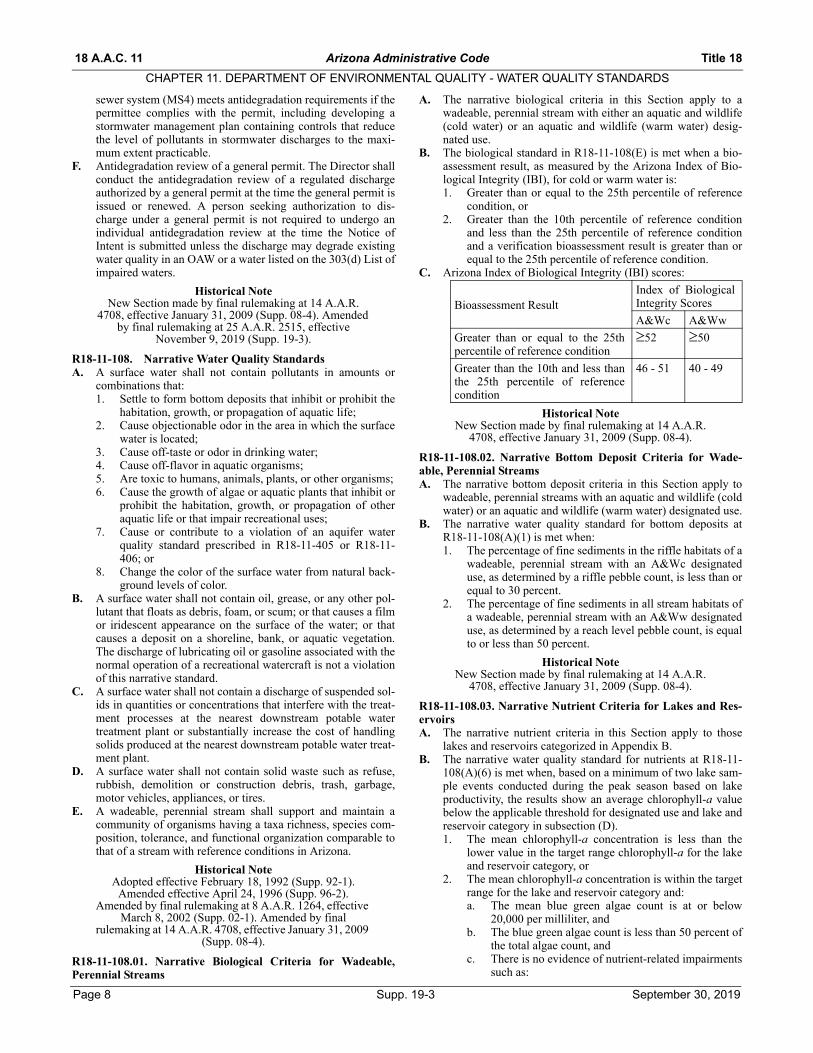
B. The biological standard in R18-11-108(E) is met when a bio-assessment result, as measured by the Arizona Index of Bio-logical Integrity (IBI), for cold or warm water is:1. Greater than or equal to the 25th percentile of reference
condition, or2. Greater than the 10th percentile of reference condition
and less than the 25th percentile of reference conditionand a verification bioassessment result is greater than orequal to the 25th percentile of reference condition.
C. Arizona Index of Biological Integrity (IBI) scores:
Historical NoteNew Section made by final rulemaking at 14 A.A.R.
4708, effective January 31, 2009 (Supp. 08-4).
R18-11-108.02. Narrative Bottom Deposit Criteria for Wade-able, Perennial StreamsA. The narrative bottom deposit criteria in this Section apply to
wadeable, perennial streams with an aquatic and wildlife (coldwater) or an aquatic and wildlife (warm water) designated use.
B. The narrative water quality standard for bottom deposits atR18-11-108(A)(1) is met when:1. The percentage of fine sediments in the riffle habitats of a
wadeable, perennial stream with an A&Wc designateduse, as determined by a riffle pebble count, is less than orequal to 30 percent.
2. The percentage of fine sediments in all stream habitats ofa wadeable, perennial stream with an A&Ww designateduse, as determined by a reach level pebble count, is equalto or less than 50 percent.
Historical NoteNew Section made by final rulemaking at 14 A.A.R.
4708, effective January 31, 2009 (Supp. 08-4).
R18-11-108.03. Narrative Nutrient Criteria for Lakes and Res-ervoirsA. The narrative nutrient criteria in this Section apply to those
lakes and reservoirs categorized in Appendix B.B. The narrative water quality standard for nutrients at R18-11-
108(A)(6) is met when, based on a minimum of two lake sam-ple events conducted during the peak season based on lakeproductivity, the results show an average chlorophyll-a valuebelow the applicable threshold for designated use and lake andreservoir category in subsection (D).1. The mean chlorophyll-a concentration is less than the
lower value in the target range chlorophyll-a for the lakeand reservoir category, or
2. The mean chlorophyll-a concentration is within the targetrange for the lake and reservoir category and:a. The mean blue green algae count is at or below
20,000 per milliliter, andb. The blue green algae count is less than 50 percent of
the total algae count, andc. There is no evidence of nutrient-related impairments
such as:
Bioassessment ResultIndex of BiologicalIntegrity Scores
A&Wc A&Ww
Greater than or equal to the 25thpercentile of reference condition
52 50
Greater than the 10th and less thanthe 25th percentile of referencecondition
46 - 51 40 - 49
Page 8 Supp. 19-3 September 30, 2019

Title 18 Arizona Administrative Code 18 A.A.C. 11
CHAPTER 11. DEPARTMENT OF ENVIRONMENTAL QUALITY - WATER QUALITY STANDARDS
i. An exceedance of dissolved oxygen or pH stan-dards;
ii. A fish kill coincident with a dissolved oxygenor pH exceedance;
iii. A fish kill or other aquatic organism mortalitycoincident with algal toxicity;
iv. Secchi depth is less than the lower value pre-scribed for the lake and reservoir category;
v. A nuisance algal bloom is present in the lim-netic portion of the lake or reservoir; or
vi. The concentration of total phosphorous, totalnitrogen, or total Kjehldal nitrogen (TKN) isgreater than the upper value in the range pre-scribed for the lake and reservoir category; or
3. For a shallow lake. In addition to meeting the mean chlo-rophyll-a concentrations in subsections (B)(1) or (2), sub-merged aquatic vegetation covers 50 percent or less of thelake bottom and there is less than a 5 mg/L swing in diel-dissolved oxygen concentration measured within the pho-tic zone.
C. The following threshold ranges apply during the peak seasonfor lake productivity:1. Warm water lakes peak season, April – October;2. Cold water lakes peak season, May – September.
D. The following table lists the numeric targets for lakes and res-ervoirs.
Historical NoteNew Section made by final rulemaking at 14 A.A.R. 4708, effective January 31, 2009 (Supp. 08-4).
R18-11-109. Numeric Water Quality StandardsA. E. coli bacteria. The following water quality standards for
Escherichia coli (E. coli) are expressed in colony formingunits per 100 milliliters of water (cfu / 100 ml) or as a MostProbable Number (MPN):
B. pH. The following water quality standards for pH areexpressed in standard units:
Footnotes:1. “1” Includes A&Wc, A&Ww, A&Wedw, and A&We.
C. The maximum allowable increase in ambient water tempera-ture, due to a thermal discharge is as follows:
D. Suspended sediment concentration.1. The following water quality standards for suspended sed-
iment concentration, expressed in milligrams per liter(mg/L), are expressed as a median value determined from
a minimum of four samples collected at least seven daysapart:
2. The Director shall not use the results of a suspended sedi-ment concentration sample collected during or within 48hours after a local storm event to determine the medianvalue.
E. Dissolved oxygen. A surface water meets the water qualitystandard for dissolved oxygen when either: 1. The percent saturation of dissolved oxygen is equal to or
greater than 90 percent, or 2. The single sample minimum concentration for the desig-
nated use, as expressed in milligrams per liter (mg/L) isas follows:
NUMERIC TARGETS FOR LAKES AND RESERVOIRS
DesignatedUse
LakeCategory
Chl-a(µg/L)
SecchiDepth(m)
TotalPhosphorus
(µg/L)
TotalNitrogen(mg/L)
TotalKjehldalNitrogen(TKN)(mg/L)
Blue-GreenAlgae
(per ml)
Blue-GreenAlgae
(% of total count)
Dis-solved
Oxygen(mg/L)
pH(SU)
FBC and PBC
Deep 10-15 1.5-2.5 70-90 1.2-1.4 1.0-1.1 20,000 6.5-9.0
Shallow 10-15 1.5-2.0 70-90 1.2-1.4 1.0-1.1
Igneous 20-30 0.5-1.0 100-125 1.5-1.7 1.2-1.4
Sedimentary 20-30 1.5-2.0 100-125 1.5-1.7 1.2-1.4
Urban 20-30 0.5-1.0 100-125 1.5-1.7 1.2-1.4
A&Wc All 5-15 1.5-2.0 50-90 1.0-1.4 0.7-1.1 <50 7(top m)
6.5-9.0
A&Ww All (except urban lakes)
25-40 0.8-1.0 115-140 1.6-1.8 1.3-1.6 6(top m)
Urban 30-50 0.7-1.0 125-160 1.7-1.9 1.4-1.7
A&Wedw All 30-50 0.7-1.0 125-160 1.7-1.9 1.4-1.7 6.5-9.0
DWS All 10-20 0.5-1.5 70-100 1.2-1.5 1.0-1.2 20,000 5.0-9.0
E. coli FBC PBC
Geometric mean (minimum of four samples in 30 days)
126 126
Statistical threshold value 410 576
pH DWS FBC, PBC, A&W 1 AgI AgL
Maximum 9.0 9.0 9.0 9.0
Minimum 5.0 6.5 4.5 6.5
A&Ww A&Wedw A&Wc
3.0° C 3.0° C 1.0° C
A&Wc A&Ww
25 80
Designated Use
Single sample minimum
concentration in mg/L
A&Ww 6.0
A&Wc 7.0
A&W edw for a sample taken from three hours after sunrise to sunset 3.0
A&W edw for a sample taken from sunset to three hours after sunrise 1.0
September 30, 2019 Supp. 19-3 Page 9

18 A.A.C. 11 Arizona Administrative Code Title 18
CHAPTER 11. DEPARTMENT OF ENVIRONMENTAL QUALITY - WATER QUALITY STANDARDS
The single sample minimum concentration is the same forthe designated use in a lake, but the sample must be takenfrom a depth no greater than one meter.
F. Nutrient criteria. The following are water quality standards fortotal phosphorus and total nitrogen (expressed in milligramsper liter (mg/L)) that apply to the surface waters listed below.A minimum of 10 samples, each taken at least 10 days apart ina consecutive 12-month period, are required to determine a90th percentile. Not more than 10 percent of the samples mayexceed the 90th percentile value listed below. The Directorwill apply these water quality standards for total phosphorusand total nitrogen to the surface waters listed below, and totheir perennial tributaries, if listed. The Director may alsoapply these total phosphorus and total nitrogen standards toany source discharging to any tributary (ephemeral, intermit-tent, effluent dependent water, or perennial) of the surfacewaters listed below, if necessary to protect nutrient water qual-ity in the listed surface water, based on the volume, frequency,magnitude and duration of the discharge, and distance to thedownstream surface water listed below:1. Verde River and its perennial tributaries from the Verde
headwaters to Bartlett Lake:
2. Black River, Tonto Creek and their perennial tributariesfor any segments that are not located on tribal lands:
3. Salt River and its perennial tributaries above RooseveltLake for any segments that are not located on tribal lands:
4. Salt River below Stewart Mountain Dam to its confluencewith the Verde River:
5. Little Colorado River and its perennial tributariesupstream from: a. The headwaters to River Reservoir,b. South Fork of Little Colorado River at 34°00’49”/
109°24’18” to above South Fork Campground at34°04’49”/109°24’18”, and
c. The headwaters of Water Canyon Creek to theApache-Sitgreaves National Forest boundary:
6. From the Little Colorado River and State Route 260 at34°06’39”/109°18’55” to Lyman Lake:
7. Colorado River at the Northern International Boundarynear Morelos Dam:
8. Oak Creek from its headwaters at 35°01'30"/111°44'12"to its confluence with the Verde River and the West Forkof Oak Creek from its headwaters at 35°02'44"/111°54'48" to its confluence with Oak Creek.
9. No discharge of wastewater to Show Low Creek or itsperennial tributaries upstream of and including FoolsHollow Lake shall exceed 0.16 mg/L total phosphates asP.
10. No discharge of wastewater to the San Francisco River orits perennial tributaries upstream of Luna Lake Dam shallexceed 1.0 mg/L total phosphates as P.
Historical NoteAdopted effective February 18, 1992 (Supp. 92-1).
Amended effective April 24, 1996 (Supp. 96-2). Amended by final rulemaking at 8 A.A.R. 1264, effective
March 8, 2002 (Supp. 02-1). Amended by final rulemaking at 14 A.A.R. 4708, effective January 31, 2009 (Supp. 08-4). Amended by final rulemaking at 22 A.A.R. 2328, effective August 2, 2016 (Supp. 16-4). Amended
by final rulemaking at 25 A.A.R. 2515, effective November 9, 2019 (Supp. 19-3).
R18-11-110. Salinity Standards for the Colorado RiverA. The flow-weighted average annual salinity in the lower main
stem of the Colorado River shall not exceed the following cri-teria:Location Total Dissolved SolidsBelow Hoover Dam 723 mg/LBelow Parker Dam 747 mg/LAt Imperial Dam 879 mg/L
B. The plan of implementation contained in the “2014 Review,Water Quality Standards for Salinity, Colorado River System,”approved October 2014, is incorporated by reference to pre-serve the basin-wide approach to salinity control developed bythe Colorado River Basin Salinity Control Forum and toensure compliance with the numeric criteria for salinity in sub-section (A). This material does not include any later amend-ments or editions of the incorporated material. Copies of theincorporated material are available for inspection at the Ari-zona Department of Environmental Quality, 1110 West Wash-ington Street, Phoenix, Arizona 85007 or may be obtainedfrom the Colorado River Basin Salinity Control Forum, 106
Surface WaterAnnual Mean
90th Percentile
Single Sample
Maximum
Total phosphorus 0.10 0.30 1.00
Total nitrogen 1.00 1.50 3.00
Surface WaterAnnual Mean
90th Percentile
Single Sample
Maximum
Total phosphorus 0.10 0.20 0.80
Total nitrogen 0.50 1.00 2.00
Surface WaterAnnual Mean
90th Percentile
Single Sample
Maximum
Total phosphorus 0.12 0.30 1.00
Total nitrogen 0.60 1.20 2.00
Surface WaterAnnual Mean
90th Percentile
Single Sample
Maximum
Total phosphorus 0.05 – 0.20
Total nitrogen 0.60 – 3.00
Surface WaterAnnual Mean
90th Percentile
Single Sample
Maximum
Total phosphorus 0.08 0.10 0.75
Total nitrogen 0.60 0.75 1.10
Surface WaterAnnual Mean
90th Percentile
Single Sample
Maximum
Total phosphorus 0.20 0.30 0.75
Total nitrogen 0.70 1.20 1.50
Surface WaterAnnual Mean
90th Percentile
Single Sample
Maximum
Total phosphorus – 0.33 –
Total nitrogen – 2.50 –
Surface WaterAnnual Mean
90th Percentile
Single Sample
Maximum
Total phosphorus 0.1 0.25 0.30
Total nitrogen 1.00 1.50 2.50
Page 10 Supp. 19-3 September 30, 2019

Title 18 Arizona Administrative Code 18 A.A.C. 11
CHAPTER 11. DEPARTMENT OF ENVIRONMENTAL QUALITY - WATER QUALITY STANDARDS
West 500 South, Suite 101, Bountiful, Utah 84010-6232 or athttp://www.coloradoriversalinity.org/.
Historical NoteAdopted effective February 18, 1992 (Supp. 92-1).
Amended by final rulemaking at 8 A.A.R. 1264, effective March 8, 2002 (Supp. 02-1). Amended by final
rulemaking at 14 A.A.R. 4708, effective January 31, 2009 (Supp. 08-4). Amended by final rulemaking at 22 A.A.R.
2328, effective August 2, 2016 (Supp. 16-4).
R18-11-111. Analytical MethodsA. A person conducting an analysis of a sample taken to deter-
mine compliance with a water quality standard shall use ananalytical method prescribed in A.A.C. R9-14-610, 40 CFR136.3, or an alternative analytical method approved underA.A.C. R9-14-610(C).
B. A test result from a sample taken to determine compliancewith a water quality standard is valid only if the sample is ana-lyzed by a laboratory that is licensed by the Arizona Depart-ment of Health Services, an out-of-state laboratory licensedunder A.R.S. § 36-495.14, or a laboratory exempted underA.R.S. § 36-495.02, for the analysis performed.
Historical NoteAdopted effective February 18, 1992 (Supp. 92-1).
Amended effective April 24, 1996 (Supp. 96-2). Amended by final rulemaking at 8 A.A.R. 1264, effective
March 8, 2002 (Supp. 02-1). Amended by final rulemaking at 14 A.A.R. 4708, effective January 31, 2009
(Supp. 08-4).
R18-11-112. Outstanding Arizona WatersA. The Director shall classify a surface water as an outstanding
Arizona water (OAW) by rule. B. The Director may adopt, under R18-11-115, a site-specific
standard to maintain and protect existing water quality in anOAW.
C. Any person may nominate a surface water for classification asan OAW by filing a nomination with the Director. The nomi-nation shall include:1. A map and a description of the surface water;2. A written statement in support of the nomination, includ-
ing specific reference to the applicable criteria for anOAW classification prescribed in subsection (D);
3. Supporting evidence demonstrating that the criteria pre-scribed in subsection (D) are met; and
4. Available water quality data relevant to establishing thebaseline water quality of the proposed OAW.
D. The Director may classify a surface water as an OAW basedupon the following criteria:1. The surface water is a perennial or intermittent water;2. The surface water is in a free-flowing condition. For pur-
poses of this subsection, “in a free-flowing condition”means that a surface water does not have an impound-ment, diversion, channelization, rip-rapping or other bankarmor, or another hydrological modification within thereach nominated for an OAW classification;
3. The surface water has good water quality. For purposes ofthis subsection, “good water quality” means that the sur-face water has water quality that meets or is better thanapplicable surface water quality standards. A surfacewater that is listed as impaired under R18-11-604(E) isineligible for OAW classification; and
4. The surface water meets one or both of the following con-ditions:a. The surface water is of exceptional recreational or
ecological significance because of its unique attri-butes, such as the geology, flora and fauna, water
quality, aesthetic value, or the wilderness character-istic of the surface water;
b. An endangered or threatened species is associatedwith the surface water and the existing water qualityis essential to the species' maintenance and propaga-tion or the surface water provides critical habitat forthe threatened or endangered species. An endan-gered or threatened species is identified in “Endan-gered and Threatened Wildlife,” 50 CFR 17.11(revised 2005), and “Endangered and ThreatenedPlants,” 50 CFR 17.12 (revised 2005). This materialis incorporated by reference and does not includeany later amendments or editions of the incorporatedmaterial. Copies of the incorporated material areavailable for inspection at the Arizona Departmentof Environmental Quality, 1110 West WashingtonStreet, Phoenix, Arizona 85007 or may be obtainedfrom the National Archives and Records Adminis-tration at http://www.access.gpo.gov/nara/cfr/cfr-table-search.html#page1.
E. The Director shall hold at least one public meeting in the localarea of a surface water that is nominated for classification asan OAW to solicit public comment on the nomination.
F. The Director shall consider the following factors when decid-ing whether to classify a surface water as an OAW:1. Whether there is the ability to manage the surface water
and its watershed to maintain and protect existing waterquality;
2. The social and economic impact of Tier 3 antidegradationprotection;
3. The public comments in support of, or in opposition to,an OAW classification;
4. The timing of the nomination relative to the triennialreview of surface water quality standards;
5. The consistency of an OAW classification with applica-ble water quality management plans; and
6. Whether the nominated surface water is located within anational or state park, national monument, national recre-ation area, wilderness area, riparian conservation area,area of critical environmental concern, or it has anotherspecial use designation (for example, Wild and ScenicRiver).
G. The following surface waters are classified as OAWs:1. The West Fork of the Little Colorado River, from its
headwaters to Government Springs (approximately 9.1river miles);
2. Oak Creek, from its headwaters to its confluence with theVerde River (approximately 50.3 river miles);
3. West Fork of Oak Creek, from its headwaters to its con-fluence with Oak Creek (approximately 15.8 river miles);
4. Peeples Canyon Creek, from its headwaters to its conflu-ence with the Santa Maria River (approximately 8.1 rivermiles);
5. Burro Creek, from its headwaters to its confluence withBoulder Creek (approximately 29.5 miles);
6. Francis Creek, from its headwaters to its confluence withBurro Creek (approximately 22.9 river miles);
7. Bonita Creek, from its boundary of the San Carlos IndianReservation to its confluence with the Gila River(approximately 14.7 river miles);
8. Cienega Creek, from its confluence with Gardner Canyonto the USGS gaging station (#09484600) (approximately28.3 river miles);
9. Aravaipa Creek, from its confluence with Stowe Gulch tothe downstream boundary of the Aravaipa Canyon Wil-derness Area (approximately 15.5 river miles);
September 30, 2019 Supp. 19-3 Page 11
18 A.A.C. 11 Arizona Administrative Code Title 18
CHAPTER 11. DEPARTMENT OF ENVIRONMENTAL QUALITY - WATER QUALITY STANDARDS
10. Cave Creek, from its headwaters to the CoronadoNational Forest boundary (approximately 10.4 rivermiles);
11. South Fork of Cave Creek, from its headwaters to its con-fluence with Cave Creek (approximately 8.6 river miles);
12. Buehman Canyon Creek, from its headwaters to its con-fluence with unnamed tributary at 32°24'31"/110°32'08"(approximately 9.8 river miles);
13. Lee Valley Creek, from its headwaters to Lee Valley Res-ervoir (approximately 1.6 river miles);
14. Bear Wallow Creek, from its headwaters to the boundaryof the San Carlos Indian Reservation (approximately 4.25river miles);
15. North Fork of Bear Wallow Creek, from its headwaters toits confluence with Bear Wallow Creek (approximately3.8 river miles);
16. South Fork of Bear Wallow Creek, from its headwaters toits confluence with Bear Wallow Creek (approximately3.8 river miles);
17. Snake Creek, from its headwaters to its confluence withthe Black River (approximately 6.2 river miles);
18. Hay Creek, from its headwaters to its confluence with theWest Fork of the Black River (approximately 5.5 rivermiles);
19. Stinky Creek, from the White Mountain Apache IndianReservation boundary to its confluence with the WestFork of the Black River (approximately 3.0 river miles);
20. KP Creek, from its headwaters to its confluence with theBlue River (approximately 12.7 river miles);
21. Davidson Canyon, from the unnamed spring at31°59'00"/110°38'49" to its confluence with CienegaCreek; and
22. Fossil Creek, from its headwaters at the confluence of San-drock and Calf Pen Canyons above Fossil Springs to its con-fluence with the Verde River (approximately 17.2 river miles).
Historical NoteAdopted effective February 18, 1992 (Supp. 92-1).
Amended effective April 24, 1996 (Supp. 96-2). Added “water quality standards” to R18-11-112, previously
omitted in error (Supp. 96-3). Amended by final rulemaking at 8 A.A.R. 1264, effective March 8, 2002
(Supp. 02-1). Amended by final rulemaking at 14 A.A.R. 4708, effective January 31, 2009 (Supp. 08-4). Amended by final rulemaking at 22 A.A.R. 2328, effective August
2, 2016 (Supp. 16-4).
R18-11-113. Effluent-Dependent WatersA. The Director shall classify a surface water as an effluent-
dependent water by rule.B. The Director may adopt, under R18-11-115, a site-specific
water quality standard for an effluent-dependent water.C. Any person may submit a petition for rule adoption requesting
that the Director classify a surface water as an effluent-depen-dent water. The petition shall include:1. A map and a description of the surface water;2. Information that demonstrates that the surface water con-
sists of a point source discharge of wastewater; and3. Information that demonstrates that, without a point
source discharge of a wastewater, the receiving water isan ephemeral water.
D. The Director shall use the water quality standards that apply toan effluent-dependent water to derive water quality-basedeffluent limits for a point source discharge of wastewater to anephemeral water.
E. The Director may use aquatic and wildlife (edw) acute stan-dards only to derive water quality based effluent limits for asporadic, infrequent, or emergency point source discharge to
an ephemeral water or to an effluent-dependent water. TheDirector shall consider the following factors when decidingwhether to apply A&Wedw (acute) standards:1. The amount, frequency, and duration of the discharge;2. The length of time water may be present in the receiving
water;3. The distance to a downstream water with aquatic and
wildlife chronic standards; and4. The likelihood of chronic exposure to pollutants.
F. The Director may establish alternative water quality-basedeffluent limits in an AZPDES permit based on seasonal differ-ences in the discharge.
Historical NoteAdopted effective February 18, 1992 (Supp. 92-1).
Amended effective December 18, 1992 (Supp. 92-4). Amended effective April 24, 1996 (Supp. 96-2).
Amended by final rulemaking at 8 A.A.R. 1264, effective March 8, 2002 (Supp. 02-1). Amended by final
rulemaking at 14 A.A.R. 4708, effective January 31, 2009 (Supp. 08-4).
R18-11-114. Mixing ZonesA. The Director may establish a mixing zone for a point source
discharge to a surface water as a condition of an individualAZPDES permit on a pollutant-by-pollutant basis. A mixingzone is prohibited in an ephemeral water or where there is nowater for dilution, or as prohibited pursuant to subsection (H).
B. The owner or operator of a point source seeking the establish-ment of a mixing zone shall submit a request to the Directorfor a mixing zone as part of an application for an AZPDESpermit. The request shall include:1. An identification of the pollutant for which the mixing
zone is requested;2. A proposed outfall design;3. A definition of the boundary of the proposed mixing
zone. For purposes of this subsection, the boundary of amixing zone is where complete mixing occurs; and
4. A complete and detailed description of the existing physi-cal, biological, and chemical conditions of the receivingwater and the predicted impact of the proposed mixingzone on those conditions. The description shall alsoaddress the factors listed in subsection (D) that the Direc-tor must consider when deciding to grant or deny arequest and shall address the mixing zone requirements insubsection (H).
C. The Director shall consider the following factors when decid-ing whether to grant or deny a request for a mixing zone:1. The assimilative capacity of the receiving water;2. The likelihood of adverse human health effects;3. The location of drinking water plant intakes and public
swimming areas;4. The predicted exposure of biota and the likelihood that
resident biota will be adversely affected; 5. Bioaccumulation;6. Whether there will be acute toxicity in the mixing zone,
and, if so, the size of the zone of initial dilution;7. The known or predicted safe exposure levels for the pol-
lutant for which the mixing zone is requested;8. The size of the mixing zone; 9. The location of the mixing zone relative to biologically
sensitive areas in the surface water; 10. The concentration gradient of the pollutant within the
mixing zone;11. Sediment deposition;12. The potential for attracting aquatic life to the mixing
zone; and
Page 12 Supp. 19-3 September 30, 2019
Title 18 Arizona Administrative Code 18 A.A.C. 11
CHAPTER 11. DEPARTMENT OF ENVIRONMENTAL QUALITY - WATER QUALITY STANDARDS
13. The cumulative impacts of other mixing zones and otherdischarges to the surface water.
D. Director determination.1. The Director shall deny a request to establish a mixing
zone if a water quality standard will be violated outsidethe boundaries of the proposed mixing zone..
2. If the Director approves the request to establish a mixingzone, the Director shall establish the mixing zone as acondition of an AZPDES permit. The Director shallinclude any mixing zone condition in the AZPDES per-mit that is necessary to protect human health and the des-ignated uses of the surface water.
E. Any person who is adversely affected by the Director’s deci-sion to grant or deny a request for a mixing zone may appealthe decision under A.R.S. § 49-321 et seq. and A.R.S. § 41-1092 et seq.
F. The Director shall reevaluate a mixing zone upon issuance,reissuance, or modification of the AZPDES permit for thepoint source or a modification of the outfall structure.
G. Mixing zone requirements.1. A mixing zone shall be as small as practicable in that it
shall not extend beyond the point in the waterbody atwhich complete mixing occurs under the critical flowconditions of the discharge and of the receiving water.
2. The total horizontal area allocated to all mixing zones ona lake shall not exceed 10 percent of the surface area ofthe lake.
3. Adjacent mixing zones in a lake shall not overlap or belocated closer together than the greatest horizontaldimension of the largest mixing zone.
4. The design of any discharge outfall shall maximize initialdilution of the wastewater in a surface water.
5. The size of the zone of initial dilution in a mixing zoneshall prevent lethality to organisms passing through thezone of initial dilution. The mixing zone shall preventacute toxicity and lethality to organisms passing throughthe mixing zone.
H. The Director shall not establish a mixing zone in an AZPDESpermit for the following persistent, bioaccumulative pollut-ants:1. Chlordane,2. DDT and its metabolites (DDD and DDE),3. Dieldrin,4. Dioxin,5. Endrin,6. Endrin aldehyde,7. Heptachlor,8. Heptachlor epoxide,9. Lindane,10. Mercury,11. Polychlorinated biphenyls (PCBs), and12. Toxaphene.
Historical NoteAdopted effective February 18, 1992 (Supp. 92-1).
Amended effective April 24, 1996 (Supp. 96-2). Amended by final rulemaking at 8 A.A.R. 1264, effective
March 8, 2002 (Supp. 02-1). Amended by final rulemaking at 14 A.A.R. 4708, effective January 31, 2009 (Supp. 08-4). Amended by final rulemaking at 25 A.A.R.
2515, effective November 9, 2019 (Supp. 19-3).
R18-11-115. Site-Specific StandardsA. The Director shall adopt a site-specific standard by rule.B. The Director may adopt a site-specific standard based upon a
request or upon the Director’s initiative for any of the follow-ing reasons:
1. Local physical, chemical, or hydrological conditions of asurface water such as pH, hardness, fate and transport, ortemperature alters the biological availability or toxicity ofa pollutant;
2. The sensitivity of resident aquatic organisms that occur ina surface water to a pollutant differs from the sensitivityof the species used to derive the numeric water qualitystandards to protect aquatic life in Appendix A;
3. Resident aquatic organisms that occur in a surface waterrepresent a narrower mix of species than those in thedataset used by ADEQ to derive numeric water qualitystandards to protect aquatic life in Appendix A;
4. The natural background concentration of a pollutant isgreater than the numeric water quality standard to protectaquatic life prescribed in Appendix A. “Natural back-ground” means the concentration of a pollutant in a sur-face water due only to non-anthropogenic sources; or
5. Other factors or combination of factors that upon reviewby the Director warrant changing a numeric water qualitystandard for a surface water.
C. Site-specific standard by request. To request that the Directoradopt a site-specific standard, a person must conduct a study tosupport the development of a site-specific standard using a sci-entifically-defensible procedure.1. Before conducting the study, a person shall submit a
study outline to the Director for approval that contains thefollowing elements:a. Identifies the pollutant;b. Describes the reach’s boundaries;c. Uses one of the following procedures, as defined by
the most recent EPA guidance documents:i. The recalculation procedure,ii. The water effects ratio for metals, iii. The streamlined water effects ratio, oriv. The Biotic ligand model.
d. Demonstrates that all designated uses are protected.2. Alternatively, a study outline submitted for the Director’s
approval must contain the following elements:a. Identifies the pollutant;b. Describes the reach’s boundaries;c. Describes the hydrologic regime of the waterbody;d. Describes the scientifically-defensible procedure,
which can include relevant aquatic life studies, eco-logical studies, laboratory tests, biological transla-tors, fate and transport models, and risk analyses;
e. Describes and compares the taxonomic composition,distribution and density of the aquatic biota withinthe reach to a reference reach and describes the basisof any major taxonomic differences;
f. Describes the pollutant’s effect on the affected spe-cies or appropriate surrogate species and on theother designated uses listed for the reach;
g. Demonstrates that all designated uses are protected;and
h. A person seeking to develop a site-specific standardbased on natural background may use statistical ormodeling approaches to determine natural back-ground concentration. Modeling approaches includeBetter Assessment Science Integrating Source andNonpoint Sources (Basins), Hydrologic SimulationProgram-Fortran (HSPF), and Hydrologic Engineer-ing Center (HEC) programs developed by the U.S.Army Corps of Engineers.
Historical NoteAdopted effective February 18, 1992 (Supp. 92-1).
Amended effective April 24, 1996 (Supp. 96-2). Section
September 30, 2019 Supp. 19-3 Page 13
18 A.A.C. 11 Arizona Administrative Code Title 18
CHAPTER 11. DEPARTMENT OF ENVIRONMENTAL QUALITY - WATER QUALITY STANDARDS
repealed by final rulemaking at 8 A.A.R. 1264, effective March 8, 2002 (Supp. 02-1). New Section made by final rulemaking at 14 A.A.R. 4708, effective January 31, 2009 (Supp. 08-4). Amended by final rulemaking at 22 A.A.R. 2328, effective August 2, 2016 (Supp. 16-4). Amended
by final rulemaking at 25 A.A.R. 2515, effective November 9, 2019 (Supp. 19-3).
R18-11-116. Resource Management AgenciesNothing in this Article prohibits fisheries management activities bythe Arizona Game and Fish Department or the U.S. Fish and Wild-life Service. This Article does not exempt fish hatcheries fromAZPDES permit requirements.
Historical NoteAdopted effective February 18, 1992 (Supp. 92-1). Amended by final rulemaking at 14 A.A.R. 4708,
effective January 31, 2009 (Supp. 08-4).
R18-11-117. Canals and Urban Park LakesA. Nothing in this Article prevents the routine physical or
mechanical maintenance of canals, drains, and the urban lakesidentified in Appendix B. Physical or mechanical maintenanceincludes dewatering, lining, dredging, and the physical, bio-logical, or chemical control of weeds and algae. Increases inturbidity that result from physical or mechanical maintenanceactivities are permitted in canals, drains, and the urban lakesidentified in Appendix B.
B. The discharge of lubricating oil associated with the start-up ofwell pumps that discharge to canals is not a violation of R18-11-108(B).
Historical NoteAdopted effective February 18, 1992 (Supp. 92-1).
Amended effective April 24, 1996 (Supp. 96-2). Amended by final rulemaking at 14 A.A.R. 4708,
effective January 31, 2009 (Supp. 08-4).
R18-11-118. Dams and Flood Control StructuresIncreases in turbidity that result from the routine physical ormechanical maintenance of a dam or flood control structure are notviolations of this Article. Nothing in this Article requires the releaseof water from a dam or a flood control structure.
Historical NoteAdopted effective February 18, 1992 (Supp. 92-1).
Amended effective April 24, 1996 (Supp. 96-2). Amended by final rulemaking at 8 A.A.R. 1264, effective
March 8, 2002 (Supp. 02-1). Amended by final rulemaking at 14 A.A.R. 4708, effective January 31, 2009
(Supp. 08-4).
R18-11-119. Natural backgroundWhere the concentration of a pollutant exceeds a water quality stan-dard and the exceedance is not caused by human activity but is duesolely to naturally-occurring conditions, the exceedance shall notbe considered a violation of the water quality standard.
Historical NoteAdopted effective February 18, 1992 (Supp. 92-1).
R18-11-120. Enforcement of Non-permitted DischargesA. The Department may establish a numeric water quality stan-
dard at a concentration that is below the practical quantitationlimit. Therefore, in enforcement actions pursuant to subsection(B), the water quality standard is enforceable at the practicalquantitation limit.
B. Except for chronic aquatic and wildlife criteria, for non-per-mitted discharge violations, the Department shall determinecompliance with numeric water quality standard criteria fromthe analytical result of a single sample, unless additional sam-ples are required under this article. For chronic aquatic andwildlife criteria, compliance for non-permitted discharge vio-
lations shall be determined from the geometric mean of theanalytical results of the last four samples taken at least 24hours apart. For the purposes of this Section, a “non-permitteddischarge violation” does not include a discharge regulatedunder an AZPDES permit.
Historical NoteAdopted effective February 18, 1992 (Supp. 92-1).
Amended effective April 24, 1996 (Supp. 96-2). Amended by final rulemaking at 8 A.A.R. 1264, effective
March 8, 2002 (Supp. 02-1). Amended by final rulemaking at 25 A.A.R. 2515, effective November 9,
2019 (Supp. 19-3).
R18-11-121. Schedules of ComplianceA compliance schedule in an AZPDES permit shall require the per-mittee to comply with a discharge limitation based upon a new orrevised water quality standard as soon as possible to achieve com-pliance. The permittee shall demonstrate that all requirementsunder § 301(b) and § 306 of the Clean Water Act [33 U.S.C.1311(b) and 1316] are achieved and that the point source cannotcomply with a discharge limitation based upon the new or revisedwater quality standard through the application of existing water pol-lution control technology, operational changes, or source reduction.In establishing a compliance schedule, the Director shall consider:
1. How much time the permittee has already had to meetany effluent limitations under a prior permit;
2. The extent to which the permittee has made good faithefforts to comply with the effluent limitations and otherrequirements in a prior permit;
3. Whether treatment facilities, operations, or measuresmust be modified to meet the effluent limitations;
4. How long any necessary modifications would take toimplement; and
5. Whether the permittee would be expected to use the sametreatment facilities, operations or other measures to meetthe effluent limitations as it would have used to meet theeffluent limitations in a prior permit.
Historical NoteAdopted effective February 18, 1992 (Supp. 92-1).
Amended effective April 24, 1996 (Supp. 96-2). Amended by final rulemaking at 8 A.A.R. 1264, effective
March 8, 2002 (Supp. 02-1). Amended by final rulemaking at 14 A.A.R. 4708, effective January 31, 2009 (Supp. 08-4). Amended by final rulemaking at 22 A.A.R.
2328, effective August 2, 2016 (Supp. 16-4).
R18-11-122. VariancesA. Upon request, the Director may establish, by rule, a dis-
charger-specific or water segment(s)-specific variance from awater quality standard if requirements pursuant to this Sectionare met.
B. A person who requests a variance must demonstrate all of thefollowing information:1. Identification of the specific pollutant and water quality
standard for which a variance is sought.2. Identification of the receiving surface water segment or
segments to which the variance would apply.3. A detailed discussion of the need for the variance, includ-
ing the reasons why compliance with the water qualitystandard cannot be achieved over the term of the pro-posed variance, and any other useful information or anal-ysis to evaluate attainability.
4. A detailed discussion of the discharge control technolo-gies that are available for achieving compliance with thewater quality standard for which a variance is sought.
5. Documentation that more advanced treatment technologythan applicable technology-based effluent limitations is
Page 14 Supp. 19-3 September 30, 2019

Title 18 Arizona Administrative Code 18 A.A.C. 11
CHAPTER 11. DEPARTMENT OF ENVIRONMENTAL QUALITY - WATER QUALITY STANDARDS
necessary to achieve compliance with the water qualitystandard for which a variance is sought.
6. A detailed description of proposed interim discharge lim-itations and pollutant control activities that represent thehighest level of treatment achievable by a point sourcedischarger or dischargers during the term of the variance.
7. Documentation that the proposed term is only as long asnecessary to achieve the highest attainable condition.
8. Documentation that is appropriate to the type of use towhich the variance would apply as follows: a. For a water quality standard variance to a use speci-
fied in Clean Water Act § 101(a)(2), documentationmust include demonstration of at least one of the fol-lowing factors that preclude attainment of the useduring the term of the variance:i. Naturally occurring pollutant concentrations
prevent attainment of the use;ii. Natural, ephemeral, intermittent or low flow
conditions or water levels prevent the attain-ment of the use, unless these conditions may becompensated for by the discharge of sufficientvolume of effluent discharges without violatingstate water conservation requirements to enableuses to be met;
iii. That human-caused conditions or sources ofpollution prevent the attainment of the waterquality standard for which the variance issought and either (1) it is not possible to rem-edy the conditions or sources of pollution or (2)remedying the human-caused conditions wouldcause more environmental damage to correctthan to leave in place;
iv. Dams, diversions or other types of hydrologicmodifications preclude the attainment of theuse, and it is not feasible to restore the waterbody to its original condition or to operate suchmodification n a way that would result in theattainment of the use;
v. Physical conditions related to the natural fea-tures of the water body, such as the lack of aproper substrate, cover, flow, depth, pools, rif-fles, and the like, unrelated to water quality,preclude attainment of aquatic life protectionuses;
vi. That installation and operation of each of theavailable discharge technologies moreadvanced than those required to comply withtechnology-based effluent limitations toachieve compliance with the water quality stan-dard would result in substantial and widespreadeconomic and social impact; or
vii. Actions necessary to facilitate lake, wetland, orstream restoration through dam removal orother significant reconfiguration activities pre-clude attainment of the designated use and cri-terion while the actions are being implemented.
b. For a water quality standard variance to a use otherthan those uses specified in Clean Water Act §101(a)(2), documentation must justify how consid-eration and value of the water subject to the useappropriately supports the variance and term. Ademonstration consistent with (B)(8)(a) of this Sec-tion may be used to satisfy this requirement.
9. For a waterbody segment(s)-specific variance, the fol-lowing information is required before the Director may
issue a variance, in addition to all other required docu-mentation pursuant to this Section: a. Identification and documentation of any cost-effec-
tive and reasonable best management practices fornonpoint source controls related to the pollutant(s)or water quality parameter(s) and water body orwaterbody segment(s) specified in the variance thatcould be implemented to make progress towardsattaining the underlying designated use and crite-rion; and
b. If any variance pursuant to subsection (B)(9)(a) pre-viously applied to the water body or waterbody seg-ment(s), documentation must also demonstratewhether and to what extent best management prac-tices for nonpoint source controls were implementedto address the pollutant(s) or water quality parame-ter(s) subject to the water quality variance and thewater quality progress achieved.
10. For a discharger-specific variance, the following informa-tion is required before the Director may issue a variance,in addition to all other required documentation pursuantto this Section:a. Identification of the permittee subject to the vari-
ance;b. For an existing point source discharge, a detailed
description of the existing discharge control technol-ogies that are used to achieve compliance with appli-cable water quality standards. For a new pointsource discharge, a detailed description of the pro-posed discharge control technologies that will beused to achieve compliance with applicable waterquality standards; and
c. Documentation that the existing or proposed dis-charge control technologies will comply with appli-cable technology-based effluent limitations.
C. The Director shall consider the following factors when decid-ing whether to grant or deny a variance request:1. Bioaccumulation,2. The predicted exposure of biota and the likelihood that
resident biota will be adversely affected,3. The known or predicted safe exposure levels for the pol-
lutant for which the variance is requested, and4. The likelihood of adverse human health effects.
D. The variance shall represent the highest attainable condition ofthe water body or water body segment applicable throughoutthe term of the variance.
E. A variance shall not result in any lowering of the currentlyattained ambient water quality, unless the variance is neces-sary for restoration activities, consistent with subsection(B)(8)(a)(vii). The Director must specify the highest attainablecondition of the water body or waterbody segment as a quanti-fiable expression of one of the following:1. The highest attainable interim criterion,2. The interim effluent condition that reflects the greatest
pollutant reduction achievable; or3. If no additional feasible pollutant control technology can
be identified, the interim criterion or interim effluent con-dition that reflects the greatest pollutant reduction achiev-able with the pollutant control technologies installed atthe time of the issuance of the variance, and the adoptionand implementation of a Pollutant Minimization Pro-gram.
F. A variance shall not modify the underlying designated use andcriterion. A variance is only a time limited exception to theunderlying standard. For discharge-specific variances, otherpoint source dischargers to the surface water that are not
September 30, 2019 Supp. 19-3 Page 15

18 A.A.C. 11 Arizona Administrative Code Title 18
CHAPTER 11. DEPARTMENT OF ENVIRONMENTAL QUALITY - WATER QUALITY STANDARDS
granted a variance shall still meet all applicable water qualitystandards.
G. Point source discharges shall meet all other applicable waterquality standards for which a variance is not granted.
H. The Director may not grant a variance for a point source dis-charge to an OAW listed in R18-11-112(G).
I. Each variance established by the Director is subject to reviewand approval by the Regional Administrator.
J. The term of the water quality variance may only be as long asnecessary to achieve the highest attainable condition and mustbe consistent with the supporting documentation in subsection(E). The variance term runs from the approval of the varianceby the Regional Administrator.
K. The Director shall reevaluate, in its triennial review, whethereach variance continues to represent the highest attainablecondition. Comment on the variance shall be consideredregarding whether the variance continues to represent thehighest attainable condition. If the Director determines that therequirements of the variance do not represent the highestattainable condition, then the Director shall modify or repealthe variance in its triennial review rulemaking.
L. If the variance is modified by rulemaking, the requirements ofthe variance shall represent the highest attainable condition atthe time of initial adoption of the variance, or the highestattainable condition identified during the current reevaluation,whichever is more stringent.
M. Upon expiration of a variance, point source dischargers shallcomply with the water quality standard.
N. The following are discharger-specific variances adopted by theDirector:
O. The following are water body and waterbody segment-specificvariances adopted by the Director:
Historical NoteAdopted effective April 24, 1996 (Supp. 96-2). Amended by final rulemaking at 8 A.A.R. 1264, effective March 8, 2002 (Supp. 02-1). Amended by final rulemaking at 14 A.A.R. 4708, effective January 31, 2009 (Supp. 08-4).
Amended by final rulemaking at 25 A.A.R. 2515, effective November 9, 2019 (Supp. 19-3).
R18-11-123. Discharge ProhibitionsA. The discharge of wastewater to the following surface waters is
prohibited:1. Sabino Canyon Creek;2. Vekol Wash, upstream of the Ak-Chin Indian Reserva-
tion; and3. Smith Wash, upstream of the Ak-Chin Indian Reserva-
tion.B. The discharge to Lake Powell of human body wastes and the
wastes from toilets and other receptacles intended to receive orretain wastes from a vessel is prohibited.
Historical NoteAdopted effective April 24, 1996 (Supp. 96-2). Amended by final rulemaking at 8 A.A.R. 1264, effective March 8, 2002 (Supp. 02-1). Amended by final rulemaking at 14 A.A.R. 4708, effective January 31, 2009 (Supp. 08-4).
Page 16 Supp. 19-3 September 30, 2019
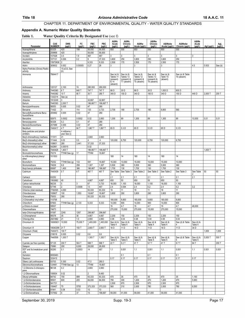
Title 18 Arizona Administrative Code 18 A.A.C. 11
CHAPTER 11. DEPARTMENT OF ENVIRONMENTAL QUALITY - WATER QUALITY STANDARDS
Appendix A. Numeric Water Quality Standards
Table 1. Water Quality Criteria By Designated Use (see f)
ParameterCAS
NUMBERDWS(µg/L)
FC(µg/L)
FBC(µg/L)
PBC(µg/L)
A&Wc Acute (µg/L)
A&Wc Chronic (µg/L)
A&Ww Acute (µg/L)
A&Ww Chronic (µg/L)
A&Wedw Acute| (µg/L)
A&Wedw Chronic (µg/L)
A&We Acute (µg/L) AgI (µg/L)
AgL (µg/L)
Acenaphthene 83329 420 198 56,000 56,000 850 550 850 550 850 550Acenaphthylene 208968 420 56,000 56,000Acrolein 107028 3.5 1.9 467 467 3 3 3 3 3 3 3Acrylonitrile 107131 0.006 0.2 9 37,333 3,800 250 3,800 250 3,800 250Alachlor 15972608 2 9,333 9,333 2,500 170 2,500 170 2,500 170Aldrin 309002 0.002 0.00005 0.27 28 3 3 3 4.5 0.003 See (b)Alpha Particles (Gross) Radio-activity
15 pCi/L See (h)
Ammonia 7664417 See (e) & Tables 11 (present) & 14 (absent)
See (e) & Tables 13 (present) & 17 (absent)
See (e) & Tables 12 (present) & 15 (absent)
See (e) & Tables 13 (present) & 16 (absent)
See (e) & Table 15 (absent)
See (e) & Table 16 (absent)
Anthracene 120127 2,100 74 280,000 280,000Antimony 7440360 6 T 640 T 747 T 747 T 88 D 30 D 88 D 30 D 1,000 D 600 DArsenic 7440382 10 T 80 T 30 T 280 T 340 D 150 D 340 D 150 D 340 D 150 D 440 D 2,000 T 200 TAsbestos 1332214 See (a)Atrazine 1912249 3 32,667 32,667Barium 7440393 2,000 T 186,667 T 186,667 TBenz(a)anthracene 56553 0.005 0.02 47 280Benzene 71432 5 114 133 3,733 2,700 180 2,700 180 8,800 560Benzo[b]fluoranthene Benz-fluoranthene
205992 0.005 0.02 47 280
Benzidine 92875 0.0002 0.0002 0.02 2,800 1,300 89 1,300 89 1,300 89 10,000 0.01 0.01Benzo(a)pyrene 50328 0.2 0.1 47 280Benzo(k)fluoranthene 207089 0.005 0.02 47 280Beryllium 7440417 4 T 84 T 1,867 T 1,867 T 65 D 5.3 D 65 D 5.3 D 65 D 5.3 DBeta particles and photon emitters
4 millirems /year See (i)
Bis(2-chloroethoxy) methane 111911 21 2,800 2,800Bis(2-chloroethyl) ether 111444 0.03 0.5 4 4 120,000 6,700 120,000 6,700 120,000 6,700Bis(2-chloroisopropyl) ether 108601 280 3,441 37,333 37,333Bis(chloromethyl) ether 542881 0.00015 0.02Boron 7440428 1,400 T 186,667 T 186,667 T 1,000 TBromodichloromethane 75274 TTHM See (g) 17 TTHM 18,667to 4-Bromophenyl phenyl ether
101553 180 14 180 14 180 14
Bromoform 75252 TTHM See (g) 133 591 18,667 15,000 10,000 15,000 10,000 15,000 10,000Bromomethane 74839 9.8 299 1,307 1,307 5,500 360 5,500 360 5,500 360Butyl benzyl phthalate 85687 1,400 386 186,667 186,667 1,700 130 1,700 130 1,700 130Cadmium 7440439 5 T 6 T 467 T 467 T See Table
2See Table 3 See Table 2 See Table 3 See Table 2 See Table 3 See Table
250 50
Carbaryl 63252 2.1 2.1 2.1 2.1 2.1 2.1 2.1Carbofuran 1563662 40 4,667 4,667 650 50 650 50 650 50Carbon tetrachloride 56235 5 3 67 3,733 18,000 1,100 18,000 1,100 18,000 1,100Chlordane 57749 2 0.0008 13 467 2.4 0.004 2.4 0.2 2.4 0.2 3.2Chlorine (total residual) 7782505 4,000 93,333 93,333 19 11 19 11 19 11Chlorobenzene 108907 100 1,553 18,667 18,667 3,800 260 3,800 260 3,800 260Chloroethane 75003 280 93,333 93,3332-Chloroethyl vinyl ether 110758 180,000 9,800 180,000 9,800 180,000 9,800Chloroform 67663 TTHM See (g) 2,133 9,333 9,333 14,000 900 14,000 900 14,000 900p-Chloro-m-cresol 59507 15 4.7 15 4.7 15 4.7 48,000Chloromethane 74873 270,000 15,000 270,000 15,000 270,000 15,000beta-Chloronaphthalene 91587 2240 1267 298,667 298,6672-Chlorophenol 95578 35 30 4,667 4,667 2,200 150 2,200 150 2,200 150Chloropyrifos 2921882 21 1.0 2,800 2,800 0.08 0.04 0.08 0.04 0.08 0.04Chromium III 16065831 10,500 75,000 T 1,400,000
T1,400,000T
See (d) & Table 4
See (d) & Table 4
See (d) & Table 4
See (d) & Table 4
See (d) & Table 4
See (d) & Table 4
See (d) & Table 4
Chromium VI 18540299 21 T 150 T 2,800 T 2,800 T 16 D 11 D 16 D 11 D 16 D 11 D 34 DChromium (Total) 7440473 100 T 1,000 1,000Chrysene 218019 0.005 0.02 0.6 0.6Copper 7440508 1,300 T 1,300 T 1,300 T See (d) &
Table 5See (d) & Table 5
See (d) & Table 5
See (d) & Table 5
See (d) & Table 5
See (d) & Table 5
See (d) & Table 5
5,000 T 500 T
Cyanide (as free cyanide) 57125 200 T 504 T 588 T 588 T 22 T 5.2 T 41 T 9.7 T 41 T 9.7 T 84 T 200 TDalapon 75990 200 8,000 28,000 28,000DDT and its breakdown prod-ucts
50293 0.1 0.0003 14 467 1.1 0.001 1.1 0.001 1.1 0.001 1.1 0.001 0.001
Demeton 8065483 0.1 0.1 0.1Diazinon 333415 0.17 0.17 0.17 0.17 0.17 0.17 0.17Dibenz (ah) anthracene 53703 0.350 0.02 47.0 280.0Dibromochloromethane 124481 TTHM See (g) 13 TTHM 18,6671,2-Dibromo-3-chloropro- pane
96128 0.2 2,800 2,800
1,2-Dibromoethane 106934 0.02 2 8,400Dibutyl phthalate 84742 700 899 93,333 93,333 470 35 470 35 470 35 1,1001,2-Dichlorobenzene 95501 600 205 84,000 84,000 790 300 1,200 470 1,200 470 5,9001,3-Dichlorobenzene 541731 2,500 970 2,500 970 2,500 9701,4-Dichlorobenzene 106467 75 5755 373,333 373,333 560 210 2,000 780 2,000 780 6,5003,3'-Dichlorobenzidine 91941 0.08 0.03 10 101,2-Dichloroethane 107062 5 37 15 186,667 59,000 41,000 59,000 41,000 59,000 41,000
September 30, 2019 Supp. 19-3 Page 17

18 A.A.C. 11 Arizona Administrative Code Title 18
CHAPTER 11. DEPARTMENT OF ENVIRONMENTAL QUALITY - WATER QUALITY STANDARDS
1,1-Dichloroethylene 75354 7 7,143 46,667 46,667 15,000 950 15,000 950 15,000 9501,2-cis-Dichloroethylene 156592 70 1,867 1,8671,2-trans-Dichloroethylene 156605 100 10,127 18,667 18,667 68,000 3,900 68,000 3,900 68,000 3,900Dichloromethane 75092 5 2,222 2,333 5,600 97,000 5,500 97,000 5,500 97,000 5,5002,4-Dichlorophenol 120832 21 59 2,800 2,800 1,000 88 1,000 88 1,000 882,4-Dichlorophenoxyacetic acid (2,4-D)
94757 70 9,333 9,333
1,2-Dichloropropane 78875 5 17,518 84,000 84,000 26,000 9,200 26,000 9,200 26,000 9,2001,3-Dichloropropene 542756 0.7 42 93 28,000 3,000 1,100 3,000 1,100 3,000 1,100Dieldrin 60571 0.002 0.00005 0.3 47 0.2 0.06 0.2 0.06 0.2 0.06 4 0.003 See (b)Diethyl phthalate 84662 5,600 8,767 746,667 746,667 26,000 1,600 26,000 1,600 26,000 1,600Di (2-ethylhexyl) adipate 103231 400 3,889 560,000Di (2-ethylhexyl) phthalate 117817 6 3 333 18,667 400 360 400 360 400 360 3,1002,4-Dimethylphenol 105679 140 171 18,667 18,667 1,000 310 1,000 310 1,000 310 150,000Dimethyl phthalate 131113 17,000 1,000 17,000 1,000 17,000 1,0004,6-Dinitro-o-cresol 534521 0.6 12 75 75 310 24 310 24 310 242,4-Dinitrophenol 51285 14 1,067 1,867 1,867 110 9.2 110 9.2 110 9.22,4-Dinitrotoluene 121142 14 421 1,867 1,867 14,000 860 14,000 860 14,000 8602,6-Dinitrotoluene 606202 0.05 7 280Di-n-octyl phthalate 117840 70 9,333 9,333Dinoseb 88857 7 12 933 9331,2-Diphenylhydrazine 122667 0.04 0.2 6 6 130 11 130 11 130 11Diquat 85007 20 176 2,053 2,053Endosulfan sulfate 1031078 42 18 5,600 5,600 0.2 0.06 0.2 0.06 0.2 0.06 3Endosulfan (Total) 115297 42 18 5,600 5,600 0.2 0.06 0.2 0.06 0.2 0.06 3Endothall 145733 100 16,000 18,667 18,667Endrin 72208 2 0.06 1,120 1,120 0.09 0.04 0.09 0.04 0.09 0.04 0.7 0.004 0.004Endrin aldehyde 7421933 2 0.06 1,120 1,120 0.09 0.04 0.09 0.04 0.09 0.04 0.7Ethylbenzene 100414 700 2,133 93,333 93,333 23,000 1,400 23,000 1,400 23,000 1,400Fluoranthene 206440 280 28 37,333 37,333 2,000 1,600 2,000 1,600 2,000 1,600Fluorene 86737 280 1,067 37,333 37,333Fluoride 7782414 4,000 140,000 140,000Glyphosate 1071836 700 266,667 93,333 93,333Guthion 86500 21 92 2,800 2,800 0.01 0.01 0.01Heptachlor 76448 0.4 0.00008 1 467 0.5 0.004 0.5 0.004 0.6 0.01 0.9Heptachlor epoxide 1024573 0.2 0.00004 0.5 12 0.5 0.004 0.5 0.004 0.6 0.01 0.9Hexachlorobenzene 118741 1 0.0003 3 747 6 3.7 6 3.7 6 3.7Hexachlorobutadiene 87683 0.4 18 60 187 45 8.2 45 8.2 45 8.2Hexachlorocyclohexane alpha 319846 0.006 0.005 0.7 7,467 1,600 130 1,600 130 1,600 130 1,600Hexachlorocyclohexane beta 319857 0.02 0.02 3 560 1,600 130 1,600 130 1,600 130 1,600Hexachlorocyclohexane delta 319868 1,600 130 1,600 130 1,600 130 1,600Hexachlorocyclohexane gamma (lindane)
58899 0.2 5 700 700 1 0.08 1 0.28 1 0.61 11
Hexachlorocyclopentadi- ene 77474 50 74 11,200 11,200 3.5 0.3 3.5 0.3 3.5 0.3Hexachloroethane 67721 0.9 1 117 653 490 350 490 350 490 350 850Hydrogen sulfide 7783064 2 See (c) 2 See (c) 2 See (c)Indeno (1,2,3-cd) pyrene 193395 0.4 1 47 47Iron 7439896 1,000 D 1,000 D 1,000 DIsophorone 78591 37 961 4,912 186,667 59,000 43,000 59,000 43,000 59,000 43,000Lead 7439971 15 T 15 T 15 T See (d) &
Table 6See (d) & Table 6
See (d) & Table 6
See (d) & Table 6
See (d) & Table 6
See (d) & Table 6
See (d) & Table 6
10,000T
100 T
Malathion 121755 140 1,455 18,667 18,667 0.1 0.1 0.1Manganese 7439965 980 130,667 130,667 10,000Mercury 7439976 2 T 280 T 280 T 2.4 D 0.01 D 2.4 D 0.01 D 2.4 D 0.01 D 5 D 10 TMethoxychlor 72435 40 18,667 18,667 0.03 0.03 0.03Methylmercury 22967926 0.3 mg/ kgMirex 2385855 1 0.0002 0.26 187 0.001 0.001 0.001Naphthalene 91203 140 1,524 18,667 18,667 1,100 210 3,200 580 3,200 580Nickel 7440020 210 T 511 T 28,000 T 28,000 T See (d) &
Table 7See (d) & Table 7
See (d) & Table 7
See (d) & Table 7
See (d) & Table 7
See (d) & Table 7
See (d) & Table 7
Nitrate 14797558 10,000 3,733,333 3,733,333Nitrite 14797650 1,000 233,333 233,333Nitrate + Nitrite 10,000Nitrobenzene 98953 14 554 1,867 1,867 1,300 850 1,300 850 1,300 850p-Nitrophenol 100027 4,100 3,000 4,100 3,000 4,100 3,000Nitrosodibutylamine 924163 0.006 0.2 0.9Nitrosodiethylamine 55185 0.0002 0.1 0.03N-nitrosodimethylamine 62759 0.001 3 0.09 0.09N-Nitrosodiphenylamine 86306 7.1 6 952 952 2,900 200 2,900 200 2,900 200N-nitrosodi-n-propylamine 621647 0.005 0.5 0.7 0.7N-nitrosopyrrolidine 930552 0.02 34 2Nonylphenol 104405 28 6.6 28 6.6 28 6.6 28Oxamyl 23135220 200 6452 23,333 23,333Parathion 56382 42 16 5,600 5,600 0.07 0.01 0.07 0.01 0.07 0.01Pentachlorobenzene 608935 6 747 747Paraquat 1910425 32 12,000 4,200 4,200 100 54 100 54 100 54Pentachlorophenol 87865 1 111 12 4,667 See (e),
(j) & Table 10
See (e),(j) & Table 10
See (e),(j) & Table 10
See (e), (j) & Table 10
See (e),(j) & Table 10
See (e), (j) & Table 10
See (e),(j) & Table 10
Permethrin 52645531 350 77 46,667 46,667 0.3 0.2 0.3 0.2 0.3 0.2Phenanthrene 85018 30 6.3 30 6.3 30 6.3Phenol 108952 2,100 37 280,000 280,000 5,100 730 7,000 1,000 7,000 1,000 180,000Picloram 1918021 500 1,806 65,333 65,333Polychlorinatedbiphenyls (PCBs)
1336363 0.5 0.00006 2 19 2 0.01 2 0.02 2 0.02 11 0.001 0.001
Page 18 Supp. 19-3 September 30, 2019
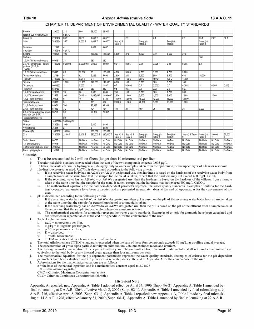
Title 18 Arizona Administrative Code 18 A.A.C. 11
CHAPTER 11. DEPARTMENT OF ENVIRONMENTAL QUALITY - WATER QUALITY STANDARDS
Footnotesa. The asbestos standard is 7 million fibers (longer than 10 micrometers) per liter.b. The aldrin/dieldrin standard is exceeded when the sum of the two compounds exceeds 0.003 µg/L.c. In lakes, the acute criteria for hydrogen sulfide apply only to water samples taken from the epilimnion, or the upper layer of a lake or reservoir.d. Hardness, expressed as mg/L CaCO3, is determined according to the following criteria:
i. If the receiving water body has an A&Wc or A&Ww designated use, then hardness is based on the hardness of the receiving water body froma sample taken at the same time that the sample for the metal is taken, except that the hardness may not exceed 400 mg/L CaCO3.
ii. If the receiving water has an A&Wedw or A&We designated use, then the hardness is based on the hardness of the effluent from a sampletaken at the same time that the sample for the metal is taken, except that the hardness may not exceed 400 mg/L CaCO3.
iii. The mathematical equations for the hardness-dependent parameter represent the water quality standards. Examples of criteria for the hard-ness-dependent parameters have been calculated and are presented in separate tables at the end of Appendix A for the convenience of theuser.
e. pH is determined according to the following criteria:i. If the receiving water has an A&Wc or A&Ww designated use, then pH is based on the pH of the receiving water body from a sample taken
at the same time that the sample for pentachlorophenol or ammonia is taken.ii. If the receiving water body has an A&Wedw or A&We designated use, then the pH is based on the pH of the effluent from a sample taken at
the same time that the sample for pentachlorophenol or ammonia is taken.iii. The mathematical equations for ammonia represent the water quality standards. Examples of criteria for ammonia have been calculated and
are presented in separate tables at the end of Appendix A for the convenience of the user.f. Table 1 abbreviations.
i. µg/L = micrograms per liter,ii. mg/kg = milligrams per kilogram,iii. pCi/L = picocuries per liter,iv. D = dissolved,v. T = total recoverable,vi. TTHM indicates that the chemical is a trihalomethane.
g. The total trihalomethane (TTHM) standard is exceeded when the sum of these four compounds exceeds 80 µg/L, as a rolling annual average.h. The concentration of gross alpha particle activity includes radium-226, but excludes radon and uranium.i. The average annual concentration of beta particle activity and photon emitters from manmade radionuclides shall not produce an annual dose
equivalent to the total body or any internal organ greater than four millirems per year.j. The mathematical equations for the pH-dependent parameters represent the water quality standards. Examples of criteria for the pH-dependent
parameters have been calculated and are presented in separate tables at the end of Appendix A for the convenience of the user.k. Abbreviations for the mathematical equations are as follows:
e = the base of the natural logarithm and is a mathematical constant equal to 2.71828LN = is the natural logarithmCMC = Criterion Maximum Concentration (acute)CCC= Criterion Continuous Concentration (chronic)
Historical NoteAppendix A repealed; new Appendix A, Table 1 adopted effective April 24, 1996 (Supp. 96-2). Appendix A, Table 1 amended by final rulemaking at 8 A.A.R. 1264, effective March 8, 2002 (Supp. 02-1). Appendix A, Table 1 amended by final rulemaking at 9 A.A.R. 716, effective April 8, 2003 (Supp. 03-1). Appendix A, Table 1 repealed; new Appendix A, Table 1 made by final rulemak-ing at 14 A.A.R. 4708, effective January 31, 2009 (Supp. 08-4). Appendix A, Table 1 amended by final rulemaking at 22 A.A.R.
Pyrene 129000 210 800 28,000 28,000Radium 226 + Radium 228 5 pCi/LSelenium 7782492 50 T 667 T 4,667 T 4,667 T 2 T 2 T 2 T 33 T 20 T 50 TSilver 7440224 35 T 8,000 T 4,667 T 4,667 T See (d) &
Table 8See (d) & Table 8
See (d) & Table 8
See (d) & Table 8
Simazine 112349 4 4,667 4,667Strontium 7440246 8 pCi/LStyrene 100425 100 186,667 186,667 5,600 370 5,600 370 5,600 370Sulfides 1001,2,4,5-Tetrachlorobenzene 95943 2.1 280 2802,3,7,8-Tetrachlorod- ibenzo-p-dioxin (2,3,7,8-TCDD)
1746016 0.00003 0.0000001 0.0007 0.0007 0.01 0.005 0.01 0.005 0.01 0.005 0.1
1,1,2,2-Tetrachloroethane 79345 0.2 32,000 23 186,667 4,700 3,200 4,700 3,200 4,700 3,200Tetrachloroethylene 127184 5 62 2,222 5,600 2,600 280 6,500 680 6,500 680 15,000Thallium 7440280 2 T 0.07 T 9 T 9 T 700 D 150 D 700 D 150 D 700 D 150 DToluene 108883 1,000 11,963 149,333 149,333 8,700 180 8,700 180 8,700 180Toxaphene 8001352 3 0.0003 4 1,867 0.7 0.0002 0.7 0.0002 0.7 0.0002 11 0.005 0.005Tributyltin 688733 0.08 280 280 0.5 0.07 0.5 0.07 0.5 0.071,2,4-Trichlorobenzene 120821 70 70 9,333 9,333 750 130 1,700 300 1,700 3001,1,1-Trichloroethane 71556 200 285,714 1,866,667 1,866,667 2,600 1,600 2,600 1,600 2,600 1,600 1,0001,1,2-Trichloroethane 79005 5 16 82 3,733 18,000 12,000 18,000 12,000 18,000 12,000Trichloroethylene 79016 5 8 101 467 20,000 1,300 20,000 1,300 20,000 1,3002,4,5- Trichlorophenol 95954 700 93,333 93,3332,4,6-Trichlorophenol 88062 3.2 2 424 424 160 25 160 25 160 25 3,0002,4,5-Trichlorophenoxy propri-onic acid (2,4,5-TP)
93721 50 29,867 29,867
Trihalomethanes (T) 80Tritium 10028178 20,000 pCi/LUranium 7440611 30 D 2,800 2,800Vinyl chloride 75014 2 5 6 2,800Xylenes (T) 1330207 10,000 186,667 186,667Zinc 7440666 2,100 T 5,106 T 280,000 T 280,000 T See (d) &
Table 9See (d) & Table 9
See (d) & Table 9
See (d) & Table 9
See (d) & Table 9
See (d) & Table 9
See (d) & Table 9
10,000T
25,000T
2-nitrophenol 88755 No Data No Data No Data No Data No Data No Data No Data No Data No Data No Data No Data No Data1,1-dichloroethane 85343 No Data No Data No Data No Data No Data No Data No Data No Data No Data No Data No Data No Data4-chlorophenyl phenyl ether 7005723 No Data No Data No Data No Data No Data No Data No Data No Data No Data No Data No Data No DataBenzo (ghi) perylene 191242 No Data No Data No Data No Data No Data No Data No Data No Data No Data No Data No Data No Data
September 30, 2019 Supp. 19-3 Page 19
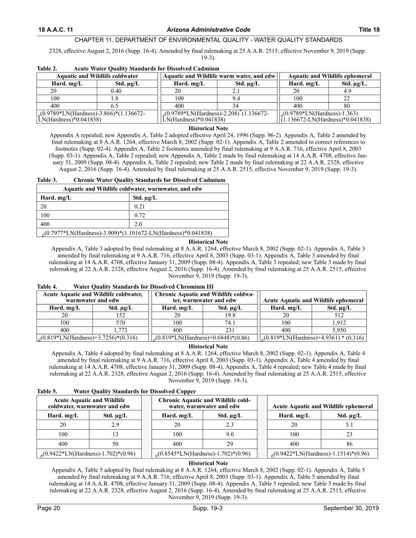
18 A.A.C. 11 Arizona Administrative Code Title 18
CHAPTER 11. DEPARTMENT OF ENVIRONMENTAL QUALITY - WATER QUALITY STANDARDS
Page 20 Supp. 19-3 September 30, 2019
2328, effective August 2, 2016 (Supp. 16-4). Amended by final rulemaking at 25 A.A.R. 2515, effective November 9, 2019 (Supp. 19-3).
Table 2. Acute Water Quality Standards for Dissolved Cadmium
Historical NoteAppendix A repealed; new Appendix A, Table 2 adopted effective April 24, 1996 (Supp. 96-2). Appendix A, Table 2 amended by final rulemaking at 8 A.A.R. 1264, effective March 8, 2002 (Supp. 02-1). Appendix A, Table 2 amended to correct references to
footnotes (Supp. 02-4). Appendix A, Table 2 footnotes amended by final rulemaking at 9 A.A.R. 716, effective April 8, 2003 (Supp. 03-1). Appendix A, Table 2 repealed; new Appendix A, Table 2 made by final rulemaking at 14 A.A.R. 4708, effective Jan-
uary 31, 2009 (Supp. 08-4). Appendix A, Table 2 repealed; new Table 2 made by final rulemaking at 22 A.A.R. 2328, effective August 2, 2016 (Supp. 16-4). Amended by final rulemaking at 25 A.A.R. 2515, effective November 9, 2019 (Supp. 19-3).
Table 3. Chronic Water Quality Standards for Dissolved Cadmium
Historical NoteAppendix A, Table 3 adopted by final rulemaking at 8 A.A.R. 1264, effective March 8, 2002 (Supp. 02-1). Appendix A, Table 3
amended by final rulemaking at 9 A.A.R. 716, effective April 8, 2003 (Supp. 03-1). Appendix A, Table 3 amended by final rulemaking at 14 A.A.R. 4708, effective January 31, 2009 (Supp. 08-4). Appendix A, Table 3 repealed; new Table 3 made by final rulemaking at 22 A.A.R. 2328, effective August 2, 2016 (Supp. 16-4). Amended by final rulemaking at 25 A.A.R. 2515, effective
November 9, 2019 (Supp. 19-3).
Table 4. Water Quality Standards for Dissolved Chromium III
Historical NoteAppendix A, Table 4 adopted by final rulemaking at 8 A.A.R. 1264, effective March 8, 2002 (Supp. 02-1). Appendix A, Table 4
amended by final rulemaking at 9 A.A.R. 716, effective April 8, 2003 (Supp. 03-1). Appendix A, Table 4 amended by final rulemaking at 14 A.A.R. 4708, effective January 31, 2009 (Supp. 08-4). Appendix A, Table 4 repealed; new Table 4 made by final rulemaking at 22 A.A.R. 2328, effective August 2, 2016 (Supp. 16-4). Amended by final rulemaking at 25 A.A.R. 2515, effective
November 9, 2019 (Supp. 19-3).
Table 5. Water Quality Standards for Dissolved Copper
Historical NoteAppendix A, Table 5 adopted by final rulemaking at 8 A.A.R. 1264, effective March 8, 2002 (Supp. 02-1). Appendix A, Table 5
amended by final rulemaking at 9 A.A.R. 716, effective April 8, 2003 (Supp. 03-1). Appendix A, Table 5 amended by final rulemaking at 14 A.A.R. 4708, effective January 31, 2009 (Supp. 08-4). Appendix A, Table 5 repealed; new Table 5 made by final rulemaking at 22 A.A.R. 2328, effective August 2, 2016 (Supp. 16-4). Amended by final rulemaking at 25 A.A.R. 2515, effective
November 9, 2019 (Supp. 19-3).
Aquatic and Wildlife coldwater Aquatic and Wildlife warm water, and edw Aquatic and Wildlife ephemeralHard. mg/L Std. µg/L Hard. mg/L Std. µg/L Hard. mg/L Std. µg/L.20 0.40 20 2.1 20 4.9100 1.8 100 9.4 100 22400 6.5 400 34 400 80
e(0.9789*LN(Hardness)-3.866)*(1.136672-LN(Hardness)*0.041838)
e(0.9789*LN(Hardness)-2.208)*(1.136672-LN(Hardness)*0.041838)
e(0.9789*LN(Hardness)-1.363) (1.136672-LN(Hardness)*0.041838)
Aquatic and Wildlife coldwater, warmwater, and edw
Hard. mg/L Std. µg/L
20 0.21
100 0.72
400 2.0
e(0.7977*LN(Hardness)-3.909)*(1.101672-LN(Hardness)*0.041838)
Acute Aquatic and Wildlife coldwater, warmwater and edw
Chronic Aquatic and Wildlife coldwa-ter, warmwater and edw Acute Aquatic and Wildlife ephemeral
Hard. mg/L Std. µg/L Hard. mg/L Std. µg/L Hard. mg/L Std. µg/L20 152 20 19.8 20 512
100 570 100 74.1 100 1,912400 1,773 400 231 400 5,950
e(0.819*LN(Hardness)+3.7256)*(0.316) e(0.819*LN(Hardness)+0.6848)*(0.86) e(0.819*LN(Hardness)+4.9361) * (0.316)
Acute Aquatic and Wildlifecoldwater, warmwater and edw
Chronic Aquatic and Wildlife cold-water, warmwater and edw Acute Aquatic and Wildlife ephemeral
Hard. mg/L Std. µg/L Hard. mg/L Std. µg/L Hard. mg/L Std. µg/L
20 2.9 20 2.3 20 5.1
100 13 100 9.0 100 23
400 50 400 29 400 86
e(0.9422*LN(Hardness)-1.702)*(0.96) e(0.8545*LN(Hardness)-1.702)*(0.96) e(0.9422*LN(Hardness)-1.1514)*(0.96)

Title 18 Arizona Administrative Code 18 A.A.C. 11
CHAPTER 11. DEPARTMENT OF ENVIRONMENTAL QUALITY - WATER QUALITY STANDARDS
Table 6. Water Quality Standards for Dissolved Lead
Historical NoteAppendix A, Table 6 adopted by final rulemaking at 8 A.A.R. 1264, effective March 8, 2002 (Supp. 02-1). Appendix A, Table 6 amended by final rulemaking at 9 A.A.R. 716, effective April 8, 2003 (Supp. 03-1). Appendix A, Table 6 renumbered to Table 9; new Table 6 made by final rulemaking at 14 A.A.R. 4708, effective January 31, 2009 (Supp. 08-4). Appendix A, Table 6 repealed; new Table 6 made by final rulemaking at 22 A.A.R. 2328, effective August 2, 2016 (Supp. 16-4). Amended by final rulemaking at
25 A.A.R. 2515, effective November 9, 2019 (Supp. 19-3).
Table 7. Water Quality Standards for Dissolved Nickel
Historical NoteAppendix A, Table 7 adopted by final rulemaking at 8 A.A.R. 1264, effective March 8, 2002 (Supp. 02-1). Appendix A, Table 7
amended by final rulemaking at 9 A.A.R. 716, effective April 8, 2003 (Supp. 03-1). Appendix A, Table 7 amended by final rulemaking at 14 A.A.R. 4708, effective January 31, 2009 (Supp. 08-4). Appendix A, Table 7 repealed; new Table 7 made by final
rulemaking at 22 A.A.R. 2328, effective August 2, 2016 (Supp. 16-4).
Table 8. Water Quality Standards for Dissolved Silver
Historical NoteAppendix A, Table 8 adopted by final rulemaking at 8 A.A.R. 1264, effective March 8, 2002 (Supp. 02-1). Appendix A, Table 8
amended by final rulemaking at 9 A.A.R. 716, effective April 8, 2003 (Supp. 03-1). Appendix A, Table 8 amended by final rulemaking at 14 A.A.R. 4708, effective January 31, 2009 (Supp. 08-4). Appendix A, Table 8 repealed; new Table 8 made by final
rulemaking at 22 A.A.R. 2328, effective August 2, 2016 (Supp. 16-4).
Table 9. Water Quality Standards for Dissolved Zinc
Historical NoteAppendix A, Table 9 adopted by final rulemaking at 8 A.A.R. 1264, effective March 8, 2002 (Supp. 02-1). Appendix A, Table 9
amended by final rulemaking at 9 A.A.R. 716, effective April 8, 2003 (Supp. 03-1). Appendix A, Table 9 renumbered to Table 11; new Table 9 renumbered from Table 6 and amended by final rulemaking at 14 A.A.R. 4708, effective January 31, 2009 (Supp. 08-4). Appendix A, Table 9 repealed; new Table 9 made by final rulemaking at 22 A.A.R. 2328, effective August 2, 2016 (Supp. 16-
4).
Acute Aquatic and Wildlifecoldwater, warmwater and edw
Chronic Aquatic and Wildlife coldwater, warmwater and edw Acute Aquatic and Wildlife ephemeral
Hard. mg/L Std. µg/L Hard. mg/L Std. µg/L Hard. mg/L Std. µg/L
20 10.8 20 0.42 20 22.8
100 64.6 100 2.5 100 136.3
400 281 400 10.9 400 592.7
e(1.273*LN(Hardness)-1.46)*(1.46203- (LN(Hardness))*(0.145712))
e(1.273*LN(Hardness)-4.705) * (1.46203-(LN(Hardness))*(0.145712))
e(1.273*(LN(Hardness))-0.7131) * (1.46203-(LN(Hardness))*(0.145712))
Acute Aquatic and Wildlife coldwa-ter, warmwater and edw
Chronic Aquatic and Wildlife coldwater, warmwater and edw
Acute Aquatic and Wildlife ephemeral
Hard. mg/L Std. µg/L Hard. mg/L Std. µg/L Hard. mg/L Std. µg/L
20 120.0 20 13.3 20 1066
100 468 100 52.0 100 4158
400 1513 400 168 400 13436
e(0.846*LN(Hardness)+2.255)*(0.998) e(0.846*LN(Hardness)+0.0584)*(0.997) e(0.846*LN(Hardness)+4.4389)*(0.998)
Acute Aquatic and Wildlife coldwater, warmwater, edw, and ephemeral
Hard. mg/L Std. µg/L
20 0.20
100 3.2
400 34.9
e(1.72*LN(Hardness)-6.59)*(0.85)
Acute and Chronic Aquatic and Wildlife coldwater, warm-water and edw
Acute Aquatic and Wildlife ephemeral
Hard. mg/L Std. µg/L Hard. mg/L Std. µg/L
20 30.0 20 284
100 117 100 1112
400 379 400 3599
e(0.8473*LN(Hardness)+0.884)*(0.978) e(0.8473*LN(Hardness)+3.1342)*(0.978)
September 30, 2019 Supp. 19-3 Page 21
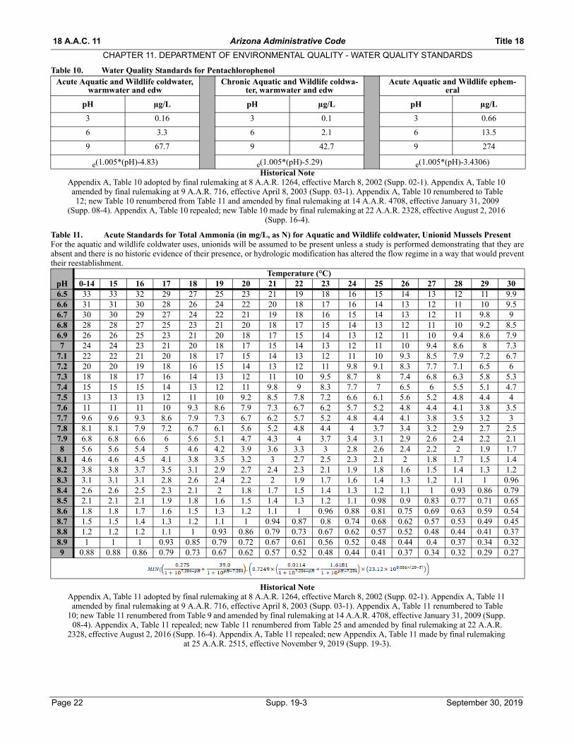
18 A.A.C. 11 Arizona Administrative Code Title 18
CHAPTER 11. DEPARTMENT OF ENVIRONMENTAL QUALITY - WATER QUALITY STANDARDS
Table 10. Water Quality Standards for Pentachlorophenol
Historical NoteAppendix A, Table 10 adopted by final rulemaking at 8 A.A.R. 1264, effective March 8, 2002 (Supp. 02-1). Appendix A, Table 10 amended by final rulemaking at 9 A.A.R. 716, effective April 8, 2003 (Supp. 03-1). Appendix A, Table 10 renumbered to Table 12; new Table 10 renumbered from Table 11 and amended by final rulemaking at 14 A.A.R. 4708, effective January 31, 2009
(Supp. 08-4). Appendix A, Table 10 repealed; new Table 10 made by final rulemaking at 22 A.A.R. 2328, effective August 2, 2016 (Supp. 16-4).
Table 11. Acute Standards for Total Ammonia (in mg/L, as N) for Aquatic and Wildlife coldwater, Unionid Mussels PresentFor the aquatic and wildlife coldwater uses, unionids will be assumed to be present unless a study is performed demonstrating that they areabsent and there is no historic evidence of their presence, or hydrologic modification has altered the flow regime in a way that would preventtheir reestablishment.
Historical NoteAppendix A, Table 11 adopted by final rulemaking at 8 A.A.R. 1264, effective March 8, 2002 (Supp. 02-1). Appendix A, Table 11 amended by final rulemaking at 9 A.A.R. 716, effective April 8, 2003 (Supp. 03-1). Appendix A, Table 11 renumbered to Table
10; new Table 11 renumbered from Table 9 and amended by final rulemaking at 14 A.A.R. 4708, effective January 31, 2009 (Supp. 08-4). Appendix A, Table 11 repealed; new Table 11 renumbered from Table 25 and amended by final rulemaking at 22 A.A.R.
2328, effective August 2, 2016 (Supp. 16-4). Appendix A, Table 11 repealed; new Appendix A, Table 11 made by final rulemaking at 25 A.A.R. 2515, effective November 9, 2019 (Supp. 19-3).
Acute Aquatic and Wildlife coldwater, warmwater and edw
Chronic Aquatic and Wildlife coldwa-ter, warmwater and edw
Acute Aquatic and Wildlife ephem-eral
pH µg/L pH µg/L pH µg/L
3 0.16 3 0.1 3 0.66
6 3.3 6 2.1 6 13.5
9 67.7 9 42.7 9 274
e(1.005*(pH)-4.83) e(1.005*(pH)-5.29) e(1.005*(pH)-3.4306)
pHTemperature (°C)
0-14 15 16 17 18 19 20 21 22 23 24 25 26 27 28 29 306.5 33 33 32 29 27 25 23 21 19 18 16 15 14 13 12 11 9.96.6 31 31 30 28 26 24 22 20 18 17 16 14 13 12 11 10 9.56.7 30 30 29 27 24 22 21 19 18 16 15 14 13 12 11 9.8 96.8 28 28 27 25 23 21 20 18 17 15 14 13 12 11 10 9.2 8.56.9 26 26 25 23 21 20 18 17 15 14 13 12 11 10 9.4 8.6 7.97 24 24 23 21 20 18 17 15 14 13 12 11 10 9.4 8.6 8 7.3
7.1 22 22 21 20 18 17 15 14 13 12 11 10 9.3 8.5 7.9 7.2 6.77.2 20 20 19 18 16 15 14 13 12 11 9.8 9.1 8.3 7.7 7.1 6.5 67.3 18 18 17 16 14 13 12 11 10 9.5 8.7 8 7.4 6.8 6.3 5.8 5.37.4 15 15 15 14 13 12 11 9.8 9 8.3 7.7 7 6.5 6 5.5 5.1 4.77.5 13 13 13 12 11 10 9.2 8.5 7.8 7.2 6.6 6.1 5.6 5.2 4.8 4.4 47.6 11 11 11 10 9.3 8.6 7.9 7.3 6.7 6.2 5.7 5.2 4.8 4.4 4.1 3.8 3.57.7 9.6 9.6 9.3 8.6 7.9 7.3 6.7 6.2 5.7 5.2 4.8 4.4 4.1 3.8 3.5 3.2 37.8 8.1 8.1 7.9 7.2 6.7 6.1 5.6 5.2 4.8 4.4 4 3.7 3.4 3.2 2.9 2.7 2.57.9 6.8 6.8 6.6 6 5.6 5.1 4.7 4.3 4 3.7 3.4 3.1 2.9 2.6 2.4 2.2 2.18 5.6 5.6 5.4 5 4.6 4.2 3.9 3.6 3.3 3 2.8 2.6 2.4 2.2 2 1.9 1.7
8.1 4.6 4.6 4.5 4.1 3.8 3.5 3.2 3 2.7 2.5 2.3 2.1 2 1.8 1.7 1.5 1.48.2 3.8 3.8 3.7 3.5 3.1 2.9 2.7 2.4 2.3 2.1 1.9 1.8 1.6 1.5 1.4 1.3 1.28.3 3.1 3.1 3.1 2.8 2.6 2.4 2.2 2 1.9 1.7 1.6 1.4 1.3 1.2 1.1 1 0.968.4 2.6 2.6 2.5 2.3 2.1 2 1.8 1.7 1.5 1.4 1.3 1.2 1.1 1 0.93 0.86 0.798.5 2.1 2.1 2.1 1.9 1.8 1.6 1.5 1.4 1.3 1.2 1.1 0.98 0.9 0.83 0.77 0.71 0.658.6 1.8 1.8 1.7 1.6 1.5 1.3 1.2 1.1 1 0.96 0.88 0.81 0.75 0.69 0.63 0.59 0.548.7 1.5 1.5 1.4 1.3 1.2 1.1 1 0.94 0.87 0.8 0.74 0.68 0.62 0.57 0.53 0.49 0.458.8 1.2 1.2 1.2 1.1 1 0.93 0.86 0.79 0.73 0.67 0.62 0.57 0.52 0.48 0.44 0.41 0.378.9 1 1 1 0.93 0.85 0.79 0.72 0.67 0.61 0.56 0.52 0.48 0.44 0.4 0.37 0.34 0.329 0.88 0.88 0.86 0.79 0.73 0.67 0.62 0.57 0.52 0.48 0.44 0.41 0.37 0.34 0.32 0.29 0.27
Page 22 Supp. 19-3 September 30, 2019

Title 18 Arizona Administrative Code 18 A.A.C. 11
CHAPTER 11. DEPARTMENT OF ENVIRONMENTAL QUALITY - WATER QUALITY STANDARDSTable 12. Acute Standards for Total Ammonia (in mg/L, as N) for Aquatic and Wildlife warmwater, Unionid Mussels PresentFor the aquatic and wildlife warmwater uses, unionids will be assumed to be present unless a study is performed demonstrating that they areabsent and there is no historic evidence of their presence, or hydrologic modification has altered the flow regime in a way that would preventtheir reestablishment.
Historical NoteAppendix A, Table 12 adopted by final rulemaking at 8 A.A.R. 1264, effective March 8, 2002 (Supp. 02-1). Appendix A, Table 12 amended by final rulemaking at 9 A.A.R. 716, effective April 8, 2003 (Supp. 03-1). Appendix A, Table 12 renumbered to Table 18; new Table 12 renumbered from Table 10 and amended by final rulemaking at 14 A.A.R. 4708, effective January 31, 2009 (Supp. 08-4). Appendix A, Table 12 repealed; new Table 12 renumbered from Table 26 and amended by final rulemaking at 22 A.A.R. 2328, effective August 2, 2016 (Supp. 16-4). Appendix A, Table 11 repealed; new Appendix A, Table 11 made by final
rulemaking at 25 A.A.R. 2515, effective November 9, 2019 (Supp. 19-3). Appendix A, Table 12 repealed; new Appendix A, Table 12 made by final rulemaking at 25 A.A.R. 2515, effective November 9, 2019 (Supp. 19-3).
pHTemperature (°C)
0-10 11 12 13 14 15 16 17 18 19 20 21 22 23 24 25 26 27 28 29 306.5 51 48 44 41 37 34 32 29 27 25 23 21 19 18 16 15 14 13 12 11 9.96.6 49 46 42 39 36 33 30 28 26 24 22 20 18 17 16 14 13 12 11 10 9.56.7 46 44 40 37 34 31 29 27 24 22 21 19 18 16 15 14 13 12 11 9.8 96.8 44 41 38 35 32 30 27 25 23 21 20 18 17 15 14 13 12 11 10 9.2 8.56.9 41 38 35 32 30 28 25 23 21 20 18 17 15 14 13 12 11 10 9.4 8.6 7.97 38 35 33 30 28 25 23 21 20 18 17 15 14 13 12 11 10 9.4 8.6 7.9 7.3
7.1 34 32 30 27 25 23 21 20 18 17 15 14 13 12 11 10 9.3 8.5 7.9 7.2 6.77.2 31 29 27 25 23 21 19 18 16 15 14 13 12 11 9.8 9.1 8.3 7.7 7.1 6.5 67.3 27 26 24 22 20 18 17 16 14 13 12 11 10 9.5 8.7 8 7.4 6.8 6.3 5.8 5.37.4 24 22 21 19 18 16 15 14 13 12 11 9.8 9 8.3 7.7 7 6.5 6 5.5 5.1 4.77.5 21 19 18 17 15 14 13 12 11 10 9.2 8.5 7.8 7.2 6.6 6.1 5.6 5.2 4.8 4.4 47.6 18 17 15 14 13 12 11 10 9.3 8.6 7.9 7.3 6.7 6.2 5.7 5.2 4.8 4.4 4.1 3.8 3.57.7 15 14 13 12 11 10 9.3 8.6 7.9 7.3 6.7 6.2 5.7 5.2 4.8 4.4 4.1 3.8 3.5 3.2 2.97.8 13 12 11 10 9.3 8.5 7.9 7.2 6.7 6.1 5.6 5.2 4.8 4.4 4 3.7 3.4 3.2 2.9 2.7 2.57.9 11 9.9 9.1 8.4 7.7 7.1 6.6 3 5.6 5.1 4.7 4.3 4 3.7 3.4 3.1 2.9 2.6 2.4 2.2 2.18 8.8 8.2 7.6 7 6.4 5.9 5.4 5 4.6 4.2 3.9 3.6 3.3 3 2.8 2.6 2.4 2.2 2 1.9 1.7
8.1 7.2 6.8 6.3 5.8 5.3 4.9 4.5 4.1 3.8 3.5 3.2 3 2.7 2.5 2.3 2.1 2 1.8 1.7 1.5 1.48.2 6 5.6 5.2 4.8 4.4 4 3.7 3.4 3.1 2.9 2.7 2.4 2.3 2.1 1.9 1.8 1.6 1.5 1.4 1.3 1.28.3 4.9 4.6 4.3 3.9 3.6 3.3 3.1 2.8 2.6 2.4 2.2 2 1.9 1.7 1.6 1.4 1.3 1.2 1.1 1 0.968.4 4.1 3.8 3.5 3.2 3 2.7 2.5 2.3 2.1 2 1.8 1.7 1.5 1.4 1.3 1.2 1.1 1 0.93 0.86 0.798.5 3.3 3.1 2.9 2.7 2.4 2.3 2.1 1.9 1.8 1.6 1.5 1.4 1.3 1.2 1.1 0.98 0.9 0.83 0.77 0.71 0.658.6 2.8 2.6 2.4 2.2 2 1.9 1.7 1.6 1.5 1.3 1.2 1.1 1 0.96 0.88 0.81 0.75 0.69 0.63 0.58 0.548.7 2.3 2.2 2 1.8 1.7 1.6 1.4 1.3 1.2 1.1 1 0.94 0.87 0.8 0.74 0.68 0.62 0.57 0.53 0.49 0.458.8 1.9 1.8 1.7 1.5 1.4 1.3 1.2 1.1 1 0.93 0.86 0.79 0.73 0.67 0.62 0.57 0.52 0.48 0.44 0.41 0.378.9 1.6 1.5 1.4 1.3 1.2 1.1 1 0.93 0.85 0.79 0.72 0.67 0.61 0.56 0.52 0.48 0.44 0.4 0.37 0.34 0.329 1.4 1.3 1.2 1.1 1 0.93 0.86 0.79 0.73 0.67 0.62 0.57 0.52 0.48 0.44 0.41 0.37 0.34 0.32 0.29 0.27
September 30, 2019 Supp. 19-3 Page 23

18 A.A.C. 11 Arizona Administrative Code Title 18
CHAPTER 11. DEPARTMENT OF ENVIRONMENTAL QUALITY - WATER QUALITY STANDARDS
Table 13. Chronic Criteria for Total Ammonia (in mg/L, as N) for Aquatic and Wildlife coldwater and warmwater, UnionidMussels PresentFor the aquatic and wildlife cold and warm water uses, unionids will be assumed to be present unless a study is performed demonstrating thatthey are absent and there is no historic evidence of their presence, or hydrologic modification has altered the flow regime in a way that wouldprevent their reestablishment.
Historical NoteAppendix A, Table 13 adopted by final rulemaking at 8 A.A.R. 1264, effective March 8, 2002 (Supp. 02-1). Appendix A, Table 13 amended by final rulemaking at 9 A.A.R. 716, effective April 8, 2003 (Supp. 03-1). Appendix A, Table 13 renumbered to Table 15; new Table 13 renumbered from Table 14 and amended by final rulemaking at 14 A.A.R. 4708, effective January 31, 2009
(Supp. 08-4). Appendix A, Table 13 repealed by final rulemaking at 22 A.A.R. 2328, effective August 2, 2016 (Supp. 16-4). New Appendix A, Table 13 made by final rulemaking at 25 A.A.R. 2515, effective November 9, 2019 (Supp. 19-3).
pHTemperature (°C)
0-7 8 9 10 11 12 13 14 15 16 17 18 19 20 21 22 23 24 25 26 27 28 29 306.5 4.9 4.6 4.3 4.1 3.8 3.6 3.3 3.1 2.9 2.8 2.6 2.4 2.3 2.1 2 1.9 1.8 1.6 1.5 1.5 1.4 1.3 1.2 1.16.6 4.8 4.5 4.3 4 3.8 3.5 3.3 3.1 2.9 2.7 2.5 2.4 2.2 2.1 2 1.8 1.7 1.6 1.5 1.4 1.3 1.3 1.2 1.16.7 4.8 4.5 4.2 3.9 3.7 3.5 3.2 3 2.8 2.7 2.5 2.3 2.2 2.1 1.9 1.8 1.7 1.6 1.5 1.4 1.3 1.2 1.2 1.16.8 4.6 4.4 4.1 3.8 3.6 3.4 3.2 3 2.8 2.6 2.4 2.3 2.1 2 1.9 1.8 1.7 1.6 1.5 1.4 1.3 1.2 1.1 1.16.9 4.5 4.2 4 3.7 3.5 3.3 3.1 2.9 2.7 2.5 2.4 2.2 2.1 2 1.8 1.7 1.6 1.5 1.4 1.3 1.2 1.2 1.1 17 4.4 4.1 3.8 3.6 3.4 3.2 3 2.8 2.6 2.4 2.3 2.2 2 1.9 1.8 1.7 1.6 1.5 1.4 1.3 1.2 1.1 1.1 0.99
7.1 4.2 3.9 3.7 3.5 3.2 3 2.8 2.7 2.5 2.3 2.2 2.1 1.9 1.8 1.7 1.6 1.5 1.4 1.3 1.2 1.2 1.1 1 0.957.2 4 3.7 3.5 3.3 3.1 2.9 2.7 2.5 2.4 2.2 2.1 2 1.8 1.7 1.6 1.5 1.4 1.3 1.3 1.2 1.1 1 0.96 0.97.3 3.8 3.5 3.3 3.1 2.9 2.7 2.6 2.4 2.2 2.1 2 1.8 1.7 1.6 1.5 1.4 1.3 1.3 1.2 1.1 1 0.97 0.91 0.857.4 3.5 3.3 3.1 2.9 2.7 2.5 2.4 2.2 2.1 2 1.8 1.7 1.6 1.5 1.4 1.3 1.3 1.2 1.1 1 0.96 0.9 0.85 0.797.5 3.2 3 2.8 2.7 2.5 2.3 2.2 2.1 1.9 1.8 1.7 1.6 1.5 1.4 1.3 1.2 1.2 1.1 1 0.95 0.89 0.83 0.78 0.737.6 2.9 2.8 2.6 2.4 2.3 2.1 2 1.9 1.8 1.6 1.5 1.4 1.4 1.3 1.2 1.1 1.1 0.98 0.92 0.86 0.81 0.76 0.71 0.677.7 2.6 2.4 2.3 2.2 2 1.9 1.8 1.7 1.6 1.5 1.4 1.3 1.2 1.1 1.1 1 0.94 0.88 0.83 0.78 0.73 0.68 0.64 0.67.8 2.3 2.2 2.1 1.9 1.8 1.7 1.6 1.5 1.4 1.3 1.2 1.2 1.1 1 0.95 0.89 0.84 0.79 0.74 0.69 0.65 0.61 0.57 0.537.9 2.1 1.9 1.8 1.7 1.6 1.5 1.4 1.3 1.2 1.2 1.1 1 0.95 0.89 0.84 0.79 0.74 0.69 0.65 0.61 0.57 0.53 0.5 0.478 1.8 1.7 1.6 1.5 1.4 1.3 1.2 1.1 1.1 1 0.94 0.88 0.83 0.78 0.73 0.68 0.64 0.6 0.56 0.53 0.5 0.44 0.44 0.41
8.1 1.5 1.5 1.4 1.3 1.2 1.1 1.1 0.99 0.92 0.87 0.81 0.76 0.71 0.67 0.63 0.59 0.55 0.52 0.49 0.46 0.43 0.4 0.38 0.358.2 1.3 1.2 1.2 1.1 1 0.96 0.9 0.84 0.79 0.74 0.7 0.65 0.61 0.57 0.54 0.5 0.47 0.44 0.42 0.39 0.37 0.34 0.32 0.38.3 1.1 1.1 0.99 0.93 0.87 0.82 0.76 0.72 0.67 0.63 0.59 0.55 0.52 0.49 0.46 0.43 0.4 0.38 0.35 0.33 0.31 0.29 0.27 0.268.4 0.95 0.89 0.84 0.79 0.74 0.69 0.65 0.61 0.57 0.53 0.5 0.47 0.44 0.41 0.39 0.36 0.34 0.32 0.3 0.28 0.26 0.25 0.23 0.228.5 0.8 0.75 0.71 0.67 0.62 0.58 0.55 0.51 0.48 0.45 0.42 0.4 0.37 0.35 0.33 0.31 0.29 0.27 0.25 0.24 0.22 0.21 0.2 0.188.6 0.68 0.64 0.6 0.56 0.53 0.49 0.46 0.43 0.41 0.38 0.36 0.33 0.31 0.29 0.28 0.26 0.24 0.23 0.21 0.2 0.19 0.18 0.16 0.158.7 0.57 0.54 0.51 0.47 0.44 0.42 0.39 0.37 0.34 0.32 0.3 0.28 0.27 0.25 0.23 0.22 0.21 0.19 0.18 0.17 0.16 0.15 0.14 0.138.8 0.49 0.46 0.43 0.4 0.38 0.35 0.33 0.31 0.29 0.27 0.26 0.24 0.23 0.21 0.2 0.19 0.17 0.16 0.15 0.14 0.13 0.13 0.12 0.118.9 0.42 0.39 0.37 0.34 0.32 0.3 0.28 0.27 0.25 0.23 0.22 0.21 0.19 0.18 0.17 0.16 0.15 0.14 0.13 0.12 0.12 0.11 0.1 0.099 0.36 0.34 0.32 0.3 0.28 0.26 0.24 0.23 0.21 0.2 0.19 0.18 0.17 0.16 0.15 0.14 0.13 0.12 0.11 0.11 0.1 0.09 0.09 0.08
Page 24 Supp. 19-3 September 30, 2019

Title 18 Arizona Administrative Code 18 A.A.C. 11
CHAPTER 11. DEPARTMENT OF ENVIRONMENTAL QUALITY - WATER QUALITY STANDARDS
Table 14. Acute Standards for Total Ammonia (in mg/L, as N) for Aquatic and Wildlife Coldwater, Unionid Mussels AbsentFor the aquatic and wildlife coldwater uses, unionids will be assumed to be present unless a study is performed demonstrating that they areabsent and there is no historic evidence of their presence, or hydrologic modification has altered the flow regime in a way that would preventtheir reestablishment.
Historical NoteAppendix A, Table 14 adopted by final rulemaking at 8 A.A.R. 1264, effective March 8, 2002 (Supp. 02-1). Appendix A, Table 14 amended by final rulemaking at 9 A.A.R. 716, effective April 8, 2003 (Supp. 03-1). Appendix A, Table 14 renumbered to Table 13; new Table 14 renumbered from Table 15 and amended by final rulemaking at 14 A.A.R. 4708, effective January 31, 2009
(Supp. 08-4). Appendix A, Table 14 repealed by final rulemaking at 22 A.A.R. 2328, effective August 2, 2016 (Supp. 16-4). New Appendix A, Table 14 made by final rulemaking at 25 A.A.R. 2515, effective November 9, 2019 (Supp. 19-3).
Temperature (°C)pH 0-14 15 16 17 18 19 20 21 22 23 24 25 26 27 28 29 306.5 33 33 33 33 33 33 33 33 33 33 33 33 33 33 31 29 276.6 31 31 31 31 31 31 31 31 31 31 31 31 31 31 30 28 266.7 30 30 30 30 30 30 30 30 30 30 30 30 30 30 29 26 246.8 28 28 28 28 28 28 28 28 28 28 28 28 28 28 27 25 236.9 26 26 26 26 26 26 26 26 26 26 26 26 26 26 25 23 217 24 24 24 24 24 24 24 24 24 24 24 24 24 24 23 21 20
7.1 22 22 22 22 22 22 22 22 22 22 22 22 22 22 21 19 187.2 20 20 20 20 20 20 20 20 20 20 20 20 20 20 19 17 167.3 18 18 18 18 18 18 18 18 18 18 18 18 18 18 17 16 147.4 15 15 15 15 15 15 15 15 15 15 15 15 15 15 15 14 137.5 13 13 13 13 13 13 13 13 13 13 13 13 13 13 13 12 117.6 11 11 11 11 11 11 11 11 11 11 11 11 11 11 11 10 9.37.7 9.6 9.6 9.6 9.6 9.6 9.6 9.6 9.6 9.6 9.6 9.6 9.6 9.6 9.6 9.3 8.6 7.97.8 8.1 8.1 8.1 8.1 8.1 8.1 8.1 8.1 8.1 8.1 8.1 8.1 8.1 8.1 7.8 7.2 6.67.9 6.8 6.8 6.8 6.8 6.8 6.8 6.8 6.8 6.8 6.8 6.8 6.8 6.8 6.8 6.5 6 5.58 5.6 5.6 5.6 5.6 5.6 5.6 5.6 5.6 5.6 5.6 5.6 5.6 5.6 5.6 5.4 5 4.6
8.1 4.6 4.6 4.6 4.6 4.6 4.6 4.6 4.6 4.6 4.6 4.6 4.6 4.6 4.6 4.5 4.1 3.88.2 3.8 3.8 3.8 3.8 3.8 3.8 3.8 3.8 3.8 3.8 3.8 3.8 3.8 3.8 3.7 3.4 3.18.3 3.2 3.2 3.2 3.2 3.2 3.2 3.2 3.2 3.2 3.2 3.2 3.2 3.2 3.2 3 2.8 2.68.4 2.6 2.6 2.6 2.6 2.6 2.6 2.6 2.6 2.6 2.6 2.6 2.6 2.6 2.6 2.5 2.3 2.18.5 2.1 2.1 2.1 2.1 2.1 2.1 2.1 2.1 2.1 2.1 2.1 2.1 2.1 2.1 2.1 1.9 1.88.6 1.8 1.8 1.8 1.8 1.8 1.8 1.8 1.8 1.8 1.8 1.8 1.8 1.8 1.8 1.7 1.6 1.48.7 1.5 1.5 1.5 1.5 1.5 1.5 1.5 1.5 1.5 1.5 1.5 1.5 1.5 1.5 1.4 1.3 1.28.8 1.2 1.2 1.2 1.2 1.2 1.2 1.2 1.2 1.2 1.2 1.2 1.2 1.2 1.2 1.2 1.1 18.9 1 1 1 1 1 1 1 1 1 1 1 1 1 1 1 0.92 0.859 0.88 0.88 0.88 0.88 0.88 0.88 0.88 0.88 0.88 0.88 0.88 0.88 0.88 0.88 0.85 0.78 0.72
September 30, 2019 Supp. 19-3 Page 25

18 A.A.C. 11 Arizona Administrative Code Title 18
CHAPTER 11. DEPARTMENT OF ENVIRONMENTAL QUALITY - WATER QUALITY STANDARDS
Table 15. Acute Standards for Total Ammonia (in mg/L, as N) for Aquatic and Wildlife Warmwater and Effluent Dependent,Unionid Mussels AbsentFor the aquatic and wildlife warmwater uses, unionids will be assumed to be present unless a study is performed demonstrating that they areabsent and there is no historic evidence of their presence, or hydrologic modification has altered the flow regime in a way that would preventtheir reestablishment. For the aquatic and wildlife effluent dependent uses, unionids will be assumed to be absent.
Historical NoteAppendix A, Table 15 adopted by final rulemaking at 8 A.A.R. 1264, effective March 8, 2002 (Supp. 02-1). Appendix A, Table 15 amended by final rulemaking at 9 A.A.R. 716, effective April 8, 2003 (Supp. 03-1). Appendix A, Table 15 renumbered to Table 14; new Table 15 renumbered from Table 13 and amended by final rulemaking at 14 A.A.R. 4708, effective January 31, 2009
(Supp. 08-4). Appendix A, Table 15 repealed by final rulemaking at 22 A.A.R. 2328, effective August 2, 2016 (Supp. 16-4). New Appendix A, Table 14 made by final rulemaking at 25 A.A.R. 2515, effective November 9, 2019 (Supp. 19-3).
pHTemperature (°C)
0-14 15 16 17 18 19 20 21 22 23 24 25 26 27 28 29 306.5 51 51 51 51 51 51 51 51 51 48 44 40 37 34 31 29 276.6 49 49 49 49 49 49 49 49 49 46 42 39 36 33 30 28 266.7 46 46 46 46 46 46 46 46 46 43 40 37 34 31 29 26 246.8 44 44 44 44 44 44 44 44 44 41 38 35 32 29 27 25 236.9 41 41 41 41 41 41 41 41 41 38 35 32 30 27 25 23 217 38 38 38 38 38 38 38 38 38 35 32 30 27 25 23 21 20
7.1 34 34 34 34 34 34 34 34 34 32 29 27 25 23 21 19 187.2 31 31 31 31 31 31 31 31 31 29 26 24 22 21 19 17 167.3 27 27 27 27 27 27 27 27 27 26 23 22 20 18 17 16 147.4 24 24 24 24 24 24 24 24 24 22 21 19 17 16 15 14 137.5 21 21 21 21 21 21 21 21 21 19 18 16 15 14 13 12 117.6 18 18 18 18 18 18 18 18 18 17 15 14 13 12 11 10 9.37.7 15 15 15 15 15 15 15 15 15 14 13 12 11 10 9.3 8.6 7.97.8 13 13 13 13 13 13 13 13 13 12 11 10 9.2 8.5 7.8 7.2 6.67.9 11 11 11 11 11 11 11 11 11 9.9 9.1 8.4 7.7 7.1 6.5 6 5.58 8.8 8.8 8.8 8.8 8.8 8.8 8.8 8.8 8.8 8.2 7.5 6.9 6.4 5.9 5.4 5 4.6
8.1 7.3 7.3 7.3 7.3 7.3 7.3 7.3 7.3 7.3 6.8 6.2 5.7 5.3 4.9 4.5 4.1 3.88.2 6 6 6 6 6 6 6 6 6 5.6 5.1 4.7 4.4 4 3.7 3.4 3.18.3 4.9 4.9 4.9 4.9 4.9 4.9 4.9 4.9 4.9 4.6 4.2 3.9 3.6 3.3 3 2.8 2.68.4 4.1 4.1 4.1 4.1 4.1 4.1 4.1 4.1 4.1 3.8 3.4 3.2 3 2.7 2.5 2.3 2.18.5 3.3 3.3 3.3 3.3 3.3 3.3 3.3 3.3 3.3 3.1 2.9 2.6 2.4 2.2 2.1 1.9 1.88.6 2.8 2.8 2.8 2.8 2.8 2.8 2.8 2.8 2.8 2.6 2.4 2.2 2 1.9 1.7 1.6 1.48.7 2.3 2.3 2.3 2.3 2.3 2.3 2.3 2.3 2.3 2.2 2 1.8 1.7 1.5 1.4 1.3 1.28.8 1.9 1.9 1.9 1.9 1.9 1.9 1.9 1.9 1.9 1.8 1.7 1.5 1.4 1.3 1.2 1.1 18.9 1.6 1.6 1.6 1.6 1.6 1.6 1.6 1.6 1.6 1.5 1.4 1.3 1.2 1.1 1 0.92 0.859 1.4 1.4 1.4 1.4 1.4 1.4 1.4 1.4 1.4 1.3 1.2 1.1 1 0.93 0.85 0.78 0.72
Page 26 Supp. 19-3 September 30, 2019
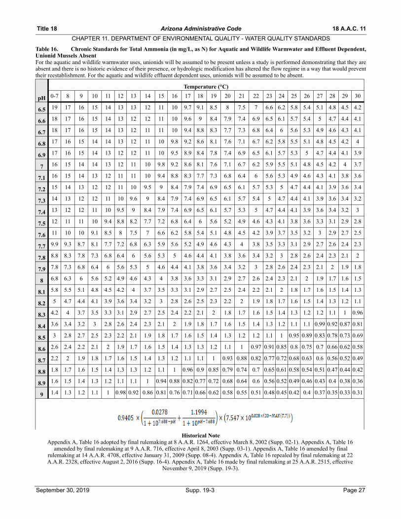
Title 18 Arizona Administrative Code 18 A.A.C. 11
CHAPTER 11. DEPARTMENT OF ENVIRONMENTAL QUALITY - WATER QUALITY STANDARDS
Table 16. Chronic Standards for Total Ammonia (in mg/L, as N) for Aquatic and Wildlife Warmwater and Effluent Dependent,Unionid Mussels AbsentFor the aquatic and wildlife warmwater uses, unionids will be assumed to be present unless a study is performed demonstrating that they areabsent and there is no historic evidence of their presence, or hydrologic modification has altered the flow regime in a way that would preventtheir reestablishment. For the aquatic and wildlife effluent dependent uses, unionids will be assumed to be absent.
Historical NoteAppendix A, Table 16 adopted by final rulemaking at 8 A.A.R. 1264, effective March 8, 2002 (Supp. 02-1). Appendix A, Table 16
amended by final rulemaking at 9 A.A.R. 716, effective April 8, 2003 (Supp. 03-1). Appendix A, Table 16 amended by final rulemaking at 14 A.A.R. 4708, effective January 31, 2009 (Supp. 08-4). Appendix A, Table 16 repealed by final rulemaking at 22 A.A.R. 2328, effective August 2, 2016 (Supp. 16-4). Appendix A, Table 16 made by final rulemaking at 25 A.A.R. 2515, effective
November 9, 2019 (Supp. 19-3).
pH
Temperature (°C)
0-7 8 9 10 11 12 13 14 15 16 17 18 19 20 21 22 23 24 25 26 27 28 29 30
6.5 19 17 16 15 14 13 13 12 11 10 9.7 9.1 8.5 8 7.5 7 6.6 6.2 5.8 5.4 5.1 4.8 4.5 4.2
6.6 18 17 16 15 14 13 12 12 11 10 9.6 9 8.4 7.9 7.4 6.9 6.5 6.1 5.7 5.4 5 4.7 4.4 4.1
6.7 18 17 16 15 14 13 12 11 11 10 9.4 8.8 8.3 7.7 7.3 6.8 6.4 6 5.6 5.3 4.9 4.6 4.3 4.1
6.8 17 16 15 14 14 13 12 11 10 9.8 9.2 8.6 8.1 7.6 7.1 6.7 6.2 5.8 5.5 5.1 4.8 4.5 4.2 4
6.9 17 16 15 14 13 12 12 11 10 9.5 8.9 8.4 7.8 7.4 6.9 6.5 6.1 5.7 5.3 5 4.7 4.4 4.1 3.9
7 16 15 14 14 13 12 11 10 9.8 9.2 8.6 8.1 7.6 7.1 6.7 6.2 5.9 5.5 5.1 4.8 4.5 4.2 4 3.7
7.1 16 15 14 13 12 11 11 10 9.4 8.8 8.3 7.7 7.3 6.8 6.4 6 5.6 5.3 4.9 4.6 4.3 4.1 3.8 3.6
7.2 15 14 13 12 12 11 10 9.5 9 8.4 7.9 7.4 6.9 6.5 6.1 5.7 5.3 5 4.7 4.4 4.1 3.9 3.6 3.4
7.3 14 13 12 12 11 10 9.6 9 8.4 7.9 7.4 6.9 6.5 6.1 5.7 5.4 5 4.7 4.4 4.1 3.9 3.6 3.4 3.2
7.4 13 12 12 11 10 9.5 9 8.4 7.9 7.4 6.9 6.5 6.1 5.7 5.3 5 4.7 4.4 4.1 3.9 3.6 3.4 3.2 3
7.5 12 11 11 10 9.4 8.8 8.2 7.7 7.2 6.8 6.4 6 5.6 5.2 4.9 4.6 4.3 4.1 3.8 3.6 3.3 3.1 2.9 2.8
7.6 11 10 10 9.1 8.5 8 7.5 7 6.6 6.2 5.8 5.4 5.1 4.8 4.5 4.2 3.9 3.7 3.5 3.2 3 2.9 2.7 2.5
7.7 9.9 9.3 8.7 8.1 7.7 7.2 6.8 6.3 5.9 5.6 5.2 4.9 4.6 4.3 4 3.8 3.5 3.3 3.1 2.9 2.7 2.6 2.4 2.3
7.8 8.8 8.3 7.8 7.3 6.8 6.4 6 5.6 5.3 5 4.6 4.4 4.1 3.8 3.6 3.4 3.2 3 2.8 2.6 2.4 2.3 2.1 2
7.9 7.8 7.3 6.8 6.4 6 5.6 5.3 5 4.6 4.4 4.1 3.8 3.6 3.4 3.2 3 2.8 2.6 2.4 2.3 2.1 2 1.9 1.8
8 6.8 6.3 6 5.6 5.2 4.9 4.6 4.3 4 3.8 3.6 3.3 3.1 2.9 2.7 2.6 2.4 2.3 2.1 2 1.9 1.7 1.6 1.5
8.1 5.8 5.5 5.1 4.8 4.5 4.2 4 3.7 3.5 3.3 3.1 2.9 2.7 2.5 2.4 2.2 2.1 2 1.8 1.7 1.6 1.5 1.4 1.3
8.2 5 4.7 4.4 4.1 3.9 3.6 3.4 3.2 3 2.8 2.6 2.5 2.3 2.2 2 1.9 1.8 1.7 1.6 1.5 1.4 1.3 1.2 1.1
8.3 4.2 4 3.7 3.5 3.3 3.1 2.9 2.7 2.5 2.4 2.2 2.1 2 1.8 1.7 1.6 1.5 1.4 1.3 1.2 1.2 1.1 1 0.96
8.4 3.6 3.4 3.2 3 2.8 2.6 2.4 2.3 2.1 2 1.9 1.8 1.7 1.6 1.5 1.4 1.3 1.2 1.1 1.1 0.99 0.92 0.87 0.81
8.5 3 2.8 2.7 2.5 2.3 2.2 2.1 1.9 1.8 1.7 1.6 1.5 1.4 1.3 1.2 1.2 1.1 1 0.95 0.89 0.83 0.78 0.73 0.69
8.6 2.6 2.4 2.2 2.1 2 1.9 1.7 1.6 1.5 1.4 1.3 1.3 1.2 1.1 1 0.97 0.91 0.85 0.8 0.75 0.7 0.66 0.62 0.58
8.7 2.2 2 1.9 1.8 1.7 1.6 1.5 1.4 1.3 1.2 1.1 1.1 1 0.93 0.88 0.82 0.77 0.72 0.68 0.63 0.6 0.56 0.52 0.49
8.8 1.8 1.7 1.6 1.5 1.4 1.3 1.3 1.2 1.1 1 0.96 0.9 0.85 0.79 0.74 0.7 0.65 0.61 0.58 0.54 0.51 0.47 0.44 0.42
8.9 1.6 1.5 1.4 1.3 1.2 1.1 1.1 1 0.94 0.88 0.82 0.77 0.72 0.68 0.64 0.6 0.56 0.52 0.49 0.46 0.43 0.4 0.38 0.36
9 1.4 1.3 1.2 1.1 1 0.98 0.92 0.86 0.81 0.76 0.71 0.66 0.62 0.58 0.55 0.51 0.48 0.45 0.42 0.4 0.37 0.35 0.33 0.31
September 30, 2019 Supp. 19-3 Page 27
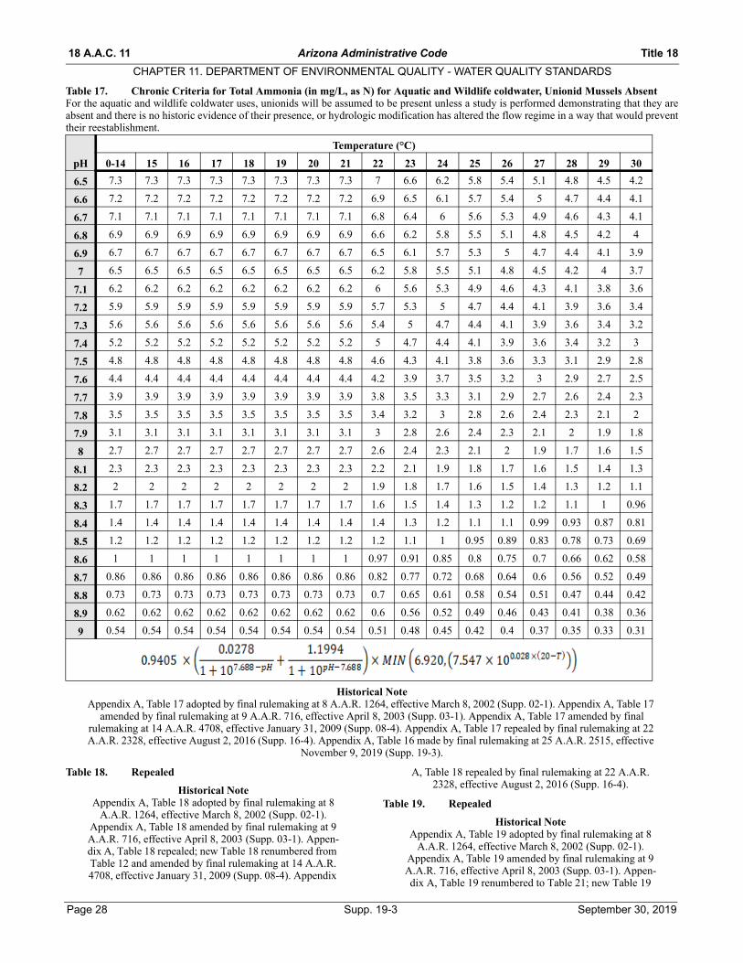
18 A.A.C. 11 Arizona Administrative Code Title 18
CHAPTER 11. DEPARTMENT OF ENVIRONMENTAL QUALITY - WATER QUALITY STANDARDS
Table 17. Chronic Criteria for Total Ammonia (in mg/L, as N) for Aquatic and Wildlife coldwater, Unionid Mussels AbsentFor the aquatic and wildlife coldwater uses, unionids will be assumed to be present unless a study is performed demonstrating that they areabsent and there is no historic evidence of their presence, or hydrologic modification has altered the flow regime in a way that would preventtheir reestablishment.
Historical NoteAppendix A, Table 17 adopted by final rulemaking at 8 A.A.R. 1264, effective March 8, 2002 (Supp. 02-1). Appendix A, Table 17
amended by final rulemaking at 9 A.A.R. 716, effective April 8, 2003 (Supp. 03-1). Appendix A, Table 17 amended by final rulemaking at 14 A.A.R. 4708, effective January 31, 2009 (Supp. 08-4). Appendix A, Table 17 repealed by final rulemaking at 22 A.A.R. 2328, effective August 2, 2016 (Supp. 16-4). Appendix A, Table 16 made by final rulemaking at 25 A.A.R. 2515, effective
November 9, 2019 (Supp. 19-3).
Table 18. Repealed
Historical NoteAppendix A, Table 18 adopted by final rulemaking at 8
A.A.R. 1264, effective March 8, 2002 (Supp. 02-1). Appendix A, Table 18 amended by final rulemaking at 9 A.A.R. 716, effective April 8, 2003 (Supp. 03-1). Appen-dix A, Table 18 repealed; new Table 18 renumbered from Table 12 and amended by final rulemaking at 14 A.A.R. 4708, effective January 31, 2009 (Supp. 08-4). Appendix
A, Table 18 repealed by final rulemaking at 22 A.A.R. 2328, effective August 2, 2016 (Supp. 16-4).
Table 19. Repealed
Historical NoteAppendix A, Table 19 adopted by final rulemaking at 8
A.A.R. 1264, effective March 8, 2002 (Supp. 02-1). Appendix A, Table 19 amended by final rulemaking at 9 A.A.R. 716, effective April 8, 2003 (Supp. 03-1). Appen-dix A, Table 19 renumbered to Table 21; new Table 19
pH
Temperature (°C)
0-14 15 16 17 18 19 20 21 22 23 24 25 26 27 28 29 30
6.5 7.3 7.3 7.3 7.3 7.3 7.3 7.3 7.3 7 6.6 6.2 5.8 5.4 5.1 4.8 4.5 4.2
6.6 7.2 7.2 7.2 7.2 7.2 7.2 7.2 7.2 6.9 6.5 6.1 5.7 5.4 5 4.7 4.4 4.1
6.7 7.1 7.1 7.1 7.1 7.1 7.1 7.1 7.1 6.8 6.4 6 5.6 5.3 4.9 4.6 4.3 4.1
6.8 6.9 6.9 6.9 6.9 6.9 6.9 6.9 6.9 6.6 6.2 5.8 5.5 5.1 4.8 4.5 4.2 4
6.9 6.7 6.7 6.7 6.7 6.7 6.7 6.7 6.7 6.5 6.1 5.7 5.3 5 4.7 4.4 4.1 3.9
7 6.5 6.5 6.5 6.5 6.5 6.5 6.5 6.5 6.2 5.8 5.5 5.1 4.8 4.5 4.2 4 3.7
7.1 6.2 6.2 6.2 6.2 6.2 6.2 6.2 6.2 6 5.6 5.3 4.9 4.6 4.3 4.1 3.8 3.6
7.2 5.9 5.9 5.9 5.9 5.9 5.9 5.9 5.9 5.7 5.3 5 4.7 4.4 4.1 3.9 3.6 3.4
7.3 5.6 5.6 5.6 5.6 5.6 5.6 5.6 5.6 5.4 5 4.7 4.4 4.1 3.9 3.6 3.4 3.2
7.4 5.2 5.2 5.2 5.2 5.2 5.2 5.2 5.2 5 4.7 4.4 4.1 3.9 3.6 3.4 3.2 3
7.5 4.8 4.8 4.8 4.8 4.8 4.8 4.8 4.8 4.6 4.3 4.1 3.8 3.6 3.3 3.1 2.9 2.8
7.6 4.4 4.4 4.4 4.4 4.4 4.4 4.4 4.4 4.2 3.9 3.7 3.5 3.2 3 2.9 2.7 2.5
7.7 3.9 3.9 3.9 3.9 3.9 3.9 3.9 3.9 3.8 3.5 3.3 3.1 2.9 2.7 2.6 2.4 2.3
7.8 3.5 3.5 3.5 3.5 3.5 3.5 3.5 3.5 3.4 3.2 3 2.8 2.6 2.4 2.3 2.1 2
7.9 3.1 3.1 3.1 3.1 3.1 3.1 3.1 3.1 3 2.8 2.6 2.4 2.3 2.1 2 1.9 1.8
8 2.7 2.7 2.7 2.7 2.7 2.7 2.7 2.7 2.6 2.4 2.3 2.1 2 1.9 1.7 1.6 1.5
8.1 2.3 2.3 2.3 2.3 2.3 2.3 2.3 2.3 2.2 2.1 1.9 1.8 1.7 1.6 1.5 1.4 1.3
8.2 2 2 2 2 2 2 2 2 1.9 1.8 1.7 1.6 1.5 1.4 1.3 1.2 1.1
8.3 1.7 1.7 1.7 1.7 1.7 1.7 1.7 1.7 1.6 1.5 1.4 1.3 1.2 1.2 1.1 1 0.96
8.4 1.4 1.4 1.4 1.4 1.4 1.4 1.4 1.4 1.4 1.3 1.2 1.1 1.1 0.99 0.93 0.87 0.81
8.5 1.2 1.2 1.2 1.2 1.2 1.2 1.2 1.2 1.2 1.1 1 0.95 0.89 0.83 0.78 0.73 0.69
8.6 1 1 1 1 1 1 1 1 0.97 0.91 0.85 0.8 0.75 0.7 0.66 0.62 0.58
8.7 0.86 0.86 0.86 0.86 0.86 0.86 0.86 0.86 0.82 0.77 0.72 0.68 0.64 0.6 0.56 0.52 0.49
8.8 0.73 0.73 0.73 0.73 0.73 0.73 0.73 0.73 0.7 0.65 0.61 0.58 0.54 0.51 0.47 0.44 0.42
8.9 0.62 0.62 0.62 0.62 0.62 0.62 0.62 0.62 0.6 0.56 0.52 0.49 0.46 0.43 0.41 0.38 0.36
9 0.54 0.54 0.54 0.54 0.54 0.54 0.54 0.54 0.51 0.48 0.45 0.42 0.4 0.37 0.35 0.33 0.31
Page 28 Supp. 19-3 September 30, 2019
Title 18 Arizona Administrative Code 18 A.A.C. 11
CHAPTER 11. DEPARTMENT OF ENVIRONMENTAL QUALITY - WATER QUALITY STANDARDS
made by final rulemaking at 14 A.A.R. 4708, effective January 31, 2009 (Supp. 08-4). Appendix A, Table 19
repealed by final rulemaking at 22 A.A.R. 2328, effective August 2, 2016 (Supp. 16-4).
Table 20. Repealed
Historical NoteAppendix A, Table 20 adopted by final rulemaking at 8
A.A.R. 1264, effective March 8, 2002 (Supp. 02-1). Appendix A, Table 20 amended by final rulemaking at 9 A.A.R. 716, effective April 8, 2003 (Supp. 03-1). Appen-
dix A, Table 20 amended by final rulemaking at 14 A.A.R. 4708, effective January 31, 2009 (Supp. 08-4).
Appendix A, Table 20 repealed by final rulemaking at 22 A.A.R. 2328, effective August 2, 2016 (Supp. 16-4).
Table 21. Repealed
Historical NoteAppendix A, Table 21 adopted by final rulemaking at 8
A.A.R. 1264, effective March 8, 2002 (Supp. 02-1). Appendix A, Table 21 amended by final rulemaking at 9 A.A.R. 716, effective April 8, 2003 (Supp. 03-1). Appen-dix A, Table 21 renumbered to Table 22; new Table 21
renumbered from Table 19 and amended by final rulemaking at 14 A.A.R. 4708, effective January 31,
2009 (Supp. 08-4). Appendix A, Table 21 repealed by final rulemaking at 22 A.A.R. 2328, effective August 2,
2016 (Supp. 16-4).
Table 22. Repealed
Historical NoteAppendix A, Table 22 adopted by final rulemaking at 8
A.A.R. 1264, effective March 8, 2002 (Supp. 02-1). Appendix A, Table 22 amended by final rulemaking at 9 A.A.R. 716, effective April 8, 2003 (Supp. 03-1). Appen-dix A, Table 22 renumbered to Table 23; new Table 22
renumbered from Table 21 and amended by final rulemaking at 14 A.A.R. 4708, effective January 31,
2009 (Supp. 08-4). Appendix A, Table 22 repealed by final rulemaking at 22 A.A.R. 2328, effective August 2,
2016 (Supp. 16-4).
Table 23. Repealed
Historical NoteAppendix A, Table 23 adopted by final rulemaking at 8
A.A.R. 1264, effective March 8, 2002 (Supp. 02-1). Appendix A, Table 23 amended by final rulemaking at 9 A.A.R. 716, effective April 8, 2003 (Supp. 03-1). Appen-dix A, Table 23 renumbered to Table 24; new Table 23
renumbered from Table 22 and amended by final rulemaking at 14 A.A.R. 4708, effective January 31,
2009 (Supp. 08-4). Appendix A, Table 23 repealed by final rulemaking at 22 A.A.R. 2328, effective August 2,
2016 (Supp. 16-4).
Table 24. Repealed
Historical NoteAppendix A, Table 24 adopted by final rulemaking at 8
A.A.R. 1264, effective March 8, 2002 (Supp. 02-1). Appendix A, Table 24 amended by final rulemaking at 9 A.A.R. 716, effective April 8, 2003 (Supp. 03-1). Appen-dix A, Table 24 renumbered to Table 25; new Table 24
renumbered from Table 23 and amended by final rulemaking at 14 A.A.R. 4708, effective January 31,
2009 (Supp. 08-4). Appendix A, Table 24 repealed by final rulemaking at 22 A.A.R. 2328, effective August 2,
2016 (Supp. 16-4).
Table 25. Renumbered
Historical NoteAppendix A, Table 25 adopted by final rulemaking at 8
A.A.R. 1264, effective March 8, 2002 (Supp. 02-1). Appendix A, Table 25 amended by final rulemaking at 9 A.A.R. 716, effective April 8, 2003 (Supp. 03-1). Appen-dix A, Table 25 renumbered to Table 26; new Table 25
renumbered from Table 24 and amended by final rulemaking at 14 A.A.R. 4708, effective January 31,
2009 (Supp. 08-4). Appendix A, Table 25 renumbered to Table 11 by final rulemaking at 22 A.A.R. 2328, effective
August 2, 2016 (Supp. 16-4).
Table 26. Renumbered
Historical NoteAppendix A, Table 26 renumbered from Table 25 and
amended by final rulemaking at 14 A.A.R. 4708, effec-tive January 31, 2009 (Supp. 08-4). Appendix A, Table 26 renumbered to Table 12 by final rulemaking at 22 A.A.R. 2328, effective August 2, 2016 (Supp. 16-4).
September 30, 2019 Supp. 19-3 Page 29

18 A.A.C. 11 Arizona Administrative Code Title 18
CHAPTER 11. DEPARTMENT OF ENVIRONMENTAL QUALITY - WATER QUALITY STANDARDS
Appendix B. Surface Waters and Designated Uses(Coordinates are from the North American Datum of 1983 (NAD83). All latitudes in Arizona are north and all longitudes are west, but thenegative signs are not included in the Appendix B table. Some web-based mapping systems require a negative sign before the longitude valuesto indicate it is a west longitude.)
Watersheds:BW = Bill WilliamsCG = Colorado – Grand CanyonCL = Colorado – Lower GilaLC = Little ColoradoMG = Middle GilaSC = Santa Cruz – Rio Magdelena – Rio SonoytaSP = San Pedro – Willcox Playa – Rio YaquiSR = Salt RiverUG = Upper GilaVR = Verde River
Other Abbreviations:WWTP = Wastewater Treatment PlantKm = kilometers
Water-shed
Surface Waters
Segment Description and Location (Latitude and Longitudes are in NAD 83)
LakeCategory
Aquatic and Wildlife Human Health Agricultural
A&Wc A&Ww A&WeA&Wed
w FBC PBC DWS FC AgI AgLBW Alamo Lake 34°14'06"/113°35'00" Deep A&Ww FBC FC AgLBW Big Sandy
RiverHeadwaters to Alamo Lake A&Ww FBC FC AgL
BW Bill Williams River
Alamo Lake to confluence with Colorado River A&Ww FBC FC AgL
BW Blue Tank 34°40'14"/112°58'17" A&Ww FBC FC AgLBW Boulder Creek Headwaters to confluence with unnamed tribu-
tary at 34°41'13"/113°03'37"A&Wc FBC FC AgL
BW Boulder Creek Below confluence with unnamed tributary to con-fluence with Burro Creek
A&Ww FBC FC AgL
BW Burro Creek (OAW)
Headwaters to confluence with Boulder Creek A&Ww FBC FC AgL
BW Burro Creek Below confluence with Boulder Creek to conflu-ence with Big Sandy River
A&Ww FBC FC AgL
BW Carter Tank 34°52'27''/112°57'31'' A&Ww FBC FC AgLBW Conger Creek Headwaters to confluence with unnamed tribu-
tary at 34°45'15"/113°05'46"A&Wc FBC FC AgL
BW Conger Creek Below confluence with unnamed tributary to con-fluence with Burro Creek
A&Ww FBC FC AgL
BW Copper Basin Wash
Headwaters to confluence with unnamed tribu-tary at 34°28'12"/112°35'33"
A&Wc FBC FC AgL
BW Copper Basin Wash
Below confluence with unnamed tributary to con-fluence with Skull Valley Wash
A&We PBC AgL
BW Cottonwood Canyon
Headwaters to Bear Trap Spring A&Wc FBC FC AgL
BW Cottonwood Canyon
Below Bear Trap Spring to confluence at Syca-more Creek
A&Ww FBC FC AgL
BW Date Creek Headwaters to confluence with Santa Maria River A&Ww FBC FC AgLBW Francis Creek
(OAW)Headwaters to confluence with Burro Creek A&Ww FBC DWS FC AgI AgL
BW Kirkland Creek Headwaters to confluence with Santa Maria River A&Ww FBC FC AgI AgLBW Knight Creek Headwaters to confluence with Big Sandy River A&Ww FBC FC AgLBW Peeples Can-
yon (OAW)Headwaters to confluence with Santa Maria River A&Ww FBC FC AgL
BW Red Lake 35°12'18''/113°03'57'' Sedi-mentary
A&Ww FBC FC AgL
BW Santa Maria River
Headwaters to Alamo Lake A&Ww FBC FC AgI AgL
BW Trout Creek Headwaters to confluence with unnamed tribu-tary at 35°06'47''/113°13'01''
A&Wc FBC FC AgL
BW Trout Creek Below confluence with unnamed tributary to con-fluence with Knight Creek
A&Ww FBC FC AgL
CG Agate Canyon Headwaters to confluence with the Colorado River
A&Ww FBC FC
CG Beaver Dam Wash
Headwaters to confluence with the Virgin River A&Ww FBC FC AgL
CG Big Springs Tank
36°36'08"/112°21'01" A&Wc FBC FC AgL
Page 30 Supp. 19-3 September 30, 2019
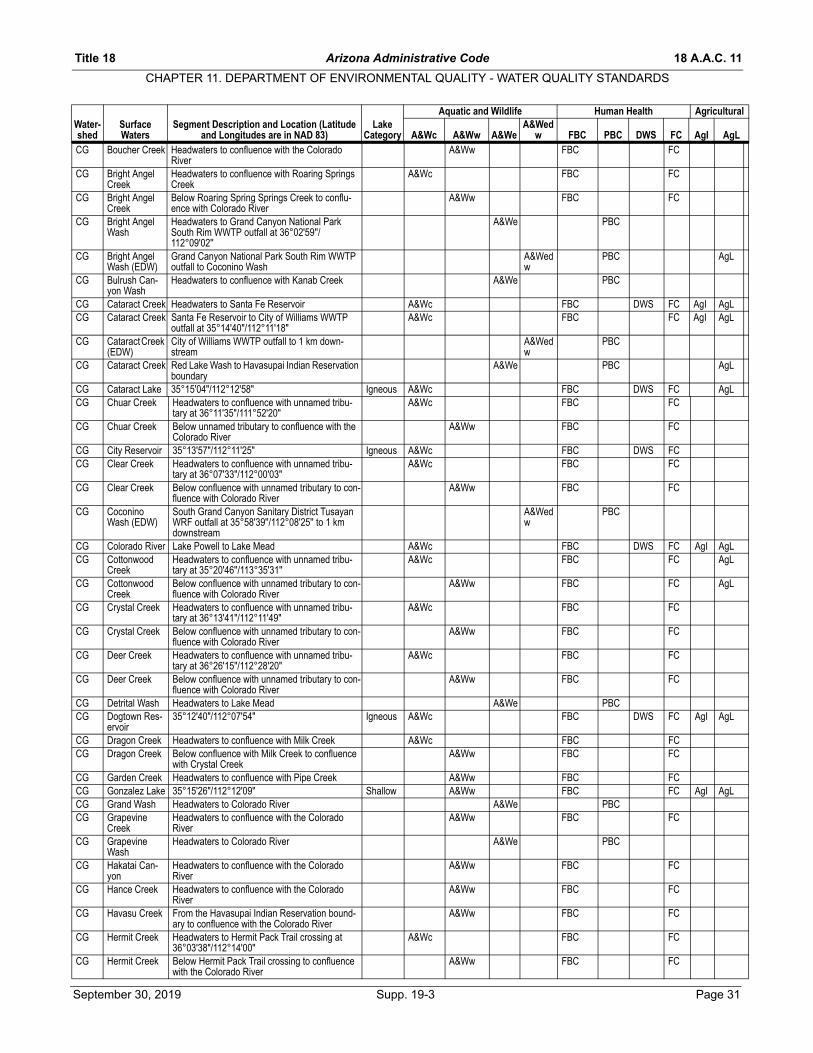
Title 18 Arizona Administrative Code 18 A.A.C. 11
CHAPTER 11. DEPARTMENT OF ENVIRONMENTAL QUALITY - WATER QUALITY STANDARDS
Water- Surface Segment Description and Location (Latitude LakeAquatic and Wildlife Human Health Agricultural
A&Wed
CG Boucher Creek Headwaters to confluence with the Colorado River
A&Ww FBC FC
CG Bright Angel Creek
Headwaters to confluence with Roaring Springs Creek
A&Wc FBC FC
CG Bright Angel Creek
Below Roaring Spring Springs Creek to conflu-ence with Colorado River
A&Ww FBC FC
CG Bright Angel Wash
Headwaters to Grand Canyon National Park South Rim WWTP outfall at 36°02'59''/112°09'02''
A&We PBC
CG Bright Angel Wash (EDW)
Grand Canyon National Park South Rim WWTP outfall to Coconino Wash
A&Wedw
PBC AgL
CG Bulrush Can-yon Wash
Headwaters to confluence with Kanab Creek A&We PBC
CG Cataract Creek Headwaters to Santa Fe Reservoir A&Wc FBC DWS FC AgI AgLCG Cataract Creek Santa Fe Reservoir to City of Williams WWTP
outfall at 35°14'40"/112°11'18"A&Wc FBC FC AgI AgL
CG Cataract Creek (EDW)
City of Williams WWTP outfall to 1 km down-stream
A&Wedw
PBC
CG Cataract Creek Red Lake Wash to Havasupai Indian Reservation boundary
A&We PBC AgL
CG Cataract Lake 35°15'04"/112°12'58" Igneous A&Wc FBC DWS FC AgLCG Chuar Creek Headwaters to confluence with unnamed tribu-
tary at 36°11'35"/111°52'20"A&Wc FBC FC
CG Chuar Creek Below unnamed tributary to confluence with the Colorado River
A&Ww FBC FC
CG City Reservoir 35°13'57"/112°11'25" Igneous A&Wc FBC DWS FCCG Clear Creek Headwaters to confluence with unnamed tribu-
tary at 36°07'33"/112°00'03"A&Wc FBC FC
CG Clear Creek Below confluence with unnamed tributary to con-fluence with Colorado River
A&Ww FBC FC
CG Coconino Wash (EDW)
South Grand Canyon Sanitary District Tusayan WRF outfall at 35°58'39''/112°08'25'' to 1 km downstream
A&Wedw
PBC
CG Colorado River Lake Powell to Lake Mead A&Wc FBC DWS FC AgI AgLCG Cottonwood
CreekHeadwaters to confluence with unnamed tribu-tary at 35°20'46''/113°35'31''
A&Wc FBC FC AgL
CG Cottonwood Creek
Below confluence with unnamed tributary to con-fluence with Colorado River
A&Ww FBC FC AgL
CG Crystal Creek Headwaters to confluence with unnamed tribu-tary at 36°13'41"/112°11'49"
A&Wc FBC FC
CG Crystal Creek Below confluence with unnamed tributary to con-fluence with Colorado River
A&Ww FBC FC
CG Deer Creek Headwaters to confluence with unnamed tribu-tary at 36°26'15"/112°28'20"
A&Wc FBC FC
CG Deer Creek Below confluence with unnamed tributary to con-fluence with Colorado River
A&Ww FBC FC
CG Detrital Wash Headwaters to Lake Mead A&We PBCCG Dogtown Res-
ervoir35°12'40"/112°07'54" Igneous A&Wc FBC DWS FC AgI AgL
CG Dragon Creek Headwaters to confluence with Milk Creek A&Wc FBC FCCG Dragon Creek Below confluence with Milk Creek to confluence
with Crystal CreekA&Ww FBC FC
CG Garden Creek Headwaters to confluence with Pipe Creek A&Ww FBC FCCG Gonzalez Lake 35°15'26"/112°12'09" Shallow A&Ww FBC FC AgI AgLCG Grand Wash Headwaters to Colorado River A&We PBCCG Grapevine
CreekHeadwaters to confluence with the Colorado River
A&Ww FBC FC
CG Grapevine Wash
Headwaters to Colorado River A&We PBC
CG Hakatai Can-yon
Headwaters to confluence with the Colorado River
A&Ww FBC FC
CG Hance Creek Headwaters to confluence with the Colorado River
A&Ww FBC FC
CG Havasu Creek From the Havasupai Indian Reservation bound-ary to confluence with the Colorado River
A&Ww FBC FC
CG Hermit Creek Headwaters to Hermit Pack Trail crossing at 36°03'38"/112°14'00"
A&Wc FBC FC
CG Hermit Creek Below Hermit Pack Trail crossing to confluence with the Colorado River
A&Ww FBC FC
shed Waters and Longitudes are in NAD 83) Category A&Wc A&Ww A&We w FBC PBC DWS FC AgI AgL
September 30, 2019 Supp. 19-3 Page 31

18 A.A.C. 11 Arizona Administrative Code Title 18
CHAPTER 11. DEPARTMENT OF ENVIRONMENTAL QUALITY - WATER QUALITY STANDARDS
Water- Surface Segment Description and Location (Latitude LakeAquatic and Wildlife Human Health Agricultural
A&Wed
Page 32 Supp. 19-3 September 30, 2019
CG Horn Creek Headwaters to confluence with the Colorado River
A&Ww FBC FC
CG Hualapai Wash Headwaters to Lake Mead A&We PBCCG Jacob Lake 36°42'27"/112°13'50" Sedi-
mentaryA&Wc FBC FC
CG Kaibab Lake 35°17'04"/112°09'32" Igneous A&Wc FBC DWS FC AgI AgLCG Kanab Creek Headwaters to confluence with the Colorado
RiverA&Ww FBC DWS FC AgL
CG Kwagunt Creek Headwaters to confluence with unnamed tribu-tary at 36°13'37"/111°54'50"
A&Wc FBC FC
CG Kwagunt Creek Below confluence with unnamed tributary to con-fluence with the Colorado River
A&Ww FBC FC
CG Lake Mead 36°06'18"/114°26'33" Deep A&Wc FBC DWS FC AgI AgLCG Lake Powell 36°59'53"/111°08'17" Deep A&Wc FBC DWS FC AgI AgLCG Lonetree Can-
yon CreekHeadwaters to confluence with the Colorado River
A&Ww FBC FC
CG Matkatamiba Creek
Below Havasupai Indian Reservation boundary to confluence with the Colorado River
A&Ww FBC FC
CG Monument Creek
Headwaters to confluence with the Colorado River
A&Ww FBC FC
CG Nankoweap Creek
Headwaters to confluence with unnamed tribu-tary at 36°15'29"/111°57'26"
A&Wc FBC FC
CG Nankoweap Creek
Below confluence with unnamed tributary to con-fluence with Colorado River
A&Ww FBC FC
CG National Can-yon Creek
Headwaters to Hualapai Indian Reservation boundary at 36°15'15"/112°52'34"
A&Ww FBC FC
CG North Canyon Creek
Headwaters to confluence with unnamed tribu-tary at 36°33'58"/111°55'41"
A&Wc FBC FC
CG North Canyon Creek
Below confluence with unnamed tributary to con-fluence with Colorado River
A&Ww FBC FC
CG Olo Canyon Headwaters to confluence with the Colorado River
A&Ww FBC FC
CG Parashant Canyon
Headwaters to confluence with unnamed tribu-tary at 36°21'02"/113°27'56"
A&Wc FBC FC
CG Parashant Canyon
Below confluence with unnamed tributary to con-fluence with the Colorado River
A&Ww FBC FC
CG Paria River Utah border to confluence with the Colorado River
A&Ww FBC FC
CG Phantom Creek
Headwaters to confluence with unnamed tribu-tary at 36°09'29"/112°08'13"
A&Wc FBC FC
CG Phantom Creek
Below confluence with unnamed tributary to con-fluence with Bright Angel Creek
A&Ww FBC FC
CG Pipe Creek Headwaters to confluence with the Colorado River
A&Ww FBC FC
CG Red Canyon Creek
Headwaters to confluence with the Colorado River '
A&Ww FBC FC
CG Red Lake 35°40'03"/114°04'07" A&Ww FBC FC AgLCG Roaring
Springs36°11'45"/112°02'06" A&Wc FBC DWS FC
CG Roaring Springs Creek
Headwaters to confluence with Bright Angel Creek
A&Wc FBC FC
CG Rock Canyon Headwaters to confluence with Truxton Wash A&We PBCCG Royal Arch
CreekHeadwaters to confluence with the Colorado River
A&Ww FBC FC
CG Ruby Canyon Headwaters to confluence with the Colorado River
A&Ww FBC FC
CG Russell Tank 35°52'21"/111°52'45" A&Wc FBC FC AgLCG Saddle Can-
yon CreekHeadwaters to confluence with unnamed tribu-tary at 36°21'36"/112°22'43"
A&Wc FBC FC
CG Saddle Can-yon Creek
Below confluence with unnamed tributary to con-fluence with Colorado River
A&Ww FBC FC
CG Santa Fe Res-ervoir
35°14'31"/112°11'10" Igneous A&Wc FBC DWS FC
CG Sapphire Can-yon
Headwaters to confluence with the Colorado River
A&Ww FBC FC
CG Serpentine Canyon
Headwaters to confluence with the Colorado River
A&Ww FBC FC
CG Shinumo Creek Headwaters to confluence with unnamed tribu-tary at 36°18'18"/112°18'07"
A&Wc FBC FC
shed Waters and Longitudes are in NAD 83) Category A&Wc A&Ww A&We w FBC PBC DWS FC AgI AgL
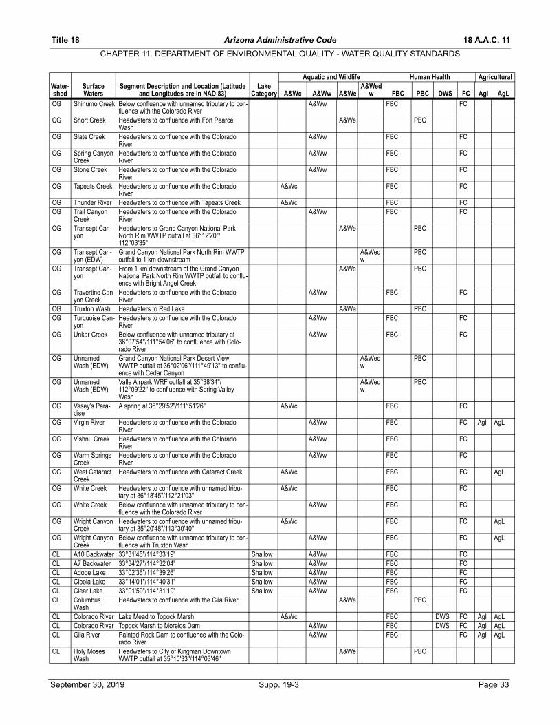
Title 18 Arizona Administrative Code 18 A.A.C. 11
CHAPTER 11. DEPARTMENT OF ENVIRONMENTAL QUALITY - WATER QUALITY STANDARDS
Water- Surface Segment Description and Location (Latitude LakeAquatic and Wildlife Human Health Agricultural
A&Wed
CG Shinumo Creek Below confluence with unnamed tributary to con-fluence with the Colorado River
A&Ww FBC FC
CG Short Creek Headwaters to confluence with Fort Pearce Wash
A&We PBC
CG Slate Creek Headwaters to confluence with the Colorado River
A&Ww FBC FC
CG Spring Canyon Creek
Headwaters to confluence with the Colorado River
A&Ww FBC FC
CG Stone Creek Headwaters to confluence with the Colorado River
A&Ww FBC FC
CG Tapeats Creek Headwaters to confluence with the Colorado River
A&Wc FBC FC
CG Thunder River Headwaters to confluence with Tapeats Creek A&Wc FBC FCCG Trail Canyon
CreekHeadwaters to confluence with the Colorado River
A&Ww FBC FC
CG Transept Can-yon
Headwaters to Grand Canyon National Park North Rim WWTP outfall at 36°12'20"/112°03'35"
A&We PBC
CG Transept Can-yon (EDW)
Grand Canyon National Park North Rim WWTP outfall to 1 km downstream
A&Wedw
PBC
CG Transept Can-yon
From 1 km downstream of the Grand Canyon National Park North Rim WWTP outfall to conflu-ence with Bright Angel Creek
A&We PBC
CG Travertine Can-yon Creek
Headwaters to confluence with the Colorado River
A&Ww FBC FC
CG Truxton Wash Headwaters to Red Lake A&We PBCCG Turquoise Can-
yon Headwaters to confluence with the Colorado River
A&Ww FBC FC
CG Unkar Creek Below confluence with unnamed tributary at 36°07'54''/111°54'06'' to confluence with Colo-rado River
A&Ww FBC FC
CG Unnamed Wash (EDW)
Grand Canyon National Park Desert View WWTP outfall at 36°02'06''/111°49'13'' to conflu-ence with Cedar Canyon
A&Wedw
PBC
CG Unnamed Wash (EDW)
Valle Airpark WRF outfall at 35°38'34''/112°09'22'' to confluence with Spring Valley Wash
A&Wedw
PBC
CG Vasey’s Para-dise
A spring at 36°29'52"/111°51'26" A&Wc FBC FC
CG Virgin River Headwaters to confluence with the Colorado River
A&Ww FBC FC AgI AgL
CG Vishnu Creek Headwaters to confluence with the Colorado River
A&Ww FBC FC
CG Warm Springs Creek
Headwaters to confluence with the Colorado River
A&Ww FBC FC
CG West Cataract Creek
Headwaters to confluence with Cataract Creek A&Wc FBC FC AgL
CG White Creek Headwaters to confluence with unnamed tribu-tary at 36°18'45"/112°21'03"
A&Wc FBC FC
CG White Creek Below confluence with unnamed tributary to con-fluence with the Colorado River
A&Ww FBC FC
CG Wright Canyon Creek
Headwaters to confluence with unnamed tribu-tary at 35°20'48"/113°30'40"
A&Wc FBC FC AgL
CG Wright Canyon Creek
Below confluence with unnamed tributary to con-fluence with Truxton Wash
A&Ww FBC FC AgL
CL A10 Backwater 33°31'45"/114°33'19" Shallow A&Ww FBC FCCL A7 Backwater 33°34'27"/114°32'04" Shallow A&Ww FBC FCCL Adobe Lake 33°02'36"/114°39'26" Shallow A&Ww FBC FCCL Cibola Lake 33°14'01"/114°40'31" Shallow A&Ww FBC FCCL Clear Lake 33°01'59"/114°31'19" Shallow A&Ww FBC FCCL Columbus
WashHeadwaters to confluence with the Gila River A&We PBC
CL Colorado River Lake Mead to Topock Marsh A&Wc FBC DWS FC AgI AgLCL Colorado River Topock Marsh to Morelos Dam A&Ww FBC DWS FC AgI AgLCL Gila River Painted Rock Dam to confluence with the Colo-
rado RiverA&Ww FBC FC AgI AgL
CL Holy Moses Wash
Headwaters to City of Kingman Downtown WWTP outfall at 35°10'33''/114°03'46''
A&We PBC
shed Waters and Longitudes are in NAD 83) Category A&Wc A&Ww A&We w FBC PBC DWS FC AgI AgL
September 30, 2019 Supp. 19-3 Page 33

18 A.A.C. 11 Arizona Administrative Code Title 18
CHAPTER 11. DEPARTMENT OF ENVIRONMENTAL QUALITY - WATER QUALITY STANDARDS
Water- Segment Description and Location (Latitude LakeAquatic and Wildlife Human Health Agricultural
A&Wed
CL Holy Moses Wash (EDW)
City of Kingman Downtown WWTP outfall to 3 km downstream
A&Wedw
PBC
CL Holy Moses Wash
From 3 km downstream of City of Kingman Downtown WWTP outfall to confluence with Sawmill Wash
A&We PBC
CL Hunter’s Hole Backwater
32°31'13"/114°48'07" Shallow A&Ww FBC FC AgL
CL Imperial Reser-voir
32°53'02"/114°27'54" Shallow A&Ww FBC DWS FC AgI AgL
CL Island Lake 33°01'44"/114°36'42" Shallow A&Ww FBC FCCL Laguna Reser-
voir32°51'35"/114°28'29" Shallow A&Ww FBC DWS FC AgI AgL
CL Lake Havasu 34°35'18"/114°25'47" Deep A&Ww FBC DWS FC AgI AgLCL Lake Mohave 35°26'58"/114°38'30" Deep A&Wc FBC DWS FC AgI AgLCL Martinez Lake 32°58'49"/114°28'09" Shallow A&Ww FBC FC AgI AgLCL Mittry Lake 32°49'17"/114°27'54" Shallow A&Ww FBC FCCL Mohave Wash Headwaters to Lower Colorado River A&We PBCCL Nortons Lake 33°02'30"/114°37'59" Shallow A&Ww FBC FCCL Painted Rock
(Borrow Pit) Lake
33°04'55"/113°01'17" Sedi-mentary
A&Ww FBC FC AgI AgL
CL Pretty Water Lake
33°19'51''/114°42'19'' Shallow A&Ww FBC FC
CL Quigley Pond 32°43'40"/113°57'44" Shallow A&Ww FBC FCCL Redondo Lake 32°44'32''/114°29'03'' Shallow A&Ww FBC FCCL Sacramento
WashHeadwaters to Topock Marsh A&We PBC
CL Sawmill Can-yon
Headwaters to abandoned gaging station at 35°09'45"/113°57'56"
A&Ww FBC FC AgL
CL Sawmill Can-yon
Below abandoned gaging station to confluence with Holy Moses Wash
A&We PBC AgL
CL Topock Marsh 34°43'27"/114°28'59" Shallow A&Ww FBC DWS FC AgI AgLCL Tyson Wash
(EDW)Town of Quartzsite WWTP outfall at 33°42'39"/ 114°13'10" to 1 km downstream
A&Wedw
PBC
CL Wellton Canal Wellton-Mohawk Irrigation District DWS AgI AgLCL Wellton Ponds 32°40'32''/114°00'26'' A&Ww FBC FCCL Yuma Proving
Ground Pond32°50'58"/114°26'14" A&Ww FBC FC
CL Yuma Area Canals
Above municipal water treatment plant intakes DWS AgI AgL
CL Yuma Area Canals
Below municipal water treatment plant intakes and all drains
AgI AgL
LC Als Lake 35°02'10"/111°25'17" Igneous A&Ww FBC FC AgLLC Ashurst Lake 35°01'06"/111°24'18" Igneous A&Wc FBC FC AgI AgLLC Atcheson Res-
ervoir33°59'59"/109°20'43" Igneous A&Ww FBC FC AgI AgL
LC Auger Creek Headwaters to confluence with Nutrioso Creek A&Wc FBC FC AgLLC Barbershop
Canyon CreekHeadwaters to confluence with East Clear Creek A&Wc FBC FC AgL
LC Bear Canyon Creek
Headwaters to confluence with General Springs Canyon
A&Wc FBC FC AgL
LC Bear Canyon Creek
Headwaters to confluence with Willow Creek A&Wc FBC FC AgL
LC Bear Canyon Lake
34°24'00"/111°00'06" Sedi-mentary
A&Wc FBC FC AgI AgL
LC Becker Lake 34°09'11"/109°18'23" Shallow A&Wc FBC FC AgLLC Billy Creek Headwaters to confluence with Show Low Creek A&Wc FBC FC AgLLC Black Canyon Headwaters to confluence with Chevelon Creek A&Wc FBC FC AgI AgLLC Black Canyon
Lake34°20'32"/110°40'13" Sedi-
mentaryA&Wc FBC DWS FC AgI AgL
LC Boot Lake 34°58'54"/111°20'11" Igneous A&Wc FBC FC AgLLC Bow and Arrow
WashHeadwaters to confluence with Rio de Flag A&We PBC
LC Buck Springs Canyon Creek
Headwaters to confluence with Leonard Canyon Creek
A&Wc FBC FC AgL
LC Bunch Reser-voir
34°02'20"/109°26'48" Igneous A&Wc FBC FC AgI AgL
shed Surface Waters and Longitudes are in NAD 83) Category A&Wc A&Ww A&We w FBC PBC DWS FC AgI AgL
Page 34 Supp. 19-3 September 30, 2019

Title 18 Arizona Administrative Code 18 A.A.C. 11
CHAPTER 11. DEPARTMENT OF ENVIRONMENTAL QUALITY - WATER QUALITY STANDARDS
Water- Surface Segment Description and Location (Latitude LakeAquatic and Wildlife Human Health Agricultural
A&Wed
LC Camillo Tank 34°55'03"/111°22'40" Igneous A&Ww FBC FC AgLLC Carnero Lake 34°06'57"/109°31'42" Shallow A&Wc FBC FC AgLLC Chevelon Can-
yon Lake34°29'18"/110°49'30" Sedi-
mentaryA&Wc FBC FC AgI AgL
LC Chevelon Creek
Headwaters to confluence with the Little Colo-rado River
A&Wc FBC FC AgI AgL
LC Chevelon Creek, West Fork
Headwaters to confluence with Chevelon Creek A&Wc FBC FC AgL
LC Chilson Tank 34°51'43"/111°22'54" Igneous A&Ww FBC FC AgLLC Clear Creek Headwaters to confluence with the Little Colo-
rado RiverA&Wc FBC DWS FC AgL
LC Clear Creek Reservoir
34°57'09"/110°39'14" Shallow A&Wc FBC DWS FC AgI AgL
LC Coconino Res-ervoir
35°00'05"/111°24'10" Igneous A&Wc FBC FC AgI AgL
LC Colter Creek Headwaters to confluence with Nutrioso Creek A&Wc FBC FC AgLLC Colter Reser-
voir33°56'39"/109°28'53" Shallow A&Wc FBC FC AgL
LC Concho Creek Headwaters to confluence with Carrizo Wash A&Wc FBC FC AgLLC Concho Lake 34°26'37"/109°37'40" Shallow A&Wc FBC FC AgI AgLLC Cow Lake 34°53'14"/111°18'51" Igneous A&Ww FBC FC AgLLC Coyote Creek Headwaters to confluence with the Little Colo-
rado RiverA&Wc FBC FC AgI AgL
LC Cragin Reser-voir (formerly Blue Ridge Reservoir)
34°32'40"/111°11'33" Deep A&Wc FBC FC AgI AgL
LC Crisis Lake (Snake Tank #2)
34°47'51"/111°17'32" A&Ww FBC FC AgL
LC Dane Canyon Creek
Headwaters to confluence with Barbershop Can-yon Creek
A&Wc FBC FC AgL
LC Daves Tank 34°44'22"/111°17'15" A&Ww FBC FC AgLLC Deep Lake 35°03'34"/111°25'00" Igneous A&Ww FBC FC AgLLC Dry Lake
(EDW)34°38'02"/110°23'40" EDW A&Wed
wPBC
LC Ducksnest Lake
34°59'14"/111°23'57" A&Ww FBC FC AgL
LC East Clear Creek
Headwaters to confluence with Clear Creek A&Wc FBC FC AgI AgL
LC Ellis Wiltbank Reservoir
34°05'25"/109°28'25" Igneous A&Ww FBC FC AgI AgL
LC Estates at Pine Canyon lakes (EDW)
35°09'32"/111°38'26" EDW A&Wedw
PBC
LC Fish Creek Headwaters to confluence with the Little Colo-rado River
A&Wc FBC FC AgL
LC Fool’s Hollow Lake
34°16'30"/110°03'43" Igneous A&Wc FBC FC AgL
LC General Springs Can-yon Creek
Headwaters to confluence with East Clear Creek A&Wc FBC FC AgL
LC Geneva Reser-voir
34°01'45"/109°31'46" Igneous A&Ww FBC FC AgL
LC Hall Creek Headwaters to confluence with the Little Colo-rado River
A&Wc FBC FC AgI AgL
LC Hart Canyon Creek
Headwaters to confluence with Willow Creek A&Wc FBC FC AgL
LC Hay Lake 34°00'11"/109°25'57" Igneous A&Wc FBC FC AgLLC Hog Wallow
Lake33°58'57"/109°25'39" Igneous A&Wc FBC FC AgI AgL
LC Horse Lake 35°03'55"/111°27'50" A&Ww FBC FC AgLLC Hulsey Creek Headwaters to confluence with Nutrioso Creek A&Wc FBC FC AgLLC Hulsey Lake 33°55'58"/109°09'40" Sedi-
mentaryA&Wc FBC FC AgL
LC Indian Lake 35°00'39"/111°22'41" A&Ww FBC FC AgLLC Jacks Canyon
CreekHeadwaters to confluence with the Little Colo-rado River
A&Wc FBC FC AgI AgL
shed Waters and Longitudes are in NAD 83) Category A&Wc A&Ww A&We w FBC PBC DWS FC AgI AgL
September 30, 2019 Supp. 19-3 Page 35

18 A.A.C. 11 Arizona Administrative Code Title 18
CHAPTER 11. DEPARTMENT OF ENVIRONMENTAL QUALITY - WATER QUALITY STANDARDS
Water- Surface Segment Description and Location (Latitude LakeAquatic and Wildlife Human Health Agricultural
A&Wed
LC Jarvis Lake 33°58'59"/109°12'36" Sedi-mentary
A&Ww FBC FC AgL
LC Kinnikinick Lake
34°53'53"/111°18'18" Igneous A&Wc FBC FC AgL
LC Knoll Lake 34°25'38"/111°05'13" Sedi-mentary
A&Wc FBC FC AgL
LC Lake Hum-phreys (EDW)
35°11'51"/111°35'19" EDW A&Wedw
PBC
LC Lake Mary, Lower
35°06'21"/111°34'38" Igneous A&Wc FBC DWS FC AgL
LC Lake Mary, Upper
35°03'23"/111°28'34" Igneous A&Wc FBC DWS FC AgL
LC Lake of the Woods
34°09'40"/109°58'47" Igneous A&Wc FBC FC AgI AgL
LC Lee Valley Creek (OAW)
Headwaters to Lee Valley Reservoir A&Wc FBC FC
LC Lee Valley Creek
From Lee Valley Reservoir to confluence with the East Fork of the Little Colorado River
A&Wc FBC FC AgL
LC Lee Valley Reservoir
33°56'29"/109°30'04" Igneous A&Wc FBC FC AgI AgL
LC Leonard Can-yon Creek
Headwaters to confluence with Clear Creek A&Wc FBC FC AgL
LC Leonard Can-yon Creek, East Fork
Headwaters to confluence with Leonard Canyon Creek
A&Wc FBC FC AgL
LC Leonard Can-yon Creek, Middle Fork
Headwaters to confluence with Leonard Canyon, West Fork
A&Wc FBC FCAgL
LC Leonard Can-yon Creek, West Fork
Headwaters to confluence with Leonard Canyon, East Fork
A&Wc FBC FC AgL
LC Lily Creek Headwaters to confluence with Coyote Creek A&Wc FBC FC AgLLC Little Colorado
RiverHeadwaters to Lyman Reservoir A&Wc FBC FC AgI AgL
LC Little Colorado River
Below Lyman Reservoir to confluence with the Puerco River
A&Wc FBC DWS FC AgI AgL
LC Little Colorado River
Below Puerco River confluence to the Colorado River, excluding segments on Native American Lands
A&Ww FBC DWS FC AgI AgL
LC Little Colorado River, East Fork
Headwaters to confluence with the Little Colo-rado River
A&Wc FBC FC AgL
LC Little Colorado River, South Fork
Headwaters to confluence with the Little Colo-rado River
A&Wc FBC FC AgL
LC Little Colorado River, West Fork (OAW)
Headwaters to Government Springs A&Wc FBC FC
LC Little Colorado River, West Fork
Below Government Springs to confluence with the Little Colorado River
A&Wc FBC FC AgL
LC Little George Reservoir
34°00'37''/109°19'15'' Igneous A&Ww FBC FC AgI
LC Little Mormon Lake
34°17'00"/109°58'06" Igneous A&Ww FBC FC AgI AgL
LC Little Ortega Lake
34°22'47"/109°40'06" Igneous A&Wc FBC FC
LC Long Lake, Lower
34°47'16"/111°12'40" Igneous A&Wc FBC FC AgI AgL
LC Long Lake, Upper
35°00'08"/111°21'23" Igneous A&Wc FBC FC AgL
LC Long Tom Tank 34°20'35"/110°49'22" A&Wc FBC FC AgLLC Lower Walnut
Canyon Lake (EDW)
35°12'04''/111°34'07'' EDW A&Wedw
PBC
LC Lyman Reser-voir
34°21'21"/109°21'35" Deep A&Wc FBC FC AgI AgL
LC Mamie Creek Headwaters to confluence with Coyote Creek A&Wc FBC FC AgLLC Marshall Lake 35°07'18"/111°32'07" Igneous A&Wc FBC FC AgL
shed Waters and Longitudes are in NAD 83) Category A&Wc A&Ww A&We w FBC PBC DWS FC AgI AgL
Page 36 Supp. 19-3 September 30, 2019

Title 18 Arizona Administrative Code 18 A.A.C. 11
CHAPTER 11. DEPARTMENT OF ENVIRONMENTAL QUALITY - WATER QUALITY STANDARDS
Water- Surface Segment Description and Location (Latitude LakeAquatic and Wildlife Human Health Agricultural
A&Wed
LC McKay Reser-voir
34°01'27"/109°13'48" A&Wc FBC FC AgI AgL
LC Merritt Draw Creek
Headwaters to confluence with Barbershop Can-yon Creek
A&Wc FBC FC AgL
LC Mexican Hay Lake
34°01'58"/109°21'25" Igneous A&Wc FBC FC AgI AgL
LC Milk Creek Headwaters to confluence with Hulsey Creek A&Wc FBC FC AgLLC Miller Canyon
CreekHeadwaters to confluence with East Clear Creek A&Wc FBC FC AgL
LC Miller Canyon Creek, East Fork
Headwaters to confluence with Miller Canyon Creek
A&Wc FBC FC AgL
LC Mineral Creek Headwaters to Little Ortega Lake A&Wc FBC FC AgI AgLLC Mormon Lake 34°56'38"/111°27'25" Shallow A&Wc FBC DWS FC AgI AgLLC Morton Lake 34°53'37"/111°17'41" Igneous A&Wc FBC FC AgLLC Mud Lake 34°55'19"/111°21'29" Shallow A&Ww FBC FC AgLLC Ned Lake
(EDW)34°17'17"/110°03'22" EDW A&Wed
wPBC
LC Nelson Reser-voir
34°02'52"/109°11'19" Sedi-mentary
A&Wc FBC FC AgI AgL
LC Norton Reser-voir
34°03'57"/109°31'27" Igneous A&Ww FBC FC AgL
LC Nutrioso Creek Headwaters to confluence with the Little Colo-rado River
A&Wc FBC FC AgI AgL
LC Paddy Creek Headwaters to confluence with Nutrioso Creek A&Wc FBC FC AgLLC Phoenix Park
WashHeadwaters to Dry Lake A&We PBC
LC Pierce Seep 34°23'39"/110°31'17" A&Wc PBCLC Pine Tank 34°46'49"/111°17'21" Igneous A&Ww FBC FC AgLLC Pintail Lake
(EDW)34°18'05"/110°01'21" EDW A&Wed
wPBC
LC Porter Creek Headwaters to confluence with Show Low Creek A&Wc FBC FC AgLLC Potato Lake 35°03'15"/111°24'13" Igneous A&Wc FBC FC AgLLC Pratt Lake 34°01'32"/109°04'18" Sedi-
mentaryA&Wc FBC FC
LC Puerco River Headwaters to confluence with the Little Colo-rado River
A&Ww FBC DWS FC AgI AgL
LC Puerco River (EDW)
Sanders Unified School District WWTP outfall at 35°12'52''/109°19'40'' to 0.5 km downstream
A&Wedw
PBC
LC Rainbow Lake 34°09'00"/109°59'09" Shallow Igneous
A&Wc FBC FC AgI AgL
LC Reagan Reser-voir
34°02'09"/109°08'41" Igneous A&Ww FBC FC AgL
LC Rio de Flag Headwaters to City of Flagstaff WWTP outfall at 35°12'21''/111°39'17''
A&We PBC
LC Rio de Flag (EDW)
From City of Flagstaff WWTP outfall to the con-fluence with San Francisco Wash
A&Wedw
PBC
LC River Reservoir 34°02'01''/109°26'07'' Igneous A&Wc FBC FC AgI AgLLC Rogers Reser-
voir33°56'30"/109°16'20" Igneous A&Ww FBC FC AgL
LC Rudd Creek Headwaters to confluence with Nutrioso Creek A&Wc FBC FC AgLLC Russel Reser-
voir33°59'29"/109°20'01" Igneous A&Ww FBC FC AgI AgL
LC San Salvador Reservoir
33°58'51"/109°19'55" Igneous A&Wc FBC FC AgI AgL
LC Scott Reservoir 34°10'31"/109°57'31" Igneous A&Wc FBC FC AgI AgLLC Show Low
CreekHeadwaters to confluence with Silver Creek A&Wc FBC FC AgI AgL
LC Show Low Lake
34°11'36"/110°00'12" Igneous A&Wc FBC FC AgI AgL
LC Silver Creek Headwaters to confluence with the Little Colo-rado River
A&Wc FBC FC AgI AgL
LC Slade Reser-voir
33°59'41"/109°20'26" Igneous A&Ww FBC FC AgI AgL
LC Soldiers Annex Lake
34°47'15"/111°13'51" Igneous A&Wc FBC FC AgI AgL
LC Soldiers Lake 34°47'47"/111°14'04" Igneous A&Wc FBC FC AgI AgLLC Spaulding Tank 34°30'17"/111°02'06" A&Ww FBC FC AgL
shed Waters and Longitudes are in NAD 83) Category A&Wc A&Ww A&We w FBC PBC DWS FC AgI AgL
September 30, 2019 Supp. 19-3 Page 37

18 A.A.C. 11 Arizona Administrative Code Title 18
CHAPTER 11. DEPARTMENT OF ENVIRONMENTAL QUALITY - WATER QUALITY STANDARDS
Water- Surface Segment Description and Location (Latitude LakeAquatic and Wildlife Human Health Agricultural
A&Wed
LC Sponseller Lake
34°14'09"/109°50'45" Igneous A&Wc FBC FC AgL
LC St Johns Res-ervoir (Little Reservoir)
34°29'10"/109°22'06" Igneous A&Ww FBC FC AgI AgL
LC Telephone Lake (EDW)
34°17'35"/110°02'42" EDW A&Wedw
PBC
LC Tremaine Lake 34°46'02"/111°13'51" Igneous A&Wc FBC FC AgLLC Tunnel Reser-
voir34°01'53"/109°26'34" Igneous A&Wc FBC FC AgI AgL
LC Turkey Draw (EDW)
High Country Pines II WWTP outfall at 33°25'35"/ 110°38'13" to confluence with Black Canyon Creek
A&Wedw
PBC
LC Unnamed Wash (EDW)
Bison Ranch WWTP outfall at 34°23'31"/110°31'29" to Pierce Seep
A&Wedw
PBC
LC Unnamed Wash (EDW)
Black Mesa Ranger Station WWTP outfall at 34°23'35"/110°33'36" to confluence of Oklahoma Flat Draw
A&Wedw
PBC
LC Vail Lake 35°05'23"/111°30'46" Igneous A&Wc FBC FC AgLLC Walnut Creek Headwaters to confluence with Billy Creek A&Wc FBC FC AgLLC Water Canyon
CreekHeadwaters to confluence with the Little Colo-rado River
A&Wc FBC FC AgL
LC Water Canyon Reservoir
34°00'16"/109°20'05" Igneous A&Ww FBC FC AgI AgL
LC Whale Lake (EDW)
35°11'13"/111°35'21" EDW A&Wedw
PBC
LC Whipple Lake '34°16'49"/109°58'29" Igneous A&Ww FBC FC AgLLC White Moun-
tain Lake34°21'57"/109°59'21" Igneous A&Wc FBC FC AgI AgL
LC White Moun-tain Reservoir
34°00'12"/109°30'39" Igneous A&Wc FBC FC AgI AgL
LC Willow Creek Headwaters to confluence with Clear Creek A&Wc FBC FC AgLLC Willow Springs
Canyon CreekHeadwaters to confluence with Chevelon Creek A&Wc FBC FC AgL
LC Willow Springs Lake
34°18'13"/110°52'16" Sedi-mentary
A&Wc FBC FC AgI AgL
LC Woodland Res-ervoir
34°07'35"/109°57'01" Igneous A&Wc FBC FC AgI AgL
LC Woods Can-yon Creek
Headwaters to confluence with Chevelon Creek A&Wc FBC FC AgL
LC Woods Can-yon Lake
34°20'09"/110°56'45" Sedi-mentary
A&Wc FBC FC AgI AgL
LC Zuni River Headwaters to confluence with the Little Colo-rado River
A&Wc FBC FC AgI AgL
MG Agua Fria River
Headwaters to confluence with unnamed tribu-tary at 34°35'14''/112°16'18''
A&We PBC AgL
MG Agua Fria River (EDW)
Below confluence with unnamed tributary to State Route 169
A&Wedw
PBC AgL
MG Agua Fria River
From State Route 169 to Lake Pleasant A&Ww FBC DWS FC AgI AgL
MG Agua Fria River
Below Lake Pleasant to the City of El Mirage WWTP at ' 33°34'20"/112°18'32"
A&We PBC AgL
MG Agua Fria River (EDW)
From City of El Mirage WWTP outfall to 2 km downstream
A&Wedw
PBC
MG Agua Fria River
Below 2 km downstream of the City of El Mirage WWTP to City of Avondale WWTP outfall at 33°23'55"/112°21'16"
A&We PBC
MG Agua Fria River
From City of Avondale WWTP outfall to conflu-ence with Gila River
A&Wedw
PBC
MG Alvord Park Lake
35th Avenue & Baseline Road, Phoenix at 33°22'23"/ 112°08'20"
Urban A&Ww PBC FC
MG Andorra Wash Headwaters to confluence with Cave Creek Wash
A&We PBC
MG Antelope Creek Headwaters to confluence with Martinez Wash A&Ww FBC FC AgLMG Arlington Canal From Gila River at 33°20'54''/112°35'39'' to Gila
River at 33°13'44''/112°46'15''AgL
MG Ash Creek Headwaters to confluence with Tex Canyon A&Wc FBC FC AgI AgLMG Ash Creek Below confluence with Tex Canyon to confluence
with Agua Fria RiverA&Ww FBC FC AgI AgL
shed Waters and Longitudes are in NAD 83) Category A&Wc A&Ww A&We w FBC PBC DWS FC AgI AgL
Page 38 Supp. 19-3 September 30, 2019

Title 18 Arizona Administrative Code 18 A.A.C. 11
CHAPTER 11. DEPARTMENT OF ENVIRONMENTAL QUALITY - WATER QUALITY STANDARDS
Water- Surface Segment Description and Location (Latitude LakeAquatic and Wildlife Human Health Agricultural
A&Wed
MG Beehive Tank 32°52'37"/111°02'20" A&Ww FBC FC AgLMG Big Bug Creek Headwaters to confluence with Eugene Gulch A&Wc FBC FC AgI AgLMG Big Bug Creek Below confluence with Eugene Gulch to conflu-
ence with Agua Fria RiverA&Ww FBC FC AgI AgL
MG Black Canyon Creek
Headwaters to confluence with the Agua Fria River
A&Ww FBC FC AgL
MG Blind Indian Creek
Headwaters to confluence with the Hassayampa River
A&Ww FBC FC AgL
MG Bonsall Park Lake
59th Avenue & Bethany Home Road, Phoenix at 33°31'24"/112°11'08"
Urban A&Ww PBC FC
MG Canal Park Lake
College Avenue & Curry Road, Tempe at 33°26'54"/ 111°56'19"
Urban A&Ww PBC FC
MG Cave Creek Headwaters to the Cave Creek Dam A&Ww FBC FC AgLMG Cave Creek Cave Creek Dam to the Arizona Canal A&We PBCMG Centennial
WashHeadwaters to confluence with the Gila River at 33°16'32"/112°48'08"
A&We PBC AgL
MG Centennial Wash Ponds
33°54'52"/113°23'47" A&Ww FBC FC AgL
MG Chaparral Park Lake
Hayden Road & Chaparral Road, Scottsdale at 33°30'40"/111°54'27"
Urban A&Ww PBC FC AgI
MG Cortez Park Lake
35th Avenue & Dunlap, Glendale at 33°34'13"/ 112°07'52"
Urban A&Ww PBC FC AgI
MG Desert Breeze Lake
Galaxy Drive, West Chandler at 33°18'47"/ 111°55'10"
Urban A&Ww PBC FC
MG Devils Canyon Headwaters to confluence with Mineral Creek A&Ww FBC FC AgLMG Dobson Lake Dobson Road & Los Lagos Vista Avenue, Mesa
at 33°22'48"/111°52'35"Urban A&Ww PBC FC
MG East Maricopa Floodway
From Brown and Greenfield Rds to the Gila River Indian Reservation Boundary
A&We PBS AgL
MG Eldorado Park Lake
Miller Road & Oak Street, Tempe at 33°28'25"/ 111°54'53"
Urban A&Ww PBC FC
MG Encanto Park Lake
15th Avenue & Encanto Blvd., Phoenix at 33°28'28"/ 112°05'18"
Urban A&Ww PBC FC AgI
MG Fain Lake Town of Prescott Valley Park Lake 34°34'29"/ 112°21'06"
Urban A&Ww PBC FC
MG French Gulch Headwaters to confluence with Hassayampa River
A&Ww PBC AgL
MG Galena Gulch Headwaters to confluence with the Agua Fria River
A&We PBC AgL
MG Galloway Wash (EDW)
Town of Cave Creek WWTP outfall at 33°50'15''/ 111°57'35'' to confluence with Cave Creek
A&Wedw
PBC
MG Gila River San Carlos Indian Reservation boundary to the Ashurst-Hayden Dam
A&Ww FBC FC AgI AgL
MG Gila River Ashurst-Hayden Dam to the Town of Florence WWTP outfall at 33°02'20''/111°24'19''
A&We PBC AgL
MG Gila River (EDW)
Town of Florence WWTP outfall to Felix Road A&Wedw
PBC
MG Gila River Felix Road to the Gila River Indian Reservation boundary
A&We PBC AgL
MG Gila River (EDW)
From the confluence with the Salt River to Gilles-pie Dam
A&Wedw
PBC FC AgI AgL
MG Gila River Gillespie Dam to confluence with Painted Rock Dam
A&Ww FBC FC AgI AgL
MG Granada Park Lake
6505 North 20th Street, Phoenix at 33°31'56"/ 112°02'16"
Urban A&Ww PBC FC
MG Groom Creek Headwaters to confluence with the Hassayampa River
A&Wc FBC DWS FC AgL
MG Hassayampa Lake
34°25'45"/112°25'33" Igneous A&Wc FBC DWS FC
MG Hassayampa River
Headwaters to confluence with Copper Creek A&Wc FBC FC AgI AgL
MG Hassayampa River
Below confluence with Copper Creek to the con-fluence with Blind Indian Creek.
A&Ww FBC FC AgI AgL
MG Hassayampa River
Below confluence with Blind Indian Creek to the Buckeye Irrigation Company Canal
A&We PBC AgL
MG Hassayampa River
Below Buckeye Irrigation Company canal to the Gila River
A&Ww FBC FC AgL
MG Horsethief Lake
34°09'42"/112°17'57" Igneous A&Wc FBC DWS FC AgL
shed Waters and Longitudes are in NAD 83) Category A&Wc A&Ww A&We w FBC PBC DWS FC AgI AgL
September 30, 2019 Supp. 19-3 Page 39
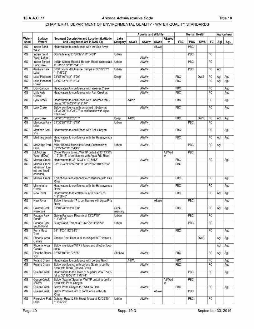
18 A.A.C. 11 Arizona Administrative Code Title 18
CHAPTER 11. DEPARTMENT OF ENVIRONMENTAL QUALITY - WATER QUALITY STANDARDS
Water- Surface Segment Description and Location (Latitude LakeAquatic and Wildlife Human Health Agricultural
A&Wed
MG Indian Bend Wash
Headwaters to confluence with the Salt River A&We PBC
MG Indian Bend Wash Lakes
Scottsdale at 33°30'32"/111°54'24" UrbanA&Ww
PBC FC
MG Indian School Park Lake
Indian School Road & Hayden Road, Scottsdale at 33°29'39"/111°54'37"
Urban A&Ww PBC FC
MG Kiwanis Park Lake
6000 South Mill Avenue, Tempe at 33°22'27"/ 111°56'22"
Urban A&Ww PBC FC AgI
MG Lake Pleasant 33°53'46"/112°16'29" Deep A&Ww FBC DWS FC AgI AgLMG Lake Pleasant,
Lower33°50'32''/112°16'03'' A&Ww FBC FC AgI AgL
MG Lion Canyon Headwaters to confluence with Weaver Creek A&Ww FBC FC AgLMG Little Ash
CreekHeadwaters to confluence with Ash Creek at A&Ww FBC FC AgL
MG Lynx Creek Headwaters to confluence with unnamed tribu-tary at 34°34'29"/112°21'07"
A&Wc FBC FC AgL
MG Lynx Creek Below confluence with unnamed tributary at 34°34'29"/112°21'07" to confluence with Agua Fria River
A&Ww FBC FC AgL
MG Lynx Lake 34°31'07"/112°23'07" Deep A&Wc FBC DWS FC AgI AgLMG Maricopa Park
Lake33°35'28"/112°18'15" Urban A&Ww PBC FC
MG Martinez Can-yon
Headwaters to confluence with Box Canyon A&Ww FBC FC AgL
MG Martinez Wash Headwaters to confluence with the Hassayampa River
A&Ww FBC FC AgI AgL
MG McKellips Park Lake
Miller Road & McKellips Road, Scottsdale at 33°27'14"/111°54'49"
Urban A&Ww PBC FC AgI
MG McMicken Wash (EDW)
City of Peoria Jomax WWTP outfall at 33°43'31"/ 112°20'15" to confluence with Agua Fria River
A&Wedw
PBC
MG Mineral Creek Headwaters to 33°12'34''/110°59'58'' A&Ww FBC FC AgLMG Mineral Creek
(diversion tun-nel and lined channel)
33°12'24''/110°59'58'' to 33°07'56''/110°58'34'' PBC
MG Mineral Creek End of diversion channel to confluence with Gila River
A&Ww FBC FC AgL
MG Minnehaha Creek
Headwaters to confluence with the Hassayampa River
A&Ww FBC FC AgL
MG New River Headwaters to Interstate 17 at 33°54'19.5''/112°08'46''
A&Ww FBC FC AgI AgL
MG New River Below Interstate 17 to confluence with Agua Fria River
A&We PBC AgL
MG Painted Rock Reservoir
33°04'23"/113°00'38" Sedi-mentary
A&Ww FBC FC AgI AgL
MG Papago Park Ponds
Galvin Parkway, Phoenix at 33°27'15"/111°56'45"
Urban A&Ww PBC FC
MG Papago Park South Pond
Curry Road, Tempe 33°26'22"/111°55'55" Urban A&Ww PBC FC
MG Perry Mesa Tank
34°11'03"/112°02'01" A&Ww FBC FC AgL
MG Phoenix Area Canals
Granite Reef Dam to all municipal WTP intakes DWS AgI AgL
MG Phoenix Area Canals
Below municipal WTP intakes and all other loca-tions
AgI AgL
MG Picacho Reser-voir
32°51'10"/111°28'25" Shallow A&Ww FBC FC AgI AgL
MG Poland Creek Headwaters to confluence with Lorena Gulch A&Wc FBC FC AgLMG Poland Creek Below confluence with Lorena Gulch to conflu-
ence with Black Canyon CreekA&Ww FBC FC AgL
MG Queen Creek Headwaters to the Town of Superior WWTP out-fall at 33°16’33”/111°07’44”
A&Ww PBC FC AgL
MG Queen Creek (EDW)
Below Town of Superior WWTP outfall to conflu-ence with Potts Canyon
A&Wedw
PBC
MG Queen Creek Below Potts Canyon to ' Whitlow Dam A&Ww FBC FC AgLMG Queen Creek Below Whitlow Dam to confluence with Gila
RiverA&We PBC
MG Riverview Park Lake
Dobson Road & 8th Street, Mesa at 33°25'50"/ 111°52'29"
Urban A&Ww PBC FC
shed Waters and Longitudes are in NAD 83) Category A&Wc A&Ww A&We w FBC PBC DWS FC AgI AgL
Page 40 Supp. 19-3 September 30, 2019

Title 18 Arizona Administrative Code 18 A.A.C. 11
CHAPTER 11. DEPARTMENT OF ENVIRONMENTAL QUALITY - WATER QUALITY STANDARDS
Water- Surface Segment Description and Location (Latitude LakeAquatic and Wildlife Human Health Agricultural
A&Wed
MG Roadrunner Park Lake
36th Street & Cactus, Phoenix at 33°35'56"/ 112°00'21"
Urban A&Ww PBC FC
MG Salt River Verde River to 2 km below Granite Reef Dam A&Ww FBC DWS FC AgI AgLMG Salt River 2 km below Granite Reef Dam to City of Mesa
NW WRF outfall at 33°26'22"/111°53'14"A&We PBC
MG Salt River (EDW)
City of Mesa NW WRF outfall to Tempe Town Lake
A&Wedw
PBC
MG Salt River Below Tempe Town Lake to Interstate 10 bridge A&We PBCMG Salt River Below Interstate 10 bridge to the City of Phoenix
23rd Avenue WWTP outfall at 33°24'44''/ 112°07'59''
A&Ww PBC FC
MG Salt River (EDW)
From City of Phoenix 23rd Avenue WWTP outfall to confluence with Gila River
A&Wedw
PBC FC AgI AgL
MG Siphon Draw (EDW)
Superstition Mountains CFD WWTP outfall at 33°21'40''/111°33'30'' to 6 km downstream
A&Wedw
PBC
MG Sycamore Creek
Headwaters to confluence with Tank Canyon A&Wc FBC FC AgL
MG Sycamore Creek
Below confluence with Tank Canyon to conflu-ence with Agua Fria River
A&Ww FBC FC AgL
MG Tempe Town Lake
At Mill Avenue Bridge at 33°26'00"/111°56'26" Urban A&Ww FBC FC
MG The Lake Tank 32°54'14''/111°04'15'' A&Ww FBC FC AgLMG Tule Creek Headwaters to confluence with the Agua Fria
RiverA&Ww FBC FC AgL
MG Turkey Creek Headwaters to confluence with unnamed tribu-tary at 34°19'28"/112°21'33"
A&Wc FBC FC AgI AgL
MG Turkey Creek Below confluence with unnamed tributary to con-fluence with Poland Creek
A&Ww FBC FC AgI AgL
MG Unnamed Wash (EDW)
Gila Bend WWTP outfall to confluence with the Gila River
A&Wedw
PBC
MG Unnamed Wash (EDW)
Luke Air Force Base WWTP outfall at 33°32'21"/112°19'15" to confluence with the Agua Fria River
A&Wedw
PBC
MG Unnamed Wash (EDW)
North Florence WWTP outfall at 33°03'50''/ 111°23'13'' to confluence with Gila River
A&Wedw
PBC
MG Unnamed Wash (EDW)
Town of Prescott Valley WWTP outfall at34°35'16"/ 112°16'18" to confluence with the Agua Fria River
A&Wedw
PBC
MG Unnamed Wash (EDW)
Town of Cave Creek WRF outfall at 33°48'02''/ 111°59'22'' to confluence with Cave Creek
A&Wedw
PBC
MG Wagner Wash (EDW)
City of Buckeye Festival Ranch WRF outfall at 33°39'14''/112°40'18'' to 2 km downstream
A&Wedw
PBC
MG Walnut Can-yon Creek
Headwaters to confluence with the Gila River A&Ww FBC FC AgL
MG Weaver Creek Headwaters to confluence with Antelope Creek, tributary to Martinez Wash
A&Ww FBC FC AgL
MG White Canyon Creek
Headwaters to confluence with Walnut Canyon Creek
A&Ww FBC FC AgL
MG Yavapai Lake (EDW)
Town of Prescott Valley WWTP outfall 002 at 34°36'07''/112°18'48'' to Navajo Wash
EDW A&Wedw
PBC
SC Agua Caliente Lake
12325 East Roger Road, Tucson 32°16'51"/ 110°43'52"
Urban A&Ww PBC FC
SC Agua Caliente Wash
Headwaters to confluence with Soldier Trail A&Ww FBC FC AgL
SC Agua Caliente Wash
Below Soldier Trail to confluence with Tanque Verde Creek
A&We PBC AgL
SC Aguirre Wash From the Tohono O'odham Indian Reservation boundary to 32°28'38"/111°46'51"
A&We PBC
SC Alambre Wash Headwaters to confluence with Brawley Wash A&We PBCSC Alamo Wash Headwaters to confluence with Rillito Creek A&We PBCSC Altar Wash Headwaters to confluence with Brawley Wash A&We PBCSC Alum Gulch Headwaters to 31°28'20''/110°43'51'' A&We PBC AgLSC Alum Gulch From 31°28'20''/110°43'51'' to 31°29'17''/
110°44'25''A&Ww FBC FC AgL
SC Alum Gulch Below 31°29'17''/110°44'25'' to confluence with Sonoita Creek
A&We PBC AgL
SC Arivaca Creek Headwaters to confluence with Altar Wash A&Ww FBC FC AgLSC Arivaca Lake 31°31'52"/111°15'06" Igneous A&Ww FBC FC AgI AgLSC Atterbury Wash Headwaters to confluence with Pantano Wash A&We PBC AgL
shed Waters and Longitudes are in NAD 83) Category A&Wc A&Ww A&We w FBC PBC DWS FC AgI AgL
September 30, 2019 Supp. 19-3 Page 41

18 A.A.C. 11 Arizona Administrative Code Title 18
CHAPTER 11. DEPARTMENT OF ENVIRONMENTAL QUALITY - WATER QUALITY STANDARDS
Water- Surface Segment Description and Location (Latitude LakeAquatic and Wildlife Human Health Agricultural
A&Wed
SC Bear Grass Tank
31°33'01"/111°11'03" A&Ww FBC FC AgL
SC Big Wash Headwaters to confluence with Cañada del Oro A&We PBCSC Black Wash
(EDW)Pima County WWMD Avra Valley WWTP outfall at 32°09'58"/111°11'17" to confluence with Braw-ley Wash
A&Wedw
PBC
SC Bog Hole Tank 31°28'36"/110°37'09" A&Ww FBC FC AgLSC Brawley Wash Headwaters to confluence with Los Robles Wash A&We PBCSC California
GulchHeadwaters To U.S./Mexico border A&Ww FBC FC AgL
SC Cañada del Oro
Headwaters to State Route 77 A&Ww FBC FC AgI AgL
SC Cañada del Oro
Below State Route 77 to confluence with the Santa Cruz River
A&We PBC AgL
SC Cienega Creek Headwaters to confluence with Gardner Canyon A&Ww FBC FC AgLSC Cienega Creek
(OAW)From confluence with Gardner Canyon to USGS gaging station (#09484600)
A&Ww FBC FC AgL
SC Davidson Can-yon
Headwaters to unnamed spring at 31°59'00"/ 110°38'49"
A&We PBC AgL
SC Davidson Can-yon (OAW)
From unnamed Spring to confluence with unnamed tributary at 31°59'09"/110°38'44"
A&Ww FBC FC AgL
SC Davidson Can-yon (OAW)
Below confluence with unnamed tributary to unnamed spring at 32°00'40"/110°38'36"
A&We PBC AgL
SC Davidson Can-yon (OAW)
From unnamed spring to confluence with Cienega Creek
A&Ww FBC FC AgL
SC Empire Gulch Headwaters to unnamed spring at 31°47'18"/ 110°38'17"
A&We PBC
SC Empire Gulch From 31°47'18"/110°38'17" to 31°47'03"/110°37'35"
A&Ww FBC FC
SC Empire Gulch From 31°47'03"/110°37'35" to 31°47'05"/ 110°36'58"
A&We PBC AgL
SC Empire Gulch From 31°47'05"/110°36'58" to confluence with Cienega Creek
A&Ww FBC FC
SC Flux Canyon Headwaters to confluence with Alum Gulch A&We PBC AgLSC Gardner Can-
yon CreekHeadwaters to confluence with Sawmill Canyon A&Wc FBC FC
SC Gardner Can-yon Creek
Below Sawmill Canyon to confluence with Cienega Creek
A&Ww FBC FC
SC Greene Wash Santa Cruz River to the Tohono O'odham Indian Reservation boundary
A&We PBC
SC Greene Wash Tohono O'odham Indian Reservation boundary to confluence with Santa Rosa Wash at 32°53'52''/ 111°56'48''
A&We PBC
SC Harshaw Creek Headwaters to confluence with Sonoita Creek at A&We PBC AgLSC Hit Tank 32°43'57''/111°03'18'' A&Ww FBC FC AgLSC Holden Canyon
CreekHeadwaters to U.S./Mexico border A&Ww FBC FC
SC Huachuca Tank 31°21'11"/110°30'18" A&Ww FBC FC AgLSC Julian Wash Headwaters to confluence with the Santa Cruz
RiverA&We PBC
SC Kennedy Lake Mission Road & Ajo Road, Tucson at 32°10'49"/ 111°00'27"
Urban A&Ww PBC FC
SC Lakeside Lake 8300 East Stella Road, Tucson at 32°11'11"/ 110°49'00"
Urban A&Ww PBC FC
SC Lemmon Can-yon Creek
Headwaters to confluence with unnamed tribu-tary at 32°23'48"/110°47'49"
A&Wc FBC FC
SC Lemmon Can-yon Creek
Below unnamed tributary at 32°23'48"/110°47'49" to confluence with Sabino Canyon Creek
A&Ww FBC FC
SC Los Robles Wash
Headwaters to confluence with the Santa Cruz River
A&We PBC
SC Madera Can-yon Creek
Headwaters to confluence with unnamed tribu-tary at 31°43'42"/110°52'51"
A&Wc FBC FC AgL
SC Madera Can-yon Creek
Below unnamed tributary at 31°43'42"/110°52'51 to confluence with the Santa Cruz River
A&Ww FBC FC AgL
SC Mattie Canyon Headwaters to confluence with Cienega Creek A&Ww FBC FC AgLSC Nogales Wash Headwaters to confluence with Potrero Creek A&Ww PBC FCSC Oak Tree Can-
yonHeadwaters to confluence with Cienega Creek A&We PBC
shed Waters and Longitudes are in NAD 83) Category A&Wc A&Ww A&We w FBC PBC DWS FC AgI AgL
Page 42 Supp. 19-3 September 30, 2019

Title 18 Arizona Administrative Code 18 A.A.C. 11
CHAPTER 11. DEPARTMENT OF ENVIRONMENTAL QUALITY - WATER QUALITY STANDARDS
Water- Surface Segment Description and Location (Latitude LakeAquatic and Wildlife Human Health Agricultural
A&Wed
SC Palisade Can-yon
Headwaters to confluence with unnamed tribu-tary at 32°22'33"/110°45'31"
A&Wc FBC FC
SC Palisade Can-yon
Below 32°22'33"/110°45'31" to unnamed tribu-tary of Sabino Canyon
A&Ww FBC FC
SC Pantano Wash Headwaters to confluence with Tanque Verde Creek
A&We PBC
SC Parker Can-yon Creek
Headwaters to confluence with unnamed tribu-tary at 31°24'17"/110°28'47"
A&Wc FBC FC
SC Parker Can-yon Creek
Below unnamed tributary to U.S./Mexico border A&Ww FBC FC
SC Parker Can-yon Lake
31°25'35''/110°27'15'' Deep A&Wc FBC FC AgI AgL
SC Patagonia Lake
31°29'56"/110°50'49" Deep A&Ww FBC FC AgI AgL
SC Peña Blanca Lake
31°24'15"/111°05'12" Igneous A&Ww FBC FC AgI AgL
SC Potrero Creek Headwaters to Interstate 19 A&We PBC AgLSC Potrero Creek Below Interstate 19 to confluence with Santa
Cruz RiverA&Ww FBC FC AgL
SC Puertocito Wash
Headwaters to confluence with Altar Wash A&We PBC
SC Quitobaquito Spring
(Pond and Springs) 31°56'39''/113°01'06'' A&Ww FBC FC AgL
SC Redrock Can-yon Creek
Headwaters to confluence with Harshaw Creek A&Ww FBC FC
SC Rillito Creek Headwaters to confluence with the Santa Cruz River
A&We PBC AgL
SC Romero Can-yon Creek
Headwaters to confluence with unnamed tribu-tary at 32°24'29"/110°50'39"
A&Wc FBC FC
SC Romero Can-yon Creek
Below unnamed tributary to confluence with Sutherland Wash
A&Ww FBC FC
SC Rose Canyon Creek
Headwaters to confluence with Sycamore Can-yon
A&Wc FBC FC
SC Rose Canyon Lake
32°23'13''/110°42'38'' Igneous A&Wc FBC FC AgL
SC Ruby Lakes 31°26'29"/111°14'22" Igneous A&Ww FBC FC AgLSC Sabino Canyon Headwaters to 32°23'20"/110°47'06" A&Wc FBC DWS FC AgISC Sabino Canyon Below 32°23'20"/110°47'06" to confluence with
Tanque Verde RiverA&Ww FBC DWS FC AgI
SC Salero Ranch Tank
31°35'43"/110°53'25" A&Ww FBC FC AgL
SC Santa Cruz River
Headwaters to the at U.S./Mexico border A&Ww FBC FC AgI AgL
SC Santa Cruz River
U.S./Mexico border to the Nogales International WWTP outfall at 31°27'25"/110°58'04"
A&Ww FBC DWS FC AgI AgL
SC Santa Cruz River (EDW)
Nogales International WWTP outfall to the Jose-phine Canyon
A&Wedw
PBC AgL
SC Santa Cruz River
Josephine Canyon to Agua Nueva WRF outfall at 32°17'04"/111°01'45"
A&We PBC AgL
SC Santa Cruz River (EDW)
Agua Nueva WRF outfall to Baumgartner Road A&Wedw
PBC
SC Santa Cruz River, West Branch
Headwaters to the confluence with Santa Cruz River
A&We PBC AgL
SC Santa Cruz River
Baumgartner Road to the Ak Chin Indian Reser-vation boundary
A&We PBC AgL
SC Santa Cruz Wash, North Branch
Headwaters to City of Casa Grande WRF outfall at 32°54'57"/111°47'13"
A&We PBC
SC Santa Cruz Wash, North Branch (EDW)
City of Casa Grande WRF outfall to 1 km down-stream
A&Wedw
PBC
SC Santa Rosa Wash
Below Tohono O'odham Indian Reservation to the Ak Chin Indian Reservation
A&We PBC
SC Santa Rosa Wash (EDW)
Palo Verde Utilities CO-WRF outfall at 33°04'20''/ 112°01'47'' to the Chin Indian Reser-vation
A&Wedw
PBC
SC Soldier Tank 32°25'34"/110°44'43" A&Wc FBC FC AgL
shed Waters and Longitudes are in NAD 83) Category A&Wc A&Ww A&We w FBC PBC DWS FC AgI AgL
September 30, 2019 Supp. 19-3 Page 43
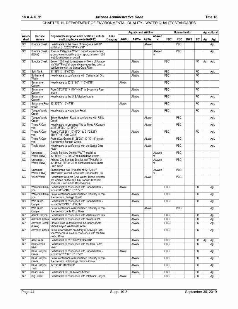
18 A.A.C. 11 Arizona Administrative Code Title 18
CHAPTER 11. DEPARTMENT OF ENVIRONMENTAL QUALITY - WATER QUALITY STANDARDS
Water- Surface Segment Description and Location (Latitude LakeAquatic and Wildlife Human Health Agricultural
A&Wed
SC Sonoita Creek Headwaters to the Town of Patagonia WWTP outfall at 31°32'25"/110°45'31"
A&We PBC AgL
SC Sonoita Creek (EDW)
Town of Patagonia WWTP outfall to permanent groundwater upwelling point approximately 1600 feet downstream of outfall
A&Wedw
PBC AgL
SC Sonoita Creek Below 1600 feet downstream of Town of Patago-nia WWTP outfall groundwater upwelling point to confluence with the Santa Cruz River
A&Ww FBC FC AgI AgL
SC Split Tank 31°28'11"/111°05'12" A&Ww FBC FC AgLSC Sutherland
WashHeadwaters to confluence with Cañada del Oro A&Ww FBC FC
SC Sycamore Canyon
Headwaters to 32°21'60'' / 110°44'48'' A&Wc FBC FC
SC Sycamore Canyon
From 32°21'60'' / 110°44'48'' to Sycamore Res-ervoir
A&Ww FBC FC
SC Sycamore Canyon
Headwaters to the U.S./Mexico border A&Ww FBC FC AgL
SC Sycamore Res-ervoir
32°20'57'/110°47'38'' A&Wc FBC FC AgL
SC Tanque Verde Creek
Headwaters to Houghton Road A&Ww FBC FC AgL
SC Tanque Verde Creek
Below Houghton Road to confluence with Rillito Creek
A&We PBC AgL
SC Three R Can-yon
Headwaters to Unnamed Trib to Three R Canyon at 31°28'26"/110°46'04"
A&We PBC AgL
SC Three R Can-yon
From 31°28'26"/110°46'04" to 31°28'28"/110°47'15" (Cox Gulch)
A&Ww FBC FC AgL
SC Three R Can-yon
From (Cox Gulch) 31°28'28"/110°47'15" to con-fluence with Sonoita Creek
A&We PBC AgL
SC Tinaja Wash Headwaters to confluence with the Santa Cruz River
A&We PBC AgL
SC Unnamed Wash (EDW)
Oracle Sanitary District WWTP outfall at 32°36'54''/ 110°48'02'' to 5 km downstream
A&Wedw
PBC
SC Unnamed Wash (EDW)
Arizona City Sanitary District WWTP outfall at 32°45'43"/111°44'24" to confluence with Santa Cruz Wash
A&Wedw
PBC
SC Unnamed Wash (EDW)
Saddlebrook WWTP outfall at 32°32'00"/110°53'01" to confluence with Cañada del Oro
A&Wedw
PBC
SC Vekol Wash Headwater to Santa Cruz Wash: Those reaches not located on the Ak-Chin, Tohono O'odham and Gila River Indian Reservations
A&We PBC
SC Wakefield Can-yon
Headwaters to confluence with unnamed tribu-tary at 31°52'48"/110°26'27"
A&Wc FBC FC AgL
SC Wakefield Can-yon
Below confluence with unnamed tributary to con-fluence with Cienega Creek
A&Ww FBC FC AgL
SC Wild Burro Canyon
Headwaters to confluence with unnamed tribu-tary at 32°27'43"/111°05'47"
A&Ww FBC FC AgL
SC Wild Burro Canyon
Below confluence with unnamed tributary to con-fluence with Santa Cruz River
A&We PBC AgL
SP Abbot Canyon Headwaters to confluence with Whitewater Draw A&Ww FBC FC AgLSP Aravaipa Creek Headwaters to confluence with Stowe Gulch A&Ww FBC FC AgLSP Aravaipa Creek
(OAW)Stowe Gulch to downstream boundary of Ara-vaipa Canyon Wilderness Area
A&Ww FBC FC AgL
SP Aravaipa Creek Below downstream boundary of Aravaipa Can-yon Wilderness Area to confluence with the San Pedro River
A&Ww FBC FC AgL
SP Ash Creek Headwaters to 31°50'28"/109°40'04" A&Ww FBC FC AgI AgLSP Babocomari
RiverHeadwaters to confluence with the San Pedro River
A&Ww FBC FC AgL
SP Bass Canyon Creek
Headwaters to confluence with unnamed tribu-tary at 32°26'06"/110°13'22"
A&Wc FBC FC AgL
SP Bass Canyon Creek
Below confluence with unnamed tributary to con-fluence with Hot Springs Canyon Creek
A&Ww FBC FC AgL
SP Bass Canyon Tank
32°24'00''/110°13'00'' A&Ww FBC FC AgL
SP Bear Creek Headwaters to U.S./Mexico border A&Ww FBC FC AgLSP Big Creek Headwaters to confluence with Pitchfork Canyon A&Wc FBC FC AgL
shed Waters and Longitudes are in NAD 83) Category A&Wc A&Ww A&We w FBC PBC DWS FC AgI AgL
Page 44 Supp. 19-3 September 30, 2019
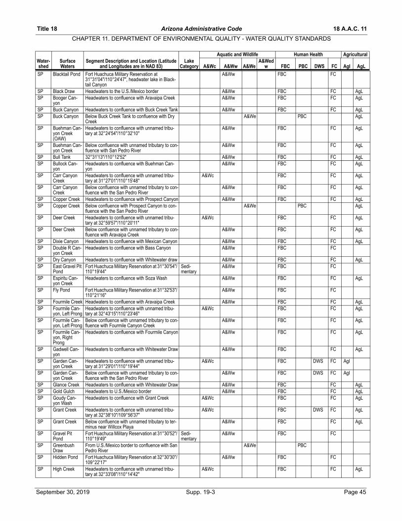
Title 18 Arizona Administrative Code 18 A.A.C. 11
CHAPTER 11. DEPARTMENT OF ENVIRONMENTAL QUALITY - WATER QUALITY STANDARDS
Water- Surface Segment Description and Location (Latitude LakeAquatic and Wildlife Human Health Agricultural
A&Wed
SP Blacktail Pond Fort Huachuca Military Reservation at 31°31'04"/110°24'47", headwater lake in Black-tail Canyon
A&Ww FBC FC
SP Black Draw Headwaters to the U.S./Mexico border A&Ww FBC FC AgLSP Booger Can-
yon Headwaters to confluence with Aravaipa Creek A&Ww FBC FC AgL
SP Buck Canyon Headwaters to confluence with Buck Creek Tank A&Ww FBC FC AgLSP Buck Canyon Below Buck Creek Tank to confluence with Dry
CreekA&We PBC AgL
SP Buehman Can-yon Creek (OAW)
Headwaters to confluence with unnamed tribu-tary at 32°24'54"/110°32'10"
A&Ww FBC FC AgL
SP Buehman Can-yon Creek
Below confluence with unnamed tributary to con-fluence with San Pedro River
A&Ww FBC FC AgL
SP Bull Tank 32°31'13"/110°12'52" A&Ww FBC FC AgLSP Bullock Can-
yonHeadwaters to confluence with Buehman Can-yon
A&Ww FBC FC AgL
SP Carr Canyon Creek
Headwaters to confluence with unnamed tribu-tary at 31°27'01"/110°15'48"
A&Wc FBC FC AgL
SP Carr Canyon Creek
Below confluence with unnamed tributary to con-fluence with the San Pedro River
A&Ww FBC FC AgL
SP Copper Creek Headwaters to confluence with Prospect Canyon A&Ww FBC FC AgLSP Copper Creek Below confluence with Prospect Canyon to con-
fluence with the San Pedro RiverA&We PBC AgL
SP Deer Creek Headwaters to confluence with unnamed tribu-tary at 32°59'57"/110°20'11"
A&Wc FBC FC AgL
SP Deer Creek Below confluence with unnamed tributary to con-fluence with Aravaipa Creek
A&Ww FBC FC AgL
SP Dixie Canyon Headwaters to confluence with Mexican Canyon A&Ww FBC FC AgLSP Double R Can-
yon CreekHeadwaters to confluence with Bass Canyon A&Ww FBC FC
SP Dry Canyon Headwaters to confluence with Whitewater draw A&Ww FBC FC AgLSP East Gravel Pit
PondFort Huachuca Military Reservation at 31°30'54"/ 110°19'44"
Sedi-mentary
A&Ww FBC FC
SP Espiritu Can-yon Creek
Headwaters to confluence with Soza Wash A&Ww FBC FC AgL
SP Fly Pond Fort Huachuca Military Reservation at 31°32'53"/ 110°21'16"
A&Ww FBC FC
SP Fourmile Creek Headwaters to confluence with Aravaipa Creek A&Ww FBC FC AgLSP Fourmile Can-
yon, Left ProngHeadwaters to confluence with unnamed tribu-tary at 32°43'15"/110°23'46"
A&Wc FBC FC AgL
SP Fourmile Can-yon, Left Prong
Below confluence with unnamed tributary to con-fluence with Fourmile Canyon Creek
A&Ww FBC FC AgL
SP Fourmile Can-yon, Right Prong
Headwaters to confluence with Fourmile Canyon A&Ww FBC FC AgL
SP Gadwell Can-yon
Headwaters to confluence with Whitewater Draw A&Ww FBC FC AgL
SP Garden Can-yon Creek
Headwaters to confluence with unnamed tribu-tary at 31°29'01"/110°19'44"
A&Wc FBC DWS FC AgI
SP Garden Can-yon Creek
Below confluence with unnamed tributary to con-fluence with the San Pedro River
A&Ww FBC DWS FC AgI
SP Glance Creek Headwaters to confluence with Whitewater Draw A&Ww FBC FC AgLSP Gold Gulch Headwaters to U.S./Mexico border A&Ww FBC FC AgLSP Goudy Can-
yon WashHeadwaters to confluence with Grant Creek A&Wc FBC FC AgL
SP Grant Creek Headwaters to confluence with unnamed tribu-tary at 32°38'10"/109°56'37"
A&Wc FBC DWS FC AgL
SP Grant Creek Below confluence with unnamed tributary to ter-minus near Willcox Playa
A&Ww FBC FC AgL
SP Gravel Pit Pond
Fort Huachuca Military Reservation at 31°30'52"/ 110°19'49"
Sedi-mentary
A&Ww FBC FC
SP Greenbush Draw
From U.S./Mexico border to confluence with San Pedro River
A&We PBC
SP Hidden Pond Fort Huachuca Military Reservation at 32°30'30''/ 109°22'17''
A&Ww FBC FC
SP High Creek Headwaters to confluence with unnamed tribu-tary at 32°33'08"/110°14'42"
A&Wc FBC FC AgL
shed Waters and Longitudes are in NAD 83) Category A&Wc A&Ww A&We w FBC PBC DWS FC AgI AgL
September 30, 2019 Supp. 19-3 Page 45
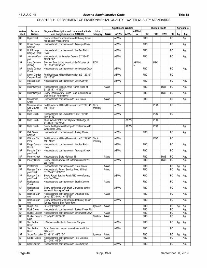
18 A.A.C. 11 Arizona Administrative Code Title 18
CHAPTER 11. DEPARTMENT OF ENVIRONMENTAL QUALITY - WATER QUALITY STANDARDS
Water- Surface Segment Description and Location (Latitude LakeAquatic and Wildlife Human Health Agricultural
A&Wed
SP High Creek Below confluence with unnamed tributary to ter-minus near Willcox Playa
A&Ww FBC FC AgL
SP Horse Camp Canyon
Headwaters to confluence with Aravaipa Creek A&Ww FBC FC AgL
SP Hot Springs Canyon Creek
Headwaters to confluence with the San Pedro River
A&Ww FBC FC AgL
SP Johnson Can-yon
Headwaters to Whitewater Draw at 31°32'46"/ 109°43'32"
A&Ww FBC FC AgL
SP Lake Cochise (EDW)
South of Twin Lakes Municipal Golf Course at 32°13'50"/109°49'27"
EDW A&Wedw
PBC
SP Leslie Canyon Creek
Headwaters to confluence with Whitewater Draw A&Ww FBC FC AgL
SP Lower Garden Canyon Pond
Fort Huachuca Military Reservation at 31°29'39"/ 110°18'34"
A&Ww FBC FC
SP Mexican Can-yon
Headwaters to confluence with Dixie Canyon A&Ww FBC FC AgL
SP Miller Canyon Headwaters to Broken Arrow Ranch Road at 31°25'35"/110°15'04"
A&Wc FBC DWS FC AgL
SP Miller Canyon Below Broken Arrow Ranch Road to confluence with the San Pedro River
A&Ww FBC DWS FC AgL
SP Moonshine Creek
Headwaters to confluence with Post Creek A&Wc FBC FC AgL
SP Mountain View Golf Course Pond
Fort Huachuca Military Reservation at 31°32'14"/ 110°18'52"
Sedi-mentary
A&Ww PBC FC
SP Mule Gulch Headwaters to the Lavender Pit at 31°26'11"/ 109°54'02"
A&Ww PBC FC
SP Mule Gulch The Lavender Pit to the' Highway 80 bridge at 31°26'30''/109°49'28''
A&We PBC
SP Mule Gulch Below the Highway 80 bridge to confluence with Whitewater Draw
A&We PBC AgL
SP Oak Grove Canyon
Headwaters to confluence with Turkey Creek A&Ww FBC FC AgL
SP Officers Club Pond
Fort Huachuca Military Reservation at 31°32'51"/ 110°21'37"
Sedi-mentary
A&Ww PBC FC
SP Paige Canyon Creek
Headwaters to confluence with the San Pedro River
A&Ww FBC FC AgL
SP Parsons Can-yon Creek
Headwaters to confluence with Aravaipa Creek A&Ww FBC FC AgL
SP Pinery Creek Headwaters to State Highway 181 A&Wc FBC DWS FC AgLSP Pinery Creek Below State Highway 181 to terminus near Will-
cox PlayaA&Ww FBC DWS FC AgL
SP Post Creek Headwaters to confluence with Grant Creek A&Wc FBC FC AgI AgLSP Ramsey Can-
yon CreekHeadwaters to Forest Service Road #110 at 31°27'44"/110°17'30"
A&Wc FBC FC AgI AgL
SP Ramsey Can-yon Creek
Below Forest Service Road #110 to confluence with Carr Wash
A&Ww FBC FC AgI AgL
SP Rattlesnake Creek
Headwaters to confluence with Brush Canyon A&Wc FBC FC AgL
SP Rattlesnake Creek
Below confluence with Brush Canyon to conflu-ence with Aravaipa Creek
A&Ww FBC FC AgL
SP Redfield Can-yon
Headwaters to confluence with unnamed tribu-tary at 32°33'40"/110°18'42"
A&Wc FBC FC AgL
SP Redfield Can-yon
Below confluence with unnamed tributary to con-fluence with the San Pedro River
A&Ww FBC FC AgL
SP Riggs Lake 32°42'28"/109°57'53" Igneous A&Wc FBC FC AgI AgLSP Rock Creek Headwaters to confluence with Turkey Creek Alc FBC FC AgLSP Rucker Canyon Headwaters to confluence with Whitewater Draw A&Wc FBC FC AgLSP Rucker Canyon
Lake31°46'46''/109°18'30'' Shallow A&Wc FBC FC AgL
SP San Pedro River
U.S./ Mexico Border to Buehman Canyon A&Ww FBC FC AgI AgL
SP San Pedro River
From Buehman canyon to confluence with the Gila River
A&Ww FBC FC AgL
SP Snow Flat Lake 32°39'10"/109°51'54" Igneous A&Wc FBC FC AgI AgLSP Soldier Creek Headwaters to confluence with Post Creek at
32°40'50"/109°54'41"A&Wc FBC FC AgL
SP Soto Canyon Headwaters to confluence with Dixie Canyon A&Ww FBC FC AgL
shed Waters and Longitudes are in NAD 83) Category A&Wc A&Ww A&We w FBC PBC DWS FC AgI AgL
Page 46 Supp. 19-3 September 30, 2019

Title 18 Arizona Administrative Code 18 A.A.C. 11
CHAPTER 11. DEPARTMENT OF ENVIRONMENTAL QUALITY - WATER QUALITY STANDARDS
Water- Surface Segment Description and Location (Latitude LakeAquatic and Wildlife Human Health Agricultural
A&Wed
SP Swamp Springs Can-yon
Headwaters to confluence with Redfield Canyon A&Ww FBC FC AgL
SP Sycamore Pond I
Fort Huachuca Military Reservation at 31°35'12"/ 110°26'11"
Sedi-mentary
A&Ww FBC FC
SP Sycamore Pond II
Fort Huachuca Military Reservation at 31°34'39"/ 110°26'10"
Sedi-mentary
A&Ww FBC FC
SP Turkey Creek Headwaters to confluence with Aravaipa Creek A&Ww FBC FC AgLSP Turkey Creek Headwaters to confluence with Rock Creek A&Wc FBC FC AgI AgLSP Turkey Creek Below confluence with Rock Creek to terminus
near Willcox PlayaA&Ww FBC FC AgI AgL
SP Unnamed Wash (EDW)
Mt. Lemmon WWTP outfall at 32°26'51"/110°45'08" to 0.25 km downstream
A&Wedw
PBC
SP Virgus Canyon Headwaters to confluence with Aravaipa Creek A&Ww FBC FC AgLSP Walnut Gulch Headwaters to Tombstone WWTP outfall at
31°43'47''/110°04'06''A&We PBC
SP Walnut Gulch (EDW)
Tombstone WWTP outfall to the confluence with Tombstone Wash
A&Wedw
PBC
SP Walnut Gulch Tombstone Wash to confluence with San Pedro River
A&We PBC
SP Ward Canyon Headwaters to confluence with Turkey Creek A&Wc FBC FC AgLSP Whitewater
DrawHeadwaters to confluence with unnamed tribu-tary at 31°20'36"/109°43'48"
A&We PBC AgL
SP Whitewater Draw
Below confluence with unnamed tributary to U.S./ Mexico border
A&Ww FBC FC AgL
SP Willcox Playa From 32°08'19''/109°50'59'' in the Sulphur Springs Valley
Sedi-mentary
A&Ww FBC FC AgL
SP Woodcutters Pond
Fort Huachuca Military Reservation at 31°30'09"/ 110°20'12"
Igneous A&Ww FBC FC
SR Ackre Lake 33°37'01''/109°20'40'' A&Wc FBC FC AgI AgLSR Apache Lake 33°37'23"/111°12'26" Deep A&Ww FBC DWS FC AgI AgLSR Barnhard
CreekHeadwaters to confluence with unnamed tribu-tary at 34°05'37/111°26'40"
A&Wc FBC FC AgL
SR Barnhardt Creek
Below confluence with unnamed tributary to con-fluence with Rye Creek
A&Ww FBC FC AgL
SR Basin Lake 33°55'00"/109°26'09" Igneous A&Ww FBC FC AgLSR Bear Creek Headwaters to confluence with the Black River A&Wc FBC FC AgI AgLSR Bear Wallow
Creek (OAW)Headwaters to confluence with the Black River A&Wc FBC FC AgL
SR Bear Wallow Creek, North Fork (OAW)
Headwaters to confluence with Bear Wallow Creek
A&Wc FBC FC AgL
SR Bear Wallow Creek, South Fork (OAW)
Headwaters to confluence with Bear Wallow Creek
A&Wc FBC FC AgL
SR Beaver Creek Headwaters to confluence with Black River A&Wc FBC FC AgI AgLSR Big Lake 33°52'36"/109°25'33" Igneous A&Wc FBC DWS FC AgI AgLSR Black River Headwaters to confluence with Salt River A&Wc FBC DWS FC AgI AgLSR Black River,
East ForkFrom 33°51'19''/109°18'54'' to confluence with the Black River
A&Wc FBC DWS FC AgI AgL
SR Black River, North Fork of East Fork
Headwaters to confluence with Boneyard Creek A&Wc FBC DWS FC AgI AgL
SR Black River, West Fork
Headwaters to confluence with the Black River A&Wc FBC DWS FC AgI AgL
SR Bloody Tanks Wash
Headwaters to Schultze Ranch Road A&We PBC AgL
SR Bloody Tanks Wash
Schultze Ranch Road to confluence with Miami Wash
A&We PBC
SR Boggy Creek Headwaters to confluence with Centerfire Creek A&Wc FBC FC AgI AgLSR Boneyard
CreekHeadwaters to confluence with Black River, East Fork
A&Wc FBC FC AgI AgL
SR Boulder Creek Headwaters to confluence with LaBarge Creek A&Ww FBC FCSR Campaign
CreekHeadwaters to Roosevelt Lake A&Ww FBC FC AgL
SR Canyon Creek Headwaters to the White Mountain Apache Res-ervation boundary
A&Wc FBC DWS FC AgI AgL
SR Canyon Lake 33°32'44"/111°26'19" Deep A&Ww FBC DWS FC AgI AgL
shed Waters and Longitudes are in NAD 83) Category A&Wc A&Ww A&We w FBC PBC DWS FC AgI AgL
September 30, 2019 Supp. 19-3 Page 47
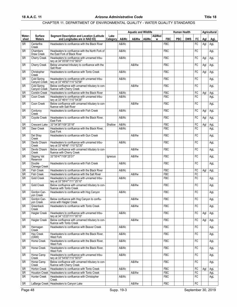
18 A.A.C. 11 Arizona Administrative Code Title 18
CHAPTER 11. DEPARTMENT OF ENVIRONMENTAL QUALITY - WATER QUALITY STANDARDS
Water- Surface Segment Description and Location (Latitude LakeAquatic and Wildlife Human Health Agricultural
A&Wed
SR Centerfire Creek
Headwaters to confluence with the Black River A&Wc FBC FC AgI AgL
SR Chambers Draw Creek
Headwaters to confluence with the North Fork of the East Fork of Black River
A&Wc FBC FC AgL
SR Cherry Creek Headwaters to confluence with unnamed tribu-tary at 34°05'09"/110°56'07"
A&Wc FBC FC AgI AgL
SR Cherry Creek Below unnamed tributary to confluence with the Salt River
A&Ww FBC FC AgI AgL
SR Christopher Creek
Headwaters to confluence with Tonto Creek A&Wc FBC FC AgI AgL
SR Cold Spring Canyon Creek
Headwaters to confluence with unnamed tribu-tary at 33°49'50"/110°52'58"
A&Wc FBC FC AgL
SR Cold Spring Canyon Creek
Below confluence with unnamed tributary to con-fluence with Cherry Creek
A&Ww FBC FC AgL
SR Conklin Creek Headwaters to confluence with the Black River A&Wc FBC FC AgI AgLSR Coon Creek Headwaters to confluence with unnamed tribu-
tary at 33°46'41"/110°54'26"A&Wc FBC FC AgL
SR Coon Creek Below confluence with unnamed tributary to con-fluence with Salt River
A&Ww FBC FC AgL
SR Corduroy Creek
Headwaters to confluence with Fish Creek A&Wc FBC FC AgI AgL
SR Coyote Creek Headwaters to confluence with the Black River, East Fork
A&Wc FBC FC AgI AgL
SR Crescent Lake 33°54'38"/109°25'18" Shallow A&Wc FBC FC AgI AgLSR Deer Creek Headwaters to confluence with the Black River,
East ForkA&Wc FBC FC AgL
SR Del Shay Creek
Headwaters to confluence with Gun Creek A&Ww FBC FC AgL
SR Devils Chasm Creek
Headwaters to confluence with unnamed tribu-tary at 33°48'46" /110°52'35"
A&Wc FBC FC AgL
SR Devils Chasm Creek
Below confluence with unnamed tributary to con-fluence with Cherry Creek
A&Ww FBC FC AgL
SR Dipping Vat Reservoir
33°55'47"/109°25'31" Igneous A&Ww FBC FC AgL
SR Double Cienega Creek
Headwaters to confluence with Fish Creek A&Wc FBC FC AgL
SR Fish Creek Headwaters to confluence with the Black River A&Wc FBC FC AgI AgLSR Fish Creek Headwaters to confluence with the Salt River A&Ww FBC FCSR Gold Creek Headwaters to confluence with unnamed tribu-
tary at 33°59'47"/111°25'10"A&Wc FBC FC AgL
SR Gold Creek Below confluence with unnamed tributary to con-fluence with Tonto Creek
A&Ww FBC FC AgL
SR Gordon Can-yon Creek
Headwaters to confluence with Hog Canyon A&Wc FBC FC AgL
SR Gordon Can-yon Creek
Below confluence with Hog Canyon to conflu-ence with Haigler Creek
A&Ww FBC FC AgL
SR Greenback Creek
Headwaters to confluence with Tonto Creek A&Ww FBC FC AgL
SR Haigler Creek Headwaters to confluence with unnamed tribu-tary at 34°12'23"/111°00'15"
A&Wc FBC FC AgI AgL
SR Haigler Creek Below confluence with unnamed tributary to con-fluence with Tonto Creek
A&Ww FBC FC AgI AgL
SR Hannagan Creek
Headwaters to confluence with Beaver Creek A&Wc FBC FC AgL
SR Hay Creek (OAW)
Headwaters to confluence with the Black River, West Fork
A&Wc FBC FC AgL
SR Home Creek Headwaters to confluence with the Black River, West Fork
A&Wc FBC FC AgL
SR Horse Creek Headwaters to confluence with the Black River, West Fork
A&Wc FBC FC AgL
SR Horse Camp Creek
Headwaters to confluence with unnamed tribu-tary at 33°54'00"/110°50'07"
A&Wc FBC FC AgL
SR Horse Camp Creek
Below confluence with unnamed tributary to con-fluence with Cherry Creek
A&Ww FBC FC AgL
SR Horton Creek Headwaters to confluence with Tonto Creek A&Wc FBC FC AgI AgLSR Houston Creek Headwaters to confluence with Tonto Creek A&Ww FBC FC AgLSR Hunter Creek Headwaters to confluence with Christopher
CreekA&Wc FBC FC AgL
SR LaBarge Creek Headwaters to Canyon Lake A&Ww FBC FC
shed Waters and Longitudes are in NAD 83) Category A&Wc A&Ww A&We w FBC PBC DWS FC AgI AgL
Page 48 Supp. 19-3 September 30, 2019

Title 18 Arizona Administrative Code 18 A.A.C. 11
CHAPTER 11. DEPARTMENT OF ENVIRONMENTAL QUALITY - WATER QUALITY STANDARDS
Water- Surface Segment Description and Location (Latitude LakeAquatic and Wildlife Human Health Agricultural
A&Wed
SR Lake Sierra Blanca
33°52'25''/109°16'05'' A&Wc FBC FC AgI AgL
SR Miami Wash Headwaters to confluence with Pinal Creek A&We PBCSR Mule Creek Headwaters to confluence with Canyon Creek A&Wc FBC DWS FC AgI AgLSR Open Draw
CreekHeadwaters to confluence with the East Fork of Black River
A&Wc FBC FC AgL
SR P B Creek Headwaters to Forest Service Road #203 at 33°57'08"/110°56'12"
A&Wc FBC FC AgL
SR P B Creek Below Forest Service Road #203 to Cherry Creek
A&Ww FBC FC AgL
SR Pinal Creek Headwaters to confluence with unnamed EDW wash (Globe WWTP) at 33°25'29''/110°48'20''
A&We PBC AgL
SR Pinal Creek (EDW)
Confluence with unnamed EDW wash (Globe WWTP) to 33°26'55"/110°49' 25"
A&Wedw
PBC
SR Pinal Creek From 33°26'55"/110°49'25" to Lower Pinal Creek water treatment plant outfall #001 at 33°31'04"/ 110°51'55"
A&We PBC AgL
SR Pinal Creek From Lower Pinal Creek WTP outfall # to See Ranch Crossing at 33°32'25''/110°52'28''
A&Wedw
PBC
SR Pinal Creek From See Ranch Crossing to confluence with unnamed tributary at 33°35'28''/110°54'31''
A&Ww FBC
SR Pinal Creek From unnamed tributary to confluence with Salt River
A&Ww FBC FC
SR Pine Creek Headwaters to confluence with the Salt River A&Ww FBC FCSR Pinto Creek Headwaters to confluence with unnamed tribu-
tary at 33°19'27"/110°54'58"A&Wc FBC FC AgI AgL
SR Pinto Creek Below confluence with unnamed tributary to Roosevelt Lake
A&Ww FBC FC AgI AgL
SR Pole Corral Lake
33°30'38''/110°00'15'' Igneous A&Ww FBC FC AgI AgL
SR Pueblo Can-yon Creek
Headwaters to confluence with unnamed tribu-tary at 33°50'23"/110°51'37"
A&Wc FBC FC AgL
SR Pueblo Can-yon Creek
Below confluence with unnamed tributary to con-fluence with Cherry Creek
A&Ww FBC FC AgL
SR Reevis Creek Headwaters to confluence with Pine Creek A&Ww FBC FCSR Reservation
CreekHeadwaters to confluence with the Black River A&Wc FBC FC AgL
SR Reynolds Creek
Headwaters to confluence with Workman Creek A&Wc FBC FC AgL
SR Roosevelt Lake 33°52'17"/111°00'17" Deep A&Ww FBC DWS FC AgI AgLSR Russell Gulch FromHeadwaters to confluence with Miami Wash A&We PBCSR Rye Creek Headwaters to confluence with Tonto Creek A&Ww FBC FC AgLSR Saguaro Lake 33°33'44"/111°30'55" Deep A&Ww FBC DWS FC AgI AgLSR Salome Creek Headwaters to confluence with the Salt River A&Ww FBC FC AgI AgLSR Salt House
Lake33°57'04''/109°20'11'' Igneous A&Ww FBC FC AgL
SR Salt River White Mountain Apache Reservation Boundary at 33°48'52''/110°31'33'' to Roosevelt Lake
A&Ww FBC FC AgL
SR Salt River Theodore Roosevelt Dam to 2 km below Granite Reef Dam
A&Ww FBC DWS FC AgI AgL
SR Slate Creek Headwaters to confluence with Tonto Creek A&Ww FBC FC AgLSR Snake Creek
(OAW)Headwaters to confluence with the Black River A&Wc FBC FC AgL
SR Spring Creek Headwaters to confluence with Tonto Creek A&Ww FBC FC AgLSR Stinky Creek
(OAW)Headwaters to confluence with the Black River, West Fork
A&Wc FBC FC AgL
SR Thomas Creek Headwaters to confluence with Beaver Creek A&Wc FBC FC AgLSR Thompson
CreekHeadwaters to confluence with the West Fork of the Black River
A&Wc FBC FC AgL
SR Tonto Creek Headwaters to confluence with unnamed tribu-tary at 34°18'11"/111°04'18"
A&Wc FBC FC AgI AgL
SR Tonto Creek Below confluence with unnamed tributary to Roosevelt Lake
A&Ww FBC FC AgI AgL
SR Turkey Creek Headwaters to confluence with Rock Creek A&Wc FBC FCSR Wildcat Creek Headwaters to confluence with Centerfire Creek A&Wc FBC FC AgLSR Willow Creek Headwaters to confluence with Beaver Creek A&Wc FBC FC AgLSR Workman
CreekHeadwaters to confluence with Reynolds Creek A&Wc FBC FC AgI AgL
shed Waters and Longitudes are in NAD 83) Category A&Wc A&Ww A&We w FBC PBC DWS FC AgI AgL
September 30, 2019 Supp. 19-3 Page 49

18 A.A.C. 11 Arizona Administrative Code Title 18
CHAPTER 11. DEPARTMENT OF ENVIRONMENTAL QUALITY - WATER QUALITY STANDARDS
Water- Surface Segment Description and Location (Latitude LakeAquatic and Wildlife Human Health Agricultural
A&Wed
SR Workman Creek
Below confluence with Reynolds Creek to conflu-ence with Salome Creek
A&Ww FBC FC AgI AgL
UG Apache Creek Headwaters to confluence with the Gila River A&Ww FBC FC AgLUG Ash Creek Headwaters to confluence with unnamed tribu-
tary at 32°46'15"/109°51'45"A&Wc FBC FC AgL
UG Ash Creek Below confluence with unnamed tributary to con-fluence with the Gila River
A&Ww FBC FC AgL
UG Bennett Wash Headwaters to the Gila River A&We PBCUG Bitter Creek Headwaters to confluence with the Gila River A&Ww FBC FCUG Blue River Headwaters to confluence with Strayhorse Creek
at 33°29'02"/109°12'14"A&Wc FBC FC AgI AgL
UG Blue River Below confluence with Strayhorse Creek to con-fluence with San Francisco River
A&Ww FBC FC AgI AgL
UG Bonita Creek (OAW)
San Carlos Indian Reservation boundary to con-fluence with the Gila River
A&Ww FBC DWS FC AgL
UG Buckelew Creek
Headwaters to confluence with Castle Creek A&Wc FBC FC AgL
UG Campbell Blue Creek
Headwaters to confluence with the Blue River A&Wc FBC FC AgL
UG Castle Creek Headwaters to confluence with Campbell Blue Creek
A&Wc FBC FC AgL
UG Cave Creek (OAW)
Headwaters to confluence with South Fork Cave Creek
A&Wc FBC FC AgI AgL
UG Cave Creek (OAW)
Below confluence with South Fork Cave Creek to Coronado National Forest boundary
A&Ww FBC FC AgI AgL
UG Cave Creek Below Coronado National Forest boundary to New Mexico border
A&Ww FBC FC AgI AgL
UG Cave Creek, South Fork
Headwaters to confluence with Cave Creek A&Wc FBC FC AgI AgL
UG Chase Creek Headwaters to the Phelps-Dodge Morenci Mine A&Ww FBC FC AgLUG Chase Creek Below the Phelps-Dodge Morenci Mine to conflu-
ence with San Francisco RiverA&We PBC
UG Chitty Canyon Creek
Headwaters to confluence with Salt House Creek A&Wc FBC FC AgL
UG Cima Creek Headwaters to confluence with Cave Creek A&Wc FBC FC AgLUG Cluff Reservoir
#132°48'55"/109°50'46" Sedi-
mentaryA&Ww FBC FC AgI AgL
UG Cluff Reservoir #3
32°48'21"/109°51'46" Sedi-mentary
A&Ww FBC FC AgI AgL
UG Coleman Creek
Headwaters to confluence with Campbell Blue Creek
A&Wc FBC FC AgL
UG Dankworth Lake
32°43'13''/109°42'17'' Sedi-mentary
A&Wc FBC FC
UG Deadman Can-yon Creek
Headwaters to confluence with unnamed tribu-tary at 32°43'50''/109°49'03''
A&Wc FBC DWS FC AgL
UG Deadman Can-yon Creek
Below confluence with unnamed tributary to con-fluence with Graveyard Wash
A&Ww FBC DWS FC AgL
UG Eagle Creek Headwaters to confluence with unnamed tribu-tary at 33°22'32"/109°29'43"
A&Wc FBC DWS FC AgI AgL
UG Eagle Creek Below confluence with unnamed tributary to con-fluence with the Gila River
A&Ww FBC DWS FC AgI AgL
UG East Eagle Creek
Headwaters to confluence with Eagle Creek A&Wc FBC FC AgL
UG East Turkey Creek
Headwaters to confluence with unnamed tribu-tary at 31°58'22"/109°12'20"
A&Wc FBC FC AgL
UG East Turkey Creek
Below confluence with unnamed tributary to ter-minus near San Simon River
A&Ww FBC FC AgL
UG East Whitetail Headwaters to terminus near San Simon River A&Ww FBC FC AgLUG Emigrant Can-
yonHeadwaters to terminus near San Simon River A&Ww FBC FC AgL
UG Evans Pond #1 32°49'19''/109°51'12'' Sedi-mentary
A&Ww FBC FC AgI AgL
UG Evans Pond #2 32°49'14''/109°51'09'' Sedi-mentary
A&Ww FBC FC AgI AgL
UG Fishhook Creek
Headwaters to confluence with the Blue River A&Wc FBC FC AgL
UG Foote Creek Headwaters to confluence with the Blue River A&Wc FBC FC AgLUG Frye Canyon
CreekHeadwaters to Frye Mesa Reservoir A&Wc FBC DWS FC AgL
shed Waters and Longitudes are in NAD 83) Category A&Wc A&Ww A&We w FBC PBC DWS FC AgI AgL
Page 50 Supp. 19-3 September 30, 2019
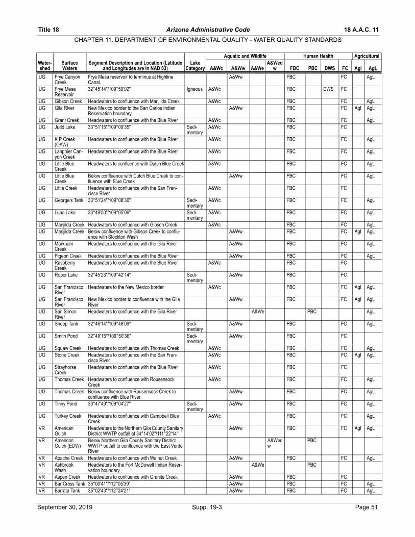
Title 18 Arizona Administrative Code 18 A.A.C. 11
CHAPTER 11. DEPARTMENT OF ENVIRONMENTAL QUALITY - WATER QUALITY STANDARDS
Water- Surface Segment Description and Location (Latitude LakeAquatic and Wildlife Human Health Agricultural
A&Wed
UG Frye Canyon Creek
Frye Mesa reservoir to terminus at Highline Canal.
A&Ww FBC FC AgL
UG Frye Mesa Reservoir
32°45'14"/109°50'02" Igneous A&Wc FBC DWS FC
UG Gibson Creek Headwaters to confluence with Marijilda Creek A&Wc FBC FC AgLUG Gila River New Mexico border to the San Carlos Indian
Reservation boundaryA&Ww FBC FC AgI AgL
UG Grant Creek Headwaters to confluence with the Blue River A&Wc FBC FC AgLUG Judd Lake 33°51'15"/109°09'35" Sedi-
mentaryA&Wc FBC FC
UG K P Creek (OAW)
Headwaters to confluence with the Blue River A&Wc FBC FC AgL
UG Lanphier Can-yon Creek
Headwaters to confluence with the Blue River A&Wc FBC FC AgL
UG Little Blue Creek
Headwaters to confluence with Dutch Blue Creek A&Wc FBC FC AgL
UG Little Blue Creek
Below confluence with Dutch Blue Creek to con-fluence with Blue Creek
A&Ww FBC FC AgL
UG Little Creek Headwaters to confluence with the San Fran-cisco River
A&Wc FBC FC
UG George’s Tank 33°51'24"/109°08'30" Sedi-mentary
A&Wc FBC FC AgL
UG Luna Lake 33°49'50"/109°05'06" Sedi-mentary
A&Wc FBC FC AgL
UG Marijilda Creek Headwaters to confluence with Gibson Creek A&Wc FBC FC AgLUG Marijilda Creek Below confluence with Gibson Creek to conflu-
ence with Stockton WashA&Ww FBC FC AgI AgL
UG Markham Creek
Headwaters to confluence with the Gila River A&Ww FBC FC AgL
UG Pigeon Creek Headwaters to confluence with the Blue River A&Ww FBC FC AgLUG Raspberry
CreekHeadwaters to confluence with the Blue River A&Wc FBC FC
UG Roper Lake 32°45'23"/109°42'14" Sedi-mentary
A&Ww FBC FC
UG San Francisco River
Headwaters to the New Mexico border A&Wc FBC FC AgI AgL
UG San Francisco River
New Mexico border to confluence with the Gila River
A&Ww FBC FC AgI AgL
UG San Simon River
Headwaters to confluence with the Gila River A&We PBC AgL
UG Sheep Tank 32°46'14"/109°48'09" Sedi-mentary
A&Ww FBC FC AgL
UG Smith Pond 32°49'15''/109°50'36'' Sedi-mentary
A&Ww FBC FC
UG Squaw Creek Headwaters to confluence with Thomas Creek A&Wc FBC FC AgLUG Stone Creek Headwaters to confluence with the San Fran-
cisco RiverA&Wc FBC FC AgI AgL
UG Strayhorse Creek
Headwaters to confluence with the Blue River A&Wc FBC FC
UG Thomas Creek Headwaters to confluence with Rousensock Creek
A&Wc FBC FC AgL
UG Thomas Creek Below confluence with Rousensock Creek to confluence with Blue River
A&Ww FBC FC AgL
UG Tinny Pond 33°47'49"/109°04'27" Sedi-mentary
A&Ww FBC FC AgL
UG Turkey Creek Headwaters to confluence with Campbell Blue Creek
A&Wc FBC FC AgL
VR American Gulch
Headwaters to the Northern Gila County Sanitary District WWTP outfall at 34°14'02"/111°22'14"
A&Ww FBC FC AgI AgL
VR American Gulch (EDW)
Below Northern Gila County Sanitary District WWTP outfall to confluence with the East Verde River
A&Wedw
PBC
VR Apache Creek Headwaters to confluence with Walnut Creek A&Ww FBC FC AgLVR Ashbrook
WashHeadwaters to the Fort McDowell Indian Reser-vation boundary
A&We PBC
VR Aspen Creek Headwaters to confluence with Granite Creek A&Ww FBC FCVR Bar Cross Tank 35°00'41"/112°05'39" A&Ww FBC FC AgLVR Barrata Tank 35°02'43"/112°24'21" A&Ww FBC FC AgL
shed Waters and Longitudes are in NAD 83) Category A&Wc A&Ww A&We w FBC PBC DWS FC AgI AgL
September 30, 2019 Supp. 19-3 Page 51

18 A.A.C. 11 Arizona Administrative Code Title 18
CHAPTER 11. DEPARTMENT OF ENVIRONMENTAL QUALITY - WATER QUALITY STANDARDS
Water- Surface Segment Description and Location (Latitude LakeAquatic and Wildlife Human Health Agricultural
A&Wed
VR Bartlett Lake 33°49'52"/111°37'44" Deep A&Ww FBC DWS FC AgI AgLVR Beaver Creek Headwaters to confluence with the Verde River A&Ww FBC FC AgLVR Big Chino
WashHeadwaters to confluence with Sullivan Lake A&We PBC AgL
VR Bitter Creek Headwaters to the Jerome WWTP outfall at 34°45'12"/112°06'24"
A&We PBC AgL
VR Bitter Creek (EDW)
Jerome WWTP outfall to the Yavapai Apache Indian Reservation boundary
A&Wedw
PBC AgL
VR Bitter Creek Below the Yavapai Apache Indian Reservation boundary to confluence with the Verde River
A&Ww FBC FC AgI AgL
VR Black Canyon Creek
Headwaters to confluence with unnamed tribu-tary at 34°39'20"/112°05'06"
A&Wc FBC FC AgL
VR Black Canyon Creek
Below confluence with unnamed tributary to con-fluence with the Verde River
A&Ww FBC FC AgL
VR Bonita Creek Headwaters to confluence with Ellison Creek A&Wc FBC FCVR Bray Creek Headwaters to confluence with Webber Creek A&Wc FBC FC AgLVR Camp Creek Headwaters to confluence with the Sycamore
CreekA&Ww FBC FC AgL
VR Cereus Wash Headwaters to the Fort McDowell Indian Reser-vation boundary
A&We PBC
VR Chase Creek Headwaters to confluence with the East Verde River
A&Wc FBC DWS FC
VR Clover Creek Headwaters to confluence with Headwaters of West Clear Creek
A&Wc FBC FC AgL
VR Coffee Creek Headwaters to confluence with Spring Creek A&Ww FBC FC AgLVR Colony Wash Headwaters to the Fort McDowell Indian Reser-
vation boundaryA&We PBC
VR Dead Horse Lake
34°45'08"/112°00'42" Shallow A&Ww FBC FC
VR Deadman Creek
Headwaters to Horseshoe Reservoir A&Ww FBC FC AgL
VR Del Monte Gulch
Headwaters to confluence with City of Cotton-wood WWTP outfall 002 at 34°43'57"/112°02'46"
A&We PBC
VR Del Monte Gulch (EDW)
City of Cottonwood WWTP outfall 002 at 34°43'57"/ 112°02'46" to confluence with Blow-out Creek
A&Wedw
PBC
VR Del Rio Dam Lake
34°48'55"/112°28'03" Sedi-mentary
A&Ww FBC FC AgL
VR Dry Beaver Creek
Headwaters to confluence with Beaver Creek A&Ww FBC FC AgI AgL
VR Dry Creek (EDW)
Sedona Ventures WWTP outfall at 34°50'02"/ 111°52'17" to 34°48'12"/111°52'48"
A&Wedw
PBC
VR Dude Creek Headwaters to confluence with the East Verde River
A&Wc FBC FC AgI AgL
VR East Verde River
Headwaters to confluence with Ellison Creek A&Wc FBC DWS FC AgI AgL
VR East Verde River
Below confluence with Ellison Creek to conflu-ence with the Verde River
A&Ww FBC DWS FC AgI AgL
VR Ellison Creek Headwaters to confluence with the East Verde River
A&Wc FBC FC AgL
VR Fossil Creek (OAW)
Headwaters to confluence with the Verde River A&Ww FBC FC AgL
VR Fossil Springs (OAW)
34°25'24"/111°34'27" A&Ww FBC DWS FC
VR Foxboro Lake 34°53'42"/111°39'55" A&Ww FBC FC AgLVR Fry Lake 35°03'45"/111°48'04" A&Ww FBC FC AgLVR Gap Creek Headwaters to confluence with Government
SpringA&Wc FBC FC AgL
VR Gap Creek Below Government Spring to confluence with the Verde River
A&Ww FBC FC AgL
VR Garrett Tank 35°18'57"/112°42'20" A&Ww FBC FC AgLVR Goldwater
Lake, Lower34°29'56"/112°27'17" Sedi-
mentaryA&Wc FBC DWS FC
VR Goldwater Lake, Upper
34°29'52"/112°26'59" Igneous A&Wc FBC DWS FC
VR Granite Basin Lake
34°37'01"/112°32'58" Igneous A&Wc FBC FC AgI AgL
VR Granite Creek Headwaters to Watson Lake A&Wc FBC FC AgI AgL
shed Waters and Longitudes are in NAD 83) Category A&Wc A&Ww A&We w FBC PBC DWS FC AgI AgL
Page 52 Supp. 19-3 September 30, 2019

Title 18 Arizona Administrative Code 18 A.A.C. 11
CHAPTER 11. DEPARTMENT OF ENVIRONMENTAL QUALITY - WATER QUALITY STANDARDS
Water- Surface Segment Description and Location (Latitude LakeAquatic and Wildlife Human Health Agricultural
A&Wed
VR Granite Creek Below Watson Lake to confluence with the Verde River
A&Ww FBC FC AgI AgL
VR Green Valley Lake (EDW)
34°13'54"/111°20'45" Urban A&Wedw
PBC FC
VR Heifer Tank 35°20'27"/112°32'59" A&Ww FBC FC AgLVR Hells Canyon
Tank35°04'59"/112°24'07" Igneous A&Ww FBC FC AgL
VR Homestead Tank
35°21'24"/112°41'36" Igneous A&Ww FBC FC AgL
VR Horse Park Tank
34°58'15"/111°36'32" A&Ww FBC FC AgL
VR Horseshoe Reservoir
34°00'25"/111°43'36" Sedi-mentary
A&Ww FBC FC AgI AgL
VR Houston Creek Headwaters to confluence with the Verde River A&Ww FBC FC AgLVR Huffer Tank 34°27'46''/111°23'11'' A&Ww FBC FC AgLVR J.D. Dam Lake 35°04'02"/112°01'48" Shallow A&Wc FBC FC AgI AgLVR Jacks Canyon Headwaters to Big Park WWTP outfall at
34°45'46''/ 111°45'51''A&We PBC
VR Jacks Canyon (EDW)
Below Big Park WWTP outfall to confluence with Dry Beaver Creek
A&Wedw
PBC
VR Lime Creek Headwaters to Horseshoe Reservoir A&Ww FBC FC AgLVR Masonry Num-
ber 2 Reservoir35°13'32"/112°24'10" A&Wc FBC FC AgI AgL
VR McLellan Res-ervoir
35°13'09"/112°17'06" Igneous A&Ww FBC FC AgI AgL
VR Meath Dam Tank
35°07'52"/112°27'35" A&Ww FBC FC AgL
VR Mullican Place Tank
34°44'16"/111°36'10" Igneous A&Ww FBC FC AgL
VR Oak Creek (OAW)
Headwaters to confluence with unnamed tribu-tary at 34°59'15"/111°44'47"
A&Wc FBC DWS FC AgI AgL
VR Oak Creek (OAW)
Below confluence with unnamed tributary to con-fluence with Verde River
A&Ww FBC DWS FC AgI AgL
VR Oak Creek, West Fork (OAW)
Headwaters to confluence with Oak Creek A&Wc FBC FC AgL
VR Odell Lake 34°56'5"/111°37'53" Igneous A&Wc FBC FCVR Peck’s Lake 34°46'51"/112°02'01" Shallow A&Ww FBC FC AgI AgLVR Perkins Tank 35°06'42"/112°04'12" Shallow A&Wc FBC FC AgLVR Pine Creek Headwaters to confluence with unnamed tribu-
tary at 34°21'51"/111°26'49"A&Wc FBC DWS FC AgI AgL
VR Pine Creek Below confluence with unnamed tributary to con-fluence with East Verde River
A&Ww FBC DWS FC AgI AgL
VR Red Creek Headwaters to confluence with the Verde River A&Ww FBC FC AgLVR Reservoir #1 35°13'5"/111°50'09" Igneous A&Ww FBC FCVR Reservoir #2 35°13'17"/111°50'39" Igneous A&Ww FBC FCVR Roundtree
Canyon CreekHeadwaters to confluence with Tangle Creek A&Ww FBC FC AgL
VR Scholze Lake 35°11'53"/112°00'37" Igneous A&Wc FBC FC AgLVR Spring Creek Headwaters to confluence with unnamed tribu-
tary at 34°57'23"/111°57'21"A&Wc FBC FC AgI AgL
VR Spring Creek Below confluence with unnamed tributary to con-fluence with Oak Creek
A&Ww FBC FC AgI AgL
VR Steel Dam Lake
35°13'36"/112°24'54" Igneous A&Wc FBC FC AgL
VR Stehr Lake 34°22'01"/111°40'02" Sedi-mentary
A&Ww FBC FC AgL
VR Stoneman Lake
34°46'47"/111°31'14" Shallow A&Wc FBC FC AgI AgL
VR Sullivan Lake 34°51'42"/112°27'51" A&Ww FBC FC AgI AgLVR Sycamore
CreekHeadwaters to confluence with unnamed tribu-tary at 35°03'41"/111°57'31"
A&Wc FBC FC AgI AgL
VR Sycamore Creek
Below confluence with unnamed tributary to con-fluence with Verde River
A&Ww FBC FC AgI AgL
VR Sycamore Creek
Headwaters to confluence with Verde River at 33°37'55''/111°39'58''
A&Ww FBC FC AgI AgL
VR Sycamore Creek
Headwaters to confluence with Verde River at 34°04'42''/111°42'14''
A&Ww FBC FC AgL
shed Waters and Longitudes are in NAD 83) Category A&Wc A&Ww A&We w FBC PBC DWS FC AgI AgL
September 30, 2019 Supp. 19-3 Page 53

18 A.A.C. 11 Arizona Administrative Code Title 18
CHAPTER 11. DEPARTMENT OF ENVIRONMENTAL QUALITY - WATER QUALITY STANDARDS
Water- Surface Segment Description and Location (Latitude LakeAquatic and Wildlife Human Health Agricultural
A&Wed
Historical NoteAdopted effective February 18, 1992 (Supp. 92-1). Appendix B repealed, new Appendix B adopted effective April 24, 1996 (Supp. 96-2). Amended by final rulemaking at 8 A.A.R. 1264, effective March 8, 2002 (Supp. 02-1). Amended by final rulemaking at 14 A.A.R. 4708, effective January 31, 2009 (Supp. 08-4). Amended by final rulemaking at 22 A.A.R. 2328, effective August 2, 2016
(Supp. 16-4). Appendix B amended by final rulemaking at 25 A.A.R. 2515, effective November 9, 2019 (Supp. 19-3).
VR Tangle Creek Headwaters to confluence with Verde River A&Ww FBC FC AgI AgLVR Trinity Tank 35°27'44"/112°48'01" A&Ww FBC FC AgLVR Unnamed
WashFlagstaff Meadows WWTP outfall at '35°13'59''/ 111°48'35'' to Volunteer Wash
A&Wedw
PBC
VR Verde River From headwaters at confluence of Chino Wash and Granite Creek to Bartlett Lake Dam
A&Ww FBC FC AgI AgL
VR Verde River Below Bartlett Lake Dam to Salt River A&Ww FBC DWS FC AgI AgLVR Walnut Creek Headwaters to confluence with Big Chino Wash A&Ww FBC FC AgLVR Watson Lake 34°34'58"/112°25'26" Igneous A&Ww FBC FC AgI AgLVR Webber Creek Headwaters to confluence with the East Verde
RiverA&Wc FBC FC AgL
VR West Clear Creek
Headwaters to confluence with Meadow Canyon A&Wc FBC FC AgL
VR West Clear Creek
Below confluence with Meadow Canyon to con-fluence with the Verde River
A&Ww FBC FC AgI AgL
VR Wet Beaver Creek
Headwaters to unnamed springs at 34°41'17''/ 111°34'34''
A&Wc FBC FC AgI AgL
VR Wet Beaver Creek
Below unnamed springs to confluence with Dry Beaver Creek
A&Ww FBC FC AgI AgL
VR Whitehorse Lake
35°06'59"/112°00'48" Igneous A&Wc FBC DWS FC AgI AgL
VR Williamson Val-ley Wash
Headwaters to confluence with Mint Wash A&We PBC AgL
VR Williamson Val-ley Wash
From confluence of Mint Wash to 10.5 km down-stream
A&Ww FBC FC AgL
VR Williamson Val-ley Wash
From 10.5 km downstream of Mint Wash conflu-ence to confluence with Big Chino Wash
A&We PBC AgL
VR Williscraft Tank 35°11'22"/112°35'40" A&Ww FBC FC AgLVR Willow Creek Above Willow Creek Reservoir A&Wc FBC FC AgLVR Willow Creek Below Willow Creek Reservoir to confluence with
Granite CreekA&Ww FBC FC AgL
VR Willow Creek Reservoir
34°36'17''/112°26'19'' Shallow A&Ww FBC FC AgI AgL
VR Willow Valley Lake
34°41'08"/111°20'02" Sedi-mentary
A&Ww FBC FC AgL
shed Waters and Longitudes are in NAD 83) Category A&Wc A&Ww A&We w FBC PBC DWS FC AgI AgL
Page 54 Supp. 19-3 September 30, 2019

Title 18 Arizona Administrative Code 18 A.A.C. 11
CHAPTER 11. DEPARTMENT OF ENVIRONMENTAL QUALITY - WATER QUALITY STANDARDS
Appendix C. Site-Specific Standards
Historical NoteAdopted effective February 18, 1992 (Supp. 92-1). Appendix C repealed effective April 24, 1996 (Supp. 96-2). New Appendix C made by final rulemaking at 14 A.A.R. 4708, effective January 31, 2009 (Supp. 08-4). Amended by final rulemaking at 22 A.A.R. 2328, effective August 2, 2016 (Supp. 16-4). Appendix C amended by final rulemaking at 25 A.A.R. 2515, effective November 9,
2019 (Supp. 19-3).
ARTICLE 2. REPEALED
R18-11-201. Repealed
Historical NoteAmended effective January 29, 1980 (Supp. 80-1).
Amended subsection A. effective April 17, 1984 (Supp. 84-2). Former Section R9-21-201 repealed, former
Section R9-21-203 renumbered as Section R9-21-201 and amended effective January 7, 1985 (Supp. 85-1).
Amended effective August 12, 1986 (Supp. 86-4). Former Section R9-21-201 renumbered without change as Section R18-11-201 (Supp. 87-3). Amended effective
December 1, 1988 (Supp. 88-4). Section repealed effective February 18, 1992 (Supp. 92-1).
R18-11-202. Repealed
Historical NoteFormer Section R9-21-202 repealed, former Section R9-21-102 renumbered as Section R9-21-202 and amended
effective January 7, 1985 (Supp. 85-1). Amended subsections (B), (D), and (E) effective August 12, 1986 (Supp. 86-4). Former Section R9-21-202 renumbered without change as Section R18-11-202 (Supp. 87-3).
Section repealed, new Section adopted effective February 18, 1992 (Supp. 92-1). Section repealed effective April
24, 1996 (Supp. 96-2).
R18-11-203. Repealed
Historical NoteAmended effective January 29, 1980 (Supp. 80-1).
Amended subsection (B) by adding paragraphs (27) and (28) effective October 14, 1981 (Supp. 81-5). Former Section R9-21-203 renumbered as Section R9-21-201,
former Section R9-21-204 renumbered as Section R9-21-203 and amended effective January 7, 1985 (Supp.
85-1). Former Section R9-21-203 renumbered and amended as Section R9-21-204, new Section R9-21-203 adopted effective August 12, 1986 (Supp. 86-4). Former
Section R9-21-203 renumbered without change as
Section R18-11-203 (Supp. 87-3). Amended subsection (B) effective December 1, 1988 (Supp. 88-4). Section repealed, new Section adopted effective February 18,
1992 (Supp. 92-1). Section repealed effective April 24, 1996 (Supp. 96-2).
R18-11-204. Repealed
Historical NoteFormer Section R9-21-204 renumbered and amended as
Section R9-21-207, former Section R9-21-206 renumbered and amended as Section R9-21-204 effective
January 29, 1980 (Supp. 80-1). Former Section R9-21-204 renumbered as Section R9-21-203, former Section R9-21-205 renumbered as Section R9-21-204 and amended effective January 7, 1985 (Supp. 85-1).
Former Section R9-21-204 renumbered and amended as Section R9-21-205, former Section R9-21-203
renumbered and amended as Section R9-21-204 effective August 12, 1986 (Supp. 86-4). Former Section
R9-21-204 renumbered without change as Section R18-11-204 (Supp. 87-3). Section repealed effective
February 18, 1992 (Supp. 92-1).
R18-11-205. Repealed
Historical NoteFormer Section R9-21-205 repealed, new Section R9-21-
205 adopted effective January 29, 1980 (Supp. 80-1). Former Section R9-21-205 renumbered as Section
R9-21-204, former Section R9-21-206 renumbered as Section R9-21-205 and amended effective January 7,
1985 (Supp. 85-1). Former Section R9-21-205 renumbered and amended as Section R9-21-206, former Section R9-21-204 renumbered and amended as Section
R9-21-205 effective August 12, 1986 (Supp. 86-4). Former Section R9-21-205 renumbered without change as Section R18-11-205 (Supp. 87-3). Section repealed,
new Section adopted effective February 18, 1992
Watershed Surface Water Surface Water Description & Location Parameter Site-Specific Criterion
LC Rio de Flag (EDW) Flagstaff WWTP outfall to the confluence with San Francisco Wash
Copper (D) 36 µg/L(A&Wedw)
CL Yuma East Wetlands From inlet culvert from Colorado River into restored channel to Ocean Bridge
Selenium (T) 2.2 µg/L(A&Ww chronic)
Total resid-ual chlorine
33 µg/L(A&Ww acute)
20 µg/L(A&Ww chronic)
SR Pinto Creek From confluence of Ellis Ranch tributary at 33°19'26.7"/110°54'57.5" to the conflu-ence of West Fork of Pinto Creek at 33°27'32.3"/111°00'19.7"
Copper (D) 34 μg/L(A&Ww acute for hard-ness values below 268 mg/L)34 µg/L(A&Ww chronic)
September 30, 2019 Supp. 19-3 Page 55

18 A.A.C. 11 Arizona Administrative Code Title 18
CHAPTER 11. DEPARTMENT OF ENVIRONMENTAL QUALITY - WATER QUALITY STANDARDS
(Supp. 92-1). Section repealed April 24, 1996 (Supp. 96-2).
R18-11-206. Repealed
Historical NoteFormer Section R9-21-206 renumbered and amended as
Section R9-21-204, new Section R9-21-206 adopted effective January 29, 1980 (Supp. 80-1). Amended by
adding subsection (B) effective October 14, 1981 (Supp. 81-5). Amended subsection (B) and Table 1 effective
January 29, 1982 (Supp. 82-1). Amended subsection (B) and Table 1 effective August 13, 1982 (Supp. 82-4). Former Section R9-21-206 renumbered as Section
R9-21-205, former Section R9-21-207 renumbered as Section R9-21-206 and amended effective January 7,
1985 (Supp. 85-1). Former Section R9-21-206 renumbered and amended as Section R9-21-207, former
Section R9-21-205 renumbered and amended as R9-21-206 effective August 12, 1986 (Supp. 86-4).
Former Section R9-21-206 renumbered without change as Section R18-11-206 (Supp. 87-3).
R18-11-207. Repealed
Historical NoteFormer Section R9-21-207 repealed, former Section
R9-21-204 renumbered and amended as Section R9-21-207 effective January 29, 1980 (Supp. 80-1). Former Section R9-21-207 renumbered as Section
R9-21-206, former Section R9-21-208 renumbered as Section R9-21-207 and amended effective January 7,
1985 (Supp. 85-1). Former Section R9-21-207 renumbered without change as Section R9-21-208,
former Section R9-21-206 renumbered and amended as Section R9-21-207 effective August 12, 1986 (Supp.
86-4). Former Section R9-21-207 renumbered without change as Section R18-11-207 (Supp. 87-3). Section repealed effective February 18, 1992 (Supp. 92-1).
R18-11-208. Repealed
Historical NoteFormer Section R9-21-208 repealed, new Section
R9-21-208 adopted effective January 29, 1980 (Supp. 80-1). Former Section R9-21-208 renumbered as Section
R9-21-207, Appendices 1 through 9 amended as Appendix A (now shown following R9-21-213), former
Section R9-21-209 renumbered as R9-21-208 and amended
effective January 7, 1985 (Supp. 85-1). Former Section R9-21-208 renumbered and amended as Section
R9-21-209, former Section R9-21-207 renumbered without change as Section R9-21-208 effective August
12, 1986 (Supp. 86-4). Former Section R9-21-208 renumbered without change as Section R18-11-208
(Supp. 87-3). Section repealed effective February 18, 1992 (Supp. 92-1).
R18-11-209. Repealed
Historical NoteFormer Section R9-21-209 renumbered and amended as
Section R9-21-210, new Section R9-21-209 adopted effective January 29, 1980 (Supp. 80-1). Former Section R9-21-209 renumbered as Section R9-21-208, Tables I and II amended as Appendix B (now shown following
R9-21-213 and Appendix A), former Section R9-21-210 renumbered as Section R9-21-209 and amended effective January 7, 1985 (Supp. 85-1). Former Section R9-21-209
renumbered and amended as Section R9-21-210, former Section R9-21-208 renumbered and amended as Section
R9-21-209 effective August 12, 1986 (Supp. 86-4). Former Section R9-21-209 renumbered without change as Section R18-11-209 (Supp. 87-3). Section repealed
effective February 18, 1992 (Supp. 92-1).
R18-11-210. Repealed
Historical NoteFormer Section R9-21-210 renumbered and amended as
Section R9-21-211, former Section R9-21-209 renumbered and amended as Section R9-21-210 effective January 29, 1980 (Supp. 80-1). Amended subsection (A)
effective April 17, 1984 (Supp. 84-2). Former Section R9-21-210 renumbered as Section R9-21-209, former
Section R9-21-211 renumbered as Section R9-21-210 and amended effective January 7, 1985 (Supp. 85-1). Former Section R9-21-210 renumbered and amended as Section R9-21-211, former Section R9-21-209 renumbered and
amended as Section R9-21-210 effective August 12, 1986 (Supp. 86-4). Former Section
R9-21-210 renumbered without change as Section R18-11-210 (Supp. 87-3). Section repealed effective
February 18, 1992 (Supp. 92-1).
R18-11-211. Repealed
Historical NoteFormer Section R9-21-210 renumbered and amended as Section R9-21-211 effective January 29, 1980 (Supp. 80-1). Amended subsections (D), (G) three (I), and added (J) effective October 14, 1981 (Supp. 81-5). Former Section
R9-21-211 renumbered as Section R9-21-210, former Section R9-21-212 renumbered as Section R9-21-211 and amended effective January 7, 1985 (Supp. 85-1). Former Section R9-21-211 renumbered and amended as Section R9-21-212, former Section R9-21-210 renumbered and
amended as Section R9-21-211 effective August 12, 1986 (Supp. 86-4). Former Section R9-21-211 renumbered without change as Section R18-11-211 (Supp. 87-3).
Section repealed effective February 18, 1992 (Supp. 92-1).
R18-11-212. Repealed
Historical NoteAdopted effective January 29, 1980 (Supp. 80-1). Former
Section R9-21-212 renumbered as Section R9-21-211, former Section R9-21-213 renumbered as Section R9-21-212 and amended effective January 7, 1985 (Supp. 85-1). Former Section R9-21-212 repealed, former Section R9-21-211 renumbered and amended as Section R9-21-212 effective August 12, 1986 (Supp. 86-4). Former Section
R9-21-212 renumbered without change as Section R18-11-212 (Supp. 87-3). Section repealed effective
February 18, 1992 (Supp. 92-1).
R18-11-213. Repealed
Historical NoteAdopted effective January 29, 1980 (Supp. 80-1).
Amended effective April 17, 1984 (Supp. 84-2). Former Section R9-21-213 renumbered as Section R9-21-212,
former Section R9-21-103 renumbered as Section R9-21-213 and amended effective January 7, 1985
(Supp. 85-1). Former Section R9-21-213 renumbered without change as Section R9-21-214, new Section
R9-21-213 adopted effective August 12, 1986 (Supp. 86-4). Former Section R9-21-213 renumbered
Page 56 Supp. 19-3 September 30, 2019

Title 18 Arizona Administrative Code 18 A.A.C. 11
CHAPTER 11. DEPARTMENT OF ENVIRONMENTAL QUALITY - WATER QUALITY STANDARDS
without change as Section R18-11-213 (Supp. 87-3). Amended effective December 1, 1988 (Supp. 88-4).
Section repealed effective February 18, 1992(Supp. 92-1).
R18-11-214. Repealed
Historical NoteFormer Section R9-21-213 renumbered without change as Section R9-21-214 effective August 12, 1986 (Supp. 86-4). Former Section R9-21-214 renumbered without change as Section R18-11-214 (Supp. 87-3). Section repealed effective February 18, 1992 (Supp. 92-1).
Appendix A. Repealed
Historical NoteFormer Section R9-21-208, Appendices 1 through 9
renumbered and amended as new Appendix A adopted effective January 7, 1985 (Supp. 85-1). Amended effective August 12, 1986 (Supp. 86-4). Appendix repealed effective February 18, 1992 (Supp. 92-1).
Appendix B. Repealed
Historical NoteFormer R9-21-209, Table 1 and Table 2 renumbered and
amended as Appendix B adopted effective January 7, 1985 (Supp.85-1). Amended effective August 12, 1986 (Supp. 86-4). Appendix repealed effective February 18,
1992 (Supp. 92-1).
ARTICLE 3. RECLAIMED WATER QUALITY STANDARDS
R18-11-301. DefinitionsThe terms in this Article have the following meanings:
“Direct reuse” has the meaning prescribed in R18-9-701(1).
“Disinfection” means a treatment process that uses oxidants,ultraviolet light, or other agents to kill or inactivate pathogenicorganisms in wastewater.
“Filtration” means a treatment process that removes particu-late matter from wastewater by passage through porous media.
“Gray water” means wastewater, collected separately from asewage flow, that originates from a clothes washer, bathtub,shower, or sink, but it does not include wastewater from akitchen sink, dishwasher, or a toilet.
“Industrial wastewater” means wastewater generated from anindustrial process.
“Landscape impoundment” means a manmade lake, pond, orimpoundment of reclaimed water where swimming, wading,boating, fishing, and other water-based recreational activitiesare prohibited. A landscape impoundment is created for stor-age, landscaping, or for aesthetic purposes only.
“NTU” means nepholometric turbidity unit.
“On-site wastewater treatment facility” has the meaning pre-scribed in A.R.S. § 49-201(24).
“Open access” means that access to reclaimed water by thegeneral public is uncontrolled.
“Reclaimed water” has the meaning prescribed in A.R.S. § 49-201(31).
“Recreational impoundment” means a manmade lake, pond, orimpoundment of reclaimed water where boating or fishing isan intended use of the impoundment. Swimming and otherfull-body recreation activities (for example, water-skiing) areprohibited in a recreational impoundment.
“Restricted access” means that access to reclaimed water bythe general public is controlled.
“Secondary treatment” means a biological treatment processthat achieves the minimum level of effluent quality defined bythe federal secondary treatment regulation at 40 CFR §133.102.
“Sewage” means untreated wastes from toilets, baths, sinks,lavatories, laundries, and other plumbing fixtures in places ofhuman habitation, employment, or recreation.
Historical NoteAdopted effective July 9, 1981 (Supp. 81-4). Former
Section R9-21-301 renumbered without change as Section R18-11-301 (Supp. 87-3). Section repealed
effective February 18, 1992 (Supp. 92-1). New Section adopted by final rulemaking at 7 A.A.R. 870, effective
January 22, 2001 (Supp. 01-1).
R18-11-302. ApplicabilityThis Article applies to the direct reuse of reclaimed water, exceptfor:
1. The direct reuse of gray water, or2. The direct reuse of reclaimed water from an onsite waste-
water treatment facility regulated by a general AquiferProtection Permit under 18 A.A.C. 9, Article 3.
Historical NoteAdopted effective June 8, 1981 (Supp. 81-3). Amended effective January 7, 1985 (Supp. 85-1). Former Section R9-21-302 renumbered without change as Section R18-
11-302 (Supp. 87-3). Section repealed effective February 18, 1992 (Supp. 92-1). New Section adopted by final
rulemaking at 7 A.A.R. 870, effective January 22, 2001 (Supp. 01-1).
R18-11-303. Class A+ Reclaimed WaterA. Class A+ reclaimed water is wastewater that has undergone
secondary treatment, filtration, nitrogen removal treatment,and disinfection. Chemical feed facilities to add coagulants orpolymers are required to ensure that filtered effluent beforedisinfection complies with the 24-hour average turbidity crite-rion prescribed in subsection (B)(1). Chemical feed facilitiesmay remain idle if the 24-hour average turbidity criterion in(B)(1) is achieved without chemical addition.
B. An owner of a facility shall ensure that:1. The turbidity of Class A+ reclaimed water at a point in
the wastewater treatment process after filtration andimmediately before disinfection complies with the fol-lowing:a. The 24-hour average turbidity of filtered effluent is
two NTUs or less, andb. The turbidity of filtered effluent does not exceed
five NTUs at any time.2. Class A+ reclaimed water meets the following criteria
after disinfection treatment and before discharge to areclaimed water distribution system:a. There are no detectable fecal coliform organisms in
four of the last seven daily reclaimed water samplestaken, and
b. The single sample maximum concentration of fecalcoliform organisms in a reclaimed water sample isless than 23 / 100 ml.
c. If alternative treatment processes or alternative tur-bidity criteria are used, or reclaimed water isblended with other water to produce Class A+reclaimed water under subsection (C), there are no
September 30, 2019 Supp. 19-3 Page 57

18 A.A.C. 11 Arizona Administrative Code Title 18
CHAPTER 11. DEPARTMENT OF ENVIRONMENTAL QUALITY - WATER QUALITY STANDARDS
detectable enteric virus in four of the last sevenmonthly reclaimed water samples taken.
3. The 5-sample geometric mean concentration of totalnitrogen in a reclaimed water sample is less than 10 mg /L.
C. An owner of a facility may use alternative treatment methodsother than those required by subsection (A), or comply withalternative turbidity criteria other than those required by sub-section (B)(1), or blend reclaimed water with other water toproduce Class A+ reclaimed water provided the owner demon-strates through pilot plant testing, existing water quality data,or other means that the alternative treatment methods, alterna-tive turbidity criteria, or blending reliably produces areclaimed water that meets the disinfection criteria in subsec-tion (B)(2) and the total nitrogen criteria in subsection (B)(3)before discharge to a reclaimed water distribution system.
D. Class A+ reclaimed water is not required for any type of directreuse. A person may use Class A+ reclaimed water for anytype of direct reuse listed in Table A.
Historical NoteAdopted effective January 7, 1985 (Supp. 85-1).
Amended effective August 12, 1986 (Supp. 86-4). Former Section R9-21-303 renumbered without change as Section R18-11-303 (Supp. 87-3). Section repealed effective February 18, 1992 (Supp. 92-1). New Section adopted by final rulemaking at 7 A.A.R. 870, effective
January 22, 2001 (Supp. 01-1).
R18-11-304. Class A Reclaimed WaterA. Class A reclaimed water is wastewater that has undergone sec-
ondary treatment, filtration, and disinfection. Chemical feedfacilities to add coagulants or polymers are required to ensurethat filtered effluent before disinfection complies with the 24-hour average turbidity criterion prescribed in subsection(B)(1). Chemical feed facilities may remain idle if the 24-houraverage turbidity criterion in subsection (B)(1) is achievedwithout chemical addition.
B. An owner of a facility shall ensure that:1. The turbidity of Class A reclaimed water at a point in the
wastewater treatment process after filtration and immedi-ately before disinfection complies with the following:a. The 24-hour average turbidity of filtered effluent is
two NTUs or less, andb. The turbidity of filtered effluent does not exceed
five NTUs at any time.2. Class A reclaimed water meets the following criteria after
disinfection treatment and before discharge to areclaimed water distribution system:a. There are no detectable fecal coliform organisms in
four of the last seven daily reclaimed water samplestaken, and
b. The single sample maximum concentration of fecalcoliform organisms in a reclaimed water sample isless than 23 / 100 ml.
c. If alternative treatment processes or alternative tur-bidity criteria are used, or reclaimed water isblended with other water to produce Class Areclaimed water under subsection (C), there are nodetectable enteric virus in four of the last sevenmonthly reclaimed water samples taken.
C. An owner of a facility may use alternative treatment methodsother than those required by subsection (A), or comply withalternative turbidity criteria other than those required by sub-section (B)(1), or blend reclaimed water with other water toproduce Class A reclaimed water provided the owner demon-strates through pilot plant testing, existing water quality data,
or other means that the alternative treatment methods, alterna-tive turbidity criteria, or blending reliably produces areclaimed water that meets the disinfection criteria in subsec-tion (B)(2) before discharge to a reclaimed water distributionsystem.
D. A person shall use Class A reclaimed water for a type of directreuse listed as Class A in Table A. A person may use Class Areclaimed water for a type of direct reuse listed as Class B orClass C in Table A.
Historical NoteAdopted effective January 7, 1985 (Supp. 85-1).
Amended effective August 12, 1986 (Supp. 86-4). Former Section R9-21-304 renumbered without change as Section R18-11-304 (Supp. 87-3). Section repealed effective February 18, 1992 (Supp. 92-1). New Section adopted by final rulemaking at 7 A.A.R. 870, effective
January 22, 2001 (Supp. 01-1).
R18-11-305. Class B+ Reclaimed WaterA. Class B+ reclaimed water is wastewater that has undergone
secondary treatment, nitrogen removal treatment, and disinfec-tion.
B. An owner of a facility shall ensure that:1. Class B+ reclaimed water meets the following criteria
after disinfection treatment and before discharge to areclaimed water distribution system:a. The concentration of fecal coliform organisms in
four of the last seven daily reclaimed water samplesis less than 200 / 100 ml.
b. The single sample maximum concentration of fecalcoliform organisms in a reclaimed water sample isless than 800 / 100 ml.
2. The 5-sample geometric mean concentration of totalnitrogen in a reclaimed water sample is less than 10 mg /L.
C. Class B+ reclaimed water is not required for a type of directreuse. A person may use Class B+ reclaimed water for a typeof direct reuse listed as Class B or Class C in Table A. A per-son shall not use Class B+ reclaimed water for a type of directreuse listed as Class A in Table A.
Historical NoteNew Section adopted by final rulemaking at 7 A.A.R.
870, effective January 22, 2001 (Supp. 01-1).
R18-11-306. Class B Reclaimed WaterA. Class B reclaimed water is wastewater that has undergone sec-
ondary treatment and disinfection.B. An owner of a facility shall ensure that Class B reclaimed
water meets the following criteria after disinfection treatmentand before discharge to a reclaimed water distribution system:1. The concentration of fecal coliform organisms in four of
the last seven daily reclaimed water samples is less than200 / 100 ml.
2. The single sample maximum concentration of fecal coli-form organisms in a reclaimed water sample is less than800 / 100 ml.
C. A person shall use a minimum of Class B reclaimed water fora type of direct reuse listed as Class B in Table A. A personmay use Class B reclaimed water for a type of direct reuselisted as Class C in Table A. A person shall not use Class Breclaimed water for a type of direct reuse listed as Class A inTable A.
Page 58 Supp. 19-3 September 30, 2019
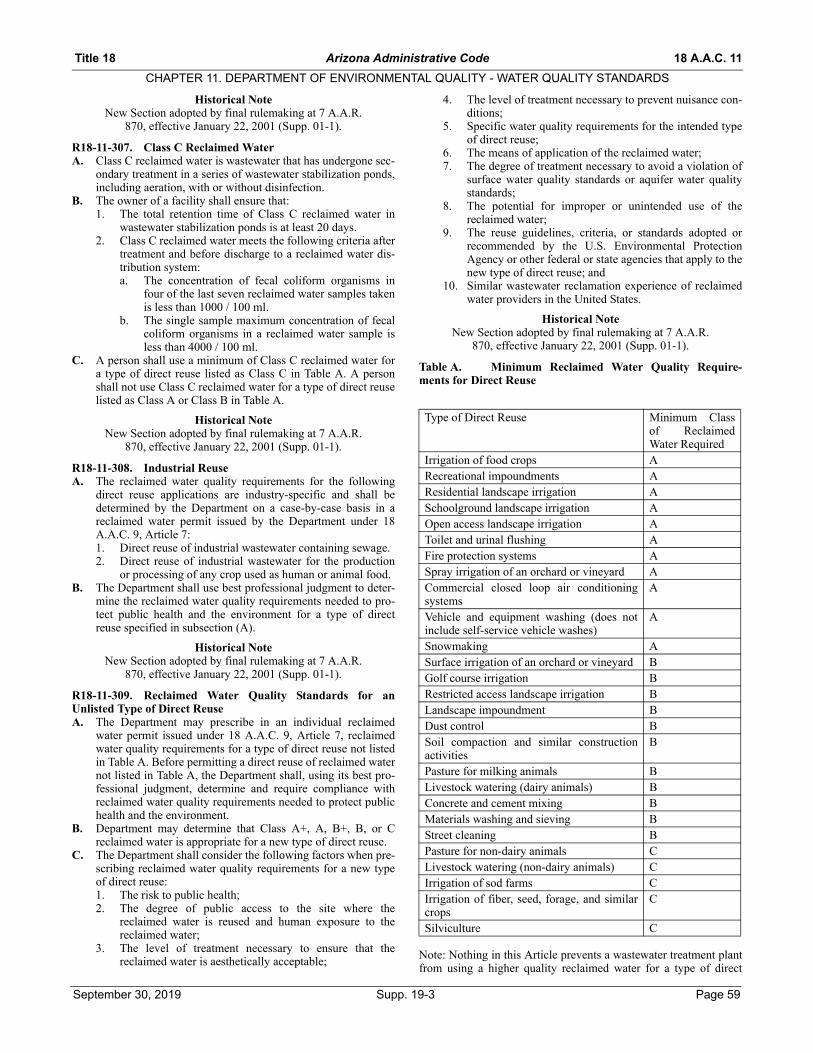
Title 18 Arizona Administrative Code 18 A.A.C. 11
CHAPTER 11. DEPARTMENT OF ENVIRONMENTAL QUALITY - WATER QUALITY STANDARDS
Historical NoteNew Section adopted by final rulemaking at 7 A.A.R.
870, effective January 22, 2001 (Supp. 01-1).
R18-11-307. Class C Reclaimed WaterA. Class C reclaimed water is wastewater that has undergone sec-
ondary treatment in a series of wastewater stabilization ponds,including aeration, with or without disinfection.
B. The owner of a facility shall ensure that:1. The total retention time of Class C reclaimed water in
wastewater stabilization ponds is at least 20 days.2. Class C reclaimed water meets the following criteria after
treatment and before discharge to a reclaimed water dis-tribution system:a. The concentration of fecal coliform organisms in
four of the last seven reclaimed water samples takenis less than 1000 / 100 ml.
b. The single sample maximum concentration of fecalcoliform organisms in a reclaimed water sample isless than 4000 / 100 ml.
C. A person shall use a minimum of Class C reclaimed water fora type of direct reuse listed as Class C in Table A. A personshall not use Class C reclaimed water for a type of direct reuselisted as Class A or Class B in Table A.
Historical NoteNew Section adopted by final rulemaking at 7 A.A.R.
870, effective January 22, 2001 (Supp. 01-1).
R18-11-308. Industrial ReuseA. The reclaimed water quality requirements for the following
direct reuse applications are industry-specific and shall bedetermined by the Department on a case-by-case basis in areclaimed water permit issued by the Department under 18A.A.C. 9, Article 7:1. Direct reuse of industrial wastewater containing sewage.2. Direct reuse of industrial wastewater for the production
or processing of any crop used as human or animal food.B. The Department shall use best professional judgment to deter-
mine the reclaimed water quality requirements needed to pro-tect public health and the environment for a type of directreuse specified in subsection (A).
Historical NoteNew Section adopted by final rulemaking at 7 A.A.R.
870, effective January 22, 2001 (Supp. 01-1).
R18-11-309. Reclaimed Water Quality Standards for anUnlisted Type of Direct ReuseA. The Department may prescribe in an individual reclaimed
water permit issued under 18 A.A.C. 9, Article 7, reclaimedwater quality requirements for a type of direct reuse not listedin Table A. Before permitting a direct reuse of reclaimed waternot listed in Table A, the Department shall, using its best pro-fessional judgment, determine and require compliance withreclaimed water quality requirements needed to protect publichealth and the environment.
B. Department may determine that Class A+, A, B+, B, or Creclaimed water is appropriate for a new type of direct reuse.
C. The Department shall consider the following factors when pre-scribing reclaimed water quality requirements for a new typeof direct reuse:1. The risk to public health;2. The degree of public access to the site where the
reclaimed water is reused and human exposure to thereclaimed water;
3. The level of treatment necessary to ensure that thereclaimed water is aesthetically acceptable;
4. The level of treatment necessary to prevent nuisance con-ditions;
5. Specific water quality requirements for the intended typeof direct reuse;
6. The means of application of the reclaimed water;7. The degree of treatment necessary to avoid a violation of
surface water quality standards or aquifer water qualitystandards;
8. The potential for improper or unintended use of thereclaimed water;
9. The reuse guidelines, criteria, or standards adopted orrecommended by the U.S. Environmental ProtectionAgency or other federal or state agencies that apply to thenew type of direct reuse; and
10. Similar wastewater reclamation experience of reclaimedwater providers in the United States.
Historical NoteNew Section adopted by final rulemaking at 7 A.A.R.
870, effective January 22, 2001 (Supp. 01-1).
Table A. Minimum Reclaimed Water Quality Require-ments for Direct Reuse
Note: Nothing in this Article prevents a wastewater treatment plantfrom using a higher quality reclaimed water for a type of direct
Type of Direct Reuse Minimum Classof ReclaimedWater Required
Irrigation of food crops ARecreational impoundments AResidential landscape irrigation ASchoolground landscape irrigation AOpen access landscape irrigation AToilet and urinal flushing AFire protection systems ASpray irrigation of an orchard or vineyard ACommercial closed loop air conditioningsystems
A
Vehicle and equipment washing (does notinclude self-service vehicle washes)
A
Snowmaking ASurface irrigation of an orchard or vineyard BGolf course irrigation BRestricted access landscape irrigation BLandscape impoundment BDust control BSoil compaction and similar constructionactivities
B
Pasture for milking animals BLivestock watering (dairy animals) BConcrete and cement mixing BMaterials washing and sieving BStreet cleaning BPasture for non-dairy animals CLivestock watering (non-dairy animals) CIrrigation of sod farms CIrrigation of fiber, seed, forage, and similarcrops
C
Silviculture C
September 30, 2019 Supp. 19-3 Page 59

18 A.A.C. 11 Arizona Administrative Code Title 18
CHAPTER 11. DEPARTMENT OF ENVIRONMENTAL QUALITY - WATER QUALITY STANDARDS
reuse than the minimum class of reclaimed water listed in Table A.For example, a wastewater treatment plant may provide Class Areclaimed water for a type of direct reuse where Class B or Class Creclaimed water is acceptable.
Historical NoteNew Table adopted by final rulemaking at 7 A.A.R. 870,
effective January 22, 2001 (Supp. 01-1).
ARTICLE 4. AQUIFER WATER QUALITY STANDARDS
R18-11-401. DefinitionsIn addition to the definitions contained in A.R.S. §§ 49-101 and 49-201, the terms of this Article shall have the following meanings:
1. “Beta particle and photon radioactivity from man-maderadionuclides” means all radionuclides emitting beta par-ticles or photons, except Thorium-232, Uranium-235,Uranium-238 and their progeny.
2. “Dose equivalent” means the product of the absorbeddose from ionizing radiation and such factors as accountfor differences in biological effectiveness due to the typeof radiation and its distribution in the body as specifiedby the International Commission on Radiological Unitsand Measurements.
3. “Drinking water protected use” means the protection andmaintenance of aquifer water quality for human con-sumption.
4. “Gross alpha particle activity” means the total radioactiv-ity due to alpha particle emission as inferred from mea-surements on a dry sample.
5. “Mg/l” means milligrams per liter.6. “Millirem” means 1/1000 of a rem. A rem means the unit
of dose equivalent from ionizing radiation to the totalbody or any internal organ or organ system.
7. “Non-drinking water protected use” means the protectionand maintenance of aquifer water quality for a use otherthan for human consumption.
8. “pCi” means picocurie, or the quantity of radioactivematerial producing 2.22 nuclear transformations per min-ute.
9. “Total trihalomethanes” means the sum of the concentra-tions of the following trihalomethane compounds: tri-chloromethane (chloroform), dibromo-chloromethane,bromodichloromethane and tribromo-methane (bromo-form).
Historical NoteAdopted effective January 4, 1990 (Supp. 90-1).
Amended effective August 14, 1992 (Supp. 92-3).
R18-11-402. Repealed
Historical NoteAdopted effective January 4, 1990 (Supp. 90-1).
Repealed effective August 14, 1992 (Supp. 92-3).
R18-11-403. Analytical MethodsAnalysis of a sample to determine compliance with an aquifer waterquality standard shall be in accordance with an analytical methodspecified in A.A.C. Title 9, Chapter 14, Article 6 or an alternativeanalytical method that is approved by the Director of the ArizonaDepartment of Health Services pursuant to A.A.C. R9-14-607(B).
Historical NoteAdopted effective January 4, 1990 (Supp. 90-1).
Amended effective August 14, 1992 (Supp. 92-3).
R18-11-404. LaboratoriesA test result from a sample taken to determine compliance with anaquifer water quality standard shall be valid only if the sample has
been analyzed by a laboratory that is licensed by the ArizonaDepartment of Health Services for the analysis performed.
Historical NoteAdopted effective January 4, 1990 (Supp. 90-1).
Amended effective August 14, 1992 (Supp. 92-3).
R18-11-405. Narrative Aquifer Water Quality StandardsA. A discharge shall not cause a pollutant to be present in an aqui-
fer classified for a drinking water protected use in a concentra-tion which endangers human health.
B. A discharge shall not cause or contribute to a violation of awater quality standard established for a navigable water of thestate.
C. A discharge shall not cause a pollutant to be present in an aqui-fer which impairs existing or reasonably foreseeable uses ofwater in an aquifer.
Historical NoteAdopted effective January 4, 1990 (Supp. 90-1).
Amended effective August 14, 1992 (Supp. 92-3).
R18-11-406. Numeric Aquifer Water Quality Standards:Drinking Water Protected UseA. The aquifer water quality standards in this Section apply to
aquifers that are classified for drinking water protected use.B. The following are the aquifer water quality standards for inor-
ganic chemicals:
C. The following are the aquifer water quality standards fororganic chemicals:
Pollutant mg/L)Antimony 0.006Arsenic 0.05Asbestos 7 million fibers/liter
(longer than 10 mm)Barium 2Beryllium 0.004Cadmium 0.005Chromium 0.1Cyanide (As Free Cyanide) 0.2Fluoride 4.0Lead 0.05Mercury 0.002Nickel 0.1Nitrate (as N) 10Nitrite (as N) 1Nitrate and nitrite (as N) 10Selenium 0.05Thallium 0.002
Pollutant (mg/L)Benzene 0.005Benzo (a) pyrene 0.0002Carbon Tetrachloride 0.005o-Dichlorobenzene 0.6para-Dichlorobenzene 0.0751,2-Dichloroethane 0.0051,1-Dichloroethylene 0.007cis-1,2-Dichloroethylene 0.07trans-1,2-Dichloroethylene 0.11,2-Dichloropropane 0.005Dichloromethane 0.005
Page 60 Supp. 19-3 September 30, 2019

Title 18 Arizona Administrative Code 18 A.A.C. 11
CHAPTER 11. DEPARTMENT OF ENVIRONMENTAL QUALITY - WATER QUALITY STANDARDS
D. The following are the aquifer water quality standards for pesti-cides and polychlorinated biphenyls (PCBs):
E. The following are the aquifer water quality standards forradionuclides:1. The maximum concentration for gross alpha particle
activity, including Radium-226 but excluding radon anduranium, shall not exceed 15 pCi/l.
2. The maximum concentration for combined Radium-226and Radium-228 shall not exceed 5 pCi/l.
3. The average annual concentration of beta particle andphoton radioactivity from man-made radionuclides shallnot produce an annual dose equivalent to the total body orany internal organ greater than 4 millirem/year.
4. Except for the radionuclides listed in this subsection, theconcentration of man-made radionuclides causing 4 milli-rem total body or organ dose equivalents shall be calcu-lated on the basis of a 2-liter-per-day drinking waterintake using the 168-hour data listed in “Maximum Per-missible Body Burdens and Maximum Permissible Con-centration of Radionuclides in Air or Water forOccupational Exposure,” National Bureau of StandardsHandbook 69, National Bureau of Commerce, asamended August 1963 (and no future editions), incorpo-rated herein by reference and on file with the Office ofthe Secretary of State and with the Department. If two ormore radionuclides are present, the sum of their annualdose equivalent to the total body or to any organ shall notexceed 4 millirem/year. The following average annualconcentrations are assumed to produce a total body ororgan dose of 4 millirem/year:
F. The aquifer water quality standard for microbiological con-taminants is based upon the presence or absence of total coli-forms in a 100-milliliter sample. If a sample is total coliform-positive, a 100-milliliter repeat sample shall be taken withintwo weeks of the time the sample results are reported. Anytotal coliform-positive repeat sample following a total coli-form-positive sample constitutes a violation of the aquiferwater quality standard for microbiological contaminants.
G. The following are the aquifer water quality standards for tur-bidity:1. One nephelometric turbidity unit as determined by a
monthly average except that five or fewer nephelometricturbidity units may be allowed if it can be determined thatthe higher turbidity does not interfere with disinfection,prevent maintenance of effective disinfectant agents inwater supply distribution systems, or interfere withmicrobiological determinations.
2. Five nephelometric turbidity units based on an average oftwo consecutive days.
Historical NoteAdopted effective January 4, 1990 (Supp. 90-1).
Amended effective August 14, 1992 (Supp. 92-3). Amended effective May 26, 1994 (Supp. 94-2).
R18-11-407. Aquifer Water Quality Standards in ReclassifiedAquifersA. All aquifers in the state are classified for drinking water pro-
tected use except for aquifers which are reclassified to a non-drinking water protected use pursuant to A.R.S. § 49-224 andA.A.C. R18-11-503.
B. Aquifer water quality standards for drinking water protecteduse apply to reclassified aquifers except where expresslysuperseded by aquifer water quality standards adopted pursu-ant to subsection (C) of this Section.
C. The Director shall adopt, by rule, aquifer water quality stan-dards for reclassified aquifers within one year of the date ofthe order reclassifying the aquifer to a nondrinking water pro-tected use. The Director shall adopt aquifer water quality stan-dards for reclassified aquifers only for pollutants that arespecifically identified in a petition for reclassification as pre-scribed by A.R.S. § 49-223(D) and A.A.C. R18-11-503(B).Aquifer water quality standards for reclassified aquifers shallbe sufficient to protect the use of the reclassified aquifer.
Di (2-ethylhexyl) adipate 0.4Di (2-ethylhexyl) pthalate 0.006Ethylbenzene 0.7Hexachlorobenzene 0.001Hexachlorocyclopentadiene 0.05Monochlorobenzene 0.1Pentachlorophenol 0.001Styrene 0.12,3,7,8-TCDD (Dioxin) 0.00000003Tetrachloroethylene 0.005Toluene 1Trihalomethanes (Total) 0.101,2,4-Trichlorobenzene 0.071,1,1-Trichloroethane 0.201,1,2-Trichloroethane 0.005Trichloroethylene 0.005Vinyl Chloride 0.002Xylenes (Total) 10
Pollutant (mg/L)Alachlor 0.002Atrazine 0.003Carbofuran 0.04Chlordane 0.002Dalapon 0.21,2-Dibromo-3-Chloropropane (DBCP) 0.00022,4,-Dichlorophenoxyacetic Acid(2,4-D) 0.07Dinoseb 0.007Diquat 0.02Endothall 0.1Endrin 0.002Ethylene Dibromide (EDB) 0.00005Glyphosate 0.7Heptachlor 0.0004Heptachlor Epoxide 0.0002Lindane 0.0002Methoxychlor 0.04Oxamyl 0.2Picloram 0.5Polychlorinated Biphenols (PCBs) 0.0005Simazine 0.004Toxaphene 0.0032,4,5-Trichlorophenoxypropionic Acid(2,4,5-TP or Silvex)
0.05
Radionuclide Critical Organ pCi/lTritium Total body 20,000Strontium-90 Bone Marrow 8
September 30, 2019 Supp. 19-3 Page 61

18 A.A.C. 11 Arizona Administrative Code Title 18
CHAPTER 11. DEPARTMENT OF ENVIRONMENTAL QUALITY - WATER QUALITY STANDARDS
Historical NoteAdopted effective January 4, 1990 (Supp. 90-1).
Amended effective August 14, 1992 (Supp. 92-3).
R18-11-408. Petition for Adoption of a Numeric AquiferWater Quality StandardA. Any person may petition the Director to adopt, by rule, a
numeric aquifer water quality standard for a pollutant forwhich no numeric aquifer water quality standard exists.
B. Petitions for adoption of a numeric aquifer water quality stan-dard shall be filed with the Department and shall comply withthe requirements applicable to petitions for rule adoption asprovided by A.R.S. § 41-1033 and A.A.C. R18-1-302, exceptas otherwise provided by A.R.S. § 49-223 or this Section.
C. In addition to the requirements of A.A.C. R18-1-302, a peti-tion for rule adoption to establish a numeric aquifer waterquality standard shall include specific reference to:1. Technical information that the pollutant is a toxic pollut-
ant.2. Technical information upon which the Director reason-
ably may base the establishment of a numeric aquiferwater quality standard.
3. Evidence that the pollutant that is the subject of the peti-tion is or may in the future be present in an aquifer or partof an aquifer that is classified for drinking water pro-tected use. Evidence may include, but is not limited to,any of the following:a. A laboratory analysis of a water sample by a labora-
tory licensed by the Arizona Department of HealthServices which indicates the presence of the pollut-ant in the aquifer.
b. A hydrogeological study which demonstrates thatthe pollutant that is the subject of the petition may bepresent in an aquifer in the future. The hydrogeolog-ical study shall include the following:i. A description of the use that results in a dis-
charge of the pollutant that is the subject of thepetition.
ii. A description of the mobility of the pollutant inthe vadose zone and in the aquifer.
iii. A description of the persistence of the pollutantin the vadose zone and in the aquifer.
D. Within 180 calendar days of the receipt of a complete petitionfor rule adoption to establish a numeric aquifer water qualitystandard, the Director shall make a written determination ofwhether the petition should be granted or denied. The Directorshall give written notice by regular mail of the determinationto the petitioner.
E. If the petition for rule adoption is granted, the Director shallinitiate rulemaking proceedings to adopt a numeric aquiferwater quality standard. The Director shall, within one year ofthe date that the petition for adoption of a numeric aquiferwater quality standard is granted, either adopt a rule establish-ing a numeric aquifer water quality standard or publish anotice of termination of rulemaking in the Arizona Adminis-trative Register.
F. If the petition for rule adoption is denied, the Director shallissue a denial letter to the petitioner which explains the reasonsfor the denial. The denial of a petition for rule adoption toestablish a numeric aquifer water quality standard is not sub-ject to judicial review.
Historical NoteAdopted effective January 4, 1990 (Supp. 90-1).
Appendix 1. Repealed
Historical NoteAdopted effective January 4, 1990 (Supp. 90-1).
Repealed effective August 14, 1992 (Supp. 92-3).
Appendix 2. Repealed
Historical NoteAdopted effective January 4, 1990 (Supp. 90-1).
Repealed effective August 14, 1992 (Supp. 92-3).
Appendix 3. Repealed
Historical NoteAdopted effective January 4, 1990 (Supp. 90-1).
Repealed effective August 14, 1992 (Supp. 92-3).
Appendix 4. Repealed
Historical NoteAdopted effective January 4, 1990 (Supp. 90-1).
Repealed effective August 14, 1992 (Supp. 92-3).
Appendix 5. Repealed
Historical NoteAdopted effective January 4, 1990 (Supp. 90-1).
Repealed effective August 14, 1992 (Supp. 92-3).
Appendix 6. Repealed
Historical NoteAdopted effective January 4, 1990 (Supp. 90-1).
Repealed effective August 14, 1992 (Supp. 92-3).
Appendix 7. Repealed
Historical NoteAdopted effective January 4, 1990 (Supp. 90-1).
Repealed effective August 14, 1992 (Supp. 92-3).
ARTICLE 5. AQUIFER BOUNDARY AND PROTECTED USE CLASSIFICATION
R18-11-501. DefinitionsIn addition to the definitions contained in A.R.S. § 49-201, thewords and phrases of this Article shall have the following meaning:
1. “Drinking water protected use” means the protection andmaintenance of aquifer water quality for human con-sumption.
2. “Hardrock areas containing little or no water” meansareas of igneous or metamorphic rock which do not yieldusable quantities of water.
3. “Nondrinking water protected use” means the protectionand maintenance of aquifer water quality for a use otherthan human consumption.
4. “Usable quantities” means five gallons of water per day.
Historical NoteAdopted effective October 22, 1987 (Supp. 87-4).
R18-11-502. Aquifer boundariesA. Except as provided in subsection (B) of this rule, aquifer
boundaries for the aquifers in this state are identified anddefined as being identical to the hydrologic basin and subbasinboundaries, as found by the Director of the Department ofWater Resources, Findings and Order In the Matter of TheDesignation of Groundwater Basins and Subbasins In TheState of Arizona (dated June 21, 1984), pursuant to A.R.S. §§45-403 and 45-404, which is incorporated herein by referenceand on file with the Department of Environmental Quality andthe Office of the Secretary of State.
B. Excluded from the boundaries of the aquifers are hard rockareas which contain little or no water, as identified in Plate 1 ofthe Department of Water Resources, Water Resource Hydro-
Page 62 Supp. 19-3 September 30, 2019

Title 18 Arizona Administrative Code 18 A.A.C. 11
CHAPTER 11. DEPARTMENT OF ENVIRONMENTAL QUALITY - WATER QUALITY STANDARDS
logic Map Series Report Number 2 (dated January 1981) andas further identified in the Bureau of Mines, University of Ari-zona County Geologic Map Series (individual county mapsdated 1957 through 1960), which are incorporated herein byreference and on file with the Department of EnvironmentalQuality and the Office of the Secretary of State.
C. The Director may, by rule, modify or add an aquifer boundaryprovided that one or more of the following applies:1. The Department of Water Resources modifies the bound-
aries of its basins or subbasins.2. The Director is made aware of new technical information
or data which supports refinement of an aquifer bound-ary.
D. Facilities located outside of the boundaries defined in theserules shall be subject to A.R.S. § 49-241 except as providedtherein.
Historical NoteAdopted effective October 22, 1987 (Supp. 87-4).
R18-11-503. Petition for reclassificationA. Any person may petition the Director to reclassify an aquifer
from a drinking water protected use to a nondrinking waterprotected use pursuant to A.R.S. § 49-224(C).
B. A written petition for reclassification pursuant to A.R.S. § 49-224(C) or A.R.S. § 49-224(D) shall be filed with the Depart-ment and shall include the following categories of informa-tion:1. The proposed protected use for which the reclassification
is being requested.2. The pollutant and affected aquifer water quality standards
for which the reclassification is being requested.3. A hydrogeologic report which demonstrates that the aqui-
fer proposed for reclassification is or will be hydrologi-cally isolated, to the extent described in A.R.S. § 49-224(C)(1). This report and demonstration of hydrologicisolation for the area containing such aquifer, and imme-diate adjacent geologic units, shall include at least the fol-lowing:a. Hydrogeologic area maps and cross sections.b. An analysis of subsurface geology, including geo-
logic and hydrologic separation.c. Water level elevation or piezometric level contour
maps.d. Analysis of hydrologic characteristics of the aquifer
and the immediate adjacent geologic units.e. Description of existing water quality and analysis of
water chemistry.f. Projected annual quantity of water to be withdrawn.g. Identification of pumping centers, cones of depres-
sion and areas of recharge.h. A water balance.i. Existing flow direction and evaluation of the effects
of seasonal and future pumping on flow.j. An evaluation as to whether the reclassification will
contribute to or cause a violation of aquifer waterquality standards in other aquifers, or in parts of theaquifer not being proposed for reclassification.
4. Documentation demonstrating that water from the aquiferor part of the aquifer for which reclassification is pro-posed is not being used as drinking water. This documen-tation shall include at least the following:a. A list of all wells or springs including their location,
ownership and use within the aquifer or part of theaquifer being proposed for reclassification.
b. Identification of groundwater withdrawal rights, onfile with the Department of Water Resources, within
the aquifer or part of the aquifer being proposed forreclassification.
c. A comprehensive list of agencies, persons and otherinformation sources consulted for aquifer use docu-mentation.
5. A cost-benefit analysis developed pursuant to the require-ments of A.R.S. § 49-224(C)(3), except for petitions sub-mitted pursuant to A.R.S. § 49-224(D). This analysisshall identify potential future uses of the aquifer beingproposed for reclassification, as well as other opportunitycosts associated with reclassification, and shall contain adescription of the cost-benefit methodology used, includ-ing all assumptions, data, data sources and criteria con-sidered and all supporting statistical analyses.
Historical NoteAdopted effective October 22, 1987 (Supp. 87-4).
R18-11-504. Agency action on petitionA. Upon receipt of a petition for reclassification, the Director
shall review the petition for compliance with the requirementsof R18-11-503. If additional information is necessary, the peti-tioner shall be notified of specific deficiencies in writingwithin 30 calendar days of receipt of the petition.
B. Within 120 calendar days after receipt of a complete petition,and after consultation with the appropriate advisory councilpursuant to A.R.S. §§ 49-224(C) and 49-204, the Directorshall make a final decision to grant or deny the petition andshall notify the petitioner of such decision and the reason forsuch determination in writing.
C. Upon a decision to grant a petition for aquifer reclassification,the Director shall initiate proceedings for promulgation ofaquifer water quality standards and, if applicable, for aquiferboundary designation for the reclassified aquifers.
Historical NoteAdopted effective October 22, 1987 (Supp. 87-4).
R18-11-505. Public participationA. Within 30 days of receipt of a complete petition for reclassifi-
cation filed pursuant to A.R.S. § 49-224(D), or if the Directordeems it necessary to consider a reclassification under A.R.S.§ 49-224(C), the Director shall give public notice of the pro-posed reclassification pursuant to A.A.C. R18-1-401.
B. The Director shall hold at least one public hearing at a locationas near as practicable to the aquifer proposed for reclassifica-tion. The Director shall give notice of each public hearing andconduct the public hearing in accordance with the provisionsof A.A.C. R18-1-402.
Historical NoteAdopted effective June 29, 1989 (Supp. 89-2).
R18-11-506. Rescission of reclassificationThe Director may, by rule, rescind an aquifer reclassification andreturn an aquifer to a drinking water protected use if he determinesthat any of the conditions under which the reclassification wasgranted are no longer valid. If the Director initiates a change underthis Section, he shall consult with the appropriate advisory councilpursuant to A.R.S. §§ 49-224(C) and 49-204.
Historical NoteAdopted effective October 22, 1987 (Supp. 87-4).
ARTICLE 6. IMPAIRED WATER IDENTIFICATION
Article 6, consisting of Sections R18-11-601 through R18-11-606, made by final rulemaking at 8 A.A.R. 3380, effective July 12,2002 (Supp. 02-3).
R18-11-601. Definitions
September 30, 2019 Supp. 19-3 Page 63

18 A.A.C. 11 Arizona Administrative Code Title 18
CHAPTER 11. DEPARTMENT OF ENVIRONMENTAL QUALITY - WATER QUALITY STANDARDS
In addition to the definitions established in A.R.S. §§ 49-201 and49-231, and A.A.C. R18-11-101, the following terms apply to thisArticle:
1. “303(d) List” means the list of surface waters or segmentsrequired under section 303(d) of the Clean Water Act andA.R.S. Title 49, Chapter 2, Article 2.1, for which TMDLsare developed and submitted to EPA for approval.
2. “Attaining” means there is sufficient, credible, and scien-tifically defensible data to assess a surface water or seg-ment and the surface water or segment does not meet thedefinition of impaired or not attaining.
3. “AZPDES” means the Arizona Pollutant EliminationDischarge System.
4. “Credible and scientifically defensible data” means datasubmitted, collected, or analyzed using:a. Quality assurance and quality control procedures
under A.A.C. R18-11-602;b. Samples or analyses representative of water quality
conditions at the time the data were collected;c. Data consisting of an adequate number of samples
based on the nature of the water in question and theparameters being analyzed; and
d. Methods of sampling and analysis, including analyt-ical, statistical, and modeling methods that are gen-erally accepted and validated by the scientificcommunity as appropriate for use in assessing thecondition of the water.
5. “Designated use” means those uses specified in 18A.A.C. 11, Article 1 for each surface water or segmentwhether or not they are attaining.
6. “EPA” means the U.S. Environmental Protection Agency.7. “Impaired water” means a Navigable water for which
credible scientific data exists that satisfies the require-ments of A.R.S. § 49-232 and that demonstrates that thewater should be identified pursuant to 33 United StatesCode § 1313(d) and the regulations implementing thatstatute. A.R.S. § 49-231(1).
8. “Laboratory detection limit” means a “Method ReportingLimit” (MRL) or “Reporting Limit” (RL). These analo-gous terms describe the laboratory reported value, whichis the lowest concentration level included on the calibra-tion curve from the analysis of a pollutant that can bequantified in terms of precision and accuracy.
9. “Monitoring entity” means the Department or any personwho collects physical, chemical, or biological data usedfor an impaired water identification or a TMDL decision.
10. “Naturally occurring condition” means the condition of asurface water or segment that would have occurred in theabsence of pollutant loadings as a result of human activ-ity.
11. “Not attaining” means a surface water is assessed asimpaired, but is not placed on the 303(d) List because:a. A TMDL is prepared and implemented for the sur-
face water;b. An action, which meets the requirements of R18-11-
604(D)(2)(h), is occurring and is expected to bringthe surface water to attaining before the next 303(d)List submission; or
c. The impairment of the surface water is due to pollu-tion but not a pollutant, for which a TMDL loadallocation cannot be developed.
12. “NPDES” means National Pollutant Discharge Elimina-tion System.
13. “Planning List” means a list of surface waters and seg-ments that the Department will review and evaluate to
determine if the surface water or segment is impaired andwhether a TMDL is necessary.
14. “Pollutant” means dredged spoil, solid waste, incineratorresidue, sewage, garbage, sewage sludge, munitions,chemical wastes, biological materials, radioactive materi-als, heat, wrecked or discarded equipment, rock, sand,cellar dirt and industrial, municipal, and agriculturalwaste discharged into water. 33 U.S.C. 1362(6). Charac-teristics of water, such as dissolved oxygen, pH, tempera-ture, turbidity, and suspended sediment are consideredpollutants if they result or may result in the non-attain-ment of a water quality standard.
15. “Pollution” means “the man-made or man-induced alter-ation of the chemical, physical, biological, and radiologi-cal integrity of water.” 33 U.S.C. 1362(19).
16. “QAP” means a quality assurance plan detailing howenvironmental data operations are planned, implemented,and assessed for quality during the duration of a project.
17. “Sampling event” means one or more samples takenunder consistent conditions on one or more days at a dis-tinct station or location.
18. “SAP” means a site specific sampling and analysis planthat describes the specifics of sample collection to ensurethat data quality objectives are met and that samples col-lected and analyzed are representative of surface waterconditions at the time of sampling.
19. “Spatially independent sample” means a sample that iscollected at a distinct station or location. The sample isindependent if the sample was collected:a. More than 200 meters apart from other samples, orb. Less than 200 meters apart, and collected to charac-
terize the effect of an intervening tributary, outfall orother pollution source, or significant hydrographicor hydrologic change.
20. “Temporally independent sample” means a sample that iscollected at the same station or location more than sevendays apart from other samples.
21. “Threatened” means that a surface water or segment iscurrently attaining its designated use, however, trendanalysis, based on credible and scientifically defensibledata, indicates that the surface water or segment is likelyto be impaired before the next listing cycle.
22. “TMDL” means total maximum daily load.23. “TMDL decision” means a decision by the Department
to:a. Prioritize an impaired water for TMDL develop-
ment,b. Develop a TMDL for an impaired water, orc. Develop a TMDL implementation plan.
24. “Total maximum daily load” means an estimation of thetotal amount of a pollutant from all sources that may beadded to a water while still allowing the water to achieveand maintain applicable surface water quality standards.Each total maximum daily load shall include allocationsfor sources that contribute the pollutant to the water, asrequired by section 303(d) of the clean water act (33United States Code section 1313(d)) and regulationsimplementing that statute to achieve applicable surfacewater quality standards. A.R.S. § 49-231(4).
25. “Water quality standard” means a standard composed ofdesignated uses (classification of waters), the numericaland narrative criteria applied to the specific water uses orclassification, the antidegradation policy, and moderatingprovisions, for example, mixing zones, site-specific alter-native criteria, and exemptions, in A.A.C. Title 18, Chap-ter 11, Article 1.
Page 64 Supp. 19-3 September 30, 2019
Title 18 Arizona Administrative Code 18 A.A.C. 11
CHAPTER 11. DEPARTMENT OF ENVIRONMENTAL QUALITY - WATER QUALITY STANDARDS
26. “WQARF” means the water quality assurance revolvingfund established under A.R.S. § 49-282.
Historical NoteNew Section made by final rulemaking at 8 A.A.R. 3380,
effective July 12, 2002 (Supp. 02-3).
R18-11-602. Credible DataA. Data are credible and relevant to an impaired water identifica-
tion or a TMDL decision when:1. Quality Assurance Plan. A monitoring entity, which con-
tribute data for an impaired water identification or aTMDL decision, provides the Department with a QAPthat contains, at a minimum, the elements listed in sub-sections (A)(1)(a) through (A)(1)(f). The Departmentmay accept a QAP containing less than the required ele-ments if the Department determines that an element is notrelevant to the sampling activity and that its omission willnot impact the quality of the results based upon the typeof pollutants to be sampled, the type of surface water, andthe purpose of the sampling.a. An approval page that includes the date of approval
and the signatures of the approving officials, includ-ing the project manager and project quality assur-ance manager;
b. A project organization outline that identifies all keypersonnel, organizations, and laboratories involvedin monitoring, including the specific roles andresponsibilities of key personnel in carrying out theprocedures identified in the QAP and SAP, if appli-cable;
c. Sampling design and monitoring data quality objec-tives or a SAP that meets the requirements of sub-section (A)(2) to ensure that:i. Samples are spatially and temporally represen-
tative of the surface water,ii. Samples are representative of water quality
conditions at the time of sampling, andiii. The monitoring is reproducible;
d. The following field sampling information to assurethat samples meet data quality objectives:i. Sampling and field protocols for each parame-
ter or parametric group, including the samplingmethods, equipment and containers, samplepreservation, holding times, and any analysisproposed for completion in the field or outsideof a laboratory;
ii. Field and laboratory methods approved undersubsection (A)(5);
iii. Handling procedures to identify samples andcustody protocols used when samples arebrought from the field to the laboratory foranalysis;
iv. Quality control protocols that describe thenumber and type of field quality control sam-ples for the project that includes, if appropriatefor the type of sampling being conducted, fieldblanks, travel blanks, equipment blanks,method blanks, split samples, and duplicatesamples;
v. Procedures for testing, inspecting, and main-taining field equipment;
vi. Field instrument calibration procedures thatdescribe how and when field sampling and ana-lytical instruments will be calibrated;
vii. Field notes and records that describe the condi-tions that require documentation in the field,
such as weather, stream flow, transect informa-tion, distance from water edge, water and sam-ple depth, equipment calibrationmeasurements, field observations of watershedactivities, and bank conditions. Indicate theprocedures implemented for maintaining fieldnotes and records and the process used forattaching pertinent information to monitoringresults to assist in data interpretation;
viii. Minimum training and any specialized trainingnecessary to do the monitoring, that includesthe proper use and calibration of field equip-ment used to collect data, sampling protocols,quality assurance/quality control procedures,and how training will be achieved;
e. Laboratory analysis methods and quality assurance/quality control procedures that assure that samplesmeet data quality objectives, including:i. Analytical methods and equipment necessary
for analysis of each parameter, including identi-fication of approved laboratory methodsdescribed in subsection (A)(5), and laboratorydetection limits for each parameter;
ii. The name of the designated laboratory, itslicense number, if licensed by the ArizonaDepartment of Health Services, and the nameof a laboratory contact person to assist theDepartment with quality assurance questions;
iii. Quality controls that describe the number andtype of laboratory quality control samples forthe project, including, if appropriate for thetype of sampling being conducted, field blanks,travel blanks, equipment blanks, methodblanks, split samples, and duplicate samples;
iv. Procedures for testing, inspecting, and main-taining laboratory equipment and facilities;
v. A schedule for calibrating laboratory instru-ments, a description of calibration methods,and a description of how calibration records aremaintained; and
vi. Sample equipment decontamination proceduresthat outline specific methods for sample collec-tion and preparation of equipment, identify thefrequency of decontamination, and describe theprocedures used to verify decontamination;
f. Data review, management, and use that includes thefollowing:i. A description of the data handling process from
field to laboratory, from laboratory to datareview and validation, and from validation todata storage and use. Include the role andresponsibility of each person for each step ofthe process, type of database or other storageused, and how laboratory and field data qualifi-ers are related to the laboratory result;
ii. Reports that describe the intended frequency,content, and distribution of final analysisreports and project status reports;
iii. Data review, validation, and verification thatdescribes the procedure used to validate andverify data, the procedures used if errors aredetected, and how data are accepted, rejected,or qualified; and
iv. Reconciliation with data quality objectives thatdescribes the process used to determinewhether the data collected meets the project
September 30, 2019 Supp. 19-3 Page 65

18 A.A.C. 11 Arizona Administrative Code Title 18
CHAPTER 11. DEPARTMENT OF ENVIRONMENTAL QUALITY - WATER QUALITY STANDARDS
objectives, which may include discarding data,setting limits on data use, or revising data qual-ity objectives.
2. Sampling and analysis plan.a. A monitoring entity shall develop a SAP that con-
tains, at a minimum, the following elements:i. The experimental design of the project, the
project goals and objectives, and evaluation cri-teria for data results;
ii. The background or historical perspective of theproject;
iii. Identification of target conditions, including adiscussion of whether any weather, seasonalvariations, stream flow, lake level, or siteaccess may affect the project and the consider-ation of these factors;
iv. The data quality objectives for measurement ofdata that describe in quantitative and qualitativeterms how the data meet the project objectivesof precision, accuracy, completeness, compara-bility, and representativeness;
v. The types of samples scheduled for collection;vi. The sampling frequency;vii. The sampling periods;viii. The sampling locations and rationale for the
site selection, how site locations are bench-marked, including scaled maps indicatingapproximate location of sites; and
ix. A list of the field equipment, including toler-ance range and any other manufacturer’s speci-fications relating to accuracy and precision.
b. The Department may accept a SAP containing lessthan the required elements if the Department deter-mines that an element is not relevant to the samplingactivity and that its omission will not impact thequality of the results based upon the type of pollut-ants to be samples, the type of surface water, and thepurpose of the sampling.
3. The monitoring entity may include any of the followingin the QAP or SAP:a. The name, title, and role of each person and organi-
zation involved in the project, identifying specificroles and responsibilities for carrying out the proce-dures identified in the QAP and SAP;
b. A distribution list of each individual and organiza-tion receiving a copy of the approved QAP and SAP;
c. A table of contents;d. A health and safety plan;e. The inspection and acceptance requirements for sup-
plies;f. The data acquisition that describes types of data not
obtained through this monitoring activity, but usedin the project;
g. The audits and response actions that describe howfield, laboratory, and data management activities andsampling personnel are evaluated to ensure dataquality, including a description of how the projectwill correct any problems identified during theseassessments; and
h. The waste disposal methods that identify wastesgenerated in sampling and methods for disposal ofthose wastes.
4. Exceptions. The Department may determine that the fol-lowing data are also credible and relevant to an impairedwater identification or TMDL decision when data werecollected, provided the conditions in subsections (A)(5),
(A)(6), and (B) are met, and where the data were col-lected in the surface water or segment being evaluated forimpairment:a. The data were collected before July 12, 2002 and the
Department determines that the data yield results ofcomparable reliability to the data collected undersubsections (A)(1) and (A)(2);
b. The data were collected after July 12, 2002 as part ofan ongoing monitoring effort by a governmentalagency and the Department determines that the datayield results of comparable reliability to the data col-lected under subsections (A)(1) and (A)(2); or
c. The instream water quality data were or are col-lected under the terms of a NPDES or AZPDES per-mit or a compliance order issued by the Departmentor EPA, a consent decree signed by the Departmentor EPA, or a sampling program approved by theDepartment or EPA under WQARF or CERCLA,and the Department determines that the data yieldresults of comparable reliability to data collectedunder subsections (A)(1) and (A)(2).
5. Data collection, preservation, and analytical procedures.The monitoring entity shall collect, preserve, and analyzedata using methods of sample collection, preservation,and analysis established under A.A.C. R9-14-610.
6. Laboratory. The monitoring entity shall ensure that chem-ical and toxicological samples are analyzed in a state-licensed laboratory, a laboratory exempted by the ArizonaDepartment of Health Services for specific analyses, or afederal or academic laboratory that can demonstrateproper quality assurance/quality control procedures sub-stantially equal to those required by the Arizona Depart-ment of Health Services, and shall ensure that thelaboratory uses approved methods identified in A.A.C.R9-14-610.
B. Documentation for data submission. The monitoring entityshall provide the Department with the following informationeither before or with data submission:1. A copy of the QAP or SAP, or both, revisions to a previ-
ously submitted QAP or SAP, and any other informationnecessary for the Department to evaluate the data undersubsection (A)(4);
2. The applicable dates of the QAP and SAP, including anyrevisions;
3. Written assurance that the methods and procedures speci-fied in the QAP and SAP were followed;
4. The name of the laboratory used for sample analyses andits certification number, if the laboratory is licensed bythe Arizona Department of Health Services;
5. The quality assurance/quality control documentation,including the analytical methods used by the laboratory,method number, detection limits, and any blank, dupli-cate, and spike sample information necessary to properlyinterpret the data, if different from that stated in the QAPor SAP;
6. The data reporting unit of measure;7. Any field notes, laboratory comments, or laboratory nota-
tions concerning a deviation from standard procedures,quality control, or quality assurance that affects data reli-ability, data interpretation, or data validity; and
8. Any other information, such as complete field notes, pho-tographs, climate, or other information related to flow,field conditions, or documented sources of pollutants inthe watershed, if requested by the Department for inter-preting or validating data.
Page 66 Supp. 19-3 September 30, 2019

Title 18 Arizona Administrative Code 18 A.A.C. 11
CHAPTER 11. DEPARTMENT OF ENVIRONMENTAL QUALITY - WATER QUALITY STANDARDS
C. Recordkeeping. The monitoring entity shall maintain allrecords, including sample results, for the duration of the listingcycle. If a surface water or segment is added to the PlanningList or to the 303(d) List, the Department shall coordinate withthe monitoring entity to ensure that records are kept for theduration of the listing.
Historical NoteNew Section made by final rulemaking at 8 A.A.R. 3380,
effective July 12, 2002 (Supp. 02-3).
R18-11-603. General Data Interpretation RequirementsA. The Department shall use the following data conventions to
interpret data for impaired water identifications and TMDLdecisions:1. Data reported below laboratory detection limits.
a. When the analytical result is reported as <X, whereX is the laboratory detection limit for the analyte andthe laboratory detection limit is less than or equal tothe surface water quality standard, consider theresult as meeting the water quality standard:i. Use these statistically derived values in trend
analysis, descriptive statistics or modeling ifthere is sufficient data to support the statisticalestimation of values reported as less than thelaboratory detection limit; or
ii. Use one-half of the value of the laboratorydetection limit in trend analysis, descriptivestatistics, or modeling, if there is insufficientdata to support the statistical estimation of val-ues reported as less than the laboratory detec-tion limit.
b. When the sample value is less than or equal to thelaboratory detection limit but the laboratory detec-tion limit is greater than the surface water qualitystandard, shall not use the result for impaired wateridentifications or TMDL decisions;
2. Identify the field equipment specifications used for eachlisting cycle or TMDL developed. A field sample mea-surement within the manufacturer’s specification foraccuracy meets surface water quality standards;
3. Resolve a data conflict by considering the factors identi-fied under the weight-of-evidence determination in R18-11-605(B);
4. When multiple samples from a surface water or segmentare not spatially or temporally independent, or when lakesamples are from multiple depths, use the followingresultant value to represent the specific dataset:a. The appropriate measure of central tendency for the
dataset for:i. A pollutant listed in the surface water quality
standards 18 A.A.C. 11, Article 1, Appendix A,Table 1, except for nitrate or nitrate/nitrite;
ii. A chronic water quality standard for a pollutantlisted in 18 A.A.C. 11, Article 1, Appendix A,Table 2;
iii. A surface water quality standard for a pollutantthat is expressed as an annual or geometricmean;
iv. The surface water quality standard for tempera-ture or the single sample maximum water qual-ity standard for suspended sedimentconcentration, nitrogen, and phosphorus inR18-11-109;
v. The surface water quality standard for radio-chemicals in R18-11-109(G); or
vi. Except for chromium, all single sample maxi-mum water quality standards in R18-11-112.
b. The maximum value of the dataset for:i. The acute water quality standard for a pollutant
listed in 18 A.A.C. 11, Article 1, Appendix A,Table 2 and acute water quality standard inR18-11-112;
ii. The surface water quality standard for nitrate ornitrate/nitrite in 18 A.A.C. 11, Article 1,Appendix A, Table 1;
iii. The single sample maximum water qualitystandard for bacteria in subsections R18-11-109(A); or
iv. The 90th percentile water quality standard fornitrogen and phosphorus in R18-11-109(F) andR18-11-112.
c. The worst case measurement of the dataset for:i. Surface water quality standard for dissolved
oxygen under R18-11-109(E). For purposes ofthis subsection, worst case measurement meansthe minimum value for dissolved oxygen;
ii. Surface water quality standard for pH underR18-11-109(B). For purposes of this subsec-tion, “worst case measurement” means both theminimum and maximum value for pH.
B. The Department shall not use the following data for placing asurface water or segment on the Planning List, the 303(d) List,or in making a TMDL decision.1. Any measurement outside the range of possible physical
or chemical measurements for the pollutant or measure-ment equipment,
2. Uncorrected data transcription errors or laboratory errors,and
3. An outlier identified through statistical procedures, wherefurther evaluation determines that the outlier represents avalid measure of water quality but should be excludedfrom the dataset.
C. The Department may employ fundamental statistical tests ifappropriate for the collected data and type of surface waterwhen evaluating a surface water or segment for impairment orin making a TMDL decision. The statistical tests includedescriptive statistics, frequency distribution, analysis of vari-ance, correlation analysis, regression analysis, significancetesting, and time series analysis.
D. The Department may employ modeling when evaluating a sur-face water or segment for impairment or in making a TMDLdecision, if the method is appropriate for the type of water-body and the quantity and quality of available data meet therequirements of R18-11-602. Modeling methods include:1. Better Assessment Science Integrating Source and Non-
point Sources (BASINS),2. Fundamental statistics, including regression analysis,3. Hydrologic Simulation Program-Fortran (HSPF),4. Spreadsheet modeling, and5. Hydrologic Engineering Center (HEC) programs devel-
oped by the Army Corps of Engineers.
Historical NoteNew Section made by final rulemaking at 8 A.A.R. 3380,
effective July 12, 2002 (Supp. 02-3).
R18-11-604. Types of Surface Waters Placed on the PlanningList and 303(d) ListA. The Department shall evaluate, at least every five years, Ari-
zona’s surface waters by considering all readily available data.1. The Department shall place a surface water or segment
on:
September 30, 2019 Supp. 19-3 Page 67
18 A.A.C. 11 Arizona Administrative Code Title 18
CHAPTER 11. DEPARTMENT OF ENVIRONMENTAL QUALITY - WATER QUALITY STANDARDS
a. The Planning List if it meets any of the criteriadescribed in subsection (D), or
b. The 303(d) List if it meets the criteria for listingdescribed in subsection (E).
2. The Department shall remove a surface water or segmentfrom the Planning List based on the requirements in R18-11-605(E)(1) or from the 303(d) List, based on therequirements in R18-11-605(E)(2).
3. The Department may move surface waters or segmentsbetween the Planning List and the 303(d) List based onthe criteria established in R18-11-604 and R18-11-605.
B. When placing a surface water or segment on the Planning Listor the 303(d) List, the Department shall list the stream reach,derived from EPA’s Reach File System or National Hydrogra-phy Dataset, or the entire lake, unless the data indicate thatonly a segment of the stream reach or lake is impaired or notattaining its designated use, in which case, the Departmentshall describe only that segment for listing.
C. Exceptions. The Department shall not place a surface water orsegment on either the Planning List or the 303(d) List if thenon-attainment of a surface water quality standard is due toone of the following:1. Pollutant loadings from naturally occurring conditions
alone are sufficient to cause a violation of applicablewater quality standards;
2. The data were collected within a mixing zone or under avariance or nutrient waiver established in a NPDES orAZPDES permit for the specific parameter and the resultdoes not exceed the alternate discharge limitation estab-lished in the permit. The Department may use data col-lected within these areas for modeling or allocating loadsin a TMDL decision; or
3. An activity exempted under R18-11-117, R18-11-118, ora condition exempted under R18-11-119.
D. Planning List.1. The Department shall:
a. Use the Planning List to prioritize surface waters formonitoring and evaluation as part of the Depart-ment’s watershed management approach;
b. Provide the Planning List to EPA; andc. Evaluate each surface water and segment on the
Planning List for impairment based on the criteria inR18-11-605(D) to determine the source of theimpairment.
2. The Department shall place a surface water or segment onthe Planning List based the criteria in R18-11-605(C).The Department may also include a surface water or seg-ment on the Planning List when:a. A TMDL is completed for the pollutant and
approved by EPA;b. The surface water or segment is on the 1998 303(d)
List but the dataset used for the listing:i. Does not meet the credible data requirements of
R18-11-602, orii. Contains insufficient samples to meet the data
requirements under R18-11-605(D);c. Some monitoring data exist but there are insufficient
data to determine whether the surface water or seg-ment is impaired or not attaining, including:i. A numeric surface water quality standard is
exceeded, but there are not enough samples orsampling events to fulfill the requirements ofR18-11-605(D);
ii. Evidence exists of a narrative standard viola-tion, but the amount of evidence is insufficient,
based on narrative implementation proceduresand the requirements of R18-11-605(D)(3);
iii. Existing monitoring data do not meet credibledata requirements in R18-11-602; or
iv. A numeric surface water quality standard isexceeded, but there are not enough sampleresults above the laboratory detection limit tosupport statistical analysis as established inR18-11-603(A)(1).
d. The surface water or segment no longer meets thecriteria for impairment based on a change in theapplicable surface water quality standard or a desig-nated use approved by EPA under section 303(c)(1)of the Clean Water Act, but insufficient current ororiginal monitoring data exist to determine whetherthe surface water or segment will meet current sur-face water quality standards;
e. Trend analysis using credible and scientificallydefensible data indicate that surface water qualitystandards may be exceeded by the next assessmentcycle;
f. The exceedance of surface water quality standards isdue to pollution, but not a pollutant;
g. Existing data were analyzed using methods with lab-oratory detection limits above the numeric surfacewater quality standard but analytical methods withlower laboratory detection limits are available;
h. The surface water or segment is expected to attain itsdesignated use by the next assessment as a result ofexisting or proposed technology-based effluent lim-itations or other pollution control requirementsunder local, state, or federal authority. The appropri-ate entity shall provide the Department with the fol-lowing documentation to support placement on thePlanning List:i. Verification that discharge controls are required
and enforceable;ii. Controls are specific to the surface water or
segment, and pollutant of concern;iii. Controls are in place or scheduled for imple-
mentation; andiv. There are assurances that the controls are suffi-
cient to bring about attainment of water qualitystandards by the next 303(d) List submission;or
i. The surface water or segment is threatened due to apollutant and, at the time the Department submits afinal 303(d) List to EPA, there are no federal regula-tions implementing section 303(d) of the CleanWater Act that require threatened waters be includedon the list.
E. 303(d) List. The Department shall:1. Place a surface water or segment on the 303(d) List if the
Department determines:a. Based on R18-11-605(D), that the surface water or
segment is impaired due to a pollutant and that aTMDL decision is necessary; or
b. That the surface water or segment is threatened dueto a pollutant and, at the time the Department sub-mits a final 303(d) List to EPA, there are federal reg-ulations implementing section 303(d) of the CleanWater Act that require threatened waters be includedon the list.
2. Provide public notice of the 303(d) List according to therequirements of A.R.S. § 49-232 and submit the 303(d)List according to section 303(d) of the Clean Water Act.
Page 68 Supp. 19-3 September 30, 2019

Title 18 Arizona Administrative Code 18 A.A.C. 11
CHAPTER 11. DEPARTMENT OF ENVIRONMENTAL QUALITY - WATER QUALITY STANDARDS
Historical NoteNew Section made by final rulemaking at 8 A.A.R. 3380,
effective July 12, 2002 (Supp. 02-3).
R18-11-605. Evaluating A Surface Water or Segment ForListing and DelistingA. The Department shall compile and evaluate all reasonably cur-
rent, credible, and scientifically defensible data to determinewhether a surface water or segment is impaired or not attain-ing.
B. Weight-of-evidence approach.1. The Department shall consider the following concepts
when evaluating data:a. Data or information collected during critical condi-
tions may be considered separately from the com-plete dataset, when the data show that the surfacewater or segment is impaired or not attaining its des-ignated use during those critical conditions, butattaining its uses during other periods. Critical con-ditions may include stream flow, seasonal periods,weather conditions, or anthropogenic activities;
b. Whether the data indicate that the impairment is dueto persistent, seasonal, or recurring conditions. If thedata do not represent persistent, recurring, or sea-sonal conditions, the Department may place the sur-face water or segment on the Planning List;
c. Higher quality data over lower quality data whenmaking a listing decision. Data quality is establishedby the reliability, precision, accuracy, and represen-tativeness of the data, based on factors identified inR18-11-602(A) and (B), including monitoring meth-ods, analytical methods, quality control procedures,and the documented field and laboratory qualitycontrol information submitted with the data. TheDepartment shall consider the following factorswhen determining higher quality data:i. The age of the measurements. Newer measure-
ments are weighted heavier than older measure-ments, unless the older measurements are morerepresentative of critical flow conditions;
ii. Whether the data provide a direct measure of animpact on a designated use. Direct measure-ments are weighted heavier than measurementsof an indicator or surrogate parameter; or
iii. The amount or frequency of the measurements.More frequent data collection are weightedheavier than nominal datasets.
2. The Department shall evaluate the following factors todetermine if the water quality evidence supports a findingthat the surface water or segment is impaired or notattaining:a. An exceedance of a numeric surface water quality
standard based on the criteria in subsections (C)(1),(C)(2), (D)(1), and (D)(2);
b. An exceedance of a narrative surface water qualitystandard based on the criteria in subsections (C)(3)and (D)(3);
c. Additional information that determines whether awater quality standard is exceeded due to a pollut-ant, suspected pollutant, or naturally occurring con-dition:i. Soil type, geology, hydrology, flow regime,
biological community, geomorphology, cli-mate, natural process, and anthropogenic influ-ence in the watershed;
ii. The characteristics of the pollutant, such as itssolubility in water, bioaccumulation potential,
sediment sorption potential, or degradationcharacteristics, to assist in determining whichdata more accurately indicate the pollutant’spresence and potential for causing impairment;and
iii. Available evidence of direct or toxic impacts onaquatic life, wildlife, or human health, such asfish kills and beach closures, where there is suf-ficient evidence that these impacts occurreddue to water quality conditions in the surfacewater.
d. Other available water quality information, such asNPDES or AZPDES water quality discharge data, asapplicable.
e. If the Department determines that a surface water orsegment does not merit listing under numeric waterquality standards based on criteria in subsections(C)(1), (C)(2), (D)(1), or (D)(2) for a pollutant, butthere is evidence of a narrative standard exceedancein that surface water or segment under subsection(D)(3) as a result of the presence of the same pollut-ant, the Department shall list the surface water orsegment as impaired only when the evidence indi-cates that the numeric water quality standard isinsufficient to protect the designated use of the sur-face water or segment and the Department justifiesthe listing based on any of the following:i. The narrative standard data provide a more
direct indication of impairment as supported byprofessionally prepared and peer-reviewedpublications;
ii. Sufficient evidence of impairment exists due tosynergistic effects of pollutant combinations orsite-specific environmental factors; or
iii. The pollutant is bioaccumulative, relativelyinsoluble in water, or has other characteristicsthat indicate it is occurring in the specific sur-face water or segment at levels below the labo-ratory detection limits, but at levels sufficientto result in an impairment.
3. The Department may consider a single line of water qual-ity evidence when the evidence is sufficient to demon-strate that the surface water or segment is impaired or notattaining.
C. Planning List.1. When evaluating a surface water or segment for place-
ment on the Planning List.a. Consider at least ten spatially or temporally indepen-
dent samples collected over three or more tempo-rally independent sampling events; and
b. Determine numeric water quality standards exceed-ances. The Department shall:i. Place a surface water or segment on the Plan-
ning List following subsection (B), if the num-ber of exceedances of a surface water qualitystandard is greater than or equal to the numberlisted in Table 1, which provides the number ofexceedances that indicate a minimum of a 10percent exceedance frequency with a minimumof a 80 percent confidence level using a bino-mial distribution for a given sample size; or
ii. For sample datasets exceeding those shown inTable 1, calculate the number of exceedancesusing the following equation: (Xx| n, p) wheren = number of samples; p = exceedance proba-bility of 0.1; x = smallest number of exceed-
September 30, 2019 Supp. 19-3 Page 69

18 A.A.C. 11 Arizona Administrative Code Title 18
CHAPTER 11. DEPARTMENT OF ENVIRONMENTAL QUALITY - WATER QUALITY STANDARDS
ances required for listing with “n” samples; andconfidence level 80 percent.
Table 1. Minimum Number of Samples Exceeding the Numeric Standard
2. When there are less than ten samples, the Departmentshall place a surface water or segment on the PlanningList following subsection (B), if three or more temporallyindependent samples exceed the following surface waterquality standards:a. The surface water quality standard for a pollutant
listed in 18 A.A.C. 11, Article 1, Appendix A, Table1, except for nitrate or nitrate/nitrite;
b. The surface water quality standard for temperatureor the single sample maximum water quality stan-dard for suspended sediment concentration, nitro-gen, and phosphorus in R18-11-109;
c. The surface water quality standard for radiochemi-cals in R18-11-109(G);
d. The surface water quality standard for dissolvedoxygen under R18-11-109(E);
e. The surface water quality standard for pH underR18-11-109(B); or
f. The following surface water quality standards inR18-11-112:i. Single sample maximum standards for nitrogen
and phosphorus,ii. All metals except chromium, oriii. Turbidity.
3. The Department shall place a surface water or segment onthe Planning List if information in subsections (B)(2)(c),(B)(2)(d), and (B)(2)(e) indicates that a narrative waterquality standard violation exists, but no narrative imple-mentation procedure required under A.R.S. § 49-232(F)exists to support use of the information for listing.
D. 303(d) List.1. When evaluating a surface water or segment for place-
ment on the 303(d) List.
a. Consider at least 20 spatially or temporally indepen-dent samples collected over three or more tempo-rally independent sampling events; and
b. Determine numeric water quality standards exceed-ances. The Department shall:i. Place a surface water or segment on the 303(d)
List, following subsection (B), if the number ofexceedances of a surface water quality standardis greater than or equal to the number listed inTable 2, which provides the number of exceed-ances that indicate a minimum of a 10 percentexceedance frequency with a minimum of a 90percent confidence level using a binomial dis-tribution, for a given sample size; or
ii. For sample datasets exceeding those shown inTable 2, calculate the number of exceedancesusing the following equation: (Xx| n, p) wheren = number of samples; p = exceedance proba-bility of 0.1; x = smallest number of exceed-ances required for listing with “n” samples; andconfidence level 90 percent.
MINIMUM NUMBER OF SAMPLES EXCEEDING THE NUMERIC STANDARDNumber of Samples Number of
Samples Exceeding Standard
Number of Samples Number of Sam-ples Exceeding Standard
Number of Samples Number of Samples Exceeding StandardFrom To From To From To
10 15 3 173 181 22 349 357 4116 23 4 182 190 23 358 367 4224 31 5 191 199 24 368 376 4332 39 6 200 208 25 377 385 4440 47 7 209 218 26 386 395 4548 56 8 219 227 27 396 404 4657 65 9 228 236 28 405 414 4766 73 10 237 245 29 415 423 4874 82 11 246 255 30 424 432 4983 91 12 256 264 31 433 442 5092 100 13 265 273 32 443 451 51101 109 14 274 282 33 452 461 52110 118 15 283 292 34 462 470 53119 126 16 293 301 35 471 480 54127 136 17 302 310 36 481 489 55137 145 18 311 320 37 490 499 56146 154 19 321 329 38 500 57155 163 20 330 338 39164 172 21 339 348 40
Page 70 Supp. 19-3 September 30, 2019

Title 18 Arizona Administrative Code 18 A.A.C. 11
CHAPTER 11. DEPARTMENT OF ENVIRONMENTAL QUALITY - WATER QUALITY STANDARDS
Table 2. Minimum Number of Samples Exceeding the Numeric Standard
2. The Department shall place a surface water or segment onthe 303(d) List, following subsection (B) without therequired number of samples or numeric water qualitystandard exceedances under subsection (D)(1), if eitherthe following conditions occur:a. More than one temporally independent sample in
any consecutive three-year period exceeds the sur-face water quality standard in:i. The acute water quality standard for a pollutant
listed in 18 A.A.C. 11, Article 1, Appendix A,Table 2 and the acute water quality standards inR18-11-112;
ii. The surface water quality standard for nitrate ornitrate/nitrite in 18 A.A.C. 11, Article 1,Appendix A, Table 1; or
iii. The single sample maximum water qualitystandard for bacteria in subsections R18-11-109(A).
b. More than one exceedance of an annual mean, 90thpercentile, aquatic and wildlife chronic water qualitystandard, or a bacteria 30-day geometric mean waterquality standard occurs, as specified in R18-11-109,R18-11-110, R18-11-112, or 18 A.A.C. 11, Article 1,Appendix A, Table 2.
3. Narrative water quality standards exceedances. TheDepartment shall place a surface water or segment on thePlanning List if the listing requirements are met underA.R.S. § 49-232(F).
E. Removing a surface water, segment, or pollutant from thePlanning List or the 303(d) List.1. Planning List. The Department shall remove a surface
water, segment, or pollutant from the Planning List when:a. Monitoring activities indicate that:
i. There is sufficient credible data to determinethat the surface water or segment is impairedunder subsection (D), in which case the Depart-
ment shall place the surface water or segmenton the 303(d) List. This includes surface waterswith an EPA approved TMDL when theDepartment determines that the TMDL strategyis insufficient for the surface water or segmentto attain water quality standards; or
ii. There is sufficient credible data to determinethat the surface water or segment is attaining alldesignated uses and standards.
b. All pollutants for the surface water or segment aredelisted.
2. 303(d) List. The Department shall:a. Remove a pollutant from a surface water or segment
from the 303(d) List based on one or more of the fol-lowing criteria:i. The Department developed, and EPA approved,
a TMDL for the pollutant;ii. The data used for previously listing the surface
water or segment under R18-11-605(D) issuperseded by more recent credible and scien-tifically defensible data meeting the require-ments of R18-11-602, showing that the surfacewater or segment meets the applicable numericor narrative surface water quality standard.When evaluating data to remove a pollutantfrom the 303(d) List, the monitoring entityshall collect the more recent data under similarhydrologic or climatic conditions as occurredwhen the samples were taken that indicatedimpairment, if those conditions still exist;
iii. The surface water or segment no longer meetsthe criteria for impairment based on a change inthe applicable surface water quality standard ora designated use approved by EPA under sec-tion 303(c)(1) of the Clean Water Act;
MINIMUM NUMBER OF SAMPLES EXCEEDING THE NUMERIC STANDARDNumber of Samples Number of
Samples Exceeding Standard
Number of Samples Number of Sam-ples Exceeding Standard
Number of Samples Number of Samples Exceeding StandardFrom To From To From To
20 25 5 174 182 24 344 352 4326 32 6 183 191 25 353 361 4433 40 7 192 199 26 362 370 4541 47 8 200 208 27 371 379 4648 55 9 209 217 28 380 388 4756 63 10 218 226 29 389 397 4864 71 11 227 235 30 398 406 4972 79 12 236 244 31 407 415 5080 88 13 245 253 32 416 424 5189 96 14 254 262 33 425 434 5297 104 15 263 270 34 435 443 53105 113 16 271 279 35 444 452 54114 121 17 280 288 36 453 461 55122 130 18 289 297 37 462 470 56131 138 19 298 306 38 471 479 57139 147 20 307 315 39 480 489 58148 156 21 316 324 40 490 498 59157 164 22 325 333 41 499 500 60165 173 23 334 343 42
September 30, 2019 Supp. 19-3 Page 71

18 A.A.C. 11 Arizona Administrative Code Title 18
CHAPTER 11. DEPARTMENT OF ENVIRONMENTAL QUALITY - WATER QUALITY STANDARDS
iv. The surface water or segment no longer meetsthe criteria for impairment for the specific nar-rative water quality standard based on a changein narrative water quality standard implementa-tion procedures;
v. A re-evaluation of the data indicate that the sur-face water or segment does not meet the criteriafor impairment because of a deficiency in theoriginal analysis; or
vi. Pollutant loadings from naturally occurringconditions alone are sufficient to cause a viola-tion of applicable water quality standards;
b. Remove a surface water, segment, or pollutant fromthe 303(d) List, based on criteria that are no morestringent than the listing criteria under subsection(D);
c. Remove a surface water or segment from the 303(d)List if all pollutants for the surface water or segmentare removed from the list;
d. Remove a surface water, segment, or pollutant, fromthe 303(d) List and place it on the Planning List, if:i. The surface water, segment or pollutant was on
the 1998 303(d) List and the dataset used in theoriginal listing does not meet the credible datarequirements under R18-11-602, or containsinsufficient samples to meet the data require-ments under subsection (D); or
ii. The monitoring data indicate that the impair-ment is due to pollution, but not a pollutant.
Historical NoteNew Section made by final rulemaking at 8 A.A.R. 3380,
effective July 12, 2002 (Supp. 02-3).
R18-11-606. TMDL Priority Criteria for 303(d) Listed Sur-face Waters or SegmentsA. In addition to the factors specified in A.R.S. § 49-233(C), the
Department shall consider the following when prioritizing animpaired water for development of TMDLs:1. A change in a water quality standard;2. The date the surface water or segment was added to the
303(d) List;3. The presence in a surface water or segment of species
listed as threatened or endangered under section 4 of theEndangered Species Act;
4. The complexity of the TMDL;5. State, federal, and tribal policies and priorities; and6. The efficiencies of coordinating TMDL development
with the Department’s surface water monitoring program,the watershed monitoring rotation, or with remedial pro-grams.
B. The Department shall prioritize an impaired surface water orsegment for TMDL development based on the factors speci-fied in A.R.S. § 49-233(C) and subsection (A) as follows:1. Consider an impaired surface water or segment a high
priority if:a. The listed pollutant poses a substantial threat to the
health and safety of humans, aquatic life, or wildlifebased on:i. The number and type of designated uses
impaired;ii. The type and extent of risk from the impair-
ment to human health, aquatic life, or wildlife;iii. The pollutant causing the impairment, oriv. The severity, magnitude, and duration the sur-
face water quality standard was exceeded;
b. A new or modified individual NPDES or AZPDESpermit is sought for a new or modified discharge tothe impaired water;
c. The listed surface water or segment is listed as aunique water in A.A.C. R18-11-112 or is part of anarea classified as a “wilderness area,” “wild and sce-nic river,” or other federal or state special protectionof the water resource;
d. The listed surface water or segment contains a spe-cies listed as threatened or endangered under thefederal Endangered Species Act and the presence ofthe pollutant in the surface water or segment is likelyto jeopardize the listed species;
e. A delay in conducting the TMDL could jeopardizethe Department’s ability to gather sufficient credibledata necessary to develop the TMDL;
f. There is significant public interest and support forthe development of a TMDL;
g. The surface water or segment has important recre-ational and economic significance to the public; or
h. The pollutant is listed for eight years or more.2. Consider an impaired surface water or segment a medium
priority if:a. The surface water or segment fails to meet more
than one designated use;b. The pollutant exceeds more than one surface water
quality standard;c. A surface water quality standard exceedance is cor-
related to seasonal conditions caused by naturalevents, such as storms, weather patterns, or laketurnover;
d. It will take more than two years for proposed actionsin the watershed to result in the surface water attain-ing applicable water quality standards;
e. The type of pollutant and other factors relating to thesurface water or segment make the TMDL complex;or
f. The administrative needs of the Department, includ-ing TMDL schedule commitments with EPA, per-mitting requirements, or basin priorities that requirecompletion of the TMDL.
3. Consider an impaired surface water or segment a low pri-ority if:a. The Department has formally submitted a proposal
to delist the surface water, segment, or pollutant toEPA based on R18-11-605(E)(2). If the Departmentmakes the submission outside the listing processcycle, the change in priority ranking will not beeffective until EPA approves the submittal;
b. The Department has modified, or formally proposedfor modification, the designated use or applicablesurface water quality standard, resulting in animpaired water no longer being impaired, but themodification has not been approved by EPA;
c. The surface water or segment is expected to attainsurface water quality standards due to any of the fol-lowing:i. Recently instituted treatment levels or best
management practices in the drainage area,ii. Discharges or activities related to the impair-
ment have ceased, oriii. Actions have been taken and controls are in
place or scheduled for implementation that willlikely to bring the surface water back into com-pliance;
Page 72 Supp. 19-3 September 30, 2019
Title 18 Arizona Administrative Code 18 A.A.C. 11
CHAPTER 11. DEPARTMENT OF ENVIRONMENTAL QUALITY - WATER QUALITY STANDARDS
d. The surface water or segment is ephemeral or inter-mittent. The Department shall re-prioritize the sur-face water or segment if the presence of the pollutantin the listed water poses a threat to the health andsafety of humans, aquatic life, or wildlife using thewater, or the pollutant is contributing to the impair-ment of a downstream perennial surface water orsegment;
e. The pollutant poses a low ecological and humanhealth risk;
f. Insufficient data exist to determine the source of thepollutant load;
g. The uncertainty of timely coordination with nationaland international entities concerning internationalwaters;
h. Naturally occurring conditions are a major contribu-tor to the impairment; and
i. No documentation or effective analytical tools existto develop a TMDL for the surface water or segmentwith reasonable accuracy.
C. The Department will target surface waters with high priorityfactors in subsections (B)(1)(a) through (B)(1)(d) for initiationof TMDLs within two years following EPA approval of the303(d) List.
D. The Department may shift priority ranking of a surface wateror segment for any of the following reasons:1. A change in federal, state, or tribal policies or priorities
that affect resources to complete a TMDL;
2. Resource efficiencies for coordinating TMDL develop-ment with other monitoring activities, including theDepartment’s ambient monitoring program that monitorswatersheds on a five-year rotational basis;
3. Resource efficiencies for coordinating TMDL develop-ment with Department remedial or compliance programs;
4. New information is obtained that will revise whether thesurface water or segment is a high priority based on fac-tors in subsection (B); and
5. Reduction or increase in staff or budget involved in theTMDL development.
E. The Department may complete a TMDL initiated before July12, 2002 for a surface water or segment that was listed asimpaired on the 1998 303(d) List but does not qualify for list-ing under the criteria in R18-11-605, if:1. The TMDL investigation establishes that the water qual-
ity standard is not being met and the allocation of loads isexpected to bring the surface water into compliance withstandards,
2. The Department estimates that more than 50 percent ofthe cost of completing the TMDL has been spent,
3. There is community involvement and interest in complet-ing the TMDL, or
4. The TMDL is included within an EPA-approved stateworkplan initiated before July 12, 2002.
Historical NoteNew Section made by final rulemaking at 8 A.A.R. 3380,
effective July 12, 2002 (Supp. 02-3).
September 30, 2019 Supp. 19-3 Page 73