the abc's of snowmelt: a topographically factorized energy component snowmelt model
TRANSCRIPT

The ABC's of snowmelt: a topographically factorizedenergy component snowmelt model
Kevin S. Williams1 and David G. Tarboton2*1Utah Division of Water Resources, 1594 West North Temple Suite 310, Salt Lake City, UT 84114-6201, USA
2Civil and Environmental Engineering, Utah State University, Logan, Utah 84322-4110, USA
Abstract:Because of the crucial role snowmelt plays in many watersheds around the world, it is important to understandand accurately quantify the melt process. As such, numerous mathematical models attempting to describe and
predict snowmelt have arisen. There are two main categories of models: conceptual index models and moreintricate energy balance models. The index models, like the degree-day or radiation index models, are practicalenough for use in large basins for operational purposes; while the energy balance models, though they are
complicated and require large amounts of data, can represent the physics behind melt and give more accuraterepresentations of the spatial distribution of melt within small research basins. The ABC model presented hereattempts to bridge the gap between these two extremes by providing a simple yet physically justi®able method
that uses elevation and radiation indices together with some measurements to distribute melt over a watershed.This new model separates the energy that causes snowmelt into three components: a spatially uniformcomponent, a component that is proportional to elevation, and one that is proportional to solar illumination(which is determined by topography). Measurements of snowmelt at several topographically unique points
(called `index points') in a watershed are related to elevation and solar illumination through regression in orderto factor the melt energy into the three separate components at each time step. The model is driven using inputsfrom snowmelt measurements at the index locations used to calibrate the regression at each time step. Then the
spatial patterns of solar illumination and elevation are used to predict the spatial distribution of melt overthe whole watershed. Field data supplemented with synthetically generated data is used to test the model.Copyright # 1999 John Wiley & Sons, Ltd.
KEY WORDS snow; snowmelt runo�; snow hydrology; digital topography; digital elevation data
INTRODUCTION
Snow plays a crucial role in the hydrology of the United States as well as in many other parts of the world.In the western United States, approximately 75% of the total water budget comes from snowmelt(McManamon et al., 1993), and many regions of the world rely heavily on snowmelt for their annual watersupply. Of particular interest to hydrologists is the timing and magnitude of melt water ¯uxes from snow. Tothis end, numerous models have been suggested and implemented, ranging from simple temperature indexmelt models to detailed, physically-based models that attempt to accurately represent all of the physicaldynamics of snow accumulation, metamorphism, and melt.
In actual engineering practice, the simpler index models, such as the Snowmelt Runo� Model(Martinec et al., 1994), are generally chosen for most jobs. These models have very simple data requirements(usually just a temperature reading, or perhaps measurements of net radiation), and are straightforward to
CCC 0885±6087/99/121905±16$17.50 Received 3 May 1998Copyright # 1999 John Wiley & Sons, Ltd. Revised 5 January 1999
Accepted 18 March 1999
HYDROLOGICAL PROCESSESHydrol. Process. 13, 1905±1920 (1999)
*Correspondence to: Dr D. Tarboton, Civil and Environmental Engineering, Utah State University, Logan, Utah 84322-4110, USA.
Contract grant sponsor: Utah Water Research Laboratory and Environmental Protection Agency.Contract grant number: R824784.

implement. They produce reasonable results when well calibrated against prior data for a particular basin,and they are very computationally e�cient. These simple index models are practical for general applicationswhere the user needs to know the quantity of runo� expected to appear in the river below. However, theylack su�cient physical basis for many purposes, such as predicting the spatial distribution of melt inheterogeneous terrain or transferring the model to basins with climatic conditions di�ering from theconditions in the basin for which the model was calibrated.
For these more complicated tasks, numerous detailed energy-balance models have been developed(Anderson, 1976; Flerchinger, 1987; Flerchinger and Saxton, 1989; Jordan, 1991; Tarboton, 1994; Tarbotonet al., 1995; Tarboton and Luce, 1996). These models can also be used to simulate melt at a larger scale bydividing the area to be modelled into smaller hydrologic units and applying the model separately at eachdi�erent unit. This gives a relatively good spatial representation of melt. However, a drawback to the energybalance models is that they are generally very data-intensive, requiring either much meteorological instru-mentation at the point to be modelled, or interpolation and extrapolation from nearby measurement sites,introducing further uncertainty. Also these models sometimes employ di�erent parameters that needcalibration and may even vary throughout the melt season. Finally, these energy-balance models can be verycomputationally intensive.
A recent focus in snowmelt hydrology has been the development of a model that balances the strengths ofthe rigorous energy-balance snow models with the strengths of the less data-demanding index models(Kustas et al., 1994; Brubaker et al., 1996). This paper describes an attempt at such a compromise: the ABCmodel. This new model is a simple yet physically based method for estimating the spatial distribution ofsnowmelt based on point snowmelt measurements and topography.
MODEL DESCRIPTION
Most snowmelt models require measurements of weather parameters (such as air temperature, relativehumidity, solar radiation, etc.). These models estimate snowmelt by relating these meteorological parametersmathematically to melt using either empirical or physical relationships. Here we take a di�erent approachwith the ABC model. Rather than using meteorological measurements, the ABC model is driven using inputfrom a few measurements of actual snowmelt within a basin. The model then extrapolates that melt to therest of the basin according to topography.
The ABC model is based on the fact that snowmelt is an energy-driven process and that theenergy available for melt is primarily dependent upon solar radiation and air temperature, which are bothfunctionally related to topography. Solar radiation is a function of slope, aspect, and shading, while airtemperature is commonly considered to be a function of elevation (Dingman, 1994). The assumption istherefore made that the spatial distribution of energy can be partitioned into components that depend on aradiation factor and an elevation factor, as well as a spatially constant component (based on the derivationgiven later). The ABC model can be stated mathematically as follows:
Dhmi � max��A�t� � B�t� � elevi � radi � C�t��; 0� �1�
where Dhmi is the depth of melt that occurs over the time step at location i expressed in snow water equivalent;radi is the direct, exoatmospheric radiation at location i determined from the slope, aspect and shading due tonearby terrain and integrated over the timestep; and elevi is the elevation of location i. The terms A(t), B(t),and C(t) (hence the name ABC model) represent a time-dependent factorization of the melt-producingenergy during the time step. A(t) is a topographically independent component quantifying the base melt ratein the watershed caused by the weather conditions during the current timestep, B(t) is an elevation-dependentcomponent quantifying the e�ect of elevation (as a surrogate for temperature) upon melt, and C(t) is aradiation-dependent component describing the transmissivity of the atmosphere to incoming solar radiationas well as the albedo of the snow. These energy factors, A(t), B(t), and C(t), are assumed spatially constant
Copyright # 1999 John Wiley & Sons, Ltd. HYDROLOGICAL PROCESSES, VOL. 13, 1905±1920 (1999)
1906 K. S. WILLIAMS AND D. G. TARBOTON
throughout the whole watershed for each time step, but they do change from one time step to the next,depending on the melt-producing e�ect of each of the energy terms integrated over the time step.
Ignoring the maximum operator in equation (1) gives a linear equation with three unknown variables ateach time step: A(t), B(t), and C(t). The terms elevi and radi can be easily determined for every point in thewatershed. Therefore, given su�cient melt observations at topographically unique points in the watershed,regression can be used to estimate e�ective values for A(t), B(t), and C(t). If the maximum operator isincluded in equation (1), one can solve for the A(t), B(t), and C(t) parameters by minimizing the error when®tting the equation to the observations. Once these three variables are established for the given time step, themelt that occurs at every point in the entire basin can be quickly calculated through equation (1).
Operational overview
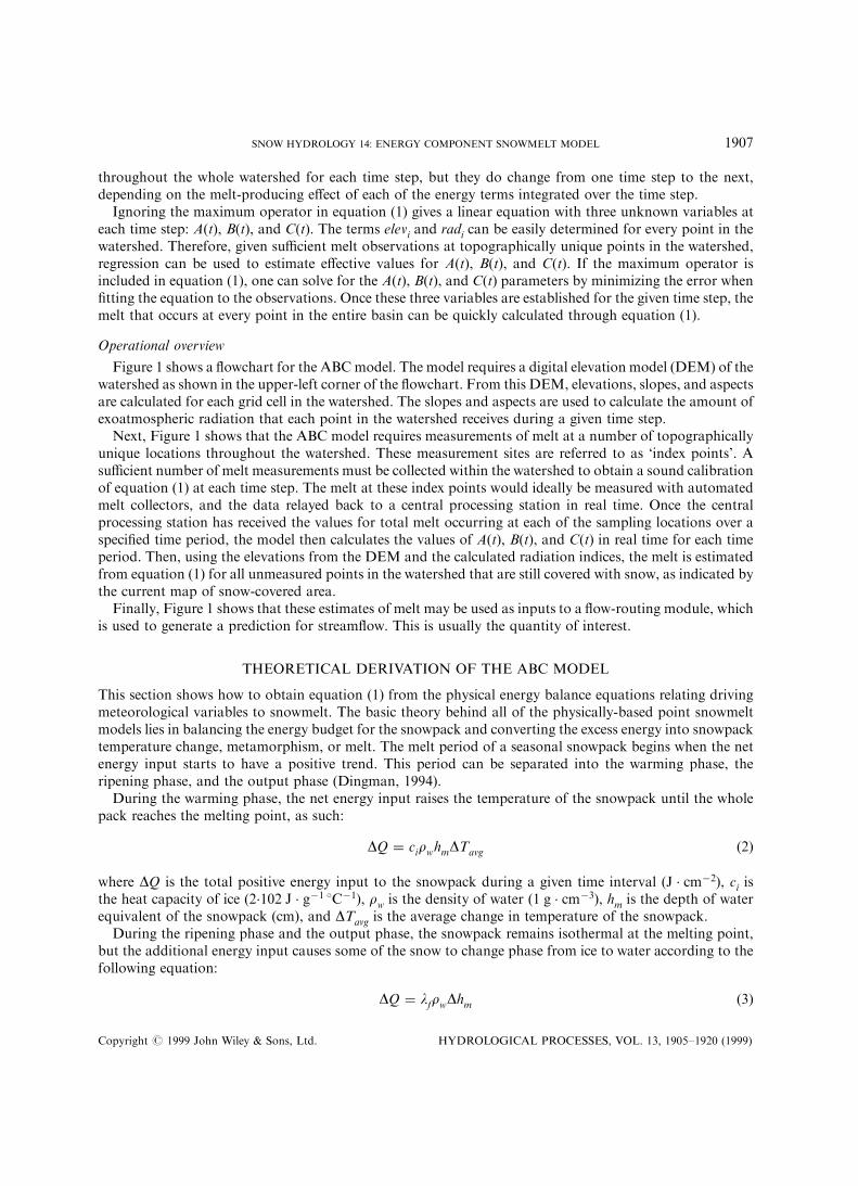
Figure 1 shows a ¯owchart for the ABCmodel. The model requires a digital elevation model (DEM) of thewatershed as shown in the upper-left corner of the ¯owchart. From this DEM, elevations, slopes, and aspectsare calculated for each grid cell in the watershed. The slopes and aspects are used to calculate the amount ofexoatmospheric radiation that each point in the watershed receives during a given time step.
Next, Figure 1 shows that the ABC model requires measurements of melt at a number of topographicallyunique locations throughout the watershed. These measurement sites are referred to as `index points'. Asu�cient number of melt measurements must be collected within the watershed to obtain a sound calibrationof equation (1) at each time step. The melt at these index points would ideally be measured with automatedmelt collectors, and the data relayed back to a central processing station in real time. Once the centralprocessing station has received the values for total melt occurring at each of the sampling locations over aspeci®ed time period, the model then calculates the values of A(t), B(t), and C(t) in real time for each timeperiod. Then, using the elevations from the DEM and the calculated radiation indices, the melt is estimatedfrom equation (1) for all unmeasured points in the watershed that are still covered with snow, as indicated bythe current map of snow-covered area.
Finally, Figure 1 shows that these estimates of melt may be used as inputs to a ¯ow-routing module, whichis used to generate a prediction for stream¯ow. This is usually the quantity of interest.
THEORETICAL DERIVATION OF THE ABC MODEL
This section shows how to obtain equation (1) from the physical energy balance equations relating drivingmeteorological variables to snowmelt. The basic theory behind all of the physically-based point snowmeltmodels lies in balancing the energy budget for the snowpack and converting the excess energy into snowpacktemperature change, metamorphism, or melt. The melt period of a seasonal snowpack begins when the netenergy input starts to have a positive trend. This period can be separated into the warming phase, theripening phase, and the output phase (Dingman, 1994).
During the warming phase, the net energy input raises the temperature of the snowpack until the wholepack reaches the melting point, as such:
DQ � cirwhmDTavg �2�
where DQ is the total positive energy input to the snowpack during a given time interval (J . cmÿ2), ci isthe heat capacity of ice (2.102 J . gÿ1 8Cÿ1), rw is the density of water (1 g . cmÿ3), hm is the depth of waterequivalent of the snowpack (cm), and DTavg is the average change in temperature of the snowpack.
During the ripening phase and the output phase, the snowpack remains isothermal at the melting point,but the additional energy input causes some of the snow to change phase from ice to water according to thefollowing equation:
DQ � lfrwDhm �3�
Copyright # 1999 John Wiley & Sons, Ltd. HYDROLOGICAL PROCESSES, VOL. 13, 1905±1920 (1999)
SNOW HYDROLOGY 14: ENERGY COMPONENT SNOWMELT MODEL 1907

where lf is the heat of fusion of ice at 0 8C (333.7 J . gÿ1) and Dhm is the depth of snow in water equivalencethat is converted to water (cm). During the ripening phase, the liquid water is retained in the snowpack bysurface-tension forces until the snow reaches its liquid holding capacity. After this, the output phase beginsand melt water ¯ows out of the snowpack. Consequently, during the output phase (which is the phase ofconcern for this model) the energy input is directly proportional to the amount of melt out¯ow.
The energy balance equation relating the meteorological driving forces to snowmelt is:
DQ � Qsn � Qln � Qp � Qg � Qh � Qe �4�
where Qsn is the net shortwave energy received by the snowpack, Qln is the net longwave radiation into thesnow, Qp is the energy advected by precipitation into the snow, Qg is the ground heat ¯ux to the snow, Qh isthe sensible heat ¯ux to the snow, and Qe is the latent heat ¯ux into the snow (Dingman, 1994).
Figure 1. Operational ¯owchart for the ABC model
Copyright # 1999 John Wiley & Sons, Ltd. HYDROLOGICAL PROCESSES, VOL. 13, 1905±1920 (1999)
1908 K. S. WILLIAMS AND D. G. TARBOTON

Physically based melt models usually require measurements of driving weather variables such as airtemperature, solar radiation, wind speed, etc. These variables are used as inputs for various equations todetermine the quantities of the di�erent components of the energy balance, and the sum of these energycomponents is used to estimate the melt occurring in a snowpack. One obstacle to this method of physicallymodelling snowmelt is the di�culty of accurately measuring these driving variables and then appropriatelyusing them to calculate each of the terms in the energy balance (equation (4)).
The ABC model di�ers from most other melt models in that it uses direct, real-time measurements of meltto drive the model, rather than relying on measurements of the driving weather variables and trying to relatethese back to melt rates. As such, it uses several spatially distributed measurements of actual snowmelt toe�ectively back-calculate the driving energy terms. These inferred energy inputs are representative of how theweather in the watershed has actually a�ected snowmelt. These calculated energy components are then usedto calculate the melt for the rest of the watershed.
The theoretical justi®cation for this model (equation (1)) lies in recognizing melt as a linear function ofavailable energy, and then approximating each of the components of the energy balance equation (equation(4)) as linear functions of elevation and potential solar illumination. In order to derive equation (1), all of theenergy ¯uxes must be expressed as linear functions of solar illumination and air temperature (and thuselevation, assuming that temperature varies linearly with elevation).
Net solar radiation at any point, i, is comprised of di�use and direct components with the direct componentrelated to illumination angle (the angle of the sun from the perpendicular to the land surface) as follows:
Qsni � Qsndif �ZDtI0 � t � �1 ÿ Alb� � cos�c� � dt �5�
where Qsni is the net shortwave radiation received at point i over the interval Dt, Qsndif is the net di�useshortwave radiation received during the timestep, I0 is the exoatmospheric solar radiation constant, t is theatmospheric transmissivity to direct beam radiation, Alb is the albedo, and c is the illumination angle. Now,neglecting the fact that Alb depends upon illumination angle and changes slowly with time as the surface icecrystals grow, and t changes with weather and sun angle, Alb and t are taken out of the integral, and theintegral of I0
. cos(c) at location i is expressed as radi . Assuming that the atmospheric transmissivity, t, andthe albedo of the snow surface, Alb, are unknown but spatially uniform throughout the watershed( justi®cation for and implications of this assumption are discussed at the end of this section), the aboveequation for net solar radiation can be written as:
Qsni � radi � C�t� � Qsndif �6�
where t and (1ÿAlb) are combined into the factor C(t). Dingman (1994) gives a formula for the calculationof radi for a given slope, aspect, and latitude at a daily time step. Dozier and Frew (1990) have presentedTOPORAD, a model that can rapidly compute radi using digital elevation data incorporating the e�ects ofterrain shading in its calculations.
Net longwave radiation can be expressed as:
Qln � eas � Ta4 ÿ esssTs4 �7�
where ea is the e�ective emissivity of the atmosphere, s is the Stefan-Boltzmann constant, Ta is the airtemperature in the basin for the given time period, ess is the emissivity of the snow surface, and Ts is thetemperature of the snow surface (all temperatures here are relative to absolute zero). Since it is desirable towrite the energy ¯uxes as linear functions of air temperature, the above equation is approximated as atruncation of a ®rst-order Taylor series expansion about Taref , a constant reference temperature as follows:
Qln � eas � Ta4ref ÿ esssTs4 � 4eas � Ta3ref � �Ta ÿ Taref� �8�
Copyright # 1999 John Wiley & Sons, Ltd. HYDROLOGICAL PROCESSES, VOL. 13, 1905±1920 (1999)
SNOW HYDROLOGY 14: ENERGY COMPONENT SNOWMELT MODEL 1909

Assuming that ea , ess and Ts are uniform throughout the basin (again, the impacts of these assumptionsare discussed at the end of this section), the terms in the last equation can be condensed to the followinglinear function of air temperature:
Qln � Aln � Bln � Ta �9�Under conditions of neutral buoyancy, turbulent mass transfer theory (Dingman, 1994) gives the sensible
heat ¯ux, Qh , as:
Qh �k2V
lnz
z0
� �2raCp � �Ta ÿ Ts� �10�
where k is the von-Karman constant, V represents the wind speed, z is the height at which the wind speed ismeasured, z0 denotes the e�ective aerodynamic roughness of the snow surface, ra is the density of the air, andCp represents the speci®c heat capacity of air. Thus, sensible heat ¯ux is already a linear function of airtemperature, and the above equation can be simpli®ed to:
Qh � Ah � Bh � Ta �11�This simpli®cation has lumped all of the variability in quantities such as wind speed (V), roughness height(z0), air density (ra), and the surface temperature (Ts) into the parameters Ah and Bh , neglecting their spatialvariability. Of these, the spatial variability in wind speed is perhaps the most serious; however, it is di�cult toquantify this variability in a simple way. The air density also varies since it is related to elevation. The impacton the model results caused by the spatial variability of these parameters is discussed at the end of thissection.
Turbulent mass transfer theory (Dingman, 1994) gives the latent heat ¯ux to the surface, Qe , as:
Qe �k2V
lnz
z0
� �2
hv0�622RdTa
�ea ÿ es� �12�
where hv equals the latent heat of vaporization for water, Rd is the dry gas constant, and ea and es are thevapour pressures of the air and surface respectively. These are related to temperature, relative humidity, RH,and the saturation vapour pressure versus temperature function esat(T) by:
ea � esat�Ta� � RH �13�es � esat�Ts� �14�
Lowe (1977) provides accurate polynomial expressions for esat(T).Again, taking a ®rst-order truncation of the Taylor's series expansion of this equation about a reference
temperature, Taref , gives the following expression:
Qe �k2V
lnz
z0
� �2
hv0�622RdTaref
�RH � esat�Taref� ÿ esat�Ts��
� k2V
lnz
z0
� �2
hv0�622Rd
RH � DTaref
ÿ RH � esat�Taref�Ta2ref
� es�Ts�Ta2ref
!�Ta ÿ Taref� �15�
where D represents the derivative of esat with respect to air temperature evaluated at Taref .
Copyright # 1999 John Wiley & Sons, Ltd. HYDROLOGICAL PROCESSES, VOL. 13, 1905±1920 (1999)
1910 K. S. WILLIAMS AND D. G. TARBOTON

Assuming that V, z0 , and RH are uniform throughout the watershed for a given time period (RH willchange with elevation, but again this is rationalized at the end of this section), the terms in the aboveequation can be condensed to the following:
Qe � Ae � Be � Ta �16�Equations (4), (6), (9), (11) and (16) can now be combined to write the following equation:
DQ � radi � C�t� � Qsndif � Aln � Bln � Ta � Qp � Qg � Ah � Bh � Ta � Ae � Be � Ta �17�
Though the terms C(t), Qsndif , Aln , Bln , Qp , Qg , Ah , Bh , Ae , and Be may vary with time, they are (byapproximation) spatially constant throughout the watershed. By condensing these terms into singleconstants (Acomb and Bcomb), the above equation can be simpli®ed to:
DQ � radi � C�t� � Acomb � Bcomb � Ta �18�Next, Ta is assumed to vary linearly with elevation according to an unknown lapse rate as such:
Ta � a � elevi � b �19�Combining equations (3), (18), and (19) gives:
lfrwDhm � radi � C�t� � Acomb � Bcomb�a � elevi � b� �20�
Finally, condensing the constants in the above equation gives an expression for Dhm , which is the depth ofsnowmelt in water equivalent:
Dhm � radi � C�t� � A�t� � B�t� � elevi �21�Equation (21) assumes a ripe snowpack (equation (3)), and as such is only valid for positive net energycontributions, i.e. Dhm 4 0. Therefore, adding this necessary condition that Dhm is the greatest of either theenergy input or 0 (since negative energy does not result in negative melt) results in equation (1):
Dhmi � max��A�t� � B�t� � elevi � radi � C�t��; 0� �22�where the subscript i denotes the location. Here A(t) is an unknown energy input factor that is a function oftime and is representative of the base energy input to the watershed, equal to the following:
A�t� � �Acomb � Bcomb � b�=rwlf �23�
B(t) is another unknown energy input factor that varies with time and represents the e�ect of elevation (or airtemperature) upon snowmelt. It is equal to:
B�t� � Bcomb � a=rwlf �24�
Finally, C(t) is a time-dependent factor that takes the net incoming direct shortwave radiation into accountas explained above. These three energy input factors vary with time, but at the end of each time step, they areassumed to be the same for every point in the whole watershed.
Because of the maximum operator, equation (1) is a non-linear equation with three unknown variables,A(t), B(t), and C(t). The terms radi and elevi are known quantities for each point in the watershed. Therefore,given melt observations at several points in the watershed (index points), one can ®t the equation to the databy minimizing either the sum of absolute errors or the sum of squared errors, and obtain unique values forthe parameters A(t), B(t), and C(t). Once these three variables are established, the melt that occurs at everypoint in the entire basin can be calculated through equation (1). This procedure can be used at every timestep
Copyright # 1999 John Wiley & Sons, Ltd. HYDROLOGICAL PROCESSES, VOL. 13, 1905±1920 (1999)
SNOW HYDROLOGY 14: ENERGY COMPONENT SNOWMELT MODEL 1911

for which there are new measurements of melt to determine the amount of melt that occurred throughout thebasin during that timestep.
It is interesting to note that the three terms in equation (1) primarily describe the e�ects of the terrain onnet radiation and turbulent transfer. Consistently in the literature, these two energy sources have been shownto dominate the snowmelt process, to the point where the other terms are usually negligible. Cline (1997)described a thorough experiment in the mountains of Colorado that quanti®ed all of the terms of the energybalance during two melt seasons. He found that net radiation and turbulent ¯uxes were of the greatestimportance, but that their relative contributions to the overall energy balance varied from year to year.Kuusisto (1986) reviewed over 20 studies of snowmelt energy balances and came to the similar conclusionthat net radiation and turbulent ¯uxes were the dominant energy components driving snowmelt.
Equation (1) clearly models only melt, not the spatial distribution of snow water equivalence. With therestriction that Dhm 4 0, equation (1) is incapable of modelling the accumulation of snow. However, ifdesired, the ABC model can be altered to keep track of the amount of water equivalence in the snowpack. Inthis case, the snow water equivalence needs to be maintained for each point as a state variable. The formulagoverning the change in snow water equivalence at each point i is:
Dwi � precipi ÿ melti �25�Assuming that precipitation is approximately linearly related to elevation (Dingman et al., 1988), we can
write the following equation:
precipi � j�t� � elevi � k�t� �26�where j(t) is the unknown lapse rate for precipitation and k(t) is the unknown base snowfall rate for thebasin during the given time period.
Computing melti as max��A�t� � B�t� � elevi � radi � C�t��; 0�, as given in equation (1), results in thefollowing expression for snow water equivalence:
Dwi � j�t� � elevi � k�t� ÿ max��A�t� � B�t� � elevi � radi � C�t��; 0� �27�This equation assumes that the advected energy from the precipitation has a negligible e�ect on the energy
balance of the snowpack. This is a reasonable assumption in most circumstances. In his review of over 20snowmelt energy balance studies, Kuusisto (1986) found that on average, energy advected from precipitationaccounts for less than 1% of the energy budget.
If snow does indeed fall during a time step, the above equation can be simpli®ed by dropping themaximum operator requiring that melt be greater than zero and combining the similar terms to give:
Dwi � Aswe�t� � Bswe�t� � elevi � radi � C�t� �28�where
Aswe�t� � A�t� � k�t� �29�Bswe�t� � B�t� � j�t� �30�
The ABC model for snow water equivalence can now be stated as follows:If there is no precipitation during a timestep:
Dwi � max��Aswe�t� � Bswe�t� � elevi � radi � C�t��; 0�If there is precipitation during a timestep:
Dwi � Aswe�t� � Bswe�t� � elevi � radi � C�t� �31�
Copyright # 1999 John Wiley & Sons, Ltd. HYDROLOGICAL PROCESSES, VOL. 13, 1905±1920 (1999)
1912 K. S. WILLIAMS AND D. G. TARBOTON

The ®rst part of equation (31) is simply equation (1), while the second part of equation (31) is a linearequation whose unknown variables can be solved for using simple linear regression. Therefore, given severalmeasurements of the change in water equivalence at di�erent points in the snowpack, one can use equation(31) to model the snow water equivalence just as one would use equation (1) to model melt.
Finally, let us examine some of the original assumptions more carefully. In the derivation of equation (1)and subsequently equation (31), the atmospheric transmissivity (t), albedo of the snow surface (A), snowsurface temperature (Ts), relative humidity (RH), air density (ra), and wind speed (V), were all assumed to bespatially invariant across the watershed. The air density, atmospheric transmissivity, and the relativehumidity will change across the watershed, but the gradients will probably be very strongly correlated withelevation. Therefore, the choice of elevation as a parameter in the model will incorporate most of thesee�ects, though only in a linearized fashion. The albedo of the snow surface and the surface temperature willmost likely vary in space; however, these parameters are intimitely related to the energy that the snowpackhas received, which is primarily determined by the amount of radiation received and the turbulent heatexchange that has occurred over the snowpack. Therefore, the model's dependence on elevation andradiation will incorporate the e�ects of changing albedo and surface temperature, though again, only in alinearized fashion. Finally, though these assumptions are not completely rigorous, they are all justi®ed aspragmatic and expedient in terms of the quality of the resulting approximations, as demonstrated in the nextsection.
MODEL TESTING
This section provides an analysis of the performance of the ABC model with two sets of data. The ®rst dataset was synthetically generated by another snowmelt model. The second set of data comes from ®eldmeasurements taken in Smith®eld Dry Canyon in the spring of 1997.
Because of the potential for measurement error when collecting snowmelt data, robust least-absolute-errorregression was used to calculate the A(t), B(t), and C(t) parameters in all the results presented.
Synthetically generated data
Because of limited ®eld data, much of this research was performed with data that was syntheticallygenerated by the Utah Energy Balance (UEB) model (Tarboton and Luce, 1996; Tarboton et al., 1995). TheUEB model is a physically based energy balance model that represents the snowpack in terms of two statevariables; water equivalence and energy content. A third state variable is used to quantify the snow surfaceage, which is used for albedo calculations. The use of only three state variables makes the model lesscomplicated than typical energy balance melt models and therefore suitable for generating many simulationsof melt at di�erent points. The model uses a parameterization of surface heat ¯ux into the snow based on thedi�erence between the snow surface and average snowpack temperatures to balance external energy ¯uxes atthe snow surface and to calculate snow surface temperature without introducing additional state variables.
In order to generate a full set of snowmelt data with which to test the ABC model, a hypothetical terrainwith 200 points was simulated. Each of these 200 points were assigned slopes randomly selected from auniform distribution over the range of 08 to 608, random aspects ranging uniformly all the way around thecompass, and random elevations selected from a uniform distribution over a range of 1500 m. Next, the UEBmodel was used with weather data recorded at the Central Sierra Snow Laboratory during the winter of1986±1987 to calculate snow accumulation and melt at each of the hypothetical points. The incomingexoatmospheric radiation at each point was modi®ed to account for slope and aspect, while the airtemperature for each point was adjusted according to a lapse rate of 1 8C for every 150 m that the point wasabove the datum (Dingman, 1994). In this manner, a time series of snowmelt was generated for every point inthe hypothetical watershed. The simulated snow water equivalence (SWE) at every point was recorded every48 hours, and the melt during each 48-hour period was calculated as the di�erence in SWE betweensubsequent time steps. Five index points within the hypothetical basin were deemed su�cient to determine
Copyright # 1999 John Wiley & Sons, Ltd. HYDROLOGICAL PROCESSES, VOL. 13, 1905±1920 (1999)
SNOW HYDROLOGY 14: ENERGY COMPONENT SNOWMELT MODEL 1913

the A(t), B(t), and C(t) terms. The following points were chosen as the index points to be used throughout themelt season:
aspect.clockwisefrom
elevation: slope: North: characteristics:
point 1 2650 m 578 3168 low radiation, med. elevationpoint 2 3420 m 598 3538 low radiation, high elevationpoint 3 2166 m 548 1698 high radiation, low elevationpoint 4 3390 m 568 728 med. radiation, high elevationpoint 5 2869 m 588 1168 high radiation, med. elevation
These points are extremely varied in terms of elevation and radiation received. This wide variation intopography of index points provides stability in the regression equation and is important for accurate meltpredictions.
Figure 2 shows eight plots of the ABC model estimates versus UEB-generated melt for each of the 200points. Only those points at which the UEB model still predicts the presence of snow are shown, since theresults are meaningless if the snow has completely melted. These correspond to the eight 48-hour meltperiods from 28March to 13 April. The solid line in each plot is the 1 :1 line, representing a perfect ®t. As canbe seen, the ABC model performed fairly well, but not perfectly. The adjusted multiple coe�cients ofdetermination (or R2 values) for each plot are given in the ®gure. Following Mendenhall and Sincich (1992),these R2 values were calculated as follows:
R2 � 1 ÿ �n ÿ 1�
n ÿ �k � 1�S�y ÿ y�2S�y ÿ �y�2� �
�32�
where y represents the values of melt predicted by the UEBmodel (or `measured' melt value), y represents thevalues of melt predicted by the ABC model, n is the total number of predictions, and k is the number ofparameters used in the regression (three).
In Figure 2, it is apparent that the linear ABC model is not entirely appropriate for modelling thissynthetic data set. Though most points fall on or near the 1 :1 lines, the points on the left-hand sides of thegraphs cluster into vertical lines, indicating that melt is not a continuously linear function of radiation andelevation near the points with zero melt. This is the region where `melt' is negative and actually representsaccumulation. There is precipitation during these intervals so the second form of equation (31) has beenused. This is somewhat arti®cial because the ABC model tries to relate snow accumulation to elevation usingthe same linear function as was used for melt at lower elevations, while in the UEB model simulationsprecipitation was held constant across the basin. In reality we expect some variation of precipitation withelevation.
Figure 3 shows the time series of snow accumulation and melt for eight sites that were selected semi-randomly to show di�erent extremes of accumulation and ablation. The points show the actual UEB results,while the lines show the ABC estimates of the melt process using equation (31). The average adjustedmultiple coe�cient of determination (R2) for the eight points shown is 0.95, while the averageR2 for all of the200 points is 0.94.
Field data
During the 1997 melt season, melt measurements were collected at 31 locations in Smith®eld Dry Canyonat approximately ®ve-day intervals. These locations were distributed over a range of 1200 feet (366 m) in
Copyright # 1999 John Wiley & Sons, Ltd. HYDROLOGICAL PROCESSES, VOL. 13, 1905±1920 (1999)
1914 K. S. WILLIAMS AND D. G. TARBOTON

Figure 2. ABC model estimates versus UEB simulations
Copyright # 1999 John Wiley & Sons, Ltd. HYDROLOGICAL PROCESSES, VOL. 13, 1905±1920 (1999)
SNOW HYDROLOGY 14: ENERGY COMPONENT SNOWMELT MODEL 1915

Figure 3. Snow water equivalence accumulation and melt at eight selected sites
Copyright # 1999 John Wiley & Sons, Ltd. HYDROLOGICAL PROCESSES, VOL. 13, 1905±1920 (1999)
1916 K. S. WILLIAMS AND D. G. TARBOTON

elevation, varied in slope from 0 to 38 degrees, and faced a variety of di�erent directions. Each point waslocated in the ®eld using three wooden stakes painted white to decrease the e�ect of absorption and re-emission of radiation. Every four days or so the depth of snow indicated on each stake was recorded and thedensity of the adjacent snow was measured with a snow-tube. The SWE (snow water equivalence) wascalculated as the average depth of snow recorded at the three stakes multiplied by the measured density of thesnow at the site. The melt that occurred between subsequent measurements at a site was calculated bysubtracting the amount of SWE measured at one time period from that of the preceding time period.
By this process, accurate measurements of the melt that occurred at each of the locations for each of thetime steps were obtained (as an average of the melt occurring at the three stakes). However, small measuringerrors still occurred. In a few instances, measured values of density decreased with time. Since melting snowtypically becomes denser with time (unless bridging occurs, and no bridging was observed), these erroneousmeasurements were recti®ed by using average density increases instead of measured values for the sites inquestion. Since no new snow fell during the melt period, the one measured negative value of melt was set tozero. Williams (1998) gives full details of this data.
The melt at Smith®eld Dry Canyon was modelled in the same fashion with the ABC model. Five indexpoints were used. These points were chosen to cover a wide range of elevation and exoatmospheric radiationvalues.
Figure 4 shows X±Y plots of the ABC model results versus the measured melt for the 9±13 March and13±19 March melt periods. The same index points were used in both cases, and are shown as triangles. Thetop graph (9±13 March) has an R2 value of 0.47, while the lower graph has an R2 value of 0.72. It isinteresting to note the predictions for the three points represented as �'s in these ®gures. These data pointswere collected in a large, new drift that formed around 7 March. They were therefore composed of deeper,fresh snow, and the energy during the ®rst few days contributed towards metamorphism or ripening of thesnow rather than melt. This is evidenced by an under-prediction of melt in the ®rst period, while in thesecond period, after the snowpack had ripened, the predictions are more in line with observed melt. If thesethree points are ignored in the ®rst graph, the calculated R2 value increases signi®cantly to 0.60.
DISCUSSION
In evaluating the ABC model some may question the utility of a model that requires inputs of meltmeasurements within the basin being modelled. Traditional energy balance models require inputs of weatherdriving variables, measured at a point and then extended or extrapolated over a watershed. The position hereis that point measurements of melt may be as easy to obtain. The purpose of the ABC model is in estimatingspatially distributed melt from point snowmelt measurements. It provides a method to directly usetopographic information (with digital elevation data now readily available) in a spatially distributedwatershed model. Snowmelt is an inherently nonlinear process involving nonlinear relationships betweenforcing variables (the weather) and surface energy exchanges. However we suggest here that much of thespatial variability in snowmelt can be related linearly (to a relatively good level of approximation) toelevation and the radiation index. Thus the ABC model provides a way to separate the nonlinear variabilityof snowmelt at a point from the linear and predictable causes for spatial variability. As currently presentedthe ABC model is not useable without the point snowmelt measurements as inputs. These capture thenonlinearity in the snowmelt dynamics at a point. A relatively easy extension (left to future research) wouldbe to couple the ABC model to a point snowmelt model run at the index points. This approach would thenprovide another way to obtain spatial snowmelt inputs. The di�erence to an explicitly spatially distributedmodel, is that the weather inputs are not extrapolated to each point in the watershed. Rather the weatherinputs drive a point model at the index points and then the topographic information (elevation and radiationindex) are used to spatially extrapolate modelled melt to each point in the watershed. Additional future workis required to fully evaluate whether predictions from an ABC like model that spatially extrapolates point
Copyright # 1999 John Wiley & Sons, Ltd. HYDROLOGICAL PROCESSES, VOL. 13, 1905±1920 (1999)
SNOW HYDROLOGY 14: ENERGY COMPONENT SNOWMELT MODEL 1917

snowmelt measurements or predictions instead of extrapolating point weather measurements is moreaccurate or useful.
The question of utility for forecasting and general applicability also arises with parameters A, B and Cbeing estimated at each time step. The coe�cients A, B and C should not be regarded as model parameters inthe usual sense. A, B and C are not quantities that are transferable from one watershed to another, or into thefuture. Rather they represent the factorization of snowmelt input energy for a particular basin and time stepdependent upon weather conditions into components related to radiation, elevation and a spatial constant.They can be evaluated, given topographic data, using the regression procedure, as soon as the driving inputs,snowmelt measurements at the index points, become available. They are e�ectively therefore internal modelcalculations. The model does not have any real calibration parameters. Its parameters are the topography, asquanti®ed by the elevation and radiation index.
The results above used ®ve index points in a very small area (�40 ha). We have not yet determined theindex point density required for extension of this approach to larger areas. This is a question for futureresearch related to the scale of variability of snow accumulation and melt and its causes. Seyfried andWilcox(1995) discuss some of the issues involved. Out intuition is that topography (through drifting, radiation andorographic e�ects) accounts for a large part of the small scale variability in snow accumulation and melt upto scales of 10's to 100's of km. Beyond these scales regional weather variability becomes more important.
Figure 4. Comparison of ABC modelled melt against Smith®eld Dry Canyon Measurements
Copyright # 1999 John Wiley & Sons, Ltd. HYDROLOGICAL PROCESSES, VOL. 13, 1905±1920 (1999)
1918 K. S. WILLIAMS AND D. G. TARBOTON

Since the ABC model incorporates topography, our intuition (that needs future research to verify it) is that asmall number of index points (10 to 15) should work for areas up to on the order of 100 km2.
CONCLUSIONS
The snowmelt modelling literature points to the need for a model that is both simple enough to use inpractical applications for melt estimations over large areas, and rigorous enough to capture the fundamentalphysics of melt and to provide spatially explicit estimations. This paper has described the ABC model, whichis a new method for estimating the spatial distribution of snowmelt based on point measurements andtopography.
The results indicate that the ABC model can be an accurate, e�cient way to predict the spatial distributionof snowmelt in a rugged, mountainous watershed. Because of the model's simplicity and accuracy, it couldreplace more traditional methods for modelling snowmelt in many applications. The advantages of the ABCmodel include:
1. simple data requirements,
2. methodology that is easily understandable to an operator,
3. computationally e�cient algorithm for rapid simulations of large basins,
4. no need for prior calibration of basin-speci®c parameters,
5. direct incorporation of topographic information in a physically justi®able manner,
6. accurate spatial melt estimates.
Though energy balance models will always be required for some applications, there are many practicaluses for the simpler ABC model. Flood forecasters as well as reservoir operators, who traditionally usesimpler lumped index models, would bene®t from the improved accuracy over the entire range of possibleweather conditions provided by a more physically based model. Researchers could employ the model toe�ciently and accurately calculate the spatial distribution of water inputs to large watersheds. This would beuseful for basin response modelling, contaminant transport modelling, erosion modelling, etc. Finally,developing countries with limited ®nances could bene®t greatly from a model that required simple data, littleskill from the operator, and no prior calibration of basin-speci®c parameters.
ACKNOWLEDGEMENTS
We thank Kaye Brubaker and Mary Albert for their helpful review and editing of this paper. This work wassupported in part by the Utah Water Research Laboratory and the Environmental Protection Agency(agreement no: R824784) under the National Science Foundation/Environmental Protection Agency Waterand Watersheds program. The views and conclusions expressed are those of the authors and should notbe interpreted as necessarily representing the o�cial policies, either expressed or implied, of the U.S.Government.
REFERENCES
Anderson EA. 1976. A Point Energy and Mass Balance Model of a Snow Cover. US National Oceanic and Atmospheric AdministrationNOAA Technical Report NWS 19, Silver Spring, MD.
Brubaker K, Rango A, Kustas W. 1996. Incorporating radiation inputs into the snowmelt runo� model. Hydrological Processes 10:1329±1343.
Cline D. 1997. Snow surface energy exchanges and snowmelt at a continental, midlatitude Alpine site. Water Resources Research 33(4):689±701.
Dingman SL. 1994. Physical Hydrology. Prentice-Hall: New Jersey; 575 pp.
Copyright # 1999 John Wiley & Sons, Ltd. HYDROLOGICAL PROCESSES, VOL. 13, 1905±1920 (1999)
SNOW HYDROLOGY 14: ENERGY COMPONENT SNOWMELT MODEL 1919

Dingman SL, Barry RG, Reynolds RC III 1988. Application of kriging to estimating mean annual precipitation in a region oforographic in¯uence. Water Resources Bulletin 24: 329±339.
Dozier J, Frew J. 1990. Rapid calculation of terrain parameters for radiation modeling from digital elevation data. IEEE Transactionson Geoscience and Remote Sensing 28(5): 963±969.
Flerchinger GN. 1987. Simultaneous Heat and Water Model of a Snow-Residue-Soil System. Ph.D. Dissertation, Engineering Science:Washington State University, Pullman, Washington.
Flerchinger GN, Saxton KE. 1989. Simultaneous heat and water model of a freezing snow-residual-soil system, I. Theory anddevelopment. Transactions of the ASAE 32(2): 565±571.
Jordan R. 1991. AOne-Dimensional Temperature Model for a Snow Cover, Technical Documentation for SNTHERM.89. Special Report91-16: US Army Corps of Engineers, CRREL.
Kustas WP, Rango A, Uijlenhoet R. 1994. A simple energy budget algorithm for the snowmelt runo� model.Water Resources Research30(5): 1515±1527.
Kuusisto E. 1986. The energy balance of a melting snow cover in di�erent environments, InModeling Snowmelt-Induced Processes, EMMorris (ed.); IAHS Publication No. 155: Wallingford, UK.
Lowe PR. 1977. An approximating polynomial for the computation of saturation vapor pressure. Journal of Applied Meteorology 16:100±103.
Martinec J, Rango A, Roberts R. 1994. The Snowmelt-Runo� Model (SRM) Users Manual, Updated Edition 1994, Version 3.2:Department of Geography Ð University of Bern.
McManamon A, Day GN, Carroll TR. 1993. Snow estimation Ð a GIS application for water resources forecasting. Proceedings of theSymposium on Engineering Hydrology. ASCE Publ.: New York; p. 856±861.
Mendenhall W, Sincich T. 1992. Statistics for Engineering and the Sciences, 3rd Edition. Macmillan: New York p. 963.Seyfried MS, Wilcox BP. 1995. Scale and the nature of spatial variability: ®eld examples having implications for hydrologic modeling.
Water Resources Research 31(1): 173±184.Tarboton DG. 1994. Measurement and Modeling of Snow Energy Balance and Sublimation from Snow. Proceedings, International Snow
Science Workshop, Snowbird, Utah, October 31±November 2 1994, p. 260±279.Tarboton DG, Chowdhury TG, Jackson TH. 1995. A spatially distributed energy balance snowmelt model. In Biogeochemistry
of Seasonally Snow-Covered Catchments, Tonnessen KA, Williams MW, Tranter M (eds); Proceedings of a Boulder Symposium,July 3±14: IAHS Publ. no. 228: p. 141±155.
Tarboton DG, Luce CH. 1996. Utah Energy Balance Snow Accumulation and Melt Model (UEB): Computer model technical descriptionand user's guide. Utah Water Research Laboratory and USDA Forest Service Intermountain Research Station.
Williams KS. 1998. The Development and Validation of a Model for the Spatial Distribution of Snowmelt Based on Topography and PointMelt Measurements. M.S. Thesis: Utah State University, Logan, Utah.
Copyright # 1999 John Wiley & Sons, Ltd. HYDROLOGICAL PROCESSES, VOL. 13, 1905±1920 (1999)
1920 K. S. WILLIAMS AND D. G. TARBOTON